~ 1110-2-4000 chapter 5 reservoir sedimentation · reservoir on stream system morphology should not...
TRANSCRIPT
~ 1110-2-400015 Dec 89
CHAPTER 5
RESERVOIR SEDIMENTATION
Section 1. Introduction
5-1. Purpose. The purposes of this chapter are to present the philosophy formeasuring the impact of a project on the stream system morphology, to identifypotential sedimentation problems in the reservoir, to associate those problemswith project purposes, and to propose approaches for analyzing them.
5-2. Scope. The scope of problems addressed in this chapter is limited toflood control and navigation. Related reservoir uses are included only as theyoccur in multiple purpose projects. Recreational problems are mentioned butnot addressed in detail. The basic processes are the same as those causingflood control and navigation problems, but recreational problems require aconsiderable refinement to the spatial and temporal resolution in analyticaltechniques. Water quality aspects of sedimentation problems are extremelyimportant in reservoir design; they should be addressed using water qualitymanuals. The physical problems, as opposed to water quality problems, arecaused primarily by inorganic sediments. Although there is recent evidencethat organic sediments affect water chemistry to the point of influencing thebehavior of the clays, information to quantify that influence is notavailable.
5-3. Philosophy of the Sedimentation Investigation. The impact of thereservoir on stream system morphology should not be determined by comparing a“future condition with the proposed reservoir project in operation” to astatic condition of the stream system depicted by either current or historicalbehavior. A more appropriate measure of impact is to develop a “basecondition” by forecasting a future condition of the stream system without theproposed project, i.e., a “do-nothing condition. ” Then forecast a futurecondition for that stream system with the proposed project in operation todevelop a “project condition.” Then compare those two future conditions todetermine the impact of the project on the stream system morphology. Notice,the “do-nothing condition” should contain all future changes in land use,water yield, sediment yield, stream hydraulics and basin hydrology exceptthose associated with the proposed l?roject.
a. System Response to Catastrophic Events. The floods in northernCalifornia and Oregon during December of 1964 so disturbed the stream systemsthat sediment yields, and river problems associated with them, were abnormallyhigh even a decade later. These stream systems are in transition because ofchanges in sediment yield and water runoff hydrography. Two points aresignificant:
(1) The water and sediment yields are the “Boundary Conditions”describing the amount of sediment that would enter a proposed reservoirproject, and field data taken during the past decade would not berepresentative of future years on these streams because a catastrophic eventhas occurred.
5-1
EM 1110-2-400015 Dec 89
(2) Secondly, if a reservoir project should be constructed on suchdisturbed streams, it should not be blamed for all changes which would occurduring its operation because that stream system was already in transitionprior to the construction of the reservoir. This point demonstrates: “alwaysevaluate potential reservoir sites and report whatever transition may be inprogress historically.”
b. System Response to Normal Events. In the absence of field data, it isnot possible to predict, with much accuracy, the sediment yield from such acatastrophic event as the December flood of 1964, but annual fluctuations inhydrology or sediment yield can cause a stream to be in transition. A database can be acquired and future conditions can be predicted sufficiently wellto minimize big surprises in this case.
Section II. Evaluation of the No-Action Condition
5-4. Indicators of Change in the Stream System. Trends, over the last decadeor so, in any of the following parameters suggest the stream system is in aperiod of transition:
a. water yield from the watershed,
b. sediment yield from the watershed,
c. water discharge duration curve,
d. concentration of sediment,
e. size of sediment particles,
f. stage-duration curve,
g. depth, velocity, slope or width of the channel, or
h. bank caving
i. trends in “specific gage” plots (i.e., the stage for a constantdischarge plotted versus time.)
Section III. Evaluation of Modified Conditions
5-5. Points of Caution. The following are sedimentation problems associatedwith reservoir projects. They should be forecast over the economic life ofthe project and reported via reservoir sedimentation studies.
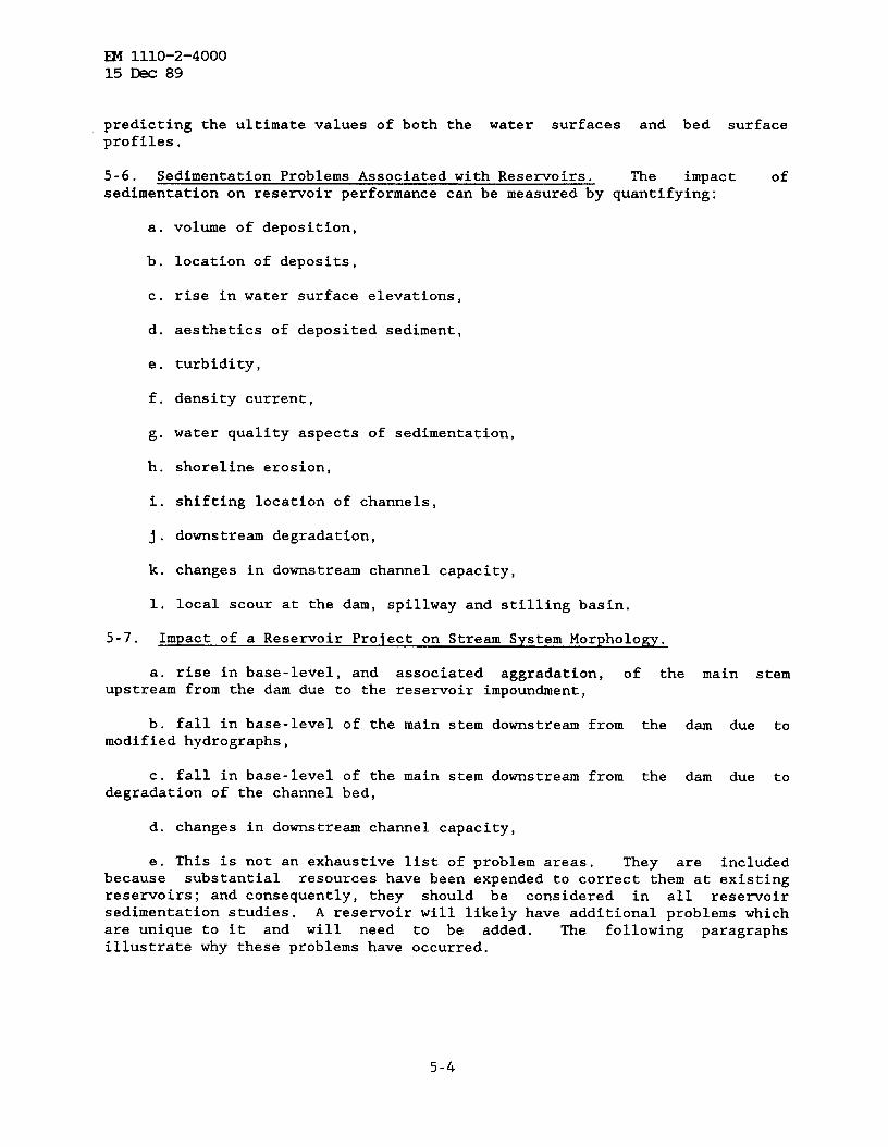
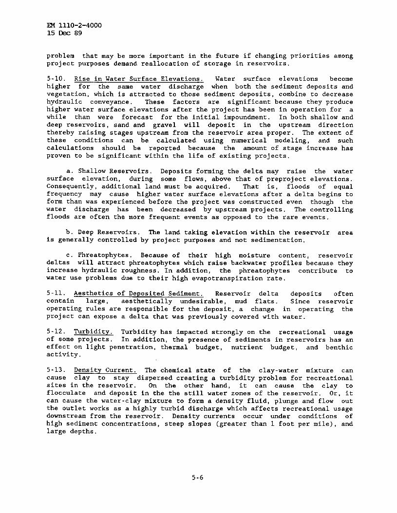
a. Fallacies. Historically, some have pictured sediment as occupying a“dead storage” zone at the very lowest depths in the reservoir, and evendescribed such space as “allocated for sediment retention”, Figure 5-1.Others show deposits as if they occur only at the upstream end of thereservoir then vanish leaving clear water to the dam. A third fallacy can beseen in sketches which picture all deposition within the reservoir proper,Avoid these fallacies. Eventually, all reservoirs will fill with sediment.
5-2

~ 1110-2-400015 M 89
?Top of floodcontrolpool%
Mean, Operotingeievation~—— —
Toe
Figure 5-1. Incomplete Concept of Reservoir Deposition
The time can range from a single storm event to hundreds of years depending onsediment yield and reservoir operation. The sedimentation report should
forecast sedimentation during the life of the project.
b. Topset Slope. A rule of thumb for the ultimate topset slope is that
it should be 50 percent of the original stream bed profile. There is no
physical reason for that value, however. Beware of any such assumptionbecause the ultimate topset slope will be constructed by the river to be inregime with the river system. Numerical modeling is presently the mosteffective method for predicting that ultimate value.
c. Impact of Increased Stages Beyond Reservoir Limits. Sand and gravel
will start to deposit upon reaching the backwater curve of the reservoir whichis usually upstream from the reservoir boundaries. Those deposits increase
the elevation of the bed surface profile which causes the water surface
elevations to rise. Of course such increases will not continue indefinitely;
the ultimate elevations will be in regime with the water-sediment hydrographyentering the reservoir from the upstream basin/sub-basins. As in the case of
the topset slope, numerical modeling is the most effective method for
5-3
EIvI1110-2-400015 Dec 89
predicting the ultimate values of both the water surfaces and bed surfaceprofiles.
5-6. Sedimentation Problems Associated with Reservoirs. The impact of
sedimentation on reservoir performance can be measured by quantifying:
a.
b.
c.
d.
e.
f.
g.
h.
i.
j.
k.
1.
volume of deposition,
location of deposits,
rise in water surface elevations,
aesthetics of deposited sediment,
turbidity,
density current,
water quality aspects of sedimentation,
shoreline erosion,
shifting location of channels,
downstream degradation,
changes in downstream channel capacity,
local scour at the dam, spillway and stilling basin.
5-7. Impact of a Reservoir Protect on Stream System Morphology.
a. rise in base-level, and associated aggravation, of the main sternupstream from the dam due to the reservoir impoundment,
b. fall in base-level of the main stem downstream from the dam due tomodified hydrography,
c. fall in base-level of the main stem downstream from the dam due todegradation of the channel bed,
d. changes in downstream channel capacity,
e. This is not an exhaustive list of problem areas. They are includedbecause substantial resources have been expended to correct them at existingreservoirs; and consequently, they should be considered in all reservoirsedimentation studies. A reservoir will likely have additional problems whichare unique to it and will need to be added. The following paragraphs
illustrate why these problems have occurred.
5-4
m 1110-2-400015 Dec 89
5-8. Volume of Deposition. Land use change from natural forest to strip
mining has so increased sediment yields that the useful life of somereservoirs will be reduced to a fraction of the 100-year design life unlessaction is taken to control the deposition problem. The volume of sedimentmaterial deposited in the reservoir delta IS NOT a function of the 100-yearproject life. That time period is an economic parameter, not a physicallimitation. Consequently, delta growth will not cease simply because theproject life has been reached. Eventually a new channel and flood plain willexist in the reservoir. Flood stages and the ground water table will reflectthat condition adjacent to and upstream from the reservoir area.
5-9. Location of Deposits. This is a more precised term than “distributionof deposits”. Location means the (x,y,z) location of deposits and not justdeposition volume by project purpose. Also , the term “distribution ofdeposits” should refer to volume depletion by project purpose rather thanspatial location of that deposit.
a. If volumetric reductions of reservoir storage space allocated for eachproject purpose represented the only problem associated with reservoirsedimentation, it would not be necessary to forecast the distribution ofdeposits in the resenoir. It would only be necessary to reassign reservoirelevations for the desired capacity as indicated by periodic resurveys. Suchis not possible with hydropower machinery, however, because it is designed tooperate within a prescribed head range.
b. Even if the total volume of sediment deposits is small, they may occurin locations where navigation, conservation storage, marinas, or other projectfeatures can not function as designed for project economics. Consequently, thespatial location must be predicted in addition to the elevation of deposits.
c. Deposition problems are often more severe on tributaries than on themain stem, and tributary locations are usually the most desirable fordeveloping recreational facilities. Analysis is complicated by two factors:(1) the lack of basic sediment data because there is usually less on atributary than on the main stem itself, and (2) the small size of the Studyarea. However, recreation sites are a limited resource and their useful lifeshould be evaluated in considerable detail so alternatives that maximize thatlife can be formulated.
d. Sediment deposits have raised water surface elevations (i.e., thestage-duration curve) sufficiently to raise the ground water table.
e. Aggravation affects not only the main stem, but also tributarychannels and can reduce the capacity of, and even block, drainage structuresalong the channels at locations upstream from the normal operating poolelevation of the reservoir but within the backwater curve of the reservoir.
f. In existing reservoirs, the United States Fish and Wildlife Service isutilizing delta and back swamp areas in the propagation of wildlife. Since thecharacteristics of this delta area are so closely controlled by the operating
policy of the reservoir, any reallocation of storage would need to considerthe impact on present delta and back swamp areas. This represents a type of
5-5
~ 1110-2-400015 Dec 89
problem that may be more important in the future if changing priorities amongproject purposes demand reallocation of storage in reservoirs.
5-1o. Rise in Water Surface Elevations. Water surface elevations becomehigher for the same water discharge when both the sediment deposits andvegetation, which is attracted to those sediment deposits, combine to decreasehydraulic conveyance. These factors are significant because they producehigher water surface elevations after the project has been in operation for awhile than were forecast for the initial impoundment. In both shallow anddeep reservoirs, sand and gravel will deposit in the upstream directionthereby raising stages upstream from the reservoir area proper. The extent ofthese conditions can be calculated using numerical modeling, and Suchcalculations should be reported because the amount of stage increase hasproven to be significant within the life of existing projects.
a. Shallow Reservoirs. Deposits forming the delta may raise the watersurface elevation, during some flows, above that of preproject elevations.Consequently, additional land must be acquired. That is, floods Of equalfrequency may cause higher water surface elevations after a delta begins toform than was experienced before the project was constructed even though thewater discharge has been decreased by upstream projects. The controllingfloods are often the more frequent events as opposed to the rare events.
b. Deep Reservoirs. The land taking elevation within the reservoir areais generally controlled by project purposes and not sedimentation.
c. Phreatophytes. Because of their high moisture content, reservoirdeltas will attract phreatophytes which raise backwater profiles because theyincrease hydraulic roughness. In addition, the phreatophytes contribute towater use problems due to their high evapotranspiration rate.
5-11. Aesthetics of Deposited Sediment. Reservoir delta deposits oftencontain large, aesthetically undesirable, mud flats. Since reservoiroperating rules are responsible for the deposit, a change in operating theproject can expose a delta that was previously covered with water.
5-12. Turbidity. Turbidity has impacted strongly on the recreational usageof some projects. In addition, the presence of sediments in reservoirs has aneffect on light penetration, thermal budget, nutrient budge t, and benthicactivity.
5-13. Density Current. The chemical state of the clay-water mixture cancause clay to stay dispersed creating a turbidity problem for recreationalsites in the reservoir. On the other hand, it can cause the clay toflocculate and deposit in the the still water zones of the reservoir. Or, itcan cause the water-clay mixture to form a density fluid, plunge and flow outthe outlet works as a highly turbid discharge which affects recreational usagedownstream from the reservoir. Density currents occur under conditions ofhigh sediment concentrations, steep slopes (greater than 1 foot per mile), andlarge depths.
5-6
EM 1110-2-400015 k 89
5-14. Water Quality Aspects of Sedimentation. Because other manuals addressin detail water quality aspects of reservoirs, an extensive discussion is notpresented. Project purposes often need a quality of water which requires theaccurate accounting of sediment movement and the chemical and biologicaleffect of the sediments, whether in suspension or deposited on the bed.
5-15. Shoreline Erosion. The shoreline erosion process stems from wind waveaction, boat wave action and water surface fluctuation. Long distances ofopen water which are oriented with prevailing winds will allow the generationof large enough waves to make beach and shoreline erosion a potential problem.As the shoreline erodes, the eroded material tends to move to lower elevationsthereby reducing the reservoir storage capacity allocated for specificpurposes at those elevations.
5-16. Shifting Location of Channels. In navigation projects which utilize acombination of lock/dam structures~nd channel contractions work to develop anavigation channel, the channel contraction is designed for the upstream endof the navigation pools. As the delta develops, however, those works willneed to be extended toward the dam, a condition occurring early in the life ofsome projects.
5-17. Downstream Degradation. Looking downstream from the dam, thepredominant problems are associated with degradation of the main channel(i.e., a general lowering of the channel bed). Not only is the tailwater atthe dam affected but also bridge crossings, pump intakes, diversionstructures, local drainage structures, and recreational uses are affected.Consider the following conceptual model of the system behavior:
a. When a rese~oir is first impounded, the hydraulics of a given waterrelease (velocity, slope, depth and width) remain unchanged from conditions inthe natural river.
b. However, the reservoir has trapped sediment material, especially thebed material load. This reduction in coarse sizes of sediment allows thesurplus energy in the flow to entrain material from the stream bed. Thatproduces a degradation trend.
c. Degradation refers to the general erosion of the channel bed over asubstantial distance and for an extended period of time such that theelevation duration curve trends downward. It is different from the local scourthat will occur at a structure.
d. The degradation trend will start at the dam and migrate in thedownstream direction as time passes. The downstream migration causes adecrease in channel slope which helps to reduce velocities and, therefore, toretard the degradation process.
e, Several other factors are also working to establish the newequilibrium condition in this movable boundary flow system. The bed surfaceis becoming coarser which shields particle sizes beneath it. Dischargehydrography are not peaking as high as preproject conditions. Tributaries arecontributing more sediment than under preproject conditions because the base-
5-7

m 1110-2-4000
15 Dec 89
level has been
f. As the
lowered.
bed de~rades, the finer sediment sizes will move out faster
than the coarser sizes. The bed surface will become coarser with time andconsequently will move at slower and slower rates until finally, movementunder normal reservoir releases will cease.
g. Coarse gravel and cobbles move only during the more extreme flooddischarges and some reservoirs eliminate such flood events.
h. Degradation of the main channel plus the modified dischargehydrography from the reservoir combine to produce a base-level lowering alongthe downstream channel. The potential energy gradient at the downstream endof each tributary will increase which results in degradation migrating up thetributary. That supplies additional sediment to the main stem which tends tooffset the effect of the reservoir and arrest degradation of the main channel.However, it can produce tributary degradation with associated geotechnicalfailures of banks.
i. The time required for degradation problems to become noticeabledepends on the size of sediment grains in the stream bed and banks. That is,fine sands will move at the water velocity so degradation is quite rapid insuch material.
j. The extent of degradation is complicated by the, fact that theresewoir also changes the water discharge duration curve. This will impactfor great distances down stream from the project because the existing riverchanne 1 reflects not only peaks but also the historical phasing between floodflows on the main stem and those from tributaries. That phasing will bechanged by the operation of the reservoir.
5-18. Changes in Downstream Channel Capacity. Early in the life of manyprojects, bank full capacity of the channel has become less than it was beforethe dam was built. Consequently the reservoir can not discharge the rate ofwater needed to maintain the rese~oir operating rules used for project designstudies. Two factors are believed to be responsible: the flow duration curveis modified by reservoir operation such that the dominant discharge becomessmaller with the project than it was without it. Consequently, a smallerchannel develops. The second factor results from the continuous releases fromthe reservoir. Vegetation will be encouraged to grow at lower elevationsalong the channel resulting in higher bank roughness plus sediment depositionin the vegetation. Both factors contribute to a loss in conveyance forchannel flows. Design studies must account for that reduction in floodreleases. The degradation trend reverses the decrease in channel capacity astime passes, but downstream movement is usually slow.
5-19. Local Scour at the Dam, Spillway and Stilling Basin. Local scour isalways a problem at hydraulic structures. Abutments are the weakest zone andshould be designed to either prevent flow from short-circuiting the overbanksand cascading down the tie between the structure and the channel bank line oraccommodate suchspillway. These
a flow path. Another critical zone is the emergencyare usually designed for infrequent, if ever use, and flow is
5-8
~ 1110-2-400015 Dec 89
left to seek a path of return to the channel. Make sure that path is as longand tortuous as possible. In the late 1970’s emergency spillways wereovertopped at two reservoirs near major metropolitan areas. Although thedischarge peaked at only 10% of the spillway design discharge and flowcontinued for a limited duration, extensive erosion of the land occurred asflow sought a return path to the channel. In one of those cases the erosionpattern was that of a waterfall, or head-cut, which moved in the upstreamdirection. Unlike the description of a head-cut on a tributary, this head-cutgot taller as it moved upstream toward the spillway. It came within a fewhundred yards of reaching the apron of the stilling basin before the overflowstopped. Once such an event is unclerway all one can do to it is takepictures. Therefore, give careful attention to safety when reservoirs arelocated upstream from urban areas. Major failures can occur in a single floodevent. Land use change during the life of the project should be a majorconsideration downstream from such structures.
Section IV. Levels of Sedimentation Studies and Methodsof Analysis
5-20. Staged Sedimentation Investigations. The basis for stagedsedimentation studies is given in Chapter 1. Words of caution to those whofollow the staged concept are “be prepared to modify basic project features ascited in Chapter 1 if the preliminary assessment is in error.”
a. Staged sedimentation studies should adopt the “safety factor-projectimpact” concept in which a safety factor from 1.5 to 2 times the best initialestimate of the sediment impact is used to develop an impact on project costs.If the problem is sediment deposition in the reservoir the sediment yieldshould be adjusted by the safety factor. If the problem is bed degradationdownstream from the dam, or any where in the study area, the safety factorconcept should be applied to stability coefficients and transport capacity.Providing such an impact does not affect basic go/no-go decisions about theproject, the sedimentation study can be staged and refined as the projectmoves through planning and design stages. However, if sediment problemsappear to dominate project design and economics, the staged concept should beavoided in favor of a more defendable sedimentation study based on field data.
b. Two stages are proposed for a reservoir sedimentation study: theSediment Impact Assessment and a Detailed Sedimentation Study. The objectiveis the same in each stage. The scope of the study is the same in both, butthe depth of study is controlled by project formulation economics in theimpact assessment whereas in the detailed study it is controlled by thetechnical details of the problems.
5-21. Sediment Impact Assessment. The purpose of the sediment impactassessment report is to convey to reviewing authorities (1) the amount ofeffort expended to date in investigating sedimentation problems; (2) theamount and type of field data available for the assessment; (3) theanticipated impact of sedimentation on project performance and maintenance,and (4) the anticipated impact of the project on stream system morphology.This assessment is expected in the initial planning document withamplification as necessary in subsequent reports. It should recommend
5-9
~ 1110-2-400015 Dec 89
additional studies, if needed, and serve as the basis for preparing the
sediment Studies Work Plan described in Chapter 2. A negative report is asimportant as one identifying problems.
5-22. = This report should discuss, at a minimum, reservoir
sedimentation problems and the impact of the project on stream systemmorphology. It should present the data itemized above in as complete form asit is available from office files and the field reconnaissance.
5-23. Approach. Usually field data are not available for this level ofStudy . The approach is to use data from office files, from references andfrom regionalize data gathered at nearby projects to predict what will happenat the one under study. AS in physical modeling, a procedure to assesssimilitude between projects is needed. The following is considered anacceptable level of similitude: demonstrate the reservoir purposes aresimilar, the water yield and sediment yield unit rates from the basin aresimilar, the sediment properties are similar, and reservoir operating rulesare similar.
a. Always consider the occurrence or absence of extreme hydrologic eventswhen using or transferring historical data. Develop a “safety factor” for theanticipated sediment yield rate and establish resulting project performance.
b. Acceptable analytical techniques for making the necessary calculationsare summarized in appendices of this manual and are referenced in the topicstatements below.
5-24. Topics to Report. The following list of topics not only suggest itemsto include in the sedimentation report but also show the general sequence oftasks for performing the study.
a. Basic Background Information. Report the pertinent data for the dam:
(1) Basin and site location maps. The general geographical location andsite location for the dam are needed. Study area and reservoir maps areneeded to develop the boundaries of the project area and the boundaries of thestudy area.
(2) Project purposes and life. A statement of the project purposes andstorage allocations for each is needed. In flood control reservoirs theproject life for sedimentation is 100 years. In navigation projects a 50 yearlife is used.
(3) Design details for the dam. Only the proposed spillway crestelevation is needed for this level.
(4) Reservoir storage allocations. The proposed elevations for storagepools are major factors in establishing the location of the reservoir delta.
(5) Stream bed profiles through the study area
5-1o
~ 1110-2-400015 E 89
(6) The rational for establishing study area boundaries (This includesestablishing the sources of water, sources of sediment, presence of upstream
projects, hydraulic and sediment conditions at boundaries of project, and theimpact of the project on those boundary conditions)
b. Results of the River Morphology Study.
(1) Land use. Report historical and probable future land use in thebasin. Knowledge of historical land uses in the basin will help in
understanding historical sediment records. Predicted future land use isessential for estimating future sediment yield. (Chapter 3)
(2) Annual water yield. Annual water yield is necessary but 90 percent
of the sediment is transported during the flood events. Therefore, ifinformation is available for floods, present it also. Both historic andfuture conditions should be estimated. (Chapter 3)
(3) Erosive mechanisms and soil types. Consider the possibility thaterosive mechanisms are associated with land use. Report the erosivemechanisms and soil types. Where sheet and rill are the dominant erosionmechanisms , unit values based on drainage area (i.e. , tons per acre per year)are appropriate for estimating sediment yield from the basin. If the soil issandy, the proximity of the sand source to a water course is as significant asthe surface area in determining the delivery to the channel. Consequently,yield from gullying and bank erosion are probably better correlated with milesof channel in the basin than they are the surface area.
(4) Sediment yield analysis. The suggested topics to include here aregiven in the chapter on sediment yield. Total sediment yield into thereservoir, during the project life, is necessary. If refinement is neededdetermine what percentage of that total is made up of silt and clay. (Chapter3)
(5) Sediment properties of channel. At a minimum, describesediment material forming the stream bed and banks fromphotographs made during the field reconnaissance trip, (Appendixsamples of the bed material are desirable.
c. Analysis of Reservoir and Watershed Parameters.
the type ofrecords andE) . A few
(1) Trap efficiency of reservoir and volume depletion, (Appendix F).
(2) Specific weight of deposits, (Appendix G).
(3) Estimated depletion of reservoir volume by pool elevation, (AppendixH) .
(4) Estimated elevations for real estate requirements (Water SurfaceProfile Calculations with sediment deposits. )
(5) Predicted effect of sediment deposits on future river stages upstreamfrom reservoir (Numerical modeling)
5-11

~ 1110-2-4000
15 Dec 89
(6) Report the possibility of turbidity in the reservoir. Turbidity is
associated with soil type. For example, soil types which erode as colloidalparticles will create turbidity problems in the reservoir.
(7) Possibility of bank erosion. A soils map will provide soil types atreservoir operating levels. A assessment can be made as to the potential forshoreline erosion.
(8) Possibility of a density current.
d. Analysis Downstream from the Dam.
(1) Modified stage duration curve at dam. Get this graph from themodified flow duration curve and use it to indicate base-level lowering due toregulation.
(2) Degradation of the channel bed. Use this study to estimate loweringof the tailwater rating curve for the stilling basin and hydropower head,(Appendix J).
(3) Predicted future tributary degradation. Combine the modified stageduration tune with degradation predictions on the main stem to forecast theneed for stabilizing tributary degradation problems. Adapt the method inAppendix J to estimate the upstream limit of degradation.
5-25. Detailed Reservoir Sedimentation Study. The purpose of the detailedreservoir sedimentation study is given in Chapter 1.
5-26. Scope. The breadth of a detailed study encompasses the same problemsidentified in the impact assessment but is greater in depth because of theneed to calculate rates and volumes of erosion, transportation and depositionin both time and space and to propose and rank alternative designs.
5-27. Method of Analysis. This level of study is designed for numericalmodeling techniques because the analysis of the data set is more laborintensive than one can afford manually. Numerical modeling techniques arestructured entirely for computer solution.
5-28. Approach. The amount of data that has to be analyzed includes all thebasic geometric and hydraulic data required for water surface profilecalculations plus data describing the size and gradation of sediment materialin the stream bed and banks, the size, gradation, and amount of inflowingsediment material and the water discharge hydrography. In addition, longperiods of hydrography record are generally utilized since sediment studiesattempt to predict trends throughout the project life. The number ofcalculations is extremely large. For example, predicting deposition in ashallow reservoir having a 50 year design life can require the calculation of1000 to 6000 water surface profiles plus the routing of sediment materialthrough the reservoir for the water discharge associated with each of the
profiles.
5-12

~ 1110-2-400015 Dec 89
a. Shallow Impoundments. For reservoirs which do not modify the
hydrography significantly, set the inflow boundary upstream from the resenoirand out of the influence of it and set the outflow boundary at the downstream
end of the downstream study reach. The dam will be an internal control pointwhere stages are controlled, and the sediment discharges passing the dam willbe feed directly into the downstream reach.
b. Deep Impoundments. For reservoirs which modify the water dischargehydrography, break the numerical model at the dam. Use the inflowinghydrography and operating rule for boundary conditions for the upstream model,but use the modified hydrography and sediment discharges passing the dam forinflows to the downstream model. The downstream boundary of the downstreammodel will be a stage discharge rating curve or a stage hydrography. It shouldbe beyond the influence of degradation.
5-29. Topics to Report. Topics suggested for the Detailed SedimentationStudy are shown in the following sub-paragraphs. Note that many are the sameas in the Impact Assessment, but they are in more detail.
a. Basic Background Information. Report the pertinent data for the dam:
(1) Basin and site location maps. The general geographical location andsite location for the dam are needed. Study area and reservoir maps areneeded to develop the boundaries of the project area and the boundaries of thestudy area.
(2) Project purposes and life. A statement of the project purposes andstorage allocations for each is needed. In flood control reservoirs theproject life for sedimentation is 100 years. In navigation projects a 50 yearlife is used.
(3) Design details for the dam. Plan and elevation views of dam, outletworks and spillway.
b. Analysis Upstream from the Dam. The volume and location of deposits;new storage curves at selected future dates; elevations for real estaterequirements; the effect of sediment deposits on future river stages upstreamfrom reservoir on the main stem and tributaries; and navigation dredgingrequirements will come directly from the numerical model output. Thefollowing data are required
(1) Reservoir and river geometry. Cross sections and stream bed profilesthrough the study area
(2) Sediment properties of bed material
(3) Top of rock profile
(4) Water inflow hydrography. Annual water yield is necessary but notsufficient for detailed reservoir sedimentation studies because 90 percent ofthe sediment is transported during the flood events. Therefore, provide waterdischarge hydrography also. Both historic and future conditions should be
5-13
~ 1110-2-400015 Dec 89
developed for each subbasin in the model.
(5) Inflowing sediment concentrations and properties.
(a) Sediment concentrations. The inflowing sediment concentration isneeded for each water discharge in the hydrography. Rather than constructing aconcentration hydrography, use the sediment discharge rating curve obtainedfrom measurements of sediment concentrations. This should be after adjustingthe curve for future conditions when analyzing proposed project conditions.
(b) Sediment properties. Sediment properties refer to size, density,shape, and chemistry of individual particles of sediment. Next toconcentration, the most significant parameter in determining storage depletionin a reservoir is particle size. That is determined by analyzing suspendedsediment samples. In addition to size, particle density, shape, and electro-chemical activity is required. Suspended sediment samples are needed for awide range of water discharges.
(c) Adjustment for future land use. Knowledge of historical land uses inthe basin will help in understanding historical sediment records. Predictedfuture land use is essential for estimating future sediment yield. Consider,also, the probable erosion mechanisms and how they will change with land use.
[1] Where overland flow, gullying, and channel bank caving are thedominant mechanisms, unit values are not sufficient to determine basin yield.Divide the sediment into wash load and bed material load categories. Use unitsediment yields for the wash load portion, but calculate the bed materialdischarge using transport theories and compare that result to the unitproduction quantities of sands.
[2] Soil type will greatly influence erosion rate, and thereby, sedimentyield from the basin. That is, once silts and colloidal particles becomedetached the particles move easily through the water courses. Sandy soilsdetached by sheet or rill mechanism, on the other hand, are likely to settleout a short distance away. Consequently, proximity of the sand source to awater course is as significant as the surface area parameter in determiningthe delivery of sands.
(6) Operating rule curve. The operating pool elevations and rule curveprovide the downstream control for sediment routing through the reservoir.
(7) Specific weight of deposits. Whereas sediment properties refer tothe individual particles, specific weight of deposits refers to the bulkproperty of the mass of the sediment deposit. It is expressed as pounds/cubicfoot , dry weight, and is the key for converting units between weights andvolumes . Such conversions are common because sediment movement computationsare made in mass units and reservoir storage depletion requires a volume unit,(Appendix G).
(a) The major factor affecting specific weight of deposits is particlesize. Coarse sediments such as sands and gravels deposit at a density verynear their ultimate density.
5-14

~ 1110-2-400015 Dec 89
(b) As particle size decreases into the silts and clays, secondaryfactors become important. Silt and clay will deposit as a “fluffy” mass(i.e., at a low specific weight) and as time passes that deposit willconsolidate. Time, the drying due to reservoir draw-down, and the overburdenpressure of more deposits are factors determining the rate of consolidation.A method is available to estimate the initial specific weight and theconsolidation coefficients so future conditions can be predicted.
(c) Elevation-capacity curve. The relationship developed for hydrologicstudies which shows initial volume in the resemoir versus elevation at thedam is needed. The volume of storage allocated for each project purposeshould be shown on that relationship. These should be reconstituted by thesediment model to confirm the geometry has modeled reservoir volumesadequately.
(8) Topics not addressed by the numerical sediment movement model aredensity currents, turbidity, and shoreline erosion.
(a) Report the possibility of turbidity in the reservoir. Turbidity isassociated with soil type. For example, soil types which erode as colloidalparticles will create turbidity problems in the reservoir.
(b) Possibility of a density current.
(c) Possibility of shoreline erosion. A soils map will provide soil typeat reservoir operating levels. A assessment can be made as to the potentialfor shoreline erosion from estimated wind wave heights, erosive forces andriprap requirements.
c. Analysis Downstream from the Dam. The reservoir causes this portionof the system to be sediment starved. Classical transport theory wouldindicate catastrophic consequences, and such will likely occur only ifsediment concentration is the only variable affected by the resenoir.However, the water discharge-duration curve, hydraulic roughness and localinflow of sediment from tributaries are all affected by the resemoir and arefactors in the degradation process. Report the following:
(1) Rationale for limits of study area. The study area should start atthe dam and go, uninterrupted, to a stable control such as a bed rock outcropor some other hard point across the channel. Laterally, the study area shouldextend up each tributary where degradation is not arrested by bed rock or someother resistant material. Maps showing study area boundaries are needed.They should show all points where flow enters or leaves the study area and allstructures, either on or across the streams, in the study area.
(2) Selection of geometry. Justify the cross sections and reach lengthsused for water surface profile computations on the main stem and up eachtributary where significant degradation problems seem likely.
(3) Hydraulic roughness. The n-values will change with time and shouldbe related to grain size and sediment transport.
5-15

~ 1110-2-4000
15 E 89
(4) Sediment inflow. Justify the sediment discharge, by particle size,passing the dam.
(5) Bed material gradation. Justify the gradation of the bed surface andthe gradation at depths beneath the bed surface through the study area. Topof rock or clay profiles are needed.
(6) Tributary data. Justify the discharge of the bed material load, bygrain size class, for each major tributary. As in the case of upstream data,land use change should be considered in developing this data.
(7) Hydrologic data. Show the modified discharge hydrography for damreleases and on each major tributary at the study area boundary. Watertemperature is needed at each inflow point. Justify the stage-dischargerelation used for the downstream boundary of the degradation study reach.
Section V. Rese~oir Sedimentation Investigation Program
5-30. Reservoir Sedimentation Investigation Program. This is a post-construction activity which monitors for sedimentation problems resulting fromthe reservoir. The Corps of Engineers cannot control land use sufficientlywell to control future sediment yield,and it is imperative that the rate andlocation of sediment deposits be known. Checking for aggravation of channelsupstream from the reservoir and degradation of channels downstream from thedam is also included in this monitoring program. To insure that informationis available for other design studies and to provide general information onreservoir sedimentation, a systematic, reservoir sedimentation investigationprogram is required at each resenoir. The program is described in thismanual in Appendix K, “Reservoir Sedimentation Investigation Program”. It isto be implemented even if the Sediment Impact Assessment study identified noadverse sediment effects.
Section VI. Debris Basin Design
5-31. Debris Basins. Debris basins, sometimes called sediment retentionbasins, are resenoirs designed to trap sediment and debris. In this usage,debris refers to the assortment of sand, gravel, cobbles, boulders, logs andother large pieces of material that deposit in a channel causing flood flowsto spill out before design conditions are reached. Generally, debris basinsare used where channe 1 slope becomes flatter, for example, where a streamleaves hills and flows across a flood plain. The need is easily identified bynoting channel meander and braiding patterns on aerial photographs.
5-32. Design Considerations. Debris basins are growing inhowever,
popularity;little work has been done to aid in their design and evaluation
except in the southern California area, and that work is not portable to otherlocations.
a. Design Guidelines. The Federal Highway Department has publishedguidelines for sedimentation basin design, reference [53].
5-16
~ 111o-2-4OOO
15 E 89
b. Safety. It is imperative that project safety be a key factor insizing the basin. Project safety requires not only design floodconsiderations but also the proper consideration of conditions antecedent to adesign flood. Also , the debris basin should function so if a flood shouldoccur which exceeds the design flood, the project will not make conditionsworse than would have occurred without the project.
c. Location. Debris basins are placed upstream from flood protection ornavigation channels. Access and shape are important considerations becausethey affect clean-out and trap efficiency, respectively.
d. Basin Size. They are usually small and designed to be cleaned outfrom time to time. However, the size is not arbitrary. It must be justifiedby project economics and available sites. Some basins are sized for only oneor two major storms. Others may have a 50 or 100 year capacity.
e. Topset Slope, The volume available for sediment storage in the debrisbasin is considerably different from the horizontal planes used in waterstorage calculations. A delta will form in these basins just as it does in areservoir. Starting at the crest of the dam the topset slope of the delta canbe estimated to be 50 percent of the original valley slope. That is adequatefor the impact assessment, but numerical modeling should be used to calculatea topset slope for the detailed sedimentation study. It will often exceed the50% approximation. Of course, trap efficiency of the basin decreases as itfills, and that will determine how much material can be stored before removalis required.
f. Sediment Yield. Sediment yield estimates for debris basin designshould include two kinds of hydrological events: the normal, long termrecords and the design flood events. Long term average sediment concentrationrecords should be used for the long term hydrologic events. The long termaverage concentration is determined from the best fit line through the log-log plot of water discharge versus sediment discharge. It assumes flood dataare available and low flow data were not extrapolated up to the range of waterdischarges in the design flood peak.
g. Analysis by Particle Size Class. Sediment yield studies for debrisbasin design always require grain size data. Methods which seem to ignorethat data, such as Tatum, actually have it built into the coefficients andprocedures. They should be used only in the region for which they weredeveloped.
h. Single Event Sediment Concentrations. The best fit line on the waterdischarge-sediment concentration plot should be adjusted upward to develop aconcentration for large floods. For example, in a flood having a chance, orless,l or 2% , the sediment concentrations may exceed long term averages by afactor of 2 or 3.
i. Sediment Discharge Curve Extrapolation. If flood measurements are notavailable, use the transport capacity approach described in Chapter 3 toextrapolate the water-sediment discharge relationship. If the concentrationof fines exceeds 10,000 ppm, (10063 mg/1), they will begin to increase
5-17
~ 1110-2-4000
15 E 89
transport capacity. By the time they reach 100,000 ppm (106;640 mg/1) thatinfluence can be as much as a factor of 10 or 20 times the normal transportcapacity.
j. Staged Design Studies. Usually the debris basin design can be stagedas discussed above for the sedimentation investigation, but a detailedsedimentation study is recommended by the time the feasibility level ofproject formulation is reached in projects where debris basins are required.
k. Embankment Height. The height of the top-of-embankment above thespillway crest should be designed for the condition when the active flowchannel has become the width of the inflowing channel and is located adjacent,and parallel to, the embankment. Calculate the height of embankment using aslope equivalent to the valley slope transporting sediment into the basin andthe distance from the spillway to the end of embankment. Add freeboard andvelocity head to that height as appropriate to turn the approaching flow .That will accommodate an energy loss for a flow that is the width of thenatural river channel and flowing along the face of the embankment.
5-33. Design Method. The trap efficiency of the basin can be calculatedusing numerical sediment models such as HEC-6 provided the proper skill isused in defining the geometry for the hydraulics calculations. The objectiveis to calculate the reduction in sediment discharge by particle size so theoutflowing load curve is defined as a function of basin capacity. The endproduct will be a size and shape of basin to provide the required storagecapacity for sediment for the period between clean out operations.
a. Defining the Geometry. Initially flow is 3-dimensional; however, therapid deposition of sediment seems to cause a rapid return to the 1-dimensional channel hydraulics problem. Therefore, a l-dimensional numericalmodel is proposed provided the following flow field-sediment depositionconcepts are followed.
b. Conveyance Limits. The inflowing water-sediment mixture will notexpand instantaneously.
c. Longitudinal Profile. Deposition will occur quickly for sands andgravels and the location will start near the inlet.
d. Lateral Shape of Deposits. Deposition of sands and gravels will firstfill the channel under the expanding jet until the loss in conveyance causesthe jet to deflect to one side or the other.
e. Sorting by Particle Size. The design must be analyzed by particlesize. Whereas the coarse particles settle out under the expanding jet, 1 to 2fps is enough energy to keep the fines in suspension. Fines in the slowervelocity water adjacent to the jet will be entrained by eddys and deposittoward the sides of the basin if at all. If the deposition of fines is ofprimary importance, a 2-Dimensional Model such as TABS-2 is recommended.
f. Channel Regime. As the basin fills the fluid jet will tend toward thesame width as the natural channel width rather than remaining a uniformly
5-18

~ 1110-2-400015 Dec 89
distributed velocity across a wide basin.
5-19