bloxham · about bloxham welcome to bloxham, a village wit h considerable heritage and fine...
TRANSCRIPT

BloxhamCircular Walk and
Village Heritage Walk
Bloxham is located 3 miles South ofBanbury on the A361 towards ChippingNorton. There is a limited bus service(Stagecoach Service 488) that operates
between Banbury and Bloxham.(www.stagecoachbus.com/timetables)
Village Location
Bloxham Village Museum is a small friendlymuseum located in the perfect settingof the Old Court House adjacent to
St Mary’s Church. For more informationincluding museum opening times visit
www.bloxhammuseum.com
For further information regarding thevillage of Bloxham and the latest
information on the Circular Walk and theVillage Heritage Walk, please visit:www.bloxhamparishcouncil.co.uk
Bloxham Parish Council thank the private landowners who havekindly granted permissive path rights, and the kind support ofthe Trust for Oxfordshire’s Environment (TOE2) and Grundon
Waste Management Ltd through the Landfill Communities Fund.
Designed by GD Associates - gdassociates.net OCT 2014
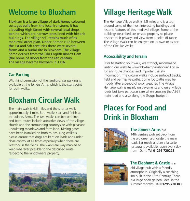
Welcome to BloxhamBloxham is a large village of dark honey colouredcottages built from the local ironstone. It hasa bustling High Street with several local shopsbehind which are narrow lanes lined with historicbuildings. The village still retains much of itsmedieval street plan. Under Roman rule betweenthe 1st and 5th centuries there were severalfarms and a burial site in Bloxham. The villagename derives from the Old English Blocc's Ham(the home of Blocc) from the 6th century.The village became Bloxham in 1316.
Village Heritage WalkThe Heritage Village walk is 1.5 miles and is a touraround some of the most interesting buildings andhistoric features of this medieval village. Some of thebuildings described are private property so pleaserespect their privacy and view from a polite distance.The Village Walk can be enjoyed on its own or as partof the Circular Walks.
Accessibility and TerrainPrior to starting your walk, we strongly recommendvisiting our website www.bloxhamparishcouncil.co.ukfor any route changes and important safetyinformation. The circular walks include surfaced tracks,field and permissive paths. Some footpaths may bemuddy after a period of poor weather. The VillageHeritage walk is mainly on pavements and quiet villageroads but take particular care when crossing the A361main road and also along the Goggs footpath.
Bloxham Circular WalkThe main walk is 4.5 miles and the shorter walkapproximately 1 mile. Both walks start and finish atthe Joiners Arms. The two walks can be combinedand both routes include attractive views of the villagechurch and the surrounding countryside with pleasantundulating meadows and farm land. Kissing gateshave been installed on both routes. Dog walkersplease ensure that dogs are kept on leads and underclose control at all times especially when there arelivestock in the fields. The walks are way marked sokeep wherever possible to the described routerespecting the landowner’s property.
Car ParkingWith kind permission of the landlord, car parking isavailable at the Joiners Arms which is the start pointfor both walks.
Places for Food andDrink in Bloxham
The Joiners Arms is a14th century pub set back fromthe old green alongside the mainroad. Bar meals and an a la carterestaurant available, open every dayfrom 10am. Tel 01295 720223.
The Elephant & Castle is anold village pub with a friendlyatmosphere. Originally a coachinginn built in the 15th Century. Thereis a large open garden, ideal in thesummer months. Tel 01295 720383.

About BloxhamWelcome to Bloxham, a village with considerableheritage and fine architecture including a splendid14th century church. Following on from theRomano British settlers the Anglo Saxonsestablished the site of the modern village onthe valley slopes of the Sor Brook tributary.
To a large extent Bloxham retains its medieval streetplan. This was extremely irregular and consisted of anetwork of winding streets or alleys. The Domesdaysurvey of 1086 recorded the village as having six millsand trading in wool and corn. After the NormanConquest, Bloxham continued to expand and at thistime, the north and south of the village were quiteseparate. All roads into Bloxham were gated until1802 and travellers were required to pay a toll toenter the village.
The row of 8 cottages in Kings Road including onewith a thatched roof are among the earliest and leastaltered. They are two storied, built of coursedironstone rubble, and have a number of originalstone-mullioned windows in moulded frames withsquare moulded labels over them. Campbell Cottagein Workhouse Lane and the cottage opposite aregood examples of the period; so also is the endcottage in Sycamore Terrace. This last house and therest of the terrace were used as weavers' cottagesin the 19th century. In 1956 they were completelymodernised.
The 19th century saw the demolition of institutionsfor the poor such as the Almshouses next to theparish church, the Workhouse, the pest house andthe poor houses on the green.

The main road was straightened in 1815 when thetrustees of the Banbury and Chipping Norton turnpikepurchased two cottages on the brook in order to alterthe tortuous line of the old road. It originally turnedleft at the church, passed along Unicorn Street, andcame out by the Green. It then ran down Old BridgeStreet to the Great Bridge and on to the ‘Elephant andCastle’, where it again turned left to join the presentstretch, of the main road.
The Church of England parish church of St Mary’s isone of the grandest in England. Its 14th century towerand spire is a local landmark. The church tower has aring of eight bells including one cast in about 1570and a tenor bell cast in 1648.
The village Pest House where inmates with highlyinfectious diseases were isolated was situated by theSlade Nature Reserve. Public contact was not allowedand a pedestal stone with a hollow top was filled withvinegar. Inmates left money in the vinegar (thought tobe a disinfectant) in exchange for food left nearby byfriends and relatives. It was in use from 1765 andeventually abandoned in 1890.The principal road inthe parish is a route of historic importance for it ranfrom Banbury to Chipping Norton and the wealthywool producing area of the Cotswolds where somehouses retain a mediaeval core. Bloxham containsa large number of well-built yeoman’s houses datingfrom this period. Many have been comparatively littlealtered, retaining their original details and plans.
About Bloxham continued
Village WalkPoints of Interest
Hand Pump. Prior to 1908 whenmains water was introduced,villagers without their own watersupply depended upon publicpumps. Fortunately Bloxham hada plentiful supply of wells, springsand village ponds and pumps were
installed around the village. One of the remaining handpumps is located close to the New Bridge (completedin 1855) adjacent to the Red Lion. Nearby was an oldcommunity laundry where the women came to do theirwashing on a large flat stone. Later the pump hadmany uses for the supply of water for cattle and forsteam traction engines as well as washing sheep.
St Marys Church. One of the manyhighlights of St Mary's is the superb198 foot tall spire, a local landmarkand claimed to be the tallest inOxfordshire, pinpointing the villagefor miles around. The church is anexcellent example of Decorated Gothic
style. Parts of St Mary's date back to the 12th century, butmost of the current building dates to the 14th and 15thcenturies. Over the west door of the tower is a carving ofthe Last Judgment. The doorway itself is heavily carved,with depictions of animals, foliage, birds, beak heads,and traditional ballflower ornamentation. There is a 12thcentury doorway, reset in the north wall of the chancel.
Alongside St Mary’s churchyard is the Court House,rebuilt in the 1680s and retaining some 14th centurydetails. Over the years the property has had many usesincluding an infant’s school, a soup house and in 1879 thedownstairs area became a fire station. The Court Houseis now Bloxham Museum and the old fire enginepurchased in 1749 is on display. Bloxham Museum is openat weekends and bank holidays from April to October.For more information and to check opening times visitwww.bloxhammuseum.com.
Sycamore Terrace, originally ayeoman’s house was subdivided intoa row of thatched cottages whereweavers lived and worked. Theterrace has a long history datingback to the 8th century when yarnwas delivered from Banbury and
collected from the weavers once woven into cloth. Thelooms were on the second floor above the bedrooms.In 1838 it was recorded that a man working nine andhalf hours a day, 6 days a week could weave 44 yardsof cloth a month, for which he received £3.
Bloxham Gasworks. Situated by the bridge inCumberford Hill is the site of Bloxham Gasworks(1869) which had its own gasometer. In 1870,
14 standard lamps and 9 bracket lamps lit the village.No light was allowed 4 nights before and 4 nightsafter a full moon. In December of 1905 the managerunfortunately blew himself up while inspecting a faultymeter. By 1908 the Bucks and Oxon Gas Companyowned the site and began promoting the use of gasfor cooking with a display of gas cookers and cookerydemonstrations. The original lamps were converted toelectricity in 1937.
The Old Jail located at the cornerof Workhouse Lane and CourtingtonLane was the most secure 18thcentury building available with ironbars at the windows. It housedfelons prior to their appearancein front of his Lordship Bloxham
Beauchamp at the Court House. It later became a barnbefore conversion into a dwelling.
A
B
C
D
E

Village WalkPoints of Interest continued
Park Close is said to be the site of theBeauchamp Manor House. When Edwin Earl ofMercia rebelled against William he forfeited his
lands to the king and Bloxham became a Royal Manor.In 1156 it was divided into two manor houses. Later,with the growth of the wool trade the site was acquiredby Sir Thomas Garaway who rebuilt a fine 17thcentury house, later remodelled in the 19th century.Oriel Cottage the site of Old Workhouse housed24 inmates as recorded by the master in 1736.The adjoining cottage on the north side is reputedto have been the workhouse infirmary and mortuary.The Old Co-op Hall (red brick building) was the firstvillage hall built in 1899 by the Co-operative Society andused as a social centre. The first recorded committeemeeting was held in 1902.
Bloxham School, formally All SaintsSchool in the north of the village wasfounded in 1853 by Philip ReginaldEgerton, a local curate. The mainschool building, designed by GeorgeEdmund Street is neo-gothic style.It was largely funded by Egerton’s
wealthy wife, Harriet, and had the backing of severalnotable academics and clergymen. In the public schooltradition, the school initially provided education for middleclass boys, although classics was originally not widelytaught. Bloxham's first non-clergy headmaster was notappointed until 1925.Like many public schools, Bloxhamsuffered disproportionately high casualties during theFirst World War. Girls started to be admitted into the sixthform in small numbers in the early 1970s and the schoolbecame fully co-educational in 1998. Bloxham School hasgrounds which cover approximately 60 acres in the villageof Bloxham.
The Elephant and Castle is a 15thcentury coaching inn. The main routefor horse drawn traffic ran throughthe archway before continuingnorthwards. It is believed that therewas a toll house under the arch at onetime. After long journeys, passengers
rested for refreshment at the inn while horses werechanged. This created a hive of local industry and closeto the archway several trades operated including ablacksmith, wheelwright and a cooper. The wheelwrightwas Charlie Taylor who kept the Elephant and Castle:a landlord was not allowed to earn a living from the innalone and often had another occupation.
Ellen Hinde Hall, built by daughterof the founder and first headmasterof All Saints School initially as amemorial to her son who foughtin the First World War. Ellen Hindepromised to give the hall to thevillage ex-servicemen but later
changed her mind. After her death in 1943, the hallwas given to the village by her son and daughter.It is currently used mainly as a sports hall.
G
H
I
F
The Slade Nature ReserveAt the South-west corner of the village and close to thenow disused railway line is the Slade Nature Reserve.Despite its small size (2.2 acres) it has supported a largediversity of habitats. The reserve is partly wooded,marshy with rich flora and fauna including CommonSpotted Orchids and Ragged Robin. The stream flowingthrough the reserve is lined with pollarded WhiteWillows. On the south edge many bird species havebeen recorded including Sparrow Hawks and all threespecies of British Woodpeckers. Refer to the CircularWalk instruction for access information.
A
E
F
G
B
C
D
B
C
Quarry(dis)
ParkFarm
FirsHill
HobbHill
Resr Golf DrivingRange
Bloxham
Playing
Fields
WoollenHale
Sch
Firs HillFarm
Tadmarton Road
Ell’s Lane
The Slade
Recn Gd
A361
Oak Tree
Tadmarton HouseFarm
NaylandFarm
EllsFarm
Sch
Yew TreePiggeries
Coate’s Spinney
ManorHouseFarm
SewageWorks
Public Paths
Permissive Paths
Disused Rail Track
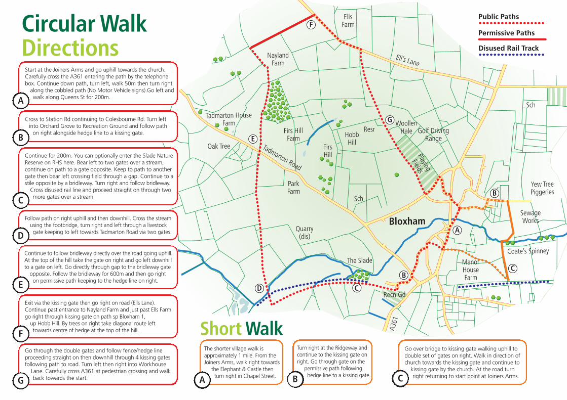
Circular WalkDirections
Exit via the kissing gate then go right on road (Ells Lane).Continue past entrance to Nayland Farm and just past Ells Farmgo right through kissing gate on path sp Bloxham 1,up Hobb Hill. By trees on right take diagonal route lefttowards centre of hedge at the top of the hill.F
Start at the Joiners Arms and go uphill towards the church.Carefully cross the A361 entering the path by the telephonebox. Continue down path, turn left, walk 50m then turn rightalong the cobbled path (No Motor Vehicle signs).Go left andwalk along Queens St for 200m.A
Cross to Station Rd continuing to Colesbourne Rd. Turn leftinto Orchard Grove to Recreation Ground and follow pathon right alongside hedge line to a kissing gate.
B
The shorter village walk isapproximately 1 mile. From theJoiners Arms, walk right towards
the Elephant & Castle thenturn right in Chapel Street.A
Turn right at the Ridgeway andcontinue to the kissing gate onright. Go through gate on the
permissive path followinghedge line to a kissing gate.B
Go over bridge to kissing gate walking uphill todouble set of gates on right. Walk in direction ofchurch towards the kissing gate and continue tokissing gate by the church. At the road turnright returning to start point at Joiners Arms.C
Continue for 200m. You can optionally enter the Slade NatureReserve on RHS here. Bear left to two gates over a stream,continue on path to a gate opposite. Keep to path to anothergate then bear left crossing field through a gap. Continue to astile opposite by a bridleway. Turn right and follow bridleway.Cross disused rail line and proceed straight on through twomore gates over a stream.C
Follow path on right uphill and then downhill. Cross the streamusing the footbridge, turn right and left through a livestockgate keeping to left towards Tadmarton Road via two gates.D
Continue to follow bridleway directly over the road going uphill.At the top of the hill take the gate on right and go left downhillto a gate on left. Go directly through gap to the bridleway gateopposite. Follow the bridleway for 600m and then go righton permissive path keeping to the hedge line on right. E
Go through the double gates and follow fence/hedge lineproceeding straight on then downhill through 4 kissing gatesfollowing path to road. Turn left then right into WorkhouseLane. Carefully cross A361 at pedestrian crossing and walkback towards the start. G
Short Walk
Village WalkDirections
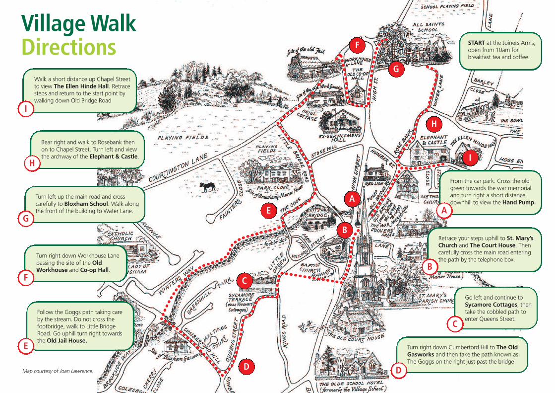
Walk a short distance up Chapel Streetto view The Ellen Hinde Hall. Retracesteps and return to the start point bywalking down Old Bridge Road
Bear right and walk to Rosebank thenon to Chapel Street. Turn left and viewthe archway of the Elephant & Castle.
Turn left up the main road and crosscarefully to Bloxham School. Walk alongthe front of the building to Water Lane.
Turn right down Workhouse Lanepassing the site of the OldWorkhouse and Co-op Hall.
Follow the Goggs path taking careby the stream. Do not cross thefootbridge, walk to Little BridgeRoad. Go uphill turn right towardsthe Old Jail House.
START at the Joiners Arms,open from 10am forbreakfast tea and coffee.
From the car park. Cross the oldgreen towards the war memorialand turn right a short distancedownhill to view the Hand Pump.
Retrace your steps uphill to St. Mary’sChurch and The Court House. Thencarefully cross the main road enteringthe path by the telephone box.
Go left and continue toSycamore Cottages, thentake the cobbled path toenter Queens Street.
Turn right down Cumberford Hill to The OldGasworks and then take the path known asThe Goggs on the right just past the bridge
I
H
G
F
E
D
C
B
AA
B
C
D
E
F
G
H
I
Map courtesy of Joan Lawrence.