· land and acres of agricultural land vulnerable to leaching and runoff (ceap soil vulnerability...
TRANSCRIPT
1
Attachment A
Guidance for State Selection of FY 2013 Watersheds and Submission to NHQ
States are required to work with their respective State water quality agency and their respective State Technical Committees in the watershed selection process. State water quality agencies (including drinking water source protection agencies and programs) have important expertise in identifying water quality concerns and can contribute data, monitoring, watershed planning and technical assistance resources to projects in NWQI watersheds. State source water protection coordinators have information about drinking water protection areas as well as other data. States must select appropriate watersheds based upon several resource factors provided by NHQ.
Working with these groups, States will identify one to three watersheds to which they will dedicate the percentage of EQIP funds outlined in their State budget allocation guidance documents. These selections must be completed and the FY 2013 NWQI Access form completed by COB Friday, March 15, 2013.
To assist States with the identification of focus watersheds, NHQ has posted documents to the Regional Conservationists’ National Water Quality Initiative SharePoint site at https://nrcs.sc.egov.usda.gov/orc/nwqi. These documents list HUC 12-digit watersheds with 303(d) impairments related to nutrients (including algal growth, low DO, and ammonia), sediment (including turbidity), and pathogens for each State. The lists will include a count of 303(d)-impaired waters and the specific sources of impairment for each watershed. The 303(d) data is provided by EPA to the RAD GIS Lab, in NHQ, for assembly and provision to the States. In addition, the RAD GIS Lab can provide other information on the total acres of agricultural land and acres of agricultural land vulnerable to leaching and runoff (CEAP soil vulnerability layer) in each 12HUC. This additional information is to be used to support the appropriate EPA 303-listed stream impairments information provided, which may be of assistance in collaborating with State Water Quality Agencies and State Technical Committees.
Other factors that should be considered in the selection of priority watersheds include USGS SPARROW model data, CEAP data, other NRCS initiatives, current projects, staffing, State resource assessments, State source water assessments and protection plans, State and local watershed management plans, existing monitoring efforts, and available data.
States should emphasize nutrients (e.g., low DO, ammonia, algal growth, and chlorophyll-A), sediment (including turbidity), and pathogens (related to animal agriculture) in this initiative, which is also reflected in the approved primary resource concerns. NRCS and collaborating agencies have targeted these impairments for the initiative.
Additional information to help in the selection of priority watersheds may be viewed on the EPA Web site at http://iaspub.epa.gov/waters10/attains_nation_cy.control?p_report_type=T On the EPA Web site, the user will be prompted to select the appropriate State and should then select “Impaired Water Reports.” Maps, impairments, etc., are available for viewing at this site; however, it should be noted that the names of bodies of water will not always match up with the “HUC12_Name” from the “National Water Quality Initiative (NWQI) Information Support Table.” In some States, the viewer must select “Assessed Water Reports” to view a map. Note
2
that the information bar on the right of this page links to EnviroMapper, from which the user can access surface and ground water sources of drinking water by clicking on the “Drinking Water Information” button and selecting a location.
When there is a choice among recommended watersheds that meet the resource considerations described above, States are strongly encouraged to select contiguous 12-digit HUCs where feasible. In States with a low number of farms and ranches vis-a-vis available funds, the STC may request a waiver from the Regional Conservationist to add additional contiguous 12-digit HUCs. In States with few landowners within individual 12-digit HUCs, States may request a waiver to select one 10-digit HUC where successful outcomes at the 10-digit scale have been identified in lieu of three 12-digit HUCs.
The results of this selection process will provide for a listing of focus watersheds where state and local partners and the NRCS State Conservationist believe NRCS can have an impact on reducing any negative agricultural water quality impacts through a focused EQIP implementation.
Watersheds should be evaluated on an annual basis (see Attachment F, “National Water Quality Initiative Outcomes”) for progress in utilizing funds, implementing core conservation practices, and partner assistance. If a watershed is not meeting expectations, it may be necessary to discontinue initiative financial assistance for new EQIP contracts under NWQI and approve new watersheds. These adjustments will be considered by the Regional Conservationists on a case-by-case basis as requested and justified by the State Conservationists.
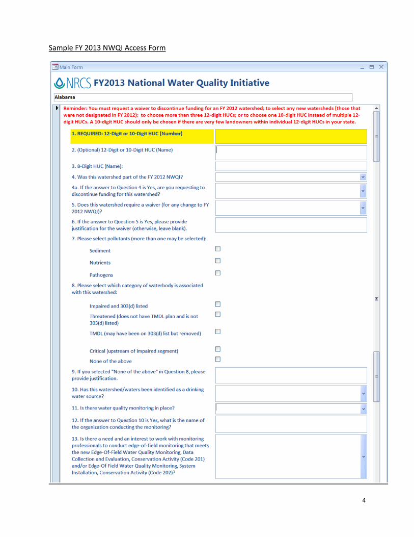
Common Terms Used by EPA can be found at: http://water.epa.gov/lawsregs/lawsguidance/cwa/tmdl/glossary.cfm http://www.epa.gov/reg3wapd/tmdl/ChesapeakeBay/primer.html http://www.sourcewatercollaborative.org/swp-usda/ Instructions for accessing and filling out the FY 2013 NWQI Access Form State Conservationists should use the FY 2013 NWQI Access Form to submit selected watersheds and other requested information to NHQ. Space is available in the form to write justifications for discontinuing funding for FY 2012 watersheds; for selecting additional 12-digit HUCs or one 10-digit HUC; and/or non-303(d) listed watersheds. Note: You must fill out the form for all FY 2012 watersheds, including those you are proposing to discontinue, in addition to watersheds you may be requesting to add in FY 2013. 1. Find the Microsoft Access file, titled “FY13 NWQI,” on the SharePoint and save it to your
desktop. (https://nrcs.sc.egov.usda.gov/orc/nwqi/Shared%20Documents/Forms/AllItems.aspx).
2. Open the file from your desktop. 3. Select your State in the first window that opens and click “Go to Form.” 4. Fill out the form according to the instructions. Note: You MUST enter a 12-digit (or 10-digit)
HUC in order to save your information and to add additional watersheds.
3
5. After you have entered one HUC, you can add another watershed by clicking the right arrow button next to “Record” at the bottom of the form.
6. When you are finished entering data, click “Save and Close” and then “Exit.” As long as you have entered a HUC, your data will be saved on the SharePoint.
7. You may edit your data at any point up until the submission deadline of March 15, 2013. 8. To delete a watershed that you’ve already entered, click “Delete Watershed” at the bottom
of the form. 9. If you need assistance with using the form, or please contact Meghan Wilson at
[email protected] or (202) 690-2191.
4
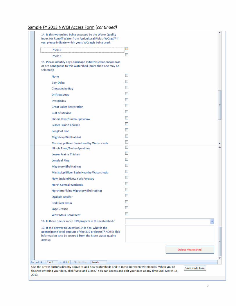
Sample FY 2013 NWQI Access Form
5
Sample FY 2013 NWQI Access Form (continued)
6
Justification to Add Supporting Practices
States adding supporting practices must complete the following justification and submit it to Meghan Wilson ([email protected]) by March 15, 2013.
Justification for additional supporting practices to be offered in State to support FY 2013 NWQI:
Instructions: Select the practice code, practice name below and enter justification why supporting practice is needed. Name of State =>
Req No
Prac Code (Select
from List)
Practice Name (Select from list)
Justification for waiver to add supporting practice. Note: Additional suggested supporting practices must also have a practice standard purpose consistent with the identified resource concerns approved for WQI. Requests for supporting practices will not be approved if the practice is not associated with one of the approved resource concerns in the national CPPE for WQI as shown on Attachment C of the FY 2013 Bulletin.
1
2
3
4
5
Example:
1 328
Conservation Crop Rotation (Ac.) (328) (5/11)
This practice is needed to address the typical resource concerns associated with water quality issues on cropland within 303(d)-listed watershed. The practice completes the typical system of practices such as cover crop and residue management needed to reduce impact of nutrient application and runoff.
7
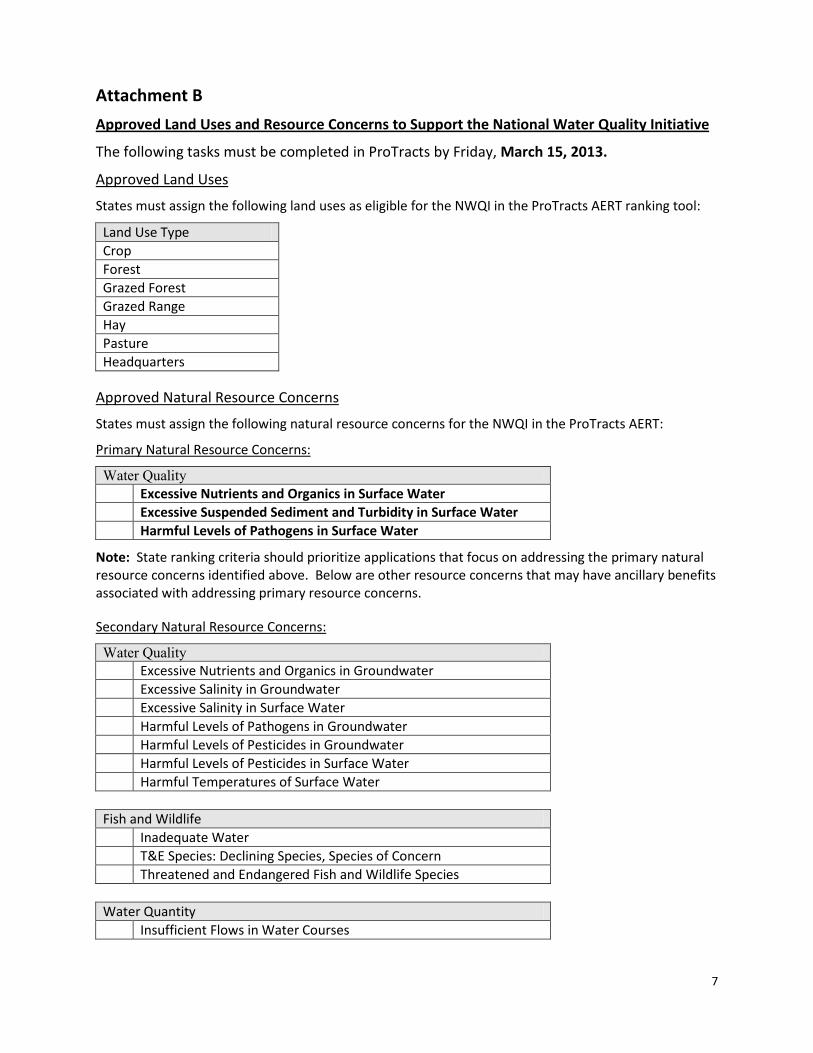
Attachment B
Approved Land Uses and Resource Concerns to Support the National Water Quality Initiative
The following tasks must be completed in ProTracts by Friday, March 15, 2013.
Approved Land Uses
States must assign the following land uses as eligible for the NWQI in the ProTracts AERT ranking tool:
Land Use Type Crop Forest Grazed Forest Grazed Range Hay Pasture Headquarters
Approved Natural Resource Concerns
States must assign the following natural resource concerns for the NWQI in the ProTracts AERT:
Primary Natural Resource Concerns:
Water Quality Excessive Nutrients and Organics in Surface Water Excessive Suspended Sediment and Turbidity in Surface Water Harmful Levels of Pathogens in Surface Water
Note: State ranking criteria should prioritize applications that focus on addressing the primary natural resource concerns identified above. Below are other resource concerns that may have ancillary benefits associated with addressing primary resource concerns.
Secondary Natural Resource Concerns:
Water Quality Excessive Nutrients and Organics in Groundwater Excessive Salinity in Groundwater Excessive Salinity in Surface Water Harmful Levels of Pathogens in Groundwater Harmful Levels of Pesticides in Groundwater Harmful Levels of Pesticides in Surface Water Harmful Temperatures of Surface Water
Fish and Wildlife Inadequate Water T&E Species: Declining Species, Species of Concern Threatened and Endangered Fish and Wildlife Species
Water Quantity Insufficient Flows in Water Courses
8
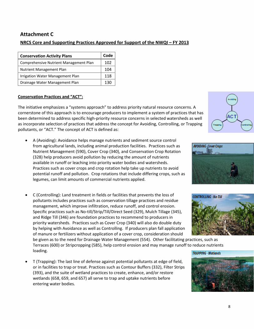
Attachment C NRCS Core and Supporting Practices Approved for Support of the NWQI – FY 2013
Conservation Activity Plans Code
Comprehensive Nutrient Management Plan 102
Nutrient Management Plan 104 Irrigation Water Management Plan 118 Drainage Water Management Plan 130
Conservation Practices and “ACT”:
The initiative emphasizes a “systems approach” to address priority natural resource concerns. A cornerstone of this approach is to encourage producers to implement a system of practices that has been determined to address specific high-priority resource concerns in selected watersheds as well as incorporate selection of practices that address the concept for Avoiding, Controlling, or Trapping pollutants, or “ACT.” The concept of ACT is defined as:
• A (Avoiding): Avoidance helps manage nutrients and sediment source control from agricultural lands, including animal production facilities. Practices such as Nutrient Management (590), Cover Crop (340), and Conservation Crop Rotation (328) help producers avoid pollution by reducing the amount of nutrients available in runoff or leaching into priority water bodies and watersheds. Practices such as cover crops and crop rotation help take up nutrients to avoid potential runoff and pollution. Crop rotations that include differing crops, such as legumes, can limit amounts of commercial nutrients applied.
• C (Controlling): Land treatment in fields or facilities that prevents the loss of pollutants includes practices such as conservation tillage practices and residue management, which improve infiltration, reduce runoff, and control erosion. Specific practices such as No-till/Strip/Till/Direct Seed (329), Mulch Tillage (345), and Ridge Till (346) are foundation practices to recommend to producers in priority watersheds. Practices such as Cover Crop (340) will also do double duty by helping with Avoidance as well as Controlling. If producers plan fall application of manure or fertilizers without application of a cover crop, consideration should be given as to the need for Drainage Water Management (554). Other facilitating practices, such as Terraces (600) or Stripcropping (585), help control erosion and may manage runoff to reduce nutrients loading.
• T (Trapping): The last line of defense against potential pollutants at edge of field, or in facilities to trap or treat. Practices such as Contour Buffers (332), Filter Strips (393), and the suite of wetland practices to create, enhance, and/or restore wetlands (658, 659, and 657) all serve to trap and uptake nutrients before entering water bodies.
9
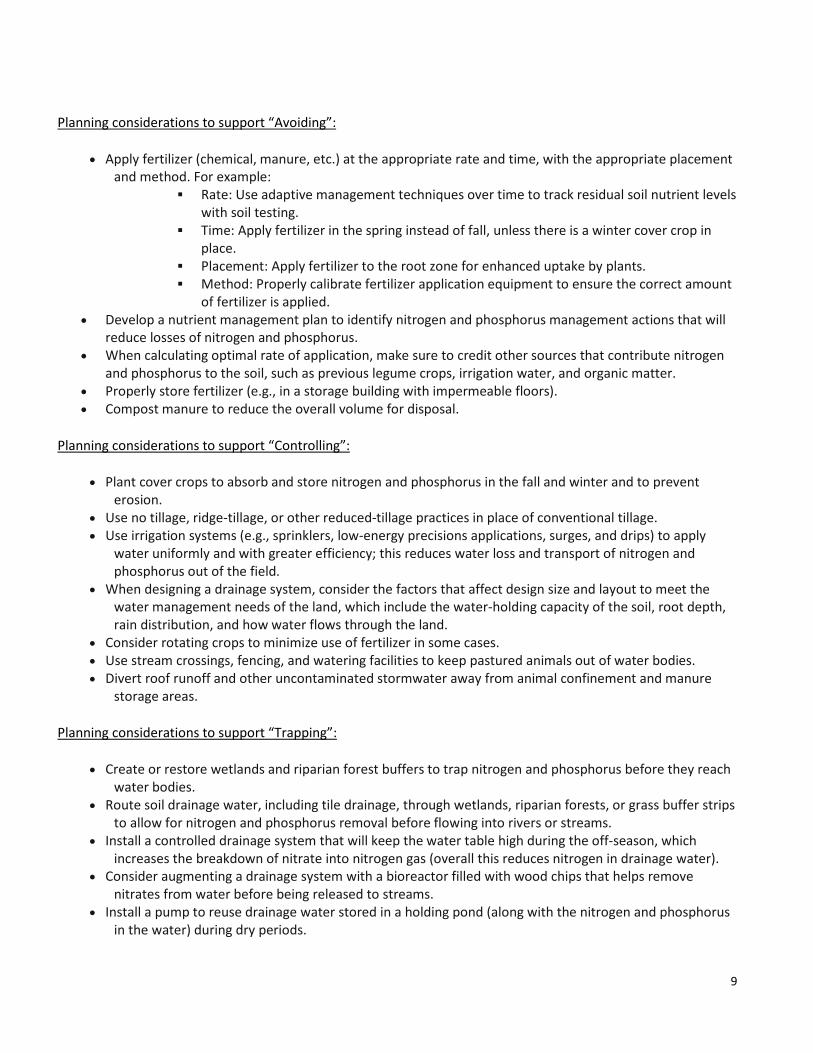
Planning considerations to support “Avoiding”:
• Apply fertilizer (chemical, manure, etc.) at the appropriate rate and time, with the appropriate placement and method. For example:
Rate: Use adaptive management techniques over time to track residual soil nutrient levels with soil testing.
Time: Apply fertilizer in the spring instead of fall, unless there is a winter cover crop in place.
Placement: Apply fertilizer to the root zone for enhanced uptake by plants. Method: Properly calibrate fertilizer application equipment to ensure the correct amount
of fertilizer is applied. • Develop a nutrient management plan to identify nitrogen and phosphorus management actions that will
reduce losses of nitrogen and phosphorus. • When calculating optimal rate of application, make sure to credit other sources that contribute nitrogen
and phosphorus to the soil, such as previous legume crops, irrigation water, and organic matter. • Properly store fertilizer (e.g., in a storage building with impermeable floors). • Compost manure to reduce the overall volume for disposal.
Planning considerations to support “Controlling”:
• Plant cover crops to absorb and store nitrogen and phosphorus in the fall and winter and to prevent erosion.
• Use no tillage, ridge-tillage, or other reduced-tillage practices in place of conventional tillage. • Use irrigation systems (e.g., sprinklers, low-energy precisions applications, surges, and drips) to apply
water uniformly and with greater efficiency; this reduces water loss and transport of nitrogen and phosphorus out of the field.
• When designing a drainage system, consider the factors that affect design size and layout to meet the water management needs of the land, which include the water-holding capacity of the soil, root depth, rain distribution, and how water flows through the land.
• Consider rotating crops to minimize use of fertilizer in some cases. • Use stream crossings, fencing, and watering facilities to keep pastured animals out of water bodies. • Divert roof runoff and other uncontaminated stormwater away from animal confinement and manure
storage areas.
Planning considerations to support “Trapping”:
• Create or restore wetlands and riparian forest buffers to trap nitrogen and phosphorus before they reach water bodies.
• Route soil drainage water, including tile drainage, through wetlands, riparian forests, or grass buffer strips to allow for nitrogen and phosphorus removal before flowing into rivers or streams.
• Install a controlled drainage system that will keep the water table high during the off-season, which increases the breakdown of nitrate into nitrogen gas (overall this reduces nitrogen in drainage water).
• Consider augmenting a drainage system with a bioreactor filled with wood chips that helps remove nitrates from water before being released to streams.
• Install a pump to reuse drainage water stored in a holding pond (along with the nitrogen and phosphorus in the water) during dry periods.
10
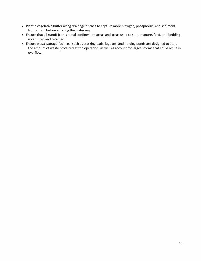
• Plant a vegetative buffer along drainage ditches to capture more nitrogen, phosphorus, and sediment from runoff before entering the waterway.
• Ensure that all runoff from animal confinement areas and areas used to store manure, feed, and bedding is captured and retained.
• Ensure waste storage facilities, such as stacking pads, lagoons, and holding ponds are designed to store the amount of waste produced at the operation, as well as account for larges storms that could result in overflow.
11
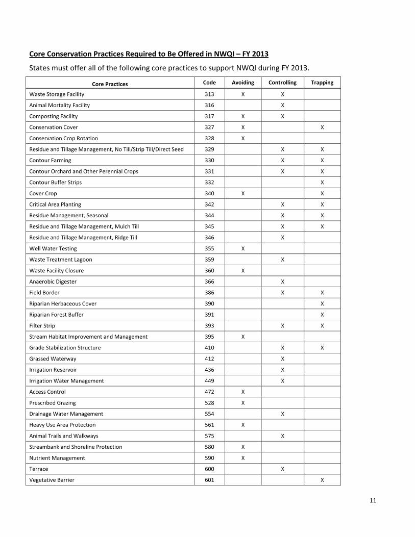
Core Conservation Practices Required to Be Offered in NWQI – FY 2013
States must offer all of the following core practices to support NWQI during FY 2013.
Core Practices Code Avoiding Controlling Trapping
Waste Storage Facility 313 X X
Animal Mortality Facility 316 X
Composting Facility 317 X X
Conservation Cover 327 X X
Conservation Crop Rotation 328 X
Residue and Tillage Management, No Till/Strip Till/Direct Seed 329 X X
Contour Farming 330 X X
Contour Orchard and Other Perennial Crops 331 X X
Contour Buffer Strips 332 X
Cover Crop 340 X X
Critical Area Planting 342 X X
Residue Management, Seasonal 344 X X
Residue and Tillage Management, Mulch Till 345 X X
Residue and Tillage Management, Ridge Till 346 X
Well Water Testing 355 X
Waste Treatment Lagoon 359 X
Waste Facility Closure 360 X
Anaerobic Digester 366 X
Field Border 386 X X
Riparian Herbaceous Cover 390 X
Riparian Forest Buffer 391 X
Filter Strip 393 X X
Stream Habitat Improvement and Management 395 X
Grade Stabilization Structure 410 X X
Grassed Waterway 412 X
Irrigation Reservoir 436 X
Irrigation Water Management 449 X
Access Control 472 X
Prescribed Grazing 528 X
Drainage Water Management 554 X
Heavy Use Area Protection 561 X
Animal Trails and Walkways 575 X
Streambank and Shoreline Protection 580 X
Nutrient Management 590 X
Terrace 600 X
Vegetative Barrier 601 X
12
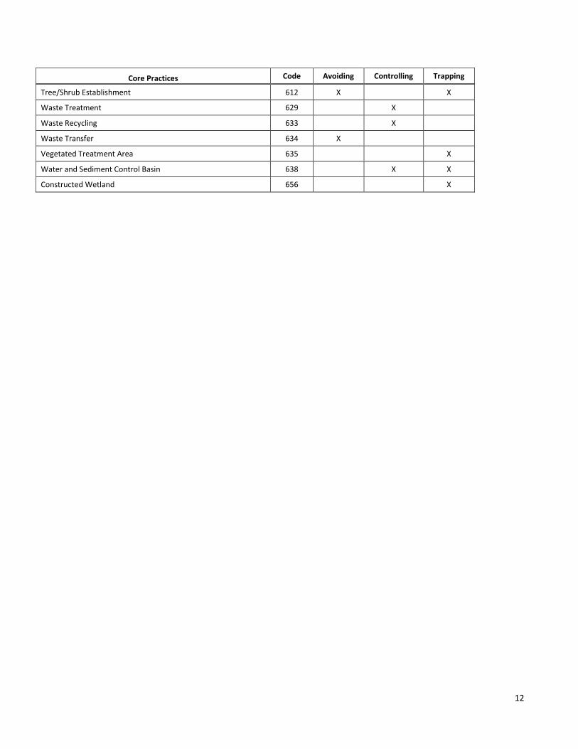
Core Practices Code Avoiding Controlling Trapping
Tree/Shrub Establishment 612 X X
Waste Treatment 629 X
Waste Recycling 633 X
Waste Transfer 634 X
Vegetated Treatment Area 635 X
Water and Sediment Control Basin 638 X X
Constructed Wetland 656 X
13
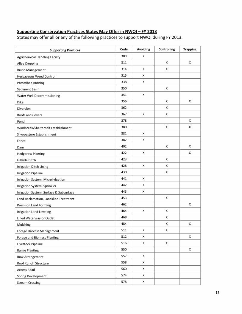
Supporting Conservation Practices States May Offer in NWQI – FY 2013 States may offer all or any of the following practices to support NWQI during FY 2013.
Supporting Practices Code Avoiding Controlling Trapping
Agrichemical Handling Facility 309 X
Alley Cropping 311 X X
Brush Management 314 X X
Herbaceous Weed Control 315 X
Prescribed Burning 338 X
Sediment Basin 350 X
Water Well Decommissioning 351 X
Dike 356 X X
Diversion 362 X
Roofs and Covers 367 X X
Pond 378 X
Windbreak/Shelterbelt Establishment 380 X X
Silvopasture Establishment 381 X
Fence 382 X
Dam 402 X X
Hedgerow Planting 422 X X
Hillside Ditch 423 X
Irrigation Ditch Lining 428 X X
Irrigation Pipeline 430 X
Irrigation System, Microirrigation 441 X
Irrigation System, Sprinkler 442 X
Irrigation System, Surface & Subsurface 443 X
Land Reclamation, Landslide Treatment 453 X
Precision Land Forming 462 X
Irrigation Land Leveling 464 X X
Lined Waterway or Outlet 468 X
Mulching 484 X X
Forage Harvest Management 511 X X
Forage and Biomass Planting 512 X X
Livestock Pipeline 516 X X
Range Planting 550 X
Row Arrangement 557 X
Roof Runoff Structure 558 X
Access Road 560 X
Spring Development 574 X
Stream Crossing 578 X
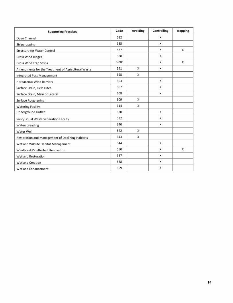
14
Supporting Practices Code Avoiding Controlling Trapping
Open Channel 582 X
Stripcropping 585 X
Structure for Water Control 587 X X
Cross Wind Ridges 588 X
Cross Wind Trap Strips 589C X X
Amendments for the Treatment of Agricultural Waste 591 X X
Integrated Pest Management 595 X
Herbaceous Wind Barriers 603 X
Surface Drain, Field Ditch 607 X
Surface Drain, Main or Lateral 608 X
Surface Roughening 609 X
Watering Facility 614 X
Underground Outlet 620 X
Solid/Liquid Waste Separation Facility 632 X
Waterspreading 640 X
Water Well 642 X
Restoration and Management of Declining Habitats 643 X
Wetland Wildlife Habitat Management 644 X
Windbreak/Shelterbelt Renovation 650 X X
Wetland Restoration 657 X
Wetland Creation 658 X
Wetland Enhancement 659 X
15
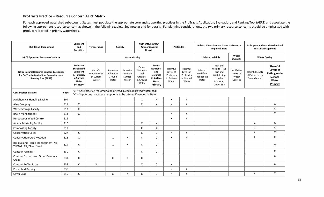
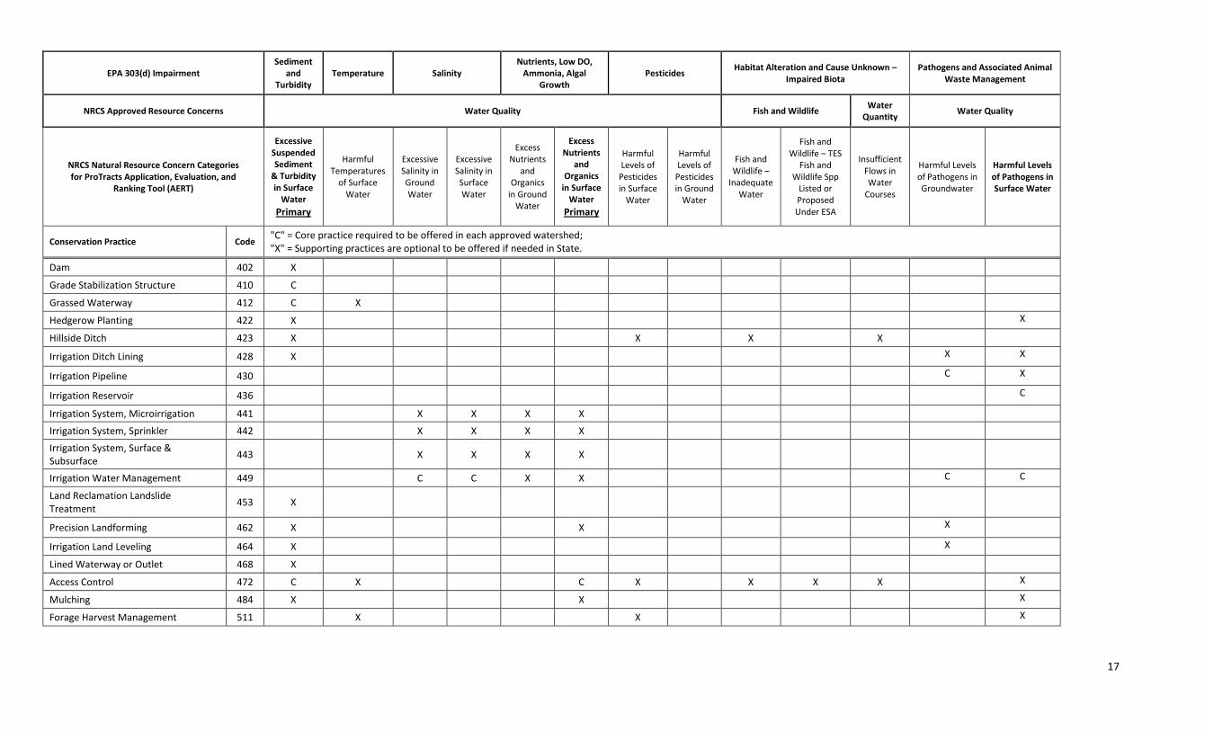
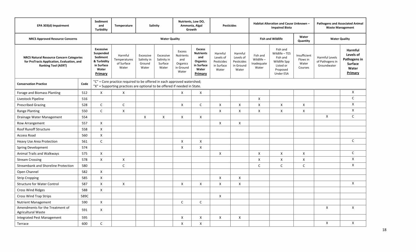
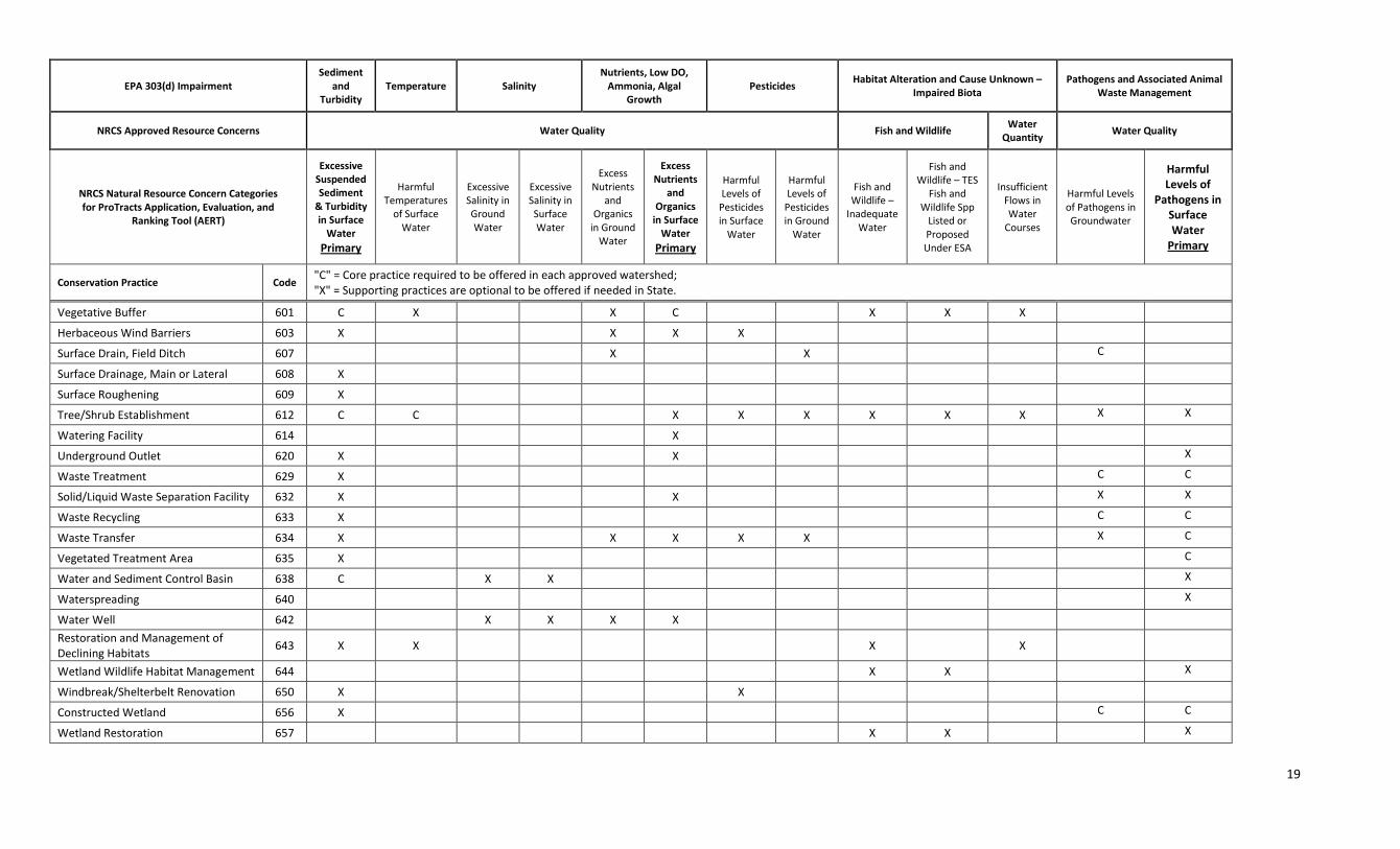
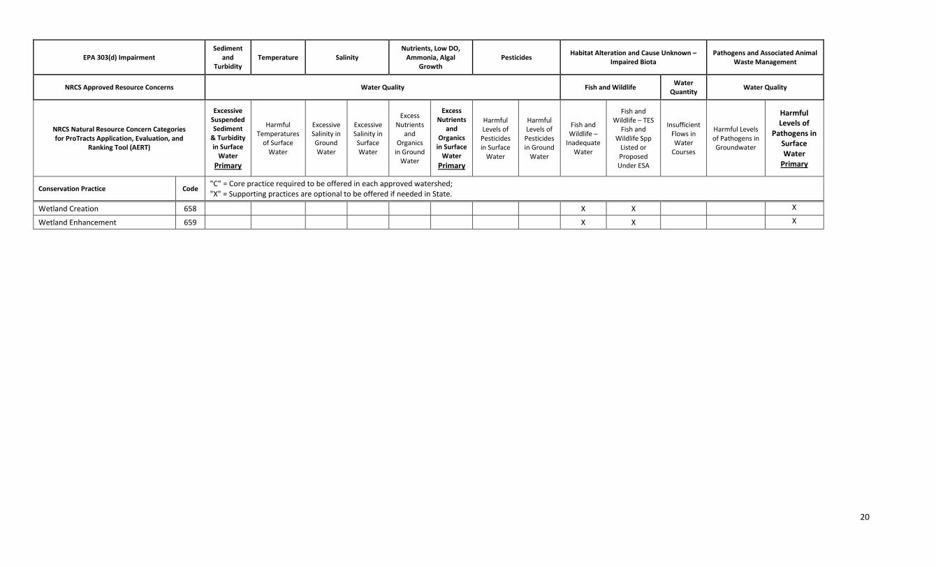
ProTracts Practice – Resource Concern AERT Matrix
For each approved watershed subaccount, States must populate the appropriate core and supporting practices in the ProTracts Application, Evaluation, and Ranking Tool (AERT) and associate the following appropriate resource concern as shown in the following tables. See note at end for details. For planning considerations, the two primary resource concerns should be emphasized with producers located in priority watersheds.
EPA 303(d) Impairment Sediment
and Turbidity
Temperature Salinity Nutrients, Low DO,
Ammonia, Algal Growth
Pesticides Habitat Alteration and Cause Unknown –
Impaired Biota Pathogens and Associated Animal
Waste Management
NRCS Approved Resource Concerns Water Quality Fish and Wildlife Water
Quantity Water Quality
NRCS Natural Resource Concern Categories for ProTracts Application, Evaluation, and
Ranking Tool (AERT)
Excessive Suspended Sediment
& Turbidity in Surface
Water Primary
Harmful Temperatures
of Surface Water
Excessive Salinity in Ground Water
Excessive Salinity in Surface Water
Excess Nutrients
and Organics
in Ground Water
Excess Nutrients
and Organics
in Surface Water
Primary
Harmful Levels of
Pesticides in Surface
Water
Harmful Levels of
Pesticides in Ground
Water
Fish and Wildlife –
Inadequate Water
Fish and Wildlife – TES
Fish and Wildlife Spp
Listed or Proposed Under ESA
Insufficient Flows in Water
Courses
Harmful Levels of Pathogens in Groundwater
Harmful Levels of
Pathogens in Surface Water
Primary
Conservation Practice Code "C" = Core practice required to be offered in each approved watershed; "X" = Supporting practices are optional to be offered if needed in State.
Agrichemical Handling Facility 309 X X X X
Alley Cropping 311 X X X X X X
Waste Storage Facility 313 X C C
Brush Management 314 X
X X
X
Herbaceous Weed Control 315
X X
Animal Mortality Facility 316
X X
C C
Composting Facility 317
X X
C C
Conservation Cover 327 C
C C X X
X X
Conservation Crop Rotation 328 X
X X C C X X
X X
Residue and Tillage Management, No Till/Strip Till/Direct Seed
329 C
X X C C
X
Contour Farming 330 C
C C
X
Contour Orchard and Other Perennial Crops
331 C
X X C C
X
Contour Buffer Strips 332 C X
X C X
X
Prescribed Burning 338
X X
Cover Crop 340 C
X X C C X X
X X
16
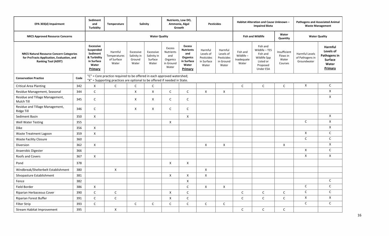
EPA 303(d) Impairment Sediment
and Turbidity
Temperature Salinity Nutrients, Low DO,
Ammonia, Algal Growth
Pesticides Habitat Alteration and Cause Unknown –
Impaired Biota Pathogens and Associated Animal
Waste Management
NRCS Approved Resource Concerns Water Quality Fish and Wildlife Water
Quantity Water Quality
NRCS Natural Resource Concern Categories for ProTracts Application, Evaluation, and
Ranking Tool (AERT)
Excessive Suspended Sediment
& Turbidity in Surface
Water Primary
Harmful Temperatures
of Surface Water
Excessive Salinity in Ground Water
Excessive Salinity in Surface Water
Excess Nutrients
and Organics
in Ground Water
Excess Nutrients
and Organics
in Surface Water
Primary
Harmful Levels of
Pesticides in Surface
Water
Harmful Levels of
Pesticides in Ground
Water
Fish and Wildlife –
Inadequate Water
Fish and Wildlife – TES
Fish and Wildlife Spp
Listed or Proposed Under ESA
Insufficient Flows in Water
Courses
Harmful Levels of Pathogens in Groundwater
Harmful Levels of
Pathogens in Surface Water
Primary
Conservation Practice Code "C" = Core practice required to be offered in each approved watershed; "X" = Supporting practices are optional to be offered if needed in State.
Critical Area Planting 342 X C C C C C C X C
Residue Management, Seasonal 344 C X X C C X X X
Residue and Tillage Management, Mulch Till
345 C
X X C C
X
Residue and Tillage Management, Ridge Till
346 C
X X C C
Sediment Basin 350 X X X
Well Water Testing 355 X C X
Dike 356 X X
Waste Treatment Lagoon 359 X X C
Waste Facility Closure 360 C C
Diversion 362 X X X X X
Anaerobic Digester 366 X C
Roofs and Covers 367 X X X
Pond 378 X X
Windbreak/Shelterbelt Establishment 380 X X
Silvopasture Establishment 381 X X X
Fence 382 X C
Field Border 386 X C X X C C
Riparian Herbaceous Cover 390 C C X C C C C C C
Riparian Forest Buffer 391 C C X C C C C X X
Filter Strip 393 C C C C C C C C C
Stream Habitat Improvement 395
X
C C C
17
EPA 303(d) Impairment Sediment
and Turbidity
Temperature Salinity Nutrients, Low DO,
Ammonia, Algal Growth
Pesticides Habitat Alteration and Cause Unknown –
Impaired Biota Pathogens and Associated Animal
Waste Management
NRCS Approved Resource Concerns Water Quality Fish and Wildlife Water
Quantity Water Quality
NRCS Natural Resource Concern Categories for ProTracts Application, Evaluation, and
Ranking Tool (AERT)
Excessive Suspended Sediment
& Turbidity in Surface
Water Primary
Harmful Temperatures
of Surface Water
Excessive Salinity in Ground Water
Excessive Salinity in Surface Water
Excess Nutrients
and Organics
in Ground Water
Excess Nutrients
and Organics
in Surface Water
Primary
Harmful Levels of
Pesticides in Surface
Water
Harmful Levels of
Pesticides in Ground
Water
Fish and Wildlife –
Inadequate Water
Fish and Wildlife – TES
Fish and Wildlife Spp
Listed or Proposed Under ESA
Insufficient Flows in Water
Courses
Harmful Levels of Pathogens in Groundwater
Harmful Levels of Pathogens in Surface Water
Conservation Practice Code "C" = Core practice required to be offered in each approved watershed; "X" = Supporting practices are optional to be offered if needed in State.
Dam 402 X
Grade Stabilization Structure 410 C
Grassed Waterway 412 C X
Hedgerow Planting 422 X
X
Hillside Ditch 423 X
X
X
X
Irrigation Ditch Lining 428 X
X X
Irrigation Pipeline 430 C X
Irrigation Reservoir 436 C
Irrigation System, Microirrigation 441
X X X X
Irrigation System, Sprinkler 442
X X X X
Irrigation System, Surface & Subsurface
443
X X X X
Irrigation Water Management 449
C C X X
C C
Land Reclamation Landslide Treatment
453 X
Precision Landforming 462 X X X
Irrigation Land Leveling 464 X
X
Lined Waterway or Outlet 468 X
Access Control 472 C X
C X
X X X X
Mulching 484 X
X
X
Forage Harvest Management 511
X
X
X
18
EPA 303(d) Impairment Sediment
and Turbidity
Temperature Salinity Nutrients, Low DO,
Ammonia, Algal Growth
Pesticides Habitat Alteration and Cause Unknown –
Impaired Biota Pathogens and Associated Animal
Waste Management
NRCS Approved Resource Concerns Water Quality Fish and Wildlife Water
Quantity Water Quality
NRCS Natural Resource Concern Categories for ProTracts Application, Evaluation, and
Ranking Tool (AERT)
Excessive Suspended Sediment
& Turbidity in Surface
Water Primary
Harmful Temperatures
of Surface Water
Excessive Salinity in Ground Water
Excessive Salinity in Surface Water
Excess Nutrients
and Organics
in Ground Water
Excess Nutrients
and Organics
in Surface Water
Primary
Harmful Levels of
Pesticides in Surface
Water
Harmful Levels of
Pesticides in Ground
Water
Fish and Wildlife –
Inadequate Water
Fish and Wildlife – TES
Fish and Wildlife Spp
Listed or Proposed Under ESA
Insufficient Flows in Water
Courses
Harmful Levels of Pathogens in Groundwater
Harmful Levels of
Pathogens in Surface Water
Primary
Conservation Practice Code "C" = Core practice required to be offered in each approved watershed; "X" = Supporting practices are optional to be offered if needed in State.
Forage and Biomass Planting 512 X X
X X
X
Livestock Pipeline 516
X
C
Prescribed Grazing 528 C C
X C X X X X X X
Range Planting 550 C X
X X X X X X
Drainage Water Management 554
X X X X
X C
Row Arrangement 557 X
X X
Roof Runoff Structure 558 X
Access Road 560 X
Heavy Use Area Protection 561 C
X X
C
Spring Development 574
X X
Animal Trails and Walkways 575 X
X
X X X C
Stream Crossing 578 X X
X X X X
Streambank and Shoreline Protection 580
C
C C C X
Open Channel 582 X
Strip Cropping 585 X
X X
Structure for Water Control 587 X X
X X X X
X
Cross Wind Ridges 588 X
Cross Wind Trap Strips 589C
X
Nutrient Management 590 X
C C
Amendments for the Treatment of Agricultural Waste
591 X
X X
Integrated Pest Management 595 X X X X
Terrace 600 C X X X X
19
EPA 303(d) Impairment Sediment
and Turbidity
Temperature Salinity Nutrients, Low DO,
Ammonia, Algal Growth
Pesticides Habitat Alteration and Cause Unknown –
Impaired Biota Pathogens and Associated Animal
Waste Management
NRCS Approved Resource Concerns Water Quality Fish and Wildlife Water
Quantity Water Quality
NRCS Natural Resource Concern Categories for ProTracts Application, Evaluation, and
Ranking Tool (AERT)
Excessive Suspended Sediment
& Turbidity in Surface
Water Primary
Harmful Temperatures
of Surface Water
Excessive Salinity in Ground Water
Excessive Salinity in Surface Water
Excess Nutrients
and Organics
in Ground Water
Excess Nutrients
and Organics
in Surface Water
Primary
Harmful Levels of
Pesticides in Surface
Water
Harmful Levels of
Pesticides in Ground
Water
Fish and Wildlife –
Inadequate Water
Fish and Wildlife – TES
Fish and Wildlife Spp
Listed or Proposed Under ESA
Insufficient Flows in Water
Courses
Harmful Levels of Pathogens in Groundwater
Harmful Levels of
Pathogens in Surface Water
Primary
Conservation Practice Code "C" = Core practice required to be offered in each approved watershed; "X" = Supporting practices are optional to be offered if needed in State.
Vegetative Buffer 601 C X X C X X X
Herbaceous Wind Barriers 603 X X X X
Surface Drain, Field Ditch 607 X X C
Surface Drainage, Main or Lateral 608 X
Surface Roughening 609 X
Tree/Shrub Establishment 612 C C X X X X X X X X
Watering Facility 614 X
Underground Outlet 620 X X X
Waste Treatment 629 X C C
Solid/Liquid Waste Separation Facility 632 X X X X
Waste Recycling 633 X C C
Waste Transfer 634 X X X X X X C
Vegetated Treatment Area 635 X C
Water and Sediment Control Basin 638 C X X X
Waterspreading 640 X
Water Well 642 X X X X
Restoration and Management of Declining Habitats
643 X X X X
Wetland Wildlife Habitat Management 644 X X X
Windbreak/Shelterbelt Renovation 650 X X
Constructed Wetland 656 X C C
Wetland Restoration 657 X X X
20
EPA 303(d) Impairment Sediment
and Turbidity
Temperature Salinity Nutrients, Low DO,
Ammonia, Algal Growth
Pesticides Habitat Alteration and Cause Unknown –
Impaired Biota Pathogens and Associated Animal
Waste Management
NRCS Approved Resource Concerns Water Quality Fish and Wildlife Water
Quantity Water Quality
NRCS Natural Resource Concern Categories for ProTracts Application, Evaluation, and
Ranking Tool (AERT)
Excessive Suspended Sediment
& Turbidity in Surface
Water Primary
Harmful Temperatures
of Surface Water
Excessive Salinity in Ground Water
Excessive Salinity in Surface Water
Excess Nutrients
and Organics
in Ground Water
Excess Nutrients
and Organics
in Surface Water
Primary
Harmful Levels of
Pesticides in Surface
Water
Harmful Levels of
Pesticides in Ground
Water
Fish and Wildlife –
Inadequate Water
Fish and Wildlife – TES
Fish and Wildlife Spp
Listed or Proposed Under ESA
Insufficient Flows in Water
Courses
Harmful Levels of Pathogens in Groundwater
Harmful Levels of
Pathogens in Surface Water
Primary
Conservation Practice Code "C" = Core practice required to be offered in each approved watershed; "X" = Supporting practices are optional to be offered if needed in State.
Wetland Creation 658 X X X
Wetland Enhancement 659 X X X

21
Note: The previous practice-resource concern matrix must be used by States to populate the NWQI AERT in ProTracts by Friday, March 15, 2013, as shown in the example screen print below:
22
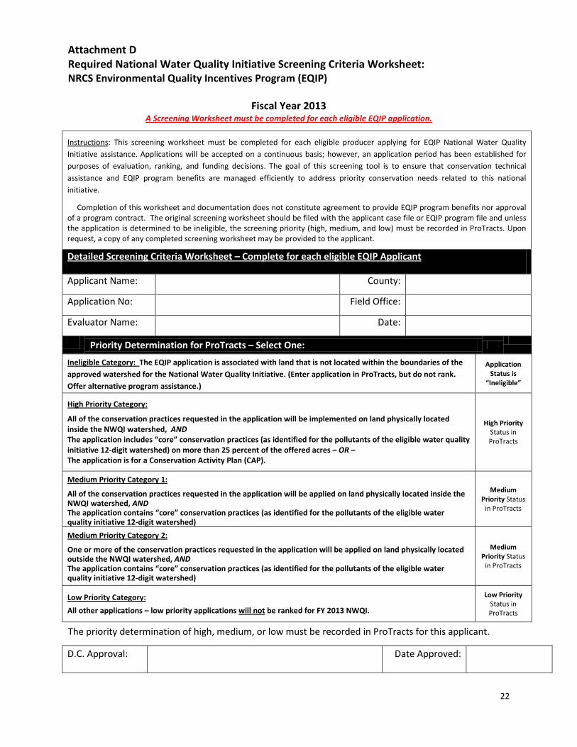
Attachment D Required National Water Quality Initiative Screening Criteria Worksheet: NRCS Environmental Quality Incentives Program (EQIP)
Fiscal Year 2013
A Screening Worksheet must be completed for each eligible EQIP application.
Instructions: This screening worksheet must be completed for each eligible producer applying for EQIP National Water Quality Initiative assistance. Applications will be accepted on a continuous basis; however, an application period has been established for purposes of evaluation, ranking, and funding decisions. The goal of this screening tool is to ensure that conservation technical assistance and EQIP program benefits are managed efficiently to address priority conservation needs related to this national initiative.
Completion of this worksheet and documentation does not constitute agreement to provide EQIP program benefits nor approval of a program contract. The original screening worksheet should be filed with the applicant case file or EQIP program file and unless the application is determined to be ineligible, the screening priority (high, medium, and low) must be recorded in ProTracts. Upon request, a copy of any completed screening worksheet may be provided to the applicant.
Detailed Screening Criteria Worksheet – Complete for each eligible EQIP Applicant
Applicant Name: County:
Application No: Field Office:
Evaluator Name: Date:
Priority Determination for ProTracts – Select One:
Ineligible Category: The EQIP application is associated with land that is not located within the boundaries of the approved watershed for the National Water Quality Initiative. (Enter application in ProTracts, but do not rank. Offer alternative program assistance.)
Application Status is
“Ineligible”
High Priority Category:
All of the conservation practices requested in the application will be implemented on land physically located inside the NWQI watershed, AND The application includes “core” conservation practices (as identified for the pollutants of the eligible water quality initiative 12-digit watershed) on more than 25 percent of the offered acres – OR – The application is for a Conservation Activity Plan (CAP).
High Priority Status in ProTracts
Medium Priority Category 1:
All of the conservation practices requested in the application will be applied on land physically located inside the NWQI watershed, AND The application contains “core” conservation practices (as identified for the pollutants of the eligible water quality initiative 12-digit watershed)
Medium Priority Status
in ProTracts
Medium Priority Category 2:
One or more of the conservation practices requested in the application will be applied on land physically located outside the NWQI watershed, AND The application contains “core” conservation practices (as identified for the pollutants of the eligible water quality initiative 12-digit watershed)
Medium Priority Status
in ProTracts
Low Priority Category:
All other applications – low priority applications will not be ranked for FY 2013 NWQI.
Low Priority Status in ProTracts
The priority determination of high, medium, or low must be recorded in ProTracts for this applicant.
D.C. Approval: Date Approved:
23
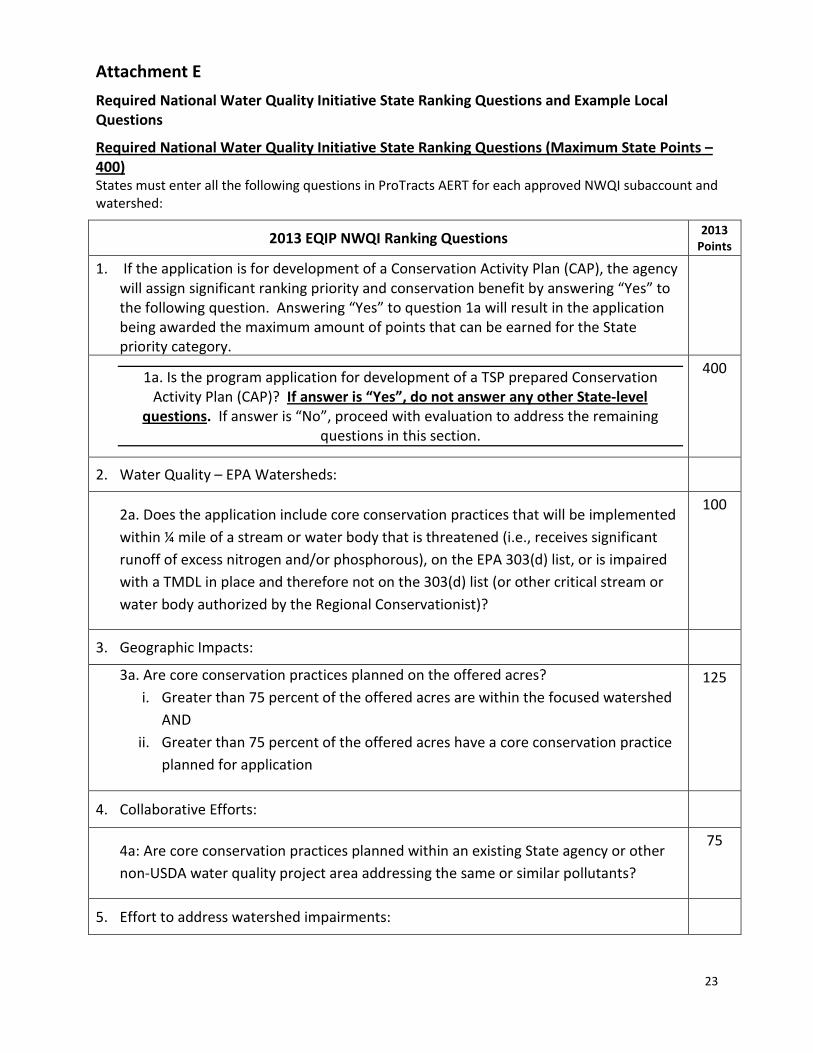
Attachment E
Required National Water Quality Initiative State Ranking Questions and Example Local Questions
Required National Water Quality Initiative State Ranking Questions (Maximum State Points – 400) States must enter all the following questions in ProTracts AERT for each approved NWQI subaccount and watershed:
2013 EQIP NWQI Ranking Questions 2013 Points
1. If the application is for development of a Conservation Activity Plan (CAP), the agency will assign significant ranking priority and conservation benefit by answering “Yes” to the following question. Answering “Yes” to question 1a will result in the application being awarded the maximum amount of points that can be earned for the State priority category.
1a. Is the program application for development of a TSP prepared Conservation Activity Plan (CAP)? If answer is “Yes”, do not answer any other State-level
questions. If answer is “No”, proceed with evaluation to address the remaining questions in this section.
400
2. Water Quality – EPA Watersheds:
2a. Does the application include core conservation practices that will be implemented within ¼ mile of a stream or water body that is threatened (i.e., receives significant runoff of excess nitrogen and/or phosphorous), on the EPA 303(d) list, or is impaired with a TMDL in place and therefore not on the 303(d) list (or other critical stream or water body authorized by the Regional Conservationist)?
100
3. Geographic Impacts:
3a. Are core conservation practices planned on the offered acres? i. Greater than 75 percent of the offered acres are within the focused watershed
AND ii. Greater than 75 percent of the offered acres have a core conservation practice
planned for application
125
4. Collaborative Efforts:
4a: Are core conservation practices planned within an existing State agency or other non-USDA water quality project area addressing the same or similar pollutants?
75
5. Effort to address watershed impairments:
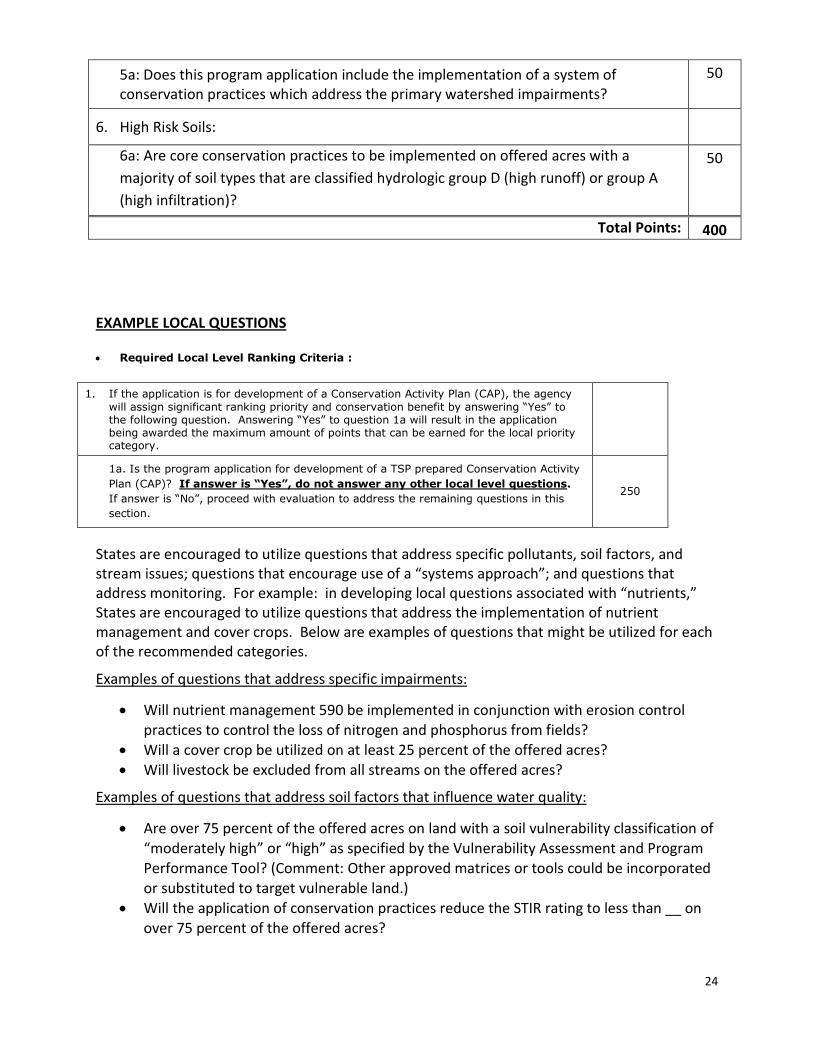
24
5a: Does this program application include the implementation of a system of conservation practices which address the primary watershed impairments?
50
6. High Risk Soils:
6a: Are core conservation practices to be implemented on offered acres with a majority of soil types that are classified hydrologic group D (high runoff) or group A (high infiltration)?
50
Total Points: 400
EXAMPLE LOCAL QUESTIONS
• Required Local Level Ranking Criteria :
1. If the application is for development of a Conservation Activity Plan (CAP), the agency will assign significant ranking priority and conservation benefit by answering “Yes” to the following question. Answering “Yes” to question 1a will result in the application being awarded the maximum amount of points that can be earned for the local priority category.
1a. Is the program application for development of a TSP prepared Conservation Activity Plan (CAP)? If answer is “Yes”, do not answer any other local level questions. If answer is “No”, proceed with evaluation to address the remaining questions in this section.
250
States are encouraged to utilize questions that address specific pollutants, soil factors, and stream issues; questions that encourage use of a “systems approach”; and questions that address monitoring. For example: in developing local questions associated with “nutrients,” States are encouraged to utilize questions that address the implementation of nutrient management and cover crops. Below are examples of questions that might be utilized for each of the recommended categories.
Examples of questions that address specific impairments:
• Will nutrient management 590 be implemented in conjunction with erosion control practices to control the loss of nitrogen and phosphorus from fields?
• Will a cover crop be utilized on at least 25 percent of the offered acres? • Will livestock be excluded from all streams on the offered acres?
Examples of questions that address soil factors that influence water quality:
• Are over 75 percent of the offered acres on land with a soil vulnerability classification of “moderately high” or “high” as specified by the Vulnerability Assessment and Program Performance Tool? (Comment: Other approved matrices or tools could be incorporated or substituted to target vulnerable land.)
• Will the application of conservation practices reduce the STIR rating to less than __ on over 75 percent of the offered acres?
25
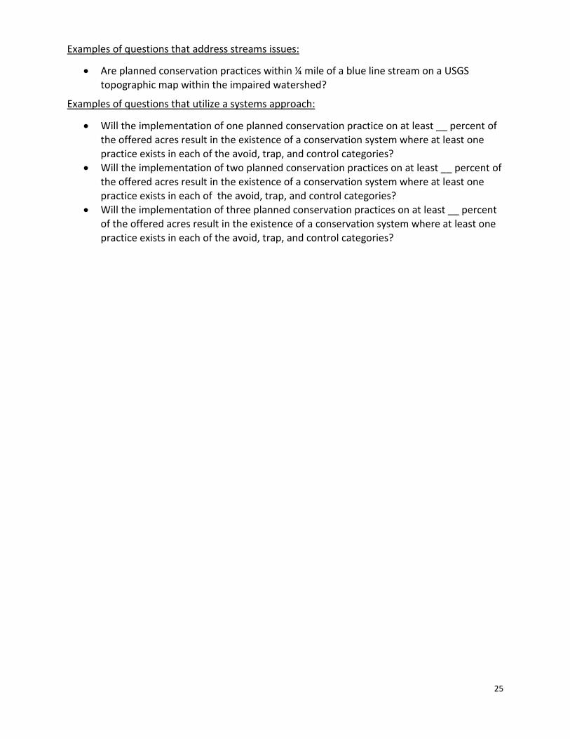
Examples of questions that address streams issues:
• Are planned conservation practices within ¼ mile of a blue line stream on a USGS topographic map within the impaired watershed?
Examples of questions that utilize a systems approach:
• Will the implementation of one planned conservation practice on at least __ percent of the offered acres result in the existence of a conservation system where at least one practice exists in each of the avoid, trap, and control categories?
• Will the implementation of two planned conservation practices on at least __ percent of the offered acres result in the existence of a conservation system where at least one practice exists in each of the avoid, trap, and control categories?
• Will the implementation of three planned conservation practices on at least __ percent of the offered acres result in the existence of a conservation system where at least one practice exists in each of the avoid, trap, and control categories?
26
Attachment F
National Water Quality Initiative Outcomes
1) Pilot Watersheds During fiscal year 2013, States will use of the Water Quality Index for Runoff Water from Agricultural Fields (WQIag) in selected watersheds. WQIag will provide an overall score that may be used to establish trends in water quality over time. Additionally, the index will provide information at the subcomponent level to address field sensitivity, nutrient management, pest management, and soil health. Each State Conservationist will submit at least one proposed pilot watershed, along with pertinent watershed information, to the Regional Conservationists by January 25, 2013, using the FY 2013 Access Form (see Attachment A). A review team will be assigned that will review proposals and submit recommendations to the RCs as soon as feasible. Pilot watershed selections will be made as early as possible in February 2013.
During fiscal year 2013, training of State and field staff in the use and application of the Water Quality Index tool will be completed for any new watersheds in which the tool will be applied. This training will be provided by NHQ staff.
2) APEX and NPAD Reports
NHQ will also predict outcomes using CEAP databases developed from the APEX model. The national key performance measures (KPM) for water quality will be used, and all conservation practices will be aggregated from selected watersheds across the country and outcomes estimated from the CEAP data.
NHQ will also obtain output of information from the National Conservation Planning Database and ProTracts. Reports will be designed to produce acres of core conservation practices applied by watershed. These reports will provide data at the watershed level and on national and regional levels, and align with national KPM strategies.
3) Watershed Plans
Ideally, selected NWQI watersheds would have an existing watershed plan that has been
developed cooperatively by local and stakeholders. To the extent possible, a watershed-based plan or inventory should exist in all selected watersheds. If there is no watershed-based plan in a selected watershed, States should either secure a plan or complete an inventory and assessment of the watershed.
For those selected watersheds with no watershed-based plan, States will complete an inventory and assessment documenting baseline conditions, previous efforts within the watersheds, and
27
any past trends in agricultural land use and conservation application. States should also document any climatic trends that might influence any previous data collection.
When preparing to measure outcomes, States should look for documentation of previous efforts and past trends. States should—
1) Utilize any archived water quality data (chemistry, physical, biological indicators) to define a trend. If insufficient data is present, a calibration period to collect water quality data will be necessary to establish a baseline.
2) Utilize archived climatological data to help characterize the hydrology. 3) Document prior and existing monitoring activities, and data sampling points. 4) Document previous program activity including state and local efforts.
For purposes of documenting the condition of the watershed at the beginning of the initiative, States should complete an initial watershed inventory and evaluation. This baseline condition will be the point of comparison for documenting outcomes for that watershed. States should include the following:
1) In order to assess the nonpoint source contribution, make an assessment of point source pollutant sources (they may represent 5–30 percent of the nutrient load).
2) Existing land use and land cover inventory (changes may occur and help explain the response, or lack of response, of water quality indicators).
3) Soil and topographic profile description (e.g., hydrologic groups and relief. Note: measuring outcomes will be very difficult in Karst geology where inter-basin pollutant movement occurs underground).
4) Streambank and bed erosion assessment (may account for as much as 70 percent of the phosphorus load). A riparian corridor assessment should be made simultaneously.
5) Level of conservation practice implementation; landowner attitude survey pre and post. 6) List of impaired streams with suspected pollutant sources. These streams are already
identified as not meeting water quality standards.
4) National Framework In fiscal year 2013, NRCS will begin implementing a national water quality monitoring plan. This plan will provide a strategy for identifying monitoring needs and establishing methods and protocols. The plan will be developed in collaboration with partnering agencies with experience in monitoring water quality.