votlendi.isvotlendi.is/wp-content/uploads/2017/10/icelandic-inland-wetlands... · * olafur arnalds...
TRANSCRIPT

1 23
WetlandsOfficial Scholarly Journal of the Societyof Wetland Scientists ISSN 0277-5212Volume 36Number 4 Wetlands (2016) 36:759-769DOI 10.1007/s13157-016-0784-1
Icelandic Inland Wetlands: Characteristicsand Extent of Draining
Olafur Arnalds, Jon Gudmundsson,Hlynur Oskarsson, Sigmundur H. Brink& Fanney O. Gisladottir

1 23
Your article is published under the Creative
Commons Attribution license which allows
users to read, copy, distribute and make
derivative works, as long as the author of
the original work is cited. You may self-
archive this article on your own website, an
institutional repository or funder’s repository
and make it publicly available immediately.

REVIEWARTICLE
Icelandic Inland Wetlands: Characteristicsand Extent of Draining
Olafur Arnalds1,2 & Jon Gudmundsson1& Hlynur Oskarsson1
&
Sigmundur H. Brink1& Fanney O. Gisladottir1
Received: 27 October 2015 /Accepted: 1 June 2016 /Published online: 9 June 2016# The Author(s) 2016. This article is published with open access at Springerlink.com
Abstract Iceland has inland wetland areas with soilsexhibiting both Andosol and Histosol properties which areuncommon elsewhere on Earth. They are generally fertile,with higher bird-nest densities than in similar wetlands inthe neighboring countries, with nutrients released by rapidweathering of aeolian materials of basaltic nature. Icelandicinland wetlands cover about 9000 km2 constituting 19.4 % ofthe vegetated surfaces of the island. The wetland soils areoften 1–3 m thick and store 33 to >100 kg C m−2. They havebeen subjected to broad-scale subsidy-driven drainingfor agricultural purposes. About 47 % of Icelandic in-land wetlands are impacted by drainage. The ditch net-work extends about 30,000 km, mainly in lowlandareas, where about 70 % of the wetland areas are im-pacted. There are >1 million wetland patches, most of them<1 ha. Much of the wetlands impacted from drainage are notused for intensive agriculture such as hay-making, howeversome are used for grazing. There is a need to prioritize theprotection of undrained wetlands and their restoration basedon a broad range of factors.
Keywords Wetlanddraining .Andosols .Wetlandpatchsize .
Gleyic
Introduction
High latitude wetlands with an elevated organic content makeup a large proportion of Earth’s wetlands (e.g., Mitsch andGosselink 2007). Iceland, an island in the North-AtlanticOcean, has diverse wetlands ranging from the coast to theinterior highland, including marshes, estuaries, ponds, lakesand rivers. The wetlands addressed in this paper are the inlandpalustrine wetlands, mostly fens with both organic or inorgan-ic soils (see definitions in Cowardin et al. 1979), which wehere also term ‘inland fen wetlands’ or simply ‘inland wet-lands’. Theywere termed Bmires^ (Bmýrar^ in Icelandic) in anoverview by Gardarsson (1998). Sloping fens are a commonfeature of the fiords and valleys formed during the last glaci-ation which cut into the Tertiary basalts whereas the greatestextent of topogenous fens are found within the gently slopinglowlands of west and south Iceland. Alluvial fens are locatedalong some of the larger rivers, particularly in north and eastIceland. Palsa wetlands are found in isolated areas in the cen-tral highlands. Intertidal flats and inland marshes are not cov-ered in this paper (559 km2 and 387 km2, respectively, num-bers based on the CORINE cover for Iceland).
The Icelandic wetlands are strongly influenced by the vol-canic nature of the island and by intense aeolian deposition(Bvolcanic loess^), which separate Icelandic wetlands frommost other wetlands on the globe. The volcanic and aeolian(loess) influences make these inland wetlands fertile with arelatively high pH and favorable nutrient availability(Arnalds 2004, 2015 Ch 8; Oskarsson et al. 2004). The fertil-ity is reflected by high breeding bird densities, which often are>10 times higher in Iceland than for the same species in theUK and >2 times that of The Netherlands (Johannesdottir etal. 2014; Gunnarsson et al. 2015). The inland fen wetlands areimportant habitat for many bird populations in Iceland(Gunnarsson et al. 2006) with some of them important
* Olafur [email protected]
1 Agricultural University of Iceland, Árleyni 22,112 Keldnaholt, Iceland
2 United Nations University Land Restoration Training Program,Árleyni 22, 112 Keldnaholt, Iceland
Wetlands (2016) 36:759–769DOI 10.1007/s13157-016-0784-1

internationally (Einarsson et al. 2002). There have been exten-sive studies on changes in species composition of plants fol-lowing drainage impacts (Magnusson 1998). Thorhallsdottiret al. (1998) found that the occurrence of rare wetland plantspecies was higher in areas with limited drainage disturbance.The extensive draining of Icelandic wetlands (addressed be-low) has had significant influence on both the distribution andoverall abundance of Icelandic birds (Thorleifsson 1998;Skarphedinsson and Thorleifsson 1998). The wetlanddraining, along with the introduction of the American mink(Mustela vison), are considered to be the main reasons for thelocal extinction of the water rail (Rallus aquaticus), Iceland’sonly rail species (Skarphedinsson and Thorleifsson 1998).
Icelandic inland fen wetlands were subjected to widespreaddrainage during the twentieth century for agricultural pur-poses, with a large proportion of the wetlands being disturbed.Drainage for various purposes is still a threat to the remainingundisturbed wetlands. The Agricultural University of Icelandhas generated nationwide geographical databases for land cov-er, including wetlands, and has surveyed the extent and impactof wetland drainage. The estimate of the extent and impact ofdrainage has been carried out in relation to the Icelandic nation-al reporting to the UN Framework Convention on ClimateChange (Hellsing et al. 2016). The main goal of this paper isto provide a general overview of the soils of the inland wetlandsin Iceland and present an estimate of their extent, disturbance bydrainage and the patch size of the remaining undrained wet-lands based on relatively high resolution data.
Background and General Characteristicsof the Wetlands
Iceland, a 103,000 km2 volcanic island, is located just south ofthe Arctic Circle, between 63° and 66° north latitude, and 13°to 24° west longitude. The climate is relatively mild in spite ofthe high geographic latitude, the reason being the oceanicclimate and the effect of the Gulf Stream that brings warmwaters to the shores of Iceland. It is worth noting that conti-nental areas at the same latitudes, in Siberia and Canada forexample, experience much colder climates than Iceland, par-ticularly in winter.
Iceland has about 30 active volcanic systems, fed by avolcanic mantle plume under the island (hotspot), with erup-tions occurring every 3–5 years (Thordarson and Höskuldsson2008). The oldest rocks are from the late Tertiary, but much ofthe surface is covered by rocks <3 million years old, withwidespread Holocene lava and tephra deposits. Glaciers coverabout 11 % of the country and many active volcanoes arelocated under ice. The volcanism provides the parent materialsof Icelandic soils through tephra deposition and aeolian redis-tribution of volcanic materials, resulting in the formation ofAndosols. The volcanic materials are primarily poorly
crystalline basalt grains with rapid weathering rates, whichresults in the formation of allophane, ferrihydrite andimogolite (Arnalds 2015 Ch. 9). Areas outside the active vol-canic regions are primarily made up of Tertiary basalt piles,but the Quaternary glaciation has cut deep valleys into theTertiary rock formation. The porosity of the Tertiary rockshas been partially plugged by secondary minerals suchas calcite, silica minerals, zeolites and clays by chemicalweathering (e.g. Ehlmann et al. 2012), resulting in slowhydraulic conductivity and higher water tables withmore frequent occurrence of wetlands within theTertiary Formation than in the active volcanic regions(Arnalds and Oskarsson 2009).
For centuries, the fen wetlands were used for grazing bylivestock and harvested for hay. The wetland sward also pro-vided sod for house construction (Sigurdardottir 2007).Intermittently flooded wetlands were important sources ofhay in many parts of the country and often shared within thecommunity. The more organic soils provided peat for fuel(Thorsteinsson 1975).
Draining the wetlands primarily took place during the latterpart of the twentieth century and was subsidized by the gov-ernment. The draining was part of the effort to enhance agri-cultural production and Bfood safety^ in the post-World-WarII era, but also an effort to reduce the migration of people fromrural sections to fast growing urban areas (see Helgadottiret al. 2013). The drainage efforts were sustained for almost50 years in spite of substantial overproduction of meat anddairy products. Dairy and lamb meat production constitutethe major proportion of Icelandic agriculture (data fromStatistics Iceland February 2013; www.statice.is) andcharacterize the rural landscape (Fig. 1a). Currently there areabout 26,000 dairy cows and 75,000 head of cattle in all,460,000 winterfed sheep (> 1.3 million grazing sheepin summer) and about 80,000 horses. Sheep and cattlerearing is highly dependent on hay making in the sum-mer as the cold winter means that animals are keptindoors in winter (see Helgadottir et al. 2013).Approximately half of the hayfields are on drained wet-land soils (Wöll et al. 2014).
Previous estimations of the extent of wetlands include thesoil map prepared by Johannesson (1960; see explanations byArnalds 2015 Ch. 7), yielding 9–10,000 km2 of what hetermed ‘peatlands’. However, wetlands of various organiccontent are a more appropriate term as is explained in thesection on soils below. This mapping was a noteworthy at-tempt, yet with relatively high uncertainty as the map is highlygeneralized with a very coarse scale (1:750,000). Other com-plete overviews include a vegetation map with the scale of1:500,000 by the Icelandic Museum of Natural History(Gudjonsson and Gislason 1998) and the CORINE coverage,which is in large part a simplified version of the AgriculturalUniversity of Iceland (AUI) data presented here.
760 Wetlands (2016) 36:759–769
Materials and Methods
The geographical data applied for the spatial analyses werederived from three main sources: the Agricultural Universityof Iceland (AUI) Nytjaland and IGLUD databases and theAUI soil map and soil databases. The AUI hosts several na-tional geographical databases which include a soil databaseand a map, a database for broadly defined vegetation classes(Icelandic Farmland Database, Nytjaland in Icelandic) and theIGLUD (Icelandic Geographical Land Use Database), whichwas constructed in response to Iceland’s commitments to theUN Framework Convention on Climate Change (UN FCCC;Gudmundsson et al. 2013). The Nytjaland database was madefrom supervised classification of Landsat 7 and Spot 5 satelliteimages, covering all of Iceland. Most of the work entailedseparating the land into 10 vegetation classes, in addition toice/glaciers and water/sea, but for a proportion of the country,6 vegetation classes were used. The database was described indetail by Gisladottir et al. (2014) in Icelandic, but also in partin English by Arnalds and Barkarson (2003). The IGLUDdatabase land use map of Iceland is compiled annually froma large number of available map layers, including theNytjaland classification. The ditch network was digitized atthe AUI manually using aerial and satellite photographs. Dataon cultivated land (hay fields) were also assembled by digitiz-ing the areas. The IGLUD database and its preparation was
described by Gudmundsson et al. (2013) and Wöll et al.(2014). The soil map was constructed by combining soil meta-data housed by the AUI (Ymir database) and the Nytjalandland cover database (Arnalds and Oskarsson 2009). This is arather broad scale map (1:250,000) for general overview of thesoils of Iceland.
The extent of wetlands and drainage was estimated using theAUI Nytjaland and IGLUD databases. Two main classes of theNytjaland classification encompass wetlands: Bsaturatedwetlands^ and Bdampwetlands^. The IGLUDmap layer of areasaffected by drainage represent areas with average drawdown ofthe water table of >15 cm, which is, however, subjected to sea-sonal and annual differences. The preparation of the map layer ofdrained soils is based on a maximum 200 m distance fromditches. Other vegetation classes closer to 200 m distance fromditches are excluded, as well as areas of more than 10°slope.Areas <200 m from a ditch but isolated from it by a body ofwater are excluded from affected areas. The 200 m distance isbased on considerable efforts by AUI to categorize drainageimpacts (mostly unpublished data, see also Oskarsson 1998;Gisladottir et al. 2007, 2010; Gisladottir and Oskarsson 2011).The preparation of the map layer for drained soils has beenfurther described byWöll et al. (2014). Map layers for croplands(mostly hay fields) on wetland soils were made separately basedon surveys of croplands and time series of land use conversionsas described byWöll et al. (2014). All data layers were combinedto prevent overlapping or double counting of areas.
The impacts range from subtle changes in water flow, hab-itat diversity and nutrient and greenhouse gas dynamics (low-est density) to substantial lowering of the water table withpronounced releases of greenhouse gasses and vegetationchanges, but many of the areas are also subjected to plowing(hay-making) and intensive grazing that cause ecosystemchanges on top of changes caused by the drainage.
Levels of disturbance were estimated by using a kerneldensity method to calculate accumulated ditch density forareas closer than 200 m from a ditch. Then the impacted areawas grouped into the following density intervals: 0.1–5, 5–10,10–15, 15–20, and >20 km km−2. Areas of slopes >10°, poor-ly vegetated land and road beds were excluded in the process.In addition, the size distribution of the inland wetlands in theAUI databases was determined, using the following size cat-egories: <1, 1–5, 5–50, 50–100, 100–500 and >500 ha.
The Inland Wetlands: Soils, Vegetation and Birds
Soils
Most circumpolar areas of similar latitudes, such as in Finland,Russia, Alaska and Canada, have extensive wetlands of highorganic content (peat), often dominated by permafrost (Joneset al. 2010). The mixture of poorly crystalline basaltic volcanic
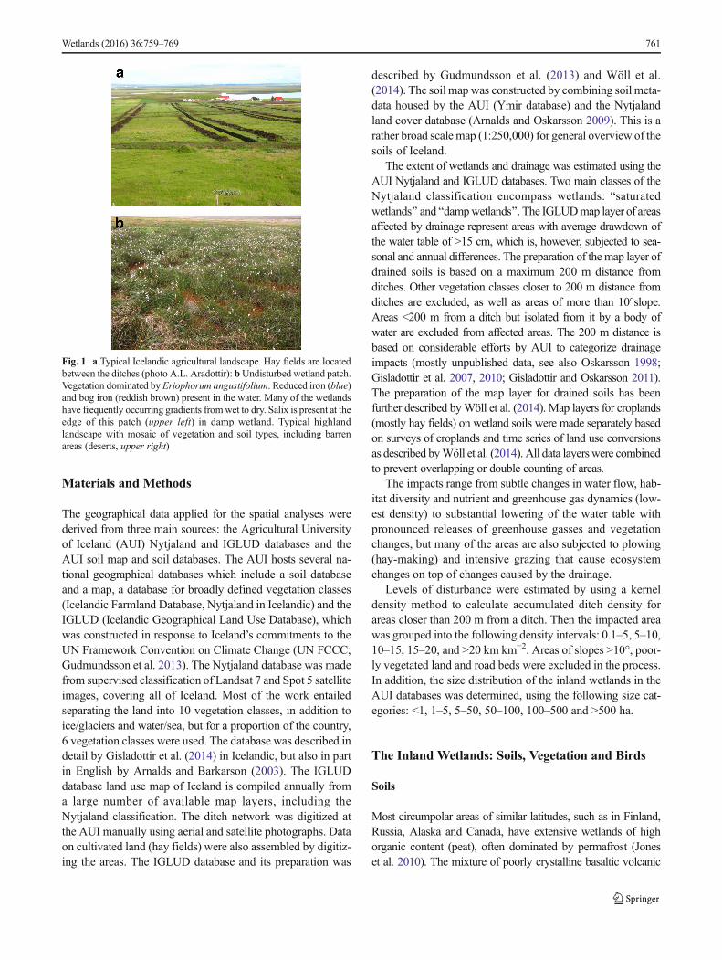
Fig. 1 a Typical Icelandic agricultural landscape. Hay fields are locatedbetween the ditches (photo A.L. Aradottir): bUndisturbed wetland patch.Vegetation dominated by Eriophorum angustifolium. Reduced iron (blue)and bog iron (reddish brown) present in the water. Many of the wetlandshave frequently occurring gradients fromwet to dry. Salix is present at theedge of this patch (upper left) in damp wetland. Typical highlandlandscape with mosaic of vegetation and soil types, including barrenareas (deserts, upper right)
Wetlands (2016) 36:759–769 761

materials and peat, which dominates Icelandic wetland soils, isuncommon in theworld, judging from our literature search. Theydiffer from the paramo Histic Andosols of Ecuador (Buytaertet al. 2005, 2007) and the Azores (Madeira et al. 2007) in havinga lower content of metal-humus complexes and a higher propor-tion of vitric materials deposited by continuous re-distribution ofvolcanic ash materials. The Icelandic wetland soils rarely exhibithydric soil properties (>100%water content at 15 bar tension) incontrast tomore developedHydricAndosols of warmer climates.Aquic Andosols have been reported in many areas such as Japan(e.g., Shoji and Ono 1978), however usually much more devel-oped and lacking the frequent volcanic additions and continuousaeolian deposition of volcanic ash which give the Icelandic soilstheir distinctive young and vitric character.
The soils of Icelandic inland wetlands have a wide range oforganic content in the surface horizons that determine the classi-fication of the soils. The C content is most often <25 %, consid-erably lower than the 36–54%Caverages reported by Loisel et al.(2014) for northern peatlands. The soils of palsa areas (perma-frost mounds) also have low organic content in surface horizonsin contrast to most other Arctic palsa areas (Saemundsson et al.2012). Carbon accumulation in the Icelandic soils, based on datafrom Oskarsson et al. (2004) and averaging total carbon stocksover 8000 yrs. indicates accumulation from 4 gm−2 yr.−1 (GleyicAndosols) to 25 g m−2 yr.−1 (Histosols). The accumulation inHistosols is of the same order as 23 g m−2 yr.−1 reported fornorthern peatlands by Loisel et al. (2014). Gudmundsson(2008) studied reported carbon accumulation between tephra-layers of known age for a Histosol in NW Iceland. The accumu-lation ranged between 9 and 20 g m−2 yr.−1 during the Holocene(4 periods) with the average rate of about 15 g m−2 yr.−1.
An Icelandic soil classification system (Arnalds andOskarsson 2009) separates the inland wetland soils based oncarbon content in the top 30 cm into Gleyic Andosols (<12 %C), Histic Andosols (12–20 % C) and Histosols (>20 % C).Andosols, by nature, accumulate higher organic content thanother mineral soils and are differentiated from Histosols accord-ing the US Soil Taxonomy (Soil Survey Staff 1999) and theWRB (IUSS Working Group WRB 2014) at the 25 % C level(not 12–16 % as for the difference between Histosols and othermineral soils). These soils differ from the highly peaty Arcticsoils, as they have a higher pH (often >5) and C/N ratio of 13–25, noticeably lower than the 34–77 average range reported fornorthern and Arctic peatlands (Loisel et al. 2014). Considerableamounts of nitrogen become readily available upon drainage.Part of the organic matter in all the wetland soils is in the formof organo-mineral complexes, which are characteristic of volca-nic soils in general (see Arnalds 2015 Ch. 8). The variability incarbon content of Icelandic wetland soils is in large part due todifferences in aeolian and tephra deposition contributing mineralmatter to the soils, with substantially lower organic content closeto volcanoes and the major dust sources. Variability in organiccontent is also caused by differences in drainage, flooding
regimes and landscape positions (Arnalds 2004; Arnalds andOskarsson 2009). Gleyic Andosols (Fig. 2) with relatively loworganic content (often 2–6 %) are dominant within the activevolcanic zone, but there is a gradient with carbon content grad-ually becoming higherwith distance from active dust sources andvolcanoes. Highly organic soils are therefore mostly found faraway from active dust sources such as in West, Northwest andNorth Iceland. The main characteristic of the organic matter inthe soils is that it is poorly decomposed and the Histosolswould classify as Fibrists (Borofibrists and Cryofibrists) un-der Soil Taxonomy. They show considerable shrinkage whenthey are completely dried in the laboratory (often less than ½of the original volume when dry), but limited or very slowshrinkage in the field when drained, which is in part attrib-uted to the volcanic ash materials in the matrix (Bartoli andBurtin 2007).
The Gleyic Andosols contain 10–20 % clays (allophaneand ferrihydrite) on average, while the Histosols do not con-tain appreciable amounts of clays with Histic Andosols beingintermediate. There is a gradient in pH from Gleyic Andosols(6–7) through Histic Andosols (5–6) to Histosols (4–5) attrib-utable to decreasing aeolian input and increased organic con-tent (Arnalds 2015 Ch. 8). Bulk density ranges from 0.2 inorganic horizons to about 0.7 g cm−3 in mineral horizons inGleyic Andosols. The organic horizons have higher waterretention than would be expected, but so do also the mineralhorizons due to their andic soil properties (see Arnalds 2004,
Fig. 2 Typical Gleyic Andosol, showing distinct tephra layers and signsof cryoturbation in the upper horizons. The boundary between the lightercolored upper part and darker colored lower part of the profile marks thesettlement of Iceland about 1200 yrs. ago. Increased aeolian activityconsisting in part of re-distribution of light colored tephra fragmentsinfluences the soil color. The lower part is more organic (>13–20%C)while the upper part has about 10%C; see Arnalds 2015 Ch. 8)
762 Wetlands (2016) 36:759–769

2015 Ch. 7). The depth of the Icelandic inland wetland soils isquite variable, ranging from a few cm to several meters, butcommonly 1–3 m.
Vegetation
The vegetation of Icelandic wetlands was described bySteindorsson (1964), but Magnusson (1998) specifically ad-dressed the plants of drained wetlands. The overarching charac-teristic of Icelandic wetland vegetation is the predominance ofvascular plants and virtual absence of Sphagnummoss dominat-ed wetlands. This can most likely be ascribed to the generalfertility of these systems arising both from thewidespread aeoliandeposition of mineral matter and the fact that there are almost notruly ombrotrophic inland wetlands in Iceland, most beingminerotrophic or only partially ombrotrophic (Steindorsson1964). Drainage changes the systems from minerotrophic toombrotrophic in areas closest to the ditch.
The subsequent discussion takes note of the AgriculturalUniversity databases which separate the wetlands into Bsaturatedwetlands^ and Bdamp wetlands^. Other divisions of Icelandicwetlands are discussed in Olafsson (1998). The plant speciescharacteristic of the Bsaturated wetland^ class include variousCarex spp., such as Carex bigelowii, C. lyngbyei, C. rostrata,C. chordorrhizia, and Equisetum spp. Cotton grass (Eriophorumangustifolium) is quite common as are some heathland speciessuch as dwarf-birch (Betula nana), blueberries (Vacciniumuliginosum), crowberries (Empetrum nigrum), common heather(Calluna vulgaris) and Arctostaphylos uva-ursi, but also willowspecies (Salix phylicifolia, S. arctica and S. lanata). Moss speciesof the genera Hypnum, Philonotis, Mnium and Rachometriumare widespread. Species characteristic of damp wetlands includemany of the same species found in saturatedwetlands, with lowerdominance of Carex spp. and more frequent occurrence ofwoody species.
Birds
Icelandic wetlands in general are particularly important for birdswith approximately 75% of Icelandic bird species relying in partor fully on various types of wetlands as a habitat (Gudmundsson1998). The Icelandic wetlands (including the inland fens) supportabout 20 internationally important bird species (Einarsson et al.2002). They are of particular importance for waders (Charadrii)in the northern hemisphere (Gunnarsson et al. 2006). Wetlandbirds include golden plover (Pluvialis apricaria), dunlin(Calidris alpina), snipe (Gallinago gallinago), whimbrel(Numenius phaeopus), black-tailed godwit (Limosa limosa), red-shank (Tringa totanus), and meadow pipit (Anthus pratensis).Swans (Cygnus cygnus) and geese are also common, includingthe graylag goose (Anser anser) and pink-footed goose (Anserbrachyrhynchus). Some of the highland wetlands are of
particular importance, e.g., the Thjorsarver RAMSAR area, theworld’s largest breeding ground of pink-footed goose.
History of the Drainage Effort
Draining wetlands facilitates oxidation of organic matter andrelease of nutrients, resulting in substantial increase in biomassproduction (Magnusson 1998), at least in the short-term. Thisprospect was of interest to the farming community during theearly twentieth century. A law was passed in 1923 that initiatedsubsides for draining. Minor areas were drained annually duringthe first few decades as ditches were excavated by hand. AfterWorld War II, with the arrival of large and effective machineryfor excavation, a broad-scale draining of the wetlands was initi-ated. The drainage activity gained momentum relatively rapidly,expedited by the government subsidies (Fig. 3). The drainingpeaked in 1968, when 1633 km of ditches were excavated. Theeffort decreased considerably after 1987 (Bjarnason 1982;Snaebjörnsson et al. 2010), when subsidies were cut dramatical-ly, but it can also be postulated that much of the easily drainedland near the farmsteads had been drained by that time. About15 % of the drained wetlands are used for hay-making. Thedrained areas are also used for grazing to some extent.However, some of the drained land is not used for agriculture;the draining disturbance of those areas has no practical purpose.
Results
The Extent of inland Wetlands
The wetlands, as represented in the AUI databases, consist ofthree classes: the saturated wetlands, damp wetlands anddrained wetlands (partial to fully). The spatial distribution ofthese wetlands is presented in Fig. 4, and their altitudinaldistribution is presented in Table 1.
The results of this GIS based analysis indicate thatIcelandic inland wetlands cover about 9000 km2. This areais based on vegetation classification using satellite images,with open water reflectance signals to augment the classifica-tion. It is likely that soil-based classification reflecting thepresence of shallow ground water would increase this extent.However, data are not available at this time.
Wetlands occur in all geographic regions of Iceland and ex-tend into highland elevations. However, about two-thirds of thewetlands are found below 200 m elevation, or 5795 km2, whichis equivalent to approximately 23 % of the lowland surface areaand about 31 % of the vegetated land occurring below 200 m.About 20 % of wetlands are located between 200 and 400 melevation, but their extent falls dramatically at higher elevationsas does vegetation cover in general. Prominent inland fen wet-lands occupy the southern lowlands (Fig. 4), with mostly
Wetlands (2016) 36:759–769 763

inorganic Gleyic Andosols in the eastern part where aeolian andvolcanic ash inputs are relatively high, together with HisticAndosols and higher carbon content towards the western partof the southern lowlands (Fig. 4). Prominent inlandwetlands alsooccupy western Iceland, mainly Histosols and Histic Andosols.Inland wetlands are also common within the deep valleys of theTertiary Formation in North and West Iceland, harboring mostlyHistic Andosols and Histosols. Widespread wetlands are foundin the northwestern and eastern highlands (Fig. 4).
Drainage Disturbance
Our results show that 4195 km2 or 47% of all Icelandic inlandwetlands have been impacted by drainage (Table 1), rangingfrom full drainage to subtle changes in water levels. The tableshows only areas affected by draining (see Materials and
Methods), but limited data are available for other wetlanddisturbances, except for hydro-electric reservoirs. The major-ity (70 %) of the lowland wetlands below 200 m elevationhave been affected. Drainage of inland wetlands is rather lim-ited above 200 m elevation, coinciding with the much limitedagriculture at higher elevations.
Ditches and Ditch Density
The digitization of the entire ditch system revealed a total ofabout 29,700 km of ditches (see also Gisladottir et al. 2010).Preliminary results from a survey on the accuracy of thedigitation showed that 91 % of ditches mapped were confirmedas ditches and that 5 % of ditches had gone undetected by themapping effort (Wöll et al. 2014). This estimate of the totallength of ditches is slightly lower than the previous estimate of
Fig. 3 Cumulative and annualditch excavation with time. Themajority of ditches wereexcavated prior to 1987, withannual activity peaking in 1968(> 1600 km yr.−1)
Fig. 4 Inland wetlands inIceland. The most prominentareas are the southern and westernlowlands together with the NWand NE highlands. Major wetlandsoil types dominating each regionare indicated, enclosed by dottedlines. H: Histosols, HA: HisticAndosols, and G: GleyicAndosols. Ramsar sites areindicated as green areas. Themajority of the lowland wetlandshave been impacted by drainage.Some impacted wetlands withaltered vegetation cover and/oragricultural fields are not shown.Large water bodies are shown inblue. White areas on the maprepresent glaciers
764 Wetlands (2016) 36:759–769

Geirsson (1975), who estimated the total length of drainageditches to be 32,700 km based on records of excavated volumeobtained in relation to the subsidies rendered for making theditches. The ditch system is further augmented by 61,600 kmof sub-surface drainage made in 1961–1993, mostly in areaswhere ditches are in place (Geirsson 1975; Helgadottir et al.2013).
The majority of the impacted area has low accumulated ditchdensity (0.1–0.5 km km−2; Table 2) i.e. about 2300 km2, or 67%.The highest densities of >10 km km−2 make up 309 km2 of theimpacted area. The total extent of cultivated areas (hay-fields andother crops) in Iceland is about 1290 km2, of which about half ison drained wetland soils (Wöll et al. 2014; see also Helgadottiret al. 2013).
An example of an area with extensive wetland draining inSouth Iceland is provided in Fig. 5. The figure shows thatalmost the entire area is influenced by the draining, which isin accordance with the results for areas <200 m elevation ingeneral. The hayfields and other cultivated land are within theareas of the highest drainage densities next to the farms. Manyareas shown as intact in the figure are encircled by a ditchsystem and are likely to be somewhat impacted. Undisturbedareas are found on the riverine floodplains. The impacts of low
ditch densities are also affected by landscape characteristicssuch as slope and bedrock hydrology. It is clear that a largeproportion of the drained land is not used for suchagricultural production. An undefined, but substantialproportion of the remaining drained wetlands is usedfor periodic grazing (data not available), and some areused for afforestation.
Wetland Patch Size
The majority of the fragmented wetland patches are small orbelow one ha in size (Table 3), with over one million suchpatches registered in our GIS Nytjaland database and accountingfor about 30 % of the wetland areas. Damp wetland patches aresmaller on average than the saturated wetland patches (data notshown). Only 16 % of the wetlands occur as patches >100 ha(1 km2). Larger patches occur as saturated wetlands on averagecompared to damp wetlands, which indicates that there is ahigher probability of saturated surface conditions within the larg-er wetland patches. Dampwetlands are often found at the periph-ery of the saturated wetlands and are therefore relatively smallerthan continuous saturated wetland patches.
Table 1 A geographical summary for Icelandic inland fen wetlands, sorted by elevation intervals. Wetlands are separated into saturated and dampwetlands. Total vegetation cover is shown in the top row for comparison. Data from the IGLUDdatabase which is based in part on the Nytjaland database
m.a.s.l.
0–200 200–400 400–600 600–800 800–1000 >1000 Total
km2
Total area 25,257 18,106 22,293 18,519 8345 10,163 102,683
Vegetated land 18,665 12,758 10,550 3932 385 41 46,331
Undisturbed wetlands$ 1743 1611 1175 258 2 0 4789
Saturated wetlands 1112 1170 1010 236 2 0 3529
Damp wetlands 631 441 166 23 0 0 1260
Drained wetlands 4052 136 3 0 0 0 4191
Total wetlands 5795 1747 1178 258 2 0 8980
%
Impacted wetlands 69.9 7.8 0.3 0 0 0 46.7
$ Saturated wetlands + damp wetlands in the table
Table 2 Wetland disturbance bydrainage sorted by density ofditches
Density Length of ditches Impacted areas Proportion of ditches Proportion of totalkm km−2 km km2 %
0.1–5 1818 2300 6.1 66.6
5–10 11,462 858 38.6 24.7
10–15 8479 231 28.6 6.7
15–20 5337 63 18.0 1.8
>20 2585 15 8.7 0.4
Total 29,680 3468 100 100
Wetlands (2016) 36:759–769 765

Discussion
The soils of Icelandic wetlands are exceptional on a global scalefor being a mixture of volcanic and organic soils, with extremelyvariable organic content. Their carbon content is usually muchlower than in Arctic wetland soils (especially the GleyicAndosols) and the C/N ratio is lower. They are more vitric incharacter than much of the Aquic and Hydric Andosols found inother volcanic areas. Their fertility is enhanced by a relativelyfavorable pH maintained by nutrient release from the rapidweathering of basaltic volcanic glass (see Arnalds 2008, 2015Ch. 9). Their uniqueness is highlighted by their dissimilarity withother northern circumpolar soils, which mostly constitute peatsoils (Histosols) and/or Cryosols (permafrost) (Jones et al.2010), while Icelandic wetlands are dominated by Andosols(mineral soils with variable organic content) with a relativelysmall proportion of Histosols, which also are influenced by aeo-lian deposition of volcanic materials.
The results show that a substantial part of the Icelandic inlandwetlands have been disturbed by drainage. About 47 % ofIcelandic wetlands have been drained, mostly below 400 m ele-vation. The results show that 70 % of the inland wetlands below200 m elevation have been impacted to some degree, which is ingood accordance with research on the southern and western low-lands (Thorhallsdottir et al. 1998; Oskarsson 1998). We suggestthat the motivations for many of the ditches of the lowest densi-ties (< 10 km km2) were subsidy driven rather than by need foragricultural land, but such claims are difficult to corroborate.
The areas of intense drainage most often go through a vege-tation composition shift fromwetland to grassland plant commu-nities, with higher cover of graminoids with various amounts ofsalix species and herbaceous plants, but the shift is also depen-dent on land use, such as grazing and fertilizer use, which tend toincrease the abundance of grasses (see Magnusson 1998). Werecognize that our estimate based on the 200 m distance from aditch has its limitations. This distance is an estimated average, butwill vary from one area to the other. Areas beyond the 200 mrange enclosed by ditches, a common scenario in South Iceland,are also most likely impacted, with altered water and nutrientflows. This methodology gives a good first appraisal of drainageimpacts in Iceland.
A minor proportion of the drained land (15 %) is used forhay production, mostly of high density drainage. Grazing byhorses on both drained and undrained lowland wetlands hascaused damage to the vegetative cover in many places(Magnusson 1998). The highland ecosystems are not affectedby drainage efforts. They often feed important salmon riversthat have a significant impact on the rural economy. However,some highland wetlands have been disturbed by hydropower
Fig. 5 Drained area in SouthIceland. The river Thjórsá, partlyin a gorge, runs through the centerof the image. Undisturbedsaturated and damp wetlandsshown separately. The black linesdisplay the ditch network. Themap shows clearly that most ofthis area is less than 200 m fromditches, but a relatively smallproportion of the area is cultivated(hay fields). Some areas markedundisturbed are surrounded byditches but >200 from them.These areas are mostly likelysomewhat impacted by thedrainage, but the numbers forimpacted areas are not included
Table 3 Number of wetland patches sorted by patch size for saturatedwetlands and damp wetlands. Data from the Nytjaland AUI database andincludes some disturbed/impacted wetlands
Patch size (ha) Number of areas Combined area (km2) %
<1 1,135,626 1631 29.6
1–5 61,859 1225 22.2
5–50 11,768 1446 26.2
50–100 486 334 6.1
100–500 318 588 10.7
>500 29 288 5.2
766 Wetlands (2016) 36:759–769

development, such as in the Blanda and Kárahnúkar areas inNorthwest and East Iceland. There is widespread livestockgrazing (mostly sheep) in the highlands, which has influenceon wetlands, especially dampwetlands, which is likely to alterspecies composition, but research on these impacts is limited.Other disturbances have not been surveyed to date. It shouldalso be noted that the nature of many of the inland wetlands,both highland and lowland, has been altered by increasingaeolian deposition rates after the Settlement of Iceland about1200 years ago, with reduced carbon content per depth incre-ment and often altered hydrology resulting from coarse sedi-ments (silt and sand) being deposited on the areas.
The carbon dioxide emissions from drained wetlands out-side cultivated areas are calculated as 5100–10,600 Gg CO2
(data from Gudmundsson and Oskarsson 2014), or 7300 GgCO2 by applying the IPCC default emission factor for the area.The emissions of other greenhouse gasses (N2O, CH4) andoff-site emissions are not included but add about 2300 GgCO2 equivalents to the greenhouse gas impact of drainage(Hellsing et al. 2016). These emissions exceed the sum of allIcelandic non-LULUCF emissions (including smelters andtransportation) reported for the year 2014 for Iceland (4597Gg CO2 equivalents) (Hellsing et al. 2016).
Icelandic landscapes are characterized by a great variety ofecotypes over short distances and this is reflected by the largenumber of small wetland patches. Small patches are important interms of ecological functions and biodiversity, with a wide rangeof habitats provided over relatively short distances, while thesmall wetland patches also provide improved hydrological char-acteristics such as water regulation during snow melt on a land-scape level. Small-scale mosaics of different habitat types canbetter fulfill different requirements for birds during the breedingseason (e.g. nesting, feeding) than larger homogenous areas(Gunnarsson et al. 2006; Pickett and Siriwardena 2011;Benton et al. 2003). Our results show that much of the inlandwetland patches are <5 ha with about 30 % of wetland areasconsisting of patches smaller than 1 ha. Only a proportion of thesmall damp wetland patches were created by the drainage activ-ities in areas below 200 m elevation. The importance of patchsize is reflected in the current law, stating that wetland areas>3 ha in size should not disturbed. The 3 ha reference is basedon much coarser mapping than presently available and poten-tially concealing the importance of smaller patches. The resultspresented here suggest that it is important to protect areas char-acterized by small wetland patches which give rise to the impor-tance of the ecosystem mosaic rather than isolated habitat typesand thus, small wetland patches are quite important. We arguethat there should be adopted a smaller reference size than thecurrent 3 ha (e.g. 0.5 ha) in light of the importance of the smallwetland patches in the overall ecosystem mosaic. Further anal-ysis of the 1–5 ha patch size shows that >40 % of wetland thearea within this size class is between 1 and 2 ha. About 55 % ofremaining wetlands are currently excluded from any protection.
Conclusions
Icelandic inland wetlands are among the most important eco-systems of the country because of their role in biodiversity,water regulation and carbon budgets and they have an inter-national value by supporting large populations of migratorybird species. There is a need for increased research on thehydrology of Icelandic wetland soils and the impact ofdraining. Furthermore, there is a need to analyze the relation-ship between drainage levels and impacts on various ecosys-tem factors and processes, such as fragmentation, GHG bud-gets, nutrient cycling and release, bird life, plant compositionand other biotic factors. Research on biodiversity in relation towetlands also needs more attention in future studies.
The remaining undisturbed inland wetlands are still beingthreatened by such factors as agriculture, with improved cropgrowing conditions with the current warming of the climate(see Helgadottir et al. 2013), development and subdivision,land fragmentation (see Wald 2012), afforestation efforts andthe generation of hydropower (large reservoirs). Some sectors,including the road authorities, have adopted strict policies toavoid wetland disturbance or restoring wetlands in place forwetland areas deemed necessary to disturb (Stefansdottir2011). We conclude that it is important to increase the levelof protection of all wetlands in Iceland. Lists have been madeof areas in need of protection based on the importance to birdecology (Ferdinand et al. 1973). The databases presented herehave been shown to be of value for predicting wetland birdspecies and densities (Johannesdottir et al. 2014; Gunnarssonet al. 2015). Many wetlands are on a list proposed for natureprotection (BNáttúruminjaskrá^, Icelandic Natural FeaturesDatabase, kept by the Environmental Agency of Iceland).However, there is a need to strengthen work to systematicallyprioritize the protection and restoration of Icelandic wetlands,which considers a broad range of factors such as size, continu-ity, ecology, hydrology, geomorphology, and the uniqueness ofthe wetlands on national, regional and global scales.
Open Access This article is distributed under the terms of the CreativeCommons At t r ibut ion 4 .0 In te rna t ional License (h t tp : / /creativecommons.org/licenses/by/4.0/), which permits unrestricted use,distribution, and reproduction in any medium, provided you give appro-priate credit to the original author(s) and the source, provide a link to theCreative Commons license, and indicate if changes were made.
References
Arnalds O (2004) Volcanic soils of Iceland. Catena 56:3–10Arnalds O (2008) Soils of Iceland. Jökull - The Icelandic J Earth Sci 58:
409–421Arnalds O (2015) The soils of Iceland.World Soils Book Series. Springer,
Dordrecht, the Netherlands
Wetlands (2016) 36:759–769 767

Arnalds O, Barkarson BH (2003) Soil erosion and land use policy inIceland in relation to sheep grazing and government subsidies.Environ Sci Pol 6:105–113
Arnalds O, OskarssonH (2009) Soil map of Iceland. Náttúrufræðingurinn78:107–121 (In Icelandic, English summary, table and figurelegends)
Bartoli F, Burtin G (2007) Organo-mineral clay and physical properties inCOST-622 European volcanic soils. In: Arnalds O, Bartoli F,Buurman P, Oskarsson H, Stoops G, Garcia-Rodeja E (eds) Soilsof volcanic regions in Europe. Springer, Heidelberg, Germany, pp.469–491
Benton TG, Vickery JA, Wilson JD (2003) Farmland biodiversity: ishabitat heterogeneity the key? Trends Ecol Evol 18:182–188
Bjarnason B (1982) Saga vatnsveita og framræslu (The story of waterdiversions and drainage). In: Snaebjornsson A (ed) Þættir ummýrajarðveg á Íslandi, Agricultural College Report 38:3–7.Agricultural College (now Agricultural University of Iceland),Hvanneyri, Iceland
Buytaert W, Wyseure G, De Bièvre B, Deckers J (2005) The effect ofland-use changes on the hydrological behaviour of Histic andosolsin South Ecuador. Hydrol Process 19:3985–3997
Buytaert W, Deckers J, Wyseure G (2007) Regional variability of volca-nic ash soils in South Ecuador: the relation with parent material,climate and land use. Catena 70:143–154
Cowardin LM, Carter V, Golet FC, LaRoe ET (1979) Classification ofwetlands and Deepwater habitats of the United States. U. S.Department of the Interior, Fish and Wildlife Service, Washington,D.C.
Ehlmann BL, Bish DL, Ruff SW, Mustard JF (2012) Mineralogy andchemistry of altered Icelandic basalts: Application to clay mineraldetection and understanding aqueous environments on Mars. JGeophys Res 117:E00J16. doi:10.1029/2012JE004156
Einarsson Ó, Kristinsson H, Skarphéðinsson KH, Ottósson JG (2002)Verndun tegunda og svæða: tillögur Náttúrufræðistofnunar Íslandsvegna Náttúruverndaráætlunar. The Icelandic Institute of NaturalHistory. Reykjavik, Iceland (In Icelandic)
Ferdinand FHM, Thamdrup A, Haapanen H, Ormio CH, Ovesen A,Gardarson D (1973) Oversigt over vigtige våde fugleområder iNorden. Nordiske arbejdsgruppe vedrørende beskyttelse af vådefugleområder "wetlands". Copenhagen, Denmark, 366 pp
Gardarsson A (1998) Íslensk votlendi (Icelandic wetlands). In: OlafssonJS (ed) Icelandic Wetlands, Protection and Utilization (Íslenskvotlendi, verndun og nýting). Háskólaútgáfan (UniversityPublishing). University of Iceland, Reykjavik, pp. 13–35
Geirsson O (1975) Framræsla (Bog drainage for farming purposes). In:Garðarsson A (ed) Íslensk votlendi (IcelandicWetlands). LandverndPubl. no 4. Icelandic Environment Association, Reykjavik Iceland,pp. 143–154
Gisladottir IV, Oskarsson H (2011) The suitability of the WIVwetland index for Icelandic condtion (Athugun á hentugleikaWIV-votlendisvísitölunnar við íslenskar aðstæður). IcelandAgricultural Congress (Fræðaþing landbúnaðarins) 2011:371–376
Gisladottir FO, Metusalemsson S, Oskarsson H (2007) Áhrifasvæðiskurða, greining með fjarkönnunaraðferðum (drainage ditch impactareas, a remote sensing study). Iceland Agricultural Congress(Fræðaþing landbúnaðarins) 2007:371–376
Gisladottir FO, Gudmundsson J, Askelsdottir S (2010) Mapping anddensity analyses of drainage ditches in Iceland. Mapping and mon-itoring of Nordic vegetation and landscapes. ConferenceProceeding. Norwegian Forest and Landscape Institute, As,Norway, pp. 43–46
Gisladottir FO, Brink SH, Arnalds O (2014) Nytjaland (The IcelandicFarmland Database). Agricultural University of Iceland Report No.49. Reykjavik, Iceland.
Gudjonsson G, Gislason E (1998) Vegetation map of Iceland 1:500000.General overview map. Icelandic Institute of Natural History,Reykjavik, Iceland
Gudmundsson GA (1998) The importance of wetlands for birds. In: JS O(ed) Icelandic wetlands, protection and utilization (Íslensk votlendi,verndun og nýting). Háskólaútgáfan (University Publishing).University of Iceland, Reykjavik, pp. 121–129
Gudmundsson T (2008) Carbon sequestraton in soils (Kolefnisbinding íjarðvegi), vol IV. Agricultural Science Conference (Fræðaþinglandbúnaðarins), Iceland, pp. 290–297
Gudmundsson J, Oskarsson H (2014). Carbon dioxide emission fromdrained organic soils in West-Iceland. Proceedings of theInternational conference: Soil carbon sequestration for climate foodsecurity and ecosystem services, European Commission JointResearch Centre and The Icelandic Soil Conservation Service,Ispra, Italy, pp. 155–159
Gudmundsson J, Brink SH, Gisladottir FO (2013) Preparation of aLULUCF land-use map for Iceland: development of the grasslandlayer and subcategories. Grassland Sci Europe 18:105–107
Gunnarsson TG, Gill JA, Appleton GF, Gíslason H, Gardarsson A,Watkinson AR, Sutherland WJ (2006) Large-scale habitat associa-tions of birds in lowland Iceland: implications for conservation. BiolConserv 128:265–275
Gunnarsson TG, Arnalds O, Appleton G, Mendez V, Gill JA (2015)Ecosystem recharge by volcanic dust drives broad-scale variationin bird abundance. Ecol Evol 5:2386–2396
Helgadottir A, Eythorsdottir E, Johannesson T (2013) Agriculture in Iceland– a grassland based production. Grassland Sci Europe 18:30–43
Hellsing VUL, Ragnarsdottir AS, Jonsson K, Andresson K, JohannssonT, Guðmundsson J, Snorrason A, Thorsson J, Einarsson S (2016)National Inventory Report 2016; submitted under the UnitedNations framework convention on climate change, emissions ofgreenhouse gases in Iceland from 1990 to 2014. EnvironmentalAgency of Iceland, Reykjavik, Iceland
IUSS Working Group WRB (2014) World Reference Base for SoilResources 2014. Intarnational soil classification system for namingsoils and creating legends for soil maps. World Soil ResourcesReports No. 106. FAO, Rome
Johannesdottir L, Arnalds O, Brink S, Gunnarsson TG (2014) Identifyingimportant bird habitats in a sub-arctic area unergoing rapid land-usechange. Bird Study 61:544–552
Johannesson B (1960) The Soils of Iceland. University Research InstituteDept. of Agriculture, Reports Series B – No 13. , University ofIceland, Reykjavik, Iceland
Jones A, Stolbovoy V, Tarnocai C, Broll G, Spaargaren O, MontanarellaL (eds) (2010) Soil atlas of the northern circumpolar region.European Comission. Publications Office of the European Union,Luxembourg
Loisel J, Yu Z, Beilman DW, Camill P, Alm J, Amesbury D, Anderson D,Anderson S, Bochicchio C, Barber K, and 51more authors (2014) Adatabase and synthesis of northern peatland soil properties andHolocene carbon and nitrogen accumulation. The Holocene 24:1028–1042
Madeira M, Pinheiro J, Madruga J, Monteiro F (2007) Soils of volcanicsystems in Portugal. In: Arnalds O, Bartoli F, Buurman P, OskarssonH, Stoops G, Garcia-Rodeja E (eds) Soils of volcanic regions inEurope. Springer, Heidelberg, Germany, pp. 69–81
Magnusson B (1998) Vegetation of drained mires in Iceland. In: OlafssonJS (ed) Icelandic Wetlands, Protection and Utilization (Íslenskvotlendi, verndun og nýting). Háskólaútgáfan (UniversityPublishing), University of Iceland, Reykjavik, pp 105–120.
Mitsch WJ, Gosselink JG (2007) Wetlands. John Wiley & Sons, NewJersey
Olafsson JS (ed) (1998) Icelandic wetlands, protection and utilization(Íslensk votlendi, verndun og nýting). Háskólaútgáfan (UniversityPublishing), University of Iceland, Reykjavik
768 Wetlands (2016) 36:759–769

Oskarsson H (1998) Wetland draining in western Iceland. In: Olafsson JS(ed) IcelandicWetlands, Protection and Utilization (Íslensk votlendi,verndun og nýting). Háskólaútgáfan (University Publishing),University of Iceland, Reykjavik, pp 121–129.
Oskarsson H, Arnalds O, Gudmundsson J, Gudbergsson G (2004)Organic carbon in Icelandic andosols: geographical variation andimpact of erosion. Catena 56:225–238
Pickett SR, Siriwardena GM (2011) The relationship between multi-scalehabitat heterogeneity and farmland bird abundance. Ecography 34:955–969
Saemundsson T, Arnalds O, Kneisel C, Jonsson HP, Decaulne A (2012)The Orravatnsrustir palsa site in Central Iceland – Palsas in an aeo-lian sedimentation environment. Geomorphology 167-168:13–20
Shoji S, Ono T (1978) Genesis of andosols at Ktakami, Iwate prefecture,Northeast Japan I Relationships between topography and soil for-mation. The Quat Res 16:247–254
Sigurdardottir S (2007) Torf til bygginga (turf for buildings). SmaritByggdasafns Skagfirdinga VII, Sauðárkrókur, Iceland
Skarphedinsson KS, Thorleifsson E (1998) Keldusvín útdauður varpfugl áÍslandi (water rail, extinct bird in Iceland). Kvískerjabók. SýslusafnAustur Skaftafellssýslu, Höfn í Hornafirði, Iceland, In, pp. 266–296
Snaebjörnsson A, Hjartardottir D, Blöndal E, Petursson JG, EggertssonO, Halldorsson O (2010) Skýrsla nefndar um landnotkun. Athuguná notkun og varðveislu ræktanlegs lands (Committee report on landuse. The use and preservation of arable land), vol 72. Ministry ofFisheries and Agriculture, Reykjavík, Iceland
Soil Survey Staff (1999) Soil taxonomy. A basic system of soil classifi-cation for making and interpreting soil surveys. 2nd edn. AgricultureHandbook No 436. USDA/NRCS, Washington
Stefansdottir M (2011) Ecological Restoration by the Road Authorities.In: AL A, Halldorsson G (eds) Restoration in Iceland, AgriculturalUniversity of Iceland and the Icelandic Soil Conservation Service,Reykjavik, pp. 56–59. isbn:ISBN:978–9979–881-08-7
Steindorsson S (1964) Gróður á Íslandi (Icelandic vegetation). Almennabókafélagið, Reykjavík, Iceland
Thordarson T, Höskuldsson A (2008) Postglacial volcanism in Iceland.Jökull – The Icelandic J Earth Sci 58:197–228
Thorhallsdottir TE, Thorsson J, Sigurdardottir S, Svavarsdottir K, JonssonMH (1998) Disturbance of wetlands in South Iceland. In: JS O (ed)Icelandic Wetlands, Protection and Utilization (Íslensk votlendi,verndun og nýting). Háskólaútgáfan (University Publishing).University of Iceland, Reykjavik, pp. 131–142
Thorleifsson E (1998) Effects of drainage on wetland birds in SouthIceland. In: JS O (ed) Icelandic Wetlands, Protection andUtilization (Íslensk votlendi, verndun og nýting). Háskólaútgáfan(University Publishing). University of Iceland, Reykjavik, Iceland,pp. 173–183
Thorsteinsson G (1975) Horfnir starfshættir og leiftur frá liðnum öldum.Örn og Örlygur, Reykjavík
Wald EC (2012) Land-use development in South Iceland 1900–2010.Faculty of Biology and Environmental Science, University ofIceland, Reykjavík, Iceland, MSc thesis
Wöll C, Hallsdottir BS, Guðmundsson J, Snorrason A, Thorsson J, JonssonPVK, Andresson K, Einarsson S (2014) Emissions of greenhouse gasesin Iceland from 1990 to 2012. National Inventory Report 2014.Submitted under the United Nations Framework Convention onClimate Change and the Kyoto Protocol, Environmental Agency ofIceland, Reykjavik, Iceland
Wetlands (2016) 36:759–769 769