victoria's biodiversity - environment · victoria’s biodiversity – directions in...
TRANSCRIPT

2
' Victoria's Biodiversity:
– Directions in Management'
_ Crown (State of Victoria) 1997
Copyright in photographs and fine art remains with the photographers and artists unless otherwise stated
Published by the Department of Natural Resources and Environment
8 Nicholson Street, East Melbourne 3002, Victoria
This document in conjunction with 'Victoria's Biodiversity — Our Living Wealth' and 'Victoria's Biodiversity — Sustaining Our Living Wealth'
comprise the Strategy required under Section 17 of the 'Flora and Fauna Guarantee Act' 1988.
Produced by the Secretary, Department of Natural Resources and Environment.
This publication is copyright. Apart from any fair dealing for private study, research, criticism or review allowed under the Copyright Act 1968, no
part of this publication may be reproduced, stored in a retrieval system or transmitted in any form or by any means, electronic, photocopying or
otherwise, without the prior permission of the copyright holder.
ISBN 0 7306 6763 4
Project co-ordination — David Meagher
Design & production — O2 Design
Film & printing — D & D Printing
Printed on recycled paper to help conserve our natural environment
3
Victorian Biodiversity in the Year 2020: A History of the Future Throughout the world, Victoria has been recognised for over a decade as the premier state in Australia for the
protection and enhancement of its biodiversity assets. It has the nation's most comprehensive reserve system forming
the cornerstone for the sustainable use of Victoria's terrestrial, freshwater and marine ecosystems. In 2020, these
'jewels in Victoria's crown' are highly valued by the local community and international visitors.
As our understanding of the biodiversity of Victoria increased many 'conservation' issues were resolved because there
was an increased awareness of what each component added to the health of the environment. Biodiversity conservation
had been fully incorporated into all planning processes and the role of plants and animals in maintaining beneficial
natural processes, for example nutrient recycling, was universally understood. Intensive studies on our threatened
species and communities over many years has led to increased protection and recovery of many of these species and
communities. Some knowledge gained from these studies gave us deeper insights into the nature of living in Victoria,
while some Victorian plants have contributed to new pharmaceutical discoveries.
There have been many visual changes over the past
20 years, one of the most notable of which is that native vegetation has been restored along almost 90 per cent
of the rivers and streams. This has dramatically extended wildlife habitats both on the banks and in the stream while
the water quality of most of our rivers and streams has markedly improved.
The quality and quantity of our freshwater resources were recognised in the 1990s as one of the primary limiting
factors in the Victorian environment and some sectors of the economy. These resources are now being very carefully
managed to maximise biodiversity outcomes for catchments and for the bays and estuaries to which they flow. In the
urban landscape Victorians have learnt that better water conservation and recycling alleviates the need for additional
dams despite the substantial increase in population.
In the rural landscape, programs such as Landcare and Land for Wildlife, begun more than 30 years ago, have taken
deep root in the community, where most people now view the conservation of biodiversity as part of their everyday
lives. Conservation custodianship has been internalised as a result of this ground-breaking work. Over this period,
urban Victorians began to take a greater interest in their local areas and in the rural landscape of Victoria. This trend
was assisted through the expanding 'Friends Groups' which gave urban people the opportunity for direct involvement in
conservation activities in significant areas.
This generation of rural and urban Victorians have a deeper appreciation of and empathy for the landscape, its
biodiversity and its place in their quality of life than had the previous generation.
The historical loss of native vegetation was reversed by the turn of the millennium and Victoria has for 20 years been
in a situation of net gain. The pivotal 'net increase' goal was introduced as part of the State/Commonwealth partnership
under the Natural Heritage Trust program in 1997. The gains were achieved through improving the health of existing
remnants and by strategic revegetation. Through restoration in 'biolinks' Victoria had obtained an international
reputation for ameliorating the potentially adverse effects of the enhanced greenhouse effect on biodiversity. The
quality of native vegetation and habitat has also improved since natural resource management regimes shifted to an
ecologically sustainable basis.
Victorian forest products are now sought after in the high value markets as being proven to be 'grown green'. In the
rural landscape, the wine industry in Victoria led the way in environmental quality assurance, achieving a strategic
advantage in the global market place. Other biodiversity assets were increasingly recognised in traditional industries;
for example our native grasslands were incorporated in drought management strategies on many grazing properties.
Our management of fisheries has become ecologically sustainable, and Victoria enjoys international prestige for its
fully integrated approach to the management of exotic marine organisms.
The development of key biodiversity monitoring methods promoted accelerated change, allowing landholders and
management agencies to assess the quality of ecological communities and measure changes over time. This was an
important breakthrough, as it gave people practical tools for working out how to modify their production and
conservation management practices to achieve zero or positive impacts on biodiversity. Monitoring undertaken across
the State provided information that enhanced Victoria's 'clean and green' reputation, assisting all Victorian export
industries and attracting international tourism.
By the end of the millennium, management of all land and water resources had agreed on definable ecological goals,
which were implemented through whole-farm planning, forest agreements, the planning system and other land
management planning and approval systems. One example of the change that this approach has brought is the increased
use of cleared private land for plantations of native timber trees, wildflowers and bush tucker species. Strategic
revegetation also helped ameliorate some of the salinity and soil degradation problems that faced Victoria.
4
Early in the new century it was recognised that international markets preferred and were willing to pay for natural
resources, especially foods that were produced in an ecologically sustainable manner. Many Victorian industries
flourished as their value-added products became known for being not only clean and green, but clean and grown green!
The domestic market both responded to and promoted these trends. Many companies brought about these changes
through environmental management systems which achieved and went beyond international standards in the area of
biodiversity conservation. The role of the Victorian Government in supporting the early development of this approach
was crucial.
In response to consumers and changing community values, leaders in all types of businesses have become genuinely
committed to conservation goals and are ameliorating impacts on biodiversity. ‘Biodiversity-friendly’ has become a
shared part of our quality of life. Once again, Victoria showed international leadership and developed methods for
including a biodiversity component in product life-cycle analysis methods. ‘Biodiversity friendliness’ is now a
standard element of product descriptions, similar to the energy efficiency ratings introduced in the 1980s.
During the past 25 years the increasing adoption of the ‘custodianship’ approach by Victorians had led to both a better
quality of life and better biodiversity conservation outcomes. Now, in the year 2020, a deeper sense of place and
quality of life has developed through better knowledge and understanding of and empathy with our natural heritage.

5
Contents
Victorian Biodiversity in the Year 2020:
A History of the Future
Contents
Foreword 1
Introduction 2
PART I: State-wide Overview 4
Objectives for Management of Biodiversity 4
Management Approaches 6
– In largely natural landscapes 6
– In largely natural seascapes 9
– In rural landscapes 10
– In urban and urban fringe areas 14
Community Involvement 16
Legislation and Self-Regulation 18
Information Systems 20
Reporting Framework 22
PART II: Victorian Bioregions 27
A Framework for Responding to Challenges in
the Management of Biodiversity 27
Victorian Mallee 32
Victorian Volcanic Plain 41
Glenelg Plain 47
Victorian Midlands 52
Northern Inland Slopes 63
Victorian Riverina 69
Victorian Alps 76
Victorian Highlands 82
Coastal Plains 93
Wilsons Promontory 105
East Gippsland 110
Wetlands 120
Rivers and Streams 128
Bays, Inlets and Estuaries 135
Open Coast 139
References
Appendix 1: Objectives of the National Strategy for
the Conservation of Australia’s Biological
Diversity 142
Appendix 2: Further Sources of Information 144
Appendix 3: Local Government Authorities and
Associated Victorian Bioregions 146
Acknowledgements 149

6
Foreword Victoria’s Biodiversity – Directions in Management documents the methods which will be used to achieve the
aspirations we have for conserving biodiversity into the future. It is one of three documents which together comprise
the Victorian strategy for conserving and maintaining our biodiversity. Victoria’s Biodiversity – Our Living Wealth
describes
the state’s broad ecosystems and the plants and animals they support. Victoria’s Biodiversity – Sustaining Our Living
Wealth shows how we can integrate biodiversity conservation into actions throughout the community.
This document presents a systematic and robust approach to defining biodiversity assets and for
reporting on performance management across diverse interests.
It presents a practical application of the biogeographical region approach which has been foreshadowed both
internationally and nationally as an appropriate framework for planning and management of biodiversity. Descriptions
of the landscape, waters and seascape, their values, condition and our management responses are detailed for each of
the Victorian bioregions defined under this system. The bioregional framework is designed to be responsive to changes
in technical information, community values and industry needs, and to improvement in our understanding of our
biodiversity and the way we monitor and report on it.
It also allows local communities to appreciate the biodiversity assets within their own landscapes.
Victoria is well placed to provide a performance reporting system which is outcome based and will contribute to the
partnership arrangement with the Commonwealth Government established under the Natural HeritageTrust.
I am pleased to endorse this document which satisfies our obligations under the Flora and Fauna Guarantee Act 1988
and the National Strategy for the Conservation of Australia’s Biological Diversity, and which will contribute to
biodiversity conservation by natural resource managers and the whole community.
Marie Tehan
Minister for Conservation
and Land Management
7
Introduction This is the third of the three documents that comprise Victoria’s Biodiversity Strategy .
The aims of the Strategy are to:
• increase awareness of the need to conserve biodiversity;
• enable continued development of partnerships between the community, industry and government in the
custodianship of our biodiversity;
• indicate the mechanisms, existing and proposed, for achieving the objectives of flora and fauna conservation
and management in the context of ecological sustainability;
• provide perspectives on advances in flora and fauna conservation and directions for effective future action;
• detail strategic frameworks to prevent further loss of habitat, and a focus for better management of existing
habitats and the continuation of natural ecological processes;
• highlight the need for protection and replenishment of the total area of native vegetation, with particular
emphasis on threatened or depleted types such as Box-Ironbark forests, grasslands and riparian environments;
• highlight the major threatening processes in each bioregion that must be ameliorated to conserve biodiversity;
• highlight the habitats and environments that require urgent attention.
Our awareness of the environment, and our knowledge of land use and the ecology of our flora and fauna have all
increased dramatically over the last two decades. In 1992, the Draft Flora and Fauna Guarantee Strategy was
published. The numerous submissions and comments generated were used to help formulate this document. Other
events, such as the publication of the National Strategy for the Conservation of Australia’s Biological Diversity (see
Appendix 1 for objectives), new legislative developments, such as the Catchment and Land Protection Act 1994, and
more recently the Natural Heritage Trust Partnership agreement have all emphasised the importance of this strategy
and provided further context for its implementation. It fulfils the requirements of the National Strategy and the Flora
and Fauna Guarantee Act 1988.
This document, Victoria’s Biodiversity – Directions in Management, addresses the critical issues of management and
continues to build on achievements of the past. Part I provides a state-wide view and key management approaches in
ecological land and water management. Part II describes the biodiversity assets and challenges that characterise each of
Victoria’s bioregions. These bioregions nest within the national categorisation for terrestrial environments, the Interim
Bioregionalisation for Australia (IBRA), and for marine environments, the Interim Marine and Coastal Regionalisation
for Australia (IMCRA).
Natural resource management across the State has changed over time and various responses, institutional, regulatory
and voluntary, have been described in Sustaining our Living Wealth.
In some environments the direction forward is clear, in others problems remain ill-defined or the specific responses are
not fully developed or implemented.
For this reason Part I considers management approaches according to the general conditions at the landscape scale:
largely natural; remnant with altered ecological processes; and highly altered with intensive pressures. Common
themes within these landscapes are examined. Part I also describes the tools available to us at present and how they can
be improved to achieve the best biodiversity outcomes. Information technology offers a good example: Victoria has the
best land information and biodiversity databases in Australia; it is important that these, and the products derived from
them, are increasingly accessible to all managers, business and the community. This will lead to more informed
decisions for the whole community and better outcomes for the Victorian environment.
Part II of Victoria’s Biodiversity – Directions in Management provides details of the biodiversity in each of Victoria’s
21 terrestrial and 6 marine bioregions, and the management responses required for protecting and restoring them.
Victoria’s bioregions are an integral part of the national bioregion classification system. Providing information on the
natural assets in each bioregion, their current condition and the major management themes makes it possible for all
Victorians, wherever they reside, work or spend recreational time, to better appreciate their local areas and the
strategic needs of their local biodiversity assets.
The key to an efficient and effective biodiversity program is to take, in cooperation with the community and other
stakeholders, systematic preventative action to reduce the causes of decline of native flora and fauna. This strategy
emphasises systematic prevention or reduction of the causes of biodiversity decline or loss. It focuses on direct
ecologically sustainable management of public lands and waters by government agencies in association with resource-
based industries, and on cooperative management of biodiversity on private land, in partnership with landholders, the
community and local government.
State-wide Overview
8
Objectives for Management of Biodiversity The National Strategy for the Conservation of Australia’s Biological Diversity, the National Strategy for Ecologically
Sustainable Development and the Flora and Fauna Guarantee Act 1988 all provide overarching objectives for the
conservation and management of biodiversity. However, the range of historical impacts on biodiversity and the need
for on-going sustainable use of natural resources, mean that it is neither feasible nor necessary for these objectives to
be met at every locality or continually in particular localities. Many biodiversity values are common and widespread,
and many are relatively robust and can recover from a range of impacts. It is therefore appropriate to express the intent
of the objectives in practical goals that can provide scaled reference points against which to plan and measure the
overall effectiveness of on-ground management actions. Each goal can be linked to performance indicators within all
bioregions.
The goals for biodiversity management are to ensure that within Victoria:
• there is a reversal, across the entire landscape, of the long-term decline in the extent and quality of native
vegetation, leading to a net gain with the first target being no net loss by the year 2000;
• the ecological processes and the biodiversity dependent upon terrestrial, freshwater and marine environments
are maintained and, where necessary, restored;
• the present diversity of species and ecological communities and their viability is maintained or improved
across each bioregion;
• there is no further preventable decline in the viability of any rare species or of any rare ecological community;
• there is an increase in the viability of threatened species and in the extent and quality of threatened ecological
communities.
Attributes that define the condition of natural vegetation, or any ecological community, include the proportion of
species remaining of the original complement and the persistence of the structural complexity of the vegetation.
Removing components of habitat on land or in water eliminates a proportion of the biodiversity, and, as ecosystems are
linked decreases the naturalness, to varying degrees, of entire ecosystems.
If that habitat is not irretrievably damaged, then the condition of an ecological community can be gradually restored
following appropriate management intervention.
The viability of species and communities is influenced by a range of attributes, including their ecological
characteristics, quality, abundance, extent of occurrence, genetic diversity, broad distribution (which promotes risk
spreading against chance events), linkages between other populations, and tolerance to various impacts in space and
time.
‘Flora and Fauna Guarantee Act’ 1988 Objectives
The flora and fauna conservation and management objectives are:
• to guarantee that all taxa of Victoria’s flora and fauna other than the taxa listed in Schedule 1 can survive,
flourish and retain their potential for evolutionary development in the wild;
• to conserve Victoria’s communities of flora and fauna;
• to manage potentially threatening processes;
• to ensure that any use of flora or fauna by humans is sustainable;
• to ensure that the genetic diversity of flora and fauna is maintained;
• to provide programs:
– of community education in the conservation of
flora and fauna;
– that encourage cooperative management of flora
and fauna through, amongst other things, the
entering into of land management cooperative
agreements under the Conservation, Forests and
Lands Act 1987;
– that assist and give incentives to people, including
landholders, to enable flora and fauna to be
conserved;
• to encourage the conserving of flora and fauna through cooperative community endeavours.
State-wide Overview
9
Management Approaches This discussion of biodiversity conservation management recognises that, in general, the different approaches adopted
depend on the extent of biodiversity assets that remain in the environment, the intactness of ecological processes and
the related level of human habitation and use. In largely natural systems there are greater possibilities to allow the
continuation of broad-scale ecological processes such as migrations and natural population fluctuations. There is also
typically a greater range of options and more flexibility for planning to meet conservation requirements. In areas where
natural ecosystems are more fragmented, typical of rural Victoria, natural ecological processes have been significantly
altered at the broad scale by the history of clearing. In these landscapes our approaches, in partnership with
landholders, therefore need to be more proactive, focusing on habitat restoration and intervention to control pests and
predators and inappropriate population levels of native species. In the urban systems, where the ‘footprint’ of human
habitation dominates, the impacts and on-going pressures on biodiversity are greatest, but opportunities for local
stewardship and education are also significant.
In largely natural landscapes
In Victoria, natural landscapes with sufficient scale and quality to largely maintain their ecological integrity, have, for
the most part, only been retained in areas remote from historical development. These large and less disturbed areas are
predominantly in public ownership as our national parks and State forests. The sustainability of these areas is
fundamentally due to their size and their intact and functional natural processes, which means they are relatively robust
in response to most perturbations or fluctuations of environmental or human origin. Historical development patterns
and public land-use decisions have meant that these areas are now Victoria’s major reservoirs of biodiversity, in
contrast to the rural and urban landscapes where the depletion and fragmentation of natural areas has resulted in a
concentration of the elements of biodiversity that are now considered threatened.
The key management approaches in the largely natural landscapes are:
• to maintain largely natural ecological processes in a ‘comprehensive, adequate and representative reserve
system’ through Park Management Plans, the Regional Forest Agreement processes, Forest Management Plans, and
Fire Management Plans;
• to protect the integrity of these areas by controlling broadscale threatening processes;
• to maximise the conservation of biodiversity assets outside this reserve system, in the context of other uses
that are ecologically sustainable.
The key objective in these landscapes is to continue implementing and improving the processes that are already in
place to manage the environments in our State forests, parks and reserves. It is also important that we continue to
improve our understanding of the natural operation of ecological processes in these landscapes so we can maintain
their long-term health, productivity and catchment protection values.
An important function of management in the largely natural landscapes is to provide the ‘backbone’ of a
‘comprehensive, adequate and representative’ (CAR)
system of terrestrial areas as part of a national reserve system. Comprehensiveness requires that the full range of
natural communities and species is conserved;
adequacy requires the maintenance of ecological viability and integrity of populations, species and communities; and
representativeness should ensure that the full biotic diversity, including genetic diversity, is included. These
requirements are articulated in the Scientific Guidelines for establishing the National Reserve System (1997), which
include the nationally agreed biodiversity criteria for the CAR system developed for the National Forest Policy (JANIS
1996).
Summary of the biodiversity criteria for a CAR reserve system in the forest estate
• As a general criterion, 15 per cent of the pre-1750 distribution of each forest ecosystem should be protected in
the CAR reserve system with flexibility considerations applied according to regional circumstances, and recognising
that as far as possible and practicable, the proportion of Dedicated Reserves should be maximised.
• Where forest ecosystems are recognised as vulnerable, then at least 60 per cent of their remaining extent
should be reserved. A vulnerable ecosystem is one which is:
– approaching a reduction in areal extent of 70 per
cent within a bioregional context and which
remains subject to threatening processes; or
– not depleted but subject to continuing and
significant threatening processes which may reduce
its extent.
State-wide Overview
10
• All remaining occurrences of rare and endangered forest ecosystems should be reserved or protected by other
means as far as is practicable.
• Reserved areas should be replicated across the geographic range of the forest ecosystem to decrease the
likelihood that chance events such as wildfire or disease will cause the forest ecosystem to decline.
• The reserve system should seek to maximise the area of high quality habitat for all known elements of
biodiversity wherever practicable, but with particular reference to:
– the special needs of rare, vulnerable or endangered
species;
– special groups of organisms, for example species
with complex habitat requirements, or migratory or
mobile species;
– areas of high species diversity, natural refugia for
flora and fauna, and centres of endemism; and
– those species whose distributions and habitat
requirements are not well correlated with any
particular forest ecosystem.
• Reserves should be large enough to sustain the viability, quality and integrity of populations.
• To ensure representativeness, the reserve system should, as far as possible, sample the full range of biological
variation within each forest ecosystem, by sampling the range of environmental variation typical of its geographic
range and sampling its range of successional stages.
Forest ecosystems are often distributed across a variety of physical environments and their species
composition can vary along environmental gradients between the micro-environments within the ecosystem.
This approach will maximise the likelihood that the samples included in the reserve system will protect the
full range of genetic variability and successional stages associated with each species, and particularly those species
with restricted or disjunct populations.
• In fragmented landscapes, remnants that contribute to sampling the full range of biodiversity are vital parts of
a forest reserve system. These areas should be identified and protected as part of the development of integrated
regional conservation strategies.
Across the forest estate, in areas not included in the CAR Reserve System, the principles of Ecologically Sustainable
Forest Management (ESFM) ensure that these areas contribute to biodiversity. The ESFM principles include protecting
and maintaining biodiversity, ecological integrity where the health and vitality of the ecosystem are maintained, and
invoking the precautionary principle. Forest Management Plans are the principal tools for defining the on-ground
conservation actions in these areas and they will be developed for all forest areas.
Many bioregions are linked by catchment flows, and effective forest management assists in ensuring that the quality of
water leaving the largely natural landscapes and entering other areas is maintained. In general, the freshwater and
wetland environments in these landscapes, particularly where the headwaters are relatively intact, are in good
condition. Codes of Practice (e.g. for timber harvesting, road making) and other guidelines (e.g. for minimising soil
disturbance in alpine areas) are applied to management activities to keep these environments in their present or better
condition.
Given that these areas support substantial components of our biodiversity, special attention needs to be given to the
strategic management of some of the more invasive threats such as environmental weeds and introduced predators.
Conserving biodiversity also requires complementary management of areas outside conservation reserves, State forest
and the predominantly natural landscape. This involves a variety of mechanisms (see next chapter) under the theme of
maximising biodiversity across the entire landscape.
Key Directions
• Continue to maintain the ecological integrity and natural processes of intact natural landscapes, by minimising
disruptive impacts on these areas and restricting those impacts to localised areas.
• Develop and maintain a comprehensive, adequate and representative forest and parks reserve system.
• Complete Forest Management Plans and negotiate Regional Forest Agreements with the Commonwealth,
using the National Reserve Criteria (JANIS 1996) and the principles of Ecologically Sustainable Forest Management
to guide these processes.
• Complete the development of criteria, indicators and processes which inform managers and the community on
the condition of biodiversity assets and ecological health.
State-wide Overview
11
• Investigate and implement strategic ways of managing the impacts on biodiversity assets of environmental
weeds and introduced predators
• Develop agreed management strategies for land with significant conservation values.
• Continue to promote the investigation of natural ecological processes in these landscapes and adjust
management regimes in response (e.g. the role of fire and grazing in the long-term ecological health of the natural
systems);
• Encourage industry and recreational users of the natural landscapes to adopt, where they are not currently
doing so, Codes of Practice with the objective of conserving biodiversity values.
IN LARGELY NATURAL SEASCAPES Victoria’s seascapes generally have intact ecological processes operating in the two environments of the bays -
estuaries and the open coast. The larger embayments and inlets are spread throughout central and eastern Victoria. For
example, Port Phillip Bay covers 1950 square kilometres and has 260 kilometres of coastline and Western Port Bay
covers 680 square kilometres and contains several large islands. The Victorian open coast extends out to 5.5
kilometres from the shore line and covers about 7000 square kilometres of the coast. Unlike the landscape, effectively
all of Victoria’s seascape is publicly owned.
The Victorian coast offers a rich diversity of flora and fauna and terrestrial and marine habitats along a compact and
easily accessible coastline. The sustainability of these seascapes is due to their largely intact and functional natural
processes. The knowledge base for the biodiversity of the marine environment has not been as well developed as that
for the terrestrial environment, however new studies are beginning to redress this balance. Following four years of
scientific investigation, the Port Phillip Bay Environmental Study (CSIRO, 1996) emphasised the potential impact of
enhanced nutrient input and introduced marine organisms on ecosystem health and function. The study also highlighted
the link between human activities in the catchment and the integrity of our estuaries and the ecosystems they contain.
Over the past two decades or so we are coming to realise the implications of using our seascapes as transport routes
and how vulnerable they are to the use of their natural resources (fish, petroleum etc.) and to human activities on the
adjacent land. Sustainable management of this precious resource is a key priority if the values that are present now are
to be retained for the future. Conserving Victoria’s seascape biodiversity also requires integrating management of the
hinterland and the open ocean to ensure that conservation of ecosystem function, habitats, and the harvesting of
biological resources is sustainable.
The key management approaches in the largely natural seascapes are:
• to ensure the natural ecological processes are maintained, with priority given to catchment activities resulting
in better control of nutrient inputs, and, to minimising the risk of exotic marine organisms in the Victorian seacape;
• to ensure that uses of seascapes are ecologically sustainable through the establishment of effective
management regimes;
• to establish a comprehensive, adequate and representative reserve system of marine parks.
A current initiative that will help these approaches, the Victorian Coastal Strategy (1997), supports sustainable use of
the natural resources and seeks to ensure the protection of significant environmental features. This overarching strategy
sets out a framework for integrated planning for the coast and marine environments that will encourage the inclusion of
biodiversity information in all stages of the planning process. The strategy further defines principles to guide future
decision making and identifies priorities for improving management processes that threaten biodiversity along the
coast.
Other strategic initiatives which will provide directions for improving the management of threatening processes are the
State Environmental Protection Policies (SEPP) for Port Phillip Bay and Westernport, and the Parliament’s
Environment and Natural Resources Committee Inquiry into Ballast Water and Hull Fouling in Victoria.
The development of fisheries management plans based on ecologically sustainable development principles will
improve biodiversity outcomes. These plans and policies all emphasise the need to recognise the links between
catchment activities and the quality of coastal waters, and the vulnerability of the ecological and economic assets to
exotic organisms.
A national initiative that will add to these approaches is the National Oceans Policy, due for release in mid 1998. The
Victorian Government is working with other States, Territories and the Commonwealth to finalise a framework for the
integrated planning and management of Australia’s oceans. Management will be a shared responsibility between the
relevant States and the Commonwealth, based on the jurisdiction responsiblities outlined in the Offshore Constitutional
Settlement.

State-wide Overview
12
Currently, about 5.4 per cent of Victoria’ seascapes are in some form of protected area. On the open coast these are at
Cape Patterson and Wilsons Promontory, and within the bays at the heads to Port Phillip and at Point Cook and at
Shallow Inlet and Corner Inlet. Extensive areas of the larger bays and estuaries are also listed under the Convention on
Wetlands of International Importance, also known as the Ramsar Convention.
The Environment Conservation Council is to complete a marine and coastal investigation by 30 June 1998. The
Council will investigate and make recommendations on the protection of significant environmental values and the
sustainable use of the marine, coastal and estuarine areas excluding the Gippsland Lakes. This includes establishing a
preferred approach and priorities for the progressive establishment of a representative system of marine parks in
Victoria. Recent investigations and inventories into the biological assets of our marine environments will help this
investigation.
Key Directions
• Integrate planning for the marine environment and adjacent areas.
• Improve management of processes that threaten biodiversity, particularly land and ship sourced pollution, and
invasion of exotic organisms.
• Establish a representative system of marine parks.
• Increase partnership arrangements between community, industry and government to address issues.
• Develop an environmental management plan for Port Phillip Bay.
• Increase our knowledge of the marine biodiversity.
In rural landscapes
The broadacre farm and pastoral landscapes in Victoria are predominantly used to produce food and fibre for local and
export markets. These landscapes are also the source of a wide range of natural resources such as water, minerals and
construction materials. Rural communities service not only farming activities but also the wider demands of society for
tourism, recreation, communication and energy services.
Early European settlers sought the most fertile soils, sited their farms and towns close to water resources and had an
obvious preference for flat, open grasslands where cereals could be readily grown. As a consequence some ecosystems
were almost totally converted to agricultural production and are not adequately protected in the reserve system. Up to
70 per cent of the State’s wetland environments are in the rural landscape and in many cases are depleted. The stream
and river environments are characteristically more degraded than those flowing through extensive areas of native
vegetation. Biodiversity assets in this environment persist as remnants of the original vegetation types and vary in both
condition and extent.
The key management approaches in rural landscapes are:
• to integrate catchment management into the planning framework to achieve sustainable development of
natural resource-based industries and the conservation of biodiversity;
• to protect environmental values as part of the reform of water management and the development of bulk water
entitlements;
• to maintain and enhance the viable remnants of native vegetation and habitats through a combination of public
land reserve management, planning processes and cooperative agreements on private land in the context of Regional
Vegetation Plans;
• to ensure that public agencies managing land or water incorporate biodiversity goals in their work programs,
and ensure that they have the necessary skills and access to tools to achieve continuing improvements in their
performance;
• to support the participation of rural landholders and communities in conserving biodiversity through
initiatives such as Landcare and Land for Wildlife.
The rural landscape is predominantly agricultural but is categorised by a multitude of management regimes, both
public and private. There are many thousands of licensed occupations. Further, Vicroads, Public Transport
Corporation, local government and Cemetery Trusts and many other public authorities have responsibility for areas
that contain important biodiversity assets. For example there are over 330 sites of botanical significance on rail
reserves, over 60 cemeteries have significant biodiversity assets and 45% of the remaining western plains grassland
sites occur on roadsides. This pattern of occupancy contrasts with the broad areas of natural environments, where the
essential two management regimes focus on timber production, conservation, catchment protection, recreation and
tourism.
Catchment Management Authorities (CMA) have been established recently to provide a focus for the development,
management and conservation of land and water resources in each of the nine Regions. Together with the Port Phillip

State-wide Overview
13
Catchment and Land Protection Board, each CMA has produced a Catchment Management Strategy. The purpose of
the strategies is to coordinate sustainable land and water management and biodiversity conservation is a central
objective. The Catchment Management Authorities are cooperating closely with Victoria’s 78 local councils to ensure
the proper planning and management of activities in catchments.
Water is a critical component in the conservation of biodiversity in this landscape. The quantity, quality and seasonal
flow of water all contribute to the health of the aquatic environments. Modification to the natural water regimes has
affected the in-stream biota (e.g. fish), wetlands and associated flora and fauna, and forest types of the flood plains.
Adequate environmental flows are crucial for biodiversity in the rural environment.
The rural landscape offers exciting possibilities for enhanced protection, rehabilitation and restoration of biodiversity
consistent with sustainable productive use. The Government recognises the immense challenges that rural landholders
face in contributing to the conservation of biodiversity. Addressing these challenges, such as the long term decline of
trees in the landscape and the widespread impacts of rising groundwater, within an environment where pressure is
placed on landholders to increase agricultural outputs, needs an integrated and cooperative approach.
Government is working in partnership with rural landholders towards a higher level of protection of biodiversity
values. The development and implementation of Regional Vegetation Plans, produced under CMAs, will be an
important component in achieving sustainable production and conserving biodiversity. They will be supported by
scientifically based advice and will provide a regional focus for protecting, enhancing and restoring native vegetation.
Rural communities increasingly recognise that remnant native vegetation makes a significant contribution to the overall
health of their living environment by improving soil stability, water quality, and the productivity of farm enterprises
while protecting native flora and wildlife. Restoring and repairing natural ecological processes is perceived as a major
aim of management. This perception is reflected in a recently completed study of vegetation changes between 1990
and 1993. The annual rate of clearing dropped to about 1500 ha per year compared to 9407 ha a year in 1987–1990
and 10 766 a year between 1972 and 1987 (Victorian Catchment and Land Protection Council Annual Report 1995/96,
pp. 15 & 16).
While remnant landscapes contain some of the most vulnerable biological resources, the protection and enhancement
of those resources is not straightforward. Management options used in the extensive areas of native vegetation may not
be effective in these landscapes. In many rural areas mature trees are not being replaced by regeneration, leading to a
decline in hollow availability for a suite of dependent bird and mammal species. Components of the more natural
environment, such as native predators, have disappeared and it is now necessary for land managers to intervene to
control some populations of native species. It is only when total grazing pressure is managed that species of some
plants will regenerate. On public land, grazing of native vegetation needs to be linked to defined management
outcomes which reflect the ecological processes and biodiversity values.
Remnant vegetation is fragmented in the rural landscape. Government agencies, private landholders and local groups
are already working on revegetation projects to reconnect previously isolated vegetated areas, such as at Black Range,
Dundas, Goulburn River and in the Mallee. Reconnection of vegetation (biolinks) presents a high potential value for
enhancing the habitat for the
long-term survival of flora and fauna. Restoration and revegetation is a major challenge with potential benefits to
biodiversity, water quality and the amelioration of land degradation and salination.
Grasslands, grassy woodlands and shallow freshwater marshes are examples of ecological communities that are now
highly restricted in extent and are heavily dependent on private landholders for their continued existence. Private
landholders are being encouraged to restore these native plant communities and where possible to connect them to
adjacent areas of public land. These often tiny remnants contain the only regional habitat of some flora and fauna
species. The Plains Wanderer is now only found on a few sites in what were once extensive grassy plains across
northern Victoria, and most of these are on private land.
The Good Neighbour Initiative encourages cooperative management of common issues between government
authorities and adjacent landholders. The Land for Wildlife Scheme is an indication that landholders feel increasing
custodianship for conserving biodiversity.
This is a voluntary scheme to which over 4000 landholders, who manage over 110 000 ha of vegetative and wetland
habitats, have committed part of their properties for conservation.
Similarly, the Landcare movement has increasingly incorporated the enhancement of biodiversity into its core goals.
The focus on Property Management Planning through the Victorian Farm$mart program also provides an opportunity
to build on the economic benefits of biodiversity conservation.

State-wide Overview
14
Public authorities and larger commercial companies are using business planning to incorporate ecologically sustainable
development goals and biodiversity conservation measures into their management processes. Public Authority
Management Agreements are suitable mechanisms through which these bodies can advance biodiversity conservation.
Industry has increasingly adopted quality systems, including those that demonstrate positive performance in
environmental management such as International Standard ISO 14001. Training and accrediting staff in environmental
and habitat management will lead to better and more efficient outcomes.
The Commonwealth owns numerous parcels of land in Victoria and uses them for a variety of purposes including
military installations. A number of these areas are of high conservation value, either because of their location as
enclaves within reserves or because their use has excluded or minimised human entry and development pressure. The
Commonwealth Endangered Species Protection Act 1992 provides for the protection of endangered and vulnerable
species on Commonwealth land and water and for Commonwealth agencies to conduct their activities so as not to
further threaten these species and communities.
Biodiversity outcomes will be enhanced through good strategic direction, coordination and planning. The community
will play a critical role and will take a major part in the achievement of on-ground outcomes.
Key Directions
• Build on cooperation between CMAs and local councils to ensure that biodiversity values are protected in
rural landscapes.
• Develop and implement Catchment Management Strategies and Regional Vegetation Plans to provide for
sustainable utilisation of natural resources while enhancing biodiversity values across the landscape.
• Promote the use of Land Management Co-operative Agreements, Public Authority Management Agreements,
codes of practice, guidelines, Environmental Management Systems (e.g. ISO 14001), and reporting on biodiversity in
annual report and audits.
• Support landowners through schemes such as Landcare, property management planning, and Land for
Wildlife to enhance the practical management of biodiversity, and target assistance to depleted or otherwise significant
habitats.
• Develop an off-reserve system within the rural landscape incorporating Public Authority Management
Agreements, Trust for Nature, Land for Wildlife and other cooperative, mutually beneficial mechanisms.
• Ensure biodiversity diversity data and advice are available and accessible to all planning processes,
landholders, industry and the community for achieving ecologically sustainable development.
• Maintain a partnership model for integrated pest plant and environment management as embodied in the Good
Neighbour Initiative.
• Continue to recognise significant contributions to biodiversity conservation through State and National
Landcare awards.
IN URBAN AND URBAN FRINGE AREAS Land in urban areas and on the fringe of urban development has similar biodiversity conservation issues to those of the
rural landscapes, but with additional pressure and less flexibility within the local landscape. This type of land occurs
extensively around metropolitan Melbourne but also around the regional centres of Victoria. Because of its proximity
to urban areas, the land has development potential and consequently increased economic value. Urban fringe areas may
have retained significant biodiversity values.
The key management approaches in urban areas and urban fringes are:
• to assist local government, developers, communities and urban infrastructure providers to protect and manage
sites of significance;
• to promote and facilitate urban community involvement in the stewardship of biodiversity values;
• to focus resources on the more ecologically viable remnants.
Established urban areas often have small remnants of habitat, which are highly valued by the local community. The
biodiversity values remaining in these areas can be particularly important for providing unique examples of pre-
existing flora and fauna, for protecting sites of biological significance and as seed sources for revegetation with
indigenous species. Importantly, those areas provide local and other urban dwellers with a direct link to the natural
heritage of a locale, contributing to a sense of place in urban environments.
Threats to these biodiversity values include habitat removal and increased fragmentation, environmental weeds, cats
and dogs, intensive recreation pressures, urban infrastructure projects, and ecologically inappropriate fire management.
These areas typically need intensive management to protect them from degrading.

State-wide Overview
15
Protecting biodiversity values in the urban fringe landscape is often more difficult than in the broader rural landscape
because of the value of the land, increased human presence and interference and the risk involved in some management
practices. Conversely, creative and careful planning and management can produce opportunities for ‘hobby farms’,
‘bush retreats’, or novel urban developments to protect and enhance biodiversity values.
New format planning schemes developed under the Victorian Planning Provisions (VPP) will provide both a consistent
framework and a strategic direction for decisions on land use and development (see section on Legislation and Self
Regulation). These apply state-wide but are particularly relevant in urban and urban fringe areas. The earlier in the
planning cycle the biodiversity values can be identified to all interested parties, the more chance there is of achieving
the best biodiversity outcome for all stakeholders.
The Department of Infrastructure, through its publication Victoria in Future, has projected populations for all local
government areas and identified future growth areas. These projections will provide a focus for setting priorities to
improve our knowledge and information base. This will enable us to maximise the opportunities for the most
significant sites to be conserved and remain relatively viable in the long term and ensure that biodiversity values can be
considered in planning decisions. It will also assist our ability to make decisions about where to direct limited
resources, so that sites with good long-term ecological viability are not overlooked in favour of urban or urban fringe
sites with lower biodiversity value or higher vulnerability.
The long-term maintenance of biodiversity values and the relative cost of maintaining the ecological viability of
important sites must be taken into account.
In urban areas there will need to be increased community custodianship and direct management. In some urban fringe
areas, particularly where biodiversity values are already degraded, urban development may have the potential to
enhance local biodiversity through targeted planting of indigenous species, improvement of waterways and disposal of
wastewater.
In urban fringe areas, where property sizes are larger, some of the new landholders may have little knowledge or
experience in land management and may unwittingly degrade biodiversity values. Land for Wildlife, Landcare and
Property Management Planning for small landholders, could address this through education and provision of carefully
targeted expert advice.
Key Directions
• Increase the provision of accessible strategic advice, such as the new format planning schemes being
developed under the VPP, to local government planning processes to promote development in the least sensitive areas
and to protect and promote corridor areas such as the Metropolitan green wedges.
• Enhance current information management systems so that information about biodiversity values for any
particular area can be easily accessed early in the planning cycle by local government, developers, and conservation
groups.
• In the urban fringe encourage landholder involvement in schemes such as Landcare, Farm$mart, Land for
Wildlife.
• Promote community group projects that assist in restoring and rehabilitating flora and fauna habitats, e.g.
Botanic Guardians.

State-wide Overview
16
Community Involvement Active involvement by the community is one of the greatest resources available in managing Victoria’s biodiversity
across all landscapes. Victoria has a rich history of people coming together to better understand, enjoy and protect our
biological heritage. For example, the Field Naturalist Club in Victoria, established in 1880 and with affiliates
throughout rural Victoria, has a continuous record of field studies and publications. Similarly, Birds Australia,
established in Melbourne in 1901 as the Royal Australasian Ornithologists Union, plays an active part in the
conservation and management of Victoria’s fauna. The extensive coverage of the first Atlas of Australian Birds
(Blakers et al. 1986) was the result of hundred of thousands of volunteer hours under the auspices of Birds Australia.
Large numbers of volunteers regularly monitor groups of species (e.g. wading species) and specific threatened species
(e.g. Hooded Plover) across Victoria.
On-ground management of biodiversity conservation is reflected in the actions of many individual landholders and
community groups. Despite the attrition of habitat over this century, many landholders have been successfully
managing habitats on their properties — about 800 000 ha of forest and woodlands and about 135 000 ha of wetlands
remain on private land. In the 1980s, the Land for Wildlife scheme was developed by Fisheries and Wildlife and the
Bird Observers Club of Victoria, to provide a voluntary vehicle for landholders to actively and openly protect, enhance
and restore wildlife habitat on their properties. The scheme now has over 4000 members who manage over 110 000 ha
of habitat throughout the State. LFW has been adopted as a national model for voluntary participation of landholders.
At a more formal level, Trust for Nature encourages the covenanting of habitats and properties in order to provide
them with permanent legal protection. Currently there is over 8500 ha under covenant.
The Landcare Movement, developed in Victoria in the 1980s, now has over 700 Landcare groups, with a membership
estimated at 22 000. Originally conceived to help landholders come together to resolve land protection and pest plant
and animal problems, the program has evolved to increasingly incorporate biodiversity considerations into farm
planning and environmental restoration. This is evident, for instance, in the involvement of Landcare groups in the
recovery program for the threatened Eastern Barred Bandicoot.
There are many community groups involved across the breadth of biodiversity conservation and management issues.
Some groups have long histories of assisting the management of specific environments (e.g. sporting shooters and
wetlands). Historically, local field naturalists clubs and groups for growing native plants have actively studied,
monitored and rehabilitated natural habitats. In some cases this interest evolves into raising funds for land purchases to
protect biodiversity values.
Some ‘Friends’ groups focus on a certain area for protection or restoration. Friends of Merri Creek, for example, has
focused on the natural rehabilitation of an urban creek and riparian environment. Over 200 Friends of Parks groups
assist Parks Victoria in park management. Other friends groups focus on both an area and a significant biodiversity
asset, such as Friends of Eltham Copper Butterfly. The Threatened Species Network
(Victoria) has liaised with over 100 small community groups that focus on a particular threatened species or
community. At present, there are about 15 groups (from Otways to East Gippsland) surveying for the Tiger Quoll.
These groups provide invaluable volunteer labour and enthusiasm. Participants are able to acquire on-ground
experience and a deeper understanding of the Victorian landscapes. They complement and are coordinated with other
programs, for example the Friends of the Regent Honeyeater work with the Land for Wildlife program and the species
recovery process.
Botanic Guardians is a scheme that promotes community groups to manage and monitor populations of threatened
plant species. In four years of operation over a hundred community groups such as Cemetery Trusts, school groups and
Country Fire Authority brigades, have become involved in active conservation management, many for the first time.
Such involvement produces valuable conservation information and increases understanding throughout the community.
Recent environmental initiatives such as Coast Action also incorporate community group participation.
Greening Australia, through activities such as the spring planting festivals, has provided an opportunity for individuals
not involved in specific groups to make a contribution to Victoria’s biodiversity.
As a consequence of their long history in Australia, the Aboriginal people have developed a cosmology that
incorporates special and unique knowledge of biodiversity and land management. Their use of fire is a significant
example. The current extent of this knowledge base varies markedly across Australia and, where strong, is an
irreplaceable asset, some of which the Aboriginal people may choose to share in the public domain. Where such
knowledge, or information derived through archeological survey, is available it should be incorporated into our
thinking to increase our depth of ecological understanding and the sense of place of all Victorians.

State-wide Overview
17
As our knowledge of the management of specific ecosystems increases, natural resource managers need to work in
partnership with specific conservation groups to achieve better outcomes across all landscapes.
Key Directions
• Emphasise involving the community in the conservation of biodiversity through partnerships with government
and industry.
• Provide local information on biodiversity values and management to facilitate active community involvement.

State-wide Overview
18
Legislation and Self-Regulation To maintain and enhance their standard of living, the entire Victorian community relies on industries that use
biological resources. These industries provide employment, directly and indirectly, and contribute significantly to the
economy. Their activities are regulated through a variety of legislation including the National Parks Act 1975, Forest
Act 1958, Fisheries Act 1995, Wildlife Act 1975 and Environmental Protection Act 1970. Recent legislation relating
to natural resource-based industries, such as fisheries, incorporates principles of ecologically sustainable development.
The Planning and Environment Act 1987 is critical to planning land use and development in Victoria. The new format
planning schemes developed under the Victoria Planning Provisions (VPP) will provide both a consistent framework
and a strategic direction for decisions on land use and development. A key component of the VPP is the State
Planning Policy Framework (SPPF), which applies to all land in Victoria.
The SPPF includes a biodiversity objective, to ‘assist the protection and conservation of biodiversity, including native
vegetation retention and provision of habitats for native plants and animals’.
Recent legislation such as the Catchment and Land Protection Act 1994, Fisheries Act 1995 and the Coastal
Management Act 1995 has taken an approach to natural resource management in which partnerships between the
community, business and government are integral. The Flora and Fauna Guarantee Act 1988 (FFG) and the Fisheries
Act 1995 together provide a framework for and management approaches to the protection of biodiversity and the
sustainable use of flora and fauna across the State. The FFG recognises community awareness and cooperative
programs as key measures for conservation.
Industry, private landholders, public authorities and community groups can participate in biodiversity conservation in
ways that range from on-site management to broad strategy-making, from business planning to recovery planning, from
voluntary activities to legal compliance. By incorporating biodiversity considerations into their overall business goals
they can consider the impacts of their activities. The provision of comprehensive information on the status of
biodiversity will facilitate compliance with existing legislation as will the development of criteria and guidelines for
assessing and avoiding adverse impacts. Some organizations are also beginning to examine methods for including
biodiversity in product life-cycle analyses.
Industry self-regulation is supported by international standards for Environmental Management Systems (EMS). For
example ISO 14001 requires a participating organisation to develop an environmental policy; identify its impacts on
the environment; develop a plan to reduce those impacts and meet continuous improvement goals. The ‘safety net’
behind this suite of tools is the FFG with its objectives, voluntary mechanisms and legal controls. For example, it
provides clarity for a wide range of clients and decision-making processes by listing the species and communities that
are threatened with extinction, and the processes that pose a threat to a range of flora and fauna.
A Scientific Advisory Committee (SAC) makes recommendations on whether to list or de-list species, communities or
potential threatening processes, to the Minister, who then makes recommendations to the Governor in Council. Anyone
can participate in this process by nominating items and commenting upon preliminary recommendations of the SAC.
An Action Statement sets out what has been done to conserve or manage the listed item, and what will be done. Other
provisions within the Act include determination of Critical Habitat. Interim Conservation Orders can be applied to
Critical Habitats of listed species or (only on Crown land and waters) ecological communities.
Protected flora controls apply to commercial harvesting on private land and to any kind of ‘taking’ from public land.
The protected flora and listed fish controls provide a powerful and flexible instrument that operates at several levels.
At an industry level, Governor in Council Orders remove the need for separate permits in all but the most serious
cases. The Orders contain guidelines to help businesses plan and conduct their activities with biodiversity objectives in
mind.
At a site level, protected flora permits are used to set sustainability conditions for a range of ‘taking’ activities
including deliberate harvesting, research and incidental damage during other activities.
There are many opportunities for public authorities to have ‘due regard’ to the conservation objectives of the Act and
integrate these with other business goals.
Public Authority Management Agreements (PAMAs) can
provide for the management of species, communities and potentially threatening processes.
The taking, keeping and trading of native fauna is controlled under the Wildlife Act 1975, which also regulates native
and introduced game species.
Key Directions
• Facilitate compliance with existing legislation though the provision of accessible information on biodiversity,
which will enhance community awareness and the development of voluntary codes of practice.
State-wide Overview
19
• Provide accessible information on biodiversity condition and threats specific to the local areas for use under
the Local Planning Provisions.
• Promote the adoption of ecological sustainability through guidelines and other standards embodied in Action
Statements and recovery programs in the public and private sector through Environmental Management Systems such
as ISO 14001.
• Encourage public authorities to develop explicit and well-documented strategies to demonstrate that they meet
the FFG’s requirement to take account of biodiversity conservation objectives.
• With industry, encourage the development of methods for considering biodiversity in whole of life-cycle
analyses.
• Expedite the listing of all eligible species, communities and potentially threatening processes.
• Develop Action Statements for listed items giving priority to species and ecological communities threatened
nationally, or of particular significance to Victoria.
• Develop and implement Action Statements for priority threatening processes in the context of increasing
community and agency custodianship.
State-wide Overview
20
Information Systems Biodiversity is intimately related to the landscape and one of the primary requirements for improving and maintaining
biodiversity is a detailed knowledge base of where the plants, animals and ecological communities are located.
Information that describes the plants and animals of the State, both marine and terrestrial, has been being recorded for
over a hundred years. Field naturalists, tertiary and research institutes have contributed to this knowledge. Satellite
imagery and other forms of remote sensing have further enhanced the traditional sources of data.
Victoria has excellent databases that cover many aspects of our biodiversity and use state-of-the-art systems to analyse,
display and map the State’s terrestrial and freshwater flora and fauna. Three million records collectively contained in
the Atlas of Victorian Wildlife, Victorian Flora Information System and Wetlands databases provide comprehensive
information on plant and animal distribution which is constantly being updated. The Site Register focusses on alerting
land managers and developers to the management issues at sites with significant flora and fauna. The ability to utilise
this information for planning and management purposes will be enhanced as these databases are integrated with other
major Geographic Information System (GIS) datasets held in NRE’s extensive Corporate Geospatial Data Library.
These data sets include fire history, Ecological Vegetation Classes, Public Land Boundaries, roads and streams.
Information from the GIS Library can be overlaid, allowing detailed analysis and presentation for biodiversity
management and monitoring.
An interactive system has been developed to enable the precise locations of all flora and fauna data to be plotted onto a
1:100 000 scale, high quality map series called BioMap. BioMap accesses data directly from NRE’s Corporate
Geospatial Data Library and allows some 6000 combinations of user-definable map themes to be selected. These maps
allow the information to be presented to local government and others in a form suitable for planning and management
purposes and can be used as a reference source. Real-time World Wide Web (WWW) mapping systems, which display
the distribution of rare or threatened flora and fauna along with a description of their FFG and Rare or Threatened
status, are currently being developed.
New technologies such as PC-based GIS, the WWW and CDROM mean that data can, in time, be made readily
accessible to land managers and the public. CDs using an interactive display combined with high quality pictures and a
description for each species have been produced for Victorian plants, butterflies and fish.
Technological advances will also provide the means to promote a greater understanding of complex ecological and
natural systems processes — for example fire and its role in determining vegetation mosaics in the landscape.
The use of computer simulations to predict the effects of global warming through the enhanced greenhouse effect on
the distribution of selected fauna demonstrated the value of such techniques. Such work is being refined and extended
to predicting the occurrence of existing and developing habitat for important species (e.g. forest owls in the North
East). Future computer modelling and remote sensing will be critical in enhancing both our understanding and our
capacity to monitor management responses to conserving biodiversity assets. The results of these studies need to be
presented in useable forms for the policy makers, land and water managers and the public.
Key Directions
• Maintain and improve the coverage and quality of current databases on the distribution, conservation status
and management requirements of native plants and animals species. Finalise coverage of critical state-wide databases,
e.g. Ecological Vegetation Class mapping.
• Facilitate wide and innovative access to biodiversity data for planners and managers, industry and the
community.
• Utilise and develop biodiversity and other databases to increase our understanding of critical stages in the life
histories of native plant and animal species and of ecological processes across the Victorian land and seascapes.
State-wide Overview
21
Reporting Framework The Victorian Government’s Management Improvement Initiative has emphasised accountability for performance
through shifting the focus of programs and reporting from activities (resource inputs) to achievements (outputs and
preferably outcomes).
Biodiversity is an inherently multi-faceted and complex area and sharpening the focus on achievements in its
management is a challenging task that is being tackled in many places around the world. Species variously respond to
ecological parameters in time and space but do not recognise human constructs in the environment like legal or
administrative frameworks. Accordingly, conservation management routinely needs to take an across-tenure view of
habitat requirements and to reconcile the diverse needs of native species and ecosystems with the diverse pursuits and
priorities of the relevant land and resource managers. The Department of Natural Resources and Environment is
responsible for this integration; in particular, the Flora and Fauna Program coordinates reporting back to the
Government on the performance of biodiversity conservation programs.
The broad objectives of the Biodiversity Reporting Framework are to clarify the achievements of biodiversity
conservation activities and to ensure that appropriate feedback on outcomes continually improves the design and
targeting of programs.
The reporting systems being developed are based on integrated adaptive management and are intended to:
• readily support refinement of priorities and strategic approaches through continuous improvement;
• allow quantitative review of progress towards program goals;
• identify expected performance with respect to natural resource managers who share responsibility for
achieving overall conservation targets for particular species and communities;
• allow hierarchical reporting of state-wide,
bioregion-based or business-based trends;
• translate readily to national overviews including State of Environment reporting and the Montreal Process for
forestry;
• successfully blend scientific rigour and affordability;
• promote broad understanding and the use of common knowledge and language;
• lead in the direction of adequate understanding of causal relationships.
The Adaptive Management Cycle for Biodiversity Conservation outlines the relationships between the activities that
influence the efficiency and effectiveness of applied conservation management. Some activities are inputs to
management (e.g. plans, standards), some are management actions (e.g. fencing some vegetation), some are
environmental outcomes (e.g. increased cover of native vegetation) and others are biodiversity outcomes (e.g.
increased population of target species due to habitat improvement).
While the ultimate focus is on biodiversity outcomes, each area of activity plays a key role in an integrated program
and is worthy of reporting on as part of an overall performance assessment.
In the Adaptive Management Cycle for Biodiversity Conservation the areas of activity and associated performance
indicators are:
Strategic direction — including the development of legislative and regulatory mechanisms, the preparation of
strategies or policies for specific issues (e.g. grasslands, environmental weeds, environmental flows) and the
development of standards through codes of practice (e.g. Timber Harvesting, Roading, Fire Management).
Inventory — improving the knowledge of assets, including their distribution, conservation status and ecological
requirements. Performance indicators are based on relative completeness of inventories with respect to taxonomic
groups, geographic coverage and vegetation community/habitat mapping.
Planning — including analyses of natural assets with respect to relative significance and threats; establishment of clear
targets for management of the key assets at risk (specifying, for example, the number of breeding pairs of a threatened
species to be supported; the area of ecological community in which natural processes will be maintained; the area of
disturbed vegetation which will be restored or rehabilitated; the area and/or range of age classes of habitat to be
maintained or created; the type of monitoring to be undertaken); and the development of management approaches to
specific risks (e.g. conservation priority zoning schemes; predator, pest plant/animal or grazing pressure control
programs; ecological burning or environmental flow regimes; applied research tasks).
Performance indicators are based on the coverage and quality of plans, which may be tenure-based (e.g.
Forest Management Plans, Parks & Reserves Ecological Management Statements), issue-based (e.g. Catchment
Management Authority Regional Vegetation Plans, Salinity Management Plans, Fire Management Plans), or asset-
based (e.g. Flora & Fauna Guarantee Action Statements).
State-wide Overview
22
Management — including on-ground or at-sea actions across the full spectrum of natural resource management
responsibilities. On public land and sea these will be specified in annual work programs, contracts and various forms
of service agreement. Performance indicators are based on achievement of quantitative targets for generic tasks (e.g.
area under active pest or predator control; area of rehabilitated or re-established vegetation; area burnt for specific
ecological management objectives).
Note that results are a combination of planned actions, other actions that are unintended and possibly
undesirable and, most significantly, of natural events including seasonal climate, disease outbreak, catastrophic fire or
extreme weather effect.
Monitoring Actions —undertaking a strategic selection of monitoring activities which adequately cover the spectrum
of management issues, and which use appropriate degrees of sophistication varying as follows:
• Qualitative Monitoring — the unstructured observation of changes in elements of biodiversity (e.g.
opportunistic observation of pest plant/animal introduction or disease outbreak), or structured observations without
quantitative design or intent (e.g. photopoints or paired plots intended only to visually illustrate changes);
• Surveillance Monitoring — the process of repetitive observations of one or more elements of biodiversity,
according to pre-arranged schedules in time and space (e.g. annual population counts of a rare species at a particular
locality);
• Research Monitoring — as in surveillance monitoring, but explicitly designed to understand the changes
detected in terms of causal links to specific management actions or natural events (e.g. sampling of populations under
differing management regimes with the statistical design power to link key factors);
• Risk-Based Assessment — the process of assigning magnitudes and probabilities to the adverse effects of
human activities and/or catastrophic natural events; a process which seeks to use unambiguous quantitative endpoints
by which to judge results of management
Performance indicators are based on the number of management issues with appropriate monitoring programs
and the achievement of annual targets for gathering the information required by these programs.
Environmental Outcomes Monitoring — including measures of environmental condition with a focus on physical
features. Although not actual measures of biodiversity, these outcomes are directly relevant to habitat quality and are
often the only features that can be readily assessed across whole systems. Performance indicators are based on some of
the established indicators of health (e.g. extent and condition of vegetation cover, Index of Stream Condition, extent of
pest plants).
Biodiversity Outcomes Monitoring — including measures of biodiversity condition selected from a matrix of features
reflecting levels of organisation (landscape, ecological community, population, genetic) and different biodiversity
attributes (composition, structure, function). Some measures will only be meaningful for a particular feature at a
particular location (e.g. recovery of an individual population), whilst others can be aggregated with similar measures to
generate indices (e.g. number of threatened species). Performance indicators are based on a variety of features, for
example
depletion/rehabilitation of extent and quality of specific vegetation communities or habitat types; population trends of
sensitive/threatened/indicator species; retention of specified sites of significance; quantitative assessment of success in
managing specific risks.
Implementation of the Biodiversity Reporting Framework is facilitating common and mutually beneficial approaches to
monitoring across government businesses, other organisations and individuals that share responsibility for delivering
and encouraging biodiversity conservation. Given the challenging nature of the task, integration through the
specification of quality assurance standards and the use and development of common core datasets and indicators is
essential. Establishing practical priorities and increased awareness of what different monitoring activities do and do not
tell us is an important discipline to develop. Additionally, the Framework must integrate with related tasks that are
undertaken in other resource management areas (e.g. the developing Decision Support System for Integrated
Catchment Management and Sustainable Agriculture).
The bioregions used in Part II summarise ecological characteristics at the landscape scale, providing a sound and
integrated geographic basis for clarifying responsibilities that are shared across various resource and land managers.
Subsequently, strategic planning and on-ground management is undertaken from a variety of perspectives, each with a
geographic focus relating to its logistical needs. Land management agencies and individuals hold tenure-based
perspectives; issue-based perspectives are used, for example, with salinity management and fire management; and
asset-based perspectives include planning for threatened species or ecological communities. Reporting on overall
achievements in biodiversity is then most appropriately undertaken by returning to the bioregional framework.
Key Directions
State-wide Overview
23
• Implement the Biodiversity Reporting Framework, in cooperation with natural resource managers, to provide
integrated feedback on the success of biodiversity conservation and management programs.
• Develop practical priorities for monitoring programs and quality assurance guidelines for monitoring
techniques.
• Provide appropriate public access, for example through the NRE Website, to information that summarises
achievements in biodiversity conservation on a bioregional basis.
• Increase the proportion of overall land and water resources directed to monitoring and reporting, and shift the
focus of these activities from efficiency to effectiveness measures.
Victorian Bioregions
24
A Framework for Responding to Challenges in the Management of
Biodiversity Native flora and fauna are inherently diverse and exist within complex systems. Beyond the broad themes and
management approaches that have been discussed in Part I, there is need for a framework which can both simplify this
complexity and connect us more directly to the biodiversity assets and challenges in our own neighbourhoods and
working environments. Biogeographic regions (bioregions) capture the patterns of ecological characteristics in the
landscape or seascape, providing a natural framework for recognising and responding to biodiversity values. As
bioregions reflect underlying environmental features, they can also be related to the patterns of use of land and sea.
Thus they can be used to identify the relationships between many natural resource based activities and biodiversity
assets.
Bioregions identified in Victoria form part of national frameworks for terrestrial and marine environments, the Interim
Bioregionalisation for Australia (IBRA) and the Interim Marine and Coastal Regionalisation for Australia (IMCRA).
These national frameworks were prepared through the cooperative efforts of Commonwealth and State/Territory
agencies at the request of the Australian and New Zealand Environment Conservation Council (ANZECC). Of the 80
IBRA regions delineated across Australia, eleven occur in Victoria with eight of these shared with adjacent States. Of
the 60 IMCRA regions delineated around Australia, five occur in Victorian waters with three of these shared with
adjacent States. The broad scale that is appropriate for national purposes may not discriminate adequately between
areas with meaningful differences at the state-wide scale.
This is particularly the case for terrestrial systems where further refinement has delineated 21 Victorian bioregions and
described them in a Victorian context (see map showing location and relationships of national and Victorian
bioregions). The following discussions of bioregions have been aggregated into descriptive areas, where appropriate,
in order to retain the link to the national framework and to reduce repetitiveness in the text. The following table
indicates the relationships between the national and Victorian frameworks and their presentation in the text.

Victorian Bioregions
25
IBRA or IMCRA Region* Descriptive Area Victorian Bioregion
Murray-Darling Depression VICTORIAN MALLEE Lowan Mallee
Murray Mallee
Wimmera
Victorian Volcanic Plain VICTORIAN VOLCANIC
PLAIN
Victorian Volcanic Plain
Naracoorte Coastal Plain GLENELG PLAIN Glenelg Plain
Victorian Midlands VICTORIAN MIDLANDS Dundas Tablelands
Greater Grampians
Goldfields
Central Victorian Uplands
NSW South Western Slopes NORTHERN INLAND SLOPES Northern Inland Slopes
Riverina VICTORIAN RIVERINA Victorian Riverina
Australian Alps VICTORIAN ALPS Victorian Alps
South Eastern Highlands VICTORIAN HIGHLANDS Highlands - Southern Fall
Highlands - Northern Fall
Otway Ranges
South East Coastal Plain COASTAL PLAINS Warrnambool Plain
Otway Plain
Gippsland Plain
Furneaux WILSONS PROMONTORY Wilsons Promontory
South East Corner EAST GIPPSLAND East Gippsland Uplands
East Gippsland Lowlands
all terrestrial WETLANDS all terrestrial
all terrestrial RIVERS AND STREAMS all terrestrial
Victorian Embayments BAYS, INLETS AND
ESTUARIES
Otway
Central Victoria
Central Bass Strait OPEN COASTS
Flinders
Twofold Shelf
* within or immediately adjacent to Victoria
In the aquatic environments within the landscape, ecological processes are largely dominated by the dynamic flows and
fluctuations of water, with the adjacent terrestrial environment playing an important but secondary role. Accordingly,
the terrestrial bioregions are less relevant for aquatic environments and the discussion of biodiversity in these
environments is presented from a state-wide perspective for Wetlands and Rivers and Streams. In the marine
environment, information is most readily available at a coarser scale than on the land and therefore the discussion of
biodiversity is presented by aggregating IMCRA regions into Bays, Inlets and Estuaries and Open Coasts. All
freshwater and marine environments can be profoundly influenced by activities in the surrounding or adjacent
terrestrial environments, and the importance of managing vegetation, particularly in riparian corridors, for the
appropriate quality and quantity of water is reflected in the discussion of the terrestrial bioregions.
Knowledge of biodiversity assets across Victoria is variable but dynamic and continually improving. Our awareness of
what and where species exist, of the habitats and communities they exist in, and of the related ecological processes,
depends on the type of organism and the research effort in a particular area.
To enable comparison between bioregions, the following discussions use datasets that may not be the most
sophisticated possible, but are available at a relatively consistent level across Victoria. For example, the general

Victorian Bioregions
26
assessments of habitat/vegetation retention use Broad Vegetation Types (BVTs) rather than Ecological Vegetation
Classes (EVCs). Current and pre-European coverage of BVTs are modeled from 1:250 000 scale land system, climate
and other information and are thus limited in use to strategic overviews. EVCs are mapped at 1:100 000 and 1:25 000
scales based on substantial on-ground survey and are the vegetation mapping dataset of choice for detailed
conservation planning and management; however there is not yet a complete state-wide coverage. Estimates of BVT
retention are based on the Department of Natural Resources and Environment dataset for tree cover as at 1987, since a
reassessment of tree cover as at 1995 is not yet completed.
Figures on the tenure status of BVTs are based on a broad division into conservation reserves, other public land and
private land. More accurate information, particularly on conservation status, is available elsewhere for some parts of
Victoria (e.g. East Gippsland Forest Management Plan, Central Highlands Regional Forest Agreement documents),
where EVCs are the basis for determining representativeness of ecosystems in the reserve system and where the
contribution of management zones in State forest is appropriately included.
Some biodiversity conservation and management issues are widespread in the environment (e.g. environmental weeds,
introduced predators, population control of native grazers, fire regimes) or have particular challenges relating to
extreme depletion (e.g. grasslands) or ecological sensitivities (e.g. old growth forest, dependent owls, rainforests).
Although these issues are discussed in each bioregion according to their relevance, it is also effective to implement
specific policy and planning approaches through Codes of Practice, targeted conservation programs and action plans.
This variety of management issues is reflected in the extent to which Victoria’s flora and fauna have become extinct or
depleted. Around 600 of the 4000 native species of vascular plants and vertebrate animals have been identified as
being threatened with extinction in Victoria.
Our knowledge of the conservation status of most invertebrates and non-vascular plants is much poorer. Clarification
of the status of biodiversity in Victoria is provided by the Flora and Fauna Guarantee Act 1988, and so far:
• 22 potentially threatening processes have been listed, of which three have Action Statements;
• 23 ecological communities have been listed and three of these have Action Statements;
• 245 vertebrate animals and vascular plants and 25 invertebrates have been listed;
• 85 of these listed species are covered by Action Statements.
The challenge of securing these species and ecological communities and preventing further threats is clearly a complex
one, and relies on a combination of state-wide and bioregional responses.
The discussion of each descriptive area is structured in the following way:
• A schematic map showing the location of the descriptive area within Victoria (with the bioregions shaded
differently where there is more than one) against a background of Catchment Management Areas labeled as follows:
MA - Mallee WI - Wimmera
GL - Glenelg NC - North Central
CO - Corangamite PP - Port Phillip
GB - Goulburn-Broken NE - North East
EG - East Gippsland WG - West Gippsland;
• The Bioregional Landscape – placing the reader in their bioregional landscape through links to major features
and administrative frameworks;
• The Natural Capital of the Landscape – summarising the natural history inheritance within the bioregion or
area;
• Land Management Themes – how the landscape has been used in the past and how we are using it now;
• Biodiversity Condition – summarising the overall consequences for biodiversity of the variety of land uses;
• Management Responses – focusing on the most important challenges for biodiversity conservation and
management.
Tables and charts for each terrestrial bioregion illustrating comparative data for the following:
• Pre-European area and percentage remaining of Broad Vegetation Types;
• Number of native terrestrial vertebrate and vascular plant species in each common life form;
• Land tenure of Broad Vegetation Types;
• Number of vascular flora and vertebrate fauna species in each rare or threatened category for each common
life form;
• Proportion of vertebrate fauna and vascular flora that are threatened, not threatened or introduced.
• Similar information is provided for each aquatic descriptive area.
Victorian Mallee
27
Victorian Mallee Bioregions: Lowan Mallee, Murray Mallee, Wimmera
The Bioregional Landscape
The Victorian Mallee extends north and north-west from the Victorian Highlands to the New South Wales and South
Australian borders. Annual rainfall ranges from 500 mm in the south to less than 250 mm in the north. It is part of the
much larger Murray-Darling Depression IBRA region which extends into New South Wales and South Australia. The
area is characteristically of low elevation and three bioregions are recognised. The Wimmera bioregion corresponds to
the flat to gently undulating Wimmera plains of the southern part of the area. The Lowan Mallee bioregion extends in
three lobes eastwards from the South Australian border, in part dividing the Wimmera plains. These three lobes
correspond broadly to: the southern section of the Murray-Sunset National Park; the Big Desert including Wyperfeld
National Park; and the Little Desert National Park. The Lowan Mallee bioregion is typified by a complex array of
jumbled dunes and east-west trending dunes with intervening plains of deep white siliceous sand. The Murray Mallee
bioregion is typified by an extensive, undulating sandy plain that is often overlain by linear, east-west aligned,
stabilised sand dunes with intervening heavier textured swales. It occurs over much of the eastern portion of the area
but extends to the South Australian border in the north. The Lowan Mallee and Murray Mallee soils in particular are
exceptionally prone to wind erosion when cleared.
The Victorian Mallee characteristically has few surface water bodies because its soils are highly permeable and its
climate promotes high evaporative losses. The Murray River flows along the northern edge of the bioregion and the
northerly flowing Avoca River more or less defines
the eastern edge. Anabranches of the Murray River form the Hattah Lakes complex and define the southern edges of
Wallpolla, Mulcra and Lindsay islands. The Wimmera River/Outlet Creek and the Yarriambiack, Tyrrell and Lalbert
creeks are northward-flowing intermittent creeks that originate beyond the southern edge of the area. They all fail to
reach the Murray River, terminating in freshwater or saline lake systems. The Hattah Lakes, which are a declared
wetland of international significance under the Ramsar Convention, are contained within the Hattah-Kulkyne National
Park, which is itself a designated Biosphere Reserve under the UNESCO ‘Man and the Biosphere’ program. The
Wimmera River north of Lochiel is listed as a Heritage River, reflecting its important biodiversity values. The terminal
lakes of this system include Lake Hindmarsh, which is a Ramsar-declared wetland, and the often dry Lake Albacutya.
Also of major significance for geological, archaeological and nature conservation reasons is the Lake Tyrrell Wildlife
Reserve, which is the terminal lake for the Tyrrell Creek. Lake Buloke in the south supports large numbers of
waterbirds when full and is the most popular duck hunting area in the State.
The most significant of the conservation reserves in the Wimmera bioregion support remnants of Plains Grassy
Woodlands, particularly at Glenlee, Barrett and Gerang Gerung. Highly significant remnants also occur in the
Brynterion and Barrabool State forests.
Prior to European settlement, the Mallee and Wimmera were occupied by Aboriginal people of eight language groups.
The bulk of the area was occupied by the Wergaia, who were found in the southern and central Mallee and the
Wimmera as far east as Lake Tyrrell and almost to the Loddon River. In the north the people were concentrated along
the main watercourses, the Wimmera/Outlet Creek system and the Murray. Further south, where conditions were
somewhat less harsh the population was probably slightly more dispersed. However the freshwater lakes and swamps
such as Lake Buloke and Lake Hindmarsh were undoubtedly focal points, offering both water and abundant food
supplies which permitted gatherings of large groups from several tribes.
The Natural Capital of the Landscape
The Victorian Mallee is a large area and has a correspondingly complex and diverse array of vegetation communities
occurring as complex mosaics in the landscape. Many individual species of fauna utilise a range of ecosystems and
consequently are widely distributed across the area. Characteristic of the Lowan Mallee and Murray Mallee bioregions
are multi-stemmed mallee eucalypts, which dominate several communities. These are interspersed with small to large
stands of Slender Cypress-pine, Buloke and Belah woodlands, grasslands and Savannah Mallee on high ground, while
halophytic shrublands occur on lower ground close to or intersecting the water table. The river and creek systems allow
the persistence of significant stands of River Red Gum and Black Box Woodland as well as lake-bed communities.
Desert Stringybark communities are found in and around the Little Desert and the southern Big Desert. The Wimmera
plains were originally covered by woodlands variously dominated or co-dominated by Yellow Gum, Buloke, Black
Box and Grey Box with large areas of native grassland occurring between the woodlands.
Victorian Mallee
28
Seventy-eight per cent of Victoria’s mammal extinctions have occurred in this area, with at least 11 species in the small
to medium size range lost. Many extant species are found nowhere else in Victoria (e.g. Red Kangaroo, Paucident
Planigale, Mallee Ningaui, Mitchell’s Hopping-mouse). The Silky Mouse and Western Pygmy-possum are
restricted to the Big and Little Deserts. The avifauna is distinctive, with raptors, parrots and honeyeaters the dominant
groups. Victoria’s only megapode, the Malleefowl, occurs here. Clearing and subsequent habitat fragmentation has led
to the decline of many species including the Black-eared Miner, Malleefowl, Australian Bustard and Western
Whipbird. In Victoria, the Malleefowl is restricted to Mallee Eucalypt Shrublands with a preference for habitat that has
not been burnt for at least 40 years. The White-browed Treecreeper is significantly affected by clearing of its habitat of
Slender Cypress-pine, Buloke and Belah woodlands. The reptile fauna is especially well developed, with a greater
diversity in the Victorian Mallee than in any other area of the State. Fire and past clearance of native vegetation may
play the major role in the restricted range of some cryptic species such as the Mallee Worm-lizard, whereas human
interference still has a detrimental effect on others such as the Carpet Python. Two threatened amphibians, 11
threatened fish and at least five threatened invertebrates occur or used to occur in the Victorian Mallee.
Land Management Themes
Small rural towns occur across the whole of the area,
but the major regional centres are Mildura, Horsham and Swan Hill. Cereal and coarse grain cropping and livestock
industries dominate the dryland areas while irrigated horticulture along the Murray and Wimmera rivers makes a
significant economic contribution. The area falls wholly or in part within the jurisdiction of three municipalities and
seven shires.
The national parks of the western side of the area make up 40 per cent of Victoria’s national park estate and include
representation of all local BVTs. As the Lowan Mallee bioregion dominates these major blocks of public land, the
heathy vegetation communities are best represented. Vegetation communities associated with the region’s better
agricultural soils in the Murray Mallee and Wimmera bioregions, especially Grassland, Plains Grassy Woodland,
Wimmera Mallee Woodland, Slender Cypress-pine, and Buloke and Belah woodlands have been extensively cleared
for agriculture. Therefore the Grassland and Plains Grassy Woodland BVTs and many significant vegetation
communities below the BVT level of resolution are under-represented, especially in the Murray Mallee and Wimmera
bioregions. East of the Calder Highway to Swan Hill and south to Donald and Warracknabeal, public land is largely
confined to scattered small blocks, streamside reserves and lakes. Freehold land retains only about three per cent of its
original native vegetation as remnants. Therefore roadsides and unused road reserves are particularly important in
preserving remnant stands of native vegetation and providing corridors for the movement of wildlife. Their role in
connecting with other larger remnants should not be underestimated. Off-reserve conservation in the Victorian Mallee
is vital to the achievement of Victoria’s conservation objectives.
Overall, approximately 70 per cent of Victoria’s mallee vegetation has been cleared. As a direct consequence of
farming practices, the 1930s saw a part of the Victorian Mallee become one of the worst wind eroded areas in
Australia, resulting in the passing of soil conservation legislation in Victoria. The area also gained notoriety for rabbit
populations of plague proportions exacerbating the effects of stock grazing on leased land and severely affecting
particularly grassy and woodland communities on reserved land.
Many mallee species require fire to regenerate. Heath of the Lowan Mallee appears to be affected by fire intensity,
whereas timing appears to be the critical factor in mallee shrublands and grasslands of the Murray Mallee.
Riverine communities require intermittent flooding. River regulation has altered not only the timing of floods but also
the size and frequency of flooding. Creeks that formerly ran dry for extended periods continue flowing while others
that were more often wet now remain dry except for exceptionally high floods. These changes affect not only adjacent
floodplain vegetation but also aquatic fauna that may be dependent upon certain flooding regimes.
Biodiversity Condition
A relatively high proportion of public land occurs in the north-west of the area. The best represented and least
modified BVT in this area is Heathland. Pest plants and animals have made least incursion on this BVT largely due to
lack of water and its undisturbed nature. Here the fire regime is the single most important factor in maintaining
biodiversity. Other BVTs reserved for conservation purposes have been modified through past management practices.
Prior to reservation, parts of the Murray-Sunset and Hattah-Kulkyne national parks had long pastoral histories. Timber
from woodland communities was utilised for fencing, horticultural trellising and firewood. Grazing pressure exerted by
stock, rabbits and feral animals such as goats modified the landscape, converting woodlands to grasslands with a high
proportion of weed species. Remnant dams support artificially high populations of native grazers in their hinterlands.
Routine kangaroo culling has taken place within a section of Hattah-Kulkyne National Park since 1990, with evidence
that a subsequent increase in some plant species can be directly attributable to a reduction in grazing pressure.
Victorian Mallee
29
Modified flooding regimes have a significant impact on each bioregion’s waterways, notably the Outlet Creek system,
which together with the terminal lakes and Lake Albacutya forms part of the Wimmera Heritage River system. River
Red Gum and Black Box communities associated with this system provide important habitat for a range of species,
notably the Regent Parrot. Regulation of the Wimmera River has resulted in a drastic reduction in the frequency of
flows, with some areas not receiving any since the 1920s.
With 70 per cent of the area cleared, habitat loss is the single most important factor affecting biodiversity. In addition
to the widespread loss of communities, clearing has resulted in increased recharge and subsequent rising saline ground
water. The Victorian Mallee contains some of the worst salt-affected land in the State, with large areas affected by
dryland salinity and more concentrated effects in irrigated horticultural areas. Low-lying areas such as the Hattah
Lakes are at threat from a further rise in ground water while floodplains of the Murray River may have yet to
experience the full effect of increased salinity.
Native vegetation in the largely cleared areas is in many cases retained as isolated reserves or remnant patches on
private land. Road and other linear reserves are the sole means of linking many of these patches. While remnant
grasslands are relatively well represented in the north they are susceptible to high grazing pressure and weed invasion.
Elsewhere grasslands occur only as small remnants where edge effects and continued clearing for agriculture pose the
greatest threat.
In the Wimmera bioregion the main threats to remnants are invasion by introduced grasses and clearing. Other threats
include inappropriate tree planting into remnants, drift from aerial spraying, expansion of irrigation and stock grazing
without replacement of senescent trees.
Of the 223 known threatened species and undetermined number of threatened ecological communities in this suite of
bioregions there are:
• 102 listed vertebrates and plants, of which 21 have Action Statements;
• six listed invertebrates, of which three have Action Statements;
• one listed community, which does not yet have an Action Statement.
Management Responses
The range of management responses in the Victorian Mallee reflects the three broad themes: maintenance of largely
natural landscapes of the Lowan Mallee; rehabilitation of previously grazed landscapes in the Sunset and Hattah-
Kulkyne areas; and protection of remnants in a rural landscape.
In mallee heaths and heathlands that are well represented in the national parks, the need for greater understanding of
fire ecology is particularly important. The large remote areas typical of the Lowan Mallee provide an opportunity for
management of fire for biodiversity objectives to be undertaken at a broad scale.
In large areas of native vegetation efforts are directed at restoring the ecological balance after past uses. Proactive
management of total grazing pressure, hydrological regimes, pest plants and animals, and salinity is critical for the
protection of biodiversity. The relationship between these factors and biodiversity is in some cases poorly understood
and requires an ongoing commitment to research and monitoring. Control of introduced species continues to be a high
priority in many areas and the Hattah-Kulkyne National Park is a part of the national monitoring program to gauge the
impact of the calicivirus release on the biodiversity assets affected by rabbits. Grazing pressures from over-population
of kangaroos have now been monitored for nearly a decade and routine culling will continue to be undertaken where
demonstrable benefits to ecosystem health and threatened flora conservation can be realised.
Areas outside the major reserves rely on sympathetic management of remnant vegetation on private land, linear
reserves and isolated small blocks of public land. Intrinsic to this is a high level of community education and incentives
in the form of assistance in identifying sites of significance and their management requirements. Regional Vegetation
Plans will provide strategic direction for these activities and will recognise the inherent importance of remnants on
roadsides and unused road reserves and their role in providing wildlife corridors. The requirement for continuing
assistance through conservation programs for works such as fencing remnant vegetation or undertaking pest plant and
animal control is significant in areas that have been extensively cleared. Conservation covenants and land purchase
may be the only options for poorly represented remnant communities such as the Plains Grassy Woodlands of the
Wimmera plains. Raising community awareness of the nature and significance of these communities will prevent
inappropriate tree planting.
Together with the state-wide key directions outlined earlier, land and water managers and planners in each bioregion
should consider the following priorities.
• Target Land for Wildlife and land protection grants to owners protecting and enhancing Northern Plains
Grassland, Buloke, Belah or Sandalwood Woodlands and riparian vegetation.

Victorian Mallee
30
• Manage kangaroo populations in parks and reserves as part of a program to restore threatened vegetation
communities.
• Protect and enhance aquatic environments, floodplain wetlands and riparian vegetation by managing
environmental flows and grazing on the banks of the Murray and Wimmera rivers and terminal, northward flowing
streams.
• Determine and implement ecologically based fire regimes, particularly in the Lowan Mallee, as part of
integrated processes outlined in the Code of Practice for Fire Management
• Protect roadside habitat from soil drift due to wind erosion.
• Manage and protect floodplain wetlands and other low lying areas of natural habitat from the effects of rising
salinity.
• Complete Ecological Vegetation Class mapping of the Little Desest and the Wimmera and facilitate
identification of all sites of biological significance in the rural landscape in conjunction with local government, and
encourage appropriate use of this information in local planning schemes.

Victorian Volcanic Plain
31
Victorian Volcanic Plain Bioregion: Victorian Volcanic Plain
The Bioregional Landscape The Victorian Volcanic Plain is an area of flat to undulating plains in south-western Victoria, stretching from
Melbourne west to Portland, south to Colac and north to Beaufort. It is characterised by vast open areas of grasslands,
small patches of open woodland, stony rises denoting old lava flows, the low peaks of long extinct volcanoes dotting
the landscape and numerous scattered large shallow lakes. Few major rivers cross the Victorian Volcanic Plain,
although the Hopkins River system is a prominent landscape feature. The major land use is agriculture, especially
sheep and cattle grazing and cropping.
Settlement on the Victorian Volcanic Plain is generally sparse, although denser in areas on the outskirts of Melbourne,
Geelong and Ballarat. Being one of the first areas settled for agriculture in Victoria, there is very little public land, and
consequently parks and conservation reserves are generally small and scattered. Important parks and reserves include
Mount Napier State Park, Mount Eccles National Park, Inverleigh Common, and Cobra Killuc and Derrimut reserves.
Nine lakes in the Victorian Volcanic Plain, including Lake Corangamite and Lake Murdeduke, are included in the
Ramsar Convention on wetlands of international importance. Several of the Victorian Volcanic Plain lakes are also
popular duck hunting reserves.
Aboriginal people of seven language groups inhabited the Victorian Volcanic Plain before European settlement. The
Girai wurrung, Dhauwurd wurrung and Djab wurrung were in the west, the Djargurd wurrung and Gulidjan around
Lake Corangamite, and the Watha wurrung and Woi
wurrung in the eastern part of the plain. Their use of fire to encourage new growth, which attracted game, and in
hunting greatly influenced the diversity of species and may have assisted in maintaining the open plains landscape.
Major regional centres include Camperdown, Hamilton and Portland. The bioregion covers parts of many local
government areas and parts of the Corangamite CMA, South West CMA and Port Phillip CaLP areas, with a small part
in the Wimmera CMA area.
The Natural Capital of the Landscape
The most prominent BVTs in this bioregion were grass lands and associated communities. Other vegetation included
woodlands, shrublands, riparian vegetation and extensive wetlands. The grassland communities are floristically rich,
usually dominated by Kangaroo Grass with a wide variety of perennial herbs. The bioregion supports a wide variety of
reptiles, birds of prey, waterbirds and several ground-dwelling birds, but few mammal species. Several species
including Eastern Barred Bandicoot, Corangamite Water Skink and Basalt Rustyhood Orchid are endemic to the
Victorian Volcanic Plain, and the Striped Legless Lizard is most strongly associated with this bioregion.
Only a handful of small conservation reserves, including Cobra Killuc Wildlife Reserve and Derrimut Grassland
Reserve preserve small remnants of native grassland. Several of the larger lakes are important sites for colonial nesting
waterbirds including Australian Pelican and Gull-billed Tern, while tens of thousands of water birds and waders occur
on Lake Goldsmith in some years. The remaining native ecosystems, particularly those severely depleted such as
grasslands, woodlands and shallow freshwater wetlands, are all highly significant and vital for biodiversity
conservation in the bioregion.
Land Management Themes
The open and fertile grassy plains provided ready opportunities for pastoralism, and early settlers soon moved into the
district. As a result, the Victorian Volcanic Plain is now largely private land used almost entirely for agriculture,
particularly grazing and cropping. The bioregion supports some of the most productive grazing country in Australia.
As a consequence there is very little public land, other than road and rail reserves, in the area. Almost all of the native
ecosystems have been severely depleted, with remnants occurring in small and isolated patches. Some of the larger
grassland remnants and most of the shallow freshwater wetlands are on private land, whereas most of the deeper
permanent wetlands are public reserves. The heavy basaltic soils of the plains and the frequent fires of pre-European
times resulted in extensive areas of open grassland, and many grassland plants are adapted to frequent burning and
grazing by native herbivores. Fire management of the dissected remnants remains one of the major problems facing
conservation managers today.
Biodiversity Condition
Once the major habitat covering many thousands of square kilometres of the Victorian Volcanic Plain, native
grasslands are now reduced to a few thousand hectares in extent, with much of this in small fragmented road and rail
reserves and cemeteries. A few larger patches remain on private land. Much of the riparian habitat has been removed
Victorian Volcanic Plain
32
or reduced to narrow bands of trees with little regeneration. Almost all of the woodlands have been cleared, with little
regeneration of remaining areas on private land because of grazing and cropping. Over 75 per cent of the shallow
freshwater wetlands have also been lost or extensively modified through drainage. Most of the larger deep, usually
permanent wetlands remain,
although much of the original shoreline vegetation has been removed. Changes in catchment hydrology of some of the
larger lakes has caused problems due to altered runoff from cleared and drained lands. The remnant habitats are under
threat from weed invasion, grazing, cropping, vehicle movement and soil disturbance. Urban, industrial and major
project developments to Melbourne’s west are also placing pressure on some remnant grasslands. Dryland salinity and
increasing salinity of some lakes is a problem.
Extensive habitat loss has resulted in many plants and animals becoming extinct or threatened; these include the
Eastern Barred Bandicoot, Plains-wanderer, Brolga, Striped Legless Lizard, Southern Lined Earless Dragon, Dwarf
Spider Orchid and Basalt Rustyhood. The Victorian Volcanic Plain has a high proportion of extinct or threatened flora
and fauna relative to the rest of Victoria. The remaining grassland areas are crucial to the conservation of many
threatened species. Small and restricted plant populations are extremely vulnerable to the slightest disturbance such as
a vehicle driving on the site. The lake systems, particularly the Ramsar listed wetlands, are important for waterbird
conservation. Lake Corangamite has one of very few Australian Pelican breeding colonies in Victoria. The protection
of colonial breeding and roosting sites is very important for the conservation of a range of waterbirds.
With much of the Victorian Volcanic Plain in private ownership and relatively few conservation reserves, biodiversity
conservation will require the cooperation of private land owners and managers. Many of the threatened plant species
now restricted to narrow road or rail reserves will depend for their conservation on the sympathetic management of
these areas. Land for Wildlife and Public Authority Management Agreements (PAMAs) are already being used to
promote the protection of these areas on private and public land, and some significant sites are protected under these
arrangements.
Of the 119 known threatened species and undetermined number of threatened ecological communities in this bioregion
there are:
• 80 listed vertebrates and plants, of which 19 have Action Statements;
• two listed invertebrates, of which one has an Action Statement;
• two listed communities, of which one has an Action Statement.
Management Responses
The extensive depletion and fragmentation of many of the bioregion’s ecosystems means that the remaining areas are
highly significant for biodiversity conservation. Given the large proportion of private land in the Victorian Volcanic
Plain and the scattered small conservation reserves, biodiversity conservation will rely heavily on the owners and
managers of private land and the network of road and rail reserves and other public land. The emphasis will be on
working with landowners and managers to identify and protect these remnants and the threatened species, communities
and critical habitats of the region through schemes such as Land for Wildlife. The Regional Vegetation Plans of the
Catchment Management Authorities in this bioregion will provide a focus for the protection, restoration and
revegetation of depleted habitats. Early identification of threatened communities will be encouraged, so that this
information can be included in planning and approval processes. There is already considerable interest from the local
community in conservation initiatives such as the Eastern Barred Bandicoot reintroductions and the Striped Legless
Lizard recovery program.
The approach will be to build on these strengths, by providing incentives and assistance for the protection of remnant
grasslands, woodlands and shallow freshwater wetlands on private land and using PAMAs and roadside vegetation
protection mechanisms for protection of significant habitats on other public land. Emphasis will be given to protecting
and enhancing riparian corridors. Management plans will be prepared and implemented for all significant conservation
reserves, including Ramsar wetlands. FFG Act processes and native vegetation retention regulations will also be used
to protect threatened species and communities.
Concentrated predator and environmental weed control is vital where small, fragmented habitats and population and
colonial breedings sites persist.
Together with the state-wide key directions outlined earlier, land and water managers and planners in the bioregion
should consider the following priorities.
• Implement a grasslands conservation program, with particular emphasis on a reserve system supplemented by
off-reserve components (landholders and property management, road and rail sides) and management of environmental
weeds. Emphasis should be placed on long-term viability, thus there should be concentration on larger sites away from
urban areas.
Victorian Volcanic Plain
33
• Finalise management plans for significant wetlands, including all Ramsar wetlands.
• Identify all sites of biological significance in the rural landscape in conjunction with local government and
encourage appropriate use of this information in local planning schemes.
• Target Land for Wildlife and property management planning extension to properties with native grasslands
and wetlands, particularly those likely to support threatened species.
• Focus revegetation and rehabilitation efforts on the riparian environments.
• Maintain appropriate water regimes for freshwater wetlands.
• Focus efforts on threatened species that are endemic or for which the volcanic plains are important (e.g.
Eastern Barred Bandicoot, Corangamite Water Skink) and encourage habitat protection (e.g. prevention of rock
removal at Striped Legless Lizard sites) and rehabilitation.
• Protect forest areas (e.g. Stony Rises) from fragmentation.
Glenelg Plain
34
Glenelg Plain Bioregion: Glenelg Plain
The Bioregional Landscape
The Glenelg Plain is located in the south-western corner of Victoria and comprises the Victorian part of the Naracoorte
Coastal Plain IBRA region.
The Glenelg Plain extends from south-east of Edenhope, for some 230 kilometres to the southern Victorian coastline.
The bioregion abuts the west end of the Warrnambool Plain bioregion near the rural township of Heywood. Portland
Bay is the south-eastern coastal limit of the Glenelg area.
The bioregion is predominantly flat and low lying, with all sections ranging from sea level to less than 200 metres
above sea level. The IBRA region features parallel dune limestone ridges with intervening swamps, closed limestone
depressions and young volcanoes at Mount Gambier. Floristically, the bioregion is varied. Coastal communities are
composed of beach and dune vegetation, coastal cliffs and saltmarshes. Wet heathlands occur on very infertile soils
that are frequently waterlogged. These heath communities, up to 2 metres high, are interspersed with tree-heaths,
having scattered low trees. Woodlands occur through much of the region, particularly in the north. Heathy Woodlands
make up a large proportion of this and there are lowland forests, predominantly Brown Stringybark, providing the basis
for hardwood logging in the south-eastern portion.
The Glenelg River is the area’s most significant waterway. Its listing as a Heritage River south of Dartmoor to its
mouth at Nelson, reflects its important biodiversity values. Several smaller rivers flow on the south-eastern portion of
the Plain, particularly the Fitzroy and Surrey rivers, and Darlots Creek.
The Buandig and Dhauwurd wurrung were the Aboriginal peoples of this area prior to European settlement. It seems
that the people here were able to form relatively permanent settlements due to the greater predictability of seasonal
food supplies such as eels. Evidence of these settlements is seen at Lake Condah, where the remains of stone huts
associated with fish traps can still be found.
Large expanses of the bioregion have been cleared for agriculture, although approximately 30 per cent of the area is
reserved Crown land. Significant reserves include Lower Glenelg, Mount Eccles and Mount Richmond national parks,
Dergholm and Mount Napier state parks, Crawford River Regional Park and Discovery Bay Coastal Park. State forests
include Cobboboonee, Curracurt, Narrawong, Weecurra, Drajurk and Dergholm.
Most of the bioregion is situated within the rural municipality of the Shire of Glenelg and is within the Glenelg
Catchment Management Authority’s area of responsibility.
The Natural Capital of the Landscape
The Glenelg Plain supports four BVTs. The most prominent community in this diverse region is Heathy Woodland,
dominated by Brown Stringybark. To the south east of the bioregion, Lowland Forest dominates. Several areas of
Plains Grassy Woodland, once dominated by Red Gum and easily converted to pasture have generally been cleared
and modified. The Coastal Grassy Woodland, once occurring between Casterton and Coleraine, was quickly settled
and replaced with exotic pasture species.
The bioregion supports a wide variety of reptiles, birds of prey, waterbirds, woodland and ground-dwelling birds, and
an array of mammal species. Threatened species include the Red-tailed Black-Cockatoo, Brolga, Rufous Bristlebird,
Hooded Plover, Powerful Owl, Heath Mouse, Spot-tailed Quoll, Brush-tailed Phascogale, and numerous orchids
including at least four spider-orchids and the Leafy Greenhood. One species of fish, the Variegated (Ewen’s) Pygmy
Perch, is restricted to south-western Victoria and adjacent areas of south-eastern South Australia.
Much of the sandy soil areas of the Glenelg Plain have been cleared for agriculture and plantation establishment.
Broad-scale drainage works have drained numerous wetland systems throughout the bioregion, although several
wetland systems of national significance remain: the Glenelg River estuary, Mundi-Selkirk wetlands, Long Swamp
complex at Discovery Bay Coastal Park and Lindsay Werrikoo wetlands.
Land Management Themes
Portland was the first European settlement in Victoria where activities were generally confined to the coast until native
grasslands were discovered between today’s townships of Casterton and Coleraine. Graziers then moved further afield
into the plains and grassy woodlands described by Major Mitchell as ‘Australia Felix’ during his journey of 1836. An
expanding pastoral industry was quickly established.
Geological reports of sand areas further west towards the South Australian border suggested appropriate sites for
broad-scale establishment of Pinus radiata plantations, which was achieved following the Second World War. Today,
plantation establishment of both pine and Blue Gum is increasing throughout the entire bioregion, with establishment

Glenelg Plain
35
rates nearing 2500 hectares per year. Hardwood logging occurs throughout State forests, which constitute almost 30
per cent of the bioregion.
Drainage of shallow wetlands continues throughout the bioregion, with sites usually being planted to exotic pasture
species once drained. As a result, native marsh and riparian vegetation and dependent species are
becoming depleted throughout the area. There is an increase in centre-pivot irrigation systems in the northern section
of the bioregion.
Biodiversity Condition
Approximately half of the Glenelg Plain has been cleared and sown to exotic pasture or plantation species, with the
other half remaining as native vegetation. Of this, national parks and reserves managed by Parks Victoria make up
some 40 per cent. About 10 per cent of existing native vegetation remains on private land.
A range of threatened birds and one mammal found on the Glenelg Plain are a focus for conservation management.
Species include Brolga, Red-tailed
Black-Cockatoo, Plains-wanderer, Hooded Plover,
Little Tern, Rufous Bristlebird, Orange-bellied Parrot,
Grey-crowned Babbler and the Heath Mouse which is now restricted to this bioregion and East Gippsland. Several of
these species depend on private land for habitat. Australasian Gannets have, over recent years, established mainland
Australia’s first recorded gannet colony, at Point Danger, south of Portland. The most apparent threats to the colony, as
with many other colonial native fauna species, are fox predation and human disturbance.
Much of the bioregion remains reserved Crown land. Land for Wildlife is increasingly adopted by landholders with
remnants of native habitat on their properties, and several Public Authority Management Agreements (PAMAs) are in
place with local governments to protect endangered species. Botanic Guardians groups are increasing also, with
several voluntary groups currently working to protect native grasslands, particularly in cemetery grounds.
Of the 59 known threatened species and undetermined number of threatened ecological communities in this bioregion
there are:
• 49 listed vertebrates and plants, of which 17 have Action Statements;
• no listed invertebrates;
• no listed communities.
Management Responses
Strategies being implemented towards ensuring sustainable biodiversity management include Coast Action, Landcare,
Botanic Guardians, Public Authority Management Agreements, Whole Farm Planning and in one instance (Portland
Aluminium) special arrangements within an industrial development area. Further, a review of local government
planning schemes has seen the development of overlay controls to protect biodiversity values. Private landowners are
increasingly being encouraged to practise sustainable land management, including preservation of remnant vegetation
and the habitat within it, through programs like Land for Wildlife, Landcare and Farm$mart. Increasing effort towards
the eradication of foxes and rabbits is protecting biodiversity values. The ‘mission’ of the recently formed Catchment
Management Authorities is to ‘ensure the sustainable development of natural resource-based industries, the protection
of land and water resources and the conservation of natural and cultural heritage’. Private forestry developments are
being encouraged and companies involved are seeking cleared land for plantations.
Together with the state-wide key directions outlined earlier, land and water managers and planners in the bioregion
should consider the following priorities.
• Complete EVC mapping program of all native vegetation on the Glenelg Plain, identify sites of biological
significance in the Glenelg and West Wimmera shires in conjunction with local government, and encourage
appropriate use of this information in Local Planning Schemes.
• Finalise the West Regional Forest Agreement Process for the bioregion.
• Establish PAMAs with public authorities managing all grassland and significant woodland sites, particularly
roadsides.
• Encourage conservation and enhancement of streamsides and Plains Grassy Woodlands and efforts to
promote natural recruitment in these areas.
• Target Land for Wildlife and property planning extension to properties supporting Plains Grassy Woodland,
areas supporting the habitat of the Red-tailed Black-Cockatoo, areas of natural wetlands and areas that will increase the
viability of biolinks.
• Develop and implement ecological fire management regimes, especially for the Heath Mouse and Red-tailed
Black-Cockatoo, as part of integrated processes outlined in the Code of Practice for Fire Management.
• Prepare and/or implement management plans for parks and reserves with priority given to those that support
nationally threatened species (e.g. Hooded Plover in Discovery Bay).
Victorian Midlands
36
Victorian Midlands Bioregions: Dundas Tablelands, Greater Grampians, Goldfields, Central Victorian
Uplands
The Bioregional Landscape
The Victorian Midlands cover 3.7 million hectares of undulating terrain stretching east-west across central Victoria.
This area is characterised by patches of woodland and forest interspersed with a rural landscape with modified pastures
and some cropping. It contains the upper catchments of north flowing rivers — the Wimmera, Avoca, Loddon and
Campaspe and south flowing rivers — the Werribee, Moorabool and Hopkins. The Victorian Midlands straddles the
south western portion of the Great Dividing Range with rainfall being higher on and south of the Divide than to the
north.
Prior to European settlement, aboriginal people of seven or eight language groups inhabited the Midlands. The
Jardwadjali were found in the Dundas Tablelands and Grampians, while the Djadja wurrung lived in the goldfields and
upper Loddon valley. Further to the east the Aboriginal people included the Ngurai-illam wurrung and Duang wurrung,
who extended through this region from the Riverina plains.
The Victorian Midlands area comprises four bioregions. Dundas Tablelands is an undulating area to the west of the
Grampians, much of which has been cleared for agriculture. The Greater Grampians bioregion is dominated by the
striking parallel ranges and valleys which comprise the Grampians National Park, and retains substantial areas of
native vegetation. The topography of the Goldfields bioregion is dominated by rolling plains and low hills between
Stawell and Wangaratta, north of the Great Dividing Range. It supports fragmented native forests and woodlands,
mostly on the relatively poor soils.
The Central Victorian Uplands bioregion extends from Beaufort in the west through Ballarat, Seymour and Alexandra
to Beechworth in the east. This bioregion was formerly dominated by foothill forest, some of which is still found on the
upper slopes. The flatter and more fertile areas are largely cleared for agriculture.
The major towns in the Victorian Midlands developed during the gold rushes of last century. Together, Ballarat and
Bendigo support over 150 000 people. Other centres of population include Stawell, Ararat, St Arnaud, Daylesford,
Kyneton, Maryborough and Alexandra. There is a general trend of decline in population from farming areas and the
smaller towns, although some localities are growing as a result of tourism, such as the Daylesford area, or their
proximity to Melbourne, such as the Woodend–Gisborne area.
Important parks and reserves in the Victorian Midlands include the Grampians and Brisbane Ranges national parks,
Whipstick, Warby Range and Lerderderg State parks, Mount Bolangum and Deep Lead flora and fauna reserves, and
the Hepburn Regional Park. No major parks or reserves occur within the Dundas Tablelands bioregion.
Within the Victorian Midlands, the major primary industry activities are agriculture (sheep and cattle grazing, cropping
and viticulture), mining and timber production. The area retains a significant manufacturing sector focused on Bendigo
and Ballarat, and an expanding services sector featuring retail, education and tourism businesses. The area also
includes important water catchments and water storages.
Parts of many shires are represented in the Victorian Midlands. The Catchment Management Authorities of Wimmera,
Corangamite, Loddon and Goulburn catchments also cover this area.
The Natural Capital of the Landscape
At the time of European settlement the Victorian Midlands were dominated by forests and woodlands. The Aboriginal
inhabitants are believed to have actively managed the landscape with fire to promote the growth of food plants and
enhance populations of grazing animals. Twelve BVTs occurred in the Midlands, including most of the Box Ironbark
Woodland Complexes in Victoria, as well as substantial areas of Valley Grassy Forest Complexes, Inland Slopes
Woodland Complexes, Herb-rich Woodland Complexes and Plains Grassy Woodland Complexes.
Today, the Victorian Midlands continue to support a wide variety of forest and woodland species; 980 species of flora
have been recorded, of which 96 are rare or threatened; 502 species of fauna have been recorded, of which 105 are rare
or threatened. Species endemic to the Victorian Midlands and found in more than one bioregion include Mount
William Beard-heath, Creeping Grevillea, Twining Scale-rush and Scented Bush-pea. Threatened fauna species in the
region include the Powerful Owl, Brush-tailed Phascogale and Common Dunnart.
Each of the four bioregions within the Victorian Midlands is distinct. At the time of European settlement, the Dundas
Tablelands were dominated by Plains Grassy Woodland Complexes, Grassland Complexes and Inland Slopes
Woodland Complexes. Endemic flora species in the Dundas Tablelands bioregion include Mossy Woodruff, Reader’s
Daisy, Hairy Raspwort and Hoary Bush-pea. The Greater Grampians bioregion remains dominated by Dry Foothill

Victorian Midlands
37
Forest Complexes, Inland Slopes Woodland Complexes, Herb-rich Woodland Complexes and Plains Grassy
Woodland Complexes with small patches of Heathy Woodland Complexes and Valley Grassy Forest Complexes. The
Greater Grampians is well recognised as an exceptionally rich area for plants, supporting a large number of endemic
species, with a diverse range of fauna.
The Goldfields bioregion was dominated by Box-Ironbark Forest but also had large areas of Dry Foothill Forest
Complexes, Inland Slopes Woodland Complexes, Plains Grassy Woodland Complexes and Herb-rich Woodland
Complexes. Endemic flora species of the Goldfields bioregion include several orchids, Narrow Goodenia, Whorled
Zieria and Goldfields Grevillea.
Dry Foothill Forest Complexes dominated the Central Victorian Uplands, but large areas of Moist Foothill Forest
Complexes and Valley Grassy Woodland Complexes also occurred. This bioregion also supports a range of endemic
plants.
Land Management Themes
The flatter and more fertile areas of the Victorian Midlands have been substantially cleared for agriculture, principally
sheep and beef cattle grazing. There has been a major increase in cultivation of grapes for the wine industry over the
past two decades. Honey production based on nectar resources from native vegetation and introduced pasture species is
also widespread within this area.
Timber harvesting remains an important land use in the Victorian Midlands. Much of the forests were extensively cut
for timber to meet the demands of the gold mining industry of last century. A variety of wood products (sawlogs, posts
and firewood) is still produced in State forest areas and on private land. Eucalyptus oil is also produced in some areas,
where suitable species occur.
Gold mining is the most significant mineral development industry in the Victorian Midlands. Although the area of land
affected by mining today is relatively small, large areas of the Victorian Midlands are covered by exploration licences.
The production and storage of water for domestic and agricultural purposes is important in the area. Among the major
impoundments are Rockland and Wartook reservoirs and Lake Bellfield in the west, with Eppalock and Eildon lakes,
and Coliban, Laanecoorie and Lauriston reservoirs in the central and eastern areas.
Nature conservation is a significant land use on public land in parts of the Victorian Midlands, and is associated with
an expanding nature-based tourism sector. Another recent trend has been the expansion of areas devoted to rural living
and hobby farms, especially within commuting distance of Melbourne or major centres such as Ballarat and Bendigo.
Biodiversity Condition
The biodiversity values associated with the more fertile valleys, tablelands and plains of the Victorian Midlands have
generally fared worse than those associated with the less fertile slopes and hills.
In fertile areas where native vegetation has been cleared, most of the native biodiversity has been lost. Remnants of
vegetation in these landscapes are often degraded, many having been affected by grazing, weed invasion, timber
harvesting and altered fire regimes. Degradation and fragmentation of habitat in these fertile landscapes has led to the
local extinction of native species where they depended on particular habitat features which have been lost.
This fragmentation and alteration of habitat is likely to have been a key factor in threatening the survival of a number
of species. Characteristic rare and threatened fauna in the Victorian Midlands include the Brush-tailed Phascogale,
Squirrel Glider, Swift Parrot, Regent Honeyeater, Bush Stone-curlew, Pink-tailed Worm-lizard, Woodland Blind
Snake and Common Dunnart. Fauna known to have ormerly occurred in the Victorian Midlands and that are now
extinct are the Eastern Hare-wallaby, Tasmanian Bettong, and White-footed Rabbit-rat. Species that are extinct in the
Victorian Midlands but survive elsewhere in Victoria or Australia
are the Bridled Nailtail Wallaby, Rufous Bettong, Eastern Quoll, Southern Purple-spotted Gudgeon and Dingo (pure
forms). There have also been many fauna extinctions on the bioregion scale.
Plants species that have been recorded in the Victorian Midlands but are now extinct in Victoria are the Long-tail
Spleenwort, Rough Wax-flower and Spike Grass.
In the less fertile parts of the Victorian Midlands, substantial areas of native vegetation remain. In some cases this
vegetation is in remarkably good condition — weed-free, structurally diverse, species-rich and with ecological
processes largely intact. For example, parts of the Grampians National Park fit this description. In other cases, the
spread of weeds and pest animals, the loss of hollows or fallen timber and changes to fire regimes have meant that
some degree of habitat degradation has occurred across even relatively large blocks of vegetated public land. Large
areas of the Goldfields and Central Victorian Uplands bioregions were cleared during the gold rushes of the late
nineteenth and early twentieth centuries.
The rivers, streams and wetlands of the Victorian Midlands have generally been greatly modified, largely as a result of
altered flow regimes and the loss and degradation of riparian and fringing vegetation, leading to stream bank erosion

Victorian Midlands
38
and increased sedimentation. The introduction of exotic fish has added to predation pressure and competition for some
native species, while reduced flows and less-frequent flooding has affected the life cycle of some aquatic species.
Some of the BVTs that previously occurred across the Victorian Midlands have been significantly depleted by clearing
for agriculture.
Ninety per cent of the Dundas Tablelands bioregion has been cleared for agriculture. Remnants of Plains Grassy
Woodland Complexes constitute 30 per cent of the remaining area of this BVT in Victoria. In the Greater Grampians
bioregion, Plains Grassy Woodland Complexes is the only BVT that has been substantially cleared and remains poorly
reserved.
Fragmented but considerable remnants of Box– Ironbark Forest BVT occur within the Goldfields bioregion, while
most other BVTs are almost all cleared for agriculture. Moderate proportions of the Mallee and Dry Foothill Forest
BVTs remain, mostly on public land outside conservation reserves. The Goldfields bioregion has a very high number
of threatened flora species and many of these are not present or adequately represented in conservation reserves.
Fragmented but moderately extensive remnants of Foothill Forest BVT remain within the Central Victorian Uplands.
Substantial areas of the Moist Foothill Forest and the Dry Foothill Forest BVTs remain within this bioregion, plus
significant remnants of Valley Grassy Forest BVT, which has been depleted across its range in Victoria. The Central
Victorian Uplands include a large number of rare or threatened fauna species (e.g. one of four Victorian populations of
the Smoky Mouse).
The Grampians State Forest supports a significant remnant of Plains Grassy Woodland BVT.
The character and condition of each of the bioregions means that some potentially threatening processes are of higher
priority in some than in others. In the Dundas Tablelands, many remnants on private land are continuously grazed by
domestic stock, preventing adequate regeneration of woody species.
Even within the modified agricultural landscape, the ongoing decline of mature and senescent trees, without adequate
recruitment, will further restrict the available habitat for hollow-dependent species, such as Red-tailed Black-
Cockatoos, Squirrel Gliders and some bats. Salinisation is a major threat to agricultural productivity
and native vegetation alike. Elevated salinity in runoff and groundwater is especially damaging to aquatic systems.
Further degradation of riparian zones and remnant vegetation in general is a major potential threat in this bioregion.
In the Greater Grampians, fire is a particularly important ecological factor for biodiversity and appropriate regimes
need to be determined and integrated with fire management for other purposes. Foxes are suspected to be a major
threat to fauna in the Greater Grampians, especially to threatened species such as the Brush-tailed Rock Wallaby in the
Grampians National Park. Habitat fragmentation and incremental loss poses a threat to many species and communities
within the Goldfields bioregion. Weed invasion and clearing are continuing threats to remnant vegetation. The decline
of senescent trees on private land is also a threat to some species in this bioregion.
Particular mining techniques, such as open-cut and dredge mining, permanently remove existing native vegetation,
although over relatively small areas. Others, such as doze and detect operations, cause substantial disturbance to native
vegetation and require careful management.
Timber harvesting and firewood collection can modify extensive areas of forest on public and private land. Impacts are
currently addressed to some extent on public land by forest management prescriptions.
Dryland salinity poses a threat to lower lying areas of this bioregion. Environmental weeds are a major threat in some
areas, particularly on fertile soils near farmland, while rabbits remain a threat to palatable native plants, such as
orchids.
Major potentially threatening processes in the Central Victorian Uplands include inappropriate fire regimes, weed
invasion and habitat modification as a result of timber harvesting. Loss of native vegetation along rivers and streams
continues to pose a threat to water quality and therefore native aquatic species.
Of the 155 known threatened species and undetermined number of threatened ecological communities in this suite of
bioregions there are:
• 96 listed vertebrates and plants, of which 26 have Action Statements;
• eight listed invertebrates, of which four have Action Statements;
• two listed communities, of which one has an Action Statement.
Management Responses
The major emphasis of future biodiversity conservation on public land in the Victorian Midlands will be on the
relevant agreements and instruments for planning, management, monitoring and review of public land use and land
management. These include Regional Forest Agreements, Forest Management Plans and Park Management Plans.
These processes require access to accurate and current information. Information derived from surveys and research
will be critical. The identification of sites of biological significance is particularly important.

Victorian Midlands
39
In the fragmented landscapes of the Victorian Midlands, where most land is in private ownership, the emphasis will be
on cooperation with the local community to identify and protect remnant vegetation, especially areas of high biological
significance, and to restore degraded areas. The active involvement of Catchment Management Authorities,
particularly through the Regional Vegetation Plans, will assist vegetation protection and restoration.
The full range of community involvement programs, including Land for Wildlife and the Botanic Guardians scheme,
will be encouraged and facilitated.
Together with the state-wide key directions outlined earlier, land and water managers and planners in each bioregion
should consider the following priorities.
Dundas Tablelands
• Identify all sites of biological significance in the rural landscape in conjunction with local government and
landholders and encourage appropriate use of this information in local planning schemes.
• Protect and enhance remnant vegetation on public land, including rail, water frontage and road reserves.
• Encourage private landholders to protect remnant vegetation on their land, using a range of incentives and
programs, such as Land for Wildlife, targeting biolink zones, riparian vegetation, depleted BVTs such as Plains Grassy
Woodland Complexes and Plains Grassland Complexes, and habitat for threatened species such as the Striped Legless-
lizard and Yucca.
Greater Grampians
• Determine and implement appropriate fire management regimes for the Grampians National Park and
associated public land, as part of integrated processes outlined in the Code of Practice for Fire Management.
• Ensure the ecological sustainability of tourism developments.
• Protect remnants of the Plains Grassy Woodland BVT.
Goldfields
• Complete and implement recommendations of Environment Conservation Council Special Investigation into
the Box-Ironbark region.
• Complete and implement the Bendigo Forest Management Plan and the West Regional Forest Agreement.
• In conjunction with the mining industry, further research and develop improved rehabilitation practices for
mine sites.
• Identify all sites of biological significance in the rural landscape in conjunction with local government and
landholders and encourage appropriate use of this information in local planning schemes.
• Protect and enhance remnant vegetation on public land, including rail, water frontage and road reserves.
• Encourage private landholders to protect remnant vegetation on their land, using a range of incentives and
programs such as Land for Wildlife, targeting biolink zones, riparian vegetation, depleted BVTs such as Grassland
Complexes, Herb-rich Woodland Complexes and Inland Slopes Woodland Complexes and habitat for threatened
species such as the Swift Parrot and Squirrel Glider.
Central Victorian Uplands
• Complete and implement the Midlands and North East Forest Management Plans, and the North East and
West Regional Forest Agreements.
• Finalise the bulk water entitlement process so that adequate and timely environmental flows are established
for the rivers and wetlands.
• Identify all sites of biological significance in the rural landscape in conjunction with local government and
landholders and encourage appropriate use of this information in local planning schemes.
• Protect and enhance remnant vegetation on public land, including rail, water frontage and road reserves.
• Encourage private landholders to protect remnant vegetation on their land, using a range of incentives and
programs such as Land for Wildlife, targeting biolink zones, riparian vegetation, depleted BVTs such as Plains Grassy
Woodland Complexes, and habitat for threatened species such as the Bush Stone-curlew

Northern Inland Slopes
40
Northern Inland Slopes Bioregion: Northern Inland Slopes
The Bioregional Landscape
The Northern Inland Slopes bioregion is a small part of the New South Wales South Western Slopes IBRA region
which extends across the Murray River into this State. It occurs on the granite, metamorphic and sedimentary lower
foothills to the north of the Great Dividing Range in north-eastern Victoria. The bioregion comprises a number of
blocks stretching from Corryong to near Shepparton, with a single outlier further west around Terrick Terrick. The
landscape consists of foothill slopes and minor ranges separated by river valleys that drain northward from the High
Country to the Murray River. Rainfall varies from a mean of 500 mm at Dookie to approximately 1000 mm at
Beechworth. The major
rivers draining though the area, the Mitta Mitta, King, Ovens, Kiewa and Broken, have their origins in the Victorian
Alps and Victorian Highlands bioregions to
the south.
Prior to European settlement, the Aboriginal people who inhabited the Northern Inland Slopes were the same groups
found at other times of the year along the Murray River, or on the Riverina plains and into the highlands. They
included the Jodajoda in the west of the region, the Way Wurru, who were centred on the Ovens valley, and the
Dhudhuroa in the East.
Clearing has been greatest in the valleys and in the west of the bioregion. This is also where population density is
highest. The regional centres of Wodonga, Wangaratta and Benalla are all within or adjacent to this part of the
bioregion.
The major land uses are agriculture and forestry. Sheep and cattle grazing are common on the hills while dairy
farming is important in the more fertile valleys. The remnant vegetation consists of a series of isolated blocks on the
rockier hilly areas, largely on public land, and smaller remnants and corridors in the valleys and slopes, which are
predominantly on private land. The bioregion is fragmented, partly as a result of the natural topographic dissection of
the bioregion by major river floodplains, and partly as a result of broadscale clearing. This presents major challenges
in management to ensure the conservation of the region’s biota.
Important reserves in the area are Chiltern Box-Ironbark and Burrowa-Pine Mountain National Parks, Warby Ranges,
Mt Lawson, Terrick Terrick and Mt Granya State Parks, Boweya Flora and Fauna Reserve and Reef Hills Regional
Park. Approximately 7.5 per cent of the area is included in reserves intended primarily for conservation. The bioregion
spreads across three Catchment Management Areas, the North-East, Goulburn Broken and North Central, and through
several shires.
The Natural Capital of the Landscape
The bioregion was once covered with a diversity of drier forest and woodland types, including Box-Ironbark Forest,
Granite Hills Woodland Grassy and Heathy Dry Forest, Herb-Rich Woodlands and Valley and Riverine Grassy
Woodlands. A distinctive feature of the bioregion is the overlap of species found mainly in New South Wales and
those typical of Northern Victoria. Several species of flora and fauna reach the southern limits of their range here.
They include the Carpet Python, Rainbow Skink , Mugga Ironbark, and Deanes Wattle.
The Box-Ironbark Forest remnants are extremely important for nectar feeding birds including the nationally
endangered Swift Parrot and Regent Honeyeater. The bioregion has a particularly rich reptile fauna with over a third of
the State’s species found here. The granitic hills and outcrops are critical to a number of reptiles, including the
vulnerable Carpet Python and flora such as Spur-wing Wattle, Green Grevillea and Hairy Hop-bush.
Other species found in the bioregion include the Squirrel Glider, Brush-tailed Phascogale, Turquoise Parrot, Grey-
crowned Babbler, Warby Swamp-gum, Dookie Daisy, Narrow Goodenia, and Cupped Bush-pea. More than three-
quarters of the bioregion has been cleared, with most of the area now rough grazing or pasture.
Land Management Themes
The Northern Inland Slopes were settled by Europeans in the nineteenth century. As was the case in many areas the
earliest settlers made use of the grassy woodlands of the plains and valleys. The population of the bioregion increased
rapidly during the goldrush. Large areas, particularly in the Box-Ironbark Forests, were felled for fuel and timber for
the mines. Clearing began in earnest as the goldrush waned and was initially concentrated in the valleys, but as these
areas were selected then later settlers were forced to look to the more hilly areas. Where remnants have survived they
are usually on the poorest soils, and the larger remnants are on public land. Very few remnants have been unaffected
by grazing or logging at some stage.

Northern Inland Slopes
41
Whilst most private land is cleared, it still contains 30 percent of remnant vegetation. This fact coupled with the
isolation of the conservation reserves makes the management of private remnants critical, both for their own habitat
value, and in providing corridors between larger remnants on public land. Valley Grassy Forests and Riverine Grassy
Woodlands are both greatly depleted. The majority of what little remains of these vegetation types is on private land,
and practically none of either type is in the reserve system. The great importance of vegetation on private land to the
region’s biodiversity
makes liaison with landholders and municipal authorities particularly important in effective conservation.
The relatively high human population levels found in and adjoining the bioregion generate some particular
management issues. People are attracted by the lifestyle opportunities of living on ‘bush blocks’. This increases
pressure for development in the areas surrounding parks close to regional centres. In popular areas low level rural
development could effectively surround conservation reserves isolating them further, and fragmenting existing links.
Careful consideration needs to be given in planning decisions to the maintenance of the integrity of links between
separate blocks of conservation reserves. This will ensure that the values which attract people to these areas are
maintained.
Biodiversity Condition
Clearing has been particularly extensive in the more fertile Valley and Riverine Grassy Woodlands. Very little of these
vegetation types remain. Loss of habitat and the fragmented and disturbed nature of much of the remainder have
already caused the loss of much biodiversity. What was once a continuous mosaic of forest and woodland systems
across the bioregion, is now a patchwork of a few moderately sized blocks of native vegetation on public land (many of
which are conservation reserves) and a scattering of remnants on private land, along road reserves and riparian
corridors. In the area west of Benalla and the Warby Ranges small remnants and linear corridors are all that survive of
the Box-Ironbark Forest.
Broad-scale clearing and overgrazing in the foothills have led to erosion problems. These compound the rate of
habitat loss, as well as degrading aquatic habitats and increasing groundwater recharge. This causes salinity and
waterlogging lower in the catchment and this in turn is one of the causes of tree decline.
Remnants throughout the area are of great conservation significance. Small remnants are all that remain in the
bioregion of some vegetation classes, for example Riverine Grassy Forest. Linear remnants along streams and roads
are important corridors linking small remnants in the locality. At a regional level they help to maintain connectivity
between otherwise isolated conservation reserves. Small remnants are particularly exposed to ‘edge effects’, which
degrade the habitat. These include invasion by environmental weeds, grazing removing understorey and preventing
regeneration, tree decline and the introduction of plant pathogens. Environmental weeds have invaded and replaced the
understorey in disturbed areas. St John’s Wort, for instance, is a major weed in Mt Pilot Multi Purpose Park and has
invaded several other parks. Environmental weeds can most easily invade small remnants and disturbed areas.
Firewood collection is another source of habitat degradation, particularly in roadside reserves, and other easily
accessible areas such as parks close to the major population centres. Fallen wood and dead trees are both important
habitat components. They form habitat for invertebrates, some reptiles, and act as refuges and nest sites for arboreal
mammals and birds. Squirrel Gliders, for instance, are reliant on tree hollows in mature and dead trees for nesting, and
Grey-crowned Babblers forage for invertebrates in fallen dead wood on roadsides.
Of the 51 known threatened species and undetermined number of threatened ecological communities in this bioregion
there are:
• 44 listed vertebrates and plants, of which 13 have Action Statements;
• one listed invertebrate which does not have an Action Statement;
• no listed communities.
Management Responses
The management, enhancement and linking of the significant vegetation remnants on private land with parks and
reserves is particularly important for biodiversity conservation due to the fragmentation of habitat in the Northern
Inland Slopes. The systematic identification, assessment and mapping of remnants and critical habitat will provide the
basis for arresting the decline of flora and fauna that has been a consequence of this fragmentation. This will allow
identification of the largest and best quality remnants as has already been done for Box-Ironbark ecosystems. The
Regional Vegetation Plans being prepared by the Catchment Management Authorities will provide strategic
frameworks for protection of remnants and priorities for rehabilitation. Detailed information from Roadside
Conservation Plans, vegetation mapping and the identification of sites of biological significance at the local scale will
provide valuable input to these plans and to the revised Local Government Planning Schemes.
Northern Inland Slopes
42
The coordinated approach to vegetation management across all land tenures will facilitate the maintenance of current
vegetation corridors and provide the framework for the development of new linkages to enhance habitat values.
Landcare and Land for Wildlife programs involving private landholders have played an important role in developing a
greater awareness and more sensitive management of these significant conservation resources. The current focus on the
development of woodlots and larger scale agroforestry on cleared farmland will provide an alternative source of
firewood and relieve pressure on valuable remnants on private land and roadsides.
Community involvement in conservation initiatives includes tree planting and population survey work for the Regent
Honeyeater. Friends groups are also active in conservation activities in the Warby Ranges State Park and the Chiltern
Box-Ironbark National Park.
Together with the state-wide key directions outlined earlier, land and water managers and planners in the bioregion
should consider the following priorities.
• Identify all sites of biological significance in the rural landscape in conjunction with local government and
land holders and encourage appropriate use of this information in local planning schemes.
• Target vegetation protection and revegetation works towards areas where they will enhance the conservation
value of existing areas of significant EVCs including Grassy Woodland, Box-Ironbark Forest, Valley and Riverine
Grassy Forest and of habitat for threatened species e.g. Regent Honeyeater.
• Enhance the long-term integrity of isolated blocks of native vegetation on public land through
co-operative agreements with owners of vegetated land connecting these blocks.
• Complete and implement the North East Forest Management Plan and the North East Regional Forest
Agreement.
Victorian Riverina
43
Victorian Riverina Bioregion: Victorian Riverina
The Bioregional Landscape
The Victorian Riverina bioregion covers approximately
24 000 square kilometres of the northern Victorian riverine plain, from Rutherglen in the east to Swan Hill and the
Avoca River in the west. The southern and eastern boundary of the bioregion occurs at an elevation of about 150
metres. Rainfall ranges from 350 mm per annum in the west to an average of 600 mm per annum in the east.
The majority of the Victorian Riverina falls within the riverine plains land system which is characterised by flat to
gently undulating land on recent unconsolidated sediments with evidence of former stream channels. Additional land
systems include wide flood plain areas associated with major river systems including the Avoca, Loddon, Campaspe,
Goulburn, Ovens and Murray rivers. Isolated areas of low hills also occur within the region, predominantly east of the
Goulburn River and south of the Broken Creek.
At the time of European settlement, the Wembawemba, Barababaraba Jodajoda, and Way Wurru were the Aboriginal
peoples living along the Murray River, from the area around Swan Hill in the west to present day Albury in the east,
while areas of the plains further south from the Murray River were home to the Ngurai-illam wurrung and the Daung
wurrung. Kow swamp was of great importance as a meeting site, as was Barmah Lakes. In the warmer months people
congregated along the rivers, where fish weirs and traps provided an important food source; in the cooler parts of the
year the population moved away from the major water bodies and dispersed in smaller groups through the plains area.
Grasslands and Grassy Woodlands once covered much of the Riverina but are now restricted to small but significant
areas of public and private land. Major environmental features include the Barmah and Gunbower forests, the Kerang
Lakes and Corop Lakes systems and the Murray River environment including the Gunbower Creek. These areas also
comprise the major public land blocks within the region and provide a range of values for fauna, flora, recreation and
tourism. Agriculture is the dominant land use with approximately 90 per cent of the land in private ownership. Major
irrigation areas including the Shepparton Irrigation Region, the Rochester Irrigation District and the Torrumbarry
Irrigation Region have been developed.
Major townships in the area include Swan Hill, Kerang, Charlton, Echuca, Benalla, Wangaratta and Rutherglen, with
Shepparton being the largest centre. Catchment Management Authorities include the North Central and Goulburn
Broken, and to a lesser extent the North East. Fifteen local government areas occur either wholly or partly within the
Victorian Riverina bioregion.
The Natural Capital of the Landscape
Plains Grassy Woodland Complexes, Grassland Complexes, and Riverine Grassy Woodland Complexes are the three
dominant BVTs in the bioregion. The Plains and Riverine Grassy Woodland Complexes are characterised by low
density tree cover dominated by River Red Gum, Black Box, other box eucalypt species and/or Buloke and native
Callitris pines. The shrubby layer, when present, included species such as Lightwood, Golden Wattle, Gold-dust
Wattle and saltbushes. The Grassland BVT is dominated by Wallaby and Spear grasses with a mixture of herbs from
the daisy, saltbush and pea families. Grassland Complexes and Grassy Woodland Complexes originally dominated
much of the Riverina but are now largely fragmented. Since European settlement in the bioregion, these communities
have been severely degraded and now only small remnant areas remain, with little protected on public land.
The bioregion supports numerous rare or threatened vertebrate species, and over 800 species of native vascular plants,
of which over 70 are rare or threatened. Numbers of invertebrate fauna and non-vascular plants are not known.
Land Management Themes
The open grassland plains and Grassy Woodlands in the Victorian Riverina Bioregion were settled and developed
early. After the 1860s vast areas of land were cleared or modified to make way for cropping and pasture development.
Later, around the turn of the century,
large-scale irrigation schemes for the production of fodder crops, cereals and fruits were established on the Campaspe,
Goulburn, Loddon and Murray rivers.
Problems of salinity and water logging were evident soon after irrigation began (as early as 1910) in the Kerang area.
Vegetation clearance in the south has also had salinity impacts, contributing to rising water tables and saline discharge
areas. Irrigation activities have resulted in increased salinity levels in the Murray River, due to the export of salt to the
river. Much of this intensive agricultural land management has also resulted in increased nutrients in wetlands and
rivers and tree decline through water logging, salinisation and insect attack. The greatest challenge facing natural
resource managers in the Victorian Riverina is the development of land and water management regimes that can
Victorian Riverina
44
reduce, halt and then reverse the degradation of land occurring through changed hydrological regimes and salinisation.
This degradation threatens both biodiversity and agricultural productivity in the bioregion.
Fertile soils coupled with a secure water supply made most of the area suitable for intensive agriculture. As a
consequence, there is very little public land within the bioregion. Extensive strips of public land adjacent to rivers still
exist — regular flooding meant that they were not suitable for intensive farming, though much of this area is grazed.
The larger River Red Gum forest blocks found in the Barmah, Gunbower and the Goulburn river areas have been
intensively harvested since early settlement for timber products including sleepers, sawlogs and firewood. The
composition and structure of the vegetation within these forest blocks has been substantially altered, resulting in a
much younger, and in places, denser forest. These structural and age class changes have dramatically affected the
diversity and abundance of faunal species, particularly those that are hollow-dependent. Changed flooding regimes and
grazing in these areas has also modified the vegetation structure and composition.
All natural ecosystems in the Victorian Riverina have been depleted or highly modified, with only isolated vegetation
patches remaining. Grasslands have been the most severely degraded with less than 1 per cent remaining, much of
which is found on freehold land. Wetland systems within the bioregion have been altered due to changes in their
hydrological cycle (restricted natural wetting and drying phases) and land management practices.
Biodiversity Condition
Once the major habitat covering many thousands of square kilometres of the Victorian Riverina, native grassy
woodlands and grasslands are now reduced to a tiny percentage of their original distribution. Northern Plains
Grasslands have been listed as a threatened community under Schedule 2 of the Flora and Fauna Guarantee Act 1988.
They are threatened by cultivation for cropping and irrigation, as well as inappropriate grazing regimes. Inappropriate
use of fire, weed invasion, and increased use of nutrients and chemicals also impact on the vegetation quality. Flora
diversity and structure can be affected by poor management and these have important implications for rare or
threatened fauna species. Many threatened plant species are now restricted to narrow road or rail reserves and their
conservation will depend on the sympathetic management of these areas. A number of tools including Land for
Wildlife and Public Authority Management Agreements are already in place to promote the protection of these areas
on private and other public land, and some significant sites are protected under these arrangements.
Grassy Woodland Complexes, located on the more fertile soils, were targeted for development for agriculture. This
broad-scale clearing has resulted in a landscape composed of isolated (often senescing) trees, with little or no native
understorey and a sprinkling of small remnants. Many of these remnants are too small or isolated to support viable
populations of fauna. Temperate woodlands such as these have been identified as being amongst the most endangered
and poorly conserved vegetation types. Faunal species still found within this bioregion include ground dwelling and
arboreal mammals including Yellow-footed Antechinus, Fat-tailed Dunnart and Lesser Long-eared Bat. Reptiles
(Bearded Dragon, Olive Legless Lizard, Striped Skink, Eastern Brown Snake, and Woodland Blind Snake),
Amphibians (Southern Bullfrog, Common Spade-foot Toad and the Spotted Marsh Frog) were all found within the
area.
Remnant forests and woodlands are confined mainly to rivers and floodplains, with isolated pockets scattered
throughout the region. Large River Red Gum forests including Barmah and Gunbower Forest are under threat from
changed flooding regimes and a reduction in floodplain inundation. Intensive management of Red
Gum forests for timber production has resulted in a reduction in the amount of mature remnant forest. Hollow-
dependent species such as the Barking Owl, Carpet Python, Superb Parrot and Regent Parrot are in decline across the
region. Loss of woody debris ground cover has affected fauna such as the Bush Stone-curlew, and the altered water
regime has significantly reduced the number of colonially nesting water birds.
The lake systems, particularly the Ramsar listed wetlands, are important for waterbird conservation. The Kerang Lakes
system (Ramsar listed) contains ibis colonies and the protection of colony breeding and roosting sites is very important
for the conservation of a range of water birds, of which there are over 50 species recorded. The two major wetland
systems within this bioregion, Kerang Lakes and Corop Wetlands, have been largely degraded by inappropriate
management and altered water regimes resulting in an absence of flushing flows and increased salinity. The increased
salinity has caused large-scale tree death in these wetlands and the diversity and abundance of fauna and flora species
have been dramatically reduced. Shallow wetlands including freshwater meadows and shallow freshwater marshes
have been significantly reduced both in number and size, which has particular significance for faunal species that
require shallow wetland habitat for breeding or nesting, such as the Brolga. Most of the permanent deep wetlands
remain, but riparian vegetation and water quality (especially in the Kerang Lakes area) have been much reduced.
The major impacts of European settlement included vast areas of land being cleared or modified to make way for
pasture and cropping, and later, intensive irrigation resulting in species extinction, vegetation decline and

Victorian Riverina
45
fragmentation, erosion, salinity and a loss in biodiversity. Rising water tables associated with changed land practices
and irrigation have resulted in alteration of the natural vegetation patterns and a dominance of salt tolerant species.
Pest plants and animals are widespread and have a serious impact upon the region. Introduced weeds, both agricultural
and environmental, have reduced productivity and encroached upon the small, fragmented areas of remnant native
vegetation. Pest animals including foxes, feral cats and starlings and carp prey upon or compete with native fauna for
food and habitat. Rabbits and hares affect both agricultural productivity and reduce the recruitment and diversity of
native flora.
Of the 99 known threatened species and undetermined number of threatened ecological communities in this bioregion
there are:
• 67 listed vertebrates and plants, of which 18 have Action Statements;
• no listed invertebrates;
• one listed community, which does not have an Action Statement.
Management Responses
The extensive depletion and fragmentation of many of the bioregion’s ecosystems means that the remaining areas are
highly significant for biodiversity conservation. Regional Catchment Strategies have been prepared for the North
Central and Goulburn Broken Catchment Management Authorities. These strategies have identified the importance of
biodiversity to the Victorian Riverina region and a number of actions have been identified for implementation. Key
strategic actions to protect and enhance the regional biodiversity have been identified in catchment salinity
management plans, the draft conservation program for native grasslands and grassy woodlands, the draft Mid-Murray
Forest Management Plan and catchment action plans produced by Trust for Nature. Many Shires within the region
have roadside
management plans and are beginning to address biodiversity protection in the revised Planning Schemes.
Given the large proportion of private land in the Victorian Riverina bioregion and the scattered small conservation
reserves, biodiversity conservation will rely heavily on the owners and managers of private land and the network of
road and rail reserves and other public land. Priorities for retention and rehabilitation should be directed towards those
BVTs that are depleted (Riverine Grassy Woodland Complexes) and highly depleted (Plains Grassy Woodland
Complexes, Grassland Complexes and Wimmera-Mallee Woodland Complexes). Land purchase to protect significant
communities under-represented in the reserve system is at times a critical management option and has previously been
applied within the Victorian Riverina. Use of the Land for Wildlife program to provide support and assistance to
landholders will be a key process.
The bulk water entitlement process currently under way will identify the environmental requirements of rivers and
associated wetlands, and attempt to provide these requirements. Preparation of an Environmental Allocation Annual
Works Program to enable distribution of the environmental water allocation will ensure high priority wetlands along
the Murray River obtain appropriate watering regimes. On-ground wetland works including construction of inlets and
outlets will allow appropriate water regimes to be implemented. Management plans will be prepared and implemented
for all significant conservation reserves, including Ramsar wetlands.
Together with the state-wide key directions outlined earlier, land and water managers and planners in the bioregion
should consider the following priorities.
• Complete and implement the Mid-Murray Forest Management Plan and West Regional Forest Agreement,
and management plans for all the major reserves.
• Finalise the bulk water entitlement process so that adequate and timely environmental flows are established
for the rivers and wetlands.
• Reach Public Authority Management Agreements (PAMA) with public authorities that manage significant
vegetation communities.
• Protect and fence remnants, encourage revegetation and property management planning which enhance off-
reserve conservation of highly depleted vegetation types such as grasslands, Plains and Riverine Grassy Woodland
Complexes, Box-Ironbark Forest Complexes, and Herb-Rich Woodland Complexes.
• Develop Roadside Conservation Plans for all shires particularly those in the west of the region to protect and
enhance habitat for threatened species, such as the Grey-crowned Babbler.
• Develop a comprehensive conservation plan for the Northern Plains Grasslands.
Victorian Alps
46
Victorian Alps Bioregion: Victorian Alps
The Bioregional Landscape
The Victorian Alps bioregion extends over 3000 square kilometres above 1200 m in altitude, and is part of the
Australian Alps IBRA region. The IBRA region consists of a series of high plateaus and peaks along the Great
Dividing Range from the Baw Baw Plateau in the south to the Snowy Mountains of New South Wales and the
Australian Capital Territory in the north. The IBRA region contains all of mainland Australia’s highest peaks and most
of the area above 1500 metres. The true alpine treeless area consists of a series of disjunct high altitude plateaus of
which the Bogong High Plains is by far the largest, representing 60 per cent of the area. Many of Victoria’s major river
systems, including the Murray, Goulburn, Ovens, King, Kiewa and Mitchell, have their sources in the alpine and sub-
alpine areas.
At the time of European settlement, the high country was not occupied by Aboriginal people throughout the year;
however many of the groups who spent part of their time in the highlands or even the lowland plains would have
visited the Alps in their annual movements. The high country was of great importance during the brief summer months,
when up to hundreds of several language groups north and south of the Alps congregated to feast on the seasonally
abundant Bogong Moths. This time was important for cultural exchange between groups who occupied exclusive areas
in the foothills and lowlands for most of the year.
The major land uses in the bioregion are conservation, recreation (commercial tourism), forestry, hydro electricity
generation and seasonal grazing. The alpine areas have no large permanent settlements except for
the five Alpine Resort Areas. Almost all of the bioregion is public land. The major parks in the area are the Alpine
National Park, Baw Baw National Park and Mount Buffalo National Park.
The Natural Capital of the Landscape
In the Australian context the alpine area represents a very small area of a unique environment on a dry, low continent.
The Victorian Alps Bioregion consists of a complex mosaic of ecological communities determined by soils, climate
and topography. There are treeless sub-alpine communities, grasslands, shrublands, heathlands, and bogs on the
highest ground and in ‘frost hollows’ in high valleys. These areas form islands separated from each other by the sub-
alpine Snowgum woodlands and, at lower altitudes Alpine Ash forest and river valleys. These woodlands and forests
adjoin the South Eastern Highlands IBRA region. The extent of the true alpine treeless area is only about 180 square
kilometres, yet this area contains many distinct communities. Many of these communities are extremely limited in
extent, and often the characteristic species of alpine biota are themselves restricted to only one or two of these
communities. The bioregion has a distinctive flora and fauna. On the Bogong High Plains, which comprise the largest
block of treeless vegetation in the bioregion, 23 vegetation types have been identified. Of these types, thirteen are
restricted to one per cent or less of the area. Three, the Podocarpus heathland, fen-bog pool and Poa hothamensis rocky
grasslands have fauna endemic to the community. The dissected nature of the bioregion means that the isolated
‘islands’ often have their own unique species or sub-species — such as the Baw Baw Frog and a suite of invertebrate
species. Different parts of the alpine bioregion exhibit different ecological features, for example the Baw Baw Plateau
Sphagnum bogs are more extensive than elsewhere.
Much of the area may be snow-covered for up to four months of the year. Approximately 600 higher plants and 246
vertebrate species have been identified within the bioregion. Many of these species are associated with the subalpine
woodlands and forest. The Australian Alps have many species which are specially adapted to, and limited by, the
harsh climate. They include the Mountain Pygmy-possum, the Alpine Water Skink, the Baw Baw Frog, the Mt Stirling
Stonefly, the Cushion Carraway and the Small Star-Plantain. Many of the endemic or threatened fauna species in the
alps are associated with very restricted habitats or freshwater environments (e.g. bogs). The short summer growing
season leads to a profusion of flowering in the Victorian Alps. Over the period from November to February this
display is a very obvious and appealing aspect of the region’s biodiversity.
Land Management Themes
Nearly all of the bioregion remains as public land which, although historically managed for different purposes has
remained relatively intact. Inaccessibility, rugged topography and the hostile climate of the alpine area inhibited large-
scale permanent settlement, but the high plateaus have been used regularly as summer pasture for cattle and sheep from
the 1850s. Early settlements developed in the valleys during the gold rushes of last century were abandoned.
Biodiversity appreciation and conservation has evolved to become a major theme of this bioregion. The Alpine
National Park is the largest in Victoria, having been expanded to its present size over many decades, and is a major
tourist focal area. The Park encompasses all the major vegetation types of the bioregion with some types having very

Victorian Alps
47
high representation in the reserve system. The Australian Alps Liaison Committee, comprising representatives of
NSW, Victoria, ACT, and the Commonwealth ensures the co-ordination of strategic
management across the entire alpine area of Australia. A comprehensive management plan, including biodiversity
conservation is being implemented for the park which also provides a broad variety of recreational and tourism
experiences. Some parts of the park are leased for the summer grazing of cattle.
The expansion of forestry operations in the Victorian Alps from the 1940s led to the development of an extensive road
system through the area, which in turn permitted easier access for other users, particularly recreational users.
Hardwood production and fire protection in the region, are both undertaken within Forest Management Plans and Fire
Management Plans, planning processes that include biodiversity conservation.
From beginnings in the 1950s skiing has expanded to become a major recreational industry in this bioregion. A rapid
increase in popularity of skiing during the 1970s and 1980s created a demand for new skiing areas. Five resort areas
support the downhill skiing industry and are focal points for cross country skiing, bushwalking and other recreational
activities. The environmental attributes which make an area attractive to the skiing industry (high altitude slopes)
correlate with those of some of the restricted habitats of threatened flora and fauna. Historically there have been some
land management conflicts in the resorts. Recent developments have demonstrated that biodiversity conservation can
be incorporated into some developments, e.g. ski-lifts at Mount Hotham have been constructed without eliminating the
threatened Snowpatch community.
While much of the alpine area remains intact, the harsh climate, topography, short growing season, and extremely
limited extent make many of the ecological communities found in the bioregion particularly sensitive to disturbance.
Water production and catchment protection are important themes of this region. Being situated at the top of many
catchments means that land use management must recognise both down stream benefits and effects. Dams and a series
of aquaducts were constructed on the Bogong High Plains for the generation of hydro-electricity in the Kiewa scheme.
Biodiversity Condition
The Victorian Alps bioregion remains largely uncleared and is in relatively good health. The large expanses, climate
and the intactness of adjacent areas have all contributed to health of the bioregion and its naturalness remains a valued
feature for all visitors. There have been no recorded extinctions of alpine flora or fauna although some populations of
species have been eliminated from some locales. Most of the natural ecological processes continue to operate across
the broad landscape and land managers have been able to learn from the past.
The removal of sheep grazing earlier this century assisted recovery of many ecological communities and reduced soil
degradation. Cattle grazing continues across over half of the region and stocking rates are controlled under seven year
licences. Cattle grazing does not occur in many significant areas, such as Mount Hotham,
Mount Bogong, the northern Bogong High Plains and the Baw Baw Plateau.
The ecological communities of the alpine areas, although evolved to survive in this harsh environment, are also highly
sensitive to some forms of change. Invasion by environmental weeds is a present and potential problem. Some weeds
may be kept in check by present climate or other factors, however some are aggressive invaders (e.g. English Broom)
particularly where the soil is disturbed.
The five ski resort areas represent the most developed and altered areas of the Victorian Alps bioregion. While the
total area of the resorts is relatively small it forms a significant proportion of the treeless area.
Developments in these areas need to be carefully planned and implemented. Codes of practice and environmental
policies have been developed to safeguard areas of ecological significance and sensitivity. In some instances
ameliorative actions have repaired past damage (e.g. the tunnel to restore habitat connectivity for the Mountain Pygmy-
possum).
The bioregion has become increasingly popular for a wide range of other recreational activities such as camping,
horseback tours, bushwalking and four-wheel driving. These activities require management so as to avoid sensitive
areas and to ensure that participants do not become vectors for spreading environmental weeds.
Alpine species and communities are amongst those most vulnerable to the effects of enhanced greenhouse climate
change resulting from global warming. Alpine communities have been “retreating” up the mountains as a result of
warming since the last ice age. The robustness of these communities to climate change is enhanced by maintaining
them in as healthy a condition as possible.
Of the 64 known threatened species and undetermined number of threatened ecological communities in this bioregion
there are:
• 32 listed vertebrates and plants, of which 18 have Action Statements;
• five listed invertebrates, of which none has an Action Statement;
• four listed communities, of which none has an Action Statement.
Management Responses
Victorian Alps
48
The Victorian Alps bioregion and the surrounding forest areas of the highlands form the largest continuous area of
public land in the State. It is also the largest area where native vegetation predominates. These two factors offer
flexible management opportunities not available in the fragmented landscapes found across much of Victoria. The
current Regional Forest Agreement, National Park management processes and the use of planning schemes in the resort
areas provide the opportunity to set a benchmark for integrated conservation in land management. The monitoring of
the different uses and their impacts are integral to the management process.
The higher altitude ecological communities are the most sensitive and fragile in the bioregion. It is these areas that
have the most pressure upon them; predominantly skiing, other recreation activities and grazing. The natural rarity and
restricted nature of many of these alpine habitats requires careful management including identification, planning
“around” sensitive habitats and high standards when modifying the environment for development. A high level of
knowledge of the requirements of these species and particularly sensitive planning and management are required when
developing infrastructure in these areas. Getting the biodiversity information into the planning processes as early as
possible is a feature of biodiversity conservation in resort and park developments. Appropriate risk management,
particularly for feral predators and environmental weeds requires coordinated and strategic efforts by all land managers
in this bioregion.
Visitor management across parks, resorts and forests is an important theme in this bioregion. The Australian Alps
Liaison Committee has initiated management and community education actions to ensure that the increasing visitor
loads does not damage the natural values which visitors come to experience. The incorporation of biodiversity
conservation into their business management planning by other industries and businesses will further contribute to
protecting the specific values of the Victorian Alps.
Together with the state-wide key directions outlined earlier, land and water managers and planners in the bioregion
should consider the following priorities.
• Continue the Australian Alps Liaison Committee bioregional cooperative management program for the alpine
national parks.
• Implement cooperative and integrated environmental weed control programs, with emphasis on the high
altitude treeless areas.
• Complete GIS mapping of the Ecological Vegetation Classes and sites of biological significance to enhance
management planning to protect endemic and threatened alpine species and communities.
• Ensure biodiversity data is available to all land use planning processes.
• Monitor levels of recreational use of the Victorian Alps and manage to minimise impacts on biodiversity
values.
• Continue to develop and promote ‘best practice’ in land management and develop appropriate codes of
practice, particularly where it involves habitat and soil disturbance.
• Target predator control to specific populations of threatened species (Mountain Pygmy-possum,
Broad-toothed Rat).
Victorian Highlands
49
Victorian Highlands Bioregions: Highlands - Southern Fall, Highlands - Northern Fall, Otway Ranges
The Bioregional Landscape
The Victorian Highlands area includes mountain ranges and associated foothills of the Great Dividing Range between
Melbourne and the New South Wales border and of the Otway Ranges to the south-west of Geelong. It is divided into
three bioregions: Highlands - Southern Fall, Highlands - Northern Fall and Otway Ranges.
Many of Victoria’s major river systems originate from within the Victorian Highlands which are composed of
dissected uplands with moderate to steep slopes between 400 and 1200 metres in altitude.
The region has a temperate climate. Summers are generally warm; winters are cool to cold. Rainfall occurs throughout
the year, but is greatest in the winter and spring. Snow falls are common above 900 metres in winter, with snow
persisting for long periods during winter above 1200 metres. Annual rainfall varies between 1000 and 2000 mm. In
some areas, a marked rainshadow effect is associated with higher ranges, such as in the Licola area, north-east of the
Baw Baw Plateau.
Most of the Aboriginal peoples using the highlands at the time of European settlement also extended into lowland areas
to the north or south. The dozen language groups or more, who made use of the various parts of the southern uplands
would have occupied these areas on a temporary seasonal basis. This seasonal movement would also have included the
major summer gatherings, which took place in alpine areas. The territory of the Gadubunud language group
corresponded very closely with the Otway Ranges.
The Victorian Highlands area is generally sparsely settled despite the efforts of early pioneers to develop
agricultural and mining pursuits. Parts of the Highlands - Southern Fall and the Otway Ranges bioregions were cleared
for agriculture and settlement was attempted. Settlement in the Highlands bioregions is now generally restricted to the
more gently undulating areas on the fringes such as the Dandenong Ranges, around Lake Eildon and Mansfield, and
around Warragul and the more fertile river valleys.
Settlement in the Otways bioregion is concentrated between Beech Forest and Lavers Hill and coastal areas. Most of
the settlement is based on agriculture, though tourism is increasing, especially along the coast at Apollo Bay, Lorne
and Aireys Inlet.
Major conservation reserves within the Victorian Highlands include the Alpine, Morwell, Yarra Ranges, Dandenong
Ranges, Kinglake, Mt Buffalo and Otway national parks. There are also numerous State, regional and other parks,
conservation reserves and Historic Areas, the Wabba and Avon Wilderness Parks and the Razor-Viking, Mt Darling-
Snowy Bluff and Indi wilderness zones.
The Victorian Highlands area is covered by several Catchment Management Authorities and is within the jurisdiction
of many shires (see Appendix 3).
The Natural Capital of the Landscape
Moist Foothill Forest Complexes and Dry Foothill Forest Complexes, with smaller occurrences of Lowland Forest
Complexes, Heathy Woodland Complexes and Valley Grassy Forest Complexes, dominate the vegetation of the
Victorian Highlands.
The Moist Foothill Forest Complexes BVT is generally located on the protected southerly and easterly slopes and
plateaus, and most commonly includes the ecological vegetation classes, Wet Forest, Damp Forest, Montane Wet
Forest and Montane Damp Forest. The gullies and river valleys support a variety of ecological vegetation classes
including Riparian Forest, Riparian Thicket and Montane Riparian Thicket. The Victorian Highlands contains
Victoria’s most extensive areas of Cool Temperate Rainforest.
The drier, more exposed northerly and westerly slopes and ridges support several ecological vegetation classes
including low, dry forests such as Heathy Dry Forest, Grassy Dry Forest, Shrubby Dry Forest and Montane Dry
Woodland frequently associated with Herb-rich Foothill Forest and Shrubby Foothill Forest on gentler, more protected
sites. Mosaics of these ecological vegetation classes are particularly common north of the Great Dividing Range.
There are about 533 species of vertebrates, 1091 species of vascular plants and a poorly documented but very
substantial and diverse invertebrate fauna. The bioregion supports a wide variety of vascular and non-vascular plants,
arboreal and terrestrial mammals, reptiles, forest-dwelling birds and birds of prey including the large forest owls. Both
the faunal emblems of Victoria, the Helmeted Honeyeater and Leadbeater’s Possum are now restricted to this
bioregion.
A number of species, including the Leadbeater’s Possum, Giant Gippsland Earthworm, Tall Astelia, Gully Grevillea,
Sticky Wattle, Aniseed Boronia, Tree Geebung, Forest Sedge, Buxton Gum and Shiny Phebalium, are endemic to the

Victorian Highlands
50
Victorian Highlands. The rivers and streams of the Victorian Highlands support populations of native fish, including
the endangered Barred Galaxias, and a wide variety of native aquatic invertebrates.
Land Management Themes
The Victorian Highlands is predominantly forested public land, comprising State forest and numerous national parks,
State parks and conservation reserves.
The extensive forests of the Victorian Highlands have supported timber harvesting industries since the late 1800s, and
this remains the most important region for
timber in Victoria. The Victorian Highlands also contains significant areas of coniferous and eucalypt plantations.
Water production is a major land use, with significant catchment areas in each bioregion supplying water for domestic,
agricultural and industrial purposes. Major impoundments include Thomson Dam, Lake Glenmaggie, Lake Dartmouth,
Blue Rock Lake, West Barwon Dam, and the Upper Yarra and Maroondah reservoirs near Melbourne. Some of the
impoundments also provide water to produce hydroelectric power for the Victorian electricity grid.
Tourism and recreation are major land uses in the Victorian Highlands. Popular activities include camping, fishing,
deer hunting, bushwalking, canoeing, sight seeing and nature study.
In settled areas, sheep and cattle grazing and dairying are the primary land uses. Some public land areas are also used
for grazing and apiculture.
Most mining activity in the Victorian Highlands is associated with the extraction of rock and gravel for road
construction and maintenance mainly on public land. Gold is still mined commercially in the Walhalla–Woods Point
area.
Biodiversity Condition
Over three quarters of the vegetation cover of the Victorian Highlands remains and biodiversity assets and the
operation of ecological processes are in relatively good to very good condition across the landscape.
A diverse range of forest types dominate the landscape particularly at higher elevations. In general the rivers and
streams are in good or better condition. Where clearing has taken place it has been concentrated mainly in the larger
river valleys and on the edges of the area, in the Dandenong and Strezeleki Ranges. As a result the depleted BVTs are
those restricted to these areas, and include Cool Temperate Rainforest and Valley Grassy Forest.
The biodiversity of the region is in the best condition in the extensive forested areas found on public land. Here broad-
scale management issues across the forest estate which influence the condition of biodiversity are forestry practices,
fire management, prevalence of environmental weeds, introduced predators and plant diseases. These issues require
long term management and apart from harvesting, need to be addressed in both reserves and production forests.
Two of the major challenges to be resolved in the context of implementation of Regional Forest Agreements and Forest
Management Plans are the development and adoption of ecologically sensitive fire regimes and reconciliation of the
needs of silvicultural systems, in terms of rotation lengths, felling patterns and the retention of sufficient areas of
undisturbed habitat.
Timber harvesting, particularly clearfelling silvicultural systems, can result changes from a forest dominated by old
trees with a diverse structure and species mix to even aged stands with simplified structure and few old trees. Planned
rotation lengths of about 80 years mean that the regrowth on harvested areas will not attain mature or senescent growth
stages before again being harvested. The result is the reduction or loss of some characteristics of mature or senescent
forests upon which a significant part of the biota depends, particularly species that utilise tree hollows, such as
possums and gliders, and those that depend on such species, like large forest owls. There is also evidence from some
sites of changes in the composition of the understorey following harvesting, particularly the decline of tree ferns and
other species that usually regenerate vegetatively after physical disturbance. Forest Management Plans and Regional
Forest Agreements are addressing these problems
through the establishment of a network of special protection zones which complement the formal reserve system, and
special management zones where forestry practices are modified to accommodate the needs of particular species found
there.
Fire has been a major influence in shaping the ecosystems and evolutionary processes of the bioregion. The taller,
wetter forests have evolved with relatively infrequent but high intensity fires, while the dry forests have evolved with
more frequent fires. We cannot be sure of the exact pre-European fire regimes. It is likely that the scale and pattern of
fire has changed significantly over the last 150 years, with consequent changes in the distribution of some species of
flora and fauna. The frequency, intensity and seasonal timing of fires have all been manipulated to achieve particular
management goals across the landscape.
Many species and ecosystems rely on a particular fire regime to facilitate regeneration, reinvigorate habitats and
maintain ecological integrity. Fire which is too frequent, too infrequent, at the wrong intensity or during the wrong
Victorian Highlands
51
season may cause some species and ecosystems to decline or disappear. For example, rainforest is very fire sensitive
and the larger, more intense fires of the type characteristic of severe fire seasons can deplete the area of rainforest.
Frequent, low intensity burning, such as is used for most fuel reduction burns, favours certain species such as Wire-
grass, some wattle species and Bracken at the expense of others which are either fire sensitive or require longer periods
between fires to reach reproductive age.
Sustained increases in water turbidity and sedimentation rates pose a significant threat to stream fauna, especially the
large invertebrates upon which many higher-order predators, such as native fish, rely. Poorly maintained roads, bridges
and culverts are an important source of much of the sediment input to streams in the Victorian Highlands.
Prescriptions in the Code of Forest Practices and Forest Management Plans specify buffers for coupes and construction
standards for roads, bridges and culverts designed to reduce the impact of logging and related infrastructure on water
quality and related fauna (e.g. Spotted Tree Frog).
Soil disturbance which results from logging operations and their associated infrastructure has also facilitated the
invasion of environmental weeds and spread of Phytophthora. Forest managers are increasingly aware of the need to
address this risk when planning new infrastructure, and in ensuring that vehicles do not act as vectors for weeds and
disease.
Water supply impoundments and their management can have a direct adverse impact on the instream movement,
migration and downstream habitat suitability for aquatic flora and fauna. Water extractions from rivers and streams can
also adversely affect the condition of aquatic habitats and ecosystems both within the Victorian Highlands and in
adjoining, downstream bioregions. The impacts of instream barriers to migration and dispersal and alterations to
stream flow regimes on aquatic ecosystems are likely to be substantial.
Much private land has been cleared, mainly for grazing. Clearing, as elsewhere in the state has focused on those areas
and BVTs on the more fertile and accessible terrain. The small size of many of the retained patches of native
vegetation on farmland or roadsides increases the potential impact of weeds, grazing by stock, roadworks and
incremental clearing. As these are sometimes significant remnants of depleted vegetation types, protection and
effective conservation management of these areas into the future is a major concern. Clearing of native vegetation on
private land has been regulated
by the Native Vegetation Retention Controls under the State Chapter of the Planning Schemes (Planning and
Environment Act 1989).
Weed invasions threaten native ecosystems in many parts of the bioregion. Introduced predators, especially foxes, feral
cats and wild dogs, are a major threat to a suite of small and medium size mammals and smaller birds. Foxes and cats
are widespread and the inaccessibility of large parts of the bioregion make systematic large-scale control programs
difficult and expensive. Introduced trout are a significant potential threat to native freshwater fish, invertebrates and
frogs, due to increased predation.
Of the 146 known threatened species and undetermined number of threatened ecological communities in this suite of
bioregions there are:
• 79 listed vertebrates and plants, of which 32 have Action Statements;
• five listed invertebrates, of which one has an Action Statement;
• four listed communities, of which none has an Action Statement.
Management Responses
The Victorian Highlands areas are a major reservoir of biodiversity in Australia, with the bulk of the area remaining as
public land directly managed by the Victorian Government as State forest or conservation reserves.
The highest priority for biodiversity conservation in the Victorian Highlands is to ensure that the relevant processes for
planning, management, monitoring and review of public land use and land management have access to accurate and
current information, and that they operate effectively to deliver ecologically sustainable forest management. These
processes and instruments include the Regional Forest Agreements, Forest Management Plans and National Park
Management Plans.
The information required by these processes includes the locations, habitat requirements and ecological sensitivities of
rare or threatened species and communities; the distribution, abundance and optimal management regimes of common
species and ecological vegetation classes; and the responses of species, communities and ecosystems to various forms
of disturbance, both human-induced and natural. The identification of sites of biological significance is particularly
important.
Information will also be made available to the relevant Catchment Management Authorities and local government to
ensure that decisions made within these spheres, particularly those affecting the fragmented landscapes around the
fringe of the Victorian Highlands, are as favourable to biodiversity conservation as practicable. In particular, native

Victorian Highlands
52
vegetation should be protected and enhanced wherever possible, especially along watercourses. The Catchment
Management Authorities have recently prepared Regional Catchment Strategies and draft Regional Vegetation Plans.
Of the potentially threatening processes and challenges affecting biodiversity in the Victorian Highlands, those to
address as a priority are: establishing ecologically appropriate fire regimes, weed invasion, altered flow regimes in
rivers and streams, the loss of habitat elements such as tree-hollows and predation by introduced predators. These
require co-ordinated efforts across the landscape irrespective of tenure.
Together with the state-wide key directions outlined earlier, land and water managers and planners in each bioregion
should consider the following priorities.
Highlands - Northern Fall
• Complete and implement the North East and Central Highlands Forest Management Plans and Regional
Forest Agreements.
• Implement management plans for national parks such as Kinglake, Mount Buffalo and Burrowa-Pine
Mountain.
• Develop and implement ecological fire management regimes, especially for sensitive species and
communities, such as heathlands, heathy woodlands and rainforests as part of integrated processes outlined in the Code
of Practice for Fire Management.
• Develop and implement strategic weed and introduced predator management approaches, with special
emphasis on protection of Broad Vegetation Types such as Valley Grassy Forest Complexes and threatened species
such as Long-footed Potoroo.
Highlands - Southern Fall
• Complete and implement Gippsland and Central Highlands Regional Forest Agreements and Tambo and
Central Highlands Forest Management Plans.
• Implement management plans for national parks such as Yarra Ranges, Dandenong Ranges and Mitchell
River, and the Avon Wilderness Park.
• Develop and implement ecological fire management regimes, as part of integrated processes outlined in the
Code of Practice for Fire Management.
• Develop and implement strategic weed and introduced predator management approaches, with special
emphasis on protection of habitats such as Riparian Forest.
• Encourage private landholders to protect remnant vegetation on their land, using a range of incentives and
programs such as the Land for Wildlife program, targeting strategic areas, depleted BVTs such as Swamp Scrub
Complexes and Riparian Forest Complexes, and habitat for threatened species such as the Helmeted Honeyeater.
Otway Ranges
• Complete and implement the West Regional Forest Agreement and review the Otway Ranges Forest
Management Plan.
• Prepare and/or implement management plans for Otway National Park, and Carlisle and Angahook-Lorne
State parks.
• Develop and implement ecological fire management regimes, especially for heathlands and heathy woodlands
as part of integrated processes outlined in the Code of Practice for Fire Management.
• Develop and implement strategic weed and introduced predator management approaches, with special
emphasis on protection of habitats such as Riparian Forests and threatened species such as the Spot-tailed Quoll.

Coastal Plains
53
Coastal Plains Bioregions: Warrnambool Plain, Otway Plain, Gippsland Plain
The Bioregional Landscape
The Coastal Plains area consists of several segments of coastal plains and hinterlands up to 200 metres in altitude,
extending from Tyrendarra in the west to Lakes Entrance in the east and including Geelong, eastern Melbourne and the
Mornington Peninsula. The area has a temperate climate with rainfall varying from about 500 to 1100 mm, typically
with higher rainfall in winter. Adjacent areas of higher altitude (e.g. the Otway and Strzelecki Ranges) produce
rainshadows in some parts of the area.
The area is synonymous with the South East Coastal Plain IBRA region and includes three Victorian bioregions.
Warrnambool Plain
The identifying features of the Warrnambool Plain are nutrient deficient soils over low calcareous dune formations and
the distinctive cliffed coastline. Much of the limestone has been overlain by more recent sediments, and between the
limestone dunes, areas of swamplands are characterised by highly fertile peats and seasonal inundation. The area east
of Warrnambool is characterised by deeper soils of volcanic origins overlying limestone, which are dissected by
streams.
Prior to European settlement, the Girai wurrung and the Dhauwurd wurrung were the Aboriginal people of the
Warrnambool Plain, with the population mainly concentrated in open or lightly timbered country with access to
permanent water. European occupation, mainly by graziers, commenced in the late 1830’s. The major population and
commercial centre of the bioregion is now the coastal city of Warrnambool. Most people live in towns on or near the
coast and in smaller inland
towns. Long established tourist destinations include Port Campbell National Park, The Great Ocean Road and the
adjacent Bay of Islands Coastal Park. A recent tourism feature during the winter months is the annual visitation of
Southern Right Whales to Logans Beach at Warrnambool. Sheep and cattle grazing are widespread land uses,
however the prime agricultural focus of the bioregion is the dairy industry. The coastal waters of the region support
Southern Rock Lobster and abalone fisheries.
Otway Plain
The Otway Plain includes coastal plains, river valleys and foothills from the Bellarine Peninsula west to Princetown.
A small isolated component at Werribee, on the western shore of Port Phillip Bay, is included.
The bioregion is characterised by coastal heathland and woodland, and open forests with heathy understoreys
dominated by Brown Stringybark and Messmate. Dry sclerophyll forest dominated by Mountain Grey Gum and
Messmate occurs around the Otway foothills. River Red Gum woodlands occur along some drainage lines. The
bioregion is drained in the east mainly by the Barwon River (which originates in the Otway Ranges) and its tributaries,
and several small coastal streams. In the west the bioregion is drained mainly by tributaries of the Gellibrand River,
although some streams flow north to lakes Corangamite and Colac located in the Victorian Volcanic Plain.
Prior to European settlement, the Watha wurrung Gulidjan, and Djargard wurrung lived in the area including the
Otway Plain. They were mainly concentrated in open or lightly timbered country with access to permanent water.
European occupation, mainly by graziers, commenced in the late 1830s.
Today most people live in towns on or near the coast and in smaller inland towns. Part of the greater Geelong urban
area occurs in the bioregion, with Colac being the next largest city (on the edge of the bioregion). Smaller urban areas
include Anglesea and Birregurra. The single largest land use is agriculture, with the focus on sheep and cattle grazing
and dairy farming. Brown coal is mined near Anglesea.
Gippsland Plain
The Gippsland Plain includes lowland coastal and alluvial plains characterised by generally flat to gently undulating
terrain. The coastline is varied and includes sandy beaches backed by dunes and cliffs, and shallow inlets with
extensive mud and sand flats. The vegetation includes lowland forests, grasslands and grassy woodlands, heathlands,
shrublands, freshwater and coastal wetlands, mangrove scrubs, saltmarshes, dune scrubs and coastal tussock
grasslands.
The bioregion extends from the Melbourne Central Business District and the Mornington Peninsula through parts of
central and south Gippsland to Lakes Entrance in the far east. A number of rivers and streams including the Yarra,
Bass, La Trobe, Thompson, Macalister and Avon drain the bioregion.
The bays, beaches, estuaries and rivers of the bioregion provided a rich source of food for the original Aboriginal
occupants. Fresh and saltwater fish and shellfish were harvested and numerous shell middens along the coast indicate
that this was a common food source. The Gunai-Kurnai Nation, which included several language groups were centred
Coastal Plains
54
on the coastal plain of South Gippsland and the La Trobe Valley, whilst the Bunurong were found along the coastal
plains from Wilsons Promontory to Port Phillip Bay.
The Gippsland Plain is now the most populated bioregion in Victoria, including the demographic centre of Melbourne
and major populations on the Mornington Peninsula and in the La Trobe Valley.
Outside the metropolitan suburbs south-east of Melbourne, the major industries are dairy, sheep, beef and potato
production. Major commercial reserves of brown coal are centred around the La Trobe Valley which is the principal
electricity-producing area in Victoria. Some hardwood and softwood production occurs, mainly within Mullungdung,
Won Wron and Alberton State Forests. The bioregion includes many important coastal parks associated with the
Mornington Peninsula, Westernport Bay and the Gippsland Lakes.
The Natural Capital of the Landscape
At the time of European settlement the Coastal Plains were dominated by lowland and foothill forests, heathy and
grassy woodlands, and coastal scrubs and grasslands. There has been substantial clearing of all vegetation types,
particularly those on the deeper more fertile soils, with Lowland Forests and Heathy Woodlands remaining the most
abundant.
Coastal Heathlands and Heathy Woodlands are known for their diverse ground floras, particularly of terrestrial
orchids, and are communities in which the importance of maintaining natural ecological processes through appropriate
fire regimes is recognised. The vulnerable Metallic Sun Orchid occurs at the Bay of Islands Coastal Park and Port
Campbell National Park. The Anglesea area is famous for its diverse and prolific display of orchids. Important large
stands of Heathland and Heathy Woodland remain on French Island. Three of the State’s four populations of the
endangered New Holland Mouse occur in the Coastal Plains.
The coastal inlets that are adjacent to some of the plains are important areas for migratory waders and shorebirds in
Australia, many species which are listed on the Japan-Australia Migratory Birds Agreement (JAMBA) and China-
Australia Migratory Birds Agreement (CAMBA). Coastal areas are also important for a number of threatened species
of shorebirds including Hooded Plover, both Pied and Sooty Oystercatchers, Orange-bellied Parrot and several species
of terns.
Other interesting fauna occurrences of the Coastal Plains include: a Common Bent-wing Bat maternity cave at Lake
Gillear, one of only three in South East Australia; a Southern Right Whale calving nursery at Logans Beach, east of the
Hopkins River mouth, at Warrnambool; and the Giant Gippsland Earthworm of the Gippsland Plain.
Land Management Themes
Warrnambool Plain
The land management themes of the Warrnambool Plain are tourism and recreation, and agriculture, particularly
dairying and some beef production. The bioregion has been largely cleared of native vegetation and modified with the
introduction of pasture species. Approximately 90% has been cleared, although some significant remnants of Manna
Gum/Messmate bushland remain on private land. The most significant of these, the Ralph Illidge Sanctuary, at
Naringal, is owned by Trust for Nature and is managed as a conservation reserve.
There are few small conservation reserves in the bioregion. Jancourt forest block is the largest forest area. Several
significant areas of riparian vegetation exist within the bioregion. Most significant are the nationally significant
wetlands of Yambuck and Lower Merri wetlands, and portions of the Lower Curdies River. Most wetlands throughout
the region are small and on freehold land. Areas in the Lower Heytesbury are affected by salinity.
Otway Plain
Much of the Otway Plain is used for agriculture. The foothill forests support a minor forest industry based on timber,
firewood and tea tree cutting, and private farm and commercial forestry is increasing. The largest forest area is the
Wonga forest block about six km north of
Simpson. Only a small percentage of the remaining native vegetation is in conservation reserves, mainly flora and
fauna and lake reserves. Roadsides often retain the last areas of some high value biodiversity assets.
Significant urban areas with related recreational and tourism activities occur on the Bellarine Peninsula and are
expected to increase.
Gippsland Plain
Most of the coastline, including the major wetlands and inlets are public land covered by native vegetation and
managed principally for nature conservation. However, the majority of the bioregion is private land most of which has
been cleared of native vegetation to allow for agriculture, urban use and other development.
The bioregion contains substantial urban areas of Melbourne, including the eastern and south-eastern metropolitan
suburbs, and this generates recreational and development pressure on the remnants and ‘green’ corridors which remain,
typically along rivers and creeks. There are important reserves close to Melbourne such as Mornington Peninsula
National Park, which are complemented by a series of regional and metropolitan parks. These parks and other features

Coastal Plains
55
such as golf courses, frequently support local remnants of flora and fauna with some being significant sites for
threatened species.
Tourism is a major industry along the coast including fishing, camping, hunting (in the east) and nature study.
Fire has been important in shaping the ecosystems of the bioregion. Little information is available on the nature and
extent of aboriginal fire regimes, but it is likely that fire patterns have changed considerably since European
occupation. It is believed that in general, fires in grassy ecosystems, lowland and coastal forests and heathlands are
now less frequent than before European occupation but individual fires are probably more intense.
Biodiversity Condition
Warrnambool Plain
The remaining native ecosystems, particularly those severely depleted such as open coastal scrubs and shallow
freshwater wetlands, are all highly significant and vital for biodiversity conservation in the bioregion. Land for
Wildlife properties play an increasingly crucial role in protecting habitat in these landscapes. Vegetation remnants are
at risk from weed invasion, whilst native fauna are increasingly affected by introduced predators (fox and feral cat),
and by fragmentation and modification of habitats.
Water quality is of importance for the significant wetland assets in the bioregion, in particular nutrient levels in relation
to dairy operations need to be carefully managed. Drainage of shallow freshwater marshes continues to affect some
wetland species of flora and fauna.
Otway Plain
The biodiversity values of many of the rivers and streams are affected by grazing, drainage, salinity and pest plants.
Nutrients and chemical run-off from the catchment also affects the quality of habitat in rivers, streams and lakes, and
this has contributed to algal blooms occurring in wetlands outside the bioregion.
Grassy woodlands are only found in small fragments and regeneration of species such as Red Gum seldom occurs.
Cattle grazing sometimes degrades native vegetation on private land.
Fire regimes, particularly in heathland habitats, are key ecological factors for species such as Rufous Bristlebird,
Ground Parrot and New Holland Mouse, and need to be appropriately defined and integrated with other fire
management activities. Fire regimes, inappropriate subdivisions and road and track maintenance can impact
on threatened flora species with small and restricted populations, such as Merrans Sun Orchid, Wrinkled Buttons,
Yarra Gum and Snow Gum.
A variety of mammals, reptiles and ground dwelling birds continue to be impacted by introduced predators (fox and
feral cat), competitors (starlings in nest hollows) and other activities (recreation in foreshore nesting habitats). The
quality of native fauna habitat in several streams and lakes is effected by the presence of introduced trout. The quality
of native vegetation is reduced in many stands by introduced animals (rabbits, wild pigs, deer and goats) and by
environmental weeds (including Serrated Tussock, Ragwort, Furze and Spartina in the Barwon estuary) and urban
expansion.
Wetlands occur throughout the region. Lake Connewarre in the lower Barwon area is a Ramsar wetland and supports
many waterbird and wader species. The extensive wetland area at Werribee (also Ramsar listed) is managed by
Melbourne Water. The saltmarshes here support the endangered Orange-bellied Parrot following its autumn migration
to the mainland. Most other wetlands are small, on freehold land and vulnerable to grazing and drainage.
Gippsland Plain
The persistence of the different native ecosystems within the bioregion varies greatly according to the history of
European settlement, and current land tenure and management. As a result, native ecosystems such as grasslands,
grassy woodlands and heathy woodland communities whose habitat occurs principally on private land, are now
severely depleted and threatened in the wild and largely restricted to small linear reserves such as roadsides. In
contrast, coastal vegetation and some wetland systems are relatively secure.
Loss of native vegetation is still a major cause of habitat loss. Clearing is regulated by the Native Vegetation
Retention provisions in planning schemes but some clearing on private land continues. Remnant areas of native
vegetation on private land or roadsides are in many places being degraded by weed invasion, and grazing by stock, or
disturbed by roadworks and incremental clearing. As these remnants include examples of ecosystems that are not well
represented in reserves within the bioregion, management of these areas for biodiversity conservation remains a
challenge.
Many species have evolved to rely on a particular fire regime to provide suitable habitat and facilitate regeneration.
These regimes need to be identified and integrated with other fire management activities to avoid decline of species
diversity. For example, insufficiently frequent fires in grassy ecosystems have lead to shrub invasion and loss of native
grass and herb flora. Fires are currently too infrequent in coastal heathlands and individual fires too large and intense
Coastal Plains
56
to maintain the fine scale mosaic of vegetation age classes required by New Holland Mouse, one of the bioregion’s
endangered mammal species.
Introduced predators (particularly foxes) are considered a threat to the survival of native fauna, including species
considered rare or threatened (e.g. Hooded Plover, Little Tern, Fairy Tern and New Holland Mouse).
The highly fragmented nature of remnant vegetation on private land greatly increases the vulnerability of stands to
dieback. This is particularly evident in the grassy woodland communities where the small isolated nature of remnants
and loss of fauna components has led to the breakdown of ecological processes and outbreak of disease and insect
plagues. In recent years, Swamp Paperbark in reserves, roadsides and on private land in South and South-west
Gippsland has suffered defoliation from infestations of Paperbark Sawfly.
The condition of the major rivers and streams is regarded as medium to poor due principally to siltation from
accelerated erosion and nutrient run-off from agricultural land and intensive forestry production in the adjoining
bioregion. Most banks have been largely denuded of native vegetation which has been replaced with introduced
pasture grass or infested with willows. Many are unfenced and subject to grazing by domestic stock.
The biodiversity of freshwater and coastal wetlands in the east is being adversely affected by a number of factors
including inappropriate flow regimes, increased brackishness associated with rising water tables, increased nutrient
inputs, increasing incidence of algal blooms and infestations of European Carp. The documented decline in
biodiversity values of these systems includes dieback of fringing vegetation associating with increasing salinity and
substantial declines in population sizes of bird and fish species as a result of deteriorating water quality. Invasion by
the environmental weed, Spartina is compromising the quality of habitat in intertidal areas.
The development of coastal habitats for housing and recreation is increasing the likelihood of human disturbance to
previously isolated fauna populations, particularly shorebirds. In areas such as the Gippsland Lakes, the pressure from
human disturbance is now sufficiently great to require active management of habitat areas to ensure the continuing
breeding success of threatened species such as the Little Tern.
Of the 116 known threatened species and undetermined number of threatened ecological communities in this suite of
bioregions there are:
• 74 listed vertebrates and plants, of which 29 have Action Statements;
• five listed invertebrates, of which two have Action Statements;
• four listed communities, of which none has an Action Statement.
Management Responses
The extensive depletion and fragmentation of many of the ecosystems across the Coastal Plains means that remaining
areas of native vegetation and habitat are highly significant for biodiversity conservation. Regional Catchment
Strategies have been prepared by the Port Phillip Regional Catchment and Land Protection Board and the various
Catchment Management Authorities across the area. These strategies have identified the importance of biodiversity in
the area and of addressing conservation in an integrated manner with other catchment health issues. Regional
Vegetation Plans are currently in production which, when approved and implemented, will provide local government
and referral agencies with guidelines for the protection of remnant native vegetation on private land and land managed
by shires and statutory authorities.
Given the large proportion of private land in the Coastal Plains area and the scattered small conservation reserves,
biodiversity conservation will rely heavily on the owners and managers of private land and the network of road and rail
reserves and other public land.
The inclusion of biodiversity protection in revised Planning Schemes is being pursued with Shires as is vegetation
mapping and management on roadsides. Shires are encouraged to consult with NRE in relation to environmental
significance and vegetation protection.
Roadside management plans have been prepared for some municipalities (e.g. Mornington Peninsula) Western Port
roadsides, the Bellarine Peninsula and the Great Ocean Road (by VicRoads) .
Interest in implementing conservation programs (such as Land for Wildlife) among private landholders is increasing.
These will concentrate on protecting native vegetation, threatened species, communities and critical habitats.
Landholder groups are encouraged and provided with assistance to prepare project bids such as with the Natural
Heritage Trust program.
Control of introduced predators will continue to be a high priority. The impact of predators on some species is well
established however their impact on a suite of other species is less clear and is a priority for current research so that
effective control programs can be developed and implemented. Cooperation with landholders is especially important
in predator control and existing programs will be enhanced to maximise benefits both to stock and native fauna.
Liaison also occurs with other government departments and community groups for the development of fire
management plans which integrate the use and prevention of fire for biodiversity conservation and other purposes.

Coastal Plains
57
Together with the state-wide key directions outlined earlier, land and water managers and planners in each bioregion
should consider the following priorities.
• Extend the coverage of Roadside Conservation Management Plans particularly in the Otway Plain and the
eastern part of the Warrnambool Plain.
• Determine and implement ecologically based fire regimes in heathland habitats as part of integrated processes
outlined in the Code of Practice for Fire Management.
• Protect grassland and grassy woodland sites, especially on the Gippsland Plain and South Gippsland.
• Identify sites of biological significance in conjunction with local government and land holders and encourage
appropriate use of this information in local planning schemes, including recognition of appropriate areas for
subdivision that have minimal biodiversity impacts.
• Focus management efforts on depleted ecological vegetation classes with an emphasis on sites with the best
possibilities of long-term viability and cost-effectiveness.
• Support ‘Friends Groups’ in urban areas to actively manage significant sites on a priority basis, particularly
along the coast.
• Minimise the impact of pets on native fauna, particularly in the urban fringe areas, by raising awareness and
by encouraging responsible pet management.
• Protect remnant Red Gum sites in the Otway Plain.
Wilsons Promontory
58
Wilsons Promontory Bioregion: Wilsons Promontory
The Bioregional Landscape
The Wilsons Promontory bioregion is a spectacular area of rugged forested hills, tannin-stained creeks, dense heathy
lowlands, sweeping white sandy beaches and prominent granite headlands surrounded by the cold waters of Bass
Strait.
Prior to European settlement, the Boon wurrung people occupied the hills and coastline of South Gippsland including
Wilsons Promontory. The marine resources of the area were of great importance to them. Clear evidence of this is seen
in the shell middens that remain on the coastline today.
The bioregion lies entirely within the Wilsons Promontory National Park, which is one of Victoria’s oldest national
parks. With this long history of protection the Wilsons Promontory bioregion still maintains 96 per cent cover of
native vegetation. Development is concentrated in about 90 hectares (less than one per cent of the bioregion) at Tidal
River, with a visitor centre and facilities, visitor and staff accommodation and commercial developments. Cattle
grazing formerly occurred within the Park (largely confined to the Yanakie Isthmus adjacent to the bioregion), but was
phased out in 1992.
Wilsons Promontory National Park is a designated Biosphere Reserve under the UNESCO ‘Man and the Environment’
program, and is listed on the Register of the National Estate. The Wilsons Promontory bioregion lies within the local
government area of South Gippsland and the West Gippsland Catchment Management Area.
The Natural Capital of the Landscape
Wilsons Promontory bioregion is almost entirely covered in natural vegetation, principally Moist Foothill Forests,
Coastal Scrubs, Heathlands and Heathy Woodlands, and the mostly natural state is reflected in the variety of flora and
fauna communities. The flora and fauna of the bioregion have similarities to that of parts of the Bass Strait islands
which form the remainder of the Furneaux IBRA region.
There are several significant vegetation communities including the southernmost examples of warm-temperate
rainforest, areas of cool temperate rainforest, stands of open forest on the mountains, and White Mangrove, the
southernmost mangroves in the world. Mammals are a prominent faunal component, with heaths having populations of
small mammals such as New Holland Mouse, White-footed Dunnart and Southern Brown Bandicoot, while woodlands
and forests have Koala, Long-nosed Potoroo, and a variety of possums and gliders. The creek systems have a rich
assemblage of native freshwater and estuarine fishes and no introduced fish.
Land Management Themes
The size, virtually intact condition and remote nature of much of the bioregion means that most ecological processes
have been little altered, especially when compared with other bioregions in Victoria. Fire has probably the most
substantial impact, with its frequency and intensity having a major influence on the composition and structure of
vegetation communities, particularly heaths and heathy woodlands. Fire prevention and suppression have altered the
natural fire regimes, with the result that fire-sensitive species including White Kunzea and Coastal Tea-tree have
invaded some vegetation communities, reducing the floristic diversity. Reinstatement of ecological burning and
managing successional change of vegetation to maximise biodiversity values and protect identified threatened species
and communities are major issues.
The single land tenure (national park) and sole management agency (Parks Victoria) allows for effective integrated
management for biodiversity conservation. Many areas in the bioregion are relatively remote, with minimal human
impact, where access is deliberately kept to a minimum and natural processes allowed to run their course. Development
and human impact are confined to a few locations where these impacts are more readily managed.
Biodiversity Condition
Almost all of the Wilsons Promontory bioregion is still in its natural state, with alteration and development confined to
a few small discrete areas (less than one per cent of bioregion). This intact nature is reflected in the large number of
species found in Victoria’s smallest bioregion, with some 20 per cent of Victoria’s vascular flora species (including
about 30 per cent of its orchids), about half of its bird species and about one-third of the State’s mammal species.
The bioregion is significant in that it is one of very few areas in Victoria where catchments have been almost entirely
unmodified by drainage and engineering works or clearing, and are currently free of introduced fish species. This is
reflected in the rich fish assemblages in the creeks and streams of the bioregion.
Nonetheless, European settlement has had an impact, with at least six fauna species no longer found there. Four species
(Spot-tailed Quoll, Water Rat, Dingo and Platypus) are still found elsewhere in Victoria, while two (Eastern Quoll and
Tasmanian Pademelon) are extinct on the Australian mainland but still occur in Tasmania.
Wilsons Promontory
59
The adoption of ecologically appropriate fire regimes in the bioregion will enhance the biodiversity conservation
values of the bioregion. Other threats to biodiversity which require attention are feral predator impact on populations
of threatened fauna, environmental weeds and uncontrolled visitor impact on sensitive sites.
Of the 17 known threatened species and undetermined number of threatened ecological communities in this bioregion
there are:
• 11 listed vertebrates and plants, of which two have Action Statements;
• no listed invertebrates;
• no listed communities.
Management Responses
The Wilsons Promontory bioregion is currently managed for maintenance and enhancement of its natural values as a
high priority. Management directions have been firmly set through Government policy and Land Conservation Council
recommendations adopted by Government. These are the principles underpinning the development of the Wilsons
Promontory National Park Management Plan (Parks Victoria July 1997), which will be the main instrument for
managing the bioregion to maintain and enhance its substantial nature conservation values. Under the plan the vast
majority (98 per cent) of the bioregion will be managed for its wilderness and nature conservation values, including
reference areas, with the remainder managed for recreation and education. In particular the park will be established as
a model of best practice in ecological management and environmental monitoring, through the development and
implementation of a comprehensive Environmental Management Plan for Wilsons Promontory National Park.
Detailed actions are outlined in the Wilsons Promontory National Park Management Plan (Parks Victoria July 1997).
Major actions for biodiversity conservation include:
• Develop and implement an Environmental Management Plan for Wilsons Promontory National Park (which
includes the whole of the Wilsons Promontory bioregion).
• Develop and implement a GIS-based baseline data collection and environmental monitoring program.
• Prepare a management plan for the Mount Vereker Creek Natural Catchment Area in accordance with the
Heritage Rivers Act.
• Protect and preserve vegetation communities in accordance with the Environmental Management Plan.
• Prepare and implement a fire management plan based on ecologically appropriate fire regimes for maintaining
the vigour and diversity of flora and fauna.
• Implement approved recovery plans, FFG Action Statements and other recovery instruments for relevant
threatened flora, fauna and communities, especially the New Holland Mouse and Ground Parrot.
• Prepare and implement an integrated program of monitoring and control for pest plant and animal species
(including invasive species and predators) and pathogens.

East Gippsland
60
East Gippsland Bioregions: East Gippsland Uplands, East Gippsland Lowlands
The Bioregional Landscape
East Gippsland contains coastal plains, river valleys, foothills, tablelands and mountains up to 1400 metres elevation in
the far east of Victoria. It stretches from near Stratford in the west to Cape Howe in the east, and from Lakes Entrance
and the coast in the south to Swifts Creek and the ‘straight line’ part of the Victorian border in the north. East
Gippsland is part of the South East Corner IBRA region which extends into New South Wales and within Victoria is
considered to contain two bioregions — East Gippsland Uplands and East Gippsland Lowlands. The area is
characterised by extensive, essentially continuous areas of forest and other native vegetation, with small isolated
‘islands’ of settlement in the river valleys, coastal plains and tablelands. The rainfall in most of the area is from 800 to
over 1200 mm, however some areas, such as around Swifts Creek and Deddick, lie in rain-shadows with average
rainfall of less than 700 mm. Several major and many minor streams drain the area, notably the Mitchell, Nicholson,
Tambo, Buchan, Snowy, Brodribb, Bemm, Cann, Thurra, Wingan and Genoa rivers. The continuity of native
vegetation over a very extensive area makes East Gippsland one of the great reservoirs of biodiversity in Australia;
there are no other regions on mainland Australia where native vegetation is continuous from alpine environments to the
coast. The area is also biogeographically important at the continental scale as the area of overlap between southern
cool temperate and eastern warm temperate zones; thus it has many species of plants and animals which are absent
from, or rare in, the rest of Victoria.
East Gippsland was home to five Aboriginal language
groups prior to European settlement. The Krauatunungalung and Brabralung occupied the south-western coast and
hinterland; the Ngarigu used the upper Snowy River valley and tablelands; the Maap occupied the eastern forested part
of the region; and the Thawa were found north and east of Mallacoota Inlet. The Aboriginal population before 1800
was probably a few thousand, with the highest densities of people along the coast and rivers where resources were most
abundant and easily obtained.
European occupation, mainly by graziers, commenced in the late 1830s and proceeded from the north onto the
tablelands and down the major rivers, and along the coast from the west and north. Settlement was slow until the late
nineteenth century, when the discovery of small deposits of gold, land selection and the coming of the railway
accelerated development. The timber industry was relatively minor until the 1950s whereafter it became a major
activity and the mainstay of many of the towns in the area.
East Gippsland is still sparsely settled, with less than
20 000 people mostly living in the towns on or near the coast and in smaller villages in the valleys. The major centre is
Orbost with other towns including Bruthen, Swifts Creek, Nowa Nowa, Buchan, Bendoc, Cann River and Mallacoota.
The single largest land use is conservation. There are several large national parks including Mitchell River, Snowy
River, Croajingolong, Errinundra, Coopracambra and part of the Alpine National Park. Timber harvesting is a major
industry. In the settled areas, sheep and cattle grazing are important whilst vegetable growing and dairy farming are
concentrated in the alluvial valleys and higher rainfall districts. Tourism is a growing industry, along with the
infrastructure to support it. Both bioregions lie almost entirely in the East Gippsland Shire, with a small part of the
Uplands in the far west in Wellington Shire. Similarly East Gippsland Catchment Management Authority (CMA)
covers almost the entire area, with the same small part of the Uplands in the west covered by West Gippsland CMA.
The Natural Capital of the Landscape
There are about 15 Broad Vegetation Types in the East Gippsland bioregions. The most prominent of these are
forested, with each of Lowland, Dry Foothill and Moist Foothill Forest Complexes covering hundreds of thousands of
hectares. Other well represented BVTs and ecosystems are Coastal Scrub Complexes, Heathy Woodland Complexes,
Riparian Forest Complexes and Rainforests, Rainshadow Woodland Complexes and wetlands. The great diversity of
ecosystems means that the region is rich in both plants and animals. There are about 480 species of vertebrates, 1002
species of vascular plants and an unknown but very substantial invertebrate fauna and non-vascular flora. Whilst there
are no endemic vertebrates, several species, including the Eastern Bristlebird, Diamond Python and Stuttering Frog are
not found elsewhere in Victoria. The East Gippsland bioregions also support a significant proportion of the State’s
populations of many other animals, including the Long-footed Potoroo, Spot-tailed Quoll, Brush-tailed Rock-wallaby,
Ground Parrot, Glossy Black-Cockatoo, Masked Owl, Giant Burrowing Frog and Eastern She-oak Skink. The extent of
old forest makes the bioregions especially important for old forest dependent species such as arboreal mammals and
owls. The relatively undisturbed rivers and estuaries support rich populations of native fish and invertebrates; the far
eastern streams are particularly notable for the absence of introduced trout.
East Gippsland
61
The flora includes numerous species endemic to the area and many others that are rare elsewhere in the State.
Most of Victoria’s Warm Temperate Rainforest and Dry Rainforest is found in East Gippsland, along with a high
proportion of its Coastal Heathlands. Silurian Limestone Pomaderris Shrubland is found no-where else in the State.
There are notable outliers in the area, such as Rainshadow Woodland dominated by White Cypress Pine and White
Box. Endemic plants include Betka Bottlebrush, Smooth Tea-tree, Forresters Bottlebrush, Mountain Correa, Marble
Daisy-Bush and Leafy Phebalium.
Land Management Themes
The East Gippsland Uplands and Lowlands bioregions are predominantly public land covered by native vegetation. A
high proportion of this is in conservation reserves of one form or another and all is managed as native vegetation. This
is a major advantage for biodiversity conservation as most ecosystem processes continue to operate more or less
naturally across the landscape and the great majority of species and vegetation types are secure and require no active
management. This land base also provides an excellent foundation for implementing effective conservation
management at the landscape scale.
The extensive forests of the region have supported a major timber industry for several decades. The perceived impacts
of timber harvesting are the principal resource use conflict in the region, and have generated considerable public
controversy. About 34 per cent of the public land in the bioregions is available for timber harvesting, and about 6000
hectares of forest are harvested each year, predominantly by the clearfelling technique. This effectively converts old
forest to regrowth, with resultant reduction in habitat quality for some species, especially those requiring tree hollows.
About half of the private land in the area is cleared. Settlement and agricultural development by Europeans has been
largely confined to the coastal plains, alluvial valleys and some parts of the tablelands. This pattern of settlement has
resulted in the depletion of vegetation types that were restricted to those landforms, including Lowland Alluvial
Rainforests and Grassy Woodlands.
Fire has been influential in shaping the vegetation of the region. Aboriginal fire regimes are difficult to infer, but it is
likely that the scale and pattern of fire has changed significantly in the last 150 years, with consequences for the flora
and fauna. It is likely that fires, at least in the lowlands and drier areas, are now generally less frequent than before
settlement, but individual fires are probably more extensive and intense. The exact biotic consequences of this change
are unclear, but are probably very significant.
Biodiversity Condition
Compared to the rest of Victoria, much of the native vegetation and most of the streams of East Gippsland are in good
condition and thus most of the biodiversity is reasonably secure. However there are still many threatened species, and
several of the Ecological Vegetation Classes are either very rare or have declined substantially since European
settlement. The most threatened vegetation types are those associated with the alluvial valleys and grassy woodlands,
where development for agriculture has reduced them to small fragments which are often vulnerable to weed invasion,
grazing and clearing. Most threatened species in the bioregions have become so because they are vulnerable to
introduced predators, changes in the fire regime, sensitive to intensive logging or confined to specialised or very
restricted habitat types.
The major biodiversity impacts of timber harvesting relate to the change from a forest dominated by old trees with a
diverse structure and species mix to an even aged stand with simplified structure and few old trees.
Planned rotation lengths of the regrowth mean that these areas will not attain old growth form before again being
harvested. The result within harvesting zones is a loss of forest with old growth features upon which a significant part
of the biota depends, particularly species that utilise tree hollows, such as possums and gliders, and species which
depend in turn on those species, such as large forest owls. There are also less well understood impacts, including
change in the species composition of the regrowth, effects on soil biota and impacts on stream flow. The former Land
Conservation Council and Forest Management Area planning processes have established a series of reserves and
management zones for conservation which have restricted the area potentially available for timber harvesting in the
region. Measures to ameliorate the smaller scale coupe level biodiversity impacts of timber harvesting management are
being examined.
Further clearing of native vegetation on private land has been restricted by Native Vegetation Retention Regulations,
but a small amount of clearing of mainly disturbed native vegetation continues, and there is considerable pressure to
allow more, especially for plantations. Many of the retained patches of native vegetation on farmland or roadsides are
under pressure from weeds, grazing by stock and incremental clearing. As these are sometimes significant remnants of
severely depleted vegetation types, conservation management of these areas remains a concern.
Inappropriate fire regimes are likely to be a significant threatening process in the region. Many species, mainly in fire-
prone ecosystems, rely on a particular fire regime to maintain habitat quality or facilitate regeneration. Fire which is
too frequent, too infrequent or at the wrong time will cause them to decline or disappear. This is well demonstrated in

East Gippsland
62
heathland where species such as the Ground Parrot require fire every 10 to 15 years to optimise habitat quality. Eastern
Bristlebird and Smoky Mouse may be declining because the pattern of fire in their limited habitat is not appropriate. In
contrast, rainforest is very fire sensitive and large intense fires of the type now characteristic of severe fire seasons in
East Gippsland can deplete its extent. Ecologically based fire planning is required to begin addressing these problems.
Introduced predators, especially foxes and possibly feral cats, are a major threat to a suite of small and medium size
mammals, notably the Long-footed Potoroo and the Brush-tailed Rock-wallaby. They have also been implicated in the
local extinction of the Eastern Quoll and Tasmanian Bettong. Foxes and cats are widespread and the inaccessibility of
large parts of the region makes systematic large-scale control programs difficult. Introduced trout may also constitute a
significant threat to native freshwater fish, invertebrates and frogs.
Other less important or localised processes with potentially negative impacts on biodiversity values include
sedimentation of streams, mining and quarrying, grazing by cattle and rabbits and weed competition.
The wetlands of the region generally remain in good condition, with most on public land, but there has been some
drainage of shallow marshland on private land on the Snowy, Mitchell, Tambo, Cann and Genoa river flats. Estuaries
and lower reaches of the major rivers are hotspots for species richness in the region and the intact nature of several
such as the Wallagaraugh, Thurra, Wingan, Cann and Bemm rivers and Lake Tyers are especially important assets.
Decline of remnant native vegetation on cleared private land continues and is a threat particularly to remnant grassy
woodlands, such as Limestone Grassy Woodland. Effective conservation of these communities will require the
cooperation of landholders, combined with local
government controls. Assessment of roadside vegetation has been completed for the south-western part of the East
Gippsland Lowlands and is being extended to other areas. Perhaps because of the extensive native vegetation in the
bioregion, the demand for programs such as Land for Wildlife and conservation covenants has been fairly low;
however these remain important tools for encouraging voluntary conservation of strategically important values.
Of the 149 known threatened species and undetermined number of threatened ecological communities in this suite of
bioregions there are:
• 67 listed vertebrates and plants, of which 21 have Action Statements;
• three listed invertebrates, of which one has an Action Statement;
• seven listed communities, of which none has an Action Statement.
Management responses
East Gippsland is a major reservoir of biodiversity in Australia; the management of flora and fauna in the area focuses
on maintaining this value. It also has the virtue of being largely continuous native vegetation, mostly on public land,
and thus amenable to landscape scale management of ecological and threatening processes, such as introduced
predators and fire. There is therefore a strong focus on strategic planning to achieve landscape scale outcomes
favourable to biodiversity conservation.
The forest management planning process in the East Gippsland Forest Management Area (FMA) has resulted in nearly
55 per cent of public land in the East Gippsland FMA being reserved in one form or another, with another 11 per cent
not available for harvesting. Conservation guidelines have been implemented for all threatened and sensitive species
in State forest, large representative areas of each EVC have been conserved as has most remaining old-growth forest
and all heathland and rainforest. A system of linear reserves has been developed to connect the reserve system in State
forest with the extensive system of statutory parks and reserves. A similar process, with similar anticipated outcomes,
is to be applied to the balance of the bioregions. Attention to ameliorating the impacts of timber harvesting will
continue, with a focus on harvesting and silvicultural practices at the coupe scale.
There is a clear need to develop fire management strategies which have an ecological basis, both to manage individual
species and communities that are sensitive to fire regime, and to develop landscape-scale fire regimes with a sound
ecological basis. This has commenced with initial attention to heathlands.
Control of introduced predators is and will continue to be a high priority. The impact of predators on some species is
well established, but their impact on a suite of other species is less clear and is a priority for current research so that
effective control programs can be developed and implemented. Cooperation with landholders is especially important in
predator control and existing programs will be enhanced to maximise benefits to stock and native fauna.
Emphasis on conservation on private land is increasing; especially targeting those species and communities not well
represented on public land and to reinforce the conservation ethic amongst landholders. There are extensive areas of
native vegetation on private land and this makes a significant contribution to regional biodiversity. The emphasis will
be on working with land owners and managers to identify and protect the remnant native vegetation and threatened
species, communities and critical habitats. A high priority is the protection of remnant grasslands, woodlands and
shallow

East Gippsland
63
freshwater wetlands on private land and using PAMAs and roadside vegetation protection mechanisms for protection
of significant habitats on other public land. There is increasing interest from the local community in conservation
initiatives such as the Little Tern program, the rock-wallaby reintroduction project, rare flora monitoring and roadside
vegetation mapping.
The role of local government is being enhanced by inclusion of a biodiversity protection component in Shire Planning
Schemes and close cooperation with shires in roadside vegetation mapping and management. Emphasis will be given
to protecting and enhancing riparian corridors, in co-operation with Catchment Management Authorities (CMA).
Management plans will be prepared and implemented for all significant conservation reserves, including Ramsar
wetlands. FFG Act processes and native vegetation retention regulations will also be used to protect threatened species
and communities. There is strong interest from the shires and the CMA in working with the department to prepare a
comprehensive regional biodiversity strategy which will build upon the existing public land planning processes to
establish a framework for landscape scale biodiversity conservation across all tenures within the region.
Together with the state-wide key directions outlined earlier, land and water managers and planners in each bioregion
should consider the following priorities.
East Gippsland Uplands
• Continue to implement and monitor the effectiveness of the East Gippsland Regional Forest Agreement and
Forest Management Plan.
• Prepare and implement management plans for Errinundra, Snowy River, Coopracambra and Alpine national
parks.
• Develop and implement ecological fire management regimes, for the management of individual species and
communities with particular sensitivity to fire regime (e.g. rainforests).
• Develop and implement strategic weed and introduced predator management approaches, with special
emphasis on preventing the spread of weeds into ‘pristine’ habitats and protecting threatened species such as the
Brush-tailed Rock-wallaby.
East Gippsland Lowlands
• Continue to implement and monitor the effectiveness of the East Gippsland Regional Forest Agreement and
Forest Management Plan.
• Prepare and implement management plans for national parks and State parks such as Croajingolong National
Park.
• Develop and implement ecological fire management regimes, for the management of individual species and
communities with particular sensitivity to fire regime (e.g. Smoky Mouse, Eastern Bristlebird, Ground Parrot,
rainforests).
• Develop and implement strategic weed and introduced predator management approaches, with special
emphasis on preventing the spread of weeds into ‘pristine’ habitats and protecting threatened species such as the Long-
footed Potoroo.
• Encourage private landholders to protect remnant vegetation on their land using a range of incentives and
programs such as Land for Wildlife, targeting strategic areas such as the lower Snowy and Brodribb valleys district,
depleted Broad Vegetation Types such as Grassland Complexes and Grassy Woodland Complexes, Shallow
Freshwater Wetlands and Lowland Alluvial Rainforests.
Wetlands
64
Wetlands Bioregion: All Terrestrial
Relationships with the Landscape
Wetlands are a unique part of Victoria’s landscape, supporting distinctive communities of plants and animals. They
range widely in character including such diverse areas as alpine bogs, floodplain billabongs, River Red Gum forests,
Coastal Tea-tree swamps, large open lakes, shallow seasonal swamps, estuaries, intertidal mudflats and inland
hypersaline lakes.
Victoria’s 13 114 wetlands now occupy 535 453 hectares or two per cent of the State and are distributed unevenly
across the landscape. Not surprisingly, the greatest concentrations of wetlands are in the lowland plains and in the
Victorian Embayments marine bioregion. Wetlands are much less common in bioregions of higher relief, for example
the Victorian Alps, and in the dunefields of the Victorian Mallee.
Wetlands are difficult to define and classify. The definition used by the Convention on Wetlands of International
Importance, also known as the Ramsar Convention, is very broad; it includes natural lakes, swamps and estuaries,
rivers and streams, shallow marine areas (including beaches and rocky shores), and artificial wetlands such as
reservoirs, sewage farms, irrigated agricultural land and farm dams. This section focuses primarily on natural inland
lakes, swamps, estuaries and intertidal mudflats. It does not cover artificial wetlands. Instream habitats and bays, inlets
and estuaries are dealt with under different sections.
The wetlands discussed in this section are those naturally occurring depressions or floodplains which are covered
temporarily or permanently by fresh, brackish or saline water.
They are classified into six categories.
• Freshwater meadows — shallow freshwater wetlands holding water for less than four months of the year.
• Shallow freshwater marshes — shallow freshwater wetlands that usually dry out in mid-summer and refill
with the onset of winter rains.
• Deep freshwater marshes — deep freshwater wetlands that remain flooded for most of the year but may dry
out occasionally.
• Permanent open freshwater wetlands — deep freshwater wetlands that hold water permanently.
• Semi-permanent saline wetlands — saline wetlands flooded for less than eight months of the year, including
salt pans and salt meadows.
• Permanent saline wetlands — saline wetlands that rarely dry out, including tidal areas and saline inland lakes.
Different wetland types characterise different landscapes. Freshwater meadows are very common on the floodplains of
the Victorian Riverina bioregion, particularly along the Murray, Ovens and Goulburn rivers and in the Kerang–Echuca
area. They are also common in the south-west of the State, particularly around Edenhope, Hamilton and Camperdown.
Shallow and deep freshwater marshes also occur in these areas and in the Gippsland Plain bioregion. Saline wetlands
are a feature of the southern Victorian Volcanic Plain near Colac, the drier parts of the State, and the Wimmera River,
Mildura, Lake Tyrrell and Kerang areas, the Gippsland coast and Port Phillip Bay and Western Port.
The Natural Capital of Wetlands
Wetland ecosystems are highly productive and characterised by a high rate of nutrient recycling. Nutrients enter
wetlands from their catchments and are trapped and stored in wetland sediments. Nutrients in sediments, those
captured by microscopic phytoplankton in the water column or those released from decaying wetland vegetation, form
the basis of the nutrient cycle in wetlands. Organic plant matter broken down into detritus by bacteria and fungi is
consumed by organisms such as snails, crustaceans, insect larvae and worms. Phytoplankton are eaten by zooplankton
and these and other invertebrates form the diet of the larger vertebrates such as fish, frogs, reptiles and birds.
Wetland flora is distinctive and varied. It typically includes several different plant forms including algae; floating
plants such as the tiny fern Azolla and duckweed Lemna; benthic plants which are attached to the bottom but grow
submerged such as seagrasses and pond weeds; emergent macrophytes such as reeds, rushes, sedges, herbs, grasses,
trees and shrubs. Trees and shrubs characteristic of wetlands include paperbark and tea-tree species, Lignum, glasswort
species, River Red Gum, Black Box and White Mangrove.
The distinct communities of wetland species that are a feature of different wetland types in different regions are the
result of individual species’ responses to a suite of factors such as climate, altitude, geomorphology, soil type, water
regime, nutrient status and water chemistry. Examples of distinctive wetland communities include sphagnum bogs in
alpine regions, coastal salt marshes dominated by species of glassworts, River Red Gum forests and reed swamps
dominated by the Common Reed or Cumbungi, and seagrass beds typical of estuaries, inlets and bays. Plants in
wetlands respond to factors such as water depth, period of inundation and light penetration, resulting in vegetation

Wetlands
65
zones within many wetlands. Some wetlands are densely vegetated while others have areas of open water or are devoid
of larger plants except around their margins.
Aquatic invertebrates are a notable component of the wetland biota. In many inland temporary wetlands the
cycle of drying and refilling is important in driving pulses of invertebrate productivity. During dry periods, organic
matter accumulates in wetlands. When these flood, the detritus quickly gives rise to very high numbers of
invertebrates, which are an important factor in stimulating breeding in many fish and waterbird species.
More than 100 species of waterbirds use Victorian wetlands. Intertidal habitats, such as those in Corner Inlet, provide
essential habitat for large numbers of migratory waders. Wetlands are important breeding areas for waterbirds. Some
colonially nesting species, such as terns, ibis, pelicans, spoonbills, egrets and cormorants, form breeding colonies when
conditions are right at certain wetlands. Appropriate management and conservation of these key wetlands and also the
shallow seasonal wetlands used for feeding at breeding time are critical to the breeding success of these species. The
large open permanent saline lakes in the Colac area are important sites for waterfowl to take refuge in during moulting
when they are temporarily flightless.
Reptiles, amphibians and fish play a major role in wetland food webs. Estuaries and mangrove areas are particularly
important habitats for the juveniles of many commercial fish species.
There has been a dramatic reduction in natural wetland area since European settlement. Thirty-seven per cent of
Victoria’s wetland area has been lost, primarily as a result of drainage. The greatest losses of original wetland area
have been in the freshwater meadow (43 per cent), shallow freshwater marsh (60 per cent) and deep freshwater marsh
(70 per cent) categories. The majority of decline has been on private land. The map above illustrates the extent of
wetlands before European settlement. Of particular note is the original extent of Koo Wee Rup Swamp to the north of
Western Port, which has since been almost totally drained. Wetland loss has also been significant in the Riverina and
the south-west of the State.
The number of artificial wetlands has increased since European settlement, but the vast majority of these are farm dams
of less than one hectare in area. Artificial wetlands provide habitat for some wetland flora and fauna species but are
often of low ecological value as they have unnatural water regimes and lack the habitat diversity of natural wetlands.
Few artificial wetlands have been constructed with the purpose of enhancing biodiversity values.
Management Themes
Wetlands are valuable to the Victorian community for conservation, aesthetic and economic reasons. Their value and
proper functioning as flora and fauna habitat is important not only for biodiversity conservation but also as the basis
for many of their other values. Healthy functioning wetlands maintain water quality by trapping sediments and utilising
and storing nutrients. They also assist in flood protection by storing floodwater and releasing it slowly. Many
commercial and recreational fish species depend on wetlands for at least some part of their life cycle. Forestry and
recreation are significant economic uses of the River Red Gum forests along the Murray River. Wetlands are important
to agriculture in supporting waterbirds that feed on insect pests, in providing sources of water for stock and in
providing opportunities for grazing and for aquaculture.
Recreational uses of wetlands are also highly valued by the community. Activities such as recreational fishing, boating,
swimming, duck hunting, birdwatching and bushwalking attract many people to wetlands and, in places such as the
Gippsland Lakes, provide the basis for tourist industries. Wetlands are valuable as areas for study and education and as
sites of archaeological and cultural significance.
They also contribute to the scenic quality of the landscape throughout Victoria.
Three-quarters of the wetland area in Victoria is on public land but this is only 20 per cent of the total number of
wetlands. Wetlands on public land are generally larger and more permanent while those on private land tend to be
smaller and less permanent. Many wetlands on public land are managed to protect biodiversity as part of the protected
area network; some are managed for multiple uses, including forestry (for example, some River Red Gum forests along
the Murray); and some as part of irrigation water supply and wastewater disposal systems or for recreation. Wetlands
on private land are most often managed within the context of broader agricultural land use.
Biodiversity condition
The impact of European settlement on Victoria’s wetlands has been severe. Some wetlands have been totally lost and
many that remain have been affected by one or more degrading processes. The main process contributing to wetland
loss and degradation in Victoria has been total or partial drainage. Thirty-seven per cent of the State’s natural wetland
area has been lost in this way. About half of this consists of wetlands which were totally destroyed, while the other half
of the lost area involves the reduction in size of many wetlands. An additional 30 per cent of the original area of
wetland in Victoria has been degraded through partial drainage or changes in water regime. Although the rate has
slowed since early this century, wetland drainage still continues. Over 90 per cent of the area lost has been on private

Wetlands
66
land. Areas most affected by drainage are south-western Victoria and the irrigation areas around Kerang and
Shepparton.
Another critical issue in wetland conservation is the maintenance of appropriate water regimes. Changes in water
regime can drastically change wetland appearance and functioning, disrupting natural productivity cycles, causing
changes in vegetation, including loss of existing species, and changes in habitat. Altered water regimes have many
causes including wetland drainage, lowered or raised water tables, construction of levee banks, the use of wetlands for
water storage or wastewater disposal associated with irrigation and drainage schemes, and urban development. Altered
water regimes are responsible for a significant proportion of wetland change. Almost all wetlands with less permanent
water regimes are on private land, while about one-third with more permanent water regimes are on public land.
A significant factor affecting the water regime of floodplain wetlands is river regulation, which has reduced the
exchange of nutrients and organic matter between rivers and floodplains and led to changes in the flooding regime, the
community structure of billabongs, fish movement and fish and waterbird recruitment.
The extent of wetland change due to increasing salinity is less significant at a state-wide level than the effects of
drainage and changed water regimes, but is still important in some Victorian bioregions. Wetlands may become saline
due to rising water tables bringing saline water to the surface or by the disposal of saline irrigation tailwaters. Native
vegetation clearing and irrigation practices have contributed to salinity problems in many agricultural areas of Victoria
and many wetlands in these areas, particularly in north central Victoria, are affected by salinisation. Some coastal
wetlands, such as the Gippsland Lakes, are becoming more saline because estuaries are now open to the sea more often
than they were prior to European settlement.
Grazing livestock in wetlands often contributes to degradation through such effects as soil compaction, increased
nutrient input, changes in turbidity, spread of
weeds, selective grazing and trampling of indigenous wetland vegetation and erosion. However, light grazing can
sometimes be a suitable tool in controlling weeds or reducing fire hazard in wetlands. Grazing in wetlands occurs
mainly on private land but also on some public land. The strategic management of stocking rates, duration and timing
of grazing and type of stock can lessen the impact of grazing on wetland ecosystems.
Runoff with an increased nutrient load from rural and urban catchments may result in algal blooms and eutrophication
in wetlands which may then be closed to recreation in summer. Other issues affecting wetlands include pollution,
sedimentation, dredging to improve navigation in coastal wetlands and land filling (usually in conjunction with urban
expansion). Wetland pest plants, such as Spartina, and pest animals, such as European Carp, can be very invasive and
difficult to control once they have entered wetland systems. Issues associated with recreational use include the
poisoning of waterbirds from ingesting spent lead shot discharged by duck hunters and stocking wetlands with
introduced fish to support recreational fishing.
At least nine potentially threatening processes listed under the Flora and Fauna Guarantee Act 1988 affect wetlands.
As a result of the threats to wetland ecosystems, many species that depend on wetlands are now threatened with
extinction. Five wetland communities have been listed under the Act.
Fifteen Action Statements under the Flora and Fauna Guarantee Act 1988 have been prepared for species and
potentially threatening processes associated with wetlands.
International and national policy setting
Australia is a signatory to the Ramsar Convention, which imposes obligations to include wetland conservation
considerations in land use planning and promote the wise use of all wetlands; to list at least one site of international
significance and maintain the ecological character of listed sites; to establish nature reserves based on wetlands; and to
promote training in the fields of wetland research and management. Victoria, together with the other States and
Territories, administers the obligations of the Convention in relation to its jurisdiction in partnership with the
Commonwealth. Victoria has ten sites of international significance listed on the Ramsar Convention and has, to date,
identified 161 wetlands for inclusion in A Directory of Important Wetlands in Australia (Second Edition).
Australia is also party to the Japan-Australia Migratory Bird Agreement (JAMBA) and the China-Australia Migratory
Bird Agreement (CAMBA). These bilateral agreements, also administered in partnership with other States and
Territories and the Commonwealth, call for the protection of the habitats of the migratory bird species listed in the
agreements. Many of these species frequent Victorian wetlands, most notably migratory waders. Seven of the 30 most
important Australian sites for migratory waders are in Victoria. In 1996, a program was launched in response to the
need for international action to protect migratory shorebirds along the East Asian–Australasian Flyway. The East
Asian–Australasian Shorebird Reserve Network links wetlands that are internationally important for shorebirds. To
date, 19 sites have joined the Network from eight countries. The Shorebird Reserve Network highlights the importance
of wetland areas for shorebirds and promotes activities for their conservation. Victoria has nominated Corner Inlet to
Wetlands
67
the network. The Commonwealth Government released a Wetlands Policy in January 1997. A key strategy is for the
Commonwealth to work in partnership with State and Territory governments to promote wetlands conservation.
Mechanisms for this include the
development of complementary wetland policies, ongoing identification of nationally important wetlands,
strengthening links between the Commonwealth and States on shared wetlands issues, and instituting formal
partnership agreements in relation to specific wetland issues.
Several Victorian wetlands are included on the Register of the National Estate. The Commonwealth is required to
consider the effects on listed areas of proposals for which the Commonwealth has a decision-making role and not to
take action that adversely affects a listed site unless there is no feasible or prudent alternative.
The Murray-Darling Basin Ministerial Council is developing a Floodplain Wetlands Management Strategy which will
focus on issues in the management of floodplain wetlands in the basin, including those along the northern flowing
rivers north of the Great Dividing Range in Victoria.
Management Responses
The vision for wetlands is to protect Victoria’s wetland biodiversity by promoting the conservation and wise use of all
wetlands. The principal outcomes sought are:
• maximum retention and restoration of existing wetlands, as far as practicable;
• viable wild populations of native wetland-dependent flora, fauna and ecological communities;
• a representative selection of Victoria’s wetland environments afforded protection in the State’s protected area
network of parks and reserves;
• a strong partnership between owners of wetlands on private land, catchment and coastal authorities and local
and State government agencies that encourages wetland owners to use wetlands wisely and sustainably, restore
degraded wetlands and protect wetland biodiversity;
• an increased awareness and appreciation of wetlands by the community leading to a higher level of active
participation in wetland conservation and monitoring.
The most significant challenges in managing wetlands for biodiversity relate to tackling the major issues such as
wetland drainage, changes to water regimes and salinisation. These are particular problems on privately owned
agricultural land and a co-operative effort between land owners, Catchment Management Authorities and local
government is required to address them effectively. A whole-of-catchment approach is critical for addressing threats
such as salinity, excess nutrient runoff, sedimentation and rising water tables, which result from catchment-wide
practices such as land clearing, overstocking, and injudicious use of fertilisers and irrigation waters.
Changes in wetland water regimes can be tackled at the local level by individual land owners. At a regional level this
issue is best addressed by Catchment Management Authorities via the implementation of salinity plans, wetland
management plans and watering strategies. Water authorities and irrigators are also important stakeholders. The bulk
water entitlement processes are a key to addressing water regime issues in floodplain wetlands. Along the coast, the
Victorian Coastal Council and Regional Coastal Boards will play a leading role in co-ordinating the actions of the
many stakeholders and agencies in implementing strategies to protect coastal wetlands such as estuaries and intertidal
areas.
The priority management responses for land and water managers and planners are to:
• Work in conjunction with the Commonwealth and other States and Territories to implement the Ramsar
Convention and to secure the best possible outcomes for wetland biodiversity through the Natural Heritage Trust and
forums such as ANZECC and the Murray-Darling Basin Ministerial Council.
• Complete integrated management planning for the ten Ramsar sites in Victoria and investigate potential new
sites.
• Protect important habitat of migratory waders and species listed on JAMBA and CAMBA with a focus on
investigating the addition of significant sites to the East Asian–Australasian Shorebird Reserve Network.
• Ensure wetland water regimes are considered in the bulk water entitlement conversion and new allocation
processes. As part of the Government’s water reform package, investigate new strategies for the effective use of
environmental water on floodplains, use savings in irrigation systems for environmental purposes and improve and
maintain habitat where environmental water is provided.
• Develop management agreements to encourage water authorities to take account of the environmental values
of those wetlands that are part of the water distribution system.
• Implement the State Environmental Protection Policy Waters of Victoria as it relates to water quality in
wetlands.
Wetlands
68
• Phase out the use of lead shot for duck hunting, in consultation with hunting organisations.
• Complete the process of identifying important and representative wetlands in Victoria and contribute to a
third edition of A Directory of Important Wetlands in Australia and a national wetlands inventory.
• Promote recognition of important wetlands and encourage actions leading to their improved management.
• Promote World Wetlands Day and World Wetlands Week in Victoria as a focus for increasing community
awareness of the importance of wetlands.
• In conjunction with the Commonwealth Asia-Pacific Wetlands Management Training Program, develop and
implement a training program for wetland managers.
• Make information about wetlands more accessible to the community, wetland managers, students and planners
through Land for Wildlife and other extension programs and by establishing a Victorian Wetlands Home Page on the
internet and promoting useful publications and interpretive material.
• Improve environmental monitoring programs in wetlands with particular emphasis on Ramsar sites and
encourage the community to adopt new wetland sites for monitoring through the Waterwatch Program.

Rivers and Streams
69
Rivers and Streams Bioregion: All Terrestrial
Relationships with the Landscape
Freshwater ecosystems are a prominent feature of the landscape in most bioregions. They include a diversity of forms,
ranging from permanently flowing rivers and streams, permanent large and small lakes and swamps, through to
temporary flowing rivers and streams and small or large temporary wetlands. Biodiversity and conservation
considerations for in-stream habitats are discussed here and wetlands (lakes and swamps) are dealt with in the previous
section.
There are 3820 named watercourses in Victoria, with a total length of 56 000 kilometres. In addition there are
numerous un-named streams, mainly smaller tributaries of named watercourses.
Unlike the relatively discrete terrestrial bioregions already described, there is no clear regionalisation for Victorian
rivers and streams. On a simple topographic basis, Victoria can be divided into 29 river basins. However, many of
these basins are interconnected, through the Murray River (for north flowing rivers, part of the major Murray-Darling
Drainage Division) and, to an extent, through Bass Strait and the historical land bridge to Tasmania (for south flowing
rivers, part of the South-East Coast Drainage Division). The differences between the two drainage basins have had
major influences on the types and distribution of some of the aquatic flora and fauna, particularly fish, throughout the
State.
A single river system can flow through a number of different bioregions. Most of the major river systems in Victoria
rise in the high country of the Victorian Alps or the Victorian Midlands, and flow down through the foothills and onto
the plains of various bioregions.
For example, the Goulburn River rises in the Alps, descends through the South Eastern Highlands and the Victorian
Midlands and finally joins the Murray River in the Riverina.
Across bioregions, there are certain similarities in form (and probably ecological processes) between rivers, depending
on the location in the landscape. In a broad sense, these can be divided into mountain, valley and plains segments of
rivers. Mountain streams tend to be small, high gradient erosional systems with rocky stream beds and with relatively
high flows compared to runoff. Further downslope, as headwater streams join to form the larger valley streams, the
gradient is lower and flows are more variable. On the plains, rivers are much larger with low gradients and highly
variable flows. While the river changes in width, depth, flow rate and water quality along its length in line with these
different landforms, it remains a single linear entity. Its biodiversity characteristics are determined by a complex
combination of geography (drainage basin, mountain, valley or plains) and local physical factors (stream size, stream
bed form, water, in-stream habitat and riparian quality), floodplain characteristics and management activities, including
those both upstream and downstream of any point.
The water, bed and banks of all watercourses in Victoria are deemed to be public land. In 1881, a Crown frontage of
between 20 and 60 metres was permanently reserved for public purposes across all water courses in the State, except
those areas which had already been alienated. Consequently, the bed and banks of most watercourses in Victoria are
deemed to be public land. In many cases, the reserved Crown frontage has been used by the adjacent landowner under
licence, and has been subjected to extensive changes in vegetation cover and condition.
It is proposed that the management of these Crown frontages and waterways will be the responsibility of the relevant
Catchment Management Authority. Legal entitlements to use of the water are also held by Water Authorities and
individual landholders.
Some of the river length is located in national and State parks. Eighteen river segments with special scenic,
recreational, cultural or ecological values have been declared Heritage Rivers under the Heritage Rivers
Act 1992.
The Natural Capital of Rivers and Streams
Rivers and streams support a wide variety of flora and fauna species and communities. Along with two largely aquatic
mammals, the Platypus and the Water Rat, there are 38 extant species of essentially freshwater fish (plus one presumed
extinct species). Of these, 29 are considered threatened in Victoria.
Within the fish fauna, there is a distinction between species located north and south of the Great Dividing Range.
Thirteen species are located only in the Murray Darling Drainage Division while 18 species are found solely south of
the Divide. Only six species have distributions on both sides of the Divide.
North of the divide four species are known to be migratory, moving upstream or downstream to spawn at particular
times of the year. Murray Cod have recently been discovered to move more than 100 kilometres upstream each year to
spawn, before returning to the same section of river. South of the Divide, 13 of the 18 species are known to migrate.

Rivers and Streams
70
Some, such as the Freshwater Herring, move downstream to estuaries to spawn, while others including the Spotted
Galaxias spawn upstream with larvae washed downstream to the sea and the juveniles making an upstream migration.
The migration behaviour of many of the freshwater fish species is unknown.
The total number of invertebrate species in rivers and streams remains unknown but would far exceed the diversity of
the vertebrate fauna. There is much less distinction between north and south of the Divide, but distinct invertebrate
faunas have been identified from a number of areas such as streams in the Grampians. There are data to suggest that
different macroinvertebrate assemblages exist in alpine, mountain, valley and plain segments. Fourteen insects and 19
crustacean species (including 11 of the 42 known decapod species) have been identified as threatened, although this is
likely to be an underestimate of the true conservation status of macroinvertebrates.
Similarly, the biodiversity of plants in rivers and streams has not been adequately evaluated. Larger macrophytes such
as reeds are fairly well known, but smaller vascular plants and algae are in need of monitoring and taxonomic research.
Many frogs spend the tadpole phase of their life cycle in streams. As adults, they rely on the moist microclimate in the
riparian zones to avoid desiccation, returning to the stream to breed and lay eggs. Many frog populations throughout
the world are declining and 10 species are considered endangered in Victoria.
Water birds including ducks, cormorants, spoonbills, ibis, herons and grebes are dependent on aquatic ecosystems for
food and breeding. At least 12 species of birds associated with rivers and streams are considered threatened in
Victoria. At least one bat species, the Large-footed Myotis, which is rare in Victoria, also depends on rivers for food.
Management Themes
Because of the vital nature of freshwater supplies for agriculture, industry and urban living, many factors and issues
influence biodiversity outcomes in rivers and streams.
The variable nature of Victorian climate and rainfall lead to a dependence on stored water for agricultural, domestic
and industrial purposes. Consequently, many Victorian rivers have been impounded. Extraction of water for domestic
or industrial use has reduced overall flows significantly in many places. About 55 per cent of all divertable streamflow
is extracted. Large releases of water for irrigation often occur during summer, when natural flows are low. The quality
of water released from impoundments is often altered, commonly being far colder than normal. These changes to
volume, seasonality and water quality reduce the suitability of rivers and streams for aquatic species. Storage during
high flow periods has reduced inundation of the floodplain, which may have been a factor in the reduction of some
fish, bird and plant species.
Impoundments create barriers to the migration of fish, restricting the available habitat. Even small structures such as
weirs or poorly constructed road crossings, or channelisation, can create barriers to fish movement.
Changing land use has altered the quality of water in rivers and streams. Clearing of native vegetation, particularly in
association with irrigation, has led to increased stream salinity, while degradation of stream bank condition through
grazing and other activities has increased turbidity levels in some streams. Agricultural practices and domestic and
industrial discharges have increased the levels of various toxic chemicals and nutrients in streams.
Many bird, invertebrate and fish species rely on woody debris for resting or breeding. Removing snags for navigation,
and during flood and erosion mitigation works, has reduced the habitat quality of many rivers for native fauna.
Increased sedimentation that fills either interstices in the stream bed or deep pools also reduces the available habitat in
many waterways.
Several species of introduced fish and invertebrates have caused declines in populations of a range of native species.
Exotic plants such as willows and blackberries dominate many riparian streamsides. These can change the ecology of
rivers and streams, making them less suitable for native biota. Aquatic weeds, including Cord-grass, can also be serious
problems where they become abundant.
Biodiversity Condition
In 1986, a state-wide survey was conducted of the environmental condition of Victorian rivers and streams. Sites were
evaluated for 10 factors likely to be important to aquatic biota, including stream bed condition, bank vegetation, flow,
depth and erosion. Results showed that 60 per cent of all streams were classified as being in good or excellent
condition, 13 per cent were in moderate condition and 27 per cent were in poor or very poor condition.
The overall state figures included all streams in upland forest areas including national park and State forest.
A high proportion of minor streams were in good or excellent condition (69 per cent), compared with far fewer main
streams (21 per cent) and tributaries (36 per cent). The figures for streams in cleared areas were significantly different,
with only 5 per cent of streams in good or excellent condition, 30 per cent in moderate condition and 65 per cent in
poor or very poor condition.
Stream condition varies throughout the State. Rivers in the east, including the East Gippsland, Tambo, Snowy,
Mitchell and Thomson catchments are generally in good condition, with over 90 per cent of the stream length in good

Rivers and Streams
71
or excellent condition. Rivers in the drier west, including the Corangamite, Avoca, Hopkins and Campaspe catchments
are in generally poor condition with over 95 per cent of stream length in moderate to very poor condition.
The composition of aquatic macroinvertebrate assemblages in rivers and streams has been used as an indicator of
biological health. In general, mountain streams are in better health than valley and plain rivers. Over 90 per cent of
mountain stream segments are rated as in excellent or good health based on the macroinvertebrate fauna compared to
just over 10 per cent of plains river segments. However, data for 50 per cent of plain segments and 65 per cent of
valley streams are insufficient to determine biological health.
Flows below points of water extraction in rivers have been evaluated for their suitability for fish. The diversion of
water for domestic purposes has placed moderate to high stress on 104 rivers and streams (67 small streams and 37
larger rivers) during the normal low flow periods in summer or autumn. Only 69 rivers and streams from which water
is diverted for domestic purposes release sufficient water to prevent downstream stress during low flow periods.
Of 88 diversions on larger rivers that store water for irrigation, 29 have a significant impact on flows during summer
and 59 have flow rates that cause minimum amounts of stress.
The condition of riparian vegetation declines markedly from the upland to the plains segments of rivers. Good quality
riparian vegetation, where there is a dominance of native species, width greater than 30 metres and with more than 80
per cent continuous length intact, is uncommon in plains, with 80 per cent of plains segments in poor or degraded
condition.
The poor condition of many rivers and streams has resulted in a significant degradation of the native aquatic fauna.
Over 65 per cent of Victorian fish species are rated as threatened and 20 of these have been listed under the Flora and
Fauna Guarantee Act 1988. Five amphibians are also listed, but fewer aquatic and riparian plants and invertebrates
have been listed. Action statements have been prepared for seven of the listed fish, frog and invertebrate species. Ten
potentially threatening processes dealing directly with rivers have been listed, but as yet none of these have Action
Statements.
Management Responses
The low number of streams in good or better condition in cleared agricultural land means that a major improvement
effort must be made. Improvements will rely heavily on Catchment Management Authorities, local councils and
landowners. The emphasis will be on working with land and water managers to incorporate protection and restoration
of rivers and streams into management plans, primarily through the amelioration of threatening processes. It is
opportune for strategic actions to be directed towards on-ground works. There is already considerable interest within
the community in protecting and restoring rivers and streams, particularly through fencing and revegetating riparian
zones. The importance of clean water for domestic, agricultural and environmental use is also well recognised and
becoming more important to the community.
Continued research and monitoring will improve our knowledge about the biodiversity of rivers and streams,
particularly of plants and invertebrates. It will also identify critical areas for protection and restoration, and assist in
determining the appropriate management approaches.
In upland streams, emphasis will be on working with land managers to incorporate protection and restoration of rivers
and streams into management plans, through the development and implementation of scientifically-based codes of
practice for activities such as roading, timber harvesting and recreation.
The priority management responses for land and water managers and planners are the following:
• Incorporate the approved LCC recommendations for Rivers and Streams into relevant plans and strategies.
• Develop an in-stream and riparian strategy for Victoria, which will help achieve better river management and
restoration outcomes, particularly to increase community and landholder custodianship in the rural landscape.
• Ensure that biodiversity information on the in-stream and riparian environments is used effectively in the bulk
water entitlements process.
• Promote the adoption of aquatic biodiversity information and conservation management into Regional Forest
Agreements, Regional Catchment Management Strategies, and Heritage River, Streamflow, Nutrient and Salinity
management plans.
• Promote instream and riparian vegetation protection and restoration as a key environmental outcome for the
Natural Heritage Trust program and co-ordinate the strategic restoration of Victorian streams to maximise biodiversity
outcomes on the ground.
• Promote the use of fishways over selected barriers with priority given to threatened species and sites that
maximise the available upstream habitat.
• Incorporate the importance and benefits of protecting and enhancing native vegetation in the instream and
riparian environments in extension and voluntary programs to landholders and the community; these include Land for
Wildlife, Farm$mart and Waterwatch.

Rivers and Streams
72
• Ensure that ‘best practice’ in restoration of riparian vegetation is continually developed and communicated to
natural resource managers and landholders and is included in relevant codes of practice.
• In conjunction with other agencies, including the Murray-Darling Basin Commission and adjacent state
governments, continue strategic and co-ordinated investigations into the ecology and management of freshwater
environments.
Bays, Inlets and Estuaries
73
Bays, Inlets and Estuaries
Relationships with the Land and Seascape
Bays, inlets and estuaries are semi-coastal waters where freshwater inputs from catchments blend to varying extents
with marine waters. In Victoria, these features are found from the Glenelg River estuary in the west to Mallacoota Inlet
in the east. They have biophysical characteristics that distinguish them from riverine and oceanic areas and together
they form one of Victoria’s significant bioregions. They have a range of salinity from virtually fresh water to fully
marine, lower wave energy than the open coast, restricted water exchange patterns and their floors are generally
covered in soft sediments. A number of habitats occur within these systems including sand flats, mud flats and
associated drainage channels, seagrass beds, and mangroves. Larger embayments also contain sandy beaches, rocky
reefs and islands. Mangroves and intertidal flats only occur within the bays, inlets and estuaries.
There are pronounced differences between the various estuaries, inlets and bays depending on their topography and
hydrology. The largest Victorian marine embayment is Port Phillip Bay, which covers 1950 square kilometres and has
250 kilometres of coastline. Sand covers the sea floor along the eastern, western and southern sides, with a large mud
area in the middle. Intertidal flats and seagrass beds occur predominantly along the western shore from Altona to Swan
Bay. The southern section near Port Phillip Heads has more oceanic characteristics. Western Port covers 680 square
kilometres, has two entrances and contains several large islands. It is also a large tidal bay with extensive mudflats and
seagrass beds occurring in the north and south-east. Corner Inlet and the Nooramunga are marine barrier island inlets
with extensive tidal mudflats, seagrass beds and the southern-most occurrence of the White Mangrove, Avicennia
marina, in the world. The Gippsland Lakes, Victoria’s largest estuary, are a series of interconnected lagoons that drain
several catchments. A permanent artificial entrance to the estuary was created in 1889.
The Natural Capital of Bays, Inlets and Estuaries
The flora and fauna vary according to the biophysical characteristics of each bay or inlet. The benthic assemblages in
the muddy central region of Port Phillip Bay are distinct from those in adjoining sandy areas to the west and east. The
turbid conditions in Western Port allow many subtidal animals to live in shallower water than is usual. A highly diverse
intertidal community has developed on the soft basalt reefs near San Remo.
In Port Phillip Bay and Western Port the dominant seagrasses are Zostera muelleri and Heterozostera tasmanica.
Posidonia australis occurs in Corner Inlet and the Nooramunga. The small riverine estuaries in western Victoria have
an impoverished benthic fauna compared to the larger estuaries with wind-mixed lagoons and lakes in the east. The
estuaries of far eastern Victoria are also distinguished by the presence of several warm temperate species, for example
peneid prawns and the seagrass Zostera capricorni.
The bays and inlets support a rich invertebrate, fish and bird fauna. For example over a hundred species of fish have
been recorded from Victorian bays, inlets and estuaries. Some fish, such as Black Bream, are normally found only in
bays, inlets and estuaries, whereas other
fish only use these areas during part of their life cycle. Bays, inlets and estuaries are important breeding and nursery
areas for several fish of commercial and recreational importance. Islands within the bays support important breeding
colonies for species of birds and seals. Intertidal flats and adjacent shorelines provide feeding areas and sheltered roost
sites that are needed by large numbers of migratory and resident wading birds and waterfowl. Many of the wetlands are
of international significance for migratory birds and nationally important for Australian waterfowl species.
Of the threatened species and ecological communities in this bioregion there are:
• two listed opisthobranchs, neither of which has an Action Statement;
• one listed community has an Action Statement.
Management Themes
The living resources of our bays, inlets and estuaries were first utilised by indigenous peoples who collected shellfish
and trapped fish. Fish and shellfish also nourished the early European settlers. Flat oysters were the target of an early
dredge fishery and were over-exploited in many areas. Near shore, fish were caught with hand-hauled seine nets.
Commercial fishing expanded with the increasing population and the development of ferry and rail links. By 1890
there was a thriving industry in all major Victorian bays and inlets. Catch levels of these fisheries have been quite
variable over this century, with peaks and declines occurring at different times in different inlets. Fishing effort has
shifted towards more profitable species as market preferences have changed. Dredging for scallops started in Port
Phillip Bay in 1963 but ceased in 1996 due to concerns about the environmental effects of this technique. The main
commercial fishing methods currently used in bays and inlets include haul seining, purse seining, mesh (gill) netting,
long-lining and hand collection of various invertebrates by divers.

Bays, Inlets and Estuaries
74
Approximately 14 per cent of Victorians over the age of 14 currently fish for recreation in the major bays and inlets at
least once a year. The participation rate has declined in recent years; however, continued improvements in fishing
technology and knowledge have probably led to an increase in the overall fish catching capacity. The recreational
catch of a number of bay and inlet species (flathead, whiting, garfish, calamari squid, snapper, bream) is potentially
equal to or greater than the commercial catch. Illegal harvesting and/or sale of shellfish and illegal netting are thought
to be major problems in some of our bays and estuaries.
The farming of blue mussels is the major current significant aquaculture development in the bays. Culture of abalone,
flounder and scallops is being developed but attempts to cultivate flat oysters and other species have not so far been as
successful as hoped. Aquaculture is expected to increase with improved technology. Environmental impacts from
poorly managed aquaculture can include nutrient enrichment at the local to regional scale, pollution from the use of
pesticides and therapeutic chemicals, the establishment of feral populations of exotic species, and interference with
seabirds and mammals.
Other uses of the bays and inlets include tourism, recreational diving, boating and other water sports and ports and
shipping. Ecology based tourism operators offer a range of wildlife watching experiences, particularly in southern Port
Phillip Bay. It is likely that tourists will increasingly seek out the experiences of our diverse biodiversity assets and
new industries will evolve. Boat ownership in Victoria has doubled in the last 20 years. The effect of boating on
sensitive habitats or water quality has not been quantified.
There are four major ports and numerous minor ports and jetties along the Victorian coast, many of which are
contained within the bays and inlets. Environmental impacts from shipping and related activities include dredging of
the sea floor to maintain channels, the discharge of dredge spoils, the use of toxic antifouling paints, the accidental
release of hydrocarbons, the cleaning of fouled ship hulls, and the disposal of ballast water. Shipping activities have
introduced numerous species from foreign ports, from hull fouling and the release of ballast water. Over 90 introduced
marine plants and animals are now known from Port Phillip Bay, some of which have become pest species. The use of
the toxic antifouling paint tributyl-tin has been banned on vessels less than 25 metres long. The in-water cleaning of
ship hulls within Victorian ports has also been banned recently.
The major sewerage discharge into our bays is from the Werribee treatment complex into Port Phillip Bay which
handles 65 per cent of the domestic sewage from Melbourne. Industrial discharges also occur from several outfalls into
Port Phillip Bay and Western Port. There is also runoff pollution from unsewered urban areas, stormwater drains and
inappropriate land use practices. High toxicant levels in the sediments of several sites around Port Phillip Bay are a
legacy of past industrial pollution. These are likely to decrease with time.
Inadequate management of the associated catchments has compromised the health of our inlets and estuaries. Increased
levels of nutrient from sewerage and agricultural practices have led to eutrophication in some areas. Sediment from
erosion and urban development has been washed down the rivers and streams to smother seagrass and alter the natural
topography. The hydrological regime has been altered in many estuaries by the creation of entrances to the sea through
the outer sand bars and the diversion of water from the catchment rivers to agriculture and urban centres. This has led
to increased salinity levels and decreased the natural flushing of the inlets. The spread of introduced pests
(e.g. Carp, marine fanworms) and weeds (Spartina, Broccoli Weed) have compounded these problems. Poor
environmental conditions pose a major threat to the biodiversity of these systems. The large bays appear better able to
absorb the increased input of nutrients, although a progressive decrease in nitrogen levels has been recently
recommended for Port Phillip Bay.
The bays and inlets are largely in public ownership. Alienated sea floor is confined to areas around some ports and
marinas. Leases, licences and similar arrangements cover a range of commercial activities,
such as aquaculture, fishing and shipping channel maintenance. Areas have been reserved or proclaimed as Protected
Areas in Port Phillip Bay, Shallow and Corner Inlets and the Nooramunga. Fishing is permitted throughout all bays,
inlets and estuaries except in the tiny Popes Eye reserve in southern Port Phillip Bay. Current reserves are not
comprehensive, adequate or representative of bay and inlet habitats. In recognition of their wetland values, extensive
areas in Port Phillip Bay, Western Port and Corner Inlet and the Nooramunga are listed for protection under
international agreements such as the Ramsar Convention.
Natural habitats have been modified in many areas. Fringing mangrove and saltmarsh habitats have been cleared.
There have been significant declines of various seagrasses in Swan Bay, Western Port, Corner Inlet and the
Nooramunga. Soft sediment habitats were extensively disturbed in the past by dredging for scallops and oysters.
Localised areas are also affected by dredging and spoil disposal for navigation and beach nourishment purposes.
Management Responses

Bays, Inlets and Estuaries
75
Victoria’s bays, inlets and estuaries support a rich diversity of flora and fauna. The public ownership of most of the
area allows for the strategy of maintaining the essentially intact ecological processes in these areas. The Victorian
Coastal Strategy (1997) provides the framework for management of this bioregion, and the Environment Conservation
Council’s investigation will make recommendations on marine park reservation and a range of activities that affect the
area.
Like aquatic systems on land, these near-shore areas are affected by the use of land in the catchments that empty into
them. Therefore a key management approach is to improve the quality of water that enters the sea from land.
Catchment management is as important for these marine areas as it is for the terrestrial bioregions in which it occurs.
There is a strong focus on research into the distribution, conservation status and management requirements of the
species and ecological communities that rely on these environments, as they are not as well understood as most
terrestrial systems. The recent four year scientific study of Port Phillip Bay is the most comprehensive investigation
carried out in this bioregion to date. As such information is gathered, environmental management plans and guidelines
for the ecologically sustainable use of the areas and the natural resources they support can be improved.
The early detection and control of introduced plants and animals is a key threat management activity in this bioregion,
as it is almost impossible to control infestations in such areas. Efforts to prevent the introduction of exotic organisms
through the release of ballast water are also significant in this respect.
The priority management responses for land and water managers and planners are the following:
• Restore the health of our inlets and estuaries through improved catchment management.
• Prevent the establishment and control the presence of noxious marine species.
• Reduce theft and illegal fishing methods through education and enforcement.
• Increase understanding, protection and monitoring of vulnerable habitats, particularly seagrass, mangroves
and saltmarsh.
• Promote ecologically sensitive tourism that is based on maintaining the long-term health of the biological
assets and minimising disruption to populations
(e.g. dolphin watching).
• Increase the understanding and protection of vulnerable and threatened species, and significant sites such as
seabird breeding locations.
• Ensure the ecologically sustainable harvesting and management of fisheries resources.
• Encourage the non-extractive use of our living marine resources
• Plan for oil spill contingencies in all bays and inlets
• Improve the environmental quality of the bays and inlets by minimising industrial waste and progressively
improving sewage treatment standards.
• Progressively improve dredging and spoil disposal.
• Encourage sustainable and environmentally sensitive aquaculture.
Open Coasts
76
Open Coasts
The Bioregional Seascape
Open coastal waters under Victorian jurisdiction extend 5.5 kilometres from the shore and cover almost 7000 square
kilometres. They range from waters of the Southern Ocean in the west, through Bass Strait, to the edge of the Tasman
Sea in the far east. Four IMCRA regions have been identified along the open coast: Otway, Central Victoria, Flinders
and Twofold Shelf. The habitats in these waters range from the intertidal beaches and rock platforms to those of the sea
floor, which off East Gippsland is almost 120 metres deep. It also includes the pelagic habitat formed by the water
column. There are numerous offshore islands from Lawrence Rocks in the west to Gabo Island in the east. Sediments
in offshore waters change from carbonate sands in the west, through the muds of central Bass Strait to quartz sands in
the east. Subtidal rocky areas are scattered throughout but predominate off much of the western coast and south of
Wilsons Promontory. Low limestone reefs representing old shorelines occur offshore in various places. Western
Victoria is mainly influenced by cool sub-Antarctic water while the east is influenced by the warm Eastern Australian
Current that originates in the tropical north. The sea surface temperature is approximately three degrees higher in
eastern Victoria than in the west.
The Natural Capital of Open Coasts
The Victorian open coast supports a diverse temperate fauna and flora that is largely endemic to southern Australia.
Rock platforms and shallow subtidal reefs are dominated by kelps and other algae. Deeper reefs are covered in a
diverse range of sessile invertebrates such as sponges, bryozoans, and gorgonians. Amphibolis seagrass beds are
common in sand adjacent to shallow rocky reefs. A rich fauna also occurs in unvegetated subtidal sand and mud
habitats. The diversity of marine invertebrates in the subtidal sands off East Gippsland is significantly higher than that
found in similar habitats elsewhere in the world. Many cool temperate species have their eastern distribution limit
within central Victoria, particularly between Bunurong and Wilsons Promontory. A number of New South Wales
species persist into eastern Victoria including the Sydney Rock Oyster and the Black Sea Urchin.
The living resources of the Victorian open waters have never been quantified but probably include over 500 species of
fish and almost 1000 species of algae. Seals, penguins and Short-tailed Shearwaters breed on offshore islands.
Offshore islands and the near-shore waters are also used by a large number of migrant, non-breeding species of birds
and mammals. For some species, these islands support the only breeding and roosting colonies in Victoria and
therefore are recognised as significant at the national level.
Several whale species visit our shores, and three of these are threatened with extinction. Most endangered of these is
the Southern Right Whale, which calves off Warrnambool. As a result of whaling activity, the population of this
species fell from tens of thousands to only about 1000, and is now recovering very slowly. This species has been listed
under the Flora and Fauna Guarantee Act 1988 and an Action Statement is being prepared. Management of the calving
and nursery
grounds and migration routes used by Southern Right
Whales focuses on maximising the reproductive potential of the species.
Management Themes
The living resources of our open coast were first utilised by indigenous peoples who collected the abundant shellfish
and ate the occasional seal or beached whale. Sealing and whaling were the first two industries established by
Europeans within Victoria. These animals were rapidly over-exploited. Commercial fishing was at first limited to
inshore areas where barracouta and lobster were taken by boats under sail. Other fisheries gradually became
established with improved technology and new discoveries: a shark fishery in the late 1930s, a mixed trawl fishery out
of Lakes Entrance in the late 1940s; abalone in the early 1960s and an eastern Bass Strait scallop fishery in the early
1970s. Recent fisheries include wrasse, king crabs, and aquarium fish. Offshore recreational fishing has also expanded
with improved technology. Line fishers target various species including snapper and sharks. Divers take abalone,
lobster and various reef fish. Intertidal shellfish and bait collecting is also an important recreational pursuit.
Aquaculture in Victorian offshore waters is currently limited to abalone ranching.
Although commercial fishing is recognised as a beneficial use of resources, it is recognised that there are some impacts
that vary with each fishery. Sea floor habitats can be damaged by scallop dredging and bottom trawling with Danish
seines and otter trawls. Long-lived habitat-forming animals such as sponges and bryozoans are particularly vulnerable.
Trawl fisheries catch a diverse mix of species including long-lived fish with low levels of fertility which are more
vulnerable to over-exploitation. Some sharks, lobster, reef fish and intertidal shellfish are either over-exploited or
vulnerable to over-exploitation by commercial or recreational fishers. Other uses along the open coast include
recreational diving, surfing, boating and other water sports, ecotourism, shipping, oil and gas exploration and

Open Coasts
77
production, waste disposal from outfalls, sea floor cables and pipelines. Current oil and gas production is outside
Victorian waters, however the as yet undeveloped Otway basin includes nearshore areas. Potential environmental
impacts arise through discharges such as drilling muds and cuttings, formation waters, outfalls and from removal of
installations at the end of their effective life. There are seventeen waste outfalls along the Victorian open coast. Sewage
treatment varies, not all sewerage treating is to a
secondary level.
The seabed is almost totally under public ownership. Potential long-term lessors include the aquaculture and petroleum
industry. There are two major oil and gas basins off Victoria’s coast, and exploration continues in these areas.
Marine reserves include areas off Point Nepean, Bunurong and Wilsons Promontory. Current reserves are not
comprehensive, adequate or representative of the Victorian open coast. Only the sanctuary zone within the Bunurong
Marine and Coastal Park is totally protected from extractive use.
Natural habitat cover has been modified in several areas. Constant bottom trawling and scallop dredging in eastern
Bass Strait may have removed the larger epibenthos species such as sponges, bryozoans and corals. The effect and
scale of this habitat loss is unknown.
There is anecdotal evidence that the Giant Southern Kelps have declined in south-eastern Australia over the past 25
years, which is possibly related to above average sea-water temperatures. Few introduced species currently occur along
the open coast; none are considered pest species.
The islands, many of which are wildlife reserves, are managed primarily to protect the biodiversity assets, some of
which are of national significance, for example those on Lady Julia Percy Island. Some species may breed in tens of
thousands while others have much lower numbers. Rabbits and cats have been an historical problem on some islands.
Maintaining fox free status and ensuring human disturbance is controlled, both on the islands and adjacent waters, is
critical for the maintenance of these breeding colonies and other biological assets.
Management Responses
Victoria’s open coast bioregions are, like the bay and inlet environments described in the previous section, largely
intact and under public ownership. Like those partially enclosed waters, open coasts are affected by catchment
management practices on adjacent lands, as well as by the marine industries, shipping and recreational activities.
Hence the key management approaches for open coast bioregions echo those established for bays and inlets.
The priority management responses for land and water managers and planners are the following:
• Ensure the ecologically sustainable harvest of fisheries.
• Encourage and assist the fishing industry to adopt technologies and develop codes of practice to minimise
damage to sea floor habitats and impact on non-target species.
• Increase understanding, protection and monitoring of vulnerable habitats, particularly kelp and epibenthic
communities affected by trawling or dredging.
• Establish a comprehensive, adequate and representative system of marine reserves.
• Increase the understanding and protection of vulnerable and threatened species and their habitats, particularly
those that communally breed or roost on islands.
• Encourage the non-extractive use of our living marine resources.
• Plan for oil spill contingencies from shipping or fixed installations in open waters.
• Encourage sustainable and environmentally sensitive aquaculture.
• Minimise the environmental impacts of exploration and extraction of earth resources, particularly oil and gas.
• Improve understanding of offshore areas through mapping marine habitats and developing an inventory of the
biological resources.
Appendix 1
78
The National Strategy for the Conservation of Australia’s
Biological Diversity: Objectives
Conservation of biological diversity across Australia.
Identify important biological diversity components and threatening processes.
Manage biological diversity on a regional basis, using natural boundaries to facilitate the integration of conservation
and production-oriented management.
Improve the standards of management and protection of Australia’s biological diversity by encouraging the
implementation of integrated management techniques.
Establish and manage a comprehensive, adequate and representative system of protected areas covering Australia’s
biological diversity.
Strengthen off-reserve conservation of biological diversity.
Ensure the maintenance of, and where necessary strengthen, existing arrangements to conserve Australia’s native
wildlife (flora and fauna).
Enable Australia’s species and ecological communities threatened with extinction to survive and thrive in their natural
habitats and to retain their genetic diversity and potential for evolutionary development, and prevent additional species
and ecological communities from becoming threatened.
Recognise and ensure the continuity of the contribution of the ethnobiological knowledge of Australia’s indigenous
peoples to the conservation of Australia’s biological diversity.
To complement in-situ measures, establish and maintain facilities for ex-situ research into and conservation of plants,
animals and microorganisms, particularly those identified by action taken in accordance with [the first objective in this
section].
Integrating biological diversity conservation and natural resource management.
Develop and implement national integrated policies for the ecologically sustainable use of biological resources.
Achieve the conservation of biological diversity through the adoption of ecologically sustainable agricultural and
pastoral management practices.
Achieve the conservation of biological diversity through the adoption of ecologically sustainable fisheries management
practices.
Achieve the conservation of biological diversity through the adoption of ecologically sustainable forestry management
practices.
Manage water resources in accordance with biological diversity conservation objectives and to satisfy economic, social
and community needs.
Achieve the conservation of biological diversity through the adoption of ecologically sustainable management
practices for tourism and recreation.
Achieve the conservation of biological diversity through the adoption of ecologically sustainable wildlife (flora and
fauna) management practices.
Ensure that the social and economic benefits of the use of genetic material and products derived from Australia’s
biological diversity accrue to Australia.
Managing threatening processes.
Monitor, regulate and minimise processes and categories of activities that have or are likely to have significant adverse
impacts on the conservation of biological diversity and be able to respond appropriately to emergency situations.
Ensure effective measures are in place to retain and manage native vegetation, including controls on clearing.
Control the introduction and spread of alien species and genetically modified organisms and manage the deliberate
spread of native species outside their historically natural range.
Minimise and control the impacts of pollution on biological diversity.
Reduce the adverse impacts of fire regimes on biological diversity.
Plan to minimise the potential impacts of human-induced climate change on biological diversity.
Repair and rehabilitate areas to restore their biological diversity.
Ensure that the potential impacts of any projects, programs and policies on biological diversity are assessed and
reflected in planning processes, with a view to minimising or avoiding such impacts.
Appendix 1
79
Improving our knowledge.
Provide the knowledge and understanding of Australia’s biological diversity essential for its effective conservation and
management.
Involving the community.
Increase public awareness of and involvement in the conservation of biological diversity.
Expand biological diversity studies in educational curricula.
Australia’s international role.
Support and encourage the development of and Australia’s participation in international agreements for the
conservation of biological diversity.
Seek to ensure that the activities of Australians outside Australia are consistent with the conservation of biological
diversity.
Ensure continued and effective international cooperation in the conservation of biological diversity, directly between
governments or through relevant international governmental and non-government organisations.
Implementation.
Implement the [National] Strategy through priority actions within established time frames.
Ensure that appropriate arrangements are established to implement the National Strategy for the Conservation of
Australia’s Biological Diversity and monitor its effectiveness.
Ensure that the National Strategy is complemented by State and Territory and bioregional strategies, supported by
effective legislation where necessary.
Ensure that the costs of biological diversity protection are equitably shared, such that they reflect contributions to
degradation and benefits from protection or use.
Appendix 2
80
Further Sources of Information
Legislation
Catchment and Land Protection Act 1994
Coastal Management Act 1995
Conservation, Forests and Lands Act 1987
Crown Lands (Reserves) Act 1978
Environmental Protection Act 1970
Fisheries Act 1995
Flora and Fauna Guarantee Act 1988
Forests (Timber Harvesting) Act 1958
Heritage Act 1995
Heritage Rivers Act 1992
National Parks Act 1975
Planning and Environment (Planning Schemes) Act 1996
Water Act 1989
Wildlife Act 1975
Strategies, Management Plans and Reports
Commonwealth of Australia (1996). The National Strategy for the Conservation of Australia’s Biological Diversity.
DEST. Available at http://www.erin.gov.au/net/
biostrat.html
Commonwealth of Australia (1997). Nationally Agreed Criteria for the Establishment of a Comprehensive, Adequate
and Representative Reserve System for Forests in Australia. A report by the Joint ANZECC/MCFFA National Forest
Policy statement Implementation
Sub-committee. Available at http://www.environment.
gov.au/land/forests/documents/janis/contents.html
CSIRO (1996). Port Phillip Bay Environmental Study: Final Report. CSIRO: Canberra.
Government of Victoria (1997). Victoria’s Biodiversity – Our Living Wealth. NRE
Government of Victoria (1997). Victoria’s Biodiversity – Sustaining Our Living Wealth. NRE
Government of Victoria (1997). Victorian Coastal Strategy. NRE
Interim Scientific Guidelines for Establishing the National Reserve System (1997). Version 5.0. Environment
Australia. Available at http://www.biodiversity.
environment.gov.au/protecte/nrs/document/scigui.htm
Interim Marine and Coastal Regionalisation of Australia (IMCRA). Currently in draft form. Further details are
available at http://www.biodiversity.environment.gov.au
/protecte/nrs/marine.htm
NRE. Forest Management Plans - East Gippsland, Otways, Midlands, Central Highlands
NRE. Flora and Fauna Guarantee Action Statements
No. 1-74. Available at http://www.nre.vic.gov.au/
plntanml/native/actstats/actstats.htm
Parks Victoria. Park Management Plans.
Contact NRE Information Centre (03) 9637 8080
Regional Catchment Strategies. There are nine strategies.
Key elements are available at http://www.vic.gov.au/catchmnt/partner/index.htm
Regional Forest Agreement - East Gippsland.
Available at http://www.erin.gov.au/land/forests/rfa.html
Thackway, R. and Cresswell, I.D. (Eds) 1995. An Interim Biogeographic Regionalisation for Australia: A framework
for setting priorities in the National Reserves System Cooperative Program. Australian Nature Conservation Agency:
Canberra.
Websites
Australian Conservation Foundation
http://www.peg.apc.org/~acfenv

Appendix 2
81
Banksia Environmental Foundation
http://www.banksia-foundation.com.au
Birds Australia
http://yarra.vicnet.net.au/~birdsaus/
Bird Observers Club of Australia
http://www.anbg.gov.au/esu/boca.html
Birds on farms
http://www.vicnet.net.au/~raou/projects/bof.html#top
Creswick Landcare Centre
http://users.netconnect.com.au/~gpark
Department of Natural Resources and Environment (NRE)
http://www.nre.vic.gov.au
Department of Primary Industries and Energy Network (PIENet)
http://www.dpie.gov.au/dpie/home.html
Earthwatch
http://www.creativeaccess.com.au/earth/index.html
Environmental Resources Information Network
http://kaos.erin.gov.au:80/erin.html.
Flora and Fauna Guarantee Action Statements
http://www.nre.vic.gov.au/plntanml/native/actstats/actstats.htm
Greening Australia Limited
http://www.greeningaustralia.com.au
Indigenous Flora and Fauna Association
http://www.vicnet.net.au/~iffa/welcome.htm
International Standard ISO 14000
http://www.dircon.co.uk/quality/iso14000.htm
NRE Information Centre
http://www.nre.vic.gov.au/sales/infocntr/infocntr.htm
Parks Victoria
http://www.parks.vic.gov.au
Regional Forest Agreements
http://www.erin.gov.au/land/forests/rfa/rfa.html
Society for Growing Australian Plants
http://www.ozemail.com.au/~sgap/index.html
Waterwatch Victoria
http://www.vic.waterwatch.org.au
Wetlands Ramsar Bureau
http://w3.iprolink.ch/iucnlib/themes/ramsar/index.html
Whale Information Network
http://chopper.macmedia.com.au/whales/whales3.html
Wilderness Society
http://www.peg.apc.org/~twsnat/
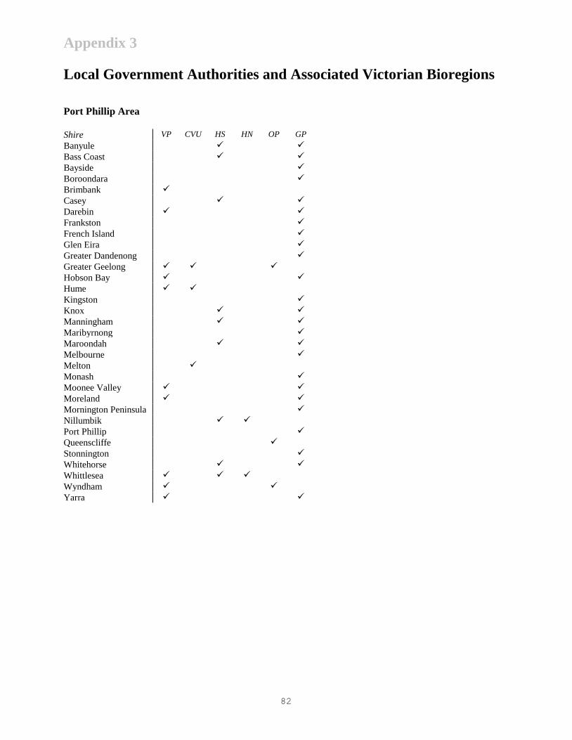
Appendix 3
82
Local Government Authorities and Associated Victorian Bioregions
Port Phillip Area
Shire VP CVU HS HN OP GP
Banyule
Bass Coast
Bayside
Boroondara
Brimbank
Casey
Darebin
Frankston
French Island
Glen Eira
Greater Dandenong
Greater Geelong
Hobson Bay
Hume
Kingston
Knox
Manningham
Maribyrnong
Maroondah
Melbourne
Melton
Monash
Moonee Valley
Moreland
Mornington Peninsula
Nillumbik
Port Phillip
Queenscliffe
Stonnington
Whitehorse
Whittlesea
Wyndham
Yarra

Appendix 3
83
Eastern Half of Victoria
Shire VP GO CVU NIS VR VA HS HN GP WPR EGU EGL
Alpine
Baw Baw
Cardinia
Delatite
East Gippsland
Greater Shepparton
Indigo
La Trobe
Mitchell
Moira
Murrindindi
South Gippsland
Strathbogie
Towong
Milawa
Wellington
Wodonga
Yallourn Works Area
Yarra Ranges
Legend for Victorian Bioregions
LM - Lowan Mallee VA - Victorian Alps
MM - Murray Mallee HS - Highlands - Southern Fall
WI - Wimmera HN - Highlands - Northern Fall
VP - Victorian Volcanic Plain OR - Otway Ranges
GLP - Glenelg Plain WP - Warrnambool Plain
DT - Dundas Tablelands OP - Otway Plain
GG - Greater Grampians GP - Gippsland Plain
GO - Goldfields WPR - Wilsons Promontory
CVU - Central Victorian Uplands EGU - East Gippsland Uplands
NIS - Northern Inland Slopes EGL - East Gippsland Lowlands
VR - Victorian Riverina

Appendix 3
84
Western Half of Victoria
Shire LM MM WI VP GLP DT GG GO CVU NIS VR OR WP OP
Ararat
Ballarat
Buloke
Campaspe
Central Goldfields
Colac Otway
Corangamite
Gannawarra
Glenelg
Golden Plains
Greater Bendigo
Hepburn
Hindmarsh
Horsham
Loddon
Macedon Ranges
Mildura
Moorabool
Mount Alexander
Moyne
Northern Grampians
Pyrenees
Southern Grampians
Surf Coast
Swan Hill
Warrnambool
West Wimmera
Yarriambiack
Acknowledgements
85
Acknowledgements
Many people have been involved in the preparation of this document. Diana Patterson, David Parkes, and Ian
Mansergh coordinated the overall content; a team of willing workers from all parts of the Flora and Fauna Program of
the Department of Natural Resources and Environment prepared the text, and supporting information; and
representatives from other Departmental Programs additional text and comment. Also Roxanne and Greg Oakley,
David Meagher and the photographers listed below for their invaluable contributions to the design and presentation of
the document.
Photo Credits: Front cover. Main - Comb Jelly Leucotheca sp., Open Coast Bioregion: William Boyle. Big Desert
Wilderness, Lowan Mallee Bioregion: David Parkes. Sunrise, Lake Mournpall, Murray Mallee Bioregion: Roxanne
Oakley. Crimson Rosella Platycercus elegans: McCann/NRE. Rough Leatherjacket Scobinichthys granulatus: Mary
Malloy. White-browed Wood-swallow Artamus superciliosus: McCann/NRE. Jack Mackerel Trachurus declivis:
Rudie Kuiter. Rock lichen Caloplaca sp.: David Meagher. Volute Amoria undulata: Mary Malloy. Jewel Anemone
Corynactis australis: Mary Malloy. Red Velvet Fish Gnathanacanthus goetzeei: William Boyle. Common Wombat
Vombatus ursinus: McCann/NRE. Red-eye Cicada Psaltoda moerens: McCann/NRE. Coast Banksia Banksia
integrifolia: McCann/NRE. Common Brushtail Possum Trichosurus vulpecula: McCann/NRE. Freshwater Crayfish
Euastacus yarraensis: McCann/NRE.
Inside front and back covers: Dragonfly Hemianax papuensis: David Meagher.
Further Information
86
Further Information
Additional copies of ‘Victoria’s Biodiversity – Directions in Management’ and the complementary documents
‘Victoria’s Biodiversity – Our Living Wealth’ and
‘Victoria’s Biodiversity – Sustaining Our Living Wealth’ may be obtained from:
NRE Information Centre
8 Nicholson Street
East Melbourne, 3002
(03) 9637 8080
Information Victoria
356 Collins Street
Melbourne, 3000
(03) 9603 9938
Regional offices
of the Department of Natural Resources and Environment
General Disclaimer
This publication may be of assistance to you but the State of Victoria and its employees do not guarantee that the
publication is without flaw of any kind or is wholly appropriate for your particular purposes and therefore disclaims all
liability for any error, loss or other consequence which may arise from you relying on any information in this
publication.