sunfishtest.files.wordpress.com · web viewwe have been told by visitors to the sally manzara...
TRANSCRIPT

Sunfish Lake Preliminary Fish Survey Report
From the Sally Manzara Interpretive Nature Center – January 23, 2019
Sunfish Lake is adjacent to Sunfish Lake Park, Lake Elmo MN 55042, and centered at 45.002 North Latitude and -92.895 West Latitude. It is highly elongated in the NW-SE direction and subject to wide fluctuations in water depth (and surface area) from year to year. Most of the water comes from precipitation and surface runoff, and at the current water level there is no outlet stream. An excerpt from the Metro Council 2012 lakes report is shown at the end of this document.
On the afternoon of July 9, 2018 Sam O’Neill and Tony Manzara launched a rowboat (with permission) from the Beaubien property on the west shore of Sunfish Lake near the location marked “1” on the map below. Fishing was done at the 8 marked locations on the lake, using rods and reels fitted with hooks and bobbers, with nightcrawlers as bait. Each location was fished for 15 minutes. The water depth of each location was measured via sonar. The surface water temperature was 28 C. All the fish caught were photographed against a background with parallel lines every inch, to determine their lengths – see photo below.

All the fish looked very similar and were identified on iNaturalist.org as Lepomis macrochirus – the common names are bluegill sunfish or bluegill. Please see the table below for details, and refer to map for location numbers. The map was provided courtesy of Angie Hong, Valley Branch Watershed District, and John Hanson, Barr Engineering.
Map n# Location Depth # of fish Length of each fish
1 Northwest Shore 5.2’ 2 7.0”, 6.0”
2 North Center 14’ 0 none
3 Off NE Shore no data 3 6.5”, 5.3”, 5.3”
4 NE Shore 9.2’ 2 5.3”, 5.0”
5 East Shore 7.4’ 4 7.5”, 7.3”, 7.0”, 6.2”
6 Midway Center 10.2’ 0 none
7 SE Shore Point 6.0’ 1 5.8”
8 South Center 15.5’ 0 none
It is clear that all of the fish were caught near the shore, in water no deeper than 10 feet.
We have been told by visitors to the Sally Manzara Interpretive Nature Center that carp or koi have been caught in the shallow area of water on the northwest edge of Sunfish Lake as it currently exists. We did not take the boat into that area.


Future Plans
It would be informative to do a more-in depth study by catching 50 fish at each end of the lake during one day, marking them to indicate the location, and releasing them. About one week later the same locations would be re-fished. If 100 fish were caught and all were marked fish, it would be clear that the total population was 100 fish. If 50/100 were marked the population estimate would be 200 total, if 10/100 were marked, the population estimate would be 1000 total, and if only one were marked, the population estimate would be 10,000 total. We would also learn if the fish moved from one end of the lake to the other in a relatively short time frame.
Also it would be interesting to try fishing other areas in the lake and with different baits.
If you have comments or suggestions, please contact Tony Manzara at [email protected] or 651-769-7001
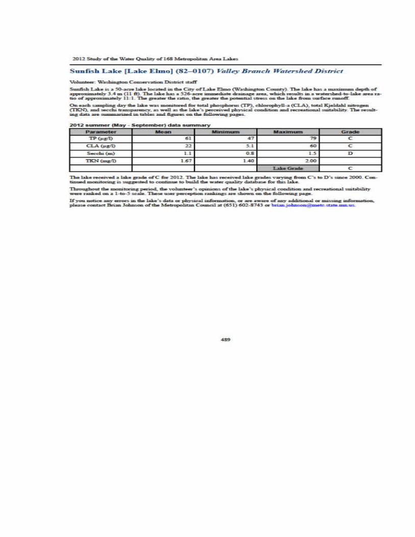
Excerpt from Metropolitan Council Report “2012 Study of the Water Quality of 168 Metropolitan Area Lakes” , page 489
Sunfish Lake [Lake Elmo] (82–0107) Valley Branch Watershed District
Volunteer: Washington Conservation District staff
Sunfish Lake is a 50-acre lake located in the City of Lake Elmo (Washington County). The lake has a maximum depth of approximately 3.4 m (11 ft). The lake has a 526-acre immediate drainage area, which results in a watershed-to-lake area ratio of approximately 11:1.
The three relevant pages concerning Sunfish Lake have been reproduced below, for better quality images please visit the metrocouncil.org website.