03 harvey (1) 051-072 22/9/11 11:00 page 51 an iron age
TRANSCRIPT

AN IRON AGE BOUNDARY SYSTEMAND ROMAN BURIALS AT
LEICESTER LANE, ST JOHNS,ENDERBYJames Harvey
Fieldwork between 2006 and 2008 has located evidence of a double-ditchedIron Age boundary system, the Fosse Way Roman road and later Romanburials west of St Johns and south of Leicester Lane, Enderby. Dating evidencefrom the eastern ditch suggests the formalisation of a boundary and/ortrackway in the Mid-Late Iron Age that probably directly or indirectly relatesto the Iron Age enclosures that have been recorded at Grove Farm to the north.This boundary was then reused and remodelled shortly after the conquest toform part of a new settlement system extending to the east. The Roman burialsmay be of inhabitants of this as yet unconfirmed Roman settlement.
INTRODUCTION
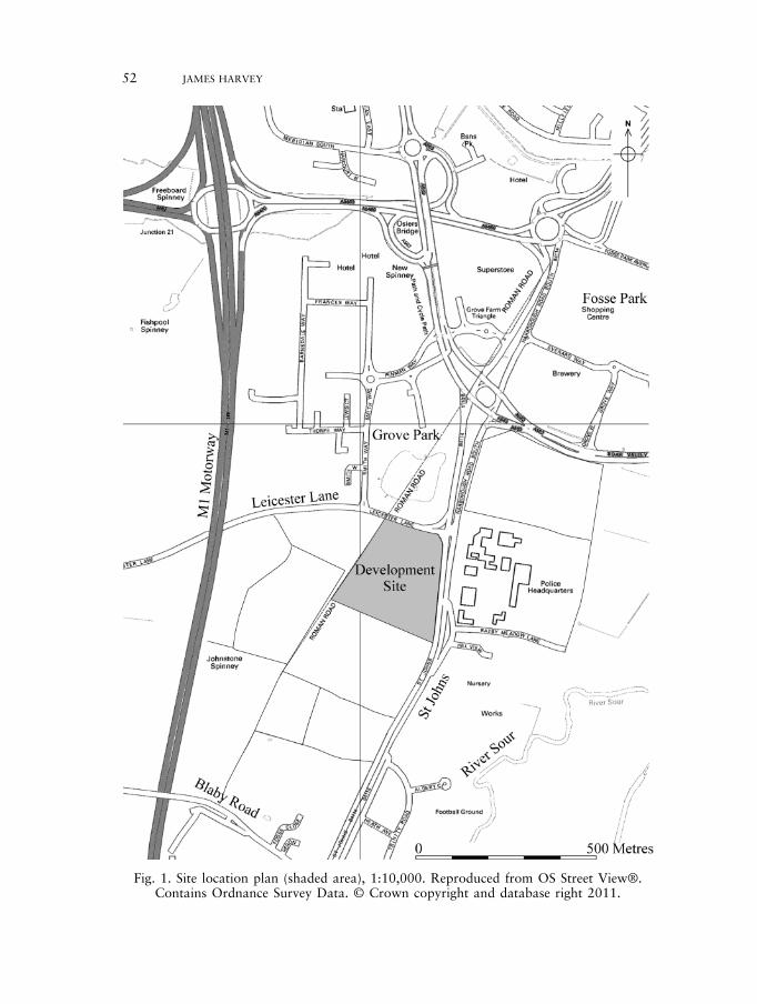
This paper presents the results of archaeological work carried out by University ofLeicester Archaeological Services (ULAS) in advance of the construction of theLeicester Park and Ride terminal, between St John’s and Leicester Lane, Enderby,Leicestershire (NGR SP 5520 9956, Fig. 1). The work was carried out on behalfof Leicestershire County Council, Department of Planning and Transportation,Highways Department, between June and August 2008. An excavation undertakenin 2008 followed a geophysical survey and an archaeological evaluation by trialtrenching undertaken in 2006.
The site is located 7km south-west of Leicester, to the north-west of the villageof Enderby. It consisted of an area of c. 6.4ha that is bounded to the north byLeicester Lane and to the east by St John’s Road (Figs 1 and 2). The site lies ona slight south-east facing slope, between heights of 65m and 70m OD, overlookingthe confluences of Lubbesthorpe Brook and other tributary streams that flow intothe River Soar to the east. The underlying geology within the areas investigatedcomprised Mercia mudstone group and drift glacial clays with gravel spreads. Aband of sandy clay with pockets of soft sand was also observed against the easternextremity of the site.
The site was within an area of known archaeological potential. A Romano-British brooch and an Anglo-Saxon die stamp had previously been found withinthe development area by metal detecting, while the western edge of the site followedthe line of a former field boundary reflecting the projected alignment of the Roman‘Fosse Way’, the major arterial road connecting Leicester with Lincoln to the north-east, and Cirencester and Exeter to the south-west (Fig. 2).
Trans. Leicestershire Archaeol. and Hist. Soc., 85 (2011)
03_Harvey (1)_051-072 22/9/11 11:00 Page 51
52 JAMES HARVEY
Fig. 1. Site location plan (shaded area), 1:10,000. Reproduced from OS Street View®.Contains Ordnance Survey Data. © Crown copyright and database right 2011.
03_Harvey (1)_051-072 22/9/11 11:00 Page 52

AN IRON AGE BOUNDARY SYSTEM AND ROMAN BURIALS AT ENDERBY 53
Two Iron Age settlements are known to the north of the site. A large ‘D’ shapedenclosure dated to the late first century BC was partially excavated 450m to thenorth of the site in 1983–84 that contained a sequence of circular roundhousestructures (Clay 1992). Additional work during a watching brief phase of the GroveFarm development in 1996 revealed further circular structures to the south of theenclosure, suggesting different phases of open and enclosed settlement (Beamishand Ripper 1997). A second, sub-circular enclosure located 150m north-west ofthe site was also partially excavated in 1996 during the Grove Farm developmentthat also dated to the first century BC. The settlement had two clear structuralphases, each represented by a pair of circular buildings within the enclosure. Theenclosure itself had a large gateway complex on its north-east side, with apossible trackway extending away from the enclosure (Meek et al. 2004, fig. 10).
Based on the potential of the site highlighted by the known sites in the vicinityand a geophysical survey conducted on the site (Stowe 2006), an archaeologicalevaluation was undertaken within the proposed development between lateJanuary and early February 2006 (Harvey 2006). The aim of the evaluation wasto establish the nature, extent and significance of archaeological deposits on thesite in order to determine the potential impact upon them from the proposeddevelopment. Eighteen trenches were excavated, targeting anomalies revealed bythe geophysical survey (Fig. 2). This revealed two large ditches highlighted by thegeophysical survey in the north-east corner of the site. Two post-holes, a gully anda possible ring-gully were also recorded in close association along the eastern edgeof the site. On the western side of the site, make-up layers relating to the FosseWay Roman road were also recorded.
In the light of the results from the trial trench evaluation, the Senior PlanningArchaeologist at Leicestershire County Council requested that two areas alongthe eastern side of the site were to be examined prior to the development, and anintensive watching brief undertaken along the western edge of the development(adjacent to the Fosse Way) site during any groundworks in that area.
RESULTS
Boundary ditches
The excavation area was crossed by two parallel ditches, running broadly northto south. They were clearly associated as they both exhibited the same subtlechanges of alignment along their course. The western ditch spans the whole lengthof Area 1 and its continuation can be projected into Area 2, giving a length inexcess of 180m within the development area. The eastern ditch was observed for75m, although it is likely that it would have continued parallel to the westernditch, extending beyond the development area a short distance north of Area 2.Despite the clear similarities in the ditch alignments, the features themselves arevery different in character from one another.
The eastern ditch was only observed within Area 1, its width varying between1.17m and 2m, and its depth between 0.6m and 0.9m. To the south a clear
03_Harvey (1)_051-072 22/9/11 11:00 Page 53

interruption of the ditch was visible with two clear termini demarcating a gapmeasuring 3.17m, covered with a gravel spread that extended westwards. It wasmade up of brown gravel, generally only a single layer thick that had been pressedinto the natural clay. There was no evidence of re-cutting within the eastern ditchand the profile was very similar throughout. The sides were steep and straight withan incline of c. 50–60º, and it had a flat base, while the two ends of the terminiwere similarly steep and straight. The excavated slots revealed two fills consistingof similar firm mid-yellow/grey brown silty-clay, the upper fill containing a highercharcoal content than the lower. Pottery was only present in small quantities inthe upper fill, which may indicate that this was the result of final levelling, probablyusing material from surviving bank material. The fills at the termini were slightlydifferent. The upper fill of the northern terminal was much richer in charcoal thananywhere else along the ditch, while the southern terminal contained a charcoalrich dark orangey grey silty-clay primary deposit below a dark orangey brownsandy-clay deposit, above which were the two fills observed elsewhere.
54 JAMES HARVEY
Fig. 2. Location of excavation Areas 1 and 2, and evaluation trenches.
03_Harvey (1)_051-072 22/9/11 11:00 Page 54
AN IRON AGE BOUNDARY SYSTEM AND ROMAN BURIALS AT ENDERBY 55
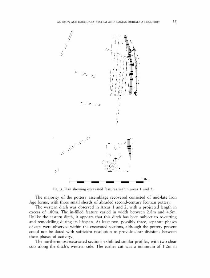
The majority of the pottery assemblage recovered consisted of mid-late IronAge forms, with three small sherds of abraded second-century Roman pottery.
The western ditch was observed in Areas 1 and 2, with a projected length inexcess of 180m. The in-filled feature varied in width between 2.8m and 4.5m.Unlike the eastern ditch, it appears that this ditch has been subject to re-cuttingand remodelling during its lifespan. At least two, possibly three, separate phasesof cuts were observed within the excavated sections, although the pottery presentcould not be dated with sufficient resolution to provide clear divisions betweenthese phases of activity.
The northernmost excavated sections exhibited similar profiles, with two clearcuts along the ditch’s western side. The earlier cut was a minimum of 1.2m in
Fig. 3. Plan showing excavated features within areas 1 and 2.
03_Harvey (1)_051-072 22/9/11 11:00 Page 55

width, and varied in depth between 0.77m and 1.1m. The eastern side was steepand straight with an incline of c. 50–60º, and the remains of the base appearedrelatively flat. Pottery that dated between the late first and early second centuryAD was recovered from the fills of this cut. The later cut varied in width between2m and 3m, and was c. 1m deep with a ‘U’ shaped profile and a concave base.The uppermost fill contained pottery dating to the late third/early fourthcentury. Disarticulated human bones relating the lower body of an unsexedindividual were found in the upper fill in the northernmost excavated section, andmay suggest that an articulated burial had been disturbed during the later re-cutting of the ditch.
Clear remodelling of the ditch system was recorded further south in Area 1 thatincluded widening along its eastern side. A gully, aligned east to west, 1m wideand varying in depth between 0.2m and 0.5m, clearly cut the eastern ditch beforechanging its alignment and merging with the western ditch. The gully was filledby a single grey brown silty-clay deposit that contained small quantities of potterydating between the late first and mid-second century AD. In addition to first–secondcentury pottery, two second-century trumpet brooches (Fig. 7.1 and 7.2) and asilver denarius of Septimius Severus (AD 192–211) were recovered.
The western ditch clearly continued into Area 2. The ditch varied in widthbetween 2.7m and 4.5m over a 20m stretch, and again clear re-cutting wasalso observed. A difference between the backfill of the sections excavated inthis area compared with Area 1 was also evident. The fill generally consisted of ahomogenous grey silty-clay with very few finds, the small quantities of Roman pot-tery that were recorded consisting of small and abraded sherds.
Iron Age activity
To the south of Area 2 an area was examined to target two post-holes, a gullyand a possible curvilinear gully located during the evaluation. The two post-holeswere relocated, while the curvilinear feature recorded in the evaluation turnedout to be elliptical and irregular when fully exposed, and is likely to represent theremains of a natural tree throw feature. A further gully to the south containedone sherd of mid-late Iron Age pottery, while to the west another post-holewas identified. These features probably represent some small-scale late prehistoricactivity, although no clear functionality can be interpreted from their limitedremains. The three post-holes were all well-defined features and may indicate thepresence of a timber structure, the remainder of which has been lost through ploughtruncation.
Burials (with Harriet Jacklin) (Fig. 4)
Six burials were located during the excavation, although five of these were locateddirectly below the plough line and had been subject to extensive truncation anddisturbance. The burials were all roughly aligned north-north-west to south-south-east, the same alignment as the ditch system, and appear to have been adults,
56 JAMES HARVEY
03_Harvey (1)_051-072 22/9/11 11:00 Page 56

AN IRON AGE BOUNDARY SYSTEM AND ROMAN BURIALS AT ENDERBY 57
although only three of the burials could be sexed. SK06 was located within the fillof the western ditch and survived comparatively intact (Figs. 4 and 8).
SK01Only faint traces of a grave cut were recorded that measured 0.9m in length,0.25m wide and 50mm deep. Little can be said about the cut as the remainsclearly only represented the extreme base of the feature that seemed to be fairlyflat. Within the cut the fragmentary human remains of lower limb bones wereexcavated, including parts of the femur and tibia. The crushed remains of some of
Fig. 4. Plan of archaeological features recorded in Area 1.
03_Harvey (1)_051-072 22/9/11 11:00 Page 57

the pelvis and lower vertebrae were also present. The adult individual had beenburied in a supine position. What little remained of the grave fill consisted ofa dark yellow brown silty-clay deposit that was probably re-deposited naturalsubstratum.
SK02As with SK01, only slight traces of a grave cut [121] were recorded that measured1.22m in length, 0.30m wide and 50mm deep. Again, clearly only the base of thefeature remained that was relatively flat although uneven in places. Within the cutwere fragmentary human remains of the torso, as well as upper and lower limbsas far as the femurs and fragments from the back of the skull. A lower limb bonewas also identified 1.5m south of the burial during topsoil machining that islikely to have been dragged away from the body fairly recently. This individualis likely to be a female aged between 36 and 50, and was buried in a supineposition. The grave fill consisted of a dark yellow brown silty-clay deposit thatwas probably re-deposited natural substratum.
58 JAMES HARVEY
Fig. 5. Plan of archaeological features recorded in Area 2.
03_Harvey (1)_051-072 22/9/11 11:00 Page 58

AN IRON AGE BOUNDARY SYSTEM AND ROMAN BURIALS AT ENDERBY 59
Fig. 6. Selected sections through the boundary ditch:Sections A–F (western) and Sections G–K (eastern).
03_Harvey (1)_051-072 22/9/11 11:00 Page 59

60 JAMES HARVEY
Fig. 7. Two Roman trumpet brooches (1 & 2) and Late Iron Age Nauheim brooch (3)recovered during the course of the archaeological investigations.
03_Harvey (1)_051-072 22/9/11 11:00 Page 60

AN IRON AGE BOUNDARY SYSTEM AND ROMAN BURIALS AT ENDERBY 61
Fig. 8. Burial remains recorded in Area 1.
03_Harvey (1)_051-072 22/9/11 11:00 Page 61

SK03No obvious cut was observed for these remains that were pressed into the naturalclay. The fragments of bone consist of a crushed skull and ribs of an adult.
SK04Only the base of the grave cut remained that measured 1.5m in length, amaximum of 0.6m wide and a maximum of 120mm deep. The base of the cut wasfairly flat although uneven in areas. Within the cut were the remains of onlythe right side of a burial consisting of fragmentary elements from the femur to theskull. This individual appears to have been an adult male deliberately buriedon their right-hand side (the left-hand side having been removed by horizontal trun-cation) as the remaining bones were well articulated, suggesting any movement/disturbance of the body would have had to have happened soon after burial.
SK05This was the only burial recorded on the eastern side of the western ditch. Again,only the base of the grave cut remained, which measured 1.21m in length, 0.43mwide and 70mm deep, and within the cut only the lower remains on an individualwere present, consisting of the lower limb bones, fragments of the left pelvis and lowerleft arm. This adult individual (16–35 years) had been placed in a supine position.
SK06This burial was located during the excavation of a section of the western ditch.Stratigraphically the grave cut the latest phase of the ditch fill, and the cut ofthe grave measured 1.65m in length and 600mm wide. The total depth of thecut could not be clearly established because the fills of the upper ditch and gravewere indistinguishable from one another. The grave did clearly cut the lowerditch fill to a depth of 0.20m. Within the grave cut was a reasonably completeburial, although the bones were fragmentary. The vertebrae were particularlyfragmented, with the upper area almost entirely absent. Another noticeableabsence was the lower right arm and hand, with the radius and ulna cut offhalfway down. This cannot be attributed to the state of preservation because theleft side was reasonably well preserved. It is unclear whether this burial was cutafter the ditch had filled up completely or whether the grave was cut into theditch when it still existed as a partially open feature. The burial appears to havebeen a male aged between 36 and 50, and was orientated along the alignment ofthe ditch at that point. Also, the burial was clearly located on the eastern edgeof a later ditch cut, so spatially it seems more likely that the burial was dug intothe ditch post-disuse while the feature was still a prominent feature within thelandscape.
The Fosse Way (Fig. 9)
Although not observed during the excavation, evidence of the Fosse Way waslocated during the evaluation and subsequent watching brief.
62 JAMES HARVEY
03_Harvey (1)_051-072 22/9/11 11:00 Page 62

AN IRON AGE BOUNDARY SYSTEM AND ROMAN BURIALS AT ENDERBY 63
Fig.
9.R
emai
nsof
the
Foss
eW
ay,
reco
rded
atth
eso
uth-
east
end
ofT
renc
h18
duri
ngth
eev
alua
tion
(Har
vey
2006
).
03_Harvey (1)_051-072 22/9/11 11:00 Page 63

The agger for the Fosse Way was partially exposed at the south-east end ofTrench 18 during the 2006 evaluation (Harvey 2006, 19). The accepted construc-tion method for Roman roads involves the building of an embankment or agger,often using material from the roadside ditches, on top of which large blocks ofstones or gravel layers would be laid to form a foundation. This would havesupported a surface consisting of gravel above. There would have also been acamber that would have helped with the drainage (Bagshawe 1979, 15). However,there is variation in construction methods (Davies 2004, 55).
Two distinct layers were observed; the lower layer consisting of large stonesforming its foundation known as ‘hard bottoming’, also observed further northat Grove Farm (Sharman and Clay 1991, 9). The upper layer consisted of a siltysand and gravel with a maximum size of 80mm. It is unlikely that this is part ofa surface and is more likely to be a middle foundation layer, as the uppermostlayers of the road in this area have been subject to considerable truncation throughplough action. A possible roadside ditch was observed to the north-west of theroad, but again this has suffered considerable plough damage. A gravel surfacewas also observed to the north-west of the trench. Land was often levelled beyondthe agger during the construction of the road; it is possible gravel was laid downin order to aid the transportation of materials for the road across difficult terraindue to the unsuitability of the natural clay. A Nauheim brooch was recovered inclose proximity to this layer that may date as early as the late first century BC(Fig. 7.3).
There was no evidence that the natural clay had been used to build an agger.Davies suggests that this is the case for only 26% of the Roman roads in Britainand that the likelihood that larger stones will be found in the foundationlayer increases towards the north of Britain. It has also been argued that ‘hardbottoming’ was favoured by military road-builders (Davies 2002, 58). The word‘Fosse’ is derived from the Latin Fossa, meaning ‘ditch’. For the first few decadesafter the Roman invasion of Britain in AD 43, the Fosse Way marked the westernfrontier of Roman rule in Britain. It is possible, therefore, that a defensive ditchpre-dated the road, or ran alongside it for at least some of its length, although todate there has been no evidence of this located.
DISCUSSION
The evidence suggests that the initial activity on the site consisted of one or, morelikely, a pair of parallel ditches dating to the mid-late Iron Age, although anearlier date for their establishment cannot be ruled out. Only the eastern ditchcontained clearly stratified prehistoric material, but the parallel nature of theditches that exhibit similar changes to their alignments reveals a clearrelationship between the eastern and western ditch. Also, the western ditch doescontain hints of an earlier ditch (along with residual Iron Age pottery) within theexcavated section that does point to a pre-Roman double-ditch system. Linearditch systems are numerous in the East Midlands (14 known from Leicestershireand Rutland), in the form of single, double, triple and even quadruple parallel
64 JAMES HARVEY
03_Harvey (1)_051-072 22/9/11 11:00 Page 64
AN IRON AGE BOUNDARY SYSTEM AND ROMAN BURIALS AT ENDERBY 65
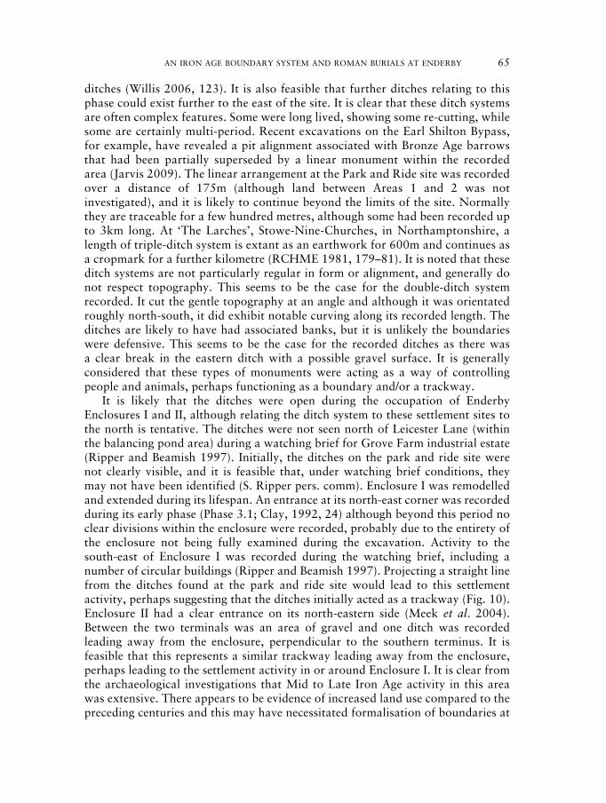
ditches (Willis 2006, 123). It is also feasible that further ditches relating to thisphase could exist further to the east of the site. It is clear that these ditch systemsare often complex features. Some were long lived, showing some re-cutting, whilesome are certainly multi-period. Recent excavations on the Earl Shilton Bypass,for example, have revealed a pit alignment associated with Bronze Age barrowsthat had been partially superseded by a linear monument within the recordedarea (Jarvis 2009). The linear arrangement at the Park and Ride site was recordedover a distance of 175m (although land between Areas 1 and 2 was notinvestigated), and it is likely to continue beyond the limits of the site. Normallythey are traceable for a few hundred metres, although some had been recorded upto 3km long. At ‘The Larches’, Stowe-Nine-Churches, in Northamptonshire, alength of triple-ditch system is extant as an earthwork for 600m and continues asa cropmark for a further kilometre (RCHME 1981, 179–81). It is noted that theseditch systems are not particularly regular in form or alignment, and generally donot respect topography. This seems to be the case for the double-ditch systemrecorded. It cut the gentle topography at an angle and although it was orientatedroughly north-south, it did exhibit notable curving along its recorded length. Theditches are likely to have had associated banks, but it is unlikely the boundarieswere defensive. This seems to be the case for the recorded ditches as there wasa clear break in the eastern ditch with a possible gravel surface. It is generallyconsidered that these types of monuments were acting as a way of controllingpeople and animals, perhaps functioning as a boundary and/or a trackway.
It is likely that the ditches were open during the occupation of EnderbyEnclosures I and II, although relating the ditch system to these settlement sites tothe north is tentative. The ditches were not seen north of Leicester Lane (withinthe balancing pond area) during a watching brief for Grove Farm industrial estate(Ripper and Beamish 1997). Initially, the ditches on the park and ride site werenot clearly visible, and it is feasible that, under watching brief conditions, theymay not have been identified (S. Ripper pers. comm). Enclosure I was remodelledand extended during its lifespan. An entrance at its north-east corner was recordedduring its early phase (Phase 3.1; Clay, 1992, 24) although beyond this period noclear divisions within the enclosure were recorded, probably due to the entirety ofthe enclosure not being fully examined during the excavation. Activity to thesouth-east of Enclosure I was recorded during the watching brief, including anumber of circular buildings (Ripper and Beamish 1997). Projecting a straight linefrom the ditches found at the park and ride site would lead to this settlementactivity, perhaps suggesting that the ditches initially acted as a trackway (Fig. 10).Enclosure II had a clear entrance on its north-eastern side (Meek et al. 2004).Between the two terminals was an area of gravel and one ditch was recordedleading away from the enclosure, perpendicular to the southern terminus. It isfeasible that this represents a similar trackway leading away from the enclosure,perhaps leading to the settlement activity in or around Enclosure I. It is clear fromthe archaeological investigations that Mid to Late Iron Age activity in this areawas extensive. There appears to be evidence of increased land use compared to thepreceding centuries and this may have necessitated formalisation of boundaries at
03_Harvey (1)_051-072 22/9/11 11:00 Page 65

this time (Willis 2006). Two other double-ditch systems have been recorded in thewider landscape from aerial photographs. Approximately 2km due south of thesite, west of Whetstone (SP 550 973), a c. 250m long stretch of a double-ditchsystem has been observed which seems to enclose an area by cutting off the anglebetween the River Soar and Whetstone Brook (Pickering and Hartley 1985, 34).Adjoining the ditch system within the enclosed area is a ‘washing line’ enclosure,as well as possible further rectangular enclosures, perhaps indicating settlement
66 JAMES HARVEY
Fig. 10. Archaeological sites in the vicinity, including cropmarks visible to the east.
03_Harvey (1)_051-072 22/9/11 11:00 Page 66

AN IRON AGE BOUNDARY SYSTEM AND ROMAN BURIALS AT ENDERBY 67
activity associated with the feature. Another double-ditch system is recorded eastof Blaby, some 3km south-east of the site (SP 578 974) running north to the RiverSoar, again with a cluster of adjoined enclosures suggesting a possible farmstead(ibid). There is no suggestion that these sites are directly related to the ditchsystem, although it is tempting to suggest that the site at Whetstone representscontemporary land division in the area. However, they do indicate a clearrelationship between these systems and the River Soar. Considering the directionof the western ditch in Area 2, it seems feasible that the ditch system may haveoriginally continued to the river, some 450m south-south-east of the site.
It has been interpreted that boundaries have been used to divide different landresources. These boundaries often run along or perpendicular to natural featuressuch as water courses or changes in geology. The westernmost ditch recorded onsite definitely appeared to demarcate a change of geology on the site, even thoughthis change was not obvious topographically. To the west of the ditch, MerciaMudstone group bedrock with shallow patches of overlying gravel was recorded,while to the east was an orangey brown sandy-clay deposit that contained bandsof red sand. Excavation of the ditch slots showed this deposit to butt up againstand overlie the mudstone. The geological map on the area loosely suggests thisdivision marks the boundary between the Mercia Mudstone and a small depositof Mid-Pleistocene Glaciofluvial material extending eastwards, consisting of sandand gravel that is itself encapsulated south, east and north-east by a small area ofterrace gravels of the River Soar.
It is clear that the eastern boundary ditch went out of use before or aroundthe point of the Roman conquest. Three extremely abraded sherds of Romanpottery were also found in one of the excavated slots, and it was suggested theirpoor condition may indicate re-deposited material. The enclosure ditches atthe two enclosures at Grove Farm also included small quantities of abradedRoman pottery in their upper fills (Pollard 1992; Marsden and Morris 2004). Thewestern boundary does clearly continue to be re-used into the Early Romanperiod, although it is uncertain whether there was an abandonment period betweenthe double-ditch system and re-use of the western ditch, as the paucity andapparent mixing of finds has made it difficult to phase the ditch. However, theredoes seem to be at least two phases of re-cutting associated with the western ditch.The majority of the pottery dates between the late first to second century AD,along with a smaller assemblage of pottery dating to the later third–fourthcentury. A silver denarius of Septimius Severus (AD 193–211) was recoveredtowards the base of the ditch at the southern end of Area 1 that would indicatethe ditch was still functional at the turn of the third century.
The projected line of the Fosse Way, the Roman road that linked Exeter (IscaDumnoniorum) in south-west England to Lincoln (Lindum Colonia) in the EastMidlands, via Ilchester (Lindinis), Bath (Aquae Sulis), Cirencester (Corinium) andLeicester (Ratae Corieltauvorum), passes within 150m west of the ditch systems,and evidence of the road make-up layers was recorded during the course of theevaluation. The word ‘Fosse’ is derived from the Latin Fossa, meaning ‘ditch’. Forthe first few decades after the Roman invasion of Britain in AD 43, the Fosse Way is
03_Harvey (1)_051-072 22/9/11 11:00 Page 67

believed to have marked the western frontier of Roman rule in Britain. It is possible,therefore, that a defensive ditch ran alongside the road for at least some of itslength, although this was not evident here. It appears that neither of the Iron Agesettlements located to the north-west (Enclosures I and II) continued into theRoman period, and this in some part may relate to their location on the western sideof the Fosse Way. Unfortunately, it is not possible to trace the extent of the westernditch beyond the confines of the site, but only consider why the ditch remains in usedespite the establishment of a new alignment. Features at the north end of the sitesuggest that archaeological deposits dating to the late first to second centurycontinue to the east of the site. A gully aligned perpendicular to and merging withthe western ditch was recorded with a possible open and closed phase against theditch. This may be evidence of a ‘clothes line’ type paddock enclosure associatedwith the ditch. Aerial photography in 2006 has revealed possible archaeologicalactivity 200m to the north-east, on the arable field north of the police headquarterson St Johns (MLE 16568). Here, a clear linear cropmark can be observed orientatedon the same alignment as the western ditch that may indicate further activityassociated with the site (Fig. 10). This feature leads to a rectangular cropmarkfeature that appears to contain an apsidal element on its southern side. As it isparallel to the projected alignment of the Fosse Way (200m to the west), this couldsuggest a Roman date. Further ditches and a possible ring gully can also be traced,suggesting that the features would continue beneath the police headquarters to thesouth. This location would appear to be a good position for a settlement, as thegeological map suggests it occupies an island of sand and gravel terrace separated tothe west by clay and alluvium to the east. If there was a settlement to the east of thesite it seems likely that the western ditch acted as a boundary to this activity. Thissuggestion of settlement activity close to the north end of the site is supported by thepattern of artefact recovery identified along the western ditch. A clear artefactualbias towards the north of the site can be seen, with the three northernmostexcavated sections producing the greatest density of pottery and variety of forms.Given that the bulk of the pottery recovered from the western ditch and theassociated gullies dated between the late first and second century AD, it is likely thatthere is a nearby settlement dating to this period. It was noted from the faunalassemblage recovered from site that there were notably high proportions of cattleand horse bones represented. Work on spatial patterning of bones at other sites hassuggested that larger bones tend to be located around the edges of the settlement,and that fragments are smaller towards the centre due to movement of bonethrough re-working of deposits (Wilson 1996, 14). Spatial analysis carried out atManor Farm Humberstone (Browning 2011), indicated that cattle and horse boneswere most common in the enclosure ditches, while sheep occurred more frequentlyin the roundhouses. The proportion of horse bones was particularly enhanced in theenclosures, compared to the roundhouses, suggesting that disposal of horse boneswas occurring away from the centre of the settlement. The very low density ofcharred plant remains recovered, a single chaff fragment in only one sample,suggests also that the site is away from the area of occupation or other cereal-relatedactivities.
68 JAMES HARVEY
03_Harvey (1)_051-072 22/9/11 11:00 Page 68

AN IRON AGE BOUNDARY SYSTEM AND ROMAN BURIALS AT ENDERBY 69
The theory that the western ditch marks a settlement boundary is givenfurther substance by the burials recorded on the site. A clear characteristic of allsix burials was their relationship to the western ditch. The ditch exhibits subtlechanges of alignment across the site and these changes in alignment are alsoevident in the burials. The differences between the bearing of the ditch and thebearing of adjacent sections of the ditch only vary by a maximum of 6.5º(although four of the five burials only vary by a maximum of 2.2º). Thedifference in orientations between the burials themselves varies by 12.2º, so it isclear that the localised orientation of the western ditch has a direct influence onthe burial location. The locations of SK01–05 are between 2.63m and 4.76maway from the edge of the ditch, with four of the five burials (SK01–04)occurring along the western and one along the eastern side (SK05). It is possiblethe burials on the western side may be respecting the line of a possible bank,formed by the excavation of the ditch. Perhaps a similar case could be suggestedfor SK05, but clearly a different burial practice was observed for SK06 whichmay either represent different treatment of the individual or more likely a laterphase of activity. The presence of disarticulated human remains located atthe northern end of the ditch does suggest the association of burial practice withthis boundary, and this may have been a long tradition given that at least onefurther burial had been disturbed. It is possible that there was an initial phase ofburials associated with the family group relating to the settlement, and then alater phase of burial occurred that reflects an association with the boundaryfeature.
When considering the specific research questions that were proposed priorto the excavation, it can be seen that the results have added to our understandingof the relationship between Late Iron Age and Roman settlements within theGrove Farm area. Neither Enclosure I nor II showed any evidence of continuityinto the Roman period, although both did reveal Roman pottery in their ditchbackfills. It is not clear whether these settlements were still occupied at the timeof the conquest, but it is suggested that Enclosure II may have been abandoned bythis point (Meek et al. 2004, 17). However, the Park and Ride site has providedan insight into a continued picture of settlement activity within the area,although it is not certain whether the evidence represents a continued re-use offeatures or whether periods of abandonment took place between the differentphases of activity. Dating evidence from the eastern ditch suggests theformalisation of a boundary and/or trackway in the Mid-Late Iron Age thatprobably directly or indirectly relates to the Iron Age enclosures that have beenrecorded at Grove Farm. This boundary was then reused and remodelled shortlyafter the conquest to form part of a new settlement system extending to the east.It was clear that the boundary still held territorial importance, as it was used as aplace of burial during this period. The pottery assemblage suggests that thesettlement activity was relatively short-lived, with most of the material dating nolater than the late second century AD. However the boundary continues to beused into the third century at the very least, with a continued tradition of burialalong its course.
03_Harvey (1)_051-072 22/9/11 11:00 Page 69

ACKNOWLEDGEMENTS
The fieldwork was undertaken by the author of this report with the assistance ofKieran Armitage, Keith Johnson, Scott Lomas, Roy Pouter and Timothy Rhodes.The subsequent watching brief was undertaken by Dan Stone and Martin Shore.Pottery analysis was by Elizabeth Johnson, metalwork by Nick Cooper, the humanbone by Harriet Jacklin, the animal bone by Jennifer Browning and charred plantremains by Angela Monckton. The brooches were drawn by Mike Hawkes. I wouldlike to thank Robert Reeves from Leicestershire County Council for his assistanceand cooperation throughout the project. Also thanks to Mike Storer for giving uphis time to undertake a metal detector survey of the site. The project wasmanaged by Patrick Clay and monitored on behalf of the planning authority byRichard Clark of Leicestershire County Council. The archive is deposited withLeicestershire County Council, under the accession number X.A.6.2006, and thefull reports (Harvey 2006; 2009) can be consulted through the OASIS databasehttp://www.oasis.ac.uk, or at the Leicestershire County Council, HistoricEnvironment Record.
BIBLIOGRAPHY
Bagshawe, R. W., 1979 Roman Roads. Shire Archaeology No. 10. Shire Publications:Aylesbury.
Browning, J., 2011 ‘The animal bone’, in J. Thomas (ed.) Two Iron Age ‘Aggregated’settlements in the environs of Leicester. Excavations at BeaumontLeys and Humberstone. Leicester: Leicester ArchaeologyMonograph 19.
Clay, P., 1992 ‘An Iron Age Farmstead at Grove Farm, Enderby, Leicestershire’,Transactions of the Leicestershire Archaeological and HistoricalSociety 66, 1–82.
Cooper, N. J., 2006 The Archaeology of the East Midlands: An ArchaeologicalResearch Assessment and Research Agenda. Leicester ArchaeologyMonograph 13. University of Leicester Archaeological Services:Leicester.
Davies, H., 2002 Roads in Roman Britain. Tempus.Harvey, J. R., 2006 An Archaeological Evaluation at the Proposed Aylestone Park and
Ride Scheme (Site 35), Leicester Lane, Enderby, Leicestershire (SP5111 9958). ULAS Report No. 2006-023 (unpublished).
Harvey, J. R., 2009 An Archaeological Excavations on land between St Johns/LeicesterLane, Enderby, Leicestershire (SP 5111 9958). ULAS Report No.2009-169 (unpublished).
Jarvis, W., 2009 Archaeological Fieldwork in advance of the Earl Shilton Bypass,Leicestershire. ULAS Report No. 2008-110 (unpublished).
Meek, J., Shore, M. ‘Iron Age Enclosures at Enderby and Huncote, Leicestershire’,and Clay, P., 2004 Transactions of the Leicestershire Archaeological and Historical
Society 78, 1–34.Marsden, P. and ‘The Iron Age and Roman pottery’, in Meek et al. 2004, 12–3Morris, E. L., 2004
70 JAMES HARVEY
03_Harvey (1)_051-072 22/9/11 11:00 Page 70

AN IRON AGE BOUNDARY SYSTEM AND ROMAN BURIALS AT ENDERBY 71
Pickering, J. and Past Worlds in a Landscape: Archaeological Cropmarks inHartley, R. F., 1985. Leicestershire. Leicestershire Museums, Art Galleries and Record
Service Archaeological Reports Series No. 11: Leicester.Pollard, R. J., 1992 ‘The Roman pottery’, in Clay 1992, 52–4.RCHME, 1981 An Inventory of the Historical Monuments in the County of
Northampton, Vol. 3: Archaeological Sites in North-WestNorthamptonshire. Royal Commission on Historical MonumentsEngland. London: Her Majesties Stationery Office.
Ripper, S. and ‘Enderby, Grove Park’, Transactions of the LeicestershireBeamish, M., 1997 Archaeological and Historical Society 71, 113.Sharman, J. and ‘Leicester Lane, Enderby: An archaeological evaluation’,Clay, P., 1991 Transactions of the Leicestershire Archaeological and Historical
Society 78, 1–34.Stowe, S., 2006 Geophysical survey Report. Aylestone Park and Ride Scheme.
Stratascan Report J 2099 (unpublished).Willis, S., 2006 ‘The Later Bronze and Iron Age’, in N. J. Cooper (ed.), The
Archaeology of the East Midlands: An Archaeological ResearchAssessment and Research Agenda, pp. 89–136. LeicesterArchaeology Monograph 13. University of Leicester ArchaeologicalServices: Leicester.
03_Harvey (1)_051-072 22/9/11 11:00 Page 71