07 · web viewlocation exp date of ferc license owner benton falls 4.3 benton 2/28/2034 benton...
TRANSCRIPT

07-105 STATE PLANNING OFFICE (obsolete; the rule chapter has been reassigned to 01 - Department of Agriculture, Conservation and Forestry)
Chapter 1: KENNEBEC RIVER RESOURCE MANAGEMENT PLAN: BALANCING HYDROPOWER GENERATION AND OTHER USES
TABLE OF CONTENTSPage
INTRODUCTION.......................................................................................................................... 1Purposes of the Kennebec River Resource Management Plan................................................... 1Geographic Scope of the Plan.................................................................................................... 2Dams Undergoing Relicensing by FERC................................................................................... 2Socioeconomic Characteristics and Historical Context.............................................................. 4History of Hydropower Regulation in Maine............................................................................. 8
ECOLOGICAL CHARACTERIZATION OF THE KENNEBEC RIVER BASIN...................... 10Physical Description of the Kennebec River and Watershed..................................................... 10Fish and Wildlife Habitat.......................................................................................................... 11
Nontidal Mainstem Waters................................................................................................... 11Tributaries............................................................................................................................. 15Tidal Waters.......................................................................................................................... 25Water Quality........................................................................................................................ 29
HYDROPOWER REGULATION................................................................................................ 31Role of the Federal Government in Hydropower Regulation.................................................... 31The FERC Consultation Process............................................................................................... 32The Role of State Government.................................................................................................. 33Relative Cost of Relicensing Activities..................................................................................... 34Summaries of Status of Projects Undergoing Relicensing........................................................ 35
RESOURCES AND BENEFICIAL USES.................................................................................... 44Hydropower Generation............................................................................................................ 44
Existing Facilities................................................................................................................. 44Hydropower Potential........................................................................................................... 48Recommendations................................................................................................................. 48
Flows......................................................................................................................................... 50Reservoir Levels and Flow Regime...................................................................................... 50Water Management Regime.................................................................................................. 51Flood Damage Reduction..................................................................................................... 52Recommendations................................................................................................................. 53
Water Quality............................................................................................................................ 54Recommendations................................................................................................................. 54
Fisheries.................................................................................................................................... 55Anadromous Fisheries.......................................................................................................... 55Inland Fisheries.................................................................................................................... 111Recommendations................................................................................................................ 126
Recreational and Scenic Resources..........................................................................................129

Chapter 1 page ii
Recreation and Access Opportunities..................................................................................129Commercial Rafting............................................................................................................. 138Recommendations................................................................................................................ 141
Archaeology............................................................................................................................. 142Archaeological and Historic Resources...............................................................................142Archaeological Impacts and Mitigation...............................................................................150Recommendations................................................................................................................ 151
MUNICIPAL PLANNING........................................................................................................... 152Shoreland Zoning..................................................................................................................... 152Municipal Planning from Harris Dam to Augusta....................................................................152
CRITERIA FOR STATE AGENCY DECISION-MAKING.......................................................156Maine Rivers Policy: Special Protection for Outstanding River Segments..............................157
SUMMARY OF RECOMMENDATIONS..................................................................................158Hydropower.............................................................................................................................. 158Flows........................................................................................................................................ 158Water Quality........................................................................................................................... 159Fisheries................................................................................................................................... 159Recreational and Scenic Resources..........................................................................................160Archaeology............................................................................................................................. 161
APPENDICES.............................................................................................................................. 162
BIBLIOGRAPHY......................................................................................................................... 192
TABLES AND FIGURES
Table 1 -- Dams in the Kennebec River Basin Subject to Relicensing; All Licenses set to Expire in 1993.......................................................................................................................... 3
Table 2 -- Hydropower Licenses Reissued Prior to 1989................................................................ 3Table 3 -- Kennebec River - Principal Tributaries......................................................................... 11Table 4 -- Summary of Field Observations on the Roach River, July 1971................................... 17Table 5 -- Drainage Areas of the Kennebec River and its Tributaries............................................ 26Table 6 -- Area (acres) of Tidal Riverine Subsystems and Classes in the Kennebec/Sheepscot
Rivers Estuarial Complex............................................................................................ 27Table 7 -- Area (acres) of Estuarine Subsystems and Classes in the Kennebec/Sheepscot Rivers
Estuarial Complex...................................................................................................... 29Table 8 -- Breakdown of Relicensing Expenses......................................................................... 35Table 9 -- Available Reservoir Storage, Kennebec River Basin above Bingham, Maine........... 45Table 10 -- Kennebec River Basin Generating Facilities and Storage Dams 47Table 11 -- Developed Head of the Kennebec River.................................................................... 48Table 12 -- Species not Found in DMR Surveys but Found in nearby Sheepscot River and
Suspected to be Found in the Lower Kennebec River............................................... 57Table 13 -- Generalized Life History Summary of Anadromous Fish Species in Maine............. 63Table 14 -- Historical Shad Production per 100 yds of Mean Low Water Surface Area in the
Lower Kennebec River and its Tributaries................................................................ 88
Chapter 1 page iii
Table 15 -- Commercial Yield of Alewives per acre of Spawning Habitat for Selected Maine Watersheds based on Landings from 1971-1983....................................................... 88
Table 16 -- Potential Alewife Production in the Kennebec River above Augusta.......................... 89Table 17 -- Potential Alewife Production in the Kennebec River and its Tributaries below the
Augusta Dam............................................................................................................. 90Table 18 -- Surface Area (ft) between the Edwards Dam and Ticonic Falls.................................. 92Table 19 -- Estimated Total Area of Current and Former Rapids above Edwards Dam................ 93Table 20 -- Impact of Edwards Dam on Rapids............................................................................. 93Table 21 -- Projected Smelt Production above Edwards Dam with Dam Removed...................... 95Table 22 -- Impact of Edwards Dam on Downstream Fish Passage.............................................. 99Table 23 -- Fisheries Productivity and Hydropower Potential in the Kennebec Basin in Relation
to the Status of Edwards Dam...................................................................................101Table 24 -- Schedule for Completion of Fish Passage Facilities...................................................108Table 25 -- Summary of Adult Alewives Stocked above Augusta................................................109Table 26 -- Summary of Adult Shad Stocked above Augusta.......................................................109Table 27 -- Adult Salmon Passed above the Augusta Dam...........................................................110Table 28 -- Major Gamefish Species of the Lower Kennebec River.............................................113Table 29 -- Kennebec River Brown Trout Management Plan Mainstem: Weston Dam to Edwards
Dam in Augusta........................................................................................................ 114Table 30 -- Summary of Sport Fishery Statistics Obtained from Angler Diaries and Creel Survey
Boxes, Lower Kennebec River, 1990.......................................................................115Table 31 -- Kennebec River Brown Trout Management Plan Special Management Section:
Shawmut Dam in Fairfield to the Route 95 Bridge in Fairfield................................116Table 32 -- Summary of Angler Catch and Effort Statistics from Voluntary Angler Reports
Summer of 1984....................................................................................................... 118Table 33 -- Numbers of Commercial Whitewater Rafting Passengers by Year, Kennebec River140Table 34 -- Passenger Trend on the Dead River by Year..............................................................141
Figure 1 -- Kennebec River Basin with Public Lands..................................................................... 7Figure 2 -- Kennebec River Basin with Hydroelectric Generating Facilities................................. 46Figure 3 -- Fisheries & Hydropower: Percent of Potential Production.........................................102
Chapter 1 page 1
INTRODUCTION
PURPOSES OF THE KENNEBEC RIVER RESOURCE MANAGEMENT PLAN
The Kennebec River Resource Management Plan represents a comprehensive examination by the State of Maine of the various resources and beneficial uses of the Kennebec River. The Plan discusses each of these resources and beneficial uses and, consistent with existing State policies, makes certain recommendations that reflect the State's determination of how those resources and beneficial uses should be balanced against one another in various circumstances.
This Resource Management Plan is intended to serve several purposes. A primary purpose of the Plan is to comply with the requirements of a Maine statute enacted in 1989. This statute, titled "An Act to Ensure Notification and Participation by the Public in Licensing and Relicensing of Hydroelectric Dams and to Further Ensure the Equal Consideration of Fisheries and Recreational Uses in Licensing and Relicensing," is codified at 12 MRSA §407 (see Appendix A). The statute requires the State Planning Office (SPO) to work with the natural resource agencies of the State to develop a management plan for each watershed in the State with a hydropower project currently or potentially regulated by the Federal government. "These plans shall provide a basis for State agency comments, recommendations and permitting decisions and shall at a minimum include, as applicable, minimum flows, impoundment level regimes, upstream and downstream fish passage, maintenance of aquatic habitat and habitat productivity, public access and recreational opportunities. These plans shall update, complement and, after public notice, comment and hearings in the watershed, be adopted as components of the State's comprehensive rivers management plan." The Plan responds to the requirements of the Maine statute with respect to the Kennebec River.
The Kennebec River Resource Management Plan also serves as the State's "comprehensive plan" for the Kennebec River for purposes of consideration by the Federal Energy Regulatory Commission (FERC) regarding hydroelectric licensing and relicensing within the Kennebec basin. Under section 10(a) (2) (A) of the Federal Power Act, FERC is required to consider the extent to which proposed hydroelectric projects, and the continued operation of existing projects, are consistent with "comprehensive plans" prepared by federal and State agencies. The Plan is intended to be used by FERC in its analysis of beneficial uses of the Kennebec River. To the extent that previous State publications have identified goals and objectives for Kennebec River resources, those goals and objectives either have been included within the Plan or have been balanced against other goals and objectives in developing the Plan's recommendations and conclusions. The Plan also incorporates existing State policies regarding Kennebec River resources.
This river resource management plan has been developed with considerable citizen and public agency input. Consistent with State policy and the provisions of the Maine Administrative Procedure Act, this plan is intended to combine professional judgements by the State Planning Office, the state agency charged with comprehensive watershed planning, with comments and opinions by all elements of the political process, including citizens, other state agencies, the State Legislature, resource users, and interested organizations.
Chapter 1 page 2
Although it is recognized that case-by-case review of individual hydroelectric projects will occur, the Plan is intended to provide a comprehensive review of various competing beneficial uses of the Kennebec, so that individual license applications can be reviewed in light of basin-wide issues and policies.
Individuals who wish to be apprised of the status of particular projects may send their names and addresses, along with the name of the project of interest, to the Hydropower Coordinator, State Planning Office, Station 38, Augusta, ME 04333.
Four informal hearings were held in October 1991 in Skowhegan and Augusta concerning a previous draft of the Plan. Formal public hearings were held on the most recent draft of the Plan in Bingham on August 26, 1992, and in Augusta on August 27, 1992. The deadline for receipt of public comments was extended from September 25 until November 2, 1992 at the request of representatives of municipalities between Augusta and Waterville.
GEOGRAPHIC SCOPE OF THE PLAN
The Kennebec River basin, located in west central Maine, has a total drainage area of 5,893 square miles, constituting almost one-fifth the total area of the State of Maine. The Androscoggin River basin lies to the west, the Penobscot River basin to the north and east, and a section of the Maine coastal area to the south. The northwesterly limit of the basin forms a part of the international boundary between the United States and Canada. The basin has a length in the north-south direction of 149 miles and a width of 72 miles.
The following watersheds in the Kennebec River system have existing, or potential for, federally licensed dams and are therefore considered by this plan:
Main stem Sebasticook RiverMoxie Stream Cobbossee StreamDead River Moosehead LakeCarrabassett River • Roach RiverSandy River • Moose RiverMessalonskee Stream
DAMS UNDERGOING RELICENSING BY FERC
There are currently 27 FERC licensed generating facilities and storage dams on the Kennebec and tributaries; of these, ten have licenses set to expire in 1993 (see Table 1) while three have had licenses renewed. All ten have initiated the relicensing process and were required to submit applications for relicensing to FERC by December 31, 1991.

Chapter 1 page 3
Table 1
Dams in the Kennebec River Basin Subject to Relicensing;All Licenses set to Expire in 1993
Project FERC # OwnerInstalled Capacity
in MW
Edwards 2389 Edwards Manufacturing Co. 3.5*Union Gas 2556 Central Maine Power Company 1.5Fort Halifax 2552 Central Maine Power Company 1.5Automatic 2555 Central Maine Power Company 0.8Rice Rips 2557 Central Maine Power Company 1.6Oakland 2559 Central Maine Power Company 2.8Weston 2325 Central Maine Power Company 12Wyman 2329 Central Maine Power Company 72Moosehead Lake (East Outlet)
2671 Kennebec Water Power Company storage
Moxie 2613 Central Maine Power Company storage
Union Gas, Oakland, Rice Rips and Automatic have been consolidated into one application which is now entitled the Messalonskee Project.
*Applicant is also requesting an 8.2 MW expansion.
Table 2
Hydropower Licenses Reissued Prior to 1989
Project FERC # Owner Status
Hydro-Kennebec 2611 United American Hydro Relicensed 10/15/86 for 50 years; 13.8 MW expansion for total of 17.5 MW
Shawmut 2322 Central Maine Power Co. Relicensed 1/5/81 for 40 years; 4.0 MW expansion for total capacity of 8.6 MW
Williams 2335 Central Maine Power Co. Relicensed 1/22/88 for 30 years at 14.5 MW of capacity
Chapter 1 page 4
SOCIOECONOMIC CHARACTERISTICS AND HISTORICAL CONTEXT
The basin's physical characteristics, the distribution of its natural resources, and establishment of Maine's capital at Augusta on the lower main stem have had considerable impact on cultural development. The following sections trace the history of development in the Kennebec basin and summarize its present demographic and economic environment.
Before the influx of European settlers to New England, the basin was inhabited by the Abenaki Indians who controlled the entire Kennebec River. They named the waterway for its twisted course through Merrymeeting Bay to the ocean; purportedly the name means either "snakey monster" or "long quiet water".
English colonization began in the 1600's along the lower Kennebec River. Popham colony was established in 1606. Although Plymouth Colony was the first lasting European settlement in the northeast, Popham Colony predated it.
In April of 1606, King James granted a charter for the permanent settlement of the east coast of America. An expedition launched in May of the same year and lead by Sir John Popham, was concerned mainly with trading rather than settlement prospects. The expedition consisted of two ships and 120 passengers and made land fall in August.
Based on the explorations of the previous year, it had been decided before leaving England that the colonists should proceed directly to the Kennebec River. It had been chosen for its size and central location to facilitate a vigorous trade in furs with the native inhabitants. It is believed that by the end of the year, both of the original ships had departed the New World, leaving behind only 45 colonists in the village.
The colony survived until 1608 when the governor was recalled to England. Without a leader to govern the enterprise, the colony was abandoned.
The Indians and early settlers depended on the Kennebec River for transportation and commerce. Small craft, often bearing furs or fish, could navigate as far upstream as Solon. Plentiful stocks of spruce and pine provided the raw materials for home and ship construction, and fertile land sustained agriculture. Tributaries, rather than the river itself, were used for water power; early settlers' crude saws and grist mills could not withstand the Kennebec's swift current.
As a transportation and communication corridor, the river gained strategic significance during the French and Indian wars and the American Revolution when forts were built at Augusta and Waterville. In particular, Benedict Arnold journeyed up the river on the way to attacking Quebec.
After the Revolution, industry grew and riverine settlement rapidly increased, spreading northward along the main stem and branching out along the southern tributaries. Commercial shipyards were built along the river from Gardiner to Waterville. Dams constructed on the lower Kennebec main stem and some of its tributaries accommodated log drivers and supplied power to the basin's timber and textile industries. The needs of these industries soon took precedence over other riverine uses. In 1837, a dam was built at Augusta, despite the fact that the structure blocked navigation and anadromous fish runs upstream of the city.

Chapter 1 page 5
During the 1820's, large lumber and logging associations replaced individual and partnership operations, and by 1930 the Kennebec Log Driving Association controlled all log driving on the river. This private association maintained control until 1976 when the Maine Legislature halted log driving throughout the State.
The trend toward consolidating ownership of the basin's timber resources was prompted in part by the emergence of new land ownership patterns. When Maine separated from Massachusetts, becoming a state in 1820, the two states shared millions of acres of land in northern Maine. The State of Maine divided the land into townships (usually 36 square miles each). Retaining 1,000 acres of each parcel, the State then sold the remaining land for needed revenue. The buyers, in an effort to minimize economic risks, established a system of "common ownership and undivided interest;" they would buy a township and distribute all profits and losses from the land in proportion to each owner's share. An outgrowth of this system was the formation of land management companies where groups of landowners formed corporations or delegated to one of the owners all responsibility for managing the land.
The northern half of the Kennebec basin is comprised primarily of unorganized territory.1 Because of the harsh climate and rugged terrain of this remote area, it remained virtually unsettled and undeveloped. However, land sales in the mid 1800's prompted new interest in harvesting this area's extensive spruce-fir forests and boosted the basin's lumber industry.
In the mid 1800's when wood-pulp began to replace rag fibers as the prime material in paper, demand for the northern basin's timber increased again. Fir, previously unimportant, joined spruce and pine as a valuable commodity. Pulp and paper companies began to acquire large tracts of the basin's unorganized territory, and by the late 1800s pulp and paper manufacturing surpassed the lumber industry in economic importance.
During the 19th century, the present-day character of the basin was established. Industrial development and the siting of the state capitol at Augusta brought people to the towns and cities clustered along the southern waterways. Good agricultural land in the lower basin provided both subsistence and commercial enterprise. Abundant surface water offered the basin's residents recreation opportunities, and in the late 1800's resort development around some of the southern lakes drew vacationers from all over New England. Dam construction continued to satisfy increasing power demands and facilitate log drives from the north. Because forest products companies owned large parcels of land in the upper basin, development in this area was minimal. Furthermore, when the anticipated migration of settlers to the 1,000-acre public parcels did not occur, Maine sold the timber rights of these lands for state revenue.
Today, the lower Kennebec River bisects the basin's only urbanized area. Industrial activity is located predominantly in the south, and pulp and paper manufacturing remains the mainstay of the basin's economy. Agriculture, while not a major land use in the basin, still holds an important place in the southern rural economy. Recreational development continues along the shoreline of many southern lakes, especially in the Belgrade and Cobbossee Lake drainages. The river provides excellent spawning and nursery habitat for Landlocked salmon and brook trout, and supports a popular, high quality sport fishery.
1 ? Land which has no local government but is under the State's jurisdiction.

Chapter 1 page 6
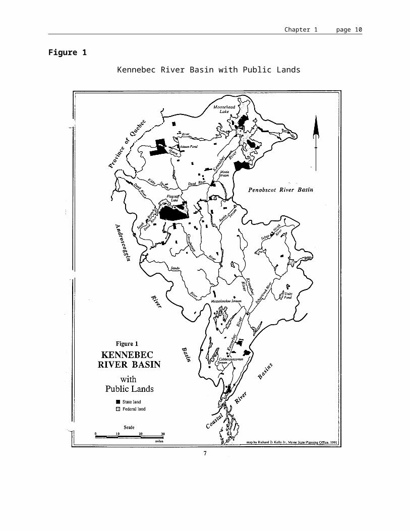
The upper basin, while remaining the raw materials base for the forest products industries, has evolved into a popular recreational area. Improved logging roads provide greater access to the scenic north country which draws tourists year-round. In recent years, Maine has begun a movement to recover use of its northern public land and, through a series of land trades with private owners, is consolidating this land into state holdings (Figure 1).
The most recent land trade was approved by the Maine Legislature in April 1990. In a trade with Scott Paper, the Bureau of Public Lands (BPL) acquired 7,275 acres of Days Academy Grant and 17.8 shoreline miles on Moosehead Lake. A conservation easement 500' deep covers 9.5 miles of the total shoreline and includes the opportunity to develop one wilderness campsite per mile of shore. BPL also gained acreage that was added to the agency's holdings in Big Squaw Township and Bald Mountain.
The State has also undertaken conservation land acquisition through bond issues: the $5 million 1986 bond for wildlife habitat protection administered by the Department of Inland Fisheries and Wildlife (IF&W) and the 1987 $35 million Land for Maine's Future (LMF) Fund. Several acquisitions have been made through both programs in the Kennebec River basin and a map showing all public lands in the watershed follows on page 7.
In May 1989, 800 acres of Mount Kineo were acquired by using $750,000 of the LMF Fund. Mount Kineo is the dominant land feature on Moosehead Lake, offering spectacular views from its summit. The mount's sheer cliffs serve as nesting habitat for a pair of peregrine falcons.
In November 1989, IF&W acquired a corridor of 500 feet on each side of the Roach River, a primary Moosehead Lake tributary, for $950,000. The mouth of the shallow river is exemplary spawning habitat for land-locked salmon and brook trout, offering world-class catch-and-release fishing. The corridor acquisition includes 250 feet in fee and a second 250 feet structured as a conservation easement on each side of the main stem.
The IF&W bond was also the source of funding for a 670 acre addition to the Sebasticook River Wildlife Management Area, increasing it to over 1,600 acres. Much of this land, along the floodplain of the main stem of the Sebasticook, is forested with mature cedar and is heavily used by deer. The area also supports populations of waterfowl and furbearers.

Chapter 1 page 7
Figure 1
Kennebec River Basin with Public Lands

Chapter 1 page 8
The Army Corps of Engineers has a long history of involvement with the Kennebec River dating back to 1827. Initial improvements of the river continued through 1888. These included removing obstructions, such as ledge rock, to provide a 13-foot-deep channel from river mouth to Swan Island in Richmond, about 25 miles upstream, with its depth decreasing to 10 feet at Augusta. A secondary channel was constructed around the west side of Swan Island. In 1898, three jetties were constructed on the west side of Swan Island and one at Beef Rock Shoals, at the southeast end of Swan Island.
Additional projects by the Corps were completed in 1943 and consist of:
• A channel 27 feet deep and 150 feet wide extending from the river mouth to a point 13 miles upstream at Bath.
• A channel 17 feet deep and 150 feet wide along the east side of Swan Island and extending to Gardiner. The channel depth increases to 18 feet through rock at Lovejoy Narrows, at the northeastern corner of Swan Island.
• A training wall at Beef Rock Shoals, at the southeast corner of Swan Island.
• A training wall above Sands Island, near the Dresden/Pittston town line.
• A 16-foot-deep channel at Gardiner.
• A channel 11 feet deep and 150 feet wide to the head of navigation in Augusta.2
HISTORY OF HYDROPOWER REGULATION IN MAINE
The initial licenses for most existing projects, in Maine and nationwide, were issued by FERC during the 1950's and 60's. Before the early 1950's, FERC did not concern itself with hydropower licensing or questions of navigability or water quality. However, the courts expanded FERC's jurisdiction during the 1950's. These early licenses were backdated and set for expiration between 1987 and 1993 by the Federal Power Commission, forerunner of today's FERC.
The Maine Rivers Policy (12 MRSA §§401-406) and the Maine Waterway Development and Conservation Act (MWDCA) (38 MRSA §§630-637) were enacted in 1983 as the Maine Rivers Act. These statutes are part of the Maine Comprehensive Rivers Management Plan submitted to FERC during the spring of 1987 as fulfillment of the State's obligation for comprehensive river planning. The 1987 Plan also includes projections of the State's hydropower potential, a Statewide Fisheries Plan, the core laws regulating use of Maine's rivers, and the Maine Rivers Study, a comprehensive review of river resources worthy of protection.
2 ? Maine Water Resources Development. U.S. Army Corps of Engineers, 1991.

Chapter 1 page 9
In the Maine Rivers Act, 1983, the Legislature declared that certain rivers, because of their unparalleled natural and recreational values, provide irreplaceable social and economic benefits to the people in their existing state. The Act prohibited the construction of new dams on these river and stream segments without the specific authorization of the Legislature and required that additional development or redevelopment of existing dams be designed and executed in a manner that either enhances or does not diminish the significant resource values of these river and stream segments. The Act identified the following "Outstanding River Segments" of the Kennebec as qualifying for this special protection. Additional segments were protected by the Subdivision Law (30 MRSA §4401).
• Kennebec River
-- Bay Point to the Father Curran Bridge (from Thorne Head Narrows in North Bath to the Edwards Dam in Augusta, excluding Perkins Township [Subdivision law]).
-- Route 148 Bridge in Madison to the Caratunk and Forks Plantation townline, excluding the western shore in Corncord township, Pleasant Ridge Plantation and Carrying Place Township and excluding Wyman Lake [Subdivision law].
-- Confluence of the Dead and Kennebec Rivers up to but not including the Harris Dam.
• Dead River from its confluence with the Kennebec to the upstream limit of Big Eddy.
• Moose River from its inlet into Attean Pond to its confluence with Number One Brook in Beattie Township.
• Carrabassett River from the Kennebec River to the Carrabassett Valley and Mt. Abram Township townline [Subdivision law].
For a listing of those stream and river segments in the Kennebec basin identified as having unique and/or significant resource value by the Maine Rivers Study see Appendix E.
This document is the first in an effort to apply statewide policies to specific rivers; as such, it is a logical next step in the State's continuing efforts to protect its invaluable river resources.
Chapter 1 page 10
ECOLOGICAL CHARACTERIZATION OF THEKENNEBEC RIVER BASIN
PHYSICAL DESCRIPTION OF THE KENNEBEC RIVER AND WATERSHED
The Kennebec River basin, located in west central Maine, has a total drainage area of 5,893 square miles, constituting almost one-fifth the total area of the State of Maine. The Androscoggin River basin lies to the west, the Penobscot River basin to the north and east, and a section of the Maine coastal area to the south. The northwesterly limit of the basin forms a part of the international boundary between the United States and Canada. The basin has a length in the north-south direction of 149 miles and a width of 72 miles. The upper two-thirds of the basin, generally above Waterville, is hilly and mountainous, being part of the Appalachian Mountain Range. The lower third of the basin, including the Sebasticook River and Cobbosseecontee Stream tributary areas, has a more gentle topography representative of the coastal area. The Kennebec River Basin lies in a large section of Somerset County, the eastern part of Franklin County, most of Kennebec County, and smaller portions of Penobscot, Waldo, Sagadahoc, and Androscoggin Counties.3 A map of the Kennebec basin including hydropower sites is shown on page 35.
The Kennebec River originates at the outlet of Moosehead Lake and flows southerly 145 miles to the head of Merrymeeting Bay at Abagadassett Point, about seven miles above Bath. From Merrymeeting Bay the Kennebec waters continue south, through the Maine coastal area, another 20 miles to the Atlantic Ocean at Hunniwell Point. The main river is tidal as far as Augusta, 25 miles above Abagadassett Point. Between its origin and mean tide at Augusta, the river falls about 1,026 feet in a distance of 120 miles, as average gradient of 8.5 feet per mile. One "S" curve in the river, between Madison and Skowhegan, forms the only large digression in the river's southward course.
The principal headwater tributary is the Moose River which drains 716 square miles of mountainous watershed area easterly to Moosehead Lake. The tributary area of the Moose River represents about 58 percent of the total Moosehead Lake watershed (1,268 square miles). The Moosehead Lake watershed, in turn, represents about one-fifth (20 percent) of the total Kennebec basin area.
Principal downstream tributaries (draining at least 400 square miles) are the Dead, Carrabassett, Sandy, and Sebasticook Rivers. Individual drainage areas are listed in Table 3. The combined drainage area of the four principal downstream tributaries are about 2,800 square miles, representing 47 percent of the total basin area and about 60 percent of the area below Moosehead Lake.
3 ? Maine Water Resources Development. U.S. Army Corps of Engineers, 1991.
Chapter 1 page 11
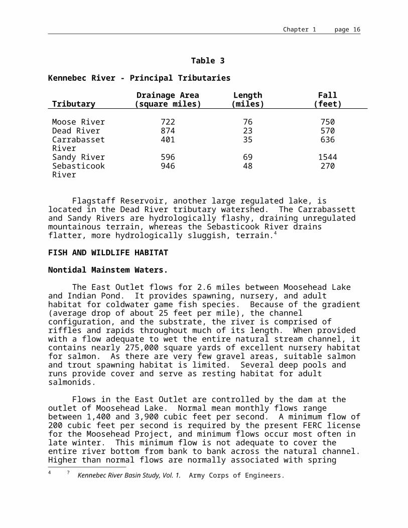
Table 3
Kennebec River - Principal Tributaries
TributaryDrainage Area(square miles)
Length(miles)
Fall(feet)
Moose River 722 76 750Dead River 874 23 570Carrabasset River 401 35 636Sandy River 596 69 1544Sebasticook River 946 48 270
Flagstaff Reservoir, another large regulated lake, is located in the Dead River tributary watershed. The Carrabassett and Sandy Rivers are hydrologically flashy, draining unregulated mountainous terrain, whereas the Sebasticook River drains flatter, more hydrologically sluggish, terrain.4
FISH AND WILDLIFE HABITAT
Nontidal Mainstem Waters.
The East Outlet flows for 2.6 miles between Moosehead Lake and Indian Pond. It provides spawning, nursery, and adult habitat for coldwater game fish species. Because of the gradient (average drop of about 25 feet per mile), the channel configuration, and the substrate, the river is comprised of riffles and rapids throughout much of its length. When provided with a flow adequate to wet the entire natural stream channel, it contains nearly 275,000 square yards of excellent nursery habitat for salmon. As there are very few gravel areas, suitable salmon and trout spawning habitat is limited. Several deep pools and runs provide cover and serve as resting habitat for adult salmonids.
Flows in the East Outlet are controlled by the dam at the outlet of Moosehead Lake. Normal mean monthly flows range between 1,400 and 3,900 cubic feet per second. A minimum flow of 200 cubic feet per second is required by the present FERC license for the Moosehead Project, and minimum flows occur most often in late winter. This minimum flow is not adequate to cover the entire river bottom from bank to bank across the natural channel. Higher than normal flows are normally associated with spring runoff, and occur after Moosehead Lake has filled. Maximum flows which exceed 10,000 cubic feet per second have also been discharged at other times of the year after major storm events that occurred when Moosehead Lake was full.
4 ? Kennebec River Basin Study, Vol. 1. Army Corps of Engineers.
Chapter 1 page 12
Although the West Outlet is longer than the East Outlet (approximately 8 miles in length), it is a much smaller stream with less gradient. Two shallow ponds (Long Pond - 173 acres, Round Pond - 40 acres) and several deadwater areas are located along its course, with short sections of rocky riffles interspersed between longer, slow-moving sections.
Flows in the West Outlet are also controlled by the dam on Moosehead Lake. A minimum flow of 25 cubic feet per second is required by the present FERC license for the Moosehead Project, but historically the required minimum flow has been exceeded . Flows have averaged close to 80 cubic feet per second throughout much of the year, except when Moosehead Lake is drawn down in late winter. During periods of peak runoff, when Moosehead Lake is full, higher-than-normal flows are occasionally discharged through the dam. Several tributary streams enter the West Outlet downstream from Long Pond. Their natural flows augment water discharged into the West Outlet through the dam at Moosehead Lake.
Harris Dam to the Forks. The twelve mile long reach of river from Harris Dam to the Forks is characterized by a steep gradient and fluctuating water flows. The river drops about 355 ft. from Indian Pond, the impoundment formed by Harris Dam, to The Forks. Water flows are regulated at the Harris Dam to provide electric power during hours of peak demand. Consequently, daily flows vary widely. A reconnaissance survey conducted by IF&W in 1983 showed that the minimum flow of 140 cubic feet per second (cfs) results in the loss of otherwise available fish habitat through streambed dewatering. At Carry Brook, about 40-50% of the river bed was dewatered and at Fish Pond outlet where the river is wider, about 75% was dewatered.
High flows used for power generation as well as for whitewater rafting are thought to conflict with fisheries needs within this reach. Peak generating flows occur rather abruptly, raising water levels at the base of Harris Dam as much as 8 ft. in less than 10 seconds. The resulting flow velocities have not been quantified but they are thought to reduce the fishery potential in this reach by reducing the amount of useable coldwater fish habitat during high flow periods.
The combination of high flows and difficult access limits fishing opportunity. However, anglers who adjust to the release schedule at Harris Dam catch landlocked salmon and brook trout. Sporadic catches of rainbow trout have also been reported in the lower end of the reach. Most fish are from natural reproduction but some are fish which are dropped from stockings in Indian Pond and elsewhere in the drainage.
The Forks to Wyman Dam. The 8+/- mile long river section from The Forks to the upstream limit of the Wyman Lake, the impoundment formed by Wyman Dam, is almost continuous riffle. Pools are few and the stream bed is predominantly cobble. The section is subject to daily flow fluctuations from regulation at Harris Dam on the Kennebec and from Flagstaff Dam on the Dead River, a major tributary which enters the Kennebec at the Forks.
Wyman Lake covers 3240 acres at normal elevation. The impoundment, which averages about 0.5 miles wide, extends 14.4 miles upstream, just above the confluence of Pleasant Pond Steam and Pierce Pond Stream. The lake is unusual in that the thermocline, the narrow layer of cool, well oxygenated water lying between the warm surface layer and cold bottom layer, is located at 80 ft. Normally, the thermocline is located nearer the surface. The deep thermocline is thought to be caused by drawing water for power generation at Wyman Dam from a depth of

Chapter 1 page 13
50 ft. and from the large volume of warm inflowing water from the Kennebec. The deep thermocline reduces but does not eliminate coldwater fish habitat.
Wyman Lake has both a winter and summer fishery for salmon, lake trout, pickerel, and smelts. There is also a spring dip net fishery for smelts at the upper end of the lake. Anglers report catching salmon, rainbow trout, and brook trout in the flowing water section. Fishing is not uniform throughout the section. Rather, anglers tend to concentrate at several specific areas.
The coldwater fish species in the fishery are from direct lake stocking and from natural reproduction occurring within the reach as well as from upstream waters. Unauthorized stockings of small mouthed bass and white perch in upstream waters will eventually establish themselves in this river reach with unpredictable results. Fishing in Wyman Lake may improve as a result but an overall reduction in the coldwater fishery is expected.
Wyman Dam, Moscow to Williams Dam, Solon. The mainstem of the Kennebec River from Williams Dam in Solon to Wyman Dam in Moscow is 8.4 miles long. The lower 4.2 miles of this reach are impounded by Williams Dam. When full, this impoundment is 426 acres in size; however, water levels normally fluctuate 5-7 feet/day as a result of upstream discharges from Wyman Dam. These discharges range from 490 cfs to 6,240 cfs. Wyman's maximum generating flow is 8,500 cfs. Average depths of the Williams impoundment vary from about 15 feet 1/3 mile above the dam to about 3 feet near the upper limit of the impoundment. Despite the depths in the lower section, the water quality is more riverine than lacustrine due to the high flushing rate.
The entire section supports coldwater sports fisheries for rainbow trout, brook trout, landlocked salmon, and to a lesser extent, lake trout and round whitefish. Other fish species present include brown trout, chain pickerel, yellow perch, rainbow smelt, suckers, sunfish, and minnows. Smallmouth bass and white perch, which are present upstream, can be expected to eventually migrate downstream. All of these species are self-sustaining. Rainbow trout were introduced above Solon in 1933, and were stocked by IF&W as recently as 1979. This species spawns during the early spring in several tributaries to the mainstem of the river, including Jackson Brook, Joe Foss Brook and Austin Stream. The other salmonids are fall spawners. Lake trout and landlocked salmon, better adapted to lacustrine than riverine habitat, grow slowly. Reduced length limits are therefore in effect for these species. No stocking is currently being done in this river section, though there may be escapement from private hatcheries near the river.
Although angling occurs throughout this section, the most popular sites include the tailrace below Wyman Dam, the gravel bar at the mouth of Austin Stream, the Cool Farm site (approximately 3.5 miles below Wyman Dam), and trolling is popular between Wyman Dam tailrace and the Route 16 bridge in Bingham. In a 1987 IF&W creel survey, 59% of the angling activity occurred during the months of May and June. Samples from that survey indicated that legal landlocked salmon and rainbow trout were II to IV years old; legal brook trout ages ranged from II to III.
A study conducted as part of the Wyman Dam relicensing evaluation concluded that fish populations below the dam are adversely affected by fluctuating flows. Negotiations to alter the flow regime or to provide mitigation are underway.

Chapter 1 page 14
Solon Dam to Augusta Dam. Water flows in this section are controlled to a large extent by KWPC. KWPC attempts to operate upstream reservoirs to provide an average annual regulated flow of at least 3600 cfs at Madison. At Solon Dam, a near constant flow of 3200 cfs is passed. Inflows from the Carrabassett River and other smaller tributaries increase the flow to 3600 cfs at Madison when water is available. Dams at Madison-Anson operate run of the river providing stable flows to Skowhegan dam, with additional inflow from the Sandy River.
The 14 +/- miles long river section from Solon Dam to Madison-Anson contains both coldwater and warmwater fish habitat. Most of the coldwater fish habitat is in the 8 mile long reach from Solon Dam to the upstream limit of the impoundment formed by Anson Dam. It is riffle and pool type with gravel-cobble substrate. The 5.9 mile long impoundment is riverine in nature, better suited to warmwater fish species, with only seasonal coldwater fish habitat.
The 14 mile long river section from Madison to Skowhegan Dam is mostly impoundment formed by Weston Dam. The 12.5 mile long impoundment covers about 930 acres at full pond elevation. Average width is 620 ft. and it is riverine in character. The upstream limit of the impoundment is about 4000 ft. upstream from the confluence of the Sandy River.
Guides and anglers report catching brook trout, landlocked salmon, brown trout, and smallmouthed bass. All species reproduce naturally. Only brown trout are stocked at the present time but in the past all of the above named coldwater fish species have been stocked. There may also be escapement of rainbow trout and salmon into this section of the Kennebec River from private hatcheries located in the towns of Bingham and Embden. There is also a winter fishery, mainly for pickerel, in the Weston Island area. Most of the coldwater fish species between Madison and Skowhegan are caught in the 1.5 miles of flowing water between Abenaki Dam in Madison and the upstream limit of the Weston impoundment.
The area below the Solon/Embden bridge is considered to be excellent wildlife habitat. The Embden side of the river has high value as wildlife habitat.
The segment from Madison to Anson contains some of the most fragile riverine ecosystems in this corridor. The Savage to Weston island sector of the river in the middle of this segment is one of the most valuable wildlife areas in the river corridor.5
5 ? Kennebec River Corridor Plan, North Kennebec Regional Planning Commission, September 1974.
Chapter 1 page 15
Near Skowhegan there is a considerable amount of wildlife habitat from Oak Islands to Hinckley Reach.6
Tributaries.
Roach River
The following description of fish habitat in the Roach River is taken from the Roach River Strategic Plan for Fisheries Management prepared by IF&W in 1985.
First Roach Pond to Moosehead Lake. From its origin at the outlet of Third Roach Pond, the Roach River flows 19 miles (9 miles through Second Roach Pond and First Roach Pond) to Moosehead Lake. There are three geographically distinct sections to the Roach River. They will be described individually as follows: from the outlet of First Roach Pond to Moosehead Lake; from the outlet of Second Roach Pond to First Roach Pond, and from the outlet of Third Roach Pond to Second Roach Pond.
The section best known for its fishery and most important for its contribution to the natural reproduction of landlocked salmon and brook trout for Moosehead Lake is the 6.3-mile section below First Roach Pond. From the base of the dam at First Roach Pond to Moosehead lake at its normal pool elevation (1,029 feet), the Roach River drops approximately 190 feet, an average gradient of about 32 feet per mile. The river width varies from approximately 50 feet to 132 feet during normal flows, averaging 75 feet. However, when water covers the entire river bed, the average width is approximately 100 feet. The depth varies from about 1 to 6 feet during normal flows. The river flows through well-defined banks, once heavily forested. Except for narrow green-belts on either side of the river, the forest was clear-cut in the 1960's and early 1970's.
Approximately 90% of the river bottom consists of rock and boulder riffles providing excellent nursery areas for salmon and brook trout. The remaining 10% is small rocks, gravel, and sand; the rubble's coarseness is best suited for salmon spawning. The most extensive gravel area is located in the river's lowest 200 to 300 yards. Another major salmon spawning site is within the upper one-half-mile below the pool at the First roach Pond dam. There are scattered salmon and brook trout spawning sites among the larger rocks or at the edges of bars in the river's wider sections. There are few resting pools available for adult salmon and trout.
Two major tributaries enter this section of the Roach River. Jewett Brook enters less than 1 mile from Moosehead Lake. This small stream has some brook trout in the springy areas, but salmon spawning areas are not available and trout spawning areas are limited.
Lazy Tom Stream, entering approximately 1 mile below First Roach Pond, has spawning and nursery facilities available in the 2-mile section between the river and an old dam at the outlet of Lazy Tom Deadwater. The flowage was used to store pulpwood that was driven through the dam on high water and into the river. Bulldozed streamside landings and the pulpwood drives widened the stream and removed much of the bank and stream cover during the wood driving years. Recovery has been slow but the stream banks are again vegetated.
6 ? Kennebec River Corridor Plan, North Kennebec Regional Planning Commission, September 1974.

Chapter 1 page 16
Electrofishing has provided evidence that a limited number of salmon parr are again using Lazy Tom Stream as a nursery area.
A minimum flow of 75 cfs has been established for the Roach River from First Roach Pond to Moosehead. Lesser flows are injurious to aquatic insects and plant life so necessary for fish populations, destroy eggs of fish and insects, reduce the size of salmon and trout nursery areas, and make fish more vulnerable to preying birds and mammals.
In July 1971, the entire reach from First Roach Pond to Moosehead Lake was surveyed to evaluate its spawning and nursery suitability. Determination of spawning suitability was made based on visual comparisons of the river bottom to areas within the river where salmon spawning was known to occur annually. Since 1971, the two major areas deemed suitable for salmon spawning have been repeatedly visited during the subsequent spawning seasons and both spawning adults and redds have been observed. No attempt was made to calculate actual acreage of suitable spawning gravel. Nursery areas were rated based on visual comparison with area where salmon parr had historically been electrofished in significant numbers. Areas suitable for brook trout reproduction were noted when observed. At the time of the survey, the flow through the First Roach Pond dam was estimated at 50 cfs. Lazy Tom Stream contributed an additional estimated 10 cfs. A summary of field observations is given in Table 4. The widths shown in the table are of the wetted area of the river channel.
The total area of this section of the Roach River was calculated to estimate the amount of salmon nursery area available. Measurements were made from aerial photographs (scale 1:15,840 or 4 inches to the mile) obtained from Scott Paper Company. The length was measured, using a map measurer, three times and the results averaged. Also from the aerial photos, twenty measurements of width were made and the mean calculated. The potential nursery area on the Roach River from the dam at First Roach Pond to Moosehead Lake is 2,502 units (one habitat unit equals 100 square yards). Estimates of parr abundance have been made using standard electrofishing techniques. The area sampled is, on appearance, typical of most of the river that was rated as "very good" nursery habitat. The two most recent estimates were made in August 1978 and 1979 (4.68 parr and 5.12 parr per habitat unit. Based on these estimates the total potential parr production for the roach River might average 12,250 per year. Using observations made by biologists equipped with SCUBA gear who floated sections of the river counting salmon parr, and estimates based on electrofishing done prior to 1978, the actual number of parr per habitat unit may be as high as 7.0. AuClair chose to use 7.0 parr per unit to determine potential production for the Roach River.7 The resulting estimate was approximately 17,500 salmon parr, approximately one-half of the total estimated parr production from all of the Moosehead Lake tributaries.
7 ? Moosehead Lake Fishery Management Plan. AuClair, Robert P., Maine Department of Inland Fisheries and Wildlife, Fishery Research Bulletin No. 11: 75pp., 1982.
Chapter 1 page 17
Table 4Summary of Field Observations on the Roach River, July 1971
Section Length Width* Gradient Spawning Nursery General Description
1 0.5 mi 60'-80' moderate very good very good alternating boulders and gravel; pools and riffles; 3 small tribs.
2 0.5 mi 75'-85' moderate poor very good boulder riffle with patchy gravel; no pools; 1 small trib. and Lazy Tom Str.
3 0.5 mi 75'-85' moderate-steep fair to good very good boulder riffle; gravel fair to good; pools and riffles; 1 small trib.
4 0.5 mi 75'-85' moderate fair very good mixed riffle and pool; boulders and patchy gravel; 1 good pool and gravel area
5 0.75 mi 50'-60' moderate-steep poor very good boulder riffle; 2 good pools at base of steep banked area; good gravel at head of first pool; 3 small tribs
6 0.5 mi 80'-100' low-moderate good very good boulder riffle; 1 pool near steep banks; good gravel; 4 small tribs
7 0.5 mi 70'-85' low-moderate good good large area of big gravel; most only fair; 2 small tribs
8 0.5 mi 60'-80' moderate good brook trout & salmon
very good boulder riffles; small pools and riffles; 2 large bars of salmon gravel
9 0.75 mi 60'-70' moderate-steep poor good boulder riffle; ledges; small pools; patchy gravel and shale; 2 small tribs
10 1.50 mi 80'-100' moderate good-very good at mouth
very good boulder riffle; few pools; abundance of gravel at mouth; Jewett Brook
___________________________
* Wetted area

Chapter 1 page 18
Second Roach Pond to First Roach Pond. The Roach River between Second Roach Pond and North Inlet on First Roach Pond is 1.75 miles long. The vertical drop is approximately 35 feet from the outlet of Second Roach Pond to First Roach Pond. This section of the Roach River is comprised of a variety of runs, riffles and small, shallow pools. The upper half of this section was surveyed in 1971 and the remainder was completed in 1983.
The river bottom is generally covered with small rock and cobble, unlike the river below First Roach Pond. The most suitable gravel areas for spawning are found near the mouth of the river above North Inlet. Future visits to this and other areas along the river are needed to confirm actual use by adult salmon.
There is an area of larger rocks and boulders in the section below the Scott Paper Company bridge that crosses the river. This appears to have the maximum potential for salmon parr habitat of any area between Second Roach Pond and First Roach Pond. The site was electrofished in 1982 and 1983 and produced estimates of 1.5 and 2.5 (average 2.0) parr per habitat unit. Young-of-the-year salmon were reported as very abundant. With abnormal low flow of approximately 10 cfs, the river width averages 30 feet. The calculated potential nursery is 308 habitat units. At 2.0 parr per unit, the potential production is 616 salmon parr.
With the loss of the barrier dam at the outlet of Second Roach Pond and the subsequent cleaning of the bottom within the long access channel to the pond, some additional suitable spawning area has been created. The remnants of the old dam (bed logs and apron) should be removed to guarantee access to the site. When the dam and its fishway were operational, adult salmon were observed using this site in the fall. Unfortunately, no additional nursery has been created.
Third Roach Pond to Second Roach Pond. The Roach River from Third Roach Pond to Second Roach Pond drops about 40 feet in 1.7 miles. Historically, beaver dams have created barriers to upstream migration on this section of the river. When surveyed in 1984, four old and two new beaver dams were observed.
The river immediately above Second Roach Pond is rocky riffle with an occasional boulder. The river below the outlet of Third Roach Pond is similar except for the absence of any large boulders. Both areas have some suitable nursery habitat for salmon. The combined length of these two areas is about 0.8 miles (4,375 feet) with an average width of 35 feet. Only 3,000 feet of the combined areas is suitable nursery for salmon, providing 118 habitat units.
In the middle section of the river between Third Roach Pond and Second Roach Pond are two deadwaters (4.3 acres and 9.5 acres) joined by an area of wide (average 52 feet) slow moving water. The outlet from Trout Pond enters the lower end of the upper deadwater.

Chapter 1 page 19
Suitable trout spawning habitat can be found within the mouth of the stream. At the upstream end of the same deadwater there is a limited amount of spawning gravel typical of what salmon are known to use elsewhere in the drainage. The deadwaters provide little measurable benefit to the young salmon that might be produced in the river. A previous owner of the sporting camp at the outlet of Second Roach Pond kept a boat or canoe hidden near the deadwaters for his guests to use during the early-season brook trout fishery. When surveyed in 1984, the river above Second Roach Pond showed little evidence of angler use. Adult salmon have been observed in the late fall upstream as far as the beaver dams at the lower end of the deadwaters.
Recent electrofishing (1983) at the site of the old bridge crossing above Second Roach Pond confirms the continued presence of young salmon within this section. Young-of-the-year and parr were taken but in relatively low numbers. A few young brook trout were also taken. Electrofishing records from 1959 and 1963 indicate that young salmon were more abundant within this section of the river than they are at present. An estimate of 3.3 parr per habitat unit in 1959 may reflect the potential for this section of river. At that rate, the Roach River between Third Roach Pond and Second Roach Pond might produce 389 salmon parr.
The combined calculated potential production of salmon parr from the two sections of the Roach River above First Roach Pond is approximately 1,000 fish. It is not known to what degree salmon dropping out of the river as young-of-the-year might contribute to the salmon populations in the waters within the Roach River drainage. A limited salmon fishery for wild salmon in Second Roach Pond may be sustained through the natural reproduction occurring in the two upper river sections.
Moose River
No. 1 Brook to Holeb Stream. An 18.7 mile section with a drop of about 340 feet in elevation. Short stretches of rock and boulder riffle interspersed among longer stretches of gravel riffle and runs provide excellent coldwater fish habitat. Several small falls are present in the section, but they appear passable to upstream fish movement.
Holeb Stream to Attean Pond. This 20.7 mile section comprises the river portion of the "Bow Trip". Total drop in elevation is about 73 feet, most of which occurs at Holeb Falls. Much of the river flows between high clay banks. Shallow to deep runs over gravel bottom, with occasional deep pools, provide good coldwater habitat for adult fish, as well as areas suitable for spawning. There are only three short sections of rocky riffles over this entire distance. They are associated with Holeb Falls, Spencer Rips, and Attean Falls. Thus nursery habitat in this section is limited. Although Holeb Falls are impassable to fish movement upstream, a boulder field river channel bypasses the falls and provides access upstream at high river flows.
Attean Pond to Big Wood Pond. Between Attean and Big Wood Ponds 0.9 miles of moderately deep run with many large submerged boulders provides good cover for adult coldwater species, most of which are moving between the two ponds. There is little gradient between the two ponds, and very little salmonid spawning or nursery habitat.
Big Wood Pond to Long Pond. This 6.8 mile section is generally deep and slow-moving between high banks, with several large, deep pools. (There is also little gradient between Big Wood and Long Ponds.) It provides good salmonid adult habitat, and some

Chapter 1 page 20
spawning habitat in gravel areas found immediately downstream from Big Wood Pond. There is very little nursery habitat in this section.
Long Pond to Brassua Lake. There is an 84 foot drop in elevation between Long Pond and Brassua Lake. Most of the river is comprised of rock and boulder riffle, with a few sections of deep run, mostly at the upper end, and a few good pools. Some spawning gravel is found immediately downstream from Long Pond. This section provides very good salmon nursery habitat, and adult salmon and trout are present throughout.
Brassua Lake to Moosehead Lake. Pools, runs, and riffles comprise the first mile of river immediately downstream from the dam on the outlet of Brassua Lake. The lower two miles of river are more lacustrine in nature due to flowage up from Moosehead Lake. Total drop in elevation of this section is about 14 feet. The river provides spawning and nursery habitat for both salmon and brook trout, as well as adult habitat for salmon, brook trout, and, seasonally, lake trout.
Public lands along the Moose River, called the Holeb Unit, provide good habitat for waterfowl, as ponds, brooks, and wetlands are abundant and well distributed throughout. Twelve waterfowl (duck) boxes are maintained on the Unit by BPL, providing nesting sites where adequate natural conditions for this purpose do not exist. Extensive wetlands are found in the north central part of the Unit in Holeb Township, south of Loon Pond, along the western shore of Holeb Pond, along the Moose River and Holeb Stream, and on the southeast shore of Attean Pond. Wetlands serve a number of important ecological purposes, including absorption of nutrients, storage of ground water, stabilizing surface water, curbing erosion, and providing part of the life cycle requirements for many species of wildlife.8
The Skowhegan to Augusta reach of the Kennebec is approximately 38 miles in length. Habitat in this portion of the Kennebec is dominated by a series of hydroelectric projects. Dams in Fairfield, Winslow, Waterville, and Augusta have created several reservoirs intermixed with short reaches of run and/or rapids. The total surface area of aquatic habitat in the reach is approximately 3,500 acres of which just 500 acres could be considered free-flowing. The reservoirs created by Edwards Dam and Shawmut Dam are the two largest impoundments with the former being about 1,200 acres and the latter about 1,400 acres.
Brown trout, smallmouth bass, largemouth bass, white perch, and chain pickerel are among the more important gamefish species found in this part of the Kennebec. The bass, perch, and pickerel populations are maintained by natural reproduction while the river's brown trout population is maintained by an annual stocking program.
8 ? Holeb Unit Management Plan. Maine Department of Conservation, Bureau of Public Lands, December 1989.
Chapter 1 page 21
Dead River
The Dead River has a drainage area of 867 square miles. The upper portion of the drainage is composed of the North Branch, which originates at Saddleback Lake, near Rangeley. A dam near the mouth of the North Branch in Eustis presents a barrier to upstream fish migration. These two branches flow into Flagstaff Lake, a 22,833 acre reservoir. The river below Flagstaff is a combination of deadwater, falls, and whitewater which enters the Kennebec at The Forks. Both Long Falls Dam, which forms Flagstaff Lake, and Grand Falls, located seven miles downstream, are barriers to upstream fish passage.
Brook trout are distributed throughout most of the Dead River drainage, and the river fishery is provided by wild trout except that spring yearlings are stocked in portions of the South Branch and the North Branch. The mainstem of the Dead River and Spencer Stream also have native populations of salmon, but their slow growth in the river environment limits their potential as a sport fishery. Fishing in the north branch of the Dead River is limited by law to fly fishing only. The majority of brook trout angled from the Dead River average 8.5 to 10 inches in length. There are no bass in the drainage, but both yellow perch and chain pickerel are present in the mainstems of both branches.
The major tributary streams to the Dead River include Spencer, Kibby, and Enchanted Streams in the northern part of the drainage; Tim Brook and Alder Stream in the west part of the drainage; and Nash and Redington Streams in the southern part of the drainage. All of these streams support wild brook trout populations; some also have populations of slow-growing landlocked salmon.
Flagstaff Lake forms the northern boundary of the Bigelow Preserve and affects public use and enjoyment of the Preserve. Flagstaff is a large, shallow, man-made impoundment that was formed by the damming of the Dead River in 1950. The Long Falls Dam is owned by Central Maine Power Company (CMP) and operated by Kennebec Water Power Company (KWPC). It controls the water levels on the lake to the 1,150 foot contour. The lake is used as a storage reservoir for hydroelectric facilities further down the Kennebec River drainage. Water levels fluctuate considerably and are usually lowest in mid-to-late March.
Although large in size, Flagstaff Lake is shallow and is drawn down annually. Pickerel, yellow perch, and hornpout thrive in this environment, but landlocked salmon and brook trout do not. Rainbow smelt provide an important spring dip net fishery, and brook trout are abundant in some of the lake's tributaries.
The lake only receives light fishing pressure as the fluctuating water levels and the presence of other excellent coldwater fishing opportunities nearby discourage use of the lake. However, Flagstaff Lake does appear to be important, or have the potential to be important to wildlife, particularly waterfowl.
The shores of the lake in the Bigelow Preserve are designated by BPL as riparian zones. A riparian zone is comprised of a 330-foot corridor, the primary purpose of which is to provide wildlife habitat. Research has shown that the areas adjacent to water are particularly important to wildlife as travel corridors, as well as home range habitat. Timber harvesting is allowed in the riparian zone; in fact, harvesting is important to maintaining the quality of the habitat by providing for a healthy, diverse environment. Timber

Chapter 1 page 22
management will be conducted on an uneven aged basis to enhance and maintain the riparian zone. The fluctuating water levels, which are a function of hydrogeneration and flood control, limit the lake's desirability for wildlife habitat.9
In contrast to Flagstaff Lake, the other 104 named lakes and ponds in the Dead River drainage are mostly well-suited to coldwater fish. Eighty percent of these waters are less than 100 acres in size; 69% are less than 50 acres. Of the larger lakes, Spencer Lake, Spring Lake, Jim Pond, Chain of Ponds, King and Bartlett Lake, and Tea Pond all have populations of lake trout, landlocked salmon and brook trout. Most are routinely or periodically stocked with these species. The remaining 95 ponds in the drainage are mostly brook trout waters, the majority of which have self-sustaining populations. Public access to more than a dozen lakes and ponds in the drainage is limited due to restrictions imposed by land owners or lessees.
Overall, the Dead River drainage has an abundance of coldwater fish habitat, much of it free from warmwater fish competition.
Carrabasset River
The Carrabassett River drains 401 square miles. From Mt. Abraham Township to Anson, where it enters the Kennebec River, it is 39 miles long and drops 2,800 feet (72 feet/mile). It has a falls impassable to upstream fish migration near its mouth at North Anson. There is also an impassable dam at Kingfield, and one at the outlet of Caribou Pond at the headwaters. The upper river, downstream to East New Portland, is mostly rapids; this portion of the river is restricted to fly fishing only. Below East New Portland the river is primarily glide/run until the falls at North Anson, about a mile before the confluence with the Kennebec. Because of its steepness and the lack of large headwater lakes, the Carrabassett's flow varies greatly with storm events and snow melt.
The major tributary streams to the mainstem are the West Branch, which enters at Kingfield, Gilman Stream, at East New Portland, and Mill Stream, at North Anson. The largest lakes in the drainage, Embden, Hancock, and Porter, have populations of lake trout, landlocked salmon, and brook trout. Higher in the drainage are 9 ponds which support brook trout and approximately 10 named ponds which contain warmwater fisheries.
The mainstem of the upper river, essentially a mountain stream, is relatively sterile and rocky. Brook trout are present but are slow-growing as a result of low productivity and cold water temperatures. Brook trout in the lower section of the river exhibit better growth rates. The wild population of brook trout in the section of the river below Kingfield is supplemented with annual stockings of spring yearlings. Rainbow trout were stocked in the section of the river below East New Portland and in Porter Lake in the 1970's, but are no longer present. Smallmouth bass are present in the mainstem below Kingfield and provide a good fishery. A wild population of brown trout occurs in Gilman Stream as far upstream as Highland Plantation. Warmwater fish present in the shallower ponds and in the slower-moving sections of the streams in the lower drainage include chain pickerel, bullhead, sunfish, yellow perch, white sucker, white perch (in Porter Lake), and smallmouth bass (in the lower river and the Mill Brook drainage, including Embden Lake and Hancock Pond).
9 ? Bigelow Preserve Management Plan. Maine Department of Conservation, August 1989.

Chapter 1 page 23
Factors limiting the coldwater sport fishery in the streams of the drainage include the extreme variations in flows, the sterility of the upper section, and lack of pools to serve as adult habitat. Within these limitations, however, the upper portion of the drainage provides both riverine and lacustrine brook trout fisheries free from warmwater fish competition, while the lower section contains habitat for both coldwater and warmwater fisheries.
Sandy River
The Sandy River has a drainage area of 596 square miles. It is a mountain stream, with no large bodies of water to store runoff. Consequently, it is subject to extreme changes in flow rates. Although only 60 miles long, the Sandy drops 1,544 feet in elevation, averaging 22.4 feet per mile. The river originates at the Sandy River Ponds, drops over Smalls Falls, a barrier to upstream fish migration, and continues primarily as rapids to Phillips where the two main tributaries, Orbeton Stream and the South Branch, join the mainstem. Below Strong, the lower 47 miles of the river are intermittent quick water and runs. As more tributaries enter, the river valley widens to form fertile bottom land. Extensive farming activity along this stretch is responsible for non-point nutrient loading. A power generating dam just above the confluence with the Kennebec at Norridgewock is a barrier to upstream fish migration.
The section of the river upstream of the Strong-Phillips area supports a wild brook trout fishery, while brown trout and smallmouth bass dominate the lower river. Many of the tributaries, even in the lower section of the river, support brook trout fisheries also.
Thirty-nine great ponds, totaling 3,695 acres, lie within the Sandy River drainage. The three largest lakes in the drainage support populations of lake trout, landlocked salmon, and brook trout. Of the smaller lakes and ponds in the drainage, those in the lower portion support warmwater fisheries, while those at the higher elevations support coldwater fisheries - primarily brook trout. The upper section of the drainage lies in rugged hills and mountains, and many small, isolated ponds provide suitable coldwater fish habitat. Competing warmwater species are kept out by natural barriers to migration.
The Sandy River's brown trout population is periodically supplemented by stockings of hatchery-reared fish from Phillips to New Sharon. Legal-sized wild brook trout angled in the river average 8.6 inches in length; brown trout of both wild and hatchery origin average 12.3 inches, and smallmouth bass average 12.2 inches in size.

Chapter 1 page 24
Sebasticook River
The Sebasticook River, the largest of the tributaries to the lower Kennebec River, has a drainage area of approximately 946 square miles. For many years human cultural activity including municipal, industrial and agricultural waste discharges and the manipulation of flows for water power and waste disposal have severely compromised the sport fishery potential of this river. More recently, water quality on the river has begun to improve with the implementation of a variety of water quality treatment programs.
Impoundments created by the three dams on the mainstem of the Sebasticook include a 417 acre pond in Winslow, an 83 acre pond in Benton, and a 304 acre pond in Burnham. The ten mile reach from the dam in Burnham to the upstream confluence of the Benton Falls project constitute the longest section of free flowing habitat on the river's mainstem. Smaller sections of riverine habitat occur upstream of the Burnham Project and just below the Benton Falls and Fort Halifax projects in Benton and Winslow, respectively.
Despite its water quality problems, the Sebasticook does support sport fisheries for a variety of species such as smallmouth bass, largemouth bass, black crappie, white perch, and chain pickerel. Brook trout, brown trout, and landlocked salmon occur seasonally. Fishing effort is increasing on this river as water quality and public perception of the value of this resource improves.
IF&W intends to initiate a brown trout management program on the Sebasticook, predicated upon continued improvement in water quality, the assurance of sufficient, stable flows; the availability of sufficient hatchery fish to support a viable program, and the demonstrated ability of the river to support a brown trout population. IF&W plans to begin a series of experimental stockings of brown trout with a planting of 5,000 fall fingerlings in 1992. The program is expected to focus on the free flowing habitat below the Burnham Project. Evaluation of the program will be primarily through angler diaries.
Messalonskee Stream
Messalonskee Stream supports excellent populations of warmwater gamefish including largemouth and smallmouth bass, white and yellow perch, chain pickerel, and hornedpout.10 Water level manipulations related to the production of hydroelectric power have an important impact on the stream's fish populations and on angler effort. Fishing effort and fish production are also negatively impacted by poor water quality resulting from waste discharge from the city of Oakland's wastewater treatment plant and from a variety of nonpoint sources.
Other tributaries of the lower Kennebec for which IF&W has habitat inventory and biological data include Carrabassett Stream, Martin Stream, Bond Brook, and Seven Mile Stream. Data for the Seven Mile Stream inventory has been summarized in tabular form and habitat maps have been prepared.11 Survey data for the other three waters has not been summarized but is available in Regional files.
10 ? Messalonskee Stream Fishery Management. Woodward, William, Maine Department of Inland Fisheries & Wildlife, 6pp., 1989.
11 ? Seven Mile Stream Habitat Inventory. Woodward, William; Maine Department of Inland Fisheries and Wildlife, Unpublished report, 12pp., 1985.

Chapter 1 page 25
Lakes and Ponds
A total of 100 lakes and ponds having a combined surface area of 60,067 acres occur within the Fishery Region B portion of the Kennebec drainage. These waters support important sport fisheries for a variety of warmwater and coldwater species. Fishing effort on the waters of Fishery Region B rank second highest among IF&W's seven fishery regions.
Among the more important sport fisheries in the lakes and ponds of the lower Kennebec are the black bass fisheries of the Belgrade chain of lakes and the Cobbossecontee Stream subdrainage of the Kennebec, the landlocked salmon fishery of Long Pond, and the brown trout fisheries of China Lake, Salmon Lake, and Togus Pond. These fisheries play a significant role in the recreational and economic well being of the communities in which they are found. For example, based on 1988 data, annual fishing effort on Great Pond (at 8,400 acres Great Pond is the largest water in the Belgrade chain of Lakes) was over 30,000 angler-days and estimated economic impact of the lake's sport fisheries was about $750,000.
Tidal Waters.
The Kennebec River, at its mouth, drains an area of 9,524 square miles (Table 5). This total encompasses the drainage area of the Androscoggin River and the smaller tributaries of Merrymeeting Bay.12 The drainage area of the Kennebec River at head-of-tide at the Augusta Dam is 5,493 square miles.
Both the Kennebec and Androscoggin Rivers flow into a large freshwater tidal bay called Merrymeeting Bay. This freshwater bay also receives freshwater inflow from several smaller drainages: the Eastern River (50 mi2), the Cathance River (70 mi2), and the Abagadasset River (20 mi2).
Although the entire tidal section of the Kennebec River from the Edwards Dam in Augusta to Bay Point, Georgetown, is commonly called an estuary, the tidal section from Merrymeeting Bay to Augusta does not fit most definitions of an estuary. The U.S. Fish & Wildlife Service (USFWS) defines the upstream limit of an estuary as "estuaries extend upstream and landward to the place where ocean-derived salts measure <0.5 ppt during the period of annual low flow."13 The Department of Marine Resources (DMR) has been measuring salinities from the mouth of the Kennebec River at Bay Point to the Edwards Dam in Augusta annually since 1976. The normal limit where salinities do not exceed 0.5 ppt varies slightly from year to year. The upstream limit of the true estuary in most years is between Abagadasset Point in Merrymeeting Bay and the Route 197 bridge in Richmond, which is a distance of eight miles. The USFWS characterized the Kennebec River from the outlet of Merrymeeting Bay to the Augusta Dam as "tidal riverine."14 Although salinities normally exceed 0.5 ppt in Merrymeeting Bay, this line of demarcation (outlet of 12 ? Drainage Areas of Surface Water Bodies of the Androscoggin River Basin in Southwestern Maine and Drainage Areas of Surface Water Bodies of the Kennebec River Basin in Southwestern Maine. Fontaine, R.A., 1979 and 1980 respectively; U.S. Dept. of the Interior, Geological Survey, Open File Report.
13 ? Classification of Wetland and Deepwater Habitats of the United States. Cowardin, L.M., V. Carter, F.C. Golet, E.T. Laroe, and J.H. Sather, 1979; U.S. Dept. of the Interior, Washington, D.C.

Chapter 1 page 26
Merrymeeting Bay) is a convenient one to separate the tidal riverine subsystem from the estuarine subsystem. The riverine tidal wetland subsystem of Merrymeeting Bay is characterized by nonpersistent freshwater emergent plants.15
Table 5Drainage Areas (mi2) of the Kennebec River and its Tributaries
RiverDrainageArea(mi2)
Average16Discharge
Period of17Record(yrs)
Kennebec River at:North Sidney 5,403 9,104 ft3/s 13Augusta Dam 5,493Above mouthof Cobbosseecontee Stream 5,535Mouth of Cobbosseecontee Stream 217 346 ft3/s 89Richmond Bridge (Rt. 197) 5,823Mouth of Eastern River 50Inlet to Merrymeeting Bay 5,893Androscoggin River near Auburn 3,263 6,145 ft3/s 62Mouth of Androscoggin River 3,524Mouth of Abagadasset River 19.6Mouth of Cathance River 70.6Mouth of Kennebec River 9,524
The large amount of tidal freshwater riverine habitat found in the Kennebec/Sheepscot Rivers' estuaries makes this system unique in the State of Maine. There is a total of 11,140 acres of tidal riverine habitat in this system with most of it being above the outlet of Merrymeeting Bay (Table 6). This represents 84% of the total tidal riverine habitat found in the State of Maine north of Cape Elizabeth.18 This subsystem can be further divided into classes of types of habitat, such as open water, nonpersistent emergent wetland, flats, and beach/bar (Table 6). There are 5,682 acres of open water habitat in this subsystem which represent 80% of this type of habitat in Maine north of Cape Elizabeth. There are 3,133 acres of nonpersistent emergent wetland which represent 98% of that found above Cape Elizabeth. This tidal riverine section constitutes one of the most important spawning and nursery areas for anadromous fish north of the Hudson River.
14 ? An Ecological Characterization of Coastal Maine. Fefer, S.I. and P.A. Schettig, 1980; FWS/OBS-80/29, Biological Services Program, U.S. Fish and Wildlife Service.
15 ? Merrymeeting Bay Investigations. Spencer, H.E., 1966; Job Completion Report 4-A, Project W-37-R-9, Maine Dept. of Inland Fisheries and Game, Augusta, Maine.
16 ? Water Resources Data for Maine, Water Year 1991. U.S. Geological Survey Water Data Report, 91-1, 1992, 187 pages.
17 ? ibid.
18 ? An Ecological Characterization of Coastal Maine. Fefer, S.I. and P.A. Schettig, 1980; FWS/OBS-80/29, Biological Services Program, U.S. Fish and Wildlife Service.
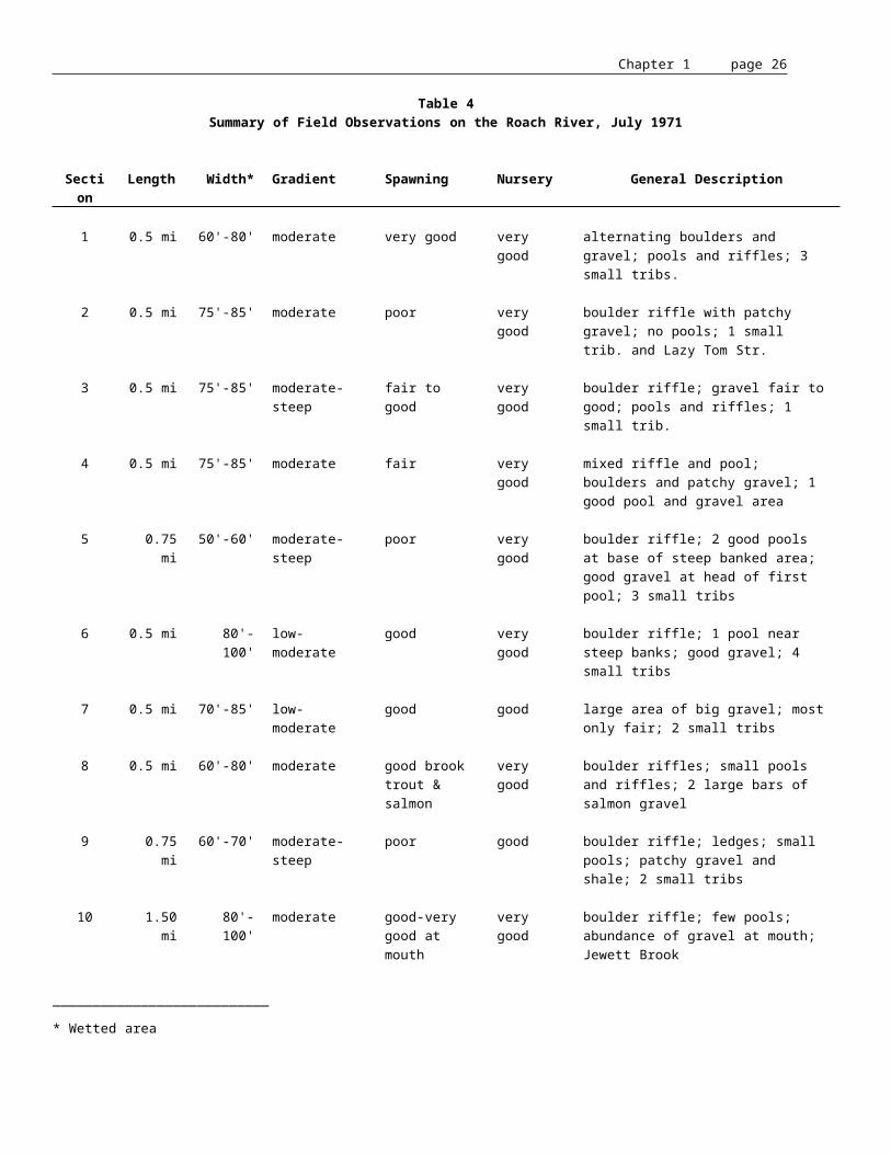
Chapter 1 page 27
The Kennebec River estuary below Chops Point (outlet of Merrymeeting Bay) forms a complex with that of the Sheepscot River estuary. Less saline surface water from the Kennebec River flows through the Sasanoa River into Hockomock Bay on an outgoing tide, whereas highly saline water from the Sheepscot River enters Hockomock Bay through Goose Rock passage on the incoming tide as bottom water in the Sasanoa. Water is also exchanged in Montsweag Bay between Hockomock Bay and the Sheepscot River in Wiscasset. Thus, both Hockomock and Montsweag Bays act as mixing basins for the Kennebec and Sheepscot Rivers' water, with there being an indirect exchange between the two systems.19 Hockomock Bay is also connected with the Kennebec River through Back River, which is very shallow near Hockomock Bay. The dynamics of water exchanged between the two systems and the exact influence one river system exerts upon the other has not been extensively studied.
Table 6
Area (acres) of Tidal Riverine Subsystems and Classes in theKennebec/Sheepscot Rivers Estuarial Complex
Beach/bar 1,102Nonpersistent Emergent Wetland 3,133Flat 1,211Unconsilidated Bottom 12Open Water 5,682Rocky Shore 0
TOTAL 11,140
Source: adopted from FWS/OBS-80/29, 1980
The Kennebec River estuary can broadly be characterized as being a narrow, relatively shallow estuary with a low tidal volume and a large freshwater flow with a large tidal exchange. This results in relatively short flushing time for the estuary in comparison to the Sheepscot and Penobscot Rivers.
The shallow entrance to the Kennebec River (about 35') prevents the entrance of nutrient rich deep water from the Gulf of Maine. The Kennebec River estuary would not be expected to be a highly productive estuary based on the fact the shallow shelf prevents the entrance of nutrient rich deep ocean water and the moderate flushing rate reduces residence time of nutrients, although an unknown amount of nutrient rich Sheepscot River water could enter through the Sasanoa River. Nitrate samples taken at Bath were higher than predicted, even allowing for a higher Sheepscot River input than probably occurs.20 These high rates were attributed to the discharge of the local sewerage discharge plant and
19 ? ibid.
20 ? An Ecological Characterization of Coastal Maine. Fefer, S.I. and P.A. Schettig, 1980; FWS/OBS-80/29, Biological Services Program, U.S. Fish and Wildlife Service.

Chapter 1 page 28
not from freshwater input. Based on nitrate values at Bingham, freshwater input was not considered significant source. The majority of nitrate inputs from municipal and industrial sources occurs below Bingham. The input of nitrates (and ammonia) from sewage treatment plants and agriculture runoff needs to be studied in more detail to determine its impact on productivity in the Kennebec River estuary. The dominant nutrient pathway in the Kennebec River is probably from the extensive marsh systems, especially those in the Merrymeeting Bay region. Thus, the food web is probably mainly based on organic detritus derived from the nonpersistent emergent vegetation from the fresh and salt marshes. The estuarial complex of the Kennebec and Sheepscot Rivers contains approximately 26% of estuarine habitat (33,419 acres) found north of Cape Elizabeth (Table 7). The emergent wetlands comprise 4,975 acres of this total and represents 36% of this class of habitat available north of Cape Elizabeth (Table 7). This estuarine complex is an important nursery area for the anadromous fish species produced in the riverine sections of both rivers, as well as for marine species.
The vertical salinity gradient in the Kennebec River estuary stratifies only slightly. Francis and coworkers21 sampled the estuary during low flow periods in the fall and found the estuary to be only slightly stratified. They noted that the two sharp bends below Bath (Doubling Bends) and the very narrow portion of the river between Doubling Bends and Bluff Head shore resulted in very intense mixing based on the amount of turbulence seen in this area. This turbulent section did not appear to impact the vertical salinity gradient at the time they sampled the river. The Department of Marine Resources has found similar results based on salinities measured in August at high slack tide, although the degree of mixing varied from year to year probably with the freshwater inflows and lunar cycle.
21 ? Observations of Turbulent Mixing Processes in a Tidal Estuary. Francis, J.R., D.H. Stommel, H.G. Farmer, and D. Parsons, 1953; Woods Hole Oceanographic Institution, Woods Hole, Massachusetts.

Chapter 1 page 29
Table 7
Area (acres) of Estuarine Subsystems and Classesin the Kennebec/Sheepscot Rivers Estuarial Complex
Aquatic Bed 718Open Water 17,993
Subtidal Total 18,711Estuarine Total 33,419
Unconsolidated Bottom -----Rock Bottom -----Aquatic Bed 163Beach/Bar -----Emergent 4,975Emergent/OW -----Emergent/UB -----Flat 9,432Flat/EM -----Flat/SS -----Reef -----Rock Shore 130Scrub/Shrub 8
Intertidal Total 14,708
Water Quality.
Water quality of the Kennebec River Basin has improved dramatically since 1978 when most of the major discharges were provided treatment. As a consequence of this significant cleanup effort, the Legislature revised the water quality classifications of the basin in 1989 to reflect the gains made in water quality improvement (see Appendix C). Much of the watershed has been raised to class AA, A and B in recognition of the excellent water quality found. This assures protection of a high quality aquatic habitat and multiple use of the resource.
The most recent evaluation of water quality22 finds that much of the water of the Kennebec River Basin achieves the standards of the designated classes. While most of the waters listed that do not attain their classification standards are small tributaries, a few notable exceptions exist. Foremost, are two segments in the basin which have health advisories for the consumption of fish due to dioxin contamination. These include a 56 mile segment of the Kennebec River from Skowhegan to Merrymeeting Bay and a 13 mile segment of the West Branch of the Sebasticook River from Hartland to Pittsfield. Other significant segments not attaining standards are portions of Messalonskee Stream which is 22 ? State of Maine 1990 Water Quality Assessment. Maine Department of Environmental Protection, 1990.

Chapter 1 page 30
eutrophic, has high levels of coliform bacteria and low dissolved oxygen, and segments of the Sebasticook River and its two main branches which are eutrophic, have high levels of bacteria, low dissolved oxygen and significantly impaired aquatic life communities. The lower Kennebec River has low dissolved oxygen and bacteria problems in segments below Waterville/Winslow and Augusta.
Cause of nonattainment problems in the Kennebec Basin can be attributed to a number of factors. Pollutants from nonpoint (diffuse) sources such as farms, forestry, and urban development are, collectively, the greatest source. These pollutants account for much of the eutrophication and dissolved oxygen problems particularly in the small tributaries and in impounded segments of rivers. Combined sewer overflows (combined storm and wastewater systems) cause some of the more severe bacteria contamination problems. The dioxin problem is associated with processes in the pulp and paper and tanning industries. Other toxic problems have been associated with the tanning and textile industries. Improved management of each of these sources will be required to resolve these problems.

Chapter 1 page 31
HYDROPOWER REGULATION
ROLE OF THE FEDERAL GOVERNMENT IN HYDROPOWER REGULATION
FERC regulates the construction and operations of hydropower projects pursuant to the Federal Power Act, first enacted in 1920. FERC's jurisdiction extends to all projects on navigable waters and to projects on non-navigable waters constructed or modified after 1935.
A river is considered to be navigable if it is or has been used to transport persons or property in interstate or foreign commerce. The historic floating of logs to sawmills and paper mills is sufficient to establish navigability. A project on a non-navigable waterway must affect interstate or foreign commerce in order to come under federal jurisdiction. Participation in interstate commerce is assumed when project power is conveyed to the public utility power grid or when project power displaces electricity that would otherwise be purchased from the grid. FERC has found the Kennebec River to be navigable from its mouth at least up to Moosehead Lake.
The Federal Power Act allows for competition during relicensing. Two or more competing applications for a new license may be filed for the same project. FERC will issue a license for the project judged to be the "best adapted to a comprehensive plan for improving or developing a waterway."23 Alternatively, FERC may recommend a federal takeover of a project. This must be authorized and funded by an act of Congress. New licenses are issued for terms varying from 30 to 50 years. The applicant makes a proposal to FERC of the license term and FERC makes the decision based on the following rules of thumb. New projects and total redevelopments are usually granted 50-year licenses and if moderate redevelopment or reinvestment is proposed, a 40-year license term is likely. In cases where no changes or no substantial investments are proposed to the facility, a 30-year license is likely to be issued.
All applications for relicensing must be filed with FERC no later than two years prior to the license expiration date. However, FERC is under no self-imposed time limitation in acting on these applications. If a new license has not been issued or a federal takeover has not occurred by the license expiration date, FERC will issue annual licenses to the applicant until relicensing action has occurred.
Many of the projects slated for relicensing were first licensed before the enactment of the National Environmental Policy Act (NEPA), the Clean Water Act and other federal environmental laws. However, the relicensing of these dams will require an assessment of the impacts using these current statutes.
23 ? Federal Power Act, 1986 Amendments, Electric Consumers Protection Act.

Chapter 1 page 32
THE FERC CONSULTATION PROCESS
FERC's regulations require that all potential applications for licensing or relicensing participate in a detailed pre-filing consultation process with the appropriate State and federal resource agencies. This three-stage process requires approximately five years for each project and involves a considerable amount of time and effort by all parties.
SPO is designated as the lead State agency in the FERC relicensing process and is charged with the duty of processing applications, monitoring application status, and coordinating and reviewing agency requests and comments. Policy and procedures were developed in 1989 to expedite the State's role in federal licensing and relicensing (See Appendix C, "Revised Procedure to Ensure that State Agency Comments in Federal Hydropower Proceedings are Timely, Coordinated and Consistent", September 1989). Emphasis is also focused on the substance of State agency review. The new policy requires all State agencies to consider their comments, study requests and recommendations to ensure that they are not unnecessarily burdensome to the applicants. The objective of the State is to achieve the best possible balance between power generation and the preservation and enhancement of natural resource and recreational values.
FERC consultation during the relicensing process will allow the State an opportunity to assess the impacts of many of the major hydropower projects in Maine and to re-evaluate the uses of the public river resources. Among the issues to be considered by the State agencies in their review for a new FERC license are: flood control, floodplain management (National Flood Insurance Program), energy generation and conservation, economics, geological and botanical resources, restoration of sea-run fish, inland fisheries and wildlife management, protection and improvement of water quality, historical and cultural resources, and improvement of recreational opportunities.
FERC licensing is also required for water storage dams and reservoirs that provide stream flow regulation to downstream licensed hydropower facilities.
In rules adopted May 24, 1989, FERC made provision for public participation from the beginning of the consultation process. Previously, public participation had been limited to the final application filed with FERC, when most studies were complete. When the licensing process is initiated, by the filing of an initial consultation document, the applicant is obligated by FERC rules to hold a public meeting during the first stage of consultation.24 (The State's provisions for public participation are discussed in the next section.)
In addition to the above, natural resources are specifically protected by the following Federal statutes and executive order:
* Section 18 of the Federal Power Act mandates that FERC shall require licensees to construct and operate such fishways as are prescribed by the USFWS, and the National Marine Fisheries Service.
* The Fish and Wildlife Coordination Act (P.L. 85-624), administered by the Department of the Interior, requires federal agencies which license dams (and other activities) to consult the federal departments and state fish and wildlife agencies to determine how fish and wildlife may be conserved and enhanced.
24 ? Maine Hydropower Relicensing Status Report. Maine State Planning Office, January 1990.

Chapter 1 page 33
* The Endangered or Threatened Species Act (P.L. 93-205): Threatened Species may be added to the Endangered Species List and regulations may be issued by the Secretary of the Interior to protect the species. The regulations may include designation of a range or critical habitat in which commercial activity may not take place without permission of the Secretary.
* Section 401 of the Clean Water Act requires that any applicant for a federal license or permit for an activity which may result in a discharge to navigable waters must obtain state certification that the activity will not violate applicable water quality standards.
* Section 404 of the Clean Water Act and the National Environmental Policy Act are also relevant for the protection of wetlands and examination of environmental impacts caused by federal action.
* Executive Order 11988 on Floodplain Management, May 24, 1977 requires all Federal agencies to review any actions they take in light of any adverse effects and incompatible development in the floodplain.
THE ROLE OF STATE GOVERNMENT
A permit is required under the MWDCA for the construction, reconstruction or structural alteration of a hydropower project. The MWDCA is administered by the Department of Environmental Protection (DEP) and the Land Use Regulation Commission (LURC) in their respective jurisdictions. Statutory review criteria include consideration of financial capacity and technical ability, public safety, public benefits, traffic movement, LURC zoning, environmental impacts and mitigation and energy benefits. In relicensing, a State hydropower permit will only be required if project redevelopment or expansion is proposed in conjunction with relicensing. Thus, the State's authority to condition the operation of most hydro projects upon relicensing is contingent upon Section 401 of the Clean Water Act which requires that any applicant for a federal license or permit for an activity which may result in a discharge to navigable waters must obtain state certification that the activity will not violate applicable water quality standards.
The Maine Comprehensive Rivers Management Plan, submitted to FERC in 1987, will ensure that during FERC relicensing proceedings the State of Maine will have a strong voice on issues regarding the development and management of its rivers. FERC officially recognized Maine's plan as a comprehensive plan in November 1988, although it was referenced as a comprehensive plan in the FERC order amending the license for the Brassua project issued July 28, 1987.
As amended by the 114th Legislature, 38 MRSA §640 now requires State agencies that review and comment on Federal licensing and relicensing procedures to allow for public participation:
• Publication. At the commencement of the consultation, review and comment process, the State agencies involved shall publish notification of this fact, informing the public of the issues anticipated to be involved in the licensing or relicensing process, the timetable for processing of the license and the opportunities the public has to comment on and participate in the process. The notice shall be designed to reach readership both
Chapter 1 page 34
statewide and in the vicinity of the hydropower project, including all persons that have contacted the agencies with an interest in this matter and all potentially interested persons.
• Written notification of status. During the entire consultation process and including the filing of the license application under the Federal Power Act, the State agencies shall inform in writing all members of the public that have indicated an interest in the particular licensing process of the status of that process, including all requirements that the agencies may be placing upon the license applicant. That information shall be provided no less than once every 4 months.
• Public comment. State agencies shall provide meaningful opportunities for public comment on the plans, studies, terms and conditions to be recommended by the agencies for inclusion in the license.
• Release of public information. All information submitted to the agencies by the applicants for a license under the Federal Power Act shall constitute a public record pursuant to 1 MRSA §402, unless such information is otherwise exempted from public disclosure by state law. Release of the information to members of the public shall be governed by 1 MRSA §408.
With regard to public participation, the SPO Hydropower Coordinator makes every possible effort to include all interested parties in the consultation process. Lists of individuals interested in particular projects undergoing relicensing are on file at SPO. At appropriate times, these individuals are notified through status reports of review and comment periods, filings with FERC and ongoing events associated with the consultation and licensing process. Public notices are published in three newspapers to solicit participation in public meetings and the consultation process and to inform the public when initial hydropower applications are received and when FERC filings are accepted.
RELATIVE COST OF RELICENSING ACTIVITIES
The relicensing process may require applicants to conduct studies and design and implement mitigation programs. Although the breakdown of the cost of these activities varies considerably from project to project, it can be roughly estimated as shown in Table 8.

Chapter 1 page 35
Table 8
Breakdown of Relicensing Expenses
40% Archaeology: surveys, studies and mitigation40% Fisheries: studies, stocking and fishways8% Recreation: studies and improved access7% Engineering design5% Miscellaneous
SUMMARIES OF STATUS OF PROJECTS UNDERGOING RELICENSING
The following summaries reflect the results of the consultation process wherein the State assessed proposals for relicensing according to an analysis of the balance of resources and uses at each project.
Edwards - FERC #2389. The Augusta Hydroelectric Project, better known as the Edwards Dam, is owned and operated by the Edwards Manufacturing Company and is located on the Kennebec River between Augusta and Waterville, Maine. The project is presently rated with an installed capacity of 3.5 MW and the applicant is proposing to upgrade and expand the facility to 11.7 MW. The Edwards Dam is located in the city of Augusta and the impoundment formed by the dam extends upstream from the dam a distance of approximately 15 miles and comprises an area of approximately 1,143 acres. Existing facilities consist of a 917' long concrete-capped timber crib spillway, an 8' long gatehouse, 450' long power canal and three powerhouses. The water quality classification for most of the project impoundment is Class C. The reach of river from its confluence with Messalonskee Stream to the Sidney/Augusta town line is classified as Class B.
The expanded project will involve the construction of a new powerhouse located at the downstream end of the existing main power canal which will house one vertical Kaplan turbine and generator with a capacity of approximately 8 MW. Powerhouses 7 and 8 will be decommissioned, the new power canal widened, a new canal intake structure and new fish passage facilities constructed, repairs and improvements to the existing dam will be accomplished and present plans specify the addition of an inflatable crest control device along the entire length of the primary spillway.
Enhancements proposed by the applicant involve the construction and operation of new upstream and downstream fish passage facilities at the project. The upstream facilities as proposed consist of fish transportation channels, a central fish attraction pool, a duplex fish lift, sorting and holding tanks, and an exit channel to the power canal. The proposed downstream facilities consist of a gated concrete entrance chamber at the intake to each powerhouse and sluice pipes to tailwater. The proposed facilities are intended to provide passage for design populations of 1,548,000 alewives, 385,000 American shad, and 7,500 Atlantic salmon annually.
The State of Maine has taken the position that removal of the Edwards Dam is necessary to achieve the State's goals for restoration of the Kennebec's fisheries and
Chapter 1 page 36
recreational resources. The State resource agencies recommend that the no dam alternative be considered and that dam removal studies be conducted.
The State resource agencies find that the applicant has failed to address the State's goal of restoring striped bass, rainbow smelt, Atlantic sturgeon, and shortnose sturgeon to their historical range which includes the river segment from Augusta to Waterville. The applicant has failed to address upstream and downstream passage requirements for striped bass, Atlantic sturgeon, shortnose sturgeon, and rainbow smelt, in addition to American shad, Atlantic salmon, and alewives. It is likely that the Federally endangered shortnose sturgeon migrate to the Edwards Dam and potentially spawn in the immediate area. Field studies should be conducted to determine if shortnose sturgeon are spawning in the project area. American shad, smelt, striped bass, and the sturgeon should be used as study species to determine the impacts of the proposed redevelopment on the habitat between the dam and the Memorial Bridge. Field studies should be designed with input from the fishery agencies to determine if, when, and where striped bass, smelt and Atlantic sturgeon spawn in the project area and to determine what impact the diversion of flows will have on this life stage of these species. The applicant should determine if smelt utilize the project area prior to spawning. The applicant should clarify that proposed techniques for holding and sorting of trapped fish is effective in preventing upstream passage of undesirable species. Studies should also determine the effect of the proposal and the no dam alternative on the abundance of brown trout. Detailed soil erosion and sedimentation plans for project redevelopment are also recommended.
Assuming that Edwards Dam is not removed, the State also recommends studies on recreational use below the dam to address fishing opportunity for striped bass, American shad, Atlantic salmon, brown trout and smallmouth bass. The State contends that the projected increase in recreational use of the impoundment is underestimated and that additional recreational access should be planned. A portage trail around the dam is warranted and consistent with other hydroelectric projects on the Kennebec. Consultation meetings with the Bureau of Parks and Recreation (BPR) and towns on the impoundment resulted in the following specific proposals being recommended:
1. Development of riverfront trail and picnic area at the existing Sidney boat launch.2. Primitive campsites at Seven Mile Island.3. Park and handicapped fishing access at Old Mill site in Augusta.4. Canoe portage route around the Edwards Dam.
Messalonskee Project. The Messalonskee Project is comprised of four small and discrete hydroelectric generating facilities and one storage facility located on Messalonskee Stream in Kennebec County, Maine. The developments that comprise the Messalonskee Project are currently licensed as four separate projects. These projects are: Oakland (includes the Messalonskee Lake Dam and the Oakland Dam), Union Gas, Automatic and Rice Rips. FERC has agreed to consider relicensing of these five developments as a single hydraulically-related project. Messalonskee Stream from the Messalonskee Lake dam to the Kennebec River is an approximately ten mile long tributary which drains an area of 177 square miles at the Messalonskee Lake Dam. Messalonskee Lake Dam is the storage facility, impounds Messalonskee Lake, and is operated to provide water to the downstream generating stations with specific and voluntary restrictions on the amount and timing of drawdown.
Chapter 1 page 37
The Water Classification of Messalonskee Stream is currently classified as Class C "from the outlet of Messalonskee Lake to its confluence with the Kennebec River." Class C is the 4th highest classification of fresh surface waters. Absent any other statutory provisions, this would mean that the entire length of Messalonskee Stream through the project area is Class C. However, the Rice Rips impoundment (Lake Hutchins - 87 acres) and the Automatic impoundment (67 acres) qualify as "great ponds" and are not specifically classified at Class C but must be considered to be Class GPA waters.
Oakland - FERC # 2559. The Oakland facility is the most upstream of the Messalonskee developments and consists of a 115 foot long concrete gravity dam, intake structure, penstock, powerhouse, one vertical Francis turbine, one vertical Allis-Chalmers generator, tailrace, and appurtenant facilities. It has an installed capacity of 2.8 MW.
Rice Rips - FERC # 2557. The Rice Rips Development receives its inflow from the Oakland Development which is 1.9 miles upstream. The 1.6 MW project consists of a 219' long concrete Ambursen dam, an intake structure, a penstock, surge pond, powerhouse with appurtenances and a tailrace.
Automatic - FERC # 2555. The Automatic facility is located 5.6 miles downstream of the Rice Rips Dam and has an installed capacity of .8 MW. The 80' long concrete gravity dam, powerhouse and appurtenant structures are located in the city of Waterville while the impoundment extends into Oakland.
Union Gas - FERC # 2556. The Union Gas Development is the furthest downstream of the Messalonskee Stream generating facilities and has an installed capacity of 1.5 MW. The dam is located 0.9 mile upstream of the confluence of the Kennebec River and Messalonskee Stream. The development's structures consist of the stone masonry dam 343' in length, adjacent powerhouse, appurtenances and the tailrace.
The applicant proposal for the Messalonskee Project involves no alteration of existing project but initiates and sustains several measures for protecting and enhancing environmental resources including:
• Providing a minimum flow release from the Messalonskee Lake Dam and through the Rice Rips bypass of 15 cfs or inflow, whichever is less, in order to protect and maintain fish resources and aquatic habitat;
• Providing a minimum flow release from the Union Gas Development of 15 cfs or inflow, whichever is less, in order to protect and maintain fish resources and aquatic habitat;
• Investigating the engineering feasibility and potential environmental benefits of reducing the downramping rate at the Union Gas Development (i.e., rate of change from generating to non-generating flows during store and release operations), in order to protect and maintain fish resources;
• Limiting normal water level fluctuations in Messalonskee Lake during daily and seasonal store and release operations to a maximum of 0.5 feet from full pond during the summer months and a maximum of 1.0 foot from full pond during the remainder of the year, in order to protect and enhance fish and wildlife resources, recreational use and wetland values;

Chapter 1 page 38
• Continuing to maintain stable water levels (within one foot of full pond) under normal run-of-river operations in the Oakland, Rice Rips and Automatic impoundments, in order to protect and maintain fish and wildlife resources;
• Limiting normal water level fluctuations in the Union Gas impoundment during store and release operations to a maximum of 1.3 feet from full pond in order to protect and maintain fish and wildlife resources;
• Continuing to clean Messalonskee Lake fish screen, owned by the Town of Oakland, in order to protect and maintain fish resources;
• Maintaining existing informal day-use access at the Messalonskee Lake Dam and investigating the feasibility of providing new recreational facilities including: improved day use area at Messalonskee Lake Dam, a managed green belt along the east side of Messalonskee Stream from the Oakland Dam to the Rice Rips Dam, improved angler parking along the Rice Rips access road, day use access sites along the Rice Rips impoundment and additional walk-in angler access below the Union Gas Dam. These improvements would be implemented in order to protect and enhance public recreational access and use to the project area.
The State finds that the proposal to relicense the Messalonskee project represents an appropriate balnce of resources and uses and that it conforms with State policy.
Fort Halifax - FERC #2552. Fort Halifax is a 1.5 MW project owned and operated by Central Maine Power Co. (CMP) located in Kennebec County on the Sebasticook River, 1,400 ft. upstream of the confluence with the Kennebec River. The dam and powerhouse are located in the Town of Winslow and the impoundment extends 5.2 miles upstream into the Town of Benton. The impoundment has a surface area of approximately 417 acres at full pond level. The project consists of a concrete Ambursen dam with a maximum height of 29 ft. and powerhouse which houses two generating units rated at 750 KW each. The water quality classification for the Ft. Halifax Dam impoundment and tailrace areas is Class C. CMP is currently proposing to enhance water quality by monitoring dissolved oxygen, and flushing when a level of 5 ppm is reached. The applicant's proposal involves no alteration of existing energy capacity but initiates and sustains several measures for protecting and enhancing environmental resources including:
• Providing a minimum flow release from the project of 150 cfs or inflow, whichever is less, for a period of April through November annually, in order to provide a zone of passage for migrating anadromous fish;
• Limiting normal impoundment fluctuations during daily cycling operations to a maximum of 2.5 feet from full pond (to elevation 49.0 feet MSL), in order to protect fish and wildlife resources in the impoundment;
• Installing permanent downstream and upstream fish passage facilities at the project by December 31, 1993 and May 1, 1999, respectively, in accordance with the Agreement between the State of Maine and the Kennebec Hydro Developers Group (KHDG), in order to restore anadromous fish to the river above the dam;
Chapter 1 page 39
• Maintaining and improving as necessary existing recreational facilities (a carry-in boat access site on the project impoundment and a downstream fishing access trail) and providing new recreational facilities (a trailored boat launching facility serving the project impoundment and a marked canoe portage trail around the project dam) in order to protect and enhance public recreational access to and use of project waters.
During second stage consultation with the State agencies, points of disagreement between CMP and the agencies were identified. One unresolved area involves minimum flows. Based on the results of the IF&W study, IF&W would prefer a minimum flow release of 400 cfs to provide optimal habitat for both life stages of brown trout, the species of concern for that agency's management program. IF&W concurs with the DMR and the USFWS recommendation for operation of the project in a run of river mode during upstream anadromous migration period (May 1 - June 30). The 400 cfs minimum flow release would apply for the rest of the year when the project was operated in a peaking mode.
DMR recommends adoption of a slightly lower minimum flow of 350 cfs, instantaneous minimum flow or inflow, whichever is less, from mid-July through October.
Weston - FERC #2325. The Weston Project, located on the Kennebec River in Somerset County, Maine, is a run-of-river, 12 MW facility owned and operated by CMP. The project is comprised of a powerhouse containing four generating units, two dams separated by an island, a 930 acre impoundment and appurtenant facilities. The powerhouse and dam are located in Skowhegan, 37.8 miles above the head-of-tide. The applicant is investigating the feasibility of replacing the existing turbine runners with new more efficient ones which would increase the total station hydraulic capacity by about 1,180 cfs and generating capacity by 2 MW. The water quality classification for the Kennebec River from the Route 201A bridge in Anson/Madison to the Skowhegan/Fairfield town line (which includes the entire Weston Project area) is Class B. Class B is the third highest water quality classification. The applicant proposal involves several measures for protecting and enhancing environmental resources including:
• Continuing to operate the project in a run-of-river mode, with minimal impoundment fluctuations under normal operating conditions, in order to protect water quality and fish and wildlife resources in the river above the dam;
• Providing a minimum flow release from the project of 1,947 cfs or inflow, whichever is less, in order to protect water quality and fish and wildlife resources in the river below the dam;
• Installing permanent upstream and downstream fish passage facilities at the project by May 1, 2001, in accordance with the Agreement between the State of Maine and the Kennebec Hydro Developers' Group in order to restore anadromous fish to the river above the dam.
• Maintaining and improving the landscaped area in front of the powerhouse, providing signage regarding the Arnold Trail at the powerhouse and expanding the existing parking area at Oosoola Park in Norridgewock. A proposal to lengthen the existing boat ramp is being investigated and will be implemented if needed. All of these efforts are being made to preserve and enhance recreational opportunities in the project area.

Chapter 1 page 40
The State finds that the proposal to relicense the Weston project represents an appropriate balnce of resources and uses and that it conforms with State policy.
Wyman Dam - FERC # 2329. The Wyman Project is the second largest hydropower project in Maine with an installed capacity of 72 MW. It is owned and operated by CMP and is an intermediate peaking facility on the Kennebec River in Somerset County in the towns of Moscow, Bingham, and Caratunk and the unorganized territories of concord Township, Pleasant Ridge Plantation and Carrying Place Township. The Wyman Project consists of a powerhouse, a 3,246 foot long dam, a 3,240 acre impoundment and appurtenant facilities. The water quality classification for the main stem of the Kennebec River from the Wyman Dam to Route 201A bridge in Anson and Madison is Class A which necessitates having aquatic life as naturally occurs. The Wyman impoundment is considered a Great Pond and is classified GPA.
The applicant's proposal involves a number of changes in project facilities and operation including:
• Restricting normal impoundment fluctuations to a maximum of 2 feet from full pond in order to protect fish and wildlife resources in Wyman Lake;
• Reserving the right to draw the impoundment down as necessary by up to eight feet during periods of heavy runoff in order to provide some measure of downstream flood control;
• Increasing project minimum flow releases from 490 cfs to 750 cfs in order to protect and enhance fish resources in the Kennebec River below Wyman Dam;
• Limiting the simultaneous shut-down of all three project generating units to cases of emergency in order to protect fish resources in the Kennebec River below Wyman Dam;
• Constructing a canoe portage trail, constructing loon rafts at Caratunk, allowing continued access for fishermen to impoundment and tailwater area, providing parking for ice fishermen and snowmobilers, and assisting with paying the operating costs for the Pleasant Ridge Municipal Recreation Area in order to protect and enhance public recreational use in the area. In connection with relicensing, a number of enhancements have already been implemented including construction of a hard surface boat ramp in Moscow and a day-use area, covered picnic areas, an outhouse and two primitive campsites at Caratunk.
The State finds that the proposal to relicense the Wyman project represents an appropriate balnce of resources and uses and that it conforms with State policy.

Chapter 1 page 41
Moosehead Lake - FERC #2671. The Moosehead Project is the largest hydro storage project in the state. It provides significant control of the flow on the Kennebec River and serves to regulate the river for the benefit of downstream resources and for 10 downstream hydroelectric projects. The Moosehead Project is owned and operated by KWPC, which in turn is owned by CMP, Edwards Manufacturing Company Inc., Merimil Limited Partnership, Scott Paper Company, and Madison Paper Industries. The project consists of two gated outlet dams (East Outlet and West Outlet), a 74,200 acre impoundment and appurtenant facilities. There are no generating facilities at the project. It is located near Greenville at the head of the Kennebec River in Somerset and Piscataquis Counties, Maine. The water quality classification for the East Outlet is Class A for the first 1,000 feet below the dam and Class AA from this point to the confluence with Indian Pond. Both Class A and AA water shall have aquatic life as naturally occurs.
The applicant's proposal involves no alteration of existing project but initiates and sustains several measures for protecting and enhancing environmental resources including:
• Establishment of a formalized lake level agreement which would include a water level management plan targetting a fall maximum drawdown date of October 10th, with a provision to draw down the lake an additional 2 feet during the winter if necessary. The use of target levels will allow the licensee, in consultation with the resource agencies, to balance the competing interests affected by abnormal water conditions;
• Restricting any drawdowns after the October 10th maximum drawdown to protect fish and wildlife resources with a provision of an additional two feet if required due to abnormal climatic conditions;
• Increasing minimum flow releases from the East Outlet Dam from 200 cfs to 500 cfs, in order to protect and enhance salmon and brook trout habitat;
• Increasing minimum flow releases from the West Outlet Dam from 25 cfs to 80 cfs, with a further increase to a target flow of 120 cfs during the summer recreation season, in order to protect and enhance salmon and brook trout habitat and recreational canoeing;
• Conducting additional field work in the East Outlet to quantify the amount of salmon and trout spawning habitat that remains watered at the proposed 500 cfs minimum flow release, and examining additional enhancement measures in the event that a substantial portion of the available spawning habitat is dewatered at the proposed flow release;
• Managing East Outlet flows to limit weekly flow fluctuations (in accordance with post-1984 project operation), in order to protect fish habitat;
• Maintaining the existing fishway at the East Outlet Dam and operating the gates at the East Outlet Dam to increase the efficiency of the fishway, in accordance with the recommendations of IF&W;
• Maintaining existing fishing and carry-in boat access facilities at the West Outlet Dam, improving existing fishing and carry-in boat access facilities at the East Outlet Dam, and enhancing public recreational use and access in the project area;

Chapter 1 page 42
• Establishing a telephone service to provide information on actual flows and forecasted flows in the East Outlet, with daily updates, in order to reduce concerns about the unpredictable nature of recreational conditions; and
• Hosting an annual meeting with commercial and private recreation interests to discuss project operations and important recreational concerns.
The State finds that the proposal to relicense the Moosehead Lake project represents an appropriate balance of resources and uses and that it conforms with State policy.
Moxie - FERC #2613. The Moxie Project is a storage project located on Moxie Stream in Somerset County, Maine. The Moxie Project is owned by CMP, Madison Paper Industries, Scott Paper Company, Merimil Limited Partnership, and Edwards Manufacturing Company Inc., and is operated by KWPC; it is comprised of a concrete dam located across the main stream channel, with four small separate closure dams located in the immediate vicinity of the main dam and a 2,231 acre reservoir. The project is operated as a water storage facility to regulate flows to the Kennebec River for downstream hydroelectric generation and flood control. The water quality classification for Moxie Stream is Class A for the first 1,000 feet below Moxie Dam and Class AA from that point to the confluence with the Kennebec River. Both Class A and Class AA shall have aquatic life as naturally occurs.
The applicant's proposal involves no alteration of existing project but initiates and sustains several measures for protecting and enhancing environmental resources including:
• Continuing current spring and summer water level management (reservoir refilled beginning in mid to late March and held to within approximately one foot of full pond level throughout the summer), in order to protect and maintain fish and wildlife resources and recreational uses;
• Restricting annual fall drawdown to a maximum of 3 feet (elevation 967.3 feet prior to November 15) in order to enhance tributary access for spawning salmonids;
• Restricting total annual drawdown to a maximum of 8 feet (elevation 962.3 feet), in order to protect and enhance fish and wildlife resources;
• Restricting flow releases from Moxie Dam during annual fall drawdown to a maximum of 145 cfs plus inflow, whenever possible, in order to reduce scouring and to protect and enhance aquatic habitat in Moxie Stream;
• Providing a minimum flow release from Moxie Dam of 25 cfs or inflow, whichever is less and whenever feasible, in order to protect and enhance fish resources and aquatic habitat in Moxie Stream; and
Chapter 1 page 43
• Maintaining and improving as necessary existing trailored boat launch, parking and picnic facilities adjacent to the Moxie Dam, in order to protect and enhance recreational use and access in the project area.
The State finds that the proposal to relicense the Moxie project represents an appropriate balnce of resources and uses and that it conforms with State policy.

Chapter 1 page 44
RESOURCES AND BENEFICIAL USES
HYDROPOWER GENERATION
One of the most important historical uses of the Kennebec River has been the generation of electricity through hydropower facilities. Today, hydropower continues to be a critical use of the river as the flow generates power which is highly reliable, renewable and generally non-polluting. Hydro projects frequently have useful lives of over 50 years and enjoy no fuel costs, and low maintenance and overall operating costs. However, potential negative environmental impacts, including oxygen depletion, impact on fish migration, riverine ecosystem structure and function, and recreational use, can offset the advantages of hydropower.
In the 1970s hydropower supplied 35% of Maine's electric energy needs; increases in demand for electric power supplied from other sources reduced that figure to 23% in 1986, 33% in 1990, and 31% in 1991.25
Existing Facilities.
There are 27 Federally licensed generating facilities and storage dams on the Kennebec and its tributaries. These facilities provide 257 MW of generating capacity which represents 36% of the State's hydropower capacity and 9% of the State's total generating capacity. This is roughly the equivalent of the energy needs of 200,000 homes in the State. Three additional dams have been found to be within FERC's jurisdiction and have begun the licensing process. Four dams with generating facilities are licensed only by the State. (SeeTable 10 for a full listing and Figure 2).
Ten dams located on the main stem Kennebec have 95 percent of total generating capacity in the basin. All mainstem hydropower dams are run-of-river except Harris (Indian Pond), Wyman and Williams which have storage capacity only for daily or weekly load fitting operations.
There is a total of about 1,300,000 acre-feet of reservoir storage in the Kennebec basin, used for hydropower regulation, with about 86 percent of that storage located in the upper 46 percent of the watershed, upstream of Bingham, Maine. The other 14 percent is generally distributed between the Sebasticook, Messalonskee, and Cobbosseecontee tributary watersheds in the lower part of the basin below Waterville. Available reservoir storage in the upper basin has a marked effect on upper basin flood flow contributions to the Kennebec River. Principal storage reservoirs in the basin above Bingham are listed in Table 9. There are 1,132,000 acre-feet of storage in the upper basin and 1,016,500 acre-feet, or 90 percent at the three lakes: Brassua, Moosehead, and Flagstaff.26
Industrial use of dammed waters in lower tributaries has declined in recent years and these watersheds are primarily regulated for recreation and water supply.
25 ? Final Report of the Commission on Comprehensive Energy Planning. Maine State Planning Office, May 1992.
26 ? Kennebec River Basin Study, Vol. 1. Army Corps of Engineers.

Chapter 1 page 45
Table 9Available Reservoir Storage, Kennebec River Basin above Bingham, Maine
Full Pool
Project
Drainagearea
(sq.mi.)
Surfacearea
(acres)Drawdown
(feet)Storage
(acre/feet) Precent
Brassua Lake 710 8,979 30 196,500 17First Roach Pond 63 3,270 7 21,500 2Moosehead Lake 1,268 74,000 7.5 544,000 48Indian Pond (Harris) 1,355 3,747 5 19,000 2Moxie Pond 80 1,747 8 14,700 2Flagstaff Lake 520 17,950 35 276,000 24Wyman Lake 2,595 3,145 20 60,300 5
Three licensed storage projects (Flagstaff, Moosehead, and Moxie) on tributaries of the Kennebec River are operated by the KWPC which is owned by CMP, Edwards Manufacturing Co. Inc., Merimil Limited Partnership, Scott Paper Company and Madison Paper Industries. In conjunction with Brassua Hydro Limited Partnership, KWPC also operates a third project (Brassua) which is a combination generating and storage project, located on a tributary of Moosehead Lake. Regulated flow by KWPC is monitored at Madison.
In addition, KWPC currently operates one unlicensed storage dam (First Roach Pond Dam) located on a tributary of Moosehead Lake. This dam was most likely originally constructed to store water for log driving. This dam appears to be located either on navigable waters or on a non-navigable tributary of a navigable waterway. The State has asked FERC to review the licensing status of First Roach Lake dam, currently unlicensed. Because this dam poses potentially significant hazards to public safety and risks to the environment, the State would like to clarify regulatory authority for managing these risks. Action by FERC on this request is pending.
The Eustis Project and the Pittsfield/Burnham Project owned by Consolidated Hydro, Inc., and the Madison Project owned by Madison Electric Works Department have been found to be within FERC jurisdiction due to navigability; licensing consultation has been initiated.
Chapter 1 page 46
Figure 2 -- Kennebec River Basin with Hydroelectric Generating Facilities

Chapter 1 page 47
Table 10Kennebec River Basin
Generating Facilities and Storage Dams
Dam
InstalledCapacity
(MW) Location
Exp Date ofFERC
License Owner
Benton Falls 4.3 Benton 2/28/2034 Benton Falls AssociatesEdwards Dam 3.5 Augusta 12/31/1993 Edwards Manufacturing Co. Inc.Lockwood Hydro Station 6.5 Waterville 4/30/2004 Kennebec Hydro Resources, Inc.Hydro Kennebec 17.5 Waterville 9/30/2036 Scott Paper CompanyShawmut 8.6 Benton 1/31/2021 Central Maine Power CompanyWeston Dam 12.0 Skowhegan 12/31/1993 Central Maine Power CompanyAbenaki Dam 16.98 Madison 4/30/2004 Madison Paper IndustriesAnson Dam 9.0 Anson 4/30/2004 Madison Paper IndustriesWilliams Station 14.5 Embden 12/31/2017 Central Maine Power CompanyWyman Hydro Station 72 Moscow 12/31/1993 Central Maine Power CompanyHarris Dam 76.6 Indian Stre 12/31/2001 Central Maine Power CompanyEast Outlet Dam1 Big Squaw Twp 12/31/1993 Kennebec Water Power Co.West Outlet Dam1 Taunton & R 12/31/1993 Kennebec Water Power Co.American Tissue Dam .9 Gardiner 4/30/2019 Consolidated Hydro Maine, Inc.New Mills .116 Gardiner Gardiner Water DistrictUnion Gas Dam Messalonskee 1.5 Waterville 12/31/1993 Central Maine Power CompanyAutomatic Dam Messalonskee .8 Waterville 12/31/1993 Central Maine Power CompanyRice Rips Dam Messalonskee 1.6 Oakland 12/31/1993 Central Maine Power CompanyOakland Dam Messalonskee 2.8 Oakland 12/31/1993 Central Maine Power CompanyFort Halifax 1.5 Winslow 12/31/1993 Central Maine Power CompanyPittsfield/Burnham 1.05 Burnham pending Consolidated Hydro Maine, Inc.Pioneer Dam .300 Pittsfield Town of PittsfieldWaverly Dam (Upper Dam) .7 Pittsfield Town of PittsfieldLombard .060 Vassalboro ----- Eugene RoderickMorneau's .035 East Vassalboro ----- Paul J. MorneauSevey .016 Ripley ----- Ernest SeveyMadison .300 Norridgewock pending Madison Electric Works Dept.Gilman Stream .100 New Portland ----- North New Portland Energy Co.Eustis .250 Eustis pending Consolidated Hydro Maine, Inc.Moxie Dam1 East Moxie 12/31/1993 Owners of Moxie DamCrocker Pond Dam2 Dennistown Plt. inactive Birch Island Realty Trust, Inc.Starks3 .050 Starks Mark VaughnFlagstaff1 T3 R4 12/31/1997 Central Maine Power CompanyBrassua 3.4 Rockwood Twp 3/31/2012 Owners of Brassua Dam/ Brassua
Hydro Ltd. PartnersFirst Roach Dam1 Frenchtown Twp Kennebec Water Power Co.
TOTAL 257.MW
1 storage dams 2 a generating facility has been approved for this dam but has not yet been constructed 3 this is a generating facility but has no dam

Chapter 1 page 48
Hydropower Potential.
The hydropower potential of the Kennebec River has been examined using a method supplied by Central Maine Power27 which compares developed head to total available head.
The developed head of the Kennebec River is calculated as follows:
Table 11Developed Head of the Kennebec River
ProjectGross Head
(in feet)
Moosehead 7Harris 149Wyman 141.5Williams 45Madison 67Weston 34Shawmut 24.5Kennebec Hydro 27Lockwood 18.5Edwards 19 .
Total Developed Head 532.5 feet
The total available head on the Kennebec River is 1,029 feet, the drop in elevation from Moosehead to Tidewater. Therefore, the proportion of the available head that has been developed can be calculated as follows:
% Developed = Total Developed Head = 532.5 * 100 = 51.7%Total Available Head 1,029
A large proportion of the remaining 496.5 feet of available head has been protected from hydropower development.
Recommendations.
As noted throughout this report, the Kennebec River serves multiple purposes and is utilized by citizens of our State in a wide variety of ways. One of the most important uses of the river is the generation of electricity through hydropower facilities. We are now utilizing an estimated 52% of the total hydropower potential of the Kennebec, beyond the utilization rate for any other use. As a general premise, it is assumed that the dams in the Kennebec River basin will continue to play a significant role in supplying a predictable quantity of energy at a predictable price to the State's energy consumers; however, each license to be renewed must be assessed on a case-by-case basis. 27 ? Letter from Central Maine Power to the State Planning Office dated September 29, 1992.
Chapter 1 page 49
After careful analysis of balances of uses and resources, the State finds that appropriate actions have been taken or have been proposed to be taken by the hydrodevelopers to achieve an appropriate balance at eight of the ten Kennebec Basin dams whose licenses expired in 1993.
At Fort Halifax, State and federal agencies recommend operation of the project in run of river mode during upstream anadromous migration (May 1 - June 30) and minimum flows of 350 -400 cfs during the rest of the year.
Analysis of Edwards Dam has resulted in a recommendation by the State that removal conditions be established during relicensing. Edwards Dam is unique among the Kennebec Basin's hydro facilities in terms of the potential benefit to be gained by its removal. It is located at head-of-tide on the Kennebec River which potentially provides the most significant anadromous fish habitat in the State.
In addition, removal of Edwards would actually reduce electric rates because power is currently purchased from the owners of Edwards at approximately 3 times the cost of replacement power. In present value terms, it will cost Maine ratepayers approximately $6.3 million if the Edwards Dam is relicensed and is permitted to operate from 1994 through 1998. The benefits of dam removal in the form of improved water quality, restored anadromous fisheries and increased recreational opportunities, and economic benefits derived from these beneficial uses outweigh the loss of 0.13% of the State's generating capacity (0.4% if the proposed expansion is considered), especially given the extraordinarily high cost of that capacity through 1998.
The removal of the existing Edwards hydroelectric dam is not recommended lightly. It is recognized that removal of any hydroelectric facility has costs as well as benefits, both of which can only be estimated. It further is recognized that dam removal is an extraordinary resource management tool that should be employed only in unusual situations. The balancing of the costs and benefits of all uses of the Kennebec River resource weighs strongly in favor of removing Edwards Dam for the reasons discussed at length in this Management Plan and in the referenced documents.
The recommendation for removal of the Edwards Dam does not represent either a sudden or a dramatic shift in State policy and should certainly not be interpreted as a precedent for management of other state water resources. As explained throughout this Management Plan, the Kennebec River is an unusual resource. Improving, developing, and conserving that resource calls for an unusual management tool. Readers should not interpret this recommendation as an invitation to seek wholesale removal of the State's hydroelectric dams.

Chapter 1 page 50
FLOWS
Reservoir Levels and Flow Regime.
Reservoir levels and flow regimes on the upper river are managed by the KWPC. The following summary of flow management strategy for the upper river has been provided by KWPC:
Upper river management focuses on the governing of water contained in storages; regulating storage outflow to ensure a year-round availability of water for power generation and other uses, and providing an added benefit of flood control, by storing run-off in the spring and, when possible, during periods of excessive precipitation, consistent with a Charter by the Maine Legislature granted in 1893.
Operation of the Kennebec Storage reservoir system and management of flows on the Kennebec River consider the following objectives:
a. Establish a more uniform year-round flow than is possible on an unregulated system;
b. Maximize benefit for power production for industrial and private consumption, while providing for other multiple uses;
c. Reduce impacts of flooding.
Some of the multiple uses include, but are not limited, to the following:
• Hydroelectric Power Generation. Ten generating stations currently are in operation on the Kennebec River, with nearly 220 megawatts of installed capacity for industrial and private sector needs.
• Recreation. A variety of recreational opportunities and uses currently exist on the Kennebec River and in the area of each storage project. It appears that the dominant forms of recreation are fishing and boating. However, a variety of other uses occurs within the basin, including whitewater boating and rafting, both seasonal and year-round residents along various shorelines, and recreation related businesses (fishing guides, sporting camps, campgrounds, boat rentals, etc.).
• Fisheries and Wildlife. River Flows are maintained as well as water levels of impoundments to enhance fish and wildlife habitat preservation.
• Industrial Requirements. Provide process water for a variety of industrial operations.
• Municipal Requirements. Provide enhanced flows during normally low flow periods to increase assimilation capacity and protect water quality.
Numerous conditions and requirements must be complied with which recognize various uses of the water resource. Included in the constraints are the following:

Chapter 1 page 51
• FERC, LURC/DEP Project License Conditions. Minimum flow releases, ramping rates for flow releases, reservoir level management, among others.
• Fish Habitat Enhancement. Reservoir level control during the lake trout (togue) spawning and incubation period, as well as complying with certain conditions developed by IF&W.
• Reservoir Level Control. Consideration of recreational uses during the prime summer vacation season at all reservoirs. Regulating levels of storage to provide beneficial capacity to hold the spring rains and snowmelt.
• Minimum Flow to Kennebec River. Provide adequate river flows to enable necessary assimilation of effluent streams from the numerous municipal and industrial waste treatment facilities along the Kennebec River.
Additional fish habitat considerations include reservoir level control to improve or maintain access into tributaries for salmon and/or trout spawning and management of minimum flows and flow fluctuations.
Water Management Regime.
The amount and time of occurrence of fluctuations in water levels and flows, which occur as a result of the needs of hydrogenerating facilities and flood control, are important to various wildlife and fish species. Waterfowl benefit from stable water levels for nesting and brood rearing. Furbearers can be flooded out if water levels are raised after they go into winter quarters, or stranded if areas are dewatered after they become established for the winter. Drawdowns in early spring could prevent smelt from reaching spawning areas in lake tributaries. Lake trout (togue) eggs could be exposed and frozen by winter drawdowns. Bass spawn along shallow shorelines in late spring and early summer. Drawdowns during this period can destroy nests. Anadromous (alewife, Atlantic salmon, shad, smelt) and catadromous (eels) fish need good stream flows to migrate to spawning areas. Trout and salmon resident in streams often must move to particular areas to spawn successfully. Adequate year-round minimum stream flows are critical to the survival of stream-dwelling fish species (especially salmon, brook trout), as well as to the production of all aquatic life required to support these fish.
Where significant waterfowl, loon, or other shorebird nesting habitat may be affected by project-induced impoundment fluctuations, IF&W generally recommends no greater than one foot surface elevation change during the period from ice-out to July 15. Greater fluctuations as a result of natural, unregulated causes are acknowledged to occur at some projects. Impoundments containing significant bass populations dependent upon natural spawning will also be subject to recommendations for restricting the degree of fluctuations to one foot during the period May through July 1, or for the same period as for waterfowl if both are of concern.
Impoundment drawdown regulation is also recommended for the protection and success of fall spawning lake trout populations. Water elevations adequate to cover identified spawning areas are to be established and specified. Drawdown to this level should occur prior to October 1 in northern portions of the State and October 15 in southern areas. During the overwinter period (November 15 to May 1) the impoundment level may be allowed to rise and fall provided it does not drop below the elevation occurring during the October/November spawning period.

Chapter 1 page 52
Aquatic furbearer populations can be protected by regulating impoundment fluctuations to no greater than one foot surface elevation change during the period October 15 through ice-out in the spring.
Impoundments used primarily for annual storage and release present special problems for maintenance of fish and wildlife resources due to the degree and timing of fluctuations. Specific recommendations require a detailed description of the hydraulic cycle, species present, and habitat affected.28
In all cases, management of water levels for protection of fish and wildlife must be balanced against the need to protect lives and property against the threat of flooding, particularly during the period March 15th to May 15th.
Flood Damage Reduction.
The Kennebec River is subject to frequent and major flooding. In the past decade, there have been four significant floods on the river, usually occurring in the spring when heavy rains and snowmelt combine to cause flooding conditions. In April 1987, Kennebec River flooding caused more than $22 million in damages.29
After the April 1987 flood, additional stream gages were recommended. However, budget constraints have prevented installation of additional gages.
Following the 1987 flood, the Army Corps of Engineers conducted a reconnaissance study of flood damage reduction alternatives in the Kennebec River Basin. Work entailed data collection and delineation of damage areas based on information received from local officials from 14 communities hit hardest by the flood. Analysis of two flood control reservoir alternatives, requested by State officials, found them to be impractical. Design and cost estimates of structural alternatives for the individual communities revealed they were also not economically justified. It is likely, with further study, that cost efficient nonstructural flood damage reduction measures would be formulated for Waterville, Winslow, Augusta, Hallowell, Randolph, Gardiner, Farmington, Madison, and Pittsfield. A basin-wide automated flood warning system and reservoir regulation were also found to be cost efficient.30
28 ? Administrative Policy Regarding Hydropower Projects. Maine Department of Inland Fisheries and Wildlife, December 1987.
29 ? Maine Water Resources Development. U.S. Army Corps of Engineers, 1991.
30 ? Water Resources Study: Kennebec River Basin, Maine. U.S. Army Corps of Engineers, February 1990.

Chapter 1 page 53
All but two of the communities on the Kennebec River participate in the National Flood Insurance Program (NFIP). This national program provides a non-structural approach to flood damage reduction by mandating that all new construction in the floodplain meet certain minimum development standards such as elevating above the 100-year flood elevation.
Federal Emergency Management Agency (FEMA) has invested tens of thousands of dollars in detailed flood insurance studies identifying the 100 year flood boundaries along the Kennebec. If these floodplain boundaries are significantly altered by structural modifications, the cost of new studies should be borne by those creating the alteration.
The Land and Water Resources Council, a cabinet level affiliation of the State's natural resource agencies, promotes informed and cooperative flood damage reduction through its standing committee, the River Flow Advisory Committee. Comprised of federal, state and private river basin managers, the River Flow Advisory Committee meets annually to review snowpack and stream gage data, assess potential spring runoff, and review various river management issues.
In an effort to promote flood preparedness, SPO has required applicants involved in the relicensing process to identify precautions and management procedures in the event of a 50-100 year flood. SPO has requested applicants to produce an operational procedure for the project in the event of severe flood conditions if one has not already been established. The procedure is required to include at a minimum information on spillway capacity, plans for flashboard failures, gate settings for various conditions, high water guidelines and delegation of authority to essential personnel.
Recommendations.
Flow management, reservoir levels, ramping and flood control are managed by the private sector according to FERC regulations which govern generating facilities and storage dams. FERC relicensing regulations require an extensive consultation process with appropriate State and Federal resource agencies. State agencies, including SPO, the Department of Economic and Community Development (DECD), and the Maine Emergency Management Agency (MEMA) in particular, should identify which issues, procedures and standards relating to flow management should be addressed in the consultation process. Augmentation of the existing system of stream gages and implementation of a basin-wide automated flood warning system should be a top priority.

Chapter 1 page 54
WATER QUALITY
The current water quality condition of the Kennebec River basin is presented in the State of Maine 1992 Water Quality Assessment.31 Most of the Kennebec basin achieves its assigned classification except the following segments:
• Carabassett River and certain tributaries - bacterial contamination• Certain tributaries of the Sandy River - nonpoint sources• One tributary to Wilson Stream - dissolved oxygen• Messalonskee Stream - dissolved oxygen and bacteria• Certain tributaries to the Sebasticook River - nonpoint sources• West Branch Sebasticook River - dioxin and chromium• Certain tributaries to the Kennebec River-combined sewer overflows and nonpoint sources• Certain tributaries to Cobbossee Stream - nonpoint sources• Kennebec River below Wyman Dam - flow modification• Kennebec River, Fairfield to Sidney - dissolved oxygen and dioxin• Kennebec River below Sidney - dioxin and bacteria
Preliminary information for water quality certification of the Fort Halifax project indicates that there may be portions of that impoundment that do not meet the dissolved oxygen standards, requiring possible modification of that project.
In 1990, legislation was submitted to improve the fishery resources of the Kennebec River. This legislation provided for the State to purchase and subsequently remove the Edwards Dam. Consideration was given to any water quality problems which might be associated with such a plan and a report was prepared by DEP.32 33 That study found that there would be significant water quality benefits to be derived from the dam's removal. These included an expected increase in the dissolved oxygen level of the water and a more abundant and diverse aquatic community. Concern was expressed for the possibility that contaminated sediments might be mobilized if the dam were removed. Sampling of the impoundment in preparation for that report, and as followup to that study, found that the substrate throughout the impoundment is predominantly coarse sand, gravel, and cobble which is essentially free of any detectable contamination, and therefore, poses no threat if the dam were removed.
Recommendations.
On Messalonskee Stream, the water quality effects from a municipal treatment facility in Oakland and a combined sewer overflow in Waterville are elevated due to the impoundments downstream of the discharges and due to flow regulation in the upper Belgrade Lakes. Changes in the amount of treatment provided, location of discharge points and flow management will be required to bring this stream into compliance with the standards for Class C.
31 ? State of Maine 1992 Water Quality Assessment. Maine Department of Environmental Protection, 1990.
32 ? State of Maine 1990 Water Quality Assessment. Maine Department of Environmental Protection, 1990.
33 ? Expected Water Quality Changes from Removal of the Edwards Dam, Augusta. Maine Department of Environmental Protection, 16 February 1990 and addendum 23 February 1990.

Chapter 1 page 55
The Sebasticook River is eutrophic primarily from nonpoint source nutrient contamination but also from several municipal treatment facilities which discharge in the watershed. Increased residence time of the watershed allows for increased algae growth leading to low dissolved oxygen in the impoundments. Several projects are presently ongoing in the watershed to reduce nutrient loading. Changes may also be required in flow management of the impoundments to dissipate algae growth.
The DEP may assess the need to seek modifications of the operation of the Wyman project to bring aquatic life conditions below that dam into compliance with water quality standards. In addition, DEP may assess the need to seek modifications of licensed discharges in Fairfield and downstream and/or modification of the operation of Edwards Dam to bring this segment into compliance with water quality standards.
FISHERIES
Anadromous Fisheries.
The Maine Rivers Study identified the Kennebec River as of highest significance regarding anadromous fisheries due to its high habitat quality and quantity, species diversity and abundance, presence of endangered species, and high recreational importance.
The Kennebec's estuarial complex hosts a very diverse assemblage of finfish species. The upper estuary, including the Androscoggin River, Merrymeeting Bay, and its tributaries, is essentially tidal freshwater habitat. This section contains most of the finfish species commonly found in inland freshwater systems. It is an important spawning and nursery habitat for many anadromous species, such as American shad, rainbow smelt, alewife, shortnose and Atlantic sturgeon, and striped bass.
A few marine species -- such as bluefish and menhaden -- also enter Merrymeeting Bay occasionally.
The mid-Kennebec River estuary from Chops Point at the outlet of Merrymeeting Bay to Doubling Point just below Bath is an area of transition. The salinities vary both seasonally and over a tidal cycle. During spring freshets this section is entirely freshwater, but during summer low flows salinities can reach 18 ppt at Doubling Point. Freshwater, marine, and anadromous fish species can be found in this section of the river, with the marine species being found mainly in the summer months.
The lower Kennebec River from Doubling Point to Bay Point is highly saline. Mostly marine and anadromous species are found in this section. Some seasonal migrants such as menhaden and bluefish are very abundant in the lower Kennebec River during August and September. Large fish kills of menhaden and bluefish occurred in 1984 and 1985 in the mid- and lower Kennebec River due to the inability of the river system to meet the respiratory demands of the large schools of menhaden. Although this section is highly saline, many freshwater species have been captured in this section. A list of marine finfish species which have been captured in the adjacent Sheepscot River estuary, and which probably occur in the lower Kennebec as well, are listed in Table 12.34
34 ? Maine Yankee Atomic Power Company Environmental Surveillance Reports, 1970-1976. Maine Yankee Atomic Power Company, Augusta, Maine.

Chapter 1 page 56
In its natural state, the Kennebec was tidal at least above Augusta; ecologically, the river from Merrymeeting Bay to Waterville can be considered an extension of the bay. The stretch of river between Augusta and Waterville was major spawning habitat, the juveniles there using the stretch below the dam and into the bay as nursery habitat.
Anadromous fish runs constitute a valuable renewable fishery resource of great importance to the coastal fishing industry. In the Kennebec River below the Augusta dam alewives, Atlantic salmon, rainbow smelt and striped bass support significant recreational and/or commercial fisheries. American shad and alewives are of particular importance as existing and potential food and bait fish resources. Self-sustaining shad and alewife runs co-exist with cold and warm water fisheries on numerous Maine river segments. American shad in southern New England are highly sought after as a food fish and as a sport fish. With proper protection and management, this species can make a major contribution to the commercial and recreational fishery of the coast. The alewife is a particularly important commercial fishery resource that is extensively used as bait by the Maine lobster fishery. In addition to commercial and recreational values of anadromous fish, adult alewives and juvenile shad/alewives provide a significant forage feed for freshwater and marine sportfish and as food for avian predators, such as bald eagles, ospreys, kingfishers, cormorants and herons.
The principal fisheries for anadromous species occur in the home rivers as the adults return from sea to spawn in fresh water. Most of the harvesting gear used in these fisheries is stationery gear and the homing characteristic of the species makes them readily available to coastal fishermen.
The development of hydroelectric generating plants can have adverse impacts on existing and potential anadromous fish runs unless adequate fish passage facilities are incorporated into the projects.
Anadromous Fisheries Goals and Objectives
The State's goals and objectives related to anadromous fish resources, as stated in the State of Maine Statewide River Fisheries Management Plan, June 1992, are as follows:
Goals:
* To restore, maintain, and enhance anadromous fish resources for the benefit of the people of Maine.

Chapter 1 page 57
Table 12
Species not Found in DMR Surveys but Found in nearbySheepscot River and Suspected to be Found in the Lower Kennebec River35
Common Name Scientific Name
Spiney dogfish Squalus acanthiasLittle skate Raja erinaceaWinter skate Raja ocellataThorney skate Raja radiataCapelin Mallotus villosusGoosefish Lophius americanusRed hake Urophycis chussWhite hake Urophycis tenuisOcean pout Macrozoarces americanusBlackspotted sticleback Gasterosteus wheatlandiCunner Tautogolabrus adspersusRock gunnel Pholis gunnellusWrymouth Cryptacanthodes maculatusButterfish Peprilus triacanthusOcean perch (redfish) Sebastes marinusNorthern searobin Prionotus carolinusSea raven Hemitripterus americanuxGrubby Myoxocephalus aenaeusLonghorn sculpin Myoxocephalus octodecemspinosusShorthorn sculpin Myoxocephalus scorpiusAlligatorfish Aspidophoroides monopterygiusWindowpane Scophthalmus aquosusAmerican plaice Hippoglossoides platessoides
35 ? Maine Yankee Atomic Power Company Environmental Surveillance Reports, 1970-1976. Maine Yankee Atomic Power Company, Augusta, Maine.
Chapter 1 page 58
* To provide increased employment through expansion of commercial and recreational fisheries for anadromous fish resources.
Objectives:
* To determine the current status of anadromous fish stocks and their potential for expansion.
* To identify, maintain, and enhance anadromous fish habitat essential to the viability of the resource.
* To provide, maintain, and enhance access of anadromous fish to and from suitable spawning areas.
* To provide technical assistance to resource users.
* To promote multiple use management of the river fisheries of Maine.
With respect to the Kennebec River, it is the State's goal to restore all anadromous fish (except for lamprey eels) to their historical range. Striped bass, rainbow smelt, Atlantic and shortnose sturgeon historically migrated to Ticonic Falls in Waterville. These species do not use fishways and the quantity and quality of the spawning and nursery habitat between the Edwards Dam and Ticonic Falls has been severely reduced by the impoundment created by Edwards Dam. Restoration of striped bass, rainbow smelt, Atlantic and shortnose sturgeon to their historical range will require removal of the Edwards Dam.
The goal of anadromous fish restoration in the Kennebec River is:
To restore striped bass, rainbow smelt, Atlantic sturgeon, shortnose sturgeon, American shad, and alewives to their historical range in the mainstem of the Kennebec River.
A goal for American shad and alewives for the Kennebec River above Augusta has been previously established and will remain the same (see page 59).
The following objectives addressing this goal have been developed.
I. To restore a native striped bass population to the Kennebec River including the segment from the Edwards Dam to the Milstar Dam in Waterville.
II. To restore and enhance rainbow smelt populations in the Kennebec River including the segment from Edwards Dam to the Milstar Dam in Waterville.
III. To restore and enhance Atlantic sturgeon populations in the Kennebec River including the segment from Edwards Dam to the Milstar Dam in Waterville.
IV. To restore and enhance shortnose sturgeon populations in the Kennebec River including the segment from Edwards Dam to the Milstar Dam in Waterville.
V. To restore and enhance American shad populations in the Kennebec River. This objective includes the already established and approved objective of achieving an annual production of 725,000 shad above Augusta.

Chapter 1 page 59
VI. To restore and enhance alewife populations in the Kennebec River. This objective includes the already established and approved objective of achieving an annual production of 6.0 million alewives above Augusta.
The strategy developed to meet these objectives is outlined as follows by species:
I. Striped Bass-An active restoration program which includes an ongoing stocking program of fall fingerling striped bass will continue through 1997 if fry remain available. Expand the available spawning habitat available in the mainstem of the Kennebec River by seeking removal of the Edwards Dam in Augusta.
II. Seek removal of the Edwards Dam to allow rainbow smelt access to spawning habitat now inundated by the dam.
III. Seek removal of the Edwards Dam to allow access of Atlantic sturgeon to their historical range. Investigate the feasibility of accelerating restoration of Atlantic sturgeon by culture methods.
IV. Seek removal of the Edwards Dam to allow shortnose sturgeon to have access to spawning habitat above Augusta.
V. Reduce the cumulative impacts of dams on the shad restoration program by seeking removal of the Edwards Dam. Investigate the feasibility of accelerating the restoration program through fish culture. Take management action to reduce and/or maintain low levels of fishing mortality during the restoration mode.
VI. Reduce the cumulative impacts of dams on the alewife restoration program by seeking removal of the Edwards Dam.
Shad, Alewife and Atlantic Salmon Restoration Plans
Shad and alewives. The goal of the Strategic Plan and Operational Plan for the Restoration of Shad and Alewives to the Kennebec River above Augusta is:
"to restore the alewife and shad resources to their historical range in the Kennebec River System."
The following objectives addressing this goal have been developed. They are:

Chapter 1 page 60
I. To achieve an annual production of 6.0 million alewives above Augusta.
II. To achieve an annual production of 725,000 shad above Augusta.
These objectives are based on the projected potential of the Kennebec River from Augusta to the lower dam in Madison including the Sebasticook River, Sandy River, Seven Mile Stream, and Wesserunsett Stream.
The strategy developed to meet these objectives involves restoration planned in two phases. They are:
Phase I (January 1, 1986 through December 31, 1998) -- Require removal of the Edwards Dam (FERC #2389). Restoration of alewives will be initiated to selected lakes and ponds in the Seven Mile Stream, Sebasticook River, and Wesserunsett Stream drainages. During Phase I, restoration of alewives will be accomplished by trap and truck.
Originally, the Edwards Dam was chosen to be the primary site for capture of broodstock for this restoration program. However, this dam's owners chose not to participate in the program supported by owners of the remaining dams above the head of tide, who cooperate as the Kennebec Hydro Developers Group (KHDG). No facilities were available at Edwards in 1987 and 1988. An experimental fish pump installed in 1988 proved ineffective in capturing sufficient numbers of alewives for restocking. Since 1987, broodstock have been collected on the Androscoggin River from the Brunswick Dam fish passage facility owned by CMP and operated by DMR. American Shad have been obtained from the Connecticut and Merrimack Rivers in Massachusetts and the Narraguagus River in Maine.
Phase I of the plan includes alewife stocking of those lakes which have been mutually agreed upon by DMR and IF&W. The stocking rate for these Phase I lakes is six (6) adult alewives per surface acre of lake habitat. This amounted to 11 of the 21 lakes. DEP has requested that stocking of the 3 ponds in the Seven-Mile Stream drainage system be deferred in order for them to establish a longterm water quality data base for these environmentally stressed systems. This results in a total stocking requirement for the remaining 8 lakes of 57,750 adult alewives.
The objective for shad during Phase I is to pass 2,500+ adults per year at the Edwards Dam with restoration to be initiated to the river segment between Augusta and the Lockwood Dam. Nonexistent or ineffective fish passage at Edwards Dam since 1987 has required that shad be obtained from other sources; however, the numbers stocked have not approached the goal of 2,500 fish. Therefore, unless new sources become available, the goal for American shad is to stock 1,000 fish annually.
Phase II (Starting in 1999) -- Fish passage will be required at all mainstem dams on the Kennebec River up to the Abenaki Dam (FERC #2364) in Madison, on the mainstem dams on the Sebasticook River up to the confluence of the east and west branches, and at the Madison Electric Works Dam on the Sandy River. Passage will be required at one year intervals proceeding upstream with the exceptions that passage will be required concurrently at the Lockwood Dam (FERC #2574), Winslow Dam (FERC #2322), Fort Halifax Dam (FERC #2552), and the Benton Falls Project (FERC #5073). The required fish passage in these dams is mainly for the benefit of American shad and Atlantic salmon.
Chapter 1 page 61
The feasibility of truck stocking alewives as a substitute for fish passage facilities will be evaluated during Phase I. It may be decided to continue the truck stocking of alewives during Phase II.
The introduction of alewives into the following lakes during Phase II is dependent on the outcome of a joint study by the DMR and IF&W: Great Moose Lake, Spectacle Pond, China Lake, Big Indian Pond, Little Indian Pond, Wassokeag Lake, Clearwater Pond, and Norcross Pond. This study is for the purpose of assessing the interactions of alewives with smelts and salmonids. Based upon the results of these studies, a cooperative decision will be made regarding future alewife introductions into the above listed waters.36
Atlantic Salmon. The ASRSC has had a legislative mandate to restore and manage Atlantic salmon populations to Maine's rivers for nearly 45 years. The Commission's Statewide Strategic Management Plan for Atlantic Salmon in Maine (1984) targets the Kennebec River (and other Group "C" rivers) for Atlantic salmon restoration when resources for that project can be made available for the Kennebec without detracting from existing management and restoration programs (the Group "A" and Group "B" rivers), as outlined in that document.
The interim plan for Atlantic salmon is to move whatever salmon become available at the Edwards Dam upriver.
Self-sustaining Atlantic salmon populations co-exist with other coldwater and warmwater fisheries on several Maine river systems. It is the ASRSC's belief that an Atlantic salmon population and fishery can exist in the Kennebec watershed without jeopardizing existing fisheries.
Achieving the ASRSC's long-term restoration goal for the Kennebec River is dependent upon the availability of adequate fish passage facilities at all Kennebec River dams. As the first obstacle encountered by anadromous fish upon their return to the river, fish passage at the Augusta dam or dam removal is critical to future salmon restoration efforts on the Kennebec River. Although a minor amount of salmon nursery area exists between Augusta and Waterville in tributaries, most of the salmon rearing area in the Kennebec lies upstream from other impassable dams.
Significant numbers of suitable hatchery reared-stocks are currently available from the aquaculture industry and from the captive broodstock program at Green Lake National Fish Hatchery for a Kennebec River Atlantic salmon restoration program. Stocking has not occurred to date because the Commission felt that stocking of upriver areas in the Kennebec should coincide with a commitment to fish passage at the Augusta dam and the Commission did not have adequate staffing to oversee and coordinate an active restoration program on the Kennebec. Assurance of fish passage or dam removal at the Edwards Dam will most likely result in implementation of a more active program on the Kennebec.
36 ? Based on Strategic Plan and Operational Plan for the Restoration of Shad and Alewives to the Kennebec River above Augusta, DMR, 1986, and Statewide Fisheries Management Plan, June 1982; and Lower Kennebec River Anadromous Fish Restoration Plan and Inland Fisheries Management Overview, 1986.

Chapter 1 page 62
Interim Atlantic salmon passage on the Kennebec River is needed until such time as significant numbers of hatchery salmon are committed to the Kennebec salmon restoration and a long-term fish passage program is adopted. An interim passage program for upstream fish passage will involve trapping at Augusta and transport of salmon to selected upstream areas, in a manner that makes use of their reproductive potential. Long-term fish passage needs involve upstream and downstream fish passage facilities at dams above Augusta.
All anadromous fish species found in Maine have reproducing populations in the Kennebec River. These species are listed in Table 13 with a brief summary of their life histories. Detailed life histories of the alewife, shad, rainbow smelt, Atlantic sturgeon, Shortnosed sturgeon, and striped bass are described below.37
Life Histories
Alewife. The anadromous alewife, Alosa pseudoharengus, is one of the most abundant of the ten anadromous fish species native to the State of Maine. In recent years, this species has become Maine's most valuable commercial anadromous fishery resource. The 1975 landings of 3,407,110 pounds represented a record value of $127,573 for this species. Because of its value as lobster bait and the great potential for development of this resource, increased emphasis has been directed toward rehabilitation of runs in watersheds which historically supported large populations of the alewife. Results of recent surveys suggest that Maine rivers have the capability to support an alewife harvest of 30-50 million pounds annually.
The alewife, a member of the herring family (Clupeidae), is easily distinguished by its silvery sides, deep body flattened sidewise, and deeply forked tail. It has large, smooth scales which are easily lost when the fish is handled. The species is differentiated from the true sea herring by its sharp, saw-toothed scales along the midline of the belly and the fact that the dorsal fin originates just forward of the midpoint of the back. The sea herring, by comparison, has weakly saw-toothed scales along the midline of the belly and the dorsal fin originates to the rear of the midpoint of the back. In body form, the alewife is generally one-third as deep as it is long, while the sea herring is about one-fourth as deep as long. Alewives on the spawning run average 11-12" in length and are slightly over 1/2 pound in weight.
The geographical range of the alewife is the Atlantic coast from Newfoundland and the Gulf of St. Lawrence to North Carolina. Landlocked populations of the alewife occur in the Great Lakes and in certain lakes of New York State. Historically, the sea-run alewife probably occurred in every stream of Maine where access was available to lakes, ponds, and river dead water areas. Commercially exploitable runs occurred in the St. Croix, Pennamaquan, Dennys,
37 ? Anadromous Fisheries in the Kennebec River Estuary. Squiers, T.S., Maine Department of Marine Resources, 1988.

Chapter 1 page 63
Table 13Generalized Life History Summary of Anadromous Fish Species in Maine
DownstreamAge at 1st Adult Weight Time in Time in Time in Spawning Egg Migration
Species Maturity (Range in lbs.) Fresh Water Ocean (Estuary) Adult Migration Time Incubation (Juvenile)-----------------------------------------------------------------------------------------------------------------------------------------------------------------------------------------------------
Rainbow Smelt* 2-3 years 0.1-1.0 15-30 days 1.5-3 years Dec - May Apr - May 8-14 days May - Jul(Osmerus mordax)
Atlantic Salmon 2-6 years 2-40 1-3 years 1-3 years Apr - Nov Oct - Nov 150 days May - Jun(Salmo salar)
American Shad 3-6 years 1.5-12 6 months 2.5-5.5 years May - Jun Jun - Jul 6-15 days Jul - Dec(Alosa sapidissima)
Alewife 3-5 years 0.4-1.8 6 months 2.5-4.5 years May - Jun May - Jun 6-10 days Jul - Dec(Alosa pseudoharengus)
Blueback Herring 3-4 years 0.3-1.4 1-6 months 2.5-3.5 years Jun - Jul July 2-5 days Aug - Dec(Alosa aestivalis)
Sea Lamprey 5-7 years 1.0-2.5 3-4 years 2-3 years May - Jun June --- Aug - Dec(Petromyzon marinus)
Striped Bass* 2-6 years 1.5-70 1-2 years 1-4 years May - Jul Jun - Jul 1-3 days Jun - Dec(Morone saxatilis)
Atlantic Sturgeon* 12-20 years 25-200 3-8 years 4-20 years Dec - Jul July 3-7 days Aug - Nov(Acipenser oxyrhynchus)
Shortnose Sturgeon* 8-12 years 2.5-25 3-40 years 1-5 years Oct - Apr Apr - May 13 days Aug - Nov(Acipenser brevirostrum)
*do not use fishways

Chapter 1 page 64
Orange, East Machias, Narraguagus, Tunk, Union, Orland, Penobscot, Ducktrap, Megunticook, St. George, Medomak, Sheepscot, Kennebec, Androscoggin, Presumpscot, Saco, Kennebunk, Mousam, York, and Salmon Falls Rivers. The Damariscotta River alewife run, which presently supports the largest commercial alewife fishery in Maine, was originally established by stocking adults from the Sheepscot River run into Damariscotta Lake in 1803. In 1806, a rock fishway built around an impassable 50' natural falls allowed fish for the first time to gain access to the lake spawning habitat. Previous to establishment of this fishway, the Damariscotta River did not support an alewife run of commercial significance.
The alewife makes its growth in the sea and returns to freshwater to spawn. The majority of adults return as first-time spawners at ages four and five. The numbers of repeat spawners vary according to the adult escapement and may be as high as 25% of the total run. Adults enter Maine rivers from early May to early June and run upstream into lakes, ponds, and dead water areas to spawn. Each female produces 60-100,000+ eggs, depending on the size of the individual fish. The majority of the surviving spent adults then make their way downstream shortly after spawning. Early spawners can be seen migrating seaward and passing later run spawners which are still migrating upriver. The spawning temperatures range from 55-60oF. The eggs, which are about 0.05" in diameter, hatch in about 3 days at 72oF and 6 days at 60oF. Young alewives have been observed moving seaward in Maine rivers as early as mid-July. The seaward migration of young occurs from mid-July through early December. The size of seaward migrating juveniles ranges from 1 1/4" to 6" long, depending on the availability of feed in the lakes, the total numbers of young produced in a particular watershed, and the length of time the fish remain in the freshwater environment.
The alewife is primarily a plankton feeder. Major food items include copepods, amphipods, and mysid shrimp. On occasion, adult alewives consume small fish and fish eggs.
Although considered an inshore species, alewives are sometimes taken 70-80 miles offshore in the Gulf of Maine and on Georges Bank at water depths ranging from 150-480'. Available evidence suggests that the majority of the Maine alewives remain inshore where they congregate in schools of fish of the same size.
Shad. The American shad, the largest member of the true herring family, is characterized by a laterally compressed body that is 1/4-1/5 as deep as it is long. It has soft-rayed fins with the dorsal fin situated well forward of the middle of the body. The lack of teeth in the roof of the mouth easily distinguishes the shad from the sea herring. The most reliable difference between the shad, alewife, and blueback herring is that the upper outline of the shad's lower jaw is slightly concave without a sharp angle, whereas the outline of the alewife and blueback herring is deeply concave with a pronounced angle. In addition, the shad has a row of pronounced dark spots beginning just behind the upper part of the gill cover, always more than four spots, and up to 27. The coloration of the large, loosely attached scales varies from dark-bluish or greenish above to whitish-silvery on the sides and belly. A golden tinge occurs over much of the body during its migration in the sea.
The natural range of the American shad is the Atlantic coast of North America from southeastern Newfoundland and the Gulf of the St. Lawrence to the St. Johns River in Florida. Introduced on the Pacific coast in 1871, the species has spread from southern California to Cook Inlet, Alaska. Historically, the largest populations occurred in Chesapeake Bay, the mid-Atlantic, and southeastern United States.

Chapter 1 page 65
The American shad is an anadromous fish species which makes its growth in the sea and returns to freshwater to spawn. Returning adults range from 2-5 years old, with males usually maturing one year earlier than females. The shad runs in the northeastern United States and Canadian Maritimes are dominated by four- and five-year old fish. Males average three pounds and females, four, in weight. Older fish may exceed 12 pounds and 30" in length.
As is the case with its close relatives, the alewife and blueback herring, the shad spawns in the spring. Depending on weather conditions, the adult fish normally enter Maine rivers from mid-May to the latter part of June. Female shad carry from 20-600,000 eggs, depending on the size, age, and river of origin of the fish. Populations that spawn north of Virginia are composed of a high proportion of repeat spawners. Southern populations have a higher number of eggs per pound of females, which is an apparent compensation for the higher postspawner mortality rate (100% in most cases) of these populations. Most Canadian shad produce from 20-150,000 eggs per female, which is probably representative of the fecundity of Maine shad.38
The eggs are spherical, about 1/8" in diameter, and slightly heavier than water. The adults spawn in river areas with current velocities of 1-3' per second and at water depths ranging from 3-20'. Fertilized eggs may be carried by river current for several miles downstream from the spawning site. Viable eggs may be found on river bottom types ranging from fine sand to coarse rubble to ledge, but never on silty or muddy bottom areas. The eggs hatch in 12-15 days at 52oF and 6-8 days at 63oF.39 The larvae are 0.4" long at the time of the hatching and very slender. Some drift down into brackish water shortly after hatching, while others remain in the freshwater throughout the summer months. At 2-3" long, the young fish leave the rivers in late fall as water temperatures decline below 54oF.40 Overwintering of juvenile fish from most Atlantic seaboard rivers is believed to occur in the middle Atlantic area. Young shad join with the adults on coastal migrations, moving into the Gulf of Maine and Canadian waters in summer and then southward to the Carolinas in fall and winter. As the young fish mature with the approach of the spawning period, they move into their parent streams to deposit their eggs and repeat the life cycle. The average life cycle is from 3-6 years, but some repeat spawners may live as long as 10 or 11 years.
The dominant food items of shad are planktonic organisms. In the freshwater environment, larval and juvenile shad eat copepods, related crustaceans, and insect larvae, primarily chironomids. While in the marine environment, shad of all sizes feed chiefly on copepods and mysids as well as small fishes, such as immature smelt and sand lance, which make up a very small part of their food.41
38 ? Fishes of the Atlantic Coast of Canada. Leim, A.H. and W.B. Scott, Fisheries Research Board of Canada, Bulletin #155, 1966.
39 ? Fishes of the Gulf of Maine. Bigelow, H.B. and W.C. Schroeder, U.S. Fish and Wildlife Service Fishery Bulletin #74, Vol. 53, 577 pp., 1953.
40 ? Distribution of Early Life Stages of American Shad in the Hudson River Estuary. Stira & Smith, Proceedings of a Workshop on American Shad, Amherst, Massachusetts, 1976.
41 ? Fishes of the Atlantic Coast of Canada. Leim, A.H. and W.B. Scott, Fisheries Research Board of Canada, Bulletin #155, 1966.
Chapter 1 page 66
Smelt. Smelt, like other anadromous species such as Atlantic salmon, alewives, and shad, attain most of their growth in the marine environment, but ascend coastal streams to spawn in freshwater. In the summer, smelts are found in the inshore areas of the coast and may be found in bays and estuaries if not forced out by high water temperatures. In early autumn, schools of smelt move into bays, estuaries, and the lower tidal reaches of rivers where they feed through the winter months. Smelt ascend to freshwater to spawn as the ice goes out and the water temperatures increase.
There is a wide range of variation in the timing of runs and types of spawning areas used. Some smelts spawn immediately after ice-out in the deeper waters of the main rivers, while others spawn in the tributary brooks and streams.42 McKenzie43 found that smelt in the Miramichi River (New Brunswick) arrived at head-of-tide in the main branches and larger tributaries as temperatures reached 4-5oC, whereas they did not enter the smaller streams and tributaries until temperatures reached 6-7oC. Flagg has observed spawning to occur in Maine streams from 0-6oC to 11oC, peaking between 4 and 9oC. It is very unlikely that the time of spawning is controlled by one factor such as temperature, but probably the cumulative effect of a number of both intrinsic and extrinsic factors.
Spawning occurs in a variety of habitats, ranging from swift water to dead water pools and on a variety of substrates, from silt to gravel and rock ledge.44 Spawning takes place mostly at night, although limited spawning has been observed during daylight hours.45 The eggs are adhesive and become attached to sticks, stones, gravel, or other submerged objects by means of "stickfast," a stalk formed by the outer coat of the egg.46
42 ? Striped Bass and Smelt Survey, Annual Report for 1971. Flagg, L.N., AFS-4-3, 1972.
43 ? Smelt Life History and Fishery in the Mirimichi River, New Brunswick. McKenzie, R.A., Fishery Research Board, Bulletin #144, ix +77pp., 1964.
44 ? Fishes of the Gulf of Maine. Bigelow, H.B. and W.C. Schroeder, U.S. Fish & Wildlife Service Fishery Bulletin #74, Vol. 53, 577pp., 1953.
45 ? Smelt Life History and Fishery in the Mirimichi River, New Brunswick. McKenzie, R.A., Fishery Research Board, Bulletin #144, ix +77pp., 1964.
46 ? Fishes of the Gulf of Maine. Bigelow, H.B. and W.C. Schroeder, U.S. Fish & Wildlife Service Fishery Bulletin #74, Vol. 53, 577pp., 1953.

Chapter 1 page 67
Percentage hatch is probably dependent on a number of variables, such as substrate, temperature, stream flow, and density of egg depositions. McKenzie found with increasing egg densities that the percentage hatch decreased. At 487 eggs 1 ft2, he found a 3.6% hatch and at 180,200 eggs 1 ft2, a 0.03% hatch. The most larvae produced per square foot occurred at a density of 12,000 eggs 1 ft2. Concentrations as high as 180,200 eggs 1 ft2 are commonly found below obstructions. Hulbert47 found that eggs incubated on substrates with flat surfaces, such as sand, may experience more severe fungal infection than eggs on substrates with large interstitial spaces, such as gravel. Hatching usually occurs in 15-30 days, depending on water temperatures. McKenzie found that hatching in the Miramichi River took 29 days at 6-7oC, 25 days at 7-8oC, and 19 days at 9-10oC.
Smelts are not able to negotiate a vertical drop of more than 6-8".48 Thus, much of the potential spawning habitat of coastal streams is inaccessible due to natural or artificial obstructions and some areas are only accessible at high tide. Age composition of smelts on the spawning run is predominantly two- and three-year olds.
The main diet of smelt in the marine environment consists mainly of planktonic and benthic crustaceans. The dominant food item of smelts sampled in Casco Bay consisted of euphausid shrimp. Other food items were caprellids, polychaetes, insects, fish remains, and plant debris. The dominant food item of smelt collected in the lower reaches of the Kennebec River was gammarids, particularly Gammarus oceanicus.49
Atlantic & Shortnose Sturgeon. The Atlantic sturgeon (Acipenser oxyrhynchus) and the shortnose sturgeon (Acipenser brevirostrum) belong to the family Acipenseridae, one of the most primitive families of the bony fishes. Sturgeon originated over 300 million years ago and have remained relatively unchanged for over 40 million years. Although their ancestors had a bony skeleton, the present day sturgeon have a cartilaginous skeleton. Sturgeon have a protrusible, toothless mouth, with bulbous lips on the underside of the head with two pair of barbels preceding the mouth. They are armored with five rows of plates called "scutes," and have a heterocercal (sickle-shaped) tail.
The Atlantic sturgeon are an anadromous species which attain most of their growth in the marine environment but return to freshwater to spawn. Shortnose sturgeon are also considered an anadromous species. Although they are not known to leave the influences of the river systems in Maine, they are found in brackish water during part of their life cycle.
Both species of sturgeon are found mainly in the larger river systems of Maine. Shortnose sturgeon are known only to occur in the estuarial complex of the Kennebec and Sheepscot Rivers and in the Penobscot River. Atlantic sturgeon are known to occur in the Kennebec, Penobscot, and Piscataqua Rivers and may occur in the St. Croix River and other smaller drainages. The Atlantic sturgeon is distributed from Labrador to the northern coast of South America. The
47 ? Factors Affecting Spawning Site Selection and Hatching Success in Anadromous Rainbow Smelt (Osmerus mordax, Mitchell). Hulbert, P.J., M.S. Thesis, University of Maine, Orono, 44pp., 1974.
48 ? Smelt Life History and Fishery in the Mirimichi River, New Brunswick. McKenzie, R.A., Fishery Research Board, Bulletin #144, ix +77pp., 1964.
49 ? Striped Bass and Smelt Survey, Completion Report. Flagg, L.N., AFS-4, 1974.

Chapter 1 page 68
shortnose sturgeon is distributed from the St. John River in New Brunswick, Canada, to the St. Johns River in Florida.
Atlantic sturgeon enter the river in the early summer at water temperatures from 55-70oF. Ripe Atlantic sturgeon have been found in the Kennebec River from mid-July through early August. Spawning habitat consists of small rubble, gravel, or hard bottom in running water or in pools below waterfalls. Historical records indicate that the major spawning area for Atlantic sturgeon in the Kennebec River was between Augusta and Waterville. The construction of the Augusta dam in the early 1800s was believed to have caused the commercial catch to decline over 50%. A female Atlantic sturgeon may spawn from 1-4,000,000 eggs depending on the size of the fish. The adhesive eggs vary in diameter from 2-2.9mm and attach to rocks, sticks, shells, etc. in strung clusters of ribbons. The eggs hatch in 3-7 days, depending on water temperature.
The larvae grow rapidly and are 4-5 1/2" long at a month old. At this size, the young sturgeon bear teeth and have sharp, closely spaced spine-tipped scutes. As growth continues, they lose their teeth, the scutes separate and loose their sharpness. The young spend up to six years in the Kennebec River system and reach a length of 3' before migrating to sea.
Atlantic sturgeon feed on molluscs, polychaeta worms, gastropods, shrimps, amphipods, isopods, and small fishes in the marine environment. The sturgeon "roots" in the sand or mud with its snout, like a pig, to dislodge worms and molluscs which it sucks into its protrusible mouth, along with considerable amounts of mud. The Atlantic sturgeon has a stomach with very thick, muscular walls that resemble the gizzard of a bird. This gizzard enables it to grind such food items as molluscs and gastropods.
The age at which the Atlantic sturgeon returns to the river system to spawn varies between sexes and increases with latitude. The youngest ripe male observed in the Kennebec River was 17 years old and the smallest was 57", fork length. The youngest ripe female was 25 years old and 67", fork length. Dovell50 found that spawning male Atlantic sturgeon in the Hudson River were at least 12 years old and ranged in length from 3 1/2 to 6 1/2'. The youngest female was 19 years old and 6 1/2' in length.
The age of sturgeon is usually determined by counting growth rings (annuli) in a basal cross section of the first pectoral ray. Atlantic sturgeon have been found to attain an age of 60 years in the St. Lawrence River. The oldest sturgeon aged in the Kennebec River was 40 years old. The largest Atlantic sturgeon observed in the Kennebec River to date was 7'2" in length. The largest Atlantic sturgeon on record was a 14' female, 811 pounds, caught off the mouth of the St. John River, New Brunswick, Canada, in July 1924.51
The shortnose sturgeon is a much smaller fish and slower growing than the Atlantic sturgeon. A 3' long shortnose sturgeon from the Kennebec River would be approximately 28 years old, whereas a 3' long Atlantic sturgeon would be only six years old.
To distinguish an adult shortnose sturgeon from a juvenile Atlantic sturgeon, one has to compare the ratios of the mouth width/interorbital width (bony width between the eyes). As a
50 ? Biology and Management of Shortnose and Atlantic Sturgeons of the Hudson River, Annual Report. Dovell, W.L., Federal Aid Project AFS-19-R-2, 130pp., 1977.
51 ? Fishes of the Atlantic Coast of Canada. Leim, A.H. and W.B. Scott, Fisheries Research Board of Canada, Bulletin #155, 1966.

Chapter 1 page 69
general rule, if the mouth width/interorbital width x 100 exceeds 60%, it is a shortnose sturgeon. In addition, all juvenile Atlantic sturgeon checked to date in the Kennebec River have had small, bony plates (supra-anal scutes) present between the anal fin and the lateral scutes. No supra-anal scutes have been found on any of the shortnose sturgeon checked from the Kennebec River.
The shortnose sturgeon also differs from the Atlantic sturgeon in its life cycle. The shortnose sturgeon spawns at lower temperatures, thus, earlier in the season than does the Atlantic sturgeon. In the Kennebec River, the shortnose spawns in late April and early May at temperatures of 10-15oC. The spawning sites on the Kennebec River (including the tidal portion of the Androscoggin River) are characterized by a substrate of gravel, rubble, and large boulders adjacent to deep, turbulent areas. The eggs of the shortnose sturgeon are slightly larger than those of the Atlantic sturgeon. The average diameter of fully matured eggs is 3.10mm. The number of eggs per female averaged 5,250 eggs/lb. for St. John River fish.52
Juvenile shortnose sturgeon remain in the upper freshwater portion of estuaries where they feed mainly in deep channels over sandy mud or gravel/mud bottoms. The adult shortnose sturgeon, at least in the northern part of their range, are confined to the river systems. The migratory movements of the adult shortnose sturgeon in the river system involves movements between the spawning, feeding, and wintering areas. The spawning areas in the Kennebec/Sheepscot River estuarial complex are located close to head-of-tide in the Kennebec River and in the Androscoggin River, and possibly in the tributaries of Merrymeeting Bay. Although the shortnose sturgeon feed throughout the estuarial complex, it appears that the greatest concentration is in the mid-estuary around Bath. It is believed that the majority of the shortnose sturgeon overwinter in the lower estuary, although occasionally one is caught in the upper estuary during the winter smelt hook and line fishery.
Striped Bass. The following account of the life history of striped bass was adopted from Flagg:53 The striped bass, Morone saxatilis, is known by a variety of local names such as striper, rock, rockfish, linesides, or roller. These names refer to the general description or habits of the striped bass. "Rock" or "rockfish" is a name commonly used in the Chesapeake Bay and south Atlantic states. The name "linesides" refers to the longitudinal black or dusky colored strips along the sides of the striper. This feature readily distinguishes the striper from the closely related white perch.
The sea bass family, or Percicthyidae, is an extremely numerous tribe of fishes but is represented by only four species in the Gulf of Maine. These are the striped bass, white perch, sea bass, and wreckfish. The striper is easily differentiated from the others by seven or eight longitudinal black or dusky colored stripes along the sides. There are two well-developed dorsal fins (each of about equal length with the first being spiny and the second soft-rayed), and a moderately stout forked tail. Three spines form the front part of the anal fin and the base of the tail fin (caudal peduncle) is moderately stout. The striper has a projecting lower jaw, a head almost as long as the fish is deep, and a mouth which gapes back to the eye. The separation of the two dorsal fins definitely distinguishes it from the white perch in which the two dorsal fins are attached. The color is dark olive green to bluish on the back, with pale sides and a silvery ventral surface. The general form is elongated with the body 3 1/3 to 4 times as long as it is
52 ? Biology and Population Characteristics of the Shortnose Sturgeon, Acipenser brevirostrum, LeSeur 1818 (Osteichthyes Acipenseridae) in the St. John River Estuary, New Brunswick, Canada. Dadswell, M.J., Canada J. Zoology, 57:2186-2210, 1979.
53 ? Striped Bass and Smelt Survey, Completion Report. Flagg, L.N., AFS-4, 1974.
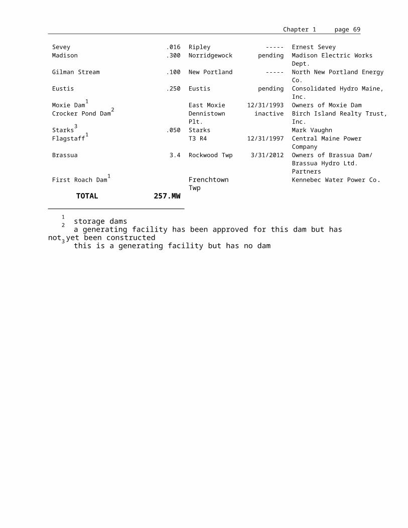
Chapter 1 page 70
deep. There are other finer characteristics which distinguish the striper, but the above description suffices to distinguish it from other Gulf of Maine fishes.
With respect to growth, striped bass are generally 4-6" long at the end of the first summer, 10-12" at age 2, 14-15" at 3, 18-20" at 4, 21-23" at 5, 24-27" at 6, and 43-47" at 14. Striped bass angled in Maine are comparable in size and weight for a given age to those of Chesapeake Bay.
The spawning habits of striped bass have been well documented and observed, both on the east and west coasts. Spawning seasons are generally governed by water temperatures with spawning known to occur at temperatures ranging from 50-75oF. Shannon and Smith54 have found that the optimum temperature for egg incubation and larval development is 65oF. Incubation time is dependent on water temperatures, with eggs hatching in 30 hours at 72oF and 74 hours at 58oF. Eggs subjected to temperatures exceeding 75oF result in such rapid development that a high proportion of malformed fry occurs.
The spawning areas range from head-of-tide in Chesapeake Bay to small tidal river systems 12 miles upstream to 80 miles above tidewater on the Roanoke River in North Carolina and 200 miles above tidewater on the St. John River in Canada. The location of spawning is probably an adaptation of certain stocks to the water temperatures at the time of spawning. Upriver spawners are probably early run fish while tidal river spawners would probably be late run spawners in order for egg incubation times to coincide with availability of freshwater flow. This would allow for adequate incubation time before the fry reach high salinity waters. Studies by Rathjen and Miller55 demonstrated that live striped bass eggs in the Hudson River were not found in areas of salinity in excess of 1:1,000. Therefore, upriver and near head-of-tide stocks of striped bass have to be very temperature sensitive in order to accommodate egg incubation time with extent of freshwater flow. The high egg production per female also compensates for the very restrictive requirements for egg incubation and fry development.
54 ? Preliminary Observations of the Effect of Temperature on Striped Bass Eggs and Sac Fry. Proc. Shannon & Smith, 21st Annual Conference Southeastern Association of Game and Fish Comm.: pp. 257-260, 1967.
55 ? Aspects of the Early Life History of the Striped Bass ( Roccus saxatilis ) in the Hudson River, New York . Rathjen & Miller, Fish & Game Journal 4(1): 43-60, 1955.

Chapter 1 page 71
During the spawning act, single females are surrounded by several to many males. Spawning usually occurs in slow to moderate currents and near the mid-channel of the river. Miller and McKechnie56 provide an accurate observation of striped bass spawning in California's Sacramento River. Females roll on the surface and as eggs are extruded males fertilize them. The newly fertilized eggs expand to about 1/8" in diameter and become semi-buoyant, requiring a current or water turbulence to remain suspended in the water column. Because of these requirements of fresh flowing water and minimum incubation time of 24-30 hours, it would appear that the best spawning areas would be large coastal rivers of moderate gradient, slow to moderate current, and stable flow during the egg incubation and larval development period. The large expanse of low salinity water in Chesapeake Bay and Albemarle Sound of North Carolina lend themselves as ideal spawning habitats for striped bass. The low range in tidal fluctuations in the middle Atlantic states lessen the possibilities of high salinity intrusions which could cause high mortality of eggs and larvae. With respect to Maine, striped bass populations would appear to be more restricted in spawning habitat because of high salinity gradients in the tidal portions of most Maine rivers. The exception to this situation is Merrymeeting Bay, where the restricted access of tidal intrusion at "The Chops" (a constriction at the seaward end of Merrymeeting Bay) and large volumes of freshwater discharge from the Kennebec and Androscoggin Rivers creates an extensive freshwater estuary.
Atlantic Salmon. The Atlantic salmon is an anadromous species, which means it reproduces in fresh water where the young grow to five to seven inches (usually in one to three years) before migrating to salt water. In the ocean the young salmon grow to a mature size of two to three feet (one to three years of ocean residence) before returning to fresh water to reproduce.
Adult Atlantic salmon ascend rivers in New England throughout the spring, summer, and fall with spawning occurring in late October through November. During spawning, the female salmon chooses a gravel area and excavates a pit called a redd into which eggs are deposited. More than one male will usually participate with a single female in spawning.
The adult fish after spawning are called kelts and may return to the sea immediately or, more typically, during the following spring. A small portion of the kelts will successfully make the journey back to salt water and return again as repeat spawners.
The salmon eggs deposited in the redd normally hatch in late March and April, followed several weeks later by the emergence of fry from the gravel. The fry rapidly assume the coloring of the life stage referred to as parr.
In New England rivers salmon parr remain in fresh water for a period of one to three years undergoing morphological and physiological changes (a process called smoltification) during the spring that prepares the young fish (now called smolts) for migration and the transition from a fresh water to a salt water habitat.
56 ? Miller & McKechnie, 1968.

Chapter 1 page 72
Once the smolts enter the ocean they will migrate to distant feeding grounds, frequently north of the Arctic Circle. The salmon will spend one or more years at sea before returning to their natural stream.
Fish that return after one winter at sea are called "grilse". The majority of the salmon will spend two winters at sea and are referred to as "large salmon" or "multi-year" fish.
Potential size and distribution of Atlantic salmon populations in New England rivers are determined largely by the quality, quantity and accessibility of the spawning and nursery habitats. Adult resting and holding areas, and environmental features impacting in-river migration can also be of major importance.
Good spawning habitat will contain sufficient gravel areas with substrate material of a size 0.5 to 4 inches in diameter;57 58 to permit movement of well-oxygenated water through the redd. Free movement of water through the substrate is critical since salmon eggs may be deposited as deep as 12 inches.59
Salmon nursery habitat is typically composed of shallow riffle areas interspersed with deeper riffle and pool reaches. Substrate material ranging from one-half inch to greater than nine inches in diameter affort adequate cover for the juvenile salmon.60
Juvenile salmon will exhibit little growth at water temperatures below 45oF61 and experience optimal growth in those streams having daily peaks of 72 to 77oF.62 Water temperatures that exceed 83oF can be harmful to the young salmon.63
Resting areas used by adult salmon are composed of pools that provide temporary refuge from the swift currents during the upstream spawning migration. These pools usually lack cover and can have a higher temperature regime than stream portions used as holding areas.
Holding areas are normally located close to the spawning grounds and consist of pools having the cover, depth, temperature, and water velocities preferred by adult salmon. The pools have a gravel substrate with large boulders, logs, or ledge outcroppings providing cover. Water depths 57 ? Physical Characteristics of Atlantic Salmon Spawning Gravel in some New Brunswick Streams, Fisheries and Marine Service Technical Report 785, 28 pp. Peterson, R.H., 1978.
58 ? Natural Spawning Success of Landlocked Salmon, ( Salmo salar ) , Trans. Am. Fish. Society, 92 (2): 161-164. Warner, K., 1963.
59 ? ibid.
60 ? Unpublished data, Mad River, NH FWS. Knight, A.E., Laconia, New Hampshire, 1981.
61 ? Estimated Escapement of Atlantic Salmon ( Salmo salar ) for Maximum Smolt Production in Rivers of Different Productivity, Canada J. Fish. Research Board, 35:175-183. Symons, P.E.K., 1979.
62 ? Atlantic Salmon Rivers, Smolt Production and Optimal Spawning: An Overview of Natural Production. IASF Special Publication 6, New England Atlantic Salmon Conference, pp.96-119. Elson, P.F., 1975.
63 ? Temperature Relations of Salmonids, Proc. 10th Meeting Nat. Committee on Fish Cult., App. D.F.R.B. Fry, F.E.J., Canada, 1947.

Chapter 1 page 73
exceeding six feet and water velocities under 1.6 feet per second are preferred.64 Optimum water temperatures in adult holding areas are 50 to 54oF, but temperatures of 60oF and daily fluctuations to 77oF are tolerated if the water cools to 68oF or less at night.65
Atlantic salmon streams in most of New England typically lack substantial buffering or acid neutralizing capacity. Consequently, these waters are sensitive to acid precipitation. Long distance atmospheric transport of air pollutants containing sulfur and nitrogen compounds is the primary cause of acid precipitation. The potential exists for such precipitation, either in the form of rain or melting snow, to lower the pH of a salmon stream to (or below) the critical level of 4.7 where successful reproduction is jeopardized.
The life stage of salmon most sensitive to low pH is the egg-to-fry stage. Values of less than pH 5.5 may result in egg mortality, while pathological changes have been noted during incubation at pH 5.0 or less.66 Several Nova Scotia streams that contained viable salmon fisheries during the 1950's now have pH levels less than 4.7 and are too acid to support Atlantic salmon reproduction.67 The potential for such problems in New England streams is greatest in smaller tributaries in central Maine and least in large mainstem areas and in basins with significant buffering capacity such as the Connecticut and Aroostook.
Various chemical and physical factors can have a significant impact on the migratory behavior of salmon. Salmon are sensitive to temperature, flows, pH, dissolved gas concentrations and concentrations of various pollutants such as dissolved heavy metals.
Salmon smolts receive migrational timing cues from photoperiod, temperature, and stream flow. Water temperatures greater than 50oF may retard downstream movement.68
The upstream movement of adult salmon can be stimulated by a rising water temperature accompanied by an increasing flow as occurs with a spring freshet. Water temperatures greater than 73oF and dissolved oxygen concentrations less than 5 (ppm) can, however, retard or entirely halt migration.69 Small amounts of zinc or copper in the water can impact the movement of adult salmon by initiating avoidance reactions.
Historical Fisheries
64 ? The Creation of Artificial Salmon Pools. Frenette, M., C. Rae, and B. Tetreault, Department of Civil Engineering, Laval University, Quebec, pp.17-24, 1972.
65 ? Atlantic Salmon Rivers, Smolt Production and Optimal Spawning: An Overview of Natural Production. IASF Special Publication 6, New England Atlantic Salmon Conference, pp.96-119. Elson, P.F., 1975.
66 ? Reproduction in Fish Experiencing Acid and Metal Stress in: Acid Rain/Fisheries, 177-196. Peterson, R.H., P.G. Days, G.L. Lacrois, and E.T. Garside, American Fishery Society, Bethesda, Maryland, 1982.
67 ? Evidence of Acidification of some Nova Scotian Rivers and its Impact on Atlantic Salmon ( Salmo salar ) , Canada J. Fish and Aquatic Sciences, 40(4):462-473. Watt, W.D., C.D. Scott, and W.J. White, 1983.
68 ? Water Quality Requirements for Atlantic Salmon. DeCola, J.N., USDI Federal Water Quality Administration, N.E. Region, Massachusetts, 42 pp., 1970.
69 ? Water Quality Requirements for Atlantic Salmon. DeCola, J.N., USDI Federal Water Quality Administration, N.E. Region, Massachusetts, 42 pp., 1970.

Chapter 1 page 74
Alewife. Historically, alewives ascended the Kennebec River in immense numbers as far as Norridgewock Falls, 89 miles from the sea on the main stem.70 They ascended the Sandy River as far as Farmington and bred in Temple Pond until a dam was built at New Sharon in 1804.71
Alewives ascended the Sebasticook River at least as far as Stetson Pond in Stetson on the East Branch and Great Moose Pond in Hartland on the West Branch.72 It is probable that alewives ascended as far as Wassokeag Lake in Dexter on the East Branch, as Atkins73 stated that, "nearly every mile" of the 48 square miles of lake surface was accessible to alewives.
Seven Mile Stream was considered one of the "principal breeding places" for alewives in the Kennebec River.74 It is probable that alewives historically had access to at least Webber Pond and Three Mile Pond. Seven Mile Brook continued to support an alewife run until 1837, when the Augusta Dam finally cut them off.
The Cobbosseecontee Stream drainage was also a "principal breeding place" for alewives. Atkins75 gave the following account: "The first of these (Cobbosseecontee Stream) afforded an extensive breeding ground in its 21 square miles of lakes and ponds, but it was early closed. In 1787 we find the Town of Wales (then including Monmouth) appointing a fish committee, which the next year was designated a `committee to see that the fishways are kept open according to law.' The dams at Gardiner, however, were impassable, fishways were not maintained, and very early in the present century this brook of alewives were extinguished."
Atkins76 further stated, "Winthrop for several years appointed a committee to obtain the opening of a fishway through the dam at Gardiner. But they were unsuccessful; reporting on one occasion that Squire Gardiner refused to do anything about it. The stream is now obstructed by dams at Gardiner to such an extent as to render the opening of the upper waters to fish a considerable undertaking. There are eight dams within one mile of the Kennebec, and they are generally high. There are ten dams to the first lake, and most of the others are cut off by them."
Nehumkeag Stream and Worromontogus Stream, which enter the Kennebec River in Pittston below Augusta, were also rendered impassable at an early date.77
70 ? Reports of the Commissioners of Fisheries of the State of Maine for the Years 1867 and 1868. Atkins, C.G. and N.W. Foster, 1869.
71 ? ibid.
72 ? ibid.
73 ? The River Fisheries of Maine - Quoted in: Goode, G.B., 1887. Atkins, C.G., The Fisheries and Fishing Industries of the United States, Section V, Vol. 1, 1887.
74 ? ibid.
75 ? The River Fisheries of Maine - Quoted in: Goode, G.B., 1887. Atkins, C.G., The Fisheries and Fishing Industries of the United States, Section V, Vol. 1, 1887.
76 ? Reports of the Commissioners of Fisheries of the State of Maine for the Years 1867 and 1868. Atkins, C.G. and N.W. Foster, 1869.

Chapter 1 page 75
One can get some indication of the historical value and magnitude of the alewife runs on the Kennebec River system from the early Reports of the Commissioners of Fisheries of the State of Maine. The most important of the alewife fisheries occurred on the Sebasticook River and Atkins gave the following account:
"The most fish were taken in the Town of Clinton, now Benton, and the town was vested with the right to take the fish by their agents, a fish committee, subject to certain conditions. They were to distribute a certain number gratis to the poor, and then sell to the inhabitants at a set price, and finally could dispose of the residue as they saw fit. Great quantities were sold to strangers, the ordinary price being 25¢ a hundred. Newport also had full control over the fisheries in that town. There were free fisheries on all other parts of the river and its tributaries. Indeed, the fisheries were all free until a falling off in the supply warned the people that there must be some regulations. On this point we have the testimony of Mr. Beriah Brown of Benton, now 78 years old. Seventy years ago he followed the man who took the fish. Also of Maj. Japeth Winn, who has lived at Benton fifty-five years. The tributaries of the Sebasticook were very early obstructed by dams through which, in most cases, efficient fishways were left -- generally a mere gap, or a pile of stones; and the number of fish had been falling off for many years before the Town of Clinton assumed control of its fisheries. The dam at the upper falls at Clinton was built before the war of 1775, but a gap for fish was left in it. About 1809 a dam was built at the lower falls twelve feet high with no fishway. It stood five or six years, and in that time had so impoverished the fisheries that the selectmen cut it away, and allowed the fish to ascend to their breeding grounds. The town in 1814 obtained the act authorizing them to control the fisheries, and the first year after cutting away this dam the fishery was leased for two or three years to one James Ford, he agreeing to pay yearly 200 fish to each man, woman, and child in Clinton, and to sell as many more as should be wanted at a set price. From this time the fish increased again rapidly and the town began to sell the fishery yearly at auction. The price obtained varied from $500 to $1,200 or $1,500; the purchaser being bound to distribute gratis to the poor, and sell to all townsmen at a fixed price. The year of the closing of the Augusta Dam the fishing sold for $225. One or two years before for $500.
Mr. John Holbrook, 65 years of age, has lived in Newport all his days. Within his memory alewives came here in great numbers, with a few shad and now and then a salmon. Forty-five years ago they were not so plenty as formerly. Thirty years ago they began to diminish rapidly, and in a few years were entirely gone.
The obstructions on the Sebasticook now existing are six dams, situated as follows:
From Kennebec, miles.
34 Newport pond, outlet34 Newport Mills, built before 183729 Detroit, 7 feet; built about forty years ago10 Clinton, 5 feet 5 Benton - upper falls, 8 feet; built before 1775 4 Benton - lower falls, 5 feet; old dam 1809; new 1847
The dam at Benton lower falls has a sluiceway twenty feet wide and three feet deep, near its west end, which was not closed during the last season until the 20th of June. With a suitable
77 ? The River Fisheries of Maine - Quoted in: Goode, G.B., 1887. Atkins, C.G., The Fisheries and Fishing Industries of the United States, Section V, Vol. 1, 1887.
Chapter 1 page 76
arrangement of the plank this might answer for the passage of fish. Over the upper dam a way might easily be constructed at the east end by bolting down some timbers and blasting a short passage out of the ledge.
At Clinton and Detroit the task would be easy, but they must be guarded against ice. At Newport the mill-dam would require a fishway, but presents no difficulty. The dam at the outlet hardly hinders the passage of fish. The river was not examined above this point, although the alewives used to run as far as Stetson Pond.
Of the branches we examined, the Pittsfield branch as far as Moose Lake or Pond, the Twenty-five Mile Stream, - and have gathered some information about others. The west branch from Moose Lake has three dams, one at Pittsfield and two at Hartland, neither of which presents any difficulty in constructing fishways; all three would require them. At Hartland there has been a dam for 67 years, but as long as the alewives came there was a hole left for them to pass into Moose Lake. Into the latter runs Main Stream, crossed by several dams which were not examined.
The Twenty-five Mile Stream is the outlet of Unity Lake. Near its mouth, in the Town of Burnham, is a dam built 35 years ago, 12 feet high. Seven miles up the stream is another dam, and beyond that Unity Lake. Tributary to Twenty-five Mile Stream is Sandy Stream of rapid flow, obstructed by two dams.
The streams draining Lovejoy's and Pattee's Ponds are obstructed each by one dam. The latter has a dam which has stood without a fishway for 60 years. The stream draining Plymouth Pond has four dams. The Vassalboro Stream is much obstructed, but was not examined.
Chapter 1 page 77
All the lakes and ponds of Sebasticook River are admirably adapted to the breeding of alewives. The restoration of these fish would be a comparatively easy matter. Plenty of live fish or their spawn can be obtained at Augusta or below. The construction of ten fishways would give them access to the three largest lakes with a surface of 10,000 or 12,000 acres. If undertaken on the right scale and perseveringly carried forward great return might be expected in a few years. Abijah Crosby, of Benton, was an enthusiast on this subject who might have accomplished much had he been supported by the public opinion. He went so far as to introduce live alewives to Pattee's Pond, Unity and Newport Lakes; they bred there, the young fish were seen going down the stream, and some of them caught; fishways were built over several of the dams on the Sebasticook, and had that built at Augusta proved a success, the alewives would now have been again established in the Sebasticook River."
The Commissioners estimated the yearly catch of alewives in Clinton to be 3,000 barrels.78 There were approximately 400 alewives in a barrel79 which translates into an annual catch of 1,200,000 alewives at the Town of Clinton alone. Alewives produced in the Sebasticook River were subject to fisheries from the mouth of the Kennebec River to Winslow in addition to fisheries which occurred in the river itself.
Seven Mile Brook was also considered an important tributary for the production of alewives. The Commissioners of Fisheries in their First Report (1867) gave the following account:
"The Seven Mile Brook is a very important stream, although in size only third rate. It drains several ponds, and these formerly produced great quantities of alewives. The fishery has been regulated by six different acts. There are several dams on the stream which would require fishways should the alewives be restored."
There is mention of the alewife fishery in Seven Mile Stream as early as 1777 in the Town Records and by 1780 the town was auctioning the run to the highest bidder.80 In 1818, the "Fish Privilege" was at a premium and the following sums of money were paid to the town for the privilege: "Elisha Barrows paid $291 for one privilege, John Homans paid $56 for the one near Snells Mills and Samuel Folson paid $52 for the one near Homans' Mills".81 Based on the fact that the harvest at Clinton on the Sebasticook River was estimated to average 3,000 barrels annually and the privilege usually went for $500 to $1,500, it may be estimated that the fishery may have harvested 320,000 to 900,000 alewives annually on Seven Mile Stream.
The Sandy River was not considered a principal alewife tributary because of its lack of ponded habitat and dead water areas. Atkins and Foster82 gave the following account of anadromous fisheries of the Sandy River: "Although it has a great many miles of spawning
78 ? Reports of the Commissioners of Fisheries of the State of Maine for the Years 1867 and 1868. Atkins, C.G. and N.W. Foster, 1869.
79 ? Third Report of the Commissioners of Fisheries of the State of Maine for 1869. Atkins, C.G., 1870.
80 ? The History of Vassalborough, Maine, 1771-1971. Robbins, A.P., Maine State Library, 1971.
81 ? ibid.
82 ? Reports of the Commissioners of Fisheries of the State of Maine for the Years 1867 and 1868. Atkins, C.G. and N.W. Foster, 1869.

Chapter 1 page 78
ground for salmon, and but a limited extent suitable for shad or alewife. Both the latter, however, came into the river and ascended as far as Farmington. The lower part of the river maintained an excellent shad fishery.
But in 1804 the New Sharon Dam was built. This stopped shad and alewives but a fishway is said to have been maintained for a few years which permitted salmon to pass. A few years later another dam was thrown across the river nearer its mouth, and the fishways were no longer maintained."
Shad. The shad was a major species fished for in the Kennebec River, especially subsequent to the construction of the Augusta Dam in 1837. This dam prevented salmon from reaching the majority of its spawning habitat but, although the shad resource may have been reduced by 50%, there still remained over 20 miles of tidal freshwater from Merrymeeting Bay to Augusta.
Although the landings prior to 1887 are only estimates, Atkins reported that the average annual landings for shad in Bowdoinham, Dresden, and Woolwich were 120,000 fish for the years 1830-36. This same district was reported to have landed 180,000 shad in 1867 and the catch for the entire Kennebec River was estimated at 225,000 shad.83
In 1880, Atkins indicated that 108,000 shad were taken in the Merrymeeting Bay district.84 In addition, 5,800 were taken above Richmond; 16,744 between Merrymeeting Bay and Bath; and 10,000 below Bath for a total catch of 140,000 shad in the Kennebec River system.
Although the landings do not reflect the loss of spawning and nursery habitat above Augusta due to the construction of the Augusta Dam, Atkins attributed this fact to the "use of a great number of far more efficient implements." A reduction of approximately 50% is indicated by the records of one weir in Merrymeeting Bay which averaged 5,961 shad yearly from 1826 through 1835, but caught only an average of 3,120 shad yearly from 1837-48 (no record for 1844).85
83 ? ibid.
84 ? The River Fisheries of Maine - Quoted in: Goode, G.B., 1887. Atkins, C.G., The Fisheries and Fishing Industries of the United States, Section V, Vol. 1, 1887.
85 ? Reports of the Commissioners of Fisheries of the State of Maine for the Years 1867 and 1868. Atkins, C.G. and N.W. Foster, 1869.

Chapter 1 page 79
Shad historically ascended the Kennebec River as far as Norridgewock Falls (89 miles from the sea), the Sandy River a few miles from its mouth, and the Sebasticook River in small numbers to Newport.86 Atkins indicated that shad ascended the Sandy River as far as Farmington.87 Atkins mentioned several upriver sites where shad fisheries were conducted.
Following is a description by Atkins of the shad fishery at Ticonic Falls (Waterville):
"At Ticonic Falls there is an island in mid-stream, where great facilities existed for catching shad with dip-nets. This island was private property. The proprietor, from 1804 down to the extinction of the fishery, has stated that in the early days of his fishing he used to take $600 worth of shad yearly. As remarkable feats he mentioned that with the assistance of his three boys he had taken 1,000 shad and 20 salmon in an afternoon and that one day four men dipped out and boated ashore 6,400 large shad. There was a similar but less productive dip-net fishery on the falls at Skowhegan."
A shad fishery was also conducted on the lower Sandy River. Although shad are reported as originally migrating to Farmington, their path was obstructed at New Sharon.88 A few years later a dam was constructed nearer the mouth. Thus, some habitat loss occurred prior to the construction of the Augusta Dam. Also a dam was built at Kendalls Mills in 1834 and one at Somerset Mills in 1836 on the main stem of the Kennebec River just above Waterville.89 Although salmon could pass these dams at high water, there is no indication given whether alewives or shad did.
From 1896 through 1906, shad landings ranged from 322,800 to 1,028,600 pounds for an average annual yield of 802,514 pounds. If an average weight of 3 pounds per fish is assigned, it would indicate a catch of 267,500 shad. Subsequent to 1900, the landings declined and after 1919, the shad fishery suffered a complete collapse. Taylor attributed the collapse to industrial pollution.90
Smelt. The sea-run smelt, the smallest of the sea-run fish species, has played an important role in the river fisheries of the Kennebec River. It provided seasonal employment in the winter when jobs were scarce and today provides for a large recreational fishery.
The fishery for smelt was pursued on a small scale as early as 1814 on the Kennebec River by hook and line and small gill nets.91 Before 1850, smelt were mostly consumed locally and sold
86 ? The River Fisheries of Maine - Quoted in: Goode, G.B., 1887. Atkins, C.G., The Fisheries and Fishing Industries of the United States, Section V, Vol. 1, 1887.
87 ? Reports of the Commissioners of Fisheries of the State of Maine for the Years 1867 and 1868. Atkins, C.G. and N.W. Foster, 1869.
88 ? ibid.
89 ? ibid.
90 ? A Survey of Former Shad Streams in Maine. Taylor, C.E., USFWS Special Scientific Report, Fisheries No. 66, 1951.
91 ? The River Fisheries of Maine - Quoted in: Goode, G.B., 1887. Atkins, C.G., The Fisheries and Fishing Industries of the United States, Section V, Vol. 1, 1887.

Chapter 1 page 80
through local markets. Bag nets were introduced in 1852 and allowed for greater efficiency in harvesting and allowed expanded markets. After 1850, a great quantity of smelt were marketed in Boston and New York City. Bag nets were fished mainly between Bath and Richmond, with 114 bag nets employed in the winter of 1879-80. Bag nets accounted for approximately 1/3 of the catch. Below Bath, half-tide weirs were utilized. There was also a large hook and line fishery which developed in the Sasanoa River around 1878. Hook and line fisheries were also pursued in the tributaries of Merrymeeting Bay, especially in the Eastern River. Two of the earliest hook and line fisheries were at Hallowell and Gardiner, which were stated to be very productive around 1850.92 The hook and line fisheries in Hallowell and Gardiner had fallen off to quite an extent by 1880, which some attributed to the introduction of bag nets.
Smelt assumed a dominant role in our river fisheries in the late 1800s. The landed value of smelt in the late 1800s was two to three times the landed value of salmon, shad, or alewives. Smelt and shad were the two dominant sea-run fish species in the Kennebec River from the late 1800s through the early 1900s.
The smelt resource was less affected by dam construction or pollution than the other sea-run fish species, with possibly the exception of the shortnose sturgeon. Historically, it is probable that smelt ascended the Kennebec River only as far as Waterville to Ticonic Falls. While a significant but unknown amount of habitat was eliminated by the construction of the Augusta dam, a significant amount of habitat remained below the dam. This was also true for shad, but increasing pollution in the 1900s had a greater impact on shad than smelt as shad spawned later and were more dependent on the river for juvenile nursery habitat.
Smelt spawn generally during the spring high water run-off and the larvae quickly leave the upper tidal section shortly after hatching. Thus, they are not as subject to adverse conditions experienced in the river system during the summer months.
Although the smelt resource was not as adversely affected by dam construction and pollution as the other sea-run fish species, the landings decreased sharply in the late 1940s. The bag net fisheries ceased around the early 1930s.
The hook and line fisheries in Hallowell and Gardiner also disappeared.
The impact of the severe pollution experienced in the 1940s, '50s, '60s, and early '70s on the smelt resource itself is not known, but the severity of the pollution certainly impacted the use of the resource.
92 ? ibid.

Chapter 1 page 81
Sturgeon. The first known fishery for sturgeon was at Pejepscot Falls in 1628. Thomas Purchase supposedly fished for salmon and sturgeon from time to time on quite a large scale until the commencement of King Philip's War in 1675. The only indication of the extent of the fishery was that Thomas Purchase caught about 90 kegs and 90 barrels of sturgeon in a three-week period.93
The fishery for sturgeon in the eighteenth and nineteenth centuries is described by Atkins as follows:94
"In the early part of the eighteenth century there existed a flourishing sturgeon fishery in the Province of Maine, which employed some years over twenty vessels and was an esteemed and important branch of industry. It does not appear, however, to have been prosecuted continuously. Very early in the present century a company of men came to the Kennebec and locating themselves on a small island near the outlet of Merrymeeting Bay, since known as "Sturgeon Island," engaged in the catching of sturgeon, which they soused, packed in kegs, and shipped to the West Indies where they sold at $1.00 a keg. This business was, however, suspended -- for what reason unknown -- and though sturgeon were very abundant in the Kennebec during the early part of the present century, at least until about 1840, no attempt was made to utilize them except occasionally for home use, until 1849.
In 1849, a Mr. N.K. Lombard, representing a Boston firm, came down to the Kennebec, established himself at "Burnt Jacket" in the Town of Woolwich (between Bath and Merrymeeting Bay) and undertook to put up the roe of sturgeon for caviar, and at the same time boil down the bodies for oil. A large number of fishermen engaged in the capture of sturgeon to sell to Lombard. The price paid was 25-50 cents apiece. The first year there were obtained 160 tons of sturgeon. They yielded oil of fine quality, superior to sperm oil for illuminating purposes in the opinion of the inhabitants of that vicinity who have been accustomed to use it when attainable. The attempt to utilize the roe was at first unsuccessful. It was put into hogsheads. Very lightly salted, and all spoiled. The next two years the roe was cured by salting heavier, drying, and laying it down with a little sturgeon oil, and was pronounced satisfactory. However, the business was discontinued after 1851. That year the sturgeon was quite scarce.
From this time there was a suspension of the sturgeon fishery until 1872, when some of the local fishermen of the Kennebec took it up again. In 1874 a crew of fishermen, headed by one John Mier of New York, went into the business catching and buying all they could and shipping them to New York where they supposed to smoke the flesh and utilize the roe for caviar and the sound for glue. They aimed to catch the sturgeon early in the season, while the roe was black and hard, and to keep the fish alive until the proper time for opening them. For the latter purpose, they constructed a great pen, in which they at one time had 700 live sturgeon. After five years, the sturgeon again became scarce and the business was relinquished to local fishermen who still continue to ship the flesh to New York but throw away all other parts. In 1880, the least successful season in recent times, 12 fishermen were engaged in the business on the Kennebec and the total catch was about 250 sturgeon, producing about 12,500 pounds of flesh which sold in New York at 7 cents per pound."
93 ? History of Brunswick, Topsham, and Harpswell, Maine. Wheeler, G.A. and H.W. Wheeler, Alfred Mudge & Son Printers, Boston, Massachusetts, 1878.
94 ? The River Fisheries of Maine - Quoted in: Goode, G.B., 1887. Atkins, C.G., The Fisheries and Fishing Industries of the United States, Section V, Vol. 1, 1887.

Chapter 1 page 82
Since the 1880s, the sturgeon fishery has been almost nonexistent. Most of the recorded landings have been incidental catches. The most common gear in which they are caught incidentally are anchored gill nets and otter trawls.
Striped Bass. The striped bass played a vital role in the development of colonial America, and along with the codfish, were probably the first natural resources of America brought under conservation legislation. The General Court of Massachusetts Bay Colony in 1639 forbade the use of either fish as fertilizer for farm crops. The first public (free) school in the New World was partially supported from monies derived from the sale of striped bass. A portion of the monies was also expended in helping widows and orphans of men engaged in service to the Colony.
Atkins, Commissioner of Fisheries (1887), in referring to Maine's striped bass resource, recounted: Bass were undoubtedly quite plenty in early times in most of the rivers west of the Penobscot. In reference to the Penobscot, old fishermen speak of having "plenty" but the degree of abundance was by no means equal to that existing in the Kennebec, and at no time has this species been marketed in any considerable numbers from the Penobscot or any river further east. On the Kennebec at Abagadasset Point, as late as 1830, bass were so plentiful that the fishermen had trouble disposing of those taken in the weirs. A single weir has been known to take 1,000 pounds at one tide. There was no demand for them and sometimes hired men would take them in pay.
A local fisherman recalled that about the time of their first decline in population he obtained a contract with General Millary, the keeper of the Bowdoinham town poor, to furnish 1,600 pounds of bass at 3/4 of a cent per pound, but the fish were not plentiful that year and he caught only 800 pounds. The extent of the decline is illustrated by comparing the above statement with the statistics representing the present condition of the bass fishery. The total catch of 22 weirs on and about Abagadasset Point in 1880 was only 3,510 pounds; the Kennebec River yielded a total of 12,760 pounds; and the entire State, 26,760 pounds."
In view of Atkins' observation, it is readily apparent that the historical striped bass resource of Maine supported a viable fishery. Unfortunately, before the striped bass became of any great demand, the resource was already on a downward trend, never to return to its former abundance as a resident species. It is also apparent that the largest resident population occurred in the Kennebec River, although the Penobscot, Androscoggin, and St. Croix were also known to have supported limited populations. The beginning of the end of large resident populations occurred around 1830 when a dam was constructed on the Penobscot River at Old Town. Unlike salmon, alewives, or shad, striped bass would not utilize fishways and the construction of dams completely eliminated those fish from upriver spawning grounds which were essential to their existence. The greatest blow to the Maine striped bass resource was the construction of the dam on the Kennebec River at Augusta in 1837. Limited reproduction continued in Merrymeeting Bay and the lower Kennebec to sustain a limited fishery in the lower river during the late nineteenth century. The last commercial fishery probably supported by resident striped bass ceased to operate shortly after World War I. This was a winter fishery on the Sheepscot and Dyer Rivers by fixed gill net. This high salinity estuary was probably an overwintering area for some of the last resident stocks of Merrymeeting Bay. The striped bass of Merrymeeting Bay faded away with the shad fishery which disappeared in the late 1930s as a result of increased pollution from the Androscoggin and Kennebec rivers.

Chapter 1 page 83
Atkins95 further describes the habits of and fisheries for the striped bass in Maine: "Bass are found in almost all brackish water of the State and ascend rivers a short distance at the various seasons of the year. On the Kennebec, it used to ascend the main river as far as Waterville; and the Sebasticook, a short distance above its mouth; but since the building of the dam at Augusta in 1837, its migration has been limited to that area. The principal run is in the month of June, at which time it feeds greedily, apparently ascending the rivers for that purpose. It continues to feed in weedy coves and bays until November. In the winter, great numbers of young, two or three inches long, are found in the rivers, and many of them fall into the bag nets and are captured along with smelts and tomcods. Larger individuals appear in many cases to retreat to quiet bays and coves of freshwater in the lower parts of the rivers, and pass the winter in a state of semi-hibernation."
Bass were taken by four methods: dip nets set under the ice, stop nets set in summer and autumn across the mouths of coves, gill nets, and by hook and line. Probably the stop net fishery was most efficient in catching large numbers of fish with one account telling of 11,000 pounds being taken close to Bath.
The abundance of striped bass is also mentioned in the early reports of the Commissioners of Fisheries of the State of Maine in 1867 and that the Kennebec River and particularly Merrymeeting Bay and the Eastern River were major concentration areas for bass.
Present Fisheries
Alewife. Since the early 1970s, water quality has improved dramatically and the tidal waters of the Kennebec River should support an alewife population similar to that found in the system after 1837. The tidal section of the Kennebec River is freshwater from the outlet of Merrymeeting Bay to Augusta, a distance of 20 miles, making it the only Maine river which will support significant shad and river herring runs below head-of-tide. This section of the river is excellent shad spawning and nursery habitat; it is marginal alewife habitat, but because of the large amount of accessible riverine area, the total production of alewives would easily approach two million fish, making it one of the largest runs in the State. While it is difficult to estimate the current population size, recent juvenile seine surveys show that the alewife is currently the most abundant of the three alosids (shad, alewife, and blueback herring).
95 ? The River Fisheries of Maine - Quoted in: Goode, G.B., 1887. Atkins, C.G., The Fisheries and Fishing Industries of the United States, Section V, Vol. 1, 1887.
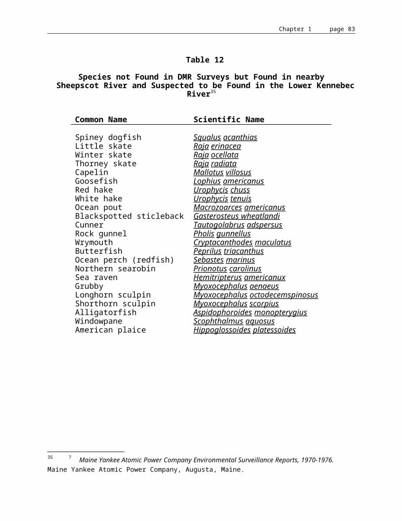
Chapter 1 page 84
American Shad. The water quality in the Kennebec River has improved dramatically since the era of gross pollution (the 1930s through the early 1970s). Since 1976, the Kennebec River has had adequate dissolved oxygen levels to support shad and other anadromous fish species in the lower river. DMR has been monitoring the shad resource in the Kennebec River. Experimental drift gill nets have been used to obtain an index of abundance for spawning adult shad and experimental seines are being used to obtain an index of abundance for juvenile shad. The present surveys indicate there is limited reproduction below the Augusta Dam and major areas of shad reproduction in the tributaries of Merrymeeting Bay, the Eastern, Cathance, and Abagadasset Rivers. Thus, the shad resource at the present time below Augusta is in a state of dynamic change. Because shad have a five-year life cycle and the stocks are reduced to extremely low levels, it is difficult to predict the rate of expansion. Based on experiences in other rivers, it is likely that significant recovery will occur within 2-4 life cycles. A very limited recreational fishery has developed below the Augusta Dam with approximately 30-50 adults being taken annually.
Rainbow Smelt. The lower Kennebec River provides the largest winter recreational smelt fishery in the State of Maine. Colonies of smelt camps have been reestablished in the Hallowell and Gardiner areas as a result of the dramatic improvement in water quality. In 1985 there were over 700 smelt camps on the tidal waters of the Kennebec River system, including the tributaries to Merrymeeting Bay.
DMR conducted intensive creel surveys of the Kennebec River winter smelt fishery from 1974-1982. The estimated annual catches were variable, ranging from 20,000-96,000 pounds. Some of the fish harvested by hand line fishermen are sold through local markets. There are presently no other commercial fisheries for smelt on the Kennebec River.
This fishery provides for 14,000-29,000 man days of fishing per year. Approximately 12% of the fishermen are nonresidents. Based on an economic survey conducted in 1982, it is estimated that the fishery at 1985 costs would have a value of approximately $500,000 based on direct expenditures.
Sturgeon. No current research or management activities are being conducted in the Kennebec River on these species. Shortnose sturgeon are on the Federal Endangered Species List and are thus afforded full protection. Based on research accomplished under AFC-19 and AFC-20, it was decided that the Atlantic sturgeon stock in the Kennebec River was at a critically low level and the river was closed to the taking of Atlantic sturgeon. In addition, a six-foot minimum length was implemented statewide. In May 1992, a statewide moratorium on the taking of both Atlantic Sturgeon and Shortnose Sturgeon was implemented.
Striped Bass. From the early 1930s through 1986, there was no evidence of striped bass spawning in the Kennebec River and those fish available to the sport fishery in later years were believed to be migrants from Chesapeake Bay and the Hudson River, with Chesapeake Bay being the major contributor.

Chapter 1 page 85
Historically, this estuary supported the largest population of resident Maine striped bass, as evidenced by accounts of many small stripers taken in the winter smelt fishery and of the commercial winter fishery for large striped bass. Even after the construction of dams at head-of-tide on the Kennebec and Androscoggin Rivers, which prevented migration of fish to upstream spawning areas, spawning populations of striped bass survived in the Merrymeeting Bay area and supported a limited commercial fishery until the post-World War I era. Industrial pollution from the Androscoggin and Kennebec Rivers completely eliminated the remaining population, probably about the same time as the shad disappeared from the Bay in the early 1930s. In recent years the water quality has improved to the point that it is believed possible that a resident population can be re-established in this area. In 1982, a juvenile striped bass stocking and tagging program was initiated to reestablish a self-sustaining native population of striped bass to the Kennebec/Androscoggin complex. In September of 1982, DMR captured 319 juvenile striped bass (fall fingerlings) in the Hudson River and transferred them to the Androscoggin River; in October 1983, a total of 572 fall fingerling striped bass were transported from the Hudson River to the Kennebec River estuary. In 1984, striped bass fry were obtained from Multi-Aquaculture System, Inc. of Amagansett, New York, and raised to fall fingerlings by the USFWS at its North Attleboro National Fish Hatchery. The fry were purchased with private funds by a non-profit organization known as the "Committee to Restore Resident Stripers to the Kennebec River in Maine," and in September, 2,306 fingerling striped bass were released into the Kennebec at Richmond. In 1985 and 1986, striped bass fry were obtained from Ecological Analysts' Verplanck Striped Bass Hatchery. These fry, of Hudson River origin, were raised to fall fingerling size by the USFWS at its North Attleboro National Fish Hatchery. In 1985, 46,769 striped bass fingerlings were stocked and in 1986, 30,246. No striped bass were available in 1987, but 1987 marks the first year in over 50 years that natural production occurred in the Kennebec River, as evidenced by the capture of 26 young-of-the-year striped bass. From 1988-92, an additional 183,333 striped bass juveniles were stocked in the Kennebec/Androscoggin estuarial complex. Wild young-of-the-year striped bass have been caught annually since 1987 with numbers ranging from 1 to 26.96
Habitat Assessment & Population Projections
General. No habitat assessments based on substrate types in the subtidal zone in the estuary of the Kennebec River have been completed. Habitat types for the intertidal zone were mapped at a minimum resolution of 3-5 acres by the USFWS.97 Although the intertidal zone acts as a nursery area for various fish species, such as juvenile shad and alewives, it was not considered in estimating potential population sizes. The total amount of area for the intertidal zone of Merrymeeting Bay was estimated by IF&W to be 17,680,520 yds2. The total estimated area for the intertidal zone for the entire Kennebec/Sheepscot Rivers estuarial complex was estimated to be 71,186,720 yds2.98 The total amount of area for the subtidal zone for the Kennebec/Sheepscot Rivers estuarial complex was estimated to be 90,561,240 yds2.99
96 ? Anadromous Fisheries in the Kennebec River Estuary. Squiers, T.S., Maine Department of Marine Resources, 1988.
97 ? An Ecological Characterization of Coastal Maine. Fefer, S.I. and P.A. Schettig, FWS/OBS-80/29, Biological Services Program, U.S. Fish and Wildlife Service, 1980.
98 ? An Ecological Characterization of Coastal Maine. Fefer, S.I. and P.A. Schettig, FWS/OBS-80/29, Biological Services Program, U.S. Fish and Wildlife Service, 1980.

Chapter 1 page 86
Estimates of shad and alewife population sizes were based on the amount of subtidal freshwater habitat in the Kennebec River estuary. The surface area for the subtidal zone of Merrymeeting Bay and its tributaries was obtained from an aerial survey of Merrymeeting Bay by IF&W.100 The total estimated surface area for this section of the river was estimated to be 28,280,120 yds2.101 The surface area of the subtidal zone of the main stem of the Kennebec River from the Richmond Bridge to the Augusta Dam was determined by multiplying the length by the average width, as determined from a navigational chart. The total estimated surface area for the subtidal zone of the Kennebec River from the Richmond Bridge to the Augusta Dam was estimated to be 11,185,240 yds2. Thus, the total estimated surface area of the freshwater subtidal zone was estimated to be 39,465,360 yds2 (Table 14). Fefer and Schettig estimated there were only 27,500,800 yds2 of riverine subtidal area in the Kennebec/Sheepscot Rivers estuarial complex. A small section of Merrymeeting Bay was classified as estuarine subtidal by Fefer and Schettig, but would not account for the large discrepancy. It may be possible that the main stem of the Kennebec River, upriver of the Richmond Bridge, was not accounted for in the Fefer and Schettig survey.
Salmon. The Kennebec River currently has a small population of Atlantic salmon below the Augusta dam, composed of hatchery strays from other rivers, as well as wild fish originating from tributaries below Augusta. The salmon runs in the Kennebec below Augusta are of uncertain magnitude, but are believed to number less than 200 adults in most years. Those salmon present in the Kennebec support a significant fishery located below the Augusta dam. In 1990, the Kennebec River had the second largest rod catch of Atlantic salmon of any river in the State of Maine.
Alewife. Alewives mainly utilize lakes and ponds as spawning and nursery habitat, although deadwater areas of rivers are utilized as well as tidal freshwater habitat. The size of the alewife run as evidenced by the commercial yield is dependent on the amount of accessible habitat. An average yield per surface acre of ponded habitat for six (6) Maine watersheds ranged from 46-694 pounds/surface acre (Table 15). The yield/acre is influenced by many factors in addition to the quantitative amount of habitat available, such as the productivity of the lake system, the accessibility of the system to adults, the amount of nursery habitat in the estuarial system, factors associated with the mortality of downstream migrating juveniles, such as turbine mortalities, etc.
99 ? ibid.
100 ? Maine Department of Inland Fisheries & Wildlife, 1981. Aerial photos of Merrymeeting Bay, Wetland Estimates, Wildlife Division, (Mimeo).
101 ? ibid.

Chapter 1 page 87
To obtain rough estimates of the potential production of alewives in the Kennebec River system, a commercial yield of 100 pounds per surface acre of ponded habitat was assumed. This is well within the range of yields experienced in other watersheds. The 100 pounds/surface acre represents the commercial yield and not the total run. It is assumed that the commercial catch represents an 85% exploitation rate. The theoretical basis for this is that most alewife runs are subjected to six (6) days of fishing per week. Estimates for adult escapement on the Damariscotta River reveal an exploitation rate ranging from 85-97% for the years 1979-1982.102 Assuming a weight of .5 pounds per adult, the assumed commercial yield would be 200 adults/surface acre and when combined with a 15% escapement rate, would result in a total production of 235 adults/acre. This factor was used to determine the alewife potential for the Kennebec River. The total estimated alewife potential in the Kennebec River above the Augusta Dam was 5,782,410 (Table 16).103
There is significant alewife habitat below the Augusta Dam currently accessible to alewives. This includes the tidal freshwater section of the Kennebec River, which has a potential to produce an estimated 1.9 million alewives, plus some small drainages with a potential of .56 million alewives (Table 17). There is also an additional potential of 2.7 million alewives in the Cobbosseecontee Stream drainage and .17 million in the Togus Stream. The total potential for alewife production below the Augusta Dam is estimated to be 5.4 million adults. This brings the total potential in the Kennebec River system, excluding the Androscoggin River, to over 10 million adults or 5 million pounds (Table 16 & Table 17).
American Shad. A significant fishery for American shad existed in the freshwater tidal section of the Kennebec River and its tributaries after access to inland waters was obstructed by impassable dams at head-of-tide. From 1896 through 1906 the average annual landings of American shad in the Kennebec River were 802,514 pounds. This would represent 267,500 adult shad if an average weight of 3 pounds per fish was assumed. This also represents a commercial yield of 0.6778 shad per 100 square yard unit (Table 14). If it was assumed that the exploitation rate varied between 25-50%, then the total shad run may have been in the range of 535,000-1,070,000 shad in the freshwater tidal section of the Kennebec River (including Merrymeeting Bay and its tributaries). This represents a production of 1.4-2.7 adult shad per 100 square yard unit of freshwater tidal habitat.
It was stated by Atkins that the shad run decreased by 50% after the construction of the Augusta Dam in 1837. Thus, the shad run above the Augusta Dam may have been equivalent to that in the tidal section which would result in a run of one-half to one million adult shad above the dam. This would result in a total population estimate of 1-2 million adult shad for the Kennebec River system.
102 ? Population Biology and Management of the Alewife (Alosa pseudoharengus) in Maine. Annual Report: Maine AFC-21-3, 1981-82, Walton, C.J., 37pp., 1982.
103 ? Kennebec River Anadromous Fish Restoration and Evaluation. Annual Report, Maine AFC-26-2, Squiers, T.S., 1987.

Chapter 1 page 88
Table 14
Historical Shad Production per 100 yds2 of Mean Low Water SurfaceArea in the Lower Kennebec River and its Tributaries
SurfaceArea
(yds2)
AverageShad
Landings
Yieldper
100 yds2
TotalProduction
(50% exploitation)
Productionper
100 yds
TotalProduction
(25% exploitation)
Productionper
100 yds2
Merrymeeting Bay (including tidal waters of the Eastern, Abbaga- dasset, and Androscoggin Rivers)
28,280,1201
Kennebec River (Richmond Bridge to the Augusta Dam)
11,185,2402
TOTAL 39,465,360 267,5003 .6778 535,000 1.3556 1,070,000 27112
Source: 1 From IF&W (1981)2 Based on length of 15.25 miles and average width of 1,250'3 Based on 8 years' data from 1896-1906, when average annual yield was 802,514 lbs; 3 lbs/fish = 267,500 shad
Table 15
Commercial Yield of Alewives per acre of Spawning Habitat for SelectedMaine Watersheds based on Landings from 1971-1983
Range
WatershedAverage Annual
Yield(lbs)Average
Yield(lbs)/Acre High Low
Damariscotta River1 641,210 144 233 42St. George River 471,588 311 474 33Orland River 403,153 97 140 47Nequasset Lake1 158,621 369 488 242Winnegance Lake 93,697 684 1,178 337Narraguagus River 56,284 46 89 14
1 Exclusive of 1983

Chapter 1 page 89
Table 16Potential Alewife Production in the Kennebec River above Augusta
Ponded AreaSurfaceacreage
Total fish1
production(235/acre)
Allowable2
harvest(200/acre)
Spawning3
escapement(35/acre)
Seven Mile StreamWebber Pond 1252 294,220 250,400 43,820Spectacle Pond 139 32,665 27,800 4,865Three Mile Pond 1077 253,095 215,400 37,695Three Cornered Pond 195 45,825 39,000 6,825TOTAL 2,663 625,805 532,600 93,205
Sebasticook RiverDouglas Pond 525 123,375 105,000 18,375China Lake 3922 921,670 784,400 137,270Pattee Pond 712 167,320 142,400 24,920Lovejoy Pond 324 76,140 64,800 11,340Unity Pond 2528 594,080 505,600 88,480Great Moose Lake 3584 842,240 716,800 125,440Big Indian Pond 990 232,650 198,000 34,650Little Indian Pond 143 33,605 28,600 5,005Sebasticook Lake 4288 1,007,680 857,600 150,080Wassookeag Lake 1062 249,570 212,400 37,170Plymouth Pond 480 112,800 96,000 16,800TOTAL 19,326 4,541,610 3,865,200 676,410
Wesserunsett StreamHayden Lake 1446 339,810 289,200 50,610
Sandy RiverNorcross Pond 122 28,670 24,400 4,270Clearwater Pond 751 176,485 150,200 26,285North Pond 170 39,950 34,000 5,950Parker Pond 128 30,080 25,600 4,480TOTAL 1,171 275,185 234,200 40,985
GRAND TOTAL4 24,606 5,782,410 4,921,200 861,210
1 Based on an annual commercial yield of 100 lbs per surface acre and an escapement rate of 15%. Average weight of .5 lbs/fish.2 Assumes 100% fish passage efficiency (upstream and downstream)3 The escapement rate of 35 adult alewives per acre refers to the escapement needed into the pond or lake. Higher rates would be needed downriver depending on the number of dams and fish passage efficiency.4 Assumes there will be 100% survival of downstream migrating juvenile alewives. A 10% mortality at each hydroelectric facility (with downstream passage) would reduce the potential total production from 5,782,410 alewives to 4,047,800.

Chapter 1 page 90
Table 17
Potential Alewife Production in the Kennebec Riverand its Tributaries below the Augusta Dam
Surfaceacreage
Total fishproduction(235/acre)
Cobbosseecontee StreamPleasant Pond 746 175,310Cobbosseecontee Lake 5,543 1,302,605Annabessacook Lake 1,420 333,700Maranacook Lake 1,673 393,155Narrows Pond 537 126,195Torsey Lake 770 180,950Wilson Pond 574 134,890Berry Pond 170 39,950Dexter Pond 120 28,200TOTAL 11,553 2,714,955
Togus StreamTogus Pond 648 152,280Little Togus Pond 93 21,855TOTAL 741 174,135
Small Drainages Presently AccessibleSewall Pond 43 10,105Winnegance Lake1 137 187,394Nequasset Lake1 430 317,242Nehumkeag Pond 173 40,655TOTAL 783 555,396
Kennebec River FreshwaterTidal Section 8,154 1,916,190
GRAND TOTAL 5,360,676
1 Winnegance Lake and Nequasset Lake are the average annual landings for 1971-83. The actual size of the run would be approximately 15% larger.
Chapter 1 page 91
For the "Lower Kennebec River Anadromous Fish Restoration Plan," the estimate for adult shad production above the Augusta Dam was made by multiplying the surface area as determined by field surveys or from topographic maps by a factor of 2.3 adult shad per 100 square yards.104 Based on the number of shad produced or passed into the Holyoke headpond on the Connecticut River, it was determined that on the average 2.3 adult shad were produced per 100 square yards.105 This method was used to determine the potential shad production for the Merrimack River Anadromous Fish Restoration Program. The amount of surface water on the Kennebec River system was determined by multiplying the average width times length as measured on U.S. Geological Survey Topographical Maps or from actual field surveys. The total number of 100 square yard units was determined to be 315,186. This resulted in an estimate of 725,000 adult shad (approximately).106 Since the completion of the "Lower Kennebec River Anadromous Fish Restoration Plan," field surveys on the main stem of the Kennebec River from Augusta to Waterville and on the Sebasticook River have been completed. The total estimated area has been revised to 299,900 units and the total estimate for adult shad potential above the Augusta Dam to 689,773. This estimate is within the range of the estimate of one-half to one million adult shad which was based on historical landings and surface area estimates.
Smelt. The sea-run smelt would be one of the major beneficiaries if the Edwards Dam was removed. Normally, smelt spawn just above head-of-tide, although in the Kennebec River some spawning occurs below head-of-tide. In the Miramichi River, New Brunswick, all spawning takes place above head-of-tide.107 It is likely that the prime spawning habitat in the Kennebec River was historically located above the Edwards Dam. Removal of the Edwards Dam would result in a free flowing river and allow smelt access to the prime spawning habitat now inundated by this dam.
To develop an estimate of the numbers of smelt that would result from restoring their spawning habitat above the dam by dam removal, it is necessary to first delineate how much habitat would be available. The Department of Marine Resources surveyed the Kennebec River from Augusta to Waterville in 1984 to obtain widths, depths, and substrate types. The total amount of wetted area was estimated to be 57,663,018 feet2.
104 ? Kennebec River Anadromous Fish Restoration and Evaluation. Annual Report, Maine AFC-26-2, Squiers, T.S., 1987.
105 ? Knight, personal communication.
106 ? Kennebec River Anadromous Fish Restoration and Evaluation. Annual Report, Maine AFC-26-2, Squiers, T.S., 1987.
107 ? Smelt Life History and Fishery in the Mirimichi River, New Brunswick. McKenzie, R.A., Fishery Research Board, Bulletin #144, ix +77pp., 1964.

Chapter 1 page 92
Table 18
Surface Area (ft2) between the Edwards Dam and Ticonic Falls
River Segment Area (ft2)
Edwards Dam Impoundment(Transect 1-135) 47,775,006
End of Impoundment to mouth of Sebasticook River(Transect 135-150) 6,648,012
Mouth of Sebasticook River to Ticonic Falls 3,240,000
TOTAL 57,663,018
This is an approximate estimate because the area would fluctuate depending on flows and headpond management at the Edwards Dam. Removal of the Edwards Dam would reduce the amount of wetted habitat, but it is difficult to predict exactly what the amount of habitat would be without an extensive hydraulic analysis. The DMR did obtain a copy of a survey of the Kennebec River between Augusta and Waterville done by the U.S. Engineer Department during the summer of 1826 (Abert, 1828). This document did provide information on the location, vertical drop, and length of rapids but we were not able to obtain the survey maps which might provide information on widths. A description of this section of river based on this survey was prepared by Squiers and King (1990). It was decided to classify two general types of habitat between Augusta and Waterville for the purposes of estimating smelt production. The areas identified as rapids in the 1826 survey was assumed to be prime smelt spawning habitat. Because no widths were available, an average width of 500 ft. was used to determine area at all rapids.
This is a conservative estimate because flows during the smelt spawning season (spring) would be higher than the average flow. The estimated areas of the rapids are listed in Table 19.

Chapter 1 page 93
Table 19Estimated Total Area of Current and Former Rapids above Edwards Dam
NameLinear feet
in rapid
Distance upriver(miles) from
Edwards Dam tohead of rapids
Estimated area insquare feet
(500 ft. width)
Coons Rapids 1,655 .3 827,500Bacons Rapids 1,460 4.8 730,000Two Mile Rapids 10,560 11 5,280,000Six Mile Rapids 3,300 11.7 1,650,000Carter Rips 1,400 14.8 700,000Petty Rips 1,850
20,22516.2 925,000
10,112,500
The area for the remainder of the riverine habitat was derived from the 1984 DMR survey.108 Based on observations made while the Edwards Dam was breached in 1974 and based on the fact that the banks are fairly steep sided, a reasonable estimate would be that areas influenced by the present impoundment should be reduced by 30%. The resulting estimates are given in Table 20.
Table 20Impact of Edwards Dam on Rapids
Impoundment Riverine*Linear length
of rapids
With Edwards Dam 79,200 feet 16,896 feet 1,850 feet
Without Edwards Dam Removal
None 96,096 feet 20,225 feet
* Free Flowing
108 ? Kennebec River - Anadromous Stock Evaluation, Completion Report. Squiers, T.S., AFC-23, 1985, Augusta, Maine.

Chapter 1 page 94
To then determine the number of smelt that would be produced above the dam, it was necessary to predict how many smelt would be produced per unit of habitat. Two general types of habitat were considered -- rapids and riverine. Data from the Miramichi River in New Brunswick was utilized to estimate the numbers of adult smelt that would be produced at the rapids. McKenzie found the optimum egg deposition density to be 10,000 to 12,000 eggs per square foot which resulted in a hatching success of 0.7 to 0.8% with a resultant production of approximately 120 larvae per square foot.109 There is no published data on survival of the larval stage to the adult, but conservatively it is probably in the order of 1 to 2% or 1.2 to 2.4 returning adults per square foot of rapids. To predict the number of smelts that would be produced in the riverine habitat excluding the rapids,data from the tidal section of the Kennebec River was used. Creel surveys and tagging studies were performed in the lower Kennebec River and tidal tributaries from 1979 through 1982. Catch of smelt varied from approximately 200,000 to 900,000 per year.110 Based on tagging/recapture studies, the average recapture rate was 2.32% and ranged from 0.56% to 4.0%.111 A tag loss study showed that for the period of the study tag loss and tagging-induced mortality was an insignificant factor (7-8%).112 These tagging/recapture ratios combined with the catch data resulted in estimated total population sizes of 6 to 90 million smelt below Edwards Dam. The estimated number of smelt, per square foot of tidal freshwater habitat below the Edwards Dam, returning to the Kennebec River estuarial complex annually from 1979 through 1982, was 0.02 to 0.25. This range of production was used to estimate the potential production of smelt above the dam in riverine habitat (excluding the rapids).
Three scenarios of smelt production with removal of the Edwards Dam were considered. There are no historical records indicating exactly how far upriver smelt migrated in the Kennebec River. There were no major obstructions until Waterville, so potentially smelt spawned all the way to Waterville. Scenario 1 assumed smelt only migrated 4.8 miles above the location of the present dam. This was probably below the historic head-of-tide. Scenario 2 assumed smelt migrated 11.7 miles above the location of the present dam. This was probably several miles above the historic head-of-tide. Scenario 3 assumed smelt migrated to Ticonic Falls in Waterville (18.2 miles above Edwards Dam). The total smelt production for Scenario 1 was estimated to be 2 million to 5.8 million smelt (Table 21). The total smelt production for Scenario 2 was estimated to be from 9.4 million to 19.7 million smelt (Table 21). The total smelt production for Scenario 3 was estimated to be from 12.8 million to 32.6 million smelt (Table 21).
109 ? Smelt Life History and Fishery in the Mirimichi River, New Brunswick. McKenzie, R.A., Fishery Research Board, Bulleting #144, ix +77pp., 1964.
110 ? American Shad Restoration and Rainbow Smelt Population Dynamics, Final Report. Flagg, L.N., AFS-21-R, 1978.
111 ? ibid.
112 ? Tag Loss and Mortality of Rainbow Smelt Tagged with Floy Anchor Tags. Squiers, T.S., M. Smith, and L.N. Flagg. In: Evaluation of Anadromous Fish Resources, Final Report, AFS-21-R. Flagg, L.N., 1984.
Chapter 1 page 95
Table 21
Error: Reference source not foundPROJECTED SMELT PRODUCTION ABOVE THE EDWARDS DAM WITH DAM REMOVEDSCENARIO 1 - SMELT SPAWNING TO HEAD OF BACON RAPIDS - 4.8 MILES
AREA (FT2) PRODUCTION #MINIMUM MAXIMUM
RAPIDS 1557500 1869000 3738000RIVERINE 8259790 165196 2064948TOTAL AREA 9817290TOTAL PRODUCTION 2034196 5802948SCENARIO 2 - SMELT SPAWNING TO HEAD OF SIX MILE FALLS - 11.7 MILESRAPIDS 7758230 9309876 18619752RIVERINE 4138060 82761 1034515TOTAL AREA 11896290TOTAL PRODUCTION 9392637 19654267SCENARIO 3 - SMELT SPAWNING TO TICONIC FALLS - 18.2 MILESRAPIDS 10112500 12135000 24270000RIVERINE 33218016 664360 8304504TOTAL AREA 43330516TOTAL PRODUCTION 12799360 32574504
NOTE: TOTAL PRODUCTION BASED ON A RANGE OF 1.2 TO 2.4 RETURNING ADULTS PER SQUARE FOOD FOR RAPIDS AND .02 TO .25 FOR RIVERINE.

Chapter 1 page 96
McKenzie estimated the smelt population in the Mirimachi River, which has approximately the same drainage area as the Kennebec River, to be 365 million.113 It should be noted that there were no dams on the Mirimachi River and all spawning was reported to take place above head-of-tide. Under Scenario 2 the Kennebec would only be producing up to 30% of what the Mirimachi was estimated to produce (including a production of 90 million below the dam). Under Scenario 3 the Kennebec River would still only produce approximately 35% of what the Mirimachi was estimated to produce. It is estimated that the removal of the Edwards Dam would result in an increase in smelt production in the Kennebec River of 10 to 30 million annually.
An additional value of the expanded smelt population would be the increased forage available for estuarine and marine finfish, especially for the striped bass population which the Department of Marine Resources is in the process of restoring.
Shortnose sturgeon. Shortnose sturgeon have been intensively studied in the Kennebec/Sheepscot Rivers estuary.114 115 116 117 Shortnose sturgeon utilize the entireKennebec/Sheepscot Rivers estuarial complex.118 119 They are usually associated with large river systems where there is a lot of tidal riverine habitat available. The Kennebec/Sheepscot Rivers estuarial complex contains 84% of the total tidal riverine habitat found in the State of Maine north of Cape Elizabeth.
Removal of Edwards Dam would result in an estimated 91% increase in shortnose sturgeon production habitat and an 11.1% increase in fish production.
These estimates are based on data collected by DMR from 1977-1981, when extensive tag and recapture studies were carried out on the Kennebec/Androscoggin River estuary. Estimates of the adult population size in the Kennebec/Androscoggin estuary was 10,000 fish, ranging from 7,000-15,000 adults. Shortnose sturgeon production is proportional to the amount of freshwater (tidal and nontidal) habitat available. There are 8,154 acres of freshwater subtidal habitat in the Kennebec/Androscoggin River system. This results in a production of 1.23 adults per acre. If the Augusta Dam was removed, the additional 906 acres of habitat made accessible to shortnose 113 ? Smelt Life History and Fishery in the Mirimichi River, New Brunswick. McKenzie, R.A., Fishery Research Board, Bulletin #144, ix +77 pp., 1964.
114 ? Occurrence of the Shortnose Sturgeon (Acipenser brevirostrum), an Endangered Species, Montsweag Bay, Maine. Fried, S.M. and J.D. McCleave, Canada J. Fish Research Board, 30:563-564, 1973.
115 ? Distribution and Abundance of Shortnose and Atlantic Sturgeon in the Kennebec River Estuary . Completion Report AFC-19, 1976-79, Squiers, T.S. and M.E. Smith, 51pp., 1979.
116 ? American Shad Enhancement and Status of Sturgeon Stocks in Selected Maine Waters. Completion Report: Maine AFC-20, 1979-82, Squiers, et al, 72pp., 1982.
117 ? Evaluation of the Spawning Run of Shortnose Sturgeon (Acipenser brevirostrum) in the Androscoggin River, Maine. Squiers, T.S., Maine Department of Marine Resources, 1983.
118 ? Occurrence of the Shortnose Sturgeon (Acipenser brevirostrum), an Endangered Species, Montsweag Bay, Maine. Fried, S.M. and J.D. McCleave, Canada J. Fish Research Board, 30:563-564, 1973.
119 ? American Shad Enhancement and Status of Sturgeon Stocks in Selected Maine Waters. Completion Report: Maine AFC-20, 1979-82, Squiers et al, 72pp., 1982.
Chapter 1 page 97
sturgeon would result in an additional 1,115 adults or an 11.1% increase in the existing population.
Atlantic sturgeon. Unlike shortnose sturgeon, adult Atlantic sturgeon do not utilize the riverine or estuarine environment for feeding and wintering habitat to any great extent. Atlantic sturgeon use the Kennebec River as a spawning and nursery area. It appears that the size of an Atlantic sturgeon population is related to the amount of freshwater (tidal and nontidal) habitat available. Historically, the largest Atlantic sturgeon populations were found in the larger river systems, such as the Kennebec, Hudson, and Delaware Rivers. Historical records indicate that a major spawning area for Atlantic sturgeon in the Kennebec River was above head-of-tide, between Augusta and Waterville. The construction of the Augusta Dam in the early 1800's was believed to have caused the commercial catch to decline over 50%.
Recent surveys in the Kennebec River indicate that only a remnant population of Atlantic sturgeon now exists. 120 121 The low number of Atlantic sturgeon in the Kennebec River is believed to be caused by the severe pollution present from the 1930's through the early 1970's.
Removal of Edwards Dam would result in an estimated 91% increase in Atlantic sturgeon production habitat and a 100% increase in fish production.
This estimate is based on the 1849 commercial fishery landings in the Merrymeeting Bay district. Most adult Atlantic sturgeon enter the river fishery at 16-20 years of age. Therefore, the 1849 fishery included sturgeon production which occurred above the Augusta Dam before the dam was built in 1837. The 1849 harvest was 320,000 pounds. It is assumed that 50% of the fish in the river were harvested because although the effort was believed to be high, fishing gear was rather primitive at the time (i.e. gillnets made of synthetic materials were unavailable). Thus, the river population was estimated to be 640,000 pounds of biomass. It is also assumed that 50% of the population was still at sea as alternate year adult spawners. Therefore, the total population biomass was estimated to be 1.28 million pounds of which it is estimated 50% were produced above Augusta (640,000 pounds). The average size of adults (male and female combined) is estimated at 125 pounds; this average size applied to the total biomass produced above Augusta yields a total of 5,120 fish. Since Atlantic sturgeon are a very slow growing species and the 1849 landings severely curtailed landings in subsequent years, it is estimated that a sustainable river fishery could be achieved with a 10% annual harvest rate. This sustainable harvest would be 64,000 pounds annually, of which 50% would be produced above the Edwards Dam (32,000 pounds).
120 ? Distribution and Abundance of Shortnose and Atlantic Sturgeon in the Kennebec River Estuary . Completion Report AFC-19 1976-79, Squiers, T.S. and M.E. Smith, 51pp., 1979.
121 ? American Shad Enhancement and Status of Sturgeon Stocks in Selected Maine Waters. Completion Report: Maine AFC-20, 1979-82, Squiers et al, 72pp., 1982.

Chapter 1 page 98
Striped bass. Flagg evaluated the potential of Maine river systems to support striped bass and concluded that the Kennebec River system was the only system to have viable spawning habitat.122 The only limiting factor at the time of the evaluation was water quality. The criteria established by Flagg were: 1) a minimum of 12-15 miles of unobstructed river flow of fresh or very low salinity water; 2) an average minimum depth of 15'; and 3) dissolved oxygen concentrations of not less than 5ppm at any time of year. The Kennebec River presently meets all these conditions: there are over 20 miles of unobstructed freshwater riverine habitat between the outlet of Merrymeeting Bay and head-of-tide at Augusta; the average minimum depth at mean low water exceeds 15' and dissolved oxygen levels usually exceed 7ppm.
There are 26,526 acres of spawning and nursery habitat (1/2 subtidal and 1/2 intertidal area) for striped bass below the Edwards Dam. Biomass yield of striped bass from Chesapeake Bay ranges from 2-6 lbs.123 per acre per year for the Bay fishery alone. Over 60% of the striped bass produced in Chesapeake Bay migrate to the coast and are harvested in coastal fisheries. Therefore, total striped bass production in the Chesapeake would be equivalent to 5-15 lbs. per acre based on commercial landings for the Chesapeake Bay vs Atlantic coast. The recreational fishery in Chesapeake Bay is equal to the commercial fishery. Therefore, the total striped bass yield would be 10-30 lbs. per acre of spawning/nursery area. Using these figures, the striped bass production in the Kennebec below Edwards Dam would be 26,526 acres x 10 = 265,260 lbs. to 26,526 x 30 = 795,780 lbs. There are two considerations regarding removal of the Edwards Dam and impacts on striped bass. First, the increase in nursery area: the area above the dam is currently 1,295 acres; if the dam were removed, this acreage would be reduced by 30% to 906 acres. Striped bass production above Augusta would equal 906 x 10, or 9,060 lbs. to 906 x 30, or 27,180. The second factor to consider is the increased spawning area for striped bass and increased probability of successful recruitment to the nursery habitat below the Augusta Dam. By doubling the length of the spawning reach, we conservatively estimate that probability of full utilization of downstream habitat is doubled. Therefore, we attribute 1/2 of downstream production to the removal of Edwards Dam. The striped bass production from dam removal is 132,630 plus 9,060 = 141,690 lbs. to 397,890 plus 27,180 = 425,070 lbs. Assuming the average fish weighs 5 lbs, the yield created from removal of the Augusta Dam would be 28,338 to 85,014 fish.
Atlantic salmon. Analysis of the Kennebec's Atlantic salmon stocks is not sufficiently complete to allow an estimate of potential production in the basin. Most of the spawning and nursery habitat for Atlantic salmon is in the upper reaches of the basin. Salmon stocks are therefore affected by a series of dams. Installation of adequate fish passage in these dams would allow for partial restoration of Atlantic salmon in the Kennebec. Removal of the Edwards Dam would improve restoration efforts by eliminating the estimated 10% loss experienced by fish stocks required to use fish passage facilities. More significantly, removal of the dam would increase the opportunity for riverine fishing for Atlantic salmon by ten fold.
122 ? Striped Bass and Smelt Survey, Completion Report. Flagg, L.N., AFS-4, 1974.
123 ? The Feasibility of Augmenting Maryland Striped Bass Populations through Hatchery Stockings. Boone, J.G. and B.M. Florence, Maryland Department of Natural Resources; Mimeo, 1978.

Chapter 1 page 99
Impacts of the Edwards Dam on Selected Fish Species which use Fishways and on Riverine Fishing Opportunity
Hydroelectric dams have unavoidable impacts on fish habitat as well as upstream and downstream passage of fish. Dams alter free flowing rivers by creating impoundments which are less desirable or unsuitable habitat for spawning of Atlantic salmon, American shad, blue-back herring, brook trout and sea lampreys. Only alewives prefer impoundment habitat for spawning, so dams generally enhance habitat for this species. Removal of the Edwards Dam would create additional or improved spawning habitat for Atlantic salmon, American shad, blueback herring, brook trout and sea lampreys. The spawning habitat quality above Augusta will improve substantially with removal of the Edwards Dam. This improved habitat quality should more than offset any production loss from the expected 30% loss of surface water area when the dam is removed.
Hydroelectric dams cause unavoidable fish losses during upstream and downstream fish passage. Although American shad, alewives, blueback herring, Atlantic salmon, brook trout and sea lampreys will use fishways, not all the fish will find the fishways and pass upstream. Downstream passage of spent adults and juveniles past hydroelectric dams results in some unavoidable turbine losses due to downstream passage inefficiencies. We estimate at least 10% of upstream migrants and up to 20% of downstream migrants could be lost in making their way to and from the spawning grounds. Unavoidable losses of Alewives and shad caused by the Edwards Dam are as follows:
Table 22
Impact of Edwards Dam on Downstream Fish Passage
SpeciesAnnual
Adult Losses*
Alewife 449,756 fishAmerican shad 57,751 fish
* Based on production data contained in the Lower Kennebec River Anadromous Fish Restoration Plan and assuming an overall 10% loss of the populations due to the Edwards Dam. This represents optimum fish passage efficiency of 90%.

Chapter 1 page 100
The commercial value of the losses of shad and alewives associated with the Edwards Dam are determined as follows: the average alewife weighs about 0.6 pounds and the average American shad is estimated to weigh 3.0 pounds. Applying the number of fish lost to average weight of each species in the spawning run results in 269,854 pounds of alewives and 173,253 pounds of American shad lost annually at the Edwards Dam.
Riverine Fishing Opportunity. The Augusta Dam impounds 15.0 miles of riverine habitat in the lower Kennebec River. Only Petty's Rips (1,850-foot long rapids) in Waterville is unaffected by the Augusta Dam impoundment. Over 18,375 linear feet of rapids is currently impounded by the Augusta Dam. These rapids are fairly evenly distributed at five locations throughout the length of the impoundment. These five rapids range in length from 1,400 feet up to 10,560 feet. Removal of the Augusta dam would result in a 1000% increase in rapids areas between Augusta and Waterville and create a 10 fold increase in riverine fishing opportunity in this river segment (Table 20).
Downstream Impacts of Dam Removal. The restoration of several anadromous fisheries that is expected to follow dam removal will restore large populations of fish to that portion of the Kennebec River downstream from the site of the Edwards Dam. In addition to supporting a potentially significant sport fishery in the tidal reach of the Kennebec, these populations will contribute to restoring the Kennebec's estuarine/tidal ecosystem to a more naturally functioning state.
Summary of Impacts of Dam Removal on Anadromous Fisheries
Removal of the Augusta Dam would have significant positive impacts on anadromous fish restoration in the Kennebec River. Estimates of these impacts are summarized in Table 23. These estimates have been derived from historical data and best available information. Specific dam removal studies should be undertaken by the Edwards Dam Licensee to allow for further refinement and updating of the estimates of habitat and population numbers. Figure 3 demonstrates the impact on anadromous fish populations of three different scenarios regarding the Edwards dam: dam removal, installation of state-of-the-art fish passage and continued use of the existing dam. Dam removal would have the most significant effect on anadromous fish in the Kennebec river. All species would benefit significantly from removal of this most seaward obstacle on the Kennebec mainstem. Alewives and shad would benefit somewhat less significantly from installation of fish passage facilities; however, smelt, sturgeon and striped bass would receive no benefit as they do not utilize fish passage facilities. Installation of fish passage would allow expansion of the dam resulting in a 3% increase in generating capacity. Figure 3 also demonstrates that the Edwards dam has a much greater impact on the potential production of anadromous fish in the Kennebec River than it does on the river's potential generating capacity. The dam today captures 2% of the river's potential generating capacity but constrains as much as 50% of the production of several anadromous species. With fish passage facilities and expanded generating capacity installed, the dam captures only another 0.5% of the river's generating capacity but still constrains anadromous fish production significantly.

Chapter 1 page 101
Table 23Fisheries Productivity and Hydropower Potential in the Kennebec Basin in Relation to the Status of Edwards Dam
Potential % of PotentialEstimated Production % Change % Increase Production % of Potential % of
Potential
Current Historical Potential w/ fish passage due to Dam with Fish w/ current dam ProductionProduction with
Species Production Production Production at Edwards Removal Passage in place without Dam Fish Passage
in numbers of fish
----------------------------------------------------------------------------------------------------------------------------------------------------------------------------------
Alewife 5,400,000 11,100,000 9,900,000 9,400,000 +83 74 49 89 85
Shad 690,000 1,380,000 1,230,000 1,173,000 +78 70 50 89 85
Smelt3 122,600,000 152,200,000 152,200,000 122,600,000 +24 0.2 81 100 81
Atlantic Sturgeon 5,120 10,240 10,240 5,120 +100 0.2 50 100 50
Shortnosed Sturgeon 10,000 11,115 11,115 10,000 +11 0.2 90 100 90
Striped Bass 28,000 56,000 56,000 28,000 +100 0.2 50 100 50
Hydropower Potential 532.5 102.9 513.5 538.51 -3.6 1.1 51.7 49.9 52.31
(available head in feet)
1 -- assumes to foot increase in height of dam 2 -- these species do not use fishways 3 -- includes production from Androscoggin River and Merrymeeting Bay

Chapter 1 page 102
Figure 3
Fisheries & Hydropower: Percent of Potential Production

Chapter 1 page 103
Fish passage, minimum flows and mitigation policies
Fish Passage. Dams are a major cause of the significant decline in anadromous fish runs in the State of Maine. In order to assure restoration and protection of these resources, upstream and downstream fish passages are essential for rivers which have been identified and programmed for anadromous fish restoration. DMR is empowered to require a fishway in any dam within coastal waters (12 MRSA, §§6121-6122). In addition, both Federal and State hydropower regulatory processes contain provisions for fish passage consideration. Existing DMR policy for fish passage requirements is provided in 12 MRSA §§6121-6122 and is summarized as follows:
In order to conserve, develop, or restore anadromous fish resources, the Commissioner may require a fishway to be erected, maintained, repaired, or altered in any dam within coastal waters frequented by alewives, shad, salmon, sturgeon, or other anadromous fish species when a dam blocks:
1. upstream passage to suitable and sufficient spawning and nursery habitat that is capable of producing one or more species of anadromous or migratory fish in such numbers that they will support a substantial commercial or recreational fishery;
2. upstream passage to habitat necessary to protect or enhance rare, threatened, or endangered fish species;
3. adequate downstream passage necessary to maintain a substantial recreational or commercial fishery or to protect rare, threatened, or endangered fish species.
It is a widely accepted fact that even the most efficient state-of-the-art upstream and downstream fish passages do not pass all the fish reaching a dam. When fishways in several dams must be ascended and descended, a run of fish can be significantly depleted. Cumulative effects of fish passage at multiple dams must be addressed where applicable.
Fish passage facilities require a flow of water during the entire fish migration season and this water requirement may not be compatible with maximum hydropower generation. However, depending on their location, flows allocated to passage facilities could serve to satisfy wholly, or in part, the instantaneous minimum stream flow requirements at the project.124
As provided in Maine's Fishways and Dams Law, 12 MRSA §§7701A-7702B, and summarized here, fish passage will be required by IF&W for Atlantic sea-run salmon, landlocked salmon, brook trout, brown trout, rainbow trout, alewives, shad, and other species as necessary when a dam blocks:
124 ? Policy Concerning Hydropower Projects. Department of Marine Resources, August 1988.

Chapter 1 page 104
1. Upstream passage to usable spawning, nursery, or adult area capable of supporting a substantial recreational fishery;
2. Upstream passage from usable spawning, nursery or adult area to lake habitat capable of supporting a substantial recreational fishery;
3. Upstream passage to spawning and nursery habitat important to the maintenance of a substantial commercial fishery;
4. Adequate downstream passage needed to maintain a substantial recreational or commercial fishery.
Mitigation. Diadromous, estuarine, and marine fish populations support diverse recreational and commercial fisheries of significant economic value to the State of Maine. The Atlantic salmon populations of the State of Maine are resources of national significance, and priority is given to avoiding adverse impacts to salmon populations and historical or accessible salmon habitats and angling sites. In evaluating hydropower project proposals, the DMR will recommend measures that avoid or minimize adverse impacts to the fishery resources and habitat in the project area. Whenever a hydropower project is approved and unavoidable impacts occur, the DMR will recommend that appropriate mitigation be provided to offset population losses and losses of other fishery values associated with the hydropower project. Such mitigation may include improving biological productivity of remaining habitat or providing access to new and historically inaccessible habitat. Mitigation efforts should be applied within the same watershed where losses occur. However, the DMR may consider on a case-by-case basis, out-of-basin enhancement proposals to offset unavoidable losses.
In general, the Atlantic Sea-Run Salmon Commission (ASRSC) follows the USFWS Mitigation Policy for critical Atlantic salmon habitats, which require no net loss of in-kind habitat value. "In-kind" is interpreted to mean of a similar type (i.e. spawning habitat, parr nursery area) within the same watershed. The ASRSC does not consider the stocking of hatchery reared Atlantic salmon to be an acceptable substitute for losses of Atlantic salmon spawning and nursery habitat resulting from the construction of a new dam or major modification to an existing dam. The ASRSC recognizes that there may be extraordinary circumstances under which exceptions to this mitigation policy may be warranted. For less critical habitat types, the ASRSC may consider alternative mitigation proposals on a case specific basis and weigh the balance between resource values lost and benefits gained to the Atlantic salmon resource and fishery use opportunity.
Mitigation for losses of substantial amounts of significant fisheries or wildlife habitat or public resource use opportunity will be recommended by IF&W. The type and amount of mitigation may require use of formal studies such as the Habitat Evaluation Procedure as developed by USFWS, to evaluate the overall habitat value lost and to provide a comparative basis for proposed replacement.
Minimum flows. According to the MWDCA, "no person may initiate construction or reconstruction of a hydropower project, or structurally alter a hydropower project in ways which change water levels or flows above or below the dam, without first obtaining a permit" (38 MRSA §633(1)) (emphasis added). Permits may be conditioned to provide for "establishment of instantaneous minimum flows for the body of water affected by the a hydropower project" (38 MRSA §635(1)(B)).

Chapter 1 page 105
State law regarding alteration of rivers, streams and brooks requires that dredging, filling and construction not "unreasonably interfere with the natural flow of any waters".
Stream flow has both biological and aesthetic considerations. Instantaneous minimum stream flows are essential to the maintenance of healthy aquatic communities. Water use associated with hydropower projects is often deleterious to fishery resources and other aquatic communities. Hydropower projects are often developed and operated to provide for energy production as system demand requires and are programmed in terms of average discharge from a dam, which may involve wide fluctuations of flow over a period of time. As far as fish and other aquatic organisms are concerned, even short periods of flow below a habitat-sustaining minimum quantity can be harmful. Therefore, instantaneous flow, the flow at any given time, should not be less than a determined suitable minimum. Atlantic salmon require an instantaneous minimum flow in order to maintain habitat productivity. Likewise, periodic flushes of high flows, followed by quick reduction to low flows, may disrupt normal aquatic organisms, reduce habitat productivity and affect fish behavior.
Fish and other aquatic organisms have adapted to natural seasonal changes in streamflows. Low flows which occur during summer, combined with warm water temperatures, are generally considered to cause periods of greatest stress on aquatic organisms in Maine waters. Requirements for maintenance of an instantaneous minimum flow which does not degrade aquatic habitat below natural summer low flow conditions will be recommended to sustain these organisms. Higher flows may be desired for certain periods for protection of certain life stages such as during spawning, egg incubation, or migration or to provide angling opportunity.
IF&W, DMR and the ASRSC endorse and will evaluate minimum flows based upon the Interim Regional Policy for New England Stream Flow Recommendations, developed by the USFWS. Basically, it recommends maintenance of at least an aquatic base flow which is the August median flow, unless a lower flow can be demonstrated to be biologically adequate to maintain aquatic organisms. An approximation of the median flow will be recommended on streams where inadequate gaging records exist for specific determination of the August median flow. This approximation has been calculated using historical flow records for appropriate regional unregulated streams and is 0.5 cubic feet per second per square mile of drainage area (cfsm) at the project. Higher flows may be recommended during spawning and incubation periods, for migration, or for optimizing angling opportunity. Whenever instantaneous inflow immediately upstream of the project is less than the aquatic base flow, outflow shall equal inflow.
Flows will generally be recommended in bypass channels if they contain significant productive Atlantic salmon or other fisheries habitat, angling opportunity or upstream and downstream fish passage. Gradual or phased changes (ramping) from generating to non-generating flows may be required to prevent stranding of fish as water levels drop below a project. Phased change from non-generating to generating flows (upramping) is also sometimes desirable during certain seasons (for upstream/downstream migration of diadromous fish). Both of these issues may require specific studies to develop recommendations.

Chapter 1 page 106
IF&W, DMR and the ASRSC may request studies to develop site-specific flow recommendations. If desired, site specific studies may be performed by the project developer to demonstrate that fish and other aquatic organisms will be adequately protected by some other flow regime. Several techniques for field surveys and modelling of flow requirements have been developed. These are grouped under the title "Instream Flow Incremental Methodology" as developed by the USFWS and others.125
KHDG Agreement
In anticipation of the expiration, during this decade, of many licenses for hydropower projects located on the Kennebec River, an agreement to address fish passage was reached in January, 1987 between a group of most of the relevant dam owners (CMP, Scott Paper Company, Pittsfield Hydro Company, Inc., and Benton Falls Associates) known as the KHDG, and the State. Under the so-called "KHDG Agreement," the KHDG agreed to provide a total of not more than $1.86 million in aggregate funding to facilitate the stocking and restoration of shad, alewives and Atlantic Salmon populations on the Kennebec River system in accordance with the Lower Kennebec River Anadromous Fish Restoration Plan and Inland Fisheries Management Overview. The KHDG Agreement established a twelve-year trap and truck program to initiate restoration efforts until fish passage facilities are built at dam sites. Edwards Manufacturing declined to participate making it more difficult to effectuate the State's goals for anadromous fish restoration in the Kennebec.
A portion of the funds provided by the agreement was earmarked for State-run, interim trap-and-truck operations. Another portion was designated for studies to determine upstream and downstream passage and habitat needs and efficiencies. As part of the agreement, the KHDG will provide immediate and interim downstream fish passage by passive means (controlled spills during migration periods, etc.) necessary to allow downstream migration until permanent downstream fish passage facilities can be installed. In addition, the agreement specified the dates when upstream fish passage would be required at specific dam sites. Specific aspects of the KHDG Agreement are as follows:
Interim Trap and Truck Operations.
a) Trapping of adult shad in the lower Kennebec or other suitable sites and transport to waters in the Kennebec system above the Augusta Dam;
b) Procurement of adult shad brood stock from the Merrimack or other suitable rivers and transport to waters in the Kennebec system above the Augusta Dam;
125 ? Administrative Policy regarding hydropower projects. Department of Inland Fish and Wildlife, Department of Marine Resources and Atlantic Sea Run Salmon Commission (summarized).
Chapter 1 page 107
c) Trapping of alewives from the Royal River (or from other suitable locations chosen by the State) and transport to waters in the Kennebec system, above the Augusta Dam, which are described in Phase I of the State's modified plan;
d) Trapping of Atlantic salmon from Bond Brook in Augusta or from other suitable sites and transport to spawning areas in the Kennebec system above the Augusta Dam;
e) If the trap and truck operations described above become no longer practicable and effective, the program may be altered in order to provide trap and truck operations at other sites or to otherwise provide the most effective anadromous fisheries restoration effort for the waters described in Phase I of the State's modified plan;
f) It is the intent of the State and the KHDG that following the commencement of operations of a fish trapping or passage facility at Augusta, the shad, alewives and salmon acquired with the monies received under this Agreement shall be dedicated to stocking upstream of such facility, and additional fish shall be secured and transported with such moneys from other locations only as a second priority.
Studies. The KHDG Agreement also provided funds for studies to determine upstream and downstream fish passage and habitat needs and efficiencies, as follows:
a) Studies necessary for the determination of appropriate downstream fish passage facilities at dams on the Kennebec system owned by KHDG members;
b) Studies which will be undertaken by the State in the context of the State's modified plan, as follows:
• The number and species of fish trapped at the Augusta Dam will be monitored by the State to determine population sizes and trends throughout the period of trapping and trucking operations at that site;
• The State will sample stocking areas above Augusta to determine the growth rates of juveniles produced from the adult stocking program;
• The State will make such other studies, including those related to upstream fish passage needs, as it deems necessary to the restoration of anadromous fisheries in the Kennebec system.
Downstream Passage. KHDG agrees to provide interim downstream fish passage (e.g., controlled spills during downstream migration periods, the installation of temporary downstream fish passage facilities or other feasible measures) necessary to allow downstream fish passage at each of its dams above which anadromous fish have been stocked in accordance with Phase I of the State's modified plan. Such efforts shall continue until permanent downstream fish passage facilities are installed and operational.
Chapter 1 page 108
Stocking. No shad or alewives will be stocked above the Lockwood Dam in Waterville before 1993. Notwithstanding the preceding sentence, the State in its discretion may undertake experimental stocking above Lockwood but such stocking shall not effectuate the obligation to install downstream passage pursuant to the terms of this Agreement. If shad or alewives are stocked above Lockwood after 1993 but before the installation of permanent fish passage facilities then temporary downstream passage facilities shall be provided in accordance with the previous section.
Sebasticook River. By December 31, 1991, permanent downstream fish passage facilities, approved by State and federal fisheries agencies, shall be installed and operational at all KHDG-owned dams downstream of locations on the Sebasticook drainage where anadromous fish have been stocked in accordance with Phase I of the State's modified plan.
Permanent Fish Passage. Except as provided in the previous section, permanent upstream and downstream fish passage facilities, approved by State and federal fisheries agencies, shall be installed and operational at the following dams in accordance with the schedule and conditions identified in Table 24.
Table 24Schedule for Completion of Fish Passage Facilities
Project FERC # Date
Lockwood 2574 May 1, 1999Hydro-Kennebec 2611 May 1, 1999Shawmut 2322 May 1, 2000Weston 2325 May 1, 2001Halifax 2552 May 1, 1999 -- upstream passage*Benton Falls 5073 May 1, 1999 -- upstream passage*Burnham Hydro May 1, 2000 -- upstream passage*
* Permanent downstream passage requirements are provided under the previous section
Implementation of the KHDG agreement, through amendment of the licenses in question by FERC, was slowed by appeals from groups that alleged a lack of a biological basis for the schedules described in the agreement and the procedures used by FERC in amending licenses. These groups further contended that the State acted inappropriately in attempting to make decisions regarding passage outside the context of imminent relicensing. In 1990, FERC granted intervention and stayed amendment of the relevant licenses to include the provisions of the KHDG agreement. On October 22, 1992, FERC denied a request for rehearing and let stand staff orders amending project licenses to incorporate the KHDG agreement. However, during the delay, restoration of fisheries on the Kennebec has proceeded. To date, DMR has completed the fifth of a twelve-year interim trap-and-truck program for shad and alewives on the upper Kennebec River.

Chapter 1 page 109
Restoration under KHDG to date.
Alewives. The introduction of alewives to the Kennebec basin during the first five years of the KHDG program is summarized in Table 25.
Table 25Summary of Adult Alewives Stocked above Augusta
Pond # of Alewives stocked1987 1988 1989 1990 1991
Douglas Pond 2,286 3,099 3,257 2,959 3,150Lovejoy Pond 1,949 2,055 1,741 2,077 1,976Pattee Pond 4,031 3,393 4,363 3,919 4,327Pleasant Pond 2,688 2,648 4,614 3,475 4,689Plymouth Pond 2,797 3,027 2,925 2,530 2,921Sebasticook Lake 12,099 14,850 24,966 11,166 21,030Unity Pond 3,301 559 4,632Lake George 2,030TOTAL 25,850 29,072 45,167 26,685 44,755
Juvenile alewives were sampled or sighted in each stocked pond in 1987, 1988, and 1990. In 1989, juveniles were sighted in all ponds except Lovejoy Pond which suffered severe algal blooms, hampering sampling efforts. The migration of these juveniles was monitored at several hydropower facilities. The data indicate that successful reproduction is occurring as a result of brood stock introductions.
Shad. The introduction of shad to the Kennebec basin during the first five years of the KHDG program is summarized in Table 26.
Table 26Summary of Adult Shad Stocked above Augusta
No. of shad stocked Year
199 1987616 1988619 1989604 1990639 1991
No shad have been recovered in sampling of the impoundment above the Edwards Dam. One juvenile shad was recovered in the impoundment in 1988 and one in 1989. However, the
Chapter 1 page 110
numbers of juvenile shad captured in the headpond may not be indicative of the success of reproduction of transferred adults.
Atlantic Salmon. The transportation of Atlantic salmon above the Edwards Dam during the first four years of the KHDG program is summarized in Table 27.
Table 27
Adult Salmon Passed above the Augusta Dam
No. of Atlanticsalmon stocked Year
1 198717 198814 19890 19900 1991
The Kennebec River currently has a small population of Atlantic salmon below the Augusta dam, composed of hatchery strays from other rivers, as well as wild fish originating from tributaries below Augusta. The salmon runs in the Kennebec below Augusta are of uncertain magnitude, but are believed to number less than 200 adults in most years. Those salmon present in the Kennebec support a significant fishery located below the Augusta dam. In 1990, the Kennebec River had the second largest rod catch of Atlantic salmon of any river in the State of Maine. In 1990, dozens of salmon were visible swimming in the vicinity of the Edwards Dam, however, none were captured by the fish pump. It had also been planned to capture Atlantic salmon at the mouth of Bond Brook and stock them above Edwards Dam. However, this plan was aborted at the advice of the ASRSC which felt that the intensive handling necessary when beach seining these fish would result in delayed, if not immediate mortality. In 1990, as many as 60 salmon were sighted by DMR personnel at the mouth of Bond Brook. Poaching and molestation did not appear to be as large a problem as in the past; the salmon were left undisturbed and moved in and out of the mouth of the brook with the changing tides.126 127
126 ? Atlantic Salmon Management in the Kennebec River: A Status Report and Interim Management Plan. Atlantic Sea-Run Salmon Commission.
127 ? Kennebec River Anadromous Fish Restoration, Annual Progress Report - 1990. Maine Department of Marine Resources, 12/90, revised 2/91.

Chapter 1 page 111
Inland Fisheries.
The goals for the management of inland fisheries are as follows:
-- maintain optimum population levels of freshwater fishes and associated aquatic species;
-- maintain optimum quality, quantity and diversity of habitat; and
-- provide for optimum and diverse uses of freshwater fishes for sport fishing, esthetic, economic, ecologic, scientific and educational purposes.
During the mid 1960's, studies were undertaken by biologists of the Maine Department of Inland Fisheries and Game (now IF&W) to provide the Department with information on the river's inland and anadromous fishery resources. These studies led to the publication of Fish Management in the Kennebec River. This publication addressed potentials within the drainage for a variety of sport and commercial species, taking into account problems facing the Department in developing and realizing the full potential for fish management in the drainage.
Fortunately, water quality in the main stem of the river and many of its tributaries has noticeably improved through the efforts of DEP with cooperation from industries and municipalities. Water degradation from wood bark deposits associated with log driving has also been greatly reduced with the termination of log driving in the Kennebec. Water quality in the Kennebec River above the Edwards Dam in Augusta is presently suitable for the management of several species of inland and anadromous fish. Dissolved oxygen levels in the main stem and its principal tributaries are now adequate to support fish life. Oxygen levels of 5 p.p.m. or higher now occur during periods of warm weather and low flow, a noticeable improvement since the 1960's.
Mainstem Waters
East Outlet. Although brook trout and lake trout are caught in the East Outlet in certain places, and at certain times, the river provides the best season-long (May-September) fishing opportunities for salmon. All brook trout and lake trout are wild fish. Although some of the salmon are wild fish, stocking in Moosehead Lake and Indian Pond contribute significantly to the fishery.
A submerged orifice fishway located in the center of the East Outlet Dam allows fish passage upstream from the outlet into Moosehead Lake. Salmon, brook trout, lake trout, and at least six other species use this fishway.
Most fishing in the East Outlet is done from shore, or by wading. In recent years, however, some fishing from drift boats has occurred, and due to the river's characteristics this activity will likely increase in popularity in the future.

Chapter 1 page 112
In 1990, recreational studies conducted by Land and Water Associates (for relicensing of Moosehead Project) determined that fishermen spent about 4,700 days on the East outlet, of which about 3,000 occurred on the one half mile of river immediately below the dam. Fishing comprised 64% of the total use recorded on the Outlet in the summer of 1990.
Specific fishery management goals for the East Outlet include maintaining or improving water quality and the quality of the habitat, increasing the production of wild salmon, maintaining or improving fishing quality, and maintaining traditional access opportunities.
West Outlet. The West Outlet provides traditional fisheries for wild brook trout and salmon, as well as for some stocked salmon that move into the river either from Moosehead upstream, or Indian Pond downstream. As a result of the illegal introduction of small mouth bass in the Moosehead Drainage in 1974, reportedly in the West Outlet area, bass are now well-established in West Outlet waters and are providing a significant fishery.
There is no fishway in the West Outlet Dam to allow fish passage upstream from the outlet into Moosehead Lake. Due to the limited amount of nursery habitat to produce salmonids in the West Outlet for Moosehead Lake, a fishway is not necessary there.
In May, there is often a concentration of adult salmon and some trout in the pool immediately below the West Outlet Dam. These fish sustain a fishery for only a short period. Total use by fishermen on the West Outlet is unknown, but estimated to be in the hundreds, rather than in the thousands.128 Use is increasing, however, largely due to the presence of smallmouth bass which are providing a season-long fishery, as opposed to the very seasonal nature of the salmon and trout fisheries.
Specific fishery management goals for the West Outlet include maintaining water quality and the quality of the habitat, maintaining wild fish production and the quality of the fishery, and maintaining traditional access opportunities.
The lower Kennebec River has long served as a depository for domestic and industrial waste with serious consequences for water quality. Concomitantly, the river's gamefish populations, particularly the salmonids, have suffered greatly. Conditions became so bad in parts of the Kennebec that even the common carp (Cyprinus carpio), a species considered to be fairly tolerant of poor water quality, was frequently involved in major fish kills.
Poor water quality also affected the recreational value of this resource in ways less dramatic than the massive fish kills that drew immediate press coverage and public attention. Anglers dropped in number to those few who fished in the early spring or late fall or those who directed their efforts to the mouths of tributaries, or just below dams. In short, while large water bodies are frequently the center of recreational attention for the human communities on their shores, the Kennebec, because of poor water quality, fell out of favor and the people of the valley satisfied their desire for water-based recreation elsewhere.
128 ? Land and Water Associates, 1990.

Chapter 1 page 113
Yearly minimum dissolved oxygen values hovered near zero from 1959 through 1975 but increased rapidly thereafter. Upgraded water quality standards and improved waste treatment led to dramatically improved water quality in the Kennebec. Public interest in the river began to grow, albeit slowly. The lowest dissolved oxygen value recorded at the Augusta dam in August of 1987 was 7.8 ppm. This dramatic increase in dissolved oxygen levels is particularly important because maximum summer water temperatures in the lower Kennebec sometimes near upper tolerable limits for brown trout and browns are better able to withstand warm water temperatures if dissolved oxygen values are high.129
Fish species occurring in this portion of the Kennebec are listed in Table 28.
Table 28Major Gamefish Species of the Lower Kennebec River
Common Name Scientific Name
Landlocked Atlantic salmon Salmo salarBrown trout Salmo truttaBrook trout Salvelinus fontinalisChain pickerel Esox nigerSmallmouth bass Micropterus dolomieuiLargemouth bass Micropterus salmoidesWhite perch Roccus americanusBlack crappie Pomoxis nigromaculatusYellow perch Perca flavescens
Weston Dam to Edwards Dam. A brown trout management plan was instituted on an experimental basis in 1983. Evaluation of the program in 1987130 led to the adoption of a revised management plan (Table 29). Angler participation in the brown trout fishery has grown steadily since the inception of the program. Most of the fishing effort is expended in the free flowing portions of the river in Skowhegan, Fairfield, and Waterville/Winslow. Recent data indicate that the plan's target values for catch rate and fish size have been met or surpassed (Table 30).
129 ? Habitat Suitability Index Models and Instream Flow Suitability Curves: Brown Trout. Raleigh, R.F., L.D. Zuckerman, and P.C. Nelson, U.S. Department of the Interior, Biological Report 82[10.124], 1986.
130 ? Kennebec River Brown Trout Management. MacNeish, J. Dennis, Maine Department of Inland Fisheries & Wildlife, Progress Report No. 1 (1983-1987), 36pp., 1987.

Chapter 1 page 114
Data collected incidental to the evaluation of the brown trout management plan indicates substantial angler interest in a variety of warmwater gamefish species, particularly smallmouth bass. There is considerable potential for a high quality smallmouth bass fishery in the lower Kennebec and a smallmouth bass management plan specific to the Skowhegan to Augusta reach of the river is being developed at this time.
A petition by anglers in 1989 led to the establishment of a special management section in the portion of the river lying between Shawmut Dam and the Route 95 bridge in Fairfield. The primary management goal of the section is to increase fishing opportunity for "quality size" brown trout in a riverine section (Table 31). Although formal evaluation of the management plan will not begin until 1993, the program has been enthusiastically received by area anglers.
Table 29
Kennebec River Brown Trout Management PlanMainstem: Weston Dam to Edwards Dam in Augusta
----------------------------------------------------------------------------------------------------------------------
Goal: to establish an open water sport fishery for brown trout in a riverine setting.
Objectives:I. to increase riverine fishing opportunity in Fishery Region BII. to provide a catch rate of 0.20 legal brown trout per angler day of fishingIII. to provide a mean size of 15.0 inches and 1.5 pounds per legal size fish caught
Management Strategies:I. Updated, complete habitat inventoryII. Annual stockings of 10,500 spring yearlingsIII. Regulations
A. season1. open to open water fishing year round2. closed to ice fishing
B. daily bag limit of 2 fish of the salmon, trout, and lake trout species C. minimum length limit of twelve inches D. terminal tackle restrictions, general law

Chapter 1 page 115
Table 30
Summary of Sport Fishery Statistics Obtained from Angler Diariesand Creel Survey Boxes, Lower Kennebec River, 1990
Variable Observation
Number of angler-days 866Number of trips 528Number of anglers/trips 1.64Average trip length (angler-hours) 4.58Number of brown trout caught 314Brown trout caught/angler-day 0.36Percent of browns kept 27.4%Number of browns kept 86Brown trout kept/angler-day 0.10Percent of brown trout of legal size 45.9%Number of legal-size brown trout/angler day 0.17Average length of legal-size brown trout caught 16.7 inchesNumber of bass* caught 544Number of bass caught/angler day 0.64Percent of bass kept 0.7%Number of bass kept 4Number of bass kept/angler day 0Percent of bass of legal size 34.7%Number of bass of legal size 189Number of legal-size bass/angler-day 0.22Average length of legal-size bass caught 13.8 inches
*Anglers often did not distinguish between largemouth and smallmouth bass; consequently, both species are reported as "bass." It should be noted, however, that bass caught in the lower Kennebec River are most frequently identified as smallmouths.

Chapter 1 page 116
Table 31
Kennebec River Brown Trout Management PlanSpecial Management Section: Shawmut Dam in Fairfield
to the Route 95 Bridge in Fairfield--------------------------------------------------------------------------------------------------------------------
Goal: to establish an open water sport fishery for "trophy" brown trout in a riverine setting.
Objectives:I. to increase fishing opportunity for "trophy" brown trout in this reach of the riverII. to provide a catch rate of 0.10 legal brown trout per angler-day of fishingIII. to provide for a mean size of 17.0 inches and 2.0 pounds per legal-size fish caught
Management Strategies:I. Updated, complete habitat inventoryII. Annual stockings of 2,000 spring yearlings to be marked with standard finclipsIII. Regulations
A. season1. open to open water fishing year round2. closed to ice fishing
B. daily bag limit of one fish of the salmon, trout, and lake trout species C. minimum length limit of 16 inches D. terminal tackle restricted to artificial lures only
Error: Reference source not found
The removal of the Edwards Dam would result in the extension of the range of carp in the mainstem of the Kennebec as far upriver as the next impassable barrier in Waterville. Carp prefer sluggish, warm, soft-bottomed, vegetated waters. With the dam removed the habitat in the area of the current impoundment would revert to an open river with relatively rapidly moving water in a series of riffles, pools, and runs; carp would not be expected to do well in this type of habitat. Therefore, it is unlikely that the upriver migration of carp as a result of removal of the dam would produce any serious consequences in the fish populations of the mainstem of the river. Of the important tributaries of the Kennebec below Waterville, only Seven Mile Stream does not have a barrier to upriver migration of carp. In the event of dam removal, Seven Mile Stream will require construction of a barrier to carp migration in order to protect this tributary from damage due to carp.131
131 ? Kennebec River Brown Trout Management. MacNeish, J. Dennis, Maine Department of Inland Fisheries & Wildlife, Progress Report No. 1 (1983-1987), 36pp., 1987.
Chapter 1 page 117
Roach River
The upper one-half to three-quarters of a mile of the Roach River below First Roach Pond is the most heavily fished section. The main access road from Greenville bridges the river approximately 100 feet below the dam on the outlet of the pond. There is no fishway in the dam, therefore fishing is permitted from the dam and along both shores of the large pool below the dam. It is rare to drive past the area without seeing at least one angler trying his luck from the dam, the bridge, or at pool-side. The increase in fishing pressure at this site has reflected the overall increase in fishing pressure observed throughout the general area.
The upper section provides a summer-long fishery. The dam and the so-called "dump pool" and "stripping pool" are some of the deepest water in the river and provide excellent holding areas for adult salmon and trout. The more accomplished fly fisherman can, with some patience, bring a salmon to his net even under the harshest conditions of late July and August. We have observed very little fishing pressure in the remainder of the river until late in the season.
Cooling water temperatures and increases in flow associated with fall rains and lake drawdowns cause a dramatic change in the Roach River fishery. Mature brook trout and salmon begin their annual spawning migration into the river from Moosehead Lake. We believe that some salmon and trout within First Roach Pond are also attracted by the increased flow through the dam and pass downstream into the river. The timing of these movements is quite variable, beginning from as early as mid-August to mid-September. The September fishery has become increasingly popular in recent years. Fishermen have located several down-river sites where suitable adult holding areas provide fishing opportunity. Access to these sites is by foot trails maintained by the anglers using old skidder roads and game (moose) trails.
Because of the pattern of fishing (early morning-late afternoon) and the hardships involved with access, it has been impossible to design an efficient ground survey of the Roach River anglers given current manpower and financial limitations. For some of the same reasons, it has not been possible to conduct an aerial survey to determine total angler use on the Roach River. In the summer of 1984, creel survey boxes were placed at various sites along the river in an attempt to collect angler-catch and fish-size statistics. In June, two boxes were placed (one on each side of the river) at the access trails to the upper river pools in Kokadjo. A supply of survey cards requesting specific information was maintained at each site. The boxes were tended at least weekly and completed cards were removed. We observed much more angler use than the card returns would indicate. We feel that the early season card returns from these two sites may be highly biased by the more successful anglers. In September, two additional boxes were placed at downstream access points, one at each of two sites. Based on our observations of use at these sites, we believe that we may have received completed cards from a greater proportion of the downriver fishermen. These data may also be biased by the more successful fishermen. A summary of the survey results is given in Table 32.

Chapter 1 page 118
Table 32
Summary of Angler Catch and Effort Statistics from Voluntary Angler ReportsSummer of 1984
June, Julyand August
sampleSeptember
sample
Totalseasonsample
No. anglers surveyed 70 259 329
Angler hours 171 1,179 1,350
Number (and percent successful) in catching a legal:
Brook trout 19 (27%) 107 (41%) 126 (38%)Salmon 26 (37%) 112 (43%) 138 (42%)Lake trout 0 3 (1%) 3 (1%)
Number of legals kept:Brook trout 7 49 56Salmon 11 47 58Lake trout 0 0 0
Number of legals released:Brook trout 21 94 115Salmon 25 115 140Lake trout 0 3 3
Number (and percent) of sublegal fish:Brook trout 24 (46%) 35 (20%) 59 (26%)Salmon 26 (42%) 75 (32%) 101 (34%)Lake trout --- --- ---
Legals kept per angler:Brook trout .100 .189 .170Salmon .157 .181 .176
Mean length (mm) of legals kept (and number reported):
Brook trout 300 (3) 423 (43) 415 (46)Salmon 476 (10) 476 (46) 476 (56)
Chapter 1 page 119
Based on the card survey, the percent of successful anglers is very high for the entire season (about 40%). Survey data collected from voluntary record books for 1981, 1982, and 1983 indicates a success rate somewhere between 20 and 30%. Very limited clerk survey data from 1979 and 1981 indicate an even lower, more realistic success rate in the 15 to 20% range.
The proportion of sub-legal salmon in the catch is quite constant at about 30 to 35%. The majority of the sub-legal salmon are reported as parr-size fish. The proportion of sub-legal brook trout in the 1984 card survey is unusually high. The legal length limit for brook trout is 6 inches. Lengths were not reported for all "short" brook trout, and it is likely that many small legal trout were released and reported as "shorts".
The Roach River between First Roach Pond and Moosehead Lake is being managed to maximize its parr production to Moosehead Lake. In order to minimize losses due to hooking mortality, the fishing method has been restricted to fly fishing only. The successful release of legal-size fish is also aided by the restriction. The daily bag limit on the Roach River has varied over the past, but in 1984 was reduced to one fish per day. This new limit applies to the entire season. Prior to 1984, the daily bag limit from May 1 to September 15 allowed an angler to possess 2 brook trout, 2 lake trout (very few are caught) and 1 salmon, for a total of 5 in the aggregate. Recent improvements in the growth and numbers of salmon and trout at Moosehead Lake have produced corresponding improvements in the quality and quantity of those species in the Roach River spawning runs. When conditions (temperature, flow, etc.) attracted salmon and trout into the river before the 15th of September, there was a potential for too great a harvest of the large, mature fish. With the dramatic increase in the number of anglers fishing the river, we felt it was necessary to restrict the catch over the entire season. These regulations allow for the catching of salmon and trout and the harvest of a limited number of each helps to assure sufficient escapement for spawning under the present conditions.
There is only a little information available concerning the fishery in the section of river between Second Roach Pond and First Roach Pond, and the section above Second Roach Pond. Neither section has been surveyed to determine the quality of its fishery. Various comments within the correspondence on file concerning the old dam at the outlet of Second Roach Pond indicate that a limited seasonal fishery for brook trout and salmon existed in the large outlet pool, at least through the early 1960's. There is no evidence that a significant summer fishery ever developed in the river between Second Roach Pond and First Roach Pond. One of the previous owners of the sporting camp at the outlet of Second Roach Pond stated that he was able to locate and catch a few adult salmon within this section in early September during some years. In recent years these fish were probably mature salmon moving upstream from First Roach Pond. Both sections of the Roach River above First Roach Pond are closed to fishing after the 15th of September, therefore, late season spawning run fisheries were never permitted. These upper sectionsare relatively small and offer little suitable adult salmon holding areas. Likewise, the number of suitable fishing sites (for salmon) would accommodate only a few anglers. Both upper sections of the Roach River do offer an early season fishery for brook trout.
The lower reaches of all three river sections provide an abundance of excellent smelt spawning habitat. Smelts provide an essential forage in waters where salmon occur. The smelt is also actively pursued by legions of spring "dippers" who are permitted to dipnet (2 quart limit) spawning adults in streams. The section of the Roach River that enters into Moosehead Lake has a tremendous potential to produce smelts to the lake. Since salmon are being intensively managed at Moosehead Lake, all smelt spawning runs have been closed to fishing in order to protect this important source of forage. We have not yet been able to document a smelt spawning run in the river between Second Roach Pond and First Roach Pond; however, the early

Chapter 1 page 120
season concentration of salmonids at the mouth of North Inlet (Roach River) is consistent with our observations of known smelt spawning runs. Because of its relative inaccessibility, this run has not been closed to the taking of smelts. The Roach River, tributary to Second Roach Pond, supports a large smelt run which is open to the dipping. Our management of Second Roach Pond is aimed toward providing a brook trout fishery. Because brook trout are not dependent upon smelts for growth, we feel that allowing the taking of smelts from this section of river will have no adverse effects on the pond management.132
Moose River
The Maine Rivers Study identified the Moose River as having a highly significant recreational fishery.
No. 1 Brook to Holeb Stream: A principal fishery for wild brook trout, with a secondary fishery for wild salmon (although salmon stocked in Holeb and Attean Ponds can move upstream into this section). Fishing from shore or by wading are the most practical means to fish this section. Present use by fishermen is unknown.
Holeb Pond is a large, shallow, productive pond whose principal fishery is brook trout and salmon. However, large populations of yellow perch, suckers, and minnows severely limit the coldwater fishery. Periodically, IF&W stocks the Pond with salmon. Lake trout were stocked on an experimental basis in 1986. The small area of deep water does not have enough dissolved oxygen below 25 feet for optimum conditions. Other species present include smelt, burbot (cusk), sticklebacks, sunfish, and sculpins. Holeb Pond is open to ice fishing.
The section of the Moose River within the Holeb Management Unit contains diverse habitat which is not only important to the seasonal river fishery, but also to the fisheries of the surrounding ponds. A large portion of the native populations of salmon and brook trout in Holeb and Attean Ponds are sustained by natural reproduction in the Moose River. Some sections of the River are fast moving with a mixture of riffles, boulders, and pools. These sections provide suitable spawning, development, and parr habitat for native salmon. Other sections of the River are slow and meandering with sandy substrate and pools as deep as fifteen feet. These areas can provide cover and cooler water for adult fish in the River.133
132 ? Roach River Strategic Plan for Fisheries Management. Roy, S., Maine Department of Inland Fisheries and Wildlife for the Land and Water Resources Council, November 1985.
133 ? Holeb Unit Management Plan. Maine Department of Conservation, Bureau of Public Lands, December 1989.

Chapter 1 page 121
Holeb Stream to Attean Pond: A principal fishery for wild brook trout, with a secondary fishery for both wild salmon and salmon stocked in Holeb and/or Attean Ponds. Most of the fishing in this section is done from canoes. Shore fishing opportunities are limited to the sections with quick water: mainly around Holeb Falls, Spencer Rips, and Attean Falls. In 1989, a survey by Land Vest and the Bureau of Public Lands indicated that total use on the Bow Trip was about 3,100 days. Fishing probably comprised at least 50% of that total use.
Attean Pond contains native populations of brook trout and salmon. Periodically, hatchery-reared salmon are stocked by IF&W to supplement the existing population. However, large areas of shallow water provide marginal habitat for these coldwater gamefish during the summer months. Only about 600 acres of the Pond have water deeper than twenty feet. Large populations of yellow perch, suckers, and minnows compete with coldwater species. Lake trout are occasionally found in Attean Pond. These fish have moved upstream from Big Wood Pond where they have been stocked by IF&W. Other species in Attean Pond include smelts and burbot (cusk). Attean Pond is closed to ice fishing.
Attean Pond to Big Wood Pond: As the Moose River provides a thoroughfare between these two waters, the fishery in this section is influenced by the fisheries in both. Principal species are wild brook trout, wild and hatchery salmon (stocked in both Big Wood and Attean), and splake stocked in Big Wood. Nearly all of the fishing is done from boats, as shore fishing opportunities are very limited. Most fishermen who use this section also do some fishing in either Big Wood or Attean as well. Total use at the present time is unknown.
Big Wood Pond to Long Pond: A principal fishery for salmon (mostly fish stocked in Big Woods), wild brook trout, and splake that drop down from Big Wood. Except for some shore fishing opportunity immediately downstream from Big Wood, fishing in this section must be done from boats or canoes. Total use by fishermen is unknown.
Long Pond to Brassua Lake: A principal fishery for wild salmon (though some stocked fish may move down from Big Wood or up from Brassua) and wild brook trout. Most of the fishing opportunity is from shore or by wading, except in upper sections where some fishing from a canoes occurs. Total use by fishermen is unknown.
Fishery management goals for the above five sections of the Moose River include maintaining water quality and the quality of the habitat, maintaining the production of all wild fish populations and contributions from hatchery fish, and maintaining both fishing quality and traditional fishing opportunities.
Brassua Lake to Moosehead Lake: This section of the Moose River provides an attractive and very popular fishery for both salmon and brook trout. Lake trout are also caught occasionally. All brook trout and lake trout are wild fish. The salmon fishery is comprised of wild fish, as well as hatchery fish stocked in both Moosehead Lake and Brassua Lakes.
As both white perch and smallmouth bass are established in the drainage downstream from Brassua Dam, and neither species is desireable upstream, there are no provisions for fish passage upstream through Brassua Dam.
Most (85%) of the fishing in the upper mile of this section is either from shore or by wading; the remainder from canoes. Nearly all of the fishing in the lower two miles is from either boats or canoes. From 1988-91, total estimated use on the upper mile of river has ranged between 2,000 and 2,500 days of fishing.

Chapter 1 page 122
Specific fishery management goals for this section of the Moose River include maintaining or improving water quality and the quality of the habitat, maintaining or increasing the production of wild salmonids, maintaining or improving fishing quality, and maintaining traditional fishing access opportunities.
Management plans for the Roach River and Messalonskee Stream
Specific management plans have been developed for the Roach River and Messalonskee Stream.
Roach River. The management goals for the Roach River between First Roach Pond and Moosehead Lake are to maintain or improve the quality of habitat, maximize the number of young landlocked salmon and brook trout produced naturally, and maintain the quality of the fishery for salmon and brook trout, especially late season runs of adults. The management goals for the river sections above both First Roach Pond and Second Roach Pond are to maintain or improve the quality of the habitat, the number of young salmon and brook trout produced there, and the present quality of the fisheries for salmon and brook trout.
Management Objectives --
The management objectives for the Roach River between First Roach Pond and Moosehead Lake are:
• to maintain the integrity of the river bottom, its banks, and its water quality;
• to maintain production of young landlocked salmon and brook trout at or above present levels;
• to maintain or improve fishing opportunity; and
• to provide for angler success which allows both catch and harvest commensurate with the ability of the runs of salmon and trout to support this use with adequate escapement for spawning.
The management objectives for the two river sections above First Roach Pond are the same as stated above.
Management Problems --
1. Limitations on funds and personnel have prevented detailed study of the fishery for the determination of:

Chapter 1 page 123
• size of adult spawning runs• annual production of young• maximum sustainable yield• current total angler use and harvest• optimum allowable harvest
2. Lack of adequate funds and personnel has also precluded needed stream improvement.
3. The apparent rapid increase in angler exploitation of the salmon and trout population may in the future exceed the capacity of the river to sustain the current high quality fishery and allow adequate spawning escapement to Moosehead Lake.
4. The presence of yellow perch, and the potential establishment of smallmouth bass and white perch threatens the brook trout fishery of Moosehead, and thus of the Roach River, and precludes the use of a fishway in the First Roach Pond dam.
5. Because of the limited number of pools, angler use is concentrated in a few areas of the river, causing congestion and undesirable interaction among anglers.
6. The remnants of old dams above First Roach Pond are partial barriers to migration.
Management Strategies --
1. Maintain a minimum flow agreement of 75 cfs in the river between First Roach Pond and Moosehead Lake.
2. Obtain free, unobstructed fish passage in the two river sections above First Roach Pond by requesting complete removal of the remnants of the two old dams.
3. Assure the continued integrity of the river's bottom, its banks and its water quality through strict adherence to LURC and DEP standards, and support the re-zoning of all sections of the river by LURC to P-RR.
4. Maintain a barrier at the First Roach Pond dam to prevent the upstream migration of yellow perch, smallmouth bass, and white perch.
5. Maintain as first priority the management of all sections of the river for salmon and brook trout spawning and nursery.
6. Initiate a periodic sampling schedule (trap-netting) to determine the number, fish size and timing of the salmon and brook trout spawning runs.
7. Continue population estimates (electrofishing) of salmon parr and expand the number of sampling sites to represent a greater proportion of the river.

Chapter 1 page 124
8. Discontinue the special extended fall season (September 16-30) if excessive removal of adult salmon and brook trout has an adverse effect on natural reproduction.
9. Investigate the possibilities of managing the extended season fishery by manipulating the timing and composition of fall runs of adults through water level management.
10. Maintain the integrity of the wild salmon and brook trout populations of the river by continuing the policy of not stocking in or near the river.
11. Investigate the feasibility of constructing and operating a "blind" fishway at the First Roach Pond dam.
12. Negotiate and maintain an agreement (currently informal) with KWPC regarding drawdown dates for First Roach Pond (October 15) and a date (November 1) when normal flow (75 cfs or inflow) would be resumed.
13. Maintain a low bag limit (1 fish per angler per day).
14. Maintain terminal gear and fishing method restrictions of fly fishing only.
15. Adjust length limits to conform to any length limit changes on Moosehead Lake.
16. Improve fishing opportunity through stream improvements to provide adult salmon and brook trout holding pools where physical alternations would not adversely affect nursery habitat.
17. Initiate a survey to determine total angler use and harvest with particular emphasis on the September fishery.
The order in which the above strategies are listed is in no way intended to imply priority of one strategy over another.134
Messalonskee Stream. Messalonskee Stream has excellent production of black bass, the perches, pickerel, and hornpout. Natural events and flowage drawdowns temporarily displace the warmwater fishery until it is replaced either naturally or through stocking. Migration from above may be the most significant contribution to both the salmonid and warmwater fisheries in the upper four reaches between dams. The lowermost reach is probably supported by both dropdowns from above and migration upstream from the Kennebec River.
134 ? Roach River Strategic Plan for Fisheries. Maine Department of Inland Fisheries and Wildlife, November 1985.

Chapter 1 page 125
Stocking of brown trout at Messalonskee Stream appears to provide a moderate fishery. Other fish species contributing to the fishery of the area are the baitfishes, golden shiners, and silvery minnows. Production of these fishes is substantial and bait dealers take advantage of this resource.135
Recommendations for Messalonskee Stream include: 1) maintaining an annual stocking of brown trout at a rate of 150 fall yearlings in the Rice Rips Pond and 100 fall yearlings in flowage above the Automatic and Union Gas dams, and 2) maintaining flowage water levels at full bank to assure warmwater fish populations (allowing for temporary disturbances during dam inspections).
Certain of the lakes and ponds of the Kennebec River that lie within the area proposed for restoration of alewives support a wide variety of gamefish species including landlocked salmon, brook trout, brown trout, and lake trout, among others. The interaction of anadromous alewives with salmonids, smelts, and other inland fish is being assessed through a cooperative research project sponsored by DMR and IF&W. Based upon the results of these studies a cooperative decision will be made regarding future alewife introductions into certain waters.
The introduction of alewives may also benefit freshwater gamefish. For example, in riverine situations, where smelts usually are not a significant part of the diet of coldwater gamefish, young alewives might provide forage for river dwelling salmonids. IF&W has recently initiated an experimental brown trout program in the lower reaches of the Kennebec River between Augusta and Skowhegan. The initial phase of the project, which began with the first stocking of browns in the spring of 1983, is designed to determine if browns can survive in the river and provide fishing for a minimum of two angling seasons. Since the long term goal of this project is to provide a brown trout sport fishery with a catch rate of 0.20 trout per angler day and an average size of 1.5 pounds per fish, it is obvious that a good growth rate is essential to the program's success. Young alewives, migrating from upriver lake systems, will be available as forage for browns that occupy the river. In fact, juvenile alewives might be the most abundant forage in the lower Kennebec from late July into October and it is hoped that they will enhance brown trout growth.
IF&W's primary management goal for the lower Kennebec River is to provide an open water fishery for brown trout. Increased fishery management activity in the Kennebec is a result of the overall goal for management of brown trout. This goal calls for increased abundance and fishing opportunity for brown trout in IF&W's administrative management regions A and B. The lower Kennebec is located in region B. This region has the second highest human population of the IF&W's seven administrative regions but just 4% of the supply of brown trout riverine fishing opportunity. IF&W's management goal for sea run brown trout is also to increase abundance and fishing opportunity.136
135 ? Messalonskee Stream Fishery Management Plan. Woodward, William, Maine Department of Inland Fisheries and Wildlife, 6pp., 1989.
136 ? Second Stage State Agency Comments on the Augusta Hydroelectric Project. Maine State Planning Office, September 1991.
Chapter 1 page 126
The restoration of anadromous fishes to the Kennebec River should play an important role in maximizing the river's sport fishery potential.137
Recommendations.
The State should contine to work with dam owners and landowners in the Kennebec basin to maintain access for fishing in all waters and to provide flows that maintain or enhance fishing opportunities.
The Edwards Dam is the first obstruction encountered by sea-run fish making their way up the Kennebec River to spawn. As such, it is the greatest obstacle to restoration of the Kennebec's fisheries resources and must be removed. It should be noted that one of the major reasons for designating the lower Kennebec and Merrymeeting Bay as an outstanding river segment (see page 9) is because of the diversity and uniqueness of anadromous fish resouces in the lower river. These anadromous fish resources are significantly dependent upon spawning habitat above the Augusta dam. As a head-of-tide dam on a major river, Edwards Dam is a serious obstacle to anadromous species which spawn above head-of-tide. These species, which include shad, alewives, Atlantic salmon, striped bass, rainbow smelt, and Atlantic and shortnose sturgeon, historically have spawned in the river stretch between Augusta and Waterville. While fish passage facilities would allow some alewives, shad, and Atlantic salmon to get above head-of-tide, unavoidable fish loss would still occur. To restore to their historical ranges those species which do not use fish passage facilities, including striped bass, rainbow smelt, Atlantic and shortnose sturgeon, the dam will have to be removed.
Riverine angling opportunity is scarce in central Maine in comparison to lake fishing. Few other areas are available for increasing angling opportunities for salmon and striped bass. Potential riverine fishing opportunities are outlined in "Description of the Kennebec River between Augusta and Waterville Prior to Construction of the Augusta Dam."138 Removal of the Edwards Dam will result in a substantially improved recreational fishery, the economic value of which will more than offset economic benefits lost due to dam removal. The economic value of a Kennebec River fishery is generated from two sources, both of which are directly related to the use of the river for fishing purposes:
1. Users of the river for fishing purposes expend dollars for goods and services to support their fishing activities, dollars which flow into the local economy and create income for their recipients.
137 ? Lower Kennebec River Inland Fisheries Management Overview. Maine Department of Inland Fisheries and Wildlife, 1986.
138 ? Description of the Kennebec River between Augusta and Waterville Prior to Construction of the Augusta Dam. Squiers, T.S., and King, Maine Department of Marine Resources, 1990.

Chapter 1 page 127
2. Fishing, itself, is an activity which is valuable to those who participate. First, the catch has economic value both to recreational and commercial fishermen and may represent a source of income. Second, the sport is enjoyable and hence of value to those who participate.
Thus, the sources of economic value associated with breaching the Edwards Dam and developing a world class fishery on the Kennebec River are: the value of the expenditures of those who partake of this fishery, the value of the catch from the fishery; and the value of the fishing experience to those who participate. It is methodologically incorrect simply to add these three sources of economic value to arrive at the total economic value of the Kennebec River without the Edwards Dam, since each of these indicators measures something slightly different. Each must be treated separately.
There is no available data related specifically to the Edwards Dam which measures the total expenditures of anglers while fishing on the Kennebec River in or around Augusta. The best data available is reported in Boyle's 1988 study "Economic Values for and Uses of Maine's Inland Fish and Wildlife." Boyle's findings indicate that the average expenditure per day for freshwater anglers is $4 for residents and $25 for nonresidents, and the total fishing related expenditures in Maine in 1980 were $93 million, which, when inflated by the Consumer Price Index, translates into approximately $146 million today. Based upon this total statewide expenditure, it seems reasonable and probably conservative to estimate that an established high-quality fishery on the Kennebec River would increase this total by 1.5% or by approximately $2.2 million. This, in turn, would generate a total increase of $3.5 million, based upon a multiplier of 1.6, much of which would remain in the Augusta area. (Of course, this number can be increased by actions taken by the State and by the City of Augusta to maximize utilization of the river and capitalize on this utilization. In this regard, this is similar to a highway. In order to receive the full economic potential of the highway, a municipality must develop a strategy to take full maximum advantage of the economic activity the new highway will generate.)
The potential value of the fish taken from the Kennebec River is similarly difficult to estimate since it will depend on the numbers of fish of various species supported by the Kennebec without the Edwards Dam, the harvest rate of fishermen, and the price of the various species harvested. Firm numbers are not available at this time for the Kennebec River, although historical accounts suggest that the river can support very large runs of alewives, shad, salmon, striped bass, and sturgeon. In 1984, DMR estimated that a commercial fishery for shad alone could generate in excess of $250,000 a year in 1984. This number should be compared with the results of a very extensive study of shad restoration on the Susquehanna River which found that a restored population of 3 million shad would result in economic benefit to the area of $64 to $263 million over a 50 year period.
The value of the Kennebec River to those who use it for fishing is the most difficult of the three sources of value to estimate. Conceptually, this value is best thought of as the amount these fishermen would be willing to pay to create the fishing experience on the Kennebec River. This value goes by a number of different names including "consumer surplus" and the "value of a unit day," and this value can be significant. In 1985 the U.S. Forest Service estimated the value of a variety of recreational activities. Anadromous fishing in the northeast was valued at $38/day (as compared to $35/day for downhill skiing). When this value is multiplied by an estimate of the number of user days on the Kennebec River, the result is an estimated value of $6.7 million per year.

Chapter 1 page 128
A recent draft report, "Economic benefits Accruing to Sport Fisheries on the Lower Kennebec River from the Provision of Fish Passage at Edwards Dam or from the Removal of Edwards Dam" by Kevin Boyle et al, 1991, concluded that anglers do not value improved fisheries resulting from the removal of the Edwards Dam. This report has a fatal shortcoming which limits its relevancy to a decision regarding Edwards Dam. Dam removal will create an entirely new fishery environment, one not effectively evaluated by surveying current anglers. Contingent valuation analysis has been thoroughly studied in situations where an amenity is to be removed or lost, as for example in a situation where a dam will eliminate opportunities for rafting or where fiscal pressures may necessitate the closing of a public park. However, there is no literature -- and the author fails to cite any examples -- which discusses the use of this technique in instances where a new amenity will be created. The problem is that individuals have little or no basis for determining the economic value of something which does not exist -- whether that something is a new fishery, highway, park or radio frequency. And without such an ability to evaluate the nonexistent, contingent valuation analysis will always underestimate the economic value of potential future amenities.
This is especially true for natural resource amenities. Today, we praise the foresight of our forefathers who set aside acreage in our metropolitan cities -- the Public Gardens and Boston Commons, Central Park, and Grant Park -- and who reserved vast tracts of wilderness areas -- Teddy Roosevelt and Governor Baxter, for example. Yet, had we applied contingent valuation analysis prior to taking those steps, total economic values would have been much lower than they are today and may have argued against going forward, simply because those surveyed would have had very little understanding of what resource would be created, how they might use that resource, and how they might benefit from its existence.
As a result of balancing the gain in anadromous fisheries, recreational activity and the resulting economic benefit to the Augusta area, against the loss of 3.5 MW of renewable energy (the loss of which will actually lower electricity costs and rates in Maine through 1998) and other potential negative impacts of dam removal such as the introduction of carp above Augusta, changes in the shoreline and wetlands in the area of the impoundment, loss of water fowl habitat, and loss of a flatwater recreational resource, it is concluded that the proposed relicensing of the Edwards Dam should only proceed within the context of the assured and eventual removal of the dam.
Chapter 1 page 129
RECREATIONAL AND SCENIC RESOURCES
Recreation and Access Opportunities.
Upper Kennebec Basin to The Forks
The Maine Rivers Study identifies the upper Kennebec, Dead River, Carrabasset River and the Moose River as outstanding recreational resources (the State's most significant), the first three for white water boating, the latter for canoe touring.139
According to the Maine Rivers Study, the following segments of the Kennebec basin have unique and/or significant scenic value: the Dead River, the mainstem from Augusta to the Harris Dam, the Sandy River, and Moxie Stream.140
In addition to its own inherent qualities, the Moose River's recreational significance lies in its contribution to the Bow Trip. That trip can be characterized by a unique blend of lake paddling/fishing/camping on scenic Attean and Holeb Ponds and flatwater paddling on the river below Holeb, spiced with the grandeur of Holeb Falls, an abundance of wildlife, and long range views of mountain scenery.141
Goals for management of the Bow Trip will be to: 1) protect the associated resource values; 2) provide adequate signs, campsites, trails, and informational materials to meet the backcountry recreational needs; and 3) ensure that recreational use is done within the management framework of the private landowners.
Lowell and Company own most of the Attean Pond shoreline -- including a number of popular campsites, and most of the portage trail between the Ponds. The Forest Society is responsible for ensuring that certain conservation deed restrictions are complied with on Lowell and Company's land. The company that manages these lands -- Land Vest -- will be a particularly important member of the management agreement development team. During the summers of 1988 and 1989, Land Vest, Lowell and Company, Attean Resort, and BPL cooperated in a Bow Trip management experiment. An attendant was employed and stationed at Attean Landing. Responsibilities included managing vehicle parking and boat launching, surveying users, distributing information, and maintaining campsites on Attean Pond and at Attean Falls. Lowell and Company's current policies are responsible and should be maintained by any future owners of their land.
Seasonal recreation staff hired by BPL in 1988 maintained campsites and monitored use on Holeb Pond and the stretch of Moose River located on the western Unit section. These projects were conducted by a SERVE Maine volunteer during the 1989 season. BPL is generally satisfied with the results of these projects and will propose to expand and improve on them with the management agreement team. Results of the Attean Landing survey and of the Holeb
139 ? Maine Rivers Access and Easement Plan. Maine Department of Conservation, Bureau of Parks and Recreation, January 1985.
140 ? ibid.
141 ? ibid.

Chapter 1 page 130
Pond/Moose River monitoring will be further sources of information for Bow Trip management purposes.142
There are a variety of non-commercial whitewater recreational opportunities along the upper river. At the East Outlet of Moosehead Lake there are 3 1/2 miles of Class II-III below 2000 cfs, and III-IV above. East Outlet enjoys approximately 1500 user days a year according to the KWPC's study.143 From Harris Station to Carry Brook there are 3 3/4 miles of Class IV-V. This section is primarily a commercial rafting area, but it does receive heavy use by kayakers and bolder canoeists. From April 15 - October 19 in 1991 there were 2541 private canoeists and kayakers at Harris Station, as well as 3298 private rafters. These numbers may be a low estimate of use because the full season extends from March through November.144
There are also recreational opportunities on the tributaries in this area. From Carry Brook to The Forks there are 8 1/2 miles of Class I-IV rapids. On the Moose River between Long Pond and Brassua Lake there are approximately 2 miles of Class II and III rapids beginning below the logging road bridge. On the Roach River from Kokadjo to Moosehead Lake there are 6 1/2 miles of class II rapids. On the Dead River from Spencer Stream to The Forks there are 16 miles of good opportunities for Class II-III whitewater at levels around 1300 cfs, with Class IV rapids at 3500 cfs and up. This is one of the most popular runs in New England due to summertime releases. On the Dead River there were approximately 1753 private canoeists, kayakers, and rafters in 1991.145
The fluctuating water levels from Harris Dam curtail fishing opportunities because of the danger to boaters from the swiftly moving water. Also limited road access restricts use by fishermen.146
CMP and affiliates have a plan for recreational facilities around their dams.147 Along the Moosehead Dam, CMP plans to develop a hard surface boat launch on the west shore and a carry-in boat launch below East Outlet Dam. They will also investigate the opportunity to provide campsites along west outlet. At the Moxie Pond Dam, CMP and other owners will investigate the potential for campsites at Joe's Hole. In addition, they will maintain and improve the existing trailored boat launch, parking and picnic facilities adjacent to the dam. Along the Dead River (Flagstaff to Forks), CMP will improve the campground at Spencer Stream, investigate the potential for campsites at Enchanted Stream, and develop a new take-out site at West Forks.
142 ? Holeb Unit Management Plan. Maine Department of Conservation, Bureau of Public Lands, December 1989.
143 ? Recreational Study for the Outlets of Moosehead Lake. Land and Water Associates, 1991.
144 ? Brad Newell, Central Maine Power Company, personal communication.
145 ? John Cureton, International Paper, personal communication.
146 ? Maine Rivers Access and Easement Plan. Maine Department of Conservation, Bureau of Parks and Recreation, January 1985.
147 ? CMP Recreational Facilities Plan. Land and Water Associates, 1989.

Chapter 1 page 131
Flagstaff Lake forms the northern boundary of the State-owned Bigelow Preserve. The fluctuating water levels limit the lake's desirability for water-oriented recreational use.
The Forks to Caratunk
The beauty of this segment, along with its clean water, fast flow, and steep banks, establishes a high value for canoeing, fishing, hiking, and hunting. This area follows seven miles of freeflowing river, with an average gradient of 14 feet per mile. According to the Kennebec River Corridor Plan, this portion of the river resembles the flow of the unregulated Kennebec, even though it is regulated to some degree by upstream dams.148
There are no official public access points in this segment although The Forks and Martin and Pooler Pond areas are used.149
Caratunk
This is an eight mile segment covering the upriver portion of Wyman Lake. This segment is characterized by steep banks except for the flood plain at the confluence of Pleasant Pond Stream and Kennebec, where Caratunk is located. Carrying Place Stream is a point of historic significance as the jumping off point for Benedict Arnold's march to Quebec in 1775. There is little development in this segment due to shallow bedrock and steep slopes. The river along this segment is calm and only suitable to low impact recreation.150
Access to the west bank is limited to jeep trails and logging roads. There is a rest area and boat launching site near MacDougal Pond off Route 201 in the southern part of this segment. The Appalachian Trail crosses the Kennebec River corridor at Caratunk village.151
Wyman Lake
This segment is the wide lower seven miles of Wyman Lake, which is the largest impoundment on the river. The valley walls rise abruptly from the lake on both banks. The impoundment is considered a Great Pond and has a water classification of Class A. It is used for fishing and hiking.152
148 ? Kennebec River Corridor Plan. North Kennebec Regional Planning Commission, September 1974.
149 ? ibid.
150 ? ibid.
151 ? ibid.
152 ? Kennebec River Corridor Plan. North Kennebec Regional Planning Commission, September 1974.
Chapter 1 page 132
There are two organized public access points on Wyman lake. On the east bank immediately south of Decker Brook, the town of Moscow operates a public boat launch. The Moscow/Bingham Chamber of Commerce with Concord and Pleasant Ridge maintains a public swimming area on the west bank in a small cove where the Pleasant Ridge Road turns away from the river about one mile above the dam.153
CMP has proposed to clean up abandoned ice fishing shacks, add a fire permit site on the island at the north end, develop a canoe portage trail (proposed for 1993-94), create a hard surface ramp at the Moscow facility, and to move gates out to the end of the town road to the powerhouse (proposed for 1993). CMP has added parking for ice fishing, facilitated a stat launch facility in the Pleasant Ridge area and installed sanitary facilities at the Caratunk boat ramp.154 In addition, they plan to construct loon rafts at Caratunk and to assist with paying the operating costs for the Pleasant Ridge Municipal Recreation Area. The hard surface boat ramp in Moscow has been completed, as well as the day-use picnic area, an outhouse, and two primitive campsites at Caratunk.
Bingham-Concord
This is the first major developed area in the corridor. It is enclosed by steep valley walls but contains areas of broad floodplain on both banks. There are numerous islands in the river below Bingham village, most of which flood.155
There is some fishing and hunting along this section of the river. It is curtailed to some degree by the fluctuations in water levels. There is public access above and below Wyman Dam.156 This area is also used by kayakers and canoers. Following Austin Stream to Bingham there are approximately seven miles of natural flow Class II-IV rapids. On the south branch of the Dead River from Dallas School to Langtown Mill there is a 6 mile natural flow run of Class II-IV rapids. On the Carrabassett River there are 6 miles above Carrabassett with up to Class V in difficulty, and 10 miles of Class I-III between Carrabassett and Kingfield. All of these areas are listed in the Appalachian Mountain Club's Maine River Guide.
At the Williams Dam, CMP has improved the access road, parking, and the canoe portage which was rough on the lower end, and developed a boat launch above dam. They will investigate multiple management potential for a new park in Bingham and carry in access to the upper limits of the impoundment.157
153 ? ibid.
154 ? CMP Recreational Facilities Plan. Land and Water Associates, 1989.
155 ? Kennebec River Corridor Plan. North Kennebec Regional Planning Commission, September 1974.
156 ? ibid.
157 ? CMP Recreational Facilities Plan. Land and Water Associates, 1989.
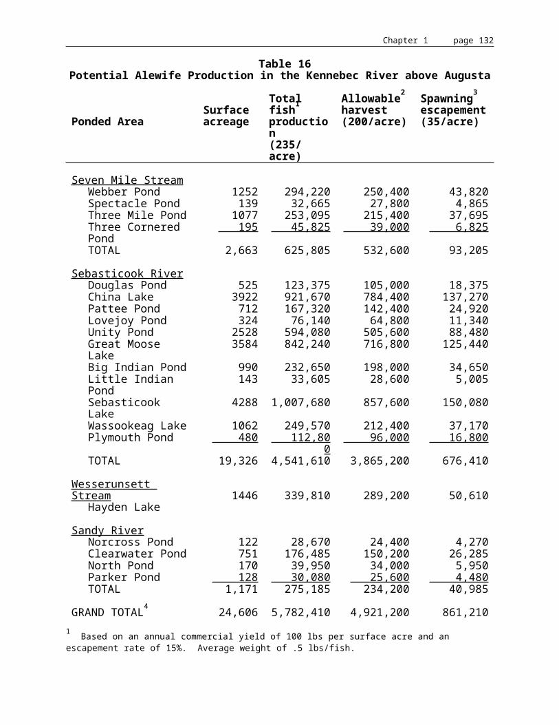
Chapter 1 page 133
Solon-Embden
The northern part of this segment above Solon consists of flat waters behind the Williams Dam at Caratunk Falls. The valley is steep walled with virtually no floodplain. Below Caratunk Falls, the river widens and has a number of islands and a broad floodplain. Between the dam and the Solon/Embden bridge, the river has been channelized. Below the bridge area, the river flows slowly and freely. It was also the site of a major campground for Benedict Arnold's army. Between Caratunk Falls and the confluence of the Carrabassett River at North Anson, there are exceptional opportunities for low impact recreation, especially for canoeing, hunting, fishing, and hiking.158
The Carrabassett is probably best known for its whitewater canoeing/kayaking, but it is equally important for a variety of other natural features and recreational uses, including sightseeing. With low water during the summer months, developmental pressure increasing, and only a low-medium level of protection, the river is particularly vulnerable to exploitation and conflicts associated with competing uses.
The Nature Conservancy owns two islands near Solon. Below the bridge on the Solon bank, there is a major private campground and recreational area.159
Madison-Anson
The section is moderately developed all the way along. It is characterized by a broad, shallow valley with expansive floodplain. The Kennebec is a slow moving impoundment of two dams below the Madison urban complex. There is a fair amount of dairy farming on the east bank north of Madison. This area is well suited for low impact recreational uses.160
The town of Madison leases access to the river from the Madison Paper Industries, Inc. on Nathan Street. The area is 1.5 acres with 50 feet of access and a graveled parking area. At the time of the writing of the plan there was adequate parking at the site. There are also two picnic areas owned by Madison Paper Industries, Inc. which are on the riverfront.161
158 ? Kennebec River Corridor Plan. North Kennebec Regional Planning Commission, September 1974.
159 ? ibid.
160 ? ibid.
161 ? Madison Comprehensive Plan, 1989.

Chapter 1 page 134
Norridgewock
This segment is where the Kennebec changes its southerly flow, turns and flows northeasterly to Skowhegan, where it turns again and continues its southward flow. From the Madison-Anson urban complex, past the confluence of the Sandy River, and through the Bombazee Rips, the shoreland contains extensive floodplains which are frequently backed by steep slopes. From here to the Norridgewock Village the southwest bank consists of a high bluff with steep slopes dropping to the river while the opposite bank is moderately sloped with some minor floodplain directly abutting the river. Between Norridgewock Village and Skowhegan, both banks consist of moderately sized floodplain backed by numerous steep slopes. Throughout most of this segment, the river consists of slow moving water. North of Norridgewock Village, the corridor is primarily forested with some large farms. East of the village the banks are primarily developed. The Old Point peninsula, across from the confluence of the Sandy river just below the Madison town line, is an important historic site. One of the earliest Abenaki Indian villages on the river was located there and a French mission was established there in 1646. In 1775, Benedict Arnold used the point as one of his primary campgrounds in the march to Quebec.
There is a privately operated park here. This area has high value for low impact recreation. The combination of fast and slow water create a great canoe trip.162 Oosoola Park is a town-owned picnic area, play ground, and boat ramp on the Kennebec River. The park is approximately three acres.163 On the Sandy River there are three opportunities for whitewater kayaking and canoeing listed in the Appalachian Mountain Club's Maine River Guide. From Smalls Falls to Phillips there are 11 miles of Class II-IV rapids and 6 miles of Class I-III rapids between Farmington Falls and New Sharon. There are 8 miles of natural flow Class I-III rapids between Drury Pond and the Sandy River.
Skowhegan
This is the most diverse segment of the river. It flows northeast over two dams, through a deep gorge that divides the Skowhegan urban center, and along a picturesque forest shore; the Kennebec swings ninety degrees at the bend to flow generally southward again. The mile long downtown gorge that begins at the base of the dams has steeply incised walls that constrict the Kennebec into a turbulent, whitewater river. Below the gorge, the river flattens out and flows gently through the rest of the segment. The northern half through Oak Islands is lined with fairly steep banks and the southern half contains moderately sloping banks with broad floodplain. The west bank is dotted with active and inactive farms, while the east bank is predominantly forested. There is a variety of open space along the shores. There is public and private access to the river.164
CMP plans to landscape the powerhouse, investigate expanding parking at Oosoola Park in Norridgewock, and create a portage trail in Skowhegan in 1992-1993.165 In addition, CMP
162 ? Kennebec River Corridor Plan. North Kennebec Regional Planning Commission, September 1974.
163 ? Norridgewock Comprehensive Plan, 1987.
164 ? Kennebec River Corridor Plan. North Kennebec Regional Planning Commission, September 1974.
165 ? CMP Recreational Facilities Plan. Land and Water Associates, 1989.

Chapter 1 page 135
improved the landscaped area at the powerhouse, providing signage regarding Arnold Trail and expanding the existing parking area at Oosoola Park.
Hinckley
This is a pastoral section of the river. It flows gently through the first half of the segment and then the river narrows below the Hinckley-Pishon Ferry village area. The valley is relatively flat throughout this segment with a broad floodplain on the west bank and moderately steep slopes on the east bank. Near the two villages of Hinckley, which is in Fairfield, and Pishon Ferry, which is in Clinton, there is considerable development. Below Pishon Ferry on the east bank, the land is primarily fields and forest with numerous large dairy farms.166
Shawmut Pond, created by the Shawmut Dam, has potential for all types of water sports.167 Clinton will prepare a plan for public access to both rivers by March 1992.168
CMP will: landscape the powerhouse site, upgrade the fishing access site (east side) with added parking, a picnic area, and a trail, develop a new boat launch proposed for 1992 (hard surface on Clinton side), and investigate a site for a new carry in boat ramp below dam (Clinton side) at the Shawmut Dam.169
Greater Waterville
The valley is moderately flat, but with little floodplain due to the escarpment which keeps the river within its channel for the most part. The section of the river is highly developed with only three sizable open space areas. Two major tributary watersheds, the Sebasticook River and Messalonskee Stream, join the Kennebec River just below the Waterville-Winslow urban center. Three dams, three auto bridges, two railroad bridges, and an abandoned footbridge spans the river in this segment.170
The recreational uses of this area are limited due to the heavy development. There are some places for foot paths and riverfront parks.171
166 ? Kennebec River Corridor Plan. North Kennebec Regional Planning Commission, September 1974.
167 ? ibid.
168 ? Clinton Comprehensive Plan, 1991.
169 ? CMP Recreational Facilities Plan. Land and Water Associates, 1989.
170 ? Kennebec River Corridor Plan. North Kennebec Regional Planning Commission, September 1974.
171 ? ibid.
Chapter 1 page 136
CMP will investigate potential for a nature study and a demonstration forest area (cooperative with adjacent landowner) at the Union Dam. At the Automatic Dam they will investigate the potential for a carry-in boat access to the headpond. At Rice Rips, CMP will investigate the potential for a carry-in boat access to the headpond, public use areas along shoreline, and a multiple-use management status of open space, as well as exploring the feasibility of conserving the area as public open space. At the Oakland Dam they will improve the boat launch.172 In addition, CMP plans to add an improved day use area at Messalonskee Lake Dam, a managed green belt along the east side of Messalonskee Stream from the Oakland Dam to the Rice Rips Dam, improved parking for fishing at Rice Rips and access below the Union Gas Dam. At the Fort Halifax Dam, CMP will improve the headpond access road and parking and trail for fishing below the dam, provide a new boat launching facility, and investigate opportunities for cooperative recreational facilities on the Winslow property. In the Fort Halifax's FERC application they add to this plan a trailored boat launching facility. CMP has completed a portage which can be used as part of the bypass around Waterville dams. At the Lockwood Dam, they have created a foot access trail and parking for fishing below dam. CMP is investigating a downstream boat launch or carry-in site and providing a boat ramp and picnicking area at the Lockwood dam. They will also provide mitigation access for Union Gas, Lockwood and Fort Halifax Dams.173
Vassalboro-Sidney
This deeply incised, 15 mile long corridor segment is located between the two major population centers in the Kennebec Valley, Augusta and Waterville/Winslow. The river is normally a very slow moving pool impounded by the Edwards Dam. The seventeen foot high Edwards Dam backs the river up to the confluence with the Messalonskee Stream. There is waterfowl and upland game habitat along this segment. Most development is on top of the ridges and cannot be seen from the river. The west bank is almost entirely of ice contact gravel deposits that are mined for sand and gravel.174
According to the North Kennebec River Planning Commission's (NKRPC) River Corridor Study, recreation would be enhanced in this segment by the removal of the Edwards Dam. With or without the dam this section is well suited for low impact recreational uses.175 The Sidney boat launch is approximately 1 acre owned by the town off River Road. It includes a boat launch and parking; the ramp is paved. According to the report, the dams in Augusta and Waterville curtail river usage in this section. Future needs for this facility, according to the Sidney's Comprehensive Plan, depends on whether the Edwards Dam in Augusta is eventually removed thereby permitting access to the southern portion of the Kennebec River.176
If the Edwards Dam is removed, the project area impoundment would revert to a free-flowing 16 mile stretch of river. The section would contain a mixture of shoal and deeper
172 ? CMP Recreational Facilities Plan. Land and Water Associates, 1989.
173 ? ibid.
174 ? Kennebec River Corridor Plan. North Kennebec Regional Planning Commission, September 1974.
175 ? ibid.
176 ? Sidney Comprehensive Plan, 1991.

Chapter 1 page 137
stretches, with at least six rapids classed as easy to low/moderate difficulty for average canoeists. The probable depth in summer months would limit watercraft to canoes, kayaks and shallow draft boats, a detriment to those who currently utilize the deeper, flat water impoundment in larger boats. This variable watercourse would be more attractive to canoeists and small craft, particularly in a region with ample natural or impounded lakes. This unimpounded resource would have greater value as a scenic, critical/ecological, and historic resource, and as an inland fishery and for canoe touring than the current impoundment. A free flowing river would provide additional passive and active recreational opportunities due to reduced water levels. The impact on existing watercraft access points would be minimal, requiring minor site improvements while possibly making additional sites feasible for trailered, carry-in or pedestrian access that are inundated by the present impoundment. The existing dam represents an impediment to a more diversified recreational resource for the Kennebec region and lost potential for improved statewide resources that could have interstate as well as regional importance.
Augusta
This segment continues with steep banks and well developed upper banks. It includes Augusta, Hallowell, Farmingdale, and Gardiner. Fort Western, located on an east bank terrace, is a national historic site. This area is a park and is part of the open space system of the city of Augusta.177
From the river, this section is scenic due to the steep, undeveloped banks and quite suitable for low level recreation. Augusta, Hallowell, and Gardiner all have municipal boat landings.178
Lower Kennebec
According to the Maine Rivers Access and Easement plan, this section of the river is the largest freshwater/tidal bay north of the Chesapeake, with an outstanding diversity of wildlife, scenic features, and historic sites. Fishing, hunting, historical exploration, picnicking, and sightseeing are among the many recreational activities which take place along the lower portions of the Kennebec.179
Access to the river between Augusta and Bath is good, although public access is still lacking in Pittston and Woolwich and below Bath in Arrowsic and Georgetown. The recommendations of the plan for access are: to continue efforts to establish public boat landings at Arrowsic or Georgetown and Woolwich or Pittston; to encourage the establishment of a river corridor commission with regulatory authority to oversee recreational/commercial user and resource protection between Waterville and Bay Point; and to identify and evaluate potential access sites and campsites at Pittston on Sand Island and near the old icehouses and above Lovejoy Narrows in Dresden. Overall access to the river, with the growing demand, is considered to be inadequate. There are public boat landings in Augusta, Hallowell, Gardiner, Chelsea, Richmond, Dresden (Eastern R.), Bowdoinham (Cathance R.), Center Point Road, Bath, and Phippsburg.180
177 ? Kennebec River Corridor Plan. North Kennebec Regional Planning Commission, September 1974.
178 ? Maine Rivers Access and Easement Plan. Maine Department of Conservation, Bureau of Parks and Recreation, January 1985.
179 ? ibid.

Chapter 1 page 138
Commercial Rafting.
Recreational use of the upper Kennebec is dominated by commercial rafting on a scale that would have been unimaginable only a few years ago. Rafting is suited to the area, given the limitations on other uses imposed by the river corridor's own geography, the water release system at Harris Dam, and its minimal impact on the river itself.181
Use limits for commercial rafting were set legislatively for the Kennebec River based on a number of factors including days and durations of release and launch characteristics. These limits are currently as follows:
Kennebec River: • Sunday (average 3 hr. release) -- 800 passengers/day • Weekdays (average 4 hr. release) -- 1,000 passengers/day • Saturdays (average 2 hr. release) -- 800 passengers/day • Memorial Day, July 4th, Labor Day -- 800 passengers/day
Commercial use on all days is monitored by reviewing monthly reports filed by outfitters. On the Kennebec there are daily total passenger limits and use on days of expected heavy use is regulated by the allocation system. These days currently include Saturdays between mid-May and mid-September on the Kennebec. Outfitters are restricted to carrying a specified number of passengers on these days, the total of which does not exceed the use limit.
The allocation system is used to assure that river use limits are not exceeded on heavy rafting use days. The following are the statutory goals of the allocation system:
• To encourage a wide diversity of whitewater trip experiences and services;• To provide a fair distribution of river use among existing and future users;• To maximize competition within the recreational use limits;
180 ? Maine Rivers Access and Easement Plan. Maine Department of Conservation, Bureau of Parks and Recreation, January 1985.
181 ? ibid.
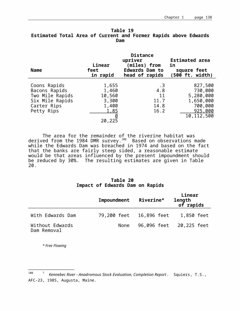
Chapter 1 page 139
• To allow for reasonable business stability for outfitters by allowing stable, well-qualified outfitters who are providing excellent service and meeting the conditions of their allocations to continue to do so, subject to periodic review when allocations are reviewed;• To encourage efficient use of the allocation system;• To be flexible enough to adapt to changes in river use or river conditions;• To prevent evasion of the system; and• To provide opportunity for public access.
The law requires that allocations be distributed among outfitters according to the following specific criteria: the experience of the outfitter (40 points); outfitter safety records (25 points); the level of financial investment in whitewater rafting (15 points); the level and quality of services provided to customers (15 points); performance in meeting past allocations (30 points); and other factors (5 points). The decision on the weight to be assigned to the various criteria is delegated to IF&W rulemaking and for 1989 was as indicated in the parentheses in the preceding sentence. The frequency of reassigning allocations is left to departmental rulemaking. Allocations have most recently been assigned for 3 years with the current period due to end in 1990. This past year the assignment period was extended to 5 years.
In addition to the assignment of allocations, outfitters are also assigned to a launch time. This assignment is based on operator preference, with conflicts being decided in favor of the operator with the longer record of continuous operation.
There is an 80 passenger per day limit for any outfitter on any rapidly flowing river. (This number was adopted as a maximum largely because of traditional passenger loads on larger trips by established outfitters prior to regulation.) Thus, the maximum allocation an outfitter can receive is 80. The law also sets a minimum allocation of 20 on the Kennebec.
There is currently no restriction on the extent of non-commercial rafting, but registration is required for such trips. There is a provision in the law for setting aside for non-commercial rafting up to 10% of the use limit, should this be required. To date, IF&W has deemed this not to be necessary.
If one applies the formula developed in A Determination of the Economic Activity Generated by Commercial Rafting, Social Research Institute, University of Maine, March 1983, to the current passenger figures, it is determined that in 1989 the total economic activity due to rafting in Maine was approximately $35,000,000, with the Kennebec accounting for $20 million, the Penobscot $12 million, and the Dead $3 million.182
For the whitewater enthusiast, competent in Class II-III water, the Dead River is the premier whitewater river in New England. With 15 miles of nearly continuous Class II-III whitewater, an undeveloped river corridor with superb mountain views, excellent highway access to Southern Maine, a convenient boat shuttle, and a 5 month season (dam regulated flow from Flagstaff Lake), the Dead is in a class by itself. Recreational and possibly commercial whitewater use may be expected to climb, and that expectation ought to be the outstanding consideration in recreational planning for the river below Grand Falls.
182 ? Annual Report of the Whitewater Advisory Committee. Office of Policy and Legal Analysis, 1990.
Chapter 1 page 140
Table 33Numbers of Commercial Whitewater Rafting Passengers by Year, Kennebec River
Year NumberPercent change vs.
previous yearNo. change vs.previous year
1981 7341 +37 +20011982 13326 +82 +59851983 17517 +31 +41911984 22369 +28 +48521985 23677 + 6 +13081986 27546 +16 +38691987 30229 +10 +26831988 29711 - 2 - 5181989 29841 + 0 + 1301990 31768 + 6 +19271991 30486 - 4 -1282
Since the Dead River has Class IV rapids, most outfitters and IF&W looked on it as a rapidly flowing river, and thus subject to certain regulations. However, prior to 1989 it was never designated as a rapidly flowing river by IF&W as required by statute, and a small number of outfitters were not considering it as such and not paying the required head fee. By rule, effective August 14, 1989, IF&W designated the Dead River as a rapidly flowing river, thus requiring reports of all outfitters.
With a reservoir capacity of 12,000 cfs, compared to 35,000 for the Kennebec and 57,000 for the Penobscot, and without the role of power provider of the other two rivers, the Dead River has a very different schedule for rafting. Recently, KWPC, the company responsible for the flow on the Dead, has released 5500 cfs at the Long Falls Dam on selected and published dates in the spring for the benefit of rafting activities.
In 1988, at outfitter request, the release pattern was changed to one Sunday and two Saturdays in May with releases of 5,500 and 7,500 cfs. Since 1989, releases of 5,500 in June, 3,500 in September, and 5,500 in October were added.183
183 ? Annual Report of the Whitewater Advisory Committee. Office of Policy and Legal Analysis, 1990.

Chapter 1 page 141
Table 34
Passenger Trend on the Dead River by Year184
Year NumberPercent change vs.
previous yearNo. change vs.previous year
1984 1946 n/a n/a1985 1951 + 0 + 71986 2914 +42 + 9631987 3144 + 8 + 2301988 2954 - 6 - 1901989 3747 +27 + 7971990 5372 +43 +16251991 3957 -26 -1415
Recommendations.
The State should continue to work with hydropower generators in the basin to provide for safe portages around dams. The Kennebec Valley Tourism Council is promoting creation of a canoe trail from Jackman to Popham Beach. The trail would cover 218 miles of the River and be expected to take 21 days to traverse. The Council would provide a guide to the trail, including portages, campsites, etc. Portages at several dams will be required to support a canoe trail. In addition, the need for speed limits on the flatwater portions of the river, due to the incompatability of fastmoving power boats with canoes and kayaks, should be addressed.
Recreational use of the Kennebec River and its tributaries has grown tremendously since the elimination of the log drives and improvements in water quality, especially in whitewater areas and where fishing opportunities are available. More growth can be expected, particularly in the underutilized flatwater portions of the river between the Forks and Augusta. The need for increased access should be assessed to ensure that the resource values being promoted are not degraded. The issue of fees is an area of increasing concern for many river users; this impediment to access should be assessed.
The whitewater rafting industry provides an important recreational benefit and is a significant contributor, along with private boating, to the economy of the rural northern Kennebec River basin. Although the current schedule of releases may result in the loss of some generating capacity, such losses are offset by the recreational and economic benefits provided by the private boating and the rafting industry.
The cooperation of the dam operators and private land holders in providing access and high flows is vital to the rafting industry as well as to private whitewater recreation.
Removal of Edwards Dam would provide a recreational benefit to the State by replacing a flatwater impoundment with a free-flowing 16 mile stretch of river accessible by canoe, kayak or shallow draft boat. The existing dam represents an impediment to a more diversified recreational resource for the Kennebec region and lost potential for improved statewide resource that could have interstate as well as regional importance.
184 ? Annual Report of the Whitewater Advisory Committee. Office of Policy and Legal Analysis, 1990.

Chapter 1 page 142
ARCHAEOLOGY
Archaeological and Historic Resources.
Since a small Indian campground was excavated at Popham in 1890, over 500 Native American archaeological sites have been identified in the Kennebec Watershed. It is possible that as many more remain undiscovered in unsurveyed areas. Judging from a modest sample investigated to date, roughly 1/3 of those discovered contain scientifically "significant" archaeological deposits, and are ultimately eligible for listing on the National Register of Historic Places.
The first Native Americans to live in Maine, called paleo indians, moved in from the south or west about 11,000 years ago as the land recovered from recent glaciation, and as tundra and open spruce woodland vegetation cover grew enough to support the large and small game they hunted (including mastodon and caribou). Because of poorly developed late glacial drainage, and perhaps because of major seasonal runoff and occasional catastrophic drainage of huge interior lake basins dammed by ice or glacial till, these people tended to camp on very well drained (sandy) soils outside of river valleys.
Between 10,500 and 9500 years ago, trees (pine, poplar, birch, oak, with other hardwoods later) colonized the Maine landscape, forcing inhabitants to live and travel along lakes and waterways and otherwise accommodate to a dense forest. An indication of such accommodation was the proliferation of stone axes and gouges during the Archaic period (between 10,000 and 3000 years ago), indicating exquisite skill in woodworking; examples of the latter unfortunately have not survived Maine's acid soil. Until 4000 years ago, we have reason to believe that people traveled in dugout canoes, on the ocean, the rivers and major lakes. Dependence on heavy dugout canoes to some degree limited mobility. Sometime between 4000 and 3500 years ago, the birchbark canoe was developed. Use of such light, back-portable watercraft allowed travel up and down small streams and beaver-flowages, and cross-drainage portaging. The birch-bark canoe opened up the Maine interior away from major lakes and rivers.
The Ceramic Period in Maine (3000 years ago to 1500 A.D.) is so-named because Maine's Native Americans adopted the use of pottery. The use of pottery with exterior designs resulted in the increased number and stylistic detail of artifacts now used to understand the archaeological record. After the first European explorers arrived off the Maine coast in the early 1500's, and began trading (the so-called Contact Period), many changes in Native American life occurred and European written records began.
Chapter 1 page 143
For most of prehistory, Maine's Native American population supported itself by hunting, fishing and gathering, in band organized societies without complex political organization or monumental construction. In southwestern Maine corn, bean and squash horticulture was added to a pre-existing hunting and gathering economic base after roughly 1000 A.D., without drastic change in socio-political organization and with only subtle changes in the use of the landscape. Maine's early Native Americans were relatively mobile in lifestyle and lived in relatively small groups. The largest and most prominent occupations were multi-seasonal villages of several hundred individuals, from which most of the population would depart and disperse over the landscape at certain seasons. Economic activities (such as food processing, tool maintenance, production of objects such as canoes, snowshoes, clothing, and, for the last 3,000 years, pottery), may have been controlled to some degree by seasonal availability of raw material, but the manufacturing activities occurred at a wide range of locations. Thus, in the absence of monumental architecture, permanent villages and towns, we recognize four types of archaeological sites: (1) habitation/workshop sites, (2) lithic quarries, (3) cemeteries, and (4) rock art (petroglyphs and pictographs).
Lithic quarry sites are highly localized mines for primary lithic material at bedrock outcrops, or for cobble material along exposed and stony streams and river bottoms. Bedrock outcrop quarries occur at localized quartz, rhyolite, and chert sources which are predictable on bedrock geology maps of the State of Maine. Cemetery sites are locations for multiple interments of the dead, spatially separated from habitation sites. Cemeteries were produced only during specific portions of Maine prehistory, notably the Laurentian and Moorehead Late Archaic, the Susquehanna Tradition, and the Early Woodland period. They are always located on well-drained sandy or gravelly sand soils within 100 yards of a large or small river or lake shore, or within 100 yards of a major habitation site in the case of the Susquehanna Tradition. The Moorehead Phase or "Red Paint" cemetery does not occur west of the Kennebec Valley. Rock art sites include petroglyphs and pictographs. There are now approximately 10 petroglyph locations known in Maine, and one pictograph or rock painting site. All contain Shaman's mnemonic representations of spirit journeys or related designs which are clearly Algonquin in origin and probably date from the last 2,000 years or less. All are located immediately adjacent to canoe-navigable water on particular kinds of bedrock outcrops.
The vast majority of prehistoric sites in Maine are habitation/workshop sites, which combine a range of activities from food procurement and processing through tool maintenance and material culture manufacture. These sites comprise the majority, certainly more than 95%, of the known archaeological record. They exist in a continuum of size and density which is currently impossible to subdivide in any meaningful fashion.
Ninety-eight percent or more of prehistoric habitation/workshop sites in Maine are 10 yards or less away from canoe-navigable water. (This high percentage is thought not to be an artifact of nonrandom searching.) Of the remainder, roughly 1% are found on highly specialized locations such as aeolean sands in the case of Paleoindian sites, or alluvial tillable soils in the case of Late Woodland and Early Contact period sites. Well drained sandy soil of low slope seems to be a predictive factor for some proportion of the remaining 1%.

Chapter 1 page 144
Habitation/workshop sites are found in two categories of depth in Maine: shallowly buried, and deeply buried. The majority are shallowly buried on soils derived from glacial till, reworked till, sand, gravel, and silt emplaced by geological processes before 12,000 years ago. In these situations there has been no net accretion of the land surface except by human agency, and archaeological material is found within the top 30 or 40 cm of active soil turnover (by frost and plant growth) on these types of soils. In this type of environment, which is representative of more than 95% of the land surface of the State of Maine, archaeological material is shallowly buried and can be discovered or destroyed by any process that disturbs the top 30 cm or so of the soil column. Deeply buried sites occur only in alluvial settings along rivers and streams, where periodic flooding has deposited silt or sand which separates sequential occupations. Such sites can be up to 3 meters deep.
Survey and Evaluation, Threats and Protection
The Maine Historic Preservation Commission recognizes two different levels of archaeological survey: Reconnaissance and Intensive survey. Reconnaissance surveys are designed to determine site presence or "prove" site absence with some level of reliability (often by shovel-testpit excavation with certain depths and intensity).
Intensive level archaeological survey is used to determine the vertical and lateral extent of an archaeological site, its contents, and often its "significance." Intensive survey is focussed on known sites and involves often extensive excavation.
Removal of a threatened archaeological site by careful excavation is called data recovery. Protection of a site from a threat (often involving a combination of data recovery, legal and physical protection) is called mitigation. Conservation of some sample of archaeological sites for future excavation is the primary principle of managing archaeological sites, because we assume that archaeological digging techniques, archaeological laboratory techniques (especially) and the questions archaeologists ask of their data will all improve in the future. Having the appropriate site to "dig" is often the only way to answer a question about the past.
A key concept in managing archaeological sites is determining which sites require attention and which would be a waste of resources. The legal term used to designate sites worthy of protection or excavation with public funds is "significant." A "significant" site is eligible for listing in the National Register of Historic Places, and vice versa. Criteria of eligibility depend upon site age, content, and condition. They are spelled out in detail in a series of archaeological "contexts", each addressing the state of knowledge of a particular portion of prehistory, written by MHPC staff.
Threats to archaeological sites, ie. those actions that can destroy a site's significance, include primarily erosion, vandalism, and development. Because most prehistoric sites in Maine are/were located along the shore of a body of water, erosion is perhaps the greatest threat. Erosion can be entirely natural, or it can be caused by human actions that raise water levels and allow waves and ice to chew away at archaeological deposits that were formerly dry land. A case in point is Moosehead Lake, where the water levels have been raised for at least a century, first by timber-industry dams and then by water storage dams for hydropower generation (downstream). Approximately 270 archaeological sites were found by a recent reconnaissance survey around the lake shore (above and just below full pool level). Intensive survey is not yet complete, but it is estimated that no more than 20% of those sites survive as "significant" archaeological sites.

Chapter 1 page 145
Protection of archaeological sites for the future is a complex problem. Protection from purposeful vandalism (non-systematic digging for artifacts) relies upon anonymity, or a combination of physical (fencing) and legal protection (conservation easements) plus periodic monitoring. (Archaeological site location information is legally protected primarily to help deter vandalism.) Protection of archaeological sites from erosion can be accomplished at great expense with the construction of erosion-control walls or other devices. Often, it is more cost effective to recover a sample of the archaeological data within the area that will be lost to erosion within a certain period of time (e.g., within the license period for a hydroelectric project). Protection from development relies upon a combination of statute (e.g., shoreland zoning, site location of development), active review of proposals related to these laws, and conservation easements.
Existing Data Base and Survey Coverage
Lower Kennebec: The Chops to Popham. This portion of the Kennebec is a narrow tidal channel dominated by current. There have not been extensive systematic professional archaeological surveys in this portion of the river. Fifteen prehistoric sites are known, none are listed on the National Register. A "Red Paint" burial (stone tools, red ochre, no skeleton) was recovered by the State Museum from Popham, and the artifacts and fieldnotes are on display in the new Maine State Museum exhibit.
Archaeological survey of the shoreland zone in this section is badly needed.
Lower Kennebec Tributaries. The Sasanoa, Back River, and Nequasset Brook are mostly-tidal extensions of the lower Kennebec. There have not been extensive systematic professional archaeological surveys in this portion of the river. Seven prehistoric sites are known. None are listed on the National Register. Sites around Nequasset Brook contain some stone tools of Early and Middle Archaic age (circa 9000-7000 years old). The Sasanoa River was clearly the location of a major Contact Period Indian village, visited and described by Biard about 1611. The site has not yet been found.
Archaeological survey of the shoreland zone in this section is badly needed, as well as intensive level survey on some sites away from the shoreland zone. Locating the Biard-described village should be a priority for studying the Contact Period.
Tidal Kennebec: Merrymeeting Bay to Augusta. We exclude the western portion of Merrymeeting Bay here, which is part of the Androscoggin. The Chops, at the outlet of Merrymeeting Bay is a drowned waterfall. Our best guess, based on rate of coastal submergence, is that it was drowned about 5000 years ago. Before that time, The Chops would have been a massive waterfall, capable of impeding the entrance of anadromous fish into the Kennebec and Androscoggin. The increase in available anadromous fish resouces over time may in part be responsible for an increase in numbers and size of archaeological occupations over time in the drainage (i.e., many more Late Archaic sites than Early Archaic).

Chapter 1 page 146
Systematic extensive professional archaeological survey has not been accomplished in this section. Eleven archaeological sites are known. None are listed on the National Register. Evidence from the Swan Island area of Richmond, in the form of an elevated beach with a circa 7000-5000 site, indicates that the Kennebec River had been downcutting into its bed, and therefore lowering the elevation of its shorelines, for thousands of years. Therefore, archaeological sites might be located on former shorelines well back from the modern shoreline along this stretch of river. Archaeological survey of the shoreland zone, and certain landforms back from the shoreland zone, in this section is badly needed.
The Cobbosseecontee Drainage. This drainage includes Cobbosseecontee Stream and Lake, and lakes further upstream in the Winthrop drainage. Systematic professional survey has been accomplished on much of the length of Cobbosseecontee Stream, and portions of the outlet area of the lake. Forty-one archaeological sites are known in this section. Several are known along the length of Cobbosseecontee Stream. There is a concentration of eroded (not significant) sites near the outlet of Jug Stream into Cobbosseecontee Lake, although many of them have yielded 5000-7000 year old stone tools. Three sites near the outlet of Cobbosseecontee Lake have yielded stone tools dating between 8000 and 1000 years to extensive professional excavations. Two of these sites are listed on the National Register.
Augusta to Waterville. This section of the river is defined to extend from the Edwards Dam upstream to the dam in Waterville. Sixty archaeological sites are known in this section. Eroding portions of the Edwards Dam impoundment margin have received professional reconnaissance survey. Removal of Edwards Dam would allow access to additional sites. Several sites around the Edwards impoundment may be eligible for listing in the National Register. This survey did not examine higher river terraces along the sides of the valley that may contain many more, early sites. Two other professional archaeological surveys have concentrated on the upper portion of this section of river. Survey of a right-of-way for a new bridge has located a group of 5 sites on the east bank of the river, one of which is eligible for the National Register. One is deeply buried in alluvium, several others are associated with an abandoned river channel perched at 20 feet elevation above the modern river. Other intensive level archaeological survey work has concentrated at the location of Fort Halifax in Winslow. Much work has been done on the circa 1760 vintage British Fort, but the entire area is underlain by stratified prehistoric deposits. The oldest so far dated under Fort Halifax is 3100 years old, containing burned bone remains of salmon and sturgeon. This site is listed on the National Register.
The Sebasticook River. The Sebasticook is an east bank tributary of the Kennebec at Winslow, and was a major canoe route connection to the Piscataquis River. It should, therefore, contain many archaeological sites. Sixty-five archaeological sites are known along the Sebasticook River below Sebasticook Lake. Reconnaissance archeological survey has been accomplished for the Fort Halifax dam and Benton Falls dam impoundments. Several huge archeological sites (and many small ones) are known around the Fort Halifax impoundment, all or most of them eroding. Intensive level archaeological survey fieldwork is completed but not yet reported. The Benton Falls impoundment yielded 8 archaeological sites to reconnaissance survey, of which one was significant, and subjected to data recovery excavation. Systematic extensive professional archaeological survey has not been accomplished on the river or lake above the Benton Falls impoundment. A few sites are known around Sebasticook Lake, but they seem to be totally eroded.

Chapter 1 page 147
Systematic extensive professional archaeological survey has not been accomplished around China Lake. However, the Cates Farm site at the outlet of China Lake has received intensive testing and the site is eligible for listing on the National Register.
The Messalonskee Drainage. The Messalonskee drainage is a small tributary of the west side of the Kennebec at Waterville, with small headwaters lakes maintained by a dam. Reconnaissance level professional survey has been accomplished along the entire drainage due to hydroelectric relicensing studies and bypass route survey near Waterville. Thirty-three archaeological sites are known along the entire drainage. Intensive level archaeological survey has been accomplished around the hydroelectric impoundments, but the results are not yet available. Preliminary results indicate several sites with deposits in the 7000 year old range, and several which are National Register eligible. Site 53.38 near the Union Gas dam is a small, Susquehanna Tradition (circa 3500 year old) encampment. It is currently undergoing total data recovery, because it is located on the centerline for the new road/bridge between Waterville and Winslow.
Waterville to Skowhegan. In this section we include the main channel of the Kennebec upstream to the Weston Dam, and the Wesserunsett Drainage. Landforms along this portion of the river are complex, with many low, alluvial deposits now used as agricultural fields and several possible fossil river meanders. Systematic extensive professional archaeological survey has not been accomplished in this section. Only 10 archaeological sites are known in this section, reflecting the paucity of professional survey. Archaeological survey of the shoreland zone in this section is badly needed, with additional attention to fossil shorelines and deeply buried alluvial context. Judging by results upstream and downstream, this section of the river probably contains dozens of National Register eligible sites.
Skowhegan to Madison, and Sandy River. This section of the river extends from the Weston dam at Skowhegan upstream to the dam at Madison, most of which is impounded by the Weston dam. It contains extensive deposits of stratified alluvium, and some abandoned high river banks and meanders.
Forty-nine archaeological sites are known in this section. The Weston impoundment has received extensive reconnaissance archaeological survey and intensive survey of many of the sites. Only the reconnaissance survey has been reported, but preliminary results indicate that a dozen or more sites may be eligible for listing in the National Register. Many are deeply stratified in river alluvium. Occupation of this portion of the valley began at least 8000 years ago. The location of "Norridgewock" is particularly significant. One site is the location of Father Rasle's mission and associated village of 1690-1725, which was burned by Massachusetts militia. Much of this site has been looted, but some remains intact. A nearby site contains extensive deposits from the late Ceramic period and Contact period: apparently the village location before people were induced to move to Rasle's mission. Postmolds ("fossil" postholes), hearths and pits from an 80 meter long longhouse have been uncovered from a late Ceramic component, along with burned corn, beans and squash. This was probably the village of Abenaki first referred to by Champlain circa 1630.

Chapter 1 page 148
Systematic extensive professional archaeological survey has not been accomplished in the section of the Sandy River above the Madison Electric Works dam.
Madison to Gray Island, south of Solon. This portion of the river contains similar landforms to the Skowhegan-Madison stretch. A reconnaissance archaeological survey of the Madison impoundment was accomplished, but it may not have included enough pit digging to detect deeply buried sites. Otherwise, systematic extensive professional archaeological survey has not been accomplished in this section. Only two archaeological sites are known in this section. Archaeological survey of the shoreland zone in this section is badly needed, along with survey of fossil river shore landforms.
Carrabassett River. Systematic extensive professional archaeological survey has not been accomplished in this river valley, with the exception of one test in Kingfield for a municipal well. One archaeological site is known in this section. Archaeological survey of the shoreland zone in this section is badly needed.
Solon Area. This is a short section of the Kennebec River, from Gray Island upstream about 1.5 miles to Williams Dam. Four archaeological sites are known, two on each side of the river. All four have been subjected to intensive archaeological survey. Three are listed in the National Register, and the fourth is eligible. Two sites contain deep, stratified sequences in river sites, beginning at least 5000 years ago. Two are shallow sites. One of the shallow sites contains a circa 1700 A.D. occupation which must be related to Rasle's mission at Norridgewock. Associated is a ledge which sticks into the river, covered with petroglyphs that date to the last one or two thousand years. This latter site, the Hodgdon site, is protected by a conservation easement.
Solon to The Forks. In this section of river, the height of hills bordering the Kennebec Valley increases, and the amount of alluvial floodplain in the valley bottom decreases. Twenty-two archaeological sites are known in this section.
The Williams project impoundment shoreline has been surveyed at the reconnaissance level and intensive level. Eleven archaeological sites were located. Two, the Smith site and Smith's landing site, were judged eligible and threatened, and subjected to major data recovery excavation. The Smith site contains a stratified series of occupations dating between 3800 and 2900 years ago, which is valuable for understanding that period of time.

Chapter 1 page 149
The Wyman project impoundment has also been subjected to reconnaissance and intensive level survey. Eight archaeological sites are known in this section. Five are eligible for listing in the National Register and are ultimately scheduled for data recovery excavation. The oldest is apparently of Paleoindian age.
There are three archaeological sites around The Forks, although none have been subject to intensive archaeological testing.
The Dead River and Flagstaff Lake. Flagstaff Lake comprises a flooded portion of Dead River, although fossil shorelines at higher elevations indicate that the basin did contain a major lake at some time in the past. Systematic extensive professional archaeological survey has not been accomplished in the Dead River or around Flagstaff Lake, with the exception of the Eustis Dam impoundment.
Even so, 40 archaeological sites are known in this section below the Eustis dam, most of them eroded and covered with the waters of Flagstaff Lake. All of these sites are known from amateur reports, and they contain deposits as old as Paleoindian.
Reconnaissance and intensive archaeological survey of the Eustis dam impoundment has been accomplished, resulting in the discovery of two archaeological sites, and determination that one is eligible for listing in the National Register.
Indian Pond to Moosehead Outlet. Systematic extensive professional archaeological survey has not been accomplished in this section. Three archaeological sites are known in this section. Archaeological survey of the shoreland zone in this section is badly needed.
Moosehead Lake. Moosehead Lake is a huge natural lake which has been enlarged slightly by a pair of low dams that block two outlets. Reconnaissance level archaeological survey of the impoundment shore and area around each outlet has been accomplished. Approximately 270 archaeological sites are known around the impoundment. The sites contain occupations as old as Paleoindian and as young as the Contact period. Intensive level archaeological survey has begun but is not complete. Preliminary results indicate that a low proportion (10-30%) of these sites have survived the raised water levels and may be eligible for listing in the National Register.
In the fall of 1646 a French missionary accompanied a large number of Indian families from the Augusta-Waterville region of the Kennebec on an upriver trip to Moosehead. The families dispersed to small hunting camps around the lake for the winter, and reassembled for the downriver trip in April. There may not be enough archaeological evidence to test whether or not this seasonal use of the lake was a regular practice.
Brassua Lake. Brassua Lake consists of a smaller natural lake enlarged drastically by raised water levels behind a dam. Several years ago, the Brassua impoundment was drained for repairs, and all archaeological sites exposed around the former lakeshore and stream banks were located through a combination of professional and amateur reconnaissance survey. Approximately 109 archaeological sites were located. Virtually none of them retain enough of their original content to be determined significant. Brassua Lake is a good example of the damage done to Maine's archaeological sites by raised water levels.

Chapter 1 page 150
Archaeological Impacts and Mitigation.
Section 106 of the National Historic Preservation Act and relevant sections of the Electric Consumer's Protection Act require consideration of potential adverse effect on significant archaeological sites as part of the process of licensing or relicensing hydroelectric projects. The following constitutes Maine Historic Preservation Commission/State Historic Preservation Office policy concerning mitigation of potential adverse impact.
License Responsibilities - Site Location and Significance. For a new license, new construction, or an increase in pool elevation or other substantive change in water management practices, the licensee is responsible for finding and assessing the significance of all archaeological sites within the area of direct impact. The direct impact area includes any construction area, flooded land, and area of erosion around the pool margins during the term of the license. For the relicensing of an existing project with no change in water management practices, the licensee is responsible for finding and assessing the significance of archaeological sites around the pool of the project or immediately downstream from the project (by the tailrace) which may experience adverse effect through erosion during the term of the license.
When an existing pool is involved, the license is responsible for determining site presence and significance for all archaeological sites located at an elevation above the normal annual low water mark of an impoundment. Licensee will not be responsible for the location of sites below the normal annual low water mark of the project except in cases when the impoundment is drained for major reconstruction of the dam.
Applicant is also responsible for finding and assessing the significance of archaeological sites for ancillary activities within the project area including recreational facilities, lease of project lands, timber harvesting, and other activities. In the case of a relicensing, it is the applicant's choice whether to proceed with complete Phase I and Phase II archaeological survey before relicensing, or to deal with recreational facilities and other ancillary activity areas, etc., on a case-by-case basis as they are proposed for construction or other action.
License Responsibilities - Mitigation. The licensee is responsible for mitigation of adverse impact to any significant archaeological sites. The National Register eligibility of archaeological sites discovered within project boundaries will ordinarily be judged by criterion D of the National Register of Historic Places (yielding "information important in prehistory or history"). Eligibility decisions will also be guided by additional detail set forth in the Maine State Plan for Prehistoric Archaeology, and any relevant thematic or individual National Register nomination forms applicable to the area of the hydroelectric project. Mitigation will usually take the form of data recovery from some portion of the site to be determined on a case-by-case basis.
For relicensing of an existing project, the licensee is responsible for mitigation of adverse impact for those portions of the site or sites that will be effected by erosion (including wave wash and ice scour, mass wasting, bank slumpage, and tree toppling) during the term of the license. Given that water management practices at the site will not change, the rate of erosion can be estimated by individuals with appropriate geological expertise, or by historical data including trees falling into the impoundment, or measurements of erosion from photographs or other data sources.
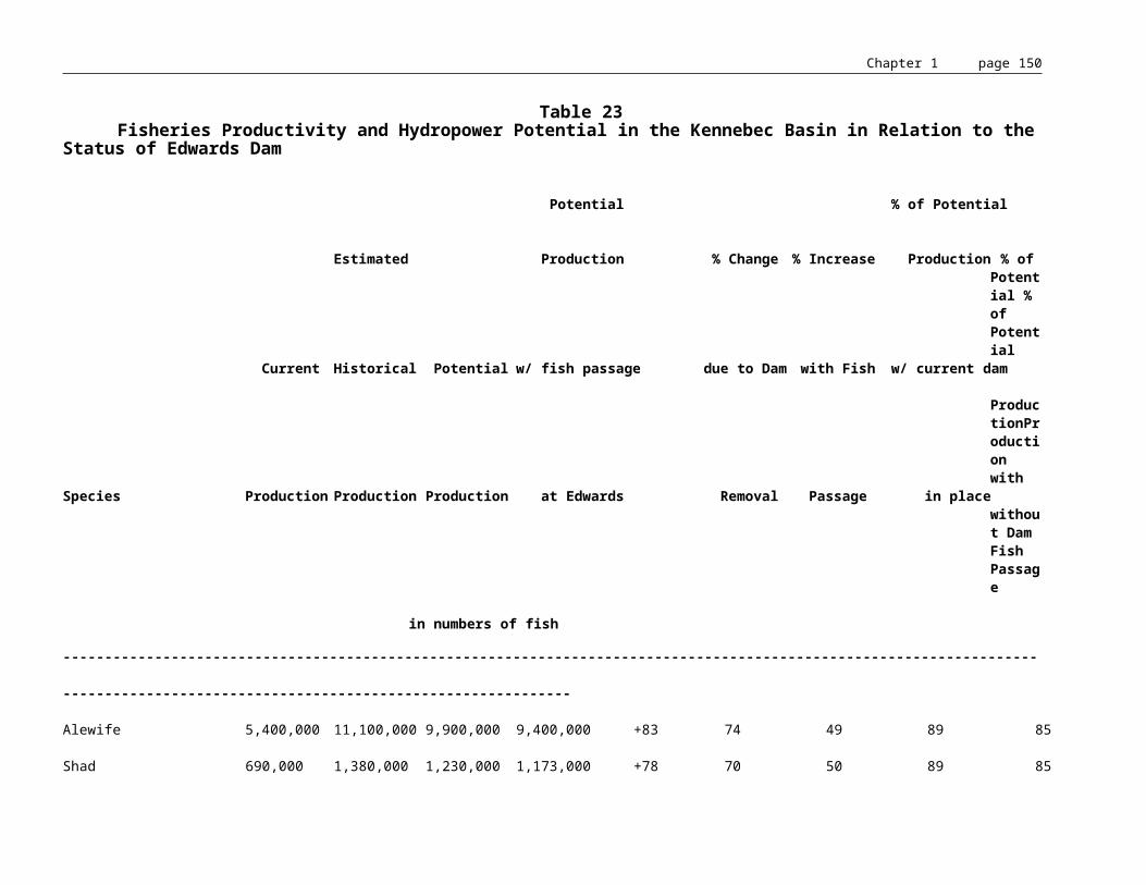
Chapter 1 page 151
Determination of the proportion of the impact area to be mitigated by data recovery (archaeological excavation) will be done on a site-by-site basis, in response to Research Significance Themes outlined in the Maine State Plan for Prehistoric Archaeology, and as described in a detailed data recovery (research) plan developed by a Maine Historic Preservation Commission approved archaeologist.
Mitigation Plan. Upon completion of Phase I and Phase II archaeological studies, and at the time of application for license or relicensing, the licensee shall prepare an Archaeological Mitigation Plan, which shall consist of the following items:
* The detailed archaeological data recovery plan for each site for which data recovery has been deemed necessary by the State Historic Preservation Officer;
* Relevant draft text for National Register of Historic Places nomination(s) and applicable visual (photographic, graphic) documentation;
* A timetable for development of relevant conservation easements or good faith efforts to contact private landowners to obtain conservation easements on significant archaeological sites; and
* A plan for monitoring archaeological site integrity for the term of the license, if any significant archaeological deposits will remain after construction and/or data recovery. The archaeological site monitoring plan shall include an agreement between the licensee and the Maine Historic Preservation Commission for periodic monitoring of the site, and reporting site conditions to the Maine Historic Preservation Commission. It may include a contract which has been approved by the Maine Historic Preservation Commission between the licensee and a third party for that monitoring.185
Recommendations.
Archaeological surveys of the shoreland zone should be conducted in the following regions of the Kennebec basin: the lower Kennebec (below the Chops) and its tributaries, Merrymeeting Bay to Augusta, Waterville to Skowhegan, Madison to Gray Island, the Carrabassett River and Indian Pond to Moosehead outlet.
185 ? Hydropower Policy: Maine Historic Preservation Commission.

Chapter 1 page 152
MUNICIPAL PLANNING
SHORELAND ZONING
The Mandatory Shoreland Zoning Act, 38 MRSA §435-449 requires all municipalities to adopt, administer, and enforce ordinances which regulate land use activities within 250 feet of great ponds, rivers, freshwater and coastal wetlands, and tidal waters; and within 75 feet of streams as defined. These ordinances are intended to protect environmental quality, wildlife habitat, archeological resources, commercial fishing and maritime industries, public access to waters, visual resources and open space. Significant and permanent changes in the water level of impoundments in the Kennebec basin may alter the shoreland zone as designated by municipalities. The effect of such changes would have to be evaluated on a case-by-case basis.
MUNICIPAL PLANNING FROM HARRIS DAM TO AUGUSTA
There is not much development along the segment from the Harris Dam to Caratunk. The greatest concentration is along Route 201 at the Forks village and some seasonal development on the east bank of the Kennebec across from the Forks. This section is under the planning jurisdiction of LURC.186
There is some development at Caratunk, where there is considerable land for further development available in the southern section of the village. This entire segment is under the planning control of LURC.187
Moscow is the first incorporated town along the river. They have shoreland zoning ordinances and use the statutory criteria for reviewing subdivision proposals. There are a series of seasonal dwellings on the east bank just below the confluence of Dexter Brook and the Kennebec. Another settlement has developed across the river on the west bank. Pleasant Ridge Plantation is also an area with suitable land for development. Moscow is part of the NKRPC. The rest of this area is under the control of LURC.188
From Bingham to Concord is the first developed area in the corridor. It is on the east bank above and below Wyman Dam. The town of Bingham is in the historic floodplain but the risk of flooding has been mitigated by the dam.189
186 ? Kennebec River Corridor Plan. North Kennebec Regional Planning Commission, September 1974.
187 ? ibid.
188 ? ibid.
189 ? ibid.

Chapter 1 page 153
Most development in Solon and Bingham is restricted to the river because of the steep backcountry in this region. Use of the land adjacent to the river is restricted along the entire pool behind Williams Dam in Solon by CMP's ownership of flowage rights. Theoretically, the utility can raise the pool elevation behind the dam an additional 12 feet. Bingham is a Tier 3 town and part of the NKRPC. Bingham has a comprehensive plan and is part of the Federal Flood Disaster program. The rest of this area is under LURC's control.190
Solon and Embden have exceptional protection of riverfront land through local zoning. Embden has restricted virtually all structure development along the river frontage. There are scattered exceptions where development already exists. Solon has zoned all of the land below the recreational area at the bridge as resource protection.191 Solon is a Tier 2 town and Embden is Tier 3, both are part of the NKRPC.192
Madison and Anson have adopted municipal shoreland zoning ordinances based on the minimum State guidelines. There has been poor development control due to Route 201's proximity to the river and shoreland zoning has been ineffective. The floodplain extends as far as half a mile back from the river. Anson has a resource protection zone along its floodplain.193 Both Madison and Anson are Tier 3 towns and part of the NKRPC.194
During development of its comprehensive plan, citizens in Madison were asked about the need for improved access to surface water: 38% strongly agreed and 22% somewhat agreed. Overall the response was statistically somewhat positive. When asked specifically about additional access to the Kennebec 30% felt it was very important, and 21% felt it was somewhat important. Overall the response was statistically somewhat positive. Madison plans to work with other communities to establish a Kennebec River Corridor Commission by 1994. The recreation goals include a plan to maintain and improve access to the river.195
Norridgewock has adopted shoreland and flood protection zoning.196 Norridgewock is a Tier 3 town and part of the NKRPC.197
190 ? Kennebec River Corridor Plan. North Kennebec Regional Planning Commission, September 1974.
191 ? ibid.
192 ? Office of Comprehensive Planning.
193 ? Kennebec River Corridor Plan. North Kennebec Regional Planning Commission, September 1974.
194 ? Office of Comprehensive Planning.
195 ? Madison Comprehensive Plan, 1989.
196 ? Norridgewock Town Plan.
197 ? Office of Comprehensive Planning.
Chapter 1 page 154
Skowhegan has adopted shoreland zoning, which is effective in this area due to the steep banks and small floodplain. There are pockets of developable land within the floodplain.198 Skowhegan is a Tier 3 town within the NKRPC.199
Fairfield has townwide zoning that places all of the land along river in a rural zone, which has virtually no restrictions on use. They have adopted shoreland zoning and the islands are zoned for protection.200 The plan also describes dangerous sections of the river from the I95 crossing south to the village where several drownings have occurred. Clinton has adopted shoreland zoning as well as a 75 foot setback on all streams in town.201
Winslow has local ordinances for zoning including shoreland zoning and subdivision review. Much of the corridor land in the southern part of Winslow has been placed in resource protection. Winslow has an active conservation commission and recreation commission. Waterville has municipal zoning and special shoreland protection mechanisms. Waterville has zoned the area within fifty feet of numerous streams as resource protection to preserve natural drainage patterns. They have a conservation commission that is active in protecting the city's natural resources.202 Benton is a Tier 1 town, while the other three are Tier 3, and all are part of the NKRPC.203
In Sidney shoreland zoning provides the highest protection of natural resources within the town. During comprehensive planning, citizens surveyed about whether the town should acquire shorefront property for recreation responded was as follows: 47% swimming, 42% park/picnic, 44% multipurpose area, 31% boat launch, and 20% no. This question did not differentiate between lakefront and riverfront acquisition. The town plan concentrates most of its surface water concerns on Messalonskee Lake, although the Kennebec is mentioned in terms of increasing boat launching area. When asked to list negative and positive changes in Sidney, survey respondents made no mention of the river. In the natural resources section of the plan, a concern was noted regarding the gravel pits on the river. The regional coordination efforts for natural resources outlined in the plan do not mention the river.204
Edwards Dam removal was specifically addressed in the Vassalboro Comprehensive Plan. According to the plan, dam removal would give boaters access to the ocean and fishing would improve due to the return of anadromous fish. This could provide significant economic benefits to Vassalboro. If the dam is removed, there would be some draining of submerged land but this may be a benefit as waterfowl habitat. In the 1974 River Corridor Study this segment of the river was considered excellent for a variety of recreational purposes: hiking on the railroad bed, fishing, and canoeing. The Study considered this area to hold a high potential for semi-
198 ? Kennebec River Corridor Plan. North Kennebec Regional Planning Commission, September 1974.
199 ? Office of Comprehensive Planning.
200 ? Fairfield Town Plan, 1987.
201 ? Clinton Comprehensive Plan, 1991.
202 ? Kennebec River Corridor Plan. North Kennebec Regional Planning Commission, September 1974.
203 ? Office of Comprehensive Planning.
204 ? Sidney Comprehensive Plan, 1991.

Chapter 1 page 155
wilderness experience between two larger population centers.205 The plan recommends that development should be kept off steep slopes and back from the immediate riverfront. Development on the ridges should be screened to lessen visual impacts from the river. According to the plan, this should be coordinated with Sidney. In the town survey, 34.4% of people wanted to develop or improve access points on river. This was the second highest priority among the town residents. The plan includes a goal to improve access to the river by 1992.206
The city of Augusta has adopted a Kennebec River Greenway Plan as part of their Growth Management Plan. This greenway consists of the creation of a series of parks for different uses along the river, including picnic areas, walking trails and natural areas. The city of Augusta has a detailed comprehensive plan which was developed in 1988. The city has a detailed protection plan for the watershed with buffers around each stream, a prohibition on the filling of wetlands except for water dependant uses, and buffers around areas of high erosion, steep slopes, floodways, and areas designated critical for wildlife.207
205 ? Vassalboro Comp Plan, 1991.
206 ? ibid.
207 ? 1988 Growth Management Plan, Augusta.

Chapter 1 page 156
CRITERIA FOR STATE AGENCY DECISION-MAKING
The MWDCA (38 MRSA, Sec. 630-637), which applies to the construction, reconstruction or structural alteration of a hydropower project, states that the Board of Environmental Protection or LURC shall approve a project when it finds that the applicant has demonstrated that the following criteria have been met:
1. Financial capability. The applicant has the financial capability and technical ability to undertake the project. In the event that the applicant is unable to demonstrate financial capability, the board may grant the permit contingent upon the applicant's demonstration of financial capability prior to commencement of the activities permitted.
2. Safety. The applicant has made adequate provisions for protection of public safety.
3. Public benefits. The project will result in significant economic benefits to the public, including, but not limited to, creation of employment opportunities for workers of the State.
4. Traffic movement. The applicant has made adequate provisions for traffic movement of all types out of or into the development area.
5. LURC Zoning. Within the jurisdiction of the LURC, the project is consistent with zoning adopted by the commission.
6. Environmental mitigation. The applicant has made reasonable provisions to realize the environmental benefits of the project, if any, and to mitigate its adverse environmental impacts.
7. Environmental and energy considerations. The advantages of the project are greater than the direct cumulative adverse impacts over the life of the project based upon the following considerations:
a. Whether the project will result in significant benefit or harm to soil stability, coastal and inland wetlands or the natural environment of any surface waters and their shorelands;
b. Whether the project will result in significant benefit or harm to fish and wildlife resources. In making its determination, the board shall consider other existing uses of the watershed and fisheries management plans adopted by IF&W, DMR, and the ASRSC;
c. Whether the project will result in significant benefit or harm to historic and archeological resources;
d. Whether the project will result in significant benefit or harm to the public rights of access to and use of the surface waters of the State for navigation, fishing, fowling, recreation and other lawful public uses;

Chapter 1 page 157
e. Whether the project will result in significant flood control benefits or flood hazards;
f. Whether the project will result in significant hydroelectric energy benefits, including the increase in generating capacity and annual energy output resulting from the project, and the amount of nonrenewable fuels it would replace; and
The Board shall make a written finding of fact with respect to the nature and magnitude of the impact of the project on each of the considerations under this subsection, and a written explanation of their use of these findings in reaching their decision.
8. Water Quality. There is a reasonable assurance that the project will not violate applicable state water quality standards, including the provisions of section 464, subsection 4, paragraph F, as required for water quality certification under the United States Water Pollution Control Act (Clean Water Act), Section 401. This finding is required for both the proposed impoundment and any affected classified water bodies downstream of the proposed impoundment.
Section 401 of the Clean Water Act is also relevant to relicensing of hydroelectric facilities because it requires any applicant for a federal license or permit for an activity which may result in a discharge to navigable waters must obtain State certification that the activity will not violate water quality standards.
Maine's Supreme Judicial Court has recognized that Maine's water quality standards contain three parts: a list of designated uses, a set of numerical criteria for water chemistry (dissolved oxygen and bacteria counts), and a set of narrative criteria on the permissable level of pollutant discharges. The court has also held that designated uses provide goals for the State's management of its classified waters and that the Board of Environmental Protection must consider those water quality goals when it renews applications for water quality certifications for hydropower facilities.208
MAINE RIVERS POLICY: SPECIAL PROTECTION FOR OUTSTANDING RIVER SEGMENTS
The Maine Rivers Policy, as laid out in Executive Order 1 FY 82/83 and dated July 6, 1982, established that the Dead River from The Kennebec to Flagstaff Lake and the Kennebec from Bay Point to the Edwards Dam and from The Forks to the Harris Dam be protected. Specifically, the Policy prohibited construction of new dams on these sections and required that additional development or redevelopment of dams be designed and executed in such a manner that either enhances the significant resource values of these river stretches, or does not diminish them.
208 ? Bangor Hydro-Electric Company v. Board of Environmental Protection, 595 A.2d (Mc. 1991).

Chapter 1 page 158
SUMMARY OF RECOMMENDATIONS
HYDROPOWER
One of the most important uses of the Kennebec River is the generation of electricity through hydropower facilities. We are now utilizing an estimated 52% of the total hydropower potential of the Kennebec, beyond the utilization rate for any other use. As a general premise, it is assumed that the dams in the Kennebec River basin will continue to play a significant role in supplying a predictable quantity of energy at a predictable price to the State's energy consumers; however, each license to be renewed must be assessed on a case-by-case basis.
After careful analysis of balances of uses and resources, the State finds that appropriate actions have been taken or have been proposed to be taken by the hydro-developers to achieve an appropriate balance at eight of the ten Kennebec basin dams whose licenses expire in 1993.
At Fort Halifax, State and federal agencies recommend operation of the project in run of river mode during upstream anadromous migration (May 1-June 30) and minimum flows of 350-400 cfs during the rest of the year.
Analysis of Edwards Dam has resulted in a recommendation by the State that dam removal conditions be established during relicensing. Due to its location at head-of-tide, Edwards Dam is unique among the Kennebec Basin's hydro facilities in terms of the scale of its impact on anadromous fisheries. In addition, removal of Edwards would actually allow electric rates to decline because power is currently purchased from the owners of Edwards at at least 3 times the cost of replacement power. The benefits of dam removal in the form of improved water quality, restored anadromous fisheries and increased recreational opportunities, and economic benefits derived from these beneficial uses outweigh the loss of 0.13% of the State's generating capacity (0.4% if the proposed expansion is considered) and other potential negative impacts of dam removal such as the introduction of carp above Augusta, changes in the shoreline and wetlands of the area of the impoundment, loss of waterfowl habitat and loss of a flatwater recreational resource.
The recommendation for removal of the Edwards Dam does not represent either a sudden or a dramatic shift in State policy and should certainly not be interpreted as a precedent for management of other state water resources. As explained throughout this Management Plan, the Kennebec River is an unusual resource. Improving, developing, and conserving that resource calls for unusual management tools. Readers should not interpret this recommendation as an invitation to seek wholesale removal of the State's hydroelectric dams.
FLOWS
Flow management, reservoir levels, ramping and flood control are managed by the private sector according to FERC regulations which govern generating facilities and storage dams. FERC relicensing regulations require an extensive consultation process with appropriate State and Federal resource agencies. State agencies, including SPO, the Department of Economic and Community Development (DECD), and the Maine Emergency Management Agency (MEMA) in particular, should identify which issues, procedures and standards relating to flow management should be addressed in the consultation process. Augmentation of the existing system of stream gages should be a top priority.
WATER QUALITY

Chapter 1 page 159
On Messalonskee Stream, the water quality effects from a municipal treatment facility in Oakland and a combined sewer overflow in Waterville are elevated due to the impoundments downstream of the discharges. Changes in the amount of treatment provided, location of discharge points and flow management will be required to bring this stream into compliance with the standards for Class C.
The Sebasticook River is eutrophic primarily from nonpoint source nutrient contamination but also from several municipal treatment facilities which discharge in the watershed. Increased residence time of the watershed allows for increased algae growth leading to low dissolved oxygen in the impoundments. Several projects are presently ongoing in the watershed to reduce nutrient loading. Changes may also be required in flow management of the impoundments to dissipate algae growth.
The DEP may assess the need to seek modifications of the operation of the Wyman project to bring aquatic life conditions below that dam into compliance with water quality standards. In addition, DEP may assess the need to seek modifications of licensed discharges in Fairfield and downstream and/or modification of the operation of Edwards Dam to bring this segment into compliance with water quality standards.
FISHERIES
The State should continue to work with dam owners and landowners in the Kennebec basin to maintain access for fishing in all waters and to provide flows that maintain or enhance fishing opportunities.
The Edwards Dam is the first obstruction encountered by sea-run fish making their way up the Kennebec River to spawn. As such, it is the greatest obstacle to restoration of the Kennebec's fisheries resources and must be removed. It should be noted that one of the major reasons for designating the lower Kennebec and Merrymeeting Bay as an outstanding river segment (see page 9) is because of the diversity and uniqueness of anadromous fish resouces in the lower river. These anadromous fish resources are significantly dependent upon spawning habitat above the Augusta dam. As a head-of-tide dam on a major river, Edwards Dam is a serious obstacle to anadromous species which spawn above head-of-tide. These species, which include shad, alewives, Atlantic salmon, striped bass, rainbow smelt, and Atlantic and shortnose sturgeon, historically have spawned in the river stretch between Augusta and Waterville. While fish passage facilities would allow some alewives, shad, and Atlantic salmon to get above head-of-tide, unavoidable fish loss would still occur. For those species which do not use fish passage facilities, including striped bass, rainbow smelt, Atlantic and shortnose sturgeon, to be restored to their historical ranges, the dam will have to be removed.

Chapter 1 page 160
Riverine angling opportunity is scarce in central Maine in comparison to lake fishing. Few other areas are available for increasing angling opportunities for salmon and striped bass. Potential riverine fishing opportunities are outlined in "Description of the Kennebec River between Augusta and Waterville Prior to Construction of the Augusta Dam," Squiers and King, 1990. Removal of the Edwards Dam will result in a substantially improved recreational fishery, the economic value of which will more than offset economic benefits lost due to dam removal.
As a result of balancing the gain in anadromous fisheries, and the resulting economic benefit to the Augusta area, against the loss of 3.5 MW of renewable energy, it is established State policy that the proposed relicensing of the Edwards Dam should only proceed within the context of the assured and eventual removal of the dam.
RECREATIONAL AND SCENIC RESOURCES
The State should continue to work with hydropower generators in the basin to provide for safe portages around dams. The Kennebec Valley Tourism Council is promoting creation of a canoe trail from Jackman to Popham Beach. The trail would cover 218 miles of the River and be expected to take 21 days to traverse. The Council would provide a guide to the trail, including portages, campsites, etc. Portages at several dams will be required to support a canoe trail. In addition, the need for speed limits on the flatwater portions of the river, due to the incompatability of fast moving power boats with canoes and kayaks, should be addressed.
Recreational use of the Kennebec River and its tributaries has grown tremendously since the elimination of the log drives and improvements in water quality, especially in whitewater areas and where fishing opportunities are available. More growth can be expected, particularly in the underutilized flatwater portions of the river between the Forks and Augusta. Increased needs for access throughout the river basin should be anticipated to allow for maximum recreational benefit.
The whitewater rafting industry provides an important recreational benefit and is a significant contributor, along with private boating, to the economy of the rural northern Kennebec River basin. Although the current schedule of releases may result in the loss of some generating capacity, such losses are offset by the recreational and economic benefits provided by the private boating and the rafting industry. The cooperation of the dam operators and private land holders in providing access and highs flows is vital to the rafting industry as well as to private whitewater recreation.
If the Edwards Dam is removed, the project area impoundment would revert to a free-flowing 16 mile stretch of river. The section would contain a mixture of shoal and deeper stretches, with at least six rapids classed as easy to low/moderate difficulty for average canoeists. The presumed depth in summer months would probably limit watercraft to canoes, kayaks and shallow draft boats. This variable watercourse would be more attractive to canoeists and small craft, particularly in a region with ample natural or impounded lakes. This unimpounded resource would have greater value as a scenic, critical/ecological, and historic resource, and as an inland fishery and for canoe touring than the current impoundment. A free flowing river would provide additional passive and active recreational opportunities due to reduced water levels. The impact on existing watercraft access points would be minimal, requiring minor site improvements while possibly making additional sites feasible for trailered, carry-in or pedestrian access that are inundated by the present impoundment. The existing dam represents an impediment to a more diversified recreational resource for the Kennebec region and lost

Chapter 1 page 161
potential for improved statewide resources that could have interstate as well as regional importance.
ARCHAEOLOGY
Archaeological surveys of the shoreland zone should be conducted in the following regions of the Kennebec basin: the lower Kennebec (below the Chops) and its tributaries, Merrymeeting Bay to Augusta, Waterville to Skowhegan, Madison to Gray Island, the Carrabassett River and Indian Pond to Moosehead outlet.
EFFECTIVE DATE: April 3, 1993
EFFECTIVE DATE (ELECTRONIC CONVERSION): May 22, 1996
NON-SUBSTANTIVE CHANGES:February 1, 1999 - converted to Microsoft Word.

Chapter 1 page 162
APPENDIX A
River Resource Management Plan Statute
12 MRSA § 407. Comprehensive river resource management plans
The State Planning Office, with assistance from the Department of Inland Fisheries and Wildlife, the Department of Marine Resources, the Department of Environmental Protection and other state agencies as needed, shall develop, subject to the Maine Administrative Procedure Act, Title 5, chapter 375,209 a comprehensive river resource management plan for each watershed with a hydropower project licensed under the Federal Power Act210 or to be licensed under the Federal Power Act. These plans shall provide a basis for state agency comments, recommendations and permitting decisions and shall at a minimum include, as applicable, minimum flows, impoundment level regimes, upstream and downstream fish passage, maintenance of aquatic habitat and habitat productivity, public access and recreational opportunities. These plans shall update, complement and, after public notice, comment, and hearings in the watershed, be adopted as components of the State's comprehensive rivers management plan.
1989, c. 453, § 1; 1989, c. 878, § A-29, eff. April 20, 1990.
Historical and Statutory NotesAmendments
1989 Amendment. Laws 1989, c. 878, § A-29, substituted "the Maine Administrative Procedure Act, Title 5, chapter 375," for "the Maine Administrative Procedures Act, Title 5, section 375,".
209 ? Section 8001 et seq. of title 5.
210 ? 16 U.S.C.A. § 791a et seq.

Chapter 1 page 163
APPENDIX B
Revised Procedure to Ensure that State Agency Commentsin Federal Hydropower Proceedings are
Timely, Coordinated and Consistent
The following replaces the procedure adopted by the Land and Water Resources Council in June 1985. It is designed to ensure that State agency consultations and comments regarding FERC proceedings are timely, well coordinated, and consistent with the Maine Waterway Development and Conservation Act where applicable, with Executive Order No. 13, FY86/87, and with Administration policy as set forth in this document.
FERC licensing is a Federal process which sets forth a defined role for the State. In order to develop an efficient response to this process, procedures and practices need to be carefully structured.
1. FERC Coordinating Committee
The membership of the standing committee of the Land and Water Resources Council, known as the FERC Coordinating Committee, will comprise the following or their designated representatives:
-- Director, State Planning Office (Chairman)-- Director, Office of Energy Resources-- Director, Land Use Regulation Commission-- Chairman, Public Utilities Commission-- Commissioner, Department of Conservation-- Commissioner, Department of Environmental Protection-- Commissioner, Department of Inland Fisheries and
Wildlife-- Commissioner, Department of Marine Resources-- State Historic Preservation Officer-- Chairman, Atlantic Sea Run Salmon Commission
The Committee will advise and assist the State Planning Office in fulfilling its functions as lead agency in FERC reviews.
2. Lead Agency
The State Planning Office will be the lead agency in the FERC hydropower process. Its objective will be to expedite the processing of applications, monitor application status and paper flows, coordinate and review agency requests and comments and attempt to resolve disputes between applicants and agencies to assure that state policies will be implemented and the interests of the State well-served.

Chapter 1 page 164
3. Submission of Consultation Documents and Draft Applications
To implement an efficient, coordinated approach to hydropower licensing, applicants should meet with the State Planning Office to determine the appropriate State agencies for consultation purposes with respect to a particular application. The applicant shall be responsible for distributing consultation documents, drafts and applications to appropriate agencies as determined by the State Planning Office.
4. Comments and Study Requests
A. Designated Agencies
In order to assure efficient use of the State's manpower resources and to avoid overlapping and inconsistent multiple comments or requests, one State agency will be designated to collect, review, consolidate, and synthesize any and all comments and study requests related to a designated subject area and provide to the State Planning Office a single unified comment and study request document. The agency designated below will have the responsibility for providing comments or study requests on the listed topics and for providing coordinated comments or study requests on these topics to the State Planning Office:
• Recreation and Water Use - Department of Conservation
• Fisheries and Wildlife - Department of Inland Fisheries and Wildlife (Marine Resources for Anadromous fisheries)
• Botanical and Aesthetic Resources - State Planning Office
• Water Quality - Department of Environmental Protection
• Land Use and Management (including public lands) - Department of Conservation
• Energy - Office of Energy Resources
• Flood Control - State Planning Office
• Historical; Archeological - State Historic Preservation Office
Where a comment relates to a topic not identified above, it should be submitted directly to the State Planning Office.
Applicants are encouraged to schedule informal meetings with individual agencies and are especially encouraged to meet informally with agencies even before consultation meetings to discuss issues of concern.

Chapter 1 page 165
B. State Policy
In submitting requests for studies or comments to the State Planning Office, agencies shall work to ensure that such comments and study requests are specific to the project under consideration, that they relate to areas and issues of high State priority and are consistent with State laws and Administration mandates and with Executive Order No. 13 and this procedure, and that they are not unnecessarily burdensome to the applicant.
As part of the consultation comments, the Department of Marine Resources (DMR) or the Department of Inland Fisheries and Wildlife (IF&W), depending on which agency has jurisdiction, shall indicate whether or not it will be requesting the construction, repair, or alteration of fishways in any dam proposed to be licensed or exempted.
C. Procedure
The agency designated to provide the comments or study requests to the State Planning Office shall do so within 60 days of receipt of the initial consultation documents. Failure to submit comments or study requests within this period will be interpreted to mean that the agency wishes to make no comments or to request no studies. Extensions of the comment period may be granted where the applicant requests that an agency delay its comments and the State Planning Office receives timely notification of this request.
The State Planning Office will review the study requests and comments to assure consistency with this policy and to avoid conflicts or overlap. The State Planning Office will provide a final document of requests and comments to applicants within 90 days of the submission of the initial consultation documents and draft application. The State Planning Office will at the same time notify the applicant in writing of those agencies which have waived, or are deemed to have waived, comments or requests.
D. Mediation
If an applicant has any disagreements with agency requests or comments, it may request a joint conference with the State Planning Office and the relevant agency to reach agreement on issues in dispute. Any agreement shall be communicated to the State Planning Office and, in turn, to the applicant in the form or a revised request for studies or comment.
5. FERC Proceedings
A. Status
The State Planning Office shall be responsible for maintaining a record of the status of all hydropower project proceedings pending before FERC. SPO shall also compile and distribute, on a periodic basis, information on the current status of all hydropower project applications before FERC, including their status in State permitting proceedings.
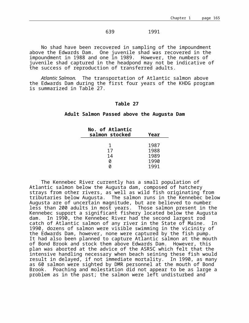
Chapter 1 page 166
B. Intervention
The State Planning Office shall automatically intervene on the State's behalf in all FERC licensing proceedings for hydropower projects in Maine, and, as appropriate, in selected FERC preliminary permit and license exemption proceedings.
C. Agency Comments
The State Planning Office shall monitor and review all proposed State agency comments to FERC on all licensing, relicensing and exemption applications for consistency with Executive Order No. 13 and this procedure. No later than 15 days prior to any FERC comment deadline, each State agency shall either (a) forward proposed comments to the State Planning Office and to all other agencies involved in the consultation and comment process, or (b) notify the State Planning Office that is has no comments.
The State Planning Office will review all agency comments for consistency and direct the agency to send them to FERC. If SPO finds that comments by agencies are conflicting or inconsistent with State policy, it shall 1) direct the agency whose comments are in question to withhold the transmittal of these comments to FERC, and 2) convene a meeting of the agencies affected to discuss the issues and to mediate a resolution consistent with State policy. Any revised comments which result from such a meeting will be circulated for further comment and within five days forwarded to FERC, if appropriate.
D. Comments Prior to BEP or LURC Decision
State agency comments to FERC or to applicants on hydropower license, relicense and exemption applications, submitted prior to regulatory actions of BEP and LURC, shall recommend no specific terms or conditions upon the federal license or exemption.
This shall not apply to comments submitted by the State Historic Preservation Officer pursuant to the National Historic Preservation Act.
E. Comments Subsequent to BEP or LURC Decision
Comments submitted to FERC subsequent to action by the BEP or LURC shall include a copy of the State decision issued pursuant to the MWDCA where applicable, and of the action on water quality certification pursuant to Section 401 of the Federal Clean Water Act. The written finding of fact shall include a summary of comments submitted by State agencies prior to the decision.
In addition, all comments submitted prior to State permit decisions shall include the following notice to FERC:
"These comments represent this agency's assessment to date of the proposed project, based on our statutory responsibilities. A decision of the Maine Board of Environmental Protection (or Maine Land Use Regulation Commission) on any application for a State hydropower permit and action by the Board on water quality certification pursuant to Section 401 of the Federal Clean Water Act, and any terms and conditions contained therein, shall represent the sole official position of the State of Maine regarding the subject application."

Chapter 1 page 167
F. Comments after FERC Comment Deadline
Any comments proposed after FERC's official comment deadline has passed shall first be forwarded to all other agencies on the Committee, and shall be reviewed in accordance with the procedure outlined in Section 5.C, para. 2.
G. Other FERC Proceedings
This coordination procedure shall also apply to State agency review and comment on draft FERC Environmental Impact Statements relating to specific projects, and on proposed FERC regulations.
For any project which falls under LURC jurisdiction, DEP and LURC shall also provide for the coordination of water quality certification proceedings before the BEP under the provisions of Section 401 of the Federal Clean Water Act, to assure consistent action by the two permitting bodies.
H. Public Participation
To provide a means for public participation in the State's role under the FERC hydropower licensing process, the policies and procedures below will be followed by appropriate State agencies unless otherwise precluded by State Law.
1. Upon receipt of consultation documents and FERC hydropower applications for new licenses, SPO will inform the public and interested third parties of each submittal by:
• Distribution of a "Notice of State Agency Review of FERC Hydropower Document" [hereinafter referred to as "the Notice"] to persons and parties who have previously requested to be notified of agency consultation activities generally or for specific hydro projects, and to those listed on a general Hydropower Mailing list maintained by SPO.
• Publication of the Notice in a newspaper of general State circulation.
• Release of the Notice to media of statewide and local circulation.
The Notice will:
• Identify the document under review;
• Indicate where copies may be viewed or obtained;

Chapter 1 page 168
• Explain how and when comments from the public should be submitted for inclusion in the State commenting process;
• Identify the State review agencies, indicate the topics of concern that each agency is responsible for addressing in comments or study requests, and how each agency may be contacted; and
• Explain how arrangements can be made to be kept informed of consultation meetings and to receive copies of the State comments.
2. Upon receipt of initial consultation documents and FERC applications for relicensing hydropower projects, SPO shall distribute a notification which includes information identical to the notices described in Section 1 above, to those listed on the general hydropower mailing list.
3. SPO and DEP (or LURC, if it has permitting jurisdiction) will each maintain a copy of the consultation document or FERC application for public review at their Augusta offices.
4. Each agency that receives public comments will forward a copy of those comments to SPO and to other appropriate review agencies so that each agency may benefit from this information in preparing comments. Public comments submitted to agencies may be considered in preparation of agency comments. At a minimum, public comments received before the agency commenting deadline will be attached to the State agency comments and forwarded to the applicant by SPO.

Chapter 1 page 169
APPENDIX C
Standards for Water Quality Classification andClassification of Surface Waters in Kennebec River Basin*
Standards for classification of fresh surface waters
The board shall have four standards for the classification of fresh surface waters which are not classified as great ponds.
1. Class AA waters. Class AA shall be the highest classification and shall be applied to waters which are outstanding natural resources and which should be preserved because of their ecological, social, scenic or recreational importance.
A. Class AA waters shall be of such quality that they are suitable for the designated uses of drinking water after disinfection, fishing, recreation in and on the water and navigation and as habitat for fish and other aquatic life. The habitat shall be characterized as free flowing and natural.
B. The aquatic life, dissolved oxygen and bacteria content of Class AA waters shall be as naturally occurs.
C. There shall be no direct discharge of pollutants to Class AA waters.
2. Class A waters. Class A shall be the second highest classification.
A. Class A waters shall be of such quality that they are suitable for the designated uses of drinking water after disinfection; fishing; recreation in and on the water; industrial process and cooling water supply; hydroelectric power generation, except as prohibited under Title 12, section 403; and navigation; and as habitat for fish and other aquatic life. The habitat shall be characterized as natural.
B. The dissolved oxygen content of Class A waters shall not be less than 7 parts per million or 75% of saturation, whichever is higher. The aquatic life and bacteria content of Class A waters shall be as naturally occurs.
C. Direct discharges to these waters licensed after January 1, 1986, shall be permitted only if, in addition to satisfying all the requirements of this article, the discharged effluent will be equal to or better than the existing water quality of the receiving waters. Prior to issuing a discharge license, the board shall require the applicant to objectively
----------------------------------------------
* This review does not reflect changes in the classification enacted by the Legislature in 1992 regarding hydropower-related impoundments.

Chapter 1 page 170
demonstrate to the board's satisfaction that the discharge is necessary and that there are no other reasonable alternatives available. Discharges into waters of this classification which were licensed prior to January 1, 1986, shall be allowed to continue only until practical alternatives exist. There shall be no deposits of any material on the banks of these waters in any manner so that transfer of pollutants into the waters is likely.
3. Class B waters. Class B shall be the third highest classification.
A. Class B waters shall be of such quality that they are suitable for the designated uses of drinking water supply after treatment; fishing; recreation in and on the water; industrial process and cooling water supply; hydroelectric power generation, except as prohibited under Title 12, section 403; and navigation; and as habitat for fish and other aquatic life. The habitat shall be characterized as unimpaired.
B. The dissolved oxygen content of Class B waters shall be not less than 7 parts per million or 75% of saturation, whichever is higher, except that for the period from October 1st to May 14th, in order to ensure spawning and egg incubation of indigenous fish species, the 7-day mean dissolved oxygen concentration shall not be less than 9.5 parts per million and the 1-day minimum dissolved oxygen concentration shall not be less than 8.0 parts per million in identified fish spawning areas. Between May 15th and September 30th, the number of Escherichia coli bacteria of human origin in these waters may not exceed a geometric mean of 64 per 100 milliliters or an instantaneous level of 427 per 100 milliliters.
C. Discharges to Class B waters shall not cause adverse impact to aquatic life in that the receiving waters shall be of sufficient quality to support all aquatic species indigenous to the receiving water without detrimental changes in the resident biological community.
4. Class C waters. Class C shall be the fourth highest classification.
A. Class C waters shall be of such quality that they are suitable for the designated uses of drinking water supply after treatment; fishing; recreation in and on the water; industrial process and cooling water supply; hydroelectric power generation, except as prohibited under Title 12, section 403; and navigation; and as a habitat for fish and other aquatic life.
B. The dissolved oxygen content of Class C water shall be not less than 5 parts per million or 60% of saturation, whichever is higher, except that in identified salmonid spawning areas where water quality if sufficient to ensure spawning, egg incubation and survival of early life stages, that water quality sufficient for these purposes shall be maintained. Between May 15th and September 30th, the number of Escherichia coli bacteria of human origin in these waters may not exceed a geometric mean of 142 per 100 milliliters or an instantaneous level of 949 per 100 milliliters. The department shall promulgate rules governing the procedure for designation of spawning areas. Those rules shall include provision for periodic review of designated spawning areas and consultation with affected persons prior to designation of a stretch of water as a spawning area.
C. Discharges to Class C waters may cause some changes to aquatic life, provided that the receiving waters shall be of sufficient quality to support all species of fish indigenous to the receiving waters and maintain the structure and function of the resident biological community.

Chapter 1 page 171
Standards for classification of lakes and ponds
The board shall have one standard for the classification of great ponds and natural lakes and ponds less than 10 acres in size. Impoundments of rivers that are defined as great ponds pursuant to section 392 shall be classified as GPA or as specifically provided in section 467 and 468.
1. Class GPA waters. Class GPA shall be the sole classification of great ponds and natural ponds and lakes less than 10 acres in size.
A. Class GPA waters shall be of such quality that they are suitable for the designated uses of drinking water after disinfection, recreation in and on the water, fishing, industrial process and cooling water supply, hydroelectric power generation and navigation and as habitat for fish and other aquatic life. The habitat shall be characterized as natural.
B. Class GPA waters shall be described by their trophic state based on measures of the chlorophyll "a" content, Secchi disk transparency, total phosphorus content and other appropriate criteria. Class GAP waters shall have a stable or decreasing trophic state, subject only to natural fluctuations and shall be free of culturally induced algal blooms which impair their use and enjoyment. The number of Escherichia coli bacteria of human origin in these waters may not exceed a geometric mean of 29 per 100 milliliters or an instantaneous level of 194 per 100 milliliters.
C. There shall be no new direct discharge of pollutants into Class GPA waters. Aquatic pesticide treatments or chemical treatments for the purpose of restoring water quality approved by the board shall be exempt from the no-discharge provision. Discharges into these waters which were licensed prior to January 1, 1986, shall be allowed to continue only until practical alternatives exist. No materials may be placed on or removed from the shores or banks of a Class GPA water body in such a manner that materials may fall or be washed into the water or that contaminated drainage therefrom may flow or leach into those waters, except as permitted pursuant to section 391. No change of land use in the watershed of a Class GPA waterbody may, by itself or in combination with other activities, cause water quality degradation which would impair the characteristics and designated uses of downstream GPA waters or cause an increase in the trophic state of those GPA waters.
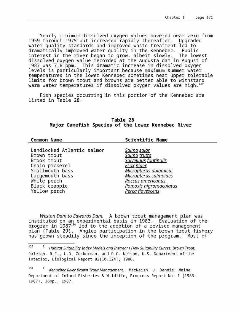
Chapter 1 page 172
Standards for classification of estuarine and marine waters
The board shall have three standards for the classification of estuarine and marine waters.
1. Class SA waters. Class SA shall be the highest classification and shall be applied to waters which are outstanding natural resources and which should be preserved because of their ecological, social, scenic, economic or recreational importance.
A. Class SA waters shall be of such quality that they are suitable for the designated uses of recreation in and on the water, fishing, aquaculture, propagation and harvesting of shellfish and navigation and as habitat for fish and other estuarine and marine life. The habitat shall be characterized as free-flowing and natural.
B. The estuarine and marine life, dissolved oxygen and bacteria content of Class SA waters shall be as naturally occurs.
C. There shall be no direct discharge of pollutants to Class SA waters.
2. Class SB waters. Class SB waters shall be the second highest classification.
A. Class SB waters shall be of such quality that they are suitable for the designated uses of recreation in and on the water, fishing, aquaculture, propagation and harvesting of shellfish, industrial process and cooling water supply, hydroelectric power generation and navigation and as a habitat for fish and other estuarine and marine life. The habitat shall be characterized as unimpaired.
B. The dissolved oxygen content of Class SB waters shall be not less that 85% of saturation. Between May 15th and September 30th, the numbers of enterococcus bacteria of human origin in these waters may not exceed a geometric mean of 8 per 100 milliliters or an instantaneous level of 54 per 100 milliliters. The numbers of total coliform bacteria or other specified indicator organisms in samples representative of the waters in shellfish harvesting areas may not exceed the criteria recommended under the National Shellfish Sanitation Program Manual of Operations, Part I, Sanitation of Shellfish Growing Areas, United States Department of Food and Drug Administration.
C. Discharges to Class SB waters shall not cause adverse impact to estuarine and marine life in that the receiving waters shall be of sufficient quality to support all estuarine and marine species indigenous to the receiving water without detrimental changes in the resident biological community. There shall be no new discharge to Class SB waters which would cause closure of open shellfish areas by the Department of Marine Resources.

Chapter 1 page 173
3. Class SC waters. Class SC waters shall be the third highest classification.
A. Class SC waters shall be of such quality that they are suitable for recreation in and on the water, fishing, aquaculture, propagation and restricted harvesting of shellfish, industrial process and cooling water supply, hydroelectric power generation and navigation and as a habitat for fish and other estuarine and marine life.
B. The dissolved oxygen content of Class SC waters shall be no less than 70% of saturation. Between May 15th and September 30th, the numbers of enterococcus bacteria of human origin in these waters may not exceed a geometric mean of 14 per 100 milliliters or an instantaneous level of 94 per 100 milliliters. The numbers of total coliform bacteria or other specified indicator organisms in samples representative of the waters in restricted shellfish harvesting areas may not exceed the criteria recommended under the National Shellfish Sanitation Program Manual of Operations, Part I, Sanitation of Shellfish Growing Areas, United States Food and Drug Administration.
C. Discharges to Class SC waters may cause some changes to estuarine and marine life provided that the receiving waters are of sufficient quality to support all species of fish indigenous to the receiving waters and maintain the structure and function of the resident biological community.
1. Kennebec River Basin
A. Kennebec River, main stem
• from Moosehead Lake, including east and west outlets, to a point 1,000 feet below the lake - Class A.
• from a point 1,000 feet below Moosehead Lake to its confluence with Indian Pond - Class AA.
• from Harris Dam to a point located 1,000 feet downstream from Harris Dam - Class A.
• from a point located 1,000 feet downstream from Harris Dam to its confluence with the Dead River - Class AA.
• from its confluence with the Dead River to the Rt. 201A bridge in Anson/Madison except for Wyman Lake - Class A.
• from the Rt. 201A bridge in Anson/Madison to the Fairfield/Skowhegan boundary, including all impoundments - Class B.
• from the Fairfield/Skowhegan boundary to its confluence with Messalonskee Stream - Class C.

Chapter 1 page 174
• from its confluence with Messalonskee Stream to the Sidney/Augusta boundary - Class B.
• from the Sidney/Augusta boundary to the Father John J. Curran Bridge in Augusta - Class C.
• from the Father John J. Curran Bridge in Augusta to a line drawn across the tidal estuary of the Kennebec River due east of Abagadasset Point - Class C. Further, the Legislature finds that the free-flowing habitat of this river segment provides irreplaceable social and economic benefits and that this use shall be maintained.
• from a line drawn across the tidal estuary of the Kennebec River due east of Abagadasset Point, to a line across the southwesterly area of Merrymeeting Bay formed by an extension of the Brunswick/Bath boundary across the bay in a northwesterly direction to the westerly shore of Merrymeeting Bay and to a line drawn from Chop Point in Woolwich to West Chop Point in Bath - Class B. Further, the Legislature finds that the free-flowing habitat of this river segment provides irreplaceable social and economic benefits and that this use shall be maintained.
B. Carrabassett River Drainage
• Carrabasset River, main stem:
a) above a point located 1.0 mile above the railroad bridge in North Anson - Class A.
b) from a point located 1.0 mile above the railroad bridge in North Anson to its confluence with the Kennebec River - Class B.
• Carrabassett River, tributaries - Class A unless otherwise specified:
a) all tributaries entering the Carrabassett River below the Wire Bridge in New Portland - Class B.
C. Cobbosseecontee Stream Drainage
• Cobbosseecontee Stream, main stem - Class B.
• Cobbosseecontee Stream, tributaries - Class B.
D. Dead River Drainage
• Dead River, main stem:
a) from the Long Falls Dam to a point 5,100 feet below the dam - Class A.
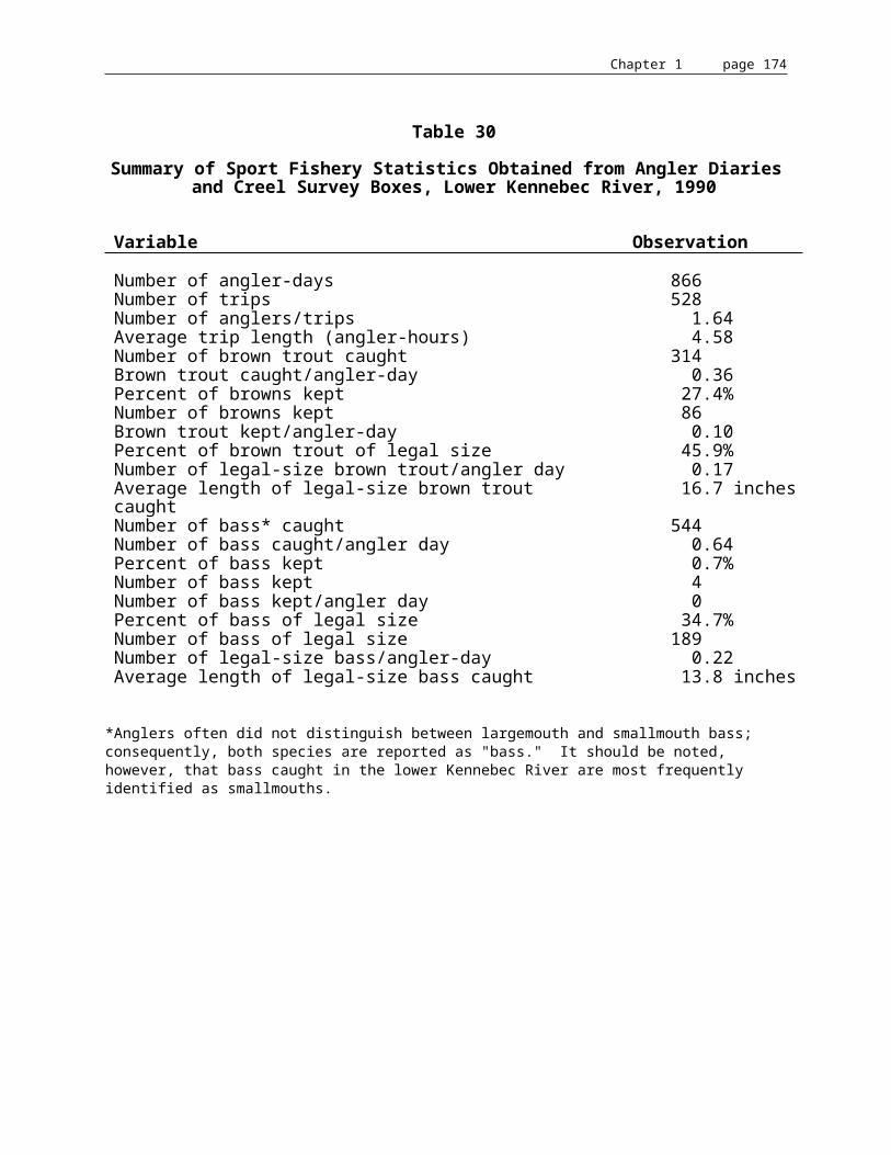
Chapter 1 page 175
b) from a point 5,000 feet below Long Falls Dam to its confluence with the Kennebec River - Class AA.
• Dead River, tributaries - Class A unless otherwise specified:
a) Black Brook below Dead River Hatchery - Class B.
b) Stratton Brook, Eustis, from the upper Rt. 16/27 bridge to its confluence with Flagstaff Lake - Class B.
c) Spenser Stream - Class B.
E. Messalonskee Stream Drainage
• Messalonskee Stream, main stem:
a) from the outlet of Messalonskee Lake to its confluence with the Kennebec River - Class C.
• Messalonskee Stream, tributaries - Class B.
F. Moose River Drainage
• Moose River, main stem:
a) above its confluence with Number One Brook in Beattie Township - Class A.
b) from its confluence with Number One Brook in Beattie Township to its confluence with Attean Pond - Class AA.
c) from the outlet of Attean Pond to the Rt. 201 bridge in Jackman - class A.
d) from the Rt. 201 bridge in Jackman to its confluence with Long Pond - Class B.
e) from the outlet of Long Pond to its confluence with Moosehead Lake - Class A.
• Moose River, tributaries - Class A.
G. Sandy River Drainage
• Sandy River, main stem:
a) from the outlet of Sandy River Ponds to the Rt. 142 bridge in Phillips - Class AA.

Chapter 1 page 176
b) from the Rt. 142 bridge in Phillips to its confluence with the Kennebec River - Class B.
• Sandy River, tributaries - Class B unless otherwise specified:
a) all tributaries entering above the Rt. 142 bridge in Phillips - Class A.
b) Wilson Stream, main stem, below the outlet of Wilson Pond - Class C.
H. Sebasticook River Drainage
• Sebasticook River, main stem, including all impoundments:
a) from the confluence of the East Branch and the West Branch to its confluence with the Kennebec River - Class C.
• Sebasticook River, tributaries - Class B unless otherwise specified:
a) Sebasticook River, East Branch main stem, from the outlet of Lake Wassookeag to its confluence with Corundel Lake - Class B.
b) Sebasticook River, East Branch main stem, from the outlet of Corundel Lake to its confluence with the West Branch - Class C.
c) Sebasticook River, West Branch main stem, from the outlet of Great Moose Lake to its confluence with the East Branch, including all impoundments - Class C.
I. Kennebec River, minor tributaries - Class B unless otherwise specified
• all minor tributaries entering above Wyman Dam that are not otherwise classified - Class A.
• all tidal portions of tributaries entering between Edwards Dam and a line drawn across the tidal estuary of the Kennebec River due east of Abagadasset Point - Class C.
• Cold Stream, West Forks Plantation - Class AA.
• Moxie Stream, Moxie Gore, below a point located 1,000 feet downstream of the Moxie Pond dam - Class AA.
• Austin Stream and its tributaries above the highway bridge of Rt. 201 in the Town of Bingham - Class A.
J. Cobbosseecontee Stream, main stem - Class B.

Chapter 1 page 177
APPENDIX D
Antidegradation Policy38 MRSA §464, Subchapter 4, Paragraph F
(1) Existing in-stream water uses and the level of water quality necessary to protect those existing uses shall be maintained and protected. Existing in-stream water uses are those uses which have actually occurred on or after November 28, 1975, in or on a water body whether or not the uses are included in the standard for classification of the particular water body.
Determinations of what constitutes an existing in-stream water use on a particular water body shall be made on a case-by-case basis by the Board of Environmental Protection. In making its determination of uses to be protected and maintained, the Board shall consider designated uses for that water body and:
(a) Aquatic, estuarine and marine life present in the water body;
(b) Wildlife that utilize the water body;
(c) Habitat, including significant wetlands, within a water body supporting existing populations of wildlife or aquatic, estuarine or marine life, or plant life that is maintained by the water body;
(d) The use of the water body for recreation in or on the water, fishing, water supply, or commercial activity that depends directly on the preservation of an existing level of water quality. Use of the water body to receive or transport waste water discharges is not considered an existing use for purposes of this antidegradation policy; and
(e) Any other evidence which, for divisions (a), (b), and (c), demonstrates their ecological significance because of their role or importance in the functioning of the ecosystem or their rarity and, for division (d), demonstrates its historical or social significance.
(1A) The board may only issue a waste discharge license pursuant to section 414-A, or approve a water quality certification pursuant to the U.S. Clean Water Act, Section 401, Public Law 92-500, as amended, when the board finds that:
(a) The existing in-stream use involves use of the water body by a population of plant life, wildlife, or aquatic, estuarine or marine life, or as aquatic, estuarine, marine, wildlife, or plant habitat, and the applicant has demonstrated that the proposed activity would not have a significant impact on the existing use. For purposes of this division, significant impact means:

Chapter 1 page 178
• Impairing the viability of the existing population, including significant impairment to growth and reproduction or an alteration of the habitat which impairs viability of the existing population; or
(b) The existing in-stream use involves use of the water body for recreation in or on the water, fishing, water supply or commercial enterprises that depend directly on the preservation of an existing level of water quality and the applicant has demonstrated that the proposed activity would not result in significant degradation of the existing use.
The board shall determine what constitutes a population of a particular species based upon the degree of geographic and reproductive isolation from other individuals of the same species.
If the board fails to find that the conditions of this subparagraph are met, water quality certification, pursuant to the U.S. Clean Water Act, Section 401, Public Law 92-500, as amended, is denied.
(2) Where high quality waters of the State constitute an outstanding national resource, that water quality shall be maintained and protected. For purposes of this paragraph, the following waters shall be considered outstanding national resources: those water bodies in national and state parks and wildlife refuges; public reserved lands; and those water bodies classified as Class AA and SA waters pursuant to section 465, subsection 1; section 465-B, subsection 1; and listed under sections 467, 468 and 469.
(3) The board may only issue a discharge license pursuant to section 414-A or approve water quality certification pursuant to the U.S. Clean Water Act, Section 401, Public Law 92-500, as amended, if the standards of classification of the water body and the requirements of this paragraph will be met.
(4) Where the actual quality of any classified water exceeds the minimum standards of the next highest classification, that higher water quality shall be maintained and protected. The board shall recommend to the Legislature that that water be reclassified in the next higher classification.
(5) The board may only issue a discharge license pursuant to section 414-A or approve water quality certification pursuant to the U.S. Clean Water Act, Section 401, Public Law 92-500, as amended, which would result in lowering the existing quality of any water body after making a finding, following opportunity for public participation, that the action is necessary to achieve important economic or social benefits to the State and when the action is in conformance with subparagraph (3). That finding must be made following procedures established by rule of the board.

Chapter 1 page 179
APPENDIX E
Classification of Stream and River Segmentsin the Kennebec Basin according to the Maine Rivers Study
• "A" Rivers (value greater than state significance)
-- Lower Kennebec (Bay Point to Augusta)-- Dead River (Kennebec River to Flagstaff Lake)-- Upper Kennebec (the Forks to Harris dam)-- Moxie Stream (Kennebec River to headwaters of Moxie Pond)-- Cobboseecontee Stream (Kennebec River to Cobboseecontee Lake)-- Moose River (Attean Pond to the Canadian border)-- Number Five Bog Stream (Moose River to Schoodic Lake)
• "B" Rivers (value with outstanding statewide significance)
-- Main stem (Madison to the Forks)-- Carrabasset River (Kennebec River to headwaters)-- Sandy River (Kennebec River to headwaters)
• "C" Rivers (statewide significance)
-- Augusta to Madison-- Dead River, North Branch (Flagstaff Lake to headwaters of Chain of Ponds)-- Dead River, South Branch (Flagstaff Lake to headwaters of Saddleback Lake)-- Messalonskee Stream (Kennebec River to Messalonskee Lake)-- Carrabassett Stream (Kennebec River to County Line)-- Sebasticook River (Kennebec River to headwaters)-- Roach River (Moosehead Lake to Seventh Roach Pond)
• "D" Rivers (regional significance)
-- Indian Pond to Moosehead Lake

Chapter 1 page 180
APPENDIX F
Acronyms for the Kennebec River Resource Management Plan
ASRSC -- Atlantic Sea-Run Salmon CommissionBPL -- Bureau of Public LandsBPR -- Bureau of Parks & RecreationFERC -- Federal Energy Regulatory CommissionCMP -- Central Maine Power CompanyDECD -- Department of Economic and Community DevelopmentDEP -- Department of Environmental ProtectionDMR -- Department of Marine ResourcesFEMA -- Federal Emergency Management AgencyIF&W -- Department of Inland Fisheries & WildlifeIFIM -- Instream Flow Incremental MethodologyKHDG -- Kennebec Hydro Developers GroupKWPC -- Kennebec Water Power CompanyLURC -- Land Use Regulation CommissionMEMA -- Maine Emergency Management AgencyMWDCA -- Maine Waterway Development & Conservation ActNEPA -- National Environmental Policy ActNFIP -- National Flood Insurance ProgramNKRPC -- North Kennebec Regional Planning CommissionOCP -- Office of Comprehensive PlanningSPO -- State Planning OfficeUSFWS -- U.S. Fish & Wildlife Service
Chapter 1 page 181
APPENDIX G
Basis Statement and Summary of Comments
Kennebec River Resources Management Plan
BASIS STATEMENT: The Kennebec River Resources Management Plan responds to the requirements of a Maine statute enacted in 1989 titled "An Act to Ensure Notification and Participation by the Public in Licensing and Relicensing of Hydroelectric Dams and to Further Ensure the Equal Consideration of Fisheries and Recreational Uses in Licensing and Relicensing." This statute, codified at 12 MRSA §407, requires the State Planning Office (SPO) to work with the natural resource agencies of the State to develop a management plan for each watershed in the State with a hydropower project currently or potentially regulated by the Federal government. The Plan responds to the requirements of the Maine statute with respect to the Kennebec River. The Kennebec River Resource Management Plan also serves as the State's "comprehensive plan" for the Kennebec River for purposes of consideration by the Federal Energy Regulatory Commission (FERC) regarding hydroelectric licensing and relicensing within the Kennebec basin.
The Kennebec River Resource Management Plan represents a comprehensive examination of the various resources and beneficial uses of the Kennebec River. The Plan discusses each of these resources and beneficial uses and, consistent with existing State policies, makes certain recommendations that reflect the State's determination of how those resources and beneficial uses should be balanced against one another in various circumstances. The Plan also incorporates and updates existing State policies regarding Kennebec River resources.
Informal hearings were held in October 1991 in Skowhegan and Augusta on an earlier draft of the plan. Formal public hearings were held on the most recent draft of the plan in Bingham on August 26, 1992 and in Augusta on August 27, 1992. The deadline for receipt of public comments was extended from September 25 until November 2, 1992 at the request of representatives of municipalities between Augusta and Waterville.
Many comments on the plan were received during the public hearings and comment period. The comments are summarized below and are followed by SPO's rationale for adopting or declining to adopt proposed changes in the plan. Where consideration of comments resulted in changes to the Plan, this has been noted; otherwise, recommended changes in the Plan were not adopted.
Many comments received were supportive of the Plan in its current form.
A number of comments addressed the process by which the Plan was developed. These comments do not bear directly on the contents of the Plan; as a result, the responses to these comments, while noted, are not reflected in any changes to the Plan itself.
One comment noted that SPO does not have regulatory authority in dam permitting. The SPO agrees with this comment noting that the Plan is not intended to supplant the process by which regulatory decisions regarding the permitting of hydroelectric facilities and storage dams are made.

Chapter 1 page 182
Some comments stated that the Plan, and the process of its development, represented an attempt to deprive Edwards Manufacturing Company of its right to own and operate its hydroelectric facility and an attempt to impair relicensing of its dam. The Legislature, in enacting 12 MRSA § 407, mandated SPO to develop this, and other, comprehensive plans. The Plan is the result of an objective analysis of relevant data; policy recommendations regarding the most beneficial balancing of resources and uses of the Kennebec River Basin are based on the best professional judgment of natural resource specialists from several State agencies as coordinated by SPO.
One comment was received regarding perceived inconsistencies in the rulemaking process. Rulemaking formally began with the filing of SPO's regulatory agenda with the appropriate standing committees of the Legislature and with the Secretary of State on May 27, 1992. As noted above, informal hearings on an earlier draft of the Plan were held in October of 1991. However, as no regulatory agenda had been filed in 1991 stating SPO's intention to promulgate the Plan as a rule, these informal hearings could not be considered as satisfying the requirements of the Administrative Procedures Act.
One comment asserted that SPO had ignored comments of other State agencies in the development of the Plan. Development of the Plan entailed establishment of consensus among several professional analysts, scientists and policy development specialists for any one of the many complex issues addressed by the Plan. SPO's role in the development of the Plan, as in the development of FERC consultation documents, was to make the final judgment regarding the nature of the consensus derived. In no case did SPO include a policy recommendation in the Plan that was not supported by a majority of the professional staff involved in the decisionmaking process.
Several comments called for timely adoption of the Plan. The timeframe for adoption of the Plan has been a function of : 1) the lengthy analysis required of the many complex issues involved, 2) requirements of the Administrative Procedures Act, and 3) limitations on the resources available to SPO to complete this and other plans. One purpose of the Plan is to provide a basis for State agency comments, recommendations, and permitting decisions related to the licensing and relicensing of hydroelectric facilities. Although originally intended in part to aid State agencies during the FERC consultation process for the ten Kennebec Basin dams whose relicensing application deadlines passed in 1992, the Plan remains relevant for several reasons: 1) five of these dams have refiled applications for water quality certification, proceedings which will be subject to State agency comment over at least the next several months; 2) FERC will consider the Plan as its pursues the lengthy process of relicensing the ten dams mentioned above; 3) First Roach Dam may be required to apply for FERC licensing and therefore be subject to the consultation process; 4) FERC has requested that additional studies be conducted regarding the application for relicensing of the Edwards Dam; as a result, State agencies will be provided with an opportunity to comment on the design and results of requested studies; 5) Flagstaff storage dam began the five-year FERC consultation process in January, 1993; 6) four other dams will begin the consultation process in the next ten years.
Several comments reflected the opinion that the Plan is not a comprehensive river management plan. Some of these comments described the Plan as too heavily focussed on the Edwards Dam. Any perceived focus on the Edwards Dam is a function of the relative impact of the dam on the fisheries resources of the Kennebec River. Due to its location at head of tide, the Edwards Dam has the greatest impact on the fisheries of the river of any dam. As noted in the
Chapter 1 page 183
Plan, anadromous species, including those which will not use fish ladders, are severely impacted by the current dam.
Several comments requested that the same level of detail applied to the analysis of Edwards Dam be applied to the other dams in the Kennebec basin. As noted above, Edwards Dam uniquely affects the basin. Analysis of the balance of uses at other dams in the basin did not warrant the development of policy recommendations such as those applied to Edwards Dam.
One comment was received recommending that the Plan address the cumulative impact of releases of up river lakes and impoundments on the fish habitat of the entire river. The flow of the river is interrupted by a series of impoundments; therefore, each dam's impact on fish habitat is generally limited to its impoundment and to the portion of the river between that dam and the next downstream dam. These impacts are addressed in the licensing and relicensing of individual projects.
One comment noted that the Plan should not be considered a "comprehensive plan" but rather a component of the State's Comprehensive Rivers Management Plan. The legislation enabling the Plan requires that such plans be adopted as components of the State's Comprehensive Rivers Management Plan. FERC refers to such components of the State's Comprehensive Rivers Management Plan as "comprehensive plans;" therefore, the Plan is both a "comprehensive plan" and a component of the State's Comprehensive Rivers Management Plan.
This comment further noted that the Plan should not be described as intended to be used by FERC as the definitive document concerning beneficial uses of the Kennebec River. Although SPO does not see any inconsistency with the legislation enabling the Plan to call it a "definitive document," the Plan has been edited to reflect this request.
A number of comments addressed perceived inconsistencies with various State and federal laws. One reviewer disagreed with the Plan's noted relevancy of Section 404 of the Clean Water Act and the National Environmental Policy Act. Congress has declared that FERC is subject to these laws as they pertain to the examination of threats to wetlands and environmental quality potentially caused by federal actions. Pursuant to NEPA and the Federal Power Act, FERC produces either an Environmental Assessment or an Environmental Impact Statement to support licensing or relicensing.
One comment suggested that the recent Maine Supreme Court decision regarding water quality was overstated. Language from the decision itself has been inserted in the Plan to clarify this point.
One who commented felt that the Plan overstated the jurisdiction of Section 401 of the Clean Water Act by referring to "activities" rather than "discharges." The Supreme Court decision noted in the paragraph above supported the State's position that the application of Section 401 is not limited to projects with discharges.
One comment requested that the chapter in the Plan entitled "Criteria for State Agency Decisionmaking" be expanded to specifically address requirements for receiving water quality certification as part of the process of relicensing dams. The Plan has been so amended.
One comment noted that more effort should be applied to achieving adoption of the Kennebec Hydro Developers' Group (KHDG) Fish Passage Agreement. On October 22, 1993 FERC denied a request for rehearing and let stand staff orders amending project licenses to incorporate the KHDG agreement. This action has been noted in the Plan.

Chapter 1 page 184
Some comments reflected a concern that the Plan demonstrated a bias against hydroelectric development; that the importance of hydroelectricity to the region and references to State policy that endorses hydropower were not included in the Plan. Similar, although less explicit, comments were received regarding the perception that the Plan was biased towards hydroelectric development; these recommended greater emphasis on wetlands, wildlife habitat, shoreland protection, and recreational opportunities. SPO recognizes that such issues as the perception of bias are difficult, if not impossible, to resolve to the satisfaction of all parties. The benefits of hydropower have been more fully noted in the Plan. The Plan represents a balanced view of the many uses of the Kennebec River.
One comment requested that the Plan incorporate an analysis of the net present value of the power generated by the Kennebec basin's projects over the life of the current and proposed licenses in order to demonstrate the economic benefit provided to licensees. This comment went on to characterize the benefit accruing to owners of hydroelectric facilities as a public subsidy and requested that the Plan require that the public benefits received from each project be commensurate with the financial benefits and power enjoyed by owners of facilities licensed to use the river for power generation. Although hydroelectric facilities generate profits for their owners, the generation of power also provides benefits to residents of the region and the State in terms of providing jobs, indigenous power, taxes, and by other means. The financial benefit to the owners of a hydroelectric facility of operating that facility is not relevant to the balancing of river resources and uses that is required by regulations governing hydroelectric generation.
Two comments questioned the methods used in the Plan to quantify the hydroelectric potential of the Kennebec River. SPO agrees that these methods are inaccurate and has edited the Plan to incorporate a more accurate method, supplied by one reviewer, for estimating hydroelectric potential.
A number of comments addressed the issue of mitigation. One comment opined that mitigation programs are not relevant under the relicensing process, especially with respect to the State role and that pre-project conditions are not appropriate as baselines for the design of mitigation programs. A second comment asserted that applicants should be required to compare pre-project and current environmental conditions as a basis for mitigation requirements and to provide mitigation plans. Mitigation can be a central focus of the consultation process, one in which representatives of State agencies are closely involved. The determination of a baseline against which to measure the requirements for mitigation must be determined on a case-by-case basis. Mitigation plans are required when indicated by the analysis of balance among resources and uses rather than as a general rule.
One comment contested the Plan's reference to the potential significance of First Roach Dam. The State stands by its contention that this dam poses potentially significant hazards to public safety and risks to the environment. The comment also asserted that the First Roach Dam was constructed only for log driving and not for power production. The Plan has been edited to reflect this comment.
Two comments expressed a concern that the Plan would set a precedent for removal of dams other than Edwards. However, the Plan explicitly states that the recommendation of removal of the Edwards Dam is in large part a function of the dam's location at head of tide and that this recommendation for removal is not to be construed as an invitation to seek wholesale removal of the State's hydroelectric facilities.

Chapter 1 page 185
In a similar vein, one comment noted that the Plan's stated objective to reduce the cumulative impacts of dams on the shad restoration program implied a management strategy that would affect dams other than Edwards. In fact, the objective, as stated in the Plan, is to reduce the cumulative impacts of dams on the shad restoration program by seeking removal of the Edwards Dam. The objective does not imply efforts to remove other dams.
Many comments addressed the Plan's recommendation for removal of the Edwards Dam in Augusta. One who commented made the point that the relatively high cost of power generated by Edwards should not be a factor in assessing the fate of the dam because this high cost could not be anticipated. The price of power generated by the dam is dictated in the terms of the contract between Edwards Manufacturing Co., Inc. and Central Maine Power Company which was signed in the early 1980's. Although power costs have not risen as steeply as predicted at the time this contract was signed, the fact remains that the price of power generated at Edwards, and a number of other generating stations, is much higher than today's avoided cost rate. A second comment noted resentment that property was being submerged in order to generate power that cost much more than replacement power.
Several comments related to the effect of removal of Edwards Dam on the impoundment and the services it provides. One comment addressed a concern that loss of the impoundment would result in reduced black duck habitat; another comment contradicted this conclusion. Open water is more highly valued waterfowl habitat than free flowing waters; however, open water is not typical habitat for black duck which prefer beaver flowages, large wetlands, emergent and wooded wetlands, if distant from populated areas.
Several comments also claimed that there was a lack of assessment of the impact of dam removal on wetlands in the area and the potential for destruction of a 150 year old ecosystem. Although detailed analysis of the impact of dam removal on wetlands necessarily must await further study, initial review of this issue indicates that positive effects, in terms of improved habitat for aquatic species, will outweigh negative effects on those waterfowl and other species which prefer a flatwater resource. One comment expressed an opinion that removal of the dam would not restore the river as proposed because much water would still be impounded above Waterville. It is the location of the Edwards Dam at head of tide that makes its removal of potential significance in the restoration of many of the Kennebec's fisheries.
A number of comments noted concerns regarding changes in the shoreline of the impoundment should the dam be either removed or enlarged. Although relatively few property owners are expected to experience undesirable results as a consequences of dam removal, it is anticipated that some shoreline changes may negatively impact aesthetic values, boat access and the use of dry hydrants, etc. However, the benefit to the residents of the State of allowing the impoundment to revert to a free flowing river outweighs any loss of amenities which may be experienced by shorefront homeowners.
A number of issues raised regarding the removal of Edwards Dam were beyond the scope and intent of the plan. These included the potential flooding of minable gravel deposits, the effect of changes in the impoundment on property values, potential changes in municipal boundary lines that occur at the thread of the river, and possible means of financing dam removal.
Fisheries issues dominated a number of comments regarding the recommendation for removal of Edwards Dam. A number of comments raised concerns regarding the impact on brown trout and smallmouth bass fisheries above the dam if the dam is removed. As stated in

Chapter 1 page 186
the Plan, the restoration of anadromous fisheries to the Kennebec should enhance both the brown trout and sea run brown trout fisheries by providing increased forage for these species. The impact of dam removal on the smallmouth bass fishery is less predictable because this species is adaptable and opportunistic. It is possible that smallmouth bass will continue to produce at the same rate/acre as currently occurs; however, loss of still water habitat will reduce the total landed catch. The smallmouth bass would be expected to continue to support a fishery; however, it will be conducted by wading and from small rather than large boats. The anticipated changes in this fishery would be offset by the benefit resulting from a substantial increase in riverine fishing opportunity upstream from the dam site.
A number of comments pointed out that removal of the Edwards Dam would provide access to the upper river to pest species such as carp and lamprey eels. Lamprey eels occur above the Edwards Dam. They range as far upriver as the dams in Waterville and Winslow. The potential effect of the removal of Edwards Dam on the range of carp was analyzed in 1986 by the Maine Department of Inland Fisheries and Wildlife. The removal of the dam would result on the extension of the range of carp in the mainstem of the Kennebec as far upriver as the next impassable dam in Waterville. Carp prefer sluggish, warm, soft-bottomed, vegetated waters. With the dam removed, little of this habitat would remain and carp would not be expected to do well. The potential risk of introducing carp above Augusta is outweighed by the benefit resulting from a substantial increase in the amount of riverine fishing opportunity in this part of the State. This analysis has been added to the Plan.
One comment stated that fish passage at Edwards would be sufficient to achieve fisheries goals; however, as described in the Plan, a number of anadromous species do not use fishways.
One comment expressed the opinion that the Plan's statement that removal of the Edwards Dam is necessary to promote the Kennebec River's fisheries and recreational resources is too broad. This statement has been modified to say that removal of the dam is necessary to achieve the State's goals for restoration of the Kennebec's fisheries and recreational resources.
One comment asserted that the Plan fails to address the downstream implications of the removal of Edwards Dam. The restoration of several anadromous fisheries that is expected to follow from dam removal will restore large populations of fish to that portion of the Kennebec downstream from the site of Edwards Dam. In addition to supporting a potentially significant sport fishery, these populations will contribute to restoring the Kennebec's estuarine/tidal ecosystem, including Merrymeeting Bay, to a more naturally functioning state. The Plan has been amended to reflect this information.
A number of comments stated that the Plan does not address the potential release of toxic contaminants if the Edwards Dam is removed. An example of contamination resulting from the removal of a dam on the Hudson River was cited. The Plan relies upon the results of sediment toxicity testing carried out upriver of the Edwards Dam and these studies indicate that there is no toxic residue behind the dam (Expected water quality changes from removal of Edwards Dam, Augusta. 16 February 1992, and Addendum 23 February 1992, Maine Department of Environmental Protection).
One comment expressed the opinion that the Edwards impoundment is needed in order to dilute pollution coming from up river. In fact, the impoundment has the opposite effect because it slows down the flow of water and wastes and can contribute to lower than normal dissolved oxygen.

Chapter 1 page 187
Several comments addressed the Plan's analysis of the removal of the impact of the removal of Edwards dam on recreational benefits in the area. Some of these comments asserted that such benefits had been overstated; that the Kennebec would only draw fishermen away from other areas rather than generating increased recreation; that the economic benefits of increased recreational activity would not be sufficient to offset the negative effect on Augusta's tax base of dam removal. Other comments asserted that the recreational benefits of dam removal had been understated; that dam removal would boost already significant guiding activity on the river; that the Augusta area could expect to experience the type of economic growth that has followed restoration of shad fisheries in the Connecticut and Delaware Rivers and salmon fisheries in upstate New York. Additional studies will be needed to assess the validity of these comments.
Two comments addressed the role of the power generated at Edwards Dam. The first asserted the need for power from Edwards when Maine Yankee goes off line early next century. According to The Final Report of the Commission on Comprehensive Energy Planning, Maine State Planning Office, May 1992, "The goal of Maine energy policy should be to meet the State's energy needs with reliable energy supplies at the lowest possible cost, while at the same time ensuring that our energy production and use is consistent with Maine's goals for a healthy environment and a vibrant economy." This report goes on to state that Maine's energy policy is to promote the continued development of renewable indigenous resources only when it can be ensured "that any reliance on indigenous resources is consistent with state objectives for the proper use and conservation of those resources."
The second comment questioned the need for power generated by Edwards Dam when a large amount of Maine's indigenous power is currently exported out-of-state. Exports of Maine's indigenous power are a function of membership of Central Maine Power and Bangor Hydro Electric Company in the New England Power Pool. Power pooling allows its members to achieve a higher reliability level with less capacity than would be required without a pool and, therefore, at lower cost. Pooling may result in lower fuel costs because load increases draw the lowest cost energy from the pool.
One comment recommended that the negative implications of dam removal should be expanded upon in the Plan. References to potentially negative impacts of dam removal, such as the introduction of carp above Augusta, changes in the shoreline and wetlands in the area of the impoundment, changes in waterfowl habitat, and the loss of a flat water recreational resource, have been added to discussions in the Plan of balancing the advantages and disadvantages of removal of Edwards Dam.
One comment requested that the Plan address the impact of dam removal on shoreland zoning. Significant and permanent changes in the water level of impoundments in the Kennebec basin may alter the shoreland zone as designated by municipalities. As is now noted in the Plan, the effects of such changes would have to be evaluated on a case-by-case basis.
One comment asserted that removal of Edwards Dam would be detrimental to bald eagles which utilize the open water which can be found below the dam in the winter. Eagles are attracted to open water, such as occurs downstream of the Edwards Dam. However, because eagles are very nomadic in Maine during the winter and do not rely on anyone site and because it is likely that, without the dam, open water will occur naturally in the winter at one or more points between Augusta and Waterville, it is anticipated that removal of Edwards Dam will not adversely impact bald eagles.

Chapter 1 page 188
One comment suggested that restoration of the smelt fishery was unnecessary due to problems in the lobster industry. The proposed restoration of the smelt in the Kennebec River is unrelated to the lobster industry.
One comment noted that the State should focus on cleaning up the river as it is rather than on the removal of Edwards Dam. The State views restoration of habitat as a logical complement to its ongoing efforts to improve water quality in the Kennebec River.
One comment noted that removal of Edwards Dam would allow access to archeological sites. This has been so noted in the Plan.
One comment requested information on the impact of the removal of Edwards Dam on flood control. The Edwards Dam has little effect on flood control for two reasons: 1) The dam is operated in run of river mode with the result that the dam is not used to store water; and 2) at high flows, the effect of the dam is reduced because the water level in the channel below the dam rises to the point that the dam is submerged or nearly submerged.
One comment asserted that the discussion of water quality in the Plan is limited. Additional information on water quality has been added to the Plan.
One comment recommended that the balance among fisheries, recreation and hydropower can best be achieved by looking at the river as a whole rather than forcing this balance at each dam. According to the writer, under this scenario, the best section of the river for a fishery should be managed as a fishery, the best section for whitewater recreation ought to be managed for whitewater recreation, etc. The interconnectedness of the uses of the river prevents basin-wide mitigation from achieving an effective balance of uses. For example, commercial whitewater recreation benefits from the predictability of established dam releases. Similarly, management of a section of river solely for hydropower generation would affect flows necessary to support fisheries and fishing opportunity. Management of a section of river solely for fisheries might require run of river flows, compromising hydropower generation in the area.
A second comment proposed mitigation for necessary losses in fisheries due to power production in the form of enhanced flows for recreation, protection of the river corridor and water quality, and improved access. Mitigation of fishery losses must compensate in kind for those losses; enhanced flows for boating, river corridor protection, etc., would not constitute mitigation for fisheries losses and could even contribute to those losses.
Several comments were received regarding flows. Two comments called for recreational releases on the Roach River and at East and West Outlet. As a result of the consultation process, the operator of West Outlet has agreed to a continuous release of 120 cfs during the summer recreation season to enhance recreational canoeing. At this time, additional recreational releases in these areas appear to be incompatible with maintenance of fish habitat and fishing opportunity.
One comment recommended that the Plan call for "meaningful public management" of flows and reservoir levels and for improvement of this management to enhance non-power values. Flows and reservoir levels are managed by KWPC, a private entity, as granted by Legislative charter. The interests of the State and federal governments are represented during the licensing process and may, if necessary, be included in the license as conditions. The State has found that this system of management serves the public interest and that non-power values do not suffer as a result of this system of management.

Chapter 1 page 189
One comment recommended that the Plan require applicants to describe hydrologic cycles, species and habitat affected by drawdowns, and wetland losses and to provide plans for mitigation of adverse impacts. Where these issues have been found to be relevant, they are noted in the Plan. While some of these issues are not addressed for each dam site, or for any dam site, it is assumed that they will, if necessary, be addressed on a case-by-case basis during licensing.
One comment asserted that the allowance for flows less than Aquatic Base Flow that is described in the hydropower policies contradicts the goals for inland fisheries. Because the allowance for flows less than Aquatic Base Flow is conditional on maintenance of aquatic organisms, it is not seen as contradicting the goals for inland fisheries
One comment provided updated information on the schedule and rate of releases on the Kennebec and Dead Rivers. The Plan has been amended to include this information.
Two comments addressed the issue of water level fluctuations in impoundments. One comment asserted that the Plan focussed on the disadvantages of fluctuating water levels without describing the benefits of fluctuations. Such fluctuations are beneficial to the generation of hydropower and to the prevention of flood conditions. These benefits have been more fully described in the Plan. A second comment stated that the Plan should call for minimization of fluctuations. The need to protect lives and property against the threat of flooding would make such a policy unwise
One comment was received expressing concerns regarding flooding; it called for additional stream gages and installation of an early warning system. The Plan already recommends additional gages; the recommendation for an early warning system has been added.
One comment recommended that the Plan address the need for greater energy conservation by hydropower licensees. The issue of energy conservation by licensees is beyond the scope of the Plan.
Several comments asserted that the Plan is lacking with regard to discussion of the need for improved access and the impact of access fees. One comment went on to assert that current recreational enhancements are not commensurate with the benefits conferred upon licensees and that licensees should contribute to a recreational enhancement trust for the purpose of purchasing access. State analysis of the balance among resources and uses at the various dams undergoing relicensing did not reveal any required enhancements other than those already called for in the Plan. The issue of fees has been included in the Plan in the form of a recommendation for analysis of fees as an impediment to access.
A number of comments stated that the inland fisheries resources of the Kennebec River had been inadequately described in the Plan. Detailed descriptions of these fisheries have been added to the Plan.
One comment recommended new language for one of the recommendations regarding fisheries restoration. The existing language in the Plan more closely adheres to State policy. One comment asserted that the Plan places too much emphasis on potential fisheries habitat. Achievement of the State's goals for restoration of anadromous fisheries in some cases requires analysis of potential fisheries habitat. One comment recommended reorganizing the subchapter on fisheries; several changes have been made.

Chapter 1 page 190
One comment recommended that a section on ecological resources be added to the chapter on resources and beneficial uses in the Plan. The current design of the Plan best suits the purposes for which it was intended.
One comment recommended that the Plan should require that applicants for licenses provide a plan for shoreline protection. At this time, the State finds insufficient basis to include this recommendation in the Plan.

Chapter 1 page 192
BIBLIOGRAPHY
Atkins, C.G., 1870. Third Report of the Commissioners of Fisheries of the State of Maine for 1869.
Atkins, C.G., 1887. The River Fisheries of Maine - Quoted in: Goode, G.B., 1887. The Fisheries and Fishery Industries of the United States, Section V, Vol. 1.
Atkins, C.G. and N.W. Foster, 1869. Reports of the Commissioners of Fisheries of the State of Maine for the Years 1867 and 1868.
Atlantic Sea-Run Salmon Commission. Atlantic Salmon Management in the Kennebec River: A Status Report and Interim Management Plan.
AuClair, Roger P., 1982. Moosehead Lake Fishery Management Plan. Maine Department of Inland Fisheries & Wildlife, Fisheries Research Bulletin No. 11, 75pp.
Bigelow, H.B. and W.C. Schroeder, 1953. Fishes of the Gulf of Maine, U.S. Fish and Wildlife Service Fishery Bulletin #74, Vol. 53, 577pp.
Boone, J.G. and B.M. Florence, 1978. The Feasibility of Augmenting Maryland Striped Bass Populations through Hatchery Stockings, Maryland Department of Natural Resources; Mimeo, 3pp.
Cowardin, L.M., V. Carter, F.C. Golet, E.T. LaRoe, and J.H. Sather, 1979. Classification of Wetland and Deepwater Habitats of the United States, U.S. Department of the Interior, Washington, D.C.
Dadswell, M.J., 1979. Biology and Population Characteristics of the Shortnose Sturgeon, Acipenser brevirostrum, LeSeur 1818 (Osteichthyes Acipenseridae) in the Saint John River Estuary, New Brunswick, Canada, Canada J. Zoology, 57:2186-2210.
Dadswell, M.J., B.D. Taubert, T.S. Squiers, D. Marchette, and J. Buckley, 1984. Synopsis of Biological Data on Shortnose Sturgeon Acipenser brevirostrum LeSeur 1818, NOAA Technical Report, NMFS #14, U.S. Department of Commerce.
DeCola, J.N., 1970. Water Quality Requirements for Atlantic Salmon, USDI Federal Water Quality Administration, N.E. Region, Massachusetts, 42 pp.
Dovell, W.L., 1977. Biology and Management of Shortnose and Atlantic Sturgeons of the Hudson River, Federal Aid Project AFS-19-R-2, Annual Report, 130pp.
Elson, P.F., 1975. Atlantic Salmon Rivers, Smolt Production and Optimal Spawning: An Overview of Natural Production, IASF Special Publication 6, New England Atlantic Salmon Conference, pp.96-119.
Federal Power Act, 1986 Amendments, Electric Consumers Protection Act.
Fefer, S.I. and P.A. Schettig, 1980. An Ecological Characterization of Coastal Maine, FWS/OBS-80/29, Biological Services Program, U.S. Fish and Wildlife Service.
Flagg, L.N., 1971. Striped Bass and Smelt Survey, Annual Report for 1970, AFS-4-2.

Chapter 1 page 193
Flagg, L.N., 1972. Striped Bass and Smelt Survey, Annual Report for 1971, AFS-4-3.
Flagg, L.N., 1974. Striped Bass and Smelt Survey, Completion Report, AFS-4.
Flagg, L.N., 1984. Evaluation of Anadromous Fish Resources, Final Report, Federal Aid Project AFS-21-R, October 1, 1978 - May 15, 1983.
Fontaine, R.A., 1979. Drainage Areas of Surface Water Bodies of the Androscoggin River Basin in Southwestern Maine, U.S. Department of the Interior, Geological Survey, Open File Report.
Fontaine, R.A., 1980. Drainage Areas of Surface Water Bodies of the Kennebec River Basin in Southwestern Maine, U.S. Department of the Interior, Geological Survey, Open File Report.
Francis, J.R., D.H. Stommel, H.G. Farmer, and D. Parsons, Jr., 1953. Observations of Turbulent Mixing Processes in a Tidal Estuary, Woods Hole Oceanographic Institution, Woods Hole, Massachusetts.
Frenette, M., C. Rae, and B. Tetreault, 1972. The Creation of Artificial Salmon Pools, Department of Civil Engineering, Laval University, Quebec, pp.17-24.
Fried, S.M. and J.D. McCleave, 1973. Occurrence of the Shortnose Sturgeon (Acipenser brevirostrum), an Endangered Species, Montsweag Bay, Maine, Canada J. Fish Research Board, 30:563-564.
Fry, F.E.J., 1947. Temperature Relations of Salmonids, Proc. 10th Meeting Nat. Committee on Fish Cult., App. D.F.R.B. Canada.
Hulbert, P.J., 1974. Factors Affecting Spawning Site Selection and Hatching Success in Anadromous Rainbow Smelt (Osmerus mordax, Mitchell), M.S. Thesis, University of Maine, Orono, 44pp.
Knight, A.E., 1981. Unpublished data, Mad River, NH FWS. Laconia, New Hampshire.
Land and Water Associates, 1981. Recreational Study for the Outlets of Moosehead Lake.
Land and Water Associates, 1989. Central Maine Power Recreational Facilities Plan.
Leim, A.H. and W.B. Scott, 1966. Fishes of the Atlantic Coast of Canada, Fisheries Research Board of Canada, Bulletin #155.
MacNeish, J. Dennis, 1987. Kennebec River Brown Trout Management Plan. Maine Department of Inland Fisheries and Wildlife, Progress Report No. 1 (1983-1987), 36pp.
Maine Department of Conservation, January 1985. Maine Rivers Access and Easement Plan, Bureau of Parks and Recreation.
Maine Department of Conservation, August 1989. Bigelow Preserve Management Plan.
Maine Department of Conservation, December 1989. Holeb Unit Management Plan. Bureau of Public Lands, Augusta.
Maine Department of Environmental Protection, 1981. State of Maine 1990 Water Quality Assessment.

Chapter 1 page 194
Maine Department of Environmental Protection, 1990. Expected Water Quality Changes from Removal of the Edwards Dam, Augusta. 16 February 1990 and addendum 23 February 1990.
Maine Department of Inland Fisheries and Wildlife, 1981. Aerial photos of Merrymeeting Bay, Wetland Estimates, Wildlife Division, (Mimeo).
Maine Department of Inland Fisheries and Wildlife, November 1985. Roach River Strategic Plan for Fisheries.
Maine Department of Inland Fisheries and Wildlife, December 1987. Administrative Policy Regarding Hydropower Projects.
Maine Department of Inland Fisheries and Wildlife, Maine Department of Marine Resources, and Atlantic Sea Run Salmon Commission. Administrative Policy Regarding Hydropower Projects, (summarized).
Maine Department of Marine Resources, June 1982. Statewide Fisheries Management Plan.
Maine Department of Marine Resources, 1986. Lower Kennebec River Inland Fisheries Management Overview.
Maine Department of Marine Resources, 1986. Lower Kennebec River Anadromous Fish Restoration Plan.
Maine Department of Marine Resources, 1986. Strategic Plan and Operational Plan for the Restoration of Shad and Alewives to the Kennebec River above Augusta.
Maine Department of Marine Resources, August 1988. Policy Concerning Hydropower Projects.
Maine Department of Marine Resources, 12/90, revised February 1991. Kennebec River Anadromous Fish Restoration, Annual Progres Report - 1990.
Maine Historic Preservation Commission. Hydropower Policy.
Maine State Planning Office, January 1990. Maine Hydropower Relicensing Status Report.
Maine State Planning Office, August 1991. The 1991 Maine Energy Data Book.
Maine State Planning Office, September 1991. Second Stage State Agency Comments on the Augusta Hydroelectric Project.
Maine State Planning Office, May 1992. Final Report of the Commission on Comprehensive Energy Planning.
Maine Yankee Atomic Power Company, 1970-76. Environmental Surveillance Reports, Maine Yankee Atomic Power Company, Augusta, Maine.
McKenzie, R.A., 1964. Smelt Life History and Fishery in the Mirimichi River, New Brunswick, Fishery Research Board, Bulletin #144, ix +77pp.
North Kennebec Regional Planning Commission, 1974. Kennebec River Corridor Plan.

Chapter 1 page 195
Office of Policy and Legal Analysis, 1990. Annual Report of the Whitewater Advisory Committee.
Peterson, R.H., 1978. Physical Characteristics of Atlantic Salmon Spawning Gravel in some New Brunswick Streams, Fisheries and Marine Service Technical Report 785, 28 pp.
Peterson, R.H., P.G. Days, G.L. Lacrois, and E.T. Garside, 1982. Reproduction in Fish Experiencing Acid and Metal Stress in: Acid Rain/Fisheries, American Fishery Society, Bethesda, Maryland, pp.177-196.
Raleigh, R.F., L.D. Zuckerman, and P.C. Nelson, 1986. Habitat Suitability Index Models and Instream Flow Suitability Curves: Brown Trout. U.S. Department of the Interior, Biological Report 82(10.124).
Rathjen & Miller, 1955. Aspects of the Early Life History of the Striped Bass ( Roccus saxatilis ) in the Hudson River, New York. Fish & Game Journal 4(1): 43-60.
Robbins, A.P., 1971. The History of Vassalborough, Maine, 1771-1971. Maine State Library.
Shannon & Smith, 1967. Preliminary Observations of the Effect of Temperature on Striped Bass Eggs and Sac Fry. Proc. 21st Annual Conference Southeastern Association of Game and Fish Comm., pp.257-260.
Spencer, H.E., 1966. Merrymeeting Bay Investigations, Job Completion Report 4-A, Project W-37-R-9, Maine Department of Inland Fisheries and Game, Augusta, Maine.
Squiers, T.S., 1983. Evaluation of Spawning Run of Shortnose Sturgeon (Acipenser brevirostrum) in the Androscoggin River, Maine, Maine Department of Marine Resources.
Squiers, T.S., 1987. Kennebec River Anadromous Fish Restoration and Evaluation, Annual Report, Maine AFC-26-2.
Squiers, T.S., 1988. Anadromous Fisheries in the Kennebec River Estuary, Maine Department of Marine Resources.
Squiers, T.S. and King, 1990. Description of the Kennebec River between Augusta and Waterville Prior to Construction of the Augusta Dam, Maine Department of Marine Resources.
Squiers, T.S. and M.E. Smith, 1979. Distribution and Abundance of Shortnose and Atlantic Sturgeon in the Kennebec River Estuary, Completion Report AFC-19, 1976-1979, 51 pp.
Squiers, T.S., M.E. Smith, and L.N. Flagg, 1982. American Shad Enhancement and Status of Sturgeon Stocks in Selected Maine Waters, Completion Report: Maine AFC-20, 1979-82, 72 pp.
Squiers, T.S., M.E. Smith, and L.N. Flagg, 1984. Tag Loss and Mortality of Rainbow Smelt Tagged with Floy Anchor Tags. (Note: This is an appendices to Flagg, L.N., 1984; Evaluation of Anadromous Fish Resources.)
Stira and Smith, 1976. Distribution of Early Life Stages of American Shad in the Hudson River Estuary, Proceedings of a Workshop on American Shad, Amherst, Massachusetts.
Chapter 1 page 196
Symons, P.E.K., 1979. Estimated Escapement of Atlantic Salmon ( Salmo salar ) for Maximum Smolt Production in Rivers of Different Productivity. Canada J. Fish. Research Board, 35:175-183.
Taylor, C.E., 1951. A Survey of Former Shad Streams in Maine, USFWS Spec. Sci. Dept., Fisheries No. 66, 29pp.
U.S. Army Corps of Engineers. Kennebec River Basin Study, Vol. 1.
U.S. Army Corps of Engineers, February 1990. Water Resources Study: Kennebec River Basin, Maine.
U.S. Army Corps of Engineers, 1991. Maine Water Resources Development.
U.S. Geological Survey, 1970. A Proposed Streamflow Data Program for Maine, Augusta, Maine.
U.S. Geological Survey, 1992. Water Resources Data for Maine, Water Year 1991, Water Data Report, 91-1, 187pp.
Walton, C.J., 1982. Population Biology and Management of the Alewife (Alosa pseudoharengus) in Maine. Annual Report: Maine AFC-21-3, 1981-82, 37pp.
Warner, K., 1963. Natural Spawning Success of Landlocked Salmon, ( Salmo salar ) . Trans. Am. Fish. Society, 92 (2): 161-164.
Wheeler, G.A. and H.W. Wheeler, 1878. History of Brunswick, Topsham, and Harpswell, Maine. Alfred Mudge & Son Printers, Boston, Massachusetts.
Woodward, William, 1985. Seven Mile Stream Habitat Inventory. Maine Department of Inland Fisheries and Wildlife, Unpublished Report, 12pp.
Woodward, William, January 1989. Messalonskee Stream Fishery Management. Maine Department of Inland Fisheries and Wildlife, 6pp.