1 cariboo chilcotin land use plan - british columbia · included consideration for the overlapping...
TRANSCRIPT

South Chilcotin Sub-Regional Plan: Introduction
- 1 -
1 CARIBOO CHILCOTIN LAND USE PLAN
1.1 90-DAY IMPLEMENTATION REPORT
On October 24, 1994, the Provincial Government announced the Cariboo Chilcotin Land Use Plan (CCLUP). A 90-day Implementation Process was initiated to develop technical details, including resource targets for the plan. Three resource management zones, Special Resource Development, Integrated Resource Management, and Enhanced Resource Development, were established for sustainable natural resource development and recreational activities.
The CCLUP is designated as a “higher level plan” under the Forest Practices Code Act and guides the application of the Code in all CCLUP land use zones.
As a result of consultation and technical analysis, integrated land-based resource targets and strategies have been established for timber, range/grazing, mining, fish, wildlife, biodiversity conservation, water management, tourism, recreation, agriculture and wildcraft/agro-forestry, in the three land-use zones. The resource targets are consistent with the general directions provided by the CCLUP. The strategy statements express management objectives and actions necessary for the implementation of the CCLUP and the achievement of the resource targets.
The CCLUP includes specific guidelines that have been produced for managing development within the Special Resource Development Zones. In addition, the report identifies specific management policies for various new Protected Areas.
Technical details presented in the CCLUP 90-Day Report make up a template for the long term implementation of the Land Use Plan which, in turn, guides the application of legislation and the development of sub-regional plans.
1.2 INTEGRATION REPORT
The CCLUP 90-Day Implementation Report (1994) identified the need to complete additional work to improve land use certainty over the next few years. To do this, a test of the CCLUP targets was required. Thus, the Integration Report was developed to ensure the Plan was capable of delivering a balance of environmental sustainability, community stability and economic security.
In 1996, the scope of the Integration Report was expanded to develop a system that balances all of the strategies and targets developed by government agencies for the achievement of timber access, biodiversity, mule deer and caribou targets. The impact assessment reports completed for fisheries and visual resource targets were included in this task.
Under the direction of the Inter-Agency Management Committee, adjustments to the strategies were made, where required, to achieve all of the targets in a balanced manner. The analysis included consideration for the overlapping requirements among the strategies. The assumptions and strategy adjustments are the foundation for the Integration Report and subsequent implementation of the report.
The purpose of the integration process was to develop a management strategy that provided direction to Sub-Regional Planning and advice to operational planning and the establishment of landscape unit objectives with respect to achievement of all of the CCLUP targets.

South Chilcotin Sub-Regional Plan: Introduction
- 2 -
The Integration Process is a regional strategic level analysis. Inherent in a process of this scope is limitations on the ability of the analysis to anticipate and resolve all site-specific issues that arise. Therefore, it is at the Sub-Regional Planning level that the assumptions used in the Integration Process can be confirmed through the completion of a more site-specific spatial analysis (see Appendix V). The Integration Report, April 6 1998, was intended to give strategic direction to the Sub-Regional Plan exercise but not restrict the ability of planning teams to develop innovative, site-specific solutions to integrated resource management issues.
1.3 REGIONAL RESOURCE BOARD/INTER-AGENCY MANAGEMENT COMMITTEE
The Inter-Agency Management Committee (IAMC) and the Regional Resources Board (RRB) were given the responsibility, by government, to jointly implement the CCLUP.
The IAMC is comprised of managers representing government agencies in the Cariboo Chilcotin. The RRB is made up of members representing labour, small business, conservation, ranching, First Nations, forestry, mining, tourism, trapping, guide/outfitters, recreation and the Cariboo Economic Action Forum.
1.4 STATUTORY DECISION MAKER DIRECTION
The District Manager for the Williams Lake Forest District and the Designated Environment Official for the Cariboo Region, both Statutory Decision Makers, accept Section 4 of the Integration Report as appropriate advice and direction for achieving the overall objectives of the CCLUP.
Section 4 describes the key components of the integrated strategies and how they are to be applied to achieve an integrated CCLUP over the short and long term. Application of the strategies described is the basis for meeting the zonal timber access targets at the operational level.
2 FIRST NATIONS
The Government is committed to working with First Nations on a government-to-government basis without prejudicing aboriginal rights or treaty negotiations. The Government has a legal commitment to ensure that First Nations’ rights are addressed and considered in the planning process. First Nations have been encouraged to participate in the planning process however, they chose not to become involved in this Sub-Regional Plan on a regular basis. A traditional use study is ongoing with the Tsilhqot’in Nation. Traditional use study projects have been completed with the Esketemc (Alkali Lake) and Xat’l’em/Stwec’emc (Dog Creek/Canoe Creek) communities.
First Nations with asserted traditional territories in the plan area include the Esketemc (Alkali Lake Band), High Bar Band, Tl’esqox (Toosey Band), Yunesit’in (Stone Band), Ts’kw’aylaxw (Pavilion Band), Xat’l’em/Stwec’emc (Dog Creek/Canoe Creek Band), and Whispering Pines Band. Three of these First Nations — Esketemc, Ts'kw'aylaxw and Xat’l’em/Stwec’emc (participating through the Cariboo Tribal Council) — are in stage 4 of the British Columbia treaty process.
3 SOUTH CHILCOTIN SUB REGIONAL PLAN
Map Reference: Appendix III Map 1 Geographic Location and Map 2 Base Map

South Chilcotin Sub-Regional Plan: Introduction
- 3 -
3.1 PLANNING AREA CHARACTERISTICS
The area within the South Chilcotin Sub-Regional Plan (SCSRP) is largely undeveloped, and has high backcountry recreation and tourism values, wildlife and fisheries values, cultural/heritage and archaeological values, as well as important resource values for timber, range and mining. This area has been the focus of extensive public planning processes. The SCSRP area overlaps four Local Resource Use Plans (LRUP): the Churn Creek Local Resource Plan that met from December 1993 to December 1996, the Hungry Valley LRUP which was completed in November 1993 and the Big Creek LRUP that was active from April 1990 to October 1992. The Yalakom LRUP (Lillooet Forest District) previously extended into the SCSRP area, but the boundary was revised in December 1996 to follow the Lillooet District boundary. The SCSRP was initiated in October 1996.
The area encompassed by the plan is approximately 131,971 hectares and includes:
• The entire South Chilcotin Special Resource Development Zone (SRDZ)
• The West Churn Creek drainage within the Gaspard Enhanced Resource Development Zone (ERDZ) following the draft Dash landscape unit boundary
• The entire Churn Creek watershed with the exception of that portion that lies in the Churn Creek Protected Area
• Tributaries within the SRDZ which flow directly into the Fraser River, and
• The portions of the Big Creek watershed that are within the SRDZ.
Aside from the northwest corner, the plan area follows draft landscape unit boundaries. Included in the planning area are four entire draft landscape units: Koster-Lone Cabin, Churn, Upper Churn, and Dash and two partial landscape units: Upper Big Creek and Big Creek.
3.2 CARIBOO-CHILCOTIN LAND USE PLAN DIRECTION
The Cariboo-Chilcotin Land Use Plan (CCLUP), a Higher Level Plan under the Forest Practices Code of British Columbia Act (FPC), established targets, land use designations and provided direction to develop strategies to meet these targets. The purpose of sub-regional planning is to coordinate the implementation of these strategies and targets on an area-specific basis to provide recommendations for landscape unit and/or operational planning. The sub-regional planning process does not revisit the land use designations, targets or strategies, identified in the CCLUP as these decisions have been made and signed off. Further, the planning process does not determine how much timber volume, or allowable annual cut, will be harvested from the SCSRP area.
Using known and locally supplied resource information, the SCSRP addresses the resource targets and strategies outlined in the CCLUP applicable to the plan area, and ensures consistency with the CCLUP as a higher level plan under the FPC. This in turn will provide direction for integrated land use at the operational level. The CCLUP targets are designed to give strategic direction to the sub-regional planning exercise, but not to restrict the ability of planning teams to develop innovative, site-specific solutions to integrated resource management issues. The SCSRP is consistent with the Regional Resource Board (RRB) and the Inter-Agency Management Committee (IAMC) Sub-Regional Planning Strategy and fits within the framework of the strategy.

South Chilcotin Sub-Regional Plan: Introduction
- 4 -
3.3 PLANNING PROCESS
3.3.1 Terms of Reference The Terms of Reference for the South Chilcotin Sub-Regional Plan are found in Appendix I of this report.
3.3.2 Planning Procedure The RRB/IAMC Sub-Regional Planning Strategy provided direction for this sub-regional plan with respect to reporting relationships, input from local communities, decision-making, and dispute resolution
A consensus approach was used throughout the planning process. The following definition of consensus is from the Commission on Resources and Environment, Strategic Land Use Planning Source Book, March 1996:
General agreement on a package of provisions to the extent that, although parties to the agreement may not agree to every aspect of the package, they do not disagree enough to warrant their opposition to the overall package. Consensus outcomes reflect agreements that each participant in the negotiations can support without sacrificing their principle. Planning processes based on ‘transactive planning theory,’ ‘interest-based negotiation,’ or ‘shared decision-making’ principles that involve face-to-face discussions among stakeholder representatives accept consensus as the planning process goal.
This approach provided an opportunity for participants to work together as equals to realize acceptable actions or outcomes without imposing the views or authority of one group over another. It also meant that general agreement had been reached and that there was evident group solidarity in either substance or sentiment. Participants may not have agreed with all aspects of the agreement, but consensus was reached if the participants were willing to live with the “total package”. If only one or a very few participants were in the position of preventing a consensus being reached, it was their responsibility to either show why they were differentially impacted by a situation or that the matter was one of such principle that they had to prevent consensus. If unable to demonstrate one of these conditions, they were expected to abstain from opposing a consensus. Where consensus was not reached, the table agreed to attach all viewpoints to the final report.
All Table meetings were open to the public, government agencies and stakeholders and held in a round-table fashion as dictated by the consensus approach. While preferable to have a consistent membership in this type of planning process, every effort was made to update newcomers in the process as to procedure and to advise them of the progress to date.
Meetings were held monthly at various locations in Williams Lake, with the exception of two meetings, which were held at Riske Creek early in the process. Written minutes of the meetings were taken and distributed by mail to approximately 100 people and groups. For the list of plan participants, see Appendix II.
Taped records of most Table meetings were kept as backup from October 1997 onwards. This was done to verify discussions and comments made at the meeting. In cases where someone felt the minutes of the meeting did not reflect what was said, the person questioning the minutes was allowed to review the tapes and report back to the Table. Corrections to the minutes were made based on the reviewer’s version of what was said.

South Chilcotin Sub-Regional Plan: Introduction
- 5 -
In addition, notes of items and points discussed at the meetings were recorded as Draft Discussion Notes. This was done to have records of the things decided at the various meeting and to facilitate final report write-up. All participants accepted these notes as “draft” and subject to change as a result of future discussions and decisions.
Various sub-committees that reported to and operated under the direction of the Table were struck to deal with specific issues. These groups met to provide recommendations to the Table on their specific area of concern (e.g. recreation or technical analysis).
Throughout the process, the three person Implementation Committee comprised of representatives from the Ministry of Environment, Lands and Parks, Ministry of Forests and the Land Use Co-ordination Office were consulted for advice and interpretative guidance.
The SCSRP Table received direction from, and reported to both the RRB and the IAMC. The Regional Resources Board adopted the South Chilcotin Sub-Regional Plan in June 1999. The IAMC provided the plan as information to the Statutory Decision Makers (the District Manager for the Williams Lake Forest District and the Designated Environment Official for the Cariboo Region) in September of 1999.
3.3.3 Participants and Groups Appendix II gives a detailed list plan participants. Generally, participants represented the following groups: British Columbia Assets and Lands Corporation B.C. Parks Community Associations Department of Fisheries and Oceans First Nations Local Residents Major Forest Licensees
Members of the Public Ministry of Environment, Lands, and Parks Ministry of Energy and Mines
Ministry of Forests Ministry of Small Business, Tourism and Culture Recreation Organizations Special Interest Organizations
3.3.4 Success/Consensus As stated earlier, this Sub-Regional Plan was based on consensus process, which meant agreeing on the final product. In the end, determination of success or failure rested with each plan participant. For some, any deviation from what they felt was acceptable meant that the plan was unsuccessful. For the majority however, it was expected that success was determined by having developed a plan that met the goals and objectives of the CCLUP. The final agreement and the signatories to the plan are included in this report as Appendix IV.
3.4 RESOURCE ISSUES
As mentioned previously, the South Chilcotin Plan area has high recreation, tourism, wildlife and fisheries values, cultural/heritage and archaeological values and substantial resource values in range, timber and minerals.

South Chilcotin Sub-Regional Plan: Introduction
- 6 -
Currently, the area is considered relatively undeveloped and this presents a spectrum of planning opportunities. The targets in the CCLUP however, govern these opportunities.
To current recreational users and some potential users, the targets set out in the CCLUP set the stage for significant alteration of an area that they have used, often for decades, that have never seen change.
On the industrial side, more opportunities exist for economic stability and growth. For others, implementation of the SCSRP will bring higher costs and more restrictions. And, for some, a potential exists for the erosion of their lifestyle and livelihood.
For land managers and others at the Table, the issue was how to balance the impacts of increased access, industrial activity, timber harvesting and altered landscapes on current users, wildlife and other natural resources while still meeting the targets set out in the CCLUP.
South Chilcotin Sub-Regional Plan: Management Strategies and Direction Goal 2 Protected Area
- 7 -
4 SOUTH CHILCOTIN GOAL 2 PROTECTED AREA
Map Reference: Appendix III Map 3 Big Basin British Columbia’s Protected Areas Strategy British Columbia’s Protected Areas Strategy (PAS) is the key policy that guides the planning, management and identification of parks and protected areas in British Columbia. PAS sets out government’s commitment to protect 12 percent of the province on a representative basis by the year 2000. PAS has two main goals:
Goal 1: To protect viable, representative examples of the natural diversity of the province, representative of major terrestrial, marine, and freshwater ecosystems, characteristic habitats, hydrology and landforms, and characteristic backcountry recreational and cultural heritage values.
Goal 2: To protect special natural, cultural heritage and recreational features, including rare and endangered species and critical habitats, outstanding or unique botanical, zoological, geological and paleontological features, outstanding or fragile cultural heritage features and outstanding recreational features.
Cariboo-Chilcotin Land Use Plan Direction In 1994, the CCLUP created 17 large new Goal 1 Parks and Protected Areas, including Big Creek Provincial Park and Churn Creek Protected Area. These new protected areas, combined with existing parks, totaled 11.75 percent of the region. As part of government’s 12 percent commitment, the remaining 0.25 percent of the region (22,000 hectares) was allocated to the smaller Goal 2 areas. Goal 2 areas were to be identified during Sub-Regional Planning processes according to the following CCLUP guidelines:
• Of the 22,000 hectares to be allocated to Goal 2 areas, only 75 percent (16,500 hectares) would be available to the planning tables to address park and protected area recommendations. The remaining 25 percent (5,500 hectares) would be retained by the Interagency Management Committee and Regional Resources Board (IAMC/RRB) to address regional priorities.
• The available Goal 2 area that each sub-regional planning table would use was determined by multiplying the total allocation (16,500 hectares) by the size of the sub-regional planning area and then dividing by the size of the Cariboo Forest Region. For the SCSRP area, Goal 2 allocation translates to 270 hectares.
4.1 GOAL 2 RECOMMENDATION: BIG BASIN
The South Chilcotin Sub-regional Planning Process examined 11 areas for potential protected area status. These can be found in Appendix VI. The table developed four options to address its 270 hectare Goal 2 allocation:
Option 1 - Full Use of Goal 2 Allocation • Use full 270 hectare budget for Protected Areas. Option 2 - Partial Use of Goal 2 Allocation • Protect one or two small areas and give back unused hectares into regional Goal 2 allocation. Option 3 - Use None of the Goal 2 Allocation

South Chilcotin Sub-Regional Plan: Management Strategies and Direction Goal 2 Protected Area
- 8 -
• Decide none of the areas are critically important to protect and give back unused 270 hectares into regional Goal 2 allocation.
Option 4 –Request Additional Area • Request an additional 200 hectares from IAMC/RRB to create a larger protected area.
Each of the areas was examined and eliminated because they did not meet PAS criteria or the Table considered 270 hectares was simply not enough to create a park or protected area with viable boundaries. The Table recommended that all the rejected protected area candidates (see Appendix VI) be managed for integrated resource use with no special resource management considerations other than those that might be applied through the general recommendations of this plan. The Table further recommended that the existing Study Area at East Churn be removed once the plan is approved and that all existing No Staking Reserves that cover these candidates be removed.
However, the Table believed one area - Big Basin - remained worthy of protection. The Table therefore recommended Option 4 to be applied to Big Basin. If this recommendation is not acceptable to IAMC/RRB, the Table suggested that Option 3 be adopted as an alternative.
The Table recommended use of the 270 hectares and requested an additional ± 200 hectares from IAMC/RRB in order to make a viable protected area in Big Basin. If the IAMC/RRB do not approve the additional 200-hectare request, the Table recommended that the 270 hectares be returned to the regional allocation and that designation of a Goal 2 Protection Area for the SCSRP area not be pursued.
4.1.1 Big Basin Description The Big Basin Goal 2 area (Appendix III Map 3 Big Basin Goal 2 Candidate) is comprised of a small (± 500 hectare) area bounded on the east side by Churn Creek and the west side by a basalt cliff and scree slope. The north boundary is a small ridgeline leading in an easterly direction from the cliff to the creek. The southern boundary is an irregular line beginning at the confluence of Fairless and Churn Creeks, and then leading in a westerly heading just south of a wetland complex to join the rimrock.
A diverse and regionally unique forest cover of aspen, spruce, pine, fir and grasslands characterizes the area. The gently sloping slump terrain of the area has created a number of small wetland drainage areas and three small lakes. There is a natural scree slope at the base of the rimrock on the west side of the area. Numerous wildlife trails lead through the area.
The area is located in the Chilcotin Plateau (CHP) Ecosection, which is currently underrepresented in the protected areas system, with only 3.9 percent currently protected. The area is in the Interior Douglas-fir dry cool (IDFdk4) biogeoclimatic subzone, which is also underrepresented, with only 8744 hectares or 2.34 percent protected in the CHP Ecosection.
The important natural values of the proposed Goal 2 area include wetlands, habitat for mule deer, sheep, waterfowl and birds and a diversity of forest cover.
The recreational values of the proposed protected area in Big Basin are: • A 4x4 trail and a horse trail leading from a break in the rimrock and meandering through the
area to Churn Creek; and • Opportunities for hiking, fishing, hunting, wildlife viewing, and horseback riding.

South Chilcotin Sub-Regional Plan: Management Strategies and Direction Goal 2 Protected Area
- 9 -
4.1.2 Placer Claim A placer claim is located adjacent to Churn Creek near the confluence of Fairless Creek. This is accessed by a small trail/road leading through the candidate area from the rimrock. The Table recommends that the Big Basin protected area boundary encompass this placer claim (Appendix III Map 3 Big Basin Goal 2 Candidate), but that the claim be “save and excepted” from the legal description of the protected area. The save and except excludes the placer claim from being in the protected area but allows the feature to be added to the protected area if the claim lapses or is abandoned at some point in the future. Only the portion of the claim that will ultimately be included in the protected area will be affected by the recommendation. Land outside the protected area will remain available for future placer mining, unaffected by the presence of the protected area.
Traditional road access to this placer claim will be guaranteed through the protected area. The rationale for including the claim inside the protected area boundary and then “save and accepting” it is that the claim boundary has not been surveyed, and therefore cannot be “found” on the ground, making it impossible to draw a legally accepted protected area boundary. The Ministry of Energy and Mines regulates mining and access for mining.
4.1.3 Big Basin Goal 2 Area Management Objectives and Strategies If the Table recommendation for the Goal 2 area is endorsed by RRB/IAMC, then the following objectives and strategies shall apply to the area. Development of a management plan for Big Basin Goal 2 will take place in conjunction with the Churn Creek Protected Area planning process.
Goal 2 Area Objectives Goal 2 Area Strategies
A. Protect the natural, cultural and recreational features located in the Big Basin Candidate Area.
1. Establish Big Basin as a Protected Area in recognition that the placer claim is accessed through the candidate area and that placer mining shall continue.
2. Develop a fire management plan - initial attack in the interim.
3. If the placer claim is abandoned, add the “save and excepted” area to the protected area.
4. Sign Protected Area boundaries.
B. Maintain the area’s wilderness character.
1. Use of All Terrain Vehicles (ATVs) and snowmobiles is restricted to existing permitees.
2. Zone in conjunction with Churn Creek P.A.
C. Honour commitments to the CCLUP.
1. Existing activities, including grazing, commercial tourism, trapping, hunting and fishing are allowed to continue.

- 10 -

South Chilcotin Sub-Regional Plan: Management Strategies and Direction Biodiversity
- 11 -
5 BIODIVERSITY
Map Reference: Appendix III Map 4 Biodiversity with Landscape Units Background Information Biodiversity is the diversity of plants, animals, and other living organisms in all their forms and levels of organization, and includes the diversity of genes, species, and ecosystems, as well as the evolutionary and functional processes that link them.
The impact of forest management practices and other human development activities on many species is not fully understood. Actions, which benefit one species, can be detrimental to another. The recommended approach to manage ecosystem diversity is to maintain ecosystem representation and integrity. This approach, commonly referred to as ecosystem management, is designed to provide suitable habitat conditions for all native species over their historical range through time.
The Forest Practices Code (FPC) Biodiversity Guidebook (BG)in conjunction with the Regional Biodiversity Conservation Strategy (RBCS) provides guidance on objectives for forest ecosystem diversity. The ecosystem based approach rests on the principle of managing to mimic natural disturbance such as fire, wind, insects, and disease while considering other values. The more that managed forests resemble the forests that were established from natural disturbances, the greater the probability that all native species and ecological processes will be maintained.
Cariboo-Chilcotin Land Use Plan Direction The Cariboo Chilcotin Land Use Plan (CCLUP) and the Forest Practices Code (FPC) provide guidance on the conservation of Biological Diversity. The South Chilcotin Sub-Regional Plan (SCSRP) process evolved from direction in the CCLUP. A key component of the SCSRP is to integrate the direction provided in the FPC and the CCLUP, to provide decision-makers with recommendations on how this area should be managed. Through the application of the FPC Biodiversity Guidebook and the specific direction in the CCLUP regarding this zone, recommendations have been made.
To draft landscape units and biodiversity emphasis options, the District Manager, Williams Lake Forest District has used the Regional Biodiversity Conservation Strategy (RBCS) and direction from the Chief Forester. The SCSRP has also used this information for the analytical basis for biodiversity objectives. Based on our analysis there is a shortfall of identified Old Growth Management Areas (OGMA) indicated in the Dash landscape unit. This shortfall will be addressed within the Gaspard Enhanced Resource Development Zone portion of the landscape unit.
5.1 OVERLAP OF INTERESTS
The concept of management of overlap is very substantive for biodiversity conservation. For example: many of the aspects of grizzly bear and furbearer management are taken care of through the biodiversity targets with some stand level modification. Areas managed to protect mule deer winter range may contribute to mature forest targets, view shed protection, forest ecosystem networks, timber availability, and recreation opportunities. These areas of overlap have been used to the greatest extent possible without compromising the objectives for any specific resource value.

South Chilcotin Sub-Regional Plan: Management Strategies and Direction Biodiversity
- 12 -
5.2 LANDSCAPE LEVEL BIODIVERSITY PLANNING
The goal of the biodiversity objectives listed in the SCSRP is not to maintain all elements of biodiversity on every hectare, but to minimize risk to native organisms by maintaining suitable habitat for all native species, over their historic range, in appropriate size, through time.
5.2.1 Landscape Level Objectives and Strategies
Landscape Level Biodiversity Objectives
Landscape Level Biodiversity Strategies
A. Maintain ecological processes and related biodiversity within the plan area.
1. Apply seral representation guidelines and stand level objectives as recommended by the Biodiversity Guidebook, Biodiversity Conservation Strategy, and Integration Report (see Appendix IX)
2. Recommend that Statutory Decision Makers (SDM) consider establishing OGMAs consistent with the impact and assumptions of Scenario 5 final. Recommend that use of the draft OGMA (see map 4, Appendix III) as the basis for discussions and, that OGMAs be established by the SDM as soon as possible.
3. Establish landscape unit boundaries and biodiversity emphasis as recommended by the RBCS and the Integration Report
4. Where required, establish Forest Ecosystem Networks through landscape unit planning.
5. Ensure that species at risk are identified and provided protection.
6. Establish OGMA to meet old requirement in montane spruce subzone of the Gaspard ERDZ portion within the SCSRP.
5.3 STAND LEVEL BIODIVERSITY PLANNING
A fundamental premise for maintaining biological diversity is to implement strategies at both the landscape and stand level. There is a linkage between how much retention of stand structure is required at the stand level and how much should be retained at the landscape level (Biodiversity Guidebook). Wildlife Tree Patches (WTPs) are the tools for retention of this stand structure. The SCSRP recognizes this need and developed objectives and strategies to ensure this vital component is properly managed.
It is recognized that the percentage of Wildlife Tree Patch requirements will not be fixed either through time or by Landscape Unit. SDM have identified their expectations for this area in terms of WTP percentage retention and these are noted in Appendix VIII. The SCSRP planning group recognized that over the long term these percentages would decrease after Landscape Unit objectives are set. Therefore, for modeling purposes, the percentage of WTP required is less than current direction.

South Chilcotin Sub-Regional Plan: Management Strategies and Direction Biodiversity
- 13 -
5.3.1 Stand Level Biodiversity Planning Objectives and Strategies
Stand Level Biodiversity Objectives
Stand Level Biodiversity Strategies
A. To maintain or restore, in managed stands, important structural attributes such as wildlife trees (including standing dead and dying trees), coarse woody debris, tree species diversity, and understorey vegetation.
1. Apply the requirement for WTP as directed by the SDM at the individual cutblock or at the cutting permit level.
2. WTP should be composed of trees that represent the size, structure and species found in the mature and/or old component of the stand, and should include the upper 10% of the diameter distribution to over represent the stand’s highest value wildlife trees, as described in the Biodiversity Guidebook.
3. WTP should follow natural boundaries where possible.
4. Design of WTP should incorporate windfirm attributes to avoid unnecessary windthrow within WTP. Straight edges and rectangular shapes should be avoided.
5. Riparian reserves and other suitable reserve areas that are within or immediately adjacent to the cutting boundary should be utilized for WTP.
6. The 500- metre maximum distance between WTP and suitable habitat should be adhered to unless there are overriding resource management concerns. Only WTP greater than 2 hectares are considered sufficient to address the 500-metre maximum guideline.
7. 75% of all WTP identified within the area of the SCSRP will be at least 2 hectares in size as modeled in Scenario 5 Final. The minimum width to meet this requirement is 100 metres.
8. Consult other strategies such as Grizzly Bear, Moose, and Visual Management for additional information on WTP placement.
9. WTP should be located outside the right-of-way due to the Workers’ Compensation Board requirement to fall snags adjacent to logging roads.
10. District Habitat Protection staff should be consulted during development of Wildlife Tree Patch proposals, only when the proposal varies from these objectives or where there are identified concerns.

- 14 -

South Chilcotin Sub-Regional Plan: Management Strategies and Direction Riparian Management
- 15 -
6 RIPARIAN MANAGEMENT
6.1 RIPARIAN AREAS
Riparian areas occur next to the banks of streams, lakes and wetlands and include both the area dominated by continuous high moisture content and the adjacent upland vegetation that exerts an influence on it. Riparian ecosystems contain many of the highest value non-timber resources in the natural forest. Streamside vegetation protects water quality and provides a ‘green zone’ of vegetation that stabilizes stream banks, regulates stream temperatures and provides a continuous source of woody debris to the stream channel. The majority of fish food organisms come from overhanging vegetation and bordering trees while leaves and twigs that fall into streams are the primary nutrient source that drives aquatic ecosystems. Riparian areas frequently contain the highest number of plant and animal species found in forests and provide critical habitats, home ranges, and travel corridors for wildlife. Biologically diverse, these areas maintain ecological linkages throughout the forest landscape, connecting hillsides to streams and upper headwaters to lower valley bottoms. There is no other landscape feature within the natural forest that provides the natural linkages of riparian areas.
The Riparian Management Area (RMA) consists of a Riparian Management Zone (RMZ) and, where required by regulation, a Riparian Reserve Zone (RRZ). Within the management zone, constraints to forest practices are applied. The width of these zones is determined by the attributes of streams, wetlands or lakes, and adjacent terrestrial ecosystems.
RMA objectives are implemented:
• To minimize or prevent impacts of forest and range uses on stream channel dynamics, aquatic ecosystems and water quality of all streams, lakes and wetlands;
• To minimize or prevent impacts of forest and range use on the diversity productivity and sustainability of wildlife habitat and vegetation adjacent to streams, lakes and wetlands with reserve zones or where high wildlife habitat values are present; or,
• To allow for forest and range use that is consistent with either of the above bullets.
6.1.1 Streams As it relates to the South Chilcotin Sub Regional Plan (SCSRP) area, stream locations and lengths were taken from the 1:20,000 scale forest cover maps (FC1 database). This analysis assumes that stream locations and the location of the forested edge are accurately represented on the FC1 files.
Stream classifications for the Churn Creek watershed are from the 1996 Forest Renewal BC Reconnaissance Level Stream Inventory whereas, stream classifications for the area east of the Black Dome height of land are from the 1994 Ministry of Environment, Lands, and Parks fish survey. For the purposes of this analysis, tributaries that were not surveyed or included in the above assessments were assumed to be S6 streams (i.e. non-fish streams, 3 metres or less in width).
In this analysis, prescribed RRZ and RMZ widths are consistent with those detailed in the FPC Operational Planning Regulation for each specific stream class and are assumed to be measured over the horizontal distance. For operational purposes it should be noted that the Forest Practices Code (FPC) dictates that slope distance shall be used when establishing appropriate RMZs and RRZ buffers. Within Scenario 5 Final (Appendix 5 Page) dated February 9, 1999, the area

South Chilcotin Sub-Regional Plan: Management Strategies and Direction Riparian Management
- 16 -
encompassed by RRZs was modeled as exclusion to the land base (i.e. contributed to the overall Equivalent Excluded Area for the SCSRP area). For the area included within prescribed RMZ, the analysis assumed the implementation of best management practices as defined by the FPC RMA Guidebook. Prescribed retention percentages within RMZ’s Scenario 5 Final, were assumed to translate [in a linear fashion] into equivalent area deductions and, as such, were again modeled as an exclusion to the land base; (e.g. over one rotation, 50% retention within an RMZ equates to 50% of the zone being excluded from harvest).
Stream Class
Dimensions (m) Reserve Zone Width (m)
Management Zone Width (m)
Assumed Retention Within the RMZ
(%)
S1 > 20 50 20 50
S2 > 5 to 20 30 20 50
S3 1.5 to 5 20 20 50
S4 < 1.5 0 30 25
S5 > 3 0 30 25
S6 3 or less 0 20 5
I. Streams classified as S1 through S4 are fish bearing whereas; S5 and S6 streams are not.
II. RMZs for S6 streams were not modeled in the analysis because the retention level is minimal (estimated to be 5% as described above) and because there is a strong belief that the number of S6 streams is overestimated on the forest cover maps.
III. One hundred percent of the area within RRZs contributes to the old seral requirement within applicable landscape units (only applied where there is a net old seral requirement remaining after accounting for the old seral contribution from the parks).
6.1.2 Wetlands Wetlands include shallow open water (up to 2 metres in depth), swamps, marshes, fens and bogs. Supplement to this, the Forest Practices Code includes shrub-carrs as wetlands due to their close similarity to and association with wetlands. Shrub-carrs occur primarily in broad depressions and low-lying areas where forest development is limited by cold, periodically saturated soils. Shrub-carrs are characterized by shrub-dominated vegetation (primarily scrub birch and willow) up to 2 metres tall and often with widely scattered taller trees.
As with streams, the prescribed Riparian Reserve Zone (RRZ) and Riparian Management Zone (RMZ) widths are consistent with those detailed in the FPC Operational Planning Regulation for each specific wetland class and are assumed to be measured over the horizontal distance. The

South Chilcotin Sub-Regional Plan: Management Strategies and Direction Riparian Management
- 17 -
area encompassed by RRZs and the equivalent area deductions for RMZs (e.g. 50% retention within an RMZ equates to 50% of the zone being excluded from harvest) were again modeled as exclusions to the land base. That is, they contributed to the overall Equivalent Excluded Area for the SCSRP. (See Appendix V)
For analysis purposes, only 20 % of the RMZ area and 8% of the RRZ area (35% in Hungry Valley) west of Churn Creek are included in the modeling data base (i.e. contributed to EEA calculations) for the SCSRP. Using forest inventory information for swamps and non-productive timber types (i.e. non-productive and non-productive brush polygon labels) was believed to be an inaccurate estimate of wetlands as defined by the FPC. This inaccuracy was confirmed through an air photo review process. For the indicated area, it was this air photo review process that ultimately generated more realistic numbers for RMZ and Riparian Reserve Zone Equivalent Excluded Area contributions (see Appendix XIII).
Non-stream RMA Equivalent Excluded Area contributions within the Sub-Boreal Pine-Spruce (SBPS) and Interior Douglas-fir (IDF) biogeoclimatic zones were not included in the SCSRP analysis because of the small contribution of area (Interior Douglas fir) or because of the low retention levels within applicable RMZs (SBPS – 10%).
Riparian Class
Dimensions (ha) Reserve Zone Width (m)
Management Zone Width (m)
W1 > 5 10 40
W5 Wetland Complex 10 40
W3 > 1 to 5 0 30
I. There are no W2 or W4 wetlands within the SCSRP planning area.
II. Within RMZs, the retention levels used are those described in the ‘Best Management Practices’ section of the FPC RMA Guidebook.
III. One hundred percent of the area within RRZs contributes to the old seral requirement within applicable landscape units (only applied where there is a net old seral requirement remaining after accounting for the old seral contribution from the parks).
6.1.3 Lakes Lakes greater than five (5) hectares were classified through the ‘Williams Lake Forest District Lake Classification Process’ and, as such, are not addressed in this section. Management implications associated with these water bodies are described in this document: Section 9.4 Lakes Classification.

South Chilcotin Sub-Regional Plan: Management Strategies and Direction Riparian Management
- 18 -
6.1.4 Riparian Management Area Objectives and Strategies
Riparian Management Objective
Riparian Management Strategies
A. Establish RMZs along streams, lakes and wetlands such that adequately accommodate riparian habitat.
1. Ensure that RRZs are established in a manner consistent with recommendations supplied in FPC RMA Guidebook.
2. Ensure that RMZs are established in a manner consistent with recommendations supplied in the ‘Best Management Practices’ section of the FPC RMA Guidebook.

South Chilcotin Sub-Regional Plan: Management Strategies and Direction Range Management
- 19 -
7 RANGE MANAGEMENT
Map Reference: Appendix III Map 5 Range Units Cariboo-Chilcotin Land Use Plan Direction The legislation, regulations and policies in place as of October 24, 1994, including the Forest Practices Code of BC Act (July 1994) constitute a baseline for the ranching industry, from which AUM levels and other management measures have been established. The Land Use Plan decision of October 24, 1994 assures the industry of land base stability and provides for enhancement opportunities through the Grazing Enhancement Fund. It is not the intention of government to introduce regulatory measures that are contradictory to the spirit and intent of the Land Use Plan with respect to this sector or any other. In future, should management issues arise that are not appropriately addressed by the Plan, the Province is committed to consulting with the ranching industry to identify appropriate solutions.
Improve management of cattle particularly with respect to riparian, alpine, and grasslands; much of this would be accomplished through the application of the Forest Practices Code and the Biodiversity and Riparian Guidelines and through the Grazing Enhancement Fund. The Biodiversity and other guidelines should provide the guidance for protecting environmental and conservation values.
In this region the agriculture sector uses Crown land for grazing, hay production and opportunities for expansion of operations. Cattle grazing will continue at existing or increased levels in the Special Resource Development, Integrated Resource Management and Enhanced Resource Development Zones. Maintain the approximate current geographic distribution of animal unit months by range unit.
The grazing targets are not as closely tied to land area as the other resource targets. For the purposes of this Land Use Plan, grazing is considered to be generally compatible with many of the other resource uses. Therefore these targets are expressed in terms of maintaining or enhancing the current authorized levels of “Animal Unit Months” (AUMs) in their approximate regional distribution.
Grazing strategies focus on:
• Development of land-based targets through the production of Range Use Plans.
• Promotion of sound, sustainable practices and land stewardship within the industry.
• Utilization of the Grazing Enhancement Fund to enhance the resource and address environmental issues.
In addition to grazing, agriculture strategies focus on:
• Maintaining the existing level of hay production from Crown land.
• Ensuring that the industry has the continued opportunity for expansion of their land base onto suitable agricultural lands.
• Promoting sound, sustainable practices and land stewardship within the industry.
All range fences should be wildlife safe according to the 1996 Cariboo Wildlife Safe Fence Guidelines.

South Chilcotin Sub-Regional Plan: Management Strategies and Direction Range Management
- 20 -
Current (October 24, 1994) government eligibility for Crown lands under the agriculture lease-to-purchase program will remain in effect and be applicable in all zones except protected areas.
Resource development activities - such as forestry, mineral exploration and mining development, cattle grazing, tourism, wildcraft/agro-forestry, fishing and hunting - will be carried out in a manner, which respects sensitive natural values. Mining, agriculture, tourism, wildcraft/agro-forestry, fish and wildlife, and recreation will have full access to the zone.
Forestry, mineral/placer exploration and mining development, cattle grazing, tourism, recreation, wildcraft/agro-forestry, fishing, trapping and hunting are appropriate activities.
The initial focus of enhancement activities will be aimed at creating new jobs by increasing the productivity of forests, increasing management and productivity of grazing lands for the ranching industry, and developing recreation and tourism opportunities.
7.1 RANGE USE WITHIN THE SOUTH-CHILCOTIN SUB-REGIONAL PLAN
7.1.1 Range Tenures As the ranches vary in their use within the plan area, each ranch is discussed in Appendix VII, Range Users within the SCSRP Area.
There are currently seven grazing tenures within the area covered by the South Chilcotin Sub-Regional Plan: Gang Ranch (Gang Ranch Ltd.), Empire Valley Ranch (John Holmes and Joyce Sapp), Sky Ranch (50 Ranch Ltd), Saugstad Ranch (Randy and Gay Saugstad), Joan Fisher, Reynolds Ranch and Ron Cable. The latter two are administered by the Lillooet Forest District and will not be discussed.
All users, except Empire Valley Ranch, have been issued ten year “evergreen” licenses, which means that the tenure must be renewed every ten years unless the Regional Manager determines that the area will no longer be used for grazing. Empire Valley Ranch has only been issued a one year permit with no expectations of renewal. Empire Valley Ranch is within the Churn Creek Protected Area and is owned by BC Parks. BC Parks is in the process of creating a management plan, which will outline the future of the ranch, including the buildings, hayfields, irrigation ditches etc. Once BC Parks has determined the future of the ranch, a longer grazing tenure may be considered.
7.1.2 Range Management Objectives and Strategies
Range Management Objectives
Range Management Strategies
A. Replace natural barriers to cattle movement that are removed through timber harvesting or mining operations.
1. Use remedial fencing to act as a substitute for the natural barriers that are removed.

South Chilcotin Sub-Regional Plan: Management Strategies and Direction Range Management
- 21 -
Range Management Objectives
Range Management Strategies
B. Minimize the spread of hound’s-tongue from Empire Valley to other areas.
1. Grass seed any disturbed areas as soon as possible. Strategies for management for hound’s-tongue in Churn Protected Area will be described in Churn Protected Area Management Plan.
C. Minimize or prevent impacts of range uses on stream channel dynamics, aquatic ecosystems, and water quality of all streams, lakes, and wetlands.
1. Use guidelines for range use in riparian areas as described in the Forest Practices Code RMA Guidebook.
D. Minimize changes to the Alpine Tundra ecosystem that may be caused by livestock grazing.
1. Use guidelines for the management of livestock in alpine tundra areas as described in the Forest Practices Code Biodiversity Guidebook.

- 22 -

South Chilcotin Sub-Regional Plan: Management Strategies and Direction Mineral Exploration and Development
- 23 -
8 MINERAL EXPLORATION AND DEVELOPMENT
Map Reference: Appendix III Map 6 Mineral and Placer Tenures
8.1 MINERAL RESOURCES
8.1.1 Bedrock Geology The South Chilcotin Sub-Regional Plan (SCSRP) Area is underlain by fault-bounded sequences of volcanic and sedimentary rocks that range in age from Permian to Pliocene. Most of the older strata can be assigned to the predominantly sedimentary Jurassic-Cretaceous Relay Mountain and Cretaceous Skeena formations, with a minor exposure of Upper Cretaceous Midnight Peak volcanic rocks. These have been intruded by mid to late Cretaceous dioritic and granitic plutons and capped by volcanic rocks of the early Tertiary Kamloops Group and late Tertiary Chilcotin Group. Pleistocene to Holocene glacio-fluvial deposits cover and obscure much of the bedrock.
8.1.2 Mineral Deposits and Mineral Potential Known precious and base metal deposits (MINFILE database) are found near some Cretaceous plutons and in volcanic rocks of the Kamloops Group. Important discoveries to date include the Poison Mountain copper-gold deposit with estimated reserves of 175 million tonnes (grading 0.33 % copper, 0.015% molybdenum and 0.3 grams per tonne gold) and the Blackdome gold deposit, a past and present producer. Among industrial minerals, the Frenier perlite deposit has been worked. There is potential for a variety of others including gemstones such as agate and opal, zeolites and clays. Several creeks in the area have been and continue to be worked for placer gold: Churn, Borin, Fairless, and Poisonmount.
The whole area is rated as having a moderate to high mineral potential rating. That is ; there exists a probability of discovering economically significant new mineral deposits. Thick glacial overburden and lack of detailed geological maps have hindered mineral exploration.
8.1.3 Exploration History The area has had a long history of mineral exploration and development, which continues to this day. Government records (ARIS database) show that since 1959 at least 84 mineral exploration campaigns have been conducted, mostly in the 1980s. Activity has concentrated in the southern and eastern parts of the plan area.
8.2 MINERAL TENURE
Current tenures include Crown Granted mineral claims, located (i.e., staked) mineral and placer claims, and mineral and placer leases. Most mineral claims are concentrated around Blackdome and Poison mountains. Placer claims are located at the confluence of Churn, Borin and Fairless creeks and on the upper slopes of Blackdome.
The entire SCSRP area is open for mineral claim staking, exploration and development. Also, most of the SCSRP is a designated placer claim area and is open for placer claim staking, exploration and development. The only exception to this are no-staking reserves that have been established on some Goal 2 protected area candidates for the purposes of land use planning. In the event that these areas are not recommended as protected areas, the no-staking reserves will be rescinded.

South Chilcotin Sub-Regional Plan: Management Strategies and Direction Mineral Exploration and Development
- 24 -
It should be noted that claim staking is at an historic low point in the province. Mineral tenure is subject to change without notice. At time of writing (December 1998) mineral tenure holdings are very low relative to historic levels. In the mid 1980s almost the whole of the area was covered by mineral tenures. Many claims have lapsed for a number of reasons including uncertainty during land use planning processes (CCLUP), depressed metal prices, and lack of investor confidence.
8.3 MINERAL RESOURCE MANAGEMENT
Mineral resource management is driven by the relative rarity of high quality, economically viable mineral deposits that can be profitably developed at any one time. There are static and dynamic elements to managing this resource: static, in that mineral deposits are hidden and fixed in place and dynamic, in that the socio-economic context of mining is highly variable. Supply and demand, product substitution, technology, prices, costs, expertise, skilled labour, social acceptability, and regulatory requirements largely determine what gets mined, when and where. Changes in these can shift a specific mineral deposit across the threshold from uneconomic to economic and vice versa. Management needs to be adaptive and flexible to realize economic benefits during the all too brief times that windows of opportunity are open.
The Ministry of Energy and Mines (MEM) is the government agency responsible for the management of the Province's mineral, placer, coal, petroleum, natural gas and geothermal resources. Mineral exploration and development ("mining") are appropriate activities in 100% of the SCSRP area outside of parks. For greater certainty this includes, for example, old growth management areas, no-harvest areas, RMAs, stream and lakeshore management zones, forest ecosystem networks, wildlife habitat areas, wildlife corridors, environmentally sensitive areas, roadless areas, wilderness areas, community watersheds, forest recreation sites and areas, and any areas with identified visual quality objectives, biodiversity emphasis options, recreational opportunity designations and the like, except where prohibited by law.
The objectives and strategies outlined below are intended to ensure that mineral exploration and development activities are conducted in a manner that considers the overall objectives for the SCSRP area as established in the CCLUP. Note that, for greater certainty, "mining" includes exploration for and development of hardrock, placer, aggregate, coal, geothermal, and petroleum resources.
Mineral exploration and development ("mining") will proceed in the SCSRP area subject to the Mineral Tenure Act, the Mines Act, the Health, Safety and Reclamation Code for Mines in British Columbia, the Mining Rights Amendment Act and the Mineral Exploration Code as well as other applicable laws and regulations. Effective April 1998, mineral exploration and development will be regulated by the Mineral Exploration Code (MX Code). MX Code standards will apply to all exploration activities. Access to mineral tenure will be subject to the Mining Rights Amendment Act (proclaimed January 1999).
Specific operational guidelines, namely, the objectives and strategies listed in the whole of this plan will be considered through standard permit review and approval processes such as inter-agency referral, regional mine development review committee, or Environmental Assessment Office. In case of a conflict between anything set out in this plan and the provisions of statutes and regulations, such as those mentioned above, the statute or regulation will govern. Nothing in this plan should be construed to fetter the discretion of a statutory decision maker.

South Chilcotin Sub-Regional Plan: Management Strategies and Direction Mineral Exploration and Development
- 25 -
Discovery of significant mineral resources may require changes to current patterns of resource management and use (e.g., access patterns). New patterns may require adaptations to resource use for periods of time measured in decades. Adaptive, integrated resource management implies recognition of such changes and utilizes a variety of means to offset impacts for the duration of mineral resource activities. Referrals and review processes ensure that impacts are co-operatively managed and mitigated so that other resource values are not unduly compromised or degraded. MEM will continue to refer exploration and development proposals involving surface disturbance to MELP and MOF, First Nations and local governments as appropriate.
8.3.1 Mineral Resource Management Objectives and Strategies The purpose of these objectives is to foster and support an economically healthy, sustainable, and environmentally responsible mineral industry in the plan area.
Mineral exploration and mine development ("mining") are allowable land uses, encouraged and permitted in all parts of the planning area where tenure may be acquired. Mining will be managed in a way that considers strategic environmental, social or economic values identified and defined in this plan. Mining will be subject to laws and regulations of general application, including, where appropriate, review and approval processes (e.g., inter-agency referral, regional mine development review committee, or Environmental Assessment Office) for activities that involve mechanical disturbance of the surface. The Ministry of Energy and Mines principally regulates mining activities.
Mineral Resource Management Objectives
Mineral Resource Management Strategies
A. Maintain and/or enhance the opportunity for exploration, development, production and processing of mineral resources throughout the planning area.
1. Ensure land use designations support investment confidence.
2. Ensure that surface land and resource uses are integrated with long-term access to geological resources, including development opportunities of known mineral resources.
3. Ministry of Energy and Mines will distribute mineral industry objectives to other (lower level or local) planning processes.
4. Ministry of Energy and Mines shall ensure that mineral resource values and interests are integrated with other (lower level or local) planning processes.
5. Ministry of Energy and Mines will inform mineral industry of other land use planning processes, which may affect them.
B. Ensure that appropriate levels of access for exploration, development, production and processing of geological resources are applied throughout the plan area.
1. Ministry of Energy and Mines will inform the mineral industry of existing management plan for the area.
2. Ensure that access management plans and regulatory controls on access reasonably accommodate present and future mineral exploration and development activities.

South Chilcotin Sub-Regional Plan: Management Strategies and Direction Mineral Exploration and Development
- 26 -
Mineral Resource Management Objectives
Mineral Resource Management Strategies
C. Maintain viability and/or integrity of geological resource tenures.
1. Respect rights of mineral tenure holders.
2. Ministry of Energy and Mines will ensure prompt and fair compensation for tenures alienated or made unworkable through land use planning processes.
D. Ministry of Energy and Mines will ensure a stable fiscal and regulatory regime in which mineral exploration and development can proceed.
1. Ministry of Energy and Mines will streamline permitting processes for exploration.
2. Ministry of Energy and Mines will pursue funding for a share of the revenues derived to the Province from the mineral industry to create financial incentives for exploration and development (e.g., prospectors' grants, tax credits, etc).
E. Ministry of Energy and Mines will maximize the mineral land base.
1. Ministry of Energy and Mines will ensure that lands closed to mineral and placer staking (through no-staking reserves) are periodically reviewed, that reasons for reserves are documented and where possible recommend amendments.
F. Ministry of Energy and Mines will enhance knowledge to support present and future opportunities for geological resource development, informed resource management decision making, and public education.
1. Ministry of Energy and Mines will conduct scientific research, geological mapping, ground and airborne geophysical and geochemical studies, property examinations, technical papers, etc.
G. Ministry of Energy and Mines will create and enhance opportunities for recreational / commercial placer mining.
1. Create panning reserves for recreational panning.
2. Expedite staking and permitting on land not currently designated placer land.
H. Ministry of Energy and Mines will encourage mining-based tourism opportunities (historical and contemporary).
1. Erect roadside signs.
2. Provide information centres with geological and mining literature.
3. Create and/or advertise recreational gold panning reserves.
4. Promote mine tours.

South Chilcotin Sub-Regional Plan: Management Strategies and Direction Mineral Exploration and Development
- 27 -
Mineral Resource Management Objectives
Mineral Resource Management Strategies
I. Subject to Access Management Plans, maintain or enhance access to Crown land for public, recreational (i.e., untenured) activities involving the use of mineral resources: i.e. rock, mineral and fossil collecting; gold panning.
1. Erect roadside signs.
2. Provide information centres with geological and mining literature.
3. Create and/or advertise recreational gold panning reserves.
4. Promote mine tours.

- 28 -

South Chilcotin Sub-Regional Plan: Management Strategies and Direction Recreation and Tourism: Backcountry
- 29 -
9 RECREATION AND TOURISM
The major recreation resources within the South Chilcotin SRDZ (SCSRP area) are the trails, recreation corridors, lakes, unique geological features, relatively remote and undeveloped terrain, and the opportunities for a recreational experience in a natural or natural appearing environment.
Cariboo-Chilcotin Land Use Plan Direction Visual quality
In the South Chilcotin Special Resource Development Area the direction is to maintain the visual quality in the areas adjacent to the Big Creek Protected Area (Park). For the Gaspard Enhanced Resource Development Zone (West Churn Creek), the direction is to maintain the visual quality in the viewshed of key lakes. For tourism, the direction is to maintain the visual quality in the viewshed surrounding existing tourism operations.
Backcountry condition
Maintain 30% of the South Chilcotin Special Resource Development Zone in a backcountry condition. In order to be compatible with the timber targets this includes areas above 5,000 feet, and is mainly located in the western portion of the SRDZ, adjacent to the Big Creek Protected Area (Park). Maintain 2% of the Gaspard Enhanced Resource Development Zone in a backcountry condition in order to provide for recreation trail networks.
Tourism development
Promote tourism development in this SRDZ, and focus tourism use and development on the backcountry areas identified in the recreation targets.
9.1 BACKCOUNTRY AREA
Map Reference: Appendix III Map 7 Backcountry Area Backcountry Definition Current public and commercial activities within the SCSRP focus on the same or complementary outdoor activities, and thus the same natural features. By managing backcountry areas, opportunities for both new recreation and future tourism development will be maintained and enhanced.
In this context, reference to recreation includes public and commercial recreation.
The goal in delineating backcountry is to provide areas, in the most natural state available, where there are opportunities for a spectrum of recreation and commercial tourism activities, which take their meaning from the natural environment.
Government clarification of the CCLUP interprets backcountry to mean a combination of Recreation Opportunity Spectrum experience classes “primitive, semi-primitive non-motorized, and semi-primitive motorized” as well as a wide range of values including: relatively undisturbed

South Chilcotin Sub-Regional Plan: Management Strategies and Direction Recreation and Tourism: Backcountry
- 30 -
viewscapes, watercourses, wildlife populations, recreational features and some level of limited access.
Backcountry does not mean roadless in all circumstances and forest harvesting will occur in these areas over time, changing the existing character and quality of backcountry over time.
In order to remain compatible with other Land Use Plan targets; backcountry areas were overlapped with as much other non-timber targets as possible. Some of these included:
• Other areas with harvesting strategies compatible with backcountry: OGMA, riparian areas, and areas with high wildlife values
• Areas managed for visual quality objectives • Classified lakes • Tourism use areas • Recreation use areas. and • In addition, Wildlife Tree Patches are to be optimized to contribute to visual management.
Methodology of Backcountry Area Selection The selection of backcountry areas followed four steps:
Step One: Mapping of specific CCLUP direction
Areas over 5,000 feet (1524 metres), mainly located in the western portion of the polygon, adjacent to the Big Creek Park were mapped.
Step Two: Information gathering
Recreation inventory and analysis studies were completed by L.A. West (Churn area), Viewpoint Consulting (west of Churn), and J.S. Hart and Associates (trail inventory and assessment). Public input was gathered which included location of trails, campsites, significant viewscapes and important recreation use areas. Current patterns of use e.g. horseback use, hunting, snowmobiling, trail bike use, 4X4 expeditions, etc. were also interpreted.
Step Three: Correlation of information
The recreation and visual subcommittee appointed by the Table mapped all areas with significant recreation and tourism values and established a hierarchy of importance and values based on the information received. Following direction from the CCLUP, and subsequently the Interim Interpretative Guide (April 4, 1996) provided by the IAMC and the RRB as direction; the Analysis Committee, while recognizing the unique values in the SCSRP, presented options to the Table incorporating the values that would integrate well with other resource targets and objectives.
As much as possible, overlaps with other non-timber values (such as areas with high wildlife values and OGMA) were optimized.
Step Four: Strategy Development
Backcountry management strategies were developed based on the information mentioned above.
9.1.1 Identification of Area The Backcountry Area includes the area adjacent to Big Creek Park south of Piltz Peak, Hungry Valley, Upper Dash Valley, Lone Valley, the Mud Lakes road, alpine areas in the vicinity of Quartz Mountain, Red Mountain, and the trail connection to Churn Creek Protected Area along

South Chilcotin Sub-Regional Plan: Management Strategies and Direction Recreation and Tourism: Backcountry
- 31 -
Lone Cabin Creek. Using the CCLUP backcountry target for South Chilcotin Special Resource Development Zone of 30% or 36,310 hectares, the Table identified a backcountry area of 32% or 38,515 hectares within the South Chilcotin Special Resource Development Zone.
The backcountry strategy created two zones within the backcountry area:
• Core Backcountry Area
• Connection Backcountry Area
9.1.2 Core Backcountry Area Map Reference: Appendix III Map 7 Backcountry Area Map Reference: Appendix III Map 8 Recreation Corridors and Destinations Core Backcountry Area includes the area adjacent to Big Creek south of Piltz Peak, Hungry Valley, upper Dash Valley and Lone (Beaver) Valley.
9.1.2.1 Core Backcountry Area Management Objectives and Strategies Goals: • Use temporary industrial access. • Manage for: natural appearing environment, low interaction with other people, high probability
of experiencing solitude and closeness to nature, self-reliance and challenge. • Establish recreation facilities only where required for safety and sanitation. • Place higher emphasis on visual management. • Use motorized restrictions/non-motorized zones.
Refer also to the Access Management Plan in Section 12 for further information.
Note: The following guidelines do not apply to snowmobiles unless they are specifically mentioned.
Core Backcountry Area Management Objectives
Core Backcountry Area Management Strategies
A. Recognize existing trails in the backcountry.
1. Do not construct new trails, unless relocation is necessary to prevent environmental degradation. Cutting of new trails is prohibited. (Section 102 of the Forest Practices Code Act)
(Subject to Objective D below.) 2. Advise ATV and motorcycles to stay on the trails and that
cutting of new trails is prohibited. (Section 102: Forest Practices Code Act)
B. Protect sensitive alpine habitats from damage.
1. Use Section 105 of the Forest Practices Code Act to exclude ATV and motorcycles from the alpine and alpine forest (above 6,000 feet: 1828m), other than on existing trails (see Section 12). Note - This guideline will also apply to alpine areas outside of the backcountry area (Access Management: Section 12).

South Chilcotin Sub-Regional Plan: Management Strategies and Direction Recreation and Tourism: Backcountry
- 32 -
Core Backcountry Area Management Objectives
Core Backcountry Area Management Strategies
C. Protect important wetland and riparian habitats in Hungry Valley from degradation.
1. Advise the public of the sensitivity of the Hungry Valley wetlands and that Section 102 of the Forest Practices Code Act, which deals with the protection of recreation resources, may be invoked if damage becomes excessive.
D. Provide for a range of recreational activities from 4WD to non-motorized access, and to minimize conflicts between users.
See Appendix III Map 8 Trail Map for details on trail sections.
1. Allow ATVs and motorcycles to use:
a. The trail through Hungry Valley to Big Creek Park boundary: Trail section 3-6-7).
b. The trail to the east of Hungry Valley to the Dash Valley: Trail section 8-11.
c. The trail from Swartz Lake through Lone Valley to Prentice Lake: Trail section 15-13-14.
d. The trail from Lone Valley to Dash Valley cabins: Trail section 13-11
This use will be subject to review at a future date if the levels of use result in unacceptable impacts on other resources.
2. ATVs and motorcycles are not allowed into the upper Dash Valley (Trail section 11-9-10, and 11-12) or on the trail connecting upper Dash to Fish Lake (Trail section 6-9). The traditional recreational use on the above trails is horse pack trips. ATV access is difficult on these trails and current ATV use is reported to be minimal.
E. Avoid wildlife/recreation conflicts in Hungry Valley
1. Exclude snowmobiles from Hungry Valley wetlands from December 1 to March 31 to protect identified moose habitat. Snowmobile access to Hungry Mountains would be permitted (on the trail at the east end of Hungry Mountains). This restriction applies to all snowmobiles, not just to recreational snowmobilers. Snowmobilers will have alternate access to areas in the vicinity of Hungry Valley on operational roads, which will be constructed outside of the wetlands.
F. Avoid overuse of natural forage in the vicinity of camps.
1. Inform the public that the Gang Ranch horse pastures are critical to the ranch’s ability to manage Crown Range.
2. Monitor use levels. If problems are identified, a further action plan is to be developed.

South Chilcotin Sub-Regional Plan: Management Strategies and Direction Recreation and Tourism: Backcountry
- 33 -
Core Backcountry Area Management Objectives
Core Backcountry Area Management Strategies
G. Inform the public of access restrictions.
1. Place signs at the following locations:
a. Where Prentice Lake trail enters the Williams Lake Forest District (stay on existing trails).
b. Where the Lone Valley trail forks off of the Swartz Lake road (stay on existing trails).
c. Where trails intersect the alpine (stay on the trail).
d. At the entrance to Hungry Valley from Gaspard Lake where road forks to Mud Lake and Fish Lake (sensitive wetlands).
e. Start of non-motorized trail segments (no motorized access).
f. Gang Ranch horse pastures (critical forage issues).
9.1.3 Connection Backcountry Area Map Reference: Appendix III Map 7 Backcountry Area This area includes Quartz Mountain, Red Mountain, Mud/Swartz Road, portions of the Dash/West Churn trail, and Lone Cabin Trail connection to Churn Creek Protected Area.
9.1.3.1 Connection Backcountry Objectives and Strategies Goals •Manage trails, focusing on the trail’s feature
•Manage visuals from trail corridors; and •Use temporary access roads. Use deactivation techniques.
Refer also to the Access Management Plan in Section 12 for further information.
Note: The following guidelines do not apply to snowmobiles unless they are specifically mentioned.
Connection Backcountry Management Objectives
Connection Backcountry Area Management Strategies
A. Recognize existing trails in the backcountry.
1. Do not construct new trails, unless relocation is necessary to prevent conflicts with other values.
2. Advise ATV and motorcycles to stay on the trails. Cutting of new trails is prohibited. (FPC Act Section 102)
B. Protect sensitive alpine habitats from damage.
1. Exclude ATV and motorcycles from the alpine and alpine forest (i.e. Above 6,000 feet, 1828 metres), other than on specified trail connections. Note - This guideline will also apply to alpine areas outside of the backcountry area (see Access Management, Section 12).

South Chilcotin Sub-Regional Plan: Management Strategies and Direction Recreation and Tourism: Backcountry
- 34 -
Connection Backcountry Management Objectives
Connection Backcountry Area Management Strategies
C. Provide for a range of recreational activities from 4WD to non-motorized access, and to minimize conflicts between users.
1. The upper Lone Cabin Creek horse trail and the Swan Lake trail are in the Gaspard-Churn Creek ATV restricted area (see Current Road and Vehicle Restrictions, Section 12)
D. Inform the public of access restrictions.
1. Place signs at the following locations:
a. Where existing trails intersect the alpine (Stay on the trails)
b. Gaspard-Churn Creek ATV restricted area.
9.1.4 Recreation Destination Points Map Reference: Appendix III Map 8 Recreation Corridors and Destinations The following list was prepared by the Recreation Subcommittee. An asterisk * denotes tourism operation destination.
• Fish Lake in Hungry Valley*
• Swartz Lake adjacent to the Lillooet Forest District*
• Lone (Beaver) Valley Cabin at the mouth of Panlos Creek
• Prentice Lake north of Relay Creek
• Dash (Lost) Valley Cabins and the Upper Dash Meadows*
• Hunting camps at the upper end of West Churn Creek
• Roaster Lakes north of Red Mountain
• Clear Lake adjacent to Churn Protected Area
• Koster Lake
• Base of French Mountain on the south fork of Lone Cabin Creek*
• Big Basin/Little Basin
• Junction of Lone, Dash and Prentice Trails
• Campsite in the vicinity of the Swartz lake trail crossing of Lone Valley Creek
9.1.5 Recreation Site Development Development of recreation sites is not considered to be necessary at this time with the current levels of recreational use. Any future recreation site development in the backcountry will incorporate the following to provide a primitive, rustic atmosphere:
• Develop sites only where required to prevent unacceptable environmental damage.

South Chilcotin Sub-Regional Plan: Management Strategies and Direction Recreation and Tourism: Backcountry
- 35 -
• Screen sites from the trail by foliage wherever possible.
• Erect no tables unless necessary.
• Install outhouses only where necessary.
• Install rock fire rings to reduce forest fire potential and to help identify suitable campsites - no metal fire rings.
• Use the “minimum tool” required for all site work.
• Use natural, rustic materials wherever possible.

- 36 -

South Chilcotin Sub-Regional Plan: Management Strategies and Direction Recreation: Recreation Corridors
- 37 -
9.2 RECREATION CORRIDORS
Map Reference: Appendix III Map 8 Recreation Corridors and Destinations Definition These are connectivity corridors along trails or roads. Most of these are within the Backcountry Area.
9.2.1 Recreation Corridor Objectives and Strategies The goal of recreation corridors is to provide a continual backcountry experience while moving between areas of high recreational and backcountry value, including Big Creek Park and Churn Creek Protected Area.
The Table has identified the primary recreation corridors (See Appendix III Map 8). These are a combination of motorized and non-motorized routes. The corridor width along the 4WD roads will be a minimum of 60 metres. For all other trails, the total width of the trail corridor will generally be 200 metres. For management options within the management corridor, see objectives and strategies below. This corridor width may be altered to fit site specific circumstances. The majority of the trails were originally cleared for livestock movement purposes and it is recognized that this traditional use will continue.
Some specified “Recreation Corridor Segments” will be managed to achieve a retention visual quality objective. See Recreation Corridor Viewshed Polygons, Section 9.3.3 for information on the location of the “Recreation Corridor Viewshed Segments”.
These guidelines apply to logging, mining and other industrial activities that may impact on the historical and recreational values of the designated recreation trails.
Recreation Corridor Management Objectives
Recreation Corridor Management Strategies
A. Maintain the opportunities for the traditional recreational, ranching, hunting and commercial tourism activities.
B. Provide for a range of recreational activities from 4WD access to non-motorized experiences.
1. Retention levels adjacent to the trail may be higher
2. The recreation corridors will be managed using modified harvesting techniques. The preferred silvicultural systems within the recreation corridors in the backcountry area (Montane Spruce Zone and Engelmann Spruce Subalpine Fir Zone) are small group selection or small patch cutting. Partial cutting is also an option.
3. Small group selection means harvesting in small, irregular openings of one to two tree lengths in size, depending on the aspect. This silvicultural system is designed to manage the area as an uneven-aged stand. These openings would be unevenly distributed within the corridor so that they appear more natural from high elevation viewpoints.

South Chilcotin Sub-Regional Plan: Management Strategies and Direction Recreation: Recreation Corridors
- 38 -
Recreation Corridor Management Objectives
Recreation Corridor Management Strategies
C. Minimize conflicts between users by encouraging the separation of uses into different areas.
D. Ensure that traditional cattle access is not compromised on existing trails.
E. Minimize the impact of resource development on recreation corridors.
F. Minimize the impact of recreation corridors on resource development by developing a strategy that can achieve the objective within one rotation using modified harvesting techniques.
1. Small patch cutting is designed to manage the area as an even-aged stand. The maximum patch size should be up to 0.5 ha. (i.e. 50 m. x 100 m.). Patch cutting could be done in narrow, sinuous and irregular strips with varying widths. The strips could be tapered in width where they intersect the trail. Patches should be placed at irregular intervals along the trail.
2. Recreation corridors within the Interior Douglas-fir biogeoclimatic zone (i.e. Little Churn Creek corridor) may be managed under a single tree selection or shelterwood system, or according to the objectives outlined in the Handbook for Timber and Mule Deer Management Co-ordination on Winter Ranges in the Cariboo Forest Region.
3. For aesthetic purposes, old trees (i.e. open grown veterans, or trees of unusual form) should be retained along trail margins, wherever possible.
4. Where appropriate, use placement of WTP, alteration of road locations and block boundaries as other methods of achieving objectives of minimizing the impact on the trail corridor
5. A priority will be placed on clean logging practices
6. Leave large diameter trees along the trail where possible
7. If possible, log only on one side of a trail at one time (i.e. small opening boundary runs along the trail). The other side of trail should not be logged until green-up of previously logged side is visually acceptable.
8. No haul roads or landings will be constructed within the recreation corridors unless where no other option is feasible. Harvested timber will be removed to locations outside of the corridors.
9. Harvesting trails between openings will be as narrow as possible.
10. Orientation of skid trails will be parallel to the trail where possible.
11. Limit trail crossings by equipment so that the trails and vegetation are damaged as little as possible. These crossings should be located where the least amount of damage will occur to the trails and to vegetation. Trail crossings must be cleaned up as soon as possible after logging.

South Chilcotin Sub-Regional Plan: Management Strategies and Direction Recreation: Recreation Corridors
- 39 -
Recreation Corridor Management Objectives
Recreation Corridor Management Strategies
( Strategy F Continued) Minimize the impact of resource development on recreation corridors.
15. Where an industrial road must cross a trail, the grade in the trail must be restored. The sight distance along the industrial road must be minimized by crossing the trail at an angle or by designing a small jog in the industrial road where it crosses the trail. Timely (off-site) slash disposal and early grass seeding are required along industrial road right-of-ways where they intersect recreation corridors.
16. Deactivate any short-term resource roads once the use is complete. When the roads are deactivated, trail crossings should be restored to their original condition before the next operating season.
17. Exempt 3 metre pine sanitation adjacent to recreation corridors where possible, with approval of District Manager.
18. Silvicultural and other post-logging activities should respect the integrity of the trail and the trail corridor.
19. Harvested areas within recreation corridors should be planted as soon as possible.
G. Maintain forest health 1. Where identified as a priority for resource management harvesting will be directed toward early control of any insect infestations, and clean up of blowdown patches. Control measures should be sensitive to recreation and visual values.
H. Maintain a natural appearance for the recreation corridors when viewed from high elevations.
1. The outer boundaries of the recreation corridors should be irregular to avoid a narrow ribbon appearance from high elevation viewpoints.
I. Minimize the impact on the viewshed along the recreation corridors.
1. Maintain some screening of broad, expansive views.
J. Inform the public of access restrictions, road/trail locations etc.
1. A Recreation Brochure should be prepared for the SCSRP area and be available at the Williams Lake District office.

South Chilcotin Sub-Regional Plan: Management Strategies and Direction Recreation: Recreation Corridors
- 40 -
9.2.2 Recreation Corridor Identification Map Reference: Appendix III Map 8 Recreation Corridors and Destinations
Trails
Appendix X: Detailed trail descriptions
Map Reference
Length (km)
Non-Motorized
Inventoried Viewpoint # Appendix III
Map 10
Priority 1
Hungry Valley - Big Creek
3 - 4 - 6 -7 10 No No Fish Lake, Mud Lake, 28
*Lone (Beaver) Valley 13 - 15 10.5 No Yes 6,24,27
Prentice Lake 13 - 14 6 No Yes 6,22,11
*Upper Dash 10-9-11 13.1 Yes Yes 1,5,4,3,25
*Dash (Lost) - Lone (Beaver) Valley
11 - 13 8.8 No Yes 3,6
Dash - West Churn 8 - 11 17 No Yes 26,7,8,9,10,25,3
Sky Ranch - Scallon Meadows
1 - 2 14 No No Not inventoried
*Lower Lone Cabin 19 - 21 11 Yes Yes 17,20,19,18
*Red Mountain 18 - 19 13.8 Yes Yes 12,13,14,15,16,17
Swan Lake 19 - 20 5.5 Yes Yes 17,21
Dash (Lost) Cabin - Dash Hill
11 - 12 10 Yes No 3
Priority 2
Mud Lake - Big Creek 4 -5 9 No No Mud Lake
Little Churn Creek - Big Basin
22 - 23 26 Yes & No No Not inventoried
Churn Creek - Quartz Mountain
16 - 17 4 No No Not inventoried
* Indicates the recreation corridors which link Churn Creek Protected Area to Big Creek Park

South Chilcotin Sub-Regional Plan: Management Strategies and Direction Recreation: Recreation Corridors
- 41 -
Recreation Corridor Identification Map Reference: Appendix III Map 8 Recreation Corridors and Destinations
4WD Roads Map Reference
Length (km)
Non-Motorized
Inventoried Viewpoint # Appendix III Map
10
Major (Minor)
Priority 1
Gaspard Lake - Hungry Valley
A - B 15 No No Not inventoried
Swartz Lake - Poison Mountain
C -D -E 10 No No Not inventoried
Yodel Cabin H - I 15 No No Not inventoried
Priority 2
Windy Ridge D - H 9 No No Not inventoried
Poison Mount. - Churn Creeks
E - F 6 No No Not inventoried
Koster - Clear Lakes
J - K 16 No No Not inventoried
9.2.3 Non-Designated Trails Objectives and Strategies Not all existing trails within the sub-regional planning area have been designated as recreation corridors. Some of these are stock trails, others may be old, indistinct trails not generally known or used by recreationalists. Existing trails, which are not designated as recreation corridors, will not be subject to the management guidelines for recreation corridors.
Non-Designated Trail Objectives
Non-Designated Trail Strategies
A. Accommodate the traditional users of non-designated trails.
1. Non-designated trails must be cleaned off after harvest.
2. If possible, log only one side of a trail at one time (i.e. Cutblock boundary runs along the trail).
3. If an industrial road must cross a trail, the sight distance along the industrial road should be minimized. For example; design a small jog in the industrial road where it crosses the trail.

South Chilcotin Sub-Regional Plan: Management Strategies and Direction Recreation: Recreation Corridors
- 42 -
Non-Designated Trail Objectives
Non-Designated Trail Strategies
A. Accommodate the traditional users of non-designated trails.
4. When spur roads are no longer required for industrial access, a small earth mound may be made where the trail is crossed.
5. If a cutblock does cross a trail, the trail location within the cutblock should be marked for the convenience and safety of traditional users. Non-designated trails that traverse cutblocks shall be identified by stubbing trees to a height <5 metres on both sides of the trail at a distance of approximately 50 metres between trees.

South Chilcotin Sub-Regional Plan: Management Strategies and Direction Recreation: Visual Resource Management
- 43 -
9.3 VISUAL RESOURCE MANAGEMENT
Map Reference: Appendix III Map 9 Visual Management Map 10 Viewpoints and Lake Viewsheds
Cariboo-Chilcotin Land Use Plan Direction The CCLUP (The CCLUP 90-Day Implementation Process, Final Report: pages 10, 12 and 13) identifies recreation and tourism targets and strategies, which focus on the following factors:
• Maintenance of backcountry recreation opportunities along regionally significant rivers and trails
• Maintenance of backcountry recreation opportunities in a significant portion of the areas of the region that are presently in a backcountry condition, principally in the Special Resource Development Zone; and
• Management for the retention of visual qualities over key recreation resources, including key lakes
• Maintenance of visual quality surrounding existing tourism facilities and key tourism areas.
• Maintenance of tourism industry development opportunities in association with backcountry areas.
The importance of recreation and visual quality is acknowledged in the CCLUP for the Special Resource Development Zones (SRDZ) with the following direction for Tourism and Recreation:
• Tourism development is to be directed to the SRDZ, with a focus on the “backcountry” areas identified.
• Backcountry recreation opportunities, outside of parks and protected areas, exist primarily in the South Chilcotin and Taseko Lake SRDZs of the Williams Lake Forest District.
The Interim Interpretive Guide (April 4, 1996) presented from the IAMC and the RRB as direction subsequent to the CCLUP, states: “The following principles should be used in applying visual targets:
• Where recreation or tourism targets state “to maintain visual quality”, it is not assumed that the entire viewshed would automatically fall into any one category of the Visual Quality Objectives1 (VQOs) of the Ministry of Forests Visual Management Guidelines. Rather it is assumed that further, localized planning processes will determine the appropriate mix of VQOs over a specific viewshed, while still meeting all other targets for the subzone.
• It was specifically not assumed that an entire viewshed would be assigned a Retention VQO, or that no activity would ever be visible. Rather it was assumed that the viewsheds would be managed for visual quality, and that management could include some change, to varying degrees, to the existing landscape”.
1 Visual Quality Objectives (VQO): a resource management objective established by the district manager or contained in a higher level plan that reflects the desired level of visual quality based on the physical characteristics and social concern for the area.

South Chilcotin Sub-Regional Plan: Management Strategies and Direction Recreation: Visual Resource Management
- 44 -
9.3.1 Recreation Corridor Viewsheds To maintain the visual quality, backcountry and recreational values of the Recreation Corridor Viewshed Polygons is the goal of visual management around the unique features in the South Chilcotin SRDZ.
Direction from the CCLUP and Interim Interpretive Guide was the basis for the methodology used for establishing recreational viewshed management guidelines and objectives and subsequently, the Visual Quality Objectives (VQO’s) within the Backcountry Area and around the Recreation Corridor Viewscapes.
The analysis committee, in recognition of the unique values in the South Chilcotin SRDZ, presented options to incorporate these values that would integrate well with other resource targets and objectives to the Table. This represents the Scenario 5 Final or final consensus scenario. (Appendix V).
Methodology for Defining Recreational Viewsheds The following section describes how the recreation corridor viewshed management guidelines and objectives were developed, and provides recommendations for monitoring the achievement of these objectives.
1. An extensive inventory and public input process was conducted.
2. Initial landscape inventory, recreation inventory, and recreation analyses were conducted:
a. L.A. West Landscape Architects (1994/1995, primarily Churn block), and
b. Viewpoint Recreation and Landscape Consulting (1995/1996, primarily the Western side of the SRP area).
3. Visibility Analysis from Big Creek Park was done in co-operation with Ministry of Small Business Tourism and Culture. The objective was to identify the views from selected points within the Big Creek Park that were outside of the Park and within the SCSRP area.
4. Review of high and low elevation viewpoints was conducted. High Elevation Viewpoint Guidelines were developed (March 1997).
5. Trails and 4x4 roads were identified, roughly plotted, viewshed estimated, and ranked. Input was received from the public regarding location, use patterns, and priority ranking.
6. Proposed Recreation Corridor Management Guidelines were developed.
7. Landscape inventory was done for the viewsheds of Roaster and Koster Lakes under the Lignum Limited Good Stewardship Program. Viewshed of Mud/Swartz Lake was estimated using site lines, until a proper inventory can be done.
8. Trail inventory of specific trails conducted by Fritz Mueller, J.S. Hart and Associates Ltd. (1997/1998).
9. Intensive review and analysis of the viewshed as seen from selected trails was completed. Digital modeling to support visual estimates of viewsheds as seen from priority viewpoints was done. Visual screening along corridors was considered as viewpoints were identified, plotted and ranked.
10. For analysis purposes, the viewsheds as seen from the priority routes were broken into separate polygons. Non-spatial percentages of retention, partial retention, and modification

South Chilcotin Sub-Regional Plan: Management Strategies and Direction Recreation: Visual Resource Management
- 45 -
were assigned to each Recreation Corridor Viewshed Polygon depending on the priority ranking of the trail, visual screening available, back country emphasis, current and potential use, priority ranking of the viewpoints and recreation potential. (Details Section 9.3.3 pages 49 to 57) For recreation corridor viewsheds polygons 1A, 1C(a), and 1C(b) objectives have been designed to accommodate high wildlife value areas in addition to visual values.
11. Achievement of the objectives for polygon viewsheds 1A, 1C(a), and 1C(b) will be assessed using percent alteration from the planimetric view. The achievement of the objectives for all other recreational corridor viewshed polygons will be assessed using perspective views from identified viewpoints.
9.3.2 Recreation Corridor Viewshed Management Objectives and Strategies
Recreation Corridor Viewshed Objectives
Recreation Corridor Viewshed Management Strategies
A. Develop a visual management strategy that can be utilized and measured for use in forest and other resource development planning processes. This strategy will reflect varying levels of visual quality objective mixes that will address the goals of the recreation corridor viewsheds and other visual areas.
1. Viewpoints were identified, numbered and ranked.
2. On areas with high visual sensitivity and backcountry values the recommended visual quality objective mixes are more restrictive.
3. In areas with lower visual sensitivity, the recommended visual quality mix is less restrictive but will still achieve the intent of the backcountry and visual objectives.
4. These areas may be established as “Scenic Areas” at the discretion of the District Manager.
B. Complete visual landscape inventories.
1. Ensure adequate funding is made available to complete the landscape inventory as soon as possible.
C. Establish visual quality objectives in visually sensitive areas as identified in the completed landscape inventories.
1. The results of the completed landscape inventories and final recommended visual quality objectives are expected to be consistent with the results of Scenario 5 Final analysis. Any variation from the Scenario 5 Final analysis will require a review by the IAMC and the RRB. Recommend that visual quality objectives be established by August 2002.
D. Define a visual strategy for the Recreation Corridor Viewshed Polygons, which includes approved Visual Quality Objectives.
1. Process to develop visual strategy:
a) Establishment of a “scenic area” without VQO’s over the visual areas identified.
b) Conduct landscape inventories, as funding permits
c) Review and analyze inventories, establishment of visual quality objectives. The target date for the establishment of VQOs is August 2002.

South Chilcotin Sub-Regional Plan: Management Strategies and Direction Recreation: Visual Resource Management
- 46 -
Recreation Corridor Viewshed Objectives
Recreation Corridor Viewshed Management Strategies
E. Proposed harvesting prescriptions will be evaluated to ensure that visual values and quality identified for the Recreation Corridor Viewshed Polygons are considered.
1. Blocks will be designed and evaluated primarily from the identified viewpoints (see Appendix III Maps 9 and 10, and Appendix XII.) Digital Terrain Models, or other appropriate tools, will be used to aid in design. If the identified viewpoints are not appropriate, alternate viewpoints will be recommended for establishment by mutual agreement between Agencies and Licensees.
2. For visually sensitive areas not yet inventoried, licensees and agency staff will work together to ensure that appropriate viewpoints are established. Priority will be given to areas where harvesting is approved in current forest development plans.
3. Review visual design proposals to ensure the objectives of recreation viewshed corridor polygons are achievable and consistent with the results of Scenario 5 analysis.
4. Until Visual Landscape Units are defined through on-the-ground inventories and visual quality objectives (VQOs) are established, there will be a heavier reliance on the intent of each VQO class definition.
F. Maintain the backcountry visual experience for the trail adjacent to Big Creek.
1. A more detailed visual landscape inventory may be completed along the trail subject to funding. This inventory may identify some sensitive areas within this viewshed. At this time current visual management may be adjusted to accommodate the new information. There will be no impact to modeled equivalent excluded areas (EEAs).
2. In the interim, visual management will be based on the recommendations for the “Big View” polygons as agreed at the Planning Table.
3. Manage to the objectives defined for the Big Creek viewshed polygons:
a) Newly constructed access must consider the visual sensitivity of the area.
b) Minimize road density to the greatest extent possible.
c) Grass-seeded road right-of-ways as soon as possible.
d) Road beds should be ripped and seeded.
4. Construct roads to minimum required standard i.e. narrow.

South Chilcotin Sub-Regional Plan: Management Strategies and Direction Recreation: Visual Resource Management
- 47 -
Recreation Corridor Viewshed Objectives
Recreation Corridor Viewshed Management Strategies
G. To maintain the special scenic values of visually sensitive areas identified in the zone.
1. Consider the use of alternative silviculture systems to achieve visual quality objectives where size, stand and ecological conditions are appropriate.
9.3.3 Individual Descriptions and Strategies for Recreation Viewshed Polygons Map Reference: Appendix III Map 9 Visual Management Map 10 Viewpoints and Lake Viewsheds The distribution of visual quality objectives (VQOs) within each Recreation Corridor Viewshed Polygon is currently non-spatial. The percentage VQO class approximates the expected visual management required to maintain visual quality in relation to the identified recreation and tourism values within the polygon. As part of the strategy for each polygon, a description of the relative location and application of each VQO is given to guide design. This will be an interim process until such time as formal landscape inventories can be conducted in the area. The VQO designation will not result in increases in rotation or Equivalent Excluded Area.
The following information is consistent with Scenario 5 Final analysis: (Appendix V) Polygon information is laid out in the following format:
Polygon #*(*) The numbers of the Recreation Corridor Viewshed Polygons correspond to Map 9 in Appendix III. The first upper case letter (A, B, etc.) of the polygon indicates its relative priority against other polygons within the SRP; i.e. Polygon 1A is a priority one polygon. The lower case letter in brackets ((a), (b) etc.) is a subdivision of the polygon, which permits individual descriptions and site specific applications of design principles.
Location generally describes the location of the polygon within the SCSRP.
Current Use Current use describes the degree of use of the travel corridor within the polygon, or the polygon it influences if there is not travel corridor within it (in instances where the polygon comprises a portion of a viewshed). Current use estimates are based on local knowledge, field reconnaissance by recreation contractors, and public input. Use ratings are relative to the high use areas of Hungry Valley and the surrounding areas of Mud/Swartz Lakes.
Recreation Potential
Recreation Potential considers the recreational values within the polygon and the anticipated use by the public in the future.
Objective The objective describes the relative distribution of the VQO classes and any polygon specific comments regarding corridor management.

South Chilcotin Sub-Regional Plan: Management Strategies and Direction Recreation: Visual Resource Management
- 48 -
Rationale Rationale describes the values within the polygon and the justification for the objectives (visual prescription).
Visual Quality Objectives (VQO) V Q O describes the resource management objective established by the Ministry of Forests District Manager or contained in a higher level plan. The VQO reflects the desired level of visual quality based on the physical characteristics and social concern for the area.
The specific VQO classes are defined as follows:
Preservation: No visible alterations
Retention: Human caused alterations are visible but not evident.
Partial Retention: Human caused alterations are evident but subordinate and not dominant.
Modification: Human-caused alterations are dominant but have natural appearing characteristics.
Maximum Modification: Human-caused alterations are dominant and out of scale.
The percent of alteration in perspective view values was derived from the Ministry of Forests Clearcutting to Meet VQOs study completed March 1996. The following table was extracted from Ministry of Forests Procedures for Managing Visual Resources to Mitigate Impacts on Timber Supply (May 1998).
VQO % Denudation range in perspective views
Preservation 0
Retention 0-1.5
Partial Retention 1.6-7.0
Modification 7.1-18.0
Maximum Modification 18.1-30.0

Individual Polygon Descriptions
Polygon Name
Location Current Use
RecreationPotential
Objective Rationale
Big Creek View “A”
Steep foreground views adjacent to Big Creek
Moderate to high
Retention/Partial Retention: 200 year rotation. Due to visual sensitivity, the % alteration will be to the restrictive end of partial retention, measured in the perspective view.
Big Creek View “B”
Dash headwaters
Moderate High Partial retention 100%: 180 year rotation. Due to visual sensitivity, the % alteration will be to the restrictive end of partial retention, measured in the perspective view.
Big Creek View “C”
Adjacent to Big Creek, below the western slopes of Piltz / Wales.
Moderate
High 100% partial retention VQO and 100% available in one rotation.
It is assumed that partial cutting will achieve a partial retention objective without an extended rotation. This is flat terrain with forested islands.
Polygon 1A
North facing slopes of the Hungry Mountains, visible from Hungry Valley.
High High 50% retention VQO: primarily the upper slopes of the Hungry Mountains and recreation destinations. 50% partial retention VQO: primarily lower slopes of the Hungry Mountains. Visual screening will be utilized adjacent to the open range and wetlands of Hungry Valley.
Hungry Valley has been identified as an important recreational area and a travel corridor to the Big Creek Park. The surrounding mountains and hills provide a natural appearing environment for Hungry Valley. The area is commonly accessed in the fall by a 4x4 road from Gaspard Lake. This is part of the core backcountry area adjacent to Big Creek Park.

Polygon 1A: Details to Objective The objective is to manage polygon area 1A on a 200 year rotation, 10% removal/20 year re-entry on the planimetric basis. Planimetric view is the guide for performance assessment. Critical viewpoints must be fixed and (not added to) or adjusted. It is expected that you could achieve recommended VQOs of/retention partial retention from viewpoints predetermined in this plan. If not achievable, the planimetric takes precedence. No other constraining influences, other than those that have been modeled, will apply. It is assumed that future determination of VQOs within polygon 1A will guarantee timber access to 100% of the productive forest land base within polygon 1A (subject to other constraints as modeled by the SCSRP Planning Table) over a 200-year rotation. Where VQOs are recommended that are more constraining to operational access than that modeled, VQO recommendations for the remainder of the polygon must be relaxed to accommodate timber access targets developed by the SCSRP Planning Table. It is recommended that the above ‘VQO Relaxation Process’ be completed prior to formal VQO designations in the area.
Polygon Name
Location Current Use
RecreationPotential
Objective Rationale
Polygon 1B
Upper Lone Cabin Basin
Low Moderate 15% Retention VQO: adjacent to, or close to, the trail and recreation destinations. Maintain visually effective screening adjacent to trails. 20% Partial Retention VQO: in the foreground of the trail viewshed, viewshed of major viewpoints. 65% Modification (with Design) VQO: in the mid to background viewshed, and non-visually sensitive areas.
Contains several small lakes with rugged and varied terrain, high recreational and backcountry opportunities and is used by a commercial guide. This polygon is an integral portion of the “connection backcountry” between Big Creek and Churn Parks.
Polygon 1C(a)
Upper Dash Creek
Moderate
High 20% Retention VQO: foreground views, especially steep slopes, and adjacent to Dash Valley trail, and recreation destinations. 60% Partial Retention VQO: midground viewshed
Polygon has high backcountry values and a more pristine setting than Hungry Valley. Maintain trail as non- motorized with emphasis on a natural recreational experience setting. Guide/outfitter camp and range camp are situated within the polygon. Important viewpoints include

Polygon Name
Location Current Use
RecreationPotential
Objective Rationale
Polygon 1C(a)
Upper Dash Creek
Moderate High 20 % Modification (with design) VQO: in the background, on upper slopes, in areas with a higher visual absorption capacity, and non-visually sensitive areas. Retention VQO: 200-metre “Recreation Corridor Segment” was identified to protect the trail from Hungry Mountain to the Dash Valley Cabins. The “Recreation Corridor Segment” is to be managed on a Retention VQO. (Recreation Corridor Segments: Appendix III Map 9)
cabin sites and open meadows in the westerly portion.
Polygon 1C(a) Details to Objective To manage polygon area 1C(a) on a 135-year rotation, 15% removal / 20-year re-entry on the planimetric basis. Planimetric view is the guide for performance assessment. Critical viewpoints must be fixed and (not added to) or adjusted. It is expected that you could achieve recommended VQOs of/retention partial retention from viewpoints predetermined in this plan. If not achievable, the planimetric takes precedence. No other constraining influences, other than those that have been modeled, will apply. It is assumed that future determination of VQOs within polygon 1C(a) will guarantee timber access to 100% of the productive forest land base within polygon 1C(a) (subject to other constraints as modeled by the SCSRP Planning Table) over a 135-year rotation. Where VQOs are recommended that are more constraining to operational access than that modeled VQO recommendations for the reminder of the polygon must be relaxed to accommodate timber access targets developed by the SCSRP Planning Table. It is recommended that the above ‘VQO Relaxation Process’ be completed prior to formal VQO designations in the area.
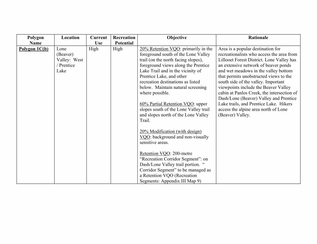
Polygon Name
Location Current Use
RecreationPotential
Objective Rationale
Polygon 1C(b)
Lone (Beaver) Valley: West / Prentice Lake
High High
20% Retention VQO: primarily in the foreground south of the Lone Valley trail (on the north facing slopes), foreground views along the Prentice Lake Trail and in the vicinity of Prentice Lake, and other recreation destinations as listed below. Maintain natural screening where possible. 60% Partial Retention VQO: upper slopes south of the Lone Valley trail and slopes north of the Lone Valley Trail. 20% Modification (with design) VQO: background and non-visually sensitive areas. Retention VQO: 200-metre “Recreation Corridor Segment”: on Dash/Lone Valley trail portion. “ Corridor Segment” to be managed as a Retention VQO (Recreation Segments: Appendix III Map 9)
Area is a popular destination for recreationalists who access the area from Lillooet Forest District. Lone Valley has an extensive network of beaver ponds and wet meadows in the valley bottom that permits unobstructed views to the south side of the valley. Important viewpoints include the Beaver Valley cabin at Panlos Creek, the intersection of Dash/Lone (Beaver) Valley and Prentice Lake trails, and Prentice Lake. Hikers access the alpine area north of Lone (Beaver) Valley.

Polygon 1C(b) Details to Objective To manage polygon area 1C(b) on a 135 year rotation, 15% removal / 20 year re-entry on the planimetric basis. Planimetric view is the guide for performance assessment. Critical viewpoints must be fixed and (not added to) or adjusted. It is expected that you could achieve recommended VQOs of/retention partial retention from viewpoints predetermined in this plan. If not achievable, the planimetric takes precedence. No other constraining influences, other than those that have been modeled, will apply. It is assumed that future determination of VQOs within polygon 1Cb will guarantee timber access to 100% of the productive forest land base within polygon 1C(b) (subject to other constraints as modeled by the SCSRP Planning Table) over a 135 year rotation. Where VQOs are recommended that are more constraining to operational access than that modeled, VQO recommendations for the reminder of the polygon must be relaxed to accommodate timber access targets developed by the SCSRP Planning Table. It is recommended that the above ‘VQO Relaxation Process’ be completed prior to formal VQO designations in the area.
Polygon Name
Location Current Use
RecreationPotential
Objective Rationale
Polygon 1D(a)
Lower Hungry Valley/Fish Lake
Moderate High
10% retention VQO: adjacent to wetlands, meadows, travel routes, and recreation destinations as listed below. Maintain visually effective screening adjacent to the trail and adjacent to open range/timber interface unless block design allows interlock with existing openings. 90% modification VQO (with design): non-visually sensitive areas.
This polygon is part of the ‘backcountry” area adjacent to Big Creek Park and is integral to the recreational values of Hungry Valley. It is adjacent to the travel corridor to Big Creek Park. Visual design principles must be applied in this area, as it is adjacent to the park, along the corridor to the park, and within the high recreational value area of Hungry Valley. With this flat topography, it is felt that foreground management techniques can be used to mitigate visual impact in this polygon.
Polygon 1D(b)
Lower Hungry Valley, vicinity of the “Fire Road”.
Moderate High
Maintain visually effective screening along recreation corridors and destinations as listed below.
As per 1D(a), this area is essentially the corridor of the “Fire Road”. It is adjacent to the Big Creek Park, and one of the potential main travel routes to the Park.

Polygon Name
Location Current Use
RecreationPotential
Objective Rationale
Polygon 1D(b) (Continued)
Lower Hungry Valley, vicinity of the “Fire Road”.
Moderate High 10% retention VQO, adjacent to the trail, wetlands, meadows, Fish Lake, and recreation destinations. 90% modification VQO (with design)
This polygon also contains Fish Lake. Fish Lake is classified as a Harvesting Guideline Class “A” lake under the Lakes Classification process. The viewshed will be managed as a scenic area (Lake Classification Guidelines: Appendix XI). Due to the flat topography, it is felt that foreground management techniques can be used to mitigate visual impact in this polygon.
Polygon 1E(a) (north)
South slopes of Piltz/Wales Mountains, adjacent to Hungry Valley
Moderate High 100% partial retention VQO South slopes of Piltz/Wales mountains and terrain adjacent to Hungry Valley. As per Polygon 1A, this viewshed is critical to the setting of Hungry Valley and the recreational values there. Portions of this polygon may be visible from within Big Creek Park.
Polygon 1E (a) (south)
Hillside south of Fish Lake, Fish Lake Viewshed
Moderate
High 100% partial retention VQO.
Part of the setting of Hungry Valley and the viewshed from Fish Lake. Fish Lake has been rated as a Harvesting Guideline Class “A” lake under the Lakes Classification Process. The viewshed of Fish Lake will be managed as a scenic area. Portions of this polygon are also visible from Big Creek Park.

Polygon Name
Location Current Use
Recreation Potential
Objective Rationale
Polygon 1E(b)
Mud/Swartz 4x4 road
High
High
Maintain trail integrity with the application of the Recreation Corridor Strategy: 60 metre trail management corridor. 100% modification with design.
Important route from Mud / Swartz recreation area to the Fraser River via Buck Mountain, Poison Mountain, China Head Mountain, etc. Polygon forms part of the “connection backcountry” between Big Creek Park and Churn Protected Area. Trail may be managed to a “roaded natural” recreational experience.
Polygon 1E(c) Big Creek Park Viewshed
Western slopes of Piltz/Wales, adjacent to Big Creek
Moderate High 55% partial retention VQO, primarily on the upper slopes. 45% modification (with design) VQO: primarily on the lower screened slopes.
CCLUP contains direction for the maintenance of visual values for viewpoints within Big Creek Park. Upper portions of polygon are visible from Scallon Meadows, Mt. Tom, and Dil-Dil Plateau. Well designed cutblocks with a higher visible alteration can be accepted if views are from distances beyond 8 kms.
Polygon 2F:
Dash Creek/Lone (Beaver) Valley connector trail
Moderate Moderate Retention VQO: 200 metre “Recreation Corridor Segment” from the intersection of Dash Creek south to the junction with the Prentice Lake Trail is to be managed to a Retention VQO for the purposes of maintaining visually effective screening along the trail. (Recreation Corridor Segment: Appendix III Map 9) 75% Modification (with design) VQO and EEA = 0.09 25% Partial Retention
This trail is the connection between Dash Creek and Lone (Beaver) Valley Creek: “core backcountry” with high recreational potential. Vegetative and topographic screening along the trail in the midsection of this polygon permits greater harvesting opportunity.

Polygon Name
Location Current Use
Recreation Potential
Objective Rationale
Polygon 2G(a)
Eastern Hungry Valley/West Churn Creek
High High 20% Partial Retention VQO: Adjacent to the trail, wetlands, And meadows, eastern shoulder of the Hungry Mountains adjacent to Polygon 1A, and in the viewshed of the Hungry Valley Range cabin. 80% Modification (with design) VQO: Midground viewshed and non- visually sensitive areas.
Contains the Eastern portion of Hungry Valley and the headwaters of West Churn Creek. This is the entrance to Hungry Valley via the Gaspard Lake 4x4 road and the 3200 Rd. High recreation and visual values exist in this area. Some modifications and trail relocation in the central portion of this polygon. Important viewpoints are the trailhead in the vicinity of the Hungry Valley Cow Camp, and Moose Lake. These are broad expansive views.
Polygon 2G(b)
Lone (Beaver) Valley east; section south of trail, including trail
High Moderate 100% Partial Retention VQO: 200 metre trail management corridor used to maintain visually effective screening.
Contains the Lone Valley Trail from trailhead at Swartz Lake to the eastern portion of Lone Valley. Important views are to the south of the trail. Good opportunities for management of vegetative screening. An important viewpoint and camping opportunity is in the open meadow where the trail from the south intersects Lone Valley.
Polygon 2G(c) Small detached polygon east of 2G(e)
High
High
100% Modification (with design) VQO
The polygon is visible from southern portion of the Dash-West Churn Trail as it passes over its highest point along the Hungry Mountains. The important viewpoint in this polygon is Viewpoint #9 (Appendix III Map 10). This polygon is a portion of the viewshed of the connector route to the higher recreational and backcountry values of Upper Dash Creek.

Polygon Name
Location Current Use
Recreation Potential
Objective Rationale
Polygon 2G(d) Lone Valley East; section north of trail
High
Moderate
100% Modification (with design)
Views from the trail in the vicinity of this polygon are predominantly to the south. This is expected to permit a greater degree of alteration to the north of the trail.
Polygon 2G(e) Eastern shoulder of Hungry Mountains
High
High 100% Modification (with design) VQO: Retention VQO: 200-metre “Recreation Corridor Segment” identified in this polygon. Recreation Segment is to be managed to a Retention VQO to permit visually effective screening along the trail. (Recreation Corridor Segments: Appendix III Map 9)
This is the southern portion of the Dash -West Churn Trail as it passes over its highest point along the Hungry Mountains. Connector route to the higher recreational and backcountry values of Upper Dash Creek. Good opportunities for management of vegetative screening along trail corridor. The important viewpoint is Viewpoint #9, the opening at the summit of the trail. (Viewpoints: Appendix III Map 10)
Polygon 2H(a)
Viewshed of 4x4 road to Hungry Valley from Gaspard Lake
High High
100% modification (with design) VQO: Retention VQO: 100 metre “Recreation Corridor Segment” adjacent to 4x4 road. Recreation Corridor Segment to be managed to a Retention VQO for the purposes of visually effective screening. (Recreation Corridor Segments: Appendix III Map 9)
Main route into Hungry Valley in the fall. A “roaded modified” recreational experience is acceptable along this route.

Polygon Name
Location Current Use
Recreation Potential
Objective Rationale
Polygon 2H(b)
Lower Lone Cabin Creek
Low
Moderate
100% Modification (with design) VQO: 200 metre trail management corridor
Open forest along the Lower Lone Cabin Trail presents some opportunities for visual screening. A commercial guide uses the trail. Important viewpoints are at the trailhead (km 0) and km 1.8 and km 7.2. These viewpoints are primarily at the crests of ridges. This polygon forms part of the “connection backcountry” between Big Creek Park and Churn Protected Area. Mule deer winter range management strategies will contribute to visual quality in this polygon.
Polygon 2I Windy Ridge 4x4 road
High High
60 metre trail management corridor based on Recreation Corridor Strategy (Recreation Corridor Segments: Appendix III Map 9) Modification (with design) is acceptable for the viewshed of the road.
Popular route used by four-wheel drive clubs since it permits extended tours through a “roaded natural” environment. Maintain the integrity of the route and the road.
View from Sky Ranch looking South
View from Sky Ranch looking South (potential access into Big Creek Park)
This viewshed will be managed using visual design principles. Techniques used in the “Visual Landscape Design Training Manual” will be applied here.

South Chilcotin Sub-Regional Plan: Management Strategies and Direction Recreation: Visual Resource Management
- 59 -
9.3.4 Visual Landscape Management From High Elevation Viewpoints Map Reference: Appendix III Map 10 The Ministry of Forests manages visual quality on public forestlands through a system called visual landscape management. Visual landscape inventory has been geared to address views from main travel corridors such as roads, recreation trails and main water corridors - all are ‘valley-bottom’ views. The management process culminates in a resource management objective for visuals called a visual quality objective (VQO). The District Manager, under the Forest Practices Code Act may establish VQOs. Visual impact assessments are required to satisfy Visual Quality Objectives (VQO). This assessment procedure works well for views with well defined visual landscape units as seen from particular viewpoints looking horizontally, or upwards. The boundaries of these units are defined by the uniformity of physical or viewing characteristics of the terrain; one unit is separated from another because of well-defined breaks in the landform, or viewing conditions.
However, the procedure for delineating landscape units, assigning a VQO and designing cutblocks to meet the allowable alteration percentage does not transfer effectively to high elevation viewpoints. For high elevation viewpoints, a different approach is required.
For the purposes of the SCSRP, high elevation viewpoints are viewpoints from which a vast panorama can be seen. These viewpoints are located above the tree line encompassing a panoramic viewing area.
The following viewpoints are recognized as high elevation viewpoints for the plan area (Appendix III Map 10 Viewpoints and Lake Viewsheds) The viewpoints marked with an asterisk * are currently used by commercial tourism operators. • Alpine ridge north of the Black Dome road • Red Mountain* • French Mountain* • Poison Mountain* • Buck Mountain* • Quartz Mountain* • Height of land, south of Lone Valley Creek • Hungry Mountain • Piltz Peak • Dash Hill*, Mount Tom* and Dil-Dil Plateau* within Big Creek Park • Alpine ridge north of Lone Valley
9.3.4.1 Visual Management: High Elevation Viewpoints Objectives and Strategies
High Elevation Viewpoints Management Objectives
High Elevation Viewpoints Management Strategies
A. Maintain a natural looking landscape with minimal geometric shapes and
1. The management strategies following will be applied to cutblocks within 16 kilometres of the identified high elevation viewpoints.

South Chilcotin Sub-Regional Plan: Management Strategies and Direction Recreation: Visual Resource Management
- 60 -
High Elevation Viewpoints Management Objectives
High Elevation Viewpoints Management Strategies
Objective A (Continued )
Maintain natural flow patterns.
1. Strategy 1 (Continued)
Techniques from the Visual Landscape Design Training Manual will be applied here. The Table recommends that Visual Quality Objectives not be established.
2. Design of cutblocks is critical and essential: Cutblocks need to have organic shapes and mimic the pattern of natural openings in the area (e.g. lakes, rock outcrops, meadows, and fire history). The shapes should be asymmetrical, interlocking, organic and have varying size consistent with the naturally occurring patch size distribution for the area. Avoid repetition and similarity.
3. Visual landscape design may also be applied to main haul road rights-of-way, recreation corridors, and riparian management zones that are visible from high elevation viewpoints. If possible, avoid creating a straight-edged, narrow, ribbon effect.
4. Where a viewshed from a high elevation viewpoint overlaps with a viewshed from a low elevation viewpoint, design considerations from the low elevation viewpoint will take precedence.
5. Cutblocks beyond 16 kilometres that may be visually dominant should follow visual landscape design management principles.

South Chilcotin Sub-Regional Plan: Management Strategies and Direction Recreation: Lakes Classification
- 61 -
9.4 LAKE CLASSIFICATION
Map Reference: Appendix III Map 11 Lakes Classification 9.4.1 Lake Classification Objectives and Strategies
Lake Classification Objectives
Lake Classification Strategies
A. Classify lakes, set standards for management of surrounding Lakeshore Management Zone, and define scenic area (if applicable).
1. Lakes and their surrounding lakeshore will be managed as per the assumptions used for Scenario 5 final analysis.
2. Ministry of Forests and Ministry of Environment established Lakes Classification Committee to solicit public and stakeholder input to process.
3. Consensus recommendations were reached by the Lakes Classification Team regarding classification of lakes in the SCSRP.
4. Recommend that approval of lake management goals and direction be given by District Manager as per Operational Planning Regulations.
5. Recommend that lake management criteria in the “Lake Classification Process: Williams Lake Forest District (WLFD) Procedures” be applied to operational plans in the SCSRP (see Appendix XI).
6. All classified lakes within the SCSRP have been assigned a 200-metre Lakeshore Management Zone (LMZ). For Class A lakes, this LMZ is considered a reserve and contributes in its entirety to the “no harvest” area.
7. The LMZ for Class B lakes is to be managed via a partial cutting silvicultural system (e.g. patch, group, or single tree selection) over a 160 year rotation. A minimum of fifty percent (50%) of the basal area is to be retained on-site post harvest and a maximum of twenty five percent (25%) of the LMZ is to be impacted per pass.
8. Class C, D, and E lakes are to be managed as per the WLFD procedures. Both clear cutting and partial cutting are acceptable silvicultural practices within these LMZs. These lakes are to be managed over a normal rotation.
9.4.2 Lake Viewsheds Map Reference: Appendix III Map 10 Viewpoints and Lake Viewsheds It is recommended that the following be established as scenic areas under the Forest Practices Code Act:

South Chilcotin Sub-Regional Plan: Management Strategies and Direction Recreation: Lakes Classification
- 62 -
• Koster Lake Viewshed
• Roaster Lake Viewshed
• Swartz Lake Viewshed
• Clear Lake viewshed (adjacent to Churn Protected Area)
The Visual Quality Objectives that were recommended in the visual landscape inventories and at the Table should become the established Visual Quality Objectives for the above viewsheds, to be consistent with the Lakes Classification as modeled for the Scenario 5 Final analysis.
• Gaspard Lake Viewshed
View from Gaspard Lake into the South Chilcotin SRDZ. Only a narrow fringe of the Gaspard viewshed is within the SCSRP area, and it is approximately 6 kilometres from Gaspard Lake. For this reason Visual Quality Objectives will not be established. The portion of the viewshed in the SRDZ will be managed through visual design principles.

9.4.3 Classified Lakes Map Reference: Appendix III Map 11 Lakes Classification CCLUP Subunit
Landscape Unit
Lake Name or Mapsheet & Polygon
Lake Size (hectares)
Lake
Mgmt.
Goal
Harvesting Guideline Class
Boating Regulation
Fishing Regulation
Commercial Land Development
Access Management Within Lakeshore Management Zone
Lake Viewshed
South Chilcotin SRDZ
Koster - Lone Cabin
Koster 13 Quality B General General No new tenures Temporary/ Reclaimed
Partial Retention
Koster-Lone Cabin
Roaster 9 Wilderness
A
General General No new tenures No new roads Retention and partial retention
Upper Churn Swartz 9 Quality B General General No new tenures Temporary/
Reclaimed
Retention and partial retention
Upper Churn 920.027-290 12 Quality B Restricted Restricted
No power boats
No new tenures Motorized restricted No concern
Churn 920.037-504 3+ Quality B General General No new tenures No new roads Overlaps
Big Basin
No Harvest
Churn 920.037-572 6 Quality B General General No new tenures Walk-in/
Fly-in
OverlapsEast Basin
Retention
Within MDWR
Upper Big Creek
Fish Lake
092O036-555
96 Wilderness A General General No new tenures ATV/walk-in Overlaps
Within recreation corridor viewshed
Upper Big Creek
Mud 44 General B General General No new tenures Temporary/ Reclaimed
Overlaps Within recreation corridor viewshed

Classified Lakes Map Reference: Appendix III Map 11 Lakes Classification CCLUP Subunit
Landscape Unit
Lake Name or Mapsheet & Polygon
Lake Size (hectares)
Lake
Mgmt.
Goal
Harvesting Guideline Class
Boating Regulation
Fishing Regulation
Commercial Land Development
Access Management Within Lakeshore Management Zone
Lake Viewshed
South Chilcotin SRDZ
Upper Big Creek
920.036-716 8 General B General General No new tenures Walk-in/
Fly-in
No concern
Upper Big Creek
920.035-216 11 Quality C General General No new tenures Walk-in/Fly-in Overlaps
Within recreation corridor viewshed.
Partial Retention
Big Creek 920.045-942 10 General C General General Enhanced referral Temporary/ Reclaimed
No concern
Big Creek 920.055-131 Unclassified
Gaspard ERDZ
Dash 920.027-253 14 General D General General Development permitted
Temporary No concern
Dash 920.036-97
(Moose Lake)
6 General D General General Development permitted
Temporary/
Reclaimed
No concern overlaps within recreation corridor viewshed
Gaspard 92O.27-34 5 General D General General Development permitted
Temporary No concerns
Refer to Appendix XI for definitions of the lake management goals and harvesting classes.
Note - stock watering will be as determined in Range Use Plans (under authority of the FPC) regardless of the lake classification.

South Chilcotin Sub-Regional Plan: Management Strategies and Direction Commercial Recreation
- 65 -
9.5 COMMERCIAL RECREATION
9.5.1 Background Information The British Columbia Assets and Land Corporation (BCAL) with Ministry of Environment, Lands and Parks (MELP) administer the Commercial Recreation (CR) policy for the purposes of authorizing Crown land use by commercial tourism operators.
Commercial recreation applies to all forms of outdoor recreation activities carried out on provincial Crown land (including Crown land in a provincial forest and Crown land covered by saltwater and freshwater) on a fee-for-service basis. This includes commercial mechanized ski guiding, commercial hunting and fishing, commercial snowmobile touring, commercial recreation activities that require the operator to construct or place improvements on the foreshore (e.g. wharves and floats, commercial horseback tours, etc.).
The SCSRP may be used to identify commercial recreation opportunities, and to direct the present and future use of Crown land in a specified area. A commercial recreation plan should identify available Crown land, indicate the associated uses that would be considered within each area, and provide a balanced context for delineating those parcels which would not be offered for development.
As an example, many commercial operators in the plan utilize horses in backcountry areas. Concern has been expressed regarding the potential for overuse of natural forage in the vicinity of frequently used camps or stopping points. Through a CR application process, intensive use of sites that have previously exhibited serious forage deterioration, or that are proposed to receive high levels of use, will be identified for special management through the Operating Area Management Plan. This Operating Plan forms part of the commercial operator’s tenure. Management options should include that alternate feeding requirements should be arranged with consultation between Ministry of Forests (Range), Ministry of Environment, Lands and Parks, and local range tenure holder(s) because of concern over the importation of noxious weeds or foreign species.
9.5.2 Commercial Recreation Management Objectives and Strategies
Commercial Recreation Management Objectives
Commercial Recreation Management Strategies
A. Identify commercial opportunities.
1. Ministry of Environment, Lands and Parks, BC Assets and Land Corporation, and Ministry of Small Business, Tourism, and Culture should work together to develop a commercial recreation plan to identify available Crown land, indicate the associated uses that would be considered within each area, and provide a balanced context for delineating those parcels which would not be offered for development.

South Chilcotin Sub-Regional Plan: Management Strategies and Direction Commercial Recreation
- 66 -
Commercial Recreation Management Objectives
Commercial Recreation Management Strategies
B. New tourism / commercial recreation development should be focused on areas managed for visuals and backcountry conditions; and should complement the existing character of the area’s recreation activities.
1. New development should meet resource management guidelines of the SCSRP. New commercial recreation applications should demonstrate consideration of environmental carrying capacities and maintenance of quality outdoor experience for existing and future users.

South Chilcotin Sub-Regional Plan: Management Strategies and Direction Timber Access
- 67 -
10 TIMBER ACCESS
Background Information Although there are a number of harvesting systems available for implementation within the South Chilcotin Sub-Regional Plan planning area, it is neither the intent nor the function of this section to describe them to the reader. This section, ‘Timber Access’, addresses nothing more than operational access to the land base. That is, it describes:
• What percentage of the land base is available for development
• Where the authority is from which timber access is derived; and
• What form (i.e. modified versus conventional) its distribution shall be across the landscape.
Cariboo-Chilcotin Land Use Plan Direction Forest development objectives within the South Chilcotin Special Resource Development Zone (SC SRDZ) portion of the SCSRP planning area shall recognize direction supplied in Appendix 5, Section 3 of the CCLUP document.
Appendix XII of the CCLUP Final Integration Report (the ‘Integration Report’) dated April 6, 1998, provides a comparison of the subunit targets contained in Appendix 3 of the CCLUP 90 Day Implementation Process Final Report (CCLUP) to those developed during the integration process. For the South Chilcotin Special Resource Development Zone (SRDZ) and the Gaspard Enhanced Resource Development Zone (ERDZ) – the subunits that encompass the area of the SCSRP (SCSRP) – the Integration Report quotes the following numbers.
Subunit Integration Report
Modified Extended Modified EEA No-Harvest EEA
South Chilcotin 31% 9% 7% 16%
Gaspard 7% 3% 11% 14%
Definitions • Equivalent Excluded Area or EEA is the common unit used to measure the impact of non-
timber strategies on timber access. EEA is based on the difference between a strategy rotation age and the base (normal) rotation age. As an example, if a prescription implies an extended rotation of 160 years for a stand in which the normal rotation age is 80 years, then the EEA would be 0.5 (i.e. 1 – (80/160)) multiplied by the strategy area. In this example, 50% of the strategy area would be unavailable for harvest during a normal rotation. EEA represents the equivalent excluded area by subunit and is derived by combining the Modified Extended impact to the No-Harvest impact.
• Rotation Age or Rotation is the planned number of years between the formation or regeneration of a tree crop or stand and its final cutting at a specified stage of maturity. It can be based on physical, biological, pathological or economic criteria. For the purposes of implementing the SCSRP, CCLUP defined rotation as the minimum harvest age by tree species

South Chilcotin Sub-Regional Plan: Management Strategies and Direction Timber Access
- 68 -
for the Cariboo Forest Region. That is, 80 years for stands in which lodgepole pine (Pli) are the leading species and 120 years for those stands that are comprised of other leading species.
• Modified Extended is the percentage area by subunit that, based on the results of the long-term analysis, will require a management prescription that extends the rotation beyond normal.
• Modified EEA is the equivalent excluded area impact by subunit attributable to the Modified Extended area. For example, in the South Chilcotin SRDZ, the 31% of the subunit that is under some form of modified harvest represents an equivalent No-Harvest area of 9%.
• No-Harvest refers to the percentage area by subunit that, based on the results of the long-term analysis, will not be harvested over a rotation. This area includes the estimated impact of RMZs, OGMA and other land exclusions within the planning area.
10.1 SCSRP TIMBER ACCESS
10.1.1 Timber Access Targets In recognition of the above, the following access targets were derived for the area encompassed by the SCSRP (see Appendix V).
Subunit SCSRP Planning Area
EEA
South Chilcotin 16.30
Gaspard 12.31
(Please see Section 5: Biodiversity)
Equivalent Excluded Area (EEA) calculations for the SCSRP planning area are the result of access netdowns due to non-timber management strategies developed by the Table and are presented as management assumptions modeled in SCSRP Appendix V Scenario 5 Final dated February 9th, 1999. As indicated in the CCLUP, there is joint sign-off of Forest Development Plans – to the extent they apply to SRDZ areas within the SCSRP planning area – by the Statutory Decision Maker (SDM) of the MOF and MELP. Consistent with their authority, the SDMs have indicated that they accept Section 4 of the Integration Report, as approved by the RRB and IAMC, as appropriate advice and direction for achieving the overall objectives of the CCLUP. SDM direction as it pertains to the Integration Report and timber access targets may be found in the Statutory Decision Maker Direction to Operational Plan Proponents document dated April 30,1998. Although Section 4 of the Integration Report provides appropriate advice and direction for achieving the overall objectives of the CCLUP, the Integration document also provides valuable

South Chilcotin Sub-Regional Plan: Management Strategies and Direction Timber Access
- 69 -
guidance as it relates to the development of a timber access impact model for the SCSRP planning unit. That is: 1. Non-timber impacts on timber access shall be based on management prescriptions developed
by the SCSRP planning group.
2. Each non-timber strategy shall be analyzed and the prescription shall be translated into an implied rotation age. If a strategy requires that stands be retained beyond the base rotation age, a resultant impact to timber access shall be calculated via an EEA. In simple terms, the longer the strategy rotation ages the greater the impact on timber access.
3. EEA impacts shall be considered incremental to current silvicultural systems in practice. For the purposes of this analysis, the following prescriptions are assumed to be normal forest management practices: even-aged management for all conifer species excluding Douglas fir; and, uneven-aged management for Douglas fir leading stands.
4. Silvicultural Systems (SS) that have the potential of being implemented within the SCSRP planning area include: • Single Tree Selection: a silvicultural system (SS) in which age classes are created or
maintained through the removal of individual stems of all diametre classes uniformly throughout the stand.
• Group Selection: an uneven-aged SS that removes trees to create openings within the stand that are less than or equal to twice the height of representative mature stems.
• Shelterwood: a SS where trees are removed in a series of cuts designed to achieve a new even-aged stand under the shelter of remaining trees.
• Patch Cutting: a SS that creates openings less than one hectare in size. Each opening is intended to be managed as a distinct even-aged unit.
• Clearcut: an even-aged SS that removes the entire stand of trees during a single harvesting operation. Openings are one hectare or greater and at least two tree heights in width.
• Partial Cutting: a SS in which only selected trees are harvested. Seed Tree, Shelterwood, Single Tree and Group Selection, and Clearcutting with reserves are examples of a Partial Cutting system.
5. The current species distribution is assumed to remain constant over time (i.e. stand conversion is not assumed to occur within the planning area).
6. Where draft Landscape Units are partially located within Protected Areas, the productive forest land base within the protected area is assumed to contribute to Old Seral requirements within that unit.
Further to the above and within the area of the plan, the following assumptions are made as they pertain to EEA calculations: 1. They apply to the productive forest land base of the applicable CCLUP subunit. The
productive forest land base equates to the total area of Crown forest within the SCSRP determined by subtracting the following:
• All non-Crown land; • All Crown land committed to non-timber use through a Land Act designation; • All non-forest Crown land; and, • All forest area classified as brush or non-commercial cover in the forest inventory.

South Chilcotin Sub-Regional Plan: Management Strategies and Direction Timber Access
- 70 -
2. They include all impacts associated with the application of management prescriptions developed by the Table.
3. They include all impacts associated with management constraints detailed in the Forest Practices Code of British Columbia Act (FPC); and
4. They are consistent with those detailed in the CCLUP as modified by the Integration Report, and ultimately by the SCSRP analysis process.
It is assumed by the Table that the ‘Implementation and Monitoring Committee’, when established by the IAMC and RRB, will examine Forest Practices Code impacts to ensure that legislative constraints are not incremental to EEA targets developed for the SCSRP planning area. Further to this and in the context of operational planning, the Table also assumes that the ‘Implementation and Monitoring Committee’ will document instances where developmental activity is constrained beyond those levels prescribed and predicted by the Table: those instances where operational realities are not accurately reflected by SCSRP modeling assumptions. Where either of these situations exist, it is expected that the ‘Implementation and Monitoring Committee’ will produce and supply appropriate resolution recommendations to the IAMC/RRB.
10.1.2 Timber Access Management Objectives and Strategies
Timber Access Management Objectives
Timber Access Management Strategies
A. Maintain timber access within the South Chilcotin SRDZ subunit and the Gaspard ERDZ subunit that accurately reflects the results of Scenario 5 Final.
1. Within the South Chilcotin SRDZ subunit and the Gaspard ERDZ subunit, implement harvesting and access management plans in a manner consistent with consensus strategies developed for the area.
B. Prescribe silvicultural prescriptions and implement harvesting regimes in a manner consistent with management strategies developed for the SCSRP.
1. Harvesting activities are not to be proposed within areas that have been excluded from the operable land base (e.g. riparian reserves, OGMA, Big Basin). Where harvesting activities are proposed in areas that are subject to the constraints of sector strategies, management prescriptions must recognize consensus recommendations developed by the Table. Access and operations proposed on the residual land base shall be governed and guided by the FPC.
C. Pursue enhancement activities in the Gaspard ERDZ portion of the SCSRP planning area that, among other things, increases the productivity of the forests within the
subunit. (CCLUP: Pg 7).
1. Management opportunities that increase wood quality and/or fiber yield should be pursued where it is feasible to do so.

South Chilcotin Sub-Regional Plan: Management Strategies and Direction Timber Access
- 71 -
Timber Access Management Objectives
Timber Access Management Strategies
D. Timber development within the South Chilcotin SRDZ portion of the SCSRP planning area should focus on the central region of the polygon. (CCLUP: Page 87).
1. Although the operational area extends beyond the central region of the South Chilcotin SRDZ subunit, initial planning work should focus on the central portion of this polygon.
E. Within the Gaspard ERDZ portion of the SCSRP planning area, the primary restriction to timber development shall be in the southwestern portion of the polygon. (CCLUP: Page 131).
1. Within the Gaspard ERDZ portion of the SCSRP planning area, timber development shall proceed in a fashion that adheres to spatial constraints developed by the Table.
F. To ensure that the natural disturbance patterns for the SCSRP planning area are maintained over the rotation; manage the temporal and spatial distribution of cut and leave areas in accordance with the patch size distribution described in the FPC.Biodiversity Guidebook for each Natural Disturbance Type.
1. Consistent with the FPC and the FPC Biodiversity Guidebook, prepare operational plans in such a way that they include a range of block sizes.
Although Section 11(1)(b) of the FPC Operational Planning Regulation indicates that the maximum cutblock size for the Cariboo Forest Region must not exceed 60 hectares, Section 11(3)(b)(ii) of the FPC Operational Planning Regulation and Sections 9(2)(e) and (f) of the FPC Timber Harvesting Regulation permit larger openings where they are proposed to salvage timber, where they are proposed in a manner consistent with the intent of Biodiversity management and where they have been authorized by the District Manager and, if applicable, the Designated Environment Official.
A patch is defined as a stand that differs in age from adjacent patches by more than 20 years and refers to either a natural disturbance opening that led to an even-aged forest or an opening that was created by a cut block.

South Chilcotin Sub-Regional Plan: Management Strategies and Direction Timber Access
- 72 -
Timber Access Management Objectives
Timber Access Management Strategies
G. Operational activity should control vehicle access and minimize the disturbance to wildlife.
1. Operational development should be designed and implemented in a fashion consistent with the SCSRP access management strategy. The length of time between disturbances should be lengthened – wherever possible – to allow time for recolonization and recovery of wildlife populations. In general, the ‘Get In and Get Out’ approach is recommended for identifiable units in the area (e.g. well defined drainage’s and/or operating areas).

South Chilcotin Sub-Regional Plan: Management Strategies and Direction Fish and Wildlife
- 73 -
11 FISH AND WILDLIFE
11.1 GRIZZLY BEAR HABITAT
Background Information Grizzly bears are recognized as a species of special importance within the province of British Columbia. Their role as a large predator in the ecosystem is considered an important barometer of ecosystem health. Historically they have played an important role for resident / non-resident hunting and other tourism values. The CCLUP notes that the South Chilcotin SRDZ is an important area for Grizzly bear. Strategies are designed to ensure that habitat suitability for Grizzly bear is maintained through time.
11.1.1 Grizzly Bear Habitat Management Objectives and Strategies
Grizzly Bear Habitat Management Objectives
Grizzly Bear Habitat Management Strategies
A. To maintain grizzly bear habitat quality and quantity through time within the area of the plan.
1. Finish activities, to the fullest extent possible, within each watershed prior to starting up in an adjacent one to minimize industrial disturbance and human interaction.
2. Complete each harvest entry as quickly as possible.
3. To manage polygon area 1C(b), (Appendix III Map 9), on a 135 year rotation, 15% removal / 20 year re-entry on the planimetric basis. Planimetric view is the guide for performance assessment. Critical viewpoints must be fixed and (not added to) or adjusted. It is expected that you could achieve recommended VQOs of retention / partial retention from viewpoints predetermined in this plan. If not achievable, the planimetric takes precedence. No other constraining influences, other than those that have been modeled, will apply.
4. It is assumed that future determination of VQOs within polygon 1C (b) will guarantee timber access to 100% of the productive forest land base within polygon 1C (b) (subject to other constraints as modeled by the SCSRP Planning Table) over a 135 year rotation. Where VQOs are recommended that are more constraining to operational access than that modeled, VQO recommendations for the remainder of the polygon must be relaxed to accommodate timber access targets developed by the SCSRP Planning Table. It is recommended that the above ‘VQO Relaxation Process’ be completed prior to formal VQO designations in the area.
5. Design Blocks with “creating edge” in mind.

South Chilcotin Sub-Regional Plan: Management Strategies and Direction Fish and Wildlife
- 74 -
Grizzly Bear Habitat Management Objectives
Grizzly Bear Habitat Management Strategies
B. Apply biodiversity objectives.
1. It is anticipated that these strategies, along with the application of biodiversity objectives will satisfy grizzly bear habitat requirements.
2. Protection and enhancement of shrub layer should be considered in development of harvesting prescriptions and site prep.
3. Blocks in areas known to contain resident grizzly bears should be designed with interior Wildlife Tree Patches of at least 2 hectares.
4. WTP should be concentrated along riparian corridors, in areas of high shrub production, in wet forest types, along game trails, etc.
5. Where there is a choice to either make a number of smaller WTP or fewer larger ones it is generally better to create fewer large patches than a number of small scattered patches.
C. Control access. 1. Restrict use of vehicles and ATVs for hunting. (See current hunting regulations and SCSRP Access Management Plan, Section 12).
2. Minimize non-industrial use of newly constructed roads consistent with the SCSRP Access Management objectives and strategies.
3. Minimize road density to only those roads required for ongoing industrial activity.
4. Align main roads several hundred metres away from areas known/or suspected to be important foraging, denning, or travel routes (riparian areas, wet forest types, areas of high herbaceous plant or berry production, etc.)
5. Deactivate spur roads immediately following harvest as per temporary access provisions under SCSRP Access Management objectives.

South Chilcotin Sub-Regional Plan: Management Strategies and Direction Fish and Wildlife
- 75 -
11.2 MULE DEER WINTER RANGES
Map Reference: Appendix III Map 12: Wildlife Habitats Background Information During winter, mule deer experience severe hardships that determine their survival. Many factors combine to limit suitability of Mule Deer habitat during winter and deer must concentrate in favourable areas to survive. In fall and summer, Mule Deer are able to access a wide range of habitats with sufficient resources, including high elevation forage, but they must migrate to smaller, lower elevation areas with specific habitat characteristics to endure the winter (Regional Mule Deer Winter Range Strategy, June 1996). Mule Deer in the Cariboo are particularly stressed during winter, as they are at their northern limit of continuous high-density distribution (BC Wildlife Branch 1990).
Mule Deer survival during winter is dependent on old growth and mature Douglas fir stands with well-developed canopies that provide snow interception, security, thermal cover; and food through litterfall (Regional Mule Deer Winter Range Strategy, June 1996).
11.2.1 Mule Deer Winter Range Management Objectives and Strategies The Mule Deer winter range management strategies will be revised to reflect stand specific management direction provided by Mule Deer Winter Range Management Plans to be completed by the Mule Deer Working Group (Ministry of Environment, Lands and Parks, Ministry of Forests, and the timber industry).
Mule Deer Winter Range Management Objective
Mule Deer Winter Range Management Strategies
A. Maintain Mule Deer Winter Range within the Plan area (Churn Creek, Koster-Grinder and Lone Cabin MDWR’s) with adequate mixes of habitat types as described in the Regional Mule Deer Strategy, the Handbook for Timber and Mule Deer Management Co-ordination on Winter Ranges in the Cariboo Forest Region, and the CCLUP Integration report.
1. Use the Handbook for Timber and Mule Deer Management Co-ordination on Winter Ranges in the Cariboo Forest Region (Land Management Handbook No. 13) as modified by the Integration report for operational guidance when proposing harvesting on Mule Deer Winter Ranges.
2. Winter range management plans completed for these winter ranges will not change the management objective but will aid in applying the strategies in a more spatial manner to these particular winter ranges.

South Chilcotin Sub-Regional Plan: Management Strategies and Direction Fish and Wildlife
- 76 -
11.2.2 Timber Access Within Mule Deer Winter Ranges 1. The pine component in mixed stands at or in excess of 40% Douglas-fir content will be
selectively harvested based on a 80 year rotation on an even flow basis.
2. The spruce component in mixed stands at or in excess of 40% Douglas-fir content will be selectively harvested based on a 120 year rotation on an even flow basis.
3. There are no MDWR constraints on pine or spruce harvest in pure pine/spruce or in mixed stands of less than 40% Douglas-fir content.
4. Harvesting incremental volume subsequent to initial stand entry in Douglas-fir stands managed for high and moderate crown closure: that is; when growth has replaced the harvested volume and the stand has recovered any winter range values, which may have been lost, the second pass may be taken (Regional Mule Deer Winter Range Strategy, June 1996).
5. Stands identified for low crown closure management within the MDWRs are to be managed according to normal silviculture Douglas-fir management with allowance for Mule Deer requirements as indicated in the Mule Deer Handbook. It is expected that given the current condition of these winter ranges no stands will be proposed for this type of harvest until these areas can be identified through the winter range management plans.
11.2.3 Timber Harvesting Priority Within Mule Deer Winter Ranges Harvesting timber within the mule deer winter ranges in the following order of priority:
1. Harvest of current beetle attack where it is identified as a priority for resource management.
2. Within non-fir stands.
3. Within age Class 5 Douglas-fir stands where commercial thinning would benefit mule deer winter range values.
4. Within Mule Deer winter ranges that have met the crown closure objectives for the fir component of the stand as described in the Regional Mule Deer Winter Range Strategy and the CCLUP Integration Report; and
5. Areas that are to be managed for low crown closure objectives: areas to be identified through Mule Deer Winter Range management plans.
11.3 MOOSE HABITAT
Map Reference: Appendix III Map 12: Wildlife Habitats Background Information Moose occur throughout the SCSRP region. Historically this area has been an important moose hunting area for both resident and non- resident hunters. Access has been slow and difficult, using old wagon roads and cattle trails. Throughout the SRP process, numerous groups and individuals spoke of the importance of the SCSRP area to local moose populations, particularly Upper Dash Valley and Hungry Valley. One of the primary goals of the SCSRP is to mitigate the direct and indirect impacts of industrial development on moose populations and moose habitat. The following strategies are meant to mitigate impact and, in some cases, enhance habitat suitability for moose.

South Chilcotin Sub-Regional Plan: Management Strategies and Direction Fish and Wildlife
- 77 -
11.3.1 Moose Habitat Management Objectives and Strategies Moose Habitat
Management Objectives Moose Habitat
Management Strategies
A. To maintain moose habitat quality and quantity through time within the area of the plan.
1. It is anticipated that the strategies outlined here, along with the application of the biodiversity targets outlined in the Biodiversity Guidebook and the Biodiversity Conservation Strategy for the CCLUP and the visual management component of the SCSRP plan will satisfy moose habitat requirements.
Details to Strategy A-1 1. Polygon Area 1-A
To manage polygon area 1A on a 200 year rotation, 10% removal 20 year re-entry on the planimetric basis. Planimetric view is the guide for performance assessment. Critical viewpoints must be fixed and (not added to) or adjusted. It is expected that you could achieve recommended VQOs of/retention partial retention from viewpoints predetermined in this plan. If not achievable, the planimetric takes precedence. No other constraining influences, other than those that have been modeled, will apply.
It is assumed that future determination of VQOs within polygon 1A will guarantee timber access to 100% of the productive forest land base within polygon 1A (subject to other constraints as modeled by the SCSRP Planning Table) over a 200 year rotation.
Where VQOs are recommended that are more constraining to operational access than that modeled, VQO recommendations for the remainder of the polygon must be relaxed to accommodate timber access targets developed by the SCSRP Planning Table. It is recommended that the above ‘VQO Relaxation Process’ be completed prior to formal VQO designations in the area.
2. Polygon 1C(a)
To manage polygon area 1C(a) on a 135 year rotation, 15% removal/20 year re-entry on the planimetric basis. Planimetric view is the guide for performance assessment. Critical viewpoints must be fixed and (not added to) or adjusted. It is expected that you could achieve recommended VQOs of retention / partial retention from viewpoints predetermined in this plan. If not achievable, the planimetric takes precedence. No other constraining influences, other than those that have been modeled, will apply.
It is assumed that future determination of VQOs within polygon 1C(a) will guarantee timber access to 100% of the productive forest land base within polygon 1C(a) (subject to other constraints as modeled by the SCSRP Planning Table) over a 135-year rotation.
Where VQOs are recommended that are more constraining to operational access than that modeled, VQO recommendations for the remainder of the polygon must be relaxed to accommodate timber access targets developed by the SCSRP Planning Table. It is recommended that the above ‘VQO Relaxation Process’ be completed prior to formal VQO designations in the area.

South Chilcotin Sub-Regional Plan: Management Strategies and Direction Fish and Wildlife
- 78 -
Details to Strategy A-1 (Continued)
3. Non-overlapped Portion of Moose Habitat in Hungry Valley
To manage the non-overlapped portion of the moose habitat in Hungry Valley on a 160 year rotation - 12 1/2% removal/20 year re-entry. The planimetric view is the basis for performance assessment.
Moose Habitat Management Objectives
Moose Habitat Management Strategies
B. To maintain moose habitat quality and quantity through time within the area of the plan.
1. Complete each pass as quickly as possible.
2. Blocks should be designed with “creating edge” in mind.
3. No more than 50% of a W1 or W5 wetland edge should be disturbed in any pass.
4. Similar restrictions should be applied to the edge of large (> 5 hectare) shrub carrs.
5. Protection and encouragement of shrub layer should be considered in development of harvesting prescriptions and site preparation.
6. WTP should be concentrated along riparian corridors, in areas of high shrub production, adjacent to shrub carr habitat, in wet forest types, along game trails, etc..
7. Where there is a choice to either make a number of smaller WTP or fewer larger ones it is generally better to create fewer large patches than a number of small scattered patches.
8. Where deciduous forest types occur, they should not be targeted for harvest.
C. Control access 1. Minimize road density to only those roads required for ongoing industrial activity.
2. Minimize non-industrial use of roads consistent with the SCSRP access management objectives.
3. Where possible align main roads several hundred metres (200 metres +) away from high quality moose habitat (riparian areas, wet forest types, areas of high shrub production, etc.).
4. Restrict use of vehicles and ATV’s for hunting. See current hunting regulations Access Management Plan, Section 12.
5. Deactivate spur roads immediately following harvest: temporary access provisions Section 12 SCSRP access management objectives.

South Chilcotin Sub-Regional Plan: Management Strategies and Direction Fish and Wildlife
- 79 -
11.4 CHURN CREEK BIGHORN SHEEP
Map Reference: Appendix III Map12: Wildlife Habitats Appendix III Map 15: Sheep Habitat Background Information The Churn Creek-Fraser River sub-population represents 15-20% of the total provincial population of California bighorn sheep and as such, is both regionally and provincially significant. Three major herds of sheep exist, within the sub-population, based on migratory patterns: non-migratory sheep (summer in the Fraser-Churn Creek area), early migrating sheep (summer in the Nine Mile Ridge and Yalakom Mountain area) and late migrating sheep (summer in the Red and French Mountain area). Most migrant sheep (approximately 50% of sub-population) use Churn Creek and East Churn Creek as the principal migratory route to and from Red and French Mountain or Nine Mile Ridge and Yalakom Mountain. All the sheep in the sub-population winter at lower elevations along Churn Creek or the Fraser River.
Bighorn sheep are predominately grazers, relying on grassland habitats. Bighorn sheep generally inhabit steep, rugged terrain such as mountains, canyons or grasslands with adjacent cliffs within areas that have a low and open plant community structure. The major needs of bighorn sheep are forage, water, thermal protection, and areas for escape, rutting and lambing. While grasses, sedges and forbs comprise the majority of bighorn food; up to 25% of the diet may be shrubs such as sage, saskatoon, bearberry, juniper and willow. Both summer and winter ranges must provide freedom from disturbance and a proper combination of forage, escape terrain and water if viable populations are to be maintained. Where bighorn sheep move or migrate to particular areas to rut or lamb, it is of utmost importance that travel corridors to such areas be protected and maintained to ensure there is no interference with this movement.
In British Columbia, California bighorn sheep are blue-listed (considered vulnerable to declines) because of their restricted distribution and low numbers. Also, in some cases, their winter ranges are threatened by past overgrazing, competition with domestic stock, land alienation and human encroachment. They are also threatened by disease; particularly those transmitted by domestic sheep.
The CCLUP directs that inventories to identify sensitive habitats and management needs for bighorn sheep, as a species at risk, be undertaken and that, consistent with targets, important habitats be protected.
Ministry of Environment, Lands and Parks, with funding from Forest Renewal BC, Habitat Conservation Trust Fund, Lignum Limited, the Williams Lake Sportsmen’s Association and the Wild Sheep Society of BC, has undertaken and recently completed a 3 year study of movements and habitat use of the Churn Creek-Fraser River Bighorn Sheep sub-population. This study has provided information on important habitats, such as the location of the migratory corridor, and the timing of migration within the sub-population. This work has identified the following important habitats for the Churn Creek-Fraser River sub-population: (Appendix III Map15)
1. Winter range situated in grassland habitats of the Lower Churn (including Little Churn) and adjacent Fraser River and associated drainage (Lone Cabin Creek, Grinder Creek, French Bar Creek)
2. Summer range for the migratory component of the sub-population situated in the alpine/sub-alpine habitats on Red Mountain, French Mountain, Nine Mile Ridge and Yalakom Mountain

South Chilcotin Sub-Regional Plan: Management Strategies and Direction Fish and Wildlife
- 80 -
3. Lambing areas situated in Lower Churn, Fraser River and in higher elevation habitats (Red Mountain and Yalakom Mountain)
4. Rutting areas situated in grassland habitats of the Lower Churn Creek and adjacent Fraser River, and
5. The migration corridor between the low elevation winter range and high elevation summer range, including Big Basin, the east side of Churn Creek south to East Churn Creek, the north side of East Churn Creek, the corridor between East Churn Creek and Red Mountain and the corridor between Red Mountain and Yalakom Mountain.
To mitigate potential problems a number of guidelines have been developed for operations utilizing the Red Mountain road system and for planning harvesting adjacent to the sheep migration corridor. See Section 12, Access Management, for additional guidance.
11.4.1 Churn Creek Bighorn Sheep Management Objectives and Strategies
Churn Creek Bighorn Sheep Objectives
Churn Creek Bighorn Sheep Management Strategies
A. Minimize the impact of human activities on the sheep migration pattern and sheep use of the corridor.
1. Minimize new access development within the migration corridor.
2. Deactivate primary, secondary and tertiary access roads within and adjacent to the migration corridor, wherever possible.
3. Establish a restricted timing window for use of access within and adjacent to the migration corridor such that migration periods are avoided.
4. For logging that utilizes road access through the migration corridor, winter logging and hauling is preferred.
B. Maintain migration corridor habitats in a condition that addresses sheep forage requirements, thermal factors and predation.
1. Protect and/or restore grassland habitats.
2. Where necessary use prescribed fire to maintain attributes to sheep migration corridor.
3. Manage for some older age trees within the corridor and adjacent to high use habitats for thermal cover purposes.
4. For portions of the corridor that also function as mule deer winter range, utilize the selective timber harvest approaches outlined in the regional Mule Deer Strategy.
5. Restrict the season of timber harvesting to those times outside the spring and fall migration periods – winter logging is preferred.
6. Where feasible use helicopter logging on steep slopes.
7. For timber harvesting outside of deer winter range areas, apply selective logging in Douglas-fir stands.

South Chilcotin Sub-Regional Plan: Management Strategies and Direction Fish and Wildlife
- 81 -
Churn Creek Bighorn Sheep Objectives
Churn Creek Bighorn Sheep Management Strategies
B. Maintain migration corridor habitats in a condition that addresses sheep forage requirements, thermal factors and predation.
8. In pine stands apply clearcut logging with reserves or interior WTP.
9. Locate WTP and / or single tree for retention along topographic breaks or other suitable locations.
10. Consult Ministry of Environment when planning forest harvesting operations within the sheep migration corridor.
C. Manage for the ecological integrity of critical lambing areas.
1. Where lambing habitat values are identified, measures will be taken to maintain the integrity of the area, including maintenance of sheep access to and from the area.
2. Establish a timing window for forestry operations in the vicinity of lambing areas. There should be no logging activities in the surrounding area (approx. within 1-2 km.) from April through July.
3. Establish a buffer or management zone around the perimeter of the lambing area, where habitat features important to sheep will be managed.
4. Reserve Ponderosa pine.
11.5 BULL TROUT
Map Reference: Appendix III Map 13: Bull Trout Background Information Bull Trout are recognized as being “blue-listed” a designation that includes any indigenous species or subspecies (taxa) considered to be vulnerable in British Columbia. Vulnerable taxa are of special concern because of characteristics that make them particularly sensitive to human activities or natural events. Blue-listed taxa are at risk, but are not extirpated, endangered or threatened. This is because of their restricted distribution, susceptibility to over fishing and habitat degradation. To ensure that current populations are maintained, special attention must be given to maintaining water quality, water temperature regimes, riparian habitat, channel integrity, and to limiting motorized access to large portions of Bull Trout habitat areas.
Bull Trout are present in the watersheds being planned and the following management strategies are meant to ensure their future distribution. Current known distribution of Bull Trout has been determined through stream inventories (Appendix III Map 13).

South Chilcotin Sub-Regional Plan: Management Strategies and Direction Fish and Wildlife
- 82 -
11.5.1 Bull Trout Management Objectives and Strategies
Bull Trout Management Objective
Bull Trout Management Strategies
A. Maintain the integrity of habitat that produces bull trout.
1. Develop management prescriptions in consultation with BC Environment habitat protection staff to ensure that Bull Trout habitat attributes are maintained.
2. Maintain channel integrity and hydrologic stability.
3. Maintain water quality.
4. Maintain riparian habitat adjacent to bull trout streams and those identified as being important for maintenance of bull trout habitat.
5. Conduct road maintenance activities in concert with the management objective.
6. Construct road crossings consistent with MoF District guidance.
7. Consider best management practices when conducting timber-harvesting activities adjacent to bull trout habitat and areas identified as important to bull trout populations.
8. Maintain water temperature regimes within systems known to contain bull trout through the innovative application of streamside protection.
9. Minimize motorized access into currently low access areas of the South Chilcotin

South Chilcotin Sub-Regional Plan: Management Strategies and Direction Access Management
- 83 -
12 ACCESS MANAGEMENT
Map Reference: Appendix III Map 14 Access Management Cariboo-Chilcotin Land Use Plan Direction Ninety-Day Implementation Process Final Report: Feb. 15, 1995 A. Section 3.8: Undeveloped Areas: Access Management, pages 25 and 26 (in part)
Background
Across the region are a number of areas, which are outside of established, and new Protected Areas and which are, as yet, undeveloped. These areas tend to be located within sub-units of the Special Resource Development Zone. They may contain important wildlife, recreation, and/or tourism values associated with undeveloped or backcountry areas. They may also contain significant mineral and timber resources.
The resource targets and sectoral strategies have been developed in recognition of these values and of the sensitivity of some of these areas to road access.
Action
Such unroaded areas are available for development. Proposals for access development within these areas will be planned and managed in the context of the resource targets, sectoral strategies, and any sub-regional plans that accommodate or are consistent with those targets and strategies.
For currently unroaded drainages, the Ministry of Energy, Mines and Petroleum Resources (Ministry of Energy and Mines) will encourage the mineral exploration industry to utilize low impact forms of access until there is sufficient evidence to warrant road construction. Where exploration roads are considered necessary, the Ministry will encourage the industry to participate in the restriction of public use of such roads and, where they are no longer necessary, the de-activation of such roads. The Ministry will make every reasonable effort to encourage the industry to avoid road development until ore bodies are sufficiently proven that the Ministry considers that road access for exploration or mine development is warranted.
The Ministry of Forests, in overseeing Forest Development Planning, will ensure that the development of currently unroaded areas is planned in conjunction with the Ministry of Environment, Lands and Parks and in consultation with the Ministry of Energy, Mines and Petroleum Resources (Ministry of Energy and Mines) and the Ministry of Small Business, Tourism and Culture. The forest development or landscape unit plans for such areas will identify access management procedures that satisfy the interests of resource uses and values, consistent with the resource targets established by the Land Use Plan and the Ninety-day Implementation Process.
B. Appendix 3, Zonal and Sub-Unit Targets
South Chilcotin Special Resource Development Zone, pages 86 and 87
Overlaps: Access Management Planning will restrict permanent road access in 80% of this polygon.

South Chilcotin Sub-Regional Plan: Management Strategies and Direction Access Management
- 84 -
Wildcraft: To maintain road access to 30% of the polygon. Access to the majority of the polygon will be walk-in off some permanent main roads. Coordinate the use of any temporary access from forest industry development or mineral exploration.
Recreation: Maintain 30% of the polygon in a backcountry condition. In order to be compatible with the timber targets this includes areas above 5000 feet, and is mainly located in the western portion of the polygon, adjacent to the Big Creek Protected Area.
Fish and Wildlife: Apply an access management strategy aimed at restricting the development of permanent access over approximately 50% of the polygon, in addition to the area to be managed for backcountry experience. (30%)
C. Appendix 3 Zonal and Sub-Unit Targets
Gaspard Enhanced Resource Development Zone, pages 130 and 131
Wildcraft: Maintain roaded access to 80% of the polygon. Access to rest of the polygon will be walk-in off permanent main roads, or temporary in conjunction with any forest industry development or mineral exploration.
Recreation: Maintain 2% of the polygon in backcountry condition.
Fish and Wildlife: Manage for access management restrictions in the areas adjacent to Special Resource Development Zones.
D. CCLUP : Other Management Strategies
Access Management, pages 159 and 160
Develop an access strategy and appropriate planning processes. This will include specific backcountry access management strategy which will be designed maintain backcountry values within (primarily) the Special Resource Development Zone. This strategy will address road locations, physical and regulatory closure of roads (non-permanent roads should be considered in previously undeveloped areas), backcountry lake access, and ATV and snowmobile use. Planning will address the need to limit the potential for disturbance or poaching of vulnerable wildlife populations. The targets include provisions for “Modified Harvest” and “No Harvest” as a result of access management requirements and the requirements for management of Quality Lakes.
Outside these backcountry areas an effective planning process is required to manage access in order to protect environmental and other values. In all zones a priority is to limit disturbance and damage to sensitive habitats such as alpine, grasslands, wetlands as a result of motor vehicles. Moose calving areas and other important wildlife habitats also require access management. The targets include provisions for “Modified Harvest” and “No Harvest” as a result of access management requirements and requirements for management of Quality Lakes.
E. Zonal Management Strategies, page 162 and 163
Special Resource Development Zone
Manage access through a Backcountry Access Management strategy (see Regional description). This will apply throughout much of the zone, however, additional stratification is required: in the more developed portions of this zone the standard Regional Access Management strategy should apply.

South Chilcotin Sub-Regional Plan: Management Strategies and Direction Access Management
- 85 -
Enhanced Development Zone
Apply the Regional Access Management strategy to manage access. The Backcountry Access Management Strategy will not apply in this zone; however, certain portions of it will receive a higher degree of access control under the regional strategy.
CCLUP Integration Report Direction A. Section 5.3.8, Access Management, page 49
Appendix 3 of the CCLUP references access management under four resource targets:
• Wildlife targets for maintenance of roaded access
• Recreation targets of site-specific areas for access restrictions
• Targets of site specific restriction on road development; and
• Fish and wildlife targets for the application of an access management strategy
Sub-regional plans should address access management issues that include the specific targets above. This will require consideration of all forms of vehicle access.
12.1 SCSRP ACCESS MANAGEMENT PLAN
The overall objectives of the Access Management Plan are:
1. Maintain functioning ecosystems over time by minimizing road density and ensuring permanent road development is reduced to only those roads required for ongoing industrial activities;
2. Maintain some of the natural attributes of the primary recreation area by limiting vehicular access, which tends to limit the number of users;
3. With the extensive trail network in SCSRP area, allow for a non-motorized recreational experience with opportunities for isolation and solitude, and the opportunity for experiencing independence and self-reliance associated with primitive recreation skills, and for experiencing some challenge and risk; and
4. Promote orderly development of extractive resources (e.g. timber and minerals) in a manner that maximizes economic benefits and minimizes negative impacts on environmental and recreational values (Appendix III Map 14 Access Management).
12.1.1 Access Management Objectives and Strategies
Access Management Objectives
Access Management Strategies
A. Aid in maintaining functioning ecosystems over time by minimizing road density and ensuring permanent road
1. Prevent loop routes or connections on new industrial roads between the Williams Lake Forest District and the Lillooet Forest District through the use of access control measures.
2. Use provisions to manage access control such as road closures, temporary deactivation permanent deactivation, and in some instances, restriction to industrial users only.

South Chilcotin Sub-Regional Plan: Management Strategies and Direction Access Management
- 86 -
Access Management Objectives
Access Management Strategies
B. Maintain traditional access.
1. Allow recreational users to travel on the industrial roads for short distances where they cross or overlap the existing non-status roads and trails.
2. Leave existing non-status roads and trails open. No maintenance of non-status roads and trails will be provided by government agencies.
3. Unless no other route is feasible, industrial roads will not overlay traditional access.
C. Maintain some of the natural attributes of the primary recreation area by limiting vehicular access, which tends to limit the number of users.
D. Manage access to limit impact on wildlife populations.
1. Enforce regulatory restrictions, British Columbia Hunting and Trapping Regulations, outlined below.
Details To Strategy C and D-1 Enforce Regulatory Restrictions: British Columbia Hunting and Trapping Regulations The following summary from the “Synopsis” of the BC Hunting and Trapping Regulations is not the law in its entirety and does not apply only to hunters and trappers. Regulations frequently change. Contact the BC Environment Regional Office in Williams Lake for detailed road access information.
• The operation of ATVs (including motorcycles and snowmobiles) for the purpose of hunting, to transport wildlife, to transport equipment and supplies which are intended for or in support of hunting or to transport hunters to and from the location of wildlife is prohibited between the hours of 4 a.m. and 10 a.m. Snowmobiles are permitted during the period December 1 to May 1. This restriction applies to the entire SCSRP
• The operation of all motor vehicles for the purpose of hunting, to transport wildlife, to transport equipment, firearms, or supplies which are intended for or in support of hunting or to transport hunters to and from the location of wildlife is prohibited on the following roads:

South Chilcotin Sub-Regional Plan: Management Strategies and Direction Access Management
- 87 -
Details To Strategies C and D-1 Enforce Regulatory Restrictions: British Columbia Hunting and Trapping Regulations1 (Continued)
a) Gaspard-West Churn Forest Service Road (3200) - south of the junction of this road and the Stobart Creek. (Bridge).
b) Churn Creek Forest Service (2800) Road (including side roads) is restricted south of km. 35.
• Gaspard-Churn Creek ATV restricted area. Situated in Management Unit 5-3, this area is mapped as Map E10 in the 1998/99 BC Environment Hunting Regulations Synopsis. The operation of ATV (including motorcycles) at any time is prohibited, except for commercial activities other than hunting. Use of snowmobiles is allowed December 1 to May 1.
• Red Mountain and French Mountain – The operation of all motor vehicles is prohibited year round above the 1920 metre elevation. A sign stands where the 1920 metre elevation intersects the road to Red Mountain, stating that there is no vehicle access beyond this point, the reason for this restriction and a reference to the Hunting Regulations. Motor vehicle use in alpine areas for industrial/commercial purpose is allowable with a valid permit.
Access Management Objectives
Access Management Strategies
E. Manage access to provide for protection of the sheep migration corridor.
1. Regulatory Restriction: Forest Practices Code Act (Forest Service Road Use Regulation) 2. Restrictions for forestry activity requiring Gaspard-Red
Mountain Forest Services Road access through the Sheep Corridor.
Details To Strategy E-1
1. Regulatory Restriction: Forest Practices Code Act
• Gaspard-Red Mountain Forest Service Road is closed from May 1 to July 1 and from September 1 to November 15. Locked gates are situated at start of Gaspard-Red Mountain Forest Service Road (near Junction with 2800 Road) and at 9.5 km. The open period may be changed pending the results of the radio collar sheep study.
• Use of the Gaspard-Red Mountain Forest Service Road is restricted to industrial users from May 1 to December 1. Industrial users include forestry operations, local ranch employees, prospectors and miners, agency staff and contract consultants. Traffic control devices consist of signs posted at two locations stating the road use restriction and the penalty for contravention.

South Chilcotin Sub-Regional Plan: Management Strategies and Direction Access Management
- 88 -
Details To Strategy E-1 (Continued)
2. Restrictions for forestry activity requiring Gaspard-Red Mountain Forest Services Road access through the Sheep Corridor.
Light industrial provisions also apply to the East Churn connector. Light industrial traffic will not be permitted through the sheep corridor during closed periods after the East Churn roads connect to Blackdome Road system.
• Light industrial activities discussed in this section are conducted outside of the sheep migration corridor periods whenever possible. Activities seasonally dependent on timeframes within the corridor closure times such as silviculture activities, surveys, inventories etc. are considered to be light industrial.
• Each spring and fall, prior to the migration period, the licensees will discuss the proposed light industrial activities with the Ministry of Forests and BC Environment to determine the best means of accommodating various interests
• Light industrial activities associated with Small Business sales are coordinated to occur at the same time as the activities associated with major licensee cutting permits.
• Forest licensees will cease light industrial activity during any peaks in migration, as determined by BC Environment.
• When light industrial traffic is deemed necessary, licensees will minimize daily traffic during the migration periods, and will try to concentrate the traffic to the same time of day.
• Silviculture activities in the vicinity of Red Mountain Meadows are completed in the shortest time period possible following harvesting, and then deactivation of the Gaspard-Red Mountain Forest Service Road south of the east Churn Junction will be addressed.
• Access through the sheep migration corridor associated with wildlife management, road building, archaeological surveys, timber cruising, silviculture prescriptions, site preparation, and mistletoe control are conducted outside of the sheep migration periods (i.e. July, August or winter). Exceptions are allowed on a site-specific basis, as determined by the District Manager in consultation with BC Environment and the licensees.
• Periodic maintenance checks on culverts and bridges are conducted during the migration period with the approval of Ministry of Forests and BC Environment.
Access Management Objectives
Access Management Strategies
F. Manage access to provide protection for identified moose habitat in Hungry Valley.
1. The Gaspard-West Churn Forest Service (3200) Road is closed south of the Stobart Creek Bridge at 5.7 km from September 15th to December 1st (barrier in place).
2. Snowmobiles will be excluded from Hungry Valley wetlands from December 1 to March 31 to protect critical moose winter range.

South Chilcotin Sub-Regional Plan: Management Strategies and Direction Access Management
- 89 -
Access Management Objectives
Access Management Strategies
F. (Continued) Manage access to provide protection for identified moose habitat in Hungry Valley.
Snowmobile access to Hungry Mountains would be permitted on the trail at the east end of the Hungry Mountains. This restriction applies to everyone, not just recreational snowmobilers. Alternate access to areas in the vicinity of Hungry Valley will be available on operational roads, which will be constructed outside of the wetlands. This restriction does not apply to officers or employees of BC Environment.
G. Maintain recreational trail use at levels that avoid impacts on other resource values including wildlife and sensitive alpine habitat.
H. Provide for a range of recreational activities from 4WD to non-motorized access, and to minimize conflicts between users.
Backcountry Area Recreation Use
2. Motorized Vehicles: Allowable Use
3. Motorized Vehicles: Restricted Use
.
Details to Strategies G and H:
1. Backcountry Area Recreation Use: Motorized Vehicles - Allowable Use The guidelines do not apply to snowmobiles unless they are specifically mentioned.
• Subject to review at a future date if the levels of use result in unacceptable environmental impacts on other resources, ATV and motorcycles are permitted to use:
a) The trail through Hungry valley to Big Creek Park. b) The trail to the east of Hungry valley to the Dash Valley (Lost Valley) cabins. c) The trail from Swartz Lake through Lone Valley to Prentice Lake. d) The trail from Lone Valley to dash Valley cabins.
• Recognize existing trails in the backcountry. Do not construct new trails, unless relocation is necessary to prevent conflict with other values. New trails will result in unnecessary impact on a range of other resource values including wildlife and sensitive alpine habitat.
• Signs are erected where the Prentice Lake trail enters the Williams Lake Forest District, and where the Lone Valley trail forks off of the Swartz Lake road. The signs advise that ATV and motorcycles must stay on the trails, and that the cutting of new trails is prohibited (Forest Practices Code Act Regulation).
• The current motorized recreational use in Hungry Valley is resulting in localized degradation of the important wetland riparian habitats.

South Chilcotin Sub-Regional Plan: Management Strategies and Direction Access Management
- 90 -
Details to Strategies G and H: Motorized Vehicles - Allowable Use (Continued) • Regulation of motor vehicle use will contribute to the maintenance of a backcountry condition
for recreation and tourism. A sign indicating the sensitivity of the Hungry Valley wetlands is in place at the fork in the road, which leads west to Mud Lake and Fish Lake. Section 102 of the Forest Practices Code Act, which deals with the protection of recreational resources, may be invoked if damage becomes excessive.
2. Backcountry Area Recreation Use: Motorized Vehicles: Restricted Use
• To protect sensitive alpine habitat, ATV and motorcycles for recreational use are excluded from the alpine and alpine forest (above 6000 feet and 1830 metres) other than on specified trail connections. These guidelines also apply to alpine areas outside the Backcountry Area.
• The traditional use on the trails listed below is horse pack trips. ATV access is difficult on these trails and ATV use is reported to be minimal.
a) ATVs and Motorcycles are not allowed into the upper Dash Valley or on the trail connecting upper Dash to Fish Lake.
b) The upper Lone Cabin Creek horse trail and the Swan Lake trail are in the Gaspard -Churn Creek ATV restricted area. (See current road and vehicle restrictions).
• All motorized vehicles are excluded from Big Basin because of its regional significance for non-motorized recreation use and winter habitat for ungulates. Access for mining is exempt from this restriction. Sign locations to be determined.
Access Management Objectives
Access Management Strategies
I. Promote orderly development of extractive resources (timber and minerals) in a manner that maximizes economic benefits and minimizes negative impacts on environmental and recreational values.
1. Access Management for Mining
2. Access Management for Forest Harvesting
Details to Strategy I Access Management for Mining and Forest Harvesting
1. Access Management for Mining Access relates to physical access (roads, trails, helicopters etc.). It recognizes that deactivation measures may be appropriate.
• Ensure that an appropriate level of access for exploration, development, production, and processing of geological resources are applied throughout the planning area.

South Chilcotin Sub-Regional Plan: Management Strategies and Direction Access Management
- 91 -
Access Management for Mining (Continued)
a) Include mineral industry (e.g. freehold miners and tenure holders) in access management planning including Watershed Restoration Projects, road deactivation etc.
b) Motor vehicles, included ATVs, are allowed on mineral tenures, wherever situated, for the purpose of mineral exploration and development. Permits for use of motor vehicles (including ATVs) in areas with motor vehicle restrictions may be required. Permitting authorities will promptly issue the required permits.
• Ensure that access management plans and regulatory controls on access reasonably accommodate present and future mineral exploration and development activities.
a) This applies to all aspects of access. For greater certainty, the current system of notification for forest development planning (ads etc.) is adequate for new roads. The current, standard procedure for watershed restoration planning (WRP) includes notification of mineral tenure holders via the Ministry of Energy and Mines and an FRBC-funded contractor. For WRP, the intent is to ensure that all proponents of restoration projects follow these standard procedures.
2. Access Management for Forest Harvesting Industrial roads are kept as narrow as possible, recognizing that there are safety issues and specific standards under the Forest Practices Code Act. Logging and silviculture activities are completed as quickly as possible and temporary roads are deactivated at the earliest opportunity.
• Permanent Road Access Provisions West side of the SCSRP
a) The extension of the 2800 road, south of Dash Creek is for industrial access only.
East side of the SCSRP
a) The Red Mountain and the East Churn Connector are used as the permanent haul route for the entire area east of Churn Creek.
b) An exception to hauling all the wood out through the Gaspard-Red Mountain Forest Service Road may be made to allow some hauling out through Empire Valley and Gang Ranch, if it becomes necessary to salvage beetle wood on the East side before linking roads are fully constructed.
c) This new industrial road will be restricted year round to industrial use only from the junction with the Gaspard-Red Mountain Forest Service Road to Koster Lake. Industrial users include forestry operations, local ranch employees, prospectors and miners, agency staff and contract consultants.
A gate is installed at an unnamed creek crossing approximately 2.25 km east of the sheep migration corridor.
Signs advising of the road use restriction are posted at all intersections of existing roads with the new industrial road. These signs indicate that travel across the industrial road is permitted to get to the traditional road on the other side.

South Chilcotin Sub-Regional Plan: Management Strategies and Direction Access Management
- 92 -
• Permanent Road Access Provisions East side of the SCSRP
For the purposes of Hunting Regulations, this new industrial road is classified as a side road of the 2800 road, and the motor vehicle restriction for hunting purposes will apply.
• Temporary Access Provisions a) Access off the 2800 road and up the valleys (Lone, Dash, and Hungry) is on a temporary basis.
Current plans propose that first pass logging will be completed in each of these valleys over a two to three year period. During active logging and hauling (winter) these road will remain open. If logging takes place over two years, the access will be closed when operations are not active. Access control points will be located close to the main 2800 road in the most suitable terrain.
b) Once logging and silviculture activities are completed, these roads will be deactivated in accordance with the deactivation operations prescribed in the Forest Development Plan and carried out in accordance with the Forest Road Regulation of the Forest Practices of British Columbia Code.
c) Debris piles are normally pushed back onto the road following harvesting and are not burned until the following year. This restricts access for a period of one year after harvesting.
d) Access closure is achieved through a variety of methods including physical barriers such as trenches, lock blocks, gates, rocks, and earth berms.
e) All industrial side roads east of Churn Creek are deactivated in accordance with the deactivation operations described in the Forest Development Plan and carried out in accordance with the Forest Road Regulation of the Forest Practices of British Columbia Code. This is completed after logging is finished and silviculture responsibilities are fulfilled.
f) The IAMC and the Cariboo Chilcotin RRB have directed the SCSRP Planning Process to avoid the creation of an unintentional linkage (through intersection of forest development roads with non-status roads) with the Lillooet Forest District.
g) The extension of the 2800 road across Mud Lakes road and into the southern tip of the Williams Lake Forest District requires special access control provisions in order to prevent a permanent road linkage with the Lillooet Forest District.
h) There is only one crossing of the Mud Lakes road by an industrial resource extraction road. This crossing is located near where Swartz Creek enters Churn Creek in terrain that facilitates access control. A gate will be installed above Swartz Creek and is closed when there are no active industrial operations.
i) The extension of the 2800 Road beyond Dash Creek is restricted year round to industrial users only for safety purposes, and the prevention of the establishment of a traditional pattern of use on this road while the Mud Lakes crossing is in use for industrial access. A sign is erected at the intersection of the Mud Lakes road and the 2800 Road advising of the industrial use restriction.

South Chilcotin Sub-Regional Plan: Management Strategies and Direction Access Management
- 93 -
• Temporary Access Provisions (Continued)
j) Once the first pass logging and associated silviculture activities are completed in the southern tip of the district, the 2800 road will be deactivated back to the gate above Swartz Creek. This will be done in accordance with the deactivation operations described in the Forest Development Plan and carried out in accordance with the Forest Road Regulation of the Forest Practices of British Columbia Code.
k) All new industrial roads west of the 2800 road are restricted year round to industrial use. The restriction applies to licensed motor vehicles as well as ATV and motorcycles. Sign locations will be determined.
Access Management Objectives
Access Management Strategies
J. Make users aware of access management controls and restrictions.
1. Erect signs publicizing access management controls and restrictions
Details to Strategy J –1: Signs required for access management control.
• Alpine Areas. ATVs and motorcycles are excluded from the alpine and alpine forest (above 6000 feet/1830 metres elevation) other than on specified trail connections. Sign location and wording to be determined. Permits may be issued to allow industrial and commercial use.
• Red Mountain and French Mountain – The operation of all motor vehicles is prohibited year round above the 1920 metre elevation. A sign stands where the 1920 metre elevation intersects the road to Red Mountain, stating that there is no vehicle access beyond this point, the reason for this restriction and a reference to the Hunting Regulations. Industrial and commercial use is allowed with a valid permit.
• Gaspard-Red Mountain Forest Service Road is closed from May 1 to July 1 and from September 1 to November 15. Locked gates are situated at start of Gaspard-Red Mountain Forest Service Road (near Junction with 2800 Road) and at 9.5 km. The open period may be changed pending the results of the radio collar sheep study.
• Gaspard-Red Mountain Forest Service Road is restricted to industrial users from May 1 to December 1. Industrial users include forestry operations, local ranch employees, prospectors and miners, agency staff and contract consultants. Traffic control devices consist of signs posted at two locations stating the road use restriction and the penalty for contravention.
• The East Churn connector industrial road will have a year round industrial use only restriction from the junction with the Gaspard-Red Mountain road to Koster Lake. A gate will be installed at an unnamed creek crossing approximately 2.5 km east of the sheep migration corridor. This gate will be closed during the sheep migration period. Signs advising of the road use will be posted at all intersections of existing roads with the new industrial road. These signs will also indicate that travel across the industrial road is permitted to get to the traditional road on the other side.

South Chilcotin Sub-Regional Plan: Management Strategies and Direction Access Management
- 94 -
Details to Strategy J –1 Signs required for access management control. (Continued)
• For the purposes of the Hunting Regulations, the East Churn connector industrial road will be classified as a side road of the 2800 road, and the motor vehicle restrictions for hunting purposes will apply.
• Where the Prentice Lake Trail enters the Williams Lake Forest District, and where the Lone Valley Trail forks off of the Swartz Lake road, signs are erected advising that ATV and motorcycles to stay on the trails, and that cutting new trails is prohibited. (Forest Practices Code Act: Section 102).
• At the fork in the road, which leads west to Mud Lake and Fish Lake, a sign indicating the sensitivity of the Hungry Valley wetlands is in place. Section 105 of the Forest Practices Code Act, which deals with the protection of recreational resources, may be invoked if damage becomes excessive.
• Snowmobiles are excluded from Hungry Valley wetlands from December 1 to March 31 to protect critical moose winter range. Determine location and wording of signs. Alternate access is permitted on the trail at the east end of Hungry Mountains.
• There is only one crossing of the Mud Lakes Road by an industrial resource extraction road. This crossing is located near where Swartz Creek enters Churn Creek in terrain that facilitates access control. A gate is installed above Swartz Creek and is closed when there are no active industrial operations.
• The extension of the 2800 Road beyond Dash Creek is restricted year round to industrial users only for safety purposes and the prevention of the establishment of a traditional pattern of use on this road while the Mud Lakes crossing is in use for industrial access. A sign is erected at the intersection of the Mud Lakes Road and the 2800 Road advising of the industrial use restriction.
• All motorized vehicles are excluded from Big Basin because of its regional significance for non-motorized recreation use and winter habitat for ungulates. Access for mining is exempt from this restriction. Sign locations to be determined.
• All new industrial roads west of the 2800 Road are restricted year round to industrial use. The restriction applies to licensed motor vehicles as well as ATVs and motorcycles. Sign locations will be determined.

South Chilcotin Sub-Regional Plan: Management Strategies and Direction Implementation and Monitoring
- 95 -
13 IMPLEMENTATION AND MONITORING OF THE SCSRP
Direction from South Chilcotin Sub-Regional Plan Planning Process Terms of Reference February 4, 1997 states:
“Section 10.0 Monitoring and Plan Review”
“Upon completion of the SCSRP, the table will establish a monitoring scheme. This scheme will be based on the objectives specified in the plan, and will specify what needs to be reviewed, by whom and how often.”
13.1 IMPLEMENTATION
The SCSRP will be forwarded to the Cariboo Mid-Coast IAMC (IAMC) and the Cariboo Chilcotin Regional Resources Board (RRB) for endorsement and approval. The SCSRP will provide guidance to statutory decisions makers for resource planning within the SCSRP area. Each resource agency will be responsible for the recommendations or actions within their mandated responsibilities.
13.2 MONITORING
The RRB and the IAMC have joint responsibility to monitor the CCLUP. Until monitoring direction is received from the RRB and IAMC, the SCSRP will be monitored in the manner described below:
1. Concerns related to conditions outlined in this plan should be forwarded to the Provincial agency responsible.
2. An annual review meeting will be held in the spring of each year. It will be the responsibility of the Ministry of Forests to organize the meeting. Thirty days notification will be given to table participants.
The purpose of an annual meeting is:
• To review the correspondence addressed to and the concerns of the Provincial agencies.
• Bring forward concerns from SCSRP Planning table participants.
• If necessary, to initiate an action plan in response to discussions; and
• To review the results of the monitoring program when it is established.
3. The Table recommends that the statutory decision makers prepare and distribute interim planning guidance based on this document prior to the establishment of landscape unit objectives.

- 96 -