1 certified mail in reply refer to: return receipt ...gustfront.ccrfcd.org/pdf_arch1/lomr/2011 pmr...
TRANSCRIPT

1
CERTIFIED MAIL IN REPLY REFER TO: RETURN RECEIPT REQUESTED 115-C-I May 16, 2011 The Honorable Susan Brager Community: Clark County, Nevada Chairman, Board of Commissioners Community No.: 320003 500 Grand Central Parkway Map Panels Affected: See FIRM Index Las Vegas, Nevada 89155 Dear Chairman Brager: On October 15, 2010, you were notified of proposed modified flood elevation determinations affecting the Flood Insurance Rate Map (FIRM) and Flood Insurance Study (FIS) report for Clark County. The statutory 90-day appeal period that was initiated on October 29, 2010, when the Department of Homeland Security’s Federal Emergency Management Agency (FEMA) published a notice of proposed Base (1-percent-annual-chance) Flood Elevations (BFEs) for the Unincorporated Areas of Clark County, Nevada has elapsed. FEMA received no valid requests for changes in the BFEs. Therefore, the determination of FEMA as to the BFEs for your community is considered final. The final BFEs will be published in the Federal Register as soon as possible. The modified BFEs and revised map panels, as referenced above, are effective as of November 16, 2011, and revise the FIRM that was in effect prior to that date. For insurance rating purposes, the community number and new suffix code for the panels being revised are indicated above and on the maps, and must be used for all new policies and renewals. The modifications are pursuant to Section 206 of the Flood Disaster Protection Act of 1973 (Public Law 93-234) and are in accordance with the National Flood Insurance Act of 1968, as amended (Title XIII of the Housing and Urban Development Act of 1968, Public Law 90-448), 42 U.S.C. 4001-4128, and Title 44 Code of Federal Regulations Part 65. Pursuant to Section 1361 of the National Flood Insurance Act of 1968, as amended, communities participating in the National Flood Insurance Program (NFIP) are required to adopt and enforce floodplain management regulations that meet or exceed minimum NFIP criteria. These criteria are the minimum and do not supersede any State or local requirements of a more stringent nature. This includes adoption of the effective FIRM and FIS report to which the regulations apply and the modifications made by this map revision. Our records show that your community has met this requirement. To assist your community in maintaining the FIRM, we have enclosed a Summary of Map Actions to document previous Letter of Map Change (LOMC) actions (i.e., Letters of Map Amendment (LOMAs), Letters of Map Revision (LOMRs)) that will be superseded when the revised FIRM panels referenced above become effective. Information on LOMCs is presented in the following four categories: (1) LOMCs for which results have been included on the revised FIRM panels; (2) LOMCs for which results could not be shown on the revised FIRM panels because of scale limitations or because the LOMC issued had determined that the lots or structures involved were outside the Special Flood Hazard Area as shown on the FIRM; (3) LOMCs for which results have not been included on the revised FIRM panels because the flood hazard information on which the original determinations were based are being superseded by new flood hazard information; and (4) LOMCs issued for multiple lots or structures where

2
the determination for one or more of the lots or structures cannot be revalidated through an administrative process like the LOMCs in Category 2 above. LOMCs in Category 2 will be revalidated through a single letter that reaffirms the validity of a previously issued LOMC; the letter will be sent to your community shortly before the effective date of the revised FIRM and will become effective one day after the revised FIRM becomes effective. For the LOMCs listed in Category 4, FEMA will review the data previously submitted for the LOMA or LOMR request and issue a new determination for the affected properties after the revised FIRM becomes effective. The FIRM and FIS report for your community have been prepared in our countywide format, which means that flood hazard information for all jurisdictions within Clark County has been combined into one FIRM and FIS report. When the FIRM and FIS report are printed and distributed, your community will receive only those panels that present flood hazard information for your community. FEMA will provide complete sets of the FIRM panels to county officials, where they will be available for review by your community. The FIRM panels were computer generated. Once the FIRM and FIS report are printed and distributed, the digital files containing the flood hazard data for the entire county can be provided to your community for use in a computer mapping system. These files can be used in conjunction with other thematic data for floodplain management purposes, insurance purchase and rating requirements, and many other planning applications. Copies of the digital files or paper copies of the FIRM panels can be obtained by calling the FEMA Map Information eXchange (FMIX), toll free, at 1-877-FEMA MAP (1-877-336-2627). In addition, your community may be eligible for additional credits under the Community Rating System if you implement your activities using digital mapping files. If you have any questions regarding the necessary floodplain management measures for your community or the NFIP in general, you can contact the Director, Mitigation Division of FEMA in Oakland, California, at (510) 627-7100 for assistance. If you have any questions concerning mapping issues in general or the enclosed Summary of Map Actions, please call our FMIX at the toll free number shown above. Additional information and resources your community may find helpful regarding the NFIP and floodplain management, such as The National Flood Insurance Program Code of Federal Regulations, Answers to Questions About the NFIP, Use of Flood Insurance Study (FIS) Data as Available Data, Frequently Asked Questions Regarding the Effect that Revised Flood Hazards have on Existing Structures, and National Flood Insurance Program Elevation Certificate and Instructions, can be found on FEMA’s website at http://www.floodmaps.fema.gov/lfd/. Paper copies of these documents can also be obtained by calling the FMIX. Sincerely,
Luis Rodriguez, P.E., Chief Engineering Management Branch Federal Insurance and Mitigation Administration
Enclosure: Final Summary of Map Actions cc: Community Map Repository Layne Weber, Principal Engineer, Clark County Representative Joe Heck, District Office Representative Shelley Berkley, District Office

3
bcc: State Coordinator
Regional Director R9-MT FEDD File MBJ Project File

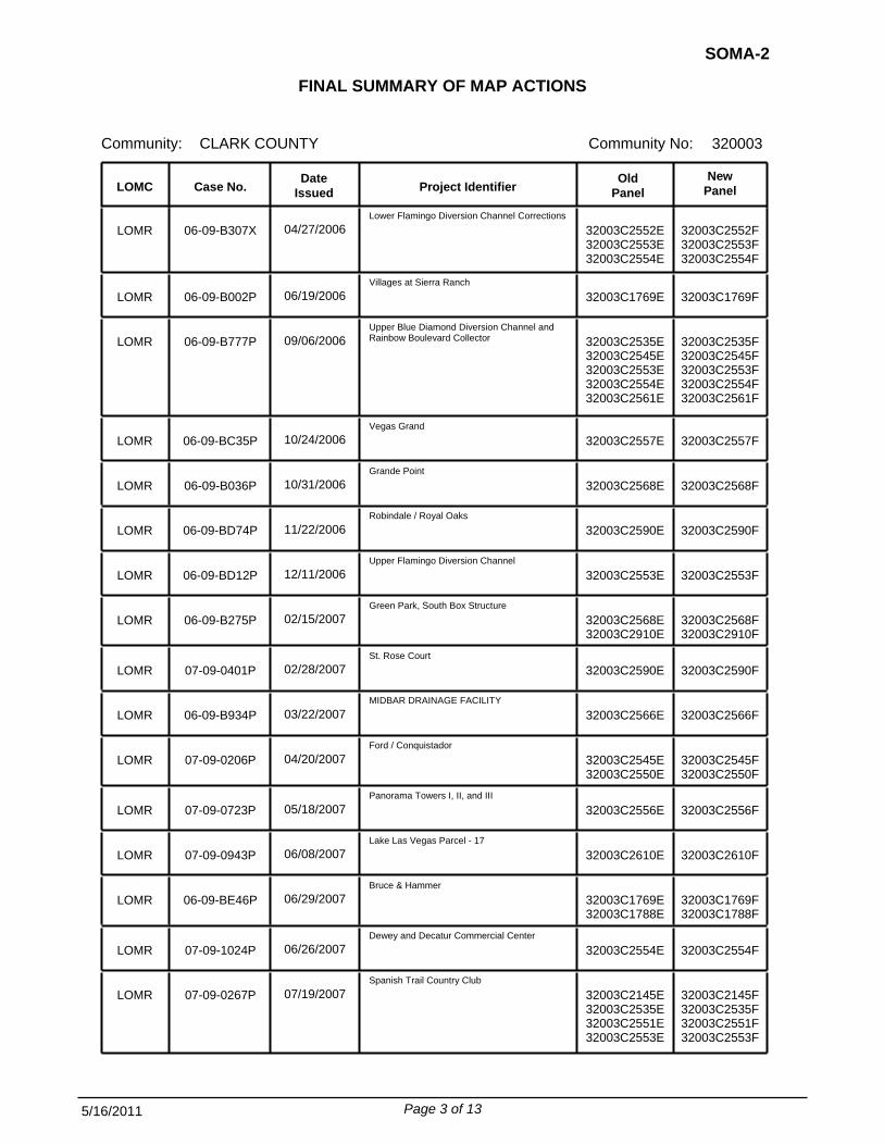
FINAL SUMMARY OF MAP ACTIONS
Community:
SOMA-2
Community No: 320003CLARK COUNTY
To assist your community in maintaining the Flood Insurance Rate Map (FIRM), we have summarizedbelow the previously issued Letter of Map Change (LOMC) actions (i.e., Letters of Map Revision (LOMRs) and Letters of Map Amendment (LOMAs)) that will be affected when the revised FIRM becomes effective on November 16, 2001.
1. LOMCs Incorporated The modifications effected by the LOMCs listed below will be reflected on the revised FIRM. In addition, these LOMCs will remain in effect until the revised FIRM becomes effective.
NewPanel
Old Panel Project Identifier
Date Issued Case No. LOMC
102 02-09-213P TRAVERSE POINT APARTMENTS 32003C2595D 32003C2595F 12/05/2001
102 02-09-963P GOWAN / BRADLEY FLOOD INSURANCE STUDY 32003C2155D 32003C2155F 05/22/2002
102 02-09-964P PITTMAN STEPHANIE REGIONAL FACILITY (HORIZON RIDGE TO PASEO VERDE) 32003C2595D 32003C2595F 05/21/2002
102 02-09-896P ORLEANS HOTEL AND CASINO - FLAMINGO WASH BOX CULVERT 32003C2552D 32003C2552F 08/01/2002
102 02-09-1023P SECTION 34
32003C2535D 32003C2535F 08/26/2002
102 03-09-0153P SOUTHERN VISTA ESTATES DIVERSION CHANNEL AND BERM 32003C2535E 32003C2535F 01/27/2003
102 02-09-718P TROPICANA WASH & TRIBS UPSTREAM OF PROPOSED LOWER FLAMINGO DIVERSION CHANNEL 32003C2560E 32003C2552F
32003C2554F 32003C2556F
06/19/2003
102 03-09-0980X DUCK CREEK/BLUE DIAMOND WASHES FIS RESTUDY 32003C2910E 32003C2562F
32003C2566F 32003C2567F 32003C2569F 32003C2583F 32003C2585F
08/13/2003
102 03-09-1569P SILVER SPRINGS - UNIT C 32003C2585E 32003C2585F 09/11/2003
102 02-09-287P HOLLYWOOD HIGHLANDS EAST NOS. 6 & 9 32003C2195E 32003C2195F 09/08/2003
102 03-09-0270P C-1 CHANNEL SYSTEM FIS RESTUDY 32003C2955E 32003C2605F
32003C2615F 32003C2620F 32003C2955F
11/06/2003
102 04-09-0124P BLUE DIAMOND RANCHES 32003C2562E 32003C2562F 12/08/2003
Page 1 of 13 5/16/2011

FINAL SUMMARY OF MAP ACTIONS
Community:
SOMA-2
Community No: 320003CLARK COUNTY
NewPanel
Old Panel Project Identifier
Date Issued Case No. LOMC
102 04-09-0021P BLUE DIAMOND CHANNEL 32003C2553E 32003C2554F 01/15/2004
102 04-09-0166P FLAMINGO WASH - MOHAVE RD. TO BOULDER HWY 32003C2190E 32003C2190F 03/12/2004
102 04-09-0167P FLAMINGO WASH - MARYLAND PARKWAY TO SPENCER STREET 32003C2557E 32003C2557F 03/12/2004
102 04-09-0352P RAINBOW / RUSSELL (ONSIGHT IMPROVEMENTS) 32003C2553E 32003C2553F 05/19/2004
102 04-09-0210P WALNUT GREEN 32003C2180E 32003C2177F 06/15/2004
102 04-09-0491P FLAMINGO DIVERSION-JONES BRANCH BETWEEN SUNSET ROAD AND RUSSELL ROAD 32003C2553E 32003C2554F 08/24/2004
102 04-09-0937P FI & F2 DETENTION BASINS AND CHANNELS 32003C2535E 32003C2535F
32003C2550F 09/03/2004
102 04-09-1057P RODES RANCH GOLF COUNTRY CLUB, L.L.C. 32003C2545E 32003C2545F 09/13/2004
102 04-09-1734P EJM DEVELOPMENT PROPERTIES 32003C2553E 32003C2553F 03/10/2005
102 05-09-1108P TROPICANA DETENTION BASIN
32003C2554E 32003C2554F 06/20/2005
LOMR 05-09-0285P GREEN PARK, NORTH BOX STRUCTURE 32003C2568E 32003C2568F 12/01/2005
LOMR 04-09-1194P REQUEST FOR LETTER OF MAP REVISION PITTMAN WASH VICINITY OF EASTERN AVENUE AND 215 BELTWAY 32003C2590E 32003C2590F 12/29/2005
LOMR 06-09-B070X LOWER DUCK CREEK LOMR
32003C2583E 32003C2585E
32003C2585F 02/02/2006
LOMR 05-09-1034P SILVERADO PINES UNIT NO. 3 32003C2568E 32003C2568F 02/09/2006
LOMR 06-09-B028X CENTRAL BRANCH OF TROPICANA WASH LOMR REISSUES 05-09-2100468P 32003C2553E 32003C2553F 02/13/2006
LOMR 05-09-A051P Rhodes Ranch Golf Country Club and Parcel 14 32003C2545E 32003C2545F 02/23/2006
LOMR 06-09-B049P Santa Margarita/Patrick 32003C2553E 32003C2553F 02/28/2006
LOMR 06-09-B083P ADAM AND EVE NIGHT CLUB 32003C2552E 32003C2552F 02/28/2006
LOMR 04-09-1382P TUSCANY MASTER PLANNED COMMUNITY 32003C2605E 32003C2605F 03/13/2006
Page 2 of 13 5/16/2011
FINAL SUMMARY OF MAP ACTIONS
Community:
SOMA-2
Community No: 320003CLARK COUNTY
NewPanel
Old Panel Project Identifier
Date Issued Case No. LOMC
LOMR 06-09-B307X Lower Flamingo Diversion Channel Corrections 32003C2552E
32003C2553E 32003C2554E
32003C2552F 32003C2553F 32003C2554F
04/27/2006
LOMR 06-09-B002P Villages at Sierra Ranch 32003C1769E 32003C1769F 06/19/2006
LOMR 06-09-B777P Upper Blue Diamond Diversion Channel and Rainbow Boulevard Collector 32003C2535E
32003C2545E 32003C2553E 32003C2554E 32003C2561E
32003C2535F 32003C2545F 32003C2553F 32003C2554F 32003C2561F
09/06/2006
LOMR 06-09-BC35P Vegas Grand 32003C2557E 32003C2557F 10/24/2006
LOMR 06-09-B036P Grande Point 32003C2568E 32003C2568F 10/31/2006
LOMR 06-09-BD74P Robindale / Royal Oaks 32003C2590E 32003C2590F 11/22/2006
LOMR 06-09-BD12P Upper Flamingo Diversion Channel 32003C2553E 32003C2553F 12/11/2006
LOMR 06-09-B275P Green Park, South Box Structure 32003C2568E
32003C2910E 32003C2568F 32003C2910F
02/15/2007
LOMR 07-09-0401P St. Rose Court 32003C2590E 32003C2590F 02/28/2007
LOMR 06-09-B934P MIDBAR DRAINAGE FACILITY
32003C2566E 32003C2566F 03/22/2007
LOMR 07-09-0206P Ford / Conquistador 32003C2545E
32003C2550E 32003C2545F 32003C2550F
04/20/2007
LOMR 07-09-0723P Panorama Towers I, II, and III 32003C2556E 32003C2556F 05/18/2007
LOMR 07-09-0943P Lake Las Vegas Parcel - 17 32003C2610E 32003C2610F 06/08/2007
LOMR 06-09-BE46P Bruce & Hammer 32003C1769E
32003C1788E 32003C1769F 32003C1788F
06/29/2007
LOMR 07-09-1024P Dewey and Decatur Commercial Center 32003C2554E 32003C2554F 06/26/2007
LOMR 07-09-0267P Spanish Trail Country Club
32003C2145E 32003C2535E 32003C2551E 32003C2553E
32003C2145F 32003C2535F 32003C2551F 32003C2553F
07/19/2007
Page 3 of 13 5/16/2011

FINAL SUMMARY OF MAP ACTIONS
Community:
SOMA-2
Community No: 320003CLARK COUNTY
NewPanel
Old Panel Project Identifier
Date Issued Case No. LOMC
LOMR 07-09-0613P Nielson Ranch 32003C2525E
32003C2550E 32003C2525F 32003C2550F
07/30/2007
LOMR 07-09-1157P Sunset and Jones 32003C2553E 32003C2553F 09/12/2007
LOMR 07-09-1641P Maryland to Algonquin 32003C2557E 32003C2557F 10/30/2007
LOMR 07-09-1642P Boulder Highway to Interstate 515
32003C2190E 32003C2190F 11/20/2007
LOMR 07-09-1870P Candlelight Units 1 and 2 32003C2553E 32003C2553F 02/08/2008
LOMR 07-09-1179P Hard Rock Casino Hotel 32003C2556E
32003C2557E 32003C2556F 32003C2557F
02/14/2008
LOMR 07-09-1418P Manhattan Condominium 32003C2568E 32003C2568F 02/19/2008
LOMR 07-09-1705P BLM 115 Channel 32003C2910E 32003C2910F 04/28/2008
LOMR 08-09-0255P Robindale Ranch 32003C2567E 32003C2567F 06/26/2008
LOMR 08-09-1194P Paradise Village 32003C2557E 32003C2557F 07/25/2008
LOMR 08-09-0351P Cactus Detention Basin and Outfall 32003C2569E
32003C2590E 32003C2910E
32003C2569F 07/28/2008
LOMR 08-09-0253P Silverton North Channel 32003C2562E
32003C2566E 32003C2562F 32003C2566F
09/26/2008
LOMR 08-09-0919P F4 Basin and Channel
32003C2535E 32003C2545E
32003C2535F 32003C2545F
09/30/2008
LOMR 07-09-1612P Blue Diamond Springs 32003C2562E 32003C2562F 11/12/2008
LOMR 09-09-0376P Pittman-Pecos Conveyance System 32003C2590E 32003C2590F 02/26/2009
LOMR 09-09-0021P Torino Avenue 32003C2550E 32002C2550F 05/29/2009
LOMR 09-09-1287P Silverado/Shelbourne Channel Culvert 32003C2566E 32003C2566F 06/25/2009
LOMR 09-09-0318P Hard Rock Channel 32003C2556E
32003C2557E 32003C2556F 32003C2557F
06/29/2009
Page 4 of 13 5/16/2011

FINAL SUMMARY OF MAP ACTIONS
Community:
SOMA-2
Community No: 320003CLARK COUNTY
NewPanel
Old Panel Project Identifier
Date Issued Case No. LOMC
LOMR 09-09-0526P Duck Creek Channel Improvements 32003C2567E
32003C2568E 32003C2569E 32003C2580E 32003C2583E 32003C2590E
32003C2567F 32003C2568F 32003C2569F 32003C2580F 32003C2583F 32003C2590F
09/16/2009
LOMR 09-09-1685P Rancho Drive/US95 32003C2155E 32003C2135F
32003C2155F 32003C2160F 32003C2170F
11/30/2009
LOMR 10-09-0393X Cactus Detention Basin 32003C2569E
32003C2910E 32003C2569F 32003C2910F
01/11/2010
LOMR 10-09-0479P FREEMAN DECORATING
32003C2553E 32003C2553F 03/17/2010
LOMR 09-09-2398P P&S Metals 32003C2552E 32003C2552F 06/28/2010
LOMR 10-09-2037P BLM 115 Channel 32003C2910E 32003C2910F 07/22/2010
LOMR 09-09-3102P Duck Creek Channel - Las Vegas Blvd Lower Duck Creek Detention Basin. 32003C2568E
32003C2910E 32003C2568F 32003C2910F
10/15/2010
LOMR 10-09-2587P HARRAH'S ENTERTAINMENT 32003C2556E 32003C2556F 10/28/2010
LOMR 10-09-2495P Northeast C-1 Detention Basin 32003C2620E 32003C2620F 11/24/2010
2. LOMCs Not Incorporated The modifications effected by the LOMCs listed below will not be reflected on the revised FIRM panels because of scale limitations or because the LOMC issued had determined that the lot(s) or structure(s) involved were outside the Special Flood Hazard Area, as shown on the FIRM. These LOMCs will remain in effect until the revised FIRM becomes effective. These LOMCs will be revalidated free of charge 1 day after the revised FIRM becomes effective through a single revalidation letter that reaffirms the validity of the previous LOMCs.
LOMC Case No. Date
Issued Project Identifier Old
Panel New
Panel
LOMR-F 95-09-684A FERNWOOD SUBDIV UNIT NO. 2, LOTS 10-11, & 88-91 3200031025B 32003C2177F 07/31/1995
LOMR-F 95-09-808A QUAIL CREEK PHASE II, LOT 32
32003C2590D 32003C2590F 09/06/1995
LOMR-F 95-09-835A FERNWOOD SUBDIV UNIT NO. 2, LOTS 1-9 & 92
32003C2180D 32003C2177F 09/14/1995
Page 5 of 13 5/16/2011

FINAL SUMMARY OF MAP ACTIONS
Community:
SOMA-2
Community No: 320003CLARK COUNTY
LOMC Case No. Date
Issued Project Identifier Old
Panel New
Panel
LOMR-F 95-09-977A QUAIL CREEK PHASE I, LOT 20-- 3250 RUTLEDGE DR. 32003C2590D 32003C2590F 10/04/1995
LOMA 95-09-917A PARCEL 2 -- 4375 EAST OQUENDO ROAD
32003C2580D 32003C2580F 10/12/1995
LOMR-F 95-09-876A SUR ESTE ESTATES, LOT 4 -- 2080 MONDO COURT 32003C2590D 32003C2590F 10/20/1995
LOMR-F 95-09-891A WINDMILL SPRINGS, UNIT 1,BLOCK 1,LOTS 1-40--UNIT 2, LOTS 102-108-- UNIT 3, LOTS 157-178
32003C2567D 32003C2567F 10/20/1995
LOMR-F 95-09-892A WINCHESTER WOODS, PORTION OF SECTION 12, T21S, R61E, M.D.B.&M. 32003C2190D 32003C2190F 10/20/1995
LOMR-F 95-09-897A ALEXANDER VILLAS ESTATES, BLOCK 3, LOTS 18-23-- BLOCK 8, LOTS 1-23-- BLOCK 9, LOTS 1-4-- AND BLOCK
32003C2180D 32003C2177F 10/20/1995
LOMR-F 95-09-872A SUNCHASE APARTMENTS, PARCEL 3, BUILDINGS A-H, J-N, P, & RECREATION BLDG 32003C2190D 32003C2567F 10/19/1995
LOMA 95-09-914A 11125 WIGWAM AVENUE -- PORTION OF SECTION 14, T22S, R59E, M.D.B.&M. 32003C2550D 32003C2550F 10/17/1995
LOMR-F 95-09-916A PECOS TERRACE CONDOS PHASE 2, BLDGS H-S AND U-X 32003C2178D 32003C2178F 10/17/1995
LOMR-F 95-09-918A LAGUNA VERDE TOWNHOMES, PHASE 1, BLOCK 1, LOTS 1-5-- BLOCK 2, LOTS 1-4-- BLOCK 3, LOTS 1-4-- BLOCK 4
32003C2580D 32003C2580F 10/17/1995
LOMR-F 95-09-817A VISTARA AT PEBBLE CANYON,UNIT 3, BLOCK 1, LOTS 4-15 32003C2590D 32003C2590F 10/24/1995
LOMR-F 95-09-848A SUNRISE VALLEY GARDEN HOMES #7 & 8, BLK. G, LOTS 107-129, AND BLOCK A, LOT 135 1688 ANGEL FALLS ST.
32003C2200D 32003C2195F 11/02/1995
LOMR-F 95-09-874A STONEBRIDGE D2A, BLOCK 1, LOTS 50-59
32003C2200D 32003C2195F 11/02/1995
LOMR-F 95-09-898A CASA BUENA UNIT 2, BLOCK 2, LOTS 16 & 17, AND BLOCK 4, LOTS 26 & 27--UNIT 3,BLOCK 5, LOTS 1, 2,& 21
32003C2200D 32003C2195F 11/02/1995
LOMR-F 95-09-899A DAYBREAK UNIT 1,BLOCK 3, LOTS 1-37 AND BLOCK 4, LOTS 1-14-- UNIT 2,BLOCK 3,LOTS 42-53-- UNIT 3,BLOCK
32003C2200D 32003C2195F 11/03/1995
LOMR-F 95-09-873A STEWART PLACE UNIT NO. 7, BLOCK 4, LOTS 1-24 32003C2200D 32003C2195F 11/03/1995
LOMR-F 95-09-915A PEACHTREE UNIT 2,BLOCK C, LOTS 179-193
32003C2200D 32003C2195F 11/02/1995
LOMR-F 95-09-928A SUNRISE HILLS UNIT 1, BLOCK 2, LOTS 19-20, BLOCK 4, LOT 39; SUNRISE HILLS UNIT 2, BLOCK 5, LOTS 47-
32003C2200D 32003C2195F 11/08/1995
Page 6 of 13 5/16/2011

FINAL SUMMARY OF MAP ACTIONS
Community:
SOMA-2
Community No: 320003CLARK COUNTY
LOMC Case No. Date
Issued Project Identifier Old
Panel New
Panel
LOMR-F 96-09-025A QUAIL CREEK PHASE II, LOTS 27 & 28-- 7470 & 7460 MOUNTAINBORO LANE 32003C2590D 32003C2590F 11/09/1995
LOMR-F 95-09-919A ORCHARDS NO. 41, LOT 622-693
32003C2200D 32003C2195F 11/13/1995
LOMR-F 96-09-114A QUAIL CREEK PHASE II, LOTS 26, 29, 30, 31, & 33
32003C2590D 32003C2590F 11/27/1995
LOMR-F 95-09-990A KCN CONDOMINIUMS, PHASE 1, BLDGS. 23-33, AND THE RECREATION BUILDING AND KCN CONDOMINIUMS, PHASE 2,
32003C2552D 32003C2552F 12/14/1995
LOMR-F 96-09-279A KCN CONDOMINIUMS, BLDGS 12, 14-18, 36 & 38
32003C2552D 32003C2552F 01/19/1996
LOMR-F 95-09-909A AMENDED PLAT OF EVERGREEN CONDOMINIUMS,BUILDINGS A-S 32003C2552D 32003C2552F 01/19/1996
LOMR-F 96-09-174A QUAIL CREEK PHASE I, LOT 22; PHASE II, LOTS 23-24 32003C2590D 32003C2590F 02/20/1996
LOMR-F 96-09-586A KCN CONDOMINIUMS PHASE 2,BUILDINGS 9-11, 39-43 & 45 32003C2552D 32003C2552F 05/06/1996
LOMR-F 96-09-803A SILVERADO HILLS UNIT 4, BLK 2, LOTS 15 &16--UNIT 4,BLK 4, LOTS 40, 49 & 51-56 &UNIT 5,BLK 5, LOTS 1-
32003C2569D 32003C2569F 32003C2590F
07/11/1996
LOMR-F 96-09-910A 270 EAST MAULDING AVENUE -- PORTION OF GOVT LOT 18, LOT 1 32003C2566D 32003C2566F 07/11/1996
LOMR-F 96-09-643A 3950 WEST DIABLO DRIVE & 3955 EAST MESA VISTA AVENUE -- PORTION OF SECTION 30,T21S, R61E, M.D.B.&M.
32003C2554D 32003C2554F 09/11/1996
LOMA 96-09-965A NEW DIMENSION ESTATES UNIT 2,LOT 9-- 5598 NORMANTON ST 32003C2580D 32003C2580F 09/20/1996
LOMR-F 97-09-191A WARM SPRINGS/BRUCE CONDOMINIUMS, BLDGS 12 & 13 32003C2590D 32003C2590F 12/19/1996
LOMR-F 97-09-299A KCN CONDOMINIUMS, PHASE II, BLDGS 1-8, 13, & 46 32003C2552D 32003C2552F 01/03/1997
LOMA 97-09-1183A BLUE DIAMOND VILLAGE, UNIT NO. 1, LOT 2-- LASSEN STREET 32003C2525D 32003C2525F 10/03/1997
LOMA 98-09-1002A SOUTHERN TRAILS, BLOCK 1, LOT 18 -- 5480 CEDAR CANYON LANE 32003C2535D 32003C2535F 09/29/1998
LOMR-F 99-09-841A AGATE/GILESPIE (VILLA TRIESTE), UNIT 7, BLOCK 1, LOTS 123-136 -- 361, 365, 369, 373, 377, 379, 381,
32003C2569D 32003C2568F 07/02/1999
LOMA 99-09-944A SOUTHERN TRAILS, BLOCK 1, LOT 24 -- 5420 CEDAR CANYON LANE 32003C2535D 32003C2535F 07/14/1999
Page 7 of 13 5/16/2011

FINAL SUMMARY OF MAP ACTIONS
Community:
SOMA-2
Community No: 320003CLARK COUNTY
LOMC Case No. Date
Issued Project Identifier Old
Panel New
Panel
LOMA 99-09-814A 4065 WEST MESA VISTA AVENUE -- PORTION OF SECTION 30, T21S, R61E, M.D.M. 32003C2554D 32003C2554F 09/28/1999
LOMR-F 00-09-179A SPRING VALLEY RANCH UNIT 4, BLOCK 7, LOTS 27-34, BLOCK 8, LOTS 14-16; UNIT 6, BLOCK 7, LOTS 24-26, B
32003C2553D 32003C2553F 32003C2554F
12/27/1999
LOMA 00-09-344A COLONY HOMES UNIT 6, BLOCK 5, LOT 19 -- 6943 ROYAL MEADOW PLACE 32003C2551D 32003C2551F 03/30/2000
LOMR-F 00-09-998A SILVER SPRINGS - UNIT B, LOT 241 -- 5197 MIDNIGHT OIL DRIVE 32003C2585D 32003C2585F 11/06/2000
LOMR-F 01-09-067A SILVER SPRINGS, UNIT B, LOTS 1-97, 102-104, 111-112, 119-120, 127-128, 135-136, 142-160, & 213-240
32003C2585D 32003C2585F 12/18/2000
LOMR-F 01-09-496A SILVER SPRINGS, UNIT C, L0TS 14, 17-104, 107-110, 209-211, 213-233, 235, 236, 251, 253-285 32003C2585D 32003C2585F 04/04/2001
LOMA 01-09-630A OQUENDO ESTATES, LOT 3; 4135 OQUENDO ROAD 32003C2580D 32003C2580F 04/27/2001
LOMA 01-09-1017A CIMARRON MEADOWS UNIT 3, LOT 168 -- 4358 MESA HILL DRIVE 32003C2535D 32003C2535F 08/15/2001
LOMA 01-09-1094A 1 ARROYO DRIVE -- PARCEL MAP 461352, PARCEL 1 32003C2525D 32003C2525F 09/26/2001
LOMA 01-09-861A OQUENDO ESTATES, LOT 4 -- 4125 EAST OQUENDO ROAD 32003C2580D 32003C2580F 10/10/2001
LOMR-F 02-09-087A TERRASANTA UNIT 2, BLDGS 1-12 & CLUBHOUSE -- 5650 SAHARA AVENUE 32003C2200D 32003C2195F 11/20/2001
LOMA 02-09-459A RIVA UNIT 4, BLOCK 2, LOT 59 -- 2121 MERANO COURT 32003C2590D 32003C2590F 03/25/2002
LOMR-F 02-09-501A 8820 KULKA ROAD -- PARCEL MAP, LOT 1, PORTION OF SECTION 13, T22S, R59E, M.D.B.&M.
32003C2550D 32003C2550F 04/05/2002
LOMR-F 02-09-805A RIVA UNIT 3, BLOCK 3, LOT 11 -- 2155 MADICA AVENUE 32003C2590D 32003C2590F 06/12/2002
LOMA 02-09-1232A TROPHY CLUB AT PARADISE UNIT II, BLOCK 1, LOT 29 -- 1026 ALYSSA CIARA COURT 32003C2567E 32003C2567F 10/09/2002
LOMA 02-09-1148A TROPHY CLUB AT PARADISE UNIT II, BLOCK 1, LOT 23 -- 7824 BRIANA RENEE WAY 32003C2567E 32003C2567F 10/15/2002
LOMA 02-09-1387A SOUTHWEST ASSEMBLAGE PHASE 1, LOT 60 -- 9910 WEST MESA VISTA AVENUE 32003C2535D 32003C2535F 12/02/2002
LOMA 03-09-0366A TIBURON PHASE 6, BLOCK 2, LOT 90 -- 8784 STOCKHOLM AVENUE 32003C2535E 32003C2535F 03/24/2003
Page 8 of 13 5/16/2011

FINAL SUMMARY OF MAP ACTIONS
Community:
SOMA-2
Community No: 320003CLARK COUNTY
LOMC Case No. Date
Issued Project Identifier Old
Panel New
Panel
LOMA 03-09-0513A AMIGO, BLOCK 5, LOT 284 -- 10273 GRECIAN LAUREL COURT 32003C2569E 32003C2569F 05/09/2003
LOMR-F 03-09-0819A CIMARRON/HACIENDA, BLOCK 1, LOTS 21, 31-39
32003C2535E 32003C2535F 06/25/2003
LOMA 03-09-1195A VERDE VALLE ESTATES, LOTS 1-20
32003C2580E 32003C2580F 07/02/2003
LOMA 03-09-1230A 4465 EMERALD AVENUE -- PORTION OF SECTION 29, T21S, R62E, M.D.B.&M. (APN: 161-29-402-004)
32003C2580E 32003C2580F 08/05/2003
LOMA 03-09-1470A NORTHPOINTE UNIT 3, LOT 10 -- 3859 LANCOME STREET 32003C2180E 32003C2177F 08/27/2003
LOMA 03-09-1568A SILVER SPRINGS-UNIT C, LOTS 14, 17-104, 107-110, 209-211, 213-233, 235, 236, 251, 253-285 32003C2585E 32003C2585F 09/02/2003
LOMR-F 03-09-1175A GREENFIELD ESTATES, BLOCK 1, LOTS 4-5, 7, 9, & 11 -- 3776, 3770, 3758, 3746, & 3734 MAHALO CIRCLE
32003C1105E 32003C1105F 09/26/2003
LOMA 04-09-1404A WINDMILL SPRINGS UNIT 1, BLOCK 1, LOTS 10-40; UNIT III, BLOCK 5, LOTS 157-178 32003C2567E 32003C2567F 08/06/2004
LOMR-F 04-09-1188A GREENFIELD ESTATES, BLOCK 1, LOT 2 -- 3788 MAHALO CIRCLE 32003C1105E 32003C1105F 08/18/2004
LOMR-F 04-09-1144A 3451 MICHAEL WAY -- PORTION OF SECTION 12, T20S, R60E, M.D.B.&M. 32003C2155E 32003C2155F 10/13/2004
LOMA 04-09-1689A GRANDBROOKE 1, BLOCK 1, LOT 17 -- 5072 TRANQUIL STREAM COURT 32003C2535E 32003C2535F 10/27/2004
LOMA 05-09-0289A PACIFIC COLLAGE D4, BLOCK 1, LOT 28
32003C2195E 32003C2195F 03/11/2005
LOMA 05-09-0798A LOT 14, BLOCK 2 DESERT INN MASTER PLAN LOT D- 6312 ENCHANTED CREEK PLACE 32003C2585E 32003C2585F 06/01/2005
LOMA 05-09-0547A RUSSELL/FORT APACHE, 11, BLOCK 25, LOT 715 -- 6049 FAIR VALLEY STREET 32003C2535E 32003C2535F 07/21/2005
LOMA 05-09-0979A ORCHARDS, UNIT 1, LOT 59 -- 1265 ORCHARD VIEW STREET 32003C2195E 32003C2195F 08/23/2005
LOMR-F 06-09-0143A ISLAND COVE, LOTS 4-13
32003C2562E 32003C2562F 11/18/2005
LOMA 05-09-1343A SILVER OAK, UNIT 3, BLOCK 3, LOT 91 -- 895 CLINE CELLARS AVENUE 32003C2569E 32003C2569F 11/22/2005
LOMR-F 06-09-B077A PARCEL 1, LOT 2, R.O.S. 0001974--3921 EAST SUNSET ROAD 32003C2580E 32003C2580F 01/24/2006
Page 9 of 13 5/16/2011

FINAL SUMMARY OF MAP ACTIONS
Community:
SOMA-2
Community No: 320003CLARK COUNTY
LOMC Case No. Date
Issued Project Identifier Old
Panel New
Panel
LOMR-F 06-09-B299A GREENFIELD ESTATES, BLOCK 2, LOT 22 -- 3747 MAHALO CIRCLE 32003C1105E 32003C1105F 02/09/2006
LOMA 06-09-B892A DESERT INN MASTER PLAN, BLOCK 4, LOT 97 -- 3731 SQUIRREL STREET 32003C2585E 32003C2585F 06/12/2006
LOMA 06-09-BB45A Lot 69, Block 2, Silverado Estates -- 888 SPARKLE RAY AVE 32003C2569E 32003C2569F 07/12/2006
LOMA 06-09-BC22A Lot 352, Blue Diamond Springs Unit 2 -- 8317 OPPENHEIMER STREET 32003C2562E 32003C2562F 07/14/2006
LOMR-F 06-09-B994A 3899 EAST SUNSET ROAD
32003C2580E 32003C2580F 08/02/2006
LOMA 07-09-0399A SECTION 30 SOUTHWEST ASSEMBLAGE R2-60/70 NO. 4, BLOCK 1, LOT 2 -- 5074 SHADOW MIST COURT
32003C2535E 32003C2535F 12/12/2006
LOMA 07-09-0416A BLUE DIAMOND VILLAGE UNIT 1, BLOCK 2, LOT 2 -- 3 COTTONWOOD DRIVE 32003C2525E 32003C2525F 01/11/2007
LOMR-F 07-09-0377A GREENFIELD ESTATES, BLOCK 2, LOT 23 -- 3753 MAHALO CIRCLE 32003C1105E 32003C1105F 02/06/2007
LOMA 08-09-0233A MESA VISTA ESTATES, LOT 2 -- 5375 LONESOME BIKER LANE 32003C2535E 32003C2535F 12/11/2007
LOMA 08-09-0460A LOT 41, BLOCK B, FORT APACHE HACIENDA SOUTH -- 9497 WEST DIABLO DRIVE 32003C2535E 32003C2535F 02/14/2008
LOMA 08-09-0626A BIASI SUBDIV, LOT 6 -- 150 NORTH TOBLER LANE 32003C0388F 32003C0388F 03/27/2008
LOMA 08-09-1130A BLUE DIAMOND SPRINGS, UNIT 5A, LOT 102 -- 4795 GOLDEN SHIMMER AVENUE 32003C2562E 32003C2562F 06/18/2008
LOMA 09-09-0680A DESERT INN MASTERPLAN, PARCEL C, BLOCK 6, LOT 176 -- 3714 KIT FOX STREET 32003C2585E 32003C2585F 02/17/2009
LOMA 09-09-1433A DESERT INN MASTER PLAN LOT B PHASE 2, BLOCK 2, LOT 78 -- 3549 CHELSEA GROVE STREET
32003C2585E 32003C2585F 05/12/2009
LOMA 09-09-1824A 8130 SOUTH VALLEY VIEW BOULEVARD -- A PORTION OF SECTION 17, T22S, R51E, M.D.M. 32003C2562E 32003C2562F 07/21/2009
LOMA 10-09-0231A LOT 94, BLOCK E, AVANTE HOMES PHASE 1 -- 9980 CLEAR CRYSTAL ST, LAS VEGAS, NV 32003C2569E 32003C2569F 11/05/2009
LOMA 10-09-3347A (70-OAS) LOT 110, BLOCK 5, DESERT INN MASTER PLAN PARCEL C -- 6393 PRONGHORN RIDGE AVENUE
32003C2585E 32003C2585F 09/02/2010
LOMA 11-09-0713A GRANDBROOKE 3, BLOCK 1, LOT 18 -- 10112 HERMIT RAPIDS AVENUE 32003C2550E 32003C2550F 01/12/2011
Page 10 of 13 5/16/2011

FINAL SUMMARY OF MAP ACTIONS
Community:
SOMA-2
Community No: 320003CLARK COUNTY
LOMC Case No. Date
Issued Project Identifier Old
Panel New
Panel
LOMA 04-09-0792A SHADOW MOUNTAIN RANCH, BLOCK 1, LOT 55 -- 9880 WEST MESA VISTA AVENUE 32003C2535E 32003C2535F
LOMA 04-09-0664A SHADOW MOUNTAIN RANCH, LOT 40 -- 10091 BONHAM COURT 32003C2550E 32003C2550F
LOMA 04-09-0679A SHADOW MOUNTAIN RANCH, LOT 44 -- 10123 BONHAM COURT 32003C2550E 32003C2550F
LOMA 03-09-0314A DURANGO SPRINGS UNIT 2, BLOCK 1, LOT 28; 5933 INDIAN SUNSET STREET 32003C2535F
LOMA 10-09-2645A (70-OAS) DESERT INN, BLOCK 5, LOT 107 -- 6375 PRONGHORN RIDGE 32003C2585E 32003C2585F
LOMA 10-09-3078A (70-OAS) Lot 20, Block 40, Sun Colony at Summerlin Unit 17 -- 10228 Questa Sera Court. 32003C2550E 32003C2550F
3. LOMCs Superseded The modifications effected by the LOMCs listed below have not been reflected on the Final revised FIRM panels because they are being superseded by new detailed flood hazard information or the information available was not sufficient to make a determination. The reason each is being superseded is noted below. These LOMCs will no longer be in effect when the revised FIRM becomes effective.
LOMC Case No. Date
Issued Project Identifier Reason Determination
Will be Superseded
LOMR-F 00-09-633A 3950 EAST PATRICK LANE -- PORTION OF SECTION 31, T21S, R62E, M.D.B.&M. 09/18/2000 1
LOMR-F 02-09-336A TERRASANTA UNIT 2, BLDGS 8 & 11 -- 5650 EAST SAHARA AVENUE 01/11/2002 1
102 02-09-1335P PIONEER DETENTION BASIN
12/17/2002 4
102 02-09-913P DUCK CREEK / BLUE DIAMOND WASHES FIS RESTUDY 04/07/2003 4
102 03-09-0861X DUCK CREEK / BLUE DIAMOND WASHES FIS RESTUDY 04/21/2003 4
102 03-09-0904P MORGYN RIDGE CONDOMINIUMS
06/20/2003 4
102 02-09-1071P LAS VEGAS WASH BETWEEN DESERT INN AND FLAMINGO ROAD 07/31/2003 4
102 03-09-0763P BLUE DIAMOND RANCHES
09/25/2003 4
Page 11 of 13 5/16/2011
04/01/200
04/01/200
04/01/200
02/10/2003
07/08/2010
08/03/2010

FINAL SUMMARY OF MAP ACTIONS
Community:
SOMA-2
Community No: 320003CLARK COUNTY
LOMC Case No. Date
Issued Project Identifier Reason Determination
Will be Superseded
102 03-09-0886P SUNRISE MEADOWS SUBDIVISION
01/22/2004 4
102 03-09-1710P SLUSHER RESIDENCE
04/15/2004 4
102 04-09-0454P PITTMAN EAST DETENTION BASIN
06/03/2004 4
102 04-09-0981P DUCK CREEK AT MIRADA AVENUE
06/03/2004 4
102 04-09-1776P MAPLEWOOD II
01/03/2005 4
102 04-09-1645P WARMINGTON HOMES AT SECTION 10 - HAMPTON VILLAGES 04/19/2005 4
LOMR 05-09-2100468P Rainbow Sunset Pavilion
09/28/2005 4
LOMR 05-09-A069P Longford Group/Duck Creek Channel Improvements 11/10/2005 4
LOMR 06-09-A635P POST-GATEWAY CENTER INDUSTRIAL DEVELOPMENT 01/30/2006 4
LOMR 05-09-0913P LOWER DUCK CREEK LOMR
02/16/2006 4
LOMR 07-09-0389P Range Wash Channelization - Charleston Boulevard to Las Vegas Wash 01/25/2007 4
LOMR 06-09-BG37P Desert Inn Master Plan
12/13/2007 4
LOMR 07-09-0831P Silverado Ranch Courts
10/14/2008 4
LOMR 09-09-0065P Sahara Avenue and Sloan Lane
12/31/2008 4
LOMR 10-09-1718P Tonopah/Covey
06/16/2010 4
1. Insufficient information available to make a determination. 2. Lowest Adjacent Grade and Lowest Finished Floor are below the proposed Base Flood Elevation. 3. Lowest Ground Elevation is below the proposed Base Flood Elevation. 4. Revised hydrologic and hydraulic analyses. 5. Revised topographic information.
Page 12 of 13 5/16/2011

FINAL SUMMARY OF MAP ACTIONS
Community:
SOMA-2
Community No: 320003CLARK COUNTY
4. LOMCs To Be Redetermined The LOMCs in Category 2 above will be revalidated through a single revalidation letter that reaffirms the validity of the determination in the previously issued LOMC. For LOMCs issued for multiple lots orstructures where the determination for one or more of the lots or structures has changed, the LOMCcannot be revalidated through this administrative process. Therefore, we will review the data previously submitted for the LOMC requests listed below and issue a new determination for the affected properties after the effective date of the revised FIRM.
LOMC Case No. Date
Issued Old
Panel New
Panel Project Identifier
LOMA 97-09-1224A 32003C2525D 32003C2525F PORTION OF SECTION 16, T22S, R59E, M.D.M. 10/30/1997
102 02-09-171P 32003C2595D 32003C2595F LAKE MEAD SOUTH - PHASE II BOX CULVERT 05/22/2002
102 02-09-911P 32003C2200D 32003C2185F RANGE WASH CONFLUENCE DETENTION BASIN AND SLOAN CHANNEL 05/28/2002
LOMR-F 04-09-0339A 32003C2562E 32003C2562F BLUE DIAMOND BUSINESS CENTER, BLDG H -- PORTIONS OF GOVT LOTS 40-44 & 75-79, SECTION 18, T22S, R61E, 03/26/2004
Page 13 of 13 5/16/2011

1 CERTIFIED MAIL IN REPLY REFER TO: RETURN RECEIPT REQUESTED 115-C-I May 16, 2011 The Honorable Andy A. Hafen Community: City of Henderson, Nevada Mayor, City of Henderson Community No.: 320005 Post Office Box 95050 Map Panels Affected: See FIRM Index Henderson, Nevada 89009 Dear Mayor Hafen: On October 15, 2010, you were notified of proposed modified flood elevation determinations affecting the Flood Insurance Rate Map (FIRM) and Flood Insurance Study (FIS) report for Clark County, Nevada and Incorporated Areas. The statutory 90-day appeal period that was initiated on October 29, 2010, when the Department of Homeland Security’s Federal Emergency Management Agency (FEMA) published a notice of proposed Base (1-percent-annual-chance) Flood Elevations (BFEs) for the City of Henderson, has elapsed. FEMA received no valid requests for changes in the BFEs. Therefore, the determination of FEMA as to the BFEs for your community is considered final. The final BFEs will be published in the Federal Register as soon as possible. The modified BFEs and revised map panels, as referenced above, are effective as of November 16, 2011, and revise the FIRM that was in effect prior to that date. For insurance rating purposes, the community number and new suffix code for the panels being revised are indicated above and on the maps, and must be used for all new policies and renewals. The modifications are pursuant to Section 206 of the Flood Disaster Protection Act of 1973 (Public Law 93-234) and are in accordance with the National Flood Insurance Act of 1968, as amended (Title XIII of the Housing and Urban Development Act of 1968, Public Law 90-448), 42 U.S.C. 4001-4128, and Title 44 Code of Federal Regulations Part 65. Pursuant to Section 1361 of the National Flood Insurance Act of 1968, as amended, communities participating in the National Flood Insurance Program (NFIP) are required to adopt and enforce floodplain management regulations that meet or exceed minimum NFIP criteria. These criteria are the minimum and do not supersede any State or local requirements of a more stringent nature. This includes adoption of the effective FIRM and FIS report to which the regulations apply and the modifications made by this map revision. Our records show that your community has met this requirement. To assist your community in maintaining the FIRM, we have enclosed a Summary of Map Actions to document previous Letter of Map Change (LOMC) actions (i.e., Letters of Map Amendment (LOMAs), Letters of Map Revision (LOMRs)) that will be superseded when the revised FIRM panels referenced above become effective. Information on LOMCs is presented in the following four categories: (1) LOMCs for which results have been included on the revised FIRM panels; (2) LOMCs for which results could not be shown on the revised FIRM panels because of scale limitations or because the LOMC issued had determined that the lots or structures involved were outside the Special Flood Hazard Area as shown on the FIRM; (3) LOMCs for which results have not been included on the revised FIRM panels because the flood hazard information on which the original determinations were based are being superseded by new flood hazard information; and (4) LOMCs issued for multiple lots or structures where

2 the determination for one or more of the lots or structures cannot be revalidated through an administrative process like the LOMCs in Category 2 above. LOMCs in Category 2 will be revalidated through a single letter that reaffirms the validity of a previously issued LOMC; the letter will be sent to your community shortly before the effective date of the revised FIRM and will become effective one day after the revised FIRM becomes effective. For the LOMCs listed in Category 4, FEMA will review the data previously submitted for the LOMA or LOMR request and issue a new determination for the affected properties after the revised FIRM becomes effective. The FIRM and FIS report for your community have been prepared in our countywide format, which means that flood hazard information for all jurisdictions within Clark County has been combined into one FIRM and FIS report. When the FIRM and FIS report are printed and distributed, your community will receive only those panels that present flood hazard information for your community. FEMA will provide complete sets of the FIRM panels to county officials, where they will be available for review by your community. The FIRM panels were computer generated. Once the FIRM and FIS report are printed and distributed, the digital files containing the flood hazard data for the entire county can be provided to your community for use in a computer mapping system. These files can be used in conjunction with other thematic data for floodplain management purposes, insurance purchase and rating requirements, and many other planning applications. Copies of the digital files or paper copies of the FIRM panels can be obtained by calling the FEMA Map Information eXchange (FMIX), toll free, at 1-877-FEMA MAP (1-877-336-2627). In addition, your community may be eligible for additional credits under the Community Rating System if you implement your activities using digital mapping files. If you have any questions regarding the necessary floodplain management measures for your community or the NFIP in general, you can contact the Director, Mitigation Division of FEMA in Oakland, California, at (510) 627-7100 for assistance. If you have any questions concerning mapping issues in general or the enclosed Summary of Map Actions, please call our FMIX at the toll free number shown above. Additional information and resources your community may find helpful regarding the NFIP and floodplain management, such as The National Flood Insurance Program Code of Federal Regulations, Answers to Questions About the NFIP, Use of Flood Insurance Study (FIS) Data as Available Data, Frequently Asked Questions Regarding the Effect that Revised Flood Hazards have on Existing Structures, and National Flood Insurance Program Elevation Certificate and Instructions, can be found on our website at http://www.floodmaps.fema.gov/lfd/. Paper copies of these documents can also be obtained by calling the FMIX.
Sincerely, Luis Rodriguez, P.E., Chief Engineering Management Branch Federal Insurance and Mitigation Administration
Enclosure: Final Summary of Map Actions cc: Community Map Repository Robert Herr, Deputy City Engineer, City of Henderson Representative Joe Heck, District Office

3 bcc: State Coordinator
Regional Director R9-MT FEDD File MBJ Project File

CERTIFIED MAIL IN REPLY REFER TO: RETURN RECEIPT REQUESTED 115-N May 16, 2011 The Honorable Roger Tobler Community: City of Boulder City, Nevada Mayor, City of Boulder City Community No.: 320004 401 California Avenue Map Panels Affected: See FIRM Index Boulder City, Nevada 89005 Dear Mayor Tobler: On February 26, 2010, the Department of Homeland Security’s Federal Emergency Management Agency (FEMA) provided you with Preliminary copies of the revised Flood Insurance Rate Map (FIRM) and Flood Insurance Study (FIS) report for Clark County, Nevada and Incorporated Areas for your review and comment. Those Preliminary copies presented revised flood hazard information for your community, but did not present revised elevations of the flood having a 1-percent chance of being equaled or exceeded in any given year (base flood). Therefore, no appeal period was required. Your community was provided with a 30-day review period, and that period has now elapsed. No comments or concerns about the Preliminary copies of the revised FIRM and FIS report were submitted to FEMA; therefore, the revised FIRM panel, as referenced above, will be effective as of November 16, 2011, and revise the FIRM that was in effect prior to that date. For insurance rating purposes, the community number and new suffix code for the FIRM panels being revised are indicated on the panels and must be used for all new policies and renewals.
The modifications are pursuant to Section 206 of the Flood Disaster Protection Act of 1973 (Public Law 93-234) and are in accordance with the National Flood Insurance Act of 1968, as amended (Title XIII of the Housing and Urban Development Act of 1968, Public Law 90-448), 42 U.S.C. 4001-4128, and 44 CFR Part 65. Because of the modifications to the FIRM and FIS report for your community made by this map revision, certain additional requirements must be met under Section 1361 of the 1968 Act, as amended, within 6 months from the date of this letter. Prior to November 16, 2011, your community is required, as a condition of continued eligibility in the National Flood Insurance Program (NFIP), to adopt or show evidence of adoption of floodplain management regulations that meet the standard of Paragraph 60.3 (d) of the NFIP regulations. These standards are the minimum requirements and do not supersede any State or local requirements of a more stringent nature. It must be emphasized that all the standards specified in Paragraph 60.3 (d) of the NFIP regulations must be enacted in a legally enforceable document. This includes the adoption of the effective FIRM and FIS report to which the regulations apply and the modifications made by this map revision. Some of the standards should already have been enacted by your community. Any additional requirements can be met by taking one of the following actions:

2
1. Amending existing regulations to incorporate any additional requirements of Paragraph 60.3 (d); 2. Adopting all the standards of Paragraph 60.3 (d) into one new, comprehensive set of regulations;
or
3. Showing evidence that regulations have previously been adopted that meet or exceed the minimum requirements of Paragraph 60.3 (d).
Communities that fail to enact the necessary floodplain management regulations will be suspended from participation in the NFIP and subject to the prohibitions contained in Section 202(a) of the 1973 Act as amended. A Consultation Coordination Officer (CCO) has been designated to assist your community with any difficulties you may be encountering in enacting the floodplain management regulations. The CCO will be the primary liaison between your community and FEMA. For information about your CCO, please contact:
Ms. Sally Ziolkowski Director, Federal Insurance and Mitigation Division
Federal Emergency Management Agency, Region IX 1111 Broadway Street, Suite 1200 Oakland, California 94607-4052
(510)-627-7103 To assist your community in maintaining the FIRM, we reviewed our records to determine if any previous Letters of Map Change (i.e., Letters of Map Amendment, Letters of Map Revision) will be superseded when the revised FIRM panels become effective. According to our records, no Letters of Map Change were issued previously for the affected FIRM panels. The FIRM and FIS report for your community have been prepared in our countywide format, which means that flood hazard information for all jurisdictions within Clark County has been combined into one FIRM and FIS report. When the FIRM and FIS report are printed and distributed, your community will receive only those panels that present flood hazard information for your community. We will provide complete sets of the FIRM panels to county officials, where they will be available for review by your community. The FIRM panels have been computer-generated. Once the FIRM and FIS report are printed and distributed, the digital files containing the flood hazard data for the entire county can be provided to your community for use in a computer mapping system. These files can be used in conjunction with other thematic data for floodplain management purposes, insurance purchase and rating requirements, and many other planning applications. Copies of the digital files or paper copies of the FIRM panels may be obtained by calling our FEMA Map Information eXchange (FMIX), toll free, at 1-877-FEMA MAP (1-877-336-2627). In addition, your community may be eligible for additional credits under our Community Rating System if you implement your activities using digital mapping files.

3
If you have any questions regarding the necessary floodplain management measures for your community or the NFIP in general, we urge you to contact the Director, Federal Insurance and Mitigation Division of FEMA in Oakland, California, at (510) 627-7100, for assistance. If you have any questions concerning mapping issues in general, please call our FMIX at the toll free number shown above. Additional information and resources your community may find helpful regarding the NFIP and floodplain management, such as The National Flood Insurance Program Code of Federal Regulations, Answers to Questions About the NFIP, Use of Flood Insurance Study (FIS) Data As Available Data, Frequently Asked Questions Regarding the Effects that Revised Flood Hazards have on Existing Structures, and National Flood Insurance Program Elevation Certificate and Instructions, can be found on our website at http://www.floodmaps.fema.gov/lfd. Paper copies of these documents may also be obtained by calling our FMIX.
Sincerely, Luis Rodriguez, P.E., Chief Engineering Management Branch Federal Insurance and Mitigation Administration
cc: Community Map Repository Scott Hansen, Public Works Director, City of Boulder City Joe Heck, Congressman, U.S. House of Representatives

4
bcc: State Coordinator Regional Director R9-MT FEDD File MBJ Project File

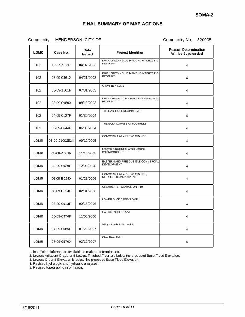
FINAL SUMMARY OF MAP ACTIONS
Community:
SOMA-2
Community No: 320005HENDERSON, CITY OF
To assist your community in maintaining the Flood Insurance Rate Map (FIRM), we have summarized below the previously issued Letter of Map Change (LOMC) actions (i.e., Letters of Map Revision (LOMRs) and Letters of Map Amendment (LOMAs)) that will be affected when the revised FIRM becomes effective on November 16, 2011.
1. LOMCs Incorporated The modifications effected by the LOMCs listed below will be reflected on the revised FIRM. In addition, these LOMCs will remain in effect until the revised FIRM becomes effective.
NewPanel
Old Panel Project Identifier
Date Issued Case No. LOMC
102 02-09-213P TRAVERSE POINT APARTMENTS 32003C2595D 32003C2595F 04/05/2002
102 02-09-964P HORIZON/CIELO ABIERTO APARTMENTS
32003C2595D 32003C2595F 07/18/2002
102 02-09-296P MARYLAND HILLS 32003C2930D 32003C2930F 07/15/2002
102 03-09-0284X PIONEER DETENTION BASIN 32003C2585E 32003C2585F
32003C2595F 01/14/2003
102 02-09-782P RESORT AT GREEN VALLEY RANCH PEBBLE CREEK 32003C2590E 32003C2590F 03/19/2003
102 02-09-382P INSPIRATION AT GREEN VALLEY RANCH 32003C2590E 32003C2590F 03/19/2003
102 02-09-717P RESORT AT GREEN VALLEY RANCH - CARNEGIE ROAD 32003C2590E 32003C2590F 03/19/2003
102 03-09-1495X GRANITE HILLS 2 32003C2930E 32003C2930F 09/11/2003
102 03-09-1436P LAKE VALLEY ESTATES 32003C2615E 32003C2615F 11/06/2003
102 03-09-0270P C-1 CHANNEL SYSTEM FIS RESTUDY 32003C2955E 32003C2605F
32003C2615F 32003C2620F 32003C2955F
11/06/2003
102 02-09-605P BALBOA SOUTH (RESIDENTIAL DEVELOPMENT) 32003C2615E 32003C2615F 11/06/2003
102 03-09-0180P LAKE LAS VEGAS SPILLWAY IMPROVEMENTS 32003C2610E 32003C2225F
32003C2610F 01/08/2004
102 04-09-0177P INDIAN ROW COURT 32003C2615E 32003C2585F
32003C2615F 01/16/2004
102 04-09-0012P BOULDER CREEK PHASE 2
32003C2615E 32003C2615F 02/12/2004
Page 1 of 11 5/16/2011

FINAL SUMMARY OF MAP ACTIONS
Community:
SOMA-2
Community No: 320005HENDERSON, CITY OF
NewPanel
Old Panel Project Identifier
Date Issued Case No. LOMC
102 04-09-0454P PITTMAN EAST DETENTION BASIN 32003C2590E 32003C2590F
32003C2910F 32003C2930F
06/03/2004
102 04-09-1227P STEPHANIE/1-215 32003C2595E 32003C2595F 08/19/2004
102 04-09-0954P GREEN VALLEY AREA 32003C2580E 32003C2580F
32003C2583F 32003C2590F
11/22/2004
102 05-09-0399P CONCORDIA AT ARROYO GRANDE 32003C2595E 32003C2590F
32003C2595F 04/11/2005
LOMR 05-09-1056P TERRAZZO II 32003C2595E 32003C2595F 07/21/2005
LOMR 05-09-0805P ASTORIA AT HORIZON RIDGE ARCH STORM DRAIN (CCRFCD Facility PTPW 0110) 32003C2590E 32003C2590F 08/02/2005
LOMR 04-09-1656P TRAVERSE POINTE
32003C2595E 32003C2595F 09/08/2005
LOMR 05-09-1015P FOXHALL/SKYLINE PHASE II LOMR 32003C2955E 32003C2955F 12/07/2005
LOMR 05-09-0013P EAGLE CREST TOWNHOMES 32003C2595E 32003C2595F 12/05/2005
LOMR 04-09-1194P REQUEST FOR LETTER OF MAP REVISION PITTMAN WASH VICINITY OF EASTERN AVENUE AND 215 BELTWAY 32003C2590E 32003C2590F 12/29/2005
LOMR 06-09-B070X LOWER DUCK CREEK LOMR 32003C2583E 32003C2583F
32003C2585F 02/02/2006
LOMR 05-09-A170P Upper and Middle Reaches of the C-1 Channel-Phase II 32003C2615E 32003C2615F 02/08/2006
LOMR 05-09-A429P Boulder Highway Channel 32003C2615E 32003C2615F 02/08/2006
LOMR 04-09-1382P TUSCANY MASTER PLANNED COMMUNITY 32003C2605E 32003C2605F 03/13/2006
LOMR 06-09-B663P Mission Drive 32003C2955E 32003C2955F 08/24/2006
LOMR 06-09-B788P Stone Lake Village 32003C2595E 32003C2595F 08/31/2006
LOMR 06-09-BC64P GREEN VALLEY 45 32003C2930E 32003C2930F 09/08/2006
LOMR 06-09-BD50P St. Rose / Seven Hills Commercial Center 32003C2910E 32003C2910F 10/26/2006
Page 2 of 11 5/16/2011

FINAL SUMMARY OF MAP ACTIONS
Community:
SOMA-2
Community No: 320005HENDERSON, CITY OF
NewPanel
Old Panel Project Identifier
Date Issued Case No. LOMC
LOMR 07-09-0031P Ladera Villas 32003C2595E 32003C2595F 11/03/2006
LOMR 06-09-BA05P Boulder Creek Phase 1 32003C2615E 32003C2615F 12/18/2006
LOMR 06-09-BC01P Lake Mead Commons 32003C2605E 32003C2605F 01/19/2007
LOMR 07-09-0401P St. Rose Court 32003C2590E 32003C2590F 02/28/2007
LOMR 07-09-0943P Lake Las Vegas Parcel - 17 32003C2610E 32003C2610F 06/08/2007
LOMR 07-09-0685P Jubilee Heights 32003C2595E 32003C2595F 07/31/2007
LOMR 07-09-1204P Stephanie and Arroyo Grande 32003C2595E 32003C2595F 08/29/2007
LOMR 06-09-BE64P Cornerstone Development 32003C2595E 32003C2595F 09/10/2007
LOMR 07-09-1588X Tuscany Master Planned Community 32003C2605E 32003C2605F 09/25/2007
LOMR 08-09-0010P Coronado Canyon 32003C2590E 32003C2590F 01/29/2008
LOMR 07-09-1417P Horizon Foothills Market Place 32003C2595E 32003C2595F 02/27/2008
LOMR 07-09-1676P Arroyo Grande & Sunset 32003C2583E 32003C2583F 04/29/2008
LOMR 07-09-1705P BLM 115 Channel 32003C2910E 32003C2910F 04/28/2008
LOMR 08-09-0100P Lake Mead Crossing 32003C2615E 32003C2615F 05/29/2008
LOMR 08-09-0468P Hilton Grand Vacations Club 32003C2610E 32003C2610F 06/26/2008
LOMR 08-09-1157P Water Reclamation Facility 32003C2605E 32003C2605F 08/15/2008
LOMR 08-09-0980X Calico Terrace Unit 3 32003C2605E 32003C2615F 09/17/2008
LOMR 08-09-1739P Pittman Wash Eastern Arch Culvert 32003C2569E
32003C2590E 32003C2910E 32003C2930E
32003C2569F 32003C2590F 32003C2910F 32003C2930F
11/10/2008
LOMR 08-09-0938P Eastside Manor Master Plan
32003C2615E 32003C2615F 12/05/2008
Page 3 of 11 5/16/2011

FINAL SUMMARY OF MAP ACTIONS
Community:
SOMA-2
Community No: 320005HENDERSON, CITY OF
NewPanel
Old Panel Project Identifier
Date Issued Case No. LOMC
LOMR 08-09-1036P Gibson Channel to Desert Canyon Open Space 32003C2585E
32003C2595E 32003C2585F 32003C2595F
12/29/2008
LOMR 09-09-0783X Augusta Unit 3 32003C2590E 32003C2590F 02/17/2009
LOMR 09-09-0376P Pittman-Pecos Conveyance System 32003C2590E 32003C2590F 02/26/2009
LOMR 09-09-1265P Monument at Calico Ridge 32003C2605E 32003C2605F 06/17/2009
LOMR 09-09-0526P Duck Creek Channel Improvements 32003C2580E
32003C2590E 32003C2580F 32003C2590F
09/16/2009
LOMR 09-09-1872P Green Valley Crossing
32003C2590E 32003C2930E
32003C2590F 32003C2930F
12/30/2009
LOMR 10-09-0681P TUSCANY SCHOOL/PARK 32003C2605E 32003C2605F 02/18/2010
LOMR 10-09-2037P BLM 115 Channel 32003C2910E 32003C2910F 07/22/2010
LOMR 10-09-2494P Heritage Park Outfall Channel 32003C2615E 32003C2615F 10/25/2010
LOMR 10-09-2495P Northeast C-1 Detention Basin 32003C2615E
32003C2620E 32003C2615F 32003C2620F
11/24/2010
LOMR 10-09-3041P PITTMAN MACDONALD RANCH CHANNEL 32003C2595E 32003C2595F 12/29/2010
2. LOMCs Not Incorporated The modifications effected by the LOMCs listed below will not be reflected on the revised FIRM panels because of scale limitations or because the LOMC issued had determined that the lot(s) or structure(s) involved were outside the Special Flood Hazard Area, as shown on the FIRM. These LOMCs will remain in effect until the revised FIRM becomes effective. These LOMCs will be revalidated free of charge 1 day after the revised FIRM becomes effective through a single revalidation letter that reaffirms the validity of the previous LOMCs.
LOMC Case No. Date
Issued Project Identifier Old
Panel New
Panel
LOMR-F 95-09-941A CANYON COUNTRY UNIT 1, BLOCK 1, LOTS 21-24 -- 811, 813, & 815 GRAPEVINE AVENUE & 703 CANYON COUNTRY
32003C2615D 32003C2615F 09/28/1995
LOMR-F 95-09-745A FOX RIDGE ESTATES UNIT 2, BLOCK 1, LOTS 59-60; UNIT 3, BLOCK 1, LOTS 61-62; BLOCK 2, LOTS 10-13, 19-
32003C2590D 32003C2590F 11/01/1995
LOMR-F 96-09-084A CHAPARRAL HILLS UNIT 3, BLOCK 1, LOTS 28-47; BLOCK 5, LOT 157; BLOCK 6, LOT 181; CHAPARRAL HILLS UNI
32003C2590D 32003C2590F 11/03/1995
Page 4 of 11 5/16/2011

FINAL SUMMARY OF MAP ACTIONS
Community:
SOMA-2
Community No: 320005HENDERSON, CITY OF
LOMC Case No. Date
Issued Project Identifier Old
Panel New
Panel
LOMR-F 96-09-104A OAKWOOD, BLOCK 2, LOTS 1-4, BLOCK 3, LOTS 1-14 & 24 32003C2590D 32003C2590F 11/03/1995
LOMR-F 95-09-939A DESERT PARK AT GREEN VALLEY UNIT NO. 1, BLOCK 2, LOT 6 32003C2590D 32003C2590F 11/07/1995
LOMR-F 96-09-082A MOUNTAINSIDE UNIT NO. 2, BLOCK 5, LOTS 61-65 AND MOUNTAINSIDE UNIT NO. 3, BLOCK 5, LOTS 66-68
32003C2590D 32003C2590F 11/07/1995
LOMR-F 96-09-103A CREEKSIDE-UNIT 1, BLOCK 1, LOTS 47-70 & BLOCK 4, LOTS 16-31 32003C2590D 32003C2590F 11/07/1995
LOMR-F 96-09-105A THE CROSSING AT GREEN VALLEY
32003C2590D 32003C2590F 11/07/1995
LOMR-F 96-09-134A PEBBLE SPRINGS UNIT NO. 1,BLOCK 11 LOTS 89-99 AND BLOCK 9, LOTS 106-108 32003C2590D 32003C2590F 11/21/1995
LOMR-F 96-09-081A AMENDED PLAT MORNINGSIDE II, UNIT NO. 1, BLK. 6 LOTS 15-30-- BLK. 8, LOTS 115-126 & 129-141-- BLK. 1
32003C2590D 32003C2590F 11/20/1995
LOMR-F 96-09-083A JESSUP APARTMENTS, BUILDINGS 1-3, 7,& 8
32003C2590D 32003C2590F 11/20/1995
LOMR-F 96-09-133A PARKVIEW UNIT NO. 4, BLOCK 5, LOTS 48-55, UNIT NO. 5,BLOCK 5, LOTS 56-60 AND UNIT NO. 1, BLOCK 4, LO
32003C2590D 32003C2590F 12/01/1995
LOMA 96-09-085A WHITNEY RANCH EAST, UNIT NO. 1, LOTS 1-9 AND UNIT NO. 3, LOTS 10-23 32003C2585D 32003C2583F 12/01/1995
LOMR-F 96-09-132A RICHWOOD HOMES UNIT NO.1, BLOCK 1, LOTS 13-16 AND UNIT NO. 2,BLOCK 1, LOTS 19-27
32003C2590D 32003C2590F 12/01/1995
LOMR-F 96-09-141A MORNINGSIDE UNIT NO. 1, BLOCK 1, LOTS 1-4-- BLOCK 2, LOTS 1-3, 9, & 10-- BLOCK 5, LOTS 90-94-- BLO
32003C2590D 32003C2590F 12/05/1995
LOMR-F 96-09-086A CANDLE CREEK UNIT NO. 1, BLOCK 3, LOTS 82-86-- CANDLE CREEK UNIT NO. 3, BLOCK 1, LOTS 11-14-- CAND
32003C2585D 32003C2583F 12/04/1995
LOMR-F 96-09-170A GREEN VALLEY ESTATES UNIT NO.1, BLOCK 1, LOTS 1-3-- BLOCK 3, LOTS 1-5-- & BLOCK 4, LOTS 7-11-- . .
32003C2590D 32003C2590F 12/15/1995
LOMR-F 96-09-426A HERITAGE VILLAS UNIT NO. 1,LOTS 1-24
32003C2615D 32003C2615F 02/26/1996
LOMR-F 95-09-750A GREEN VALLEY PARKWAY WEST UNIT 2, BLOCK 3, LOTS 27-30 & 32-33 32003C2590D 32003C2590F 03/08/1996
LOMR-F 96-09-542A LEGACY COURTYARD CONDOMINIUMS UNIT 2, LOTS 88-92, 99-103, 113-116 AND 125-128 32003C2590D 32003C2590F 04/11/1996
LOMA 96-09-557A PARADISE MESA ESTATES, UNIT NO. 1,BLOCK 2, LOT 46-- 2905 LA MESA DR . 32003C2580D 32003C2580F 04/19/1996
Page 5 of 11 5/16/2011

FINAL SUMMARY OF MAP ACTIONS
Community:
SOMA-2
Community No: 320005HENDERSON, CITY OF
LOMC Case No. Date
Issued Project Identifier Old
Panel New
Panel
LOMR-F 96-09-573A CHAPARRAL AT SOUTHFORK, BLOCK 1, LOTS 15-22, & UNIT 2, BLOCK 1, LOTS 1-15 32003C2590D 32003C2590F 05/08/1996
LOMR-F 96-09-606A ARROWHEAD POINTE CONDOS, BUILDING 14
32003C2615D 32003C2615F 05/10/1996
LOMR-F 96-09-1034A LEGACY COURTYARD CONDOMINIUMS UNIT 2, LOTS 97, 98, 104 & 112 32003C2590D 32003C2590F 09/03/1996
LOMR-F 96-09-1150A WOODCREEK VILLAS-- HAPPY LANE AT ANNIE OAKLEY DR 32003C2580D 32003C2580F 10/02/1996
LOMR-F 97-09-008A WELLINGTON MANOR, BLOCK 1, LOTS 1, & 14-16 32003C2615D 32003C2615F 12/16/1996
LOMR-F 97-09-292A LA MANCHA ESTATES EDITION- PHASE I, BLDGS 6-10, AND RECREATION BLDG; PHASE II, BLDGS 32-33, & 46-58
32003C2590D 32003C2590F 01/07/1997
LOMR-F 97-09-428A THE DOWNS, UNIT 2B, BLOCK 5, LOTS 427-429, BLOCK 7, LOTS 430-433, BLOCK 12, LOTS 299-304 & 315-319
32003C2615D 32003C2590F 03/13/1997
LOMR-F 97-09-779A CREEKSIDE UNIT 2, BLOCK 1, LOTS 44-46
32003C2590D 32003C2590F 06/03/1997
LOMR-F 97-09-722A ALTAIR AT GREEN VALLEY CONDOMINIUMS, BLDGS 7-12 32003C2590D 32003C2590F 06/19/1997
LOMA 97-09-1127A 359 PUEBLO BLVD-- PARCEL 1, PORTION OF SECTION 9, T22S, R63E, M.D.B.&M. 32003C2615D 32003C2615F 09/17/1997
LOMR-F 98-09-039A FOOTHILLS NORTH 7C, BLOCK E, LOTS 1-9; BLOCK D, LOTS 28-36; FOOTHILLS NORTH NO. 5, BLOCK E, LOTS 173
32003C2620D 32003C2620F 11/19/1997
LOMR-F 98-09-426A CHAPARRAL UNIT 1, BLOCK 1, LOT 23-- 402 PRESQUE ISLE STREET 32003C2590D 32003C2590F 03/13/1998
LOMA 98-09-514A COBBLESTONE UNIT 5, BLOCK 2, LOT 50 -- 2705 MALLARD LANDING AVENUE 32003C2590D 32003C2590F 04/13/1998
LOMR-F 98-09-513A LEGACY BUSINESS PARK, BLDGS 2, 3, 4, 8, & 9; AKA GREEN VALLEY PARKWAY WEST AMENDED, VILLAGE 11
32003C2590D 32003C2590F 05/20/1998
LOMA 99-09-239A COBBLESTONE UNIT 5, BLOCK 3, LOT 65 -- 2712 MALLARD LANDING AVENUE 32003C2590D 32003C2590F 01/07/1999
LOMR-F 99-09-506A CLEARWATER CANYON - UNIT 7, BLOCK 8, LOTS 42-48 32003C2595D 33003C2590F 03/26/1999
LOMR-F 99-09-907A CLEARWATER CANYON UNIT 7, BLOCK 8, LOTS 49-62 32003C2595D 32003C2595F 07/02/1999
LOMR-F 99-09-627A ARROYO GRANDE APTS., BLDGS. 5, 6, 18, 21, 23, 24, A PORTION OF SEC. 21, T22S, R62E, M.D.B. & M.
32003C2595D 32003C2595F 07/12/1999
Page 6 of 11 5/16/2011

FINAL SUMMARY OF MAP ACTIONS
Community:
SOMA-2
Community No: 320005HENDERSON, CITY OF
LOMC Case No. Date
Issued Project Identifier Old
Panel New
Panel
LOMA 99-09-960A PARKSIDE/PARCEL H, PHASE 3, BLOCK 2, LOT 47 -- 2047 ANGEL FALLS DRIVE 32003C2590D 32003C2590F 07/15/1999
LOMR-F 99-09-998A CORONADO AT SOUTHFORK UNIT 1, BLOCK 1, LOTS 3-7, 10-14; BLOCK 2, LOTS 32-35; BLOCK 3, LOTS 1-4, & 21
32003C2590D 32003C2590F 10/22/1999
LOMR-F 00-09-324A CORONADO AT SOUTHFORK UNIT 1, BLOCK 1, LOTS 10-14; BLOCK 3, LOTS 1-4 -- 2880, 2882, 2884, 2886, 288
32003C2590D 32003C2590F 02/10/2000
LOMR-F 00-09-387A CHAPARRAL AT SOUTHFORK UNIT 3, BLOCK 3, LOT 16 -- 2892 EVERGOLD DRIVE 32003C2590D 32003C2590F 03/15/2000
LOMA 00-09-856A COBBLESTONE UNIT 5, BLOCK 2, LOT 47 -- 2711 MALLARD LANDING AVENUE 32003C2590D 32003C2590F 07/28/2000
LOMR-F 00-09-661A ARROYO MESA TOWNHOMES -- PORTION OF SECTION 9, T22S, R62E, M.D.B.&M. 32003C2595D 32003C2595F 08/18/2000
LOMA 01-09-584A COBBLESTONE UNIT 5, BLOCK 3, LOT 64 -- 2710 MALLARD LANDING AVENUE 32003C2590D 32003C2590F 05/02/2001
LOMA 01-09-1045A COBBLESTONE UNIT 5, BLOCK 2, LOT 45 -- 2715 MALLARD LANDING AVENUE 32003C2590D 32003C2590F 08/30/2001
LOMR-F 02-09-347X JASMINE POINTE, BLOCK 1, LOTS 7-8, 16-38; HILLSBORO HEIGHTS AMENDED, BLOCK 4, LOTS 1-19; HILLSBORO H
32003C2590D 32003C2590F 32003C2595F
01/16/2002
LOMR-F 02-09-1248A CLEARWATER CANYON UNIT 7, BLOCK 8, LOTS 42-62 32003C2595D 32003C2595F 07/24/2002
LOMA 03-09-0102A COBBLESTONE UNIT 5, BLOCK 2, LOTS 44 & 46 -- 2713 & 2717 MALLARD LANDING AVENUE 32003C2590E 32003C2590F 12/02/2002
LOMR-F 02-09-1467A PARADISE HILLS NO. 18, BLOCK A, LOTS 3-15, 22-32, 42-48, 62-64, 81 32003C2955E 32003C2955F 12/13/2002
LOMR-F 03-09-0231A FOOTHILLS RANCH SOUTH, LOTS 2-4, & 15-21 -- 1402, 1400, 1401 BLAINE RANCH STREET, 1400 COLFAX CREEK
32003C2595E 32003C2595F 12/09/2002
LOMR-F 03-09-0220A NEWPORT TOWNHOMES, BLOCK 1, LOTS 3-4, BLOCK 2, LOTS 2-4, BLOCK 7, LOTS 1-8, BLOCK 8, LOTS 1-8, & CL
32003C2615E 32003C2615F 12/09/2002
LOMA 03-09-0274A CHAPARRAL HILLS UNITS 4 & 5, BLOCK 1, LOTS 62-72 32003C2590E 32003C2590F 01/23/2003
LOMA 03-09-0455A PARKSIDE/PARCEL H - PHASE 3, BLOCK 2, LOT 48 -- 2049 ANGEL FALLS DRIVE 32003C2590E 32003C2590F 03/10/2003
LOMA 03-09-0690A OCOTILLO POINTE I, BLOCK 2, LOTS 12-18; OCOTILLO POINTE II, BLOCK 2, LOTS 21-35, BLOCK 3, LOTS 14-17
32003C2590E 32003C2590F 04/11/2003
LOMR-F 03-09-1120A BALBOA PARK PHASE II, BLOCK 4, LOTS 1-18
32003C2615E 32003C2615F 07/02/2003
Page 7 of 11 5/16/2011

FINAL SUMMARY OF MAP ACTIONS
Community:
SOMA-2
Community No: 320005HENDERSON, CITY OF
LOMC Case No. Date
Issued Project Identifier Old
Panel New
Panel
LOMA 03-09-0992A COBBLESTONE UNIT 4, BLOCK 2, LOT 41 -- 2723 MALLARD LANDING AVENUE 32003C2590E 32003C2590F 07/16/2003
LOMR-F 03-09-1320A LAKE LAS VEGAS PARCEL 20, LOT 19 -- 9 VIA MIRA MONTE 32003C2610E 32003C2610F 08/06/2003
LOMA 04-09-0001A ECHO GLEN CONDOMINIUMS, BLDGS 1-8, & CLUBHOUSE 32003C2580E 32003C2580E 11/21/2003
LOMR-F 03-09-1662A PARCEL 4N-3, LOTS 17-19 -- 6, 4, & 2 VIA RAVELLO 32003C2610E 32003C2605F
32003C2610F 11/25/2003
LOMA 04-09-0391A COBBLESTONE UNIT 5, BLOCK 2, LOT 51 -- 2703 MALLARD LANDING AVENUE 32003C2590E 32003C2590F 01/16/2004
LOMA 04-09-0429A COBBLESTONE UNIT 5, BLOCK 2, LOT 52 -- 2701 MALLARD LANDING AVENUE 32003C2590E 32003C2590F 01/16/2004
LOMA 04-09-0410A COBBLESTONE UNIT 5, BLOCK 2, LOT 42 -- 2721 MALLARD LANDING AVENUE 32003C2590E 32003C2590F 02/13/2004
LOMA 04-09-0548A RIVER LANDING UNIT 1, BLOCK 4, LOT 11 -- 167 EMDEN DRIVE 32003C2615E 32003C2615F 03/12/2004
LOMA 04-09-0508A COBBLESTONE UNIT 5, BLOCK 2, LOT 49 -- 2707 MALLARD LANDING AVENUE 32003C2590E 32003C2590F 03/31/2004
LOMR-F 04-09-0853A GREEN VALLEY PARKWAY WEST UNIT 2, BLOCK 2, LOTS 22-24; BLOCK 3, LOTS 27-30 & 32-33
32003C2590E 32003C2590F 04/09/2004
LOMR-F 04-09-0938A CANYON COUNTRY UNIT 1, BLOCK 1, LOTS 21-24; BLOCK 2, LOTS 8-9; BLOCK 3, LOTS 6-10; UNIT 2, BLOCK 3,
32003C2615E 32003C2615F 05/07/2004
LOMA 04-09-1635A PARADISE VALLEY COUNTRY CLUB ESTATES, LOT 49 -- 2911 LA MESA DRIVE 32003C2580E 32003C2580F 10/13/2004
LOMR-F 04-09-1273A VILLAGE SOUTH UNIT 1, LOTS 74-75
32003C2595E 32003C2595F 01/27/2005
LOMA 05-09-0194A COBBLESTONE UNIT 5, BLOCK 2, LOT 43 -- 2719 MALLARD LANDING AVENUE 32003C2590E 32003C2590F 02/11/2005
LOMA 05-09-0054A COBBLESTONE UNIT 5, BLOCK 3, LOT 63 -- 2708 MALLARD LANDING AVENUE 32003C2590E 32003C2590C03/11/2005
LOMA 05-09-1041A BOULDER CREEK, UNIT 3, LOT 109 -- 1018 PECOS RIVER AVENUE 32003C2615E 32003C2615F 06/27/2005
LOMR-F 06-09-B570A LAKE LAS VEGAS, BLOCK 1, LOT 9 -- 28 VIA MIRA MONTE 32003C2610E 32003C2610F 03/28/2006
LOMR-F 07-09-0373A LAKE LAS VEGAS Parcel 20, BLOCK 1, LOT 9 -- 28 VIA MIRA MONTE 32003C2610E 32003C2610F 01/09/2007
Page 8 of 11 5/16/2011

FINAL SUMMARY OF MAP ACTIONS
Community:
SOMA-2
Community No: 320005HENDERSON, CITY OF
LOMC Case No. Date
Issued Project Identifier Old
Panel New
Panel
LOMA 07-09-0585A WESTON HILLS, UNIT 1
32003C2605E 32003C2605F 01/23/2007
LOMR-F 07-09-1211A RANCHO ARROYO GRANDE UNIT 2, BLOCK 4, LOTS 2-4 -- 1474 , 1476 & 1478 ARROYO VERDE DRIVE
32003C2595E 32003C2595F 08/02/2007
LOMA 07-09-1975A ASTORIA HEIGHTS UNIT 2, BLOCK 1, LOTS 25 & 26 -- 267 & 269 CASCADING STREET 32003C2595E 32003C2595F 10/30/2007
LOMA 08-09-0809A CINNAMON RIDGE/MESA, BLOCK 1, LOT 189 -- 262 HYSSOP COURT 32003C2615E 32003C2615F 04/17/2008
LOMA 10-09-3486A COBBLESTONE, UNIT 5, BLOCK 3, LOT 68 -- 2718 MALLARD LANDING AVENUE 32003C2590E 32003C2590F 09/03/2010
LOMR-F 11-09-0427A AMERICAN WEST LEGACY UNIT 6, BLOCK 5, LOT 2 -- 18 HIGH SIERRA DRIVE 32003C2590E 32003C2590F 01/11/2011
3. LOMCs Superseded The modifications effected by the LOMCs listed below have not been reflected on the Final revised FIRM panels because they are being superseded by new detailed flood hazard information or the information available was not sufficient to make a determination. The reason each is being superseded is noted below. These LOMCs will no longer be in effect when the revised FIRM becomes effective.
LOMC Case No. Date
Issued Project Identifier Reason Determination
Will be Superseded
LOMR-F 96-09-080A SUNSET CLIFFS APARTMENTS, BUILDINGS A3-A7, C8-C16, B17, B18, A19, B20-B22, A23-A25, B26-B29, A30-A33 11/20/1995 4
LOMR-F 96-09-582A THE DOWNS UNIT 2-B, BLOCK 12, LOT 314 & BLOCK 1, LOT 420 05/10/1996 1
LOMR-F 97-09-721A THE DOWNS, UNIT 2B, BLOCK 1, LOTS 421-426; BLOCK 12, LOTS 305-308; UNIT 4, BLOCK 5, LOTS 163-165; BL 05/22/1997 1
LOMR-F 97-09-1101A THE DOWNS UNIT 4, BLOCK 7, LOTS 176-179; BLOCK 6, LOTS 189-206 09/17/1997 1
LOMR-F 97-09-1179A THE DOWNS UNIT 4, BLOCK 7, LOTS 176-179; BLOCK 6, LOTS 198-206 09/26/1997 1
LOMR-F 98-09-483A NEWPORT TOWNHOMES, BLOCK 21, LOTS 1-4; & BLOCK 24, LOTS 1-4 06/03/1998 4
102 02-09-156P STEPHANIE/ARROYO GRANDE UNITS 4 AND 5 02/20/2002 4
102 02-09-1335P PIONEER DETENTION BASIN 12/17/2002 4
Page 9 of 11 5/16/2011
FINAL SUMMARY OF MAP ACTIONS
Community:
SOMA-2
Community No: 320005HENDERSON, CITY OF
LOMC Case No. Date
Issued Project Identifier Reason Determination
Will be Superseded
102 02-09-913P DUCK CREEK / BLUE DIAMOND WASHES FIS RESTUDY 04/07/2003 4
102 03-09-0861X DUCK CREEK / BLUE DIAMOND WASHES FIS RESTUDY 04/21/2003 4
102 03-09-1161P GRANITE HILLS 2
07/31/2003 4
102 03-09-0980X DUCK CREEK/ BLUE DIAMOND WASHES FIS RESTUDY 08/13/2003 4
102 04-09-0127P THE GABLES CONDOMINIUMS
01/30/2004 4
102 03-09-0644P THE GOLF COURSE AT FOOTHILLS
06/03/2004 4
LOMR 05-09-2100252X CONCORDIA AT ARROYO GRANDE
09/19/2005 4
LOMR 05-09-A069P Longford Group/Duck Creek Channel Improvements 11/10/2005 4
LOMR 05-09-0929P EASTERN AND PRESQUE ISLE COMMERCIAL DEVELOPMENT 12/05/2005 4
LOMR 06-09-B025X CONCORDIA AT ARROYO GRANDE, REISSUES 05-09-2100252X 01/26/2006 4
LOMR 06-09-B024P CLEARWATER CANYON UNIT 10
02/01/2006 4
LOMR 05-09-0913P LOWER DUCK CREEK LOMR
02/16/2006 4
LOMR 05-09-0376P CALICO RIDGE PLAZA
11/03/2006 4
LOMR 07-09-0065P Village South, Unit 1 and 3
01/22/2007 4
LOMR 07-09-0570X Clear River Falls
02/16/2007 4
1. Insufficient information available to make a determination. 2. Lowest Adjacent Grade and Lowest Finished Floor are below the proposed Base Flood Elevation. 3. Lowest Ground Elevation is below the proposed Base Flood Elevation. 4. Revised hydrologic and hydraulic analyses. 5. Revised topographic information.
Page 10 of 11 5/16/2011

FINAL SUMMARY OF MAP ACTIONS
Community:
SOMA-2
Community No: 320005HENDERSON, CITY OF
4. LOMCs To Be Redetermined The LOMCs in Category 2 above will be revalidated through a single revalidation letter that reaffirms the validity of the determination in the previously issued LOMC. For LOMCs issued for multiple lots or structures where the determination for one or more of the lots or structures has changed, the LOMC cannot be revalidated through this administrative process. Therefore, we will review the data previously submitted for the LOMC requests listed below and issue a new determination for the affected properties after the effective date of the revised FIRM.
LOMC Case No. Date
Issued Old
Panel New
Panel Project Identifier
LOMR-F 03-09-0452A 32003C2590E 32003C2590F GREEN VALLEY PARKWAY WEST UNIT 2, BLOCK 3, LOTS 27-30, 32-33 02/10/2003
Page 11 of 11 5/16/2011

CERTIFIED MAIL IN REPLY REFER TO: RETURN RECEIPT REQUESTED 115-C-I May 16, 2011 The Honorable Shari Buck Community: City of North Las Vegas, Nevada Mayor, City of North Las Vegas Community No.: 320007 2200 Civic Center Drive Map Panels Affected: See FIRM Index North Las Vegas, Nevada 89030 Dear Mayor Buck: On October 15, 2010, you were notified of proposed modified flood elevation determinations affecting the Flood Insurance Rate Map (FIRM) and Flood Insurance Study (FIS) report for Clark County, Nevada and Incorporated Areas. The statutory 90-day appeal period that was initiated on October 29, 2010, when the Department of Homeland Security’s Federal Emergency Management Agency (FEMA) published a notice of proposed Base (1-percent-annual-chance) Flood Elevations (BFEs) for the City of North Las Vegas, has elapsed. FEMA received no valid requests for changes in the BFEs. Therefore, the determination of FEMA as to the BFEs for your community is considered final. The final BFEs will be published in the Federal Register as soon as possible. The modified BFEs and revised map panels, as referenced above, are effective as of November 16, 2011, and revise the FIRM that was in effect prior to that date. For insurance rating purposes, the community number and new suffix code for the panels being revised are indicated above and on the maps, and must be used for all new policies and renewals. The modifications are pursuant to Section 206 of the Flood Disaster Protection Act of 1973 (Public Law 93-234) and are in accordance with the National Flood Insurance Act of 1968, as amended (Title XIII of the Housing and Urban Development Act of 1968, Public Law 90-448), 42 U.S.C. 4001-4128, and Title 44 Code of Federal Regulations Part 65. Pursuant to Section 1361 of the National Flood Insurance Act of 1968, as amended, communities participating in the National Flood Insurance Program (NFIP) are required to adopt and enforce floodplain management regulations that meet or exceed minimum NFIP criteria. These criteria are the minimum and do not supersede any State or local requirements of a more stringent nature. This includes adoption of the effective FIRM and FIS report to which the regulations apply and the modifications made by this map revision. Our records show that your community has met this requirement. To assist your community in maintaining the FIRM, we have enclosed a Summary of Map Actions to document previous Letter of Map Change (LOMC) actions (i.e., Letters of Map Amendment (LOMAs), Letters of Map Revision (LOMRs)) that will be superseded when the revised FIRM panels referenced above become effective. Information on LOMCs is presented in the following four categories: (1) LOMCs for which results have been included on the revised FIRM panels; (2) LOMCs for which results could not be shown on the revised FIRM panels because of scale limitations or because the LOMC issued had determined that the lots or structures involved were outside the Special Flood Hazard Area as shown on the FIRM; (3) LOMCs for which results have not been included on the revised FIRM panels because the flood hazard information on which the original determinations were based are being superseded by new flood hazard information; and (4) LOMCs issued for multiple lots or structures where

2
the determination for one or more of the lots or structures cannot be revalidated through an administrative process like the LOMCs in Category 2 above. LOMCs in Category 2 will be revalidated through a single letter that reaffirms the validity of a previously issued LOMC; the letter will be sent to your community shortly before the effective date of the revised FIRM and will become effective one day after the revised FIRM becomes effective. For the LOMCs listed in Category 4, FEMA will review the data previously submitted for the LOMA or LOMR request and issue a new determination for the affected properties after the revised FIRM becomes effective. The FIRM and FIS report for your community have been prepared in our countywide format, which means that flood hazard information for all jurisdictions within Clark County has been combined into one FIRM and FIS report. When the FIRM and FIS report are printed and distributed, your community will receive only those panels that present flood hazard information for your community. FEMA will provide complete sets of the FIRM panels to county officials, where they will be available for review by your community. The FIRM panels were computer generated. Once the FIRM and FIS report are printed and distributed, the digital files containing the flood hazard data for the entire county can be provided to your community for use in a computer mapping system. These files can be used in conjunction with other thematic data for floodplain management purposes, insurance purchase and rating requirements, and many other planning applications. Copies of the digital files or paper copies of the FIRM panels can be obtained by calling the FEMA Map Information eXchange (FMIX), toll free, at 1-877-FEMA MAP (1-877-336-2627). In addition, your community may be eligible for additional credits under the Community Rating System if you implement your activities using digital mapping files. If you have any questions regarding the necessary floodplain management measures for your community or the NFIP in general, you can contact the Director, Mitigation Division of FEMA in Oakland, California, at (510) 627-7100 for assistance. If you have any questions concerning mapping issues in general or the enclosed Summary of Map Actions, please call the FMIX at the toll free number shown above. Additional information and resources your community may find helpful regarding the NFIP and floodplain management, such as The National Flood Insurance Program Code of Federal Regulations, Answers to Questions About the NFIP, Use of Flood Insurance Study (FIS) Data as Available Data, Frequently Asked Questions Regarding the Effect that Revised Flood Hazards have on Existing Structures, and National Flood Insurance Program Elevation Certificate and Instructions, can be found on FEMA’s website at http://www.floodmaps.fema.gov/lfd/. Paper copies of these documents may also be obtained by calling the FMIX.
Sincerely, Luis Rodriguez, P.E., Chief Engineering Management Branch Federal Insurance and Mitigation Administration
Enclosure: Final Summary of Map Actions cc: Community Map Repository Jennifer Doddy, Development and Flood Control Manager, City of North Las Vegas Representative Shelley Berkley

3
bcc: State Coordinator Regional Director R9-MT FEDD File MBJ Project File

FINAL SUMMARY OF MAP ACTIONS
Community:
SOMA-2
Community No: 320007NORTH LAS VEGAS, CITY OF
To assist your community in maintaining the Flood Insurance Rate Map (FIRM), we have summarizedbelow the previously issued Letter of Map Change (LOMC) actions (i.e., Letters of Map Revision (LOMRs) and Letters of Map Amendment (LOMAs)) that will be affected when the revised FIRM becomes effective on November 16, 2011.
1. LOMCs Incorporated The modifications effected by the LOMCs listed below will be reflected on the revised FIRM. In addition, these LOMCs will remain in effect until the revised FIRM becomes effective.
NewPanel
Old Panel Project Identifier
Date Issued Case No. LOMC
102 03-09-0177P INTERIM NORTHERN BELTWAY IMPROVEMENTS / NLV 1905 ACRE 32003C1766E 32003C1766F 02/20/2003
102 03-09-0441P COMMERCE / WESTERN TRIBUTARY
32003C2160E 32003C2160F 06/26/2003
102 03-09-1664P LAS VEGAS WASH AND UNNAMED TRIBUTARY TO LAS VEGAS WASH 32003C2160E 32003C2160F
32003C2176F 32003C2178F
12/11/2003
102 04-09-0165P UNNAMED TRIBUTARY TO LAS VEGAS WASH -- GOWAN DETENTION BASIN OUTFALL 32003C2160E 32003C2160F 02/26/2004
102 04-09-0637P REVERE/GOWAN
32003C2160E 32003C2160F 04/12/2004
102 04-09-0210P WALNUT GREEN 32003C2180E 32003C2177F 06/15/2004
102 04-09-0976P COMMERCE BUSINESS PARK 32003C2160E 32003C2160F 09/23/2004
102 04-09-1208P NORTHSTAR ESTATES
32003C2160E 32003C2160F 09/27/2004
102 04-09-0855P ELDORADO NO. 18 IMPROVEMENTS 32003C1766E 32003C1766F
32003C1768F 11/08/2004
102 05-09-0056X ELDORADO NO. 18 IMPROVEMENTS 32003C1768E 32003C1768F 11/10/2004
102 05-09-0237P ELDORADO NO.17 IMPROVEMENTS 32003C1768E 32003C1768F 05/03/2005
LOMR 05-09-A166P Alexander Channel - Commerce Street to the Western Tributary 32003C2160E
32003C2176E 32003C2160F 32003C2176F
01/19/2006
LOMR 06-09-B022X ALIANTE PARCEL 31 32003C1766E 32003C1766F 01/26/2006
LOMR 06-09-B366P Centennial/Clayton
32003C1768E 32003C1768F 03/30/2006
Page 1 of 4 5/16/2011

FINAL SUMMARY OF MAP ACTIONS
Community:
SOMA-2
Community No: 320007NORTH LAS VEGAS, CITY OF
NewPanel
Old Panel Project Identifier
Date Issued Case No. LOMC
LOMR 06-09-B002P Villages at Sierra Ranch 32003C1769E 32003C1769F 06/19/2006
LOMR 07-09-0518P Collins Development 32003C2176E 32003C2176F 01/31/2007
LOMR 07-09-0559P Walnut and Mitchell 32003C2176E
32003C2180E 32003C2176F 32003C2177F
03/27/2007
LOMR 06-09-BE46P Bruce & Hammer
32003C1769E 32003C1788E
32003C1769F 32003C1788F
06/29/2007
LOMR 07-09-0778P Update to Interim Northern Beltway Improvements 32003C1766E 32003C1766F 06/25/2007
LOMR 07-09-1262P Laurel Canyon Drainage Facilities 32003C1788E
32003C1790E 32003C1788F 32003C1790F
08/29/2007
LOMR 07-09-1521X Upper Las Vegas Wash Channel
32003C1767E 32003C1769E 32003C1788E 32003C2176E
32003C1767F 32003C1769F 32003C1788F 32003C2176F
09/28/2007
LOMR 07-09-1944P Southern Nevada Lumber 32003C2176E
32003C2180E 32003C2176F 32003C2177F
10/31/2007
LOMR 08-09-0813P "A" Channel - Craig Confluence Project 32003C2160E 32003C2160F 08/29/2008
LOMR 09-09-1151P Deer Springs Town Center
32003C1767E 32003C1767F 06/08/2009
LOMR 09-09-1685P Rancho Drive/US95 32003C2155E 32003C2155F
32003C2160F 11/30/2009
2. LOMCs Not Incorporated The modifications effected by the LOMCs listed below will not be reflected on the revised FIRM panels because of scale limitations or because the LOMC issued had determined that the lot(s) or structure(s) involved were outside the Special Flood Hazard Area, as shown on the FIRM. These LOMCs will remain in effect until the revised FIRM becomes effective. These LOMCs will be revalidated free of charge 1 day after the revised FIRM becomes effective through a single revalidation letter that reaffirms the validity of the previous LOMCs.
LOMC Case No. Date
Issued Project Identifier Old
Panel New
Panel
LOMR-F 96-09-126A LOT 3 -- 4120 DONOVAN WAY
32003C2176D 32003C2176F 12/01/1995
LOMR-F 96-09-744A DEL PRADO HIGHLANDS NORTH BLOCK 8, LOTS 1&2 32003C2160D 32003C2160F 06/07/1996
Page 2 of 4 5/16/2011

FINAL SUMMARY OF MAP ACTIONS
Community:
SOMA-2
Community No: 320007NORTH LAS VEGAS, CITY OF
LOMC Case No. Date
Issued Project Identifier Old
Panel New
Panel
LOMR-F 96-09-1015A DEL PRADO HIGHLANDS SOUTH UNIT 8, BLK 5, LOTS 1, 7 & 8 AND DEL PRADO HIGHLANDS NORTH,UNIT 5A,BLOCK 1
32003C2160D 32003C2160F 08/20/1996
LOMR-F 98-09-1050A KIDS CAMPUS (LA PETITE ACADEMY), LOT 3 -- 3910 MARTIN LUTHER KING BLVD 32003C2160D 32003C2160F 09/25/1998
LOMA 99-09-493A AZURE ESTATES UNIT 1, LOTS 148-172
32003C1770D 32003C1769F 05/26/1999
LOMR-F 99-09-861A RANCHO RIDGE II, UNIT 2, BLOCK 1, LOTS 10-16 & 35-41 32003C1770D 32003C1769F 07/01/1999
LOMR-F 00-09-877A TEMPO-UNIT 2, BLOCK 4, LOTS 73-76, 89-93, BLOCK 6, 123-124 32003C2160D 32003C2160F 08/11/2000
LOMR-F 00-09-797A NELLIS INDUSTRIAL PARK UNIT 1, BLOCK 2, LOT 10 32003C2180D 32003C2177F 12/18/2000
LOMA 03-09-0398A BELMONT TERRACE UNIT 2, BLOCK 2, LOT 39 -- 4510 OLD CANYON COURT 32003C2160E 32003C2160F 02/19/2003
LOMA 03-09-0996A 1037 EAST COLTON AVENUE -- PORTION OF SECTION 11, T20S, R61E, M.D.B.&M. 32003C2160E 32003C2160F 07/07/2003
LOMA 03-09-0913A VICTORY OVATIONS II, BLOCK 1, LOT 18 -- 3534 DUSTY VIEW STREET 32003C2176E 32003C2176F 08/13/2003
LOMR-F 04-09-0787A NELLIS INDUSTRIAL PARK UNIT 1, BLOCK 4, LOT 11 -- PETERSEN WAREHOUSE II
32003C2180E 32003C2177F 07/14/2004
LOMA 07-09-1265A 1693 STARLIGHT PEAK COURT -- Lot 40, Block 4, Eldorado R-1 70 No. 7-TM No. 17 32003C1768E 32003C1768F 06/21/2007
LOMA 08-09-1916A 350 EAST ALEXANDER ROAD -- PORTION OF SECTION 3, T20S, R61E 32003C2160E 32003C2160F 10/16/2008
3. LOMCs Superseded The modifications effected by the LOMCs listed below have not been reflected on the Final revised FIRM panels because they are being superseded by new detailed flood hazard information or the information available was not sufficient to make a determination. The reason each is being superseded is noted below. These LOMCs will no longer be in effect when the revised FIRM becomes effective.
LOMC Case No. Date
Issued Project Identifier Reason Determination
Will be Superseded
102 01-09-514P N CHANNEL 10/31/2001 4
102 05-09-0153P ALIANTE PARCEL 31 02/09/2005 4
Page 3 of 4 5/16/2011

FINAL SUMMARY OF MAP ACTIONS
Community:
SOMA-2
Community No: 320007NORTH LAS VEGAS, CITY OF
LOMC Case No. Date
Issued Project Identifier Reason Determination
Will be Superseded
102 05-09-0333P TRIPOLY AT KINGS HILL
03/04/2005 4
LOMR 06-09-BD79P Upper Las Vegas Wash Channel
11/30/2006 4
LOMR 09-09-0019P Broadacres Open Market
09/14/2009 4
1. Insufficient information available to make a determination. 2. Lowest Adjacent Grade and Lowest Finished Floor are below the proposed Base Flood Elevation. 3. Lowest Ground Elevation is below the proposed Base Flood Elevation. 4. Revised hydrologic and hydraulic analyses. 5. Revised topographic information.
4. LOMCs To Be Redetermined The LOMCs in Category 2 above will be revalidated through a single revalidation letter that reaffirmsthe validity of the determination in the previously issued LOMC. For LOMCs issued for multiple lots orstructures where the determination for one or more of the lots or structures has changed, the LOMC cannot be revalidated through this administrative process. Therefore, we will review the data previously submitted for the LOMC requests listed below and issue a new determination for the affected properties after the effective date of the revised FIRM.
LOMC Case No. Date
Issued Old
Panel New
Panel Project Identifier
102 02-09-1104P 32003C2160D 32003C2160F GLENEAGLES - REGIONAL FACILITY LV05 - 0131 09/17/2002
Page 4 of 4 5/16/2011

CERTIFIED MAIL IN REPLY REFER TO: RETURN RECEIPT REQUESTED 115-C-I May 16, 2011 The Honorable Oscar Goodman Community: City of Las Vegas, Nevada Mayor, City of Las Vegas Community No.: 325276 400 Stewart Avenue, Tenth Floor Map Panels Affected: See FIRM Index Las Vegas, Nevada 89101 Dear Mayor Goodman: On October 15, 2010, you were notified of proposed modified flood elevation determinations affecting the Flood Insurance Rate Map (FIRM) and Flood Insurance Study (FIS) report for Clark County, Nevada and Incorporated Areas. The statutory 90-day appeal period that was initiated on October 29, 2010, when the Department of Homeland Security’s Federal Emergency Management Agency (FEMA) published a notice of proposed Base (1-percent-annual-chance) Flood Elevations (BFEs) for the City of Las Vegas, has elapsed. FEMA received no valid requests for changes in the BFEs. Therefore, the determination of FEMA as to the BFEs for your community is considered final. The final BFEs will be published in the Federal Register as soon as possible. The modified BFEs and revised map panels, as referenced above, are effective as of November 16, 2011, and revise the FIRM that was in effect prior to that date. For insurance rating purposes, the community number and new suffix code for the panels being revised are indicated above and on the maps, and must be used for all new policies and renewals. The modifications are pursuant to Section 206 of the Flood Disaster Protection Act of 1973 (Public Law 93-234) and are in accordance with the National Flood Insurance Act of 1968, as amended (Title XIII of the Housing and Urban Development Act of 1968, Public Law 90-448), 42 U.S.C. 4001-4128, and Title 44 Code of Federal Regulations Part 65. Pursuant to Section 1361 of the National Flood Insurance Act of 1968, as amended, communities participating in the National Flood Insurance Program (NFIP) are required to adopt and enforce floodplain management regulations that meet or exceed minimum NFIP criteria. These criteria are the minimum and do not supersede any State or local requirements of a more stringent nature. This includes adoption of the effective FIRM and FIS report to which the regulations apply and the modifications made by this map revision. Our records show that your community has met this requirement. To assist your community in maintaining the FIRM, we have enclosed a Summary of Map Actions to document previous Letter of Map Change (LOMC) actions (i.e., Letters of Map Amendment (LOMAs), Letters of Map Revision (LOMRs)) that will be superseded when the revised FIRM panels referenced above become effective. Information on LOMCs is presented in the following four categories: (1) LOMCs for which results have been included on the revised FIRM panels; (2) LOMCs for which results could not be shown on the revised FIRM panels because of scale limitations or because the LOMC issued had determined that the lots or structures involved were outside the Special Flood Hazard Area as shown on the FIRM; (3) LOMCs for which results have not been included on the revised FIRM panels because the flood hazard information on which the original determinations were based are being superseded by new flood hazard information; and (4) LOMCs issued for multiple lots or structures where

2
the determination for one or more of the lots or structures cannot be revalidated through an administrative process like the LOMCs in Category 2 above. LOMCs in Category 2 will be revalidated through a single letter that reaffirms the validity of a previously issued LOMC; the letter will be sent to your community shortly before the effective date of the revised FIRM and will become effective one day after the revised FIRM becomes effective. For the LOMCs listed in Category 4, FEMA will review the data previously submitted for the LOMA or LOMR request and issue a new determination for the affected properties after the revised FIRM becomes effective. The FIRM and FIS report for your community have been prepared in our countywide format, which means that flood hazard information for all jurisdictions within Clark County has been combined into one FIRM and FIS report. When the FIRM and FIS report are printed and distributed, your community will receive only those panels that present flood hazard information for your community. FEMA will provide complete sets of the FIRM panels to county officials, where they will be available for review by your community. The FIRM panels were computer generated. Once the FIRM and FIS report are printed and distributed, the digital files containing the flood hazard data for the entire county can be provided to your community for use in a computer mapping system. These files can be used in conjunction with other thematic data for floodplain management purposes, insurance purchase and rating requirements, and many other planning applications. Copies of the digital files or paper copies of the FIRM panels can be obtained by calling the FEMA Map Information eXchange (FMIX), toll free, at 1-877-FEMA MAP (1-877-336-2627). In addition, your community may be eligible for additional credits under the Community Rating System if you implement your activities using digital mapping files. If you have any questions regarding the necessary floodplain management measures for your community or the NFIP in general, we urge you to contact the Director, Mitigation Division of FEMA in Oakland, California, at (510) 627-7100 for assistance. If you have any questions concerning mapping issues in general or the enclosed Summary of Map Actions, please call the FMIX at the toll free number shown above. Additional information and resources your community may find helpful regarding the NFIP and floodplain management, such as The National Flood Insurance Program Code of Federal Regulations, Answers to Questions About the NFIP, Use of Flood Insurance Study (FIS) Data as Available Data, Frequently Asked Questions Regarding the Effect that Revised Flood Hazards have on Existing Structures, and National Flood Insurance Program Elevation Certificate and Instructions, can be found on FEMA’s website at http://www.floodmaps.fema.gov/lfd/. Paper copies of these documents can also be obtained by calling the FMIX.
Sincerely, Luis Rodriguez, P.E., Chief Engineering Management Branch Federal Insurance and Mitigation Administration
Enclosure: Final Summary of Map Actions cc: Community Map Repository Robert Welch, Food Control Project Manager, City of Las Vegas Representative Joe Heck, District Office Representative Shelley Berkley, District Office

3
bcc: State Coordinator
Regional Director R9-MT FEDD File MBJ Project File

FINAL SUMMARY OF MAP ACTIONS
Community:
SOMA-2
Community No: 325276LAS VEGAS, CITY OF
To assist your community in maintaining the Flood Insurance Rate Map (FIRM), we have summarizedbelow the previously issued Letter of Map Change (LOMC) actions (i.e., Letters of Map Revision (LOMRs) and Letters of Map Amendment (LOMAs)) that will be affected when the revised FIRM becomes effective on November 16, 2011.
1. LOMCs Incorporated The modifications effected by the LOMCs listed below will be reflected on the revised FIRM. In addition, these LOMCs will remain in effect until the revised FIRM becomes effective.
NewPanel
Old Panel Project Identifier
Date Issued Case No. LOMC
102 02-09-963P GOWAN BRADLEY FLOOD INSURANCE STUDY 32003C2155D 32003C2155F 07/09/2002
102 03-09-0687P SUMMERLIN VILLAGE 3 PARCEL C (CANYON TERRACE) 32003C2145E 32003C2145F 08/18/2003
102 04-09-0178P 300 ELLIOTT 32003C2155E 32003C2135F
32003C2155F 12/31/2003
LOMR 05-09-0073P LONE MOUNTAIN APARTMENTS 32003C2155E 32003C2155F 01/12/2006
LOMR 06-09-B651P KERMIT BOOKER ELEMENTARY SCHOOL (NV) 32003C2160E 32003C2160F 06/23/2006
LOMR 06-09-B483P Queensridge Place 32003C2145E 32003C2145F 09/21/2006
LOMR 06-09-BF86P Village at Queensridge 32003C2145E 32003C2145F 10/19/2006
LOMR 07-09-0594P Rancho Roadway Improvements 32003C2170E 32003C2170F 05/09/2007
LOMR 09-09-1685P Rancho Drive/US95 32003C1765E
32003C2155E 32003C2160E 32003C2170E
32003C2135F 32003C2155F 32003C2160F 32003C2170F
11/30/2009
2. LOMCs Not Incorporated The modifications effected by the LOMCs listed below will not be reflected on the revised FIRM panels because of scale limitations or because the LOMC issued had determined that the lot(s) or structure(s) involved were outside the Special Flood Hazard Area, as shown on the FIRM. These LOMCs will remain in effect until the revised FIRM becomes effective. These LOMCs will be revalidated free of charge 1 day after the revised FIRM becomes effective through a single revalidation letter that reaffirms the validity of the previous LOMCs.
LOMC Case No. Date
Issued Project Identifier Old
Panel New
Panel
Page 1 of 5 5/16/2011

FINAL SUMMARY OF MAP ACTIONS
Community:
SOMA-2
Community No: 325276LAS VEGAS, CITY OF
LOMC Case No. Date
Issued Project Identifier Old
Panel New
Panel
LOMR-F 95-09-184A ROSEWALK UNIT 3, BLOCK 3, LOTS 41, 42, & 55-- UNIT 6, BLOCK 4, LOTS 17-24 3252760025C 32003C2187F 01/24/1995
LOMR-F 95-09-513A ROSEWALK UNIT 5, BLOCK 5, LOTS 6 & 7 ROSEWALK UNIT 6, BLOCK 5, LOTS 1-5 & 8-19
3252760025C 32003C2187F 06/07/1995
LOMR-F 95-09-716A PARADISO AT PAINTED DESERT, LOTS 54-123
32003C1745D 32003C1745F 32003C1765F
08/17/1995
LOMR-F 95-09-824A ROSEWALK UNIT 2, BLOCK 3, LOTS 33-35 & 40-- ROSEWALK UNIT 5, BLOCK 1, LOTS 1-11-- BLOCK 4, LOTS 1-16
32003C2187D 32003C2187F 10/11/1995
LOMR-F 95-09-844A HIGH COUNTRY ESTATES, BLK. 1, LOTS 78-92-- HIGH COUNTRY ESTATES, BLK. 3, LOTS 1-6 AND 26,27-- HIGH C
32003C2155D 32003C2155F 10/11/1995
LOMA 95-09-847A PARCEL 1, 6301 LONE MOUNTAIN RD.
32003C2155D 32003C2155F 10/11/1995
LOMR-F 95-09-849A CEDAR CREEK PARK-UNIT 1, BLK. 2, LOTS 1-7 AND 14-21. 32003C2187D 32003C2187F 10/11/1995
LOMR-F 95-09-851A BREEZEWOOD SUBDIV. PHASE 1, LOTS 1-42
32003C2187D 32003C2590F 10/11/1995
LOMR-F 95-09-852A BOULDER HEIGHTS ADDITION TRACT NO. 2, LOTS 28-37 32003C2187D 32003C2187F 10/11/1995
LOMA 95-09-853A LEWIS HOMES LAS VEGAS #9A, BLK. 1, LOT 11, 4728 LAKESTREAM AVE. 32003C2187D 32003C2187F 10/11/1995
LOMR-F 95-09-856A WINDCHIME PHASE 5, BLK. 4, LOTS 1-5,56,57-- WINDCHIME PHASE 5, BLK. 5, LOTS 1-9.
32003C2160D 32003C2560F 10/12/1995
LOMR-F 95-09-858A VEGAS GREEN TOWNHOUSES, UNITS 1-16.
32003C2180D 32003C2179F 32003C2187F
10/11/1995
LOMR-F 95-09-859A VILLAGE AT WASHINGTON, BLOCK 1, LOTS 1-28; BLOCK 2, LOTS 1-26 32003C2187D 32003C2187F 10/11/1995
LOMR-F 95-09-837A PORTRAITS @ PAINTED DESERT PHASE II, LOTS 12-27, 37-39, 44, 45, AND 51-53 32003C1765D 32003C1765F 10/18/1995
LOMR-F 95-09-838A PAINTED DESERT PARCEL 6, LOTS 35-47
32003C1765D 32003C1745F 32003C1765F
10/18/1995
LOMA 96-09-555A REFLECTIONS AT THE LAKE UNIT 2, BLK. 1, LOTS 20-28,37,39 AND 71-77; BLK. 3, LOTS 11-15 & 19-49.
32003C2145D 32003C2145F 04/19/1996
LOMA 96-09-794A GREATER LAS VEGAS ADDT'N. NO 3, UNIT 5-B, BLK 3, LOT 84-- 1117 NORTH 22ND ST.
32003C2186D 32003C2186F 07/31/1996
LOMR-F 97-09-267A RANCHO SAN MIGUEL UNIT 3, BLK. 1, LOTS 10-12, 14-16 32003C2155D 32003C2155F 12/23/1996
Page 2 of 5 5/16/2011

FINAL SUMMARY OF MAP ACTIONS
Community:
SOMA-2
Community No: 325276LAS VEGAS, CITY OF
LOMC Case No. Date
Issued Project Identifier Old
Panel New
Panel
LOMR-F 97-09-396A RANCHO SAN MIGUEL UNIT 2, BLOCK 1, LOTS 44-45, BLOCK 2, LOTS 5-17; UNIT 3, BLOCK 1, LOTS 1-9, 13, 17
32003C2155D 32003C2155F 01/27/1997
LOMA 97-09-547A GREATER LAS VEGAS ADDITION 3, UNIT NO. 4, BLOCK 7, LOT 130-- 2317 CONSTANTINE AVENUE
32003C2186D 32003C2186F 03/25/1997
LOMR-F 97-09-248A A PORTION OF N 1/2 OF SECTION 19, T20S, R61E, M.D.M. -- 2151 N. RANCHO ROAD 32003C2155D 32003C2155F 06/03/1997
LOMR-F 97-09-1135A ROSEWALK UNIT 2, BLOCK 2, LOTS 1-4, BLOCK 3, LOTS 31-40; UNIT 3, BLOCK 3, LOTS 41-55; UNIT 5, BLOCK
32003C2187D 32003C2187F 09/10/1997
LOMR-F 98-09-729A SUNSET DRIVE APTS, EASTLAND HEIGHTS, BLOCK 14, LOTS 4-5 -- 1701 NORTH RANCHO DRIVE
32003C2155D 32003C2155F 07/17/1998
LOMR-F 98-09-788A DESERT PINES CONDOS, PARCEL 1, PARCEL MAP 1747 32003C2155D 32003C2535F 07/14/1998
LOMA 02-09-684A GREATER LAS VEGAS ADDITION 3 UNIT 3, BLOCK 5, LOT 113 -- 1901 EAST THERESA STREET
32003C2186D 32003C2186F 04/10/2002
LOMR-F 02-09-1070A DESERT PINES CONDOMINIUMS UNIT 1, PHASES XIV, XV, XVII -- 6161 WEST ALEXANDER ROAD
32003C2155D 32003C2155F 08/26/2002
LOMR-F 03-09-0560A DUNCAN COURT 2, BLOCK 1 -- 3700, 3701, 3704, 3705, 3708, 3709, 3712, 3713, 3716, 3717, 3720 & 3721
32003C2155E 32003C2155F 03/19/2003
LOMR-F 03-09-0895A DESERT PINES CONDOMINIUMS UNIT 1, PHASES XIV, XV, XVII -- 6161 WEST ALEXANDER ROAD
32003C2155E 32003C2155F 06/20/2003
LOMA 04-09-0845A CACTUS SPRINGS, BLOCK 5, LOT 40 -- 2412 BOCA RIVER DRIVE 32003C2170E 32003C2170F 05/21/2004
LOMA 04-09-1596A 3531 NORTH RANCHO DRIVE -- PORTION OF SECTION 12, T20S, R60E, M.D.B.&M. 32003C2155E 32003C2155F 10/18/2004
LOMR-F 07-09-0252A SUNSET MANOR 3, LOTS 1, 2 AND 19 - 36; KASPER PARK 1, LOTS 1 AND 2; KASPER PARK 2, LOTS 12 - 21
32003C2160E 32003C2160F 01/03/2007
LOMR-F 08-09-1245A CRAIG TENAYA SUBDIV, LOT 5 -- 4430 NORTH TENAYA WAY 32003C2135E
32003C2155E 32003C2135F 32003C2155F
07/31/2008
LOMR-F 09-09-1541A VEGAS HEIGHTS TRACT, UNIT 4, LOT 96C -- 1340 BALZAR AVENUE 32003C2160E 32003C2160F 07/28/2009
LOMR-F 09-09-2886A VEGAS HEIGHTS TRACT, UNIT 4, LOT 96C -- 1340 BALZAR AVENUE 32003C2160E 32003C2160F 09/24/2009
LOMR-F 11-09-1782A RANCHO LAKE MEAD, PORTION OF LOT 1 -- 2025 NORTH RANCHO DRIVE 32003C2155E 32003C2155F 04/26/2011
Page 3 of 5 5/16/2011

FINAL SUMMARY OF MAP ACTIONS
Community:
SOMA-2
Community No: 325276LAS VEGAS, CITY OF
3. LOMCs Superseded The modifications effected by the LOMCs listed below have not been reflected on the Final revised FIRM panels because they are being superseded by new detailed flood hazard information or the information available was not sufficient to make a determination. The reason each is being superseded is noted below. These LOMCs will no longer be in effect when the revised FIRM becomes effective.
LOMC Case No. Date
Issued Project Identifier Reason Determination
Will be Superseded
LOMR-F 95-09-845A MOUNTAIN VIEW APTS.,PHASE 2, LOT 2 10/11/1995 1
LOMR-F 95-09-846A MARION VIEW SUBDIVISION, LOTS 50-66. 10/11/1995 1
LOMA 96-09-541A MARION VIEW ESTATES LOTS 33-49 04/11/1996 1
LOMR-F 96-09-592A RANCHO SAN MIGUEL UNIT 2, BLK 2, LOTS 5-17, 44, 45; BLK 1, LOTS 1-28; & UNIT 3, BLK 2, LOTS 29-46 09/13/1996 1
LOMR-F 97-09-017A RANCHO SAN MIGUEL UNIT 2, BLK 1, LOTS 44-45. AND BLK 2, LOTS 5-17; UNIT 3, BLK 1, LOTS 1-28, BLK 2, 10/18/1996 1
102 03-09-0936P UNNAMED WASH ALONG US HIGHWAY 95 05/01/2003 4
LOMR 10-09-1223P U-HAUL @ JONES & RANCHO 06/22/2010 4
1. Insufficient information available to make a determination. 2. Lowest Adjacent Grade and Lowest Finished Floor are below the proposed Base Flood Elevation. 3. Lowest Ground Elevation is below the proposed Base Flood Elevation. 4. Revised hydrologic and hydraulic analyses. 5. Revised topographic information.
4. LOMCs To Be Redetermined The LOMCs in Category 2 above will be revalidated through a single revalidation letter that reaffirmsthe validity of the determination in the previously issued LOMC. For LOMCs issued for multiple lots orstructures where the determination for one or more of the lots or structures has changed, the LOMC cannot be revalidated through this administrative process. Therefore, we will review the data previously submitted for the LOMC requests listed below and issue a new determination for the affected properties after the effective date of the revised FIRM.
LOMC Case No. Date
Issued Old
Panel New
Panel Project Identifier
LOMR-F 95-09-850A 32003C2187D 32003C2187F BROKEN SOUND CONDOMINIUMS A PORTION OF THE EAST 1/2 OF THE NORTHEAST 1/4 OFTHE SOUTHEAST 1/4 OF SEC 10/11/1995
Page 4 of 5 5/16/2011

FINAL SUMMARY OF MAP ACTIONS
Community:
SOMA-2
Community No: 325276LAS VEGAS, CITY OF
LOMC Case No. Date
Issued Old
Panel New
Panel Project Identifier
LOMR-F 95-09-855A 32003C2155D 32003C2155F TONOPAH TERRACE, BLK. 2, LOTS 7 & 9-- 5650 DUNCAN DR. AND 3800 NORTH RANCHO DR. 10/11/1995
LOMR-F 97-09-445A 32003C2155D 32003C2155F HOMESTEAD ESTATES UNITS 1, 2, & 3, LOTS 18, 61, 62, 66-69; PARCEL MAP CURTIS, LOTS 1-3; SHADOW ACRES 06/10/1997
LOMA 01-09-1032A 32003C2155D 32003C2155F 4543 NORTH RANCHO DRIVE -- PORTION OF SECTION 2, T20S, R60E, M.D.M. 09/10/2001
LOMR-F 03-09-0168A 32003C2155E 32003C2155F RANCHO BUSINESS PARK, BLDGS 8/9, 14/15, 16-19, 27, & 29-30 03/13/2003
LOMA 03-09-1150A 32003C2155E 32003C2155F TONOPAH TERRACE, BLOCK 2, LOT 10 -- 3850 NORTH RANCHO DRIVE 07/07/2003
Page 5 of 5 5/16/2011