1 east end mine action group (inc) - queensland parliament · east end mine action group (inc)...
TRANSCRIPT

Chairman:
Mr Peter Brady Tel: 07 4975 3561
East End Mine Action Group (Inc) (EEMAGINC)
1415 East End Road, Mt Larcom. Q. 4695
~<11? Paper C'<o.: .<;1..\IL.I T 4-J
Date: S"'{$/11.1'
1
® Member: ,MI. t.llf'/Niwi/H-1'11 . Email: [email protected]
17/2/2014
The Chief Executive
Department of Environment and Heritage Protection
The EIS Coordinator- East End No 5 Mine Project Department of Environment and Heritage Protection
GPO Box 2454 Brisbane Qld 4001
Dear Sir,
.... :<.bled
Incorporated, by leave
Clerk at the Table:,....
Response to the EIS for East End Mine MLA 80156
Hydrology
Tabled, by lea,:e
Remainder incorporated, by leave
"-~ •
Because this Draft EIS depends upon past groundwater modelling and hydrogeological evaluations as the foundation on which to develop a new numerical model, it has been deemed necessary to relate the background circnmstances under which those hydrogeological assessments were made and to present the vast amount of dissenting opinions/evidence by four (4) different highly reputed experts that challenged the mine's (and the regulator's findings).
• EEMAG's evidence is that when IAS/EIS findings are shown to be grossly inaccurate after an lAS is approved, there is no process to review them or to restructure the environmental approvals. Thus it is essential that technical assessments for the EIS be accurate.
Introduction
The East End Mine Action Group is not opposed to the new Mining Lease Application. What we are opposed to is the misrepresentations of facts motivated by a desire to take continuing unfair advantages of the affected community and environment in the interests of economic development and corporate gain. The mine has operated for thirty five years under a covert minimum compliance strategy that we learned of in 2006. We do not want to see these circumstances continued by virtue of data manipulations, an inadequate technical assessment and compliant oversight of this EIS.
In our experience mining companies I government carruot be trusted to ensure full, frank and fearless scientific assessments of adverse impacts. Through legislative intent the consultative process is often a farce and so compromised that objectors (who are not empowered) participate at their peril and at an enormous disadvantage.

2
In many ways the current Draft EIS, through false construction threatens to become a continuum of the .1996 IAS that was approved (without public objections of the mine expansion being allowed) in advance of any actionable understanding of the mine's cumulative depletion of the interconnected karst aquifer system. After the IAS, the community learned there is no process to challenge approvals based on IAS findings. Consequently the mine's Environmental Authority remains fixed on the inaccurate 1996 IAS findings and does not recognise extensive off-lease impacts on the water table (and depletion remains permanently entrenched despite the extraordinary recharge events of2010-2013 inclusive.) This, together with inadequacies in the Special Conditions, triggered the dispute between EEMAG, the regulators and the mine that has been ongoing since 1995. Refer K.alf2000Map 33 sqkm and DERM 20i1 Map 19 approx SOsq km of mine impacted zones,
• We are alleging that the Draft EIS' assessment of water impacts in its present form is a false and misleading report in that important information known to Cement Australia, DNRM and EEMAG is not presented, so that the real dangers of further catastrophic dewatering impacts
. I are glossed over and not adequately considered. See .. DNRWletter 19Decen:fber2008
Within the EIS, the new numerical model based on Darcian Flow methodology places reliance upon the standard groundwater Darcian Flow models of Dr Frans Kalf (February 1997) and (September 1999) as the foundation for it's model construction, aquifer conceptualisation, future predictions and recommendations that flow from it. Rather than verifying and independently checking the inputs and appropriateness of those models the proponents have presumed that the Kalf models are trustworthy interpretations. This approach is totally flawed on the basis that both Kalf models failed the ultimate test of model integrity by being unable to evolve to the next generation. The new numerical model is therefore founded on a false premise and is unsalvageable.
The hydrogeology studies referenced within the EIS are restricted to those officially endorsed by the regulating agencies. Numerous dissenting reports/formal comments by highly reputed experts (Prof Volker, Assoc Prof Finlayson and Smith) that have been provided to the mine and Groundwork are not referenced. Those Dr Peter James reports compiled in an official capacity are referenced while his other work has been ignored.
This current EIS conforms with previous hydrology assessments by company consultants and govermnent agencies using selective data to falsely claim predictability through use of inappropriate Darcian Flow methodology and water contouring as a principal means of evaluating impacts and potential impacts on the complex karst aquifer system. It is contended that the EIS' methodology I reliance on standard modelling is unsuited for evaluating karst and that through this failing the EIS contains no factually based, valid risk assessment to quantify the very real risk posed by the mine intercepting random underground conduit flows as the pits are deepened to 90 metres.
See 2 1etter written by a leading Australian limestone hydrologist, David (Dingle) Smith (ANU) to the Minister for Natural Resources and Mines dated 18 October 2002. Extract Quote:
"The features of karst aquifers are such that the application of standard modelling techniques and assumptions, as used in by the mine owners and their consultants are invalid to assess underground flow rates in such limestones. The models are based on the assumption that flow is intergranular and homogenous. In karst limestones this is not the case as superimposed on the slower flow is a network of fast flowing pathways, termed conduits above.
This reliance on inappropriate groundwater models is basic to the recurring problems between the QCL interpretation and that ofEEMAG." (My bold)

3
Smith's professional views were restated and karst aquifers explained in detail in the Federally funded Mt Larcom Community Restoration Project Report (October 2003) (Consultant Team Leader Prof Brian Roberts) Refer Groundwater Resources, Pages 27 to 47 inclusive. Smith reviewed the voluminous hydrology reports and data, including the Kalf 1999 Model. The CRP Report states that underground conduit flow in karst limestones, which can carry a large proportion of the groundwater flow, can occur at considerable depths and that it is difficult to locate these underground flow lines. In relation to the KalfModels Smith states on P.43, quote "Although there are a large number of observation boreholes in the region covered by the model, there are insufficient to recognise conduit flow of the kind described here. This is especially the case when the problem relates to possible underground links that occur in a very small area such as in the vicinity of Weir 2." Smith supported the dissenting reports by James (1997) and Volker (1998). The Mt Larcom CRP Report was provided to a wide range of recipients, including the regulating agencies, East End mine and Groundwork. Some additional Quotes from Smith in the Mt Larcom CRP Report are included on Page 19.
Smith sought the overview of geomorphologist and limestone hydrologist, Associate Professor Brian Finlayson (University of Melbourne) who also inspected the local area and after confirming the complex karst aquifer status wrote the 3 Karst Conundrum, published in Geodata in 2002. Quote, "Hydrologists hired by Queensland Cement and by the government have applied the rules pertaining to 'normal' aquifers to determine the area affected by (the) pumping (or dewatering) of the mine. This has not satisfied farmers located some distance from the mine who believe they have also been affected. The difficulty here is that analysis of the influence of the mine's pumping will be time consuming and expensive and must be done as a one-off study of this particular site. While the mining company and the government hide behind inappropriate text book science and standard groundwater models to defend their position, the local farmers have to use their own resources -and those of the karst-friendly coalition who plan to trace the water using flourescent dyes- to prove otherwise."
• Smith, Finlayson and Dr James thereafter continued to participate in technical discussions and provide their views to DNR&M and mine consultants. Unfortunately they were never empowered and only the department's and the mine's finding are included in the government reports and Draft EIS.
Quoted below are extracts from 4 letter from Brian Finlayson to DNR& W dissenting with DNR&W's methodology dated 28 Dec 2008;
"I have perused this report and I see little point in now attempting yet another commentary on it. Any changes since the last version are only cosmetic and the basis and fundamental problems of this whole approach remain unchanged. Any information that has been provided in other reports or in comments and discussion on previous versions of this report that seriously challenge the methodological approach have simply been ignored.
The geological sequences surrounding the East End Mine are complex both lithologically and structurally yet the approach taken in this report is to ignore all those complexities and treat this material as a single unconfined Darcian aquifer. A major component of the lithology here is limestone (it is, after all, a limestone mine!) and we are being asked to accept that this limestone, which has been here for upwards of300 million years, has not in all that time developed any of the usual features oflimestone aquifers." and
"The danger with this report, and others like it that have been produced in the past, is that because the groundwater contours have been drawn and the discussion centred around that

4
view ofthis aquifer, other commentators get drawn into also discussing these contours and the patterns they show as ifthey are real. Another far more realistic view of this aquifer system could be constructed by carrying out the kinds of investigations advocated by Drew and Goldscheider (and thousands of other karst hydro geologists.)" End of quote (My bold)
EIS 2013, Volume 2, Subterranean Ecology Segment provides confirmation of Karst Development in East End and Bracewell
Refer Page 14 of 42, "Karst Development in Central Queensland and the Bracewell/ East End Area" Quote: "Numerous small caves in scattered outcrops of limestone have been recorded in the Bracewell area (Matthews 1985). Oceanics Australia (1975) identified five areas of significant limestone outcrops in the Bracewell/ East End area (referred to as outcrops A through D), some of which contain meso-caverns and macro-caverns. The limestone in the East End belt exhibits welldeveloped karst solution features including rillenkarren, rundkarren. dolines (sinkholes), solutionally-widened fissures, caves and a sinking stream within the Project area. In the existing East End quarry face, karstic weathering features are well developed, including tower-like landforms (now buried beneath clay) and numerous solution cavities up to one metre in dimension."
Re Data Required for Modelling Karst
As evidence on the information base and data required for modelling Karst aquifers, attached is a presentation scheduled for the Denver Annual Meeting (7 -1 0 November 2004) Paper No 10 -13 entitled, "5 C.A,SESTIJDIESFROM A.l,ONG-TERlv[ l(AB.S'[RESEARCH SITE ILLUSTRATING DATA REQUIREMENTS NECESSARY TO ADEQUATELY CHARACTERISE AND REPRESENT FLOW IN KARST AQUIFERS AT MEANINGFUL SCALES" quote:
"Case studies drawn from more than 10 projects in the Savoy Experimental Watershed (SEW) conducted during the last 7 years provide an understanding of data requirements that are necessary to fully characterize karst ground-water flow systems. Interpretation of test results are increasing our knowledge not only about the detailed hydrology of the SEW, but also provide insight into minimal temporal and spatial data needs necessary to elucidate processes in this and similar settings."
"The SEW is a long-term field research facility of 1250 hectares owned by the University of Arkansas, and shared with academic, state, and federal researchers. Such a long-term site provides an in-situ field laboratory that generates meaningful data for ground truth at varying scales, as well as recurrent testing for a wide variety of antecedent conditions. Based on work completed thus far, optimum data requirements necessary to adequately characterise karst aquifers include:-
!. continuous monitoring, including input stresses and output responses 2. sampling over the complete hydrologic cycle 3. evaluation and delineation of the entire flow system, including all boundaries, and valdose
and epikarst determination 4. determination of flow directions and time of travel 5. water-quality determination 6. geochemical process identification 7. assessment and hydraulic attributes, both in 3-D and temporally 8. accurate water budget determinations."
"The list is daunting, yet without these data, we tend to oversimplify our models, with the results that our predictions are not accurate." End of quote (Copy of information from Internet Attached.)
• EEMAG contends that the recommended level of information for accurately modelling karst

as specified above is not available to the consultants for the EIS and that there is not adequate specific information to be able to produce a model that would inspire any confidence in its accuracy.
The selective use of data has been used to present the project in the most advantageous manner possible and, with there being no means of challenging the accuracy of an approved EIS, approvals once granted on such terms could endure unchanged into the indefinite future.
5
The use of selective data to create a false impression can be aptly illustrated by assumptions and speculative conclusions that sinkholes within the karst terrain terminate at a shallow depth, conduits are mostly filled with clay, and at depth the limestone aquifer has low permeability with little incidence of conduit activity.
This submission effectively debunks such myths by presenting evidence already well known and mostly available to the other involved parties, including the mine and Groundwork Plus.
Historical overview
At grant of extensive leases to Queensland Cement & Lime in the Mt Larcom district in 1976 a water monitoring scheme and special administrative conditions to govern the operation of the open cut mine were attached. The then Irrigation and Water Supply Commission was charged with the responsibility of acting as arbiter and consultant to the lead agency the Department of Mines. The 6 IWS offered the following reassurances, "The Commission will ensure that a proper and adequate investigation of the groundwater resource is carried out, that the water supplies are preserved as far as possible, and for those cases where groundwater supplies have been injuriously affected, that adequate replacement supplies are provided etc."
On 8 May 1995 I wrote a four sentence letter to DPI Water Resources in Rockhampton stating that in company with other landholders we were experiencing uncharacteristic difficulties in accessing underground water and asked for a public briefing on the results of the East End Mine water monitoring program.
On 715May 1995 I received a three page response from DPI Water Resources, Rockhampton, quote, "As you are aware, the mine has been monitoring water resources in the area for a considerable period of time. We have only ever received one formal review and that was in 1980 prepared by the mine relating to review of the hydrology of impacts upon district's water resources. In response, I have requested (by 30 June 1995) such assessment from the mine through the DME and will investigate the need and frequency for these assessments and their distribution."
In 2001, a 8 subpoena issued in connection with an unimproved valuation objection, contested and won by EEMAG executive in the Land Court, seems to contradict the implication that the data had been collected but not analysed for fifteen years. EEMAG subpoenaed documents from QCL as follows, quote: hydrology reports, letters and advice prepared by Dr Col Dudgeon in his role as consultant to QCL mine during the term of QCL mining leases.
QCL resisted the subpoena on several grounds including oppression due to the enormous task of sorting through the material produced. From affidavit of East End Area Manager Tony Spierings, quote: .. . do verily believe that they are contained in our archives and when stacked together will reach a height of five metres.
On 30 August 2001 the Land Court rejected the subpoena application and invited written submissions on costs. On 23 October 2001 solicitors representing QCL attached the following letter
to their submission, quote, "We do not intend to respond to the legal issues raised in Mr Lucke's submission on costs, however, we are concerned with a number of defamatory remarks made concerning our client and its employees and wish to put these concerns on the record."
"Firstly, our client views very seriously the allegations regarding the alleged damage to groundwater in the vicinity of its operations. Our client is unaware of any evidence to support this and, to the contrary, has provided the EEMAG member with abundant evidence showing thar (sic) any decline in surrounding groundwater is due to natural weather fluctuations. Our client views very seriously its obligations to Environment and Community with the utmost respect is concerned at unsupported allegations to the contrary." 9 See Clayton Utz 2001 letter allegedly denying the existence of off-lease dewatering impacts, assessed by the mine's modelling consultant Dr Kalf Kalfin 2000 as a "Mine Pit Zone ofinfluence" of33 square kilometres.
Under the Special Conditions the company was required to collect the data in a professional manner, analyse the data and produce reports and submit them to the department for the final interpretation. The evidence indicates QCL allegedly suppressed information in blatant contravention of their Special Lease Conditions throughout the period from 1980 -1995 and engaged in selective denial of dewatering impacts at the time of the above letter in August 2001.
6
On 14 August 1995 J:)r Col Dudgeon (the mine's water monitoring consultant who had assisted with development of the WM program and quarterly collection of data since 1977) presented a hydrology study to a select gathering at the East End Mine. In his opening remarks Dr Dudgeon apologised for the delay due to illness and the brevity of his draft findings (that were never upgraded to a final report). He said a further study was required, preferably after good rainfall so that drought could be more accurately assessed. Dudgeon found there was steep drawdown cone within the lease boundaries and that impacts rapidly attenuated with distance so that some landholders might have suffered a one to two metre water loss.
Dudgeon's report contained erroneous statements based on his misinterpretation of the Special Conditions. On page one, Dudgeon wrongly claimed the company's liability did not extend to "new" bores drilled after the leases were granted. He also incorrectly concluded that the company only had to collect the data and that it was the responsibility of the department to provide the interpretation. These misinterpretations of the Special Conditions were an involuntary admission of non-compliance from 1980 to 1995.
About two weeks later, the $220M Gladstone Ejj:pansionProject was armounced. Coral dredging would cease in Moreton Bay and Cement Australia would relocate to an expanded presence in the Gladstone region.
Alarmed by the implications of this announcement and by how Dudgeon's hydrology findings did not reflect landholder's local knowledge and experience of other droughts and effects on their bores, wells and perennial creeks, EEMAG was formed at a public meeting on 1 September 1995.
A sympathetic contact made available a copy of the draft IAS/EIS. The lAS was stamped CONFIDENTIAL and its contents revealed that public objections would only be allowed on the new railway connection and the cement kiln at Fisherman's Landing. The mine would treble production without being subjected to public objections. The meeting was incensed to learn that DPI Water Resources were not listed among advisory bodies. The Irrigation and Water Supply had been similarly overlooked in the original lAS in 1974. In both instances the department was granted advisory body status after the community's insistent representations.
Unimpressed by Dudgeon's findings, EEMAG insisted upon independent verification by Dr Peter

7
James and to appease these concerns mine consultants David Kershaw & Co (now Groundwork Plus) commissioned James to prepare a report for the lAS. With a limited budget and restricted access to the water monitoring data, James produced a report that identified total water loss of thirteen metres within the East End aquifer. James commented that monitoring strongly indicated the limestone encapsulating Borehole 03 [ approx 1.5 km from the mine] was hydraulically connected to the mine and that the mined aquifer is recharged, at least partly by surface water in Machine Creek. He queried whether mine pumping had migrated to lots 59 and 71 -approximately 5. 5 kilometres outside the East End working lease - and expressed concerns of mine related stresses upon Machine Creek ..
Dr James accepted in good faith and without independent verification Dr Dudgeon's prognosis that an eight metre water loss at Bracewell was due to drought, and then superimposed that drought component upon the East End aquifer.
Although published in the lAS, Dr Peter James' brief October 1995 dissenting views on the extent of the mine dewatering impacts received only pseudo endorsement and Dudgeon's reports in the 1996 lAS remained the benchmark upon which environmental approvals were I are fixed.
So as to not jeopardise the $220 M expansion project (Dudgeon in company with departmental staff who had arbiter powers under the Special Conditions) visited a number of landholders to advise them they were not injuriously affected by the mine.) Some of these landholders subsequently received 11 written notice from DPl Water Resources that they had no claim. However, within a couple of years both Murphy and Lashfords qualified for replacement water supplies under the make good provisions.
On 21 September 1995 a special meeting was held at the East End Mine to consider the lAS and to agree on an action to be taken to address the groundwater impacts. Senior DPl officer John Hillier suggested there was sufficient data to enable a regional model of groundwater to be developed.
Col Dudgeon advised he had conducted numerical modelling of pit inflow and outflow and warned modelling might not work.
With regard to the suitability of the water monitoring data for modelling: The water monitoring scheme was set up to collect trendline data only, and data collection begun in 1977. The era largely preceded computers and computer modelling so no emphasis was placed upon collecting the specific data required for modelling purposes. Since there was no continuous record of mine pit pumping, the data needed to determine aquifer storativity, aquifer recharge percentages, or permeability values so as to compile a water balance was not available. In the absence of such hard data, assumptions have to be substituted. As the level of assumption increases the risk of error grows exponentially. The water monitoring program did not require pump testing so there was very little data available on the permeability values within a very complex aquifer system comprised of limestone, volcaniclastic and alluvium components. The creek weirs were designed for base flow purposes and could not accurately record data when they overtopped. The weirs were not self cleansing types so that sticks and debris rapidly built up at the crest and gave inaccurate readings. With the monitoring staff in Brisbane or interstate, after interruptions, weir calibrations were often not undertaken for extended periods. Three monthly monitoring was so intermittent that it routinely failed to capture the peaks and troughs of aquifer behaviour. Rainfall gauges were not supervised and gave untrustworthy information so that other sources had to be relied upon.
So the available data apart from being highly unsuited for modelling purposes was often compromised as well.

12 Refer to page 3 of this submission re 2004 Denver Annual Meeting Paper NoJ0-13 for additional modelling requirements and shortcomings when those requirements are not met.
In 1996 QCL advertised for expressions of interest from modelling consultants. I subsequently spoke to a well reputed modeller who attended and explored the option but privately expressed grave reservations about the suitability of the data and the purposes for which the model would be put. On that basis, he and his modelling partner declined involvement.
Standard Groundwater Model by Mine Consultant Dr Frans KalfDraft February 1997
8
In late 1996 more than 40 new bores were drilled at East End to assist in preparation of the Dr Frans Ka1f model. Some of these bores were drilled to depths greater than the mine pit (0 AHD) and in a number of instances struck greater volumes at depth than had been expected.
The following bores were drilled to depths of, or greater than the East End mine, i.e 45 metres.
Bore number Bore depth I metres Pumping rate I litres 96-20 45 4.5 96-44 70 2.7 96-22 50.3 10.5 97-8B 51.4 6 96-43 47 7.36 96-34 48 3.68 97-4C 54 8 96-5 50 5.2 96-7 50 11.93 96.9 50 12.20 96-10 50 8.48 96-11 50 11.6
In February 1997 Dr Frans Kalfpresented the findings of his first model at the CWA Hall Mt Larcom. The model identified approx 7.5 square kilometres of mine pit drawdown. Once again the findings did not reflect what affected landholders were seeing on the ground and the community refused to accept the findings without independent verification.
After some months of impasse, Minister Tom Gihnore and Liz Cunningham (who held the balance of power) intervened and it was agreed Dr Peter James would conduct a review of the Kalfmodel. The study was funded under the auspices of the East End Mine Community Liaison Group on the proviso that EEMAG accepted the findings. EEMAG agreed to those terms.
Report by Dr.JamesforEast End Mine Community Liaison Group July 1997
Dr James was assured of full access to the monitoring data. However the seven weirs were recorded by antiquated equipment and had not been analysed and there was no data on the volumes of mine pit discharges despite the Special Conditions requiring the water monitoring program to be conducted "in a professional manner."
James found the Kalfmodel so unrepresentative of the circumstances that he abandoned its review and conducted an overall hydrology study.
In July 1997 James released what was basically a whistle blower report that identified dewatering

9
impacts upon about 60 sq krns of the East End and Bracewell aquifers. James identified karst development in the mine pit and maintained that East End and Bracewell aquifers were linked via transmissive alluvium at Weir 2 on Machine Creek, and that drawdown of Bracewell occurred by these means. Company and departmental officers were shocked when James revised downwards his earlier findings of eight metres drought to one to two metres and apologised to the local community for his previous error. Although EEMAG had been bound to accept the findings the other parties, in the face of an increased liability and wider claims of negligence, would now not do so.
With a report that flagged widespread dewatering impacts and severe non compliance on the Minister's desk and with the major East End leases due for expiry on 31 July 1997, Minister Gilmore was unable to be renew the leases and allowed them to continue under his discretion. Although the MRAct allows for leases to continue under ministerial discretion the lessee must meet the terms of their lease and remain in compliance. Clearly the mine was in severe breach of their Special Conditions and the Minister therefore exceeded his discretionary powers.
On II August 1997 a Round Table Conference was staged at Mt Larcom to try and settle the differences between experts Kalf and James. No agreement was reached and a further technical meeting was scheduled for Indooroopilly in Brisbane to decide how to proceed.
At the Indooroopilly meeting it was agreed to drill two bores at Weir 2 and a number of bores in Hut Creek north east of the mine where insufficient monitoring points existed to make a valid interpretation. However, rather than resolving the Weir 2 conflict the differing interpretations placed on the strata of the two bores intensified the controversy.
DNR Position. Paper 1998
On 19 December 1997 DNR staged a hastily convened forum in Rockhampton to consider options to resolve the groundwater issues. Both Dr James and Dr Kalf were present but could not reach a consensus.
DNR unexpectedly presented a major hydrology Draft Position Paper that swamped the meeting. In relation to the Kalf 1997 model the report said, quote, "The model developed by Kalf (1997) is considered adequate as a first pass model and will serve as a suitable basis for development as a management tool. .... etc ...... The report presented by Kalf (1997) in conjunction with this position paper will be used as the basis for determining the current extent of the impacts of the East End Mine." DNR further advised they expected to present their Final Position Paper in February 1998.
At the conclusion of the forum the Enviromnental Director of the Mines Department presented EEMAG with a copy of Expert Determination- a process proposed by Minister Gilmore who had first spoken of Expert Determination at a meeting with EEMAG in Brisbane on 19 November 1997. On appraisal, Expert Determination permitted only written evidence and since EEMAG had not hired any experts EEMAG had no expert evidence to present. That afternoon EEMAG entered into a contractual arrangement with the Queensland University for highly reputed modeller Professor Ray Volker to conduct a hydrology study of the Weir 2 area in advance of the projected release of the DNR Position Paper in February.1998.
In Januaryl998 EEMAG and Peter James collaborated to conduct a kato dig of the alluvium profile adjacent to Weir 2. Below a shallow, but thick calcrete horizon, water was struck in loose, silty alluvium to the extent of the kato's reach of about 5 metres. The volumes were mathematically calculated, strata samples were collected and photographs taken before the holes were refilled.
Once again there was disputation about the strata samples and their origins with Kalf and DNR

dismissing the methodology James had employed in his mathematical calculations.
When EEMAG queried the release date of the Qld University study, we were told that following discussions with a senior DNR officer the study had been deferred until after release of the DNR Position Paper. A series of intense telephone calls ensued including two same day phone calls initiated by Minister Gilmore asking that EEMAG withdraw allegations of impropriety so as to preserve the close working relationship between DNR and the University (that we had been unaware of.)
10
In February 1998 DNR released their Final Position Paper with a small addendum included. The Position Paper described how the Bracewell and East End aquifer water levels had a differential of more than 25 metres and concluded quote, "that there was insufficient flow through the strata at weir 2 to have any measurable impact on the Bracewell catchment upstream of weir 2."
The dangers of placing absolute reliance on Darcian flow methodology while disregarding the characteristics of karst, is, by example, spelled out in the DNR evaluation. DNR page 24, quote, "It is apparent (Figure 8) that there are three areas where the greatest water level changes have occurred. There is an area that is near the East End Mine, another area at the northern end of the East End Road and the third in the Bracewell area upstream of weir 2. Between each of these areas of high water level change lie bores with smaller water level decline. The separation of the Bracewell area from East End is particularly clear cut. The area close to the East End mine is obviously affected by the dewatering operations at the mine."
• Within the DNR 1998 Position Paper, Bracewell water loss was attributed to drought, landholder use and gravitational drainage. That a valid explanation of the Bracewell drawdown zone was consistent with karst aquifer characteristics remained uncontemplated.
Smith in the Mt Larcom CRP Report states on Page 3 3, quote "It is also worthy of note that the groundwater levels in the Bracewell areas exhibit a 'flat' water level. Such a pattern is indicative of the fast underground flow rates commonly encountered in karstic limestones."
In comments on DNR 1998, Smith in an extract from Page 34 states quote "The DNR report (p.24) dismisses the effect of mine de-watering as responsible for the Bracewell depletion. The reasoning is:
'If the argument is that the area of highest water level decline are largely caused by the mine then these areas ought be continuous and the amount of decline should decrease with distance from the mine. This is not the case, therefore factors other the mine must be responsible for this pattern'.
This again concerns the links in the area of Weir 2. As the critical link is narrow, see the descriptions in the Weir 2 studies undertaken by EEMAG and James, it would not show up in the map produced by the DNR. The spacing of boreholes is much too coarse. Despite this even on the DNR map there is a 'trough' that gives some credence to a link between the two areas of major draw down. This is indicated by the addition of a 5 m contour for deletion on [CRP Report] Figure 3. It is possible that the links underlying Weir 2 could be a relatively narrow limestone bedrock conduit that would not be apparent on maps of this kind. (My bold)
Monitoring since the James report has continued and it is recommended that this study of the decline or otherwise of the boreholes is again plotted in map form as a major guide to the argument regarding the extent of mine de-watering." End of quote
DNR Position Paper Figure 7 shows the Bracewell to East End water level profiles in April 1978 and Sept/ Oct 1997. Quote, "It is interesting to note that in April 1978, bore 57093 at the

11
downstream end of Machine Creek was surrounded by a pumping depression. An examination of the water level plots for this bore suggests the regular development of pumping depressions up until1988. Water level measurements taken during periods when water levels were depressed reveal that the bore was sometimes pumping at the time of measurement. There is still a small area of flattened water levels near this bore."
• Note: Irrigation from Bore 57093 ceased in 1988. Knowledge accrued since DNR 1998, shows a channel-like mine drawdown effect within this area where the incidence of conduits has since been proven. It is most probable that the main source of drawdown was mine related rather than from bore extraction.
DNR Figure 9 uses the pre-mining figures of 1978/79, to plot the East End recharge shortfall in 1991 at the same time as Bracewell and surrounding districts fully recharged following a succession of above average years that culminated in flood falls early in 1991. DNR attributed this recharge deficit to mine impacts. 13 See yearly rainfall totals
• Note: DNR Figure 9 findings of approx 20 square kilometres of off-lease mine dewatering drawdown, effectively discredits the August 1995 Dr Dudgeon Hydrology Study used and approved for the 1996 lAS and for the mine's enviroumental approvals that found negligible off-leasedewatering impacts. 1991 was followed by four consecutive years of drought to 1995. See annUalrainfall totals aud DERM (2011) Map 1.9.
UniQuest Report August (Prof Volker) for EEMAG Inc
In August 1998 Professor Ray Volker produced a hydrology study focussed on the Weir 2 connection. Volker used hydrological principles to demonstrate that, quote, "an increase in discharge is possible due to increasing the hydraulic gradient by lowering of the water level downstream of the constriction." In his interim findings he said, quote, "On the basis of the available evidence, it cannot be concluded that there is no effect of mine dewatering on the Bracewell aquifer, for the following reasons.
1. Some connectivity between the aquifers in the vicinity of Weir 2 appears likely as indicated by the permeable material exposed by the excavation in early 1998.
2. In such a complicated aquifer system there is a distinct possibility of channels of relatively more permeability linking the aquifers and acting as confined flow conduits.
"The evidence on amounts and timing of drawdown in the Bracewell aquifer, in spite of the prolonged drought, are consistent with the possibility of mine dewatering effects reaching the Bracewell." Volker also said, quote, "The comments in DNR (1998) (p.l 0) that"" .... Petrographiic analysis .... Has confirmed without doubt that rock chips in DHH-97-1 b are volcaniclastic from 4.5m depth"" does not preclude more permeable material to greater depths at nearby locations. The variability of the aquifer s over short distances has been noted by many writers including Kalf (1997). The value of the information obtained from an excavated pit should not be under-estimated since it samples a greater area in plan than does a bore. For this reason the results obtained from the pits excavated near Weir 2 early in 1998 seem to have been treated in a rather cavalier fashion by DNR (1998) without obvious justification."
Weir2
EEMAG, the party with the least resources, has been the only one to make a concerted effort to clarify the true circumstances and the nature of the constriction downstream of Weir 2.

12
Above Weir 2 on Machine Creek the water table approaches Lower Bracewell levels of approximately 65 m AHD while at some as yet undetermined point downstream of Weir 2, the depleted East End aquifer level is approximately 25 metres lower. Pre-mining the difference in the Bracewell and East End water table levels was not nearly so pronounced. Based on local knowledge the pre-mining differential would have been 5-6 m or less.
In an endeavour to answer the Weir 2 riddle, EEMAG on 2 and 3 June 1999 financed and drilled a bore close to Machine Creek about 500 m further downstream of bores 1-A and 1-B at Weir 2. The Bore 14 99~1 was drilled through clays to 32ft and alluvium from 32 to 58 feet. Water was struck at 34 feet. Beyond 58 feet was volcaniclastic to end of hole atl02 feet. The bore had a SWL of about 20 feet and was air lift tested at 4,500 1/h. When the bore was given an ADH level the water table was about 5 m lower than bores at Weir 2.
These results disproved DNR (1998) findings that the Weir 2 constriction was the due to a "rock bar" at Weir 2 . The constriction was proven to between Weir 2 and the 500 m of down valley alluvium to 99-1 and presumably beyond that, to the Bracewell I East End interface .
The 2013 EIS is also in error when it states that Machine Creek is a gaining stream at Weir 2. Certainly the creek has springs that discharge to its bed just above Weir 2 but bores 1-A and 1-B are ALWAYS lower than flow over the weir plate, due to down valley transmission through the alluvium being the line of least resistance. Machine Creek becomes a gaining stream some 200 metres below Weir 2 at that point where landholder Peter Williamson in 2007 drilled a bore beside the creek from which he and his ancestors have traditionally pumped.
In July 2000 EEMAG financed and drilled a second bore approximately 500 m south of 99-1 looking for a palaeo channel or limestone. The bore struck hard volcaniclastics almost at surface and stayed in volcaniclastic until drilling ceased at 1 04 feet. The dry bore was not cased.
Land owner George Armstrong volunteered information that an old derelict well close to the creek about 300 metres below 99-1 had been dug to about 10 m by the previous owners when the creek was perceived to be under stress in the 1946 drought. When George bought the property in 1949 the SWL in the well was "about 3m." This information tallies closely and suggests continuity of the bore log strata from bore 99-1 to the old well.
On 12 May 2001 EEMAG again financed bore drilling close to Machine Creek about 400 m below the old well site searching for the Bracewell I East End interface. Various fine coloured clays were intercepted before limestone was struck at 21 m. The dry hole was then terminated and the rig moved up to an alternative gully at "Armstrong's Crossing" some 200 metres below the old well site. Drilling was commenced with a blade pit and after penetrating a thin cover of soil stayed in very weathered volcaniclastics. The three inch hole was drilled entirely by blade bit through volcaniclastics to limestone rock at 27 m where water seepage was detected at East End water table levels. The hole was abandoned without being cased.
On 12 June 2007 EEMAG financed and drilled bore 1-C close to Machine Creek about 100 metres below Weir 2 . Technical meetings were taking place at the same time between Cement Australia, DNRW and EEMAG and their experts and; on inspection, DNRW officer Bruce Pearce and Peter James clashed over whether the water bearing material was unconsolidated alluvium (James) or fractured volcaniclastic rock. (Pearce) The hole was drilled and cased to 55 feet with SWL of 5.32 m.
Landowner Peter Williamson has a dependence upon the creek for the supply of water for his entire property and with the creek rapidly drying up Peter, on 1 August 2007, drilled a bore about 80 m
downstream of 1-C. The log recorded 2 metres of clay and white and cream calcrete to 30 feet. Water was struck at 30-32ft 6in and the SWL rose to 6.31m.
13
• In his Review of Groundwater in the Mount Larcom -Bracewell Area (DNRW Feb 2011) Pearce on Page 81 second last para said, quote, "Recent drilling just downstream of Weir 2 has confirmed the presence of a deep palaeo channel that passes through the constricted area, although it has only been encountered in one of four bores that have been constructed in the vicinity. Downstream of Weir 2, the alluvium associated with Machine Creek becomes more extensive in area .... etc" (My bold)
Based on the number of bores EEMAG has drilled and knowledge of several others, around 1 0 metres is the magical number for the water bearing medium connected with the Machine Creek. Due to a process of elimination we also know the Bracewell/ East End interface lies within the 200 metres between Armstrong's Crossing and the old well but it remains unknown whether the interface is a moderately sloped gradient or the equivalent of an abrupt underground water fall.
EEMAG has continually asked for a further bore to be drilled in this zone to try and answer this conundrum and to shed more light upon the volumes of flow. We believe that a seismic survey and a bore would be cost effective rather than continuing to rely upon hypothetical conclusions. In EEMAG"s view a bore must be drilled at this site as a condition of approval.
On 9 November 1998 EEMAG received an offer of mediation from mines minister Hon Tony McGrady. EEMAG insisted that disputed technical issues must frrst be canvassed in an Open Technical Forum before proceeding to mediation. With these initiatives in train, the parties to the dispute began preparing for the Open Technical Forum. EEMAG's key issue was to obtain the full details of the Kalfmodel (that was under recalibration) so that the model parameters and construction could be critiqued prior to the OTF.
By 15 letterdated 12 May 1999 Dr Frans Kalf advised EEMAG, "It should be pointed out that a completely new model has since been developed rather than any of the old model being retained. This was necessary because of the considerable information collected since the frrst model was produced and limitations that were inherent in this model."
Plainly the frrst model had failed the ultimate test of its effectiveness by being unable to evolve to the next generation.
Groundwater Flow Model by Mine Consultant Dr Frans KalfDraft September 1999
In September 1999 Dr Kalf released his second Darcian Flow model that determined a "mine pit zone of influence" of 33 sq kms upon the East End aquifer. Ultimately a Map of this zone was released in February 2000.
The Kalf September 1999 model, supposedly modelled the East End and Bracewell limestone aquifers. The three Bracewell calibration wells chosen were W28, (57025) W43 (57038) and W42 (5703 7) W28 was dug in alluvium to less than 5 m deep and lay in a backwater gully that overtopped whenever Machine Creek ran. W43 was 8.5 m deep and dug in limestone but appeared to have lost its limestone connection and for many years its behaviour was conforming with the saturated alluvium aquifer surrounding it. (In 1998 bore 98-l was drilled about 50 metres away and struck water in alluvium/ colluvium at 8-10 m.) W42 although in limestone to a depth of about 12 metres was in the Jacob's Creek headwater catchment and not representative of the Bracewell limestone aquifer. The three wells chosen for calibration were ~ll therefore unrepresentative of the Bracewell limestone aquifer supposedly being modelled. 16 See frle calibration bores.

As a result of the Bracewell limestone aquifer's chronic depletion and loss of spring flow the alluvium became a stranded aquifer and under transient recharge conditions the alluvium rose higher than the limestone and established reverse gradients into the depleted limestone.
14
One can only speculate upon the reasons for the choices of these three wells for calibration purposes when the model was purportedly modelling the limestone aquifer. Obviously the soundness of such choices, reflects on the standard of decision making and that of other assumptions incorporated in the model. EEMAG alleges such choices rendered the model alarmingly error prone and jeopardised the integrity of the model fmdings on Bracewell. and the model overall.
All three wells have since been removed from the water monitoring program.
Kalfs 33 sq kms of"mine pit zone of influence" within the East End aquifer was generally accepted as a reasonable interpretation but the same conclusions could have been drawn by plotting the uninterrupted underground gradient draining to the mine. Further north, within the East End aquifer, too few monitoring points existed to be able to reach any valid conclusions.
In spite ofEEMAG's best efforts to obtain the full parameters of the Kalfmodel so that the model could be expertly critiqued this information was never made available.
On 22 May 2000 EEMAG faxed to EPA (and all proposed Forum participants) Professor Ray Volker's list of additional information required on QCL groundwater model that was necessary to enable his effective participation in the Open Technical Forum, with a covering letter. His list is quoted here in full.
17 f Additional information rl)quired on QCL groundwater model'
'I. Actual layer depths, hydraulic conductivities or transmissivities, and storativities.
Some information on elevations of top and bottom oflayers is given in Table 1 of (QCL' s modeling consultants) [1]. Similarly ranges for permeability are given in section 4.1 of [ 1] as are values of storativity for different rock types. However, tbe boundaries in botb the horizontal and vertical directions of the rock types are not given. In order to appreciate more precisely how the model represents the system, actual parameters for each cell of each layer are required. For example, these details are required for strata in the vicinity of Weir 2 in order to understand exactly what has been modeled. While it is appreciated tbat the authors consider the model to be sufficiently calibrated, it needs to be appreciated that calibration does not result in exact solutions for model parameters and it is possible that a different set of parameters may give adequate agreement with measured results. In order to ascertain whether there are reasonable alternative configurations, details of what has been adopted are required.
2. Actual recharge values in space and time
Again the recharge has been given in a general way in section 4.4 of [1] but then in section 4.5 on evapotranspiration it is stated that: 'This component removes a large proportion of rainfall recharge over the monitoring area, ... ' Hence, the information provided does not allow detailed consideration of how net recharge to the groundwater system has been assumed to vary in space and time. Full details of the net recharge values are required for a proper appreciation and analysis of the consequences of the assumptions made in developing the model.
3. Pumping rates and durations for bores and wells

There are no values given in [I] for discharges assumed for bores or wells in the area of the model. It is impossible to assess the implications for groundwater behaviour is no values are given.
4. Values of pit discharge indirectly simulated
15
It is recognized that, as discussed in section 4.3 of [1], the pit was not represented as a pumping well with pumping assigned. However comparison of actual pump discharge from the mine pit with what is effectively predicted by the model is a valuable tool for judging the performance of the model in this area. Presumably mine pit discharges consistent with the simulated mining sequence can be ascertained from the model and these should be provided.
5. Transmissivity and storativity values used in sensitivity ruus and the corresponding results obtained
The full import of the results of the sensitivity ruus cannot be appreciated without more complete information on the model parameters for these runs.
Reference
1. (Kalf) QCL Groundwater Flow Model: Background, Hydrogeology, Model Description and Current Findings- Summary Document, (undated).
After many months of preparations, in May 2000 the government aborted the Open Technical F onnn and advised that the EPA would conduct an "independent hydrology assessment."
In early 2001 hydrologist John Waterhouse of Golder Associates, working out of the EPA offices in Rockhampton arrived at Mt Larcom to commence his study. On 24 April2001 John Waterhouse was asked if EPA would circulate his Draft Report prior to their assessment or review. He said he expected his report to go to the EPA and that "some cosmetic changes may occur."
18 "Independent Assessment" for EPA by Golder Associates (John Waterhouse) 2001 and 2002
At EEMAG's insistence Liz Cunningham who was to chair the public forum where Waterhouse was to present his findings, obtained an unaltered version of John Waterhouse's initial draft prior to EPA assessment or review. The preliminary draft obtained by Liz Cunningham had a distribution of two- one for John Waterhouse and one for EPA with the footer on each page stamped, "This draft has been prepared solely for the purpose of discussion with EPA and has not been subjected to Golder Associates normal review process." EEMAG interpreted from this that there was no "independent study" and that EPA had right of veto on John Waterhouse's work.
The Golder Associates draft review was not well received by EEMAG and after some face to face discussions on its shortcomings, EEMAG requested the draft be re-written. Finally it was agreed an addendum would be prepared. The proposed workshop never eventuated due to procedural conflict and John Waterhouse's Consolidated Review of the Hydrological Impacts East End Mine, Mount Larcom Queensland was released in April 2002. The report contained no new research but endorsed Kalfs existing fmdings of33 sq kms of mine pit zone of influence at East End.
In the addendum, Waterhouse quoted a mine pit discharge of 1. 7 MLID as a reasonable estimate of mine pit pumping. EEMAG disputed this contending that the 1. 7MLID was a consequence of successive drought years coupled with more than twenty one years of continuous but poorly recorded pumping. We therefore contended it was not a realistic figure on which to base the mine's pumping effects on the water table.
In a hydrology audit report contained within the Mt Larcom Community Restoration Project Report

(2003) Page 37 consultant Dingle Smith (ANU), commented, quote, "The lack of a useable data run of mine pit pump data indicates a major flaw in the administration of the monitoring program and also renders any attempt to obtain a water balance presented in the various reports by Golder Associates to be so incomplete as to be of no practical value."
16
"Even to the non-technical reader of the voluminous reports on the mine it is apparent that the amount pumped out of the quarry is the single most significant feature to be addressed in discussing the impact of the mine on surface and groundwater."
On page 28 Smith also said, quote, "Attention is drawn to the shortcomings in the Golder Associates Reports prepared for the Environmental Protection Agency of the Queensland Government and especially to the lack of recognition that limestone aquifers have both slow and fast flow components. The former is amenable to the standard methods used for computer modelling of groundwater and the latter is not."
The Karst Conundrum, Assoc Prof Brian Finlayson published in Geodata 2002
In 2002 EEMAG received a technical report entitled The Karst Conundrum from Dr Brian Finlayson School of Anthropology, Geography and Environmental Studies University of Melbourne Brain had previously inspected the Mt Larcom area and his article specifically mentioned the local controversy and the neglected role of karst and its characteristics in the overall debate. Quote, Page 5 "There are significant differences between karst aquifers and non-karst or 'normal' aquifers and these are summarised in Box 2. These differences affect the extent to which it is possible to predict how these aquifers will react to outside interference, such as the dewatering of a mine." and Page 7 quote
"While the mining company and the government hide behind inappropriate text book science and standard groundwater models to defend their position, the local farmers have to use their own resources- and those of the karst-friendly coalition who plan to trace the water using flourescent dyes- to prove otherwise." End of quote.
EEMAG's and Dingle Smith's Collaborative Dye Tracing Trial2002
Between 9 May- 30 June 2002 Dingle Smith and EEMAG collaborated in a dye tracing trial. The injection site was easily determined as some piggery effluent at an earlier time, had escaped into a sink hole and George Armstrong at East End complained of piggery odour emanating from his bore 105.
A solution of260 mm of Rhodamine water tracing dye was injected into a sink hole at Bracewell Lake within a few metres of observation bore 04, some 5 kms from the mine. It was a dry weather pattern at the time and the dye was washed in with120,000 litres of water to lubricate the system. Over the next nine weeks 454 samples were collected from a variety of creek sites, bores, wells and from the mine pit itself. Samples were tested in an experienced accredited laboratory in Canberra. The trial recorded a weak positive at one bore site but when the same day back up sample tested negative the result was discarded.
39 days after commencement of the trial a positive was recorded from samples talcen at the mine pit. Both the initial and same day back up sample tested positive but subsequent samples did not detect a declining plume. The reasons for this are unclear. Were samples always taken at the same location within the mine pit? Samples were collected by mine personnel and the results were considered inconclusive. Subsequently neither the mine nor the regulating agencies were prepared to accept the results or to participate in a further trial. 20 See photos 2002-3

17
21 In corresponde11ce from Minister Stephen Robertson to Heather Luck:e dated 7 October 2002 re the dye tracing trial the Minister said; quote:
"If the most extreme data (the highest known permeability in the area) is considered and it is assumed that there is a line link between the injection point and the mine, it would take about 23 0 days for the dye to arrive at the mine. The experiment suggested 39 days, When the more realistic and well tested information from the many bores and computer analysis are considered, it is more likely that the dye would take over *seven years to arrive. The dye would not flow in a direct line because water levels along this route are higher than at the injection point."
(* My italics.)
Both Dr Peter. James and >Dingle Smith replied to the Minister's letter. In his correspondence of 25 October 2002 Dr James said; quote:
Your estimate of seven years for the dye to travel from Bracewell to East End mine is completely unrealistic. Even the shorter interval quoted, of two hundred and thirty days is an order of magnitude out. Such estimates can only have been arrived at by considering the limestone aquifer as a porous body. In reality, limestone aquifers are composed of:
• Hard rock which, for our purpose can be considered impermeable. • Open, albeit sometimes tortuous, channels which are interconnected by the
very nature of karst formation. It is along these open channels that the groundwater flows occur and the capacity for large flows in limestone bodies has been adequately demonstrated in dam engineering.
On travel times in karst terrains, we have at one end of the spectrum the underground stream where travel times can be many kilometres per day. In karst situations similar to that at Mt Larcom, flow rates of the order of a kilometre in two days have been consistently measured in the field (pers.comm.:James Sherrard, Member of the World Bank Panel of Experts, China 1987). The arrival time of the dye traces at the mine fits in with this order of travel times.
Further confirmation that the subject limestone bodies at Mt Larcom are rapid response aquifers comes from reports of two storm events in 1980-81, by C R Dudgeon. These storms produced upwards kinks in the water table monitoring at the mi!le site, within a few days of the events See file of correspondence on aquifer permeability betWeen I:JingleSmith, Peter James and Mines Minister Hoti Stephel).Robertsoti
Quote of extract from letter from Dingle Smith to Minister Robertson dated 18 October 2002
"Limestone groundwater movement
"The comment in your letter that:
'The intervening geology has a very low permeability such that even if a link exists, it would take a number of years for a tracer to arrive at the mine'
This is completely at variance with published literature worldwide that concern movement in karstic limestone aquifers. The limestones in question are acknowledged to exhibit karstic features, such as sink holes, streams leaking through their beds into the groundwater system etc.
Karstic limestone exhibit two forms of flow, which we can term intergranular or conduit flow. Intergranular flow is indeed, slow but karstic limestones also contain a conduit system in which flow rates can approach velocities that are close to those encountered in surface streams.

18
Regardless of interpretations of the dye trace, it would be foolish not to acknowledge that water passing underground from sink holes during periods of heavy flow would not have fast flow rates." End of quote.
Amendment ofthe Environmental Authority 2002
By letter dated 9 August 2001 Regional Environmental Manager John Womersley advised, quote, "Mr Waterhouse's report played no role in the conversion of Queensland Cement Limited's transitional authority to the current environmental authority."
On 30 April 2002 EPA in preparation for lease renewal, issued the East End Mine with an amended whole of project Environmental Authority. It had no legal pathway and required retrospective legislation under the Environmental Protection Amendment Bill of November 2003 that included a retrospective section, "to correct an oversight in the transitional provisions for mining activities under the EPOLA Bill2000" to bring the EA and EPA's actions into legal conformity. The EPA did not use their "independent hydrology assessment" or the Kalf re~ort but ruled that the outdated and discredited findings attached to the 1996 EIS "were still valid." 2 See FOI
• EPA's decision above, circumvented the requirement for a new EIS and public objections for the 2002 EMOS and Environmental Authority. Thus the adequacy and appropriateness of the mine's 2002 EMOS and EA, that are fixed on the false 1996 lAS findings of no offlease dewatering impacts were protected from effective challenge by EPA's 200 I decisions;
Apart from the basic monitoring requirements, the amended EA remained unchanged, other than to increase the maximum mine pit discharge from 6 ML/D to I 0 ML/D under recharge conditions. The EA contains no valid environmental safeguards, list of environmental values - crucial karst features are omitted and the EA has no conditions to minimise or remediate water loss caused or likely to be caused by mining.
• EEMAG learned of the Environmental Authority's approval months later in correspondence from the Ombudsman. By that time, the timefrarne for Judicial Review had expired.
On the 20 March 2003 the mining lease renewal took effect with the Special Conditions downgraded through the removal of injurious affection and the requirement to conduct monitoring in a professional manner etc. 23 See exclusiol1S
On 31 July 2003 the Regional Mining Registrar advised , quote, "Under the Judicial Review Act 1991, Section 6: Making of a report or recommendation is making a decision. If provision is made by enactment for the making of a report or recommendation before a decision is made, the making of the report or recommendation is itself taken, for the purpose of this act, to be the making of a decision."
Federally Funded Mt Larcom Community Restoration Project Report (October 2003) (Consultant Team Leader Professor Brian Roberts)
Quoted below are Item 10, 12 and 13 from the Executive Summary "I 0. Groundwater depletion and its relation to pumpout procedures at the East End limestone mine was a major sphere of project investigation. The leading Australian limestone expert, who developed the groundwater segment of the study, concludes that modelling of the local karst aquifer is not an appropriate methodology. In summary he attributes most of the water depletion to the operation of the QCL mine rather than to drought, gravitational drainage or landholder

19
consumption. The mine pump-out figures were considered to be so poorly recorded as to be of little practical use, while the meter attached to the mine pit sump was not adequately maintained so as to provide a meaningful back-up alternative. An associated report analyses creek flow upstream of the mine in comparison with rainfall/runoff over time and identifies declining rainfall trends, but finds additionally that creek flow progressively and disproportionately declined due to mining and identifies a date when these effects markedly increased. Recommendations are made to clarify this causation and remediation.
12. In recent years the consultative approach has been incorporated into planning procedures. There is evidence that on several occasions the consultation process has been abused and has degenerated into an inequitable manipulative farce.
13. Statewide there are several examples of the State abandoning the concept of co-existence by allowing political decisions to over-ride environmental considerations. The buyouts ofTarginnie and lease renewals at Mt Larcom without first addressing residual impacts are considered prime examples. Once departures from decisions based upon science and sound environmental principles occur, planning and approval processes become a travesty and are liable to political and commercial manipulation. Such conduct may help explain the high level of community distrust and general loss of confidence in the administrative and political system. A summary of individual issues for corrective action is set out in the Recommendations section."
Mt Larcom CRP Report (oct 2003), Groundwater Resources, by D I Smith Pages 27 to 47 inclusive.
Smith reviewed the voluminous hydrology reports and data for the Mt Larcom CRP Report.
Since the 2013 EIS contains a new numerical model that apparently considers the previous Kalf models' methodology, data and findings accurate, see extract from the CRP Report, 2.2.5 Modelling, that identifies shortcomings in the Kalf Model Quote:
"2.2.5 MODELLING The report Groundwater flow modelling- a summary (undated but thought to be September 1999) by Kalf and Associates updates earlier accounts of the groundwater model used in the Mt Larcom region.
This report states (on p.l3):
'The previous model has also indicated that on a regional basis the fractured rock mass behaves as an equivalent porous medium. The same assumption is used in the new model'.
This limitation is a problem encountered with all comparable models. Models of this kind are routinely used but have major limitations when applied to karstic limestone aquifers. For such aquifers it cannot be assumed that that 'the fractured rock mass behaves as equivalent porous medium'. Kalf (p.l 0) acknowledges that the limestone in the area is karstic although adds the caveat that 'the limestone is not strongly karstic'. What this means is unclear.
To a degree the problem is apparent in the widely different flow characteristics encountered in boreholes only a few metres apart. More significantly, conduit flow in isolated limestone solution 'pipes' of unknown size and location are not conducive to such modelling. It is accepted in the karst literature that conduit flow is often 'turbulent' in contrast to other rock types where underground flow is 'laminar'. Turbulent flow is not conducive to the methods and assumptions that underpin groundwater models.

20
Although there are a large number of observation boreholes in the region covered by the model, there are insufficient to recognise conduit flow of the kind described here. This is especially the case when the problem relates to possible underground links that occur in a very small area such as in the vicinity of Weir 2.
Earlier in this account attention was drawn to examples where considerable volumes of underground flow are known at considerable depths and only become apparent because they discharge fresh water at depths well below sea level. There is no easy way to establish the existence of such deep conduit flow. It is quite possible that such flows occur well below the floor of the East End Mine. Thus even if water budgeting studies had been undertaken, and it appears they have not, they could still be inadequate if they relied entirely upon pump out data. (My bold)
Others have drawn attention to other possible shortcomings with the model and how it has been employed.
The DNR Position paper- East End Mine and Environs (1998) in general accepts the model output but also describes a number of limitations. These include:
• Comments on recharge assumptions (p.27) 'This is a standard approach in many models and is quite appropriate in many situations and as a first pass estimate of recharge.' Then on p.29, ' ... A significant problem with the current model is the method of estimating recharge, there is a need to account for antecedent conditions'
• 'Seed values for aquifer parameters were not plentiful for this model. This particularly applies to values of storativity. Limited values of hydraulic conductivity are available for pumping tests' (p.27).
• 'Although a model is very capable of producing estimates of system response over large areas with many complex interactions it is not a tool to predict the future (p.30)'.
24Prof Volker (2000) provides more critical comment on the Kalfmodelling. These include ' . .it is not clear there has been a meaningful attempt to ensure there are no anomalies between results generated by the model and information such as is available from local residents' (p.2).
Prof. Volker also draws attention to assumptions regarding the values used for recharge. These comments include ' ... the basic message is that effects of drought on water levels are subject to a great deal of uncertainty and it would be prudent to include consideration of all relevant information' (p, 1 ).
Dr. James (1997) also provides comments on the Kalf modelling. These confirm the comments above that 'the model performs well when conditions are reasonably isotropic, as in sands or in artesian basin conditions' (p.9). He also questions that the model ' ... simulated changes in the nature of the limestone by varying horizontal permeabilities in different areas. This is no doubt a valid approach in modelling although no justification of the physical base for this is offered'.
However the major limitation is that the model does not appear to have included data on mine pump-out or recognised the major decreases in irrigation use since 1980. Indeed, it does not appear to have seriously addressed any such form of post-mine water budgeting, a lack that has been consistently made by all reviewers such as the Golder Associates reports." End of quote.
Lucke Farm arbitration August 2004
In August 2004 Lucke Farm at Bracewell received a DNRW arbitration as to whether they were affected by mine dewatering and therefore entitled to a replacement supply at the company's

21
expense. This was the first arbitration sought for Bracewell and therefore would serve as a test case. Historically Lucke Farm had relied upon multiple limestone bores to supply sufficient water to service their 750 sows and piggery complex. However under severe drought conditions (and effects of mine pumping) in 1998 the aquifer was unable to meet the requirements and a deeper drilling program was initiated. If replacement water could not be located the future of the business was at risk. A number of bores were drilled between depths of 49 to 73.2m without success. Bore No 5 was 36 metres into solid limestone at the end of drilling for the day. Upon resumption next morning the hole was dry. This was considered unusual as some seepage normally occurs. At 53 metres a major supply was struck and air lift tested at 67,000 litres an hour. The driller explained that the volume was restricted by the size of the hole and the amount of air he had to lift it with. In his opinion greater volumes were there to be extracted. The bore was deepened to 61 m and benefitting from the experiences gained while drilling deeper bores within the East End aquifer Depco reamed the hole to 200 mm and back filled around the l50mm casing with fine screenings to reduce the sediment loading. The initial conductivity reading was around 2600 and the SWL 20m. Two weeks later the still unequipped bore's SWL was stable at 18.55m .The likely explanation for this would seem to be that water was draining away into the depleted upper aquifer.
By time the expenses were tallied up for the drilling of deeper bores and infrastructure to service the facility (including a water meter) the cost exceeded $40,000.
The DNRW Lucke Farm arbitration was internally peer reviewed within DNRW. This lack of impartiality was inappropriate but they did it in the expectation the peer review process would give the determination an additional layer of protection if it were challenged.
Lucke Farm arbitration Under 4.0 Conduit Connection to East End
"The results of weathering in limestone , solution and leaching, is known as karst. According to V T Springfield and Others, Karst may be divided into two groups: (1 ) surficial features that do not extend far below the surface : and (2) karst features that extend well below the surface and affect circulation of water below. The karst features at East End and Bracewell generally fit into type (1) karst. A feature of type 2 karst is cave development."
Quote "Another obvious karst feature in the area is sinkholes. The sinkholes apparent are generally the surface expression of a vertical shaft. On inspection it is found that most of the sinkholes are terminated by earth floors at fairly shallow depths, usually less than 3m below ground level."
Under 5.0 Alluvial connection between Bracewell and East End
Quote, "It is concluded that the large water level declines in the lower Barcewell area are due to localised usage, particularly on the Lucke Farm which seems to be the centre of major draw down effects. It is the virtually permanent cone of depression formed in this area which can be used to explain many of the features raised in Mr Lucke's submission rather than a separation of aquifers into alluvial and limestone types."
With regard to the above quote.s
As a resident of Bracewell for 66 years, the observed change in the Bracewell limestone aquifer since mining began caused a reduction in "stable levels" at which the aquifer at B3 5 used to "hold" at around 72 AHD (this kept the perennial springs above Weir 2 flowing) to around 66 m AHD when similarly, daily losses attenuated to negligible losses and spring flows had long ceased.

22
Water Injection of Sinkholes on Lucke FarmReport, July 2005.
On 4 July 2005 I produced a hydrology report entitled Water Injection of Sinkholes on Lucke Farm. This research was undertaken to prove or disprove claims within the DNRW Lucke arbitration that the local sinkholes were basically blind and not deeply connected to the underground aquifer. The report iocludes colour plates of each sinkhole, the location, hours pumped and the volumes absorbed
Overnight, all other farm sources of water were turned off and water was systematically pumped to a sinkhole. Since the bore was equipped with a water meter it was not difficult to supervise the operation and ensure that the results were accurately depicted. For individual pumping rates see Trial Results page 3.
Summary
Of the sinkholes tested, all demonstrated a capacity to absorb significant quantities of water. Siokholes A, C, and E appeared to have much greater absorption capacity that at the rate pumped. With regard to Fit was estimated during the major recharge event of 5, 6 and 7 February 2003 that the sinkhole absorbed 50,000 litres an hour over an uninterrupted 50 hours recharge period. When the Bracewell Lake filled to about 80% of its capacity (estimated at about 25 megalitres) sinkhole F was not overtopped by the lake. See photograph of intake capacity to sinkhole F. See also the stakes inserted io the ground. The gap between each stake represents the daily rate of decline due to absorption by submerged sinkholes.
Following the February 2003 recharge event and filling of the Bracewell Lake, the groundwater monitoring round of 4 March detected a 5 m rise at BIOS at Armstrong's the closest bore in limestone below weir 2. Regular monitoring of B 105 commenced in 1997 and previous recharges or runs ih Machine Creek in the absence of a recovery ofthe Bracewqll Lake barely registered a blimp on the hydro graph of Bore 105. 25 Seehydrograph Borel OS and siokhole map
Many other sinkholes considered capable of ingesting large volumes of water are located proximate to the north-west and south of Lucke farm and at other locations throughout the district. Data on the incidence and locations of sinkholes has not been exhaustively logged and with a more thorough survey many more would be expected to be located. However, it is hoped the results of the present trial will gaio sufficient credence to win local siokholes proper recognition of their type 2 karst status.
Dr Fran~ K,alf Artificial Groundwiter Recharge Concepts and Options~t E~stEnp Jlme 199s
Quote: "4.0 Conclusions
There are a number of options for artificial recharge at East End that could be examined. These options include:
1. recharge to existing sinkholes. 2. borehole recharge 3. recharge to Machine Creek 4. recharge using spreading basins
3.1 Pumping to limestone Sink Holes
This would be the least costly proposal and would involve pumping from existing settlement ponds currently used to remove suspended matter from the pit discharge.

The scheme would require suitable sinkholes top be identified within the East End area and a trial discharge system set up to pump water from the settling ponds into the sinkholes. Such a system could be easily set up at low cost using polypipe and, for example, a suitable Mono Longhaul pump.
23
Some of these sinkholes may require removal of surface material and other debris before discharge operations are started. This could be done using perhaps a mini backhoe depending on the site."
Note: The above is proof positive that Dr Kalfhad alleast a rudimentary understanding of karst.
DNR&WHydrologyReport 2006
In 2005 and 2006 EEMAG were permitted only relatively minor inputs into DNRW's May 2006 Darcian Flow Draft Hydrology Review authored by a young hydrologist new to DNRW. Apart from concern about technical issues the report strayed from technical considerations to local politics and erroneous hearsay evidence that defamed EEMAG and myself. Principal among the technical findings was a badly misplaced reliance upon Cement Australia's "confidential" radio magnetic aerial survey. This new imagery detected a deeply embedded, broad mafic dyke some kilometres long that was said to partitioning the Bracewell limestone aquifer. The mafic dyke cut diagonally across the Bracewell Lake and the Lucke property and the study claimed the mafic dyke constituted an impervious barrier that prevented Bracewell water flowing to the mine.
The mafic dyke was clearly delineated and not disputed but claims of an impervious barrier were dismissed with ridiculous ease merely by examining the water monitoring levels and contours that showed no such impermeable barrier in play. At intervals the mafic dyke is heavily perforated with viable sinkholes that the author declined to inspect. The Lower Bracewell, big production bores of 57090 and 111096 are located on the East End mine side of the mafic dyke.
With regard to the erroneous hearsay content EEMAG sought an apology on behalf of EEMAG and myself. In addition we asked the author be restrained from producing a final report - due to apprehended bias and the mediocrity of the report. However, the department declined to accommodate. the requests. Neither the CMC or Ombudsman would act and referred EEMAG to the civil courts. Fortunately the author resigned and left the department.
25 Extracts quoted from Dingle Smith's 25 September 2006 Comments on 'Review of Groundwater Issues East End Mine', by DNR&W draft dated May 2006.
"I find the draft report totally unsatisfactory especially as it does not reference, mention or address the extensive report, the Mount Larcom Community Restoration Project (CRP) published and distributed in October 2003.
This clearly invalidates the final paragraph of the DNRM & W Draft Report that states ' ... the Department has acknowledged and reviewed all of the previous investigations that have been completed at, and adjacent to, the East End Mine by all parties in dispute.'
In the areas in which I have expertise and experience I find the draft still fails to address many of the issues presented in detail in the CRP Report. This is especially regrettable as CRP Study was funded specifically by the federal government and permitted EEMAG to obtain the services of a range of expert consultants. Many from Australian University research groups that have international experience and reputations. To ignore such a report in an official Queensland

24
Government Review is completely unacceptable." and
"Summary In short, I share your disappointment in the draft report which adds little new to earlier arguments and fails to address any of the adverse views put forward by the consultants involved in producing the CRP Report. Over the years I have worked in conjunction with the water agencies in most States and Territories in Australia but I find this report to be among the poorest I have encountered, not least of all because it refuses to acknowledge let along comment upon the work undertaken by consultants working with EEMAG and whose findings are readily available in the CRP Report." End or quote.
26 EEMAG's Petition fori\ Grout Curtain an~und the mine February 2007
On 17 February 2007 (in the middle of another failed wet season) EEMAG staged a well attended public presentation at Mt Larcom entitled, "What we have learned from 30 years of water monitoring and 12 years of dispute." The function was attended by senior DNRW officers Bruce Pearce and Ed Donohue. A petition calling for a grout curtain was popularly received and enthusiastically supported. See petition
Bruce Pearce advised that he was entrusted with updating the DNR W Hydrology Study. However, when Bruce examined the report he abandoned those intentions and undertook to conduct an entirely new study.
Progression of the study was a major undertaking that consisted of a number of two or three day meetings between EEMAG and their consultants Dr Brian Finlayson, Dr Peter James and Dingle Smith, DERM hydrologists, David Kershaw from Groundwork and the East End mine manager from Cement Australia, who strangely were not represented by a qualified hydrologist. After June, August and September 2007 meetings, each of which ran for two or three days, DNRW worked towards releasing a draft report.
Disquiet about perceived alarming inconsistencies within the attitude of those in control of the report prompted the following conjointly signed letter from EEMAG experts, quoted in full below: 27 See attached signed copy
"David I Smith, Brian L Finlayson, Peter M James Consulting to EEMAG
The Hon. Craig Wallace MP Minister for Natural Resources and Water Level13, Mineral House 41 George Street, Q 4000
Dear Sir, East End Mine, Groundwater Issues
c/EEMAG Bracewell Via Mt Larcom Q4695
21 September 2007

Having just completed a two day meeting with representatives of the DNR& W, discussing the above, we write to you to express a deep concern for the outcome.
25
The meeting of 13/14 September was held allegedly to achleve a consensus on the groundwater issues. However, assurances that the DNR& W was to act as an unbiased arbiter in tills matter were negated by a lack of consideration given to dissenting evidence. Serious scientific discussion was frequently brushed aside when well-reasoned arguments ran counter to the department's established vrew.
Based on more than a century of cumulative experience with geohydrology and karst aquifers, the undersigned have severe reservations about the department's conceptual plan and also its reliance on a groundwater contouring methodology that contains some basic interpretative flaws. Moreover, the department's adherence to analysis at a regional scale, based on Darcian principles, simply ignores conflicting evidence at a local scale.
Major environmental impacts on groundwater and surface streams have been apparent for a long time in the East End and Bracewell areas. The DNR&W unduly emphasizes the current drought as the only explanation for the impacts, at least for the latter area. This simplistic view again runs contrary to the weight of evidence.
Other investigative work done by the DNR& W up to this point has also been very limited in scope, considering the excellence of the monitoring program that has been established here. The bulk of the data obtained since 1977 have never been subject to rigorous analysis by the department. Neither has the department attempted to incorporate into the conceptualization of aquifer behaviour much of the detailed knowledge and the climatological data held by local landholders regarding, for instance, comparisons between the effects of the 1960s drought and that of the 1990s.
We understand that the content of the forthcoming departmental report lies entirely withln the control of the DNR&W. We therefore express our concern that this report will not provide adequate balanced judgments nor logical conclusions and we wish to make it clear that our presence at the meeting in Mt Larcom on 13/14 September should not be taken as an endorsement of that report.
In summary, we would like to bring to your attention that, after more than a decade, the major environmental impacts still need to be resolved rationally and quantitatively and we would welcome your personal opinion in this respect.
Please find attached, for your information, brief notes on the qualifications and experience of the undersigned.
Signed
Other than an acknowledgement no response was received from the minister.
Extracts from the CV's of Smith, Finlayson and James are quoted below

David Ingle SMITH, Sur Fellow (Ret), Centre for Resource & Environmental Studies, ANU; Formerly Reader, Univ. of Bristol
BSc (Hons, Kings Coli. 1956), Geography BSc (Hons, Kings Coli. 1957) Geology MSc (McGill Univ. 1959) Geography/Geomorphology
26
After taking up an appointment as Lecturer, later Reader, at the University of Bristol, D.I. Smith became involved in research in geomorphology and hydrology, with special reference to limestone regions in both the U.K. and the West Indies. Worked in conjunction with Government and United Nations Agencies; developed various techniques for tracing underground flows in limestone and supervised PhD students in this area. Appointed Senior Fellow in the Centre for Resource and Environmental Studies at the Australian National University, in 1976, and carried out research in water resource problems in Australia, South Africa, Malaysia and China. Worked with a wide range of Commonwealth Departments and water agencies in all States and Territories.
Publications In excess of 200. Some relevant publications are:
Smith D.I. (1971). The concepts of water flow and water tables in limestone. Trans Cave Res. Group, Gt Brit., 13(2):95-99
Smith D.I. et al (1973). Experiments in tracing underground waters in limestone. Jnl Hydrology 19:323-349
Smith D.I. & Atkinson T.C. (1974). Rapid underground flow in fissures in chalk: S. Hampshire. Qtly Jnl Engin. Geol., 7(2):197-205
Smith D.I. et al (1976). The hydrology of limestone terrains. The Science ofSpeology, Chapt.6. Academic Press.
Smith D.I. & Atkinson T.C. (1977). Underground flow in cavernous limestones ... Malham area. Field Studies, 4:597-616
Smith D.I. (1993). The nature of karst aquifers and their susceptibility to pollution. Catena, 25:41-58
Another 4 papers of dye tracing, not here listed.
Published "Water in Australia; resources and management" (Oxford Univ. Press, 1998), the first comprehensive account of the nation's water resources and management.
Brian Leslie FINLAYSON, Associate Professor, School of Social & Environmental Enquiry & Co-director, Centre for Envir. Appl. Hydro!., Univ. of Melbourne
B.A. (Hons. Univ ofQld, 1970) Geography PhD (Univ. ofBristol1976) Geomorphology Roy. Soc. Victoria Research Medal, 2003 Edie Smith Award for contributions to Aus. Speleological Research
Over thirty years experience in university teaching at Bristol, Oxford, James Cook and Melbourne, and held visiting academic positions at Univ. of Amsterdam, Aus. Defence Force Academy, Taiwan Forestry Research Bureau, Chinese Academy of Science, Rhodes University and Central Qld University. Supervised more than thirty Doctorate and fifteen Masters research students.
27
Undertaken individual and multi-disciplinary research in the areas of global hydrology, sediment transport, catchment management, environmental flows etc., and provided specialist expertise in geomorphology, environmental hydrology and karst geomorphology. Undertaken consulting with a wide variety of government agencies, commissions and consultants, both throughout Australia and abroad.
Publications Some relevant publications.
McMahon T.A. & Finlayson B.L. (2003) Droughts and anti-droughts: the low flow hydrology of Australian rivers. Freshwater Biology, 48:1147-1160.
McMahon T.A. el a!, & Finlayson B.L. (2002). Estimating discharge at an ungauged site. A us. Jnl ofWater Resource,. 5:113-117.
Ladson T.A. & Finlayson B.L. (2002). Rhetoric and reality in the allocation of water to the Environment: case study, Goulburn River. River Res. & Applications, 18:555-568.
Davis J, Finlayson B.L., & Hart (2001). Barriers to science informing community-based land and water management. Aus. Jnl Environ. Management, 8:99-104
Contributed chapters to two books and joint author/editor of three books, including: Finlayson, Brian & Hamilton-Smith, Elery (Ed) (2003). Beneath the Surface: A Natural History of
Australian Caves. UNSW Press, Syd.
Peter Michael JAMES, Consulting Engineering Geologist/Geotechnical Engineer BSc (Qld, 1959), Geology & Maths MSc (Eng) & DIC (Imperial College, 1965), Geotechnical Engineering PhD (Imperial College, 1970). "Time Effects and Progressive Failure in Clay Slopes"
After two years seismic exploration for oil, transferred to geotechnical engineering in the UK, in 1961. Postgraduate study/research was followed by a period (1970-74) as senior lecturer in Dept. of Civil Engin., Univ. of Qld. Subsequently worked as an independent consultant in more than fifteen countries, for a range of clients including major consultants, government bodies (including P.R. China, New Zealand, PNG, Malaysia), the ADB and World Bank. Member of a Panel of Experts on dam projects in China, Indonesia and Malaysia. Experience with investigations and projects in limestone/karst includes: Sri Lanka (Kotmale Hydro & Canyon Hydro); P.R.China (Lubuge Hydro); Turkey, (Y edigoze Darn); Queensland, (Bjelke Peterson Dam); air photo interpretation of karst terrain along proposed highway over the Cantabrian Mts, Spain; reservoirs in evaporate terrains in Laos and Greece. Various specific investigations in the area of geohydrology.
Publications In excess of fifty. Some relevant publications.
Some insitu permeability tests in sands. Qtly Jnl Engin. Geol. #2, 1970 A geohydrological study of sand mining impacts: Manifold Hills. Case Histories in Engin. Geol.,
Vol.3, GSA 1997 Engineering problems associated with unusual weathering processes in limestone. Engin.
Geol. Case Histories, Vol2, GSA, 1992 Comments on the diagnosis of karst features in dam engineering. Aus. Geomechnics #6, 1983
Preliminary DNRW Draft Review of Groundwater in the Mount Larcom Bracewell Area 2007.

28
In December 2007, DNR&W produced a Preliminary Draft Review of Groundwater in the Mount Larcom Bracewell area.
In the next generational draft of November 2008, DNR&W ruled that water samples collected by the water monitoring program, (more than 12,000 collected over thirty years) were inadmissible for water quality comparisons. Unlike loss of water levels, water quality under EPA guidelines is accorded an environmental value and this ruling in one fell swoop went along way towards absolving QCL of water quality liability.
28 Extract from Dingle Smith's 11 January 2oo9 comments to DNR& W, Quote Page2, Para 4
"The other aspect on which I would like to comment relates to the groundwater monitoring program set up prior to the commencement of mining. There are two aspects of this that are particularly disturbing.
1. The fact, now acknowledged, that after more than twenty years it is considered that the methods used for water quality sampling were such that the data are valueless. This is discussed on p. 76, where it is reported that the procedures used did not meet Australian Standards and the data are unsuitable for any form of detailed analysis. That this state of affairs was allowed to continue without comment from your Department for so long does not reflect well on any of those concerned; ie. the Dept ofNatural Resources & Water, Cement Australia and its consultants ..
2. It is acknowledged in this and earlier reports that water budgeting is critical to the assessment of possible impacts of the mine on the local groundwater. The key measurement in such a budget is the assessment of quality and quantity of the water that seeps into, and is pumped out of the mine. This should be apparent even to those with no detailed acquaintance with limestone groundwater. There are no long-term reliable records for this, and as far as I can see the recommendations still do not require such observations to be made. On several occasions I have tried to obtain these data from the mine or its consultants and there are no long-term records available. I have mentioned this major shortcoming in reports stretching back to the mid-1990s. The current report acknowledges this deficiency, see for example p.105 'Water Balance Studies", This reports that a reduction of assumptions by a factor of five enabled a 'reasonable balance to be achieved'. This is certainly not acceptable science!" End of quote
Under the original special conditions governing the water monitoring scheme, QCL was required to operate the program, 'in a professional manner' which they plainly did not. It is just another example of minimum compliance, self-regulation and corruption of the system that did not enforce rules and regulations.
29 Comments oriDRN&W fi .. I.n ... din.gs. ·.b .. · y Associate Professor Brian Finlayson dated 28 Dec 2008 - .. "'- - ''
put the DNR&W's report's findings into perspective; quote:
The danger with this report, and others like it that have been produced in the past, is that because the groundwater contours have been drawn and the discussion centred around that view of this aquifer, other commentators get drawn into also discussing these contours and the patterns they show as if they are real. Another far more realistic view of this aquifer system could be constructed by carrying out the kinds of investigations advocated by Drew and Goldscheider (and thousands of other karst hydro geologists.)

29
DERM Final Review of Groundwater in the Mount Larcom- Bracewell Area February 2011
The cut off point of this study was March 2008. During the technical discussions there was little support for the department's hydrological conceptual model on page 80. The department held that the East End and Bracewell limestone deposits were separate and therefore conduit transmission between deposits were not possible. They likewise dismissed any significant volumes being transmitted through the Weir 2 and Machine Creek or other alluviums. In their concept the low permeability volcaniclastics separating the deposits, were slowly leaching from the higher elevations to lower zones. It was this relatively impermeable volcanaclastic barrier that was said to be protecting Bracewell at the bottom end of its recurring saw tooth range.
Note: EEMAG disagreed with this concept and spoke of an Irish bathtub to explain Bracewell limestone aquifer behaviom. The plug was in the side of the bath and not the bottom - thus conduits at Bracewell connected to the depleted East End aquifer exhaust at the lower end of the Bracewell drawdown scale. Conduits from Bracewell to any portion of the permeable East End aquifer would mean Bracewell was affected by mine drawdown. EEMAG also supports Peter James findings on alluvium flows of magnitude through the Machine Creek Weir 2 constriction.
The department's hydrological conceptual model also has the additional problem offailing to provide a feasible explanation of how the virtually impermeable volcaniclastics, that on one hand are said to protect Bracewell from mine pit drawdown and, on the other, be able to transmit the volume of water that is obviously churning through the East End aquifer since the enduring recharges brought about by extraordinary rains since 2010.
In (DNRW) Feb 2011, quoting Dr Kalfs 1997 Model, "The declines in the Bracewell leases are not due to the propagation of mine pit drawdown but can be attributed to lack of recharge, gravity drainage and local pumping. (The same conclusion is reached in this review.")
For rebuttal: Lucke Farm's water consumption averaged l.IML/ week. 30 See rainfall mass graph and hydrograph ofB35 comparisons. Note the rainfall mass graph falling like a stone while at the same time the hydrograph for limestone Bore 3 5 oscillates in a saw tooth pattern at the bottom end of its range. Clearly whenever the Lower Bracewell limestone aquifer falls to around 66 m AHD, daily losses attenuate to a negligible amount despite the landholders' consumption remaining unchanged.
The attached photograph taken after heavy rainfall in 2003, shows a model windruill propeller being rapidly turned by pressurised air expelled from W35 in Lower Bracewell (former well converted to a bore. Two other sites similarly expelling air after that rainfall event were located at East End, Bill Geaney's (Bill's attention was attracted by the bore's metal lid flapping) and a well at Berrys. Clearly these instances indicate tmbulent water flow displacing air in conduits ..
Since 1993 Lower Bracewell limestone hydro graphs have displayed a distinctive, saw tooth pattern of behaviom with maximum losses of around ten metres as the aquifer oscillates within the bottom end, of it's by then, remarkably stable range. This 'equilibrium' at the bottom of its cycle, dispels claims that Bracewell's losses are principally due to drought, gravitational drainage and landholder consumption, as, at the bottom of this recurring cycle, all of those factors (in italics) remain in play, while daily aquifer losses attenuate to an absolute minimum. See rainfall mass graph and hydro graph B35.
Pre-mining, the Bracewell aquifer behaved in precisely the same way - with the caveat that the stable level was then some five metres higher than that since 1993. This claim is self-evident as the main limestone based springs never failed under any set of circumstances, regardless of dmation or

30
drought intensity. In the intervening years between 1993 to 2010, the Bracewell springs, other than for the barest of seepages at Weir 2, remained inoperative before rejuvenating under the sustained recharge conditions from 20 I 0 onwards
Since 1993, there has been delineation between the chronically depleted limestone and the stranded alluvium that periodically attains full to near full recharges of a transient nature. With the chronically depleted limestone at lower levels than the recharged alluvium, reverse gradients drain back into the limestone - the equivalent of the comer store trying to supply Woolworth's distribution chain. See (DERM)201l,page 81 quote," ... there is evidence that during the early years of the current extended dry period (1980 to 1991) when groundwater levels in the limestone deposits were high, discharge was occurring into Machine Creek. There is also evidence that in very dry periods following local rainfall events as occurred in June 2007, recharge to the limestones and volcaniclastics will occur through the alluvium. See Map 14."
The recurring pattern in Bracewell limestone has been: with good rain, Bracewell aquifer has muted rises but without follow up rain, the aquifer soon falls back to chronically depleted levels associated with its distinctive saw tooth pattern of behaviour.
Comparison of the rainfall mass graph, i.e., a graph drawn over the duration of the rainfall records, when compared with Lower Bracewell limestone bore hydro graphs, shows no coherent correlation. In the final years of what was a record drought, Bracewell limestone hydrographs were still oscillating and holding within their customary saw tooth pattern, while the rainfall mass graph was falling like a stone.
In February 1998, DNR's Position Paper compared the March 1991 aquifer levels with pre-mining levels to verify that Bracewell in 1991 fully recharged but East End did not. DNR thus interpreted the 1991 recharge shortfall at East End as a mine impact over a twenty square kilometre zone.
It is instructive to compare the pattern of the 1991 and 201 0 Bracewell recharges as there are parallels in how the Bracewell recharges occurred.
Consecutive above average rainfall years in 1988, 1989 and 1990 culminated in flood falls of 443 mm in January and February that brought Bracewell to full recharge in March 1991.
By comparison, after years of drought, 2008 reverted to a strong summer wet in an average year, 2009 had a good summer in a below average year that still resulted in rising aquifer levels; extreme sunnner rain in February 2010 of 522mm and March 19lmm fully recharged Cedar Vale in isolation of Bracewell. Very intense December 201 0 rain, that led to the second highest calendar year rainfall on record brought Bracewell to full recharge after 515 mm in December 2010. Full aquifer recovery in Cedar Vale and Bracewell at different times has no past precedent. Pre-mining, it was, to all intents and purposes, a single homogonous aquifer.
The pattern ... for full recovery at Bracewell - on both occasions - steady progressive accumulative water level rises over the period of a few years, as verified by the water monitoring results, coupled with intense rainfall climaxing in full aquifer recovery.
Clearly, post-mining, the final stage of full aquifer recovery at Bracewell depends upon extreme rainfall so that inflow (recharge) accumulates faster than outflow. In documented, full recharges in 1991 and 2010, both full recharges at Bracewell were achieved on the back of progressive rises climaxed by intense rainfall.
The 'practical reality' of Cedar Vale staging a full recharge in March 2010 some seven or eight

31
months in advance of Bracewell means that Bracewell, is of course, mine affected as EEMAG and its experts have always maintained.
Unfortunately the water monitoring data is unlikely to be of much assistance in confirming these 2010 circumstances as Cedar Vale is very poorly monitored and would be unlikely to have sufficient monitoring points to provide a trustworthy interpretation.
In the past four years the Brady gauge has recorded the following rainfall figures 201 0 1 ,962mm (second highest annual rainfall on record) 2011 912 2012 984 2013 1,567
In their 2011 Hydrology Study DNR&W quoted local annual average rainfall at 912.72 mm.
Approvals for increased pumping rates to dewater the mine
In 2010 the mine's licensed pumping regime of6 MLID and 10 MLID under recharge conditions was unable to prevent inundation of the lower and mid benches of the East End Mine. Since the welcome return to a succession of wet years from 2010 onwards the mine has sought and received a number of Transitional Environmental Approvals to counter increased mine pit inflows. Discharges of up to 30 MLID have been approved. Cement Anstralia's Annual Water Monitoring Reports reveal some rather horrifYing statistics.
Volumes discharged each financial year: For 2010-2011, 2,326ML. For 2011-2012, 2,826 ML For 2012-2013, 5,471 ML OR 15 MLID.
Three year total 10,623 ML
These serious numbers have kept the East End aquifer from staging a full recovery. Indeed the recharge at East End has been much muted while at the same time the surrounding districts of Cedar Vale and Bracewell staged full recoveries at different times instead of simultaneously.
The size and storativity of the depleted East End aquifer is too small to account for the volumes of water being pumped by the mine. Water has to be churning into and through the East End aquifer from further afield. Within the EIS, attempts have been made to disguise this fact through adjusting recharge percentages, storativity and the area of catchment needed to produce such volumes.
Revised water monitoring program
During the technical discussions with DNRW and the mine it was agreed that EEMAG and our experts would be consulted and have input in relation to the revised water monitoring program but the parties reneged of this undertaking. The first distribution ofthe revised water monitoring program was subsequently followed by four more drafts supplied to three contacts in Cement Australia, three contacts in DERM and one in DME. EEMAG was kept out of the loop while observing new, deep bores being drilled in strange places.
The 2012 election of the LNP State Government provided EEMAG with the incentive to write to the new Minister ofNRM advising of the commitment to involve EEMAG and their experts in the water monitoring revision and asking for it to be honoured.

32
By letter dated 12 July 2012, DNRM Minister Andrew Cripps advised; quote:
"I am advised that the department will be forwarding a copy of the report to you to allow the East End Mine Action Group to review and provide comments on this report before the department's final assessment decision."
On the 1 August 2012, EEMAG lodged a 31 submission that included comments from Peter Brady, Alec Lucke, Prof Brian Finlayson and Dr Peter James. The opening paragraph of EEMAG's submission read; quote:
I think it is very unfortunate that EEMAG and our experts' comments had not been sought earlier. I believe this overall submission highlights real problems with the approach taken.
On the basis that Dr James' comments encapsulated the nub of the problems, only Dr James' submission is quoted. Quote:
Upgrading, East End Mine Water Monitoring Program
Submission: Peter M. JAMES
• East End Mine has had one of the world's best water monitoring programs for over 35 years. Apart from a couple of superficial and inadequate documents in the early years, by C. Dudgeon, no real interpretation of the water level monitoring was made tmtil some 18 years after commencement of mine dewatering - when the associated major water table depletions had already taken place. The monitoring system did, however, provide an adequate history of the aquifer depletions, but these were interpreted by the relevant Government Department( s) in such a way as to give a distorted picture of the depletions and the likely causes.
So, my concern is: who is going to interpret the new ("upgraded") monitoring system- the same stamp of people who made such a mess of the interpretations in the first decade of this century? One example:- Bruce Pearce - the author of the so-claimed definitive report (Review of Groundwater in the Mt Larcom-Bracewell Area, February 2011)- displayed remarkable sophistry in drawing up his aquifer units, Figure 17 of the above report. Units 7 and 3 cross the flat lands of the Bracewell aquifer, rise up over the hill to the south (initially limestone but largely volcaniclastics), then continue down the far side of the hill onto the alluvial flats of Scrub Creek, thereby covering at least 4 terrain units, three or four different lithologies, and two catchments. Unit 9 begins in low volcaniclastic hills north and east of Weir 2, crosses an East End limestone band and then the Machine Creek watershed, to continue down the Jacobs Creek aquifer to Scrub Creek. Again several terrain units and three catchments. One could go on.
That such an abuse of geohydrological principles has been allowed to pass review and be presented in an official scientific document is inexcusable.
• Thus, it is not great deductive step to presume that the purpose of the monitoring proposal has another agenda besides upgrading, perhaps to provide a continuance of the relevant Government Department's policy of obfuscation. Alternatively, it might be used to develop some inoffensive nexus between the East End depleted aquifer levels and rainfall/pumping rates: that is, a presentable "reality" when the damaging reality of 20 m aquifer depletion- the depletion that has already taken place - can be dismissed in the light of these new data. The upgrading proposal is

33
analogous to counting yarded cattle in the morning, after the stockyard gates have been left ajar all night.
On the above basis, the term "upgrading" is a misnomer. The Government could save its money by restoring existing monitoring bores, where appropriate, in order to provide continuance of the monitoring data from Day 1, and limit drilling to sites in need of specific clarification, such as those mentioned in the accompanying submissions.
Aquifer permeability at depth
The cornerstone of the Kalf models and the new numerical model is that there is low permeability at depth and that conduit activity reduces to at an absolute minimum. In recent years both the East End Mine and some landholders have drilled numerous bores deeper than levels existing at the East End Mine. These bores are additional to those listed earlier. Rather than supporting claims of reduced permeability and conduit activity deeper bores drilled by the mine have produced evidence to the contrary at the following locations: Stegman, Peters, Alderson, Cosgrove, Geaney Armstrong Brady The bore drilled at Armstrong's on 25 August 2007 not only struck conduits and large volumes of water at depth but also raised egg sized rounded pebbles. 32 See photograph and my following diary notes: bore drilled by Depco with new $1.1M rig about 100m west ofB105 clay and calcrete to 20 m limestone till water struck between 74 and 76.5 m cased to full depth air lift tested at 3000 GPH. Conductivity 4,000
I was present for the bore drilling and took the photograph that day. The water had a heavy sediment loading and the rounded pebbles were obviously raised from within a substantial conduit that must have been capable of high velocity flow to transport pebbles of such size. The air lift test may not have been indicative of the volume available as a lot of air was probably being lost. The bore had to pumped for quite some time before it pumped clean.
Final mine pit void
In the EIS's forward projections for the final mine pit void potentially a lifetime away, it is envisaged that at the conclusion of mining the mine pit void will progressively fill to around 37-40 M AHD and occasionally overtop. When full, it is expected to hold some 80 GL. What this scenario is saying that for the full period of mining over the next 50 - 70 years nothing will be done, in the way of remediation to prevent water flowing into and being discharged from the mine as waste.
Although evaporation is a legitimate issue of concern that may void some forward projections the biggest single oversight would seem to be that before closure of the East End Mine the operation will presumably relocate to Bracewell. It could be presumed that the Bracewell operations would be progressed sufficiently so that the mine pit closure at East End would be seamlessly intergrated so that production was not interrupted. One can further presume that the digging of an open pit at

34
Bracewell would also require dewatering. Based on the abysmal record of the company it can be envisaged the water will again be treated as waste and discharged at the surface to Machine Creek that flows to Larcom Creek or less likely, to Scrubby Creek that flows to Raglan Creek. In either instance, this underground water once pumped to the surface will not reach the East End mine.
In their own defence, the proponents will say that Bracewell water does not flow to East End. EEMAG and its experts disagree entirely and this submission provides copious evidence in support of our claims.
Geology
On of the enduring contentious issues has been the geology and the mapping oflimestone deposits. Locallmowledge has been disregarded. What would lay people know, anyway? Perhaps, but some of these same lay people blasted outcropping limestone to grow peanuts on a district basis in the 1950's. Some of those same paddocks, show no observable presence of limestone and are not classified as such. One can be excused for believing that the classification of the geology has been shaped, moulded and manipulated like the rest of the science in this debate. Such distortion included false identification of the strata in some bores
Our experts point to outcropping karst landforms, caves, sink holes, surface and groundwater interconnections, rapid recharge characteristics, sinking streams, conduit and secondary aquifer connections that are commonly expressed in the anisotropic nature of drawdown. Unlike a Darcian Flow aquifer, karst is unpredictable and not amenable to Darcian Flow methodology. 33 See .Speleological Society. mapping oflocal cave systems.
Table 1.1 Public Consultation - Interested Persons:
It is bewildering to find that affected landholders like Bill and Lorraine Geaney, Brent and Margaret Lashford, Frank and Shirley Lenz and others in the Kalf zone are not included although plainly qualifying under the assessment criteria.
Under Table 3.1 Outcome of Public Consultation on EIS.
EEMAG's submission on page 16 listed under Summary oflssues attracted no action what-so-ever. Similarly, the information evening held in the Mt Larcom Hall on 27/7/2011 was relegated to a comment of "no substantial issues" and no action was taken. We are disappointed in the lack of outcomes that are meaningful to affected stalceholders and feel it is a sham consultation process. We request the DEHP to intervene and require the EIS proponents to address those issues most relevant to safeguarding the rights and welfare of affected stakeholders.
Folio:Table of Contents It is noted that the East End mine at the existing and expanded site intends to mine to a depth of 90 metres for a further lifetime. This continuity removes any argument that money expended on a grout curtain would be wasted due to an early relocation. EEMAG believes that only the installation of a grout curtain can provide any prospect of safeguarding widespread aquifer health and ensuring genuine environmental sustainability. On 2 March 2007 Hon Liz Cunningham presented a petition to the Queensland parliament with 130 local signatures supporting the installation of a grout curtain. In September 2007 EEMAG provided Sandra Collins the then Manager of the East End Mine with articles on grout curtainin~ and a reasonable quote and date for an inspection by a leading internationally acclaimed expert 3 Donald A Bruce of Geosystems ,

Venetia USA. See attached data
EEMAG believes the installation of a grout curtain should be a condition of approval, with implementation of a grout curtain required before the project can proceed ..
35
Other options "under consideration" like pumping back to areas of depletion or to the injection bore drilled at Wallaby Lane (that EEMAG formally agreed to with the mine as long back as 11 September 2000, using water with 1840 us/em conductivity- but which never happened) can only be seen as insincere and intended as defer and delay tactics. Our view is borne out by long experiences marked by the mine's failure to negotiate sound and practical outcomes and their present posturing is no different to that of the past.
Under Chapter 1, Page 25 it is intended that an application be made for an amended Environmental Authority.
EEMAG remains diametrically opposed to the grant of an amended Environmental Authority as under Division 4 232 ( 4) (a) (b) EEMAG would be locked out of objections other than against the hypothetical findings of a major hydrology study within the EIS for the new MLA 80156. Thus, the inadequacies in the current Environmental Authority due to omission of conditions requiring the mine to repair entrenched off-lease water depletion caused by its existing operations or to minimise/ prevent further water loss and migrating of impacts, would not be able to be scrutinised or dealt with. We believe that the existing Environmental Authority is so deficient and unrepresentative of the actual circumstances of the mine's operation that any amendment would be tainted and only a new whole of project Environmental Authority framed on the above terms is acceptable ..
Chapter 3, Page 3-8
Proposed relinquishment of slurry pipeline. The original slurry pipeline approval was for a licence to carry across alien land. It had provision for removal at the end of its use but no provision for conversion to a mining lease or for the company to walk away from their obligations at the end of its life. The limited opportunity for conversion after introduction of the MRA 1989 was let lapse. EEMAG has a large file of documentation that suggests conversion of the slurry pipeline to a "lease" was problematic to the degree that the authenticity of the purported "lease" was very doubtful and therefore "lease renewal" or surrender may equally not survive a robust examination of the historical facts.
Chapter 4 4.1 1.2 Rainfall intensity
Quote, "In the case of the East End Storm Water Management System, the design criterion is a 1-in-5 rainfall event (infrequent event)" It is noted that Figure 4.1 provides annual rainfall for Mt Larcom PO (1978- 2009) but excludes the consecutive (and presumably beyond 1-in-5 years) 2010-2013 inclusive years. Is this selective use of data and why are those years not included?
EEMAG requests the design criteria include years 2010-2013 inclusive.
Chapter 4 4.3 Waste
Mine pit water is discharged as waste. Under prime recharge conditions the water quality is quite

good and thls better quality water should be stored for beneficial purposes or conserved by installation of a grout curtain. Increased pumping approvals can only abbreviate the timeframe when chronic depletion reasserts itself upon the donor aquifer.
Chapter 4 4.4.2
36
The potential future impact is calculated at a 2 metre contour of drawdown with - or without MLA 80156 mined to 90 metres -to occur between Davis Road and Wallaby Lane. This unbelievable claim is backed up by little substance other than reliance upon conceptualisation and untested assumptions. Local knowledge, the progressive hlstorical drawdown oflocal aquifers zones defined by Kalf2000 and DERM 2011 and hydrogeology advice independent of the mine consultants and govermnent experts do not support such a prognosis.
EEMAG requests the regulating agencies to insist upon a full risk assessment study of potential drawdown effects on the complex, interconnected karst aquifer system using valid karst methodology that takes into account all known evidence of positive and negative factors. These results should then be analysed and quoted in percentages of the quantifiable risk.
Probity demands the hydrology study within the EIS be peer reviewed by experts independent of the proponents and govermnent agencies.
Chapter 4 page 4-87
Quote, "It is concluded that the mine extension should be allowed to proceed on the grounds that potential impacts have been adequately identified and the ongoing development of a comprehensive monitoring network forms the basis for effective management of impacts."
It is not accepted that potential impacts have been adequately identified. Nor has any effective monitoring program been proposed for weirs on Scrub Creek, the composition of an effective monitoring program defined, how it would operate or what level of impact would trigger make good provisions if dewatering damaged the alluvial and hard rock aquifers. The existence of a monitoring program in itself is only a means to an end. To date thls company has hidden behind the fact that they have a monitoring program rather than analysing the data and proactively providing timely remediation of issues of concerns.
In EEMAG's view there has not been any "effective management of impacts" If an agreed program had been developed and implemented in consultation with affected stakeholders to effectively redress the mine's impacts this would have constituted effective management of impacts. Under the minimum compliance strategy for the mine this has obviously not occurred
Chapter 5 EMP 7.1 General Conditions A3 monitoring.
All water monitoring data should be retained. The most valuable data is the 1977- 1979 data generated pre-mining. Stating a requirement to keep data for a period of not less than 5 years allows a line to be drawn under hlstoric performance and a periodic resetting of the base on whlch assessments are made. This is very bad policy that can only result in bracket creep and unrealistic, falsely benchmarked assessments.
Wl2, page 60

Quote "Note: Where an exceedence of a trigger level has occurred and is being investigated, in accordance with W12 (2) of this condition, no further reporting is required for subsequent trigger events for that quality characteristic."
37
This clause provides a loophole that a semi trailer could drive through and should be removed. All exceedences should be promptly reported rather than annually. Alternatively if the regulating authority is intent upon retaining this clause there should be a strict timeline for any investigation so that an intentionally protracted investigation cannot disguise further breaches.
Executive Summary page 10 Quote "The 2 m-contour of additional drawdown in both the with- and without MLA scenarios is predicted to occur between Davis Road and Wallaby Lane. Significant impact on the waterways to the south of the mine is more likely but quantification of this impact will require additional ongoing monitoring."
In view of the history of progressive aquifer decline within the East End aquifer (exacerbated by expanded pit size and below average rainfall) and mining to a projected depth of 90 m the anticipated water loss of an additional 2 M is hopelessly optimistic, while no quantifiable predictions are provided for south of the mine. With a progressively steepened gradient due to increased mine water discharges to 30 ML/day, pumping the aquifer down to chronic depletion levels will be abbreviated and the equivalent of perennial drought. These wing and a prayer projections are entirely unacceptable and should not pass without quantifiable predictions based on soundly researched data and principles.
Folio 3 Groundwater Study
Groundwater Use, Page 4, "See Map 16- zone of influence around East End Mine) No map 16 is provided.
Groundwater Chemistry, Page 4, Quote" .. there is a trend of freshening groundwater to the north of the mine (e.g. Bore DHH96-20) this is associated with lowering of the water table and is attributed to lowering of a salinity profile within the saturated water column and /or due increased groundwater recharge." This statement should include the information that current water levels in Bore 96-20 is more than 20 metres lower than pre-mining.
Nitrate levels in Machine Creek and the mine pit sump probably owe their origin to the residual nitrate footprint associated with intensive livestock production on the Lucke Property at Bracewell that ceased production in 2006. (DNR)2004 IrivestigationofWater SupplyC Lucke & Sons, Bracewell, via Mmfut Larcqtri see 6.0 .
The EIS groundwater study acknowledges that Machine Creek is predominantly groundwater fed from limestone aquifers. Since the 2008- 2009 inclusive pump back trial to Machine Creek detected little benefit to the underground aquifer, or capacity to rebuild the water mound that once ran parallel to Machine Creek ,then clearly nitrate transmission via conduit from Bracewell to East End is indicated.
Appendix 9 Revised Conceptual Model of Groundwater Flow
Quote, "the contacts between rock types are assumed to be near vertical and are assumed to be

38
vertical for the purposes of the numerical model."
This assumption is grossly inaccurate. There are many examples of differing rock types overlying the limestone or of infiltration by volcaniclastics into limestone before again reverting to limestone.
Appendix 9 Mitigation Measures
Quote "Bore rectification is carried out to the satisfaction of the land owners."
This is a misleading statement as many bores have not been to the satisfaction of landholders and there generally is a delay of up to three years in provision of an alternative supply, or worse. This is not satisfactory. The special conditions state, "to the satisfaction of the Chief Executive Officer."
Appendix 9 Alluvium
Contrary to the assertion, the water levels in Bores DHH 97-lA and DHH 97-1B are ALWAYS lower than the flow over the Weir 2 plate. At that point Machine Creek is NOT a gaining stream
Previous investigations Dudgeon August 199 5
Quote" ... it was stated that interpretation of monitoring data was the responsibility ofDPI." This erroneous interpretation was officially corrected and enforced by a proper reading of the Special Conditions. There is no place in this report for such misinformation.
James (1997)
Quote "the scope of the study was left to the author's discretion."
This is false. James' TOR was to review the 1997 Kalfmodel that he found so unrepresentative of the existing circumstances that he abandoned the review and conducted an overall hydrology assessment. James also retracted the 8 m 'drought' component contained within his September 1995 study which he had accepted in good faith without independent verification on advice from Col Dudgeon. James subsequently placed the Bracewell drought component at 1 to 2 m.
Grid Geometry Page 88 Quote "it was assumed that the contacts between rock types were near-vertical;one rock type overlying another was not simulated."
Despite these assumptions one rock type overlying another is commonplace.
Thank you for accepting EEMAG's submission to the Draft EIS,
Yours faithfully,
Alec Lucke Research & Communications Officer, EEMAG Inc

39
LIST OF ATTACHMENTS
1. DNR&W Letter 19 December 2002
2. Letter from D Smith to Minister for
3. Natural Resources & Mines 18 October 2008
4. Karst Conundrum, Brian Finlayson
5. Letter from Brian Finlayson to DNR&W dated 28 December 2008
6. Case Studies for Long Term Karst Research Site, November 2004
7. IWS Letter to GA Lucke, 31 August 1977
8. DPI Water Resources Letter to Alec Lucke 15 May 1995
9. Subpoena connected with unimproved valuation objection 2001
10. Clayton Utz letter to Land Court, 2001
11. Written Notice from DPI Water Resources to Landowner 26 March 1996
13. Yearly Rainfall Totals
14. Bore Log for 99.1
15. Letter from Frans Kalf dated 12 May 1999 to Alec Lucke
16. See File Calibration Bores
17. Additional Information Required on QCL Groundwater Model, Prof Val Volker to EEMAG 22 May 2000
18 Cover of Preliminary Draft of Independent Assessment by John Waterhouse of Golder Associates, March 2001
20. Dye Tracing Photos 2002 and 2003
21. Correspondence from Hon Stephen Robertson, Minister for Natural Resources & Mines
Dated 7 October 2002, plus letters in response from PM James and D Smith
22. FOI of EPA Memorandum 22 October 2001 re environmental approvals for East End Mine
23. Changes to new Special Conditions at Lease Renewal 20 March 2003
24. Professor 2000, Comment on KalfModelling
25. Hydrograph Bore 105 and sinkhole map
26. Rodney Geaney's Petition for a Grout Curtain February 2007
27. Copy of conjoint letter by Smith, Finlayson and James to Minister for Natural Resources & Mines 21 September 2007
28. D Smith's 2009 Comments to DNR&W on Report
29. Comments from Associate Professor Brian Finlayson 28 December 2008 on DNR&W Report
30. Rainfall Mass Graph and Hydro graph B35
31. EEMAG Submission into the upgrading of East End Mine Water Monitoring Progrannne File
32. Photograph and diary notes
33. Speleological Society of University of Queensland mapping of local caves

34. Donald A Bruce of Geosystems re a Grout Curtain
REFERENCES
Connell Wagner Gladstone Expansion Impact Assessment Study 1 February 1996 Department of Environment & Resource Management I Bruce Pearce Review of Groundwater in the Mount Larcom- Bracewell Area February 2011 Department of Natural Resources, Position Paper East End Mine & Environs February 1998 Dr Frans Kalf Artificial Groundwater Recharge Concepts June 1998
Draft Groundwater Model Determinations of Current & Future East End Mine Pit Drawdowns February 1997 QCL Groundwater Flow Model September 1999
Uniquest Professor Ray Volker Proposed Study into Groundwater Impacts at Bracewell August 1998 Prof Brian Finlayson The Karst Conundrum 2002 Roberts, Brian & Others, Mount Larcom Community Restoration Project Report- 4 Volumes -prepared for EEMAG October 2003 Alec Lucke, Report on Water Injection of sinkholes on Lucke Farm, 4 July 2005 DNR, Investigation of Water Supply, C Lucke & Sons, Bracewell, Via Mount Larcom, 12 August 2004 Department of Natural Resources and Water letter to the Mining Registrar, Rockharnpton Re: Mining Lease Application Number 80156- East End Mine Mt Larcom, 19 December 2008 Professor Ray Volker Facsimile to EEMAG Secretary Heather Lucke with attached list of "Additional Information required on QCL groundwater model" dated 22 May 2000 Kalf and Associates, Fax to Alec Lucke EEMAG 12 May 1999 CHC Shannon on behalf of the University of Queensland Speleological Society, Second Submission on the Bracewell Limestone mine proposal undated (1975) DPI Water Resources letter to Alec Lucke, 15 May 1995 CR Dudgeon, Bracewell-East End Groundwater Monitoring Review 1977-1980 Technical Report 8014 prepared for Queensland Cement & Lime Limited 1980 CR Dudgeon, Groundwater Monitoring Around Bracewell-East End Limestone Mining Leases, August 1995 Rodney W Geaney Petition to The Honourable the Speaker and Members of the Legislative Assembly Queensland, 213107
40
David I Smith, Brian L Finlayson, Peter M James letter to The Ron Craig Wallace MP, Minister for Natural Resources and Water and Minister Assisting Premier, 21 September 2007 Brahana, John V (and others),Case Studies from a long-term Karst Research Site Illustrating Data Requirements, PaperNo 10-13, November 7-10,2004 PM James, Groundwater review for QCL East End Mine Community Liaison Group, July 1997 Kalf and Associates, Mine Pit Zone of Influence 21212000 Department of Environment & Resource Management I Bruce Pearce Review of Groundwater in the Mount Larcom- Bracewell Area February 20 II, Map 19 Smith, DI to Ron Stephen Robertson MP, Minister for Natural Resources and Minister for Mines, 18 October 2002 Smith, Dl to Ed Donohue (DNR&M), Response from Dl Smith to: Review of Groundwater in the Mt LarcomBracewell Areas, November 2008, 11 January 2009 Smith, DI in collaboration with EEMAG Inc, Report on Dye Injection Trial Bracewell 2002 Volker, R, Key Issues Prepared for Technical Forum on Groundwater Aspects of East End Mine Dewatering, prepared for EEMAG, 2000 Waterhouse, John- Review of Hydrological Impacts of East End Mine for Golder Associates, Perth, May 2001 submitted to EPA, Addendum to Review of Hydrological Impacts of East End

Mine for Golder Associates, Perth submitted to EPA; Consolidated Review of the Hydrological Impacts of East End Mine, Mount Larcom Queensland for Golder Associates Perth, Submitted to EPA2002 Draft Hydrology Review, Department of Natural Resources and Water, Rockharnpton 2006 Smith, DI, Comments on 'Review of Groundwater Issues East End Mine', draft to Alec Lucke, May 2006
41
Harbison, John East End Mine Annual Water Monitoring Report 2010-2011, Groundwork Plus for Cement Australia; East End Mine Annual Water Monitoring Report 2011-2012 for Cement Australia; East End Mine Annual Water Monitoring Report 2012-2013 James, PM, East End Mine Groundwater Review, Summary Document Weir 2, January 1998

Brent & Margaret Lashford 196 East End Road MT LARCOM QLD 4695 10 February 2014 Phone (07) 4975 1226
The Chief Executive Department of Environment and Heritage Protection Attention: The EIS Coordinator (East End No. 5 Mine Project) GP0Box2454 Level 9, 400 George Street BRISBANE QLD 4001
Dear Sir/Madam,
Re: Connnents on East End Mine No 5 Mine Project EIS
We are farmers affected by East End mine, with long-term unresolved issues with the mine.
This is due to their thirteen year delay in providing us with an alternative irrigation supply and the progressive detrimental effects of mine-caused water depletion, including on Machine Creek that services our property. Our property lies in the mine's chronically affected zone. Unlike pre-mining, the creek is now only perennial when sustained by a sequence of above average rainfall years, that is 2010-2013 inclusive. Our bore's capacity to effectively recharge is muted by the mine's need for increased pumping rates at times of prolonged and heavy rainfall. Our farm is blighted by the mine's chronic impacts upon the underground aquifer and its sale value as a farming property is correspondingly reduced.
It's inevitable that the proposed new mine on Larcom Creek I Scrub Creek floodplain and mining both the new pit and the original pit to the deeper depth of 90 metres as stated in the EIS, will compound dewatering impacts on our land, and raise conductivity levels as water is drained to much deeper levels.
• We request that the East End Mine No 5 Project lease and approvals not be granted until our outstanding issues are resolved. We are open to discussions on compensation or a connnercial sale.
We request that the term "affect injuriously" which was included in the mine's originall976 Condition 11 be reinstated as part of granting the proposed new lease. ("Affect injuriously" was removed from the conditions at lease renewal in 2003.) This would provide an affordable process for redress for loss of land values and economic loss - as was intended by the original conditions. We request that the conditions set time lines to require provision of an alternative water supply within a reasonable time.
The mine's whole of project Environmental Authority is framed on the basis of no off-lease impacts on the water table and does not recognize the water loss mining has caused to our land. This permits the aquifer to be de watered without any attempt to repair the damage. We request that the Environmental Authority recognize the off- lease 33 square kilometer Mine

2
Pit Zone of Influence evaluated by mine consultant Dr Frans Kalf in 2000 and Map 19 in the Bruce Pearce DERM report of February 2011 that defined an even larger area by utilizing the migrating 40 metre contour as the mine affected area. We ask that the Environmental Authority include conditions so that the enormous wastage of precious water and draining of farmland is rectified. We request that the EA include a strategy to safeguard water quality.
The Kalf (2000) Map and Pearce DNR (20 11) Map 19 findings should be included in the EIS. The EIS' Table 1.2 Public Consultation should list all the affected persons within these respective zones so that these findings are available in the public interest.
Our Situation Regarding Mine Impacts My wife and I live 4.5 km from the mine as the crow flies. We bought our property on East End Road in May 1994. At that time the farm had successfully irrigated up to about 7 acres of lucerne and forage for many years. DNR's 1998 Position Paper Figure 9 shows that our farm was affected by mine dewatering when we bought it but that information was not available to us in 1994 because the mine had collected but not assessed its quarterly water monitoring data for 15 years between 1980 and 1995 (contrary to their Special Conditions). (Letter from DPI Water Resources 15 May 1995.) Attached is a copy ofDNR's "Figure 9" showing an approx 20 sq km "Mine Impacted Area 1991" with our farm highlighted.
Our farm has underground mains for irrigation that were installed and used by the previous owner. There was a lot of money spent on this infrastructure that we paid for in our purchase of the property. We have been unable to use this infrastructure since we lost our original irrigation bore to mine dewatering.
We lost our irrigation supply in 1995. Our original pump burned out when the bore lost its supply. It cost us $1,601.00 to repair the pump in August 1995 but it burned out again shortly after due to sucking air and sediment from the depleted aquifer. The mine drilled a replacement bore in October 1997, but refused to equip it. (An unequipped bore is not an alternative water supply.) We obtained an arbitration from DNR in July 1998 that evaluated we had lost 12.7 metres in water levels.
The mine refused to equip the bore they drilled until late 2003 - after their leases were renewed. However they were only prepared to equip it with a smaller capacity pump than the original on the irrigation bore. This was not a "like for like" replacement irrigation supply. We asked the mine to equip the bore with the same size equipment but the company refused. We offered to pay the difference in cost but the mine refused.
This downsizing of our pump restricted our irrigation capacity and its use was minimal since the cost and practicality of running the smaller pump was not economically sound and outweighed the benefits.
We applied for a second arbitration in November 2006 from DNR&M and received a favorable decision in August 2007. The mine contested the arbitration and did not equip the bore with the larger pump until2008. Thus it took 13 years for the mine to replace the irrigation supply we lost in 1995 with an alternative supply suitable for irrigation.
From 1995 until 2008 when the larger capacity pump was installed, we suffered a devastating loss of income due to our inability to irrigate our land. This caused us a lot of

3
hardship, anxiety and sleepless nights due to worry and we carne very close to losing our farm through being unable to meet our financial commitments.
An economic report obtained in March 1999 assessed our accrued economic loss due to diminution of the use of our land and loss of productivity from water loss to be $83,938. This loss was ongoing until irrigation supplies were reinstated in 2008, but has never been redressed by the mine.
A professional valuation of our property undertaken in November1998 assessed a loss of value of $92,500, i.e. a loss of value of 30%-40% due to impacts of water depletion. (The professional assessments were paid for by others in an attempt to get the mine and regulators to act to redress the extreme financial hardship and distress we were suffering.)
There is ongoing diminution of use of our farm land due to mine caused water loss that cannot be redressed by simply providing an alternative water supply. This damage will increase with the proposed new mine and excavating both pits to 90 metres.
In October 1997 when the mine drilled the new bore (No 97.8B) it had a standing water level of 22 metres. When DNR conducted our arbitration in 1998 they determined the water table was 12.7 metres lower than pre-mining levels. Water Monitoring Data for December 2009 shows the SWL for the bore as 30.65 metres- a further loss oflevels of 8.65 metres since 1998. In total the aquifer had declined in excess of20 metres. Now, even after the extraordinary wet I flood years from 2010 to 2013 inclusive our bore has a severe recharge deficit due the mine's increased dewatering to reduce water levels in the pit. In December 2013, the SWL of bore 97-SB was 20.52 metres, that is, a recharge shortfall of almost 20 metres from the original pre-mining levels.
When we purchased our farm Machine Creek formed a natural boundary fence for about two (2) kilometres between us and our neighbours. Some holes were more than 6metres deep.
Prior to mine dewatering impacts on our farm, the history of the farm and the district was that there had been no prior need to fence between the two properties because the deep holes in the creek stopped cattle from crossing. (Dr Col Dudgeon in his April1980 Report for QCL documented Machine Creek as perennial.)
Machine Creek went dry in about 1995/96 and we had the expense of fencing it to stop cattle straying.
When we bought the farm the creek flats had a shallow water table and lucerne could be grown with minimal irrigation because of the sub soil moisture. Once water depletion became more entrenched and the creek went dry we suffered a loss of this sub soil moisture, causing vegetation growth to be reduced and the pasture and crops to dry out faster. This sub soil water loss is an economic and an environmental impact.
Machine Creek was artificially refilled during the mine's pump back trial in 2007 to 2009. The discharge point was on the George Armstrong property, a short distance upstream of us. The sub soil moisture on the flat above the creek did not recover to anywhere near what it had been when we purchased our land but some water did move laterally into the soil beside the creek and the grass was green in this limited area.

4
Interpretation of the water monitoring data shows that the pump back trial to Machine Creek had little detectable benefit to groundwater levels. After the mine ceased the trial the above average sequence of rainfall kept the creek flowing. The creek is again under stress and stopped at the boundary fence between our property and Holzheimer's prior to the 63 ml of rain we received on 2 February 2014.
The need to avoid waste of water There has been a huge ongoing waste of water over the life of the mine. The water is mainly drawn from the populated, agricultural land upstream and pumped away as waste on the unpopulated grazing land downstream side of the mine to Larcom Creek. Water is wasted while upstream landholders break up their holdings and pursue rural residential sales because they have too little of the precious commodity left for sustainable agriculture.
Under prime recharge conditions huge quantities of good quality water suitable for almost all applications is being discharged as waste. Mine pit discharges during recent above average wet years are listed below;
30 June 2010- IJuly 2011, 2,826 ML. 30 June 2011 - 1 July 2012, 2,326 ML. 30 June 2012- 1 July 2013, 5,471 ML
We believe a grout curtain would provide the most effective solution to these problems.
Or, as a less preferred alternative, we suggest that the pit inflow water be pumped further upstream to try to replenish the underground water and the creeks, or some other scheme to put the water to sustainable agricultural use similar to what is being done in some instances with coal seam gas. At times the pit water is of fairly high conductivity and it would need treatment to reduce conductivity to suitable levels.
We believe this should be done in proper consultation with all landholders near and around the various mining lease areas.
Brent Lashford

LEGEND:
0 Monitored Bores
e Unmonitored Bores
2.75 Drawdown (metres)
- - Impacted Area Boundary
NOTE: Bores outside Impacted area have zero water level difference
•
/ITT D
---------·-
0
/
KILOMETRES 0 0.5 1.0 1.5
~--~R~ES~O~U~R~C~E~SC~I~E~N~C~ES~C~E~N~T~RE~ __ 111r NATURAL QUI!I!~ILUill RESOURCES oOVliiN•!!Of
Bracewell - East End Area Groundwater Investigations
Mine Impacted Area 1991 (Wl Difference 1978fl9 -1991)
A4-502511 RSC
0

Submission to:
FrankLenz 12 Shaw Road Mt Larcom 4695 3 February2014
The EIS Coordinator- East End Mine No5 Mine Project Department of Environment and Heritage Protection GPO Box 2454 Brisbane Qld 4000
Dear sir,
My wife and I bought block number 121 Shaw Road and moved in on 16 April2006. It was a single lot of 39.65 ha that Percy Shaw had broken up from a larger holding. The property was some five kilometres distant from the mine but within the East End Mine's dewatering zone of influence and had recently received a replacement bore rmder the make good provisions attached to the mining lease conditions. Percy had equipped the bore with a submersible pump with a capacity of about 6,500 litres an hour.
Prior to purchase, our inquiries revealed that the property was once owned by John Boge who in the late 1940's and early 50's successfully produced commercial quantities of small cropping. Pre-mining superior water quality was obviously maintained by the much higher water table levels. Surface outcrops oflimestone are commonplace, and sink -holes are present on both our block and block 71 next door and we were told that pre-mining, rmder extreme rainfall conditions, springs appeared. During the recent extra-ordinary good rainfall years I have commonly witnessed surface flow entering the sink -holes but of course no springs as the water table remains severely depleted.
In continuation of my lifetime experiences I planted commercial quantities of paw paws and subsequently diversified with mangoes, bananas, pineapples, custard apples and other fruits and vegetables. Until the partial recharge that accompanied the well above annual rainfall from 2010 onwards to the present, the mediocre water quality scalded and left residues on the leaves of all plants. With the better water quality brought about by the partial recharges from 2010 onwards to the present this problem has ceased to occur. However, when the abnormally good seasons end and mine pumping causes the standing water levels to again fall, I know that the water quality will again cause a loss of productivity.
I have taken in interest in the various hydrology findings and remain personally horrified by what I consider to be criminal negligence on the part of the mine that they should in the fist instance continuously de water the aquifer and in the second, discharge the water without returning it to the aquifer or putting it to some beneficial use. In recent times, despite my dissent, my bore has been removed from the water monitoring program.
I am not opposed to the mining lease application approval but I am against the mine abusing and robbing everyone of their water. I personally consider that a grout curtain is the only possible way to protect the public interest and to ensure aquifer sustainability. Should the mine extract material to a depth of ninety metres as stated in the Draft EIS, I believe the repercussions upon local aquifers will be catastrophic. The mine's long term tenure at the East End site makes a grout curtain installation entirely feasible.

Ref CTS20248/13
17 February 2014
Mr RW Geaney 8 Butler Street Clinton Heights Gladstone QLD 4680
Dear Mr Geaney
Department of
Environment and Heritage Protection
I am writing to you regarding your interest in the Environmental Authority (EA) for the East End Mine. This Jetter is a follow up to address concerns previously discussed with the Department of Environment and Heritage Protection (EHP).
EHP is the administering authority for the Environmental Protection Act 1994 (the Act) and has responsibility for environmental impact assessments, the acjministration of EAs, as well as compliance, auditing and monitoring of the environmental management of the mining industry in accordance with the provisions of the Act
In relation to the matters you have raised regarding compensation for potential impacts of mining at the East End Mine on the groundwater supplies of neighbouring landholders, these are addressed in the terms of the Special Lease Conditions for ML3629, ML3630, ML3631 and ML3632 under the provisions of the Mineral Resources Act 1989. That Act is administered by the Department of Natural Resources and Mines (DNRM). To progress discussions of these matters, contact should be made with the Mining Registrar, at DNRM in Rockhampton. The Mining Registrar can be contacted on (07) 4936 0360 or at the local office located at: Building 'E', 25 Yeppoon Road, Parkhurst, North Rockhampton.
I have asked my staff to contact the Mining Registrar's office to make them aware of your situation in an effort to expedite a resolution for you.
Although I am sure you are aware, the Environmental Impact Statement (EJS) for the Proposed East End No. 5 Mine Project is currently out for public consultation and written submissions on the EIS are invited from any person during the submission period, which ends on Tuesday 25 February 2014. Please note there is a formal process to be followed for written submissions on the EIS. Submissions should be mailed to:
Page 1 of 2
Level2 209 Bolsover Street PO Box 413 Rockham pton Queensland 4 700 Australia Telephone + 61 7 4837 3490 Facsimile+ 61 7 4837 3418 Website www.ehp.qld.qov.au ABN 46 640 294 485

The Chief Executive Department of Environment and Heritage Protection Attention: The EIS Coordinator (East End No. 5 Mine Project) GPO Box 2454 _ BRISBANE 4001
Should the EIS gain approval, a draft EA will be published and there will be an opportunity for further input from interested parties at that stage.
In relation to the construction of a grout curtain to prevent groundwater from flowing into the _ East End_Mj~_~flh.!hi~-~~J~I .b?SQ§.!'JXJr'l,[~_E)g Qr:J ~pumtlE~r.9f PWYi()uil,£l,Gca$iQnp. ~jthis -~~~EHP is not in a positio_n to support the construction of a grout curtain, ~iven the) .;_s1gn1f1cant econom1c 1m~l1ca!lons of such a proJect. _q,···
I trust this information is of assistance. Should you have further E~nquiriE~s, please contact Leonie Crane of the department on (07) 4837 3490.
Yours sincerely
Sam Tarlinton Manager, Mining Environmental Services and Regulation Central Region
Page 2 of i

RWGeaney 8 Butler Street NEW AUCKLAND GLADSTONE QLD 4680 5 February 2014
The Chief Executive Department of Environment and Heritage Protection Attention: The EIS Coordinator (East End No. 5 Mine Project) GPO Box 2454 BRISBANE OLD 4001
Dear Sir/Madam,
I wish to lodge my objections to the proposed new mine project at East End.
I bought a block of land across the road from the mine in 1994 and have unresolved issues with the mine. In my experience the Special Conditions and Environmental Authority fail to adequately protect our water supplies, land value and potential. I request these issues be equitably redressed prior to granting the new mining lease.
Set out below, in table form, are my unresolved issues with the mine and recommendations for changes to the mine's Special Conditions and whole of project Environmental Authority.
My Experiences Recommendations The original bore on our block was drilled For grant of the new lease the Special by Jack Carr in 1928. I lost its water Conditions should reinstate "affect supply used for cropping and cattle due injuriously" requiring payment of to mine dewatering in 1995. DNR's 1996 compensation for diminution of use and Arbitration assumed my water levels potential of land due to loss of water were 13.5 metres lower than pre mining. levels and/or quality. Our first replacement bore from the mine, No 96.20, drilled in 1996 had a SWL of Require rectification of water supply and 19.42 metres. In December 2009 the quality with certainty of a reliable supply SWL was 33.05 i.e. a further 13.631oss by some other source. in levels since 1996. At Dec 2009 this was a total water loss of 27.15 metres.
December 2013 levels for Bore 96.20 after four (4) years' extraordinary above average rainfall was 29.62 metres. Even with this level of recharge this bore currently still has 23.72 metres less water levels than the block had pre-mining
Due to progressive water loss since I received my first alternative supply in 1996, I was supplied with a second replacement supply in late 2009 (applied for in 2006). The second bore is much deeper and conductivity levels have risen making the water presently unsuitable for croppinQ.

2
My Experiences Recommendations
In line with already established trends, it Prompt provision of satisfactory quality is foreseeable that loss of water levels reliable water source instead of and rising conductivity will progressively continually providing deeper bores. worsen as the existing and proposed new mine pits deepen to the projected 90 Or commercial sale of "Injuriously metres. affected" property
I have included water levels and quality for my new bore for the year 2013 that shows as water levels drop the conductivity rises
Conductivity Levels for new bore for 2013
7.03.2013- SWL 28.75 m- 2160 us/em 4.06.2013- SWL 30.79 m- 2090 us/em 5.09.2013- SWL 32.75 m- 2840 us/em 2.12.2013- SWL 34.22 m - 3330 us/em
The Special Conditions have no The Special Conditions should be timeframes for provision of an alternative amended to set timeframes for the water supply. prompt provision of an alternative water
supply as a requirement of the grant of Like many other landholders, I the new lease and/or under the experienced a three (3) year delay in environmental authority. obtaining my second alternative supply, applied for in 2006.
On both occasions my negotiations with Economic loss due to unreasonable the company broke down when I sought delay in providing an alternative supply replacement water supplies. On both should be recognised and compensated occasions I had to obtain professional under administration of the Special assistance and an arbitration from the Conditions as was provided under "affect Department of Natural Resources. injuriously" in original Condition 11.
I was not reimbursed for solicitor costs when I sought redress for economic loss I suffered due to the mine's three (3) year delay in provision of my second alternative water supply. Nor was I reimbursed for the economic loss.

3
My Experiences Recommendations
Our land is already blighted by mine impacts The term "affect injuriously" should be and proximity and has no open market sale reinstated into the Special Conditions under prospects comparable to other district values. administrative provisions as part of granting
the new lease. This would provide an The immediate proximity of our block to the affordable process for redress for affected mine coupled with the mine's ongoing landholders when the mine fails to act, as development means it would be foolhardy to was intended under the original Special build the home we planned when we bought Conditions. our land in 1994. We have lost the amenity and peaceful enjoyment of our land we had The term "affect injuriously" was included in when we purchased our block. 1976 Condition 11 but removed from the
Conditions for the mine's 2003 lease It is foreseeable that loss of water levels, renewal. rising conductivity and other negative impacts, including stress from long drawn out Crown Law advice to the Mines Department struggles with the mine seeking redress for of 22 July 1996 was that "injuriously affected" dewatering impacts, will progressively landholders were entitled to compensation worsen as the existing and proposed new under the 1976 Condition 11, but this was mine pits expand and deepen to their never administratively enforced. projected 90 metres.
My various attempts to settle outstanding While the company is seeking a new mining issues with the mine through a land swap or lease we, and other affected landholders with commercial sale have not produced an outstanding issues, still have an opportunity outcome. for redress.
Once the new lease is granted we will no longer have any leverage. These issues must be equitably resolved prior to the lease being granted.
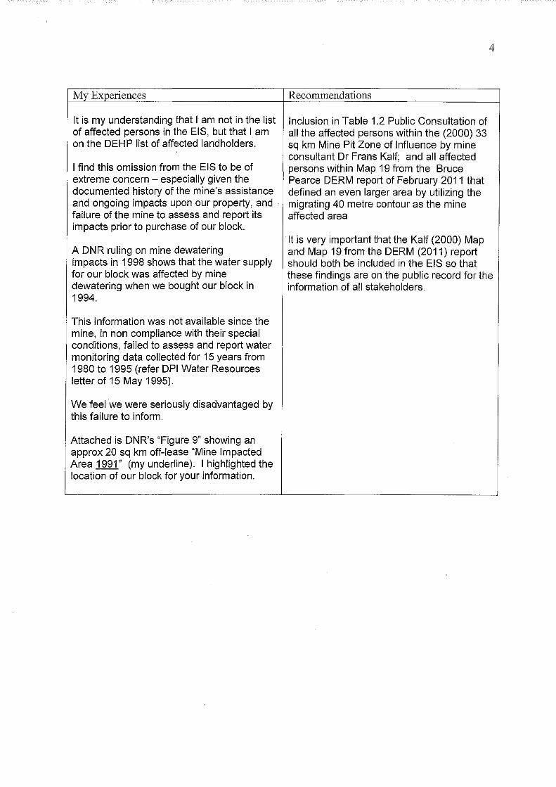
4
My Experiences Reconnnendations
It is my understanding that I am not in the list Inclusion in Table 1.2 Public Consultation of of affected persons in the EIS, but that I am all the affected persons within the (2000) 33 on the DEHP list of affected landholders. sq km Mine Pit Zone of Influence by mine
consultant Dr Frans Kalf; and all affected I find this omission from the EIS to be of persons within Map 19 from the Bruce extreme concern -especially given the Pearce DERM report of February 2011 that documented history of the mine's assistance defined an even larger area by utilizing the and ongoing impacts upon our property, and migrating 40 metre contour as the mine failure of the mine to assess and report its affected area impacts prior to purchase of our block.
It is very important that the Kalf (2000) Map A DNR ruling on mine dewatering and Map 19 from the DERM (2011) report impacts in 1998 shows that the water supply should both be included in the EIS so that for our block was affected by mine these findings are on the public record for the dewatering when we bought our block in information of all stakeholders. 1994.
This information was not available since the mine, in non compliance with their special conditions, failed to assess and report water monitoring data collected for 15 years from 1980 to 1995 (refer DPI Water Resources letter of 15 May 1995).
We feel we were seriously disadvantaged by this failure to inform.
Attached is DNR's "Figure 9" showing an approx 20 sq km off-lease "Mine Impacted Area 1991" (my underline). I highlighted the location of our block for your information.

My Experiences
The way the mine is environmentally regulated has certainly not protected my property from mine caused water depletion under the Environmental Authority, since the EA is framed on the false basis that there are no off-lease impacts on the water table.
The EA does not recognise that water depletion has migrated across the road to our property. The mine is not required to manage dewatering the karst aquifer in an environmentally sustainable way.
This allows obscene wastage of our precious water resources and allows impacts to widen and deepen
Mine pit discharges during recent above average wet years;
30 June 2010- I July 2011, 2,826 ML. 30 June 2011- 1 July 2012, 2,326 ML. 30 June 2012- 1 July 2013, 5,471 ML
The EIS states it is the mine's intention to mine deeper to 90 metres at both the present mine and the new mining lease -i.e. 2 mine pits -for a further lifetime.
My land shows numerous examples of the groundwater system being a karst aquifer;
Sinkholes occur and the drilling for replacement water supplies intersected numerous cavities, with different conductivities in different bores which is a sign of conduit flows (random, naturally occurring pipes in the limestone).
These are on the ground examples of karst limestone aquifer status.
5
Recommendations
The Environmental Authority must be changed to recognise off-lease impacts including the 2000 assessment by mine Consultant Dr Frans Kalf of a 33 sq km "Mine Pit Zone of Influence" and Map 19 from the Bruce Pearce DERM report of February 2011.
In my view a grout curtain is the only feasible and effective option for minimising mine dewatering impacts on the karst aquifer.
A grout curtain on the proposed site, if successful, would provide enduring relief and long term benefits to both the mine and the community by resolving the conflict and conserving the district's precious water resources.
I would be happy for a grout curtain to be built on my block
At the very minimum pit inflow water should be pumped far enough upstream to where it can replenish groundwater and the creeks, or some other scheme to put the water to agricultural use similar to what is being done in some instances with coal seam gas.
This should be done in proper consultation with all landholders around all the mining leases.
Recognition that the aquifer intercepted by the mine is a complex karst limestone aquifer system.
It is recognised that a karst aquifer with conduit flows behaves differently to a Darcian flow aquifer and impacts are less predictable.
Under the above circumstances I strongly oppose Cement Australia being allowed to further expand their mining leases untilthese issues have been resolved.
Yours sincerely, :rf, ~ ~

LEGEND:
0 03, 2.75 ...
•
o Monitored Bores
e Unmonitored Bores
2.75 Drawdown (metres)
- - Impacted Area Boundary
NOTE: Bores outside Impacted area have zero water level difference
•
!ITT D Figure 9
0
KILOMETRES 0 0.5 1.0 1.5
• RESOURCE SCIENCES CENTRE • ~ ~::.:::.:.:.;:::::.:.::.:..:..;.;;;;:;:.;.;.;._ ......... N ATll RAL GOWIN•llll"
"''0"""' Bracewell - East End Area
Groundwater Investigations Mine Impacted Area 1991
(Wl Difference 1978n9 - 1991) M-502511 RSC

Anne Patricia Kelly Kelly's Road Bracewell MT LARCOM QLD 4695 Phone (John Kelly) (07) 5598 1701 14 February 2014
The Chief Executive Department of Environment and Heritage Protection Attention: The EIS Coordinator (East End No. 5 Mine Project) GPO Box2454 BRISBAl\fE QLD 4001
Dear Sir/Madam,
I wish to oppose the proposed mining lease application 80156 tor East End mine being granted on the same or similar basis as the existing inadequate whole of project Environmental Authority.
7 '1 FeR ?Q'I' ,., ,_LJ "" It
The mine's EA is inappropriately framed on no off-lease impacts on the water table. I believe this has allowed a blind eye to be turned to the mine's widespread environmental harm to the districts' water resources and gives the go-ahead for mine dewatering to deplete the water table without limit.
I believe that if the mine had been required to act to repair the mine-caused depletion recognised by the 33 square kilometre Mine Pit Zone ofinfluence at East End assessed by Kalf (2000), the deep level of conflict that has been ongoing between landholder stakeholders, the regulators and the mine for the past 18 years would have been resolved many years ago. The call on the Special Conditions would have been greatly reduced. This surely would have greatly benefited all parties.
From my contact and friendship with other locals, some of whom are in the Kalf33 square kilometre zone, it is clear that the Special Conditions have provided only token redress for loss of water supplies and do not redress economic loss from unreasonable delays in provision of an alternative supply and damage to the land's potential. My own experience as a landholder outside the Kalf zone, is that I consider I have lost water supplies and perennial creek water to mine dewatering (and have the support of assessments by experts independent of the mine and Government) but have no affordable process to obtain redress. I believe the Special Conditions are quite inadequate to protect affected landholders.
Therefore I request; • a new EA be established that includes conditions requiring the mine to properly repair
depletion in the Kalf (2000) 33 square kilometre Mine Pit Zone of Influence instead of an amended EA that remains fixed on no off-lease dewatering impacts;
• that the mining lease application on the Scrub Creek/Larcom Creek floodplain and deepening of the new mine pit and original pit to 90 metres not be approved until a plan (for example a grout curtain) is developed and implemented that will effectively repair I avoid mine caused depletion of the water table;
• this be arranged in proper consultation with landholders near to and around all the mine's leases and proposed lease and their experts. I request these landholder

2
stakeholders and their experts be empowered in consultations, not the hollow processes we have participated in in the past;
o the Special Conditions be required to reinstate "affect injuriously" as was part of the 1976 Conditions; that timelines be set for provision of an alternative supply and that an affordable process be set in place for landholders to have the views of their own experts included and empowered when assessing entitlements to an alternative water supply.
The reasons for my above objections and requests are detailed below.
I am approaching my ninety-sixth (96'h) birthday. I was born in Bracewell to pioneers Tom and Anne Brady. I live on the farm which my husband and I purchased in 1949, approximately two kilometres from my place of birth. This farm is nov.r owned by one of my sons. Other than for nine years in North Queensland, I have always lived in Bracewell.
The farm I still own in lower Bracewell is mostly within the Area of High Usage (greater than I 0 metres water loss) in Figure 8 of DNR's 1998 Position Paper. Figure 8 displays both the areas of water loss in Bracewell and at East End in December 1996. Bracewell is upstream of East End. (A Copy of Figure 8 with my two blocks highlighted is attached). Bracewell remained chronically depleted until the extra-ordinary and flooding rains from 2010 to early 2013. Since 2010 the well above average and average rainfall has sustained my bore at acceptable levels.
DNR 1998 evaluated that the zone of water loss at East End was caused by mine dewatering but the Bracewell zone of water loss was not. DNR's assessment is supported by mine consultants.
I now understand that DNR and mine consultants used Darcian flow methodology (such as for a sand aquifer) for evaluating East End mine's impacts on the complex karst limestone aquifer system with conduit flows, i.e. random natural pipes in the limestone. When the mine intercepts a conduit it drains the conduit to that level.
Given my historical local knowledge and love of the Bracewell area, its creeks and water supplies, for many years I have disputed the DNR's and the mine's consultant's assessment that mine dewatering caused depletion at East End but none of the unexplained water loss at Bracewell. This level of water loss at Bracewell was unprecedented in its history including during serious droughts. Reports by Dr Peter James (1997) and Professor Ray Volker (1998) dissented with DNR' s findings that mine impacts had not migrated upstream into Bracewell.
The validity of the various dissenting views is best explained by internationally recognised limestone hydrologist David (known as Dingle) Smith (Emeritus Faculty, ANU) for the Federally funded Mt Larcom Community Restoration Project Report (October 2003). Extracts from Pages 28 and 29 are quoted below:
Quote from Mt Larcom Community Restoration Project Report (October 2003)
GROUND WATER RESOURCES
"2.2.2 Limestone Hydrology The East End Mine and the surrounding area are dominantly composed of limestones. A feature of limestone terrain is that much of the water flow is subterranean with connections between surface streams and groundwater. In such areas water supply is dominated, and often dependent upon, the use of groundwater usually obtained from bores. This is the case for the

3
farming community in the Mt Larcom region, which for many years relied upon bore water for pasture irrigation and for other rural activities. Groundwater of this kind can be regarded as a form of natural storage, akin to storage in dams in non-limestone regions. Indeed, ii has the advantage over dam storage because losses due to evaporation in the summer months are negligible. As with surface storage it is necessary to manage the resource in a sustainable manner so that the groundwater is not 'mined', ie, the reserves over-exploited so that the storage is depleted or becomes unusable.
All limestone areas are dominated by underground water flow but the presence of fissures of all kinds, enlarged by natural solution of the limestone over long periods of geological time, results in patterns of underground water movement that differ from those in other rock types. The solution action of water in some forms of limestone can lead to the development of 'karstic' features. The term 'karst' comes from a region in northern Yugoslavia where these distinctive features were first described over a century ago. These features include a paucity of surface flow, streams that flow intermittently and which have enlarged fissures present in the stream beds, the presence of siiLk holes down which flood water flow and, at the extreme, the formation of caves. Caves are evidence of conduit flow in earlier phases of the development of karst features, under present conditions these conduits are often left 'high and dry'. However, conduit flow continues but at depth with the conduits now full of water. It is stressed that conduit flow can occur in solutionally enlarged fissure of very much smaller dimensions than 'caves' which are generally defined as sufficiently large to allow entry by humans 1
The limestone terrain in the Mt Larcom area, and especially in the disputed Bracewell area, exhibits such karstic features in the surface terrain. These include stream flow sinking into fissures in limestone stream beds, the presence of sink holes that are only activated in times of flood rains and evidence of (now dry) caves that indicate flow in major fissures in earlier times, ie. before deeper conduits were solutionally enlarged.
2.2,2,2 ImplicatioRJ.s for grm:mdwa[er The development of karstic features indicates that the form and patterns of sub-surface flow are complex. Some water flows rapidly, especially after heavy rain, along solutionally enlarged fissures that can regarded as similar to flow in pipes. Other water moves very slowly essentially as intergranular flow. The latter style of groundwater movement is regarded as the normal type of groundwater flow in non-limestone aquifer, such as sandstones.
A simple example of conduit flow is that in limestone areas, and the Bracewell area is no exception, boreholes for water sunk a few metres part can result in very different yields, some of no value as a source of water while others can have high water yields.
The difference in flow rates between the conduits and the slower inter-granular movement can vary by factors of thousands. In large conduits water flow is often measured in kilometres per day, intergranular flow at less than millimetres per day.
Often the pattern of underground water movement in karst areas does not match that of surface water catchments. It is difficult to define the underground catchments but frequently they differ quite markedly from those defmed by surface streams.
A further feature of underground flow in karst limestones is that the conduit flows, which can carry a large proportion of the groundwater flow, can occur at considerable depths. In many places throughout the world, large freshwater springs emerge on the sea floor often at some distance from the coast and at depths well below sea level. The problem is that it is difficult to

4
locate such underground flow lines. A well-known UK example is the very large fresh water springs that were encountered in the construction of the railway twmel beneath the Severn Estuary. These are some 40m below sea level. Initially they flooded the tunnel and very large amounts of water have been pumped daily from the tunnel over a period exceeding a hundred years. Similar occurrences are known in Australia. For example, the very large submarine freshwater springs off the coast in southeastern Australia that are fed from limestones in the Mt Gambier region. Recently it has been suggested that similar submarine iimestone springs exist off parts of the Queensland coast.
It is widely recognised in groundwater studies that underground flow in limestones, especially those having karstic features, is very different to that found in non-limestone aquifers. This has major implications for all forms of groundwater modelling which basically rely on what is termed Darcian flow. Such models normaliy assume that groundwater movement is isotropic over relatively large areas. While these assumptions remain as the basis for groundwater modelling and development they are of limited value in limestone aquifers, especially those with karst features." End of quote from Dingle Smith, Mt Larcom Community Restoration Project Report (2003).
Sinkholes on Mv Farm- Karst features There are numerous sinkholes on my farm in lower Bracewell. After I lost my husband in 1974 I lived on this farm for some years. I have often recalled I used to sit and watch water running down one particular sinkhole not far from the house during times of heavy rain as I found it therapeutic. There are sinkholes and caves in the blocks up behind my farm. There are caves in the hills above Bracewell lake (which is not a real lake but fills during flood times) and sinkholes in the land around and in the lake. There are caves in upper Bracewell and numerous sinkholes. There are numerous sinkholes all around all the districts, including some at East End.
We now know that the sinkholes and caves are surface expressions of the complex karst aquifer that is fundamental to the limestone deposits.
Affected landholders have often sought for the sinkholes to be properly mapped in participation with long-term landholders but this has never been done. The caves in the blocks behind my farm, at Bracewell lake and at upper Bracewell have been added onto DNR (1998) Figure 8 attached as well as highlighting the two blocks of land I own.
Part of my farm was originally included in the mine's Lease No 3 in 1976. This is considered a blight on title and inhibits undertaking improvements The land was required to be compensated for or purchased by the mine for lease renewal due in 1997. I was put to the expense of hiring a solicitor and he wrote letters on my behalf. However, without any prior consultation, on 26 June 2001 the Department of Natural Resources and Mines advised that QCL (now Cement Australia) applied to excise my farm and some other farms from their leases. The lease area on my property was surrendered and lease renewal granted in 2003
My son Jolm's telephone number is provided at the top of this letter and I request that any contact or questions be directed to him.
Yours faithfully,

I I
I
~ ~ g ~ i 1 ' ; ~-
11 H q Lt ~J ~]
-~- <:-
•
•
•
• '
f< e/ I ~1 Far vv1
. t-o.Jz e. r . "
. c' .. I. f j .
. J t i/'i.JZ, lrl (.), (;> l('cli?~\ __ cr)
1.5 'W
•
' ·-r----------l '
·-;;;
5
~
. ' ~ '.
4 rL i{
~~l
1,
;
L
.. !
--··r
.,! --··t··---- ..:~---~f---- -----' ·----.:-.. v
8.5 5" 7
8
4.5 -----------6_--6.
• ---~~--4~-· ---"'
• 0
• 6•·
i} v .,. . ··-· .I j
.t' -.. ,,
II
v
·--·-y-s-· v,
, •
1 0
v 2.5
•
7-
" " V>f0
"' v • • •
•
-~
L v
I !w
r I
'1- . li v
y .·-' ! .. ">6
•·
•
•
I' rl !/
•
II
figure 8
i li\l
~l \ \
:: co::cc:cc:=.c::_:c~, \
\
II :t '· I
·I il : I I
, ... ---~==\ \ --------\
>6.5'7 lEGEND: . • •
11 1"
• • w
-- -- ------
• ------- ·----
( s.
-~·~- ') .
I:ILI)fllETm:s
L,,.., .. ~......._.,L,"'-"'"'-='""'~=--,~
v
··--------. 'i
•
.. Monitored Bores (No Data on F:JJI Supply Lavel)
o Unmonitored Bores
- ---
'2.5
Area of High Usage (8 -10 metres)
Area of High Usage (greatarthan 10 metres)
Monitored Bores (showing Water Level Difference)
v >10m
w 8-IOm
'V 4-7.5m
,, <4m
l'~ "'~=:·=~~·::· GroundhtlfBJfter ~ruvestigattions
Estimated Water Lever tl!ll<>rences Full Su;,ply Level- D~e.::.c.::.1.::.99"-6'--~..-J
• t~~~.~