1 north american reference frame (naref) working group mike craymer geodetic survey division,...
TRANSCRIPT

1
North American Reference FrameNorth American Reference Frame(NAREF) Working Group(NAREF) Working Group
Mike CraymerGeodetic Survey Division, Natural Resources Canada
2nd SNARF Workshop
Montreal, May 19, 2004(Revised June 4, 2004)

2
ObjectiveObjective
To provide international focus and cooperation for issues involving the horizontal, vertical, and three-dimensional geodetic control networks of North America, Central America, the Caribbean and Greenland (Denmark).

3
StructureStructure
IAG Commission 1Reference FramesITRF
DensificationSNARFReference Frame
TransformationsNAREF Working GroupsSub-Commission 1.3 Regional Reference FramesRegional Sub-Commission
1.3c for North America (NAREF)
OtherRegional Sub-Commissions Regional Sub-Commission
1.3a for Europe(EUREF)

4
NAREF ObjectivesNAREF Objectives
• Densify the ITRF reference frame in NA– Densify IGS global network
– Combine various regional and local networks
• Generate coordinate solutions– Weekly combinations of regional solutions
– Cumulative solutions with velocity estimates
• Provide transformations– Between NAD83 and ITRF/IGS

5
StandardsStandards
• Site selection– Dual frequency data, 24 hr/day, 10° elevation mask
angle– Continuous operations (min. 5 days/week)– Stable geodetic-quality monumentation (or classify?)– Complete & up to date station logs
• Overlapping networks/solutions desired– Stations in multiple solutions– Allows for outlier detection & relative weighting– Average out software “noise”

6
Standards (con’t)Standards (con’t)
• Regional processing– Follow IGS & EUREF standards as much as possible
– Fix IGS orbits & EOPs (preferably “final”)
– Different software essential for quality control checks
• Problems– Regional centers operate independently with different
objectives
– Difficult to impose standards
– Take what we can get

7
Regional SolutionsRegional Solutions
• Since 2001.0GSD Bernese regional networkGSD GIPSY regional networkPGC Western Canada Deformation Array (Bernese)CORS network (PAGES)SIO PBO Solution (GAMIT)
• Plan to include more Canadian stationsNew 64-bit computer to handle more stationsAdd BCACS, Quebec DGPS, others ??

8
GSD Bernese Regional Network (GSB)GSD Bernese Regional Network (GSB)

9
GSD GIPSY Regional Network (GSG)GSD GIPSY Regional Network (GSG)

10
PGC Western Canada Deformation Array (WCDA)PGC Western Canada Deformation Array (WCDA)

11
SIO Plate Boundary Observatory (PBO)SIO Plate Boundary Observatory (PBO)

12
NGS CORS Network (NGS)NGS CORS Network (NGS)

13
Regional CombinationsRegional Combinations
• Combine solutions in ITRF/IGS– Regular weekly coordinate solutions
– Currently 550+ stations (nearly 50 in Canada incl. IGS)
– 4 week latency (2 weeks after precise orbits available)Working towards cumulative solutions with velocities
– Using Remi Ferland’s SINEX software (IGS combo)

14
NAREF Combined Densification NetworkNAREF Combined Densification Network

15
Combination MethodCombination Method
Alignment of Each Regional Solution
1. A priori datum constraints removed
2. Aligned to IGS weekly solution (3 translations, 3 rotations, scale change)
3. Covariance matrix scaled by WRMS of residuals
4. Residuals tested for outliers (outliers removed –> iterate #2-4)
Combination of Regional Solutions
5. Summation of normals of (scaled) regional solutions
6. Aligned to IGS weekly solution (3 translations., 3 rotations, scale change)
7. Covariance matrix scaled by WRMS of residuals
8. Residuals tested for outliers (outliers removed –> iterate #2-8)
9. Integrated into IGS weekly solution using IGS coordinates & covariance matrix for common stations as weighted pseudo-observations
16
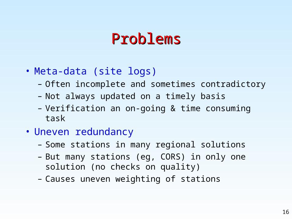
ProblemsProblems
• Meta-data (site logs)– Often incomplete and sometimes contradictory
– Not always updated on a timely basis
– Verification an on-going & time consuming task
• Uneven redundancy– Some stations in many regional solutions
– But many stations (eg, CORS) in only one solution (no checks on quality)
– Causes uneven weighting of stations

17
Problems (con’t)Problems (con’t)
• Identification of outlier station solutions– Difficult and time consuming
– Need a reliable automated procedure
• Water loading around Great Lakes– Affects Great Lakes CORS network
– 2 foot range in water levels between Spring & Fall
– 4? foot variations between decades (climate variations)
– Secular variations due to post-glacial rebound?
– Loading models possible?

18
Problems (con’t)Problems (con’t)
• Changes in reference frames– Confusing to users if not explicitly identified (see plot)
– No reference frame ID block in SINEX format
– Obtained elevated noise levels at some IGS stations after change from IGS97 to IGS00 (see plot)

19
MIL1 (Milwaukee) Time Series
ITRF97/IGS97 ITRF2000/IGS00
Shift in coordinates due to change in reference frame.

20
ALGO (Algonquin, Ontario) Time Series
ITRF97/IGS97 ITRF2000/IGS00
Note noise in solutions after change in reference frame. Coming mainly from noise in constrained IGS solutions.

21
Access to Reference FramesAccess to Reference Frames
• Three basic methods of integrating survey into a reference frame:
• Constrain to reference frame stations– Fix reference frame stations (least desirable)
– Weight reference frame stations (use full cov matrix)
• Align/transform to reference frame stations using:– Known transformation parameters, or
– Estimated best fitting parameters
• Combined alignment and weighted constraint
• Results depend on:– Method used (see plots)
– Number of ref. Frame stations used to align or constrain (see plots)

22
Method 1 (Fixed) vs Method 3 (Aligned+Wtd)
129oW 126oW 123oW 120oW 117 oW 114 oW 46oN
47oN
48oN
49oN
50oN
51oN
52oN
53oN
DRAO
ALBH
BAMF
BCOV
BLYNBREW
CHWK
CPXF
ELIZ
HOLB
BCLI
KTBW
BCLC
LINH
LKCP
BCMRNANO
NEAH
NTKA
PGC3PGC4PGC5
PABH
PTAL
PRDS
PUPU
SC00
SC02
SC03
SC04
SEAT
BCSF
SMLD
SEDR
UCLU
BCVC
WLBC
WSLR
ESQM
PTHY
1 cm Horz
1 cm Vert

23
Method 3: 6 vs 4 Reference Frame Sites
129oW 126oW 123oW 120oW 117 oW 114 oW 46oN
47oN
48oN
49oN
50oN
51oN
52oN
53oN
DRAO
ALBH
BAMF
BCOV
BLYNBREW
CHWK
CPXF
ELIZ
HOLB
BCLI
KTBW
BCLC
LINH
LKCP
BCMRNANO
NEAH
NTKA
PGC3PGC4PGC5
PABH
PTAL
PRDS
PUPU
SC00
SC02
SC03
SC04
SEAT
BCSF
SMLD
SEDR
UCLU
BCVC
WLBC
WSLR
ESQM
PTHY
1 cm Horz
1 cm Vert

24
Proposed Contributions to SNARFProposed Contributions to SNARF
• Vehicle for– Providing & maintaining official SNARF products
– Wider use under auspices of IAG & national geodetic agencies
• Combined regional solutions in SNARF• Transformations between SNARF and
– NAD83
– ITRF/IGS