1-s2.0-s0301479709002576-main
DESCRIPTION
River channel network design for drought and flood control: A case study ofXiaoqinghe River basin, Jinan City, ChinaTRANSCRIPT

lable at ScienceDirect
Journal of Environmental Management 90 (2009) 3675–3686
Contents lists avai
Journal of Environmental Management
journal homepage: www.elsevier .com/locate/ jenvman
River channel network design for drought and flood control: A case study ofXiaoqinghe River basin, Jinan City, China
Baoshan Cui a,*, Chongfang Wang a, Wendong Tao b, Zheyuan You a
a School of Environment, Beijing Normal University, State Key Joint Laboratory of Environmental Simulation and Pollution Control,No. 19 Xinjiekouwai Street, Beijing 100875, Chinab College of Environmental Science and Forestry, State University of New York, Department of Environmental Resources and Forest Engineering,Forestry Drive, Syracuse, NY 13210, USA
a r t i c l e i n f o
Article history:Received 4 January 2009Received in revised form29 June 2009Accepted 22 July 2009Available online 15 August 2009
Keywords:River channel networkDrought and floodThe shortest path algorithmAssessmentXiaoqinghe River basin
* Corresponding author. Tel./fax: þ86 10 58802079E-mail addresses: [email protected], cuibs@bnu
0301-4797/$ – see front matter � 2009 Elsevier Ltd.doi:10.1016/j.jenvman.2009.07.010
a b s t r a c t
Vulnerability of river channels to urbanization has been lessened by the extensive construction of arti-ficial water control improvements. The challenge, however, is that traditional engineering practices onisolated parts of a river may disturb the hydrologic continuity and interrupt the natural state ofecosystems. Taking the Xiaoqinghe River basin as a whole, we developed a river channel network designto mitigate river risks while sustaining the river in a state as natural as possible. The river channel riskfrom drought during low-flow periods and flood during high-flow periods as well as the potential forwater diversion were articulated in detail. On the basis of the above investigation, a network with‘‘nodes’’ and ‘‘edges’’ could be designed to relieve drought hazard and flood risk respectively. Subse-quently, the shortest path algorithm in the graph theory was applied to optimize the low-flow networkby searching for the shortest path. The effectiveness assessment was then performed for the low-flowand high-flow networks, respectively. For the former, the network connectedness was evaluated bycalculating the ‘‘gamma index of connectivity’’ and ‘‘alpha index of circuitry’’; for the latter, the ratio offlood-control capacity to projected flood level was devised and calculated. Results show that the designboosted network connectivity and circuitry during the low-flow periods, indicating a more fluent flowpathway, and reduced the flood risk during the high-flow periods.
� 2009 Elsevier Ltd. All rights reserved.
1. Introduction
Urbanization affects the processes that control streamflow ofriver channels (Rose and Peters, 2001). Greater runoff, higher peakdischarges, more rapid response times, and variations in sedimentproduction often occur during urbanization (Bledsoe and Watson,2001; White and Greer, 2006), posing great risks on ecology andflood control for river managers (Gregory, 2002). The risks arefurther exacerbated by the river flow fluctuations over time, typi-cally with cyclic variations on a seasonal, annual and interannualbasis (Lopez-Moreno et al., 2008). For example, during low-flowperiods, on-going water resources abstraction results in gradualreduction of flow available for instream uses, which, in turn, triggera number of environmental effects, including increased sedimen-tation, aggravated water pollution, decreased aquatic biota, anddeclined recreational landscape (Smakhtin, 2001). During high-flow periods, intense rainfall increases river runoff and peak
.
.edu.cn (B. Cui).
All rights reserved.
discharges, posing more challenges on flood protection. Moreseriously, the global warming and related climate changes arepredicted to occur over the next century, which will significantlyincrease the weather-related risks (Muller, 2007); especially, thistrend would aggravate periodic and chronic shortfalls of water andtrigger a rise in the frequency and intensity of extreme stormevents (Browning-Aiken et al., 2007; Mujumdar, 2008).
Therefore, a necessary strategy to reduce urban river risksinduced by urbanization and climate change is to take rainfallvariations into account for improvements. There are two oppositemethodologies of river improvements. The first is to use traditionalengineering techniques, such as river channelization, andconstruction of dams and reservoirs. Second, a more sustainableapproach can be taken to address the challenges of urban effects onstream flows and sediment yield, such as channel restoration inparts of the selected basin (Morris and Moses, 1999; Henshaw andBooth, 2000; Asakawa et al., 2004; Clifford, 2007). Nevertheless,most of the engineering projects have generally been applied ina piecemeal manner over relatively short reaches, without a soundunderstanding of the broader spatial context (Harper et al., 1999;Gregory, 2002; Brouwer and van Ek, 2004). Such reactive strategies

B. Cui et al. / Journal of Environmental Management 90 (2009) 3675–36863676
are not the most efficient and cost-effective way to achieveimprovement success in ecological terms (Brierley et al., 2002). Asa result, defining a basin-framed ‘vision’ is a critical early step ineffective river improvements (Chin and Gregory, 2005; Schmandt,2006).
This alteration, when taken in the context of a river network asa population of channels and their confluences (Benda et al., 2004),allows the development of a river channel network to regulate thespatial distribution of water resources and further impose riverimprovements throughout a river basin. The interest in river channelnetwork has been concentrated on analyzing its topological struc-ture by descriptive measures, for example, discussing the relation-ship between river channel network morphometry and river reachhydrologic and geomorphic characteristics (Moussa, 2008), andexploring how river channel network structure imposes effects onecological patterns, such as riverine habitat organization (Bendaet al., 2004), fish assemblage structure (Hitt and Angermeier, 2008),and riparian vegetation distribution (Shaw and Cooper, 2008).However, combining structures of graphs and algorithms to findoptimal network paths (Poulter et al., 2008) or predicting stream-flow statistics with river channel network models (Young et al.,2000; Liu and Weller, 2008) have also been explored. The well-developed application of graphs and algorithms allows us to designan artificial river channel network to address risks of a single riverreach by supplementing the removed connection in urban areas,where the real state of basin is one of highly fragmented and largelymodified transfers (Graf, 2001). Although a few endeavors have beenmade to design artificial networks composed of open water chan-nels, storage ponds, and constructed wetlands to relieve urban floodwater (Wang et al., 2006a,b), the valid method to link variouselements within a river channel network for urban river manage-ment is far less developed.
This paper explores how such a channel network can bedeveloped and applied to the basin of Xiaoqinghe (XQH) River inthe City of Jinan, China to address the consequences of drought andflood presented by urbanization and climate change during low-flow and high-flow periods, respectively. The City of Jinan hasalternating high-flow (June–September) and low-flow (October tonext May) periods, corresponding to flood-dominated anddrought-dominated regimes. According to Ren et al. (2008), due toclimate change, since 1950s, especially after 1990, limitation ofwater supply has been largely intensified during low-flow periods;meanwhile, flood frequency and intensity also increase apparentlyduring high-flow periods in east China. However, poor planning foremergencies and the lack of structured contingency plans fails tomitigate inundation and water shortages during times of rainfallvariations in the study area. Efforts are required to design an arti-ficial river channel network comprising open channels, lakes,reservoirs and wetlands to redistribute water resources withinriver channels and in turn to reduce risks of flood and drought.
The objective of this study is to 1) propose river channelnetwork scenarios for low-flow and high-flow periods; 2) intro-duce the shortest path algorithm of graph theory to optimize thelow-flow network; and 3) evaluate the risk-relieving capacity of thenetworks designed for low-flow and high-flow periods.
2. Study area
The city of Jinan (Fig. 1A) is bordered by the Tai Mountain to thesouth and the Yellow River to the north, with a strongly highertopography in the south than in the north. Hilly areas, piedmontclinoplain, and alluvial plains lie across the city from south to north.Altitude within the area ranges from 23 m to 975 m above sea level,with a highly contrasting relief. The semi-humid continentalmonsoon climate throughout the city is characterized by cold, dry
winters and hot, wet summers. The average annual precipitation is636 mm, with 75% during the high-flow periods. The average annualtemperature is 14.3 �C. The average monthly temperature rises tothe highest point in July, ranging from 26.8 �C to 27.4 �C, and drops tothe lowest point in January, ranging from �3.2 �C to �1.4 �C.
The rivers flowing through this city belong to the Yellow Riverbasin in the southwest, the XQH River basin in the central district,and the Haihe River basin in the northeast (Fig. 1B). The XQH Riverbasin covers half of the whole urban area. The streams within theXQH River basin are used for navigation, irrigation, and stormwaterdrainage.
XQH River, the mainstream of the basin, originates from westernsuburb of the city, flows from southwest to northeast parallel to theYellow River, and eventually enters the Bohai Sea. The XQH Riverhas a total length of 237 km and a catchment area of 10,572 km2, ofwhich 70.3 km and 2824.1 km2 are in the urban districts of JinanCity. There are 27 tributary streams flowing into or out of the XQHRiver. Most of the streams begin in southern mountains and flownorth to the mainstream. Rainfall is the main water source of thestreams. The streams to the north of XQH River are mostly flood-discharging channels. The lakes and reservoirs all over the basin(Fig. 1C) have been exploited for water resources development andrecreational services.
The uneven distribution of rainfall makes a clear distinctionbetween the low-flow and high-flow periods within a year, whichin turn imposes river risks on the XQH River basin. During low-flowperiods, scarce rainfall and on-going water resources developmentusually result in zero flow for instream use in the XQH River and itsstreams to the south. During high-flow periods, the sharp increasesof flow rate, high slope, and narrow cross sections all contribute toflood inundation, especially along the XQH River, Xingji Stream, andXiujiang Stream (Yu and Wang, 2006). A series of measures havebeen implemented to fight against flood and drought (Table 1).However, the engineering structures either suffer from a lack ofmaintenance or have inadequate flood-control capacity. Further-more, a systematic water management plan is absent for this basin.
3. Methods
The river channel network in a basin is composed of all theriver channels in the basin that are interconnected in an orderlyfashion (Liu and Weller, 2008). The topology of river channelnetworks can be efficiently described using graph theory algo-rithms, which have been developed initially for electrical circuitsand transportation networks (Albert and Barabasi, 2002). Graphtheory is an organized branch of mathematics, it uses graphs tomodel situations that occur within certain kinds of problems(Chartrand and Zhang, 2006), and hence gains wide applicationsto domains of Computer Science, Operational Research, Elec-tronics, Chemistry, Physics, Geography and Environment, andother social sciences (Bu et al., 2002). Main work on geographicaland environmental applications of graph theory is concentratedon analyzing topological structure of stream networks andtransportation networks. Recent rapid expansion of graph theorypermits computational methodologies develop from simpledescriptive measures to structure combination and algorithms forfinding optimal network flows (Cliff et al., 1979).
The networks in graph theory are composed of ‘‘edges’’ and‘‘nodes’’, which in hydrologic terms are river channels and conflu-ences respectively (Poulter et al., 2008). In the broader definitionused in this study, nodes refer to channel confluences, river head-waters, lakes, reservoirs and wetlands; and edges represent naturaland artificial river channels.
Using the digitalization method of ArcView GIS 3.2, we extrac-ted nodes and edges of the natural river channel network within
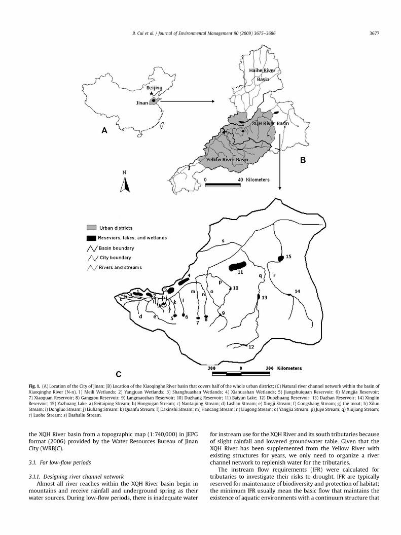
Fig. 1. (A) Location of the City of Jinan; (B) Location of the Xiaoqinghe River basin that covers half of the whole urban district; (C) Natural river channel network within the basin ofXiaoqinghe River (N-n). 1) Meili Wetlands; 2) Yangjuan Wetlands; 3) Shanghuashan Wetlands; 4) Xiahuashan Wetlands; 5) Jiangshuiquan Reservoir; 6) Mengjia Reservoir;7) Xiaoguan Reservoir; 8) Ganggou Reservoir; 9) Langmaoshan Reservoir; 10) Duzhang Reservoir; 11) Baiyun Lake; 12) Duozhuang Reservoir; 13) Dazhan Reservoir; 14) XinglinReservoir; 15) Yazhuang Lake. a) Beitaiping Stream; b) Hongxigan Stream; c) Nantaiping Stream; d) Lashan Stream; e) Xingji Stream; f) Gongshang Stream; g) the moat; h) XiluoStream; i) Dongluo Stream; j) Liuhang Stream; k) Quanfu Stream; l) Daxinshi Stream; m) Hancang Stream; n) Liugong Stream; o) Yangjia Stream; p) Juye Stream; q) Xiujiang Stream;r) Luohe Stream; s) Dashaliu Stream.
B. Cui et al. / Journal of Environmental Management 90 (2009) 3675–3686 3677
the XQH River basin from a topographic map (1:740,000) in JEPGformat (2006) provided by the Water Resources Bureau of JinanCity (WRBJC).
3.1. For low-flow periods
3.1.1. Designing river channel networkAlmost all river reaches within the XQH River basin begin in
mountains and receive rainfall and underground spring as theirwater sources. During low-flow periods, there is inadequate water
for instream use for the XQH River and its south tributaries becauseof slight rainfall and lowered groundwater table. Given that theXQH River has been supplemented from the Yellow River withexisting structures for years, we only need to organize a riverchannel network to replenish water for the tributaries.
The instream flow requirements (IFR) were calculated fortributaries to investigate their risks to drought. IFR are typicallyreserved for maintenance of biodiversity and protection of habitat;the minimum IFR usually mean the basic flow that maintains theexistence of aquatic environments with a continuum structure that

Table 1Stream length, water source, river risk, and risk-relieving measure surveyed forXiaoqinghe River and its tributaries.
Name Stream length(km)
Water source River risk Risk-relievingmeasure
Xiaoqinghe 120.3 Rainfall Droughtand flood
(1), (3), (4)
Nantaiping 11.4 Yellow River No risksHongxigan 15.0 Yellow River No risksBeitaiping 17.9 Yellow River No risksLashan 8.2 Rainfall Drought No measuresXingji 27.9 Rainfall Drought
and floodNo measures
Gongshang 9.6 XiaoqingheRiver
Drought No measures
Xiluo 2.9 Spring andrainfall
Drought (5)
Dongluo 3.2 Spring andrainfall
Drought (5)
The moat 8.8 Spring andrainfall
Drought (5)
Liuhang 8.2 Rainfall Drought No measuresQuanfu 12.7 Rainfall Drought (2)Daxinshi 16.8 Rainfall Drought (2)Hancang 23.5 Rainfall Drought (2)Liugong 25.2 Rainfall Drought (2), (6)Yangjia 24.5 Rainfall Drought (6)Juye 42.3 Rainfall Drought (2), (6)Xiujiang 81.6 Rainfall Drought
and flood(2), (6)
Luohe 66.0 Rainfall Drought (2)Dashaliu 30.7 Yellow River No risks
Note: risk-relieving measures include (1) river or stream channelization; (2)construction of reservoirs to store runoff; (3) construction of levees to protect floodfrom outburst; (4) diversion of water from the Yellow River to replenish drying riverreaches; (5) closure of nearby waterworks to protect underground water sources;(6) greening of banks to conserve water.
B. Cui et al. / Journal of Environmental Management 90 (2009) 3675–36863678
provide physical habitat for biodiversity (Tang et al., 2004). Herein,replenishing IFR for tributaries will produce potential ecologicalbenefits for the whole basin. Usually, instream flow is obtainedempirically from a series of historic data. In China, for regions lackof water resources, IFR are calculated using the following formula(Wang et al., 2007):
Qh ¼ minfQig; (1)
where Qh is the minimum IFR (108 m3), it will maintain the flowcontinuity and basic ecological functions of a stream; Qi is the flowdischarge during low-flow periods in the year of i (108 m3); i is thestatistic year, i¼ 1970, 1971, ., 2006.
A river channel network was then designed to redistributewater resources spatially and temporally with water-diversionchannels that address the drought problem during low-flowperiods. The design was accomplished in three steps, i.e., 1)investigating river channel risk to drought and analyzing water-diversion potential; 2) selecting available water sources (reservoirs,wetlands, lakes and headwaters) or conjunctions as network nodesto supply water for the river channels subject to drought threat;and 3) connecting the selected nodes with edges that representartificial channels or natural corridors, to form the designed riverchannel network that was different from the natural one.
3.1.2. Optimizing channel network with the shortest path modelCompared to the natural river channel network, the designed
one embodies more nodes and links, with boosted degree ofnetwork connectivity and circuitry, or complexity (Forman andGodron, 1986). Theoretically, a complex network provides alter-native routes for material transportation, implicating the effec-tiveness of linkages (Dramstad et al., 1996). Practically, a complex
network has to be connected with more loops, links and nodes,increasing constructing and management costs. The contrastbetween theory and practice calls for an optimizing approach toreduce redundant loops, links and nodes within complex networks.Therefore, we improved the topology of the designed river channelnetwork by applying the shortest path algorithm of graph theory.
A directed graph Gd is a pair of (V, E), where V is a set of nodesand E a set of unordered pairs of (i, j) that denote the directed edges.The i and j are initial and terminal nodes respectively, whichtogether are called endpoints of (i, j) (Chen, 1976). If each edge of Gd
is weighted with one or more real numbers, then the directedgraph can be called a directed network, or simply a network.Therefore, a directed network N is defined as:
N ¼ ðV ; E;WÞ; (2)
where V¼ {1,., n} is the set of n nodes, E 3 N�N is the set ofedges, and associated with each edge (i, j) ˛ E is a vector weightwij ˛ W.
In the above network N, the path from origin edge to destinationedge p (u, v) consists of a group of edge series (e0, ., ek), in whichu¼ e0, v¼ ek. The weight of the path is the sum of weights of alledges. The shortest path between the edges u and v is defined as thepath with the least weight among all the paths between these twoedges. The shortest path model can be described as follows (Xie andXing, 2000):
minPði;jÞ˛A
wijxij
s:t:P
j:ði;jÞ˛Axij �
Pj:ðj;iÞ˛A
xji ¼
8<:
1; i ¼ s;�1; i ¼ t;0; iss; t:
xij � 0;
(3)
where the decision variable xij is a 0–1 variable. If xij¼ 1, the edge(i, j) is on the route s–t; if xij¼ 0, the edge (i, j) is not on the route s–t.
To solve the above optimization model, lengths have to beassigned to edges firstly. Herein, the edge length was defined as‘‘integrative resistance’’, referring to hydraulic resistance andeconomic cost. In view of hydraulic conditions, the flow alonga channel is related to slope (Rinaldo et al., 2004), the geometry ofa channel and the frictional force (Poulter et al., 2008), which can beseen from the Manning Equation that states flow velocity within anindividual open channel (Lin, 2008):
v ¼ 1n
R2=3i1=2; (4)
where v is the mean velocity in section, n is the Manning roughnesscoefficient, R is the hydraulic radius of the channel, and i is thefriction slope, under steady flow conditions, the friction slope isassumed to be equal to bed slope (Chow et al., 1988). According tothe ‘‘Code for Design of Irrigation and Drainage Engineering’’(GB50288-99), the designed channel will surely maintain flowsteady, so i refers to bed slope in this paper. It has also beenproposed that the optimal river channel network is toward thestate of minimum energy dissipation, which is determined by edgelength in addition to flow discharge (Paik and Kumar, 2008).Actually this is understandable from the equation as follows:
t ¼ l=v ¼ l� n� R�2=3 � i�1=2; (5)
where t is time period of flow movement along the channel, l is thechannel length. The higher the resistance is, the longer the flowmoves along the channel, and the more energy dissipation is.
Economic cost mainly comes from two aspects: channel exca-vation and construction of water control structures. The

B. Cui et al. / Journal of Environmental Management 90 (2009) 3675–3686 3679
engineering quantity of channel excavation further relates tochannel length and section dimension. Because all newly addedchannels are assumed to have the same flow rate of 8 m3/s, the totalIFR of the nine target streams (Table 2), they have the same sectiondimension. Then only channel length determines the economic costof channel excavation. As for water control structures, according tothe ‘‘Code for Design of Irrigation and Drainage Engineering’’(GB50288-99), water-drawing structures (including water-drawingsluice, desilting sluice, and diversion dike) are to be built at thehead of water-transferring channels, thus all designed channelshave similar water control structures and relative economic cost.Consequently, the overall economic cost is mainly determined bychannel length. In addition, construction of the channel networkrequires land occupation, which converts agricultural areas to riverchannels or ecological based habitat, interrupts the original agri-cultural ecosystems, and further arouse social conflicts. Ecosysteminterruption and social conflicts both arouse externalities andindirectly increase the economic cost of this engineering. Exter-nalities can be decreased by reducing engineering quantity;therefore, channel length not only determines the direct engi-neering cost but also the potential cost produced by externalities.
The ‘‘integrative resistance’’ was then explained as:
W ¼ l� n� R�2=3 � i�1=2; (6)
R ¼ AX¼ ðbþmhÞ � h�
bþ 2h� ffiffiffiffiffiffiffiffiffiffiffiffiffiffiffiffi
1þm2p ; (7)
where W is the ‘‘integrative resistance’’, A is the cross-sectional areaof the channel, X is the wetted perimeter, b is the channel width,and h is the water depth, m is the slope coefficient. Herein con-necting two sites with a river channel has to consider length, slope,roughness and geometry. In China, channel slope is generallydesigned between 1/10,000 and 1/28,000 (Li, 2006), which is smallenough to be neglected. In practice, the manning roughness coef-ficient reflects the roughness of channel sidewalls, and can besimply determined by building materials (Tang et al., 2007); hence,all designed channels are assumed to have the same roughness,because they will be built with the same materials under nearlysame geological conditions and similar flow rates. Therefore, thechannel roughness can also be neglected. For a rectangular channel,m¼ 0, the hydraulic radius R can be simplified as:
R ¼ AX¼ b� h
bþ 2h¼ b
aþ 2; (8)
b ¼ a� h ¼ a� b� Q1=3; (9)
where a is the ratio of channel width to water depth, b is anempirical coefficient, Q is the flow discharge of channel (m3/s).According to the ‘‘Code for Design of Irrigation and DrainageEngineering’’ (GB50288-99), b¼ 0.76, and when m¼ 0, a¼ 2 is the
Table 2Calculation of the minimum IFR for tributaries of the Xiaoqinghe River.
Stream IFR(108 m3)
Flow rateof IFR (m3/s)
Stream IFR(108 m3)
Flow rateof IFRa (m3/s)
Lashan 0.129 0.622 Daxinshi 0.132 0.638Xingji 0.237 1.144 Hancang 0.004 0.019Gongshang 0.199 0.959 Liugong 0.015 0.073The Moat 0.110 0.532 Yangjia 0.002 0.011Xiluo 0.351 1.692 Juye 0.072 0.347Dongluo 0.122 0.587 Xiujiang 0.099 0.479Liuhang 0.184 0.889 Luohe 0.071 0.341Quanfu 0.198 0.953
a Flow rate of the IFR is the IFR divided by time interval of low-flow period.
optimal value. Q is designed as the total water requirements of8 m3/s (Table 2). R is then equal to 0.76 after calculation. Because alldesigned channels have the same hydraulic radius, R can also beneglected. We concluded from the above analysis that, for theintegrative resistance W, only channel length l is the significantlyeffective factor for the basin of Xiaoqinghe River.
This study then defined wij as the length of edge (i, j), the valuesof wij were measured on the digitalized map. For convenience ofcalculation and description, wij was classified into six levels; basi-cally one level contained two kilometers for hilly areas and threekilometers for plains (Table 3). The label-setting algorithm was thenemployed to calculate the least length with the Bellman Formula(Xie and Xing, 2000):
�us ¼ 0;uj ¼ min
isj
�ui þwij
�; (10)
where s is the initial node, and uj the length of the shortest pathbetween nodes i and j. Based on the calculations, edges with longerlength between every pair-nodes, if existed, were consideredredundant and thus removed from the designed channel network.Finally, the remaining nodes and edges formed the optimized riverchannel network.
3.1.3. Assessing the effectiveness of network linkageIf a river reach is struggling against drought, the network was
expected to effectively divert water from other water bodies to thedrying one. Therefore, the functional effectiveness of the artificialriver channel network can be assessed by linkage effectiveness. Thelinkage of various elements within the network can be explainedwith circuitry and connectivity (Cook, 2002). Connectivity isa measure of the extent to which nodes are connected. This studyemployed the ‘‘gamma index of connectivity’’, the ratio of thenumber of links in a network to the maximum number of linkspossible as given in the following formula (Forman and Godron,1986; Cook, 2002).
g ¼ L=Lmax ¼ L=3ðV � 2Þ ðV � 3;V˛NÞ; (11)
where g is the gamma index of connectivity, L the number oflinkages, and V the number of nodes.
Network circuitry is described as the extent to which loops orcircuits are present in the network. This study used ‘‘alpha index ofcircuitry’’, which measures the number of loops present divided bythe maximum number of loops possible as in the following formula(Forman and Godron, 1986; Cook, 2002).
a ¼ ðL� V þ 1Þ=ð2V � 5Þ ðV � 3;V˛NÞ; (12)
where a is the degree of network circuitry.The indices of a and g were calculated for analysis of the natural,
designed and optimized channel networks, respectively.
Table 3Level of edge weight determined by channel length for plains and hilly areas.
Weight level Channel length l (km)
For plains For hilly areas
0 Natural channels1 0< l� 3 0< l� 22 3< l� 6 2< l� 43 6< l� 9 4< l� 64 9< l� 12 6< l� 85 12< l� 15 8< l� 106 l> 15 l> 10

Table 4Exploitable upper-reach reservoirs used as water sources for several streams.
Stream IFR (108 m3) Reservoir Available storagea (108 m3)
Yangjia 0.002 Langmaoshan 0.021Juye 0.072 Duzhang 0.088Xiujiang 0.099 Dazhan 0.040
Duozhuang 0.071Luohe 0.071 Xinglin 0.037
a Available storage is the difference between storage at the beginning of the yearand storage at the end of the year.
B. Cui et al. / Journal of Environmental Management 90 (2009) 3675–36863680
3.2. For high-flow periods
3.2.1. Designing river channel networkWithin the basin, XQH River, Xingji Stream, and Xiujiang Stream
are particularly vulnerable to flood risks during high-flow periods(Table 1). The designing steps are similar to those for low-flowperiods, while the results are different.
Only one artificial channel is available to divert stormwater fromthe Lashan Stream, Xingji Stream and Xiujiang Stream, respectively.Flood water of the XQH River can be discharged from a number ofchannels, which were constructed by the full use of lakes andwetlands (Fig 5); they are expected to be put into use simulta-neously since only one or two flow paths would be far from beingcapable to protect from flooding at a safe level. Given the above, weassume that no redundant channels exist in the network and theoptimization practice is unnecessary for the designed network ofhigh-flow periods.
Table 5Investigation into water-transferring availability and designed flow path for streams sub
Stream Flow patha Water-trans
Lashan Stream 6–10; 9–10 The Yufu Str
Xingji Stream 1–2–5–11; 9–10–11; 6–10–11 Besides the Ywater sourceStream frustwhich receiv
Gongshang Stream 9–10–11–12; 6–10–11–12 The U-shapeThus the mo
The moat 1–2–5–7 The three strOne is rechasurface wateReservoir, floOne path isXingji Streamrecharge the
Xiluo (9,13); 6–(10,13); 1–2–5–7–13;Dongluo 1–2–5–7–13–14; (9,14); 6–(10,14)
Liuhang 1–2–4–8–15; 1–3–4–8–15; 1–2–5–7–8–15;(9,15); 6–(10,15)
Water is discOne is alongthe Mengjia
Quanfu 1–2–4–16; 1–3–4–16; (9,16); 6–(10,16) The small stMengjia ResJinxiuchuan
Daxinshi 1–2–4–16–17; 1–3–17; 1–3–4–16–17;1–2–4–8–15–16–17; 1–2–5–7–8–15–16–17;(9,17); 6–(10,17)
Hancang 18–19–20–24; 21–22–23–24 The upper-rereaches are iLangmaoshaThe other wrecharge undDuzhang Res
Liugong 18–19–23; 21–22–23
Yangjia 18–22; 28–21–22 The three strif allocatingfrom other w
Juye 18–21; 28–21Luohe 29–30
Xiujiang 25–26–27; 28–27 Water is discto supply forthe water de
a (m, n), the flow path passing through all the continuous nodes of m, mþ 1, ., n� 1
3.2.2. Assessing the network flood-relieving effectThe peak discharge risk within a river reach diminishes through
retention wetlands, reservoirs, levees, and flood-diverting channelswithin the designed network. Therefore, we used four variables torepresent flood-control capacity as in the following formula:
E ¼ C=ðP � 3600tÞ;C ¼ Cw þ Cr þ Fl � 3600t þ Fc � 3600t;
(13)
where E is the ratio of flood-control capability to target flood level,representing the flood-control effect of the designed network forhigh-flow periods, it is a>0 variable, if E� 1, the network is capableenough to eliminate flood risk completely; t is flood duration, hour;3600 is a coefficient of unit conversion, an hour is 3600 s; C is thetotal flood-control capability of the designed network whichincorporates all possible flood-protection works, 104 m3; P is thetarget peak discharge, m3/s; Cw is the flood storage capacity ofretention wetlands, 104 m3; Cr is the flood storage capacity ofreservoirs,104 m3; Fl is the flood-withstand standard of levees, m3/s;and Fc is flow rate of river channels diverting flood directly to otherriver reaches, m3/s.
Notably, P represents the peak discharge of a certain standard offlood, which is projected conforming to the ‘‘Chinese NationalStandard for flood control’’ (GB50201-94). In this study, the standardof 100-year return period was set for the mainstream segments inthe urban districts, and 20-year return period for the othersegments of the mainstream and its tributaries.
With reference to the ‘‘Feasibility study report on the compre-hensive control project of the XQH River, Jinan City’’ provided by
ject to drought risk during low-flow periods.
ferring investigation
eam and Wohushan Reservoir are the two available water sources.
ufu Stream and Wohushan Reservoir, the Jinxiuchuan Reservoir is another, yet the hilly topography and long distance from the reservoir to Xingji
rate the possibility to connect them directly. The midway Fenshuiling Waterworks,es water from the reservoir, can be used as a transfer station.
d artificial channel receives water from the Xiaoqinghe River.st economic approach is increasing source flow from the mainstream.
eams are fed by springs, indicating two water-transferring ways.rging groundwater as an underlying way; the other is supplyingr as an immediate way. In detail, water is discharged from the Jinxiuchuanws through the Xingji Stream till the middle reach, and diverges into two paths.
to connect the moat for surface water supplementing. The other is along theto its lower reach within the high permeability zone, where water leaks to
springs.
harged from the Jinxiuchuan Reservoir, and then diverges into three paths.the Xingji Stream; another is by the Jiangshuiquan Reservoir; the last is byReservoir.
orage capacity of their own reservoirs (Jiangshuiquan Reservoir andervoir) is not self-sufficient, so water is extracted from theReservoir to the two small reservoirs to, in turn, replenish the two streams.
ach reservoirs are too small to supply themselves; besides, under their lowermportant groundwater sources. Thus, one way is to divert flow from then Reservoir to the upper-reach reservoirs to feed the two streams.ay is to divert flow from the Duzhang Reservoir to the lower reaches toerground water resources. In case of water shortage happening to theervoir, water is transferred from the Baiyun Lake to replenish it.
eams all have large reservoirs or lakes along them for water storage and,properly, can meet the water demand by themselves without borrowingater sources.
harged from the Dazhan Reservoir and flows along the natural channelthe upper reach; water is diverted from the Baiyun Lake to guarantee
mands of its lower reaches.
, n; refer to Fig. 2 for the node numbering.

Fig. 2. Designed channel network for low-flow periods (N-dl). The subnetwork in the rectangle is relatively complex and needs to be optimized with the shortest path model.1) Fenshuiling Waterworks; 2) headwater of Xingji Stream; 5) a turning point on the Xingji Stream; 6) WohushanReservoir; 7) headwater of the moat; 8) headwater of LiuhangStream; 9) a turning point on the Yufu Stream; 10) headwater of Lashan Stream; 11) another turning point on the Xingji Stream; 12) Fenghuang Sluice on the Gongshang Stream;13) confluence of Xiluo Stream and the moat; 14) confluence of Dongluo Stream and the moat; 15) a turning point on the Liuhang Stream; 16) a turning point on the Quanfu Stream;17) a turning point on the Daxinshi Stream; 22) a turning point on the Yangjia Stream; 23) a turning point on the Liugong Stream; 24) a water intake on the Hancang Stream; 27)a water intake on the Xiujiang Stream.
B. Cui et al. / Journal of Environmental Management 90 (2009) 3675–3686 3681
WRBJC, we divided the mainstream into five segments: 1) from theheadwater to the Lashan Stream confluence; 2) from the LashanStream confluence to the Xingji Stream confluence; 3) from theXingji Stream confluence to the Daxinshi Stream Confluence; 4)from the Daxinshi Stream Confluence to the Juye Stream conflu-ence; 5) from the Juye Stream confluence to the lower reaches.
Fig. 3. Optimization of the subnetwork. Edges of (4, 8), (6, 10), (10, 11), (11, 12), (14, 15),(15, 16), (16, 17) were excluded from the originally designed subnetwork using theshortest path model.
4. Results
4.1. For low-flow periods
4.1.1. Designing river channel networkNine streams were selected as the targets that need water
replenishing from the Yellow River basin after calculation of theminimum IFR (Table 2), they are the Lashan Stream, Xingji Stream,Gongshang Stream, the Moat, Xiluo Stream, Dongluo Stream, Liu-hang Stream, Quanfu Stream, and Daxinshi Stream. Because theYangjia Stream, Juye Stream, Xiujiang Stream and Luohe Stream allhave reservoirs on their upper reach, and can self-supply their ownIFR without water replenishing from out of the basin (Table 4). Theother two streams of Hancang and Liugong both have small enoughIFR to be neglected (Table 2).
Exploitable water sources and water-transferring scenarios oftarget streams were then investigated (Table 5). Despite beingbeyond the study basin, Yufu Stream and its upstream WohushanReservoir have been developed as a flow path recharging water intothe XQH River. Consequently, the flow path is adopted to replenishflow for most of the tributaries. In particular, Yufu Stream,a perennial stream with plentiful runoff, is an important watersource. We laid out a long channel starting from the Yufu Stream,extending east to the Daxinshi Stream.
To articulate the above scenarios with graph theory, we selectednodes and linked them to design a river channel network based onthe natural network (Fig. 2). Water-drawing structures (includingwater-drawing sluice, desilting sluice, and diversion dike) are to bebuilt at all of the nodes except 12, 25, 26, 29, 30.
4.1.2. Optimizing river channel networkAccording to the original design, almost all tributaries, espe-
cially those in the urban districts, have more than one flow path toreceive water diverted from other water bodies (Table 5), impli-cating that some paths with longer length may be redundant. Both
the Hancang Stream and Liugong Stream have two flow paths: oneis to replenish water for the two above surface streams, the other isto recharge groundwater. Yangjia Stream, Juye Stream and XiujiangStream all have two flow paths, of which only one is artificial; andthus none of them is redundant.
Network optimization was performed for the subnetwork in therectangle in Fig. 2, which is relatively complex (Table 5). The orig-inally proposed river channel subnetwork in Fig. 3 was optimized toa simpler one in Fig. 4.
4.1.3. Assessing the network linkage effectivenessUsing formulas (11) and (12), the indices of a and g were
calculated and compared between natural, designed and optimized
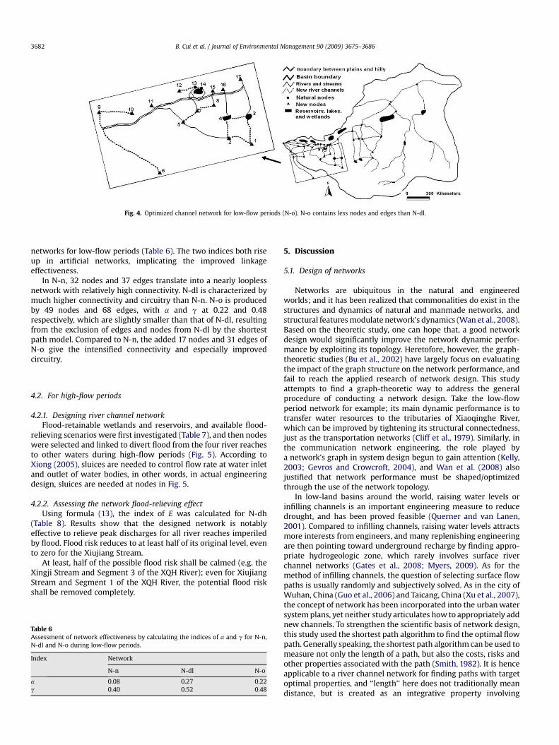
Fig. 4. Optimized channel network for low-flow periods (N-o). N-o contains less nodes and edges than N-dl.
B. Cui et al. / Journal of Environmental Management 90 (2009) 3675–36863682
networks for low-flow periods (Table 6). The two indices both riseup in artificial networks, implicating the improved linkageeffectiveness.
In N-n, 32 nodes and 37 edges translate into a nearly looplessnetwork with relatively high connectivity. N-dl is characterized bymuch higher connectivity and circuitry than N-n. N-o is producedby 49 nodes and 68 edges, with a and g at 0.22 and 0.48respectively, which are slightly smaller than that of N-dl, resultingfrom the exclusion of edges and nodes from N-dl by the shortestpath model. Compared to N-n, the added 17 nodes and 31 edges ofN-o give the intensified connectivity and especially improvedcircuitry.
4.2. For high-flow periods
4.2.1. Designing river channel networkFlood-retainable wetlands and reservoirs, and available flood-
relieving scenarios were first investigated (Table 7), and then nodeswere selected and linked to divert flood from the four river reachesto other waters during high-flow periods (Fig. 5). According toXiong (2005), sluices are needed to control flow rate at water inletand outlet of water bodies, in other words, in actual engineeringdesign, sluices are needed at nodes in Fig. 5.
4.2.2. Assessing the network flood-relieving effectUsing formula (13), the index of E was calculated for N-dh
(Table 8). Results show that the designed network is notablyeffective to relieve peak discharges for all river reaches imperiledby flood. Flood risk reduces to at least half of its original level, evento zero for the Xiujiang Stream.
At least, half of the possible flood risk shall be calmed (e.g. theXingji Stream and Segment 3 of the XQH River); even for XiujiangStream and Segment 1 of the XQH River, the potential flood riskshall be removed completely.
Table 6Assessment of network effectiveness by calculating the indices of a and g for N-n,N-dl and N-o during low-flow periods.
Index Network
N-n N-dl N-o
a 0.08 0.27 0.22g 0.40 0.52 0.48
5. Discussion
5.1. Design of networks
Networks are ubiquitous in the natural and engineeredworlds; and it has been realized that commonalities do exist in thestructures and dynamics of natural and manmade networks, andstructural features modulate network’s dynamics (Wan et al., 2008).Based on the theoretic study, one can hope that, a good networkdesign would significantly improve the network dynamic perfor-mance by exploiting its topology. Heretofore, however, the graph-theoretic studies (Bu et al., 2002) have largely focus on evaluatingthe impact of the graph structure on the network performance, andfail to reach the applied research of network design. This studyattempts to find a graph-theoretic way to address the generalprocedure of conducting a network design. Take the low-flowperiod network for example; its main dynamic performance is totransfer water resources to the tributaries of Xiaoqinghe River,which can be improved by tightening its structural connectedness,just as the transportation networks (Cliff et al., 1979). Similarly, inthe communication network engineering, the role played bya network’s graph in system design begun to gain attention (Kelly,2003; Gevros and Crowcroft, 2004), and Wan et al. (2008) alsojustified that network performance must be shaped/optimizedthrough the use of the network topology.
In low-land basins around the world, raising water levels orinfilling channels is an important engineering measure to reducedrought, and has been proved feasible (Querner and van Lanen,2001). Compared to infilling channels, raising water levels attractsmore interests from engineers, and many replenishing engineeringare then pointing toward underground recharge by finding appro-priate hydrogeologic zone, which rarely involves surface riverchannel networks (Gates et al., 2008; Myers, 2009). As for themethod of infilling channels, the question of selecting surface flowpaths is usually randomly and subjectively solved. As in the city ofWuhan, China (Guo et al., 2006) and Taicang, China (Xu et al., 2007),the concept of network has been incorporated into the urban watersystem plans, yet neither study articulates how to appropriately addnew channels. To strengthen the scientific basis of network design,this study used the shortest path algorithm to find the optimal flowpath. Generally speaking, the shortest path algorithm can be used tomeasure not only the length of a path, but also the costs, risks andother properties associated with the path (Smith, 1982). It is henceapplicable to a river channel network for finding paths with targetoptimal properties, and ‘‘length’’ here does not traditionally meandistance, but is created as an integrative property involving
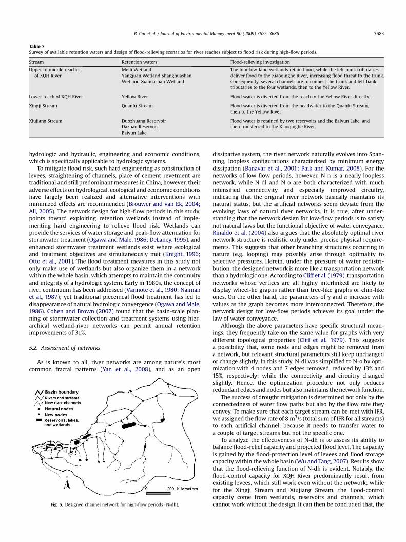
Table 7Survey of available retention waters and design of flood-relieving scenarios for river reaches subject to flood risk during high-flow periods.
Stream Retention waters Flood-relieving investigation
Upper to middle reachesof XQH River
Meili Wetland The four low-land wetlands retain flood, while the left-bank tributariesdeliver flood to the Xiaoqinghe River, increasing flood threat to the trunk.Consequently, several channels are to connect the trunk and left-banktributaries to the four wetlands, then to the Yellow River.
Yangjuan Wetland ShanghuashanWetland Xiahuashan Wetland
Lower reach of XQH River Yellow River Flood water is diverted from the reach to the Yellow River directly.
Xingji Stream Quanfu Stream Flood water is diverted from the headwater to the Quanfu Stream,then to the Yellow River
Xiujiang Stream Duozhuang Reservoir Flood water is retained by two reservoirs and the Baiyun Lake, andthen transferred to the Xiaoqinghe River.Dazhan Reservoir
Baiyun Lake
B. Cui et al. / Journal of Environmental Management 90 (2009) 3675–3686 3683
hydrologic and hydraulic, engineering and economic conditions,which is specifically applicable to hydrologic systems.
To mitigate flood risk, such hard engineering as construction oflevees, straightening of channels, place of cement revetment aretraditional and still predominant measures in China, however, theiradverse effects on hydrological, ecological and economic conditionshave largely been realized and alternative interventions withminimized effects are recommended (Brouwer and van Ek, 2004;All, 2005). The network design for high-flow periods in this study,points toward exploiting retention wetlands instead of imple-menting hard engineering to relieve flood risk. Wetlands canprovide the services of water storage and peak-flow attenuation forstormwater treatment (Ogawa and Male, 1986; DeLaney, 1995), andenhanced stormwater treatment wetlands exist where ecologicaland treatment objectives are simultaneously met (Knight, 1996;Otto et al., 2001). The flood treatment measures in this study notonly make use of wetlands but also organize them in a networkwithin the whole basin, which attempts to maintain the continuityand integrity of a hydrologic system. Early in 1980s, the concept ofriver continuum has been addressed (Vannote et al., 1980; Naimanet al., 1987); yet traditional piecemeal flood treatment has led todisappearance of natural hydrologic convergence (Ogawa and Male,1986). Cohen and Brown (2007) found that the basin-scale plan-ning of stormwater collection and treatment systems using hier-archical wetland-river networks can permit annual retentionimprovements of 31%.
5.2. Assessment of networks
As is known to all, river networks are among nature’s mostcommon fractal patterns (Yan et al., 2008), and as an open
Fig. 5. Designed channel network for high-flow periods (N-dh).
dissipative system, the river network naturally evolves into Span-ning, loopless configurations characterized by minimum energydissipation (Banavar et al., 2001; Paik and Kumar, 2008). For thenetworks of low-flow periods, however, N-n is a nearly looplessnetwork, while N-dl and N-o are both characterized with muchintensified connectivity and especially improved circuitry,indicating that the original river network basically maintains itsnatural status, but the artificial networks seem deviate from theevolving laws of natural river networks. It is true, after under-standing that the network design for low-flow periods is to satisfynot natural laws but the functional objective of water conveyance.Rinaldo et al. (2004) also argues that the absolutely optimal rivernetwork structure is realistic only under precise physical require-ments. This suggests that other branching structures occurring innature (e.g. looping) may possibly arise through optimality toselective pressures. Herein, under the pressure of water redistri-bution, the designed network is more like a transportation networkthan a hydrologic one. According to Cliff et al. (1979), transportationnetworks whose vertices are all highly interlinked are likely todisplay wheel-lie graphs rather than tree-like graphs or chin-likeones. On the other hand, the parameters of g and a increase withvalues as the graph becomes more interconnected. Therefore, thenetwork design for low-flow periods achieves its goal under thelaw of water conveyance.
Although the above parameters have specific structural mean-ings, they frequently take on the same value for graphs with verydifferent topological properties (Cliff et al., 1979). This suggestsa possibility that, some nods and edges might be removed froma network, but relevant structural parameters still keep unchangedor change slightly. In this study, N-dl was simplified to N-o by opti-mization with 4 nodes and 7 edges removed, reduced by 13% and15%, respectively; while the connectivity and circuitry changedslightly. Hence, the optimization procedure not only reducesredundant edges and nodes but also maintains the network function.
The success of drought mitigation is determined not only by theconnectedness of water flow paths but also by the flow rate theyconvey. To make sure that each target stream can be met with IFR,we assigned the flow rate of 8 m3/s (total sum of IFR for all streams)to each artificial channel, because it needs to transfer water toa couple of target streams but not the specific one.
To analyze the effectiveness of N-dh is to assess its ability tobalance flood-relief capacity and projected flood level. The capacityis gained by the flood-protection level of levees and flood storagecapacity within the whole basin (Wu and Tang, 2007). Results showthat the flood-relieving function of N-dh is evident. Notably, theflood-control capacity for XQH River predominantly result fromexisting levees, which still work even without the network; whilefor the Xingji Stream and Xiujiang Stream, the flood-controlcapacity come from wetlands, reservoirs and channels, whichcannot work without the design. It can then be concluded that, the

Table 8Assessment of flood-relieving effect of the designed network for high-flow periods by calculating E, the ratio of total flood-control capability (C) to peak discharge of projectedflood level (P).
Cw (104 m3) Cr (104 m3) Fl (m3/s) Fc (m3/s) C (104 m3) t (h) P (m3/s) E
XQH River 1 600 0 51 0 1921.9 72 70 1.062 450 0 209 0 5867.3 72 345 0.663 324 0 343 0 9214.6 72 669 0.534 585 0 523 0 14,141.2 72 771 0.715 0 0 703 150 22,109.8 72 1030 0.83
Xingji Stream 0 0 0 200 1728 24 387 0.52
Xiujiang Stream 2700 2055 0 0 4755 24 330 1.67
Data of Fl, P and t come from ‘‘Feasibility study report on the comprehensive control project of the Xiaoqinghe River, Jinan City’’; Data of Fc was estimated referring to the flowof left-bank tributaries of Xiaoqinghe River.
B. Cui et al. / Journal of Environmental Management 90 (2009) 3675–36863684
design is more effective for the tributaries than that for the main-stream. Reason for this is that the designed network is built up withboth natural waters (wetlands and river reaches), and artificialstructures (reservoirs and levees). The design is hence nota completely natural restoration work but an attempt to avoidfurther adverse interventions on the environment. In fact, thecombination of natural waters and artificial structures has gainedprevalent acceptance in urban stormwater management, such asbest management practices (Backstrom et al., 2002; Marsalek andChocat, 2002; Wang et al., 2006a,b).
5.3. Management implications
This network design is meant to restore ecological regimes ofthe target natural streams by recharging them with ecologicallybased flows, and combine nature-like look and ecological processinto artificial channels by paving the revetment with vegetationand natural materials instead of absolutely hard materials. Just asother restoration engineering, this design will produce great posi-tive ecological and environmental benefits: fish repopulation,water purification, waterfront greening, and nutrient trans-portation (Yang, 2005; Nagayama et al., 2008). Nevertheless, theecologically based engineering may cause the opposite problem aswell: negative effects of reestablished ecological processes onsocioeconomic land uses (Buckley and Crone, 2008), such as con-verting agricultural areas to river channels or habit for native plantswill not only interrupt the original agricultural ecosystems but alsoarouse negative attitudes and defensive actions of surroundinglandowners. The social conflict will impede our ecological engi-neering from achieving its goal, and also reduce ecological benefitsin economics (Armsworth et al., 2006). In economics, the concept ofexternalities is used to describe the effects of activities on indi-viduals not directly involved in those activities. The negative effectof our ecological engineering on local landowners is such a typicalexample. Consequently, we figured out several technical andmanagement measures to incorporate social conditions andconflict resolution into this network design to promote favorableecological and social compatibility. When the negative social effectsgenerated by ecological engineering are also undesirable to ecolo-gists, the negative externalities are considered indirect, when theeffects are generated by intended ecological activities, the negativeexternalities are considered direct (Buckley and Crone, 2008). In thenetwork design for low-flow periods, flood is a potential risk tolocal landowners, but flood is not the goal of our design though itmay exist after artificial channels are constructed, thus flood isconsidered the most significant indirect negative externalities. Werecommend ecological revetment instead of hard materials builtalong artificial channels, because ecological revetment is moreeffective and sustainable for flood control (Chen et al., 2007). Directnegative externalities are more difficult to resolve than indirect
(Buckley and Crone, 2008). The construction of artificial channelswill have to occupy agricultural areas and cause economic lost tolocal farmers. To resolve the direct externalities, implementingsocial–ecological interactions is the first step, community partici-pation is required, such as distributing surveys to farmers to judgetheir satisfaction to the engineering and seek suggestions, clearlypresenting overall outcomes including benefits and uncertainties tolocal farmers. Only in this way, a stable outcome is likely to comeout, and other researchers also point out the importance of social–ecological cooperation (Higgs, 1997; Folke, 2007). Internalizationand compensation is the second step, local government agencies ormanagement board for the engineering purchase farmland fromwilling sellers, and pay them fair market price. If they like, localfarmers can also be employed as labors in the ecological activities toincrease their income. In China, direct money compensation orgrain subsidy for relevant residents is a general strategy(Luo, 2009).
In addition, river has conventionally been managed withinadministrative rather than natural boundaries, in a fragmentedrather than holistic manner (Gourbesville, 2008). As a consequence,boundary rivers are unregulated or managed under rules that differfrom one to another political jurisdiction. The design of riverchannel network in this paper adopts river basin at the manage-ment scale, which corresponds to natural ecosystem processes(Blackmore, 1995). As argued by Schmandt (2006), an integratedbasin management can serve four goals: provide an adequatesupply of water for natural and human uses, maintain and improvewater quality, restore biodiversity, and support regional sustainableeconomic development. None of these goals has been achieved bythe current management plans for the XQH River basin. The firstgoal, to which endeavors in this study are dedicated, is evenhindered by the lack of scientific understanding of instreamconditions. Hence, for the XQH River basin, a proper monitoringprotocol on hydrological, ecological, and physical conditions needsto be devised as soon as possible.
6. Conclusion
We applied graph theory to a channel network methodology todesign and identify major flow paths that provide uniquemanagement opportunities. Our approach represents a close-tonature and cost-effective method for designing large river channelnetworks. However, the designed river channel network in thisstudy is implemented in a transportation-oriented manner andpermits relatively large engineering quantity, it is better to beapplied to basins in simple terrains with homogenous hierarchy ofstream networks and regular network structure, such as, artificialsystem of irrigation ditches.
To find the optimal flow path, we consider hydraulic andeconomic properties of a path conceptually, but only channel

B. Cui et al. / Journal of Environmental Management 90 (2009) 3675–3686 3685
length is involved practically, because the objective of this paper isnetwork design but not channel design. Nevertheless, this optimi-zation procedure can be better applied to river basins where thetopography, such as slope, elevation, and distance, is detailed bydigital elevation models, and necessary hydrological data areavailable. The shortest path algorithm we have used to optimizenetwork links can also be modified to select or design other fluvialroutes if the length of the shortest path algorithm is designed ina multi-category and numerically based manner. For example, itcan be used to identify major underground flow paths or pollutantremoval path, if the length involves geological conditions or envi-ronmental capacity or other integrative properties.
Acknowledgement
We appreciate financial support from the National Key Programfor Developing Basic Sciences (973) (Approval Number:2006CB403303), Programs from National Natural Science Founda-tion (Approval Number: U0833002; 40571149) and Project fromspecial fund of State Key Joint Laboratory of Environmental Simula-tion and Pollution Control (Approval Number: 08ESPCT-Z). We wouldlike to thank the Water Resources Bureau of Jinan City for providingdata on the study area. We acknowledge the constructive commentsand suggestions of anonymous reviewers.
References
Albert, R., Barabasi, A.L., 2002. Statistical mechanics of complex networks. Reviewsof Modern Physics 74, 47–97.
All, J.D., 2005. Colorado River floods, droughts, and shrimp fishing in the upper Gulfof California, Mexico. Environmental Management 37, 111–125.
Armsworth, P.R., Daily, G.C., Kareiva, P., Sanchirico, J.N., 2006. Land market feed-backs can undermine biodiversity conservation. Proceedings of the NationalAcademy of Sciences 103, 5403–5408.
Asakawa, S., Yoshida, K.Y., Yabe, K., 2004. Perceptions of urban stream corridorswithin the greenway system of Sapporo, Japan. Landscape and Urban Planning68, 167–182.
Backstrom, M., Malmqvist, P.A., Viklander, M., 2002. Stormwater management ina catchbasin perspective – best practices or sustainable strategies? WaterScience and Technology 46, 159–166.
Banavar, J.R., Colaiori, F., Flammini, A., Maritan, A., Rinaldo, A., 2001. Scaling, opti-mality, and landscape evolution. Journal of Statistical Physics 104, 1–48.
Benda, L., Poff, N.L., Miller, D., Dunne, T., Reeves, G., Pess, G., Pollock, M., 2004. Thenetwork dynamics hypothesis: how channel networks structure riverinehabitats. BioScience 54, 413–427.
Blackmore, D.J., 1995. Murray–Darling basin commission: a case study in integratedcatchment management. Water Science and Technology 32, 15–25.
Bledsoe, B.P., Watson, C.C., 2001. Effects of urbanization on channel instability.Journal of the American Water Resources Association 37, 255–270.
Brierley, G., Fryirs, K., Massey, O.C., 2002. Application of the River Styles frameworkas a basis for river management in New South Wales, Australia. AppliedGeography 22, 91–122.
Brouwer, R., van Ek, R., 2004. Integrated ecological, economic and social impactassessment of alternative flood control policies in the Netherlands. EcologicalEconomics 50, 1–21.
Browning-Aiken, A., Morehouse, B., Davis, A., Wilder, M., Varady, R., Goodrich, D.,Carter, R., Moreno, D., McGovern, E.D., 2007. Climate, water management, andpolicy in the San Pedro Basin: results of a survey of Mexican stakeholders nearthe U.S. Mexico border. Climatic Change 85, 323–341.
Bu, Y.H., Wu, J.Z., Gu, G.H., Yin, X., 2002. Graph Theory and Its Application. DongnanUniversity Press, Nanjing, China (in Chinese).
Buckley, M.C., Crone, E.E., 2008. Negative off-site impacts of ecological restoration:understanding and addressing the conflict. Conservation Biology 22, 1118–1124.
Chartrand, G., Zhang, P., 2006. Introduction to Graph Theory. Posts & Telecom Press,Beijing, China.
Chen, W.K., 1976. Applied Graph Theory. North-Holland Publishing Company,Amsterdam.
Chen, M.X., Chen, F.Q., Liu, D.F., 2007. Application of landscape ecology inconstruction of natural river levee. Resources and Environment in the YangtzeBasin 16, 97–105.
Chin, A., Gregory, K.J., 2005. Managing urban river channel adjustments. Geomor-phology 69, 28–45.
Chow, V.T., Maidment, D.R., Mays, L.W., 1988. Applied Hydrology. McGraw-Hill, NewYork, USA.
Cliff, A., Haggett, P., Ord, K., 1979. Graph theory and geography. In: Wlison, R.J.,Beineke, L.W. (Eds.), Applications of Graph Theory. Academic Press INC., Lon-don, pp. 293–326.
Clifford, N.J., 2007. River restoration: paradigms, paradoxes and the urban dimen-sion. Water Science & Technology: Water Supply 17, 57–68.
Cohen, M.J., Brown, M.T., 2007. A model examining hierarchical wetland networksfor watershed stormwater management. Ecological Modelling 201, 179–193.
Cook, E.A., 2002. Landscape structure indices for assessing urban ecologicalnetworks. Landscape and Urban Planning 58, 269–280.
DeLaney, T.A., 1995. Benefits to downstream flood attenuation and water quality asa result of constructed wetlands in agricultural landscapes. Journal of Soil andWater Conservation 50, 620–626.
Dramstad, W., Olson, J., Forman, R., 1996. Landscape Ecology Principles for Land-scape Architecture and Land Use Planning. Island Press, Washington, DC.
Folke, C., 2007. Social–ecological systems and adaptive governance of the commons.Ecological Research 22, 14–15.
Forman, R.T.T., Godron, M., 1986. Landscape Ecology. Wiley, New York.Gates, J.B., Edmunds, W.M., Darling, W.G., Ma, J.Z., Pang, Z.H., Young, A.A., 2008.
Conceptual model of recharge to southeastern Badain Jaran Desert groundwaterand lakes from environmental tracers. Applied Geochemistry 23, 3519–3534.
Gevros, P., Crowcroft, G., 2004. Distributed resource management with heteroge-neous linear controls. The International Journal of Computer and Telecommu-nications Networking 45, 835–858.
Graf, W.L., 2001. Damage control: restoring the physical integrity of America’srivers. Annals of the Association of American Geographers 91, 1–27.
Gregory, K.J., 2002. Urban channel adjustments in a management context: anAustralian example. Environmental Management 29, 620–633.
Gourbesville, P., 2008. Integrated river basin management, ICT and DSS: challengesand needs. Physics and Chemistry of the Earth 33, 312–321.
Guo, H.C., Wang, J.F., Liu, Y., Mao, G.Z., Wang, Z., 2006. The framework for functionalcontrol of urban water systems and its application. Geological Research 25,596–605 (in Chinese).
Harper, D.M., Ebrahimnezhad, M., Taylor, E., Dickinson, S., Decamp, O., Verniers, G.,Balbif, T., 1999. A catchment-scale approach to the physical restoration oflowland UK rivers. Aquatic Conservation: Marine and Freshwater Ecosystems 9,141–157.
Henshaw, P.C., Booth, D.B., 2000. Natural restabilization of stream channels in urbanwatersheds. Journal of the American Watersheds Association 36, 1219–1236.
Higgs, E.S., 1997. What is good ecological restoration? Conservation Biology 11,338–348.
Hitt, N.P., Angermeier, P.L., 2008. Evidence for fish dispersal from spatial analysis ofstream network topology. Journal of the North American Benthological Society27, 304–320.
Kelly, F., 2003. Fairness and stability of end-to-end congestion control. EuropeanJournal of Control 9, 159–176.
Knight, R.L., 1996. Wildlife habitat and public use of treatment wetlands. WaterScience and Technology 35, 35–43.
Li, D.X., 2006. Handbook for Design of Agricultural Hydraulic Engineering. ChinaWaterPower Press, Beijing, China (in Chinese).
Lin, Z.X., 2008. Error analysis of flow computation by Manning equation. WaterResources and Power 26, 93–96 (in Chinese).
Liu, Z.J., Weller, D.E., 2008. A stream network model for integrated watershedmodeling. Environmental Modelling and Assessment 13, 291–303.
Lopez-Moreno, J.I., Beniston, M., Garcıa-Ruiz, J.M., 2008. Environmental change andwater management in the Pyrenees: facts and future perspectives for Medi-terranean mountains. Global and Planetary Change 61, 300–312.
Luo, H.W., 2009. Study on compensation for ecological benefits of water resourcesexploitation in Shanxi Province. Shanxi Agricultural Science 2, 172–175.
Marsalek, J., Chocat, B., 2002. International report: storm management. WaterScience and Technology 46, 1–17.
Morris, S., Moses, T., 1999. Urban stream rehabilitation: a design and constructioncase study. Environmental Management 23, 165–177.
Moussa, R., 2008. Effect of channel network topology, basin segmentation andrainfall spatial distribution on the geomorphologic instantaneous unit hydro-graph transfer function. Hydrological Process 22, 395–419.
Mujumdar, P.P., 2008. Implications of climate change for sustainable water resourcesmanagement in India. Physics and Chemistry of the Earth 33, 354–358.
Muller, M., 2007. Adapting to climate change: water management for urban resil-ience. Environment and Urbanization 19, 99–113.
Myers, T., 2009. Groundwater management and coal bed methane development inthe Powder River Basin of Montana. Journal of Hydrology 368, 178–193.
Nagayama, S., Kawaguchi, Y., Nakano, D., Nakamura, F., 2008. Methods for and fishresponse to channel remeandering and large wood structure placement in theShibetsu River Restoration Project in northern Japan. Landscape EcologicalEngineering 4, 69–74.
Naiman, R.J., Melillo, J.M., Lock, M.A., Ford, T.E., Reice, S.R., 1987. Longitudinalpatterns of ecosystem processes and community structure in a subarctic rivercontinuum. Ecology 68, 1139–1156.
Ogawa, H., Male, J.W., 1986. Simulating the flood mitigation role of wetlands. WaterResources Planning and Management 112, 114–128.
Otto, G.M., Clark, M.W., Walker, T.J., Crisman, T.L., 2001. Reintroduction of wetlandfunctions to the urban landscape: the stormwater ecological enhancementproject. In: 27th Congress of the International Association of Theoretical andApplied Limnology, vol. 27. International Association of Theoretical and AppliedLimnology, pp. 1–6.
B. Cui et al. / Journal of Environmental Management 90 (2009) 3675–36863686
Paik, K., Kumar, P., 2008. Emergence of self-similar tree network organization.Complexity 13, 30–37.
Poulter, B., Goodall, J.L., Halpin, P.N., 2008. Applications of network analysis foradaptive management of artificial drainage systems in landscapes vulnerable tosea level rise. Journal of Hydrology 357, 207–217.
Querner, E.P., van Lanen, H.A.J., 2001. Impact assessment of drought mitigationmeasures in two adjacent Dutch basins using simulation modeling. Journal ofHydrology 252, 51–64.
Ren, G.Y., Jiang, T., Li, W.J., Zhai, P.M., Luo, Y., Ma, Z.G., 2008. An integrated assess-ment of climate change impacts on China’s water resources. Advances in WaterScience 19, 772–779 (in Chinese).
Rinaldo, A., Banavar, J.R., Colizza, V., Maritan, A., 2004. On network form andfunction. Physica A 340, 749–755.
Rose, S., Peters, N.E., 2001. Effects of urbanization on streamflow in the Atlanta area(Georgia, USA): a comparative hydrological approach. Hydrological Processes 15,1441–1457.
Schmandt, J., 2006. Bringing sustainability science to water basin management.Energy 31, 2350–2360.
Shaw, J.R., Cooper, D.J., 2008. Linkages among watersheds, stream reaches, andriparian vegetation in dryland ephemeral stream networks. Journal of Hydrology350, 68–82.
Smakhtin, V.U., 2001. Low flow hydrology: a review. Journal of Hydrology 240,147–186.Smith, D.K., 1982. Network Optimization Practice: A Computational Guide. Ellis
Horwood Limited, West Sussex, England.Tang, H.W., Yan, J., Xiao, Y., Lu, S.Q., 2007. Manning’s roughness coefficient of vege-
tated channels. Journal of Hydraulic Engineering 38, 1347–1353 (in Chinese).Tang, Y., Wang, H., Chen, M.J., Yan, D.H., 2004. Research on minimum ecological flux
on lower reach of Yellow River. Journal of Soil and Water Conservation 18,171–174 (in Chinese).
Vannote, R.L., Minshall, G.W., Cummins, K.W., Sedell, J.R., Cushing, C.E., 1980. The rivercontinuum concept. Canadian Journal of Fisheries and Aquatic Sciences 37,130–137.
Wan, Y., Roy, S., Saberi, A., 2008. A new focus in the science of networks: towardsmethods for design. Proceedings of the Royal Society A 464, 513–535.
Wang, L., Wang, W.D., Gong, Z.G., 2006a. Integrity of local ecosystem and stormwater management in residential areas. Journal of Ocean University of China 5,363–367.
Wang, L., Wang, W.D., Gong, Z.G., Liu, Y.L., Zhang, J.J., 2006b. Integrated manage-ment of water and ecology in the urban area of Laoshan district, Qingdao, China.Ecological Engineering 27, 79–83.
Wang, X.Q., Zhang, Y., Liu, C.M., 2007. Estimation of eco-water requirement in theLiaohe River Basin. Geographical Research 26, 22–28 (in Chinese).
White, M.D., Greer, K.A., 2006. The effects of watershed urbanization on the streamhydrology and riparian vegetation of Los Penasquitos Creek, California. Land-scape and Urban Planning 74, 125–138.
Wu, H.L., Tang, D.S., 2007. Research on comprehensive evaluation index system offlood control in the basin of Liaohe River. China Rural Water and Hydropower 5,21–25 (in Chinese).
Xie, J.X., Xing, W.X., 2000. Network Optimization. Tsinghua University Press, Beijing,China (in Chinese).
Xiong, Z.P., 2005. Introduction to Flood Control of Rivers. Wuhan University Press,Wuhan, China (in Chinese).
Xu, H., Xu, X.Y., Cui, G.B., 2007. Application of landscape spatial structure analysis tourban river system planning. Advances in Water Science 18, 108–113(in Chinese).
Yan, G.W., Zhang, Z.Y., Wang, H.M., Guo, L., 2008. Simple stochastic lattice gasautomaton model for formation of river networks. Physical Review E 78, 1–7.
Yang, Z.L., 2005. Ecological benefit and influence of Guilin flood control and Lijiangwater-replenishment project. GX Water Resources & Hydropower Engineering2, 60–63 (in Chinese).
Young, A.R., Gustard, U.A., Bullock, A., Sekulin, A.E., Croker, K.M., 2000. A rivernetwork based hydrological model for predicting natural and influenced flowstatistics at ungauged sites: micro LOW FLOWS. Science of the Total Environ-ment 251/252, 293–304.
Yu, C.S., Wang, Y.L., 2006. Problems and their countermeasures of flood control inthe basin of Xiaoqinghe River. Water Resources Development Research 2, 39–41(in Chinese).