1 use and development of land for extractive …
TRANSCRIPT
TOWN PLANNING COMMITTEE - 5 DECEMBER 2016
1 USE AND DEVELOPMENT OF LAND FOR EXTRACTIVE INDUSTRY (SAND QUARRY) AT 685 MCDONALDS TRACK LANG LAND
FILE REFERENCE INT1691186
RESPONSIBLE GENERAL MANAGER Andrew Paxton
AUTHOR Hugh Pierce RECOMMENDATION That a Notice of Decision to Grant Planning Permit T160424 be issued for the use and development of land for extractive industry (sand quarry) at 685 McDonalds Track, Lang Lang subject to the conditions attached to this report. Attachments 1 Locality Plan 1 Page 2 Development plans 3 Pages 3 Copies of objections circulated to councillors only 15 Pages EXECUTIVE SUMMARY: APPLICATION NO.: T160424 APPLICANT: Jack Kraan LAND: 685 McDonalds Track, LANG LANG VIC 3984 PROPOSAL: Use and development of land for extractive industry (sand quarry) PLANNING CONTROLS: General Residential Zone Schedule 1, Land Subject to Inundation
Overlay, Significant Landscape Overlay – Schedule 3 NOTIFICATION & OBJECTIONS: Notification by mail to surrounding property owners and occupiers in
conjunction with notice displayed on the land and a public notice in the newspaper. Six (6) objections were received.
KEY PLANNING CONSIDERATIONS: State and local planning policies on extractive industry Green Wedge Zone (Schedule 1) Significant Landscape Overlay (Schedule 3) Amenity of neighbors RECOMMENDATION: Notice of Decision BACKGROUND: No recent previous planning applications relevant to the subject site are evident. SUBJECT SITE: The subject site is located on the northern side of Westernport Road, Lang Lang. The site is bound by agricultural land to both the north and east, whilst abuts Steeles Road to the west. The site is approximately 80.67 hectares and is two (2) lots Lot 1 on PS 201593P and Lot 1 on PS 082920.
Town Planning Committee - 5 December 2016 Page 3

TOWN PLANNING COMMITTEE - 5 DECEMBER 2016 Access to the site is available via McDonald Track, Steeles Road and Cams Road. The site contains three (3) existing dwellings, one near the eastern boundary, one in the south west corner and one towards the north-west. Multiple outbuildings are located within close proximity of the east dwelling. Little Lang Lang River South runs through the southern half of the subject site. Topographically, the land exhibits a modest and gradual downward slope of approximately 3 to 4 metres in a western direction across the site. The main characteristics of the surrounding area are:
• The properties within the surrounding area of the subject site (north, south, east and west) are mainly used for agricultural purposes with some agricultural lots having dwellings.
• Further to the west is the Lang Lang Township, approximately 4 kilometres. • Within a 6 kilometre radius of the subject site, there are three (3) sand extraction sites.
PROPOSAL: Use and Development The applicant is seeking planning approval for the use and development of site for the extraction and processing of construction and speciality sands. The resultant products will include both washed and unwashed sands. The proposal will require a fixed processing plant and a mobile plant, with the administration and staff amenities to be located within the existing dwelling to the south-west of the subject site. Additionally, a weighbridge and office will be constructed in the vicinity of the entry point at the corner of the McDonald Track and Steeles Road. This access point is proposed to be upgraded with a rural basis left-turn treatment. The proposed operating hours of the proposal as follows: Extraction and Processing:
- Monday to Friday: 7 AM to 6:00 PM; and - Saturday: 7:00 AM o 1 :00 PM
Load out and Sales:
- Monday to Saturday: 4:00 AM to 10:00 PM There will be no operation or truck movement conducted on Sundays and Public Holidays. The only activities that will be undertaken outside of these hours will be essential maintenance, unless otherwise authorised in advance by the Cardinia Shire Council and/or the Department of Economic Development, Jobs, Transport and Resources. There is no car parking requirement associated with the use of site, the applicant has noted there will be adequate area of car parking near the site offices and weighbridge. Once the extraction has been exhausted suitable rehabilitation measures will be applied so that the land is made suitable for future uses. PLANNING SCHEME PROVISIONS: State Planning Policy Framework (SPPF) The relevant clauses of the SPPF are:
Town Planning Committee - 5 December 2016 Page 4

TOWN PLANNING COMMITTEE - 5 DECEMBER 2016
• Clause 11.04-7 ‘Green Wedges’
• Clause 11.05 ‘Melbourne’s Hinterland Areas’
• Clause 12.01 ‘Biodiversity’
• Clause 14 ‘Natural Resource Management’
• Clause 14.03 ‘Resource Exploration and Extraction’ Local Planning Policy Framework (LPPF) The relevant clauses of the LPPF are:
• Clause 21.01-4 ‘Strategic vision’
• Clause 21.04-6 ‘Extractive Industry’
• Clause 21.02-3 ‘Biodiversity’
• Clause 21.02-7 ‘Aboriginal Cultural Heritage’
• Clause 22.02 ‘Sand Extraction – Lang Lang to Grantville Region’ Relevant Particular/ General Provisions and relevant incorporated or reference documents The relevant provisions/ documents are:
• Clause 52.08 ‘Earth and Energy Resources Industry’ • Clause 52.09 ‘Stone Extraction and Extractive Industry Interest Areas’
• Clause 52.29 ‘Land Adjacent to a Road Zone Category 1, or a Public Acquisition Overlay for a
Category 1 Road.
• Lang Lang Township Strategy (2009) Zone The land is subject to the Green Wedge Zone Schedule 1 Overlays The land is subject to the following overlays:
• Significant Landscape Overlay Schedule 3
• Land Subject to Inundation Overlay PLANNING PERMIT TRIGGERS The proposal for the use and development of land for extractive industry (sand quarry) requires a planning permit under the following clauses of the Cardinia Planning Scheme:
Town Planning Committee - 5 December 2016 Page 5

TOWN PLANNING COMMITTEE - 5 DECEMBER 2016
• Pursuant to Clause 35.04-1 of the Green Wedge Zone a planning permit is required for the use and development for the land for extractive industry (sand quarry).
• Pursuant to Clause 35.04-5 of the Green Wedge Zone, a planning permit is required for buildings
and works associated with a Section 2 use.
• Pursuant to Clause 42.03-2 of the Significant Landscape Overlay, Sub Clause 3.0 of the Significant Landscape Overlay Schedule 3 a planning permit is required for the excavation exceeding 1 metre.
• Pursuant to Clause 44.04- of the Land Subject to Inundation Overlay, a planning permit is required to construct a building or to construct of carry out works.
PUBLIC NOTIFICATION The application has been advertised pursuant to Section 52 of the Planning and Environment Act 1987, by:
• Sending notices to the owners and occupiers of adjoining land. • Placing (a) sign(s) on site. • Placing a notice in the Pakenham newspaper.
Council has received six objections to date. The key issues that were raised in the objections are:
• Protection of residential amenity. • Noise from the subject site and vehicles. • Health concerns. • Impact on the re-sale value and devaluation of land. • Environmental concerns to the flora, fauna and waterways within the surrounding area. • Implications on sub-terrain water. • Extent of notice.
REFERRALS Aboriginal Affairs Victoria The application was referred to Aboriginal Affairs Victoria under Section 52 of the Planning and Environment Act 1987. Aboriginal Affairs Victoria did not respond to the proposal. Department of Environment and Primary industries The application was referred to DEPI under Section 55 of the Planning and Environment Act 1987. DEPI had no objection to the proposal. Environmental Protection Authority The application was referred to EPA under Section 52 of the Planning and Environment Act 1987. EPA had no objection to the proposal. Melbourne Water The application was referred to Melbourne Water under Section 55 of the Planning and Environment Act 1987. Melbourne Water had no objection to the proposal subject to conditions National Trust
Town Planning Committee - 5 December 2016 Page 6

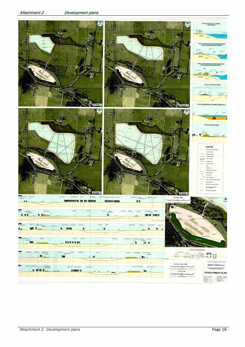
TOWN PLANNING COMMITTEE - 5 DECEMBER 2016 The application was referred to National Trust under Section 55 of the Planning and Environment Act 1987. National Trust did not respond to the proposal. South East Water The application was referred to South East Water under Section 55 of the Planning and Environment Act 1987. South East Water had no objection to the proposal. Southern Rural Water The application was referred to Southern Rural Water under Section 55 of the Planning and Environment Act 1987. Southern Rural Water did not respond to the proposal. SP AusNet The application was referred to SP AusNet under Section 55 of the Planning and Environment Act 1987. SP AusNet did not respond to the proposal. DISCUSSION The Lang Lang to Grantville region contains significant sand resources. As current sand resources in the Heatherton-Dingley area become exhausted, the Lang Lang - Grantville area is expected to become the major supply area for Melbourne concrete sand. The aim of the Regional Sand Extraction Strategy is to provide guidelines for “the extraction of the resource and rehabilitation of the site in a manner which protects significant environmental, economic and social values of the area”. The applicant has undertaken a comprehensive assessment of the issues associated with the proposal as part of the application and the findings of these assessments have been supported by the relevant referral authorities. The proposal has been assessed in detail in relation to the Regional Sand Extraction Strategy which forms part of a local policy under Clause 22.02 of the Cardinia Planning Scheme, in addition the Work Authority and its boundaries were required to be endorsed under Section 77l of the Minerals Resources Act (Sustainable Development) Act 1990. An endorsed Work Plan has been received as part of this application and as such has been approved by the State Authorities. A summary of the key issues addresses in the Work Authority No. 6051 Work Plan are outlined below. Buffers and Screening Bunds In the northern half of the subject site, there will be a minimum buffer of 20 metre along the western part of the northern boundary and northern part of the western boundary along Steeles Road. The extraction area will be setback at least 160 square metres from the eastern site boundary. Meanwhile in the southern half, the extraction limit will be setback a minimum of 60 metres from the Little Lang Lang River South to the south and a minimum 220 metres from McDonald Track. Two acoustic bund walls are located within the setback to the northern common boundary whilst one will located to the south setback to McDonald Track. These acoustic bund walls will be approximately 11 metres high and mitigate against environmental noise impacts upon McDonald Track and the two dwellings on the adjoining land to the north. Temporary bund walls will also be constructed from material collected from the excavation and will be constructed in advance of excavation in the relevant area. These bund walls will also be removed when the machinery is no longer working on this area. Soil and Overburden
Town Planning Committee - 5 December 2016 Page 7

TOWN PLANNING COMMITTEE - 5 DECEMBER 2016 Top soil and clay overburden depths vary on the subject site. Top soil averages 0.5 metres depth whilst clay overburden averages a 4.5 metre depth. Top soil will be removed separately from clay overburden and will be used for top dressing acoustic bunds and disturbed areas. It will be stored in temporary bunds up to 2.5 metres high when it cannot be directly deposited in its final location. To minimise erosion and dust generation these bunds will be contoured and vegetated. Additional top soil will also be development into wetlands following extraction whilst surplus soil will be dry processed and sold. Clay overburden will be used in early site development works for flood protection bunds, acoustic bunds, internal roads, the plant hard stand area and the walls of the slimes storage dam. Following the early stages clay overburden will be used to form slimes storage cells in worked out areas. Working Method The operation of the site will involve sand being extracted using long reach excavators and a crawler to depths of around 9 metres below natural ground level. Once collected this material is transported to the processing plant via dump trucks or an overland conveyor system. Any sand collected below this depth will be accessed via a floating cutter suction dredge and transported to the plant via a slurry pipeline. Noise Control The applicant has engaged an acoustic consultant, SLR Consulting Australia, to assess the acoustic implications of the proposed quarry. With the number of acoustic bunds both fixed and temporary located around the subject site the consultant determined that the predicted operation noise levels will not exceed a maximum noise level of 46 dB(A). As a consequence the proposal complies with that of the requirements of the October 2011 EPA noise in regional Victoria guidelines at the nearest residential dwelling. Dust The applicant has engaged Environmental Science Associated to identify potential sources of dust arising from the development, operational and rehabilitation phases. Subsequently the applicant has prepared a detailed dust management plan in order to protect local amenity and comply with the provisions of the EPA’s Protocol for Environmental management – Mining and Extractive Industries. This plan requires a variety of measures to be undertaken to control dust including using water trucks fitted with spray bars to water unsealed roads and trafficable areas, the use of a water cannon, fixed spray and sprinkler systems to control dust from stockpiles and the processing area, the use of dust suppressants where appropriate, limit vehicles to designated routes and limit speeds to less than 25 kph, covering and wetting down loads before they leave the quarry and prompt clean-up for sediment on internal sealed roads, intersections and public roads. Provided the dust management plan is satisfied, Environmental Science Associated has advised that the proposal should achieve compliance with the EPA requirements. Visual Impact Currently, views of the subject site are attainable from locations along McDonald Track, Steeles Road and Cams Road. It is considered that due to the location of established vegetation that will be retained on the subject site, the topography of the landscape and the addition of bund walls, the proposed operations will be predominately screened from view from land outside of the subject site. Traffic The local policy in the Cardinia Planning Scheme in relation to sand extraction provides that the extracted resource is transported to its end use in an efficient and safe manner which protects the amenity of the area and minimizes the impacts on existing service levels.
Town Planning Committee - 5 December 2016 Page 8

TOWN PLANNING COMMITTEE - 5 DECEMBER 2016 The applicant has engaged a traffic engineer, Traffix Group, to undertake an assessment of the proposal. This assessment has anticipated a production of 1.5 loads per hour which is the equivalent of 3 truck movements (in and out) per hour. Per annum this equates to 300, 000 tonnes. It is further highlighted by the applicant that the owner of the subject site operates two other sand quarries to the east along McDonalds Track. The proposal will result in less loads of sand being removed from these other two sites, which will result in local traffic maintaining a comparable volume to that at present. The traffic assessment has also highlighted that as a consequence of the vehicle movement to and from the subject site, that the intersection of Steeles Road and McDonalds Track be upgraded with a rural basis left turn treatment. Drainage and Groundwater The local policy in the Cardinia Planning Scheme in relation to sand extraction provides that extraction should not adversely impact on the quality and quantity of groundwater resources in the area to the extent that the beneficial uses of groundwater are reduced. The application has been reviewed by Melbourne Water and Southern Rural Water who are responsible for groundwater management and drainage in the area. Both authorities have provided no objection to the granting of a permit subject to conditions. Flora and Fauna The local policy in the Cardinia Planning Scheme in relation to sand extraction provides that the bio-diversity of flora and fauna in the area be protected and enhanced. The clearing of native vegetation for mining is exempt from the requirements for a planning permit under Clause 52.17 ‘Native Vegetation’ and Clause 42.03-3 ‘Significant Landscape Overlay’ if “the vegetation is to be removed, destroyed or lopped to enable the carrying out of Stone extraction in accordance with a Work Plan approved under the Mineral Resources (Sustainable Development) Act 1990 and authorised by a work authority granted under that Act”. The application submitted provides this authority from DELWP. Cultural Heritage The applicant has engaged a qualified Aboriginal heritage advisor, Clarkeology, to prepare an assessment as to whether the application requires a Cultural Heritage Management Plan. It is noted that whilst the proposal is classified as a high impact activity in relation to the Aboriginal Heritage Regulations 2007, the subject site is not an area of cultural heritage sensitivity. Therefore, a Cultural Heritage Management Plan is not required. Rehabilitation Once the site has ceased use, the site will be returned to pasture for agricultural activities with an open water body. The batters above the water level will be top soiled and revegetated with pasture grasses, the access road to the hard stand area will be retained for future use, disturbed areas will be top soiled and revegetated whilst fencing would also be provided to protect area newly planted indigenous species. The final stage of rehabilitation will result in the removal of the sand processing plant and equipment and the workshop will be retained on-site to support future use of the property. Objections The following is a response to all concerns raised within objections to the application that have not already been considered in the discussion.
• Impact on the re-sale value and devaluation of land.
Town Planning Committee - 5 December 2016 Page 9

TOWN PLANNING COMMITTEE - 5 DECEMBER 2016 In relation to Planning decisions loss of property values, perceived or actual, cannot form the basis for the rejection of an application.
• Implications on sub-terrain water The applicant has advised via submitted management strategies that the maximum likely drawdown at any existing stock and domestic bore located 200 metres from the proposed extraction boundary would be about 0.44 metres. For a shallow bore with 15 metres of water above the pump this would result in a 3% loss in available draw down. Furthermore, the applicant has advised that there are only 2 known stock and domestic bores between 200 and 300 metres from the proposal. It is therefore considered that the proposal will not have an adverse impact on sub-terrain water.
• Extent of notice It has been highlighted that some residents for whatever reason did not receive notification of the application via the post despite the application being set down to be sent to adjoining allotments. It is however, noted that for those that did not receive notification via the post, the application was advertised via signage along the property boundary and within the local paper. It is therefore considered that Council has satisfied its statutory obligations. CONCLUSION The land is in an area identified by planning policy for sand extraction and a number of operations have been approved in the surrounding area. The application provides a comprehensive assessment of operational and environmental issues that justify the proposal. The application is consistent with the State and Local Planning Policy Framework, zone, overlays and other relevant particular provisions associated with the proposal. It is considered that the proposal can be supported therefore it recommended that a Notice of Decision for planning permit application T160424 be issued for the use and development of land for extractive industry (sand quarry) at 685 McDonalds Track, LANG LANG VIC 3984 subject to the following conditions: CONDITIONS
1. Before the use or development starts, plans to the satisfaction of the Responsible Authority must be submitted to and approved by the Responsible Authority. When approved, the plans will be endorsed and will then form part of the permit. The plans must be drawn to scale with dimensions and three copies must be provided. The plans must show:
a. Floor plans and elevations of all fixed plant and site buildings.
b. A stormwater management plan showing the stormwater works to the nominated point of
discharge must be submitted for the approval of the Responsible Authority. The stormwater management plan must be prepared by a suitably qualified person and show details of the proposed stormwater works including all existing and proposed features that may have impact (including trees to be retained, crossings, services, fences, abutting buildings, existing boundary levels etc). All works must be undertaken in accordance with the approved stormwater management plan.
c. An Environmental Management Plan covering all aspects of site establishment, extraction
operations, rehabilitation and monitoring must be submitted to and approved by the Responsible Authority or referral authorities. The Environment Management Program shall be generally in accordance with the detailed environmental and operational reports submitted with the application and include any additional requirements of the Responsible Authority. The use and development of the land must be at all times in accordance with the Environment Management Plan, and as required by the Responsible Authority, an audit of
Town Planning Committee - 5 December 2016 Page 10

TOWN PLANNING COMMITTEE - 5 DECEMBER 2016
the Environment Management Plan must be undertaken by an independent auditor to the satisfaction of the responsible authority every five (5) years.
d. A landscape plan prepared by a person suitably qualified and experienced in landscape
design to the satisfaction of the Responsible Authority must be submitted to and approved by the Responsible Authority. When approved, the plan will be endorsed and will then form part of the permit. The plan must be drawn to scale with dimensions and three copies must be provided. The plan must show:
i. A survey (including botanical names) of all existing vegetation to be retained and/or removed.
ii. Buildings and trees (including botanical names) on neighbouring properties within three metres of the boundary.
iii. Details of surface finishes of pathways and driveways, iv. A planting schedule of all proposed trees, shrubs and ground covers,
including botanical names, common names, pot sizes, sizes at maturity, and quantities of each plant, and
v. Landscaping and planting within all open areas of the subject land.
All species selected must be to the satisfaction of the Responsible Authority.
2. Before the use and development starts:
a. The intersection of Steeles Road and McDonalds Track must be designed and constructed in accordance with plans and specifications approved by the Responsible Authority, at no cost to Council.
b. The extent of Steeles Road must be designed and constructed between McDonalds Track and the entry to the subject site in accordance with plans and specifications approved by the Responsible Authority, at no cost to Council.
c. The applicant will have to enter an agreement with Council which provides for the owner’s
obligation to maintain Steeles Road for as long as the approved use is in operation on the subject site to the satisfaction of the Responsible Authority, at no cost to Council.
d. A copy of the approved Work Plan, Work Authority conditions and Work Plan conditions,
issued pursuant to the Mineral Resources (Sustainable Development) Act 1990 must be submitted to the Responsible Authority.
3. The use and development as shown on the endorsed plans must not be altered without the written
consent of the Responsible Authority. 4. Within six (6) months the date of issue of this permit, the owner must enter into an agreement with
Council which provides for the owner’s obligation to pay for the construction of a bypass road for the Lang Lang Township along the alignment of Range Road. The agreement must be to the satisfaction of the Responsible Authority.
5. All security alarms or similar devices installed on the subject land must be of a silent type in
accordance with any current standard published by Standards Australia International Limited and be connected to a security service.
6. Before the commencement of the use or by such later date as is approved by the Responsible Authority in writing, the landscaping works shown on the endorsed plans must be carried out and completed to the satisfaction of the Responsible Authority.
7. The landscaping shown on the endorsed plans must be maintained to the satisfaction of the Responsible Authority and used for no other purpose. Any dead, diseased or damaged plants are to be replaced.
Town Planning Committee - 5 December 2016 Page 11

TOWN PLANNING COMMITTEE - 5 DECEMBER 2016
8. Except with the written consent of the Responsible Authority, the uses may operate only between the
hours of:
Extraction and Processing
a. 7:00am thru 6:00pm on weekdays (Monday – Friday);
b. 7:00am and 1:00pm pm Saturdays.
c. Closed on Sundays and public holidays. Load out and Sales
d. 4:00 am thru to 10:00 pm (Monday – Saturday)
9. The use or development:
a. As shown on the endorsed plans must not be altered without the written consent of the
Responsible Authority.
b. Must not commence until the “Work Authority” is given in accordance with the requirements of the Mineral Resources (Sustainable Development) Act 1990.
c. Must at all times be in accordance with the approved Work Plan, Work Authority conditions
and Work Plan conditions, issued pursuant to the Mineral Resources (Sustainable Development) Act 1990.
d. Must not detrimentally affect the amenity of the area, through the:
i. Transport of materials, goods or commodities to or from the land. ii. Appearance of any building, works or materials. iii. Emission of noise, artificial light, vibration, smell, fumes, smoke, vapour,
steam, soot, ash, dust, waste water, waste products, grit or oil. iv. Presence of vermin.
10. Prior to the removal of any sand resources from the site, the buffer planting and bund walls and any
proposed fencing must be established as shown on the approved plans to the satisfaction of the responsible authority.
11. Stormwater works must be provided on the subject land so as to prevent overflows onto adjacent properties. Sediment trap fences or devices, must be constructed from heavy duty materials and maintained to ensure their ongoing effective operation. If the soil is to be exposed for a period of in excess of thirty (30) days, sediment trap fences or devices must be installed down slope to ensure that there is no runoff into any of the nearby watercourses.
12. Earthworks must be undertaken in a manner that minimises soil erosion. Exposed areas of soil must
be stabilised to prevent soil erosion. The time for which soil remains exposed and unestablished must be minimised to the satisfaction of the Responsible Authority.
13. The slope of batters, both cut and fill, must not exceed 2:1 (horizontal: vertical) or, where this is not
practicable, batters must be stabilised by other means to the satisfaction of the Responsible Authority.
14. Erosion must be controlled during construction in accordance with the Environment Protection Authority Guideline TG208/90 (as amended) or in accordance with such guideline, policy or role that replaces TG 208/90.
Town Planning Committee - 5 December 2016 Page 12

TOWN PLANNING COMMITTEE - 5 DECEMBER 2016
15. Roads, storage areas, external stockpiles and vacant areas must be maintained to avoid dust nuisance to any surrounding property to the satisfaction of the Responsible Authority.
16. All roads used for the purpose of haulage of imported or exported materials for construction must be:
a. Approved in writing by the Responsible Authority for the submitted haulage strategy, at least
seven days prior to the commencement of use;
b. Maintained in accordance with the Responsible Authority's maintenance intervention levels, or as requested by the Responsible Authority if the road deteriorates during the haulage period; and
c. Reinstated to the satisfaction of the Responsible Authority.
Melbourne Water
17. Pollution and sediment laden runoff shall not be discharged directly or indirectly into Melbourne Water's drains or waterways.
18. The 100 Year ARI bund (flood levee) for each stage of the operation is to be designed and constructed by suitably qualified and experienced practitioners /contractors. At each stage of the operations advancement, as constructed survey of the bunds, including re-survey of past stages, is to be submitted to Melbourne Water within one month of the bund construction.
19. Prior to constructing the ‘Stage 4 100 Year ARI bund’ the flood weirs in the existing Stages 2 and 3
bunds are to be constructed. Detailed design plans of the weirs prepared by a suitably qualified and experienced practitioner are to be approved by Melbourne Water prior to construction of the weirs.
20. Access road crossing of the waterway corridor (from the toe of the ‘Operational Area’ fill pad batter to
the extraction boundary) is to be designed, constructed and maintained to the satisfaction of Melbourne Water.
21. Any conveyor or pipeline crossing of the waterway corridor (from the toe of the ‘Operational Area’ fill
pad batter to the extraction boundary) must be designed and constructed to the satisfaction of Melbourne Water.
22. Diversion of the tributary drain entering the eastern boundary of the property (adjacent to Hance Lane)
around the extraction boundary is to be undertaken to the satisfaction of Melbourne Water. 23. Prior to the commencement of works, a separate application direct to Melbourne Water must be made
for approval of any new or modified storm water connection to Melbourne Water's drains or watercourses.
24. Prior to the commencement of works, a Site Environmental Management Plan (SEMP) must be
submitted to Melbourne Water for review. The SEMP must show the location and nature of environmental values identified through site environmental assessments, and includes details of measures to protect or mitigate risk to those values. The SEMP must include a site map detailing the location and design of all measures in relation to significant site values including the following:
a. Silt fencing; b. Access tracks; c. Spoil stockpiling; d. Trenching locations; e. Machinery/ Plant locations; and
Town Planning Committee - 5 December 2016 Page 13

TOWN PLANNING COMMITTEE - 5 DECEMBER 2016
f. Exclusion fencing around native vegetation/ habitat.
25. Prior to completion of detailed design of the proposed works, the proponent will need to formally apply
to Melbourne Water’s Asset Services Team to conduct any works on or near a Melbourne Water asset (including waterways). Prior to undertaking any works, the proposal must be accepted by Melbourne Water and the contractor must be in receipt of a Melbourne Water Permit to Work.
26. Prior to the completion of works, the drainage line running roughly north – south through the eastern
side of the site and the associated retarding basin/wetland must be fenced and revegetated for future management and improved water quality of the downstream environment.
27. Melbourne Water has previously required the work authority plan to be submitted to Melbourne Water
clearly demonstrating an appropriate exclusion zone to protect any waterways likely to be impacted by extraction activities. The exclusion zone must be of an adequate width so that the extraction activities (vicinity and depth of works) do not affect the local hydrology, geomorphology or ecological values of the waterway. The Hydraulic Assessment Report by Cardno in section 7.2 has conflicting minimum setback requirements for the waterway. The minimum setback distance from the waterway must be 60 metres or greater.
28. Melbourne Water requires fencing along the riparian area to be widened to the track along the toe of
the bund prior to works commencing to provide additional protection from impacts of activities within the floodplain and ensure an exclusion zone.
29. Prior to the commencement of works, a copy of the vegetation offset management plan must be
submitted to Melbourne Water, showing proposed revegetation, development and management of the offset area within the riparian corridor.
30. Prior to the commencement of works, detailed design of the following must be submitted to Melbourne
Water for approval: a. Sediment traps and treatment of proposed connections for overflow to waterway;
b. Swale drains & sediment treatment along access road and bund tracks. Further detail of
management & maintenance of sediment traps & swale drains is required to manage WQ of downstream environments;
c. Diversion of drainage line with proposed on line retarding basin or wetland feature and proposed connection to Little Lang Lang River South Branch; and
d. Access road crossing including sediment treatment during construction and post construction. Environmental Protection Authority
31. Noise emitted from the premises must not exceed the recommended levels as setout in Noise from Industry in Regional Victoria (NIRV; EPA Publication 1411, 2011) or as amended.
Expiry
32. This permit will expire if one of the following circumstances applies:
a. The development is not started within two (2) years of the date of this permit; or b. If the Work Authority for the use issued under the provisions of the Extractive Industries
Development Act 1995 is cancelled in accordance with Section 24 of this Act. The Responsible Authority may extend the periods referred to if a request is made in writing in accordance with Section 69 of the Planning and Environment Act 1987.
Town Planning Committee - 5 December 2016 Page 14

TOWN PLANNING COMMITTEE - 5 DECEMBER 2016 Permit Notes Melbourne Water Hydraulics The need to clarify the ownership and maintenance responsibility for the bunds and flood diversion weirs was previously minuted in discussion, and was to be stated in the hydraulic assessment and dealt with in the planning process. Melbourne Water notes that the hydraulic assessment does not refer to this, nor the mechanism that will be implemented to address this. The hydraulic assessment contains a number of errors and incorrect statements. For example:
- Figure 7-1 contains a label stating “Minimum setback distance is 60 m” but then the report text states “setback is a minimum of 50 m”.
- There are still some fundamental flaws in the access crossing culvert assessment, however, these
issues can be worked out during the detailed design prior to construction, however it makes it difficult as it has been assumed that the concept in the report is the final accepted solution.
River Health The rehabilitation plan and Groundwater Management Plan outline the rehabilitation of the pit as a wetland, but no detail of planting is included to support the development of a wetland, as opposed to a large area of open water - 32Ha. Depth of water (if greater than 350mm) may restrict the development of wetland planting. Long term viability of the scattered vegetation will be improved if planted in groups and fenced to provide protection from grazing animals. Melbourne Water requests inclusion as a referral authority for approval of the crossing on the access road in the Environmental Monitoring Program.
Town Planning Committee - 5 December 2016 Page 15

Attachment 1 Locality Plan
Attachment 1 - Locality Plan Page 16

Attachment 2 Development plans
Attachment 2 - Development plans Page 17
Attachment 2 Development plans
Attachment 2 - Development plans Page 18

Attachment 2 Development plans
Attachment 2 - Development plans Page 19