11.10.4 after hours - western australian planning … daps/wheatbelt... · if excavation...
TRANSCRIPT

Consulting Civil and Traffic Engineers, Risk Managers.
Page 36
11.10.4 After Hours
Appoint personnel to conduct after dark checks. Observe any signs / devices not
working, missing or damaged and record in diary.
Appoint personnel to conduct checks on non-work days (e.g. week ends). Observe
any signs / devices not working, missing or damaged and record in diary.
Provide after hours contact names and numbers for implementation of maintenance
and repairs arising from the above inspections.
11.11 Records
A daily diary recording all inspections including variations to the approved TMP shall be kept using
Standard Forms “Daily Diary”.
The Traffic Supervisor is to record all inspections made on a daily basis and at those times prescribed
by the Traffic Management Implementation Standards. Upon completion of each day the Traffic
Supervisor shall provide copies of the daily diary record to the Project Manager.
The Traffic Supervisor is to record all variations made to the approved Traffic Management Plan on a
daily basis and indicate clearly the nature of the variations and the reason for the variations. Upon
completion of each day the Traffic Supervisor shall provide copies of the variation record to the
Project Manager.
11.12 Temporary Pavement Markings
Temporary pavement markings shall be installed after each individual stage of works prior to the
application of the ultimate pavement marking in accordance with the following:
After profiling works lanes shall be delineated by temporary RRPMs.
After asphalt works have been carried out lanes shall be delineated by either ultimate
pavement markings, temporary RRPMs or temporary painted pavement markings.
Temporary RRPMs shall be installed at not less than 4m spacing and not greater than
12m spacing.
11.13 Aftercare Signage
Aftercare signage shall be installed between work shifts as determined to be applicable on site and
applicable to the state of completion of the road works and pavement markings in accordance with the
following requirements:

Consulting Civil and Traffic Engineers, Risk Managers.
Page 37
Aftercare signage shall be the installation of roadwork advisory signage on the
approaches to the work site at the end of work shift.
All symbolic worker signage shall be removed or laid flat during out of work hours.
Pedestrian watch Your Step signage shall be erected where works have impacted on
footpath surface condition.

Consulting Civil and Traffic Engineers, Risk Managers.
Page 38
12 RECORD KEEPING
12.1 Daily Diary
Record details of all changes to the approved Traffic Management plan, who directed/made the changes and who authorised the changes (if applicable).
PROJECT DETAILS:
LOCATION:
DATE:
Contract No.
TMP Document No. TCD Dwg No. Revision No. 0
Date: Time: Location:
Inspection/
changes
By: Signed: Changes authorised
By: Signed:
Detail/Comments:
Date: Time: Location:
Inspection/
changes
By: Signed: Changes authorised
By: Signed:
Detail/Comments:
Date: Time: Location:
Inspection/
changes By: Signed: Changes
authorised By: Signed:
Detail/Comments:

TRAFFIC MANAGEMENT PLAN
Page 39
TRAFFIC MANAGEMENT - DAILY INSPECTION SHEET DATE: TCD No(s).
Inspection Prior to Commencement of Work Day Time Inspection During Work Hours
Time of Inspection: Time of Inspection:
Signs & devices appropriate for the day’s activities and conditions
Satisfactory
Modifications / Repairs Required
Signs & devices operating satisfactorily and seen by motorists
Satisfactory
Modifications / Repairs Required
Signs & devices positioned and mounted correctly
Satisfactory
Modifications / Repairs Required
Signs & devices positioned and mounted correctly
Satisfactory
Modifications / Repairs Required
Signs & devices clean and clearly visible Satisfactory
Modifications / Repairs Required Signs & devices clean and clearly visible Satisfactory
Modifications / Repairs Required
Modifications and/or repairs completed Yes (Give details)
No (If no, give reason)
Traffic Controllers correctly attired and operating correctly
Satisfactory
Modifications / Repairs Required
Modifications and/or repairs completed Yes (Give details)
No / Not Applicable (Give reason)
Closing Down Inspection Night Time Inspection After Working Hours
Time of Inspection: Time of Inspection:
Signage removed Satisfactory
Modifications / Repairs RequiredArrow boards/VMS operating? Satisfactory
Modifications / Repairs Required
Excavations correctly back filled Satisfactory
Modifications / Repairs Required
Signs & devices positioned and mounted correctly
Satisfactory
Modifications / Repairs Required
Driving surfaces adequate Satisfactory
Modifications / Repairs RequiredSigns & devices clean and reflective Satisfactory
Modifications / Repairs Required
If excavation backfilling is unsealed, are ROUGH SURFACE signs and cones in
Satisfactory
Modifications / Repairs Required
Modifications and/or repairs completed Yes (Give details)
No / Not Applicable (Give reason)

TRAFFIC MANAGEMENT PLAN
Page 40
place N/A Notes:
1. Indicate by placing a tick ( ) in the appropriate box for each item.
2. Items requiring modification and/or repair are to be described on the back of this form.
3. For all modifications that are different to the basic traffic management plan layout give details of who authorised changes.
4. Hand sheets to supervisor / manager at the end of each day.
5. When copying, ensure any notes on back of sheet are copied as well.
Signed:…………………............……...(Supervisor) Signed:……………........………...……….(Manager)
Date:…………… …………...........……………… Date:…………………………………………………
All materials removed from medians Satisfactory
Modifications / Repairs Required
Modifications and/or repairs completed Yes (Give details)
No / Not Applicable (Give reason)

TRAFFIC MANAGEMENT PLAN
Page 41
WORKSITE TRAFFIC MANAGEMENT GENERIC AUDIT CHECKLIST
ITEM Yes No IMP N/A COMMENT
General Copy of Australian Standard 1742.3 on site
Copy of Traffic Management Requirements document on site
Copy of the approved Traffic Management Plan on site Traffic Control in place in accordance with approved Traffic Control Plan for stage of construction
If not; have reasons for changes been recorded Is Contractor’s Works Foreman aware of variations Are modifications in accordance with Australian Standard and Traffic Management Requirements
Have modifications been made following a formal Job Safety Analysis (JSA)
Are arrangements in place to allow for vehicle breakdown
Are arrangements in place to allow for emergency vehicle access to the work site and adjacent properties
Are pavement widths adequate for traffic volumes and type
Adequate provision have been made for the safe access and egress of construction vehicles and equipment
Construction vehicles/equipment are not located to create site vision problems or force motorists to undertake illegal manoeuvres e.g. cross over double white lines etc.
Does the traffic control plan address the needs of major adjacent traffic generators e.g. parking stations and major commercial traffic generators
Has there been a need to alter the existing pedestrian, cyclists or public transport facilities
Traffic Controllers on site are qualified
Traffic control measures have been put in place by qualified traffic personnel.
Do work methods ensure delays are minimised
Is the site being monitored daily and records kept as per AS1742.3
Approaches to Work Site Signs and controls have been positioned to provide clear direction on the approach to the worksite
Horizontal and vertical alignments have been taken into account and traffic control signage meets the safe stopping site distance requirements for the approach speed
ITEM Yes No IMP N/A COMMENT Signs and controls have been placed so that

TRAFFIC MANAGEMENT PLAN
Page 42
landscaping or other obstruction do not obscure the drivers line of vision to the signs The traffic control layout ensures that drivers are able to read the changing road characteristics, visual illusions, subliminal delineation etc. Ensure that traditional characteristics such as lines of trees, lines of poles do not lead drivers to make incorrect decisions in the changed environment.
Are side roads appropriately signed
Are speed controls appropriate for the approaching speed environment*
Are Merging lanes appropriate for the approaching environment: speed, no. of lanes width of merging lanes etc.
Are pedestrians, cyclists and others adequately catered for on the approaches to the work site. Warning signs, physical obstructions, lighting etc.
Does lighting complement the approach control measures
Where variable message signs are used is the message easily understood and unambiguous
Is the sequencing of the signs in accordance with the Standards
Are signs spaced in accordance with the approaching speed environment
Is the size of the lettering on the signage in accordance with the Standards for the approach speed
Is the size of the signage in accordance with the Standards for the approach speed.
Does the placement of signage, cones or other temporary device present a hazard to users of the road environment.
Are signs level
The layout of road markings and reflective media both on the road and on the surrounds is adequate to deal with the changes in the road environment
Existing markings have been adequately masked to ensure motorists are not confused on the approach to and through the worksite
Are portable traffic signals providing adequate traffic flows
Control at the worksite Do speed restrictions adequately cater for the changing nature of the worksite e.g. construction plant and vehicular traffic interacting.
If barriers have been required to be placed between the construction site and the through traffic, are they of adequate capacity to protect the worksite.
Are intersections free of sight distance obstructions
Is traffic adequately guided through intersections
Are lane widths and swept paths adequate
ITEM Yes No IMP N/A Have signalised intersections been accounted for with the temporary controls
Are the appropriate sized cones being used

TRAFFIC MANAGEMENT PLAN
Page 43
Are cones being used for periods greater than 24 hour delineation.
Are there adequate repeater signs along the length of the site.
Is access for private property adequately catered for
Is there adequate provision for pedestrians
Is there adequate provision for cyclists
Is there adequate provision for public transport
Is there adequate provision for people with disabilities
Are footpaths and cycle facilities well maintained and free of loose materials and other hazards
Has there been adequate provision been made for parking requirements / signs
Are sidetracks adequately signed
Does the geometry of the sidetrack provide suitable site distance and manoeuvrability for all classes of vehicles using the track
Is the sidetrack suitably constructed for the traffic environment
Are merging/diverging requirements appropriate for the sidetrack
Is linemarking adequate
Are approaches to detours adequate
Do detours clarify the alternative route to be taken
Does the detour guide traffic back to the through route
Are lateral shift marker layout adequate on lane closures
Are temporary cones used correctly
Have regulatory signage been adequately adjusted or managed
Are roads kept sufficiently maintained for safe traffic movements at all times
Has the transition between sealed and unsealed pavement being adequately managed
Night Use Has the site being inspected at night Are signs suitable for night use Are temporary road markings clearly visible at night Do removed or painted-out markings cause confusion at night
Does lighting provide suitable guidance for approaching traffic
ITEM Yes No IMP N/A COMMENT
Have suitable lamps been used in accordance with the Australian Standard
Are signs not required for night usage adequately covered or removed and stored.
Exit from the Worksite Have appropriate End Limit/End of Road work signs been erected
Are drivers adequately guided back to the completed road pavement.
Are any differences in pavement texture maintained to ensure a safe transition
TRAFFIC MANAGEMENT PLAN
Page 44
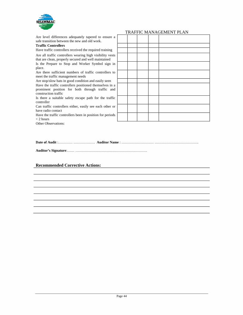
Are level differences adequately tapered to ensure a safe transition between the new and old work.
Traffic Controllers Have traffic controllers received the required training
Are all traffic controllers wearing high visibility vests that are clean, properly secured and well maintained
Is the Prepare to Stop and Worker Symbol sign in place.
Are there sufficient numbers of traffic controllers to meet the traffic management needs
Are stop/slow bats in good condition and easily seen Have the traffic controllers positioned themselves in a prominent position for both through traffic and construction traffic
Is there a suitable safety escape path for the traffic controller
Can traffic controllers either, easily see each other or have radio contact
Have the traffic controllers been in position for periods < 2 hours
Other Observations:
Date of Audit :………… ……………… Auditor Name : ……………………… ………………………………. Auditor’s Signature:…… …………………………………………………… Recommended Corrective Actions:

TRAFFIC MANAGEMENT PLAN
Page 45
13 TRAFFIC CONTROL DIAGRAMS

TRAFFIC MANAGEMENT PLAN
Page 46

TRAFFIC MANAGEMENT PLAN
Page 47
14 Incident Report
14.1 Incident Report Form
Any incident occurring onsite shall be reported using the following incident report format.
Region Incident Report No.
Contract Number
Contractor
Major Incident Reports must be forwarded to the Superintendent within 48 hours of the incident occurring or becoming apparent.
Contractors shall use this Form for reporting of Traffic incidents on works under Contract and this form supplements the OSH Incident Reporting Form.
1.0 Details of Incident Reported to: Supervisor TMR Other ---
OSH Incident Report No
Atmospheric Conditions
Light Conditions
Fatality Clear Day Light
Injury Road Surface Overcast Night Time
Property Damage Unsealed
Raining Dawn/Dusk
Police Attended Yes/No Sealed
Fog/Smoke/Dust
Street Lighting
Time and Date of incident
Road Condition On
AM / PM Wet Off
Day
Month
Year
Dry Not Provided
Other relevant details, (Last maintenance grade, watering and dust conditions):
2.0 Details of Traffic Management in place:
TCD No: Name of individual that prepared the
TCD

TRAFFIC MANAGEMENT PLAN
Page 48
Time last inspected:
Accreditation No:
TCD Approved: Day
Month
Year
TMP Approved: Day
Month
Year
3.0 Descriptions of Vehicles:
Detail (make, model/ped/cyclist/VRU) Registration No
Direction of Travel
Age of Driver
3.1 Vehicle 1
3.2 Vehicle 2
3.3 Vehicle 3
Comments:
4.0 Description of Incident:
Draw the incident including the direction of travel, traffic control signs, fixed structures and north point.
North

TRAFFIC MANAGEMENT PLAN
Page 49
5.0 Attachments: The following copies MUST be submitted with this Incident Report.
Approved TMP Approved TCP Approvals for temporary speed restrictions
Daily Diary
6.0 Police Report:
Accident reported to Police:
YES NO Report made by
Phone Fax
Mail or E-
Date Report Made
Day
Month
Year
Police WA Reference Number
7.0 Details of Person Completing this Incident Form:
Name: Contractor Name:
Position:
Date: Signature:

Iluka Resources Limited
Appendix 2 Flora and Vegetation Survey of the Cataby Proposed Camp Locations
Tiwest Camp Relocation – Planning Application B

FLORA AND VEGETATION SURVEY
OF THE CATABY PROPOSED CAMP LOCATIONS
Prepared for Iluka Resources Limited
Prepared by Mattiske Consulting Pty Ltd
March 2012
IRL1102/091/12

Mattiske Consulting Pty Ltd
Disclaimer and Limitation
This report has been prepared on behalf of and for the exclusive use of Iluka Resources Limited, and is subject to and issued in accordance with the agreement between Iluka Resources Limited and Mattiske Consulting Pty Ltd. Mattiske Consulting Pty Ltd accepts no liability or responsibility whatsoever for it in respect of any use of or reliance upon this report by any third party. This report is based on the scope of services defined by Iluka Resources Limited, budgetary and time constraints imposed by Iluka Resources Limited, the information supplied by Iluka Resources Limited (and its agents), and the method consistent with the preceding. Copying of this report or parts of this report is not permitted without the authorisation of Iluka Resources Limited or Mattiske Consulting Pty Ltd.
DOCUMENT HISTORY
Report Version Prepared By
Reviewed By
Submitted to Client
Date Copies
Internal Review V1 AM EMM - -
Draft Report released for Client Review V2 AM EMM 5/3/12 Email
Final Report V3 - EMM

Mattiske Consulting Pty Ltd
TABLE OF CONTENTS Page
1. SUMMARY .................................................................................................................................................. 1
2. INTRODUCTION ........................................................................................................................................ 3
2.1 Location and Scope of Proposal ...................................................................................................... 3
2.2 Climate ............................................................................................................................................... 3
2.3 Soils and Topography ....................................................................................................................... 4
2.4 Regional Vegetation .......................................................................................................................... 4
2.5 Western Australia’s Flora – A Legislative Perspective .................................................................. 4
2.5.1 Threatened and Priority Flora ......................................................................................................... 5
2.5.2 Threatened Ecological Communities .............................................................................................. 5
2.5.3 Clearing of Native Vegetation ......................................................................................................... 6
2.6 Declared Plant Species ..................................................................................................................... 7
2.7 Local and Regional Significance ...................................................................................................... 7
3. OBJECTIVES .............................................................................................................................................. 8
4. METHODS .................................................................................................................................................. 8
4.1 Desktop survey .................................................................................................................................. 8
4.2 Field survey ........................................................................................................................................ 9
4.3 Survey Constraints .......................................................................................................................... 10
5. RESULTS .................................................................................................................................................. 12
5.1 Desktop Survey ............................................................................................................................... 12
5.1.1. Threatened and Priority Flora ....................................................................................................... 12
5.1.2 Threatened and Priority Ecological Communities ....................................................................... 14
5.2 Field Survey ..................................................................................................................................... 14
5.2.1 Flora .................................................................................................................................................. 14
5.2.2 Threatened and Priority Flora ....................................................................................................... 14
5.2.3 Threatened and Priority Ecological Communities ....................................................................... 15
5.2.4 Introduced (Exotic) Plant Species ................................................................................................ 15
5.2.5 Tree Species .................................................................................................................................... 17
5.2.6 Condition of the Vegetation ........................................................................................................... 18
6. DISCUSSION ............................................................................................................................................ 18
7. RECOMMENDATIONS ............................................................................................................................. 21
8. ACKNOWLEDGEMENTS .......................................................................................................................... 22
9. LIST OF PERSONNEL: ............................................................................................................................. 22
10. REFERENCES ........................................................................................................................................... 22
Mattiske Consulting Pty Ltd
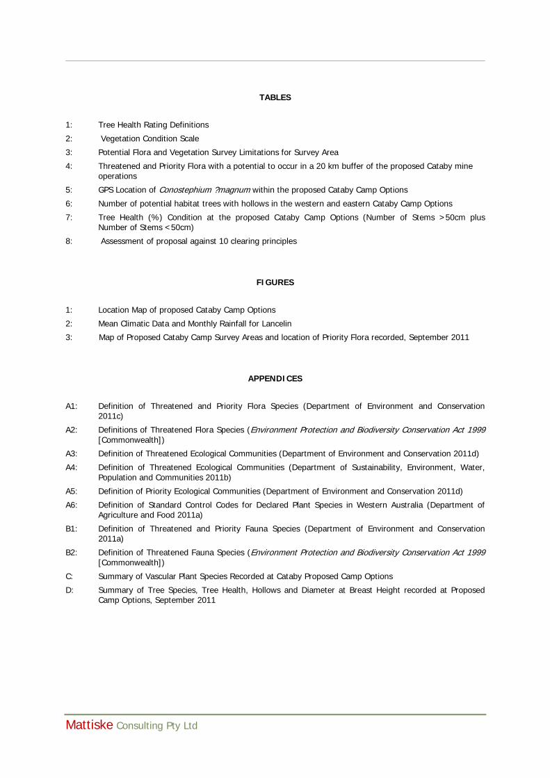
TABLES
1: Tree Health Rating Definitions
2: Vegetation Condition Scale
3: Potential Flora and Vegetation Survey Limitations for Survey Area
4: Threatened and Priority Flora with a potential to occur in a 20 km buffer of the proposed Cataby mine operations
5: GPS Location of Conostephium ?magnum within the proposed Cataby Camp Options
6: Number of potential habitat trees with hollows in the western and eastern Cataby Camp Options
7: Tree Health (%) Condition at the proposed Cataby Camp Options (Number of Stems >50cm plus Number of Stems <50cm)
8: Assessment of proposal against 10 clearing principles
FIGURES
1: Location Map of proposed Cataby Camp Options
2: Mean Climatic Data and Monthly Rainfall for Lancelin
3: Map of Proposed Cataby Camp Survey Areas and location of Priority Flora recorded, September 2011
APPENDICES
A1: Definition of Threatened and Priority Flora Species (Department of Environment and Conservation 2011c)
A2: Definitions of Threatened Flora Species (Environment Protection and Biodiversity Conservation Act 1999 [Commonwealth])
A3: Definition of Threatened Ecological Communities (Department of Environment and Conservation 2011d)
A4: Definition of Threatened Ecological Communities (Department of Sustainability, Environment, Water, Population and Communities 2011b)
A5: Definition of Priority Ecological Communities (Department of Environment and Conservation 2011d)
A6: Definition of Standard Control Codes for Declared Plant Species in Western Australia (Department of Agriculture and Food 2011a)
B1: Definition of Threatened and Priority Fauna Species (Department of Environment and Conservation 2011a)
B2: Definition of Threatened Fauna Species (Environment Protection and Biodiversity Conservation Act 1999 [Commonwealth])
C: Summary of Vascular Plant Species Recorded at Cataby Proposed Camp Options
D: Summary of Tree Species, Tree Health, Hollows and Diameter at Breast Height recorded at Proposed Camp Options, September 2011

1. __________________________________________________________________________________
Mattiske Consulting Pty Ltd
1. SUMMARY
Mattiske Consulting Pty Ltd was commissioned in September 2011 by Iluka Resources Limited to undertake a biological assessment of the two proposed camp locations along Cataby Road, Figure 1. The road verges were searched for Declared Threatened and Priority Flora, and the paddock areas were assessed for the health and size of isolated trees which may be potential habitats for endangered cockatoo species.
No Threatened Flora Species, pursuant to Schedule 1 of the Wildlife Conservation Act 1950 and as listed by the Department of Environment and Conservation (2011b), were recorded in the two proposed camp locations. One Priority Flora species as listed by the Department of Environment and Conservation (2011h) was potentially recorded. This species, Conostephium ?magnum, is a Priority 4 taxa, but was unable to be confirmed to species due to a lack of fertile material.
There were no Threatened Ecological Communities, as listed under the Environment Protection and Biodiversity Conservation Act 1999 (Department of Sustainability, Environment, Water, Population and Communities 2011b) and by the Department of Environment and Conservation (2011e), recorded in the Cataby road verge survey areas. One Priority Ecological Community (PEC) was identified as having the potential to occur in the survey area based on its distribution within the Bassendean Dune system. The remnant bushland area within the proposed Cataby camp locations had very little in common with this PEC. The dominant overstorey species described in this floristic community, namely Banksia attenuata and Banksia menziesii, do not exist as dominant overstorey species within the proposed Cataby camp location, with Banksia attenuata not found in the area and Banksia menziesii existing, but not as a dominant overstorey species.
The proposed camp survey areas were found to be in a completely degraded condition, consisting of parkland cleared isolated trees over pasture. The poor condition of the vegetation is a result of historical and current agricultural practices in the region, particularly clearing of native vegetation, grazing of stock, and the introduction of aggressive weed species. The road verge vegetation of the western camp was in a better condition, with a rating of Good. The vegetation structure had been significantly altered by obvious signs of multiple disturbances, particularly the presence of aggressive weeds at high density and partial clearing, but it retains a basic vegetation structure or the ability to regenerate it (Keighery 1994).
Some of the weeds recorded in the area have been assessed by the Department of Environment and Conservation as aggressive and difficult to control. These include weeds of Medium to High Ecological Impact; *Avena barbata, *Oxalis pes-caprae, *Arctotheca calendula and *Hypochaeris glabra (Department of Environment and Conservation 2011i). These species, although not listed under the Agricultural and Related resources Protection Act 1976 [WA] should be managed to minimize the risk of spreading from disturbed areas.
Clearing Principle (No.2) states that “native vegetation should not be cleared if it comprises the whole or a part of, or is necessary for the maintenance of a significant habitat for fauna indigenous to Western Australia” (Environmental Protection Act 1986). A number of trees (Corymbia calophylla) within the survey area had a diameter at breast height >50 cm and as such are considered a suitable habitat tree for the protected Carnaby’s Black Cockatoo (Calyptorhynchus latirostris) (Department of Sustainability, Environment, Water, Population and Communities 2011c, 2011d). There was also evidence of tree hollows in a number of the habitat trees suitable for nesting. Therefore although the vegetation within the proposed camp survey areas is highly degraded, the isolated parkland cleared Corymbia calophylla trees are a possible habitat for the Carnaby’s Cockatoo. Therefore it is recommended that the design for the camps takes into account avoidance of the larger trees that have the potential to support hollows in the future and those that support hollows that may be currently utilized.
This is an unlicensed copy of Split Pdf
This page will be appended to every output
in unlicensed mode only.
For purchase information see our website
http://www.traction-software.co.uk/servertools/splitpdf/
Thank you,