12. cultural heritageeisdocs.dsdip.qld.gov.au/legacy way project (gazetted as... · 2015-08-18 ·...
TRANSCRIPT

12. Cultural Heritage

Northern Link Phase 2 – Detailed Feasibility Study
CHAPTER 12
CULTURAL HERITAGE
September 2008

PAGE i
Contents
12. Cultural Heritage 12-1 12.1 Description of the Existing Environment 12-1 12.1.1 Cultural Heritage Significance 12-1 12.1.2 Commonwealth Legislation 12-2 12.1.3 State Legislation 12-2 12.1.4 Local Legislation 12-2 12.1.5 Approach 12-3 12.1.6 Aboriginal Heritage 12-3 12.1.7 Non Indigenous Heritage 12-8 12.2 Impact Assessment 12-17 12.2.1 Western Freeway Connection 12-18 12.2.2 Toowong Connection 12-18 12.2.3 Driven Tunnels 12-19 12.2.4 Kelvin Grove Connection 12-25 12.2.5 Inner City Bypass Connection 12-27 12.2.6 Proposed Ventilation Outlet Sites 12-27


PAGE 12-1
12. Cultural Heritage This chapter addresses Part B, Section 5.8, of the Terms of Reference (ToR), which require the EIS to describe existing values for indigenous and non-indigenous cultural heritage areas and objects that may be affected by Northern Link activities. The ToR also require that the EIS prepare cultural heritage surveys as relevant, to determine the significance of any cultural heritage areas or items and assist with the preparation of Cultural Heritage Management Plans to protect any areas or items of significance. The ToR also require that the EIS provide a description of any likely impacts on cultural heritage values, and to recommend means of mitigating any negative impacts.
12.1 Description of the Existing Environment Cultural heritage focuses on aspects of the past which people value and which are important in identifying who we are. Cultural heritage incorporates places, objects, artefacts, documents, beliefs, skills and practices. Although there is obvious overlap and connections, legislatively Aboriginal and non-Aboriginal cultural heritage is divided. This division has been acknowledged in the preparation of this EIS.
Historical and cultural heritage impact risks associated with the proposed Northern Link Project were initially identified during the prefeasibility stage of TransApex and the identification of the prefeasibility of the Northern Link route alignment options. At that stage, listed heritage sites and places were obtained from a review of existing Council, State and Commonwealth heritage registers. The assessment of the strategic options during the Preliminary Assessment of the detailed feasibility of Northern Link also included within the assessment criteria for the feasibility of the project, the impacts on places or areas of cultural heritage significance. This included the number, extent and nature of impacts on local, State, Commonwealth, Indigenous and Non-Indigenous buildings, vegetation, places and artefacts. Existing cultural heritage data has been used extensively to advise the development of the project design options regarding potential impacts and avoidance or mitigation requirements for the tunnel alignments and location of key project structures.
The University of Queensland Archaeological Services Unit (UQASU) was engaged during phase 2 of the detailed feasibility study, including this EIS, to undertake a detailed study of the existing cultural heritage values of the proposed Northern Link route. This chapter summarises the results of studies of both the Aboriginal and non-Aboriginal cultural heritage places within the Study Corridor and their considerations, impacts and proposed management in regard to the proposed tunnel alignment and surface works. It is based on existing knowledge, registers and reports of the Study Corridor and surveys of standing structures conducted between October and December 2007.
12.1.1 Cultural Heritage Significance The Burra Charter (Australia ICOMOS 1999) sets the standard of practice in Australia for places of cultural heritage significance. It defines heritage significance as ‘aesthetic, historic, scientific, social or spiritual value for past, present or future generations’. Heritage significance is assessed at the national, State and local levels and accordingly, is subject to certain legislative criteria. The Burra Charter is a voluntary charter drafted by the International Council of Monuments and Sites (ICOMOS) members, which has been adopted as best practice and which guides decision making under Commonwealth and Queensland State heritage legislation. Brisbane City Council has adopted Burra Charter principles for determining local heritage significance for the listing of items on Council’s heritage register.

PAGE 12-2
12.1.2 Commonwealth Legislation In 2004, a new national heritage system was established under the Environment Protection and Biodiversity Conservation Act 1999 (EPBC Act). This legislation is administered by the Federal Department of the Environment, Water, Heritage and the Arts. The EPBC Act established the National Heritage List (NHL), which recognises and protects places of outstanding heritage value to the nation, and the Commonwealth Heritage List (CHL), which protects Commonwealth owned or leased places of significant heritage value. The EPBC Act also includes transitional arrangements for the Register of the National Estate (RNE), which was established under the Australian Heritage Commission Act 1975. From 19 February 2007 the RNE was frozen, and no further places can be entered on the Register. The RNE will continue as a statutory register until February 2012 after which it will remain as an information source only. The expectation is that by that date state governments will have registered all places currently on the RNE that they consider to be of State level significance. In the interim, new listings of places or items of national heritage significance will be entered on either the NHL or CHL.
To satisfy the significance threshold for listing on the NHL a place must have outstanding heritage value to the nation, that is, being important to the Australian community as a whole. A place on the RNE must have significance at a national level and must also satisfy a number of significance criteria relating to natural, cultural or social history, interpretive value, aesthetic characteristics, creative or technical achievement, or association with a particular person or group of persons.
12.1.3 State Legislation In Queensland, indigenous cultural heritage and non indigenous cultural heritage are accommodated by two separate pieces of legislation – the Aboriginal Cultural Heritage Act 2003 and the Queensland. Heritage Act 1992.
Aboriginal cultural heritage is administered under the Aboriginal Cultural Heritage Act 2003 by the Department of Natural Resources and Water (DNRW). This Act provides for a Cultural Heritage Register and Cultural Heritage Database. The Cultural Heritage Register holds information about cultural heritage studies, Cultural Heritage Management Plans, cultural heritage bodies, and Aboriginal and Torres Strait Islander parties. The Indigenous Cultural Heritage Database contains information about places of Indigenous cultural heritage and provides a research and planning tool to help assess heritage values of particular areas.
Non-indigenous cultural heritage in Queensland is administered under the Queensland Heritage Act 1992, by the Environmental Protection Agency through the Queensland Heritage Register, which is a list of places assessed as being of State level significance (in accordance with criteria similar to those used to assess places/items of national significance).
Under Part 6 of the amended Queensland Heritage Act development applications that affect State registered heritage places are automatically referred to the Chief Executive of the EPA. The Chief Executive makes the decision to approve or not approve the development application on heritage grounds. The Chief Executive can refer matters to the Heritage Council and/or obtain the Council's advice about any part of the development application.
12.1.4 Local Legislation The Brisbane City Plan 2000 (City Plan), prepared under the Integrated Planning Act 1997 (IPA), is Brisbane City Council’s planning scheme for the future development of the city. The City Plan Heritage Register is

PAGE 12-3
contained within the planning scheme in the Heritage Register Planning Scheme Policy. The Register contains places and precincts of cultural heritage significance at a city or local level, places of special cultural significance to Indigenous people, and places of natural heritage significance. All places contained in the Register require the City Plan’s Heritage Place Code to be applied when an application for development is made.
A place may be entered in the City Plan Heritage Register if it satisfies cultural heritage significance criteria similar to those used to assess national and State cultural heritage significance.
A recent amendment to IPA has had the effect of including ‘local heritage places’ in Schedule 8 of that Act. This means that any development impacting on local heritage places is code assessable under IPA, regardless of any exemptions the Project might otherwise be entitled to.
12.1.5 Approach Searches were undertaken at the national, state and local level for registered heritage places within the Study Corridor. Searches were undertaken of all of the national, State and local lists, registers and databases discussed above. To date no Cultural Heritage Management Plans have been approved by the Minister administering the Aboriginal Cultural Heritage Act for any part of the Study Corridor.
For the purposes of the Cultural Heritage Study, a 300m buffer was applied around the Study Corridor to ensure that all places that may be affected by the proposed development were captured in the study. Therefore the Cultural Heritage Study includes well known locations such as the Royal Brisbane Hospital, the Brisbane Exhibition Grounds, Lang Park and Government House.
A literature review and multiple surveys of the Study Area were undertaken to identify, locate and record non-Aboriginal cultural heritage. Places located, recorded and photographed included all places on the Register of the National Estate, Queensland Heritage Register and Brisbane City Plan Heritage Register. Places identified in Brisbane City Council’s Geographic Information Systems (GIS) as Potential Heritage Buildings/Places were located and recorded. Additional places of ‘potential’ heritage significance were also identified and recorded during the surveys, based on professional judgment and the application of heritage significance criteria by UQASU. It must be noted that those places identified as having potential heritage significance do not have any status under the provisions of any legislation, or under Brisbane City Council’s planning codes or policies.
All places and items recorded during the cultural heritage surveys, including places of potential heritage significance, have been mapped using a GIS database, and the maps are presented throughout this chapter.
12.1.6 Aboriginal Heritage The Northern Link Study Corridor is a precisely defined precinct within the bounds of modern Brisbane. In terms of Aboriginal occupation and significance, however, it is a small part of a larger dynamic landscape that hosted not only the Brisbane-based group but also a diverse range of neighbouring groups involved in economic, subsistence, social, ritual and political activities. In order to appreciate the Aboriginal cultural heritage of the Study Corridor it is important to understand it within the broader regional context.
The Brisbane – Moreton Bay region supported a large number of tribal groups, and historical sources indicate a complex web of social and political relationships throughout the Moreton Region and beyond. The Aborigines of the Moreton Region had available to them a rich resource base, particularly marine and littoral resources.

PAGE 12-4
This resource base afforded the coastal groups a relatively sedentary lifestyle, in that there was no need to relocate to pursue different types of food only seasonally available.
Stone implements known to have been used by Aborigines of the Moreton Region included the tomahawk (axe or adze), and stone knives made from reddish-coloured flint stone, sometimes ornamented with possum fur stuck on with bees’ wax. Other ‘formal’ stone implements include grindstones and mullers, and bevelled pounders used for processing bungwall. For most tasks, however, straightforward sharp stone flakes were sufficient and these form the majority of stone assemblages in the Moreton Region.
Although stone artefacts dominate the known archaeological record the majority of material culture items used by the Brisbane – Moreton Bay Aborigines were, in common with Aboriginal people all over Australia, manufactured from organic materials. Many material culture items were made of wood or bark. These included boomerangs, spears, ‘waddies’, digging sticks, shields, coolamons and canoes.
There are no dated Aboriginal archaeological sites within the Greater Brisbane area. Rapid urban expansion prior to the recognition of the importance of Aboriginal places would have destroyed many sites. The majority of these sites would have been open, rather than in rockshelters, and subject to natural erosion through weathering and flooding, and scavenging by animals. In the process of urban expansion archaeological and material culture items were casually collected. The Queensland Museum holds seven stone axes collected by the Petrie family from Brisbane Aborigines, as well as a stone axe collected from Munro Street Auchenflower, within the Study Corridor, and an Aboriginal cranium and a stone axe, both from unspecified locations in Toowong.
York’s Hollow York’s Hollow (Barrambin) is the most important Aboriginal cultural heritage site known within the Study Corridor, and is the place most frequently referred to in the literature concerning Aborigines and early Brisbane. It includes the area now covered by Victoria Park, the Brisbane General Hospital, and the National Agricultural and Industrial Association of Queensland (RNA) Exhibition Grounds. Prior to 1890, Breakfast Creek flowed through York’s Hollow. The area comprises Site LB: N62 on the Department of Natural Resources and Water Indigenous Cultural Heritage Database of Aboriginal cultural heritage places.
York’s Hollow played an active role in the lives not only of the Brisbane Aborigines but also other groups within the Moreton Region. The Aboriginal name for the location was Barrambin; it acquired its European name from the Duke of York, the settlers’ name for the acknowledged elder of the local Aboriginal clan. It was a useful food gathering spot, but there are suggestions that it also held religious significance. Groups of up to 800 gathered at York’s Hollow for ceremonial and trading purposes from as far away as the Blackall Ranges, and such large gatherings were a source of disquiet for the local settlers.
There are numerous accounts of raids of the Aboriginal camps by settlers and police, and by the 1850s the European settlement had begun to encroach on York’s Hollow. John Dunmore Lang’s immigrants settled in Fortitude Valley not far from the site; the Bowen Hills scrub began to be cleared for farming and new estates were being established in Herston. The Aboriginal groups were forced further out to Breakfast Creek and Enoggera, and by the 1860s most of the Aborigines had gone from York’s Hollow. In the 1870s the Brisbane Municipal Council began to fill the wetland lagoons on the Victoria Park reserve to convert it to parkland. The first Exhibition was held at the new Exhibition Ground in 1876.

PAGE 12-5
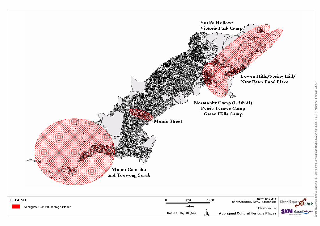
Aboriginal Heritage Places There are two places on the Queensland Indigenous Cultural Heritage Database that are located within the Study Corridor, as seen in Figure 12-1:
LB: N51, the campsite referred to by Petrie (1992:160-1) in the vicinity of the present day Normanby Hotel on Kelvin Grove Road. This was the camp used by the northern Aboriginal groups participating in ritual combat following a corroboree.
LB: N62, the extensive camp, contact and cultural site at Victoria Park. This is the area of York’s Hollow, the semi permanent base of the Brisbane Aborigines described above.
Other places have been identified during this research, namely:
The axe collected from Munro Street, Toowong and now housed in the Queensland Museum, which indicates a general use of the entire area rather than specifically being a important place itself;
The Mt Coot-tha and Toowong Scrub that was a major resource area and form which human bones and artefacts are known to have been collected; and
The Bowen Hills/Spring Hill/ New Farm Food Place that was a large scale resource area.
Consultations with Traditional Owners There are two Native Title claims over the Study Area by the Jagera People and the Turrbal People. Both groups have undertaken separate Aboriginal cultural heritage investigations in the Study Area, and reported their findings separately to Brisbane City Council. The Jagera People’s native title claim area extends only partly into the northern end of the Study Area.
The Jagera reported their findings by email to the Brisbane City Legal Practice on 12 June 2008. The Turrbal report, prepared in May 2008, is entitled Cultural Heritage Report (Indigenous Historical & Cultural Analysis) for the Proposed Northern Link Tunnel.
The information contained in these two reports has been integrated with the results of the literature and database searches undertaken for the Existing Cultural Heritage Environment Report for the Proposed Northern Link Project (Pragnell et al. 2008), to identify impacts on Aboriginal cultural heritage and to provide strategies to mitigate these impacts. The Existing Cultural Heritage Environment report identified two areas within the Study Corridor that are on the Queensland Indigenous Cultural Heritage Database, namely:
LB:N51, a campsite referred to by Petrie (1992:160-1) in the vicinity of the present day Normanby Hotel on Kelvin Grove Road. This camp was apparently used by northern Aboriginal groups participating in ritual combat following a corroboree; and
LB:N62, an extensive camp, contact and cultural site at Victoria Park. This is the area known as York’s Hollow, a semi-permanent base of Brisbane Aborigines.
Three other places that are not on the Queensland Indigenous Cultural Heritage Database were identified:
Munro Street, Auchenflower, from whence a stone axe was collected and donated to the Queensland Museum;
The Mt Coot-tha and Toowong Scrub which was a major resource area and from which human bones and stone artefacts are known to have been collected; and
The Bowen Hills/Spring Hill/ New Farm Food Place.
G:\M
IPO
\Nor
ther
n Li
nk\C
_Sub
ject
s\70
0_Sp
atia
l Dat
a\D
etai
ledF
easi
bilit
yStu
dy\M
apin
fo\1
4080
8_Fi
g12_
1_Ab
orig
inal
_Her
itage
_A4.
wor
LEGEND
Aboriginal Cultural Heritage Places
0 700 1400
metres
Scale 1: 35,000 (A4)
NORTHERN LINKENVIRONMENTAL IMPACT STATEMENT
Aboriginal Cultural Heritage PlacesFigure 12 - 1

PAGE 12-7
Jagera The Jagera People were specifically commissioned for this project by the Brisbane City Council to undertake a cultural heritage report of their native title claim area within the Northern Link Study Corridor. On 18 March 2008 a site inspection was carried out by Mr James Bonner, Jagera representative together with Council officers. The inspection covered the following areas:
the proposed tunnel entry points at the conjunction of Western Freeway and Mt Coot-tha Road,
Anzac Park, Dean Street Toowong,
By vehicle along Milton Road,
Inner City Bypass at Kelvin Grove Road / Brisbane Grammar School Playing Fields.
Following that inspection, and in response to Council’s requests for a cultural heritage report, Jagera recommended:
That as the majority of the project is underground, and as there is previous significant ground disturbance at the entry and exit points, a cultural heritage report will not be provided;
That there be monitoring by Jagera of topsoil removal at the tunnel entry and exit points;
That there be monitoring by Jagera of clearing, grading or ground disturbance in lay down areas, and where this is not feasible, that topsoil is relocated to an area for inspection; and
That Jagera Daran Pty Ltd delivers on-site Aboriginal Cultural Heritage induction for key project personnel.
Turrbal The Turrbal People were specifically commissioned for this project by the Brisbane City Council to undertake a cultural heritage report of the Northern Link Study Area (Turrbal 2008:6).
Turrbal identified a number of places within the Study Area as areas of cultural significance, namely:
Mt Coot-tha – identified as a Dreaming site of the Turrbal People, associated with the honey-bee dreaming;
Toowong – identified as a low-lying swampy area rich in resources;
Milton – identified as a low-lying, swampy area rich in resources; and
Victoria Park – identified as a major occupation area known as Barrambin. It was the site of ‘acrimony and hostility toward the Turrbal People’ by non-Aboriginal inhabitants of Brisbane (Turrbal 2008:50).
Turrbal also identified that an important Aboriginal pathway existed between the area of Mt Coot-tha and Roma Street. Coronation Drive and Milton Road follow part of the route of this pathway (Turrbal 2008:56).
The Turrbal report makes the following recommendations in relation to the “cultural and spiritual significance of the project route to the Turrbal people:”
That the Brisbane City Council as the project proponent, opens discussions and negotiations with Turrbal representatives regarding native title matters, as the proposed project constitutes a future act within the meaning and definition of the Native Title Act 1993;
That the removal of any vegetation which may be associated with the project be monitored by Turrbal personnel;
That Turrbal representatives deliver cultural awareness training prior to and/or during the construction of works. Costs to be borne by the project proponent;

PAGE 12-8
That all other ground-breaking activities undertaken by Brisbane City Council and/or its contractors which may impact on the Turrbal cultural heritage values be monitored by Turrbal personnel;
That any artefacts found (in the non-overlap area) during the course of construction be retained by the Turrbal People. Artefacts found within an area of overlapping native title claim are to be kept in a neutral Keeping Place pending the outcome of the native title determination in relation to that area of overlap.
Consultations with Turrbal and Jagera will continue throughout the Project assessment and procurement phases, including during the preparation of a Cultural Heritage Management Plan (CHMP) for the Project.
Aboriginal Heritage - Mitigation Therefore the following mitigation measures would be put in place to manage the Aboriginal heritage of the Northern Link project area:
All reasonable and practicable measures must to be taken to ensure that no development activities harm Aboriginal cultural heritage;
All project approvals need to be obtained in accordance with the Native Title Act 1993 (Cth) and any notification required by that Act;
On-going contact be maintained between Brisbane City Council and both Aboriginal groups throughout the duration of the development;
A CHMP or Indigenous Land Use Agreement (ILUA) must be negotiated between the project proponents and both Aboriginal Parties.
Without limiting the contents of the CHMP or ILUA, they are expected to at least address issues of:
– Aboriginal Parties monitoring certain surface earthworks;
– Aboriginal Parties monitoring certain vegetation removal;
– Aboriginal Parties to deliver the Aboriginal component of the cultural awareness training
– Arrangements for the storage of any Aboriginal artefacts collected by the Aboriginal parties during the monitoring activities and by project staff during development activities.
12.1.7 Non Indigenous Heritage From its settlement in 1824 Brisbane existed only as an outpost of the New South Wales penal colony, and was not opened to free settlement until 1842. Pastoral, agricultural and timber industries developed quickly, and Brisbane’s importance as a port and urban centre grew accordingly. The physical remoteness of Brisbane from the centre of government in New South Wales and disquiet with the maintenance of public infrastructure, in particular the port, contributed to a desire for independence. As the northern colony’s economic significance increased and its productivity and population expanded, a separate sense of identity emerged.
In 1859 Queensland was declared a separate colony, and suburban growth in Brisbane gained momentum. To the west, development embraced Milton, Rosalie, Torwood, Kelvin Grove and Paddington. The construction of the first stage of the tramway system between 1882 and 1890 and expansion of the railway allowed working men to live further from their place of employment. They settled in suburbs, often clustered around railway stations, while industry became concentrated in the city area.
Brisbane’s commercial and economic progress fluctuated throughout the latter half of the 19th century, and during the early 20th century was impacted by world events including the two world wars and the Depression. The city entered the second half of the 20th century more neglected and dilapidated than the southern capitals.

Brisbane’s emergence as a modern city came with the big Queensland mineral discoveries of the 1960s and the booming tourist industry.
Historical Development of the Study Corridor Suburban development in the Study Corridor was largely driven by the growth that occurred in Brisbane during the last decade of the 19th century, helped by the construction of tram and railway lines. Suburbs grew around railway stations and the electric tramline on Milton Road (Figure 12-2). Topography also played a part, with ridges and elevated ground being sought after for their views, immunity from flooding and their exposure to cooling summer breezes. These factors, and the dominance of the ‘timber and tin’ vernacular architecture, helped to shape the suburbs in the Study Corridor and to form their distinct character.
Figure 12-2 Milton Road Auchenflower ca.1921. Tramline is visible in the centre of the road with a tram in the distance at the base of the hill (John Oxley Library)
Southwest District This district comprises the suburbs of Auchenflower and Toowong, and includes the Toowong Cemetery, Anzac Park and Mt Coot-tha. The residential suburbs developed between the 1870s and the 1890s as suburban development spread further west, gradually converting the exclusive domains with their grand homes and surrounding estates into commuter suburbs.
By the outbreak of World War I Auchenflower had become a suburb in its own right, centred about Milton Road and also served by the steam train stopping at Auchenflower station. The first multi-unit apartments were built in Auchenflower in the 1960s, with luxurious apartments appearing first on the most expensive, elevated properties that were flood-free and afforded commanding views. With time the trend to high-density living came to characterise the suburb of today.
PAGE 12-9

Toowong developed slowly compared to neighbouring suburbs, mainly because of concerns about flooding of low-lying areas. When Moggill Road was constructed, to provide a shorter route to Ipswich and the Darling Downs, the Toowong area was traversed and subsequently divided.
Toowong in the 1890s was an aristocratic satellite suburb with a greater sense of community than most suburban areas of Brisbane. It had a relatively highly developed shopping centre, its own churches, private schools, sporting clubs and choral society. Toowong grew rapidly during the first two decades of the 20th century. Upgrading of Milton Road and improvement in public transport led to a doubling of the population between 1900 and 1922 to over 10,000 residents.
There are a total of seven heritage-registered places in present-day Auchenflower – three residential places, three churches and one police station. Toowong contains 15 registered heritage places across a range of place types including one burial ground, one school, one fire-station, four monuments/memorials, two parks, one church, three residences and one tram shelter.
Toowong Cemetery has been Brisbane’s main burial ground since it officially replaced the Paddington-Milton Cemetery in 1875. The area of Toowong Cemetery reserve has been reduced over time to less than half its original size as the land was resumed for other purposes including the Brisbane City Council Bus Depot, Anzac Park and the Botanic Gardens. The entire Toowong Cemetery is on the Queensland Heritage Register, with the Caskey Monument, the Temple of Peace and Trooper Cobb’s Grave also listed separately.
Anzac Park occupies land that was part of the original Toowong Cemetery gazettal. In 1886 it was re-gazetted as a rifle range (Figure 12-3) which was used by rifle clubs and the military until 1918.
Figure 12-3 Rifle training in the area that became Anzac Park ca. 1912 (John Oxley Library)
After World War I, the park was named Anzac Park and ornamental trees were planted as a memorial to those who had fought for their country. A marker was placed on each tree depicting a map of Australia with the soldier’s name, rank, unit colours and number. Anzac Park is listed on the Brisbane City Plan Heritage Register.
PAGE 12-10

PAGE 12-11
Mt Coot-tha Forest Park, proclaimed a public park in 1874, is a 3,500ha nature reserve and an important part of the Brisbane Forest Park. The Mt Coot-tha Forest Park is listed on the Queensland Heritage Register and the Brisbane City Plan Heritage Register.
Central District This district contains the suburbs of Red Hill, Paddington, Milton and Bardon. These suburbs began to develop in the mid-1800s as the city grew and residents were pushed out of the CBD. The development of Paddington and Red Hill was hindered substantially by the precipitous terrain, and during the 1870s Municipal authorities spent thousands of pounds modifying the landscape by grading hills, cutting down crests and filling hollows. Drainage and sanitation also presented problems. Milton’s development, by comparison, was hampered by the flood-prone nature of low-lying areas and the location of the Paddington-Milton Cemeteries.
Paddington and Red Hill were attractive to residents because of their proximity to the CBD, and became more popular with the construction of the tram line through Red Hill and eventually to Latrobe Terrace (1898) and Bardon (1916). Development in Milton intensified in the 1880s after the opening of the Milton railway station in 1877, and as the more popular suburbs of Red Hill and Paddington became overcrowded.
The Paddington-Milton Cemeteries were closed to burials in 1872, and following a small number of exhumations the site was cleaned and levelled. The majority of the land became a public park, named Lang Park. Adjacent to Lang Park is the Castlemaine Brewery, which dates from 1870 when a distillery was established on the site. The distillery was not a success and in 1877 the premises was purchased and converted to a brewery. The existing brewery buildings mostly date from the 1940s and 1950s, with the oldest structures dating from the 1920s.
Northeast District This district contains the suburbs of Herston, Bowen Hills, Spring Hill and Kelvin Grove. Herston is dominated by two major land uses, Victoria Park and the Royal Brisbane Hospital. Parts of Victoria Park have over time been used for temporary immigrant housing, a military and police rifle range, a rubbish dump, a single mens’ camp (during the Great Depression) and a golf course. Part of the land was set aside in 1909 for a new Governor’s residence, which never eventuated. The Park also housed United States Army troops during World War 2 and after the war, the Army camp buildings housed war brides. Subsequently and until the 1960s, the buildings were used as emergency accommodation for homeless people, and also as school classrooms, a teachers college, and as facilities for the Queensland Institute of Medical Research. Victoria Park, the former Golf Clubhouse and the current golf course are all registered heritage places.
The Royal Brisbane Hospital was first established at its present location in 1867, however the earliest buildings on the site date from 1875. Parts of the Royal Brisbane and Women’s Hospital are heritage registered including the former pavilion ward (1875), the Lady Norman Wing (1896), Ward 15 (1918), the Edith Cavell Block (1922), the Wattlebrae group (1930) and the Superintendent’s Residence (1941). The Nurses Homes (including Lady Lamington and Blocks 1 and 2) are also heritage registered. The University of Queensland Medical School, dating from 1938, is also listed on the Queensland and Brisbane City Plan Heritage Registers.
Kelvin Grove’s wooded hills fed the colony’s early timber industry and after being cleared, the land was used for farming, orchards and vineyards. Residential development did not commence until 1864. A total of seven heritage-registered places in Kelvin Grove are within the Study Area, including the Gona Barracks, an air raid shelter, three educational facilities, one police station and precincts of distinctive fig tree plantings.

The fig tree plantings near the Normanby Hotel date from the late 19th and early 20th century, when Kelvin Grove benefited from the district beautification endeavours of the Ithaca Divisional Board. The trees hold strong community significance and plans to interfere with any of them in the course of road works have met strong resistance. In 1994, a march was held from the site of the trees, through the city, to King George Square in protest to the planned removal of two of the trees for the widening of Kelvin Grove Road. The two trees were relocated to McCaskie Park in 1996. Community opposition was again raised in 1999 with the prospect of damage to the trees from an Inner City Bypass sub-tunnel. The route of the bypass was moved so as to prevent impact on the trees. In 2003, 15 trees along Kelvin Grove Road from the Normanby Fiveways northwards were entered on the Queensland Heritage Register.
Also of prominence in this area are the RNA Exhibition Grounds and surroundings and the Old Museum Building, each of which are listed on the Queensland Heritage Register and the Brisbane City Plan Heritage Register.
Transport The development of transport networks, services and infrastructure throughout the Study Corridor was a key driver of land development. The Brisbane suburban rail network had its most sustained growth period during the 1870s and 1880s, which coincided also with the development of tram networks along the major arterial roads. The railway line from Roma Street to Indooroopilly was opened in 1875, initially with stations at Milton and Toowong. Auchenflower Station was established later, but a ‘whistle-stop’ operated at the same location from 1887. The Roma Street to Sandgate line was completed in 1889, while Central and Brunswick Street Stations opened in 1890, allowing connections to other lines. Steam trains were gradually replaced by diesel engines and by 1979, electrification of the suburban network was completed.
The tram system followed key routes in the study corridor along Milton Road to Toowong and Government House (Bardon), and along the Terraces through Paddington and Red Hill to Ashgrove. In 1969 tram services in Brisbane ceased, and were replaced by buses.
Figure 12-4 Ithaca Embankments
Following a population boom in the area in the early 20th century, the Ithaca Town Council embarked on a program of road works including the formation and metalling of new roads. Because of the hilly terrain, many of the roads were divided leaving embankments that the Council considered easier to beautify than cut down.
PAGE 12-12

PAGE 12-13
The Ithaca Embankments (Figure 12-4) were built of stone, with rock gardens containing TAgave sp., Queen Palms (Syagrus romanzoffiana) and Camphor Laurel (Cinnamomum camphora). The heritage-registered embankments (QHR) are features in Red Hill and Paddington.
The importance of the tramways is reflected in the seven heritage-registered tram shelters (Brisbane City Council heritage register) in Paddington, Red Hill and Bardon. Other heritage places related to the area’s transport include the tramway substation at Paddington and a porphyry retaining wall on Heussler Terrace, Milton.
Education and Worship Schools and churches were important elements in the social and cultural fabric of the emerging suburbs in the study corridor, and a number of these buildings remain, providing strong links with the past. Of particular note in the study corridor are the Milton State School, the Sacred Heart Convent, Paddington, Old Bishopsbourne Chapel and Theological College, Milton, Toowong Baptist Church, the Brisbane Grammar and Girls’ Grammar Schools, Kelvin Grove State High School, the Ithaca Presbyterian Church, and the Paddington Community Creche and Kindergarten. All of these are listed on either the Queensland Heritage Register or the Brisbane City Plan Heritage Register, or both.
Listed Non-Aboriginal Heritage Places A total of 137 registered non-Aboriginal heritage places are located within the Study Corridor, on the Register of the National Estate, Queensland Heritage Register or Brisbane City Plan Heritage Register, or a combination of these. All places that are entered on the Queensland Heritage Register are also listed on the Brisbane City Plan Heritage Register. There are no places in the Study Corridor that are entered on the National Heritage List or the Commonwealth Heritage List. The locations of listed items are shown on the map(s) in Figure 12-5 (A, B and C).
A detailed tabulated list of all registered heritage items in the Study Corridor can be found in the UQASU Existing Cultural Heritage Environment Report for the Proposed Northern Link Project (2007). A list of registered heritage places that are affected by the Project either directly or indirectly, is provided below in Section 12.2.
The majority of registered places (77) are listed solely for their local significance, with 35 registered for state significance, and 25 for national significance values.
There are a wide range of registered place types in the Study Corridor, with the majority being Residential places (44), followed by Education/Research (15), Religion/Worship (14), Transport (14), Parks/Gardens/Trees (13) and Commercial places (11).
The majority of heritage places are registered for their historical values (92), followed by aesthetic value (77) and for demonstrating the principle characteristics of a particular class of places (68).
Under the Brisbane City Council’s City Plan 2000, almost all of the residential land in the study corridor is designated as ‘Character Residential’, and subject to the Demolition Control Code (Chapter 11). The intent of the Demolition Code is to maintain the character of traditional pre-war streetscapes by controlling demolition, relocation and removal of buildings that contribute character. While the vast majority of individual residences are not identified or listed as heritage items, the Demolition Code ensures that the character and integrity of these areas is preserved.

G:\M
IPO
\Nor
ther
n Li
nk\C
_Sub
ject
s\70
0_Sp
atia
l Dat
a\D
etai
ledF
easi
bilit
yStu
dy\M
apin
fo\1
4080
8_Fi
g12_
5a_W
estP
reci
nct_
Her
itage
_A4.
wor
444444444
555555555
222222222
333333333
111111111
LEGENDRegistered Heritage Places (IncludeNational, State & BCC Heritage Register)Potential Heritage Places(not on any register)
Identified BCC Character Places(Brisbane City Plan 2000)
NORTHERN LINKENVIRONMENTAL IMPACT STATEMENT
Western Precinct Heritage PlacesFigure 12 - 5A
0 340 680
metres
Scale 1: 17,000 (A4) �
Proposed Alignment
Surface WorkTunnel Underground
Study Area Corridor
1 Mt Coot-tha Forest
2 Anzac park, Toowong
3 Toowong Cemetery
4 Toowong Baptist Church, Croydon St Toowong
5 Memorial Crows Ash, Sylvan Rd Toowong
No. Place

G:\M
IPO
\Nor
ther
n Li
nk\C
_Sub
ject
s\70
0_Sp
atia
l Dat
a\D
etai
ledF
easi
bilit
yStu
dy\M
apin
fo\1
4080
8_Fi
g12_
5b_C
entra
lPre
cinc
t_H
erita
ge_A
4.w
or
141414141414141414
131313131313131313
161616161616161616141414141414141414151515151515151515
777777777
121212121212121212
999999999
101010101010101010
111111111111111111
666666666
888888888
NORTHERN LINKENVIRONMENTAL IMPACT STATEMENT
Central Precinct Heritage PlacesFigure 12 - 5B
0 280 560
metres
Scale 1: 14,000 (A4) �
LEGENDRegistered Heritage Places (IncludeNational, State & BCC Heritage Register)Potential Heritage Places(not on any register)
Identified BCC Character Places(Brisbane City Plan 2000)
Study Area Corridor
Proposed Alignment
Surface WorkTunnel Underground
6 Baroona, 90 Howard St Paddington
7 Rosalie Community Kindergarten & Preschool, Elizabeth St Paddington
8 Rosalie RSL Hall, Elizabeth St Paddington
9 Marist Bros Monastery, Fernberg Rd Paddington
10 Church of the Sacred Heart, Given Terrace Paddington
11 Sacred Heart Convent, Given Terrace Paddington
12 Forester's Hall, Latrobe Terrace Paddington
13 St Brigid's Church, Musgrave Rd Red Hill
14 Ithaca Embankments Nos. 3 & 4, Musgrave Rd Red Hill
15 Terrace Shops and Flats, 91-109 Musgrave Rd Red Hill
16 St Brigid's Convent, Upper Clifton Terrace Red Hill
No. Place

G:\M
IPO
\Nor
ther
n Li
nk\C
_Sub
ject
s\70
0_Sp
atia
l Dat
a\D
etai
ledF
easi
bilit
yStu
dy\M
apin
fo\1
4080
8_Fi
g12_
5c_E
astP
reci
nct_
Her
itage
_A4.
wor
191919191919191919
181818181818181818171717171717171717
202020202020202020
NORTHERN LINKENVIRONMENTAL IMPACT STATEMENT
Eastern Precinct Heritage PlacesFigure 12 - 5C
0 250 500
metres
Scale 1: 12,500 (A4)
LEGENDRegistered Heritage Places (IncludeNational, State & BCC Heritage Register)Potential Heritage Places(not on any register)
Identified BCC Character Places(Brisbane City Plan 2000)
Study Area Corridor
Proposed Alignment
Surface WorkTunnel Underground
17 Fig Trees, Marshall Park, Kelvin Grove Rd
18 McCaskie Park, Kelvin Grove Rd Kelvin Grove
19 Fig Trees, Kelvin Grove Rd opp. Normanby Hotel
20 Victoria Park, Herston
No. Place

PAGE 12-17
12.2 Impact Assessment The Project would affect a number of registered heritage places in the Study Corridor, either directly or indirectly. Table 12-1 summarises those heritage items or places in the Study Corridor that are in the vicinity of the proposed tunnel alignment or the proposed surface works, and whether those places are impacted or not.
Table 12-1 Summary of Impacts on Registered Non-Indigenous Heritage Places
No. Place Surface or Tunnel1 Heritage Status2 Affectation: Direct or Indirect
1 Mt Coot-tha Forest Surface QHR, BCC Direct impact from surface works 2 Anzac park, Toowong Surface BCC Direct impact from surface works 3 Toowong Cemetery Tunnel QHR, BCC Direct (above tunnel alignment) 4 Toowong Baptist Church Surface BCC Direct impact from surface works 5 Memorial Crows Ash,
Sylvan Rd Toowong Surface BCC Direct impact from surface works
6 Baroona, 90 Howard St Paddington
Tunnel RNE, QHR, BCC Direct (above tunnel alignment)
7 Rosalie Community Kindergarten & Preschool, Elizabeth St Paddington
Tunnel RNE, QHR, BCC Indirect (not directly above tunnel alignment)
8 Rosalie RSL Hall, Elizabeth St Paddington
Tunnel QHR, BCC Indirect (not directly above tunnel alignment)
9 Marist Bros Monastery, Fernberg Rd Paddington
Tunnel BCC Indirect (not directly above tunnel alignment)
10 Church of the Sacred Heart, Given Terrace Paddington
Tunnel RNE, BCC Indirect (not directly above tunnel alignment)
11 Sacred Heart Convent, Given Terrace Paddington
Tunnel RNE, BCC Indirect (not directly above tunnel alignment)
12 Forester’s Hall, Latrobe Terrace Paddington
Tunnel QHR, BCC Direct (above tunnel alignment)
13 St Brigid’s Church, Musgrave Rd Red Hill
Tunnel RNE, QHR, BCC Direct (above tunnel alignment)
14 Ithaca Embankments Nos. 3 & 4, Musgrave Rd Red Hill
Tunnel QHR, BCC Direct (above tunnel alignment)
15 Terrace Shops and Flats, 91-109 Musgrave Rd Red Hill
Tunnel BCC Indirect (not directly above tunnel alignment)
16 St Brigid’s Convent, Upper Clifton Terrace Red Hill
Tunnel QHR, BCC Direct (above tunnel alignment)
17 Fig Trees, Marshall Park, Kelvin Grove Rd
Surface QHR, BCC Direct impact from surface works
18 McCaskie Park, Kelvin Grove Rd Kelvin Grove
Surface BCC Direct impact from surface works
19 Fig Trees, Kelvin Grove Rd opp. Normanby Hotel
Tunnel QHR, BCC Direct (above tunnel alignment)
20 Victoria Park, Herston Surface QHR, BCC Direct impact from surface works 1. Indicates whether the item or place is affected by proposed surface works or tunnel works
2. RNE: Register of the National Estate; QHR: Queensland Heritage Register; BCC: BCC Heritage Register

PAGE 12-18
For each item or place that is potentially directly affected, the impacts are discussed in the following sections.
12.2.1 Western Freeway Connection The Western Freeway connection would potentially impact on portions of the Mt Coot-tha Forest (Queensland Heritage Register) and Anzac Park (Brisbane City Plan Heritage Register). The impact on Mt Coot-tha Forest would comprise the earthworks and vegetation removal required on either side of the existing Western Freeway and the construction of new traffic lanes. The extent of widening on either side of the Freeway would vary from approximately 20 m to approximately 40 m. Application would need to be made under IPA to the Chief Executive (the Director-General) of the Environmental Protection Agency for any development within the heritage listing boundary, and to Brisbane City Council in respect of development affecting a local heritage place.
A major construction site would be established on Council-owned land adjacent to the Western Freeway, immediately to the west of Mt Coot-tha Road (as detailed in Chapters 3 and 4). This land is not subject to any heritage listing, but adjoins both the Brisbane Forest Park and the Mt Coot-tha Botanic Gardens.
The proposed spoil conveyor would potentially impact on a narrow strip of land in Mt Coot-tha Botanic Gardens, including a portion of the Gardens that is part of the Brisbane Forest Park. The Botanic Gardens are not heritage listed, while the Brisbane Forest Park is listed on the QHR. There is a need to minimise the Project’s impact during construction for aesthetic, recreational, social and ecological reasons as much as for cultural heritage considerations.
During construction, vehicular access to construction sites would be closely controlled. Apart from those areas already referred to, which are required for construction of the ramps and transition structures or for the tunnel spoil conveyor, Anzac Park and Brisbane Forest Park would not be used for site access, or for laydown or storage of construction materials.
Also during construction, representatives of the Traditional Owners would be present to monitor earthworks and the removal of vegetation in accordance with a Cultural Heritage Management Plan, to be prepared prior to the commencement of construction.
12.2.2 Toowong Connection The proposed Toowong connection would potentially impact on two listed items, the Toowong Baptist Church at 5 Jephson Street (corner of Sylvan Road), and the memorial Crows Ash and plaque at 134A Sylvan Road (corner of Milton Road). Both of these items are listed on the Brisbane City Plan Heritage Register. The partial acquisition of church property on this corner for road widening would require the removal of the existing retaining wall, which contains a 1938 commemorative plaque to the memory of Rev William and Mrs Richer, the church’s founder.
The memorial Crows Ash, on the corner of Sylvan and Milton Roads, marks the original boundary of the Town of Toowong and commemorates the amalgamation of Toowong with the City of Brisbane in 1925, as well as the centenary of the landing at Toowong of Lieutenant John Oxley. The Project would require the removal or demolition of this memorial, to make way for support pylons for the tunnel access ramp from Milton Road. The Crows Ash, which is now over 80 years old, is in relatively poor condition and may have suffered root damage from being planted within an enclosed sandstone surround. The Crows Ash is not a significant species in terms of rarity, nor is it an endemic species. The item’s local significance is in the memorial and plaque, rather than the tree itself.
PAGE 12-19
Removal of the Crows Ash memorial would trigger a requirement for approval under Schedule 8 of the Integrated Planning Act 1997 (IPA), meaning that this activity becomes ‘assessable development’ under IPA. A key criterion for assessment under IPA would be that the activity must be in the public interest. A discussion of the Project’s overall benefits, including justification for the proposed Toowong Connection, is given in Chapter 2 of this EIS, and it is considered that this justification would satisfy the assessment requirements under IPA.
In order to mitigate the Project’s impacts on these items, the retaining wall and plaque at the Toowong Baptist Church would be relocated within the church grounds, set into the wall along the post-acquisition boundary in a similar fashion to the existing. The Toowong and District Historical Society have requested that the Crows Ash memorial be relocated to the Mt Coot-tha Botanic Gardens. However, the tree is unlikely to survive removal or relocation from its existing location, and therefore it is recommended that following construction, a memorial marking the site be erected, using the original plaque, as near as practicable to the location of the existing memorial. A new setting and location for the memorial would be determined in consultation with the Toowong and District Historical Society.
Toowong Connection – Character Places In addition to the two listed heritage items, there are a number of properties in Croydon Street, Milton Road, Morley Street, St Osyth Street, Sylvan Road and Valentine Street, which are identified Character Places under Brisbane City Plan 2000, and which would be demolished to allow the Toowong Connection to be constructed. Construction of road works is exempt from the Demolition Code provisions under City Plan 2000. No other mitigation measures are available that would allow for the retention of these structures in-situ.
If, during removal of these character places, a potentially significant archaeological deposit is discovered then:
under Part 9 of the Queensland Heritage Act 2003, the site must be reported to the Chief Executive of the Environmental Protection Agency; and
consultant archaeologists should assess the archaeological potential of the deposit and determine any follow-up archaeological activity required.
12.2.3 Driven Tunnels The mainline driven tunnels would pass beneath the following places that are listed on the Queensland Heritage Register (QHR).
Toowong Cemetery
Baroona (1866 residence located at 90 Howard Street, Paddington)
Foresters’ Hall (1888 timber community hall at 16 Latrobe Terrace, Paddington)
St Brigid’s Church (1912-14, at 78 Musgrave Road Red Hill). Also listed on the Register of the National Estate (RNE)
St Brigid’s Convent (1902-03 at 15 Upper Clifton Terrace, Red Hill).
The tunnels would also pass beneath almost 300 Brisbane City Council Character Places, including the remains of Ormand’s (‘Condamine Bell’) blacksmith shop at 89 Frederick Street, Toowong.
PAGE 12-20
Application would need to be made to the Environmental Protection Agency for any development within the heritage listed boundary of Toowong Cemetery, and consultation should occur with the Queensland Heritage Council concerning all development impacts on the cemetery.
The following sections discuss each of the above items, and the Project’s potential to impact on the heritage significance of those places.
Toowong Cemetery The Project would not have a direct impact on any land at the surface in Toowong Cemetery. However, during consultations with the community and more specifically, with the Friends of Toowong Cemetery, concerns have been raised in regard to possible effects on graves and monuments of vibration from tunnel construction. Many of the graves and monuments on terraced areas of the cemetery are in a badly deteriorated and highly unstable condition. Vibration in these areas may adversely impact on already unstable and deteriorating retaining walls, grave surrounds and headstones.
One of the monuments above the proposed tunnel alignment is Trooper Cobb’s Grave, a Boer War interment that is separately listed on the RNE as well as the QHR and the Brisbane City Council City Plan Heritage Register.
The Northern Link noise and vibration assessment (Chapter 9, Noise and Vibration) found that likely surface vibration levels in Toowong Cemetery during TBM construction, above the alignments of the two tunnels, would vary from approximately 0.7mm/sec to 13.9mm/sec. The wide discrepancy between the upper and lower figures is a function of the steep terrain in the cemetery, and the varying depth from surface to tunnel crown. The highest figure corresponds only to that portion of the cemetery nearest to Mt Coot-tha Road, where the driven tunnel would be at its shallowest. However, the predictions also show vibration levels above the guide value, around the mid-point of that section of tunnel passing beneath the cemetery.
The predicted rate of advance for the TBMs would be between 15 m and 20 m per day, therefore the duration of exposure to the maximum vibration levels would be less than one day.
Through the cemetery, the depth of cover over the two tunnels ranges from 8.4m to 43.3m. Therefore, at the cemetery’s high points, vibration would be almost imperceptible, while on lower ground it would be more noticeable. The vibration assessment suggests a ‘Guide Value’ for cosmetic damage of 2mm/sec (for heritage structures), and also suggests that the higher levels of predicted vibration in Toowong Cemetery would be ‘strongly noticeable’.
The findings of the vibration assessment, along with other project-related information of relevance to the cemetery, were presented to the Friends of Toowong Cemetery on July 30, 2008. At this meeting, considerable interest was shown regarding the issue of vibration and the potential impacts on the cemetery of tunnel construction. However, no written submissions or correspondence has been received from the Friends of Toowong Cemetery, in relation to vibration or any other issue of relevance to the cemetery.
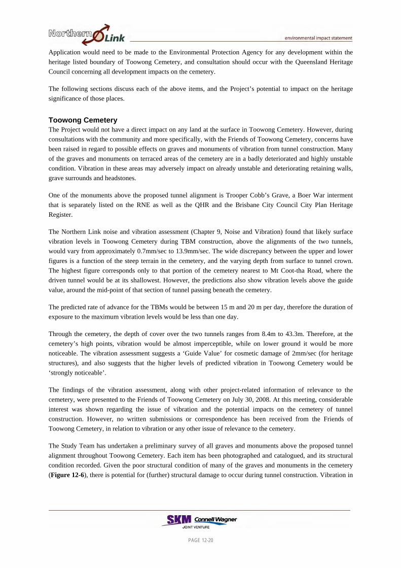
The Study Team has undertaken a preliminary survey of all graves and monuments above the proposed tunnel alignment throughout Toowong Cemetery. Each item has been photographed and catalogued, and its structural condition recorded. Given the poor structural condition of many of the graves and monuments in the cemetery (Figure 12-6), there is potential for (further) structural damage to occur during tunnel construction. Vibration in
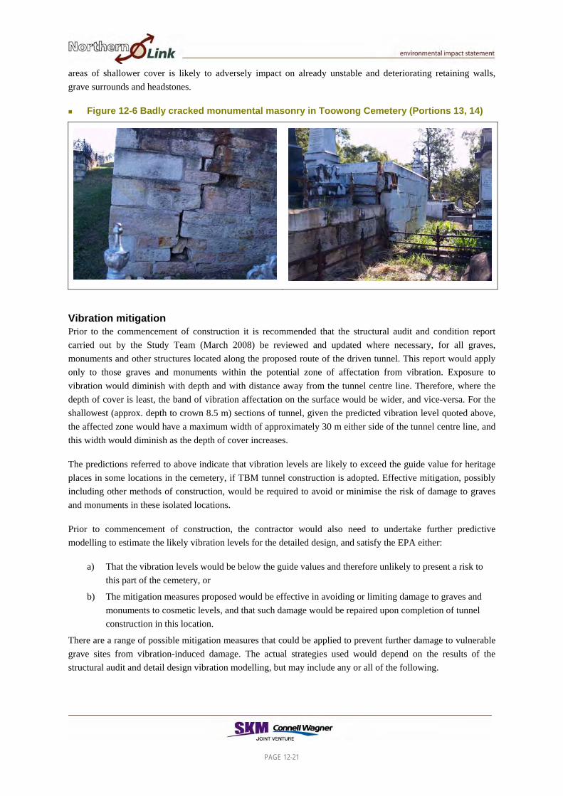
areas of shallower cover is likely to adversely impact on already unstable and deteriorating retaining walls, grave surrounds and headstones.
Figure 12-6 Badly cracked monumental masonry in Toowong Cemetery (Portions 13, 14)
Vibration mitigation Prior to the commencement of construction it is recommended that the structural audit and condition report carried out by the Study Team (March 2008) be reviewed and updated where necessary, for all graves, monuments and other structures located along the proposed route of the driven tunnel. This report would apply only to those graves and monuments within the potential zone of affectation from vibration. Exposure to vibration would diminish with depth and with distance away from the tunnel centre line. Therefore, where the depth of cover is least, the band of vibration affectation on the surface would be wider, and vice-versa. For the shallowest (approx. depth to crown 8.5 m) sections of tunnel, given the predicted vibration level quoted above, the affected zone would have a maximum width of approximately 30 m either side of the tunnel centre line, and this width would diminish as the depth of cover increases.
The predictions referred to above indicate that vibration levels are likely to exceed the guide value for heritage places in some locations in the cemetery, if TBM tunnel construction is adopted. Effective mitigation, possibly including other methods of construction, would be required to avoid or minimise the risk of damage to graves and monuments in these isolated locations.
Prior to commencement of construction, the contractor would also need to undertake further predictive modelling to estimate the likely vibration levels for the detailed design, and satisfy the EPA either:
a) That the vibration levels would be below the guide values and therefore unlikely to present a risk to this part of the cemetery, or
b) The mitigation measures proposed would be effective in avoiding or limiting damage to graves and monuments to cosmetic levels, and that such damage would be repaired upon completion of tunnel construction in this location.
There are a range of possible mitigation measures that could be applied to prevent further damage to vulnerable grave sites from vibration-induced damage. The actual strategies used would depend on the results of the structural audit and detail design vibration modelling, but may include any or all of the following.
PAGE 12-21

PAGE 12-22
Construction of pier supports beneath endangered structures.
Erection of permanent support structures or temporary shoring.
Stabilisation, reconstruction and/or restoration of susceptible monumental masonry (ie: those already impacted by vault distortion or collapse, differential compaction of soil or the localised movement of soil. A number of the obelisks, columns and pedestal memorials were originally erected with minimal reinforcement and mortar that has disintegrated over time making them vulnerable to collapse).
Continuous vibration monitoring devices would be located at numerous points within the cemetery during construction, to confirm the predictions and to provide accurate data on which to base decisions regarding any changes to mitigation strategies, while tunnel construction is under way.
At the completion of construction a further structural audit and condition report should be prepared and any resultant damage restored.
In addition to these ground surface mitigation measures engineering solutions could be implemented within the driven tunnel itself to ensure a reduction in the vibrations reaching the surface. One possible method is the use of canopy tube ground support in the roof of the tunnel. Another is to vary the speed of the TBM cutting mechanisms (and hence the rate of tunnelling advance) such that the surface vibration levels are reduced and less likely to cause damage.
The structural audit would provide a baseline for future conservation planning. Preventative and restorative work undertaken on grave sites and monumental masonry would assist in the long term management of the cemetery as a cultural heritage place.
Settlement Tunnel construction beneath the cemetery may result in some settlement of the ground surface, potentially between 5mm and 10mm across the cemetery depending on depth of cover and lateral separation from the tunnel alignment. Generally however, the rock is strong and structurally resilient, so settlement is not expected to cause any major structural damage. Further, any settlement would not be immediate but would happen gradually so there is little chance of any ‘slumping’ effect. Also, any settlement would be over an area larger than any one grave or monument so it could reasonably be expected that any one grave site or monument would experience more or less even settlement throughout. Therefore, the risk of both short term and long term settlement effects across the cemetery has been assessed as very low, and consequently no mitigation measures are considered necessary. If tunnel construction results in damage to graves or monuments within the cemetery, it is more likely to be caused by vibration than by settlement.
Dust There is potential for increased dust fall on the memorials at Toowong Cemetery from the proposed deposition and treatment of excavated spoil material at the Mt Coot-tha quarry. Monitoring of dust levels in the vicinity of construction worksites and the quarry, including at the cemetery, would occur throughout the construction phase and appropriate dust control measures would be implemented at the quarry site.
Public access Public access to the cemetery would not be impeded during construction. Appropriate signage would be erected to inform visitors of alterations to the cemetery’s ingress or egress particularly relating to interruption of traffic flows along Mt Coot-tha Road during the construction of the cut and cover section of the western tunnel portal.

PAGE 12-23
Toowong Cemetery would not be used as a means of access to construction sites, nor would it be used for any storage of construction materials.
Positive outcomes On completion of the Project, the expected reduced traffic volumes along Frederick Street and Mt Coot-tha Road would provide visitors to Toowong Cemetery with a more tranquil environment due to the reduction in noise and vibration from passing traffic. Additionally, the effect of exhaust emissions on the monumental masonry would be reduced. Pedestrian access to the main entrance of the cemetery would also be enhanced due to changed traffic volumes on Frederick Street and Milton Road.
Baroona Baroona, built in 1866 for William Draper Box MLC, is a residence located at 90 Howard Street, Paddington. It is listed on the RNE, the QHR and the Brisbane City Plan 2000 Heritage Register. TBM driven tunnel excavation would occur at a depth in excess of 50m (depth to tunnel crown) beneath this residence.
At this depth, predicted vibration levels are in the range of 0.3 to 0.9mm/sec (see Chapter 9), while the Guide Value for cosmetic damage for heritage listed buildings is 2mm/sec. Vibration is likely to be perceptible, but the risk of cosmetic or structural damage is low. As a mitigation strategy, it is recommended that owners/occupants be notified prior to the ‘arrival’ of the TBM beneath the property, and that vibration monitoring be carried out during the period when vibration levels are likely to be highest.
Forester’s Hall Forester’s Hall is a timber built community hall located at 16 Latrobe Terrace, Paddington, built in 1888 for the Trustees of Court Foresters’ Hope, No. 6535 of the Ancient Order of Foresters Friendly Society United Brisbane District. It is listed on the QHR and the Brisbane City Plan 2000 Heritage Register. TBM driven tunnel excavation would occur at a depth in excess of 40m (depth to tunnel crown) beneath the hall.
At this depth, predicted vibration levels are in the range of 0.7 to 1.9mm/sec (see Chapter 9, Noise and Vibration), while the Guide Value for cosmetic damage for heritage listed buildings is 2mm/sec. Vibration is likely to be perceptible, but the risk of cosmetic or structural damage remains low. As a mitigation strategy, it is recommended that owners/ occupants be notified prior to the ‘arrival’ of the TBM beneath the property, and that vibration monitoring be carried out during the period when vibration levels are likely to be highest. It is also recommended that a building condition survey be carried out prior to construction commencing.
St Brigid’s Convent St Brigid’s Convent was built in 1902/3 at 15 Upper Clifton Terrace, Red Hill for the Order of Sisters of Mercy in Queensland (Figure 12-7). It is listed on the QHR and the Brisbane City Plan 2000 Heritage Register. Roadheader excavation would occur at a depth of approximately 25m (depth to tunnel crown) beneath the convent, to construct the entry ramp into the westbound tunnel from Kelvin Grove Road. Some intermittent blasting may also be required for construction of the ramp tunnel.
At this depth, predicted vibration levels from roadheader operations would be less than 1mm/sec (Chapter 9, Noise and Vibration), while the Guide Value for cosmetic damage for heritage listed buildings is 2mm/sec. Therefore, roadheader vibration levels may be perceptible, but the risk of cosmetic or structural damage would remain low.

Depending on the design and scheduling of the blasting program, blasting typically would result in short vibration ‘events’ lasting seconds. People would ‘hear’ the blast, although vibration (and noise) levels are usually relatively low.
To mitigate any potential impacts on the convent building from roadheader operation or blasting, a building condition survey is recommended, as well as prior notification of scheduled works including details of any blasting program. Monitoring of vibration levels and blast emissions would also be required, to confirm the predictions and to allay any community concerns.
Figure 12-7 St Brigid’s Convent and St Brigid’s Church, Red Hill
St Brigid’s Church St Brigid’s Church, at 78 Musgrave Road, Red Hill was built between 1912 and 1914 and was designed by R S Dods and modelled on St Ceciles Cathedral in Alba, France (Figure 12-7). It is listed on the RNE, the QHR and the Brisbane City Plan 2000 Heritage Register. TBM driven tunnel excavation would occur at a depth of approximately 38m (depth to tunnel crown) beneath the church.
At this depth, predicted vibration levels would be in the range of 0.7 to 2.4mm/sec (Chapter 9, Noise and Vibration), while the Guide Value for cosmetic damage for heritage listed buildings is 2mm/sec. Vibration is likely to be perceptible, and although the predicted vibration level exceeds the Guide Value, the risk of cosmetic or structural damage remains low. As a mitigation strategy, it is recommended that the Church’s custodians be notified prior to the ‘arrival’ of the TBM beneath the property, and that vibration monitoring be carried out during the period when vibration levels are likely to be highest. It is also recommended that a building condition survey be carried out prior to construction commencing.
Blacksmith shop at 89 Frederick Street, Toowong In the backyard of 89 Frederick Street are the standing remains of a blacksmith shop established by Alfred Ormand around 1912. The Blacksmith’s shop is not a listed heritage item, but nevertheless holds some local historical significance and is a recognised character place under City Plan 2000. Ormand had been an assistant to Samuel William Jones, the inventor of the Condamine Bell (also known as the bullfrog or Jones bell), a bullock and horse bell that became a Queensland icon. The bell is one of 12 items listed on the National Trust’s 2004 list of Queensland icons, along with the Ekka, ‘Bundy rum’ and the Royal Flying Doctors. After Jones’ death in 1912 Ormand continued to produce the Condamine Bell in Frederick Street for another 57 years (1969)
PAGE 12-24

PAGE 12-25
when Alfred Halliday Ormand took over the business and continued to make the bells until his retirement in 1998 (Bray 2003:87-88). The blacksmith shop itself is currently in reasonable state of repair.
Roadheader excavation would occur at a depth of approximately 10m (depth to tunnel crown) beneath this property, to construct the entry ramp into the mainline tunnel from the Toowong Connection. Some intermittent blasting may also be required for construction of the ramp tunnel.
At this depth, predicted vibration levels from roadheader operations would be in the range of 0.06 to 0.7mm/sec (Chapter 9, Noise and Vibration), while the Guide Value for cosmetic damage for heritage listed buildings is 2mm/sec. Therefore, roadheader vibration levels would not be felt, and the risk of cosmetic or structural damage would be low. Any vibration caused by blasting would have a similar effect to that described in Section 12.2.2 above for St Brigid’s Convent.
There is also potential for the blacksmith’s shop to be affected by ground settlement after the completion of construction.
To mitigate any potential impacts on the blacksmith’s shop from roadheader operation, blasting or settlement, a building condition survey is recommended, as well as prior notification of scheduled works including details of any blasting program. Monitoring of vibration levels and blast emissions would also be required, to confirm the predictions and to allay any community concerns. Subject to the findings of the building condition survey, options for future management of the blacksmith’s shop may include:
archaeological investigation;
removal to another location;
reconstruction or restoration; or
temporary structural support.
Other character places The driven tunnels would pass beneath a total of 296 Brisbane City Plan 2000 character places, comprising residential and commercial properties. On-going vibration and settlement monitoring throughout the Project’s construction phase would need to be undertaken on a sample of these places, to confirm the accuracy of the predicted vibration levels and to allay any community concerns. A complaints handling procedure would also be established to ensure that community concerns can be communicated as and when required.
12.2.4 Kelvin Grove Connection Works associated with the proposed Kelvin Grove connection would impact on a stand of fig trees in Marshall Park, which are listed on the QHR and the Brisbane City Plan Heritage Register (Figure 12-8). Based on the Northern Link EIS Reference Design, two of the fig trees at the southern end of Marshall Park would be affected by construction of the connection, and would be removed.
Application would need to be made under Part 6 of the Queensland Heritage Act 1992 to the Director-General of the Environmental Protection Agency for any development impacting on the fig trees. A development application under IPA would also be required, for an activity having an impact on local heritage places, as listed in Schedule 8 of IPA.

The remaining trees in Marshall Park would not be disturbed by construction activities. Construction vehicles would not use any part of either Marshall or McCaskie Parks for access to the construction worksites, nor would these areas be used for laydown or storage of construction materials.
Figure 12-8 Fig trees in Marshall Park
Character places There are 12 Brisbane City Council character places that would need to be removed to allow construction of the Kelvin Grove Connection to occur Table 12-2
Table 12-2 Character housing requiring removal
Address Lot on Plan 88 Kelvin Grove Road 10 RP20427 90 Kelvin Grove Road 9 RP20427 92 Kelvin Grove Road 8 RP20427 94 Kelvin Grove Road 7 RP20427 96 Kelvin Grove Road 6 RP20427 98 Kelvin Grove Road 3 RP20426
100 Kelvin Grove Road 2 RP20426 102 Kelvin Grove Road 1 RP20426 104 Kelvin Grove Road 7 RP20425 106 Kelvin Grove Road 6 RP20425 108 Kelvin Grove Road 5 RP20425 34 Upper Clifton Terrace 11 RP20427
If during the removal of these character places a potentially significant archaeological deposit is discovered then:
under Part 9 of the Queensland Heritage Act 2003, the site must be reported to the Chief Executive of the Environmental Protection Agency; and
PAGE 12-26
PAGE 12-27
consultant archaeologists should assess the archaeological potential of the deposit and determine any follow-up archaeological activity required.
12.2.5 Inner City Bypass Connection The proposed connection to the Inner City Bypass (ICB) would mainly be contained within the existing road corridor boundaries. However, the proposed construction activities may impact on Victoria Park. Victoria Park is listed on the Queensland Heritage Register and application would need to be made under Part 6 of the Queensland Heritage Act 1992 to the Director-General of the Environmental Protection Agency for any development that is likely to occur within the heritage listed boundary. Victoria Park has also been identified as an important Aboriginal cultural heritage place.
Potential for archaeological places Archaeological investigations undertaken during the construction of the ICB revealed an extensive Aboriginal and historical archaeological record. Should earthmoving activities occur within Victoria Park the potential exists for uncovering archaeological remains.
Should Aboriginal archaeological places be identified during construction, under the Aboriginal Cultural Heritage Act 2003 they must not be harmed. The proposed CHMPs would deal with this issue.
Should a non-Aboriginal archaeological artefact, or place that may be an important source of information concerning Queensland’s history be identified, then:
under Part 9 of the Queensland Heritage Act 2003, the site must be reported to the Chief Executive of the Environmental Protection Agency; and
consultant archaeologists should assess the archaeological potential of the deposit and determine any follow-up archaeological activity required.
Monitoring of certain earthworks and vegetation removal at the worksites at the ICB connection would be carried out in the presence of representatives of the relevant Aboriginal Parties, in accordance with a CHMP to be prepared prior to the commencement of construction.
12.2.6 Proposed Ventilation Outlet Sites The preferred locations for the two proposed ventilation outlets are:
adjacent to the northern side of the Western Freeway, approximately 440m west of the Mt Coot-tha Road roundabout; and
within Victoria Park golf course, adjacent to the Inner Northern Busway approximately 190m north of the edge of the ICB (see Chapter 8).
The proposed western vent site does not have any designated heritage value and is not part of the heritage listed Mt Coot-tha Forest. Victoria Park is listed on the QHR, but the proposed ventilation outlet and ventilation station at the Northern Connection (ICB) would be situated on land that, while functionally part of the Victoria Park Golf Course, is owned by QDMR and is not covered by the QHR listing. Therefore, no heritage approvals would be required in relation to the proposed ventilation structures.