12 ecology and nature conservation - transport scotland · 12 ecology and nature conservation ......
TRANSCRIPT

A9/A96 Inshes to Smithton
DMRB Stage 2 Scheme Assessment Report
Part 3: Environmental Assessment
Page 12-1
12 Ecology and Nature Conservation
12.1 Introduction
12.1.1 This chapter presents the results of the Design Manual for Roads and Bridges (DMRB) Stage 2Ecological Impact Assessment (EcIA) for each of the route options. The assessment considers thepotential impacts of the route options on terrestrial and freshwater species, habitats and ecosystems.It identifies the route option which is the most environmentally sensitive in terms of ecology andnature conservation.
12.1.2 The chapter is supported by the following appendices:
Appendix A12.1 (Legislation and Policy Framework);
Appendix A12.2 (Species Names and Target Notes); and
Appendix CA12.1 (Confidential Appendix – Badger and Otter). This is not published with theEcIA due to the potential risk to protected species from locational data being publicly available.However, these data will be submitted as a confidential report to Scottish Natural Heritage(SNH) and Transport Scotland.
12.1.3 The assessment is derived primarily from a desk based review of available information, augmentedwith an extended Phase 1 habitat survey, targeted field surveys and consultation responses received(as per Chapter 7: Overview of Environmental Assessment, Section 7.6). Ecological features wereassessed up to 500m from the route options.
12.2 Approach and Methods
Scope and Guidance
12.2.1 The approach to this assessment is based on the guidance provided in:
DMRB Volume 11, Section 2, Part 5: HA205/08 Assessment and Management ofEnvironmental Effects (Highways Agency et al. 2008) (hereafter referred to as ‘HA205/08’);
DMRB Volume 11, Section 3, Part 4: Ecology and Nature Conservation (Highways Agency et al.1993); and
DMRB Interim Advice Note 130/10 ‘Ecology and Nature Conservation: Criteria for ImpactAssessment’ (Highways Agency et al. 2010) (hereafter referred to as IAN130/10).
12.2.2 In addition to DMRB guidance, other policy documents and published guidance taken into account inthe preparation of this chapter include:
Scottish Transport Appraisal Guidance (STAG) (Transport Scotland, 2014);
the Chartered Institute for Ecology and Environmental Management’s (CIEEM) Guidelines forEcological Impact Assessment in the UK and Ireland: Terrestrial, Freshwater and Coastal, 2ndedition (CIEEM 2016);
Scottish Government’s Planning for Natural Heritage: Planning Advice Note 60 (ScottishExecutive 2000);
Scottish Government’s Planning Advice Note 1/2013: Environmental Impact Assessment(Scottish Government 2013a);
Scottish Natural Heritage’s (SNH), a handbook on environmental impact assessment (SNH2013); and
Scottish Fisheries Co-Ordination Centre (SFCC) Habitat Surveys manual (SFCC 2007).

A9/A96 Inshes to Smithton
DMRB Stage 2 Scheme Assessment Report
Part 3: Environmental Assessment
Page 12-2
Study Area
12.2.3 The study area extends to 500m from all of the route options and is shown on Figures 12.1 to 12.3.
Baseline Conditions
Desk Based Assessment
12.2.4 A desk study was undertaken to review existing relevant literature and web-based resources, and toobtain ecological information within the study area. This included a review of data collected to informthe A96 Dualling Inverness to Nairn (including Nairn Bypass) DMRB Stage 3 EnvironmentalStatement (Jacobs 2016). Other resources utilised included:
A96 Inverness to Nairn (including Nairn Bypass): DMRB Stage 2 Scheme Assessment Report(Jacobs 2014);
Stratton Environmental Statement. Planning Application for urban expansion including a newtown centre (WSP Energy and Environment 2009);
Scottish Environment Protection Agency (SEPA) Water Framework Directive (WFD)classifications (SEPA 2017); and
survey data from Scottish Badgers.
12.2.5 Information for the desk study was also obtained from the following online resources:
Joint Nature Conservation Committee (JNCC) website (JNCC 2016); and
SNH Information Service (SNH 2016a).
Site Surveys
12.2.6 An extended Phase 1 habitat survey (JNCC 2010) of the study area was undertaken by Jacobsecologists in April 2016 to supplement survey data obtained from the A96 Dualling Inverness toNairn (including Nairn Bypass) DMRB Stage 2 Scheme Assessment Report, (Jacobs 2014) and theA96 Dualling Inverness to Nairn (including Nairn Bypass) Environmental Statement (Jacobs 2016).
12.2.7 Information from the National Biodiversity Network (NBN) gateway website (NBN 2016) was alsoused to inform the scope and extent of species surveys.
12.2.8 Targeted ecology surveys were conducted by Jacobs between March 2016 and April 2016comprising:
bat habitat assessment surveys undertaken within 50m of the route options to identify theroosting potential of suitable buildings, structures (such as bridges) and trees, which werecategorised according to the Bat Conservation Trust (BCT) Good Practice Guidelines (Collins2016);
otter and water vole surveys undertaken along watercourses within the study area (exceptInshes Burn (SWF 02), upstream of NH 69249 45698). Surveys followed the current bestpractice guidance of Chanin (2003) and Strachan et al. (2011), respectively; and
aquatic walkover surveys undertaken on watercourses potentially directly impacted by one ormore of the route options. Watercourses were surveyed within a 100m buffer to either side ofthe centreline of the route option footprint to characterise presence, absence and distribution ofsupporting habitat for aquatic species of conservation interest. Watercourses were classified asbeing of high, medium or low ecological value, using the criteria in Table 12.1 along withprofessional judgement. No targeted surveys for fish species were undertaken at this stage.

A9/A96 Inshes to Smithton
DMRB Stage 2 Scheme Assessment Report
Part 3: Environmental Assessment
Page 12-3
Table 12.1: Example of high, medium and low watercourse ecological habitat value criteria
Ecological Value Criteria
High
Permanent watercourse with variable flow types and heterogeneous habitat. In-stream andbankside cover for fish. No signs of pollution (e.g. sewage sludge, excess algae growth, ochrecoloured water/sediment). High potential to support species of conservation interest. No obvioushabitat modifications. No barriers to migration.
MediumTwo or more flow types. Heterogeneous habitat. Some in-stream and/or bankside fish covernoted. Potential to support species of conservation interest. Some habitat modifications. Barriersto migration may be present.
LowReach dominated by a single flow type. Homogenous habitat. No in-stream or bankside cover.Pollution may be present. Low potential to support species of conservation interest. Heavilymodified. Barriers to migration are likely to be present.
Impact Assessment
12.2.9 In accordance with CIEEM (2016), the impact assessment focused on important ecological features.Importance of ecological features in the study area, and the nature of potential impacts on thesefeatures (including duration, extent and reversibility), are defined using criteria as set out below.
Importance
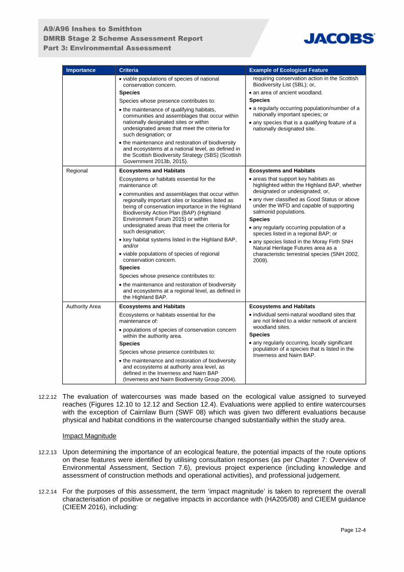
12.2.10 The general approach to defining the importance of ecological features followed CIEEM guidelines(CIEEM 2016) and IAN130/10. Ecosystems, habitats and species were assigned levels ofimportance for nature conservation based on the criteria set out in Table 12.2. The list of examplesprovided in Table 12.2 is not exhaustive.
12.2.11 Factors taken into account when determining the importance of an ecological feature included:
rarity and uniqueness;
ability to resist or recover from environmental change;
function/role within an ecosystem; and
level of legal protection or designation.
Table 12.2: Importance Criteria for Ecological Features
Importance Criteria Example of Ecological Feature
International Ecosystems and Habitats
Ecosystems or habitats essential for themaintenance of:
internationally designated areas or undesignatedareas that meet the criteria for designation;and/or
viable populations of species of internationalconservation concern.
Species
Species whose presence contributes to:
the maintenance of qualifying habitats,communities and assemblages that occur withininternationally designated sites or withinundesignated areas that meet the criteria forsuch designation.
Ecosystems and Habitats
internationally designated areas; or,
smaller watercourses that are undesignatedbut which are connected to, or havefunctionally important habitat for,internationally designated areas.
Species
a host species for another viable andinternationally important population of aspecies of international conservationconcern; or
any regularly occurring population of aninternationally important species, which isthreatened or rare in the UK (such as a UKRed List species).
National Ecosystems and Habitats
Ecosystems or habitats essential for themaintenance of:
qualifying communities and assemblages thatoccur within nationally designated sites or withinundesignated areas that meet the criteria forsuch designation; and/or
Ecosystems and Habitats
nationally designated site, e.g. a Site ofSpecial Scientific Interest (SSSI);
areas of land or water that are important inmaintaining the viability of a nationallyimportant population or key habitat in thewider area;
a viable area of a priority habitat identified as
A9/A96 Inshes to Smithton
DMRB Stage 2 Scheme Assessment Report
Part 3: Environmental Assessment
Page 12-4
Importance Criteria Example of Ecological Feature
viable populations of species of nationalconservation concern.
Species
Species whose presence contributes to:
the maintenance of qualifying habitats,communities and assemblages that occur withinnationally designated sites or withinundesignated areas that meet the criteria forsuch designation; or
the maintenance and restoration of biodiversityand ecosystems at a national level, as defined inthe Scottish Biodiversity Strategy (SBS) (ScottishGovernment 2013b, 2015).
requiring conservation action in the ScottishBiodiversity List (SBL); or,
an area of ancient woodland.
Species
a regularly occurring population/number of anationally important species; or
any species that is a qualifying feature of anationally designated site.
Regional Ecosystems and Habitats
Ecosystems or habitats essential for themaintenance of:
communities and assemblages that occur withinregionally important sites or localities listed asbeing of conservation importance in the HighlandBiodiversity Action Plan (BAP) (HighlandEnvironment Forum 2015) or withinundesignated areas that meet the criteria forsuch designation;
key habitat systems listed in the Highland BAP,and/or
viable populations of species of regionalconservation concern.
Species
Species whose presence contributes to:
the maintenance and restoration of biodiversityand ecosystems at a regional level, as defined inthe Highland BAP.
Ecosystems and Habitats
areas that support key habitats ashighlighted within the Highland BAP, whetherdesignated or undesignated; or,
any river classified as Good Status or aboveunder the WFD and capable of supportingsalmonid populations.
Species
any regularly occurring population of aspecies listed in a regional BAP; or
any species listed in the Moray Firth SNHNatural Heritage Futures area as acharacteristic terrestrial species (SNH 2002,2009).
Authority Area Ecosystems and Habitats
Ecosystems or habitats essential for themaintenance of:
populations of species of conservation concernwithin the authority area.
Species
Species whose presence contributes to:
the maintenance and restoration of biodiversityand ecosystems at authority area level, asdefined in the Inverness and Nairn BAP(Inverness and Nairn Biodiversity Group 2004).
Ecosystems and Habitats
individual semi-natural woodland sites thatare not linked to a wider network of ancientwoodland sites.
Species
any regularly occurring, locally significantpopulation of a species that is listed in theInverness and Nairn BAP.
12.2.12 The evaluation of watercourses was made based on the ecological value assigned to surveyedreaches (Figures 12.10 to 12.12 and Section 12.4). Evaluations were applied to entire watercourseswith the exception of Cairnlaw Burn (SWF 08) which was given two different evaluations becausephysical and habitat conditions in the watercourse changed substantially within the study area.
Impact Magnitude
12.2.13 Upon determining the importance of an ecological feature, the potential impacts of the route optionson these features were identified by utilising consultation responses (as per Chapter 7: Overview ofEnvironmental Assessment, Section 7.6), previous project experience (including knowledge andassessment of construction methods and operational activities), and professional judgement.
12.2.14 For the purposes of this assessment, the term ‘impact magnitude’ is taken to represent the overallcharacterisation of positive or negative impacts in accordance with (HA205/08) and CIEEM guidance(CIEEM 2016), including:

A9/A96 Inshes to Smithton
DMRB Stage 2 Scheme Assessment Report
Part 3: Environmental Assessment
Page 12-5
impact extent/scale (e.g. entire habitat loss, partial habitat loss or indication over specific areaaffected);
direct or indirect impact (e.g. direct mortality of individuals from vehicle collisions, or indirectmortality of individuals from reduced prey resources due to pollution of watercourses);
reversibility of impact (reversible or irreversible);
frequency of impact (single event, recurring or constant);
duration of impact (short-term, medium-term, long-term or permanent); and
likelihood of occurrence (certain/near certain, probable, unlikely or extremely unlikely).
12.2.15 The magnitude (and character) of impacts is defined using the criteria set out in Table 12.3. Impactmagnitude was identified as high, medium, low or negligible, taking into account the above impactcharacterisation approach.
Table 12.3: Impact Magnitude and Characterisation for Ecological Features
Impact Characterisation Impact Magnitude
A permanent effect on the distribution and/or abundance of a habitat, speciesassemblage/community or population. A permanent effect is one which results in changes to thedistribution of habitats over more than one season, one which changes the availability of criticalhabitats for a species over multiple generations, changes to the fecundity of a species, or onewhich has the potential to affect an entire cohort of juveniles of a species.
If negative, this type of effect would reduce the integrity of the feature and its conservation status. Ifpositive, it would result in an improvement to the conservation status of the feature.
High
A long-term but reversible effect on the distribution and/or abundance of a habitat, speciesassemblage/community or population, such as an effect that changes the distribution of habitatsthat are replaceable within the lifetime of the proposed Scheme, in either form or ecosystemfunction, but not within a single season or life cycle of any species that depends on such habitats.This also applies to changes in the distribution of a species which allow it to re-colonise a habitat,but not within a single season or life cycle. If negative, this type of effect would have neutral long-term implications for the integrity of the feature or its conservation status. If positive, it would notalter the long-term conservation status of the feature.
Medium
A short-term reversible effect on the distribution and/or abundance of a habitat, speciesassemblage/community or population, and one which is within normal fluctuations observed in theecology of the feature.
Low
A short-term reversible effect on the distribution and/or abundance of a habitat, speciesassemblage/community or population, unlikely to be detectable by monitoring.
Negligible
Impact Significance
12.2.16 In general accordance with CIEEM (2016) a significant impact is an impact (negative or positive) onthe integrity of a defined site or ecosystem and/or on the conservation status of habitats and species.Significance of impact is also determined by taking cognisance of the relevant guidance inIAN130/10 and SNH (2013a).
12.2.17 Integrity is the coherence of ecological structure and function (across the whole area of a site) thatenables it to sustain a habitat, complex of habitats and/or the levels of populations of species.Conservation status for habitats is determined by the sum of the influences acting on the habitat andits typical species that may affect its long-term distribution, structure and function as well as the long-term distribution and abundance of its population within a given geographical area. Conservationstatus for species is determined by the sum of influences acting on the species concerned that mayaffect the long-term distribution and abundance of its population within a given geographical area.
12.2.18 In accordance with (HA205/08) the above magnitude and importance information is taken togetherand applied to a matrix to categorise the significance of an impact (refer to Table 12.4). Professionaljudgement is, however, relied upon to ensure that an impact is categorised appropriately. The impactsignificance terms are explained in Table 12.5.

A9/A96 Inshes to Smithton
DMRB Stage 2 Scheme Assessment Report
Part 3: Environmental Assessment
Page 12-6
Table 12.4: Impact Significance
Magnitude
ImportanceHigh Medium Low
International Major Major Moderate
National Major Moderate Moderate
Regional Major Moderate Minor
Authority Area Moderate Minor Negligible
Table 12.5: Description of Significance Categories
SignificanceCategory
Typical Description
Major Associated with features of international, national or regional importance. Likely to be adamaging impact or loss of integrity. Effects likely to be permanent and irreversible, resulting in aloss of structure and/or function.
If beneficial, they will have a significant positive effect on the international or national feature.
Moderate Associated with features of international, national, regional or authority area importance. Likely tobe a damaging impact or loss of integrity. Effects are likely to be long term but reversible.
If beneficial, they will have a significant positive effect on the international or national feature.
Minor Associated with features of regional, or authority areal importance. Likely to be a damagingimpact or loss of integrity. Effects are likely to be short term and reversible.
Negligible No detectable effects. Effects may also be within the normal bounds of variation for a feature.
12.2.19 Only impacts on important ecological features (authority area importance or above) were progressedthrough the detailed assessment process. For example, an area of amenity grassland, or non-designated woodland would be evaluated as of less than authority area ecological importance, andtherefore would not progress through the assessment. However, any impact on a SSSI wouldprogress through the assessment as such sites are designated as nationally important. Detailedmitigation would, however, also be required to be developed pre-construction to ensure that anypotential breaches of legislation are avoided, regardless of a feature’s importance or significance ofimpact (e.g., damage to an active bird nests).
12.2.20 Where impacts were assessed as being of Major or Moderate significance, these were considered tobe potentially significant under the terms of the EIA Regulations (further information can be found inChapter 7: Overview of Environmental Assessment), and would require further assessment anddevelopment of mitigation at DMRB Stage 3 to reduce impacts where feasible.
Limitations
12.2.21 Due to design changes and land access constraints, surveys were not undertaken at some locationswithin the identified survey area. Aerial photography was used to facilitate the classification ofhabitats not accessed. Where necessary, the precautionary principle was applied to enableassessment of habitat suitability for ecological features and evaluate the impacts on these features.Full surveys for all receptors will be undertaken at DMRB Stage 3.
12.3 Policies and Plans
12.3.1 Appendix A8.1 (Planning Policy Context for Environmental Assessment) describes the planningpolicies and guidance from national to local level which are relevant to ecology and natureconservation. An assessment of the compliance of the route options against all development planpolicies relevant to this environmental topic is reported in Appendix A8.2 (Assessment ofDevelopment Plan Policy Compliance) and a summary overview is provided in Chapter 8 (Policiesand Plans), Section 8.4 (Compliance with Policies and Plans).

A9/A96 Inshes to Smithton
DMRB Stage 2 Scheme Assessment Report
Part 3: Environmental Assessment
Page 12-7
12.3.2 The legislative background is a combination of international conventions and directives and nationallegislation. Full details can be found in Appendix A12.1 (Legislation and Policy Framework), howeverthe principal legislative tools include:
Conservation (Natural Habitats, &c.) Regulations 1994 (as amended in Scotland);
Water Framework Directive (European Council Directive 2000/60/EC);
Wildlife and Countryside Act 1981 (as amended) (WCA) (including updates in Scotland);
Nature Conservation (Scotland) Act 2004;
Wildlife and Nature Conservation (Scotland) Act 2011 (WANE);
Protection of Badgers Act 1992 (as amended by WANE); and
Salmon and Freshwater Fisheries (Consolidation) (Scotland) Act 2003.
Biodiversity Action Plan
12.3.3 The study area is covered by the regional Highland BAP (Highland Environment Forum, 2016) and isfurther covered by the Local BAP for Inverness and Nairn (Inverness and Nairn Biodiversity Group,2004) (Appendix A12.1: Legislation and Policy Framework).
12.4 Baseline Conditions and Evaluation
12.4.1 This section summarises the existing ecological conditions within the study area that have beendetermined through desk study, consultation and site surveys. The baseline information is shown inTable 12.6 and presented on Figures 12.1 to 12.12, in Confidential Appendix CA12.1 (Badger andOtter), and in supporting Confidential Figures C12.1 to 12.6.
12.4.2 All references to watercourses are provided in the same context as within Chapter 14 (RoadDrainage and the Water Environment), providing their Surface Water Feature (SWF) reference.
Designated Sites
12.4.3 Three statutory designated sites lie within the study area (Table 12.6, Figure 12.1 to 12.3):
Longman and Castle Stuart Bays Site of Special Scientific Interest (SSSI) (SNH 2008a);
Inner Moray Firth Special Protection Area (SPA) (JNCC, 2015a, 2016); and
Inner Moray Firth Wetland of International Importance (Ramsar) (JNCC 2016).
12.4.4 The Moray Firth Special Area of Conservation (SAC) lies approximately 900m from the route optionsbut is hydrologically connected to it via Scretan (SWF 04) and Cairnlaw burns (SWF 08).
12.4.5 One non-statutory designated site is present within the study area, the Moray Basin, Firths and BaysInternational Bird Area (IBA) (Table 12.6, Figure 12.1 to 12.3) (BirdLife International 2016). IBAs aresites identified using internationally agreed criteria applied locally by Birdlife Partners, in the UK thisis the Royal Society for the Protection of Birds (RSPB). These criteria take into account the status ofbird species and knowledge of the size and trends of bird populations. The Moray Basin, Firths andBays IBA is a complex area of coastline and estuary and forms an integral unit that is important forpopulations of wintering and passage wildfowl, and for breeding cormorant. The IBA covers theareas designated as the Inner Moray Firth SPA/Ramsar (which are designated wholly or partly fortheir bird assemblages) and the Moray Firth SAC, and therefore it has not been taken forward to theimpact assessment stage; potential impacts and mitigation identified for the statutory designatedsites would satisfy any requirements for the IBA.
12.4.6 Two Ancient Woodland Inventory (AWI) sites (SNH, undated, 2008b) are present within the studyarea as well as 16 sites categorised under the Native Woodland Survey Scotland (NWSS) (Patterson

A9/A96 Inshes to Smithton
DMRB Stage 2 Scheme Assessment Report
Part 3: Environmental Assessment
Page 12-8
et al., 2014). A description of these is provided in Table 12.6 and their locations are shown onFigures 12.1 to 12.3

A9/A96 Inshes to Smithton
DMRB Stage 2 Scheme Assessment Report
Part 3: Environmental Statement
Page 12-9
Table 12.6: Summary of Ecological Features Recorded in the Study Area
Feature Data Source Baseline Legal/BAP Status Justification Importance
Statutory Designated Sites
Moray Firth SAC
UK0019808
NH 976 821
15,1273ha
JNCC, 2016
SNH, 2016d
The Moray Firth in north-east Scotland supports the only known resident population ofbottlenose dolphin in the North Sea. The population is estimated to be around 130individuals (Wilson et al., 1999). Dolphins are present all year round, and, while they rangewidely in the Moray Firth, they appear to favour particular areas.
European/Ramsar site under Conservation(Natural habitats &c) Regulations 1994 (asamended in Scotland).
Designated for its subtidal sandbanks and population ofbottlenose dolphin.
International
Inner Moray Firth SPA, UK9001624and Ramsar site, UK13025
NH 672 528, 580 480, 800 590, 705473, 730 500
2,339ha
JNCC, 2015a,2016
SNH, 2016b
This site comprises the Beauly Firth and Inverness Firth. It contains extensive intertidal flatsand smaller areas of saltmarsh. The rich invertebrate fauna of the intertidal flats, with beds ofeelgrass, glasswort, and Enteromorpha algae, provide important food sources for largenumbers of wintering and migrating waterbirds (geese, ducks and waders). The boundary ofthe SPA and Ramsar follows those of the Beauly Firth SSSI, Munlochy Bay SSSI, Longmanand Castle Stuart Bays SSSI and Whiteness Head SSSI.
Designated for their breeding and non-breeding bird interest,and littoral and supralittoral habitats. In addition to this theRamsar designation covers saltmarsh, sand dune andshingle habitats.
International
Longman and Castle Stuart Bays SSSIsite code 1675
NH 715 496
424ha
SNH, 2008a
SNH, 2016c
This site includes extensive areas of intertidal mudflats which provide rich feeding groundsfor wintering wildfowl and waders and an important roosting area for these birds. There areapproximately 6ha of ungrazed saltmarsh in a sheltered bay 2km east of Alturlie Point, andthere are substantial areas of pioneer plant species typical of northern firths, such as thenationally scarce dwarf eelgrass and narrow-leaved eelgrass.
Designated under the Nature Conservation(Scotland) Act 2004.
Designated for mudflats, saltmarshes, eelgrass beds andwintering waterfowl and waders.
National
Habitats and Plant Species
AWI woodland (2 sites)
Category 2b LEPO
SNH, undated; 2008b Two AWI woodland sites within the study area, to the south at Balvonie woodland. These arecategory 2b “Long-established of plantation origin” (LEPO).
AWI is regarded as an important and irreplaceablenational resource. Actions for ancient woodlandhave also been identified in the Highland BAP toprotect relict areas.
SBL priority habitat (including a variety of semi-naturalbroadleaved woodland types).
The Scottish Government’s policy on control of woodlandremoval states that there is a strong presumption againstremoving ancient semi-natural woodland or plantations onancient woodland sites.
National
NWSS woodland Patterson et al., 2014 Thirteen of the NWSS woodland sites within the study area are categorised as Nativewoodland. These comprise upland birchwood, oakwood and mixed ash woodland as well aslowland mixed deciduous woodland. Two areas were classified as nearly native woodlandand one as open land habitat.
Upland oakwood, upland birchwood, upland mixedashwoods and lowland mixed deciduous woodlandare all listed in the SBL.
Broadleaved semi-natural woodland with a broad range oftree species and well established, diverse ground flora.
Authority Area
Non designated woodland Phase 1 HabitatSurvey (Figures 12.4to 12.6)
Site Survey: Three areas of woodland within the study area are not covered by anydesignations. These comprise broad-leaved semi-natural woodland and broad-leavedplantation containing a variety of species with the common dominant species consisting ofoak, beech, and birch.
None. These woodland are not listed on either the AWI or theNWSS and have a reduced diversity in comparison withother woodland areas.
Less thanAuthority Area
Agricultural land Phase 1 HabitatSurvey (Figures 12.4to12.6)
Site Survey: The majority of the study area was under agricultural management comprisingarable fields, improved grassland and poor semi-improved grassland. Grassland waspredominantly grazing for sheep and cattle.
None. Arable farmland is an extensive habitat found across thecountry. Under normal extensive management, it has limitedecological interest.
Improved grassland is one of the most intensively managedhabitats; it is widespread throughout the Scottish Lowlandsand is botanically species-poor with limited ecologicalinterest. Poor semi-improved grassland is less intensivelymanaged than improved grassland, however it is species-poor and generally not differentiable into acid/calcareous.
Less thanAuthority Area
Terrestrial Species
Otter Jacobs, 2016 Present within the study area. Refer to Confidential Appendix CA12.2 for the desk basedrecords and site surveys records for otter.
European Protected Species (EPS) under the
Conservation (Natural habitats &c)
Regulations1994 (as amended in Scotland).
Listed in the Highland BAP and Inverness andNairn BAP.
Recent publications by SNH indicate that otter populationsare increasing and that they are now widespread withinScotland. Locally, it has been confirmed that Inverness citycentre supports breeding otters (Findlay, et al., 2015; SNH,2015). SNH have indicated that otter populations in the EastHighland area, which includes the Moray Firth and RiverNairn, may be at or near carrying capacity (Strachan 2007).Otter have been recorded at three distinct locations withinthe study area.
Regional
Bats WPS Energy andEnvironment, 2009
Desk Based: Both common and soprano pipistrelle have been recorded at the north of thestudy area around the locality of Stratton Farm in 2008. Four non-breeding roost sites havebeen identified (locations unknown). Leisler’s bat was recorded near Nairn in 2010 howeverit has not been recorded since. No evidence of Leisler’s has been obtained within the studyarea.
Site Survey: Taking into account roosting, commuting and foraging potential 11 habitatareas within the study area were assessed to be of overall high potential for bats and six asmoderate potential (Figures 12.7 to 12.9).
All UK bat species are EPS under theConservation (Natural habitats &c) Regulations1994 (as amended in Scotland).
There are ten species of bat known to occur inScotland and all, with the exception of Leisler’sbat, are listed on the SBL.
Soprano pipistrelle and brown long-eared bat arelisted as a priority species on the Highland BAP.
Soprano pipistrelle, common pipistrelle, Natterer'sbat, Daubenton's bat and brown long-eared bat
Common and soprano pipistrelle are widespread and foundthroughout the majority of Scotland (Bat Conservation Trust2010a, 2010b). The site provides high and moderatepotential foraging and commuting habitat - woodland andwatercourses. Roosting potential ranges from high tonegligible with an unknown number of roosts nearby.
Regional

A9/A96 Inshes to Smithton
DMRB Stage 2 Scheme Assessment Report
Part 3: Environmental Statement
Page 12-10
Feature Data Source Baseline Legal/BAP Status Justification Importance
are listed on the Inverness and Nairn BAP.
Badger Jacobs, 2016 Present within the study area. Refer to Confidential Appendix CA12.1 for the desk basedrecords and site surveys records for badger.
Protection of Badgers Act 1992 (as amended).
Listed in the Inverness and Nairn BAP.
Although considered widespread across Scotland, badgersare subject to persecution and high mortality associated withcollisions on roads. Badger is also identified as acharacteristic terrestrial species within the Moray FirthNatural Heritage Futures report (SNH 2002).
Regional
Water vole Jacobs, 2016 Desk Based: Jacobs recorded water vole on a tributary of Scretan Burn (SWF 04) (InshesBurn (SWF 02)) in 2015 within the Inverness Retail and Business Park (Figures 12.7 to12.9).
Site Survey: No further evidence of water vole was recorded within the study area duringthe site surveys. However suitable habitat exists along Inshes Burn (SWF 02) and SWF 09.
Schedule 5 of the WCA.
Listed on the SBL.
Listed in the Highland BAP and Inverness andNairn BAP.
Water voles have undergone population declines in recentyears (Jefferies 2003) and are now one of the UK's mostendangered mammals.
Regional
Red squirrel Jacobs, 2011 Desk Based: Red squirrel presence was confirmed to the south of the study area inBalvonie wood (NH 69806 42862) in 2010.
Site Survey: No evidence of red squirrel was recorded within the study area during the sitesurveys.
Schedule 5 of the WCA.
Listed on the SBL as a species for whichconservation action is needed.
Listed in the Highland BAP and Inverness andNairn BAP.
No evidence of red squirrel was recorded within the studyarea. This species is widespread within Scotland althoughthere has been widespread decline in population and range.
Less thanAuthority Area
Pine marten Jacobs, 2016 Desk Based: A pine marten wildlife vehicle incident (WVI) was recorded near Scretan Burn(SWF 04) (NH 69821 45995).
Site Survey: No evidence of pine marten was recorded within the study area during the sitesurveys.
Schedule 5 of the WCA.
Listed on the SBL.
Listed in the Highland BAP and Inverness andNairn BAP.
No evidence of pine marten was recorded within the studyarea. This species is widespread throughout Scotland andwell established in the Highlands (Croose et al., 2014).
Less thanAuthority Area
Aquatic Habitat and Species
Aquatic HabitatCairnlaw Burn (SWF 08) downstreamof NH 70240 45941
Jacobs, 2016SEPA, 2017
Desk Based: Jacobs (2016) surveys indicated that the habitat in Cairnlaw Burn (SWF 08)was of high ecological value along a reach partially within the study area.
Site Survey: This reach of Cairnlaw Burn (SWF 08) was assessed as being of mediumecological value and contained some supporting habitat for aquatic species (Figures 12.10 to12.12). This reach contained heterogeneous habitat for aquatic species and some naturalfeatures (e.g. meanders).
SEPA 2015 WFD Overall and Hydromorphologyclassification of Moderate.
Good habitat conditions for aquatic species, includinglamprey, were observed in this reach of Cairnlaw Burn (SWF08-1).
Regional
Aquatic HabitatCairnlaw Burn (SWF 08) upstream ofNH 70240 45941
Jacobs, 2016SEPA, 2017
Cairnlaw Burn (SWF 08) upstream of this point is characteristic of a ditch and two reaches inthis area of the burn were assessed as being of low ecological value (Figure 12.10 to 12.12).This area of Cairnlaw Burn was physically modified and characterised by low flow and little orno habitat heterogeneity.
SEPA 2015 WFD Overall and Hydromorphologyclassification of Moderate.
Cairnlaw Burn (SWF 08) upstream of this point is notexpected to support healthy populations of designatedaquatic species due to unsuitable habitat conditions.
Less thanAuthority Area
Aquatic HabitatScretan Burn (SWF 04)
Jacobs, 2016 Desk Based: Jacobs (2016) surveys indicated that the habitat in Scretan Burn (SWF 04)downstream of the study area was of medium ecological value. One barrier to migration wasnoted in the burn near the sea.
Site Survey: Scretan Burn (SWF 04) was assessed as being of medium ecological valueand contained supporting habitat for aquatic species (Figures 12.10 to12.12).
n/a Although good habitat for aquatic species was observed,barriers will prevent migration of fish species of conservationinterest.
Less thanAuthority Area
Aquatic HabitatInshes Burn (SWF 02), Tributaries ofScretan and Cairnlaw burns, (SWF 03,SWF 06, SWF 07)
n/a These watercourses were ditches and of low ecological value (Figures 12.10 to12.12). Thereaches were characterised by low/no flow and little or no habitat heterogeneity.
n/a These burns are not expected to support healthy populationsof designated aquatic species due to unsuitable habitatconditions.
Less thanAuthority Area
FishCairnlaw Burn (SWF 08) downstreamof NH 70240 45941
Jacobs, 2016SEPA, 2017
Desk Based: Jacobs (2016) surveys conducted in August 2015 on Cairnlaw Burn (SWF 08)indicated that European eel and trout were present within the 500m study area, butdownstream of the reach surveyed in April 2016. An area with suitable juvenile lampreyhabitat within the study area was also surveyed by Jacobs in August 2015, but no lampreywere found during subsequent fish surveys.
Site Survey: No fish were observed during aquatic walkover surveys. Supporting habitat forlamprey species was noted in this area of Cairnlaw Burn (SWF 08).
SEPA 2015 WFD Fish classification of High. This reach of Cairnlaw Burn (SWF 08-1) had suitable habitatfor juvenile lamprey species. European eel, a criticallyendangered species, were found in Cairnlaw Burn (SWF 08)400m downstream of this point in August 2015.
Regional
FishCairnlaw Burn (SWF 08) upstream ofNH 70240 45941
SEPA, 2017 Site Survey: No fish were observed during aquatic walkover surveys. One fish (speciesunknown) was observed during otter surveys on Cairnlaw Burn (SWF 08) close to, but notwithin one of the aquatics survey reaches (SWF 08-3). No supporting habitat for fish specieswas noted within this area of Cairnlaw Burn (SWF 08).
SEPA 2015 WFD Fish classification of High. This section of Cairnlaw Burn (SWF 08-2 and SWF 08-3) isnot expected to support healthy populations of designatedfish species due to unsuitable habitat conditions.
Less thanAuthority Area
FishInshes Burn (SWF 02), Tributaries ofScretan and Cairnlaw burns (SWF 03,SWF 06, SWF 07)
n/a Site Survey: No fish were observed during aquatic walkover surveys and no supportinghabitat for fish species was noted in these burns.
n/a
FishScretan Burn (SWF 04)
n/a Site Survey: No fish were observed during aquatic walkover surveys. Supporting habitat forEuropean eel was noted in survey reach SWF 04-1 on Scretan Burn (SWF 04) andsupporting habitat for lamprey species and trout was noted at both reaches on Scretan Burn(SWF 04).
n/a Although suitable habitat conditions for fish were observed,barriers to migration will prevent fish species of conservationinterest from accessing this burn.
MacroinvertebratesInshes Burn (SWF 02), Scretan Burn(SWF 04), Cairnlaw Burn (SWF 08),
SEPA, 2017 Site Survey: Supporting habitat for macroinvertebrates was noted during aquatic walkoversurveys in Cairnlaw Burn (SWF 08) downstream of NH 70175 45590, Inshes Burn (SWF 02)and Scretan Burn (SWF 04). No supporting habitat for macroinvertebrates was noted in the
SEPA 2015 WFD Macroinvertebrate (WHPT)classification of Good for Cairnlaw Burn (SWF 08).
Although suitable habitat conditions for macroinvertebrateswere observed in some watercourses, these burns are notexpected to support healthy populations of
Less thanAuthority Area

A9/A96 Inshes to Smithton
DMRB Stage 2 Scheme Assessment Report
Part 3: Environmental Statement
Page 12-11
Feature Data Source Baseline Legal/BAP Status Justification Importance
Tributaries of Scretan and Cairnlawburns (SWF 03, SWF 06, SWF 07).
other watercourses. macroinvertebrate species of conservation interest.
MacrophytesInshes Burn (SWF 02), Scretan Burn(SWF 04), Cairnlaw Burn (SWF 08),Tributaries of Scretan and Cairnlawburns (SWF 03, SWF 06, SWF 07).
SEPA, 2017 Site Survey: No supporting habitat for macrophytes was noted during aquatic walkoversurveys.
SEPA 2015 WFD Macrophyte classification ofHigh for Cairnlaw Burn (SWF 08).
These burns are not expected to support healthy populationsof macrophyte species of conservation interest due tounsuitable habitat conditions.
Less thanAuthority Area

A9/A96 Inshes to Smithton
DMRB Stage 2 Scheme Assessment Report
Part 3: Environmental Assessment
Page 12-12
12.4.7 The approach at DMRB Stage 2 has been to present data that is considered most relevant to the routeoption assessment process and thus a number of ecological features are not considered here asfollows:
Scottish wildcat, internationally important, in decline and protected under the Conservation (NaturalHabitats &c.) Regulations 1994 (as amended in Scotland), but no data to indicate definite presencein the study area;
reptiles, protected under the WCA. There is little suitable habitat identified within the study areaand assessments undertaken to inform the A96 Dualling Inverness to Nairn (including NairnBypass) Environmental Statement (Jacobs 2016) did not indicate their presence in the study area;and
freshwater pearl mussel (FWPM), internationally important and noted in the Inverness and NairnBiodiversity Action Plan (Inverness and Nairn Biodiversity Group 2004). No suitable habitat wasobserved during the site walkover surveys.
Plants of Conservation Interest
12.4.8 No plants classified as rare or scarce were recorded during the site survey. Bluebell, identified as a localpriority species in the Inverness and Nairn LBAP (Inverness and Nairn Biodiversity Group 2004), wasrecorded in one location within the study area (See Appendix A12.2 Species Names and Target Notes,Target note 3).
Birds
12.4.9 Wintering bird surveys were undertaken to inform the A96 Dualling Inverness to Nairn (including NairnBypass) Environmental Statement (Jacobs 2016). The A96 Dualling Inverness to Nairn (including NairnBypass) Wintering Bird Report (Jacobs 2015) did not detect any evidence of use of the study area byqualifying species of the Inner Moray Firth SPA and Ramsar site.
12.4.10 The following incidental records were made during the walkovers:
skylark observed in the area around Cairnlaw Burn (SWF 08) (NH 70062 45845);
rookery recorded NH 69537 43928; and
tawny owl roost recorded at NH 69694 45237.
Invasive Non-Native Species (INNS)
12.4.11 Two invasive non-native plant species and one animal species were recorded within the study area(Appendix A12.2 Species Names and Target Notes):
Himalayan balsam (Target notes 6, 7, 11, 14 and 15);
few-flowered leek (Target notes 5 and 9); and
American mink (a significant predator of water vole; SNH 2016e) was recorded on Scretan Burn(SWF 04) (Jacobs 2016).
12.4.12 Invasive non-native species (INNS), whilst presenting a threat to biodiversity (Secretariat of theConvention on Biological Diversity 2001), are not factors in determining the preferred option at thisstage, and will be considered when further detail is available on the land requirements at DMRB Stage 3(i.e. once the route is known and land requirements includes areas that may be temporarilyutilised/disturbed during construction).

A9/A96 Inshes to Smithton
DMRB Stage 2 Scheme Assessment Report
Part 3: Environmental Assessment
Page 12-13
12.5 Impact Assessment
12.5.1 Potential impacts on ecological features for all route options are described below in Table 12.7.
12.5.2 Where a potential impact was assessed as not significant (Minor or Negligible) according to the criteriasummarised in Table 12.5, it was not considered further in the comparative assessment of the routeoptions (paragraph 12.2.20). Standard construction and design practices would mitigate for theseimpacts.
12.5.3 Impacts on features of less than authority area importance are not considered within this impactassessment, as explained in paragraph 12.2.19.
12.5.4 Where an impact is initiated in construction but also occurs throughout operation (e.g. permanenthabitat removal), it is discussed only within operational impacts.
12.5.5 Potential impacts in terms of the land that may be directly required for the route options (i.e. the scheme‘footprint’) does not take into account any potential temporary land requirements during construction, asthese are not known at this stage.
12.5.6 No impacts are predicted for the following features either during the construction or operational phasesof the proposed Scheme as no effects pathways were identified.
Moray Firth SAC; and
ancient woodland.
12.5.7 Water vole surveys were not conducted on the upper part of the Inshes Burn (SWF 02) during theDMRB Stage 2 assessments. However, as water vole presence was recorded by Jacobs downstream ofthe survey area (Jacobs 2016), the precautionary principle has been applied and they are presumedpresent.
12.5.8 Standard construction impacts may include:
injury or mortality of protected species due to vegetation removal, vehicle movements or becomingtrapped in uncovered holes and pipes;
temporary habitat fragmentation due to disturbance and instream activities;
disturbance to protected species from noise, lighting and movement of vehicles and increasedhuman activity;
sediment release and run-off from construction works;
generation of dust from use of haul routes, earth movement and soil storage; and
temporary hydrological changes to terrestrial and aquatic habitats.
12.5.9 Standard operational impacts may include:
injury and mortality of protected species from vehicle collisions;
permanent loss of habitats under footprint of the proposed Scheme;
fragmentation and severance of habitats;
disturbance to protected species from traffic noise and lighting;
pollution from road run-off; and
hydrological changes from run-off and structures.

A9/A96 Inshes to Smithton
DMRB Stage 2 Scheme Assessment Report
Part 3: Environmental Statement
Page 12-14
Table 12.7: Description of Potential Impacts (Without Mitigation) for All Route Options.
Feature Importance Potential Impact Potential Effect Magnitude Significance
Construction
Inner Moray FirthSPA, UK9001624and Ramsar site,UK13025
NH 672 528, 580480, 800 590, 705473, 730 500
2,339ha
International Run-off from construction works includingsediment release and chemicals from accidentalspillage in the following locations:
Cairnlaw Burn (SWF 08)ch1020/ch1140;
Inshes Burn (SWF 02) ch200; and
Scretan Burn (SWF 04) ch270/ch290
Pollution of Cairnlaw Burn (SWF 08), Inshes Burn (SWF 02) andScretan Burn (SWF 04) which feed into the SPA/Ramsar/SSSIresulting in reduced water quality resulting in mortality of its speciesassemblages.
Dependent on the magnitude of the pollution event this could resultin permanent reductions in the quality of the SPA/Ramsar/SSSIhabitats and their species assemblages.
Long-term, reversible and possible, this effect would be localised tothe Longman Bay area of the SPA/Ramsar/SSSI.
High Major
Longman andCastle Stuart BaysSSSI site code1675
NH 715 496
424ha
National High Major
NWSS woodland Authority No construction phase impacts identified.
Otter Regional Construction related activities, including vehiclemovement in the following areas:
Cairnlaw Burn (SWF 08);
Inshes Burn (SWF 02); and
Scretan Burn (SWF 04).
Direct mortality of individuals from collisions or entrapment in pits,pipes or machinery. Unlikely to occur in sufficient numbers to affectthe wider population.
Although the potential impact would be short-term, the effect wouldbe permanent and negative.
Low Minor
Noise, vibration and light spill associated withconstruction related operations including earthmovement, in the areas indicated above.
Disturbance of an EPS leading to its avoidance of key places ofshelter and rest. Known resting sites are situated more than 30mfrom the route options, it is not therefore considered that anydisturbance would cause declines in population.
This effect would be short-term and reversible.
Low Minor
Water vole Regional Construction related activities, including vehiclemovement in the following areas:
Inshes Burn (SWF 02).
Disturbance of water vole leading to its avoidance of key places ofshelter and rest. Although presumed present this effect would beshort-term and reversible.
Low Minor
Bats Regional Noise and vibrations from piling, generalconstruction noise and construction lightingwithin areas of overall high bat habitat potential.
Disturbance of roosts leading to avoidance of key places of shelterand rest; but no evidence at DMRB Stage 2 to suggest that thiswould be at a level that will cause declines in population. Effectswould be short-term, reversible and frequent.
Low Minor

A9/A96 Inshes to Smithton
DMRB Stage 2 Scheme Assessment Report
Part 3: Environmental Statement
Page 12-15
Badger Regional Construction related activities, including vehiclemovement and vegetation clearance.
Direct injury or mortality of badgers from collisions or animalsbecoming trapped in uncovered holes and pipes.
Mortality of individuals is permanent and negative, however giventhe large and wide ranging population in this area it is unlikely tohave a significant effect on the status of the badger population in thearea.
Low Minor
Noise, vibration and light spill associated withconstruction related operations includingblasting, piling and earth movements throughoutthe proposed Scheme.
Temporary disturbance of badgers leading to a change in thedistribution of local population(s).
This effect would be negative but short-term and reversible.
Low Minor
Aquatic Habitat –Cairnlaw Burn(SWF 08)
Regional Construction activities for structures associatedwith the route options could result in run-off ofcontaminants or sediments in Cairnlaw Burn(SWF 08) downstream of NH 70240 45941.
Pollution leading to reduced water quality in the burn.
Inputs of fine sediments smothering important substrates for aquaticspecies.
These would cause long-term, reversible effects.
Medium Moderate
Changes in hydrology from over pumping ofwater due to construction activities for structuresassociated with the route options in CairnlawBurn (SWF 08) downstream of NH 70240 45941.
Changes in hydrology leading to functional alteration of habitatconditions in the burn.
This would be a short-term, reversible effect.
Low Minor
Fish – CairnlawBurn (SWF 08)
Regional Construction activities for the route options couldresult in contaminated run-off or input ofsediments in Cairnlaw Burn (SWF 08)downstream of NH 70240 45941.
Pollution leading to reduced water quality in the burn which can havenegative physiological implications.
This would cause short-term, reversible effects.
Low Moderate
Dewatering during construction activities forstructures associated with the route options inCairnlaw Burn (SWF 08) downstream ofNH 70240 45941.
Mortality of fish from dewatering activities.
This would be a permanent and negative effect.
Medium Moderate
Operation
Inner Moray FirthSPA, UK9001624and Ramsar site,UK13025
NH 672 528, 580480, 800 590, 705473, 730 500
2,339ha
International Increase in road run-off due to increase inimpervious surfaces at the following locations:
Cairnlaw Burn (SWF 08)ch1020/ch1140; and
Scretan Burn (SWF 04) ch270/ch290.
Pollution of Cairnlaw Burn (SWF 08) and Scretan Burn (SWF 04)which feed into the SPA/Ramsar/SSSI resulting in reduced waterquality and reduction in biodiversity.
This would be long-term and negative but reversible.
Medium Major
Longman andCastle Stuart BaysSSSI site code
National Medium Moderate

A9/A96 Inshes to Smithton
DMRB Stage 2 Scheme Assessment Report
Part 3: Environmental Statement
Page 12-16
1675
NH 715 496
424ha
NWSS woodland Authority Loss of habitat under the footprint of the routeoptions.
Loss of NWSS woodland.
This effect would be permanent and negative.
High Moderate
Otter Regional Increased and new road footprint at the followinglocations:
Cairnlaw Burn (SWF 08); and
Scretan Burn (SWF 04).
Direct mortality of individuals through road-traffic related incidents.
This effect would be permanent and negative.
Low Minor
Severance of habitat by the route options, atlocations indicated above.
Fragmentation of connecting terrestrial habitats leading to increasein barriers to movement and reduced access to resources for thespecies within the catchment.
This effect would be permanent and negative.
Low Minor
Noise, vibration and light spill associated withoperation of the road and increased traffic, atlocations indicated above.
Disturbance of an EPS leading to its avoidance of key places ofshelter and rest. However, as known resting sites are situated morethan 30m from the route options, it is not considered that anydisturbance will cause declines in population.
This effect would be permanent and negative.
Low Minor
Increase in road run-off due to increase inimpervious surfaces, at locations indicatedabove.
Pollution leading to decreased water quality resulting in reducedfitness of individuals and a reduction in prey resource.
This effect would be permanent and negative.
Low Minor
Water vole Regional No operation phase impacts identified.
Bats Regional Loss of roost habitat under the footprint of theroute options within areas of high and moderatebat habitat value.
Permanent loss of roost sites which could result in mortality of batsand reduced breeding success.
This effect would be permanent and negative.
High Major
Loss of foraging and commuting habitat underthe footprint of the route options within areas ofhigh and moderate bat habitat value.
Permanent loss and fragmentation of habitat and reduced availabilityof foraging resources.
This effect would be permanent and negative.
Medium Moderate
Disturbance of roosts from noise, vibration andlight spill associated with operation of the roadand increased traffic within areas of high andmoderate bat habitat value.
Disturbance of an EPS leading to the abandonment of roost sites,increased energy expenditure during roosting periods.
This would lead to reduced breeding success.
This effect would be permanent and negative.
High Major
Badger Regional Increased and new road footprint. Direct mortality of badgers caused by collision with road traffic.
This effect would be permanent and negative.
Medium Moderate
Loss of habitat under the footprint of the route Reduction of foraging and commuting habitat within social groupterritories reducing the carrying capacity of the area in respect to
Medium Moderate

A9/A96 Inshes to Smithton
DMRB Stage 2 Scheme Assessment Report
Part 3: Environmental Statement
Page 12-17
options. badgers.
This effect would be long-term and negative.
Severance of habitat by the route options. Habitat fragmentation/isolation which would restrict/precludemovement for the purposes of badger ecological function andgenetic flow.
This effect would be permanent and negative.
Medium Moderate
Noise, vibration and light spill associated withoperation of the road and increased traffic.
Altered use of habitats and disturbance of badger habitat leading toa change in the distribution of local population(s) and a reduction inavailable resources.
This effect would be long-term and neutral.
Medium Moderate
Aquatic Habitat –Cairnlaw Burn(SWF 08)
Regional Loss of habitat under structures associated withthe route options on Cairnlaw Burn (SWF 08)downstream of NH 70240 45941.
Loss of habitat for aquatic species.
This effect would be permanent and irreversible.
High Major
Culverts associated with the route options createunnatural flow and substrate conditions that willfragment Cairnlaw Burn (SWF 08) downstreamof NH 70240 45941.
Discontinuity in flow and substrate conditions that could discourageor prevent migration of aquatic species.
Change in hydrology leading to altered substrate movement in thissection of the stream and scouring of substrates at the culvert outlet.
This would be a permanent effect.
Medium Moderate
Increase in contaminant run-off from the roadnear Cairnlaw Burn (SWF 08) downstream ofNH 70240 45941.
Pollution leading to reduced water quality in the burn.
This would be chronic and long-term.
Medium Moderate
Increase in sediment inputs in Cairnlaw Burn(SWF 08) downstream of NH 70240 45941 fromsilt collected in road drainage.
Inputs of fine sediments resulting in smothering substrates that areimportant for aquatic species. This effect would be recurring butshort-term.
Low Minor
Fish – CairnlawBurn (SWF 08)
Regional Loss of habitat under structures such as culvertsassociated with the route options on CairnlawBurn (SWF 08) downstream of NH 70240 45941.
Permanent habitat loss resulting in fish losing access to potentiallyimportant feeding or spawning habitat.
This would be a permanent, irreversible effect.
Medium Moderate
Culverts associated with the route options createunnatural flow and substrate conditions that mayfragment the watercourses in Cairnlaw Burn(SWF 08) downstream of NH 70240 45941.
Change in hydrology leading to altered substrate movement in thissection of the burn and scouring of substrates at the culvert outlet.This would discourage or prevent upstream migration by fish.
This would be a permanent effect.
Medium Moderate
Increase in contaminant run-off from the roadnear watercourses in Cairnlaw Burn (SWF 08)downstream of NH 70240 45941.
Pollution leading to reduced water quality in the watercourses.
This would be a chronic effect that can have long-term implications.
Medium Moderate
Increase in sediment inputs from silt collected inroad drainage in Cairnlaw Burn (SWF 08)downstream of NH 70240 45941.
Inputs of fine sediments resulting in smothering of substratesimportant for juveniles and spawning adults. This effect would berecurring but short-term.
Low Minor

A9/A96 Inshes to Smithton
DMRB Stage 2 Scheme Assessment Report
Part 3: Environmental Assessment
Page 12-20
12.6 Potential Mitigation
12.6.1 As discussed above, proposed mitigation would follow a hierarchical approach to be adopted, wherepossible, in the following order (CIEEM 2016 and SNH 2013):
avoid adverse impacts in the first instance;
where avoidance is not possible, reduce the adverse impacts; and
where significant adverse residual impacts remain, measures to offset the adverse impacts at asite-specific level may be required.
12.6.2 It is expected that all impacts of Negligible and Minor significance would be mitigated through theapplication of best working practice (e.g. mitigation of potential pollution impacts through adherence tostandard best practice and guidelines, such as the SEPA Pollution Prevention Guidelines (PPGs)(SEPA, 2003) and Guidance for Pollution Prevention (GPPs) (Netregs 2017)).
12.6.3 Significant ecological impacts (Moderate or above) are expected to be mitigated through a combinationof best practice and mitigation techniques (as described below) which would be targeted to specificlocations.
12.6.4 The following potential mitigation measures are applicable to impacts arising from all route options asdescribed in Table 12.7.
Construction
12.6.5 Potential for disturbance (noise, vibration and lighting) to protected species could be reduced for allroute options by measures such as:
careful routing of site access routes and creating exclusion zones in sensitive areas;
use of directional lighting;
use of noise and vibration management plans (avoiding sensitive times) to minimise negativeeffects on protected species;
soft start techniques for piling procedures; and
limits on hours of darkness working where feasible and where need confirmed in discussion withSNH.
12.6.6 Best practice guidance could be set out in a contractor’s Construction Environmental Management Plan(CEMP) which would outline how construction of the project would avoid, minimise or mitigate effects onthe environment and surrounding area.
12.6.7 Potential fragmentation (physical or functional) of aquatic habitats through in-channel works and culvertinstallation and the resultant loss of populations of aquatic species, could be reduced through:
avoiding sensitive time periods for protected species such as spawning and migration periods;
works being carried out in accordance with SEPA’s Engineering in the Water Environment: GoodPractice Guide - River Crossings (2010) to ensure fish passage is maintained during construction;and
relocation of fish present within the culvert extension/installation footprints.
12.6.8 Disturbance to roosting bats, fish and otters could be reduced through:
the provision of appropriate protection systems and/or construction exclusion zones; and

A9/A96 Inshes to Smithton
DMRB Stage 2 Scheme Assessment Report
Part 3: Environmental Assessment
Page 12-21
use of noise management plans (avoiding sensitive times) to minimise negative effects on fishspecies (all three lamprey species, European eel).
12.6.9 The risk of mortality of species such as otter when travelling through construction areas could beavoided or reduced by provision of mammal-proof fencing to mitigate for direct mortality duringconstruction along with standard best practice site management, e.g. covering holes and pipes.
Operation
12.6.10 Potential habitat loss (under project footprint) could be reduced or compensated through:
the provision of new habitat in landscape design and if necessary through off-setting, aiming toreduce fragmentation (of habitats and their supporting species) and creating new linkages or moreecologically resilient functional units thereby increasing the amount of supporting habitat forterrestrial and aquatic species. Any potential replacement habitat would be identified for thepreferred option at DMRB Stage 3.
12.6.11 Road run-off and its potential effects on watercourses and other aquatic habitats could be mitigated byappropriate drainage design to minimise run-off of sediments directly into the watercourse. It should benoted that Sustainable Drainage Systems (SuDS) would be developed as part of the DMRB Stage 3design.
12.6.12 Potential for loss and/or fragmentation of protected species lying-up/resting/roosting sites under theproject footprint could be compensated for through:
the provision of alternative sites; and
planting to provide opportunities for above ground lying-up sites and foraging habitat for otherspecies.
12.6.13 Potential fragmentation of otter, badger and bat habitats and associated barriers to access foragingareas could be mitigated for through:
the provision of mammal ledges in culverts and under bridges for otter and badger. Where this isnot possible, dry mammal underpasses could be provided;
away from watercourse crossings, provision of dry mammal underpasses at appropriate crossingpoints for badger; and
design of new landscape planting suitable for use by commuting bats.
12.6.14 Loss of migratory fish passage due to the presence of additional culverts could be reduced through thedesign of crossings in accordance with SEPA’s Engineering in the Water Environment: Good PracticeGuide - River Crossings (2010).
12.6.15 Operational disturbance to bats, otters, badgers and migratory fish species could be reduced throughmeasures such as:
design of artificial lighting using current best practice, including directional lighting or othermeasures to reduce peripheral light spillage; and
avoidance of lighting in areas of migratory fish habitat at watercourse crossings.
12.6.16 Direct mortality of otters and badgers crossing the road is not considered likely if appropriate design ofriver crossings and dry mammal underpasses is applied (and so has not been discussed above).However, if deemed appropriate for the preferred option at DMRB Stage 3, it could be avoided throughprovision of mammal-proof fencing.
A9/A96 Inshes to Smithton
DMRB Stage 2 Scheme Assessment Report
Part 3: Environmental Assessment
Page 12-22
12.7 Summary of Route Options
12.7.1 This section provides a summary of the DMRB Stage 2 assessment of impacts for the route optionstaking into account the anticipated potential mitigation as described in Section 12.6.
12.7.2 Two aspects are considered; whether any impacts would be considered significant in the context of theEIA Regulations, and whether any of the impacts identified differ sufficiently between route options thatthey need to be considered as part of the overall identification of a preferred option (which as explainedin Chapter 7: Overview of Environmental Assessment, takes into account environmental, engineering,economic and traffic considerations).
12.7.3 This assessment has identified significant potential impacts, in the context of the EIA Regulations,associated with the route options as shown in Table 12.7.
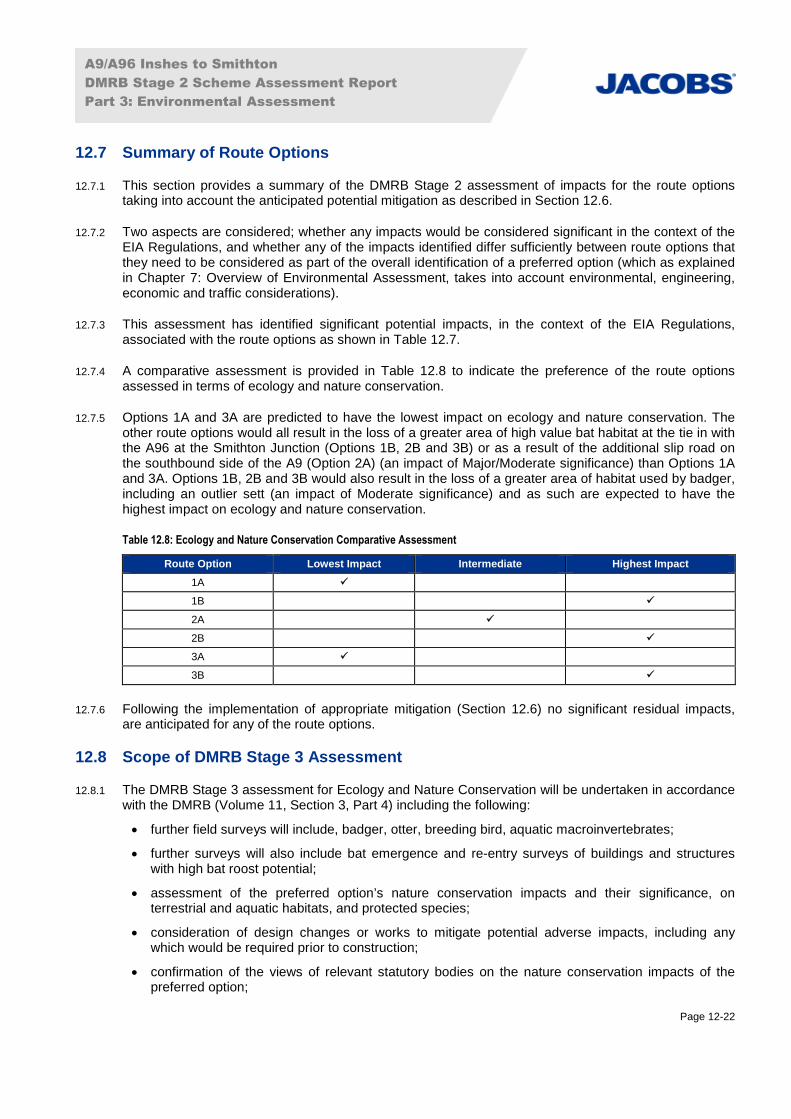
12.7.4 A comparative assessment is provided in Table 12.8 to indicate the preference of the route optionsassessed in terms of ecology and nature conservation.
12.7.5 Options 1A and 3A are predicted to have the lowest impact on ecology and nature conservation. Theother route options would all result in the loss of a greater area of high value bat habitat at the tie in withthe A96 at the Smithton Junction (Options 1B, 2B and 3B) or as a result of the additional slip road onthe southbound side of the A9 (Option 2A) (an impact of Major/Moderate significance) than Options 1Aand 3A. Options 1B, 2B and 3B would also result in the loss of a greater area of habitat used by badger,including an outlier sett (an impact of Moderate significance) and as such are expected to have thehighest impact on ecology and nature conservation.
Table 12.8: Ecology and Nature Conservation Comparative Assessment
Route Option Lowest Impact Intermediate Highest Impact
1A
1B
2A
2B
3A
3B
12.7.6 Following the implementation of appropriate mitigation (Section 12.6) no significant residual impacts,are anticipated for any of the route options.
12.8 Scope of DMRB Stage 3 Assessment
12.8.1 The DMRB Stage 3 assessment for Ecology and Nature Conservation will be undertaken in accordancewith the DMRB (Volume 11, Section 3, Part 4) including the following:
further field surveys will include, badger, otter, breeding bird, aquatic macroinvertebrates;
further surveys will also include bat emergence and re-entry surveys of buildings and structureswith high bat roost potential;
assessment of the preferred option’s nature conservation impacts and their significance, onterrestrial and aquatic habitats, and protected species;
consideration of design changes or works to mitigate potential adverse impacts, including anywhich would be required prior to construction;
confirmation of the views of relevant statutory bodies on the nature conservation impacts of thepreferred option;

A9/A96 Inshes to Smithton
DMRB Stage 2 Scheme Assessment Report
Part 3: Environmental Assessment
Page 12-23
identification of required mitigation, including provision for species to pass across the A9/A96 routeand replacement habitat planting; and
production of an Environmental Statement (ES) detailing the information obtained from the pointsabove and identifying any potential residual impacts for ecology and nature conservation.
12.8.2 In addition to preparation of the ES, a Habitats Regulations Appraisal will be prepared to consider theimplications from the project on the Natura 2000 network, in particular the Inner Moray Firth SPA andRamsar, under the requirements of the Habitats Regulations 1994 (as amended in Scotland).
12.9 References
Bat Conservation Trust (2010a). Common Pipistrelle (Pipistrellus pipistrellus) Fact Sheet. Available athttp://www.bats.org.uk/data/files/Species_Info_sheets/commonpipistrelle.pdf [Accessed May 2016].
Bat Conservation Trust (2010b). Soprano Pipistrelle (Pipistrellus pygmaeus) Fact Sheet. Available athttp://www.bats.org.uk/data/files/Species_Info_sheets/Soprano_pipistrelle.pdf [Accessed May 2016].
BirdLife International (2016). Important Bird and Biodiversity Area factsheet: Moray Basin, Firths andBays. Available at: http://www.birdlife.org [Accessed May 2016].
Collins, J. (ed.) (2016). Bat Surveys for Professional Ecologists: Good Practice Guidelines (3rd ed.). TheBat Conservation Trust, London.
Chanin, P. (2003). Monitoring the Otter Lutra lutra. Conserving Natura 2000 Rivers Monitoring SeriesNo 10. English Nature, Peterborough.
Chartered Institute for Ecology and Environmental Management (2016). Guidelines for EcologicalImpact Assessment in the UK and Ireland: Terrestrial, Freshwater and Coastal, 2nd edition. CharteredInstitute of Ecology and Environmental Management, Winchester.
Croose, E., Birks, J.D.S., Schofield, H.W. and O’Reilly, C. (2014). Distribution of the pine marten(Martes martes) in southern Scotland in 2013. Scottish Natural Heritage Commissioned Report No. 740.
Findlay, M., Alexander, L. and Macleod, C. (2015). Site conditions for monitoring otters (lutra lutra) in2011-2012. Scottish Natural Heritage Commissioned Report No. 521.
Highland Environment Forum (2016). Highland Nature: The Biodiversity Action Plan. HighlandEnvironment Forum, June 2015. Available at: http://www.highlandbiodiversity.com/highland-bap.asp#subpage1 [Accessed May 2016].
Highways Agency, Scottish Executive Development Department, The National Assembly for Wales andthe Department of Regional Development Northern Ireland (1993). Design Manual for Roads andBridges Volume 11, Section 3, Part 4: Ecology and Nature Conservation.
Highways Agency, Scottish Executive Development Department, The National Assembly for Wales andthe Department of Regional Development Northern Ireland (2008). Design Manual for Roads andBridges Volume 11, Section 2, Part 5 HA 205/08 Assessment and Management of EnvironmentalEffects. and the Department of Regional Development Northern Ireland. (2010). Design Manual forRoads and Bridges Interim Advice Note 130/10 ‘Ecology and Nature Conservation: Criteria for ImpactAssessment’.
Inverness and Nairn Biodiversity Group (2004). The Inverness & Nairn Biodiversity Action Plan.Available from: http://www.highlandbiodiversity.com/userfiles/file/acion-plans/inverness_nairn.pdf.

A9/A96 Inshes to Smithton
DMRB Stage 2 Scheme Assessment Report
Part 3: Environmental Assessment
Page 12-24
International Union for Conservation of Nature and Natural Resources (IUCN) (2015). red list ofthreatened species website. Available at: http://www.iucnredlist.org/ [Accessed May 2016].
Jacobs (2011). A96 Inshes to Nairn Trunk Road DMRB Stage 2 Assessment. Extended Phase 1 HabitatSurvey. February 2011 (unpublished report to Transport Scotland).
Jacobs (2014) (on behalf of Transport Scotland). A96 Dualling Inverness to Nairn (including NairnBypass): DMRB Stage 2 Scheme Assessment Report.
Jacobs (2015). A96 Dualling Inverness to Nairn (including Nairn Bypass). Wintering Bird Report.September 2015. Unpublished report to Transport Scotland.
Jacobs (2016) (on behalf of Transport Scotland). A96 Dualling Inverness to Nairn (including NairnBypass): DMRB Stage 3 Environmental Statement.
Joint Nature Conservancy Council (2010). Handbook for Phase 1 habitat survey - a technique forenvironmental audit. Joint Nature Conservancy Council, Peterborough.
Joint Nature Conservancy Council (2015a). SPA description: Inner Moray Firth. Available at:http://jncc.defra.gov.uk/default.aspx?page=1879 [Accessed May 2016].
Joint Nature Conservation Committee (2016). Available at: http://jncc.defra.gov.uk/. [Accessed February2016].
National Biodiversity Network (2016). National Biodiversity Network (NBN) Gateway. Available at:http://data.nbn.org.uk/interactive [Accessed March 2016].
Netregs (2017). Guidance for Pollution Prevention (GPPs) - Full list. Available athttp://www.netregs.org.uk/environmental-topics/pollution-prevention-guidelines-ppgs-and-replacement-series/guidance-for-pollution-prevention-gpps-full-list/ [Accessed August 2017].
Patterson, G., Nelson, D., Robertson, P. and Tullis, J. (2014). Scotland’s Native Woodlands, Resultsfrom the Native Woodland Survey of Scotland. Forestry Commission, Edinburgh.
Scottish Environment Protection Agency (2003). Pollution Prevention Guidance.http://www.sepa.org.uk/about_us/publications/guidance/ppgs.aspx.
Scottish Environment Protection Agency (2010). Engineering in the Water Environment: Good practiceguide: River crossings.
Scottish Environment Protection Agency (2017). Water Classification Hub.https://www.sepa.org.uk/data-visualisation/water-classification-hub/ [Accessed July 2017].
Scottish Executive (2000). Planning Advice Note 60: Planning For Natural Heritage.http://www.scotland.gov.uk/Resource/Doc/927/0016396.pdf [Accessed December 2015].
Scottish Fisheries Co-Ordination Centre (2007b). Habitat Surveys Training Course Manual. [Online].Available at: http://www.sfcc.co.uk/assets/files/SFCC%20Habitat%20Training%20Manual.pdf.
Scottish Government (2013a). Planning Advice Note 1/2013: Environmental Impact Assessment.Available at: http://www.gov.scot/Publications/2013/08/6471.
Scottish Government (2013b). Scottish Biodiversity List (SBL) (22 April 2013 version). Available at:http://www.scotland.gov.uk/Topics/Environment/Wildlife-Habitats/16118/Biodiversitylist/SBL [AccessedApril 2015].

A9/A96 Inshes to Smithton
DMRB Stage 2 Scheme Assessment Report
Part 3: Environmental Assessment
Page 12-25
Scottish Government (2015). 2020 Challenge for Scotland’s Biodiversity. A Strategy for theconservation and enhancement of biodiversity in Scotland. Scottish Government, Edinburgh. Availableat: http://www.biodiversityscotland.gov.uk/doing/strategy/ [Accessed November 2015].
Scottish Natural Heritage (2002). Natural Heritage Futures: Moray Firth. Available at:http://www.snh.org.uk/futures/Data/pdfdocs/Moray_Firth.pdf [Accessed February 2016].
Scottish Natural Heritage (2008a). Longman and Castle Stuart Bays Site of Special Scientific Interest,Site Management Statement. 25 January 2008. Available at:file:///C:/Users/robertsj2/Downloads/site1675-doc3%20(1).pdf.
Scottish Natural Heritage (2008b). Ancient Woodland Inventory. Scottish Natural Heritage, Inverness.
Scottish Natural Heritage (2009). Natural Heritage Futures Update: Moray Firth. Available at:http://www.snh.gov.uk/docs/A306395.pdf [Accessed February 2016].
Scottish Natural Heritage (2013). A handbook on environmental impact assessment: Guidance forCompetent Authorities, Consultees and others involved in the Environmental Impact AssessmentProcess in Scotland. 4th Edition. Scottish Natural Heritage, Battleby, Perth.
Scottish Natural Heritage (2015). Trend Note: Trends of Otters in Scotland. Number 023. Availablefrom: http://www.snh.gov.uk/docs/A1794619.pdf [Accessed February 2016].
Scottish Natural Heritage (2016a). Scottish Natural Heritage Information Service, Sitelink. Available at:available at: http://gateway.snh.gov.uk/sitelink/ [Accessed January 2016].
Scottish Natural Heritage Sitelink (2016b). Inner Moray Firth SPA Citation. Available from:https://gateway.snh.gov.uk/sitelink/siteinfo.jsp?pa_code=8515#features [Accessed May 2016].
Scottish Natural Heritage Sitelink (2016c). Longman and Castle Stuart Bays SSSI Citation. Availablefrom https://gateway.snh.gov.uk/sitelink/siteinfo.jsp?pa_code=1675 [Accessed May 2016].
Scottish Natural Heritage Sitelink (2016d). Moray Firth SAC Citation. Available fromhttps://gateway.snh.gov.uk/sitelink/siteinfo.jsp?pa_code=8327 [Accessed May 2016].
Scottish Natural Heritage (2016e). Water voles. Webpage http://www.snh.gov.uk/about-scotlands-nature/species/mammals/land-mammals/water-voles/ [Accessed May 2016].
Scottish Natural Heritage (undated). A guide to understanding the Scottish Ancient Woodland Inventory(AWI). Scottish Natural Heritage.
Strachan, R. (2007). National survey of otter Lutra lutra distribution in Scotland 2003–04. ScottishNatural Heritage Commissioned Report No. 211.
Strachan, R., Moorhouse, T. and Gelling, M. (2011). Water Vole Conservation Handbook (third edition).WildCRu: Oxford.
Transport Scotland (2014). Scottish Transport Appraisal Guidance (STAG). Available at:http://www.transport.gov.scot/stag.
Water Framework Directive – United Kingdom Technical Advisory Group (WFD-UKTAG) (2014).UKTAG River Assessment Method Macrophytes and Phytobenthos: Macrophytes (River LEAFPACS2).WFD-UKTAG. Stirling. United Kingdom.
Wilson, B., Hammond, P.S. and Thompson, P.M. (1999). Estimating size and assessing trends in a

A9/A96 Inshes to Smithton
DMRB Stage 2 Scheme Assessment Report
Part 3: Environmental Assessment
Page 12-26
coastal bottlenose dolphin population. Ecological Applications, 9, 288-300.
WSP Energy and Environment (2009). Stratton Environmental Statement. Planning application forurban expansion including a new town centre. February 2009.