129 alan r. moller: senior forecaster ... - home | flame.org
TRANSCRIPT

129 Alan R. Moller: Senior Forecaster, Photographer, and Storm Chaser 1950-2014
Timothy P. Marshall1, S. Barricklow, C. A. Doswell III2, L. R. Lemon3,
M. Lisius4, G. Woodall5, and Brian Curran5
1Haag Engineering Company 2C. Doswell Enterprises, Inc.
3Radar, Severe Storms, and Research Meteorologist 4Prairie Pictures
5NOAA/NWS 1. INTRODUCTION Alan R. Moller (Fig. 1) whose life-long dedication and skill contributed directly to saving many lives, left a legacy in the world of severe storms forecasting and storm spotter training. His journey of public service began in the early 1970’s, when he participated in the Tornado Intercept Project (TIP), sponsored by the National Severe Storms Laboratory (NSSL) and the University of Oklahoma (OU). He helped identify fundamental relationships between Doppler radar signatures and severe weather events. Alan began his career with the National Weather Service (NWS) in 1974 in Fort Worth, Texas as a warning coordination meteorologist (WCM). His passion for severe weather warning led him to organize local area storm spotters and to develop the SKYWARN program, which grew and became a nationwide organization. He assisted in the production of the training film, Tornadoes: A Spotter’s Guide in 1977 distributed by the National Oceanic and Atmospheric Administration (NOAA) and made major contributions to an accompanying slide program. Images used in these training programs came from his annual storm chases with longtime chase partner Dr. Charles Doswell III. Alan’s great communication skills and enthusiasm kept the audience’s attention through hours of basic and advanced spotter training sessions. It wasn’t long before he had a regular following that would “pack the house”. Alan was promoted to senior forecaster in 1983 and retired from public service in 2009. He was stricken with Alzheimer’s disease and passed away on 19 June 2014. This paper will summarize some of Alan Moller’s many accomplishments. A bibliography of his work also will be presented. _______ Corresponding author’s address: Timothy P. Marshall, 4949 W. Royal Lane, Irving, Texas 75063. Email: [email protected]
Figure 1. Alan Moller was a great forecaster, photographer, and storm chaser. He was an enthusiastic presenter who drew large crowds to storm spotter training sessions. Image by Charles Doswell III. 2. THE EARLY YEARS Alan Moller was born in Fort Worth, Texas on 1 February 1950 and grew up in Benbrook, a nearby suburb. He became passionate about storms as a child. He was known to climb out his window, up a tree, and onto the roof of his parents’ home to watch storms roll into Fort Worth. He attended R. L. Paschal High School, then went to OU, where he earned B.S. and M.S. degrees in meteorology during the 1970s. While at OU, Alan took part in TIP. This was the first, organized, scientific storm chasing program in the U.S. The purpose of TIP was to correlate visual observations with experimental Doppler radar imagery (Doswell and Moller 2004). The program had some success in its first season in 1972. However, it all came together at Union City, Oklahoma the following year.
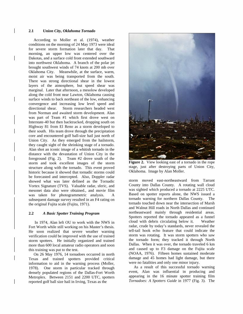
2.1 Union City, Oklahoma Tornado According to Moller et al. (1974), weather conditions on the morning of 24 May 1973 were ideal for severe storm formation later that day. That morning, an upper low was centered over the Dakotas, and a surface cold front extended southward into northwest Oklahoma. A branch of the polar jet brought southwest winds of 74 knots at 200 mb over Oklahoma City. Meanwhile, at the surface, warm, moist air was being transported from the south. There was strong directional shear in the lowest layers of the atmosphere, but speed shear was marginal. Later that afternoon, a mesolow developed along the cold front near Lawton, Oklahoma causing surface winds to back northeast of the low, enhancing convergence and increasing low level speed and directional shear. Storm researchers headed west from Norman and awaited storm development. Alan was part of Team #1 which first drove west on Interstate-40 but then backtracked, dropping south on Highway 81 from El Reno as a storm developed to their south. His team drove through the precipitation core and encountered golf ball-size hail just north of Union City. As they emerged from the hailstorm, they caught sight of the shrinking stage of a tornado. Alan shot an iconic image of a whitish tornado in the distance with the devastation of Union City in the foreground (Fig. 2). Team #2 drove south of the storm and took excellent images of the storm structure along with the tornado. This event proved historic because it showed that tornadic storms could be forecasted and intercepted. Also, Doppler radar showed what was later defined as the Tornadic Vortex Signature (TVS). Valuable radar, sferic, and mesonet data also were obtained., and movie film was taken for photogrammetric analysis. A subsequent damage survey resulted in an F4 rating on the original Fujita scale (Fujita, 1971). 2.2 A Basic Spotter Training Program In 1974, Alan left OU to work with the NWS in Fort Worth while still working on his Master’s thesis. He soon realized that severe weather warning verification could be improved with the use of trained storm spotters. He initially organized and trained more than 600 local amateur radio operators and soon this training was put to the test. On 26 May 1976, 14 tornadoes occurred in north Texas and trained spotters provided critical information to aid in the warning process (Moller, 1978). One storm in particular tracked through densely populated regions of the Dallas-Fort Worth Metroplex. Between 2151 and 2200 UTC, spotters reported golf ball size hail in Irving, Texas as the
Figure 2. View looking east of a tornado in the rope stage, just after destroying parts of Union City, Oklahoma. Image by Alan Moller. storm moved east-northeastward from Tarrant County into Dallas County. A rotating wall cloud was sighted which produced a tornado at 2225 UTC. Based on spotter reports alone, the NWS issued a tornado warning for northern Dallas County. The tornado touched down near the intersection of Marsh and Walnut Hill roads in North Dallas and continued northeastward mainly through residential areas. Spotters reported the tornado appeared as a funnel cloud with debris circulating below it. Weather radar, crude by today’s standards, never revealed the tell-tail hook echo feature that could indicate the storm was rotating. It was storm spotters who saw the tornado form; they tracked it through North Dallas. When it was over, the tornado traveled 6 km and caused up to F3 damage on the Fujita scale (NOAA, 1976). Fifteen homes sustained moderate damage and 45 homes had light damage, but there were no fatalities and only one minor injury. As a result of this successful tornado warning event, Alan was influential in producing and appearing in the 16 minute spotter training film Tornadoes: A Spotters Guide in 1977 (Fig. 3). The
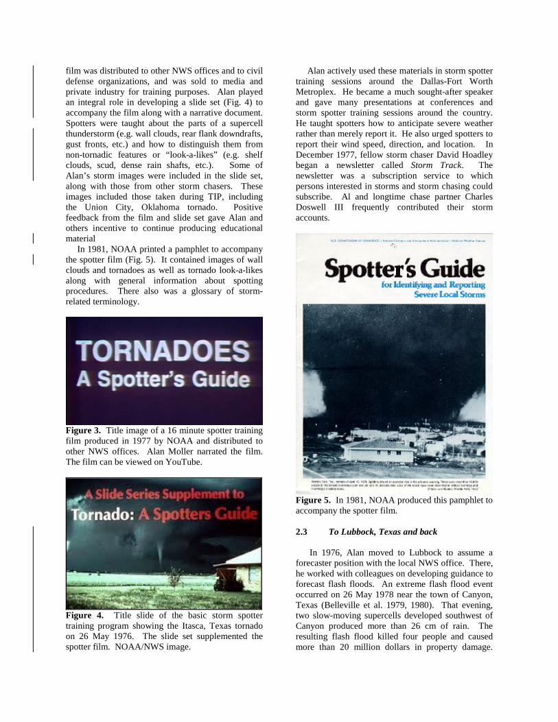
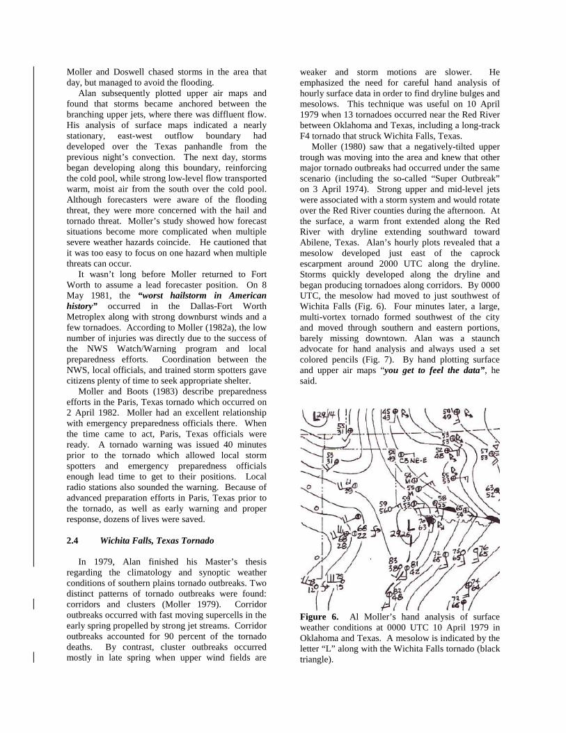
film was distributed to other NWS offices and to civil defense organizations, and was sold to media and private industry for training purposes. Alan played an integral role in developing a slide set (Fig. 4) to accompany the film along with a narrative document. Spotters were taught about the parts of a supercell thunderstorm (e.g. wall clouds, rear flank downdrafts, gust fronts, etc.) and how to distinguish them from non-tornadic features or “look-a-likes” (e.g. shelf clouds, scud, dense rain shafts, etc.). Some of Alan’s storm images were included in the slide set, along with those from other storm chasers. These images included those taken during TIP, including the Union City, Oklahoma tornado. Positive feedback from the film and slide set gave Alan and others incentive to continue producing educational material In 1981, NOAA printed a pamphlet to accompany the spotter film (Fig. 5). It contained images of wall clouds and tornadoes as well as tornado look-a-likes along with general information about spotting procedures. There also was a glossary of storm-related terminology.
Figure 3. Title image of a 16 minute spotter training film produced in 1977 by NOAA and distributed to other NWS offices. Alan Moller narrated the film. The film can be viewed on YouTube.
Figure 4. Title slide of the basic storm spotter training program showing the Itasca, Texas tornado on 26 May 1976. The slide set supplemented the spotter film. NOAA/NWS image.
Alan actively used these materials in storm spotter training sessions around the Dallas-Fort Worth Metroplex. He became a much sought-after speaker and gave many presentations at conferences and storm spotter training sessions around the country. He taught spotters how to anticipate severe weather rather than merely report it. He also urged spotters to report their wind speed, direction, and location. In December 1977, fellow storm chaser David Hoadley began a newsletter called Storm Track. The newsletter was a subscription service to which persons interested in storms and storm chasing could subscribe. Al and longtime chase partner Charles Doswell III frequently contributed their storm accounts.
Figure 5. In 1981, NOAA produced this pamphlet to accompany the spotter film. 2.3 To Lubbock, Texas and back In 1976, Alan moved to Lubbock to assume a forecaster position with the local NWS office. There, he worked with colleagues on developing guidance to forecast flash floods. An extreme flash flood event occurred on 26 May 1978 near the town of Canyon, Texas (Belleville et al. 1979, 1980). That evening, two slow-moving supercells developed southwest of Canyon produced more than 26 cm of rain. The resulting flash flood killed four people and caused more than 20 million dollars in property damage.
Moller and Doswell chased storms in the area that day, but managed to avoid the flooding. Alan subsequently plotted upper air maps and found that storms became anchored between the branching upper jets, where there was diffluent flow. His analysis of surface maps indicated a nearly stationary, east-west outflow boundary had developed over the Texas panhandle from the previous night’s convection. The next day, storms began developing along this boundary, reinforcing the cold pool, while strong low-level flow transported warm, moist air from the south over the cold pool. Although forecasters were aware of the flooding threat, they were more concerned with the hail and tornado threat. Moller’s study showed how forecast situations become more complicated when multiple severe weather hazards coincide. He cautioned that it was too easy to focus on one hazard when multiple threats can occur. It wasn’t long before Moller returned to Fort Worth to assume a lead forecaster position. On 8 May 1981, the “worst hailstorm in American history” occurred in the Dallas-Fort Worth Metroplex along with strong downburst winds and a few tornadoes. According to Moller (1982a), the low number of injuries was directly due to the success of the NWS Watch/Warning program and local preparedness efforts. Coordination between the NWS, local officials, and trained storm spotters gave citizens plenty of time to seek appropriate shelter. Moller and Boots (1983) describe preparedness efforts in the Paris, Texas tornado which occurred on 2 April 1982. Moller had an excellent relationship with emergency preparedness officials there. When the time came to act, Paris, Texas officials were ready. A tornado warning was issued 40 minutes prior to the tornado which allowed local storm spotters and emergency preparedness officials enough lead time to get to their positions. Local radio stations also sounded the warning. Because of advanced preparation efforts in Paris, Texas prior to the tornado, as well as early warning and proper response, dozens of lives were saved. 2.4 Wichita Falls, Texas Tornado In 1979, Alan finished his Master’s thesis regarding the climatology and synoptic weather conditions of southern plains tornado outbreaks. Two distinct patterns of tornado outbreaks were found: corridors and clusters (Moller 1979). Corridor outbreaks occurred with fast moving supercells in the early spring propelled by strong jet streams. Corridor outbreaks accounted for 90 percent of the tornado deaths. By contrast, cluster outbreaks occurred mostly in late spring when upper wind fields are
weaker and storm motions are slower. He emphasized the need for careful hand analysis of hourly surface data in order to find dryline bulges and mesolows. This technique was useful on 10 April 1979 when 13 tornadoes occurred near the Red River between Oklahoma and Texas, including a long-track F4 tornado that struck Wichita Falls, Texas. Moller (1980) saw that a negatively-tilted upper trough was moving into the area and knew that other major tornado outbreaks had occurred under the same scenario (including the so-called “Super Outbreak” on 3 April 1974). Strong upper and mid-level jets were associated with a storm system and would rotate over the Red River counties during the afternoon. At the surface, a warm front extended along the Red River with dryline extending southward toward Abilene, Texas. Alan’s hourly plots revealed that a mesolow developed just east of the caprock escarpment around 2000 UTC along the dryline. Storms quickly developed along the dryline and began producing tornadoes along corridors. By 0000 UTC, the mesolow had moved to just southwest of Wichita Falls (Fig. 6). Four minutes later, a large, multi-vortex tornado formed southwest of the city and moved through southern and eastern portions, barely missing downtown. Alan was a staunch advocate for hand analysis and always used a set colored pencils (Fig. 7). By hand plotting surface and upper air maps “you get to feel the data”, he said.
Figure 6. Al Moller’s hand analysis of surface weather conditions at 0000 UTC 10 April 1979 in Oklahoma and Texas. A mesolow is indicated by the letter “L” along with the Wichita Falls tornado (black triangle).
Figure 7. Alan hand analyzed weather maps using colored pencils. Note he liked to drink Dr. Pepper. Image by Tim Vasquez. 3. 1980’s - SERENDIPITY Alan was especially intrigued by those events that were not anticipated. So, if he made a successful forecast on a less than marginal chase day, it was extra special to him. He called it “serendipity”. He often said that making a correct forecast was only part of being successful. One also must have good luck. 3.1 The Borger, TX tornado Alan Moller loved to chase storms and would drive long distances to witness one. “The tornado was just a bonus”, he said. Moller saw both on 5 June 1982 near Borger, Texas. Early that morning, he targeted the Texas panhandle for supercell thunderstorms, while other chasers headed into western Kansas. Here are excerpts of Al Moller’s article from Storm Track (Moller, 1982b): “I had earlier decided on staying close to Amarillo and not chase from Dalhart into southwest Kansas, where there seemed to be stronger surface parameters. There was a very strong 700 mb cap over the entire area, with the strongest capping at Dodge City. Even though surface conditions were strong in Kansas, I didn't think they would have enough heating/surface convergence to break the strong cap (they didn't). The cap was enough at Amarillo, that I knew there would either be no thunderstorms or a few severe thunderstorms. By mid-afternoon, there was considerable cirrus overhead at Amarillo, with a break in the clouds to the northwest. I charged up State Road 1061 to
Boys Ranch and watched the first towering cumulus (TCu) bubble up on the dry line, in the clearing. Three storms developed. Initially, they all looked good, but all evolved into having the largest part of the rain-free base (RFB) and the hardest anvil edges on the northwest flank, as opposed to the southwest flank (not good)! They also raced rapidly north-northeast at 40 to 50 kts, too fast to keep up with and not at all like a slowing, right-moving supercell would do! After penetrating marble hail and brief, heavy rain from storm #3 east of Dumas, I eyeballed cell #4 to my south-southwest. I figured that either #4 would repeat the process of storms 1, 2 and 3 or show slower, more right-hand moving tendencies, and give some hope! It didn't take long to realize that the latter was coming true! I roared southward on State Road 207, encountering the northeast edge of the precipitation area out of storm #4, from north of Borger. The precipitation was marble-sized hail and scattered large raindrops, visibility was never less than 4 or 5 miles. As I broke out of the precipitation in southern Borger, I was greeted by a storm chasers dream (Fig. 8). The obviously cyclonically rotating storm was tossing out almost continuous staccato lightning bolts from the anvil into my immediate area. Thus, I stayed in the car while shooting the life cycle of a tornado. The tornado destroyed a rural house near Fritch, Texas. A small Rear Flank Downdraft (RFD) was visible wrapping around the first tornado. Apparently, the RFD pushed the bottom of the funnel northeastward, with the dissipating tornado tilting into the precipitation area, not away from it as most tornadoes do. The tornado was visible as a funnel/ tornado for about 6 or 7 minutes, as one of several 'funnels aloft' near Fritch. Most people still think that such an 'aloft' appearance means 'no touchdown'. I have been telling spotters to search for a damage track beneath any 'funnel aloft' and to expect damage in almost every case if the condensation cloud is at least halfway to the ground. After tornado #1 dissipated, I doubled back into Borger, catching golf ball hail, again mixed with scattered large rain drops. The rotating RFB and CB striations were more pronounced by this time, and the wall cloud was larger than with tornado #l. I expected a more substantial tornado, and I got it! A second, high-contrast tornado developed with full condensation to the ground (Fig. 9). Meanwhile, a pronounced RFD wrapped around the tornado, making its demise predictable. Luckily, both tornadoes missed Borger. After tornado #2 dissipated, the Borger storm weakened and continued to Miami, Texas.”
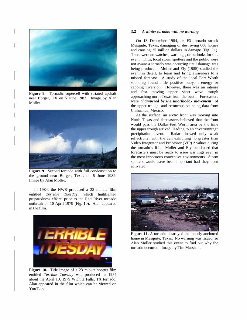
Figure 8. Tornadic supercell with striated updraft near Borger, TX on 5 June 1982. Image by Alan Moller.
Figure 9. Second tornado with full condensation to the ground near Borger, Texas on 5 June 1982. Image by Alan Moller. In 1984, the NWS produced a 23 minute film entitled Terrible Tuesday, which highlighted preparedness efforts prior to the Red River tornado outbreak on 10 April 1979 (Fig. 10). Alan appeared in the film.
Figure 10. Title image of a 23 minute spotter film entitled Terrible Tuesday was produced in 1984 about the April 10, 1979 Wichita Falls, TX tornado. Alan appeared in the film which can be viewed on YouTube.
3.2 A winter tornado with no warning On 13 December 1984, an F3 tornado struck Mesquite, Texas, damaging or destroying 600 homes and causing 25 million dollars in damage (Fig. 11). There were no watches, warnings, or outlooks for this event. Thus, local storm spotters and the public were not aware a tornado was occurring until damage was being produced. Moller and Ely (1985) studied the event in detail, to learn and bring awareness to a missed forecast. A study of the local Fort Worth sounding found little positive buoyant energy or capping inversion. However, there was an intense and fast moving upper short wave trough approaching north Texas from the south. Forecasters were “hampered by the unorthodox movement” of the upper trough, and erroneous sounding data from Chihuahua, Mexico. At the surface, an arctic front was moving into North Texas and forecasters believed that the front would pass the Dallas-Fort Worth area by the time the upper trough arrived, leading to an “overrunning” precipitation event. Radar showed only weak reflectivity, with the cell exhibiting no greater than Video Integrator and Processor (VIP) 2 values during the tornado’s life. Moller and Ely concluded that forecasters must be ready to issue warnings even in the most innocuous convective environments. Storm spotters would have been important had they been activated.
Figure 11. A tornado destroyed this poorly anchored home in Mesquite, Texas. No warning was issued, so Alan Moller studied this event to find out why the tornado occurred. Image by Tim Marshall.
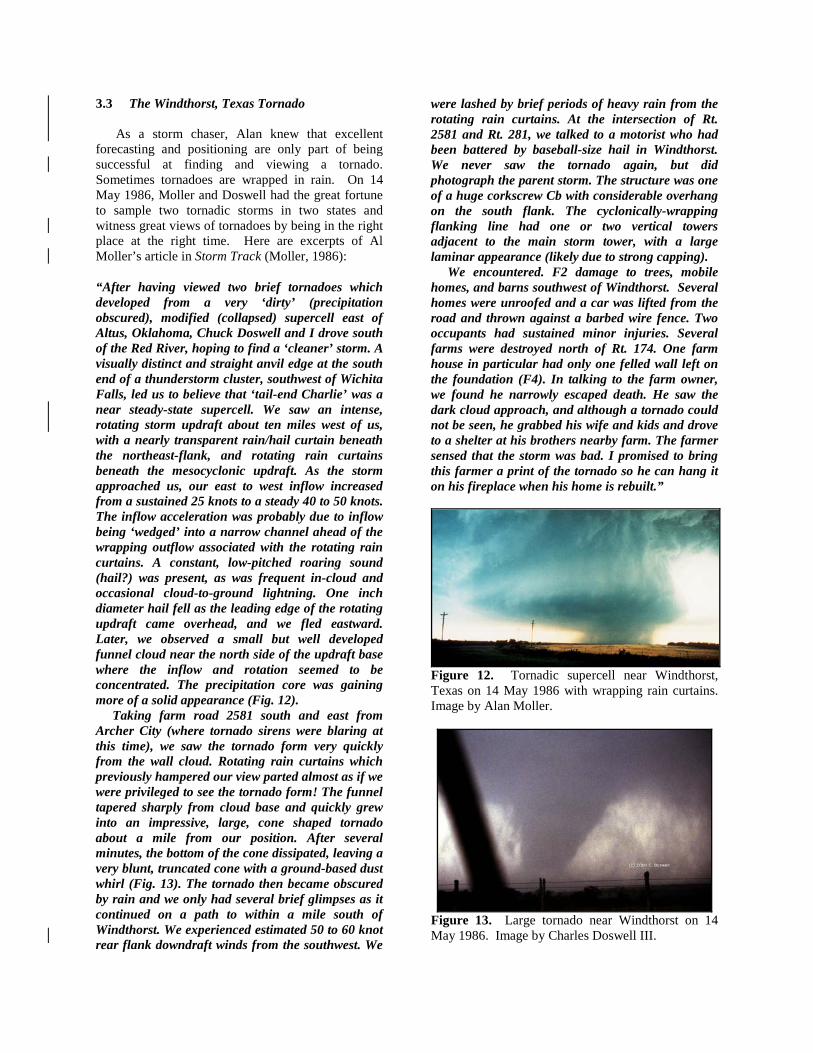
3.3 The Windthorst, Texas Tornado As a storm chaser, Alan knew that excellent forecasting and positioning are only part of being successful at finding and viewing a tornado. Sometimes tornadoes are wrapped in rain. On 14 May 1986, Moller and Doswell had the great fortune to sample two tornadic storms in two states and witness great views of tornadoes by being in the right place at the right time. Here are excerpts of Al Moller’s article in Storm Track (Moller, 1986): “After having viewed two brief tornadoes which developed from a very ‘dirty’ (precipitation obscured), modified (collapsed) supercell east of Altus, Oklahoma, Chuck Doswell and I drove south of the Red River, hoping to find a ‘cleaner’ storm. A visually distinct and straight anvil edge at the south end of a thunderstorm cluster, southwest of Wichita Falls, led us to believe that ‘tail-end Charlie’ was a near steady-state supercell. We saw an intense, rotating storm updraft about ten miles west of us, with a nearly transparent rain/hail curtain beneath the northeast-flank, and rotating rain curtains beneath the mesocyclonic updraft. As the storm approached us, our east to west inflow increased from a sustained 25 knots to a steady 40 to 50 knots. The inflow acceleration was probably due to inflow being ‘wedged’ into a narrow channel ahead of the wrapping outflow associated with the rotating rain curtains. A constant, low-pitched roaring sound (hail?) was present, as was frequent in-cloud and occasional cloud-to-ground lightning. One inch diameter hail fell as the leading edge of the rotating updraft came overhead, and we fled eastward. Later, we observed a small but well developed funnel cloud near the north side of the updraft base where the inflow and rotation seemed to be concentrated. The precipitation core was gaining more of a solid appearance (Fig. 12). Taking farm road 2581 south and east from Archer City (where tornado sirens were blaring at this time), we saw the tornado form very quickly from the wall cloud. Rotating rain curtains which previously hampered our view parted almost as if we were privileged to see the tornado form! The funnel tapered sharply from cloud base and quickly grew into an impressive, large, cone shaped tornado about a mile from our position. After several minutes, the bottom of the cone dissipated, leaving a very blunt, truncated cone with a ground-based dust whirl (Fig. 13). The tornado then became obscured by rain and we only had several brief glimpses as it continued on a path to within a mile south of Windthorst. We experienced estimated 50 to 60 knot rear flank downdraft winds from the southwest. We
were lashed by brief periods of heavy rain from the rotating rain curtains. At the intersection of Rt. 2581 and Rt. 281, we talked to a motorist who had been battered by baseball-size hail in Windthorst. We never saw the tornado again, but did photograph the parent storm. The structure was one of a huge corkscrew Cb with considerable overhang on the south flank. The cyclonically-wrapping flanking line had one or two vertical towers adjacent to the main storm tower, with a large laminar appearance (likely due to strong capping). We encountered. F2 damage to trees, mobile homes, and barns southwest of Windthorst. Several homes were unroofed and a car was lifted from the road and thrown against a barbed wire fence. Two occupants had sustained minor injuries. Several farms were destroyed north of Rt. 174. One farm house in particular had only one felled wall left on the foundation (F4). In talking to the farm owner, we found he narrowly escaped death. He saw the dark cloud approach, and although a tornado could not be seen, he grabbed his wife and kids and drove to a shelter at his brothers nearby farm. The farmer sensed that the storm was bad. I promised to bring this farmer a print of the tornado so he can hang it on his fireplace when his home is rebuilt.”
Figure 12. Tornadic supercell near Windthorst, Texas on 14 May 1986 with wrapping rain curtains. Image by Alan Moller.
Figure 13. Large tornado near Windthorst on 14 May 1986. Image by Charles Doswell III.

3.4 Advanced Severe Storm Spotter Training The basic spotter training course taught students how to recognize certain severe storm features including tornado look-a-likes. However, Moller and Doswell (1988a, 1988b) wanted to take this a step further and teach spotters about the various types of severe storms as well as the ingredients needed to produce them. So they developed an advanced severe storm spotter training course in 1988 (Fig. 14). The course consisted of 170 slides with an expanded narrative document. Explanatory graphics were added, and their quality was improved. Moller and Doswell saw the need to give storm spotters more comprehensive knowledge of storm structure, evolution, and associated impact to help spotters better anticipate associated hazards. The advanced spotter training course began with the introduction of the thunderstorm spectrum illustrating the four major types of storms: single cell, multicell cluster, multicell line, and supercell (Fig. 15). Examples of each storm type were shown with emphasis on the fact that storms were part of a continuous spectrum, involving hybrids that could change from one type to another. Three types of supercells were presented: low precipitation, classic, and high precipitation (Fig. 16). In addition, the types of storm environments also were presented with discussions of directional and speed shear, and updraft strength. In addition, Doswell et al. (1990) and Moller et al. (1990, 1994) presented these conceptual models of thunderstorm structure to the scientific community. They believed it was important to bridge the gap between academic interests and storm spotters.
Figure 14. Title slide of the advanced storm spotter training program showing the Cordell, Oklahoma tornado on 22 May 1981. The slide set was accompanied by an expanded narrative document. NOAA/NWS image.
Figure 15. The advanced severe storm spotter course presented thunderstorms as part of a continuous spectrum rather than just discrete types. NOAA/NWS image.
Figure 16. Three types of supercells presented in the Advanced Severe Storm Spotter Training Course: a) low precipitation, b) classic, and c) high precipitation. NOAA/NWS images.

3.5 Hodges, Texas Tornado It was another chase day along the Texas dryline on 13 May 1989 but what happened near Hodges, Texas made this date last forever in the minds of many chasers, including Alan Moller. That morning, a Moderate Risk of severe thunderstorms was forecasted for north-central Texas by the Severe Local Storms Unit (SELS). A synoptic scale upper trough was located in the Rocky Mountains, forcing the jet stream south over Arizona and New Mexico. Southerly low-level flow brought plenty of moisture east of the dryline. With increasing southwesterly winds aloft, there was ample speed and directional shear for storms to rotate. By afternoon, several storms initiated on the dryline and chasers set out to pick their storm. Alan Moller and Charles Doswell III proceeded to a small town near Abilene, Texas and watched a relatively high-based storm develop, meeting a number of other chasers including David Hoadley, Arjen Verkaik, Roy Britt, Phil Sherman, and Tim Marshall. At 2325 UTC, a funnel descended from the cloud base while a dirt whirl formed at the ground. Moller exclaimed his characteristic phrase: “Look at that!” (Fig. 17). Soon, a double-walled tornado formed less than 1 km to the northwest and moved slowly to the south. The tornado emerged from behind some trees (where it destroyed a mobile home) and then became stationary in an open field. Meanwhile, the storm continued to drift eastward causing the tornado to stretch and bend into a long, contorted rope that lasted several minutes (Fig. 18). The tornado was given an F2 rating based on the destruction of a mobile home (NOAA, 1982).
Figure 17. Alan Moller photographing the Hodges, TX tornado on 13 May 1989. Image by Tim Marshall.
Figure 18. Contorted rope tornado near Hodges, Texas on 13 May 1989. Image by David Hoadley. 4. 1990’s – NWS MODERNIZATION The 1990’s were a decade of modernization for the National Weather Service. A network of Doppler radars had become operational across the U.S. along with advanced computer technology. This benefitted the operational and warning process. It was a perfect time to develop an integrated warning system (IWS). Moller and Doswell (1993) noted that spotters were just one component of an IWS, which is composed of four basic elements: forecast, detection, dissemination, and public response. These elements were like links of a chain; a weak or broken link would constitute a failure to warn. However, as Moller (1999) noted, better detection also can lead to more false alarms. The new Doppler radars were able to detect considerably more mid-level mesocyclones than the older radars. So, Al worked to improve all aspects of the IWS. 4.1 Advanced Spotters’ Field Guide In 1992, NOAA (1992) distributed a four-color brochure to accompany the advanced severe storm spotter training slide set (Fig. 19). Moller and Doswell provided extensive review of the guide’s draft version and contributed photographs. It was during this time that Alan participated in major pieces of media coverage regarding forecasting storms, storm spotting, and chasing. He expressed concern at the popularity of storm chasing and how the roads were becoming more crowded with irresponsible chasers. He wrote an extended article about storm chase ethics in Storm Track (Moller, 1992).
Figure 19. Alan Moller and Charles Doswell III assisted Gary Woodall in developing the advanced spotters’ field guide published by NOAA in 1992. The cover image is the Red Rock, Oklahoma tornado photographed by Alan Moller on 26 April 1991 shortly before it crossed Interstate 35. 4.2 Texas Severe Storms Association (TESSA) In 1993, Martin Lisius, a storm chaser in the Dallas-Fort Worth area formed the Texas Severe Storms Association (TESSA). The purpose of this non-profit group was to educate the public on the threats posed by severe storms. The conference was held annually and Alan was a frequent speaker (Figs. 20 and 21). To reach a wider audience, TESSA sought funding from the National Weather Service and then co-produced a 30 minute training video entitled StormWatch in 1995 (Fig. 22a). Alan Moller and colleague Gary Woodall assisted in the production of this video. The cover image is from a photograph of the Dallas, Texas tornado on 2 April 1957. A second video entitled The Chasers of Tornado Alley also was produced by TESSA in 1995 and included Alan Moller and Charles Doswell III chasing the Pampa, Texas tornadoes (Fig. 22b). The cover image was shot by Alan as the tornado was churning through town on 8 June 1995. On 10 March 1995, The Weather Channel hosted a Storm Chasers Conference in Norman, Oklahoma, and about 200 storm chasers attended from around the United States. The StormWatch video debuted at this conference. Later that year, the National Weather Association (NWA) presented TESSA with a Media Award for outstanding contribution in providing weather education to the public.
Figure 20. Alan Moller speaking at a TESSA meeting. Image by Sam Barricklow.
Figure 21. Participants at a TESSA meeting, from left-to-right: Carson Eads, Alan Moller, Sam Barricklow, Roger Edwards, and Tim Marshall.
Figure 22. Covers of videos produced by TESSA starring Alan Moller, Charles Doswell III, and others in 1995: a) StormWatch and b) The Chasers of Tornado Alley.
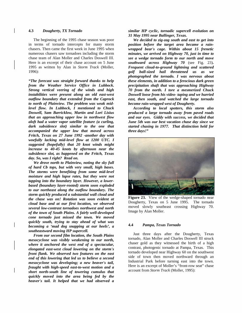
4.3 Dougherty, TX Tornado The beginning of the 1995 chase season was poor in terms of tornado intercepts for many storm chasers. Then came the first week in June 1995 when numerous chasers saw tornadoes including the storm chase team of Alan Moller and Charles Doswell III. Here is an excerpt of their chase account on 5 June 1995 as written by Alan in Storm Track (Moller, 1996): “The forecast was straight forward thanks to help from the Weather Service Office in Lubbock. Strong vertical veering of the winds and high instabilities were present along an old east-west outflow boundary that extended from the Caprock to north of Plainview. The problem was weak mid-level flow. In Lubbock, I mentioned to Chuck Doswell, Sam Barricklow, Martin and Lori Lisius that an approaching upper low in northwest flow aloft had a water vapor satellite feature (a curling, dark subsidence slot) similar to the one that accompanied the upper low that moved across Fritch, Texas on 27 June 1992 -another day with woefully lacking mid-level flow at 1200 UTC. I suggested (hopefully) that 20 knot winds might increase to 40-45 knots by afternoon near the subsidence slot, as happened on the Fritch, Texas day. So, was I right? Read on. We drove north to Plainview, noting the sky full of hard Cb tops, but with very small, high bases. The storms were benefiting from some mid-level moisture and high lapse rates, but they were not tapping into the boundary layer. However, a lower-based (boundary layer-rooted) storm soon exploded to our northeast along the outflow boundary. The storm quickly produced a substantial wall cloud and the chase was on! Rotation was soon evident at cloud base and at our first location, we observed several low-contrast tornadoes northwest and north of the town of South Plains. A fairly well-developed cone tornado just missed the town. We moved quickly south, trying to stay ahead of what was becoming a ‘mad dog snapping at our heels’, a southeastward moving HP supercell. From our second film location, the South Plains mesocyclone was visibly weakening to our north, where it anchored the west end of a spectacular, elongated east-west cloud lowering on the storm's front flank. We observed two features on the east end of this lowering that led us to believe a second mesocyclone was developing; a new beaver's tail, fraught with high-speed east-to-west motion and a short north-south line of towering cumulus that quickly moved into the area being fed by the heaver's tail. It helped that we had observed a
similar HP cyclic, tornadic supercell evolution on 31 May 1995 near Ballinger, Texas. We decided to zig-zag south and east to get into position before the target area became a rain-wrapped bear's cage. Within about 15 frenetic minutes, we arrived on Highway 70, just in time to see a wedge tornado form to our north and move southward across Highway 70 (see Fig. 23). Frequent cloud-to-ground lightning and scattered golf ball-sized hail threatened us as we photographed the tornado. I was nervous about these elements, in addition to a ferocious dark green precipitation shaft that was approaching Highway 70 from the north. I tore a mesmerized Chuck Doswell loose from his video- taping and we hurried east, then south, and watched the large tornado become rain-wrapped west of Dougherty. According to local spotters, this storm also produced a large tornado away from paved roads and our eyes. Giddy with success, we decided that June 5th was our best vacation chase day since we started chasing in 1977. That distinction held for three days!”
Figure 23. View of the wedge-shaped tornado near Dougherty, Texas on 5 June 1995. The tornado moved slowly southeast crossing Highway 70. Image by Alan Moller. 4.4 Pampa, Texas Tornado Just three days after the Dougherty, Texas tornado, Alan Moller and Charles Doswell III struck chaser gold as they witnessed the birth of a high contrast, photogenic tornado at Pampa, Texas. This tornado developed near Highway 60 on the southwest side of town then moved northward through an Industrial Park before turning east into the town. Here is an excerpt of Moller’s “front-row seat” chase account from Storm Track (Moller, 1995):

“We received extremely helpful information from phone calls to Mike Branick, and Harold Brooks in Norman. The first conversation brought us south from Lamar, Colorado (where Chuck, Sam Barricklow, and I witnessed several beautiful supercells the evening before) towards a triple point low Mike said was forecast to be in the extreme northeast panhandle at 0000 UTC. The prognostications turned out to be fast with the surface low's position. We decided to drive south towards Dumas, instead of southeast into the Oklahoma Panhandle, to approach storms from the clear air mass behind the dry line, rather than from the low visibility, stratus-laden air mass across the OK Panhandle. That was a fortunate decision, since we never would have made it in time for Pampa if we had taken the southeast route. A line of scattered, rapidly developing Cb's, already with visual right-flank overhang, was to our east as we arrived in Dumas. Unfortunately, Sam had to drop out temporarily, owing to a driver's side window that ‘dropped out’ of his van on the trip out of Colorado. Weak, rear-flank convection began to mask the Cb tops as we drove into Stinnett, making it difficult to pick a target storm. So we called Harold Brooks. He said that three storms to our east had mesocyclones and suggested that we drive down Hwy 152 to pursue tail-end Charlie. We saw a dense precipitation curtain to the east and a large, rounded rain-free base to the south as we entered the outskirts of Pampa. A funnel cloud was dangling beneath the Cb base! The funnel cloud dissipated, but a wall cloud formed quickly to our SSE as we turned south on FM road 282 in west Pampa. Dust whirls and frequent, short-lived ground-based condensation tubes were visible beneath the roiling wall cloud. We pointed out the developing tornado to a Pampa policeman and he zoomed toward it as debris became more apparent. Unknown to us, sirens had already been activated in Pampa. The developing tornado initially moved northwest and then west, passing within a mile south of our position, which was about midway between Highways 152 and 60. We drove to the Hwy 60/282 intersection, then watched in awe as the circulation intensified into a full-blown tornado and turned north across Hwy 60 and the railroad tracks. From our location the photographic contrast was excellent - the core of the tornado was dark with light-fringed edges and a bright background. I have only dreamed of such a photogenic view! Chuck zoomed in with the video camera at the right moment, as if he knew he was about to capture the
very sudden and dramatic example of tornado intensification from about a third of a mile. We made a U-turn and moved north on 282, paralleling the tornado as it began to pick up considerable debris. The spin of its compacted debris cloud intensified to about one revolution per second. The tornado entered an industrial district in west Pampa, with high speed motions continuing in its central, wedge-shaped debris cloud. Considerable lightweight roof and building material floated skyward into a less dense, outer debris cloud. I shot with a normal lens at 1/250th of a second (wide open at F1.4), freezing debris in the photos (see Figs. 24 through 26). Chuck's video at this time ranks with the best ‘whirling debris’ videos and films I have seen. The tornado sounded like a loud waterfall as it moved about 1/2 mile northwest and north of us. What had been a dark funnel began to reflect skylight, turning milky white as it moved to our northeast. At this time we captured tornado #2 (forming in the distance near Hoover) in the same frame as tornado #1. After the Pampa tornado dissipated, we spent eight minutes steering clear of emergency vehicles and exited Pampa, so that we could chase the Hoover tornado. Apparently we were so stunned by the Pampa-Hoover tornado event that we played a futile game of catch-up to other tornadic storms the rest of the day.”
Figure 24. Alan Moller talks about his close encounter with the Pampa, TX tornado on 8 June 1995. This image hangs on the wall at the NWS in Fort Worth. Photo by William T. Reid.
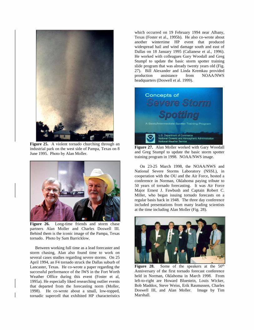
Figure 25. A violent tornado churching through an industrial park on the west side of Pampa, Texas on 8 June 1995. Photo by Alan Moller.
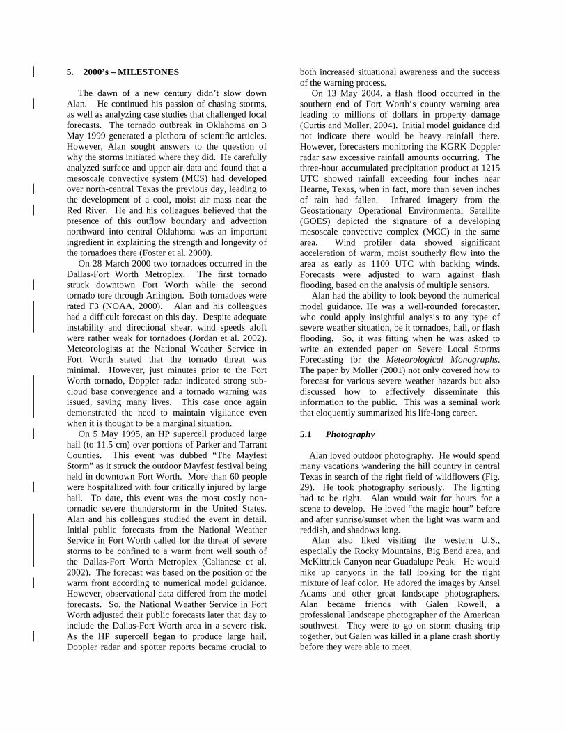
Figure 26. Long-time friends and storm chase partners Alan Moller and Charles Doswell III. Behind them is the iconic image of the Pampa, Texas tornado. Photo by Sam Barricklow. Between working full time as a lead forecaster and storm chasing, Alan also found time to work on several cases studies regarding severe storms. On 25 April 1994, an F4 tornado struck the Dallas suburb of Lancaster, Texas. He co-wrote a paper regarding the successful performance of the IWS in the Fort Worth Weather Office during this event (Foster et al, 1995a). He especially liked researching outlier events that departed from the forecasting norm (Moller, 1998). He co-wrote about a small, low-topped, tornadic supercell that exhibited HP characteristics
which occurred on 19 February 1994 near Albany, Texas (Foster et al., 1995b). He also co-wrote about another wintertime HP event that produced widespread hail and wind damage south and east of Dallas on 18 January 1995 (Calianese et al., 1996). He worked with colleagues Gary Woodall and Greg Stumpf to update the basic storm spotter training slide program that was already twenty years old (Fig. 27). Bill Alexander and Linda Kremkau provided production assistance from NOAA/NWS headquarters (Doswell et al. 1999).
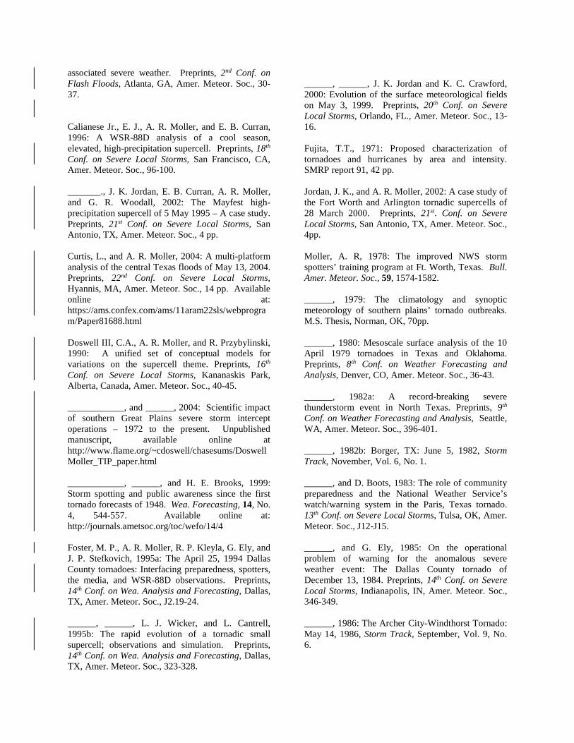
Figure 27. Alan Moller worked with Gary Woodall and Greg Stumpf to update the basic storm spotter training program in 1998. NOAA/NWS image. On 23-25 March 1998, the NOAA/NWS and National Severe Storms Laboratory (NSSL), in cooperation with the OU and the Air Force, hosted a conference in Norman, Oklahoma paying tribute to 50 years of tornado forecasting. It was Air Force Major Ernest J. Fawbush and Captain Robert C. Miller, who began issuing tornado forecasts on a regular basis back in 1948. The three day conference included presentations from many leading scientists at the time including Alan Moller (Fig. 28).
Figure 28. Some of the speakers at the 50th Anniversary of the first tornado forecast conference held in Norman, Oklahoma in March 1998. From left-to-right are Howard Bluestein, Louis Wicker, Bob Maddox, Steve Weiss, Erik Rasmussen, Charles Doswell III, and Alan Moller. Image by Tim Marshall.
5. 2000’s – MILESTONES The dawn of a new century didn’t slow down Alan. He continued his passion of chasing storms, as well as analyzing case studies that challenged local forecasts. The tornado outbreak in Oklahoma on 3 May 1999 generated a plethora of scientific articles. However, Alan sought answers to the question of why the storms initiated where they did. He carefully analyzed surface and upper air data and found that a mesoscale convective system (MCS) had developed over north-central Texas the previous day, leading to the development of a cool, moist air mass near the Red River. He and his colleagues believed that the presence of this outflow boundary and advection northward into central Oklahoma was an important ingredient in explaining the strength and longevity of the tornadoes there (Foster et al. 2000). On 28 March 2000 two tornadoes occurred in the Dallas-Fort Worth Metroplex. The first tornado struck downtown Fort Worth while the second tornado tore through Arlington. Both tornadoes were rated F3 (NOAA, 2000). Alan and his colleagues had a difficult forecast on this day. Despite adequate instability and directional shear, wind speeds aloft were rather weak for tornadoes (Jordan et al. 2002). Meteorologists at the National Weather Service in Fort Worth stated that the tornado threat was minimal. However, just minutes prior to the Fort Worth tornado, Doppler radar indicated strong sub-cloud base convergence and a tornado warning was issued, saving many lives. This case once again demonstrated the need to maintain vigilance even when it is thought to be a marginal situation. On 5 May 1995, an HP supercell produced large hail (to 11.5 cm) over portions of Parker and Tarrant Counties. This event was dubbed “The Mayfest Storm” as it struck the outdoor Mayfest festival being held in downtown Fort Worth. More than 60 people were hospitalized with four critically injured by large hail. To date, this event was the most costly non-tornadic severe thunderstorm in the United States. Alan and his colleagues studied the event in detail. Initial public forecasts from the National Weather Service in Fort Worth called for the threat of severe storms to be confined to a warm front well south of the Dallas-Fort Worth Metroplex (Calianese et al. 2002). The forecast was based on the position of the warm front according to numerical model guidance. However, observational data differed from the model forecasts. So, the National Weather Service in Fort Worth adjusted their public forecasts later that day to include the Dallas-Fort Worth area in a severe risk. As the HP supercell began to produce large hail, Doppler radar and spotter reports became crucial to
both increased situational awareness and the success of the warning process. On 13 May 2004, a flash flood occurred in the southern end of Fort Worth’s county warning area leading to millions of dollars in property damage (Curtis and Moller, 2004). Initial model guidance did not indicate there would be heavy rainfall there. However, forecasters monitoring the KGRK Doppler radar saw excessive rainfall amounts occurring. The three-hour accumulated precipitation product at 1215 UTC showed rainfall exceeding four inches near Hearne, Texas, when in fact, more than seven inches of rain had fallen. Infrared imagery from the Geostationary Operational Environmental Satellite (GOES) depicted the signature of a developing mesoscale convective complex (MCC) in the same area. Wind profiler data showed significant acceleration of warm, moist southerly flow into the area as early as 1100 UTC with backing winds. Forecasts were adjusted to warn against flash flooding, based on the analysis of multiple sensors. Alan had the ability to look beyond the numerical model guidance. He was a well-rounded forecaster, who could apply insightful analysis to any type of severe weather situation, be it tornadoes, hail, or flash flooding. So, it was fitting when he was asked to write an extended paper on Severe Local Storms Forecasting for the Meteorological Monographs. The paper by Moller (2001) not only covered how to forecast for various severe weather hazards but also discussed how to effectively disseminate this information to the public. This was a seminal work that eloquently summarized his life-long career. 5.1 Photography Alan loved outdoor photography. He would spend many vacations wandering the hill country in central Texas in search of the right field of wildflowers (Fig. 29). He took photography seriously. The lighting had to be right. Alan would wait for hours for a scene to develop. He loved “the magic hour” before and after sunrise/sunset when the light was warm and reddish, and shadows long. Alan also liked visiting the western U.S., especially the Rocky Mountains, Big Bend area, and McKittrick Canyon near Guadalupe Peak. He would hike up canyons in the fall looking for the right mixture of leaf color. He adored the images by Ansel Adams and other great landscape photographers. Alan became friends with Galen Rowell, a professional landscape photographer of the American southwest. They were to go on storm chasing trip together, but Galen was killed in a plane crash shortly before they were able to meet.

Alan showed his images at severe storm conferences: a mixture of pastoral scenes with beautiful sunsets, flowers, and windmills as well as distant thunderheads, lightning, and tornadoes. A selection of his photographs never failed to elicit "ooohs” and "aaahs" from the audience. He also used a medium format panoramic camera and shot hundreds of breathtaking photographs, which he kept in plastic sleeves. Occasionally, he would get together with fellow storm chasers and show his latest accomplishments. His images would come alive, when backlit on a light table, making all of us wish we were with him when he shot them.
Figure 29. Alan Moller loved photography, especially capturing wildflowers in spring. Image by Charles Doswell III. 5.2 Retirement Alan Moller retired from public service in 2009 after more than 30 years of employment. A formal retirement dinner was held in his honor on 20 February 2009 at a local restaurant. NWS Southern Region Director Bill Proenza started the tributes. Gary Woodall presented Alan with a bent garden hose mounted on a plaque (Fig 30). Alan used the garden hose in his spotter talks to illustrate the tilting of horizontal vortex tubes, which causes storms to rotate. Longtime friend and colleague Larry Mooney presented Alan with autographed baseball of which Alan was a fan. The first storm chaser and Storm Track editor, David Hoadley expressed great admiration for Alan as a fellow storm chaser and friend. David drove all the way from Virginia for the occasion. Colleague Stacie Hatcher Hanes flew in from Maine to play guitar and entertain the crowd along with her Dryline Band. Martin Lisius with TESSA presented Alan with a certificate signed by the Texas governor thanking him for his outstanding contributions as a public servant (Fig. 31). Martin also announced that TESSA had established the Alan R. Moller Severe Weather Education and Research
Scholarship to be awarded to the college with the most students that attended a TESSA meeting. That March, Texas A & M University students were the first to receive the award and Alan Moller was there to present it (Fig. 32). David Hoadley drew a sketch of Alan conducting storm spotter training that was printed on t-shirts and sold at the 2009 TESSA meeting (Fig. 33).
Figure 30. Gary Woodall presented Alan Moller with a garden hose prop that Al used during his spotter talks to simulate the bending of vortex tubes. Image by Charles Doswell III.
Figure 31. A certificate signed by Governor Rick Perry thanking Alan Moller for his outstanding public service contributions presented to him at his retirement party. Image by Charles Doswell III.
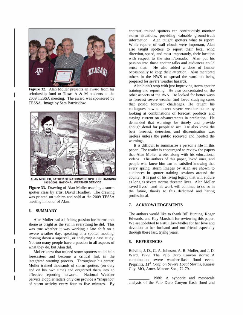
Figure 32. Alan Moller presents an award from his scholarship fund to Texas A & M students at the 2009 TESSA meeting. The award was sponsored by TESSA. Image by Sam Barricklow.
Figure 33. Drawing of Alan Moller teaching a storm spotter class by artist David Hoadley. The drawing was printed on t-shirts and sold at the 2009 TESSA meeting in honor of Alan. 6. SUMMARY Alan Moller had a lifelong passion for storms that shone as bright as the sun in everything he did. This was true whether it was working a late shift on a severe weather day, speaking at a spotter meeting, chasing down a supercell, or analyzing a case study. Not too many people have a passion in all aspects of what they do, but Alan did. Moller knew that trained storm spotters could help forecasters and become a critical link in the integrated warning process. Throughout his career, Moller trained thousands of storm spotters (on duty and on his own time) and organized them into an effective reporting network. National Weather Service Doppler radars only can provide a “snapshot” of storm activity every four to five minutes. By
contrast, trained spotters can continuously monitor storm situations, providing valuable ground-truth information. Alan taught spotters what to report. While reports of wall clouds were important, Alan also taught spotters to report their local wind direction, speed, and most importantly, their location with respect to the storm/tornado. Alan put his passion into those spotter talks and audiences could sense that. He also added a dose of humor occasionally to keep their attention. Alan mentored others in the NWS to spread the word on being prepared for severe weather hazards. Alan didn’t stop with just improving storm spotter training and reporting. He also concentrated on the other aspects of the IWS. He looked for better ways to forecast severe weather and loved studying cases that posed forecast challenges. He taught his colleagues how to detect severe weather better by looking at combinations of forecast products and staying current on advancements in prediction. He demanded that warnings be timely and provide enough detail for people to act. He also knew the best forecast, detection, and dissemination was useless unless the public received and heeded the warnings. It is difficult to summarize a person’s life in this paper. The reader is encouraged to review the papers that Alan Moller wrote, along with his educational videos. The authors of this paper, loved ones, and people who knew him can be satisfied knowing that every spring, storm images by Alan are shown to audiences in spotter training sessions around the county. It is part of his living legacy that will endure as long as severe storms threaten lives. Alan Moller saved lives – and his work will continue to do so in the future, thanks to this dedicated and caring professional. 7. ACKNOWLEDGEMENTS The authors would like to thank Bill Bunting, Roger Edwards, and Kay Marshall for reviewing this paper. We are indebted to Patti Clay-Moller for her love and devotion to her husband and our friend especially through these last, trying years. 8. REFERENCES Belville, J. D., G. A. Johnson, A. R. Moller, and J. D. Ward, 1979: The Palo Duro Canyon storm: A combination severe weather-flash flood event. Preprints, 11th Conf. on Severe Local Storms, Kansas City, MO, Amer. Meteor. Soc., 72-79. __________, 1980: A synoptic and mesoscale analysis of the Palo Duro Canyon flash flood and
associated severe weather. Preprints, 2nd Conf. on Flash Floods, Atlanta, GA, Amer. Meteor. Soc., 30-37. Calianese Jr., E. J., A. R. Moller, and E. B. Curran, 1996: A WSR-88D analysis of a cool season, elevated, high-precipitation supercell. Preprints, 18th Conf. on Severe Local Storms, San Francisco, CA, Amer. Meteor. Soc., 96-100. _______., J. K. Jordan, E. B. Curran, A. R. Moller, and G. R. Woodall, 2002: The Mayfest high-precipitation supercell of 5 May 1995 – A case study. Preprints, 21st Conf. on Severe Local Storms, San Antonio, TX, Amer. Meteor. Soc., 4 pp. Curtis, L., and A. R. Moller, 2004: A multi-platform analysis of the central Texas floods of May 13, 2004. Preprints, 22nd Conf. on Severe Local Storms, Hyannis, MA, Amer. Meteor. Soc., 14 pp. Available online at: https://ams.confex.com/ams/11aram22sls/webprogram/Paper81688.html Doswell III, C.A., A. R. Moller, and R. Przybylinski, 1990: A unified set of conceptual models for variations on the supercell theme. Preprints, 16th Conf. on Severe Local Storms, Kananaskis Park, Alberta, Canada, Amer. Meteor. Soc., 40-45. ____________, and ______, 2004: Scientific impact of southern Great Plains severe storm intercept operations – 1972 to the present. Unpublished manuscript, available online at http://www.flame.org/~cdoswell/chasesums/DoswellMoller_TIP_paper.html ____________, ______, and H. E. Brooks, 1999: Storm spotting and public awareness since the first tornado forecasts of 1948. Wea. Forecasting, 14, No. 4, 544-557. Available online at: http://journals.ametsoc.org/toc/wefo/14/4 Foster, M. P., A. R. Moller, R. P. Kleyla, G. Ely, and J. P. Stefkovich, 1995a: The April 25, 1994 Dallas County tornadoes: Interfacing preparedness, spotters, the media, and WSR-88D observations. Preprints, 14th Conf. on Wea. Analysis and Forecasting, Dallas, TX, Amer. Meteor. Soc., J2.19-24. ______, ______, L. J. Wicker, and L. Cantrell, 1995b: The rapid evolution of a tornadic small supercell; observations and simulation. Preprints, 14th Conf. on Wea. Analysis and Forecasting, Dallas, TX, Amer. Meteor. Soc., 323-328.
______, ______, J. K. Jordan and K. C. Crawford, 2000: Evolution of the surface meteorological fields on May 3, 1999. Preprints, 20th Conf. on Severe Local Storms, Orlando, FL., Amer. Meteor. Soc., 13-16. Fujita, T.T., 1971: Proposed characterization of tornadoes and hurricanes by area and intensity. SMRP report 91, 42 pp. Jordan, J. K., and A. R. Moller, 2002: A case study of the Fort Worth and Arlington tornadic supercells of 28 March 2000. Preprints, 21st. Conf. on Severe Local Storms, San Antonio, TX, Amer. Meteor. Soc., 4pp. Moller, A. R, 1978: The improved NWS storm spotters’ training program at Ft. Worth, Texas. Bull. Amer. Meteor. Soc., 59, 1574-1582. ______, 1979: The climatology and synoptic meteorology of southern plains’ tornado outbreaks. M.S. Thesis, Norman, OK, 70pp. ______, 1980: Mesoscale surface analysis of the 10 April 1979 tornadoes in Texas and Oklahoma. Preprints, 8th Conf. on Weather Forecasting and Analysis, Denver, CO, Amer. Meteor. Soc., 36-43. ______, 1982a: A record-breaking severe thunderstorm event in North Texas. Preprints, 9th Conf. on Weather Forecasting and Analysis, Seattle, WA, Amer. Meteor. Soc., 396-401. ______, 1982b: Borger, TX: June 5, 1982, Storm Track, November, Vol. 6, No. 1. ______, and D. Boots, 1983: The role of community preparedness and the National Weather Service’s watch/warning system in the Paris, Texas tornado. 13th Conf. on Severe Local Storms, Tulsa, OK, Amer. Meteor. Soc., J12-J15. ______, and G. Ely, 1985: On the operational problem of warning for the anomalous severe weather event: The Dallas County tornado of December 13, 1984. Preprints, 14th Conf. on Severe Local Storms, Indianapolis, IN, Amer. Meteor. Soc., 346-349. ______, 1986: The Archer City-Windthorst Tornado: May 14, 1986, Storm Track, September, Vol. 9, No. 6.
______, 1992: Storm chase ethics, Storm Track, March, Vol. 15, No. 3. Available online at: http://www.cimms.ou.edu/~stumpf/cethics.html ______, 1995: Pampa, TX Tornado, Storm Track, November, Vol. 19, No. 1. ______, 1996: Dougherty, TX Tornado: June 5, 1995, Storm Track, January, Vol. 19, No. 2 ______, 1998: Severe local storm forecasting, 19th Conf. on Severe Local Storms, Minneapolis, MN, Amer. Meteor. Soc.,591. ______, 2001: Severe Local Storms Forecasting, Meteorological Monographs, Vol. 28, No. 50, 433-480. ______, and C. A. Doswell III, 1988a: A proposed advanced storm spotter’s training program, 15th Conf. on Severe Local Storms, Baltimore, MD, Amer. Meteor. Soc., 173 – 177. ______and_____________,1988b: Advanced Meteorologist/Spotter Training Slide Series. NWS Warning and Forecast Branch, Suitland, Maryland, 44 pp. ______, and __________, 1993: Some considerations of severe local storm product dissemination in the modernized and restructured National Weather Service. Preprints, 17th Conf. on Severe Local Storms, St. Louis, MO, Amer. Meteor. Soc., 375-379. ______, _____________, J. McGinley, S. Tegtmeier and R. Zipser, 1974: Field observations of the Union City tornado in Oklahoma. Weatherwise, 27, 68-77. ______, _____________, and R. Przybylinski, 1990: High precipitation supercells: A conceptual model and documentation. Preprints, 16th Conf. on Severe Local Storms, Kananaskis Park, Alberta, Canada, Amer. Meteor. Soc., 52-57. ______, ____________, M. P. Foster, and G. R. Woodall, 1994: The operational recognition of supercell thunderstorm environments and storm structures. Wea. Forecasting, 9, No. 3, 327-347. Available online at: http://journals.ametsoc.org/toc/wefo/9/3. NOAA, 1976: Storm Data, May. ______, 1982: Storm Data, May
NOAA, 1992: Advanced spotters guide, National Oceanic and Atmospheric Administration Booklet, 30p. Available online at: http://www.crh.noaa.gov/oax/skywarn/adv_spotters.pdf ______, 2000: Storm Data, March