559926.fm 13-06-07 13:14 k02 bj · is managed by the danish vts authority. 7. ... great belt vts....
TRANSCRIPT

Order No 488 of 31th May 2007
Schultz Grafisk
G:\Søfartsstyrelsen\Ordre\559926\Dokumenter\Dok\559926.fm 13-06-07 13:14 k02 bj
Order on the mandatory ship reporting system BELTREP and navigation under the East Bridge and West Bridge in the
Storebælt (Great Belt)1)
Pursuant to Section 1(1) and (3), Section 6 andSection 32 in the Act on Safety at Sea, cf. Con-solidated Order no. 627 of 26 July 2002, asamended by Act no. 547 of 8 June and Act no.567 of 9 June 2006 and by authority of the Min-ister of Economic and Business Affairs, the fol-lowing provisions are laid down in concert withthe Ministry of Defence:
1. - This order applies to Danish and foreignships.
2. - This order establishes provisions for navi-gation and procedure for participation in the shipreporting system BELTREP in the areas sur-rounding the fixed link across the Storebælt(Great Belt) and Hatter Barn in Samsø Belt.
(2) The ship reporting system BELTREP is ap-proved by the International Maritime Organisa-tion (IMO)2) and applies to the ships mentionedin Section 3(2).
The ship reporting system BELTREP
3. - To ensure shipping, the environment andthe fixed link across the Storebælt (Great Belt) inthe Eastern channel and the Western channel, aship reporting system called BELTREP has beenestablished.
(2) The following ships shall report to BEL-TREP:1) All ships with a gross tonnage of 50 or more.2) All ships with an air draught of 15 metres or
more.(3) Ships shall report when passing the report-
ing lines, cf. Section 4 and 5 or before departingfrom a port located in the BELTREP area.
4. - The area of the ship reporting system BEL-TREP, which covers the central and the northernpart of the Great Belt and the waters around Hat-ter Barn in Samsø Belt, is limited by the follow-ing reporting lines:1) A northern limit by a reporting line between
Fyn, Samsø and Sjælland connected by thefollowing points:
1) This Order contains provisions implementing article 5 (1) and article 7 (1) in Directive 2002/59/EC of the European Par-liament and of the Council of 27 June 2002 establishing a Community vessel traffic monitoring and information systemand repealing Council Directive 93/75/EEC, Official Journal 2002, L 208, p. 10.
Fyn: 55°36´.00 N, 010°38´.00 E (Korshavn)Samsø: 55°47´.00 N, 010°38´.00 E (East coast of Samsø)
56°00´.00 N, 010°56´.00 E (South east of Marthe Flak)Sjælland: 56°00´.00 N, 011°17´.00 E (Sjællands Odde)

2
G:\Søfartsstyrelsen\Ordre\559926\Dokumenter\Dok\559926.fm 13-06-07 13:14 k02 bj
2) A southern limit at the reporting line be-tween Sjælland, Omø and the east side ofLangeland connected by the followingpoints:
3) A southern limit at the reporting line be-tween the west side of Langeland and ThurøRev buoy connected by the following points:
(2) The area of limitation of BELTREP in no.1, 2 and 3 is shown on the chartlet, cf. appendix2.
5. - The BELTREP area is divided into twosectors which are separated by a reporting line atthe latitude 55°35´.00 N. (Fyns Hoved – Jam-merland Bugt).
(2) Sector 1 is located north of the latitude andsector 2 south of the latitude. Each sector has aVHF channel which shall be used at communica-tion as stated in appendix 1.
Vessel Traffic Service Great Belt VTS
6. - The Vessel Traffic Service Great Belt VTShas been established in connection with the man-datory ship reporting system BELTREP.
(2) The Vessel Traffic Service Great Belt VTSis managed by the Danish VTS authority.
7. - The guidelines provided in appendix 1shall be followed when communicating withGreat Belt VTS.
8. - Great Belt VTS provides the followingservices for shipping within the area mention inSection 4 (1):1) Broadcast of information of general interest
for shipping in the area concerning the traf-fic situation, marking, light house, condi-tions relating to wind and current, water lev-el, ice conditions and other matters related tonavigation and safety. Such general broad-casts will be transmitted on VHF channel 10or a channel appointed by Great Belt VTSsubsequent to previous announcement on
channel 16 as well as the working channels11 and 74. Furthermore, such reports can begiven on request by Great Belt VTS on aspecified channel.
2) Individual navigational assistance for aship’s decision-making with a view to avoidcollision with the Storebælt (Great Belt)bridges, collisions between ships andgroundings in areas difficult to navigate.
3) Recommend suitable anchorage for ships incases of breakdown, adverse weather, lowvisibility, changes in the indicated depth ofwater, etc. Anchorages are marked on nauti-cal charts covering the area as well on thechartlet in appendix 2.
(2) Information about specific matters regard-ing safety of navigation in the area will be broad-casted via VHF channel 10 or via a channel spec-ified by Great Belt VTS subsequent to previousannouncement on channel 16 as well as theworking channels 11 and 74.
(3) All ships in the BELTREP area shall mon-itor the working channels for the BELTREP re-porting system.
The East Bridge
9. - The bridge over the East channel is a sus-pension bridge connecting Sprogø and Sjælland.The bridge’s 2 connecting spans rest on 2 abut-ments, 2 anchor blocks and 19 bridge piers, 12towards Sjælland and 7 towards Sprogø. Thebridge piers are numbered from 2 to 26 startingfrom the Sjælland side.
(2) In the span between the 2 bridge towers,no. 16 and no. 17 a traffic separation system has
Stigsnæs: 55°12´.00 N, 011°15´.40 E (Gulf’s oil pier)Omø: 55°08´.40 N, 011°09´.00 E (Ørespids, Omø)
55°05´.00 N, 011°09´.00 E (South of Ørespids)Langeland: 55°05´.00 N, 010°56´.10 E (Snøde Øre)
Langeland: 55°00´.00 N, 010°48´.70 E (South of Korsebølle Rev)Thurø Rev: 55°01´.20 N, 010°44´.00 E (Thurø Rev buoy)

3
G:\Søfartsstyrelsen\Ordre\559926\Dokumenter\Dok\559926.fm 13-06-07 13:14 k02 bj
been established, cf. Appendix 3. The free verti-cal clearance at mean sea level between thebridge towers is 65 metres. The lowest free ver-tical clearance at mean sea level of each individ-ual bridge span is shown in the table, cf. appen-dix 4.
Navigation provisions and prohibitions in the Eastern Channel
10. - Navigation under the East Bridge is onlyallowed for ships with an air draught of less than65 metres.
(2) Ships of 20 metres or more in length shalluse the traffic lanes in the traffic separationscheme between Korsør and Sprogø.
(3) Ships of 20 metres or less in length andsailing vessels are recommended to avoid usingthe traffic lanes of the traffic separation schemebetween the two bridge towers of the East Bridgeand instead to use the adjacent connection spans.
(4) Fishing is prohibited in the northbound andsouthbound traffic lanes in the traffic separationscheme between Korsør and Sprogø, cf. appen-dix 3.
The West Bridge
11. - The West Bridge is a low-level bridgeconnecting the islands of Fyn and Sprogø. Itrests on 2 abutments and 62 bridge piers. Thebridge piers are numbered from 2 to 63 startingfrom Sprogø.
(2) The eastern navigation span of the WestBridge is established between piers 34 and 35,and the western navigation span is establishedbetween piers 37 and 38. The two navigationspans are separated by two unmarked bridgespans. The navigation spans have a width of 104metres. Over a width of 70 metres around thecentre of the navigation spans, the free verticalclearance is 18 metres at mean sea level, cf. ap-pendix 5.
Navigation provisions and prohibitions in the Western Channel
12. - Navigation through the West Bridge isonly allowed for vessels of less than 1,000 tonsdeadweight and ships with an air draught of lessthan 18 metres.
(2) All vessels of 50 gross tonnage and up-wards wishing to pass under the West Bridgeshall use the two marked navigation spans.
(3) Northbound vessels shall use the easternnavigation span and southbound vessels shalluse the western navigation span, cf. appendix 5.
(4) Anchoring and fishing is prohibited in thebuoyed navigation lanes through the WestBridge. This provision also applies to theselanes’ extension of 500 metres on the oppositeside of the bridge.
(5) Navigation at right angles to the general di-rection of traffic flow is prohibited off the navi-gation spans and within a distance of 500 metresfrom the bridge.
General prohibitions
13. - Making fast to and anchoring under eitherof the bridges is prohibited without prior consentof VTS Great Belt.
(2) Diving and unnecessary stay in the naviga-tional channels under either of the bridges is pro-hibited without prior consent of Great Belt VTS.
Penalties and entry into force, etc.
14. - Contravention of this order shall be pun-ishable by fine or imprisonment for up to oneyear.
(2) The penalty may increase to imprisonmentof up to 2 years if1) contravention has caused harm to life or
health or brought about the risk thereof,2) a ban or order has previously been issued re-
garding the same or equivalent circumstanc-es, or
3) contravention resulted in, or was intended toresult in, financial gain for the person con-cerned or for others.
(3) It shall be deemed particularly aggravatingcircumstances if young people under the age of18 have suffered harm to life or health or therehas been the risk thereof, cf. subsection 2, point1.
(4) If the profits gained through the contraven-tion are not confiscated, particular considerationshall be given to the size of the financial gain orintended financial gain when meting out the fine,including supplementary fines.
(5) Criminal liability may be incurred by com-panies etc. (legal entities) in accordance with therules of Chapter 5 of the Penal Code.
15. - This order enters into force on 1 July2007.
4
G:\Søfartsstyrelsen\Ordre\559926\Dokumenter\Dok\559926.fm 13-06-07 13:14 k02 bj
(2) Order no. 86 of 12 February 2004 on navi-gation through the East Bridge and the WestBridge in the Great Belt shall be repealed.
Danish Maritime Authority, 31th May 2007
ANDREAS NORDSETH
/ Carsten G. Jensen
2) Adopted by resolution MSC.230(82) on 5 December 2006: Adoption of amendments to existing mandatory ship report-ing system ”In the Storebælt (Great Belt) Traffic Area”.
5
G:\Søfartsstyrelsen\Ordre\559926\Dokumenter\Dok\559926.fm 13-06-07 13:14 k02 bj
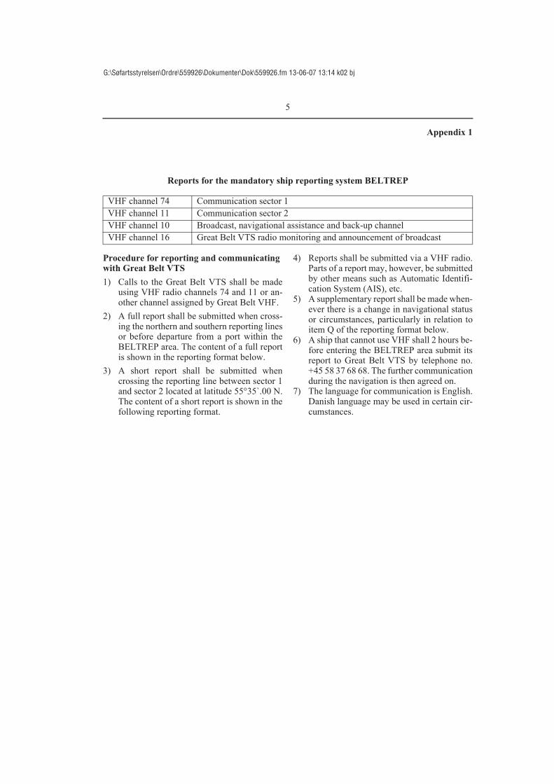
Appendix 1
Reports for the mandatory ship reporting system BELTREP
Procedure for reporting and communicating with Great Belt VTS1) Calls to the Great Belt VTS shall be made
using VHF radio channels 74 and 11 or an-other channel assigned by Great Belt VHF.
2) A full report shall be submitted when cross-ing the northern and southern reporting linesor before departure from a port within theBELTREP area. The content of a full reportis shown in the reporting format below.
3) A short report shall be submitted whencrossing the reporting line between sector 1and sector 2 located at latitude 55°35`.00 N.The content of a short report is shown in thefollowing reporting format.
4) Reports shall be submitted via a VHF radio.Parts of a report may, however, be submittedby other means such as Automatic Identifi-cation System (AIS), etc.
5) A supplementary report shall be made when-ever there is a change in navigational statusor circumstances, particularly in relation toitem Q of the reporting format below.
6) A ship that cannot use VHF shall 2 hours be-fore entering the BELTREP area submit itsreport to Great Belt VTS by telephone no.+45 58 37 68 68. The further communicationduring the navigation is then agreed on.
7) The language for communication is English.Danish language may be used in certain cir-cumstances.
VHF channel 74 Communication sector 1VHF channel 11 Communication sector 2VHF channel 10 Broadcast, navigational assistance and back-up channelVHF channel 16 Great Belt VTS radio monitoring and announcement of broadcast

6
G:\Søfartsstyrelsen\Ordre\559926\Dokumenter\Dok\559926.fm 13-06-07 13:14 k02 bj
FULL REPORT
SHORT REPORT
Designator Function Information requiredA Ship Name of the ship, call sign and IMO identification number
(if available)C Position A 4-digit group giving latitude in degrees and minutes suf-
fixed with N and a 5-digit group giving longitude in de-grees and minutes suffixed with E
I Next port of call
The name of the expected destination
L Route A brief description of the intended routed as planned by the master (see below)
O Draught A 2 or 3-digit group giving the present maximum draught in metres (E.g.: 8.7 metres or 10.2 metres)
Q Defects and de-ficiencies
Details of defects and deficiencies affecting the equipment of the ship or any other circumstances affecting normal na-vigation and manoeuvrability
U Deadweight tonnage and air draught
A Ship Name of the ship, call sign and IMO identification number (if available)
C Position A 4-digit group giving latitude in degrees and minutes suf-fixed with N and a 5-digit group giving longitude in de-grees and minutes suffixed with E

7
G:\Søfartsstyrelsen\Ordre\559926\Dokumenter\Dok\559926.fm 13-06-07 13:14 k02 bj
Appendix 2
The BELTREP area

8
G:\Søfartsstyrelsen\Ordre\559926\Dokumenter\Dok\559926.fm 13-06-07 13:14 k02 bj
Appendix 3
Navigation in the Eastern Channel

9
G:\Søfartsstyrelsen\Ordre\559926\Dokumenter\Dok\559926.fm 13-06-07 13:14 k02 bj
Appendix 4
The East Bridge
Attention should be given to the fact that the depth in the navigation spans varies and charts shouldbe consulted when planning such navigation.

10
G:\Søfartsstyrelsen\Ordre\559926\Dokumenter\Dok\559926.fm 13-06-07 13:14 k02 bj
Appendix 5
The West Bridge with navigation span channels
Attention should be given to the fact that the current in the Western channel normally not runs par-allel with the direction of the navigation through the spans.