Date of Meeting: July 19, 2016 Agenda Item No. (to be assigned by CSO): 2016-244 From: Elizabeth Walker, City Secretary Subject: Certification of Public Notice. Background: Call to Order, includes the following: A. Certification of Public Notice. B. Invocation. C. Pledge of Allegiance. D. Mayoral recognition. E. Roll Call. Funding Source (budget code, if applicable): Amount: Term of Impact: Identified in Current Budget: Additional Action Prompted: If item previously considered, provide date and action by Commission: N/A If item requires Publication Notice, provide date and periodical of publication; indicate if comments received from letters mailed to property owners: N/A Advisory Review, if any (name of board/committee, date of action, recommendation): N/A Elizabeth Walker Created/Initiated Elizabeth Walker Final Approval City Manager Comments: Staff Recommendation: A. Mayor will Call to Order and certify Public Notice. B. Pastor Pastor Raja Masilamony, Seventh Day Adventists Church, will lead the invocation. C. Mayor will lead Pledge of Allegiance; Mayor Pro-Tem may lead Texas Flag. D. Mayoral recognition. E. City Secretary will call roll. Four or more Commissioners present constitute a Quorum; otherwise, no action may be taken. Attachments, if any: Pledge & Mission Statement Responsibilities upon Approval: Conduct meeting per Ordinance 2011-05, according to Roberts Rule of Order and Standardized Agenda Request Form Weslaco City Commission Regular Meeting Page 1 July 19, 2016
supplemental documentation to the agenda of the regular meeting of the Weslaco City Commission on July 19, 2016
TRANSCRIPT
Date of Meeting:July 19, 2016
Agenda Item No. (to be assigned by CSO):2016-244
From:Elizabeth Walker, City SecretarySubject:Certification of Public Notice.
Background:Call to Order, includes the following:A. Certification of Public Notice.B. Invocation.C. Pledge of Allegiance.D. Mayoral recognition.E. Roll Call.
Funding Source (budget code, if applicable): Amount: Term of Impact: Identified in Current Budget: Additional Action Prompted: If item previously considered, provide date and action by Commission:N/A
If item requires Publication Notice, provide date and periodical of publication; indicate if comments received from letters mailed to property owners:N/A
Advisory Review, if any (name of board/committee, date of action, recommendation):N/A
Elizabeth Walker Created/InitiatedElizabeth Walker Final ApprovalCity Manager Comments:
Staff Recommendation:A. Mayor will Call to Order and certify Public Notice.B. Pastor Pastor Raja Masilamony, Seventh Day Adventists Church, will lead the invocation.C. Mayor will lead Pledge of Allegiance; Mayor Pro-Tem may lead Texas Flag.D. Mayoral recognition.E. City Secretary will call roll.Four or more Commissioners present constitute a Quorum; otherwise, no action may be taken.
Attachments, if any:Pledge & Mission Statement
Responsibilities upon Approval:Conduct meeting per Ordinance 2011-05, according to Roberts Rule of Order and
David Suarez, MayorOlga M. Noriega, Mayor Pro-Tem, District 3
Leo Muñoz, Commissioner, District 1Greg Kerr, Commissioner, District 2
Gerardo “Jerry” Tafolla, Commissioner, District 4Letty Lopez, Commissioner, District 5
Fidel L. Peña, III, Commissioner, District 6
Mike R. Perez, City Manager
The Pledge of Allegiance to the Flag
“I PLEDGE ALLEGIANCE TO THE FLAG OF THE UNITED STATES OF AMERICA AND TO THE REPUBLIC FOR WHICH IT STANDS, ONE NATION UNDER GOD, INDIVISIBLE, WITH LIBERTY AND JUSTICE FOR ALL.”
The Pledge of Allegiance to the State Flag
"Honor the Texas flag; I pledge allegiance to thee, Texas, one state under God, one and indivisible."*The pledge was amended by House Bill 1034 during the 80th Legislature with the addition of "one state under God." The revised wording became effective on June 15, 2007.
Preamble to the Constitution of the United States of America
We the people of the United States, in order to form a more perfect union, establish justice, insure domestic tranquility, provide for the common defense, promote the general welfare, and secure the blessings of liberty to ourselves and our posterity, do ordain and establish this Constitution for the United States of America.
STATEMENT OF VISION: AN INTERNATIONAL CENTER OF GROWTH
Friendly people with vision, courage and integrity
STATEMENT OF MISSION: COMMITMENT TO EXCELLENCE IN PUBLIC SERVICE
*Positive Attitude of Courtesy & Concern*Doing it Right the First Time*Sensitive to the citizens’ needs*Friendly Respect for All*Service without Hassle
Weslaco City Commission Regular Meeting
Page 3 July 19, 2016
Date of Meeting:July 19, 2016
Agenda Item No. (to be assigned by CSO):2016-282
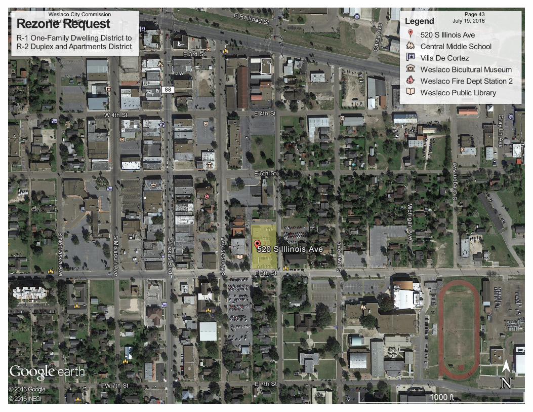
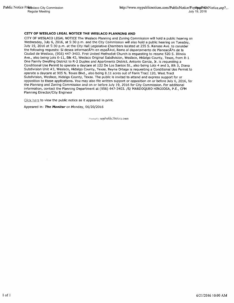
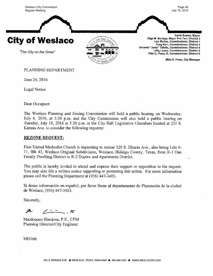
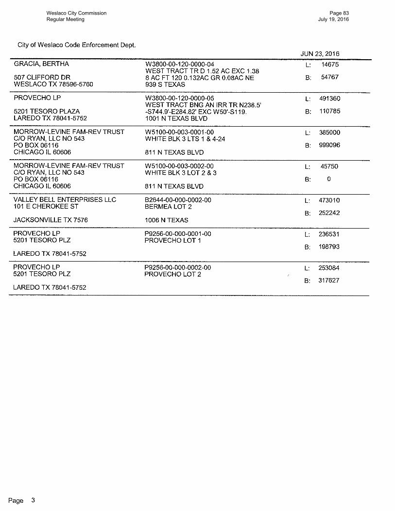
From:Mardoqueo Hinojosa, Planning DirectorSubject:To solicit input on behalf of First United Methodist Church to rezone 520 S. Illinois Ave., also being Lots 6-11, Block 43, Weslaco Original Subdivision, Weslaco, Hidalgo County, Texas, from R-1 One Family Dwelling District to R-2 Duplex and Apartments District. (Staffed by Planning and Code Enforcement Department.)
Background:First United Methodist Church intends to operate a Boarding House in a near future. Boarding Houses can operate on R-2 Districts and higher.
Funding Source (budget code, if applicable): Amount: Term of Impact: Identified in Current Budget: Additional Action Prompted: Mayor's SignaturePublic HearingIf item previously considered, provide date and action by Commission:
If item requires Publication Notice, provide date and periodical of publication; indicate if comments received from letters mailed to property owners:Notice of the application and the public hearing for the Planning and Zoning Commission and the City Commission appeared in The Monitor on June 20, 2016
Advisory Review, if any (name of board/committee, date of action, recommendation):
Planning and Zoning Commission recommended approval on July 6, 2016.
Martha Hernandez Created/InitiatedMardoqueo Hinojosa ApprovedMike Perez Final ApprovalCity Manager Comments:
Staff Recommendation:Staff recommends approval.
Attachments, if any:Aerial, 520 S Illinois Ave
Standardized Agenda Request Form
Weslaco City Commission Regular Meeting
Page 4 July 19, 2016
Responsibilities upon Approval:
Planning staff will advise applicant.
Weslaco City Commission Regular Meeting
Page 5 July 19, 2016
Date of Meeting:July 19, 2016
Agenda Item No. (to be assigned by CSO):2016-283
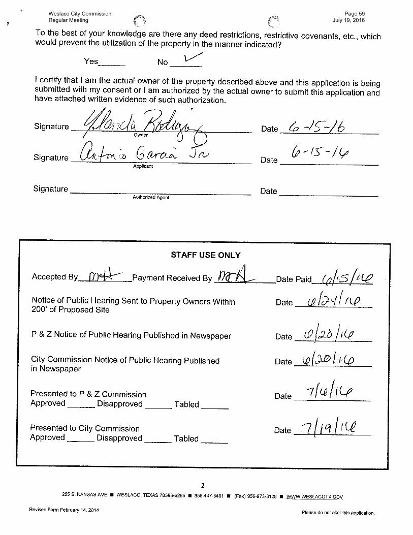
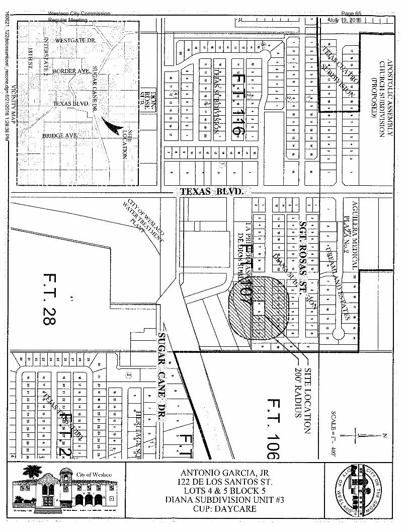
From:Mardoqueo Hinojosa, Planning DirectorSubject:To solicit input on behalf of Antonio Garcia, Jr. for a Conditional Use Permit to operate a daycare at 122 De Los Santos St., also being Lots 4 and 5, Block 5, Diana Subdivision Unit #3, Weslaco, Hidalgo County, Texas. (Staffed by Planning and Code Enforcement Department.)
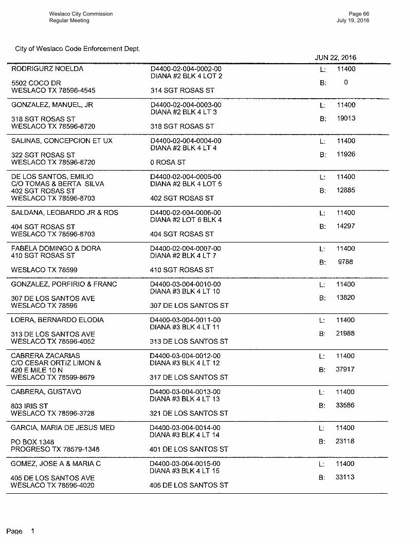
Background:The applicant is requesting to obtain Conditional Use Permit to operate a daycare. Twenty-four (24) property owners within 200 feet of the applicant’s property were notified by letter on June 24, 2016. Property has been operational with a daycare and is now changing ownership.
Funding Source (budget code, if applicable): Amount: Term of Impact: Identified in Current Budget: Additional Action Prompted: Mayor's SignaturePublic HearingIf item previously considered, provide date and action by Commission:
If item requires Publication Notice, provide date and periodical of publication; indicate if comments received from letters mailed to property owners:Notice of the application and the public hearing for the Planning and Zoning Commission and the City Commission appeared in The Monitor on June 20, 2016.
Advisory Review, if any (name of board/committee, date of action, recommendation):Planning and Zoning Commission recommended approval on July 6, 2016.
Martha Hernandez Created/InitiatedMardoqueo Hinojosa ApprovedMike Perez Final ApprovalCity Manager Comments:
Staff Recommendation:Staff recommends approval.
Attachments, if any:Aerial, 122 de los Santos
Responsibilities upon Approval:
Standardized Agenda Request Form
Weslaco City Commission Regular Meeting
Page 6 July 19, 2016
Planning staff will advise applicant.
Weslaco City Commission Regular Meeting
Page 7 July 19, 2016
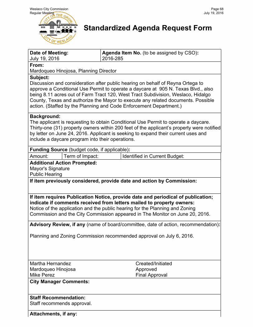
Date of Meeting:July 19, 2016
Agenda Item No. (to be assigned by CSO):2016-285
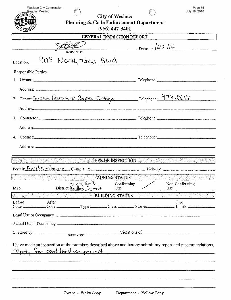
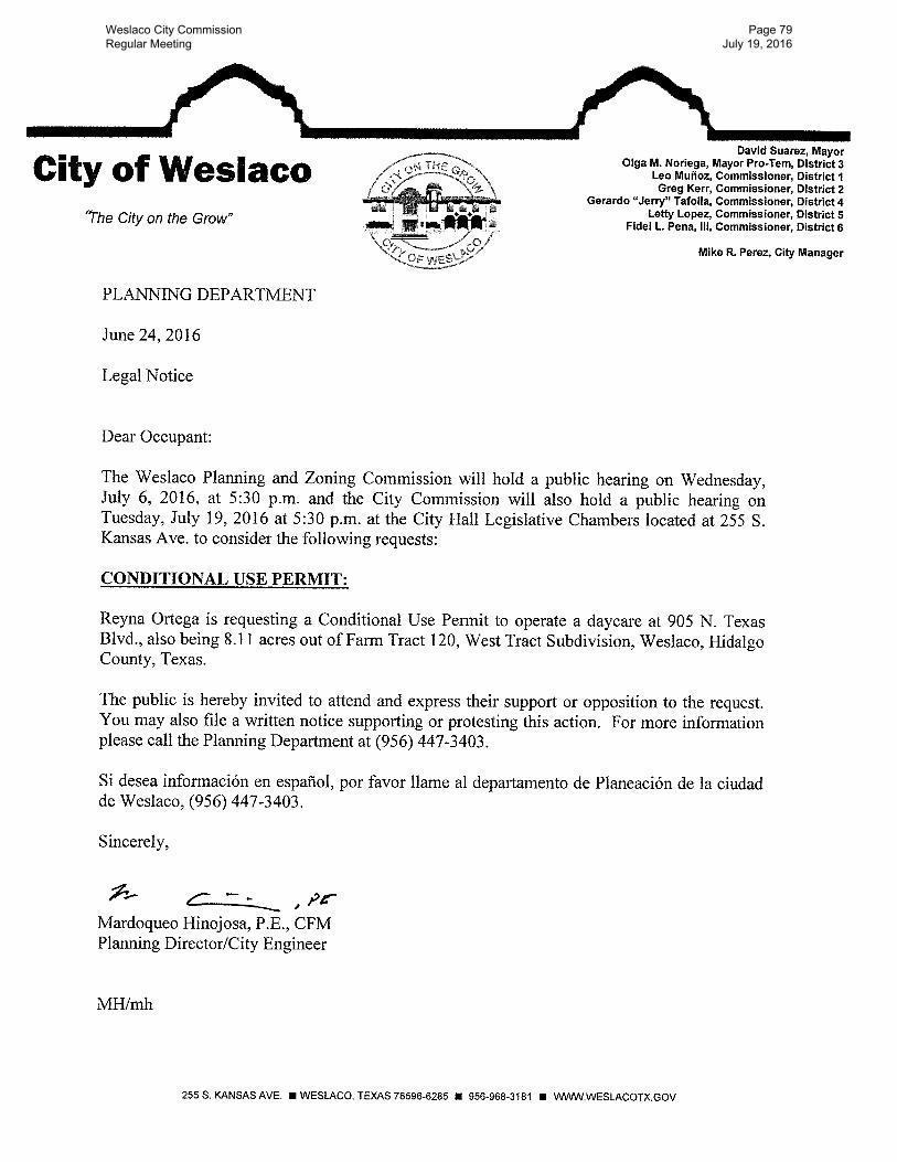
From:Mardoqueo Hinojosa, Planning DirectorSubject:To solicit input on behalf of Reyna Ortega for a Conditional Use Permit to operate a daycare at 905 N. Texas Blvd., also being 8.11 acres out of Farm Tract 120, West Tract Subdivision, Weslaco, Hidalgo County, Texas. (Staffed by Planning and Code Enforcement Department.)
Background:The applicant is requesting to obtain Conditional Use Permit to operate a daycare. Thirty-one (31) property owners within 200 feet of the applicant’s property were notified by letter on June 24, 2016. Applicant is seeking to expand their current uses and include a daycare program into their operations.
Funding Source (budget code, if applicable): Amount: Term of Impact: Identified in Current Budget: Additional Action Prompted: If item previously considered, provide date and action by Commission:
If item requires Publication Notice, provide date and periodical of publication; indicate if comments received from letters mailed to property owners:Notice of the application and the public hearing for the Planning and Zoning Commission and the City Commission appeared in The Monitor on June 20, 2016
Advisory Review, if any (name of board/committee, date of action, recommendation):
Planning and Zoning Commission recommended approval on July 6, 2016.
Martha Hernandez Created/InitiatedMardoqueo Hinojosa ApprovedMike Perez Final ApprovalCity Manager Comments:
Staff Recommendation:Staff recommends approval.
Attachments, if any:Aerial, 905 N Texas Blvd
Standardized Agenda Request Form
Weslaco City Commission Regular Meeting
Page 8 July 19, 2016
Responsibilities upon Approval:
Planning staff will advise applicant.
Weslaco City Commission Regular Meeting
Page 9 July 19, 2016
Date of Meeting:July 19, 2016
Agenda Item No. (to be assigned by CSO):2016-314
From:Elizabeth Walker, City SecretarySubject:Record of Workshop Meeting on July 5, 2016;
Background:Though there was no action to document as minutes, this record will serve for preservation as a summary of discussion. The City Secretary's Office hopes to maintain this as recommended best practice.
Funding Source (budget code, if applicable): Amount: Term of Impact: Identified in Current Budget: Additional Action Prompted: Mayor's SignatureIf item previously considered, provide date and action by Commission:N/A
If item requires Publication Notice, provide date and periodical of publication; indicate if comments received from letters mailed to property owners:N/A
Advisory Review, if any (name of board/committee, date of action, recommendation):N/A
Elizabeth Walker Created/InitiatedElizabeth Walker ApprovedMike Perez Final ApprovalCity Manager Comments:
Staff Recommendation:Approve as presented.
Attachments, if any:record - workshop 070516
Responsibilities upon Approval:Execute and retain.
Standardized Agenda Request Form
Weslaco City Commission Regular Meeting
Page 10 July 19, 2016
Record of Workshop Meeting July 5, 2016 Page 1 of 2
RECORD - WORKSHOPOF THE WESLACO CITY COMMISSION
TUESDAY, JULY 5, 2016
On this 5th day of July, 2016 at 5:06 p.m., the City Commission of the City of Weslaco, Texas convened in a Workshop at City Hall in the Planning Conference Room, located at 255 South Kansas Avenue with the following members present:
Mayor David SuarezMayor Pro-Tem Olga NoriegaCommissioner Gerardo “Jerry” TafollaCommissioner Letty LopezCommissioner Leo MuñozCommissioner Greg KerrCommissioner Fidel Peña III
City Manager Mike R. PerezCity Secretary Elizabeth M. Walker
Also present: David Arce, Parks and Recreation Director, and other staff members and citizens. I. CALL TO ORDER
A. Certification of Public Notice.
Mayor Suarez called the meeting to order and certified the public notice of the meeting as properly posted Friday, July 1, 2016
B. Roll Call.
Elizabeth Walker, City Secretary, called the roll, noting perfect attendance.
II. REPORT
A. Presentation by Ms. Sally Gavlik - Online survey results for the Parks, Recreation and Open Space Master Plan and top ten (10) priority listing.
The City Manager stated the last Parks Master Plan was approved in 2007. The City hired Sally Gavlik to assist in the preparation of an updated parks master plan to submit for grant funding for future park development.
Sally Gavlik, Consultant, reviewed the proposed parks master plan for 2016 that addressed park locations, amenities, deficiencies and areas eligible for grant funds. An online survey of 220 respondents showed overall satisfaction with parks had improved to 61.36% in 2016 from 54.2% in 2007 with a concern of better park maintenance. Top priorities revealed more parks, trails, better lighting, splash park, indoor recreation center and amphitheater.
Weslaco City Commission Regular Meeting
Page 11 July 19, 2016
Record of Workshop Meeting July 5, 2016 Page 2 of 2
No action required as the item was a presentation by Consultant Sally Gavlik.
III. ADJOURNMENT
With no other business before the Commission, at 5:30 p.m. on July 5, 2016, the workshop meeting stood adjourned.
CITY OF WESLACO
__________MAYOR, David Suarez
ATTEST:
CITY SECRETARY, Elizabeth Walker
Weslaco City Commission Regular Meeting
Page 12 July 19, 2016
Minutes of the Regular Meeting of the Weslaco City Commission on July 5, 2016 Page 1 of 9
A REGULAR MEETINGOF THE WESLACO CITY COMMISSION
TUESDAY, JULY 5, 2016
On this 5th day of July, 2016 at 5:34 p.m., the City Commission of the City of Weslaco, Texas convened in a Regular Meeting at City Hall in the Legislative Chamber, located at 255 South Kansas Avenue with the following members present:
Mayor David SuarezMayor Pro-Tem Olga NoriegaCommissioner Gerardo “Jerry” TafollaCommissioner Letty LopezCommissioner Leo MuñozCommissioner Greg KerrCommissioner Fidel Peña III
City Manager Mike R. PerezCity Secretary Elizabeth M. WalkerCity Attorney Juan E. Gonzalez
Also present: Mary Barrera, Finance Director; Veronica Ramirez, Human Resources Director; Jose Peña, IT Director; Pete Garcia, Public Works Director; Chief Tony Lopez, Fire Department; Chief Mayer; Mardoqueo Hinojosa, Planning and Code Enforcement Director and City Engineer; Arnoldo Becho, Library Director; Andrew Muñoz, Airport Director; Rosa Huerta, Municipal Court Coordinator; and other staff members and citizens.
I. CALL TO ORDER
A. Certification of Public Notice.Mayor Suarez called the meeting to order and certified the public notice of the meeting as properly posted Friday, July 1, 2016.
B. Invocation.
Pastor J.J. Wicke, First Baptist Church led the invocation.
C. Pledge of Allegiance. Mayor Suarez led the Pledge of Allegiance and Texas Flag.
D. Mayoral recognition.
The Mayor recognized the upcoming birthdays of Mayor Pro-Tem Noriega and Commissioner Tafolla.
E. Roll Call.Elizabeth Walker, City Secretary, called the roll, noting perfect attendance.
Weslaco City Commission Regular Meeting
Page 13 July 19, 2016
Minutes of the Regular Meeting of the Weslaco City Commission on July 5, 2016 Page 2 of 9
II. PUBLIC COMMENTS There were no comments received. III. CONSENT AGENDA The following items are of a routine or administrative nature. The City Commission has been furnished with
background and support material on each item, and/or it had been discussed at a previous meeting. All items will be acted upon by one vote without being discussed separately unless requested by one commission member, in which event the item or items will immediately be withdrawn for individual consideration in its normal sequence after the items not requiring separate discussion have been acted upon. The remaining items will be adopted by one vote. Possible action.
A. Approval of the Minutes of the Regular Meeting on June 21, 2016. (Staffed by City Secretary's Office.)
B. Approval on second and final reading of the following:
1) Ordinance 2016-17 rezoning 2200 S. Texas Blvd., also being 7.47 acres out of Farm Tract 743, excluding an irrigation Tract E343.08`- N307.54, West Tract Subdivision, Weslaco, Hidalgo County, Texas, from R-1 One Family Dwelling District to R-2 Duplex and Apartments District. (First reading held June 21, 2016; Staffed by Planning and Code Enforcement Department.)
2) Ordinance 2016-23, amending the “Zoning Ordinance,” Section 150-19 of the Weslaco Code of Ordinances, to remove the 60 day clause on "any appeal or permit granted by the board of adjustment shall not be valid if construction authorized by said permit is not begun within a period of 60 days" and authorize the Mayor to execute any related documents. (First Reading held June 21, 2016; Staffed by Planning and Code Enforcement Department.).
Commissioner Tafolla, seconded by Commissioner Peña, moved to approve consent agenda items A and B as presented. The motion carried unanimously; Mayor Suarez was present and voting.
For the record the following are the ordinances.
ORDINANCE NO. 2016-17
AN ORDINANCE AMENDING ZONING ORDINANCE NO. 320 AND AMENDING THE ZONING MAP OF THE CITY OF WESLACO TO CHANGE THE ZONING OF 2200 S. TEXAS BLVD., ALSO BEING 7.47 ACRES OUT OF FARM TRACT 743, EXCLUDING AN IRRIGATION TRACT E343.08`-N307.54`, WEST TRACT SUBDIVISION, WESLACO, HIDALGO COUNTY, TEXAS, FROM R-1 ONE FAMILY DWELLING DISTRICT TO R-2 DUPLEX AND APARTMENTS DISTRICT.
BE IT ORDAINED BY THE CITY COMMISSION OF THE CITY OF WESLACO, TEXAS:
SECTION I: R-1 One Family Dwelling District to R-2 Duplex and Apartments District, being the 7.47 acres out of Farm Tract 743, excluding an irrigation Tract E343.08`-N307.54`, West Tract Subdivision,
Weslaco City Commission Regular Meeting
Page 14 July 19, 2016
Minutes of the Regular Meeting of the Weslaco City Commission on July 5, 2016 Page 3 of 9
also being 2200 S Texas Blvd., Weslaco, Hidalgo County, Texas.
SECTION II: That this ordinance shall become effective upon its passage.
PASSED AND APPROVED on first reading at a regular meeting of the City Commission this 21st day of June, 2016.
PASSED AND APPROVED on second reading at a regular meeting of the City Commission this 5th day of July, 2016.
ORDINANCE 2016-23
AN ORDINANCE AMENDING ORDINANCE NUMBER 320, CODIFIED AS SECTION 150-19 OF THE WESLACO CODE OF ORDINANCES, ADOPTING NEW REGULATIONS; AND ORDAINING OTHER MATTERS WITH RESPECT TO THE SUBJECT MATTER HEREOF.
BE IT ORDAINED BY THE CITY COMMISSION OF THE CITY OF WESLACO TEXAS THAT:
SECTION I.Ordinance 320 passed and approved on December 1, 1959 to amend the Board of Adjustments
regulations and Codified as Section 150-19 of the Weslaco Code of Ordinances is hereby amended.
SECTION II.After second and final reading of this Ordinance the amended ordinance sections will be adopted
and codified as 150-19 of the Weslaco Code of Ordinances and said Section shall read as follows:Sec.150-19. Board of Adjustment
e. The board of adjustment shall have the following powers::5) Any appeal or permit granted by the board of adjustment shall have
perpetual approval for the property.
PASSED AND APPROVED on first reading at a regular meeting of the City Commission this 21st day of June, 2016.
PASSED AND APPROVED on second reading at a regular meeting of the City Commission this 5th day of July, 2016.
CITY OF WESLACO/s/David Suarez, MAYOR
ATTEST:/s/Elizabeth Walker, CITY SECRETARY
APPROVED AS TO FORM:/s/Juan E. Gonzalez, CITY ATTORNEY
IV. APPOINTMENTS
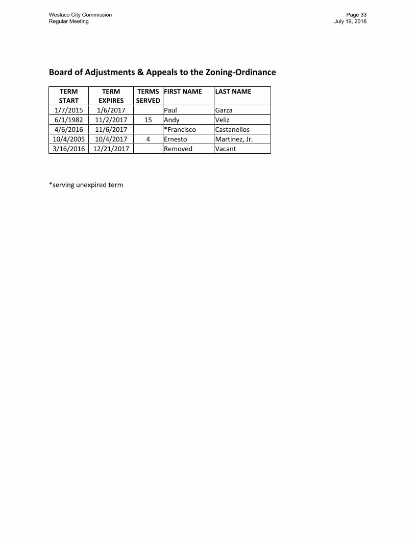
A. Discussion and consideration to remove one member and approve Resolution 2016-49 appointing one member to that unexpired term on the Board of Adjustments and Appeals
Weslaco City Commission Regular Meeting
Page 15 July 19, 2016
Minutes of the Regular Meeting of the Weslaco City Commission on July 5, 2016 Page 4 of 9
to the Zoning Ordinance and authorize the Mayor to execute any related documents. Possible action. (Staffed by Planning and Code Enforcement Department.) Attachment.
In response to Commissioner Peña, the City Manager stated a letter had been received signed by three board members expressing the working relationship with another member was not productive. In response to Commissioner Tafolla, the City Manager stated he had not listened to the audio of the meetings and relied on the opinions of the other members. Commissioner Kerr called for the question.
Mayor Pro-Tem Noriega, seconded by Commissioner Kerr, moved to remove Edward Mejia from the Board of Adjustments and Appeals to the Zoning Ordinance. The motion carried unanimously; Mayor Suarez was present and voting.
Commissioner Peña raised a point of order that the Commission had not acted to appoint a replacement; the Mayor stated the resolution would be brought back next meeting.
Commissioner Peña, seconded by Commissioner Tafolla, moved to table Resolution 2016-49 until the next meeting. The motion carried unanimously; Mayor Suarez was present and voting.
V. OLD BUSINESS
A. Discussion and consideration to approve compensation for project delays to CDM Constructors, Inc. in an amount not to exceed $960,000.00 and authorize the Mayor to execute any related documents. Possible action. (This item was tabled June 7, 2016 and there was no action June 21, 2016; Staffed by Planning and Code Enforcement Department.) Attachment.
Mayor Pro Tem Noriega, second by Commissioner Kerr, moved to remove the item from the table. The motion carried unanimously; Mayor Suarez was present and voting.
The City Manager stated CDM contacted staff and advised they were in the process of gathering information this week. Once received, staff along with Jeff Chapman will review toward a recommendation for the next meeting. If CDM does not provide the documentation, the item will be removed from the agenda until such time CDM is ready to proceed. Staff recommends tabling the item.
Mayor Pro-Tem Noriega, second by Commissioner Kerr, moved to table as recommended. The motion carried unanimously; Mayor Suarez was present and voting.
VI. NEW BUSINESS
A. Discussion and consideration to approve Ordinance 2016-24 disannexing in accordance
with the boundary lines affixed by the City of Mercedes settlement agreement and City of Donna Memorandum of Understanding. First reading of Ordinance 2016-24. Possible
Weslaco City Commission Regular Meeting
Page 16 July 19, 2016
Minutes of the Regular Meeting of the Weslaco City Commission on July 5, 2016 Page 5 of 9
action. (Staffed by Planning and Code Enforcement Department.)
Commissioner Kerr abstained from vote and discussion.
Mardoqueo Hinojosa, Planning Director, stated the ordinance proposed would document both the settlement agreement with the City of Mercedes and the Memorandum of Understanding with Donna for Extraterritorial Jurisdictional boundaries as agreed. The City Manager stated a letter to the Mayor of Donna was sent defining Midway Road/Mile 7 as the division line as agreed to in meetings. This action addresses election deadlines and clarification of property taxes as a result of boundary changes. Staff recommends approval.
Mayor Pro-Tem Noriega, seconded by Commissioner Tafolla, moved to approve Ordinance 2016-24 disannexing in accordance with the boundary lines affixed by the City of Mercedes settlement agreement and City of Donna Memorandum of Understanding. The motion carried with Commissioner Kerr abstaining; Mayor Suarez was present and voting.
B. Discussion and consideration to approve Resolution 2016-50 authorizing the submission of the Weslaco Parks, Recreation, and Open Space Master Plan to Texas Parks and Wildlife Department. Possible action. (Staffed by Parks and Recreation.)
Sally Galvik, Consultant, reviewed the ten year Master Plan developed for 2016-2026, a requirement of the Texas Parks and Wildlife Master Plan grant process. Citizen surveys, focus groups, non-profit organizations and the Parks Board were solicited for suggestions of parks facilities and amenities. Approval rating of parks satisfaction had increased in 2016 to 60% from 57% in 2007. Marketing efforts revealed the community using the internet and web services.
Commissioner Peña, seconded by Commissioner Kerr, moved to approve Resolution 2016-50 authorizing the submission of the Weslaco Parks, Recreation, and Open Space Master Plan to Texas Parks and Wildlife Department. The motion carried unanimously; Mayor Suarez was present and voting.
C. Discussion and consideration to identify the top ten (10) park priorities for the next ten (10) years. Possible action. (Staffed by Parks and Recreation.)
Sally Galvik, Consultant, stated identifying the top ten park priorities gives consideration of additional points during the grant process. The top ten rankings identified trail plans; new parks on the North side; additional lights at parks; splash park; youth soccer and baseball fields; picnic areas; indoor recreation center; leisure pool and amphitheater. These rankings were a result of the citizen input and the Commission may amend the rankings as needed at any time to be submitted to the Texas Parks and Wildlife.
Commissioner Peña, second by Commissioner Tafolla, moved to approve the top ten (10) park priorities for the next ten (10) years as identified and presented. The motion carried
Weslaco City Commission Regular Meeting
Page 17 July 19, 2016
Minutes of the Regular Meeting of the Weslaco City Commission on July 5, 2016 Page 6 of 9
unanimously; Mayor Suarez was present and voting.
D. Discussion and consideration to approve the reinvestment of the Booth Endowment Funds through the purchase of a Certificate of Deposit with Rio Bank for the term of 18 months in an amount not to exceed $240,000.00. Possible action. (Staffed by Library Department.)
Arnold Becho, Library Director, stated Ms. Marion Booth left $500,000 to the Library 10 years ago that established the Marion Booth Endowment. The Library Board recommends investing the principal of the funds and spending only interest earned from certificates of deposit. The City Manager recommended approval suggesting future investments be structured as a stair step to respond to the changing interest rates.
Commissioner Peña, seconded by Commissioner Tafolla, moved to approve the reinvestment of the Booth Endowment Funds through the purchase of a Certificate of Deposit with Rio Bank for the term of 18 months in an amount not to exceed $240,000.00. The motion carried unanimously; Mayor Suarez was present and voting.
E. Discussion and consideration to award the bid to the sole respondent for the purchase of a 2016 Ford Transit van for EMS division training in an amount not to exceed $34,000.00 as budgeted. Possible action. (Staffed by Fire Department.)
Fire Chief Tony Lopez stated the purchase would replace a 1996 training van and recommended to award to sole respondent Boggus Ford.
Commissioner Tafolla, seconded by Commissioner Peña, moved to award the bid to the sole respondent for the purchase of a 2016 Ford Transit van to Boggus Ford in an amount not to exceed $34,000.00 as budgeted. The motion carried unanimously; Mayor Suarez was present and voting.
F. Discussion and consideration to ratify Amendment No. 1 to the Agreement with the Texas Department of Transportation for project M1621WESL related to the RAMP grant at the Airport increasing the local contribution in an amount not to exceed $40,000.00 and authorize the Mayor to execute any related documents. Possible action. (Staffed by Airport.).
Andrew Munoz, Airport Director, recommended amending the grant amount from $20,000.00 to $100,000.00 for FY 2015-16. This is the maximum grant amount allowed and stated the grant is a 50/50 annual contribution share cost with the City. The Airport Advisory Board recommended approval. In response to Commissioner Muñoz, the additional $40,000.00 local contribution, by raising the total grant amount, would come from the general fund.
Commissioner Peña, seconded by Commissioner Lopez, moved to ratify Amendment No. 1 to the Agreement with the Texas Department of Transportation for project M1621WESL related to the RAMP grant at the Airport increasing the local contribution in an amount not to exceed $40,000.00. The motion carried unanimously; Mayor Suarez was present and voting.
Weslaco City Commission Regular Meeting
Page 18 July 19, 2016
Minutes of the Regular Meeting of the Weslaco City Commission on July 5, 2016 Page 7 of 9
VII. REPORTS
A. Report by Weslaco Area Chamber of Commerce.
Martha Noell, Chamber Director, reported on strong advertising for summer, including a new branding campaign initiated with two billboards with an “imagine” theme and joint advertising efforts with the Nature Centers.
B. Report by Economic Development Corporation of Weslaco.
Mary McDermott, Interim EDC Director, reported the 4th of July event was well attended with an estimated 5,000 attendees; the UTRGV grant process is moving forward and results should be in the next couple of weeks; and the summary of leads list identifies 32 prospects interested.
C. Report by Planning and Code Enforcement.
Mardoqueo Hinojosa reported the ribbon cutting for the Boys and Girls Club was held and is substantially complete with the parking lot to be paved within the next week; 6th Street should be substantially complete by the end of the week with final tie ins being done with two fire hydrants needed to be connected; stripping plans are complete and bidding documents are being finalized to go out next week. Joe Pedraza reported on revenues received from the City of San Juan will be used to kick off the Spay/Neuter Program and weekend code enforcement included removing signs from right-a-way enforcing itinerant vendor regulations.
D. Report by Severn Trent.
There was no report as a representative was unable to attend.
E. Report by Public Works Department.
Pete Garcia reported on addressing several water breaks; installing an A/C unit at the annex building; ongoing paving projects in the city; replacing old fire hydrants; improving detention ponds and maintaining drain ditches and completing inventory of materials for sandbags.
F. Report by Parks and Recreation Department.
David Arce, Parks Director, reported on ribbon cutting events at Valley Nature Center and Boys and Girls Club; AEP powerlines are now underground at the Valley Nature Center; the pool opened with a slow start but at full capacity and the 4th of July event well attended and has received great comments. The Dog Park ribbon cutting ceremony is planned for tomorrow.
VIII. EXECUTIVE SESSION
At 6:46 p.m. Mayor David Suarez announced the regular meeting to convene in executive session. At 7:46 p.m. Mayor Suarez announced the City Commission had completed its
Weslaco City Commission Regular Meeting
Page 19 July 19, 2016
Minutes of the Regular Meeting of the Weslaco City Commission on July 5, 2016 Page 8 of 9
executive session and reconvened the regular meeting as open to the public.
IX. POSSIBLE ACTION ON WHAT IS DISCUSSED IN EXECUTIVE SESSION
A. Personnel - Discussion regarding the goals, objectives, and evaluation of the City Manager for the City of Weslaco as authorized by §551.074 of the Texas Government Code.
There was no action on this item.
B. Pending Litigation - Consultation with City Attorney regarding City of Weslaco v. Briones Consulting and Engineering as authorized by §551.071 of the Texas Government Code.
There was no action on this item.
C. Real Property - Consultation with City Attorney on the purchase, exchange, lease or value of real property (North Texas; Intersection of Mile 11 and Texas Boulevard) as authorized by §551.072 of the Texas Local Government Code.
Commissioner Peña, seconded by Commissioner Lopez, moved to authorize the City Manager and City Attorney to proceed with negotiations on the purchase, exchange, lease or value of real property as discussed in executive session. The motion carried unanimously; Mayor Suarez was present and voting.
D. Pending Litigation – Consultation with City Attorney regarding Cause No.C-1277-15-H Elvia Caballero Lopez d/b/a or a/k/a Caballero Governmental Affairs v. City of Weslaco, Texas in the 389th Judicial District Court of Hidalgo County pursuant to §551.071 of the Texas Government Code.
Commissioner Peña, seconded by Commissioner Lopez, moved to authorize the City Manager and City Attorney to proceed with mediation negotiations regarding Cause No.C-1277-15-H Elvia Caballero Lopez d/b/a or a/k/a Caballero Governmental Affairs v. City of Weslaco, as discussed in executive session. The motion carried unanimously; Mayor Suarez was present and voting
E. Personnel - Discussion regarding the investigation by the Department of Justice into an Americans with Disabilities Act complaint against the Police Department as authorized by §551.074 of the Texas Government Code.
Commissioner Tafolla, seconded by Commissioner Peña, moved to authorize the City Attorney prepare a response regarding the investigation by the Department of Justice into an Americans with Disabilities Act complaint against the Police Department. The motion carried unanimously; Mayor Suarez was present and voting
X. ADJOURNMENT
With no other business before the commission, at 7:48 p.m. on July 5, 2016, Commissioner Peña, seconded by Commissioner Tafolla, moved to adjourn the regular meeting. The motion carried unanimously; Mayor Suarez was present and voting.
Weslaco City Commission Regular Meeting
Page 20 July 19, 2016
Minutes of the Regular Meeting of the Weslaco City Commission on July 5, 2016 Page 9 of 9
CITY OF WESLACO
__________MAYOR, David Suarez
ATTEST:
CITY SECRETARY, Elizabeth Walker
__________MAYOR PRO-TEM, Olga Noriega
_____COMMISSIONER, Leo Muñoz
_______________________COMMISSIONER, Greg Kerr
___________COMMISSIONER, Gerardo “Jerry” Tafolla
COMMISSIONER, Letty Lopez
____________ COMMISSIONER, Fidel L. Peña, III
Weslaco City Commission Regular Meeting
Page 21 July 19, 2016
Date of Meeting:July 19, 2016
Agenda Item No. (to be assigned by CSO):2016-261
From:Mardoqueo Hinojosa, Planning DirectorSubject:Approval on Second and Final Reading of Ordinance 2016-24 disannexing in accordance with the boundary lines affixed by the City of Mercedes settlement agreement and City of Donna Memorandum of Understanding. (First reading of Ordinance held July 5, 2016; Staffed by Planning and Code Enforcement Department.)
Background:The City is trying to reach an agreement with the City of Donna to have Midway Road as the division line. At the same time, to have better defined lines, staff is proposing to stop the City limits at Mile 10 North road.
Funding Source (budget code, if applicable): Amount: Term of Impact: Identified in Current Budget: Additional Action Prompted: Ordinance - Final ReadingIf item previously considered, provide date and action by Commission:N/A
If item requires Publication Notice, provide date and periodical of publication; indicate if comments received from letters mailed to property owners:N/A
Advisory Review, if any (name of board/committee, date of action, recommendation):N/A
Aida Vega Created/InitiatedMardoqueo Hinojosa ApprovedMike Perez Final ApprovalCity Manager Comments:
Staff Recommendation:Staff recommends approval of ordinance.
Attachments, if any:Exhibit, Exhibit 2, Ordinance
Responsibilities upon Approval:Staff will submit documentation to different entities.
Standardized Agenda Request Form
Weslaco City Commission Regular Meeting
Page 22 July 19, 2016
CITY OF WESLACO
PROPOSED DISANNEXED AREALegend
PROP DISANNEXED AREA2013_PARCELSWESLACO CITY LIMITS
PLANNING AND CODE ENFORCEMENT PLANNING AND
CODE ENFORCEMENT
1 inch = 1,000 feetµ
WESLACOCITY LIMITS
MILE 10 NORTH
MILE 11 NORTH
MILE 12 NORTH
MILE 13 NORTH
TEXA
S BLVD
(MILE
5 WES
T)
MILE 5
1/2 WE
ST
MILE 7
WEST
MILE 6
1/2 WE
ST
MILE 6
1/2 WE
ST
Weslaco City Commission Regular Meeting
Page 23 July 19, 2016
CITY OF WESLACO
PROPOSED DISANNEXED AREA
PLANNING AND CODE ENFORCEMENT PLANNING AND
CODE ENFORCEMENT
1 inch = 1,000 feetµ
WESLACOCITY LIMITS
MILE 11 NORTH
MILE 8 NORTH
MILE 9 NORTH
TEXA
S BLVD
(MILE
5 WES
T)
MILE 2
1/2 WE
ST
INTERSTATE 2
MILE 2
WEST
MILE 10 NORTH
Legenddis_annex-2016mercedes2013_PARCELSWESLACO CITY LIMITS
MILE 5 NORTH
MILE 6 NORTH
FM 10
15
MILE 2
1/2 W
MILE 2
W
INTERSTATE 2
U.S. BUS 83
WESLACOCITY LIMITS
1 inch = 1,000 feetµ
Weslaco City Commission Regular Meeting
Page 24 July 19, 2016
ORDINANCE NO. 2016-24
AN ORDINANCE AMENDING ORDINANCES NO. 2008-05, 2014-02 AND 2014-15 TO PROVIDE FOR THE DISANNEXATION OF CERTAIN AREA FROM THE TERRITORY TO THE CORPORATE LIMITS OF THE CITY OF WESLACO, HIDALGO COUNTY, TEXAS, AND ORDAIN OTHER MATTERS WITH RESPECT TO THE SUBJECT MATTER HEREOF.
BE IT ORDAINED BY THE CITY COMMISSION OF THE CITY OF WESLACO, TEXAS, THAT:
SECTION I: Section 1 of Ordinances No. 2014-02 and 2014-15 is hereby amend to
delete Section 2 of Ordinances No. 2014-02 AND 2014-15 are hereby delete the
following territory being annexed by Ordinances No. 2014-02 and 2014-15:
A TRACT OF LAND CONTAINING 1468.35 ACRES SITUATED IN THE COUNTY OF HIDALGO, TEXAS, BEING PART OR PORTIONS OF FARM TRACTS 83, 84, 85, 103, 104, 201, 202, 203, 204, 226, 227, 228, 229, 280, 281, 282, 285, 286, 333, 1022, 1023, 1024, 1025, AND 1094 WEST AND ADAMS TRACT SUBDIVISION, ACCORDING TO THE PLAT THEREOF RECORDED IN VOLUME 2, PAGES 34-37, HIDALGO COUNTY MAP RECORDS AND ALSO ALL OR PART OF LOTS 2,7,9,10 OUT OF BLOCK 117,LOTS 1, 8, 9, 10, 11, 12 OUT OF BLOCK 100, LOTS 4 OUT BLOCK 83, PART OR ALL OF LOTS A THRU H, N, O, P, Q, R OUT OF THE CAPISALLO HEIGHTS, PART OR ALL OF LOTS 13, 14 OUT OF BLOCK 84, AND 3024, 3025 OUT OF THE CAPISALLO SUBDIVISION, ACCORDING TO THE PLAT RECORDED AT THE HIDALGO COUNTY MAP RECORDS.
Section 1 of Ordinance No. 2008-05 is hereby amend to delete Section 1 of Ordinance No. 2008-05 are hereby delete the following territory being annexed by Ordinance No. 2008-05:
A TRACT OF LAND CONTAINING 23.47 ACRES SITUATED IN THE COUNTY OF HIDALGO, TEXAS, BEING PART OR PORTIONS OF FARM TRACTS 1002, 1003, 1004 AND 1005 ADAMS TRACT SUBDIVISION, ACCORDING TO THE PLAT THEREOF RECORDED IN VOLUME 2, PAGES 34-37, HIDALGO COUNTY MAP RECORDS EXCLUDING THE WEST RIGHT-OF-WAY OF FARM-TO-MARKET 1015 ROAD WITHIN THE WESLACO CITY LIMITS.
SECTION II: This Ordinance becomes effective on the Second and Final Reading
PASSED AND APPROVED on first reading at a regular meeting of the City Commission this 5th day of July, 2016.
PASSED AND APPROVED on second reading at a regular meeting of the City Commission this _____ day of July, 2016.
Weslaco City Commission Regular Meeting
Page 25 July 19, 2016
CITY OF WESLACO
_________________________David Suarez,MAYOR
ATTEST:
___________________________________Elizabeth M. Walker, CITY SECRETARY
APPROVED AS TO FORM:
___________________________________Juan Gonzalez, CITY ATTORNEY
Weslaco City Commission Regular Meeting
Page 26 July 19, 2016
Date of Meeting:July 19, 2016
Agenda Item No. (to be assigned by CSO):2016-256
From:Elizabeth Walker, City SecretarySubject:Discussion and consideration to approve Resolution 2016-49 appointing one member to an unexpired term on the Board of Adjustments and Appeals to the Zoning Ordinance and authorize the Mayor to execute any related documents. Possible action. (This Resolution was tabled July 5, 2016; Staffed by Planning and Code Enforcement Department.)
Background:One member was removed from BOAA on July 5, 2016.
Funding Source (budget code, if applicable): Amount: Term of Impact: Identified in Current Budget: Additional Action Prompted: ResolutionIf item previously considered, provide date and action by Commission:N/A
If item requires Publication Notice, provide date and periodical of publication; indicate if comments received from letters mailed to property owners:N/A
Advisory Review, if any (name of board/committee, date of action, recommendation):N/A
Aida Vega Created/InitiatedMardoqueo Hinojosa ApprovedMike Perez Final ApprovalCity Manager Comments:
Staff Recommendation:Staff recommends appointment
Attachments, if any:standard Board appt. documents, BOAA roster, R2016-49
Responsibilities upon Approval:N/A
Standardized Agenda Request Form
Weslaco City Commission Regular Meeting
Page 27 July 19, 2016
Weslaco City Commission Regular Meeting
Page 28 July 19, 2016
Form 1412
Name of Applicant:
Telephone Number:
E-Mail Address:
Alternate Phone Number (work/cell):
Home Address:
[ ] Inside City Limits [ ] Outside City Limits
City:
State:
Zip Code:
How many years have you lived at this residence?
Do you own this house? [ ] Yes or [ ] No
Preference for consideration, naming committees on which you desire to serve: 1.) 2.) 3.) List of Civic Involvement and Business Experience: Have you been bonded or eligible to obtain one? [ ] Yes or [ ] No
Are you currently suing or being sued by the City of Weslaco or any of its entities? [ ] Yes or [ ] No
Are you related to any member of the Commission? [ ] Yes or [ ] No
If so, who and how?
Have you previously served on a City board? [ ] Yes or [ ] No
If so, which and when?
Have you ever been elected to public office? [ ] Yes or [ ] No
If so, which and when?
Do you consent to release this info to the public? [ ] Yes or [ ] No
Are you age 25 or older? [ ] Yes or [ ] No
The statements I have made on this Application for Service are truthful and I am not disqualified to serve due to nepotism, City of Weslaco Charter or Ordinances or State of Texas laws.
There were no applications on file at the time of this printing.
ewalker
Typewritten Text
ewalker
Typewritten Text
RESOLUTION NO. 2016-49
A RESOLUTION OF THE CITY OF WESLACO APPOINTING ONE MEMBER TO THE BOARD OF ADJUSTMENTS & APPEALS-ZONING ORDINANCE.
WHEREAS, the City of Weslaco created and established the Board of Adjustments & Appeals-Zoning Ordinance.
WHEREAS, the term of the members of this board are for two years; and
WHEREAS, the Board of Adjustments & Appeals-Zoning Ordinance members shall serve with neither compensation nor term limits; and
NOW, THEREFORE, BE IT RESOLVED BY THE CITY COMMISSION OF THE CITY OF WESLACO, TEXAS THAT ________________________________is appointed to serve an unexpired term on the Board of Adjustments & Appeals-Zoning Ordinance and the term will expire on 21st day of December, 2017.
PASSED AND APPROVED on this 19th day of July, 2016.
CITY OF WESLACO
________________________________David Suarez, MAYOR
ATTEST:
________________________________Elizabeth M. Walker, CITY SECRETARY
APPROVED AS TO FORM:
_________________________________Juan E. Gonzalez, CITY ATTORNEY
Weslaco City Commission Regular Meeting
Page 34 July 19, 2016
ewalker
Typewritten Text
Date of Meeting:July 19, 2016
Agenda Item No. (to be assigned by CSO):2016-175
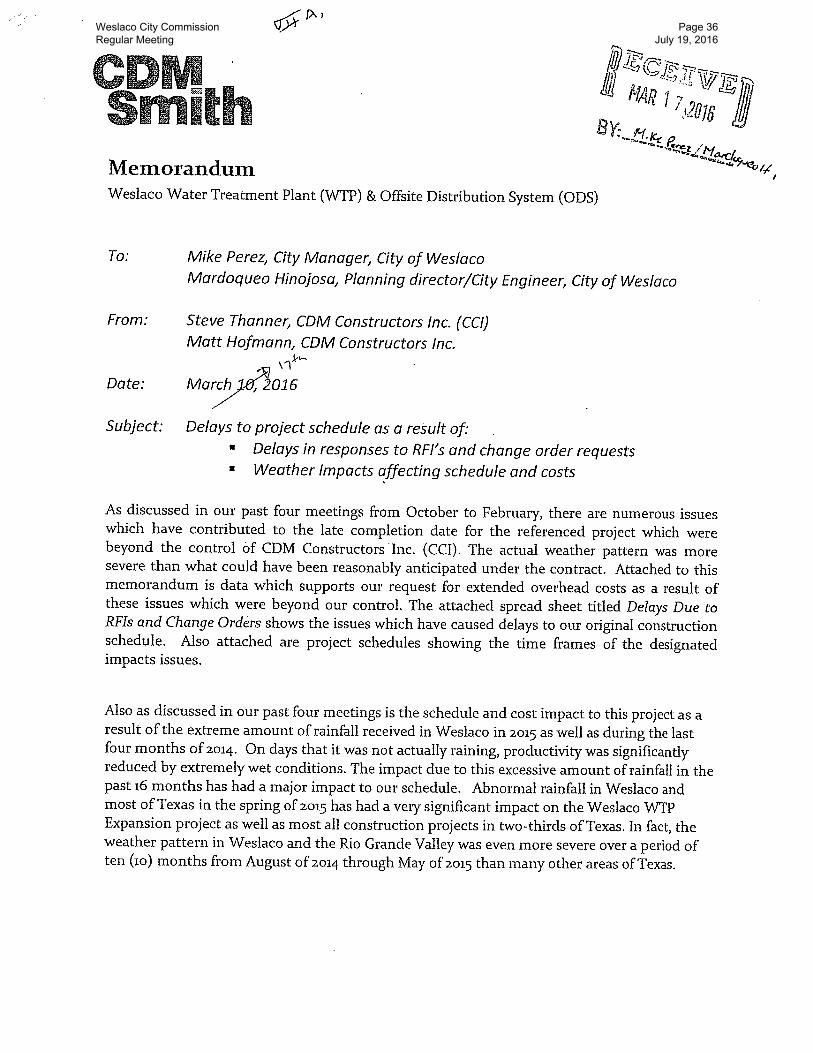
From:Mardoqueo Hinojosa, Planning DirectorSubject:Discussion and consideration to approve compensation for project delays to CDM Constructors, Inc. in an amount not to exceed $960,000.00 and authorize the Mayor to execute any related documents. Possible action. (This item was tabled July 5, 2016; Staffed by Planning and Code Enforcement Department.)
Background:CDM seeks $960,000.00 for project delays.
Funding Source (budget code, if applicable): Amount: Term of Impact: Identified in Current Budget: Additional Action Prompted: Mayor's SignatureIf item previously considered, provide date and action by Commission:Remains on table as of June 21, 2016
If item requires Publication Notice, provide date and periodical of publication; indicate if comments received from letters mailed to property owners:N/A
Advisory Review, if any (name of board/committee, date of action, recommendation):N/A
Aida Vega Created/InitiatedMardoqueo Hinojosa ApprovedMike Perez Final ApprovalCity Manager Comments:Seek City Attorney opinion first.
Staff Recommendation:City attorney's recommendation is required.
Attachments, if any:CDM request payment delays
Responsibilities upon Approval:
Standardized Agenda Request Form
Weslaco City Commission Regular Meeting
Page 35 July 19, 2016
ewalker
Typewritten Text
ewalker
Typewritten Text
Weslaco City Commission Regular Meeting
Page 36 July 19, 2016
Weslaco City Commission Regular Meeting
Page 37 July 19, 2016
Weslaco City Commission Regular Meeting
Page 38 July 19, 2016
Weslaco City Commission Regular Meeting
Page 39 July 19, 2016
Weslaco City Commission Regular Meeting
Page 40 July 19, 2016
Date of Meeting:July 19, 2016
Agenda Item No. (to be assigned by CSO):2016-282
From:Mardoqueo Hinojosa, Planning DirectorSubject:Discussion and consideration after public hearing on behalf of First United Methodist Church, to approve Ordinance 2016-25 rezoning 520 S. Illinois Ave., also being Lots 6-11, Block 43, Weslaco Original Subdivision, Weslaco, Hidalgo County, Texas, from R-1 One Family Dwelling District to R-2 Duplex and Apartments District. First reading of Ordinance 2016-25. Possible action. (Staffed by the Planning and Code Enforcement Department.)
Background:The applicant is requesting to rezone property from R-1 One Family Dwelling District to R-2 Duplex and Apartments District. Twenty-seven (27) property owners within 200 feet of the applicant’s property were notified by letter on June 24, 2016. Applicant wants to use property for a Boarding House which requires an R-2 District zone or higher.
Funding Source (budget code, if applicable): Amount: Term of Impact: Identified in Current Budget: Additional Action Prompted: Mayor's SignaturePublic HearingOrdinance - First ReadingOrdinance - Final ReadingIf item previously considered, provide date and action by Commission:
If item requires Publication Notice, provide date and periodical of publication; indicate if comments received from letters mailed to property owners:Notice of the application and the public hearing for the Planning and Zoning Commission and the City Commission appeared in The Monitor on June 20, 2016.
Advisory Review, if any (name of board/committee, date of action, recommendation):
Planning and Zoning Commission recommended approval on July 6, 2016.
Martha Hernandez Created/InitiatedMardoqueo Hinojosa ApprovedMike Perez Final ApprovalCity Manager Comments:
Standardized Agenda Request Form
Weslaco City Commission Regular Meeting
Page 41 July 19, 2016
ewalker
Typewritten Text
Staff Recommendation:Staff recommends approval.
Attachments, if any:Aerial, 520 S Illinois Ave, Ordinance 2016-25
AN ORDINANCE AMENDING ZONING ORDINANCE NO. 320 AND AMENDING THE ZONING MAP OF THE CITY OF WESLACO TO CHANGE THE ZONING OF 520 S. ILLINOIS AVE., ALSO BEING LOTS 6-11, BLK 43, WESLACO ORIGINAL SUBDIVISION, WESLACO, HIDALGO COUNTY, TEXAS, FROM R-1 ONE FAMILY DWELLING DISTRICT TO R-2 DUPLEX AND APARTMENTS DISTRICT.
BE IT ORDAINED BY THE CITY COMMISSION OF THE CITY OF WESLACO, TEXAS:
SECTION I: R-1 Single Family Dwelling District to R-2 Duplex and Apartments District being Lots 6-11, Blk 43, Weslaco Original Subdivision, also being 520 S. Illinois Ave., Weslaco, Hidalgo County, Texas.
SECTION II: That this ordinance shall become effective upon its passage.
PASSED AND APPROVED on first reading at a regular meeting of the City Commission this 19th day of July, 2016.
PASSED AND APPROVED on second reading at a regular meeting of the City Commission this ______________ day of ______________, 2016.
CITY OF WESLACO
David Suarez, MAYOR
ATTEST:
Elizabeth M. Walker, CITY SECRETARY
APPROVED AS TO FORM:
Juan E. Gonzalez, CITY ATTORNEY
Weslaco City Commission Regular Meeting
Page 54 July 19, 2016
Date of Meeting:July 19, 2016
Agenda Item No. (to be assigned by CSO):2016-283
From:Mardoqueo Hinojosa, Planning DirectorSubject:Discussion and consideration after public hearing on behalf of Antonio Garcia, Jr. to approve a Conditional Use Permit to operate a daycare at 122 De Los Santos St., also being Lots 4 and 5, Block 5, Diana Subdivision Unit #3, Weslaco, Hidalgo County, Texas and authorize the Mayor to execute any related documents. Possible action. (Staffed by the Planning and Code Enforcement Department.)
Background:The applicant is requesting to obtain Conditional Use Permit to operate a daycare. Twenty-four (24) property owners within 200 feet of the applicant’s property were notified by letter on June 24, 2016. Property has been operational with a daycare and is now changing ownership.
Funding Source (budget code, if applicable): Amount: Term of Impact: Identified in Current Budget: Additional Action Prompted: Mayor's SignaturePublic HearingIf item previously considered, provide date and action by Commission:
If item requires Publication Notice, provide date and periodical of publication; indicate if comments received from letters mailed to property owners:Notice of the application and the public hearing for the Planning and Zoning Commission and the City Commission appeared in The Monitor on June 20, 2016.
Advisory Review, if any (name of board/committee, date of action, recommendation):Planning and Zoning Commission recommended approval on July 6, 2016.
Martha Hernandez Created/InitiatedMardoqueo Hinojosa ApprovedMike Perez Final ApprovalCity Manager Comments:
From:Mardoqueo Hinojosa, Planning DirectorSubject:Discussion and consideration after public hearing on behalf of Reyna Ortega to approve a Conditional Use Permit to operate a daycare at 905 N. Texas Blvd., also being 8.11 acres out of Farm Tract 120, West Tract Subdivision, Weslaco, Hidalgo County, Texas and authorize the Mayor to execute any related documents. Possible action. (Staffed by the Planning and Code Enforcement Department.)
Background:The applicant is requesting to obtain Conditional Use Permit to operate a daycare. Thirty-one (31) property owners within 200 feet of the applicant’s property were notified by letter on June 24, 2016. Applicant is seeking to expand their current uses and include a daycare program into their operations.
Funding Source (budget code, if applicable): Amount: Term of Impact: Identified in Current Budget: Additional Action Prompted: Mayor's SignaturePublic HearingIf item previously considered, provide date and action by Commission:
If item requires Publication Notice, provide date and periodical of publication; indicate if comments received from letters mailed to property owners:Notice of the application and the public hearing for the Planning and Zoning Commission and the City Commission appeared in The Monitor on June 20, 2016.
Advisory Review, if any (name of board/committee, date of action, recommendation):
Planning and Zoning Commission recommended approval on July 6, 2016.
Martha Hernandez Created/InitiatedMardoqueo Hinojosa ApprovedMike Perez Final ApprovalCity Manager Comments:
From:Mardoqueo Hinojosa, Planning DirectorSubject:Discussion and reconsideration to approve the final plat of WesFar Subdivision, being 20.00 acres being a part or portion of Lot 131, Block 162, West Tract Subdivision, Weslaco, Hidalgo County, Texas. Possible action. (Staffed by Planning and Code Enforcement Department.)
Background:Developer is requesting that easements are included in this subdivision to accomodate utility infrastructure.
Funding Source (budget code, if applicable): Amount: Term of Impact: Identified in Current Budget: Additional Action Prompted: Mayor's SignatureIf item previously considered, provide date and action by Commission:Item was approved at May 17, 2016 regular meeting.
If item requires Publication Notice, provide date and periodical of publication; indicate if comments received from letters mailed to property owners:
Advisory Review, if any (name of board/committee, date of action, recommendation):P&Z recommended approval of original plat.
Mardoqueo Hinojosa Created/InitiatedMardoqueo Hinojosa ApprovedMike Perez Final ApprovalCity Manager Comments:
Staff Recommendation:Staff recommends approval.
Attachments, if any:Plat
Responsibilities upon Approval:Staff will advise applicant.
Standardized Agenda Request Form
Weslaco City Commission Regular Meeting
Page 84 July 19, 2016
ewalker
Typewritten Text
F.T
. 1
17
F.T
. 1
40
F.T
. 1
30
F.T
. 1
38
F.T
. 1
31
F.T
. 1
32
F.T
. 1
25
F.T
. 1
47
F.T
. 1
44
F.T
. 1
33
F.T
. 1
37
PIK
E B
OU
LE
VA
RD
WESTGATE DRIVE
BORDER AVE.
F.T
. 1
38
F.T
. 1
45
F.T
. 1
36
F.T
. 1
20
12
3
SAN
MARTIN
CATH
OLIC
CH
URCH
D
RAIN
D
ITC
H
D
RAIN
D
ITC
H
DRAINAGE D
ISTR
ICT R
.O.W
.
MAIN
CANAL
DRAINAGE R.O.W.
D
RAIN
AG
E R
.O.W
.
U. S
. E
XP
RE
SS
WA
Y 83
BORDER AVE.
MILE 5 1/2 WEST
N:1
65
90
01
9.2
52
E:1
14
85
52
.2
05
TO
P IR
RIG
AT
IO
N LIN
E E
L=
69.61
BO
RD
ER
T
RA
CE
, P
HA
SE
I
VO
LU
ME
3
5, P
AG
E 1
46
, H
.C
.M
.R
.
LO
T 1
8L
OT
1
7L
OT
1
6L
OT
1
5
LO
T 1
LO
T 2
LO
T 3
LO
T 4
DE
L
A P
EN
A #
2 S
UB
DIV
IS
IO
N
VO
LU
ME
2
0, P
AG
E 7
8, H
.C
.M
.R
.
LO
T 2
1L
OT
2
0L
OT
1
9L
OT
1
8L
OT
1
7
LO
T 1
LO
T 2
LO
T 3
LO
T 4
LO
T 5
BL
OC
K 1
BL
OC
K 1
N:1
65
89
99
2.0
29
E:1
14
72
32
.4
86
B L
O
C
K
1
B L
O
C
K
2
BO
RD
ER
T
RA
CE
, P
HA
SE
I
VO
LU
ME
3
5, P
AG
E 1
46
, H
.C
.M
.R
.
10.0' A
DD
IT
IO
NA
L R
.O
.W
.
DE
DIC
AT
ED
B
Y T
HIS
P
LA
T
50.0' R
IG
HT
O
F W
AY
DE
DIC
AT
ED
B
Y T
HIS
P
LA
T
1
S01° 10' 54"E 660.00'
7
3
7
3
73
73
70
69
66
70
7
4
74
74
75
77
74
717273
74
717273
70
68
69
65
66
676869
71727374
7
4
N01° 10' 54"W 660.00'
N8
8° 4
9' 0
6"E
1
32
0.0
0'
12
00
.0
0'
530.00'
12
15
.0
0'
545.00'
65
.0
' D
IT
CH
R
.O
.W
.
DE
DIC
AT
ED
T
O T
HE
C
IT
Y
OF
W
ES
LA
CO
B
Y T
HIS
P
LA
T
65
.0
' D
IT
CH
R
.O
.W
.
DE
DIC
AT
ED
T
O T
HE
C
IT
Y
OF
W
ES
LA
CO
B
Y T
HIS
P
LA
T
74
75
77
74
75
77
S.E
. C
OR
.
ST
AR
LIG
HT
P.O
.B
.
S8
8° 4
9' 0
6"W
1
32
0.0
0'
1
662,062.50 S
.F
.
15.199 A
C.
BE
NC
HM
AR
K: 1
SQ
UA
RE
C
UT
T
OP
OF
IN
LE
T E
L.=
73
.2
8
BE
NC
HM
AR
K:2
SE
T M
HI D
IS
K
EL
.=
72
.9
5
S4
6° 1
0' 5
4"E
21
.2
1'
SU
BD
IV
IS
IO
N
[W
ES
T]
[E
AS
T]
[SOUTH]
[N 01°12'00"W]
S 8
8° 4
9' 0
6" W
1
32
0.0
0'
FROSTPROOF DRIVE
80.0' ROW
VOLUME 36, PAGE 117B H.C.M.R.
N8
8° 4
9' 0
6"E
9
67
.3
5'
S8
8° 4
9' 0
6"W
2
23
.4
7'
S8
8° 4
9' 0
6"W
2
92
.3
6'
S8
8° 4
9' 0
6"W
4
41
.5
2'
N1° 10' 54"W 279.50'
N1° 10' 54"W 289.50'
S 0
1° 1
0' 5
4" E
20
.0
0'
S 8
8° 4
9' 0
6" W
10
.0
0'
S 0
1° 1
0' 5
4" E
20
.0
0'
S 0
1° 1
0' 5
4" E
20
.0
0'
S 8
8° 4
9' 0
6" W
10
.0
0'
N 0
1° 1
0' 5
4" W
20
.0
0'
S 8
8° 5
0' 0
0" W
2
37
.6
5'
S 01° 10' 54" E 255.44'
10
.0
' U
TIL
IT
Y E
AS
EM
EN
T
10
.0
' U
TIL
IT
Y E
AS
EM
EN
T
ST
AT
E O
F T
EX
AS
CO
UN
TY
O
F H
ID
AL
GO
SC
ALE
:1" =
100'
CO
NS
UL
TA
NT
S E
NG
IN
EE
RS
S
UR
VE
YO
RS
TE
XA
S R
EG
IS
T. F
-1435
ME
LD
EN
&
H
UN
T, IN
C.
SE
T N
o.4 R
EB
AR
W
/P
LA
ST
IC
CA
P S
TA
MP
ED
M
ELD
EN
&
H
UN
T
HID
ALG
O C
OU
NT
Y M
AP
R
EC
OR
DS
H.C
.M
.R
. -
RIG
HT
O
F W
AY
R.O
.W
. -
HID
ALG
O C
OU
NT
Y O
FF
IC
IA
L R
EC
OR
DS
H.C
.O
.R
. -
PO
IN
T O
F B
EG
IN
NIN
GP
.O
.B
. -
HID
ALG
O C
OU
NT
Y D
EE
D R
EC
OR
DS
H.C
.D
.R
. -
SO
UT
HE
AS
T C
OR
NE
RS
.E
. C
OR
. -
BEARING BASIS AS PER TEXAS STATE
PLANE GRID COORDINATE SYSTEM NAD 83
TEXAS SOUTH 4205 ELEVATION
PER NAVD 88 [GEOID 2003]
SQ
UA
RE
F
EE
TS
.F
.-
GE
NE
RA
L P
LA
T N
OT
ES
&
R
ES
TR
IC
TIO
NS
:
We
sF
AR
S
UB
DIV
IS
IO
N
WA
RR
AN
TY
D
EE
DW
.D
.-
RE
CO
RD
ED
M
AP
C
ALLS
[ ] -
SIT
E L
OC
AT
IO
N
CO
UN
TY
O
F H
ID
ALG
O
ST
AT
E O
F T
EX
AS
CE
RT
IF
IC
AT
IO
N O
F H
ID
AL
GO
&
C
AM
ER
ON
CO
UN
TIE
S IR
RIG
AT
IO
N D
IS
TR
IC
T N
O. 9
’”
’”
’
’”
’”
’
’
’”
12" IR
RIG
AT
IO
N S
TA
ND
P
IP
E
FO
UN
D S
QU
AR
E C
UT
AC
RE
SA
C.-
Y:\Lan
d D
evelo
pm
en
t\R
esid
en
tial\W
eslaco
\15187-R
ub
ian
o C
om
mercial\15187.00 - P
lat D
ev-R
ep
ort-G
en
eral\A
uto
Cad
Files\D
WG
\W
esFA
R.d
wg
, 6/21/2016 1:51:27 P
M, D
WG
To
P
DF.p
c3
Weslaco City Commission Regular Meeting
Page 85 July 19, 2016
AutoCAD SHX Text
SGT. M.C.GARCIA STREET
AutoCAD SHX Text_1
SAN CARLOS STREET
AutoCAD SHX Text_2
SAN BENITO STREET
AutoCAD SHX Text_3
SANTA ANA STREET
AutoCAD SHX Text_4
SAN JOAQUIN AVE.
AutoCAD SHX Text_5
NORTH OHIO AVE.
AutoCAD SHX Text_6
DELMA STREET
AutoCAD SHX Text_7
FROST PROOF DRIVE
AutoCAD SHX Text_8
LANE
AutoCAD SHX Text_9
PENA AVENUE
AutoCAD SHX Text_10
NEBRASKA
AutoCAD SHX Text_11
CITRUS DR.
AutoCAD SHX Text_12
SUN VALLEY
AutoCAD SHX Text_13
WESTGATE DRIVE
AutoCAD SHX Text_14
ADELITA STREET
AutoCAD SHX Text_15
NEBRASKA AVE.
AutoCAD SHX Text_16
N. MISSOURI AVE.
AutoCAD SHX Text_17
CYPRESS DR.
AutoCAD SHX Text_18
MEADOW DR.
AutoCAD SHX Text_19
HOLLOW RD.
AutoCAD SHX Text_20
TERRACE LANE
AutoCAD SHX Text_21
BEAUMONT ST.
AutoCAD SHX Text_22
BLUEBONNET AVE.
AutoCAD SHX Text_23
ABILENE ST.
AutoCAD SHX Text_24
CORPUS CHRISTI ST.
AutoCAD SHX Text_25
DALLAS ST.
AutoCAD SHX Text_26
ANAQUA AVE
AutoCAD SHX Text_27
NORTHGATE CIRCLE
AutoCAD SHX Text_28
NORTHGATE PASS
AutoCAD SHX Text_29
NORTHGATE DRIVE
AutoCAD SHX Text_30
HIGHLAND DRIVE
AutoCAD SHX Text_31
CATHERINE AVE.
AutoCAD SHX Text_32
SANTA ANA ST.
AutoCAD SHX Text_33
NORTH TRACE
AutoCAD SHX Text_34
HIDDEN TRACE
AutoCAD SHX Text_35
VILLAS DEL NORTE DR.
AutoCAD SHX Text_36
LILIA DR.
AutoCAD SHX Text_37
ANACUA CIR.
AutoCAD SHX Text_38
FRESNO LANE
AutoCAD SHX Text_39
ANACUA CIR.
AutoCAD SHX Text_40
ANGELITA DR.
AutoCAD SHX Text_41
OAK DR.
AutoCAD SHX Text_42
CANYON DR.
AutoCAD SHX Text_43
W. ROOSEVELT ST.
AutoCAD SHX Text_44
W. JEFFERSON ST.
AutoCAD SHX Text_45
TAFT STREET
AutoCAD SHX Text_46
HARRISON STREET
AutoCAD SHX Text_47
W. LINCOLN ST.
AutoCAD SHX Text_48
W. ADELITA ST.
AutoCAD SHX Text_49
FROST PROOF DRIVE
AutoCAD SHX Text_50
VALLEY TRACE DRIVE
AutoCAD SHX Text_51
SAN-BENITO
AutoCAD SHX Text_52
PIASANO
AutoCAD SHX Text_53
W. I. S. D. BEATRIZ. G. GARZA INTERMEDIATE SCHOOL
AutoCAD SHX Text_54
W. I. S. D. CLECKLER-HEALD ELEM. SCHOOL
AutoCAD SHX Text_55
W. I. S. D. H I G H S C H O O L
AutoCAD SHX Text_56
LANE
AutoCAD SHX Text_57
PIASANO
AutoCAD SHX Text_58
MARIA
AutoCAD SHX Text_59
ISABEL DR.
AutoCAD SHX Text_60
LOT 5
AutoCAD SHX Text_61
LOT 1
AutoCAD SHX Text_62
LOT 2
AutoCAD SHX Text_63
LOT 3
AutoCAD SHX Text_64
LOT 4
AutoCAD SHX Text_65
CAPITAL DRIVE
AutoCAD SHX Text_66
9
AutoCAD SHX Text_67
10
AutoCAD SHX Text_68
8
AutoCAD SHX Text_69
7
AutoCAD SHX Text_70
6
AutoCAD SHX Text_71
5
AutoCAD SHX Text_72
4
AutoCAD SHX Text_73
3
AutoCAD SHX Text_74
2
AutoCAD SHX Text_75
1
AutoCAD SHX Text_76
11
AutoCAD SHX Text_77
1
AutoCAD SHX Text_78
2
AutoCAD SHX Text_79
3
AutoCAD SHX Text_80
4
AutoCAD SHX Text_81
6
AutoCAD SHX Text_82
7
AutoCAD SHX Text_83
8
AutoCAD SHX Text_84
9
AutoCAD SHX Text_85
W. JEFFERSON ST.
AutoCAD SHX Text_86
LOUISIANA AVE.
AutoCAD SHX Text_87
CALLE DEL CEDRO
AutoCAD SHX Text_88
CALLE DEL PINO
AutoCAD SHX Text_89
CALLE DE LA REPUBLICA
AutoCAD SHX Text_90
CALLE DEL LAS PALMAS
AutoCAD SHX Text_91
CENTRAL INDUSTRIAL SUBD. PHASE III VOLUME 40, PAGE 71 H.C.M.R.
AutoCAD SHX Text_92
SARINA GROUP SUBDIVISION INSTRUMENT 2467263 H.C.M.R.
AutoCAD SHX Text_93
T.S.C. SUBDIVISION RE-SUBDIVISION OF LOT 3 REDBIRD SUBDIVISION VOLUME 42, PAGE 189 H.C.M.R.
AutoCAD SHX Text_94
RED BIRD SUBDIVISION VOLUME 28, PAGE 67A H.C.M.R.
AutoCAD SHX Text_95
DE LA PENA SUBDIVISION No. 2 VOLUME 20, PAGE 78 H.C.M.R.
AutoCAD SHX Text_96
BORDER TRACE PHASE I VOLUME 35, PAGE 146 H.C.M.R.
AutoCAD SHX Text_97
BORDER TRACE PHASE II VOLUME 43, PAGE 97 H.C.M.R.
AutoCAD SHX Text_98
HIDALGO COUNTY HOUSING AUTHORITY SUBDIVISION UNIT No. 1 VOLUME 33, PAGE 41, H.C.M.R.
BORDER AVENUE - MILE 5 WEST 12 WEST (R.O.W.VARIES)VARIES)
AutoCAD SHX Text_132
C
AutoCAD SHX Text_133
L
AutoCAD SHX Text_134
DRAIN DITCH R.O.W.
AutoCAD SHX Text_135
50.0' CITY OF WESLACO
AutoCAD SHX Text_136
DRAIN DITCH R.O.W.
AutoCAD SHX Text_137
FROSTPROOF DRIVE
AutoCAD SHX Text_138
FROSTPROOF DRIVE
AutoCAD SHX Text_139
VOLUME 26, PAGE 67A, H.C.M.R.
AutoCAD SHX Text_140
VOLUME 40, PAGE 71, H.C.M.R.
AutoCAD SHX Text_141
12"
AutoCAD SHX Text_142
12"
AutoCAD SHX Text_143
12"
AutoCAD SHX Text_144
15.0' STREET R.O.W. AND UTILITY EASEMENT AS PER DOCUMENT NO. 490228, H.C.O.R.
AutoCAD SHX Text_145
LIN'S GRAND BUFFET-WESLACO VOLUME 45, PAGE 113, H.C.M.R.
AutoCAD SHX Text_146
LOT 3
AutoCAD SHX Text_147
50.0'
AutoCAD SHX Text_148
R.O.W.
AutoCAD SHX Text_149
1
AutoCAD SHX Text_150
2
AutoCAD SHX Text_151
3
AutoCAD SHX Text_152
21
AutoCAD SHX Text_153
22
AutoCAD SHX Text_154
BLOCK 4
AutoCAD SHX Text_155
BLOCK 5
AutoCAD SHX Text_156
FARM TRACT 124, BLOCK 162 WEST AND ADAM'S TRACT VOLUME 2, PAGES 34-37 H.C.M.R.
AutoCAD SHX Text_157
50.0' CITY OF WESLACO
AutoCAD SHX Text_158
DRAIN DITCH R.O.W.
AutoCAD SHX Text_159
VOLUME 42, PAGE 189, H.C.M.R.
AutoCAD SHX Text_160
50.0' CITY OF WESLACO
AutoCAD SHX Text_161
DRAIN DITCH R.O.W.
AutoCAD SHX Text_162
INSTRUMENT 2467263 H.C.M.R.
AutoCAD SHX Text_163
LEGEND
AutoCAD SHX Text_164
V I C I N I T Y M A P
AutoCAD SHX Text_165
SCALE: 1" = 1000'
AutoCAD SHX Text_166
I, THE UNDERSIGNED, OWNER OF THE LAND SHOWN ON THIS PLAT, AND DESIGNATED AS THE THE UNDERSIGNED, OWNER OF THE LAND SHOWN ON THIS PLAT, AND DESIGNATED AS THE THE UNDERSIGNED, OWNER OF THE LAND SHOWN ON THIS PLAT, AND DESIGNATED AS THE UNDERSIGNED, OWNER OF THE LAND SHOWN ON THIS PLAT, AND DESIGNATED AS THE UNDERSIGNED, OWNER OF THE LAND SHOWN ON THIS PLAT, AND DESIGNATED AS THE OWNER OF THE LAND SHOWN ON THIS PLAT, AND DESIGNATED AS THE OWNER OF THE LAND SHOWN ON THIS PLAT, AND DESIGNATED AS THE OF THE LAND SHOWN ON THIS PLAT, AND DESIGNATED AS THE OF THE LAND SHOWN ON THIS PLAT, AND DESIGNATED AS THE THE LAND SHOWN ON THIS PLAT, AND DESIGNATED AS THE THE LAND SHOWN ON THIS PLAT, AND DESIGNATED AS THE LAND SHOWN ON THIS PLAT, AND DESIGNATED AS THE LAND SHOWN ON THIS PLAT, AND DESIGNATED AS THE SHOWN ON THIS PLAT, AND DESIGNATED AS THE SHOWN ON THIS PLAT, AND DESIGNATED AS THE ON THIS PLAT, AND DESIGNATED AS THE ON THIS PLAT, AND DESIGNATED AS THE THIS PLAT, AND DESIGNATED AS THE THIS PLAT, AND DESIGNATED AS THE PLAT, AND DESIGNATED AS THE PLAT, AND DESIGNATED AS THE AND DESIGNATED AS THE AND DESIGNATED AS THE DESIGNATED AS THE DESIGNATED AS THE AS THE AS THE THE THE "WesFAR SUBDIVISION" TO THE CITY OF WESLACO, TEXAS, AND WHOSE NAME IS SUBSCRIBED WesFAR SUBDIVISION" TO THE CITY OF WESLACO, TEXAS, AND WHOSE NAME IS SUBSCRIBED SUBDIVISION" TO THE CITY OF WESLACO, TEXAS, AND WHOSE NAME IS SUBSCRIBED SUBDIVISION" TO THE CITY OF WESLACO, TEXAS, AND WHOSE NAME IS SUBSCRIBED " TO THE CITY OF WESLACO, TEXAS, AND WHOSE NAME IS SUBSCRIBED TO THE CITY OF WESLACO, TEXAS, AND WHOSE NAME IS SUBSCRIBED TO THE CITY OF WESLACO, TEXAS, AND WHOSE NAME IS SUBSCRIBED THE CITY OF WESLACO, TEXAS, AND WHOSE NAME IS SUBSCRIBED THE CITY OF WESLACO, TEXAS, AND WHOSE NAME IS SUBSCRIBED CITY OF WESLACO, TEXAS, AND WHOSE NAME IS SUBSCRIBED CITY OF WESLACO, TEXAS, AND WHOSE NAME IS SUBSCRIBED OF WESLACO, TEXAS, AND WHOSE NAME IS SUBSCRIBED OF WESLACO, TEXAS, AND WHOSE NAME IS SUBSCRIBED WESLACO, TEXAS, AND WHOSE NAME IS SUBSCRIBED WESLACO, TEXAS, AND WHOSE NAME IS SUBSCRIBED TEXAS, AND WHOSE NAME IS SUBSCRIBED TEXAS, AND WHOSE NAME IS SUBSCRIBED AND WHOSE NAME IS SUBSCRIBED AND WHOSE NAME IS SUBSCRIBED WHOSE NAME IS SUBSCRIBED WHOSE NAME IS SUBSCRIBED NAME IS SUBSCRIBED NAME IS SUBSCRIBED IS SUBSCRIBED IS SUBSCRIBED SUBSCRIBED SUBSCRIBED HERETO, HEREBY DEDICATE TO THE USE OF THE PUBLIC ALL STREETS, ALLEYS, PARKS, WATER HEREBY DEDICATE TO THE USE OF THE PUBLIC ALL STREETS, ALLEYS, PARKS, WATER HEREBY DEDICATE TO THE USE OF THE PUBLIC ALL STREETS, ALLEYS, PARKS, WATER DEDICATE TO THE USE OF THE PUBLIC ALL STREETS, ALLEYS, PARKS, WATER DEDICATE TO THE USE OF THE PUBLIC ALL STREETS, ALLEYS, PARKS, WATER TO THE USE OF THE PUBLIC ALL STREETS, ALLEYS, PARKS, WATER TO THE USE OF THE PUBLIC ALL STREETS, ALLEYS, PARKS, WATER THE USE OF THE PUBLIC ALL STREETS, ALLEYS, PARKS, WATER THE USE OF THE PUBLIC ALL STREETS, ALLEYS, PARKS, WATER USE OF THE PUBLIC ALL STREETS, ALLEYS, PARKS, WATER USE OF THE PUBLIC ALL STREETS, ALLEYS, PARKS, WATER OF THE PUBLIC ALL STREETS, ALLEYS, PARKS, WATER OF THE PUBLIC ALL STREETS, ALLEYS, PARKS, WATER THE PUBLIC ALL STREETS, ALLEYS, PARKS, WATER THE PUBLIC ALL STREETS, ALLEYS, PARKS, WATER PUBLIC ALL STREETS, ALLEYS, PARKS, WATER PUBLIC ALL STREETS, ALLEYS, PARKS, WATER ALL STREETS, ALLEYS, PARKS, WATER ALL STREETS, ALLEYS, PARKS, WATER STREETS, ALLEYS, PARKS, WATER STREETS, ALLEYS, PARKS, WATER ALLEYS, PARKS, WATER ALLEYS, PARKS, WATER PARKS, WATER PARKS, WATER WATER WATER COURSES, DRAINS, EASEMENTS, AND PUBLIC PLACES THEREON SHOWN FOR THE PURPOSE OF DRAINS, EASEMENTS, AND PUBLIC PLACES THEREON SHOWN FOR THE PURPOSE OF DRAINS, EASEMENTS, AND PUBLIC PLACES THEREON SHOWN FOR THE PURPOSE OF EASEMENTS, AND PUBLIC PLACES THEREON SHOWN FOR THE PURPOSE OF EASEMENTS, AND PUBLIC PLACES THEREON SHOWN FOR THE PURPOSE OF AND PUBLIC PLACES THEREON SHOWN FOR THE PURPOSE OF AND PUBLIC PLACES THEREON SHOWN FOR THE PURPOSE OF PUBLIC PLACES THEREON SHOWN FOR THE PURPOSE OF PUBLIC PLACES THEREON SHOWN FOR THE PURPOSE OF PLACES THEREON SHOWN FOR THE PURPOSE OF PLACES THEREON SHOWN FOR THE PURPOSE OF THEREON SHOWN FOR THE PURPOSE OF THEREON SHOWN FOR THE PURPOSE OF SHOWN FOR THE PURPOSE OF SHOWN FOR THE PURPOSE OF FOR THE PURPOSE OF FOR THE PURPOSE OF THE PURPOSE OF THE PURPOSE OF PURPOSE OF PURPOSE OF OF OF CONSIDERATION THEREIN EXPRESSED. PENSCO TRUST COMPANY, CUSTODIAN . DATE . DATE . DATE . FBO ALBERTO CEPEDA, M.D. P.O. BOX 173859 DENVER, COLORADO 80217-3859
AutoCAD SHX Text_167
I, THE UNDERSIGNED, CHAIRPERSON OF THE PLANNING AND ZONING COMMISSION OF THE CITY THE UNDERSIGNED, CHAIRPERSON OF THE PLANNING AND ZONING COMMISSION OF THE CITY THE UNDERSIGNED, CHAIRPERSON OF THE PLANNING AND ZONING COMMISSION OF THE CITY UNDERSIGNED, CHAIRPERSON OF THE PLANNING AND ZONING COMMISSION OF THE CITY UNDERSIGNED, CHAIRPERSON OF THE PLANNING AND ZONING COMMISSION OF THE CITY CHAIRPERSON OF THE PLANNING AND ZONING COMMISSION OF THE CITY CHAIRPERSON OF THE PLANNING AND ZONING COMMISSION OF THE CITY OF THE PLANNING AND ZONING COMMISSION OF THE CITY OF THE PLANNING AND ZONING COMMISSION OF THE CITY THE PLANNING AND ZONING COMMISSION OF THE CITY THE PLANNING AND ZONING COMMISSION OF THE CITY PLANNING AND ZONING COMMISSION OF THE CITY PLANNING AND ZONING COMMISSION OF THE CITY AND ZONING COMMISSION OF THE CITY AND ZONING COMMISSION OF THE CITY ZONING COMMISSION OF THE CITY ZONING COMMISSION OF THE CITY COMMISSION OF THE CITY COMMISSION OF THE CITY OF THE CITY OF THE CITY THE CITY THE CITY CITY CITY OF WESLACO, HEREBY CERTIFY THAT THIS SUBDIVISION PLAT CONFORMS TO ALL REQUIREMENTS WESLACO, HEREBY CERTIFY THAT THIS SUBDIVISION PLAT CONFORMS TO ALL REQUIREMENTS WESLACO, HEREBY CERTIFY THAT THIS SUBDIVISION PLAT CONFORMS TO ALL REQUIREMENTS HEREBY CERTIFY THAT THIS SUBDIVISION PLAT CONFORMS TO ALL REQUIREMENTS HEREBY CERTIFY THAT THIS SUBDIVISION PLAT CONFORMS TO ALL REQUIREMENTS CERTIFY THAT THIS SUBDIVISION PLAT CONFORMS TO ALL REQUIREMENTS CERTIFY THAT THIS SUBDIVISION PLAT CONFORMS TO ALL REQUIREMENTS THAT THIS SUBDIVISION PLAT CONFORMS TO ALL REQUIREMENTS THAT THIS SUBDIVISION PLAT CONFORMS TO ALL REQUIREMENTS THIS SUBDIVISION PLAT CONFORMS TO ALL REQUIREMENTS THIS SUBDIVISION PLAT CONFORMS TO ALL REQUIREMENTS SUBDIVISION PLAT CONFORMS TO ALL REQUIREMENTS SUBDIVISION PLAT CONFORMS TO ALL REQUIREMENTS PLAT CONFORMS TO ALL REQUIREMENTS PLAT CONFORMS TO ALL REQUIREMENTS CONFORMS TO ALL REQUIREMENTS CONFORMS TO ALL REQUIREMENTS TO ALL REQUIREMENTS TO ALL REQUIREMENTS ALL REQUIREMENTS ALL REQUIREMENTS REQUIREMENTS REQUIREMENTS OF THE SUBDIVISION REGULATIONS OF THIS CITY WHEREIN MY APPROVAL IS REQUIRED. APPROVED THIS THE DAY OF 20 . CHAIRPERSON , PLANNING AND ZONING COMMISSION
AutoCAD SHX Text_168
I, THE UNDERSIGNED, MAYOR OF THE CITY OF WESLACO, HEREBY CERTIFY THAT THIS THE UNDERSIGNED, MAYOR OF THE CITY OF WESLACO, HEREBY CERTIFY THAT THIS THE UNDERSIGNED, MAYOR OF THE CITY OF WESLACO, HEREBY CERTIFY THAT THIS UNDERSIGNED, MAYOR OF THE CITY OF WESLACO, HEREBY CERTIFY THAT THIS UNDERSIGNED, MAYOR OF THE CITY OF WESLACO, HEREBY CERTIFY THAT THIS MAYOR OF THE CITY OF WESLACO, HEREBY CERTIFY THAT THIS MAYOR OF THE CITY OF WESLACO, HEREBY CERTIFY THAT THIS OF THE CITY OF WESLACO, HEREBY CERTIFY THAT THIS OF THE CITY OF WESLACO, HEREBY CERTIFY THAT THIS THE CITY OF WESLACO, HEREBY CERTIFY THAT THIS THE CITY OF WESLACO, HEREBY CERTIFY THAT THIS CITY OF WESLACO, HEREBY CERTIFY THAT THIS CITY OF WESLACO, HEREBY CERTIFY THAT THIS OF WESLACO, HEREBY CERTIFY THAT THIS OF WESLACO, HEREBY CERTIFY THAT THIS WESLACO, HEREBY CERTIFY THAT THIS WESLACO, HEREBY CERTIFY THAT THIS HEREBY CERTIFY THAT THIS HEREBY CERTIFY THAT THIS CERTIFY THAT THIS CERTIFY THAT THIS THAT THIS THAT THIS THIS THIS SUBDIVISION PLAT CONFORMS TO ALL REQUIREMENTS OF THE SUBDIVISION REGULATIONS OF PLAT CONFORMS TO ALL REQUIREMENTS OF THE SUBDIVISION REGULATIONS OF PLAT CONFORMS TO ALL REQUIREMENTS OF THE SUBDIVISION REGULATIONS OF CONFORMS TO ALL REQUIREMENTS OF THE SUBDIVISION REGULATIONS OF CONFORMS TO ALL REQUIREMENTS OF THE SUBDIVISION REGULATIONS OF TO ALL REQUIREMENTS OF THE SUBDIVISION REGULATIONS OF TO ALL REQUIREMENTS OF THE SUBDIVISION REGULATIONS OF ALL REQUIREMENTS OF THE SUBDIVISION REGULATIONS OF ALL REQUIREMENTS OF THE SUBDIVISION REGULATIONS OF REQUIREMENTS OF THE SUBDIVISION REGULATIONS OF REQUIREMENTS OF THE SUBDIVISION REGULATIONS OF OF THE SUBDIVISION REGULATIONS OF OF THE SUBDIVISION REGULATIONS OF THE SUBDIVISION REGULATIONS OF THE SUBDIVISION REGULATIONS OF SUBDIVISION REGULATIONS OF SUBDIVISION REGULATIONS OF REGULATIONS OF REGULATIONS OF OF OF THIS CITY WHEREIN MY APPROVAL IS REQUIRED. MAYOR, CITY OF WESLACODATE DATE CITY CLERKDATEDATE
AutoCAD SHX Text_169
EDINBURG, TX. 78541
AutoCAD SHX Text_170
115 W. McINTYRE
AutoCAD SHX Text_171
OFF: (956) 381-0981
AutoCAD SHX Text_172
FAX: (956) 381-1839
AutoCAD SHX Text_173
E-MAIL: www.meldenandhunt.com
AutoCAD SHX Text_174
ESTABLISHED 1947
AutoCAD SHX Text_175
227 N. F.M. 3167
AutoCAD SHX Text_176
RIO GRANDE CITY, TX. 78582
AutoCAD SHX Text_177
OFF: (956) 487-8256
AutoCAD SHX Text_178
FAX: (956) 488-8591
AutoCAD SHX Text_179
FOUND No.4 REBAR
AutoCAD SHX Text_180
FOUND PK NAIL
AutoCAD SHX Text_181
1. PROPOSED SETBACKS: FRONT: 25 FEET; REAR: 25.00' OR EASEMENT WIDTH WHICHEVER IS GREATER 25.00' OR EASEMENT WIDTH WHICHEVER IS GREATER WIDTH WHICHEVER IS GREATER WIDTH WHICHEVER IS GREATER WHICHEVER IS GREATER WHICHEVER IS GREATER SIDE: 5.00' OR EASEMENT WIDTH WHICHEVER IS GREATER 2. FLOOD ZONE DESIGNATION: ZONE "X" UNSHADED "AREAS DETERMINED TO BE OUTSIDE FLOOD ZONE DESIGNATION: ZONE "X" UNSHADED "AREAS DETERMINED TO BE OUTSIDE FLOOD ZONE DESIGNATION: ZONE "X" UNSHADED "AREAS DETERMINED TO BE OUTSIDE ZONE DESIGNATION: ZONE "X" UNSHADED "AREAS DETERMINED TO BE OUTSIDE ZONE DESIGNATION: ZONE "X" UNSHADED "AREAS DETERMINED TO BE OUTSIDE DESIGNATION: ZONE "X" UNSHADED "AREAS DETERMINED TO BE OUTSIDE DESIGNATION: ZONE "X" UNSHADED "AREAS DETERMINED TO BE OUTSIDE ZONE "X" UNSHADED "AREAS DETERMINED TO BE OUTSIDE ZONE "X" UNSHADED "AREAS DETERMINED TO BE OUTSIDE "X" UNSHADED "AREAS DETERMINED TO BE OUTSIDE "X" UNSHADED "AREAS DETERMINED TO BE OUTSIDE UNSHADED "AREAS DETERMINED TO BE OUTSIDE UNSHADED "AREAS DETERMINED TO BE OUTSIDE "AREAS DETERMINED TO BE OUTSIDE "AREAS DETERMINED TO BE OUTSIDE DETERMINED TO BE OUTSIDE DETERMINED TO BE OUTSIDE TO BE OUTSIDE TO BE OUTSIDE BE OUTSIDE BE OUTSIDE OUTSIDE OUTSIDE 500-YEAR FLOODPLAIN. ACCORDING TO THE FLOOD INSURANCE RATE MAP COMMUNITY FLOODPLAIN. ACCORDING TO THE FLOOD INSURANCE RATE MAP COMMUNITY FLOODPLAIN. ACCORDING TO THE FLOOD INSURANCE RATE MAP COMMUNITY ACCORDING TO THE FLOOD INSURANCE RATE MAP COMMUNITY ACCORDING TO THE FLOOD INSURANCE RATE MAP COMMUNITY TO THE FLOOD INSURANCE RATE MAP COMMUNITY TO THE FLOOD INSURANCE RATE MAP COMMUNITY THE FLOOD INSURANCE RATE MAP COMMUNITY THE FLOOD INSURANCE RATE MAP COMMUNITY FLOOD INSURANCE RATE MAP COMMUNITY FLOOD INSURANCE RATE MAP COMMUNITY INSURANCE RATE MAP COMMUNITY INSURANCE RATE MAP COMMUNITY RATE MAP COMMUNITY RATE MAP COMMUNITY MAP COMMUNITY MAP COMMUNITY COMMUNITY COMMUNITY PANEL NUMBER 480334 0450 C, MAP REVISED: JUNE 6, 2000; REVISED TO REFLECT LOMR NUMBER 480334 0450 C, MAP REVISED: JUNE 6, 2000; REVISED TO REFLECT LOMR NUMBER 480334 0450 C, MAP REVISED: JUNE 6, 2000; REVISED TO REFLECT LOMR 480334 0450 C, MAP REVISED: JUNE 6, 2000; REVISED TO REFLECT LOMR 480334 0450 C, MAP REVISED: JUNE 6, 2000; REVISED TO REFLECT LOMR 0450 C, MAP REVISED: JUNE 6, 2000; REVISED TO REFLECT LOMR 0450 C, MAP REVISED: JUNE 6, 2000; REVISED TO REFLECT LOMR C, MAP REVISED: JUNE 6, 2000; REVISED TO REFLECT LOMR C, MAP REVISED: JUNE 6, 2000; REVISED TO REFLECT LOMR MAP REVISED: JUNE 6, 2000; REVISED TO REFLECT LOMR MAP REVISED: JUNE 6, 2000; REVISED TO REFLECT LOMR REVISED: JUNE 6, 2000; REVISED TO REFLECT LOMR REVISED: JUNE 6, 2000; REVISED TO REFLECT LOMR JUNE 6, 2000; REVISED TO REFLECT LOMR JUNE 6, 2000; REVISED TO REFLECT LOMR 6, 2000; REVISED TO REFLECT LOMR 6, 2000; REVISED TO REFLECT LOMR 2000; REVISED TO REFLECT LOMR 2000; REVISED TO REFLECT LOMR REVISED TO REFLECT LOMR REVISED TO REFLECT LOMR TO REFLECT LOMR TO REFLECT LOMR REFLECT LOMR REFLECT LOMR LOMR LOMR DATED MAY 30, 2002. 3. MINIMUM FINISH FLOOR NOTE: MINIMUM FINISH FLOOR ELEVATION SHALL BE 18" ABOVE TOP OF CURB LOCATED IN THE CENTER FRONT OF THE LOT. 4. BENCH MARK 1: SQUARE CUT FOUND ON TOP OF INLET ALONG THE WEST SIDE OF BORDER BENCH MARK 1: SQUARE CUT FOUND ON TOP OF INLET ALONG THE WEST SIDE OF BORDER BENCH MARK 1: SQUARE CUT FOUND ON TOP OF INLET ALONG THE WEST SIDE OF BORDER MARK 1: SQUARE CUT FOUND ON TOP OF INLET ALONG THE WEST SIDE OF BORDER MARK 1: SQUARE CUT FOUND ON TOP OF INLET ALONG THE WEST SIDE OF BORDER 1: SQUARE CUT FOUND ON TOP OF INLET ALONG THE WEST SIDE OF BORDER 1: SQUARE CUT FOUND ON TOP OF INLET ALONG THE WEST SIDE OF BORDER SQUARE CUT FOUND ON TOP OF INLET ALONG THE WEST SIDE OF BORDER SQUARE CUT FOUND ON TOP OF INLET ALONG THE WEST SIDE OF BORDER CUT FOUND ON TOP OF INLET ALONG THE WEST SIDE OF BORDER CUT FOUND ON TOP OF INLET ALONG THE WEST SIDE OF BORDER FOUND ON TOP OF INLET ALONG THE WEST SIDE OF BORDER FOUND ON TOP OF INLET ALONG THE WEST SIDE OF BORDER ON TOP OF INLET ALONG THE WEST SIDE OF BORDER ON TOP OF INLET ALONG THE WEST SIDE OF BORDER TOP OF INLET ALONG THE WEST SIDE OF BORDER TOP OF INLET ALONG THE WEST SIDE OF BORDER OF INLET ALONG THE WEST SIDE OF BORDER OF INLET ALONG THE WEST SIDE OF BORDER INLET ALONG THE WEST SIDE OF BORDER INLET ALONG THE WEST SIDE OF BORDER ALONG THE WEST SIDE OF BORDER ALONG THE WEST SIDE OF BORDER THE WEST SIDE OF BORDER THE WEST SIDE OF BORDER WEST SIDE OF BORDER WEST SIDE OF BORDER SIDE OF BORDER SIDE OF BORDER OF BORDER OF BORDER BORDER BORDER AVENUE (MILE 5 WEST) AND APPROXIMATELY 5.65 FEET SOUTH OF THE (MILE 5 WEST) AND APPROXIMATELY 5.65 FEET SOUTH OF THE (MILE 5 WEST) AND APPROXIMATELY 5.65 FEET SOUTH OF THE 5 WEST) AND APPROXIMATELY 5.65 FEET SOUTH OF THE 5 WEST) AND APPROXIMATELY 5.65 FEET SOUTH OF THE WEST) AND APPROXIMATELY 5.65 FEET SOUTH OF THE 12 WEST) AND APPROXIMATELY 5.65 FEET SOUTH OF THE WEST) AND APPROXIMATELY 5.65 FEET SOUTH OF THE AND APPROXIMATELY 5.65 FEET SOUTH OF THE AND APPROXIMATELY 5.65 FEET SOUTH OF THE APPROXIMATELY 5.65 FEET SOUTH OF THE APPROXIMATELY 5.65 FEET SOUTH OF THE 5.65 FEET SOUTH OF THE 5.65 FEET SOUTH OF THE FEET SOUTH OF THE FEET SOUTH OF THE SOUTH OF THE SOUTH OF THE OF THE OF THE THE THE INTERSECTION OF THE CENTER LINE OF HIDDEN TRACE AND BORDER OF THE CENTER LINE OF HIDDEN TRACE AND BORDER OF THE CENTER LINE OF HIDDEN TRACE AND BORDER THE CENTER LINE OF HIDDEN TRACE AND BORDER THE CENTER LINE OF HIDDEN TRACE AND BORDER CENTER LINE OF HIDDEN TRACE AND BORDER CENTER LINE OF HIDDEN TRACE AND BORDER LINE OF HIDDEN TRACE AND BORDER LINE OF HIDDEN TRACE AND BORDER OF HIDDEN TRACE AND BORDER OF HIDDEN TRACE AND BORDER HIDDEN TRACE AND BORDER HIDDEN TRACE AND BORDER TRACE AND BORDER TRACE AND BORDER AND BORDER AND BORDER BORDER BORDER AVENUE-MILE 5 WEST. N:16589843.24 E:1148536.69 ELEV. 73.28. 12 WEST. N:16589843.24 E:1148536.69 ELEV. 73.28. BENCH MARK 2: MHI DISK SET ALONG THE WEST SIDE OF BORDER AVENUE (MILE 5 MARK 2: MHI DISK SET ALONG THE WEST SIDE OF BORDER AVENUE (MILE 5 MARK 2: MHI DISK SET ALONG THE WEST SIDE OF BORDER AVENUE (MILE 5 2: MHI DISK SET ALONG THE WEST SIDE OF BORDER AVENUE (MILE 5 2: MHI DISK SET ALONG THE WEST SIDE OF BORDER AVENUE (MILE 5 MHI DISK SET ALONG THE WEST SIDE OF BORDER AVENUE (MILE 5 MHI DISK SET ALONG THE WEST SIDE OF BORDER AVENUE (MILE 5 DISK SET ALONG THE WEST SIDE OF BORDER AVENUE (MILE 5 DISK SET ALONG THE WEST SIDE OF BORDER AVENUE (MILE 5 SET ALONG THE WEST SIDE OF BORDER AVENUE (MILE 5 SET ALONG THE WEST SIDE OF BORDER AVENUE (MILE 5 ALONG THE WEST SIDE OF BORDER AVENUE (MILE 5 ALONG THE WEST SIDE OF BORDER AVENUE (MILE 5 THE WEST SIDE OF BORDER AVENUE (MILE 5 THE WEST SIDE OF BORDER AVENUE (MILE 5 WEST SIDE OF BORDER AVENUE (MILE 5 WEST SIDE OF BORDER AVENUE (MILE 5 SIDE OF BORDER AVENUE (MILE 5 SIDE OF BORDER AVENUE (MILE 5 OF BORDER AVENUE (MILE 5 OF BORDER AVENUE (MILE 5 BORDER AVENUE (MILE 5 BORDER AVENUE (MILE 5 AVENUE (MILE 5 AVENUE (MILE 5 (MILE 5 (MILE 5 5 5 12WEST) AND APPROXIMATELY 128.56 FEET SOUTH OF THE INTERSECTION AND APPROXIMATELY 128.56 FEET SOUTH OF THE INTERSECTION AND APPROXIMATELY 128.56 FEET SOUTH OF THE INTERSECTION APPROXIMATELY 128.56 FEET SOUTH OF THE INTERSECTION APPROXIMATELY 128.56 FEET SOUTH OF THE INTERSECTION 128.56 FEET SOUTH OF THE INTERSECTION 128.56 FEET SOUTH OF THE INTERSECTION FEET SOUTH OF THE INTERSECTION FEET SOUTH OF THE INTERSECTION SOUTH OF THE INTERSECTION SOUTH OF THE INTERSECTION OF THE INTERSECTION OF THE INTERSECTION THE INTERSECTION THE INTERSECTION INTERSECTION INTERSECTION OF THE CENTER LINES OF BORDER AVENUE-MILE 5 WEST AND THE CENTER LINES OF BORDER AVENUE-MILE 5 WEST AND THE CENTER LINES OF BORDER AVENUE-MILE 5 WEST AND CENTER LINES OF BORDER AVENUE-MILE 5 WEST AND CENTER LINES OF BORDER AVENUE-MILE 5 WEST AND LINES OF BORDER AVENUE-MILE 5 WEST AND LINES OF BORDER AVENUE-MILE 5 WEST AND OF BORDER AVENUE-MILE 5 WEST AND OF BORDER AVENUE-MILE 5 WEST AND BORDER AVENUE-MILE 5 WEST AND BORDER AVENUE-MILE 5 WEST AND AVENUE-MILE 5 WEST AND AVENUE-MILE 5 WEST AND 5 WEST AND 5 WEST AND WEST AND 12 WEST AND WEST AND AND AND PAISANO LANE. N:16589427.78 E:1148531.43 ELEV. 72.95. 5. NO BUILDING IMPROVEMENTS AND NO STRUCTURES SHALL BE PERMITTED ON OR WITHIN ANY NO BUILDING IMPROVEMENTS AND NO STRUCTURES SHALL BE PERMITTED ON OR WITHIN ANY NO BUILDING IMPROVEMENTS AND NO STRUCTURES SHALL BE PERMITTED ON OR WITHIN ANY BUILDING IMPROVEMENTS AND NO STRUCTURES SHALL BE PERMITTED ON OR WITHIN ANY BUILDING IMPROVEMENTS AND NO STRUCTURES SHALL BE PERMITTED ON OR WITHIN ANY IMPROVEMENTS AND NO STRUCTURES SHALL BE PERMITTED ON OR WITHIN ANY IMPROVEMENTS AND NO STRUCTURES SHALL BE PERMITTED ON OR WITHIN ANY AND NO STRUCTURES SHALL BE PERMITTED ON OR WITHIN ANY AND NO STRUCTURES SHALL BE PERMITTED ON OR WITHIN ANY NO STRUCTURES SHALL BE PERMITTED ON OR WITHIN ANY NO STRUCTURES SHALL BE PERMITTED ON OR WITHIN ANY STRUCTURES SHALL BE PERMITTED ON OR WITHIN ANY STRUCTURES SHALL BE PERMITTED ON OR WITHIN ANY SHALL BE PERMITTED ON OR WITHIN ANY SHALL BE PERMITTED ON OR WITHIN ANY BE PERMITTED ON OR WITHIN ANY BE PERMITTED ON OR WITHIN ANY PERMITTED ON OR WITHIN ANY PERMITTED ON OR WITHIN ANY ON OR WITHIN ANY ON OR WITHIN ANY OR WITHIN ANY OR WITHIN ANY WITHIN ANY WITHIN ANY ANY ANY EASEMENT IN THIS SUBDIVISION. 6. UNLESS OTHERWISE SHOWN, ALL LOT CORNERS ARE SET BY A 1/2 INCH DIAMETER BY 18 UNLESS OTHERWISE SHOWN, ALL LOT CORNERS ARE SET BY A 1/2 INCH DIAMETER BY 18 UNLESS OTHERWISE SHOWN, ALL LOT CORNERS ARE SET BY A 1/2 INCH DIAMETER BY 18 OTHERWISE SHOWN, ALL LOT CORNERS ARE SET BY A 1/2 INCH DIAMETER BY 18 OTHERWISE SHOWN, ALL LOT CORNERS ARE SET BY A 1/2 INCH DIAMETER BY 18 SHOWN, ALL LOT CORNERS ARE SET BY A 1/2 INCH DIAMETER BY 18 SHOWN, ALL LOT CORNERS ARE SET BY A 1/2 INCH DIAMETER BY 18 ALL LOT CORNERS ARE SET BY A 1/2 INCH DIAMETER BY 18 ALL LOT CORNERS ARE SET BY A 1/2 INCH DIAMETER BY 18 LOT CORNERS ARE SET BY A 1/2 INCH DIAMETER BY 18 LOT CORNERS ARE SET BY A 1/2 INCH DIAMETER BY 18 CORNERS ARE SET BY A 1/2 INCH DIAMETER BY 18 CORNERS ARE SET BY A 1/2 INCH DIAMETER BY 18 ARE SET BY A 1/2 INCH DIAMETER BY 18 ARE SET BY A 1/2 INCH DIAMETER BY 18 SET BY A 1/2 INCH DIAMETER BY 18 SET BY A 1/2 INCH DIAMETER BY 18 BY A 1/2 INCH DIAMETER BY 18 BY A 1/2 INCH DIAMETER BY 18 A 1/2 INCH DIAMETER BY 18 A 1/2 INCH DIAMETER BY 18 1/2 INCH DIAMETER BY 18 1/2 INCH DIAMETER BY 18 INCH DIAMETER BY 18 INCH DIAMETER BY 18 DIAMETER BY 18 DIAMETER BY 18 BY 18 BY 18 18 18 INCHES LONG IRON REBAR. 7. DRAINAGE: IN ACCORDANCE WITH THE HIDALGO COUNTY DRAINAGE DISTRICT NO. 1 AND HIDALGO IN ACCORDANCE WITH THE HIDALGO COUNTY DRAINAGE DISTRICT NO. 1 AND HIDALGO IN ACCORDANCE WITH THE HIDALGO COUNTY DRAINAGE DISTRICT NO. 1 AND HIDALGO ACCORDANCE WITH THE HIDALGO COUNTY DRAINAGE DISTRICT NO. 1 AND HIDALGO ACCORDANCE WITH THE HIDALGO COUNTY DRAINAGE DISTRICT NO. 1 AND HIDALGO WITH THE HIDALGO COUNTY DRAINAGE DISTRICT NO. 1 AND HIDALGO WITH THE HIDALGO COUNTY DRAINAGE DISTRICT NO. 1 AND HIDALGO THE HIDALGO COUNTY DRAINAGE DISTRICT NO. 1 AND HIDALGO THE HIDALGO COUNTY DRAINAGE DISTRICT NO. 1 AND HIDALGO HIDALGO COUNTY DRAINAGE DISTRICT NO. 1 AND HIDALGO HIDALGO COUNTY DRAINAGE DISTRICT NO. 1 AND HIDALGO COUNTY DRAINAGE DISTRICT NO. 1 AND HIDALGO COUNTY DRAINAGE DISTRICT NO. 1 AND HIDALGO DRAINAGE DISTRICT NO. 1 AND HIDALGO DRAINAGE DISTRICT NO. 1 AND HIDALGO DISTRICT NO. 1 AND HIDALGO DISTRICT NO. 1 AND HIDALGO NO. 1 AND HIDALGO NO. 1 AND HIDALGO 1 AND HIDALGO 1 AND HIDALGO AND HIDALGO AND HIDALGO HIDALGO HIDALGO COUNTY REQUIREMENTS, THIS DEVELOPMENT WILL BE REQUIRED TO DETAIN A TOTAL OF REQUIREMENTS, THIS DEVELOPMENT WILL BE REQUIRED TO DETAIN A TOTAL OF REQUIREMENTS, THIS DEVELOPMENT WILL BE REQUIRED TO DETAIN A TOTAL OF THIS DEVELOPMENT WILL BE REQUIRED TO DETAIN A TOTAL OF THIS DEVELOPMENT WILL BE REQUIRED TO DETAIN A TOTAL OF DEVELOPMENT WILL BE REQUIRED TO DETAIN A TOTAL OF DEVELOPMENT WILL BE REQUIRED TO DETAIN A TOTAL OF WILL BE REQUIRED TO DETAIN A TOTAL OF WILL BE REQUIRED TO DETAIN A TOTAL OF BE REQUIRED TO DETAIN A TOTAL OF BE REQUIRED TO DETAIN A TOTAL OF REQUIRED TO DETAIN A TOTAL OF REQUIRED TO DETAIN A TOTAL OF TO DETAIN A TOTAL OF TO DETAIN A TOTAL OF DETAIN A TOTAL OF DETAIN A TOTAL OF A TOTAL OF A TOTAL OF TOTAL OF TOTAL OF OF OF 174,474 CUBIC-FEET OR 3.386 ACRE-FEET. THIS SUBDIVISION WILL DETAIN ITS RUNOFF CUBIC-FEET OR 3.386 ACRE-FEET. THIS SUBDIVISION WILL DETAIN ITS RUNOFF CUBIC-FEET OR 3.386 ACRE-FEET. THIS SUBDIVISION WILL DETAIN ITS RUNOFF OR 3.386 ACRE-FEET. THIS SUBDIVISION WILL DETAIN ITS RUNOFF OR 3.386 ACRE-FEET. THIS SUBDIVISION WILL DETAIN ITS RUNOFF 3.386 ACRE-FEET. THIS SUBDIVISION WILL DETAIN ITS RUNOFF 3.386 ACRE-FEET. THIS SUBDIVISION WILL DETAIN ITS RUNOFF ACRE-FEET. THIS SUBDIVISION WILL DETAIN ITS RUNOFF ACRE-FEET. THIS SUBDIVISION WILL DETAIN ITS RUNOFF THIS SUBDIVISION WILL DETAIN ITS RUNOFF THIS SUBDIVISION WILL DETAIN ITS RUNOFF SUBDIVISION WILL DETAIN ITS RUNOFF SUBDIVISION WILL DETAIN ITS RUNOFF WILL DETAIN ITS RUNOFF WILL DETAIN ITS RUNOFF DETAIN ITS RUNOFF DETAIN ITS RUNOFF ITS RUNOFF ITS RUNOFF RUNOFF RUNOFF WITHIN THE GREEN AREA. AN APPROVED STORM WATER DETENTION PLAN WILL BE REQUIRED THE GREEN AREA. AN APPROVED STORM WATER DETENTION PLAN WILL BE REQUIRED THE GREEN AREA. AN APPROVED STORM WATER DETENTION PLAN WILL BE REQUIRED GREEN AREA. AN APPROVED STORM WATER DETENTION PLAN WILL BE REQUIRED GREEN AREA. AN APPROVED STORM WATER DETENTION PLAN WILL BE REQUIRED AREA. AN APPROVED STORM WATER DETENTION PLAN WILL BE REQUIRED AREA. AN APPROVED STORM WATER DETENTION PLAN WILL BE REQUIRED AN APPROVED STORM WATER DETENTION PLAN WILL BE REQUIRED AN APPROVED STORM WATER DETENTION PLAN WILL BE REQUIRED APPROVED STORM WATER DETENTION PLAN WILL BE REQUIRED APPROVED STORM WATER DETENTION PLAN WILL BE REQUIRED STORM WATER DETENTION PLAN WILL BE REQUIRED STORM WATER DETENTION PLAN WILL BE REQUIRED WATER DETENTION PLAN WILL BE REQUIRED WATER DETENTION PLAN WILL BE REQUIRED DETENTION PLAN WILL BE REQUIRED DETENTION PLAN WILL BE REQUIRED PLAN WILL BE REQUIRED PLAN WILL BE REQUIRED WILL BE REQUIRED WILL BE REQUIRED BE REQUIRED BE REQUIRED REQUIRED REQUIRED TO THE ISSUANCE OF A BUILDING PERMIT. 8. NO CONSTRUCTION OF ANY STRUCTURES IS ALLOWED UNLESS FIRE PROTECTION IS IN PLACE. 9. SITE PLAN SHALL BE APPROVED BY THE CITY OF WESLACO PRIOR TO ISSUE OF BUILDING PERMIT. 10. LAND USE SHALL COMPLY WITH CITY OF WESLACO R-2, DUPLEX AND APARTMENTS LAND USE SHALL COMPLY WITH CITY OF WESLACO R-2, DUPLEX AND APARTMENTS LAND USE SHALL COMPLY WITH CITY OF WESLACO R-2, DUPLEX AND APARTMENTS USE SHALL COMPLY WITH CITY OF WESLACO R-2, DUPLEX AND APARTMENTS USE SHALL COMPLY WITH CITY OF WESLACO R-2, DUPLEX AND APARTMENTS SHALL COMPLY WITH CITY OF WESLACO R-2, DUPLEX AND APARTMENTS SHALL COMPLY WITH CITY OF WESLACO R-2, DUPLEX AND APARTMENTS COMPLY WITH CITY OF WESLACO R-2, DUPLEX AND APARTMENTS COMPLY WITH CITY OF WESLACO R-2, DUPLEX AND APARTMENTS WITH CITY OF WESLACO R-2, DUPLEX AND APARTMENTS WITH CITY OF WESLACO R-2, DUPLEX AND APARTMENTS CITY OF WESLACO R-2, DUPLEX AND APARTMENTS CITY OF WESLACO R-2, DUPLEX AND APARTMENTS OF WESLACO R-2, DUPLEX AND APARTMENTS OF WESLACO R-2, DUPLEX AND APARTMENTS WESLACO R-2, DUPLEX AND APARTMENTS WESLACO R-2, DUPLEX AND APARTMENTS R-2, DUPLEX AND APARTMENTS R-2, DUPLEX AND APARTMENTS DUPLEX AND APARTMENTS DUPLEX AND APARTMENTS AND APARTMENTS AND APARTMENTS APARTMENTS APARTMENTS DISTRICT ZONING. 11. 5' SIDEWALK EXTERIOR PERIMETER. 12. FOLLOW LANDSCAPE ORDINANCE AS PER CITY REQUIREMENTS. 13. FOLLOW STREET LIGHT ORDINANCE AS PER CITY REQUIREMENTS. 14. STORM WATER POLLUTION PREVENTION PLAN PRIOR TO BUILDING. 15.HIDALGO AND CAMERON COUNTIES IRRIGATION DISTRICT No. 9 WAS CONTACTED IN HIDALGO AND CAMERON COUNTIES IRRIGATION DISTRICT No. 9 WAS CONTACTED IN AND CAMERON COUNTIES IRRIGATION DISTRICT No. 9 WAS CONTACTED IN AND CAMERON COUNTIES IRRIGATION DISTRICT No. 9 WAS CONTACTED IN CAMERON COUNTIES IRRIGATION DISTRICT No. 9 WAS CONTACTED IN CAMERON COUNTIES IRRIGATION DISTRICT No. 9 WAS CONTACTED IN COUNTIES IRRIGATION DISTRICT No. 9 WAS CONTACTED IN COUNTIES IRRIGATION DISTRICT No. 9 WAS CONTACTED IN IRRIGATION DISTRICT No. 9 WAS CONTACTED IN IRRIGATION DISTRICT No. 9 WAS CONTACTED IN DISTRICT No. 9 WAS CONTACTED IN DISTRICT No. 9 WAS CONTACTED IN No. 9 WAS CONTACTED IN No. 9 WAS CONTACTED IN 9 WAS CONTACTED IN 9 WAS CONTACTED IN WAS CONTACTED IN WAS CONTACTED IN CONTACTED IN CONTACTED IN IN IN REFERENCE TO ANY EXISTING IRRIGATION EASEMENTS AND/OR UTILITIES THAT MIGHT TO ANY EXISTING IRRIGATION EASEMENTS AND/OR UTILITIES THAT MIGHT TO ANY EXISTING IRRIGATION EASEMENTS AND/OR UTILITIES THAT MIGHT ANY EXISTING IRRIGATION EASEMENTS AND/OR UTILITIES THAT MIGHT ANY EXISTING IRRIGATION EASEMENTS AND/OR UTILITIES THAT MIGHT EXISTING IRRIGATION EASEMENTS AND/OR UTILITIES THAT MIGHT EXISTING IRRIGATION EASEMENTS AND/OR UTILITIES THAT MIGHT IRRIGATION EASEMENTS AND/OR UTILITIES THAT MIGHT IRRIGATION EASEMENTS AND/OR UTILITIES THAT MIGHT EASEMENTS AND/OR UTILITIES THAT MIGHT EASEMENTS AND/OR UTILITIES THAT MIGHT AND/OR UTILITIES THAT MIGHT AND/OR UTILITIES THAT MIGHT UTILITIES THAT MIGHT UTILITIES THAT MIGHT THAT MIGHT THAT MIGHT MIGHT MIGHT AFFECT SUBJECT TRACT. THEY CLAIM THAT THE ONLY STRUCTURE THAT BELONGS TO SAID SUBJECT TRACT. THEY CLAIM THAT THE ONLY STRUCTURE THAT BELONGS TO SAID SUBJECT TRACT. THEY CLAIM THAT THE ONLY STRUCTURE THAT BELONGS TO SAID TRACT. THEY CLAIM THAT THE ONLY STRUCTURE THAT BELONGS TO SAID TRACT. THEY CLAIM THAT THE ONLY STRUCTURE THAT BELONGS TO SAID THEY CLAIM THAT THE ONLY STRUCTURE THAT BELONGS TO SAID THEY CLAIM THAT THE ONLY STRUCTURE THAT BELONGS TO SAID CLAIM THAT THE ONLY STRUCTURE THAT BELONGS TO SAID CLAIM THAT THE ONLY STRUCTURE THAT BELONGS TO SAID THAT THE ONLY STRUCTURE THAT BELONGS TO SAID THAT THE ONLY STRUCTURE THAT BELONGS TO SAID THE ONLY STRUCTURE THAT BELONGS TO SAID THE ONLY STRUCTURE THAT BELONGS TO SAID ONLY STRUCTURE THAT BELONGS TO SAID ONLY STRUCTURE THAT BELONGS TO SAID STRUCTURE THAT BELONGS TO SAID STRUCTURE THAT BELONGS TO SAID THAT BELONGS TO SAID THAT BELONGS TO SAID BELONGS TO SAID BELONGS TO SAID TO SAID TO SAID SAID SAID HIDALGO AND CAMERON COUNTIES IRRIGATION DISTRICT No. 9, IS THE DRAIN DITCH THAT AND CAMERON COUNTIES IRRIGATION DISTRICT No. 9, IS THE DRAIN DITCH THAT AND CAMERON COUNTIES IRRIGATION DISTRICT No. 9, IS THE DRAIN DITCH THAT CAMERON COUNTIES IRRIGATION DISTRICT No. 9, IS THE DRAIN DITCH THAT CAMERON COUNTIES IRRIGATION DISTRICT No. 9, IS THE DRAIN DITCH THAT COUNTIES IRRIGATION DISTRICT No. 9, IS THE DRAIN DITCH THAT COUNTIES IRRIGATION DISTRICT No. 9, IS THE DRAIN DITCH THAT IRRIGATION DISTRICT No. 9, IS THE DRAIN DITCH THAT IRRIGATION DISTRICT No. 9, IS THE DRAIN DITCH THAT DISTRICT No. 9, IS THE DRAIN DITCH THAT DISTRICT No. 9, IS THE DRAIN DITCH THAT No. 9, IS THE DRAIN DITCH THAT No. 9, IS THE DRAIN DITCH THAT 9, IS THE DRAIN DITCH THAT 9, IS THE DRAIN DITCH THAT IS THE DRAIN DITCH THAT IS THE DRAIN DITCH THAT THE DRAIN DITCH THAT THE DRAIN DITCH THAT DRAIN DITCH THAT DRAIN DITCH THAT DITCH THAT DITCH THAT THAT THAT RUNS FROM THE SOUTHEAST CORNER TO THE NORTHWEST CORNER OF SUBJECT TRACT, FROM THE SOUTHEAST CORNER TO THE NORTHWEST CORNER OF SUBJECT TRACT, FROM THE SOUTHEAST CORNER TO THE NORTHWEST CORNER OF SUBJECT TRACT, THE SOUTHEAST CORNER TO THE NORTHWEST CORNER OF SUBJECT TRACT, THE SOUTHEAST CORNER TO THE NORTHWEST CORNER OF SUBJECT TRACT, SOUTHEAST CORNER TO THE NORTHWEST CORNER OF SUBJECT TRACT, SOUTHEAST CORNER TO THE NORTHWEST CORNER OF SUBJECT TRACT, CORNER TO THE NORTHWEST CORNER OF SUBJECT TRACT, CORNER TO THE NORTHWEST CORNER OF SUBJECT TRACT, TO THE NORTHWEST CORNER OF SUBJECT TRACT, TO THE NORTHWEST CORNER OF SUBJECT TRACT, THE NORTHWEST CORNER OF SUBJECT TRACT, THE NORTHWEST CORNER OF SUBJECT TRACT, NORTHWEST CORNER OF SUBJECT TRACT, NORTHWEST CORNER OF SUBJECT TRACT, CORNER OF SUBJECT TRACT, CORNER OF SUBJECT TRACT, OF SUBJECT TRACT, OF SUBJECT TRACT, SUBJECT TRACT, SUBJECT TRACT, TRACT, TRACT, BUT THEY ARE INTER-LOCAL WITH THE CITY OF WESLACO AND THE CITY OF WESLACO THEY ARE INTER-LOCAL WITH THE CITY OF WESLACO AND THE CITY OF WESLACO THEY ARE INTER-LOCAL WITH THE CITY OF WESLACO AND THE CITY OF WESLACO ARE INTER-LOCAL WITH THE CITY OF WESLACO AND THE CITY OF WESLACO ARE INTER-LOCAL WITH THE CITY OF WESLACO AND THE CITY OF WESLACO INTER-LOCAL WITH THE CITY OF WESLACO AND THE CITY OF WESLACO INTER-LOCAL WITH THE CITY OF WESLACO AND THE CITY OF WESLACO WITH THE CITY OF WESLACO AND THE CITY OF WESLACO WITH THE CITY OF WESLACO AND THE CITY OF WESLACO THE CITY OF WESLACO AND THE CITY OF WESLACO THE CITY OF WESLACO AND THE CITY OF WESLACO CITY OF WESLACO AND THE CITY OF WESLACO CITY OF WESLACO AND THE CITY OF WESLACO OF WESLACO AND THE CITY OF WESLACO OF WESLACO AND THE CITY OF WESLACO WESLACO AND THE CITY OF WESLACO WESLACO AND THE CITY OF WESLACO AND THE CITY OF WESLACO AND THE CITY OF WESLACO THE CITY OF WESLACO THE CITY OF WESLACO CITY OF WESLACO CITY OF WESLACO OF WESLACO OF WESLACO WESLACO WESLACO MANAGES SAID DRAIN DITCH. ALL OTHER IRRIGATION UTILITIES FOUND ON SUBJECT TRACT SAID DRAIN DITCH. ALL OTHER IRRIGATION UTILITIES FOUND ON SUBJECT TRACT SAID DRAIN DITCH. ALL OTHER IRRIGATION UTILITIES FOUND ON SUBJECT TRACT DRAIN DITCH. ALL OTHER IRRIGATION UTILITIES FOUND ON SUBJECT TRACT DRAIN DITCH. ALL OTHER IRRIGATION UTILITIES FOUND ON SUBJECT TRACT DITCH. ALL OTHER IRRIGATION UTILITIES FOUND ON SUBJECT TRACT DITCH. ALL OTHER IRRIGATION UTILITIES FOUND ON SUBJECT TRACT ALL OTHER IRRIGATION UTILITIES FOUND ON SUBJECT TRACT ALL OTHER IRRIGATION UTILITIES FOUND ON SUBJECT TRACT OTHER IRRIGATION UTILITIES FOUND ON SUBJECT TRACT OTHER IRRIGATION UTILITIES FOUND ON SUBJECT TRACT IRRIGATION UTILITIES FOUND ON SUBJECT TRACT IRRIGATION UTILITIES FOUND ON SUBJECT TRACT UTILITIES FOUND ON SUBJECT TRACT UTILITIES FOUND ON SUBJECT TRACT FOUND ON SUBJECT TRACT FOUND ON SUBJECT TRACT ON SUBJECT TRACT ON SUBJECT TRACT SUBJECT TRACT SUBJECT TRACT TRACT TRACT ARE PRIVATE.
AutoCAD SHX Text_182
MAP OF BEING A RESUBDIVISION OF 20.00 ACRES (871,200.00 S.F.) OUT OF FARM TRACT 131, BLOCK 162, WEST AND ADAMS TRACT SUBDIVISION AS RECORDED IN VOLUME 2, PAGES 34-37, H.C.M.R. CITY OF WESLACO, TEXAS HIDALGO COUNTY, TEXAS
AutoCAD SHX Text_183
BY:
AutoCAD SHX Text_184
DATED THIS DAY OF , 20 .
AutoCAD SHX Text_185
THIS PLAT " WesFAR SUBDIVISION " HAS BEEN SUBMITTED TO AND CONSIDERED BY PLAT " WesFAR SUBDIVISION " HAS BEEN SUBMITTED TO AND CONSIDERED BY PLAT " WesFAR SUBDIVISION " HAS BEEN SUBMITTED TO AND CONSIDERED BY " WesFAR SUBDIVISION " HAS BEEN SUBMITTED TO AND CONSIDERED BY " WesFAR SUBDIVISION " HAS BEEN SUBMITTED TO AND CONSIDERED BY " WesFAR SUBDIVISION " HAS BEEN SUBMITTED TO AND CONSIDERED BY WesFAR SUBDIVISION " HAS BEEN SUBMITTED TO AND CONSIDERED BY WesFAR SUBDIVISION " HAS BEEN SUBMITTED TO AND CONSIDERED BY WesFAR SUBDIVISION " HAS BEEN SUBMITTED TO AND CONSIDERED BY WesFAR SUBDIVISION " HAS BEEN SUBMITTED TO AND CONSIDERED BY SUBDIVISION " HAS BEEN SUBMITTED TO AND CONSIDERED BY SUBDIVISION " HAS BEEN SUBMITTED TO AND CONSIDERED BY " HAS BEEN SUBMITTED TO AND CONSIDERED BY " HAS BEEN SUBMITTED TO AND CONSIDERED BY " HAS BEEN SUBMITTED TO AND CONSIDERED BY " HAS BEEN SUBMITTED TO AND CONSIDERED BY HAS BEEN SUBMITTED TO AND CONSIDERED BY HAS BEEN SUBMITTED TO AND CONSIDERED BY HAS BEEN SUBMITTED TO AND CONSIDERED BY BEEN SUBMITTED TO AND CONSIDERED BY BEEN SUBMITTED TO AND CONSIDERED BY SUBMITTED TO AND CONSIDERED BY SUBMITTED TO AND CONSIDERED BY TO AND CONSIDERED BY TO AND CONSIDERED BY AND CONSIDERED BY AND CONSIDERED BY CONSIDERED BY CONSIDERED BY BY BY HIDALGO & CAMERON COUNTIES IRRIGATION DISTRICT NO. 9 AND WAS APPROVED BY SUCH & CAMERON COUNTIES IRRIGATION DISTRICT NO. 9 AND WAS APPROVED BY SUCH & CAMERON COUNTIES IRRIGATION DISTRICT NO. 9 AND WAS APPROVED BY SUCH CAMERON COUNTIES IRRIGATION DISTRICT NO. 9 AND WAS APPROVED BY SUCH CAMERON COUNTIES IRRIGATION DISTRICT NO. 9 AND WAS APPROVED BY SUCH COUNTIES IRRIGATION DISTRICT NO. 9 AND WAS APPROVED BY SUCH COUNTIES IRRIGATION DISTRICT NO. 9 AND WAS APPROVED BY SUCH IRRIGATION DISTRICT NO. 9 AND WAS APPROVED BY SUCH IRRIGATION DISTRICT NO. 9 AND WAS APPROVED BY SUCH DISTRICT NO. 9 AND WAS APPROVED BY SUCH DISTRICT NO. 9 AND WAS APPROVED BY SUCH NO. 9 AND WAS APPROVED BY SUCH NO. 9 AND WAS APPROVED BY SUCH 9 AND WAS APPROVED BY SUCH 9 AND WAS APPROVED BY SUCH AND WAS APPROVED BY SUCH AND WAS APPROVED BY SUCH WAS APPROVED BY SUCH WAS APPROVED BY SUCH APPROVED BY SUCH APPROVED BY SUCH BY SUCH BY SUCH SUCH SUCH DISTRICT SUBJECT TO:
AutoCAD SHX Text_186
1. THE RATE OF FLOW OF DRAIN WATER WILL BE NO GREATER THAN THE RATE OF FLOW OF DRAIN WATER WHEN THE LAND WAS IN AGRICULTURAL USE.
AutoCAD SHX Text_187
2. IT IS UNDERSTOOD THAT THE OWNERS WILL BE MADE AWARE OF ALL OF THE DISTRICT'S PIPELINES, DRAINS, CANALS, EASEMENTS, ETC. THAT EXIST WITHIN THEIR PROPERTY.
I, FRED L. KURTH A REGISTERED PROFESSIONAL LAND SURVEYOR AND LICENSED PROFESSIONAL
AutoCAD SHX Text_197
ENGINEER IN THE STATE OF TEXAS, HEREBY CERTIFY THAT THE ABOVE PLAT AND DESCRIPTION
AutoCAD SHX Text_198
WAS PREPARED FROM A SURVEY OF THE PROPERTY MADE ON THE GROUND BY ME OR UNDER
AutoCAD SHX Text_199
MY SUPERVISION ON
AutoCAD SHX Text_200
AND THAT THE PROPER ENGINEERING
AutoCAD SHX Text_201
CONSIDERATION HAS BEEN GIVEN TO THIS PLAT AND IS A TRUE AND ACCURATE
AutoCAD SHX Text_202
REPRESENTATION OF THE SUBDIVISION.
AutoCAD SHX Text_203
SURVEY JOB No.
AutoCAD SHX Text_204
15187.08
AutoCAD SHX Text_205
OF
AutoCAD SHX Text_206
4-4-16
AutoCAD SHX Text_207
5-5-15
AutoCAD SHX Text_208
1011
AutoCAD SHX Text_209
2-7
AutoCAD SHX Text_210
15187.00
AutoCAD SHX Text_211
WesFAR SUBDIVISION
AutoCAD SHX Text_212
4-14-16
AutoCAD SHX Text_213
FRED L. KURTH
AutoCAD SHX Text_214
G
AutoCAD SHX Text_215
R
AutoCAD SHX Text_216
O
AutoCAD SHX Text_217
P
AutoCAD SHX Text_218
54151
AutoCAD SHX Text_219
F
AutoCAD SHX Text_220
N
AutoCAD SHX Text_221
A
AutoCAD SHX Text_222
N
AutoCAD SHX Text_223
I
AutoCAD SHX Text_224
S
AutoCAD SHX Text_225
O
AutoCAD SHX Text_226
L
AutoCAD SHX Text_227
E
AutoCAD SHX Text_228
S
AutoCAD SHX Text_229
E
AutoCAD SHX Text_230
E
AutoCAD SHX Text_231
R
AutoCAD SHX Text_232
E
AutoCAD SHX Text_233
N
AutoCAD SHX Text_234
I
AutoCAD SHX Text_235
X
AutoCAD SHX Text_236
E
AutoCAD SHX Text_237
O
AutoCAD SHX Text_238
T
AutoCAD SHX Text_239
A
AutoCAD SHX Text_240
E
AutoCAD SHX Text_241
T
AutoCAD SHX Text_242
F
AutoCAD SHX Text_243
T
AutoCAD SHX Text_244
S
AutoCAD SHX Text_245
A
AutoCAD SHX Text_246
S
AutoCAD SHX Text_247
TEXAS REGISTRATION F-1435
AutoCAD SHX Text_248
MELDEN & HUNT, INC.
AutoCAD SHX Text_249
FRED L. KURTH
AutoCAD SHX Text_250
4750
AutoCAD SHX Text_251
HIDALGO COUNTY DRAINAGE DISTRICT NO.1
AutoCAD SHX Text_252
RAUL E. SESIN, P.E., C.F.M. GENERAL MANAGER
AutoCAD SHX Text_253
DATE
AutoCAD SHX Text_254
APPROVED BY DRAINAGE DISTRICT: HIDALGO COUNTY DRAINAGE DISTRICT NO.1 HEREBY CERTIFIES THAT THE DRAINAGE PLANS FOR COUNTY DRAINAGE DISTRICT NO.1 HEREBY CERTIFIES THAT THE DRAINAGE PLANS FOR COUNTY DRAINAGE DISTRICT NO.1 HEREBY CERTIFIES THAT THE DRAINAGE PLANS FOR DRAINAGE DISTRICT NO.1 HEREBY CERTIFIES THAT THE DRAINAGE PLANS FOR DRAINAGE DISTRICT NO.1 HEREBY CERTIFIES THAT THE DRAINAGE PLANS FOR DISTRICT NO.1 HEREBY CERTIFIES THAT THE DRAINAGE PLANS FOR DISTRICT NO.1 HEREBY CERTIFIES THAT THE DRAINAGE PLANS FOR NO.1 HEREBY CERTIFIES THAT THE DRAINAGE PLANS FOR NO.1 HEREBY CERTIFIES THAT THE DRAINAGE PLANS FOR HEREBY CERTIFIES THAT THE DRAINAGE PLANS FOR HEREBY CERTIFIES THAT THE DRAINAGE PLANS FOR CERTIFIES THAT THE DRAINAGE PLANS FOR CERTIFIES THAT THE DRAINAGE PLANS FOR THAT THE DRAINAGE PLANS FOR THAT THE DRAINAGE PLANS FOR THE DRAINAGE PLANS FOR THE DRAINAGE PLANS FOR DRAINAGE PLANS FOR DRAINAGE PLANS FOR PLANS FOR PLANS FOR FOR FOR THIS SUBDIVISION COMPLY WITH THE MINIMUM STANDARDS OF THE DISTRICT ADOPTED UNDER SUBDIVISION COMPLY WITH THE MINIMUM STANDARDS OF THE DISTRICT ADOPTED UNDER SUBDIVISION COMPLY WITH THE MINIMUM STANDARDS OF THE DISTRICT ADOPTED UNDER COMPLY WITH THE MINIMUM STANDARDS OF THE DISTRICT ADOPTED UNDER COMPLY WITH THE MINIMUM STANDARDS OF THE DISTRICT ADOPTED UNDER WITH THE MINIMUM STANDARDS OF THE DISTRICT ADOPTED UNDER WITH THE MINIMUM STANDARDS OF THE DISTRICT ADOPTED UNDER THE MINIMUM STANDARDS OF THE DISTRICT ADOPTED UNDER THE MINIMUM STANDARDS OF THE DISTRICT ADOPTED UNDER MINIMUM STANDARDS OF THE DISTRICT ADOPTED UNDER MINIMUM STANDARDS OF THE DISTRICT ADOPTED UNDER STANDARDS OF THE DISTRICT ADOPTED UNDER STANDARDS OF THE DISTRICT ADOPTED UNDER OF THE DISTRICT ADOPTED UNDER OF THE DISTRICT ADOPTED UNDER THE DISTRICT ADOPTED UNDER THE DISTRICT ADOPTED UNDER DISTRICT ADOPTED UNDER DISTRICT ADOPTED UNDER ADOPTED UNDER ADOPTED UNDER UNDER UNDER TEXAS WATER CODE §49.211 (C). THE DISTRICT HAS NOT REVIEWED AND DOES NOT CERTIFY WATER CODE §49.211 (C). THE DISTRICT HAS NOT REVIEWED AND DOES NOT CERTIFY WATER CODE §49.211 (C). THE DISTRICT HAS NOT REVIEWED AND DOES NOT CERTIFY CODE §49.211 (C). THE DISTRICT HAS NOT REVIEWED AND DOES NOT CERTIFY CODE §49.211 (C). THE DISTRICT HAS NOT REVIEWED AND DOES NOT CERTIFY §49.211 (C). THE DISTRICT HAS NOT REVIEWED AND DOES NOT CERTIFY §49.211 (C). THE DISTRICT HAS NOT REVIEWED AND DOES NOT CERTIFY §49.211 (C). THE DISTRICT HAS NOT REVIEWED AND DOES NOT CERTIFY (C). THE DISTRICT HAS NOT REVIEWED AND DOES NOT CERTIFY (C). THE DISTRICT HAS NOT REVIEWED AND DOES NOT CERTIFY THE DISTRICT HAS NOT REVIEWED AND DOES NOT CERTIFY THE DISTRICT HAS NOT REVIEWED AND DOES NOT CERTIFY DISTRICT HAS NOT REVIEWED AND DOES NOT CERTIFY DISTRICT HAS NOT REVIEWED AND DOES NOT CERTIFY HAS NOT REVIEWED AND DOES NOT CERTIFY HAS NOT REVIEWED AND DOES NOT CERTIFY NOT REVIEWED AND DOES NOT CERTIFY NOT REVIEWED AND DOES NOT CERTIFY REVIEWED AND DOES NOT CERTIFY REVIEWED AND DOES NOT CERTIFY AND DOES NOT CERTIFY AND DOES NOT CERTIFY DOES NOT CERTIFY DOES NOT CERTIFY NOT CERTIFY NOT CERTIFY CERTIFY CERTIFY THAT THE DRAINAGE STRUCTURES DESCRIBED ARE APPROPRIATE FOR THE SPECIFIC SUBDIVISION THE DRAINAGE STRUCTURES DESCRIBED ARE APPROPRIATE FOR THE SPECIFIC SUBDIVISION THE DRAINAGE STRUCTURES DESCRIBED ARE APPROPRIATE FOR THE SPECIFIC SUBDIVISION DRAINAGE STRUCTURES DESCRIBED ARE APPROPRIATE FOR THE SPECIFIC SUBDIVISION DRAINAGE STRUCTURES DESCRIBED ARE APPROPRIATE FOR THE SPECIFIC SUBDIVISION STRUCTURES DESCRIBED ARE APPROPRIATE FOR THE SPECIFIC SUBDIVISION STRUCTURES DESCRIBED ARE APPROPRIATE FOR THE SPECIFIC SUBDIVISION DESCRIBED ARE APPROPRIATE FOR THE SPECIFIC SUBDIVISION DESCRIBED ARE APPROPRIATE FOR THE SPECIFIC SUBDIVISION ARE APPROPRIATE FOR THE SPECIFIC SUBDIVISION ARE APPROPRIATE FOR THE SPECIFIC SUBDIVISION APPROPRIATE FOR THE SPECIFIC SUBDIVISION APPROPRIATE FOR THE SPECIFIC SUBDIVISION FOR THE SPECIFIC SUBDIVISION FOR THE SPECIFIC SUBDIVISION THE SPECIFIC SUBDIVISION THE SPECIFIC SUBDIVISION SPECIFIC SUBDIVISION SPECIFIC SUBDIVISION SUBDIVISION SUBDIVISION BASED ON GENERALLY ACCEPTED ENGINEERING CRITERIA. IT IS THE RESPONSIBILITY OF THE ON GENERALLY ACCEPTED ENGINEERING CRITERIA. IT IS THE RESPONSIBILITY OF THE ON GENERALLY ACCEPTED ENGINEERING CRITERIA. IT IS THE RESPONSIBILITY OF THE GENERALLY ACCEPTED ENGINEERING CRITERIA. IT IS THE RESPONSIBILITY OF THE GENERALLY ACCEPTED ENGINEERING CRITERIA. IT IS THE RESPONSIBILITY OF THE ACCEPTED ENGINEERING CRITERIA. IT IS THE RESPONSIBILITY OF THE ACCEPTED ENGINEERING CRITERIA. IT IS THE RESPONSIBILITY OF THE ENGINEERING CRITERIA. IT IS THE RESPONSIBILITY OF THE ENGINEERING CRITERIA. IT IS THE RESPONSIBILITY OF THE CRITERIA. IT IS THE RESPONSIBILITY OF THE CRITERIA. IT IS THE RESPONSIBILITY OF THE IT IS THE RESPONSIBILITY OF THE IT IS THE RESPONSIBILITY OF THE IS THE RESPONSIBILITY OF THE IS THE RESPONSIBILITY OF THE THE RESPONSIBILITY OF THE THE RESPONSIBILITY OF THE RESPONSIBILITY OF THE RESPONSIBILITY OF THE OF THE OF THE THE THE DEVELOPER AND HIS ENGINEER TO MAKE THESE DETERMINATIONS.
AutoCAD SHX Text_255
METES AND BOUNDS DESCRIPTION A TRACT OF LAND CONTAINING 20.00 ACRES (871,200.00 SQUARE FEET) SITUATED IN THE CITY OF TRACT OF LAND CONTAINING 20.00 ACRES (871,200.00 SQUARE FEET) SITUATED IN THE CITY OF TRACT OF LAND CONTAINING 20.00 ACRES (871,200.00 SQUARE FEET) SITUATED IN THE CITY OF OF LAND CONTAINING 20.00 ACRES (871,200.00 SQUARE FEET) SITUATED IN THE CITY OF OF LAND CONTAINING 20.00 ACRES (871,200.00 SQUARE FEET) SITUATED IN THE CITY OF LAND CONTAINING 20.00 ACRES (871,200.00 SQUARE FEET) SITUATED IN THE CITY OF LAND CONTAINING 20.00 ACRES (871,200.00 SQUARE FEET) SITUATED IN THE CITY OF CONTAINING 20.00 ACRES (871,200.00 SQUARE FEET) SITUATED IN THE CITY OF CONTAINING 20.00 ACRES (871,200.00 SQUARE FEET) SITUATED IN THE CITY OF 20.00 ACRES (871,200.00 SQUARE FEET) SITUATED IN THE CITY OF 20.00 ACRES (871,200.00 SQUARE FEET) SITUATED IN THE CITY OF ACRES (871,200.00 SQUARE FEET) SITUATED IN THE CITY OF ACRES (871,200.00 SQUARE FEET) SITUATED IN THE CITY OF (871,200.00 SQUARE FEET) SITUATED IN THE CITY OF (871,200.00 SQUARE FEET) SITUATED IN THE CITY OF SQUARE FEET) SITUATED IN THE CITY OF SQUARE FEET) SITUATED IN THE CITY OF FEET) SITUATED IN THE CITY OF FEET) SITUATED IN THE CITY OF SITUATED IN THE CITY OF SITUATED IN THE CITY OF IN THE CITY OF IN THE CITY OF THE CITY OF THE CITY OF CITY OF CITY OF OF OF WESLACO, HIDALGO COUNTY, TEXAS, BEING A PART OR PORTION OF FARM TRACT 131, BLOCK 162, HIDALGO COUNTY, TEXAS, BEING A PART OR PORTION OF FARM TRACT 131, BLOCK 162, HIDALGO COUNTY, TEXAS, BEING A PART OR PORTION OF FARM TRACT 131, BLOCK 162, COUNTY, TEXAS, BEING A PART OR PORTION OF FARM TRACT 131, BLOCK 162, COUNTY, TEXAS, BEING A PART OR PORTION OF FARM TRACT 131, BLOCK 162, TEXAS, BEING A PART OR PORTION OF FARM TRACT 131, BLOCK 162, TEXAS, BEING A PART OR PORTION OF FARM TRACT 131, BLOCK 162, BEING A PART OR PORTION OF FARM TRACT 131, BLOCK 162, BEING A PART OR PORTION OF FARM TRACT 131, BLOCK 162, A PART OR PORTION OF FARM TRACT 131, BLOCK 162, A PART OR PORTION OF FARM TRACT 131, BLOCK 162, PART OR PORTION OF FARM TRACT 131, BLOCK 162, PART OR PORTION OF FARM TRACT 131, BLOCK 162, OR PORTION OF FARM TRACT 131, BLOCK 162, OR PORTION OF FARM TRACT 131, BLOCK 162, PORTION OF FARM TRACT 131, BLOCK 162, PORTION OF FARM TRACT 131, BLOCK 162, OF FARM TRACT 131, BLOCK 162, OF FARM TRACT 131, BLOCK 162, FARM TRACT 131, BLOCK 162, FARM TRACT 131, BLOCK 162, TRACT 131, BLOCK 162, TRACT 131, BLOCK 162, 131, BLOCK 162, 131, BLOCK 162, BLOCK 162, BLOCK 162, 162, 162, WEST AND ADAMS TRACT SUBDIVISION, ACCORDING TO THE PLAT THEREOF RECORDED IN VOLUME 2, AND ADAMS TRACT SUBDIVISION, ACCORDING TO THE PLAT THEREOF RECORDED IN VOLUME 2, AND ADAMS TRACT SUBDIVISION, ACCORDING TO THE PLAT THEREOF RECORDED IN VOLUME 2, ADAMS TRACT SUBDIVISION, ACCORDING TO THE PLAT THEREOF RECORDED IN VOLUME 2, ADAMS TRACT SUBDIVISION, ACCORDING TO THE PLAT THEREOF RECORDED IN VOLUME 2, TRACT SUBDIVISION, ACCORDING TO THE PLAT THEREOF RECORDED IN VOLUME 2, TRACT SUBDIVISION, ACCORDING TO THE PLAT THEREOF RECORDED IN VOLUME 2, SUBDIVISION, ACCORDING TO THE PLAT THEREOF RECORDED IN VOLUME 2, SUBDIVISION, ACCORDING TO THE PLAT THEREOF RECORDED IN VOLUME 2, ACCORDING TO THE PLAT THEREOF RECORDED IN VOLUME 2, ACCORDING TO THE PLAT THEREOF RECORDED IN VOLUME 2, TO THE PLAT THEREOF RECORDED IN VOLUME 2, TO THE PLAT THEREOF RECORDED IN VOLUME 2, THE PLAT THEREOF RECORDED IN VOLUME 2, THE PLAT THEREOF RECORDED IN VOLUME 2, PLAT THEREOF RECORDED IN VOLUME 2, PLAT THEREOF RECORDED IN VOLUME 2, THEREOF RECORDED IN VOLUME 2, THEREOF RECORDED IN VOLUME 2, RECORDED IN VOLUME 2, RECORDED IN VOLUME 2, IN VOLUME 2, IN VOLUME 2, VOLUME 2, VOLUME 2, 2, 2, PAGES 34-37, HIDALGO COUNTY MAP RECORDS, WHICH SAID 20.00 ACRES (871,200.00 SQUARE 34-37, HIDALGO COUNTY MAP RECORDS, WHICH SAID 20.00 ACRES (871,200.00 SQUARE 34-37, HIDALGO COUNTY MAP RECORDS, WHICH SAID 20.00 ACRES (871,200.00 SQUARE HIDALGO COUNTY MAP RECORDS, WHICH SAID 20.00 ACRES (871,200.00 SQUARE HIDALGO COUNTY MAP RECORDS, WHICH SAID 20.00 ACRES (871,200.00 SQUARE COUNTY MAP RECORDS, WHICH SAID 20.00 ACRES (871,200.00 SQUARE COUNTY MAP RECORDS, WHICH SAID 20.00 ACRES (871,200.00 SQUARE MAP RECORDS, WHICH SAID 20.00 ACRES (871,200.00 SQUARE MAP RECORDS, WHICH SAID 20.00 ACRES (871,200.00 SQUARE RECORDS, WHICH SAID 20.00 ACRES (871,200.00 SQUARE RECORDS, WHICH SAID 20.00 ACRES (871,200.00 SQUARE WHICH SAID 20.00 ACRES (871,200.00 SQUARE WHICH SAID 20.00 ACRES (871,200.00 SQUARE SAID 20.00 ACRES (871,200.00 SQUARE SAID 20.00 ACRES (871,200.00 SQUARE 20.00 ACRES (871,200.00 SQUARE 20.00 ACRES (871,200.00 SQUARE ACRES (871,200.00 SQUARE ACRES (871,200.00 SQUARE (871,200.00 SQUARE (871,200.00 SQUARE SQUARE SQUARE FEET) ALSO BEING MORE PARTICULARLY DESCRIBED AS FOLLOWS: BEGINNING AT A COTTON PICKER SPINDLE FOUND (NORTHING: 16590019.252, EASTING: AT A COTTON PICKER SPINDLE FOUND (NORTHING: 16590019.252, EASTING: AT A COTTON PICKER SPINDLE FOUND (NORTHING: 16590019.252, EASTING: A COTTON PICKER SPINDLE FOUND (NORTHING: 16590019.252, EASTING: A COTTON PICKER SPINDLE FOUND (NORTHING: 16590019.252, EASTING: COTTON PICKER SPINDLE FOUND (NORTHING: 16590019.252, EASTING: COTTON PICKER SPINDLE FOUND (NORTHING: 16590019.252, EASTING: PICKER SPINDLE FOUND (NORTHING: 16590019.252, EASTING: PICKER SPINDLE FOUND (NORTHING: 16590019.252, EASTING: SPINDLE FOUND (NORTHING: 16590019.252, EASTING: SPINDLE FOUND (NORTHING: 16590019.252, EASTING: FOUND (NORTHING: 16590019.252, EASTING: FOUND (NORTHING: 16590019.252, EASTING: (NORTHING: 16590019.252, EASTING: (NORTHING: 16590019.252, EASTING: 16590019.252, EASTING: 16590019.252, EASTING: EASTING: EASTING: 1148552.205) ON THE EAST LINE OF SAID FARM TRACT 131, BLOCK 162 AND AT THE SOUTHEAST ON THE EAST LINE OF SAID FARM TRACT 131, BLOCK 162 AND AT THE SOUTHEAST ON THE EAST LINE OF SAID FARM TRACT 131, BLOCK 162 AND AT THE SOUTHEAST THE EAST LINE OF SAID FARM TRACT 131, BLOCK 162 AND AT THE SOUTHEAST THE EAST LINE OF SAID FARM TRACT 131, BLOCK 162 AND AT THE SOUTHEAST EAST LINE OF SAID FARM TRACT 131, BLOCK 162 AND AT THE SOUTHEAST EAST LINE OF SAID FARM TRACT 131, BLOCK 162 AND AT THE SOUTHEAST LINE OF SAID FARM TRACT 131, BLOCK 162 AND AT THE SOUTHEAST LINE OF SAID FARM TRACT 131, BLOCK 162 AND AT THE SOUTHEAST OF SAID FARM TRACT 131, BLOCK 162 AND AT THE SOUTHEAST OF SAID FARM TRACT 131, BLOCK 162 AND AT THE SOUTHEAST SAID FARM TRACT 131, BLOCK 162 AND AT THE SOUTHEAST SAID FARM TRACT 131, BLOCK 162 AND AT THE SOUTHEAST FARM TRACT 131, BLOCK 162 AND AT THE SOUTHEAST FARM TRACT 131, BLOCK 162 AND AT THE SOUTHEAST TRACT 131, BLOCK 162 AND AT THE SOUTHEAST TRACT 131, BLOCK 162 AND AT THE SOUTHEAST 131, BLOCK 162 AND AT THE SOUTHEAST 131, BLOCK 162 AND AT THE SOUTHEAST BLOCK 162 AND AT THE SOUTHEAST BLOCK 162 AND AT THE SOUTHEAST 162 AND AT THE SOUTHEAST 162 AND AT THE SOUTHEAST AND AT THE SOUTHEAST AND AT THE SOUTHEAST AT THE SOUTHEAST AT THE SOUTHEAST THE SOUTHEAST THE SOUTHEAST SOUTHEAST SOUTHEAST CORNER OF STARLIGHT SUBDIVISION, ACCORDING TO THE PLAT THEREOF RECORDED IN VOLUME 35, OF STARLIGHT SUBDIVISION, ACCORDING TO THE PLAT THEREOF RECORDED IN VOLUME 35, OF STARLIGHT SUBDIVISION, ACCORDING TO THE PLAT THEREOF RECORDED IN VOLUME 35, STARLIGHT SUBDIVISION, ACCORDING TO THE PLAT THEREOF RECORDED IN VOLUME 35, STARLIGHT SUBDIVISION, ACCORDING TO THE PLAT THEREOF RECORDED IN VOLUME 35, SUBDIVISION, ACCORDING TO THE PLAT THEREOF RECORDED IN VOLUME 35, SUBDIVISION, ACCORDING TO THE PLAT THEREOF RECORDED IN VOLUME 35, ACCORDING TO THE PLAT THEREOF RECORDED IN VOLUME 35, ACCORDING TO THE PLAT THEREOF RECORDED IN VOLUME 35, TO THE PLAT THEREOF RECORDED IN VOLUME 35, TO THE PLAT THEREOF RECORDED IN VOLUME 35, THE PLAT THEREOF RECORDED IN VOLUME 35, THE PLAT THEREOF RECORDED IN VOLUME 35, PLAT THEREOF RECORDED IN VOLUME 35, PLAT THEREOF RECORDED IN VOLUME 35, THEREOF RECORDED IN VOLUME 35, THEREOF RECORDED IN VOLUME 35, RECORDED IN VOLUME 35, RECORDED IN VOLUME 35, IN VOLUME 35, IN VOLUME 35, VOLUME 35, VOLUME 35, 35, 35, PAGE 190, HIDALGO COUNTY MAP RECORDS, AND BEING WITHIN THE EXISTING RIGHT-OF-WAY OF 190, HIDALGO COUNTY MAP RECORDS, AND BEING WITHIN THE EXISTING RIGHT-OF-WAY OF 190, HIDALGO COUNTY MAP RECORDS, AND BEING WITHIN THE EXISTING RIGHT-OF-WAY OF HIDALGO COUNTY MAP RECORDS, AND BEING WITHIN THE EXISTING RIGHT-OF-WAY OF HIDALGO COUNTY MAP RECORDS, AND BEING WITHIN THE EXISTING RIGHT-OF-WAY OF COUNTY MAP RECORDS, AND BEING WITHIN THE EXISTING RIGHT-OF-WAY OF COUNTY MAP RECORDS, AND BEING WITHIN THE EXISTING RIGHT-OF-WAY OF MAP RECORDS, AND BEING WITHIN THE EXISTING RIGHT-OF-WAY OF MAP RECORDS, AND BEING WITHIN THE EXISTING RIGHT-OF-WAY OF RECORDS, AND BEING WITHIN THE EXISTING RIGHT-OF-WAY OF RECORDS, AND BEING WITHIN THE EXISTING RIGHT-OF-WAY OF AND BEING WITHIN THE EXISTING RIGHT-OF-WAY OF AND BEING WITHIN THE EXISTING RIGHT-OF-WAY OF BEING WITHIN THE EXISTING RIGHT-OF-WAY OF BEING WITHIN THE EXISTING RIGHT-OF-WAY OF WITHIN THE EXISTING RIGHT-OF-WAY OF WITHIN THE EXISTING RIGHT-OF-WAY OF THE EXISTING RIGHT-OF-WAY OF THE EXISTING RIGHT-OF-WAY OF EXISTING RIGHT-OF-WAY OF EXISTING RIGHT-OF-WAY OF RIGHT-OF-WAY OF RIGHT-OF-WAY OF OF OF BORDER AVENUE-MILE 5 ½ WEST FOR THE NORTHEAST CORNER OF THIS TRACT; 1.THENCE, S 01°10’54” E [SOUTH, RECORDED MAP CALLS] ALONG THE EAST LINE OF SAID FARM THENCE, S 01°10’54” E [SOUTH, RECORDED MAP CALLS] ALONG THE EAST LINE OF SAID FARM S 01°10’54” E [SOUTH, RECORDED MAP CALLS] ALONG THE EAST LINE OF SAID FARM S 01°10’54” E [SOUTH, RECORDED MAP CALLS] ALONG THE EAST LINE OF SAID FARM 01°10’54” E [SOUTH, RECORDED MAP CALLS] ALONG THE EAST LINE OF SAID FARM 01°10’54” E [SOUTH, RECORDED MAP CALLS] ALONG THE EAST LINE OF SAID FARM 54” E [SOUTH, RECORDED MAP CALLS] ALONG THE EAST LINE OF SAID FARM E [SOUTH, RECORDED MAP CALLS] ALONG THE EAST LINE OF SAID FARM [SOUTH, RECORDED MAP CALLS] ALONG THE EAST LINE OF SAID FARM [SOUTH, RECORDED MAP CALLS] ALONG THE EAST LINE OF SAID FARM RECORDED MAP CALLS] ALONG THE EAST LINE OF SAID FARM RECORDED MAP CALLS] ALONG THE EAST LINE OF SAID FARM MAP CALLS] ALONG THE EAST LINE OF SAID FARM MAP CALLS] ALONG THE EAST LINE OF SAID FARM CALLS] ALONG THE EAST LINE OF SAID FARM CALLS] ALONG THE EAST LINE OF SAID FARM ALONG THE EAST LINE OF SAID FARM ALONG THE EAST LINE OF SAID FARM THE EAST LINE OF SAID FARM THE EAST LINE OF SAID FARM EAST LINE OF SAID FARM EAST LINE OF SAID FARM LINE OF SAID FARM LINE OF SAID FARM OF SAID FARM OF SAID FARM SAID FARM SAID FARM FARM FARM TRACT 131, BLOCK 162 AND BEING WITHIN THE EXISTING RIGHT-OF-WAY OF BORDER 131, BLOCK 162 AND BEING WITHIN THE EXISTING RIGHT-OF-WAY OF BORDER 131, BLOCK 162 AND BEING WITHIN THE EXISTING RIGHT-OF-WAY OF BORDER BLOCK 162 AND BEING WITHIN THE EXISTING RIGHT-OF-WAY OF BORDER BLOCK 162 AND BEING WITHIN THE EXISTING RIGHT-OF-WAY OF BORDER 162 AND BEING WITHIN THE EXISTING RIGHT-OF-WAY OF BORDER 162 AND BEING WITHIN THE EXISTING RIGHT-OF-WAY OF BORDER AND BEING WITHIN THE EXISTING RIGHT-OF-WAY OF BORDER AND BEING WITHIN THE EXISTING RIGHT-OF-WAY OF BORDER BEING WITHIN THE EXISTING RIGHT-OF-WAY OF BORDER BEING WITHIN THE EXISTING RIGHT-OF-WAY OF BORDER WITHIN THE EXISTING RIGHT-OF-WAY OF BORDER WITHIN THE EXISTING RIGHT-OF-WAY OF BORDER THE EXISTING RIGHT-OF-WAY OF BORDER THE EXISTING RIGHT-OF-WAY OF BORDER EXISTING RIGHT-OF-WAY OF BORDER EXISTING RIGHT-OF-WAY OF BORDER RIGHT-OF-WAY OF BORDER RIGHT-OF-WAY OF BORDER OF BORDER OF BORDER BORDER BORDER AVENUE-MILE 5 ½ WEST, A DISTANCE OF 660.00 FEET TO A NAIL SET AT THE SOUTHEAST 5 ½ WEST, A DISTANCE OF 660.00 FEET TO A NAIL SET AT THE SOUTHEAST 5 ½ WEST, A DISTANCE OF 660.00 FEET TO A NAIL SET AT THE SOUTHEAST ½ WEST, A DISTANCE OF 660.00 FEET TO A NAIL SET AT THE SOUTHEAST ½ WEST, A DISTANCE OF 660.00 FEET TO A NAIL SET AT THE SOUTHEAST WEST, A DISTANCE OF 660.00 FEET TO A NAIL SET AT THE SOUTHEAST WEST, A DISTANCE OF 660.00 FEET TO A NAIL SET AT THE SOUTHEAST A DISTANCE OF 660.00 FEET TO A NAIL SET AT THE SOUTHEAST A DISTANCE OF 660.00 FEET TO A NAIL SET AT THE SOUTHEAST DISTANCE OF 660.00 FEET TO A NAIL SET AT THE SOUTHEAST DISTANCE OF 660.00 FEET TO A NAIL SET AT THE SOUTHEAST OF 660.00 FEET TO A NAIL SET AT THE SOUTHEAST OF 660.00 FEET TO A NAIL SET AT THE SOUTHEAST 660.00 FEET TO A NAIL SET AT THE SOUTHEAST 660.00 FEET TO A NAIL SET AT THE SOUTHEAST FEET TO A NAIL SET AT THE SOUTHEAST FEET TO A NAIL SET AT THE SOUTHEAST TO A NAIL SET AT THE SOUTHEAST TO A NAIL SET AT THE SOUTHEAST A NAIL SET AT THE SOUTHEAST A NAIL SET AT THE SOUTHEAST NAIL SET AT THE SOUTHEAST NAIL SET AT THE SOUTHEAST SET AT THE SOUTHEAST SET AT THE SOUTHEAST AT THE SOUTHEAST AT THE SOUTHEAST THE SOUTHEAST THE SOUTHEAST SOUTHEAST SOUTHEAST CORNER OF SAID FARM TRACT 131, BLOCK 162 AND THE NORTHEAST CORNER OF RED BIRD OF SAID FARM TRACT 131, BLOCK 162 AND THE NORTHEAST CORNER OF RED BIRD OF SAID FARM TRACT 131, BLOCK 162 AND THE NORTHEAST CORNER OF RED BIRD SAID FARM TRACT 131, BLOCK 162 AND THE NORTHEAST CORNER OF RED BIRD SAID FARM TRACT 131, BLOCK 162 AND THE NORTHEAST CORNER OF RED BIRD FARM TRACT 131, BLOCK 162 AND THE NORTHEAST CORNER OF RED BIRD FARM TRACT 131, BLOCK 162 AND THE NORTHEAST CORNER OF RED BIRD TRACT 131, BLOCK 162 AND THE NORTHEAST CORNER OF RED BIRD TRACT 131, BLOCK 162 AND THE NORTHEAST CORNER OF RED BIRD 131, BLOCK 162 AND THE NORTHEAST CORNER OF RED BIRD 131, BLOCK 162 AND THE NORTHEAST CORNER OF RED BIRD BLOCK 162 AND THE NORTHEAST CORNER OF RED BIRD BLOCK 162 AND THE NORTHEAST CORNER OF RED BIRD 162 AND THE NORTHEAST CORNER OF RED BIRD 162 AND THE NORTHEAST CORNER OF RED BIRD AND THE NORTHEAST CORNER OF RED BIRD AND THE NORTHEAST CORNER OF RED BIRD THE NORTHEAST CORNER OF RED BIRD THE NORTHEAST CORNER OF RED BIRD NORTHEAST CORNER OF RED BIRD NORTHEAST CORNER OF RED BIRD CORNER OF RED BIRD CORNER OF RED BIRD OF RED BIRD OF RED BIRD RED BIRD RED BIRD BIRD BIRD SUBDIVISION, ACCORDING TO THE PLAT THEREOF RECORDED IN VOLUME 26, PAGE 67A, HIDALGO ACCORDING TO THE PLAT THEREOF RECORDED IN VOLUME 26, PAGE 67A, HIDALGO ACCORDING TO THE PLAT THEREOF RECORDED IN VOLUME 26, PAGE 67A, HIDALGO TO THE PLAT THEREOF RECORDED IN VOLUME 26, PAGE 67A, HIDALGO TO THE PLAT THEREOF RECORDED IN VOLUME 26, PAGE 67A, HIDALGO THE PLAT THEREOF RECORDED IN VOLUME 26, PAGE 67A, HIDALGO THE PLAT THEREOF RECORDED IN VOLUME 26, PAGE 67A, HIDALGO PLAT THEREOF RECORDED IN VOLUME 26, PAGE 67A, HIDALGO PLAT THEREOF RECORDED IN VOLUME 26, PAGE 67A, HIDALGO THEREOF RECORDED IN VOLUME 26, PAGE 67A, HIDALGO THEREOF RECORDED IN VOLUME 26, PAGE 67A, HIDALGO RECORDED IN VOLUME 26, PAGE 67A, HIDALGO RECORDED IN VOLUME 26, PAGE 67A, HIDALGO IN VOLUME 26, PAGE 67A, HIDALGO IN VOLUME 26, PAGE 67A, HIDALGO VOLUME 26, PAGE 67A, HIDALGO VOLUME 26, PAGE 67A, HIDALGO 26, PAGE 67A, HIDALGO 26, PAGE 67A, HIDALGO PAGE 67A, HIDALGO PAGE 67A, HIDALGO 67A, HIDALGO 67A, HIDALGO HIDALGO HIDALGO COUNTY MAP RECORDS, FOR THE SOUTHEAST CORNER OF THIS TRACT; 2. THENCE, S 88°49’06” W [WEST, RECORDED MAP CALLS] AT A DISTANCE OF 30.00 FEET PASS A THENCE, S 88°49’06” W [WEST, RECORDED MAP CALLS] AT A DISTANCE OF 30.00 FEET PASS A THENCE, S 88°49’06” W [WEST, RECORDED MAP CALLS] AT A DISTANCE OF 30.00 FEET PASS A S 88°49’06” W [WEST, RECORDED MAP CALLS] AT A DISTANCE OF 30.00 FEET PASS A S 88°49’06” W [WEST, RECORDED MAP CALLS] AT A DISTANCE OF 30.00 FEET PASS A 88°49’06” W [WEST, RECORDED MAP CALLS] AT A DISTANCE OF 30.00 FEET PASS A 88°49’06” W [WEST, RECORDED MAP CALLS] AT A DISTANCE OF 30.00 FEET PASS A 06” W [WEST, RECORDED MAP CALLS] AT A DISTANCE OF 30.00 FEET PASS A W [WEST, RECORDED MAP CALLS] AT A DISTANCE OF 30.00 FEET PASS A [WEST, RECORDED MAP CALLS] AT A DISTANCE OF 30.00 FEET PASS A [WEST, RECORDED MAP CALLS] AT A DISTANCE OF 30.00 FEET PASS A RECORDED MAP CALLS] AT A DISTANCE OF 30.00 FEET PASS A RECORDED MAP CALLS] AT A DISTANCE OF 30.00 FEET PASS A MAP CALLS] AT A DISTANCE OF 30.00 FEET PASS A MAP CALLS] AT A DISTANCE OF 30.00 FEET PASS A CALLS] AT A DISTANCE OF 30.00 FEET PASS A CALLS] AT A DISTANCE OF 30.00 FEET PASS A AT A DISTANCE OF 30.00 FEET PASS A AT A DISTANCE OF 30.00 FEET PASS A A DISTANCE OF 30.00 FEET PASS A A DISTANCE OF 30.00 FEET PASS A DISTANCE OF 30.00 FEET PASS A DISTANCE OF 30.00 FEET PASS A OF 30.00 FEET PASS A OF 30.00 FEET PASS A 30.00 FEET PASS A 30.00 FEET PASS A FEET PASS A FEET PASS A PASS A PASS A A A NO. 4 REBAR SET ON THE EXISTING WEST RIGHT-OF-WAY LINE OF BORDER AVENUE-MILE 5 ½ 4 REBAR SET ON THE EXISTING WEST RIGHT-OF-WAY LINE OF BORDER AVENUE-MILE 5 ½ 4 REBAR SET ON THE EXISTING WEST RIGHT-OF-WAY LINE OF BORDER AVENUE-MILE 5 ½ REBAR SET ON THE EXISTING WEST RIGHT-OF-WAY LINE OF BORDER AVENUE-MILE 5 ½ REBAR SET ON THE EXISTING WEST RIGHT-OF-WAY LINE OF BORDER AVENUE-MILE 5 ½ SET ON THE EXISTING WEST RIGHT-OF-WAY LINE OF BORDER AVENUE-MILE 5 ½ SET ON THE EXISTING WEST RIGHT-OF-WAY LINE OF BORDER AVENUE-MILE 5 ½ ON THE EXISTING WEST RIGHT-OF-WAY LINE OF BORDER AVENUE-MILE 5 ½ ON THE EXISTING WEST RIGHT-OF-WAY LINE OF BORDER AVENUE-MILE 5 ½ THE EXISTING WEST RIGHT-OF-WAY LINE OF BORDER AVENUE-MILE 5 ½ THE EXISTING WEST RIGHT-OF-WAY LINE OF BORDER AVENUE-MILE 5 ½ EXISTING WEST RIGHT-OF-WAY LINE OF BORDER AVENUE-MILE 5 ½ EXISTING WEST RIGHT-OF-WAY LINE OF BORDER AVENUE-MILE 5 ½ WEST RIGHT-OF-WAY LINE OF BORDER AVENUE-MILE 5 ½ WEST RIGHT-OF-WAY LINE OF BORDER AVENUE-MILE 5 ½ RIGHT-OF-WAY LINE OF BORDER AVENUE-MILE 5 ½ RIGHT-OF-WAY LINE OF BORDER AVENUE-MILE 5 ½ LINE OF BORDER AVENUE-MILE 5 ½ LINE OF BORDER AVENUE-MILE 5 ½ OF BORDER AVENUE-MILE 5 ½ OF BORDER AVENUE-MILE 5 ½ BORDER AVENUE-MILE 5 ½ BORDER AVENUE-MILE 5 ½ AVENUE-MILE 5 ½ AVENUE-MILE 5 ½ 5 ½ 5 ½ ½ ½ WEST AND AT THE NORTHEAST CORNER OF LOT 2 OF SAID RED BIRD SUBDIVISION, AT A DISTANCE AND AT THE NORTHEAST CORNER OF LOT 2 OF SAID RED BIRD SUBDIVISION, AT A DISTANCE AND AT THE NORTHEAST CORNER OF LOT 2 OF SAID RED BIRD SUBDIVISION, AT A DISTANCE AT THE NORTHEAST CORNER OF LOT 2 OF SAID RED BIRD SUBDIVISION, AT A DISTANCE AT THE NORTHEAST CORNER OF LOT 2 OF SAID RED BIRD SUBDIVISION, AT A DISTANCE THE NORTHEAST CORNER OF LOT 2 OF SAID RED BIRD SUBDIVISION, AT A DISTANCE THE NORTHEAST CORNER OF LOT 2 OF SAID RED BIRD SUBDIVISION, AT A DISTANCE NORTHEAST CORNER OF LOT 2 OF SAID RED BIRD SUBDIVISION, AT A DISTANCE NORTHEAST CORNER OF LOT 2 OF SAID RED BIRD SUBDIVISION, AT A DISTANCE CORNER OF LOT 2 OF SAID RED BIRD SUBDIVISION, AT A DISTANCE CORNER OF LOT 2 OF SAID RED BIRD SUBDIVISION, AT A DISTANCE OF LOT 2 OF SAID RED BIRD SUBDIVISION, AT A DISTANCE OF LOT 2 OF SAID RED BIRD SUBDIVISION, AT A DISTANCE LOT 2 OF SAID RED BIRD SUBDIVISION, AT A DISTANCE LOT 2 OF SAID RED BIRD SUBDIVISION, AT A DISTANCE 2 OF SAID RED BIRD SUBDIVISION, AT A DISTANCE 2 OF SAID RED BIRD SUBDIVISION, AT A DISTANCE OF SAID RED BIRD SUBDIVISION, AT A DISTANCE OF SAID RED BIRD SUBDIVISION, AT A DISTANCE SAID RED BIRD SUBDIVISION, AT A DISTANCE SAID RED BIRD SUBDIVISION, AT A DISTANCE RED BIRD SUBDIVISION, AT A DISTANCE RED BIRD SUBDIVISION, AT A DISTANCE BIRD SUBDIVISION, AT A DISTANCE BIRD SUBDIVISION, AT A DISTANCE SUBDIVISION, AT A DISTANCE SUBDIVISION, AT A DISTANCE AT A DISTANCE AT A DISTANCE A DISTANCE A DISTANCE DISTANCE DISTANCE OF 40.00 FEET PASS THE HEREBY PROPOSED WEST RIGHT-OF-WAY LINE FOR BORDER 40.00 FEET PASS THE HEREBY PROPOSED WEST RIGHT-OF-WAY LINE FOR BORDER 40.00 FEET PASS THE HEREBY PROPOSED WEST RIGHT-OF-WAY LINE FOR BORDER FEET PASS THE HEREBY PROPOSED WEST RIGHT-OF-WAY LINE FOR BORDER FEET PASS THE HEREBY PROPOSED WEST RIGHT-OF-WAY LINE FOR BORDER PASS THE HEREBY PROPOSED WEST RIGHT-OF-WAY LINE FOR BORDER PASS THE HEREBY PROPOSED WEST RIGHT-OF-WAY LINE FOR BORDER THE HEREBY PROPOSED WEST RIGHT-OF-WAY LINE FOR BORDER THE HEREBY PROPOSED WEST RIGHT-OF-WAY LINE FOR BORDER HEREBY PROPOSED WEST RIGHT-OF-WAY LINE FOR BORDER HEREBY PROPOSED WEST RIGHT-OF-WAY LINE FOR BORDER PROPOSED WEST RIGHT-OF-WAY LINE FOR BORDER PROPOSED WEST RIGHT-OF-WAY LINE FOR BORDER WEST RIGHT-OF-WAY LINE FOR BORDER WEST RIGHT-OF-WAY LINE FOR BORDER RIGHT-OF-WAY LINE FOR BORDER RIGHT-OF-WAY LINE FOR BORDER LINE FOR BORDER LINE FOR BORDER FOR BORDER FOR BORDER BORDER BORDER AVENUE-MILE 5 ½ WEST, AT A DISTANCE OF 299.36 FEET PASS THE NORTHWEST CORNER OF 5 ½ WEST, AT A DISTANCE OF 299.36 FEET PASS THE NORTHWEST CORNER OF 5 ½ WEST, AT A DISTANCE OF 299.36 FEET PASS THE NORTHWEST CORNER OF ½ WEST, AT A DISTANCE OF 299.36 FEET PASS THE NORTHWEST CORNER OF ½ WEST, AT A DISTANCE OF 299.36 FEET PASS THE NORTHWEST CORNER OF WEST, AT A DISTANCE OF 299.36 FEET PASS THE NORTHWEST CORNER OF WEST, AT A DISTANCE OF 299.36 FEET PASS THE NORTHWEST CORNER OF AT A DISTANCE OF 299.36 FEET PASS THE NORTHWEST CORNER OF AT A DISTANCE OF 299.36 FEET PASS THE NORTHWEST CORNER OF A DISTANCE OF 299.36 FEET PASS THE NORTHWEST CORNER OF A DISTANCE OF 299.36 FEET PASS THE NORTHWEST CORNER OF DISTANCE OF 299.36 FEET PASS THE NORTHWEST CORNER OF DISTANCE OF 299.36 FEET PASS THE NORTHWEST CORNER OF OF 299.36 FEET PASS THE NORTHWEST CORNER OF OF 299.36 FEET PASS THE NORTHWEST CORNER OF 299.36 FEET PASS THE NORTHWEST CORNER OF 299.36 FEET PASS THE NORTHWEST CORNER OF FEET PASS THE NORTHWEST CORNER OF FEET PASS THE NORTHWEST CORNER OF PASS THE NORTHWEST CORNER OF PASS THE NORTHWEST CORNER OF THE NORTHWEST CORNER OF THE NORTHWEST CORNER OF NORTHWEST CORNER OF NORTHWEST CORNER OF CORNER OF CORNER OF OF OF SAID LOT 2 AND THE NORTHEAST CORNER OF T.S.C. SUBDIVISION, RE-SUBDIVISION OF LOT 3, LOT 2 AND THE NORTHEAST CORNER OF T.S.C. SUBDIVISION, RE-SUBDIVISION OF LOT 3, LOT 2 AND THE NORTHEAST CORNER OF T.S.C. SUBDIVISION, RE-SUBDIVISION OF LOT 3, 2 AND THE NORTHEAST CORNER OF T.S.C. SUBDIVISION, RE-SUBDIVISION OF LOT 3, 2 AND THE NORTHEAST CORNER OF T.S.C. SUBDIVISION, RE-SUBDIVISION OF LOT 3, AND THE NORTHEAST CORNER OF T.S.C. SUBDIVISION, RE-SUBDIVISION OF LOT 3, AND THE NORTHEAST CORNER OF T.S.C. SUBDIVISION, RE-SUBDIVISION OF LOT 3, THE NORTHEAST CORNER OF T.S.C. SUBDIVISION, RE-SUBDIVISION OF LOT 3, THE NORTHEAST CORNER OF T.S.C. SUBDIVISION, RE-SUBDIVISION OF LOT 3, NORTHEAST CORNER OF T.S.C. SUBDIVISION, RE-SUBDIVISION OF LOT 3, NORTHEAST CORNER OF T.S.C. SUBDIVISION, RE-SUBDIVISION OF LOT 3, CORNER OF T.S.C. SUBDIVISION, RE-SUBDIVISION OF LOT 3, CORNER OF T.S.C. SUBDIVISION, RE-SUBDIVISION OF LOT 3, OF T.S.C. SUBDIVISION, RE-SUBDIVISION OF LOT 3, OF T.S.C. SUBDIVISION, RE-SUBDIVISION OF LOT 3, T.S.C. SUBDIVISION, RE-SUBDIVISION OF LOT 3, T.S.C. SUBDIVISION, RE-SUBDIVISION OF LOT 3, SUBDIVISION, RE-SUBDIVISION OF LOT 3, SUBDIVISION, RE-SUBDIVISION OF LOT 3, RE-SUBDIVISION OF LOT 3, RE-SUBDIVISION OF LOT 3, OF LOT 3, OF LOT 3, LOT 3, LOT 3, 3, 3, RED BIRD SUBDIVISION, ACCORDING TO THE PLAT THEREOF RECORDED IN VOLUME 42, PAGE 189, BIRD SUBDIVISION, ACCORDING TO THE PLAT THEREOF RECORDED IN VOLUME 42, PAGE 189, BIRD SUBDIVISION, ACCORDING TO THE PLAT THEREOF RECORDED IN VOLUME 42, PAGE 189, SUBDIVISION, ACCORDING TO THE PLAT THEREOF RECORDED IN VOLUME 42, PAGE 189, SUBDIVISION, ACCORDING TO THE PLAT THEREOF RECORDED IN VOLUME 42, PAGE 189, ACCORDING TO THE PLAT THEREOF RECORDED IN VOLUME 42, PAGE 189, ACCORDING TO THE PLAT THEREOF RECORDED IN VOLUME 42, PAGE 189, TO THE PLAT THEREOF RECORDED IN VOLUME 42, PAGE 189, TO THE PLAT THEREOF RECORDED IN VOLUME 42, PAGE 189, THE PLAT THEREOF RECORDED IN VOLUME 42, PAGE 189, THE PLAT THEREOF RECORDED IN VOLUME 42, PAGE 189, PLAT THEREOF RECORDED IN VOLUME 42, PAGE 189, PLAT THEREOF RECORDED IN VOLUME 42, PAGE 189, THEREOF RECORDED IN VOLUME 42, PAGE 189, THEREOF RECORDED IN VOLUME 42, PAGE 189, RECORDED IN VOLUME 42, PAGE 189, RECORDED IN VOLUME 42, PAGE 189, IN VOLUME 42, PAGE 189, IN VOLUME 42, PAGE 189, VOLUME 42, PAGE 189, VOLUME 42, PAGE 189, 42, PAGE 189, 42, PAGE 189, PAGE 189, PAGE 189, 189, 189, HIDALGO COUNTY MAP RECORDS, AT A DISTANCE OF 569.67 FEET PASS THE NORTHWEST CORNER COUNTY MAP RECORDS, AT A DISTANCE OF 569.67 FEET PASS THE NORTHWEST CORNER COUNTY MAP RECORDS, AT A DISTANCE OF 569.67 FEET PASS THE NORTHWEST CORNER MAP RECORDS, AT A DISTANCE OF 569.67 FEET PASS THE NORTHWEST CORNER MAP RECORDS, AT A DISTANCE OF 569.67 FEET PASS THE NORTHWEST CORNER RECORDS, AT A DISTANCE OF 569.67 FEET PASS THE NORTHWEST CORNER RECORDS, AT A DISTANCE OF 569.67 FEET PASS THE NORTHWEST CORNER AT A DISTANCE OF 569.67 FEET PASS THE NORTHWEST CORNER AT A DISTANCE OF 569.67 FEET PASS THE NORTHWEST CORNER A DISTANCE OF 569.67 FEET PASS THE NORTHWEST CORNER A DISTANCE OF 569.67 FEET PASS THE NORTHWEST CORNER DISTANCE OF 569.67 FEET PASS THE NORTHWEST CORNER DISTANCE OF 569.67 FEET PASS THE NORTHWEST CORNER OF 569.67 FEET PASS THE NORTHWEST CORNER OF 569.67 FEET PASS THE NORTHWEST CORNER 569.67 FEET PASS THE NORTHWEST CORNER 569.67 FEET PASS THE NORTHWEST CORNER FEET PASS THE NORTHWEST CORNER FEET PASS THE NORTHWEST CORNER PASS THE NORTHWEST CORNER PASS THE NORTHWEST CORNER THE NORTHWEST CORNER THE NORTHWEST CORNER NORTHWEST CORNER NORTHWEST CORNER CORNER CORNER OF SAID T.S.C. SUBDIVISION, RE-SUBDIVISION OF LOT 3 RED BIRD SUBDIVISION, AND THE SAID T.S.C. SUBDIVISION, RE-SUBDIVISION OF LOT 3 RED BIRD SUBDIVISION, AND THE SAID T.S.C. SUBDIVISION, RE-SUBDIVISION OF LOT 3 RED BIRD SUBDIVISION, AND THE T.S.C. SUBDIVISION, RE-SUBDIVISION OF LOT 3 RED BIRD SUBDIVISION, AND THE T.S.C. SUBDIVISION, RE-SUBDIVISION OF LOT 3 RED BIRD SUBDIVISION, AND THE SUBDIVISION, RE-SUBDIVISION OF LOT 3 RED BIRD SUBDIVISION, AND THE SUBDIVISION, RE-SUBDIVISION OF LOT 3 RED BIRD SUBDIVISION, AND THE RE-SUBDIVISION OF LOT 3 RED BIRD SUBDIVISION, AND THE RE-SUBDIVISION OF LOT 3 RED BIRD SUBDIVISION, AND THE OF LOT 3 RED BIRD SUBDIVISION, AND THE OF LOT 3 RED BIRD SUBDIVISION, AND THE LOT 3 RED BIRD SUBDIVISION, AND THE LOT 3 RED BIRD SUBDIVISION, AND THE 3 RED BIRD SUBDIVISION, AND THE 3 RED BIRD SUBDIVISION, AND THE RED BIRD SUBDIVISION, AND THE RED BIRD SUBDIVISION, AND THE BIRD SUBDIVISION, AND THE BIRD SUBDIVISION, AND THE SUBDIVISION, AND THE SUBDIVISION, AND THE AND THE AND THE THE THE NORTHEAST CORNER OF SARINA GROUP SUBDIVISION, ACCORDING TO THE PLAT THEREOF CORNER OF SARINA GROUP SUBDIVISION, ACCORDING TO THE PLAT THEREOF CORNER OF SARINA GROUP SUBDIVISION, ACCORDING TO THE PLAT THEREOF OF SARINA GROUP SUBDIVISION, ACCORDING TO THE PLAT THEREOF OF SARINA GROUP SUBDIVISION, ACCORDING TO THE PLAT THEREOF SARINA GROUP SUBDIVISION, ACCORDING TO THE PLAT THEREOF SARINA GROUP SUBDIVISION, ACCORDING TO THE PLAT THEREOF SARINA GROUP SUBDIVISION, ACCORDING TO THE PLAT THEREOF GROUP SUBDIVISION, ACCORDING TO THE PLAT THEREOF GROUP SUBDIVISION, ACCORDING TO THE PLAT THEREOF SUBDIVISION, ACCORDING TO THE PLAT THEREOF SUBDIVISION, ACCORDING TO THE PLAT THEREOF ACCORDING TO THE PLAT THEREOF ACCORDING TO THE PLAT THEREOF TO THE PLAT THEREOF TO THE PLAT THEREOF THE PLAT THEREOF THE PLAT THEREOF PLAT THEREOF PLAT THEREOF THEREOF THEREOF RECORDED IN INSTRUMENT NUMBER 2467263, HIDALGO COUNTY MAP RECORDS, AT A DISTANCE OF IN INSTRUMENT NUMBER 2467263, HIDALGO COUNTY MAP RECORDS, AT A DISTANCE OF IN INSTRUMENT NUMBER 2467263, HIDALGO COUNTY MAP RECORDS, AT A DISTANCE OF INSTRUMENT NUMBER 2467263, HIDALGO COUNTY MAP RECORDS, AT A DISTANCE OF INSTRUMENT NUMBER 2467263, HIDALGO COUNTY MAP RECORDS, AT A DISTANCE OF NUMBER 2467263, HIDALGO COUNTY MAP RECORDS, AT A DISTANCE OF NUMBER 2467263, HIDALGO COUNTY MAP RECORDS, AT A DISTANCE OF 2467263, HIDALGO COUNTY MAP RECORDS, AT A DISTANCE OF 2467263, HIDALGO COUNTY MAP RECORDS, AT A DISTANCE OF HIDALGO COUNTY MAP RECORDS, AT A DISTANCE OF HIDALGO COUNTY MAP RECORDS, AT A DISTANCE OF COUNTY MAP RECORDS, AT A DISTANCE OF COUNTY MAP RECORDS, AT A DISTANCE OF MAP RECORDS, AT A DISTANCE OF MAP RECORDS, AT A DISTANCE OF RECORDS, AT A DISTANCE OF RECORDS, AT A DISTANCE OF AT A DISTANCE OF AT A DISTANCE OF A DISTANCE OF A DISTANCE OF DISTANCE OF DISTANCE OF OF OF 720.82 FEET PASS THE NORTHWEST CORNER OF SAID SARINA GROUP SUBDIVISION AND THE FEET PASS THE NORTHWEST CORNER OF SAID SARINA GROUP SUBDIVISION AND THE FEET PASS THE NORTHWEST CORNER OF SAID SARINA GROUP SUBDIVISION AND THE PASS THE NORTHWEST CORNER OF SAID SARINA GROUP SUBDIVISION AND THE PASS THE NORTHWEST CORNER OF SAID SARINA GROUP SUBDIVISION AND THE THE NORTHWEST CORNER OF SAID SARINA GROUP SUBDIVISION AND THE THE NORTHWEST CORNER OF SAID SARINA GROUP SUBDIVISION AND THE NORTHWEST CORNER OF SAID SARINA GROUP SUBDIVISION AND THE NORTHWEST CORNER OF SAID SARINA GROUP SUBDIVISION AND THE CORNER OF SAID SARINA GROUP SUBDIVISION AND THE CORNER OF SAID SARINA GROUP SUBDIVISION AND THE OF SAID SARINA GROUP SUBDIVISION AND THE OF SAID SARINA GROUP SUBDIVISION AND THE SAID SARINA GROUP SUBDIVISION AND THE SAID SARINA GROUP SUBDIVISION AND THE SARINA GROUP SUBDIVISION AND THE SARINA GROUP SUBDIVISION AND THE GROUP SUBDIVISION AND THE GROUP SUBDIVISION AND THE SUBDIVISION AND THE SUBDIVISION AND THE AND THE AND THE THE THE NORTHEAST CORNER OF CENTRAL INDUSTRIAL SUBDIVISION PHASE III, ACCORDING TO THE PLAT CORNER OF CENTRAL INDUSTRIAL SUBDIVISION PHASE III, ACCORDING TO THE PLAT CORNER OF CENTRAL INDUSTRIAL SUBDIVISION PHASE III, ACCORDING TO THE PLAT OF CENTRAL INDUSTRIAL SUBDIVISION PHASE III, ACCORDING TO THE PLAT OF CENTRAL INDUSTRIAL SUBDIVISION PHASE III, ACCORDING TO THE PLAT CENTRAL INDUSTRIAL SUBDIVISION PHASE III, ACCORDING TO THE PLAT CENTRAL INDUSTRIAL SUBDIVISION PHASE III, ACCORDING TO THE PLAT INDUSTRIAL SUBDIVISION PHASE III, ACCORDING TO THE PLAT INDUSTRIAL SUBDIVISION PHASE III, ACCORDING TO THE PLAT SUBDIVISION PHASE III, ACCORDING TO THE PLAT SUBDIVISION PHASE III, ACCORDING TO THE PLAT PHASE III, ACCORDING TO THE PLAT PHASE III, ACCORDING TO THE PLAT III, ACCORDING TO THE PLAT III, ACCORDING TO THE PLAT ACCORDING TO THE PLAT ACCORDING TO THE PLAT TO THE PLAT TO THE PLAT THE PLAT THE PLAT PLAT PLAT THEREOF RECORDED IN VOLUME 40, PAGE 71, HIDALGO COUNTY MAP RECORDS, CONTINUING A RECORDED IN VOLUME 40, PAGE 71, HIDALGO COUNTY MAP RECORDS, CONTINUING A RECORDED IN VOLUME 40, PAGE 71, HIDALGO COUNTY MAP RECORDS, CONTINUING A IN VOLUME 40, PAGE 71, HIDALGO COUNTY MAP RECORDS, CONTINUING A IN VOLUME 40, PAGE 71, HIDALGO COUNTY MAP RECORDS, CONTINUING A VOLUME 40, PAGE 71, HIDALGO COUNTY MAP RECORDS, CONTINUING A VOLUME 40, PAGE 71, HIDALGO COUNTY MAP RECORDS, CONTINUING A 40, PAGE 71, HIDALGO COUNTY MAP RECORDS, CONTINUING A 40, PAGE 71, HIDALGO COUNTY MAP RECORDS, CONTINUING A PAGE 71, HIDALGO COUNTY MAP RECORDS, CONTINUING A PAGE 71, HIDALGO COUNTY MAP RECORDS, CONTINUING A 71, HIDALGO COUNTY MAP RECORDS, CONTINUING A 71, HIDALGO COUNTY MAP RECORDS, CONTINUING A HIDALGO COUNTY MAP RECORDS, CONTINUING A HIDALGO COUNTY MAP RECORDS, CONTINUING A COUNTY MAP RECORDS, CONTINUING A COUNTY MAP RECORDS, CONTINUING A MAP RECORDS, CONTINUING A MAP RECORDS, CONTINUING A RECORDS, CONTINUING A RECORDS, CONTINUING A CONTINUING A CONTINUING A A A TOTAL DISTANCE OF 1,320.00 FEET TO THE SOUTHWEST CORNER OF SAID FARM TRACT 131, DISTANCE OF 1,320.00 FEET TO THE SOUTHWEST CORNER OF SAID FARM TRACT 131, DISTANCE OF 1,320.00 FEET TO THE SOUTHWEST CORNER OF SAID FARM TRACT 131, OF 1,320.00 FEET TO THE SOUTHWEST CORNER OF SAID FARM TRACT 131, OF 1,320.00 FEET TO THE SOUTHWEST CORNER OF SAID FARM TRACT 131, 1,320.00 FEET TO THE SOUTHWEST CORNER OF SAID FARM TRACT 131, 1,320.00 FEET TO THE SOUTHWEST CORNER OF SAID FARM TRACT 131, FEET TO THE SOUTHWEST CORNER OF SAID FARM TRACT 131, FEET TO THE SOUTHWEST CORNER OF SAID FARM TRACT 131, TO THE SOUTHWEST CORNER OF SAID FARM TRACT 131, TO THE SOUTHWEST CORNER OF SAID FARM TRACT 131, THE SOUTHWEST CORNER OF SAID FARM TRACT 131, THE SOUTHWEST CORNER OF SAID FARM TRACT 131, SOUTHWEST CORNER OF SAID FARM TRACT 131, SOUTHWEST CORNER OF SAID FARM TRACT 131, CORNER OF SAID FARM TRACT 131, CORNER OF SAID FARM TRACT 131, OF SAID FARM TRACT 131, OF SAID FARM TRACT 131, SAID FARM TRACT 131, SAID FARM TRACT 131, FARM TRACT 131, FARM TRACT 131, TRACT 131, TRACT 131, 131, 131, BLOCK 162 AND TO A POINT ON THE EAST LINE OF LIN’S GRAND BUFFET-WESLACO, ACCORDING 162 AND TO A POINT ON THE EAST LINE OF LIN’S GRAND BUFFET-WESLACO, ACCORDING 162 AND TO A POINT ON THE EAST LINE OF LIN’S GRAND BUFFET-WESLACO, ACCORDING AND TO A POINT ON THE EAST LINE OF LIN’S GRAND BUFFET-WESLACO, ACCORDING AND TO A POINT ON THE EAST LINE OF LIN’S GRAND BUFFET-WESLACO, ACCORDING TO A POINT ON THE EAST LINE OF LIN’S GRAND BUFFET-WESLACO, ACCORDING TO A POINT ON THE EAST LINE OF LIN’S GRAND BUFFET-WESLACO, ACCORDING A POINT ON THE EAST LINE OF LIN’S GRAND BUFFET-WESLACO, ACCORDING A POINT ON THE EAST LINE OF LIN’S GRAND BUFFET-WESLACO, ACCORDING POINT ON THE EAST LINE OF LIN’S GRAND BUFFET-WESLACO, ACCORDING POINT ON THE EAST LINE OF LIN’S GRAND BUFFET-WESLACO, ACCORDING ON THE EAST LINE OF LIN’S GRAND BUFFET-WESLACO, ACCORDING ON THE EAST LINE OF LIN’S GRAND BUFFET-WESLACO, ACCORDING THE EAST LINE OF LIN’S GRAND BUFFET-WESLACO, ACCORDING THE EAST LINE OF LIN’S GRAND BUFFET-WESLACO, ACCORDING EAST LINE OF LIN’S GRAND BUFFET-WESLACO, ACCORDING EAST LINE OF LIN’S GRAND BUFFET-WESLACO, ACCORDING LINE OF LIN’S GRAND BUFFET-WESLACO, ACCORDING LINE OF LIN’S GRAND BUFFET-WESLACO, ACCORDING OF LIN’S GRAND BUFFET-WESLACO, ACCORDING OF LIN’S GRAND BUFFET-WESLACO, ACCORDING LIN’S GRAND BUFFET-WESLACO, ACCORDING LIN’S GRAND BUFFET-WESLACO, ACCORDING S GRAND BUFFET-WESLACO, ACCORDING GRAND BUFFET-WESLACO, ACCORDING GRAND BUFFET-WESLACO, ACCORDING BUFFET-WESLACO, ACCORDING BUFFET-WESLACO, ACCORDING ACCORDING ACCORDING TO THE PLAT THEREOF RECORDED IN VOLUME 45, PAGE 113, HIDALGO COUNTY MAP RECORDS, THE PLAT THEREOF RECORDED IN VOLUME 45, PAGE 113, HIDALGO COUNTY MAP RECORDS, THE PLAT THEREOF RECORDED IN VOLUME 45, PAGE 113, HIDALGO COUNTY MAP RECORDS, PLAT THEREOF RECORDED IN VOLUME 45, PAGE 113, HIDALGO COUNTY MAP RECORDS, PLAT THEREOF RECORDED IN VOLUME 45, PAGE 113, HIDALGO COUNTY MAP RECORDS, THEREOF RECORDED IN VOLUME 45, PAGE 113, HIDALGO COUNTY MAP RECORDS, THEREOF RECORDED IN VOLUME 45, PAGE 113, HIDALGO COUNTY MAP RECORDS, RECORDED IN VOLUME 45, PAGE 113, HIDALGO COUNTY MAP RECORDS, RECORDED IN VOLUME 45, PAGE 113, HIDALGO COUNTY MAP RECORDS, IN VOLUME 45, PAGE 113, HIDALGO COUNTY MAP RECORDS, IN VOLUME 45, PAGE 113, HIDALGO COUNTY MAP RECORDS, VOLUME 45, PAGE 113, HIDALGO COUNTY MAP RECORDS, VOLUME 45, PAGE 113, HIDALGO COUNTY MAP RECORDS, 45, PAGE 113, HIDALGO COUNTY MAP RECORDS, 45, PAGE 113, HIDALGO COUNTY MAP RECORDS, PAGE 113, HIDALGO COUNTY MAP RECORDS, PAGE 113, HIDALGO COUNTY MAP RECORDS, 113, HIDALGO COUNTY MAP RECORDS, 113, HIDALGO COUNTY MAP RECORDS, HIDALGO COUNTY MAP RECORDS, HIDALGO COUNTY MAP RECORDS, COUNTY MAP RECORDS, COUNTY MAP RECORDS, MAP RECORDS, MAP RECORDS, RECORDS, RECORDS, AND BEING THE NORTHWEST CORNER OF SAID CENTRAL INDUSTRIAL SUBDIVISION PHASE III, FOR BEING THE NORTHWEST CORNER OF SAID CENTRAL INDUSTRIAL SUBDIVISION PHASE III, FOR BEING THE NORTHWEST CORNER OF SAID CENTRAL INDUSTRIAL SUBDIVISION PHASE III, FOR THE NORTHWEST CORNER OF SAID CENTRAL INDUSTRIAL SUBDIVISION PHASE III, FOR THE NORTHWEST CORNER OF SAID CENTRAL INDUSTRIAL SUBDIVISION PHASE III, FOR NORTHWEST CORNER OF SAID CENTRAL INDUSTRIAL SUBDIVISION PHASE III, FOR NORTHWEST CORNER OF SAID CENTRAL INDUSTRIAL SUBDIVISION PHASE III, FOR CORNER OF SAID CENTRAL INDUSTRIAL SUBDIVISION PHASE III, FOR CORNER OF SAID CENTRAL INDUSTRIAL SUBDIVISION PHASE III, FOR OF SAID CENTRAL INDUSTRIAL SUBDIVISION PHASE III, FOR OF SAID CENTRAL INDUSTRIAL SUBDIVISION PHASE III, FOR SAID CENTRAL INDUSTRIAL SUBDIVISION PHASE III, FOR SAID CENTRAL INDUSTRIAL SUBDIVISION PHASE III, FOR CENTRAL INDUSTRIAL SUBDIVISION PHASE III, FOR CENTRAL INDUSTRIAL SUBDIVISION PHASE III, FOR INDUSTRIAL SUBDIVISION PHASE III, FOR INDUSTRIAL SUBDIVISION PHASE III, FOR SUBDIVISION PHASE III, FOR SUBDIVISION PHASE III, FOR PHASE III, FOR PHASE III, FOR III, FOR III, FOR FOR FOR THE SOUTHWEST CORNER OF THIS TRACT; 3.THENCE, N 01°10’54” W [N 01°12’00” W, RECORDED MAP CALL] ALONG THE WEST LINE OF SAID THENCE, N 01°10’54” W [N 01°12’00” W, RECORDED MAP CALL] ALONG THE WEST LINE OF SAID N 01°10’54” W [N 01°12’00” W, RECORDED MAP CALL] ALONG THE WEST LINE OF SAID N 01°10’54” W [N 01°12’00” W, RECORDED MAP CALL] ALONG THE WEST LINE OF SAID 01°10’54” W [N 01°12’00” W, RECORDED MAP CALL] ALONG THE WEST LINE OF SAID 01°10’54” W [N 01°12’00” W, RECORDED MAP CALL] ALONG THE WEST LINE OF SAID 54” W [N 01°12’00” W, RECORDED MAP CALL] ALONG THE WEST LINE OF SAID W [N 01°12’00” W, RECORDED MAP CALL] ALONG THE WEST LINE OF SAID [N 01°12’00” W, RECORDED MAP CALL] ALONG THE WEST LINE OF SAID [N 01°12’00” W, RECORDED MAP CALL] ALONG THE WEST LINE OF SAID 01°12’00” W, RECORDED MAP CALL] ALONG THE WEST LINE OF SAID 01°12’00” W, RECORDED MAP CALL] ALONG THE WEST LINE OF SAID 00” W, RECORDED MAP CALL] ALONG THE WEST LINE OF SAID W, RECORDED MAP CALL] ALONG THE WEST LINE OF SAID RECORDED MAP CALL] ALONG THE WEST LINE OF SAID RECORDED MAP CALL] ALONG THE WEST LINE OF SAID MAP CALL] ALONG THE WEST LINE OF SAID MAP CALL] ALONG THE WEST LINE OF SAID CALL] ALONG THE WEST LINE OF SAID CALL] ALONG THE WEST LINE OF SAID ALONG THE WEST LINE OF SAID ALONG THE WEST LINE OF SAID THE WEST LINE OF SAID THE WEST LINE OF SAID WEST LINE OF SAID WEST LINE OF SAID LINE OF SAID LINE OF SAID OF SAID OF SAID SAID SAID FARM TRACT 131, BLOCK 162 AND THE EAST LINE OF SAID LIN’S GRAND BUFFET-WESLACO, AT A TRACT 131, BLOCK 162 AND THE EAST LINE OF SAID LIN’S GRAND BUFFET-WESLACO, AT A TRACT 131, BLOCK 162 AND THE EAST LINE OF SAID LIN’S GRAND BUFFET-WESLACO, AT A 131, BLOCK 162 AND THE EAST LINE OF SAID LIN’S GRAND BUFFET-WESLACO, AT A 131, BLOCK 162 AND THE EAST LINE OF SAID LIN’S GRAND BUFFET-WESLACO, AT A BLOCK 162 AND THE EAST LINE OF SAID LIN’S GRAND BUFFET-WESLACO, AT A BLOCK 162 AND THE EAST LINE OF SAID LIN’S GRAND BUFFET-WESLACO, AT A 162 AND THE EAST LINE OF SAID LIN’S GRAND BUFFET-WESLACO, AT A 162 AND THE EAST LINE OF SAID LIN’S GRAND BUFFET-WESLACO, AT A AND THE EAST LINE OF SAID LIN’S GRAND BUFFET-WESLACO, AT A AND THE EAST LINE OF SAID LIN’S GRAND BUFFET-WESLACO, AT A THE EAST LINE OF SAID LIN’S GRAND BUFFET-WESLACO, AT A THE EAST LINE OF SAID LIN’S GRAND BUFFET-WESLACO, AT A EAST LINE OF SAID LIN’S GRAND BUFFET-WESLACO, AT A EAST LINE OF SAID LIN’S GRAND BUFFET-WESLACO, AT A LINE OF SAID LIN’S GRAND BUFFET-WESLACO, AT A LINE OF SAID LIN’S GRAND BUFFET-WESLACO, AT A OF SAID LIN’S GRAND BUFFET-WESLACO, AT A OF SAID LIN’S GRAND BUFFET-WESLACO, AT A SAID LIN’S GRAND BUFFET-WESLACO, AT A SAID LIN’S GRAND BUFFET-WESLACO, AT A LIN’S GRAND BUFFET-WESLACO, AT A LIN’S GRAND BUFFET-WESLACO, AT A S GRAND BUFFET-WESLACO, AT A GRAND BUFFET-WESLACO, AT A GRAND BUFFET-WESLACO, AT A BUFFET-WESLACO, AT A BUFFET-WESLACO, AT A AT A AT A A A DISTANCE OF 620.00 FEET TO THE NORTHEAST CORNER OF SAID LIN’S GRAND BUFFET-WESLACO OF 620.00 FEET TO THE NORTHEAST CORNER OF SAID LIN’S GRAND BUFFET-WESLACO OF 620.00 FEET TO THE NORTHEAST CORNER OF SAID LIN’S GRAND BUFFET-WESLACO 620.00 FEET TO THE NORTHEAST CORNER OF SAID LIN’S GRAND BUFFET-WESLACO 620.00 FEET TO THE NORTHEAST CORNER OF SAID LIN’S GRAND BUFFET-WESLACO FEET TO THE NORTHEAST CORNER OF SAID LIN’S GRAND BUFFET-WESLACO FEET TO THE NORTHEAST CORNER OF SAID LIN’S GRAND BUFFET-WESLACO TO THE NORTHEAST CORNER OF SAID LIN’S GRAND BUFFET-WESLACO TO THE NORTHEAST CORNER OF SAID LIN’S GRAND BUFFET-WESLACO THE NORTHEAST CORNER OF SAID LIN’S GRAND BUFFET-WESLACO THE NORTHEAST CORNER OF SAID LIN’S GRAND BUFFET-WESLACO NORTHEAST CORNER OF SAID LIN’S GRAND BUFFET-WESLACO NORTHEAST CORNER OF SAID LIN’S GRAND BUFFET-WESLACO CORNER OF SAID LIN’S GRAND BUFFET-WESLACO CORNER OF SAID LIN’S GRAND BUFFET-WESLACO OF SAID LIN’S GRAND BUFFET-WESLACO OF SAID LIN’S GRAND BUFFET-WESLACO SAID LIN’S GRAND BUFFET-WESLACO SAID LIN’S GRAND BUFFET-WESLACO LIN’S GRAND BUFFET-WESLACO LIN’S GRAND BUFFET-WESLACO S GRAND BUFFET-WESLACO GRAND BUFFET-WESLACO GRAND BUFFET-WESLACO BUFFET-WESLACO BUFFET-WESLACO AND ON THE EXISTING SOUTH RIGHT-OF-WAY LINE OF FROSTPROOF DRIVE, CONTINUING A TOTAL ON THE EXISTING SOUTH RIGHT-OF-WAY LINE OF FROSTPROOF DRIVE, CONTINUING A TOTAL ON THE EXISTING SOUTH RIGHT-OF-WAY LINE OF FROSTPROOF DRIVE, CONTINUING A TOTAL THE EXISTING SOUTH RIGHT-OF-WAY LINE OF FROSTPROOF DRIVE, CONTINUING A TOTAL THE EXISTING SOUTH RIGHT-OF-WAY LINE OF FROSTPROOF DRIVE, CONTINUING A TOTAL EXISTING SOUTH RIGHT-OF-WAY LINE OF FROSTPROOF DRIVE, CONTINUING A TOTAL EXISTING SOUTH RIGHT-OF-WAY LINE OF FROSTPROOF DRIVE, CONTINUING A TOTAL SOUTH RIGHT-OF-WAY LINE OF FROSTPROOF DRIVE, CONTINUING A TOTAL SOUTH RIGHT-OF-WAY LINE OF FROSTPROOF DRIVE, CONTINUING A TOTAL RIGHT-OF-WAY LINE OF FROSTPROOF DRIVE, CONTINUING A TOTAL RIGHT-OF-WAY LINE OF FROSTPROOF DRIVE, CONTINUING A TOTAL LINE OF FROSTPROOF DRIVE, CONTINUING A TOTAL LINE OF FROSTPROOF DRIVE, CONTINUING A TOTAL OF FROSTPROOF DRIVE, CONTINUING A TOTAL OF FROSTPROOF DRIVE, CONTINUING A TOTAL FROSTPROOF DRIVE, CONTINUING A TOTAL FROSTPROOF DRIVE, CONTINUING A TOTAL DRIVE, CONTINUING A TOTAL DRIVE, CONTINUING A TOTAL CONTINUING A TOTAL CONTINUING A TOTAL A TOTAL A TOTAL TOTAL TOTAL DISTANCE OF 660.00 FEET TO A NO. 4 REBAR SET (NORTHING: 16589992.029, EASTING: OF 660.00 FEET TO A NO. 4 REBAR SET (NORTHING: 16589992.029, EASTING: OF 660.00 FEET TO A NO. 4 REBAR SET (NORTHING: 16589992.029, EASTING: 660.00 FEET TO A NO. 4 REBAR SET (NORTHING: 16589992.029, EASTING: 660.00 FEET TO A NO. 4 REBAR SET (NORTHING: 16589992.029, EASTING: FEET TO A NO. 4 REBAR SET (NORTHING: 16589992.029, EASTING: FEET TO A NO. 4 REBAR SET (NORTHING: 16589992.029, EASTING: TO A NO. 4 REBAR SET (NORTHING: 16589992.029, EASTING: TO A NO. 4 REBAR SET (NORTHING: 16589992.029, EASTING: A NO. 4 REBAR SET (NORTHING: 16589992.029, EASTING: A NO. 4 REBAR SET (NORTHING: 16589992.029, EASTING: NO. 4 REBAR SET (NORTHING: 16589992.029, EASTING: NO. 4 REBAR SET (NORTHING: 16589992.029, EASTING: 4 REBAR SET (NORTHING: 16589992.029, EASTING: 4 REBAR SET (NORTHING: 16589992.029, EASTING: REBAR SET (NORTHING: 16589992.029, EASTING: REBAR SET (NORTHING: 16589992.029, EASTING: SET (NORTHING: 16589992.029, EASTING: SET (NORTHING: 16589992.029, EASTING: (NORTHING: 16589992.029, EASTING: (NORTHING: 16589992.029, EASTING: 16589992.029, EASTING: 16589992.029, EASTING: EASTING: EASTING: 1147232.486) AT THE SOUTHEAST CORNER OF WESTGATE VILLAGE MOBILE HOME SUBDIVISION, AT THE SOUTHEAST CORNER OF WESTGATE VILLAGE MOBILE HOME SUBDIVISION, AT THE SOUTHEAST CORNER OF WESTGATE VILLAGE MOBILE HOME SUBDIVISION, THE SOUTHEAST CORNER OF WESTGATE VILLAGE MOBILE HOME SUBDIVISION, THE SOUTHEAST CORNER OF WESTGATE VILLAGE MOBILE HOME SUBDIVISION, SOUTHEAST CORNER OF WESTGATE VILLAGE MOBILE HOME SUBDIVISION, SOUTHEAST CORNER OF WESTGATE VILLAGE MOBILE HOME SUBDIVISION, CORNER OF WESTGATE VILLAGE MOBILE HOME SUBDIVISION, CORNER OF WESTGATE VILLAGE MOBILE HOME SUBDIVISION, OF WESTGATE VILLAGE MOBILE HOME SUBDIVISION, OF WESTGATE VILLAGE MOBILE HOME SUBDIVISION, WESTGATE VILLAGE MOBILE HOME SUBDIVISION, WESTGATE VILLAGE MOBILE HOME SUBDIVISION, VILLAGE MOBILE HOME SUBDIVISION, VILLAGE MOBILE HOME SUBDIVISION, MOBILE HOME SUBDIVISION, MOBILE HOME SUBDIVISION, HOME SUBDIVISION, HOME SUBDIVISION, SUBDIVISION, SUBDIVISION, ACCORDING TO THE PLAT THEREOF RECORDED IN VOLUME 36, PAGE 117B, HIDALGO COUNTY MAP TO THE PLAT THEREOF RECORDED IN VOLUME 36, PAGE 117B, HIDALGO COUNTY MAP TO THE PLAT THEREOF RECORDED IN VOLUME 36, PAGE 117B, HIDALGO COUNTY MAP THE PLAT THEREOF RECORDED IN VOLUME 36, PAGE 117B, HIDALGO COUNTY MAP THE PLAT THEREOF RECORDED IN VOLUME 36, PAGE 117B, HIDALGO COUNTY MAP PLAT THEREOF RECORDED IN VOLUME 36, PAGE 117B, HIDALGO COUNTY MAP PLAT THEREOF RECORDED IN VOLUME 36, PAGE 117B, HIDALGO COUNTY MAP THEREOF RECORDED IN VOLUME 36, PAGE 117B, HIDALGO COUNTY MAP THEREOF RECORDED IN VOLUME 36, PAGE 117B, HIDALGO COUNTY MAP RECORDED IN VOLUME 36, PAGE 117B, HIDALGO COUNTY MAP RECORDED IN VOLUME 36, PAGE 117B, HIDALGO COUNTY MAP IN VOLUME 36, PAGE 117B, HIDALGO COUNTY MAP IN VOLUME 36, PAGE 117B, HIDALGO COUNTY MAP VOLUME 36, PAGE 117B, HIDALGO COUNTY MAP VOLUME 36, PAGE 117B, HIDALGO COUNTY MAP 36, PAGE 117B, HIDALGO COUNTY MAP 36, PAGE 117B, HIDALGO COUNTY MAP PAGE 117B, HIDALGO COUNTY MAP PAGE 117B, HIDALGO COUNTY MAP 117B, HIDALGO COUNTY MAP 117B, HIDALGO COUNTY MAP HIDALGO COUNTY MAP HIDALGO COUNTY MAP COUNTY MAP COUNTY MAP MAP MAP RECORDS AND THE SOUTHWEST CORNER OF HIDALGO COUNTY HOUSING AUTHORITY SUBDIVISION AND THE SOUTHWEST CORNER OF HIDALGO COUNTY HOUSING AUTHORITY SUBDIVISION AND THE SOUTHWEST CORNER OF HIDALGO COUNTY HOUSING AUTHORITY SUBDIVISION THE SOUTHWEST CORNER OF HIDALGO COUNTY HOUSING AUTHORITY SUBDIVISION THE SOUTHWEST CORNER OF HIDALGO COUNTY HOUSING AUTHORITY SUBDIVISION SOUTHWEST CORNER OF HIDALGO COUNTY HOUSING AUTHORITY SUBDIVISION SOUTHWEST CORNER OF HIDALGO COUNTY HOUSING AUTHORITY SUBDIVISION CORNER OF HIDALGO COUNTY HOUSING AUTHORITY SUBDIVISION CORNER OF HIDALGO COUNTY HOUSING AUTHORITY SUBDIVISION OF HIDALGO COUNTY HOUSING AUTHORITY SUBDIVISION OF HIDALGO COUNTY HOUSING AUTHORITY SUBDIVISION HIDALGO COUNTY HOUSING AUTHORITY SUBDIVISION HIDALGO COUNTY HOUSING AUTHORITY SUBDIVISION COUNTY HOUSING AUTHORITY SUBDIVISION COUNTY HOUSING AUTHORITY SUBDIVISION HOUSING AUTHORITY SUBDIVISION HOUSING AUTHORITY SUBDIVISION AUTHORITY SUBDIVISION AUTHORITY SUBDIVISION SUBDIVISION SUBDIVISION UNIT NO. 1, ACCORDING TO THE PLAT THEREOF RECORDED IN VOLUME 33, PAGE 41, HIDALGO NO. 1, ACCORDING TO THE PLAT THEREOF RECORDED IN VOLUME 33, PAGE 41, HIDALGO NO. 1, ACCORDING TO THE PLAT THEREOF RECORDED IN VOLUME 33, PAGE 41, HIDALGO 1, ACCORDING TO THE PLAT THEREOF RECORDED IN VOLUME 33, PAGE 41, HIDALGO 1, ACCORDING TO THE PLAT THEREOF RECORDED IN VOLUME 33, PAGE 41, HIDALGO ACCORDING TO THE PLAT THEREOF RECORDED IN VOLUME 33, PAGE 41, HIDALGO ACCORDING TO THE PLAT THEREOF RECORDED IN VOLUME 33, PAGE 41, HIDALGO TO THE PLAT THEREOF RECORDED IN VOLUME 33, PAGE 41, HIDALGO TO THE PLAT THEREOF RECORDED IN VOLUME 33, PAGE 41, HIDALGO THE PLAT THEREOF RECORDED IN VOLUME 33, PAGE 41, HIDALGO THE PLAT THEREOF RECORDED IN VOLUME 33, PAGE 41, HIDALGO PLAT THEREOF RECORDED IN VOLUME 33, PAGE 41, HIDALGO PLAT THEREOF RECORDED IN VOLUME 33, PAGE 41, HIDALGO THEREOF RECORDED IN VOLUME 33, PAGE 41, HIDALGO THEREOF RECORDED IN VOLUME 33, PAGE 41, HIDALGO RECORDED IN VOLUME 33, PAGE 41, HIDALGO RECORDED IN VOLUME 33, PAGE 41, HIDALGO IN VOLUME 33, PAGE 41, HIDALGO IN VOLUME 33, PAGE 41, HIDALGO VOLUME 33, PAGE 41, HIDALGO VOLUME 33, PAGE 41, HIDALGO 33, PAGE 41, HIDALGO 33, PAGE 41, HIDALGO PAGE 41, HIDALGO PAGE 41, HIDALGO 41, HIDALGO 41, HIDALGO HIDALGO HIDALGO COUNTY MAP RECORDS, FOR THE NORTHWEST CORNER OF THIS TRACT; 4. THENCE, N 88°49’06” E [EAST, RECORDED MAP CALL] AT A DISTANCE OF 50.00 FEET PASS THE THENCE, N 88°49’06” E [EAST, RECORDED MAP CALL] AT A DISTANCE OF 50.00 FEET PASS THE THENCE, N 88°49’06” E [EAST, RECORDED MAP CALL] AT A DISTANCE OF 50.00 FEET PASS THE N 88°49’06” E [EAST, RECORDED MAP CALL] AT A DISTANCE OF 50.00 FEET PASS THE N 88°49’06” E [EAST, RECORDED MAP CALL] AT A DISTANCE OF 50.00 FEET PASS THE 88°49’06” E [EAST, RECORDED MAP CALL] AT A DISTANCE OF 50.00 FEET PASS THE 88°49’06” E [EAST, RECORDED MAP CALL] AT A DISTANCE OF 50.00 FEET PASS THE 06” E [EAST, RECORDED MAP CALL] AT A DISTANCE OF 50.00 FEET PASS THE E [EAST, RECORDED MAP CALL] AT A DISTANCE OF 50.00 FEET PASS THE [EAST, RECORDED MAP CALL] AT A DISTANCE OF 50.00 FEET PASS THE [EAST, RECORDED MAP CALL] AT A DISTANCE OF 50.00 FEET PASS THE RECORDED MAP CALL] AT A DISTANCE OF 50.00 FEET PASS THE RECORDED MAP CALL] AT A DISTANCE OF 50.00 FEET PASS THE MAP CALL] AT A DISTANCE OF 50.00 FEET PASS THE MAP CALL] AT A DISTANCE OF 50.00 FEET PASS THE CALL] AT A DISTANCE OF 50.00 FEET PASS THE CALL] AT A DISTANCE OF 50.00 FEET PASS THE AT A DISTANCE OF 50.00 FEET PASS THE AT A DISTANCE OF 50.00 FEET PASS THE A DISTANCE OF 50.00 FEET PASS THE A DISTANCE OF 50.00 FEET PASS THE DISTANCE OF 50.00 FEET PASS THE DISTANCE OF 50.00 FEET PASS THE OF 50.00 FEET PASS THE OF 50.00 FEET PASS THE 50.00 FEET PASS THE 50.00 FEET PASS THE FEET PASS THE FEET PASS THE PASS THE PASS THE THE THE SOUTHWEST CORNER OF LOT 35 OF SAID HIDALGO COUNTY HOUSING AUTHORITY SUBDIVISION UNIT CORNER OF LOT 35 OF SAID HIDALGO COUNTY HOUSING AUTHORITY SUBDIVISION UNIT CORNER OF LOT 35 OF SAID HIDALGO COUNTY HOUSING AUTHORITY SUBDIVISION UNIT OF LOT 35 OF SAID HIDALGO COUNTY HOUSING AUTHORITY SUBDIVISION UNIT OF LOT 35 OF SAID HIDALGO COUNTY HOUSING AUTHORITY SUBDIVISION UNIT LOT 35 OF SAID HIDALGO COUNTY HOUSING AUTHORITY SUBDIVISION UNIT LOT 35 OF SAID HIDALGO COUNTY HOUSING AUTHORITY SUBDIVISION UNIT 35 OF SAID HIDALGO COUNTY HOUSING AUTHORITY SUBDIVISION UNIT 35 OF SAID HIDALGO COUNTY HOUSING AUTHORITY SUBDIVISION UNIT OF SAID HIDALGO COUNTY HOUSING AUTHORITY SUBDIVISION UNIT OF SAID HIDALGO COUNTY HOUSING AUTHORITY SUBDIVISION UNIT SAID HIDALGO COUNTY HOUSING AUTHORITY SUBDIVISION UNIT SAID HIDALGO COUNTY HOUSING AUTHORITY SUBDIVISION UNIT HIDALGO COUNTY HOUSING AUTHORITY SUBDIVISION UNIT HIDALGO COUNTY HOUSING AUTHORITY SUBDIVISION UNIT COUNTY HOUSING AUTHORITY SUBDIVISION UNIT COUNTY HOUSING AUTHORITY SUBDIVISION UNIT HOUSING AUTHORITY SUBDIVISION UNIT HOUSING AUTHORITY SUBDIVISION UNIT AUTHORITY SUBDIVISION UNIT AUTHORITY SUBDIVISION UNIT SUBDIVISION UNIT SUBDIVISION UNIT UNIT UNIT NO. 1, AT A DISTANCE OF 483.00 FEET PASS A NO. 4 REBAR FOUND AT THE SOUTHERNMOST 1, AT A DISTANCE OF 483.00 FEET PASS A NO. 4 REBAR FOUND AT THE SOUTHERNMOST 1, AT A DISTANCE OF 483.00 FEET PASS A NO. 4 REBAR FOUND AT THE SOUTHERNMOST AT A DISTANCE OF 483.00 FEET PASS A NO. 4 REBAR FOUND AT THE SOUTHERNMOST AT A DISTANCE OF 483.00 FEET PASS A NO. 4 REBAR FOUND AT THE SOUTHERNMOST A DISTANCE OF 483.00 FEET PASS A NO. 4 REBAR FOUND AT THE SOUTHERNMOST A DISTANCE OF 483.00 FEET PASS A NO. 4 REBAR FOUND AT THE SOUTHERNMOST DISTANCE OF 483.00 FEET PASS A NO. 4 REBAR FOUND AT THE SOUTHERNMOST DISTANCE OF 483.00 FEET PASS A NO. 4 REBAR FOUND AT THE SOUTHERNMOST OF 483.00 FEET PASS A NO. 4 REBAR FOUND AT THE SOUTHERNMOST OF 483.00 FEET PASS A NO. 4 REBAR FOUND AT THE SOUTHERNMOST 483.00 FEET PASS A NO. 4 REBAR FOUND AT THE SOUTHERNMOST 483.00 FEET PASS A NO. 4 REBAR FOUND AT THE SOUTHERNMOST FEET PASS A NO. 4 REBAR FOUND AT THE SOUTHERNMOST FEET PASS A NO. 4 REBAR FOUND AT THE SOUTHERNMOST PASS A NO. 4 REBAR FOUND AT THE SOUTHERNMOST PASS A NO. 4 REBAR FOUND AT THE SOUTHERNMOST A NO. 4 REBAR FOUND AT THE SOUTHERNMOST A NO. 4 REBAR FOUND AT THE SOUTHERNMOST NO. 4 REBAR FOUND AT THE SOUTHERNMOST NO. 4 REBAR FOUND AT THE SOUTHERNMOST 4 REBAR FOUND AT THE SOUTHERNMOST 4 REBAR FOUND AT THE SOUTHERNMOST REBAR FOUND AT THE SOUTHERNMOST REBAR FOUND AT THE SOUTHERNMOST FOUND AT THE SOUTHERNMOST FOUND AT THE SOUTHERNMOST AT THE SOUTHERNMOST AT THE SOUTHERNMOST THE SOUTHERNMOST THE SOUTHERNMOST SOUTHERNMOST SOUTHERNMOST SOUTHEAST CORNER OF SAID HIDALGO COUNTY HOUSING AUTHORITY SUBDIVISION UNIT NO. 1 AND CORNER OF SAID HIDALGO COUNTY HOUSING AUTHORITY SUBDIVISION UNIT NO. 1 AND CORNER OF SAID HIDALGO COUNTY HOUSING AUTHORITY SUBDIVISION UNIT NO. 1 AND OF SAID HIDALGO COUNTY HOUSING AUTHORITY SUBDIVISION UNIT NO. 1 AND OF SAID HIDALGO COUNTY HOUSING AUTHORITY SUBDIVISION UNIT NO. 1 AND SAID HIDALGO COUNTY HOUSING AUTHORITY SUBDIVISION UNIT NO. 1 AND SAID HIDALGO COUNTY HOUSING AUTHORITY SUBDIVISION UNIT NO. 1 AND HIDALGO COUNTY HOUSING AUTHORITY SUBDIVISION UNIT NO. 1 AND HIDALGO COUNTY HOUSING AUTHORITY SUBDIVISION UNIT NO. 1 AND COUNTY HOUSING AUTHORITY SUBDIVISION UNIT NO. 1 AND COUNTY HOUSING AUTHORITY SUBDIVISION UNIT NO. 1 AND HOUSING AUTHORITY SUBDIVISION UNIT NO. 1 AND HOUSING AUTHORITY SUBDIVISION UNIT NO. 1 AND AUTHORITY SUBDIVISION UNIT NO. 1 AND AUTHORITY SUBDIVISION UNIT NO. 1 AND SUBDIVISION UNIT NO. 1 AND SUBDIVISION UNIT NO. 1 AND UNIT NO. 1 AND UNIT NO. 1 AND NO. 1 AND NO. 1 AND 1 AND 1 AND AND AND THE SOUTHWEST CORNER OF STARLIGHT SUBDIVISION, ACCORDING TO THE PLAT THEREOF SOUTHWEST CORNER OF STARLIGHT SUBDIVISION, ACCORDING TO THE PLAT THEREOF SOUTHWEST CORNER OF STARLIGHT SUBDIVISION, ACCORDING TO THE PLAT THEREOF CORNER OF STARLIGHT SUBDIVISION, ACCORDING TO THE PLAT THEREOF CORNER OF STARLIGHT SUBDIVISION, ACCORDING TO THE PLAT THEREOF OF STARLIGHT SUBDIVISION, ACCORDING TO THE PLAT THEREOF OF STARLIGHT SUBDIVISION, ACCORDING TO THE PLAT THEREOF STARLIGHT SUBDIVISION, ACCORDING TO THE PLAT THEREOF STARLIGHT SUBDIVISION, ACCORDING TO THE PLAT THEREOF SUBDIVISION, ACCORDING TO THE PLAT THEREOF SUBDIVISION, ACCORDING TO THE PLAT THEREOF ACCORDING TO THE PLAT THEREOF ACCORDING TO THE PLAT THEREOF TO THE PLAT THEREOF TO THE PLAT THEREOF THE PLAT THEREOF THE PLAT THEREOF PLAT THEREOF PLAT THEREOF THEREOF THEREOF RECORDED IN VOLUME 35, PAGE 190, HIDALGO COUNTY MAP RECORDS, AT A DISTANCE OF IN VOLUME 35, PAGE 190, HIDALGO COUNTY MAP RECORDS, AT A DISTANCE OF IN VOLUME 35, PAGE 190, HIDALGO COUNTY MAP RECORDS, AT A DISTANCE OF VOLUME 35, PAGE 190, HIDALGO COUNTY MAP RECORDS, AT A DISTANCE OF VOLUME 35, PAGE 190, HIDALGO COUNTY MAP RECORDS, AT A DISTANCE OF 35, PAGE 190, HIDALGO COUNTY MAP RECORDS, AT A DISTANCE OF 35, PAGE 190, HIDALGO COUNTY MAP RECORDS, AT A DISTANCE OF PAGE 190, HIDALGO COUNTY MAP RECORDS, AT A DISTANCE OF PAGE 190, HIDALGO COUNTY MAP RECORDS, AT A DISTANCE OF 190, HIDALGO COUNTY MAP RECORDS, AT A DISTANCE OF 190, HIDALGO COUNTY MAP RECORDS, AT A DISTANCE OF HIDALGO COUNTY MAP RECORDS, AT A DISTANCE OF HIDALGO COUNTY MAP RECORDS, AT A DISTANCE OF COUNTY MAP RECORDS, AT A DISTANCE OF COUNTY MAP RECORDS, AT A DISTANCE OF MAP RECORDS, AT A DISTANCE OF MAP RECORDS, AT A DISTANCE OF RECORDS, AT A DISTANCE OF RECORDS, AT A DISTANCE OF AT A DISTANCE OF AT A DISTANCE OF A DISTANCE OF A DISTANCE OF DISTANCE OF DISTANCE OF OF OF 1,280.00 FEET PASS THE FUTURE WEST RIGHT-OF-WAY LINE FOR BORDER AVENUE-MILE 5 ½ FEET PASS THE FUTURE WEST RIGHT-OF-WAY LINE FOR BORDER AVENUE-MILE 5 ½ FEET PASS THE FUTURE WEST RIGHT-OF-WAY LINE FOR BORDER AVENUE-MILE 5 ½ PASS THE FUTURE WEST RIGHT-OF-WAY LINE FOR BORDER AVENUE-MILE 5 ½ PASS THE FUTURE WEST RIGHT-OF-WAY LINE FOR BORDER AVENUE-MILE 5 ½ THE FUTURE WEST RIGHT-OF-WAY LINE FOR BORDER AVENUE-MILE 5 ½ THE FUTURE WEST RIGHT-OF-WAY LINE FOR BORDER AVENUE-MILE 5 ½ FUTURE WEST RIGHT-OF-WAY LINE FOR BORDER AVENUE-MILE 5 ½ FUTURE WEST RIGHT-OF-WAY LINE FOR BORDER AVENUE-MILE 5 ½ WEST RIGHT-OF-WAY LINE FOR BORDER AVENUE-MILE 5 ½ WEST RIGHT-OF-WAY LINE FOR BORDER AVENUE-MILE 5 ½ RIGHT-OF-WAY LINE FOR BORDER AVENUE-MILE 5 ½ RIGHT-OF-WAY LINE FOR BORDER AVENUE-MILE 5 ½ LINE FOR BORDER AVENUE-MILE 5 ½ LINE FOR BORDER AVENUE-MILE 5 ½ FOR BORDER AVENUE-MILE 5 ½ FOR BORDER AVENUE-MILE 5 ½ BORDER AVENUE-MILE 5 ½ BORDER AVENUE-MILE 5 ½ AVENUE-MILE 5 ½ AVENUE-MILE 5 ½ 5 ½ 5 ½ ½ ½ WEST, ACCORDING TO HIDALGO COUNTY THOROUGHFARE PLAN, AT A DISTANCE OF 1,290.00 FEET ACCORDING TO HIDALGO COUNTY THOROUGHFARE PLAN, AT A DISTANCE OF 1,290.00 FEET ACCORDING TO HIDALGO COUNTY THOROUGHFARE PLAN, AT A DISTANCE OF 1,290.00 FEET TO HIDALGO COUNTY THOROUGHFARE PLAN, AT A DISTANCE OF 1,290.00 FEET TO HIDALGO COUNTY THOROUGHFARE PLAN, AT A DISTANCE OF 1,290.00 FEET HIDALGO COUNTY THOROUGHFARE PLAN, AT A DISTANCE OF 1,290.00 FEET HIDALGO COUNTY THOROUGHFARE PLAN, AT A DISTANCE OF 1,290.00 FEET COUNTY THOROUGHFARE PLAN, AT A DISTANCE OF 1,290.00 FEET COUNTY THOROUGHFARE PLAN, AT A DISTANCE OF 1,290.00 FEET THOROUGHFARE PLAN, AT A DISTANCE OF 1,290.00 FEET THOROUGHFARE PLAN, AT A DISTANCE OF 1,290.00 FEET PLAN, AT A DISTANCE OF 1,290.00 FEET PLAN, AT A DISTANCE OF 1,290.00 FEET AT A DISTANCE OF 1,290.00 FEET AT A DISTANCE OF 1,290.00 FEET A DISTANCE OF 1,290.00 FEET A DISTANCE OF 1,290.00 FEET DISTANCE OF 1,290.00 FEET DISTANCE OF 1,290.00 FEET OF 1,290.00 FEET OF 1,290.00 FEET 1,290.00 FEET 1,290.00 FEET FEET FEET PASS A NO. 4 REBAR FOUND ON THE EXISTING WEST RIGHT-OF-WAY LINE OF BORDER A NO. 4 REBAR FOUND ON THE EXISTING WEST RIGHT-OF-WAY LINE OF BORDER A NO. 4 REBAR FOUND ON THE EXISTING WEST RIGHT-OF-WAY LINE OF BORDER NO. 4 REBAR FOUND ON THE EXISTING WEST RIGHT-OF-WAY LINE OF BORDER NO. 4 REBAR FOUND ON THE EXISTING WEST RIGHT-OF-WAY LINE OF BORDER 4 REBAR FOUND ON THE EXISTING WEST RIGHT-OF-WAY LINE OF BORDER 4 REBAR FOUND ON THE EXISTING WEST RIGHT-OF-WAY LINE OF BORDER REBAR FOUND ON THE EXISTING WEST RIGHT-OF-WAY LINE OF BORDER REBAR FOUND ON THE EXISTING WEST RIGHT-OF-WAY LINE OF BORDER FOUND ON THE EXISTING WEST RIGHT-OF-WAY LINE OF BORDER FOUND ON THE EXISTING WEST RIGHT-OF-WAY LINE OF BORDER ON THE EXISTING WEST RIGHT-OF-WAY LINE OF BORDER ON THE EXISTING WEST RIGHT-OF-WAY LINE OF BORDER THE EXISTING WEST RIGHT-OF-WAY LINE OF BORDER THE EXISTING WEST RIGHT-OF-WAY LINE OF BORDER EXISTING WEST RIGHT-OF-WAY LINE OF BORDER EXISTING WEST RIGHT-OF-WAY LINE OF BORDER WEST RIGHT-OF-WAY LINE OF BORDER WEST RIGHT-OF-WAY LINE OF BORDER RIGHT-OF-WAY LINE OF BORDER RIGHT-OF-WAY LINE OF BORDER LINE OF BORDER LINE OF BORDER OF BORDER OF BORDER BORDER BORDER AVENUE-MILE 5 ½ WEST, CONTINUING A TOTAL DISTANCE OF 1,320.00 FEET TO THE POINT OF 5 ½ WEST, CONTINUING A TOTAL DISTANCE OF 1,320.00 FEET TO THE POINT OF 5 ½ WEST, CONTINUING A TOTAL DISTANCE OF 1,320.00 FEET TO THE POINT OF ½ WEST, CONTINUING A TOTAL DISTANCE OF 1,320.00 FEET TO THE POINT OF ½ WEST, CONTINUING A TOTAL DISTANCE OF 1,320.00 FEET TO THE POINT OF WEST, CONTINUING A TOTAL DISTANCE OF 1,320.00 FEET TO THE POINT OF WEST, CONTINUING A TOTAL DISTANCE OF 1,320.00 FEET TO THE POINT OF CONTINUING A TOTAL DISTANCE OF 1,320.00 FEET TO THE POINT OF CONTINUING A TOTAL DISTANCE OF 1,320.00 FEET TO THE POINT OF A TOTAL DISTANCE OF 1,320.00 FEET TO THE POINT OF A TOTAL DISTANCE OF 1,320.00 FEET TO THE POINT OF TOTAL DISTANCE OF 1,320.00 FEET TO THE POINT OF TOTAL DISTANCE OF 1,320.00 FEET TO THE POINT OF DISTANCE OF 1,320.00 FEET TO THE POINT OF DISTANCE OF 1,320.00 FEET TO THE POINT OF OF 1,320.00 FEET TO THE POINT OF OF 1,320.00 FEET TO THE POINT OF 1,320.00 FEET TO THE POINT OF 1,320.00 FEET TO THE POINT OF FEET TO THE POINT OF FEET TO THE POINT OF TO THE POINT OF TO THE POINT OF THE POINT OF THE POINT OF POINT OF POINT OF OF OF BEGINNING, AND CONTAINING 20.00 ACRES (871,200.00 SQUARE FEET), OF LAND, MORE OR LESS
AutoCAD SHX Text_256
BY:%%U %%U DEPUTY
AutoCAD SHX Text_257
OF THE MAP RECORDS OF HIDALGO COUNTY, TEXAS
AutoCAD SHX Text_258
INSTRUMENT NUMBER%%U %%U
AutoCAD SHX Text_259
ON: %%U %%UAT%%U %%U AM/PM
AutoCAD SHX Text_260
FILED FOR RECORD IN
AutoCAD SHX Text_261
HIDALGO COUNTY
AutoCAD SHX Text_262
ARTURO GUAJARDO, JR.
AutoCAD SHX Text_263
HIDALGO COUNTY CLERK
AutoCAD SHX Text_264
STATE OF TEXAS COUNTY OF HIDALGO
AutoCAD SHX Text_265
GIVEN UNDER MY HAND AND SEAL OF OFFICE THIS DAY OF , .
AutoCAD SHX Text_266
MY COMMISSION EXPIRES:
AutoCAD SHX Text_267
NOTARY PUBLIC, STATE OF, TEXAS
AutoCAD SHX Text_268
BEFORE ME, THE UNDERSIGNED NOTARY PUBLIC, ON THIS DAY PERSONALLY APPEARED
AutoCAD SHX Text_269
,
AutoCAD SHX Text_270
PROVED TO ME THROUGH
AutoCAD SHX Text_271
TEXAS DEPARTMENT OF PUBLIC SAFETY DRIVERS LICENSE
AutoCAD SHX Text_272
TO BE THE PERSON WHOSE NAME IS SUBSCRIBED TO THE FOREGOING INSTRUMENT, WHO,
AutoCAD SHX Text_273
BEING BY ME FIRST DULY SWORN, DECLARED THAT THE STATEMENTS THEREIN ARE TRUE
AutoCAD SHX Text_274
AND CORRECT AND ACKNOWLEDGED THAT
AutoCAD SHX Text_275
EXECUTED THE SAME FOR THE PURPOSES
AutoCAD SHX Text_276
AND CONSIDERATION THEREBY EXPRESSED.
AutoCAD SHX Text_277
ALBERTO CEPEDA
AutoCAD SHX Text_278
HIS
AutoCAD SHX Text_279
HE
AutoCAD SHX Text_280
2016
AutoCAD SHX Text_281
FOUND COTTON PICKER SPINDLE
AutoCAD SHX Text_282
FOUND SQUARE CUT
AutoCAD SHX Text_283
SET MHI DISK
AutoCAD SHX Text_284
SET PK NAIL
AutoCAD SHX Text_285
12"
Date of Meeting:July 19, 2016
Agenda Item No. (to be assigned by CSO):2016-284
From:Mardoqueo Hinojosa, Planning DirectorSubject:Discussion and consideration to approve Ordinance 2016-26, amending Ordinance 27-172, codified as Section 134-259 Designation of Truck Routes:
1. Westgate Drive from Frost Proof Drive to 18th Street2. U.S. Business 83 from Midway Road to Mile 2 ½ West3. Farm to Market Road 1015 within City limits4. Farm to Market Road 88/Texas Blvd from 579.65 feet North of 18th Street to
Mina Street5. 18th Street from Westgate Drive to Mile 2 3/4 West Road6. Airport Drive from 18th Street to Haggar Avenue7. Border Avenue from Interstate 2 to U.S. Business 838. Panther Drive the West 900 Feet9. Bridge Avenue from Intertstate 2 to Ballard Street10.Sugarcane Drive from Farm to Market Road 1015 to Joe Stephens Avenue11.Vo-Tech Drive from Interstate 2 to Sugarcane Drive12.Mid Valley Drive13.Venture Drive14. Industrial Drive15.Corporate Drive16.Sugarsweet Avenue17.Ballard Street from Farm to Market Road 88/Texas Blvd to Dolores Huerta
Avenue18.Farm to Market Road 88/Texas Blvd from Intertstate 2 to City limits19.Annie Drive20.Garza Avenue from U.S. Business 83 to 2nd Street21.Calle De La Republica from Railroad Street to U.S. Business 8322. Illinois Avenue from Interstate 2 to Pike Blvd23.Pike Blvd from Farm to Market Road 1015 to North Airport Drive24.Pike Blvd from Illinois Avenue to Farm to Market Road 88/Texas Blvd25.Milanos Road from U.S. Business 83 to Interstate 226.Pike Blvd from Westgate Drive to Milanos Road27. Interstate 2 within City limits
First Reading of Ordinance 2016-26. Possible action. (Staffed by Planning and Code Enforcement Department.)
Background:Ordinance was last amended in 1999 Since then, City has grown and limits must be updated.
Funding Source (budget code, if applicable): Amount: Term of Impact: Identified in Current Budget:
Standardized Agenda Request Form
Weslaco City Commission Regular Meeting
Page 86 July 19, 2016
ewalker
Typewritten Text
ewalker
Typewritten Text
ewalker
Typewritten Text
Additional Action Prompted: Mayor's SignatureOrdinance - First ReadingOrdinance - Final ReadingIf item previously considered, provide date and action by Commission:
If item requires Publication Notice, provide date and periodical of publication; indicate if comments received from letters mailed to property owners:
Advisory Review, if any (name of board/committee, date of action, recommendation):
Mardoqueo Hinojosa Created/InitiatedMardoqueo Hinojosa ApprovedMike Perez Final ApprovalCity Manager Comments:
Staff Recommendation:Staff recommends approval.
Attachments, if any:Exhibit, Exhibit 2, Ordinance 2016-26
Responsibilities upon Approval:Staff will enforce ordinance.
Weslaco City Commission Regular Meeting
Page 87 July 19, 2016
!H
!H
!H
!H
!H
!H
!H
#
#
!!
"J "J
))
))
)
$
$$
CITY OF WESLACO
1 inch = 6,000 feet
µ
PLANNING & CODE ENFORCEMENT
PLANNING & CODE ENFORCEMENT
LegendBusiness
$ Tex-Mex Sales LLC
$ Federal Petroleum Co
!H Dollar General
# Walgreens
# CVS
"J Home Depot
"J Lowe's
! Payne
) HEB
)Walmart
RoutesExistingProposedWeslaco City Limits
255 S. KANSAS AVE.WESLACO, TEXAS 78599WWW.WESLACOTX.GOV
TRUCK ROUTES
Weslaco City Commission Regular Meeting
Page 88 July 19, 2016
!H
!H
!H
!H
!H
!H
!H
#
#
!
!
"J"J
))
)
)
)
$
$
$
INTERSTATE 2
SUGARCANE DR.
MILE 10 N.
PIKE BLVD.
U.S. HIGHWAY 836TH ST.
18TH ST.
MILE 5 N.
WEST
GATE
DR.
TEXA
S BLVD
.
BRIDG
E AVE
.
AIRPO
RT DR
.
INTER
NATIO
NAL B
LVD.
MILE 2
1/2 W.
BORD
ER AV
E.
MILAN
OS RD
.
MIDWA
Y RD.
PLEAS
ANTV
IEW RD
.
MILE 11 N.
C I T Y O F W E S L A C O
1 inch = 1,200 feetµ
PLANNING & CODE ENFORCEMENT
PLANNING & CODE ENFORCEMENT
LegendWeslaco City Limits
RoutesExistingProposed
Business$ Tex-Mex Sales LLC$ Federal Petroleum Co!H Dollar General# Walgreens# CVS"J Home Depot"J Lowe's! Payne) HEB) Walmart
Parcel
255 S. KANSAS AVE.WESLACO, TEXAS 78599WWW.WESLACOTX.GOV
TRUCK ROUTES
Weslaco City Commission Regular Meeting
Page 89 July 19, 2016
ORDINANCE 2016-26
AN ORDINANCE AMENDING ORDINANCE NUMBER 1984-43, THE CITY OF WESLACO TRUCK ROUTES ORDINANCE; CODIFIED AS ARTICLE V SOF THE WESLACO CODE OF ORDINANCES, ADOPTING NEW REGULATIONS; AND ORDAINING OTHER MATTERS WITH RESPECT TO THE SUBJECT MATTER HEREOF.
BE IT ORDAINED BY THE CITY COMMISSION OF THE CITY OF WESLACO TEXAS THAT:
SECTION I.Ordinance 1984-43 passed and approved on November 16, 1984 as “Truck Routes
Ordinance” and Codified as Article V of the Weslaco Code of Ordinances is hereby amended.
SECTION II.After second and final reading of this Ordinance the amended Truck Routes ordinance
sections will be adopted and codified as Article V of the Weslaco Code of Ordinances and said Chapter shall read as follows:
ARTICLE V TRUCK ROUTES
SECTION 134-259 Designation of Routes
1. Westgate Drive from Frost Proof Drive to 18th Street2. U.S. Business 83 from Midway Road to Mile 2 ½ West3. Farm to Market Road 1015 within City limits4. Farm to Market Road 88/Texas Blvd from 579.65 feet North of 18th Street to Mina Street5. 18th Street from Westgate Drive to Mile 2 3/4 West Road6. Airport Drive from 18th Street to Haggar Avenue7. Border Avenue from Interstate 2 to U.S. Business 838. Panther Drive the West 900 Feet9. Bridge Avenue from Intertstate 2 to Ballard Street10. Sugarcane Drive from Farm to Market Road 1015 to Joe Stephens Avenue11. Vo-Tech Drive from Interstate 2 to Sugarcane Drive12. Mid Valley Drive13. Venture Drive14. Industrial Drive15. Corporate Drive16. Sugarsweet Avenue17. Ballard Street from Farm to Market Road 88/Texas Blvd to Dolores Huerta Avenue18. Farm to Market Road 88/Texas Blvd from Intertstate 2 to City limits19. Annie Drive
Weslaco City Commission Regular Meeting
Page 90 July 19, 2016
20. Garza Avenue from U.S. Business 83 to 2nd Street21. Calle De La Republica from Railroad Street to U.S. Business 8322. Illinois Avenue from Interstate 2 to Pike Blvd23. Pike Blvd from Farm to Market Road 1015 to North Airport Drive24. Pike Blvd from Illinois Avenue to Farm to Market Road 88/Texas Blvd25. Milanos Road from U.S. Business 83 to Interstate 226. Pike Blvd from Westgate Drive to Milanos Road27. Interstate 2 within City limits
PASSED AND APPROVED on first reading at a regular meeting of the City Commission this this 19th day of July, 2016.
PASSED AND APPROVED on second reading at a regular meeting of the City Commission this ____ day of ___________, 2016.
CITY OF WESLACO
____________________________________David Suarez, MAYOR
ATTEST:
___________________________________Elizabeth Walker, CITY SECRETARY
APPROVED AS TO FORM:
___________________________________ Juan E. Gonzalez, CITY ATTORNEY
Weslaco City Commission Regular Meeting
Page 91 July 19, 2016
ewalker
Typewritten Text
ewalker
Typewritten Text
Date of Meeting:July 19, 2016
Agenda Item No. (to be assigned by CSO):2016-288
From: Subject:Discussion and Consideration to approve Ordinance 2016-27, amending Ordinance number 2014-24, the City of Weslaco streets and sidewalks ordinance; codified as Chapter 118 of the Weslaco Code of Ordinances, adopting new regulations. First Reading of Ordinance 2016-27. Possible action. (Staffed by Planning and Code Enforcement Department.)
Background:Staff is proposing to amend Ordinance 2014-24 the streets and sidewalks ordinance to except R-3 Rural District zoned areas and areas where storm sewer improvement do not exist.
Funding Source (budget code, if applicable): Amount: Term of Impact: Identified in Current Budget: Additional Action Prompted: Mayor's SignatureOrdinance - First ReadingOrdinance - Final ReadingIf item previously considered, provide date and action by Commission:
If item requires Publication Notice, provide date and periodical of publication; indicate if comments received from letters mailed to property owners:
Advisory Review, if any (name of board/committee, date of action, recommendation):
Rebekah De La Fuente Created/InitiatedMardoqueo Hinojosa ApprovedMike Perez Final ApprovalCity Manager Comments:
Staff Recommendation:Staff recommends approval of the amendment to the ordinance
Attachments, if any:Ordinance 2016-27, Exhibit
Responsibilities upon Approval:Staff will enforce ordinance.
Standardized Agenda Request Form
Weslaco City Commission Regular Meeting
Page 92 July 19, 2016
ORDINANCE 2016-27
AN ORDINANCE AMENDING ORDINANCE NUMBER 2014-24, THE CITY OF WESLACO STREETS AND SIDEWALKS ORDINANCE; CODIFIED AS CHAPTER 118 OF THE WESLACO CODE OF ORDINANCES, ADOPTING NEW REGULATIONS; AND ORDAINING OTHER MATTERS WITH RESPECT TO THE SUBJECT MATTER HEREOF.
BE IT ORDAINED BY THE CITY COMMISSION OF THE CITY OF WESLACO TEXAS THAT:
SECTION I.Ordinance 2014-24 passed and approved on December 16, 2014 as “Streets and
Sidewalks Ordinance” and Codified as Chapter 118 of the Weslaco Code of Ordinances is hereby amended.
SECTION II.After second and final reading of this Ordinance the amended ordinance section will be
adopted and codified as Section 118 of the Weslaco Code of Ordinances and said Section 118-07 shall read as follows:
STREETS AND SIDEWALKS ORDINANCE
Sec. 118.07 Special provisions
a) R-3 Rural District areas and areas where storm sewer improvement does not exist are except from all sidewalk requirements at the approval of the Planning & Code Enforcement Director or their designee.
b) All other special conditions which exist where the construction of sidewalks is infeasible, unnecessary or undesirable, and such conditions have been verified by city staff, the sidewalk requirement may be waived. Such waivers shall be only granted by the board of adjustments and upon submission of an application requesting a hearing before the board of adjustments.
PASSED AND APPROVED on first reading at a regular meeting of the City Commission this 19th day of July, 2016.
PASSED AND APPROVED on second reading at a regular meeting of the City Commission this ____ day of ______, 2016.
Weslaco City Commission Regular Meeting
Page 93 July 19, 2016
CITY OF WESLACO
David Suarez, MAYOR
ATTEST:
Elizabeth M. Walker, CITY SECRETARY
APPROVED AS TO FORM:
Juan E. Gonzalez, CITY ATTORNEY
Weslaco City Commission Regular Meeting
Page 94 July 19, 2016
Weslaco City Commission Regular Meeting
Page 95 July 19, 2016
mhinojosa_22
Line
ewalker
Typewritten Text
Date of Meeting:July 19, 2016
Agenda Item No. (to be assigned by CSO):2016-290
From:Andrew Muñoz, Airport DirectorSubject:Discussion and consideration to approve the submission of the Weslaco Mid Valley Airport’s Capital Improvement Plan to the Texas Department of Transportation - Aviation Division and authorize the Mayor to execute any related documents. Possible action. (Staffed by Airport .)
Background:The Mid Valley Airport staff is respectfully requesting authorization to submit the Three to Five year Capital Improvement Plan to the Texas Department of Transportation – General Aviation Division (TxDOT). As the TxDOT General Aviation Division has no formal application process for capital grants, they do require a Letter of Intent be filed annually stating upcoming and/or planned Capital Improvement Projects for general aviation airports. Once received, TXDOT reviews and ranks the requests and as funding becomes available, projects are negotiated and grant agreements are executed.
The Letter of Intent is non-binding and can be revised as needed. No local match funds are currently budgeted for the proposed projects. Funding ratios will range from 90/10 to a 50/50 local match contribution depending on the approved projects. These ratios are negotiated with local agencies once a project is selected for funding.
On July 14, 2015, airport staff presented to the Airport Advisory Committee the following projects for consideration:
Airport Master Plan Update to refine long term airport needs. The previous plan was completed in 2001.
Apron expansion to the south of the existing terminal area next to the current U.S. Customs and Border Patrol (CBP) station.
Relocation of existing Airport Rotating Beacon and Automated Weather Observation System (AWOS) to allow for development airport property
Fuel Farm/Self Serve relocation to maximize apron space in current terminal area.
Land acquisition to the north to include control of Runway Protection Zone (RPZ) and Approach Lighting Systems (ALS) for Runway 14/32Taxiway and Taxilane rehabilitation and reconstruction where needed
Parallel Taxiway addition/expansion on west side of airport enhance access for redevelopment area
Replacement of runway edge lighting system (MIRL) and Precision Approach Path
Identified in Current Budget: Proposed projects are currently not budgeted until selected by TxDOT for funding. Possible 90/10 to 50/50 local match contribution.
Additional Action Prompted: Mayor's SignatureIf item previously considered, provide date and action by Commission:
If item requires Publication Notice, provide date and periodical of publication; indicate if comments received from letters mailed to property owners:
Advisory Review, if any (name of board/committee, date of action, recommendation):This item was presented to the Airport Advisory Committee on July 14, 2016 and was approved unanimously.
Andrew Muñoz Created/InitiatedMike Perez Final ApprovalCity Manager Comments:
Staff Recommendation:Staff recommends approval.
Attachments, if any:CIP Letter of Intent, Proposed Airport Improvements
Responsibilities upon Approval:
Weslaco City Commission Regular Meeting
Page 97 July 19, 2016
July 19, 2016 Mr. Greg Miller Director of Planning via email only TxDOT Aviation Division [email protected] 125 E. 11th Street Austin, Texas 78701-2483 Re: Welsaco Mid Valley Airport Letter of Interest for Airport Improvement Projects Dear Mr. Miller: The City of Weslaco and the Mid-Valley Regional Airport (Airport) are interested in undertaking airport improvement projects. Please consider this letter the City’s Letter of Interest for state airport improvement projects as detailed below. The City and the Airport, with the support of TxDOT Aviation, are undertaking a significant amount of work at the Airport. Recent completion of apron and runway pavement rehabilitation enhanced our airside facilities and we are currently in the process of a 1,000 foot runway extension. Coupled with planning support from an ongoing Business Development Plan and Drainage Master Plan, the airport has never been more prepared to implement projects to help meet the aviation needs of the entire Rio Grande Valley into the future. The Vision for Mid Valley Airport, as identified in the current Airport Business Plan, states that by 2025, the Mid Valley Airport will become an active and economically vibrant regional contributor to the entire Rio Grande Valle, which is anticipated to grow to over 1.6 million people in 2020. With its central location in the Valley, the City of Weslaco reaches a populat ion of over 500,000 w ithin a 30-mile radius and is primed to be the corporate general aviat ion airport for the entire Valley.
The City requests that TxDOT Aviation accepts this letter as the City of Weslaco’s letter of Interest for a T-hangar project and related taxilane and apron improvements. The project will need to include all necessary hangar access taxiways, drainage improvements and utilities. Economic development in and surrounding Weslaco has created a demand for hangars at the Airport. The addition of new hangars will create immediate income for the Airport in airplane storage leases and fuel sales and compliment the recommendations from the recent Airport Business Plan.
Additionally, there are several anticipated airport improvements needed over the next few years. The City of Weslaco would like consideration of including the following projects in the Aviation Capital Improvement Program (ACIP) or other eligible grant programs:
Airport Master Plan Update to refine long term airport needs. The previous plan was completed in 2001.
Apron expansion to the south of the existing terminal area next to the current U.S. Customs and Border Patrol (CBP) station.
Relocation of existing Airport Rotating Beacon and Automated Weather Observation System (AWOS) to allow for development airport property
Fuel Farm/Self Serve relocation to maximize apron space in current terminal area.
Land acquisition to the north to include control of Runway Protection Zone (RPZ) and Approach Lighting Systems (ALS) for Runway 14/32
Taxiway and Taxilane rehabilitation and reconstruction where needed
Parallel Taxiway addition/expansion on west side of airport enhance access for redevelopment area
Replacement of runway edge lighting system (MIRL) and Precision Approach
Path Indicators (PAPI) Please accept this letter as a Letter of Interest for airport improvement project to design and construct a T-hangar, hangar access taxilanes and related infrastructure. Please do not hesitate to contact me if you have any questions or comments. Respectfully, City of Weslaco _______________________ David Suarez Mayor Cc: Dave Fulton, Director, TxDOT Aviation Michelle Hannah, Project Manager, TxDOT Aviation
Mike R. Perez, City Manager, City of Weslaco Andrew Muñoz, Airport Manager, Mid Valley Airport
Weslaco City Commission Regular Meeting
Page 99 July 19, 2016
ewalker
Typewritten Text
Run
way
16
/32
4,9
98
' x 7
5'
N Airp
ort
Dr.
Joe S
teph
ens
Ave
N G
TE A
ve
Vo T
ech
Dr.
E Sug
ar C
ane D
r.
Tax
iway
Alp
haT
axiw
ay A
lpha
MR
O/L
ight
Man
ufac
turi
ng
Relo
cate
dA
WO
S S
ens
itiv
e A
rea
Larg
e H
anga
rs f
or
Man
ufac
turi
ng
Alt
ern
ativ
e N
ew
Han
gar
Spa
ce
Exe
cuti
ve2
8,8
00
Sq
Ft
Corp
ora
te17
3,7
00
Sq
Ft
T-H
anga
rs5
6,3
00
Sq
Ft
Tota
l2
58
,80
0 S
q F
t
Lege
ndA
WO
S S
ens
itiv
e A
rea
Pro
pert
y L
ine
Segm
ent
ed C
ircle
and
Win
d C
one
Exis
tin
g B
uild
ings
Pavem
ent
/Roadw
ay
Recom
mend
ed C
losur
e
Pro
posed A
pron
Pro
posed T
axiw
ay
Fut
ure D
evelo
pment
Are
a
Pro
posed R
oad/P
ark
ing
Pro
posed B
uild
ings
Pro
posed O
ffic
e S
pace
Run
way E
xtens
ion
(Und
er
Cons
tru
ctio
n):
Ult
imate R
unw
ay L
eng
th (
6,0
00
')
Exe
cuti
ve H
anga
rs10
0' X
80
'T
erm
inal
Weslaco City Commission Regular Meeting
Page 100 July 19, 2016
Date of Meeting:July 19, 2016
Agenda Item No. (to be assigned by CSO):2016-303
From:Andrew Muñoz, Airport DirectorSubject:Discussion and consideration to transfer the airport lease agreement for Mr. Joe Marroquin D/B/A Marroquin Aviation Maintenance to Mr. Jeremy Reiley D/B/A as Rio Aviation and authorize the Mayor to execute any related documents. Possible action. (Staffed by Airport.)
Background:In July 2015, the City Commission entered into a lease hanger agreement, a city owner hanger (B), with Mr. Joe Marroquin D/B/A Marroquin Aviation Maintenance for a period of five (5) years.
The effective stat date of the contract was July 2015 to August 2020, with a monthly payment of $750 or $0.17 per square foot. The hanger is city owned and is approximately 2,500 square feet.
Mr. Marroquin has expressed his interest in transferring the lease to Mr. Jeremy Reiley from Harlingen, Texas due to financial reasons. Airport Staff has meet with Mr. Reiley and he is aware he would be assuming the lease in its current form and receiving the hanger "As-Is."
Funding Source (budget code, if applicable):
Amount: $750.00
Term of Impact: 5 Year Lease Agreement
Identified in Current Budget: Hanger Revenue
Additional Action Prompted: Mayor's SignatureIf item previously considered, provide date and action by Commission:
If item requires Publication Notice, provide date and periodical of publication; indicate if comments received from letters mailed to property owners:
Advisory Review, if any (name of board/committee, date of action, recommendation):The item has not been presented to the Airport Advisory Board. Lease Agreements are typically not discussed on the advisory board level due to the tenant's confidential information.
Elizabeth Walker Created/InitiatedAndrew Muñoz ApprovedMike Perez Final ApprovalCity Manager Comments:
From:Stephen Mayer, Police ChiefSubject:Discuss and consideration to approve adding a rank position to the supervisory structure of the Weslaco Police Department, adding a lieutenant position to the Criminal Investigation Division. Possible action. (Staffed by Police Department.)
Background:At the Weslaco Police Department it is our intention to provide the best quality of service posible to the citizens of Weslaco. Of utmost importance is the level of service provided to the victims of crime. The Criminal Investigation Division plays a major role in accomplishing this goal. Facilitating these high expectations from this division requires audits, inspections, and personal oversight from supervision. The addition of a lieutenant position will allow for greater oversight and accountability.
Funding Source (budget code, if applicable): Amount: Term of Impact: Identified in Current Budget: Additional Action Prompted: If item previously considered, provide date and action by Commission:
If item requires Publication Notice, provide date and periodical of publication; indicate if comments received from letters mailed to property owners:
Advisory Review, if any (name of board/committee, date of action, recommendation):
Elizabeth Walker Created/InitiatedStephen Mayer ApprovedMike Perez Final ApprovalCity Manager Comments:
Staff Recommendation:
Attachments, if any:
Responsibilities upon Approval:
Standardized Agenda Request Form
Weslaco City Commission Regular Meeting
Page 104 July 19, 2016
ewalker
Typewritten Text
ewalker
Typewritten Text
ewalker
Typewritten Text
No
ewalker
Typewritten Text
ewalker
Typewritten Text
ewalker
Typewritten Text
$22K
ewalker
Typewritten Text
ewalker
Typewritten Text
ewalker
Typewritten Text
Possible budget amendment.
ewalker
Typewritten Text
Will replace one Sgt. with one Lieutenant
ewalker
Typewritten Text
Strongly recommends approval.
ewalker
Typewritten Text
ewalker
Typewritten Text
None.
Date of Meeting:July 19, 2016
Agenda Item No. (to be assigned by CSO):2016-305
From:David Arce, Parks DirectorSubject:Discussion and consideration to reallocate $15,000.00 from Capital Improvement Program (CIP) funds to build two (2) park signs at the entrance of Mayor Pablo G. Pena City Park. Possible action. (Staffed by Parks and Recreation Department.)
Background:Discussion and Approval to reallocate $15,000 from CIP funds to build two (2) park signs at the entrance of Mayor Pablo G. Pena City Park.
Funding Source (budget code, if applicable): Amount: Term of Impact: Identified in Current Budget: Additional Action Prompted: If item previously considered, provide date and action by Commission:N/A
If item requires Publication Notice, provide date and periodical of publication; indicate if comments received from letters mailed to property owners:N/A
Advisory Review, if any (name of board/committee, date of action, recommendation):N/A
Elizabeth Walker Created/InitiatedDavid Arce ApprovedMike Perez Final ApprovalCity Manager Comments:
Staff Recommendation:Approval
Attachments, if any:Mayor Pablo G Pena City Park Sample Sign
Responsibilities upon Approval:Solicit quotes for construction.
Standardized Agenda Request Form
Weslaco City Commission Regular Meeting
Page 105 July 19, 2016
ewalker
Typewritten Text
Weslaco City Commission Regular Meeting
Page 106 July 19, 2016
Weslaco City Commission Regular Meeting
Page 107 July 19, 2016
Date of Meeting:July 19, 2016
Agenda Item No. (to be assigned by CSO):2016-272
From: Subject:Discussion and consideration to approve a contract with Nueva Luz Foundation to use the Service Center at Isaac Rodriguez Park. Possible action. (Staffed by Parks and Recreation Department.)
Background:
Funding Source (budget code, if applicable): Amount: Term of Impact: Identified in Current Budget: Additional Action Prompted: If item previously considered, provide date and action by Commission:
If item requires Publication Notice, provide date and periodical of publication; indicate if comments received from letters mailed to property owners:
Advisory Review, if any (name of board/committee, date of action, recommendation):
Elizabeth Walker Created/InitiatedDavid Arce ApprovedMike Perez Final ApprovalCity Manager Comments:Recommend approval for term until August 31, 2016.
Staff Recommendation:
Attachments, if any:Luz flyer, Luz harmless, Luz MOU
Responsibilities upon Approval:
Standardized Agenda Request Form
Weslaco City Commission Regular Meeting
Page 108 July 19, 2016
ewalker
Typewritten Text
The Nueva Luz Foundation is a 501(c)3 nonprofit that focuses
on empowering individuals to overcome life’s obstacles.
www.nuevaluzfoundation.org
What is the Nueva Luz Foundation?
RANK UP Leadership & Empowerment
As we get closer to the start of the 2016-2017 school year –
let’s get our youth ready!
With our philosophy of understand, cope, and prevail,
we help children enhance their leadership &
communication skills to build confidence, and resiliency.
902 S Airport Dr. Suite 7 º Weslaco, TX 78596www.nuevaluzfoundation.org
General Release, Waiver of Liability and Hold Harmless Agreement
I, ________________________________________, am the parent or legal guardian of ______________________________________, (the “minor”), who desires to participate in the services provided by the Nueva Luz Foundation (hereinafter collectively referred to as “NLF”). These services are being provided to the community with the use of City of Weslaco facilities.
I understand and acknowledge that NLF will not allow the minor to participate in the services without me releasing and holding NLF, and the City of Weslaco, harmless from any liability arising out of participation in the NLF’s programs. I fully understand that I will assume all risks on my child’s behalf.
I request that NLF allow the minor to participate in the services provided, and in consideration thereof agree hereby to release and forever discharge NLF, its directors, officers, and the City of Weslaco and any other parties volunteering on behalf of NLF from all actions, causes of action, injuries, claims, damages, costs or expenses of any kind growing out of, or related to the services provided in which the minor participates. I understand that this is full and complete release of all injuries and damages which I or the minor may sustain as a result of his or her participation in NLF’s program, regardless of the specific cause thereof.
I give permission for my child, the minor, to participate in Nueva Luz Foundation’s TIFT program.
If I am unable pick up my child, my child has permission to leave the facility with (state ID will be requested at time of pickup):