17. appendix e hydraulic technical note - transport … · 17. appendix e hydraulic technical note....
TRANSCRIPT

17. Appendix E Hydraulic Technical Note

Page 433
Flood Risk Assessment
Project A9 Dualling: Kincraig to Dalraddy
Subject Detailed Analysis of Hydraulic Models
Date 18th October 2013
1. Introduction1.1. Background
An Environmental Statement (ES) for the proposed A9 Dualling: Kincraig to Dalraddy has been prepared by Atkins and published in November 2013. SEPA highlighted during consultation on the ES that the earthworks at the Allt an Fhearna and Dunachton Burn would potentially encroach onto the Indicative Flood Outlines and recommended a Flood Risk Assessment (FRA) was undertaken to assess any risk to the area. In August 2013 there was an amendment to the scheme design following continuing discussion with statutory consultees. The revised design includes a cycleway running parallel to the road. A revised FRA has been produced to reflect the changes due to the addition of a cycleway. This technical note will provide detail of the hydraulic modelling undertaken to assess the risk of fluvial flooding to the proposed design.
1.2. Proposed Development
The proposed development crosses six watercourses:
• Unnamed Watercourse at Meadowside (Chainage 0000 metres)• Dunachton Underpass/Watercourse (Chainage 1660 metres)• Leault Burn Watercourse (Chainage 3090 metres)• Baldow Smiddy Underpass/Watercourse (Chainage 3540 metres)• Unnamed Watercourse at Dalraddy (Chainage 7025)• Allt an Fhearna Underpass/Watercourse (Chainage 7050 metres).
The proposed structures are detailed in the FRA. During consultation (dated 19.12.12), SEPA expressed concern that the proposed embankments for the A9 Dualling at the Allt an Fhearna were encroaching onto the functional flood plain. The SEPA Indicative Flood Risk Map also showed flooding at the Dunachton Burn crossing. Historical flood records showed reports of flooding at a property adjacent to the unnamed watercourse at Meadowside.
Hydraulic models were built for all six watercourses. Details of the hydraulic models and their results are provided in this technical note.
17E Hydraulic Technical Note

Page 434
A9 Dualling Kincraig to Dalraddy Environmental Statement
2. Review of Data2.1. Topographical Survey
A topographical survey was undertaken by Loy Surveys Ltd in March 2013 and additional survey was carried out in August 2013 in accordance with a survey specification and brief to survey open channel crosssections for each of the watercourses. The cross-sections included a survey of the river channel and extended to a distance of 10m beyond each bank top. It also included a survey of the structures crossing the watercourses.
Loy Surveys Ltd provided the following deliverables:
• A longitudinal section in dwg format• Cross-section in dwg format• Cross-section in xyz format• Photographs of cross-sections
2.2. LiDAR
The first version of the FRA submitted in June 2013 used NextMap DTM to generate a groundmodel. This provided ground surface elevation points every five metres and has a vertical accuracy of +/- 0.6m. This revised FRA has used LiDAR (accuracy of +/- 0.05m) data provided by Transport Scotland. Both the NextMap DTM and the LiDAR were compared and verified against the the topographical survey. The LiDAR provided the closest accuracy to the topographical survey and therefore an improvement in accuracy for the hydraulic models was achieved compared to the first version of the FRA.
2.3. Site Visits
Two site visits were carried out. The first was undertaken in November 2012 and used to visually inspect the watercourses and identify any drainage channels and flow routes for the hydrological analysis. The second was carried out in August 2013 as the revision of the cycleway resulted in an additional watercourse being modelled. During the second site visit a visual inspection of the unnamed watercourse at Meadowside was undertaken.
3. Hydraulic Modelling3.1. Model Build
The hydraulic models were built using either ISIS or InfoWorks RS software. The Allt an Fhearna model included 2D modelling to simulate the storage within the low lying ground at Loch Alvie and Loch Beag as well as storage within the lochs themselves. The models were built using the cross-sections surveyed by Loy Surveys Ltd. The cross-sections were renamed using the chainages corresponding to the survey location. This was relative to the distance from the downstream extent of each watercourse. Each crosssection has a unique label, in which the initial three letters of each node relates to the watercourse name and the last four digits refer to the cross-section chainage. Manning’s n values have been used as roughness co-efficients for the models. The n values were based on a visual inspection during the site visit, and photographs of each cross-section provided by the surveyors. The values were defined in accordance with values depicted in ‘Open Channel Hydraulics’ (Chow, 1959).

Page 435
Flood Risk Assessment
3.2. Structures
All surveyed structures were included in the model. The structures were represented in the model using an Arch Bridge unit or a conduit unit. Details of the modelled structures are in Table 1. Default parameters were used unless otherwise stated.
Table 1. Schedule of Hydraulic Structures
Structure Label Grid Reference Label on Dwg file (from Loy Surveyors Ltd)
Hydraulic Model Unit
Additional Information
MEA06_0095U 281147, 803754 MEA06 Existing – Circular Conduit Proposed –rectangular conduit
A9 road crossing
MEA03_0017U 281178, 803694 281178, 803694 Circular Conduit B9150 road crossing
DUN_0543A 282275, 805040 DUN Track Road Crossing U
Arch Bridge Access track
DUN_0360A 282337, 804942 DUN06_0349 Arch Bridge A9 road crossing
DUN_0281A 282353, 804803 DUN B9152 Road Crossing U
Arch Bridge B9150 road
crossing
LEA_0215 282908, 805997 LEA A9 Road Crossing U
Circular Conduit A9 road crossing
BAL_03U 283269, 806491 BAL A9 Road Crossing U
Existing - Circular
conduit
Proposed - Arch
bridge
A9 road crossing
UNN_4 285200, 808889 UNN04_0253 Circular Conduit A9 road crossing
ALL_0530A 285332, 809145 ALL A9 Road Crossing U
Arch Bridge A9 road crossing

Page 436
A9 Dualling Kincraig to Dalraddy Environmental Statement
3.3. Modelling Out-of-Bank Flow
Out-of-bank flow can be modelled either as extended cross-sections or as floodplain storage areas. Extended sections can be used where the floodplains are adjacent to the river bank area, allowing unrestricted transfer of water between the channel and the floodplain. Floodplain storage is used in areas where significant pooling of flood waters occurs, or where the floodplain flows are separated from the main channel by walls or embankments. Floodplains are connected to the main channel by later spills over the banks allowing different flood levels in the channel and floodplains to be modelled. Out-of-bank flow pathways can be modelled by connecting a series of storage areas together using floodplain sections or spills.
In the majority of areas, out-of-bank flow was modelled using extended cross-sections. The exception to this is the Allt an Fhearna which flows into Loch Alvie and there is an extensive flood plain area between the A9 road crossing and the loch. This was modelled using a 2D simulation polygon. All cross-sections were extended using LiDAR groundmodel data. The 2D simulation polygon was also created using LiDAR data.
3.4. Boundary Conditions
Upstream boundary conditions were defined using the FEHBDY option in InfoWorks/ISIS which is based on the rainfall runoff methodology of the Flood Estimation Handbook (FEH). This generates a hydrograph for the modelled inflows. The statistical peak flow was applied to these hydrographs by using the ‘fit to peak’ function in the boundary conditions. Hydrological estimates and methodology are described in Appendix B of the A9 Dualling: Kincraig to Dalraddy Flood Risk Assessment.
All downstream boundaries were defined using a stage/flow boundary. This is generated using the crosssection data for the cross-section at the downstream extent of the model and the Conveyance Estimation System rating automatically generated for each cross-section within InfoWorks.
3.5. Model Calibration and Verification
The hydraulic models were not calibrated as there is no gauged data available for any of the modelled watercourses. Verification was provided on the unnamed watercourse at Meadowside based on details of historical flooding in this area. The flood outlines for the Allt an Fhearna and Dunachton were compared to the SEPA Indicative Flood Map. It was found that both flood outlines predicted out-of-bank flow in the same locations. The SEPA flood outlines were found to be of a greater extent. It should be noted that the SEPA Indicative Flood Map outlines could be over-predicting or under-predicting the actual flood risk. This could be due to the more generalised application of the FEH methodology, the use of Nextmap DTM data to represent both the river channel and the flood plain and the absence of hydraulic structures from the SEPA Indicative models (SEPA, 2008).

Page 437
Flood Risk Assessment
4. Sensitivity Analysis4.1. Introduction
A sensitivity analysis was carried out to ascertain the impact of variations in critical design parameters to modelled peak flood levels at the area of interest. The variables selected for the sensitivity tests were channel and floodplain roughness co-efficients, downstream boundary conditions and flow. A further sensitivity analysis was carried out on the Allt an Fhearna model to assess the sensitivity of the model results to the loch level. The unnamed watercourse at Meadowside was analysed for sensitivity to Manning’s n only.
4.2. Channel and Floodplain Roughness Co-efficients
Channel and floodplain roughness was represented using a Manning’s n co-efficient. Sensitivity to this parameter was tested by increasing and decreasing the value by 20%. The water levels at the A9 crossings were assessed.
The change in stage for each watercourse due to adjustments in Manning’s n values are listed in the table below.
Table 2. Sensitivity to Manning’s n values
Watercourse Maximum variation in Water level due to changes in Manning’s n (m)
Unnamed at Meadowside +/- 0.02
Dunachton Burn +/- 0.01
Leault Burn +/- 0.02
Baldow Smiddy +/- 0.0
Unnamed at Dalraddy 0
Allt an Fhearna +/- 0.1
The analysis found that the models have a low sensitivity to changes in Manning’s n values as there were only very slight changes in water level.

Page 438
A9 Dualling Kincraig to Dalraddy Environmental Statement
4.3. Downstream Boundary
Sensitivity to the downstream boundary was undertaken by decreasing the bed level of the downstream cross-section by 1m. The downstream boundary was then recalculated and the models re-run using the 0.5% AEP (with 20% increase as allowance for climate change). The water levels at the A9 crossings were assessed.
The change in stage for each watercourse due to adjustments in the downstream boundary are listed in the table below.
Table 3. Sensitivity to Downstream Boundary
Watercourse Maximum Variation in Water level due to changes in Downstream Boundary (m)
Unnamed at Meadowside NA
Dunachton Burn 0
Leault Burn 0.02
Baldow Smiddy 0
Unnamed at Dalraddy 0.0
Allt an Fhearna 0
The analysis found that the models have a low sensitivity to changes in the downstream boundary.
4.4. Flow
The hydrological analysis estimated the rainfall runoff peak for the 0.5% AEP (with 20% increase as allowance for climate change) and this was applied to the hydraulic models to assess the sensitivity to flow. For all models it increased the water levels at the upstream face of the structures. The table below shows the water level upstream of the structure and the soffit level of the proposed structure.
Table 4. Sensitivity due to changes in Flow
Watercourse Water level upstream of the structures (m AOD)
Soffit level (m AOD)
Unnamed at Meadowside NA NA
Dunachton Burn 228.7 232.5
Leault Burn 240.5 241.5
Baldow Smiddy 234.6 239.5
Unnamed at Dalraddy 220.3 220.8
Allt an Fhearna 219.4 222.7
The analysis found that the structures were able to convey the rainfall runoff flow without surcharging.
4.5. Allt an Fhearna Sensitivity to Loch Level
A sensitivity analysis for the level of Loch Alvie was undertaken. The loch level was increased and decreased by 1m and the water level of the upstream face of the structure was assessed. The analysis found that there was no increase in water level at the A9 crossing due to changes in the loch level. The bed level from the A9 crossing is 7.3 m above the modelled level of the loch.

Page 439
Flood Risk Assessment
5. ResultsThis section details the results for the hydraulic models. For most watercourses two options were assessed and a preferred option was identified. The preferred options are the only options that have been reported in the FRA. The location of the cross-section for each model are in Figures 1-6.
5.1. Unnamed Watercourse at Meadowside
Two options were simulated for the unnamed watercourse at Meadowside. The preferred option (Option1) of placing a spanned structure over the watercourse and an alternative option (Option 2) of extending the 0.8m pipe 13m upstream.
The results for the preferred option (Option 1) are shown in the tables below. The results for the location of the upstream section of the proposed culvert are highlighted.
Table 5. Option 1 (preferred): Spanned structure over watercourse – Flow (m3/s)
Cross-section Flow for existing scenario (m3/s)
Flow for proposed scenario (m3/s)
Difference
MEA01_0000U 1.62 1.64 0.02
MEA02_0006D 1.62 1.64 0.02
MEA03_0017U 1.62 1.64 0.02
MEA04_0039 1.62 1.64 0.02
MEA05_0054D 1.62 1.64 0.02
MEA06_0054B 1.62 1.64 0.02
MEA06_0075 1.62 1.64 0.02
MEA06_0095J 1.62 1.64 0.02
MEA07_0108 1.62 1.64 0.02
MEA07_0167 1.63 1.64 0.01
MEA08_0254 1.63 1.64 0.00
MEA09_0324 1.64 1.64 0.00
The results show a negligible change in flow due to the proposed structures.
Table 6 shows the changes in stage due to the changes for option 1.

Page 440
A9 Dualling Kincraig to Dalraddy Environmental Statement
Table 6: Option 1 (preferred): Spanned structure over watercourse – Stage (m)
Cross-section Water level for Existing Scenario (m AOD)
Water Depth (m)
Water level for Proposed Scenario (m AOD)
Water Depth (m)
Difference in Water Depth (m)
MEA01_0000U 220.89 0.53 220.89 0.53 0.00
MEA02_0006D 221.07 0.68 221.08 0.69 0.00
MEA03_0017U 222.24 1.68 222.24 1.68 0.00
MEA04_0039 222.35 0.73 222.36 0.73 0.00
MEA05_0054D 222.93 0.67 222.93 0.67 0.00
MEA06_0054B 223.05 0.79 223.07 0.81 0.01
MEA06_0075 223.69 0.48 223.70 0.49 0.01
MEA06_0095J 226.46 2.26 226.06 1.86 -0.40
MEA07_0108 226.46 1.52 226.06 1.32 -0.20
MEA07_0167 229.04 0.41 229.03 0.40 -0.01
MEA08_0254 234.88 0.55 234.89 0.56 0.01
MEA09_0324 242.95 0.44 242.95 0.44 0.00
The results show that there was a reduction in water levels as a result of the proposed design. Tables 7 and 8 show the results for the second option which was to extend the 800mm pipe by 13m.
Table 7. Option 2: Extending the pipe - Flow (m3/s)
Cross-section Flow for Existing Scenario
Flow for proposed Scenario
Difference
MEA01_0000U 1.62 1.64 0.0
MEA02_0006D 1.62 1.64 0.0
MEA03_0017U 1.62 1.64 0.0
MEA04_0039 1.62 1.64 0.0
MEA05_0054 1.62 1.64 0.0
MEA06_0054B 1.62 1.64 0.0
MEA06_0075 1.62 1.64 0.0
MEA06_0095J 1.62 1.64 0.0
MEA07_0108 1.63 1.64 0.0
MEA07_0167 1.64 1.64 0.0
MEA08_0254 1.64 1.64 0.0
MEA09_0324 1.64 1.64 0.0

Page 441
Flood Risk Assessment
Table 8. Option 2: Extending the pipe - Water level (m)
Cross-section Water level for Existing Scenario (m AOD)
Water Depth (m)
Water level for Proposed Scenario (m AOD)
Water Depth (m)
Difference in Water Depth (m)
MEA01_0000U 220.89 0.53 220.89 0.53 0.0
MEA02_0006D 221.07 0.68 221.08 0.69 0.0
MEA03_0017U 222.24 1.68 222.24 1.68 0.0
MEA04_0039 222.35 0.73 222.36 0.73 0.0
MEA05_0054D 222.93 0.67 222.93 0.67 0.0
MEA06_0054B 223.05 0.79 223.07 0.81 0.0
MEA06_0075 223.69 0.48 223.70 0.49 0.0
MEA06_0095J 226.46 2.26 226.00 1.80 -0.4
MEA07_0108 226.46 1.52 226.00 1.26 -0.2
MEA07_0167 229.04 0.41 229.03 0.40 0.0
MEA08_0254 234.88 0.55 234.89 0.56 0.0
MEA09_0324 242.95 0.44 242.95 0.44 0.0
The results showed that there was no change in flow as a result of the proposed option and a decrease in stage.
Option 1 was chosen as the preferred option as this option would be a simpler solution to construct. The span would be built over the watercourse and the existing pipe will remain undisturbed. This would result in minimul disruption to the watercourse. The first option has a negligible effect on the flow and stage of the watercourse. Therefore there was no increase in flood risk as a result of this option.
5.2. Dunachton Burn
Two options were modelled for the Dunachton Burn. Option 1, which is the preferred option is a structure with a span of 9.45m The second option is to reduce the span to 6.65m. Results for Option 1 are in Tables 9 and 10.

Page 442
A9 Dualling Kincraig to Dalraddy Environmental Statement
Table 9. Option 1 - Replace structure, 9.45m span – Flow (m3/s)
Cross-section Flow for Existing
Scenario
Flow for proposed
Scenario
Difference
DUN_0000 21.8 21.8 0
DUN_0098 21.8 21.8 0
DUN_0255 21.8 21.8 0
DUN_0280 21.8 21.8 0
DUN_0280A 21.8 21.8 0
DUN_0280B 21.8 21.8 0
DUN_0334 21.8 21.8 0
DUN_0361_int 21.8 21.8 0
DUN_0361A 21.8 21.8 0
DUN_0361B 21.8 21.8 0
DUN_0361B! 21.8 21.8 0
DUN_0522 21.8 21.8 0
DUN_0543B 21.8 21.8 0
DUN_0550 21.8 21.8 0
DUN_0550A 21.8 21.8 0
DUN_0712 21.8 21.8 0
DUN_1031 21.8 21.8 0

Page 443
Flood Risk Assessment
Table 10. Option 1 – Replace Structure 9.45m Span - Water Level (m)
Cross-section Water level for Existing Scenario (m AOD)
Water Depth (m)
Water level for Proposed Scenario (m AOD)
Water Depth (m)
Difference in Water Depth (m)
DUN_0000 222.61 1.91 222.61 1.91 0.00
DUN_0098 222.95 1.05 222.95 1.05 0.00
DUN_0255 224.79 1.02 224.79 1.02 0.00
DUN_0280 225.57 1.61 225.57 1.61 0.00
DUN_0280A 225.47 1.52 225.47 1.52 0.00
DUN_0280B 224.91 0.95 224.91 0.95 0.00
DUN_0334 225.96 1.43 225.96 1.43 0.00
DUN_0361 227.75 2.55 228.43 2.48 -0.07
DUN_0361A 227.59 2.39 228.19 2.36 -0.03
DUN_0361B 227.59 2.39 228.19 2.36 -0.03
DUN_0361B! 227.54 2.34 228.13 2.31 -0.03
DUN_0522 228.98 1.00 228.98 1.00 0.00
DUN_0543B 230.38 1.66 230.37 1.64 -0.01
DUN_0550 230.50 1.70 230.50 1.69 -0.01
DUN_0550A 230.42 1.61 230.40 1.59 -0.01
DUN_0712 231.68 1.40 231.68 1.40 0.00
DUN_1031 235.85 1.12 235.85 1.13 0.01
The results show that there is no change in flow and a slight decrease in water level as a result of the proposed changes. The decrease in water level occurs at the proposed crossing as the span has increased, resulting in the flow that is out-of-bank at the 0.5% AEP (with 20% allowance for climate change) being conveyed over a larger cross-sectional area.
A second option was simulated to assess the effects of reducing the span of the structure. This would provide a more cost-effective solution. The second option reduced the span to 6.65m. The results for Option 2, decreasing the span to 6.65m are in Tables 11 and 12.

Page 444
A9 Dualling Kincraig to Dalraddy Environmental Statement
Table 11. Option 2 - Structure Span 10m - Flow (m3/s)
Cross-section Flow for Existing
Scenario
Flow for proposed
Scenario
Difference
DUN_0000 21.8 21.8 0
DUN_0098 21.8 21.8 0
DUN_0255 21.8 21.8 0
DUN_0280 21.8 21.8 0
DUN_0280A 21.8 21.8 0
DUN_0280B 21.8 21.8 0
DUN_0334 21.8 21.8 0
DUN_0361_int 21.8 21.8 0
DUN_0361A 21.8 21.8 0
DUN_0361B 21.8 21.8 0
DUN_0361B! 21.8 21.8 0
DUN_0522 21.8 21.8 0
DUN_0543B 21.8 21.8 0
DUN_0550 21.8 21.8 0
DUN_0550A 21.8 21.8 0
DUN_0712 21.8 21.8 0
DUN_1031 21.8 21.8 0

Page 445
Flood Risk Assessment
Table 12. Option 2 – Replace Structure 6.65m Span - Water Level (m)
Cross-section Water level for Existing Scenario (m AOD)
Water Depth (m)
Water level for Proposed Scenario (m AOD)
Water Depth (m)
Difference in Water Depth (m)
DUN_0000 222.61 1.91 222.61 1.91 0.00
DUN_0098 222.95 1.05 222.95 1.05 0.00
DUN_0255 224.79 1.02 224.79 1.02 0.00
DUN_0280 225.57 1.61 225.57 1.61 0.00
DUN_0280A 225.47 1.52 225.47 1.52 0.00
DUN_0280B 224.91 0.95 224.91 0.95 0.00
DUN_0334 225.96 1.43 225.96 1.43 0.00
DUN_0361 227.75 2.55 228.71 2.76 0.21
DUN_0361A 227.59 2.39 228.42 2.59 0.20
DUN_0361B 227.59 2.39 228.42 2.59 0.20
DUN_0361B! 227.54 2.34 228.36 2.53 0.19
DUN_0522 228.98 1.00 229.01 1.03 0.03
DUN_0543B 230.38 1.66 230.37 1.64 -0.01
DUN_0550 230.50 1.70 230.50 1.69 -0.01
DUN_0550A 230.42 1.61 230.40 1.59 -0.01
DUN_0712 231.68 1.40 231.73 1.45 0.05
DUN_1031 235.85 1.12 235.85 1.13 0.01
The results show that there is an increase in water level when the span is reduced to 6.65m. A span wider than 9.45m was not assessed as the span of 9.45m decreased water level and reduced flood risk.

Page 446
A9 Dualling Kincraig to Dalraddy Environmental Statement
5.3. Leault Burn
The proposed structure for the Leault Burn was modelled and the changes in water level and flow are shown in Table 13 and 14.
Table 13: Proposed Option for Leault Burn - Flow (m3/s)
Cross-section Flow for existing scenario
Flow for proposed scenario
Difference
LEA_0000 3.99 3.99 0.00
LEA_0087 3.99 3.99 0.00
LEA_0182 3.99 3.99 0.00
LEA_0215 3.99 3.99 0.00
LEA_0495 4.00 3.99 -0.01
LEA_0713 3.99 3.99 0.00
Table 14: Proposed Option for Leault Burn - Stage (m)
Cross-section Water level for Existing Scenario (m AOD)
Water Depth (m)
Water level for Proposed Scenario (m AOD)
Water Depth (m)
Difference in Water Depth (m)
LEA_0000 235.58 1.08 235.52 1.02 -0.06
LEA_0087 236.96 0.85 236.95 0.85 0.00
LEA_0182 238.62 1.16 238.38 0.92 -0.24
LEA_0215 239.62 1.20 239.09 0.68 -0.51
LEA_0495 243.33 0.76 243.35 0.40 -0.36
LEA_0713 247.18 0.70 247.17 0.32 -0.38
The results show that there is a decrease in water level as a result of the proposed option. There is a negligible decrease in flow which may simply be a result of model variance and convergence
A second option which reduced the span was modelled. This reduced the overall span from 4.8m to 3.55m. This option provided no additional benefit to option 1.

Page 447
Flood Risk Assessment
5.4. Baldow Smiddy
The results for the proposed option for Baldow Smiddy are in Tables 15 and 16 below. Option 1 was for a structure with an overall span of 10m.
Table 15: Option 1 for Baldow Smiddy - flow (m3/s)
Cross-section Flow for existing scenario
Flow for proposed scenario
Difference
Bal_01 2.68 2.68 0.0
Bal_02 2.68 2.68 0.0
Bal_03U 2.68 2.68 0.0
Bal_03 0.89 0.85 0.0
Bal_04 0.85 0.85 0.0
Bal_05 0.85 0.85 0.0
Table 16: Option 1 for Baldow Smiddy - Stage (m)
Cross-section Water level for Existing Scenario (m AOD)
Water Depth (m)
Water level for Proposed Scenario (m AOD)
Water Depth (m)
Difference in Water Depth (m)
Bal_01 233.13 1.3 233.13 1.3 0.0
Bal_02 233.6 0.7 233.64 0.7 0.0
Bal_03U 234.40 1.1 234.3 0.8 -0.4
Bal_03 234.90 1.0 234.93 1.0 0.0
Bal_04 246.15 0.2 246.14 0.2 0.0
Bal_05 251.696 0.4 251.69 0.4 0.0
The results show that there is no increase in flow or stage as a result of the proposed design. There was a decrease in water level at the upstream face of the proposed culvert.
A second option was modelled to assess the affect of reducing the span to minimum of 9.55m There was also no change in flow or water level associated with this scenario.

Page 448
A9 Dualling Kincraig to Dalraddy Environmental Statement
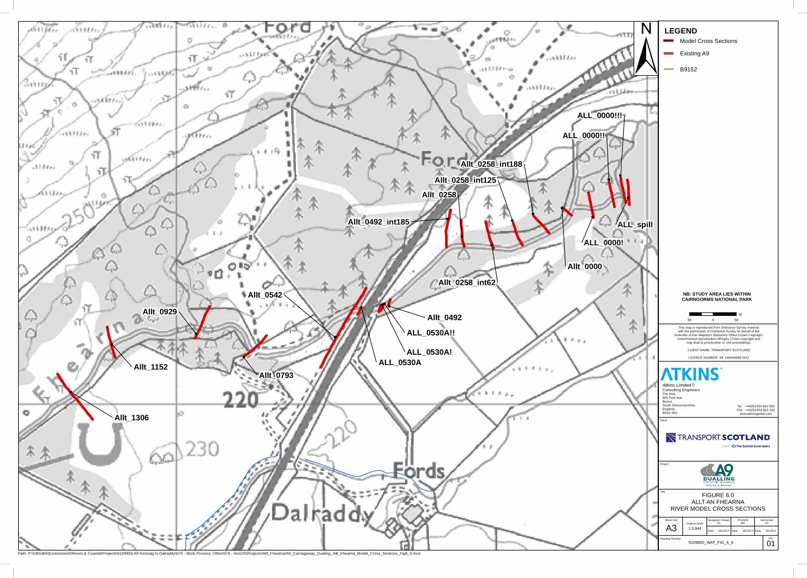
5.5. Allt an Fhearna
The proposed structure was assessed using the hydraulic model. The flow and water levels for the existing and proposed models are presented in Tables 17 and 18.
Table 17: Allt an Fhearna - Flow (m3/s)
Cross-section Flow for existing scenario
Flow for proposed scenario
Difference
Allt_0000 12.28 10.77 -1.50
Allt_0258 12.24 10.75 -1.49
Allt_0492 24.30 20.30 -4.00
ALL_0530A 38.93 38.75 -0.18
Allt_0542 39.75 38.75 -0.99
Allt_0793 39.11 38.91 -0.20
Allt_0929 38.89 38.87 -0.02
Allt_1152 38.89 38.91 0.02
Allt_1306 38.87 38.87 0.00
Table 18. Allt an Fhearna - Stage (m)
Cross-section Water level for Existing Scenario (m AOD)
Water Depth (m)
Water level for Proposed Scenario (m AOD)
Water Depth (m)
Difference in Water Depth (m)
Allt_0000 212.90 1.49 212.88 1.47 -0.01
Allt_0258 215.54 0.70 215.45 0.61 -0.09
Allt_0492 217.87 1.51 217.81 1.44 -0.07
ALL_0530A 219.78 2.66 219.11 1.85 -0.81
Allt_0542 220.10 2.69 219.28 1.86 -0.82
Allt_0793 221.51 1.29 221.41 1.19 -0.10
Allt_0929 223.35 1.21 223.40 1.26 0.05
Allt_1152 226.96 1.25 226.92 1.21 -0.04
Allt_1306 229.14 1.63 229.17 1.66 0.03
The results show that there is a drop in downstream flow and stage in the watercourse as a result of the proposed option. The proposed design decreases the water level as the width of the access track is increasing from approximately 3m to 6.6m. The out-of-bank flow spills onto the access track, as the access track is wider it reduces the water level. There is no increase in water level as a result of the proposed embankments. It was found that the out-of-bank flow spills to the flood plain through low lying ground downstream of the culvert outlet cross-section. The levels of this spill are unaffected by the proposed earthworks embankments. The flow from the Allt an Fhearna is therefore still able to flow into the floodplain and this results in no increase in flow or water level downstream of the proposed design.

Page 449
Flood Risk Assessment
The floodplain storage is modelled using a 2D mesh. Volume and levels of each triangle within the mesh vary, however a check was carried out of the flood levels for two locations in the mesh. A location near the A9 crossing and a location at the loch was picked. This analysis found that there was negligible difference in water level at each location (+/- 0.05m) between the existing and proposed scenarios. Its important to note that it is difficult to do a direct comparison as the triangles making up the 2D mesh are repositioned between the existing and the proposed model, however checks on several points at various locations provided the most accurate check for increases in water level.
Although flood waters will have been displaced due to the proposed embankments there has been no increase in water level in the channels and a negligible difference to floodplain water levels. Compensatory storage has not been optioned as the model has shown that there is no increase in flood risk associated with the proposed works. With no increase in water level in the channel or the floodplain due to the proposed design, construction of compensatory storage cannot be demonstrated to provide any benefit to the water environment.
No options were assessed for the Allt an Fhearna. Increasing the span would require a deeper deck crosssection which would reduce the headroom required for vehicle passage through the access track within the structure. The trunk road vertical profile has been raised through this section to achieve required headrooms and it would be difficult to raise this profile further within the confines of road design standards. Furthermore, raising the profile would result in an increase of the earthworks embankments. Reducing the span was not considered as it would result in further encroachment of the embankments onto the flood plain area.

Page 450
A9 Dualling Kincraig to Dalraddy Environmental Statement
6. ConclusionsThe key conclusions to this study are as follows
• Hydraulic models were used to assess the changes to flow and water levels for all watercourses crossed by the proposed A9 Dualling: Kincraig to Dalraddy.
• Where possible two options for each crossing were assessed,• The models found that there was no increase to flow or water level as a result of the
proposed design.• For the Dunachton Burn and Allt an Fhearna crossings, the models show an improvement to
flood risk at the structures.
LEGEND
Section Locations
Existing A9
B9152
Surface water feature
Path: P:\GBGWA\Environment\Rivers & Coastal\Projects\5109850 A9 Kincraig to Dalraddy\070 - Work Process, Other\076 - ArcGIS\Projects\Meadowside\A9_Carriageway_Meadowside_Section_Location_FIG1_0.mxd
5109850_WAT_FIG1.0
Designed / DrawnLG
01
This map is reproduced from Ordnance Survey materialwith the permission of Ordnance Survey on behalf of the
controller of Her Majesty's Stationery Office Crown Copyright.Unauthorised reproduction infringes Crown copyright and
may lead to prosecution or civil proceedings.
CLIENT NAME: TRANSPORT SCOTLAND
LICENCE NUMBER: SE 100046668 2012
Date 22/10/13
Original Scale
1:2,000
CheckedEM
AuthorisedXX
Date 22/10/13 Date 22/10/13
Sheet Size
MEA08_0254
MEA06_0095U
MEA09_0324
MEA04_0039
MEA07_0167
MEA02_0006D
MEA03_0017U
MEA05_0054D
MEA01_0000U
50 0 50M
±
Rev
A3
TM
Project
Title
Drawing Number
Client
Atkins Limited ©Consulting EngineersThe Hub,500 Park Ave,Bristol,South Gloucestershire,England,BS32 4RZ
Tel: +44(0)1454 662 000Fax: +44(0)1454 663 333
www.atkinsglobal.com
NB: STUDY AREA LIES WITHINCAIRNGORMS NATIONAL PARK
FIGURE 1.0MEADOWSIDE Q200 + (20%CC)
SECTION LOCATIONS

Path: P:\GBGWA\Environment\Rivers & Coastal\Projects\5109850 A9 Kincraig to Dalraddy\070 - Work Process, Other\076 - ArcGIS\Projects\Dunachton\A9_Carriageway_Dunachton_Model_Cross_Sections_Fig2_0.mxd
5109850_WAT_FIG_2_1
Designed / DrawnLG
01
This map is reproduced from Ordnance Survey materialwith the permission of Ordnance Survey on behalf of the
controller of Her Majesty's Stationery Office Crown Copyright.Unauthorised reproduction infringes Crown copyright and
may lead to prosecution or civil proceedings.
CLIENT NAME: TRANSPORT SCOTLAND
LICENCE NUMBER: SE 100046668 2012
Date 22/10/13
Original Scale
1:2,500
CheckedEM
AuthorisedXX
Date 22/10/13 Date 22/10/13
Sheet Size
DUN_0000
DUN_0543
DUN_0710
DUN_0281
DUN_1021
DUN_0335
DUN_0098
DUN_0254_int39
DUN_0522
DUN_0254
DUN_0360
DUN_0360B
DUN_0360A
DUN_0254_int78
DUN_0254_int117
DUN_0281ADUN_0281B
DUN_0543A
DUN_0543B! DUN_0522BS
50 0 50M
±
Rev
A3
TM
Project
Title
Drawing Number
Client
Atkins Limited ©Consulting EngineersThe Hub,500 Park Ave,Bristol,South Gloucestershire,England,BS32 4RZ
Tel: +44(0)1454 662 000Fax: +44(0)1454 663 333
www.atkinsglobal.com
NB: STUDY AREA LIES WITHINCAIRNGORMS NATIONAL PARK
FIGURE 2.1DUNACHTON
RIVER MODEL CROSS SECTIONS
Legend
Dunachton River Model Cross Sections
Existing A9
B9152
WaterCourse
Surface water feature

Path: P:\GBGWA\Environment\Rivers & Coastal\Projects\5109850 A9 Kincraig to Dalraddy\070 - Work Process, Other\076 - ArcGIS\Projects\Leault_Burn\A9_Carriageway_Leault_Burn_Model_Cross_Sections_Fig3_0.mxd
5109850_WAT_FIG_3_0
Designed / DrawnLG
01
This map is reproduced from Ordnance Survey materialwith the permission of Ordnance Survey on behalf of the
controller of Her Majesty's Stationery Office Crown Copyright.Unauthorised reproduction infringes Crown copyright and
may lead to prosecution or civil proceedings.
CLIENT NAME: TRANSPORT SCOTLAND
LICENCE NUMBER: SE 100046668 2012
Date 22/10/13
Original Scale
1:4,876
CheckedEM
AuthorisedXX
Date 22/10/13 Date 22/10/13
Sheet Size
LEA_0495 LEA_0182
LEA_0000
LEA_0087
LEA_0713
LEA_0215
LEA_0215D
Lealt Burn
50 0 50M
±
Rev
A3
TM
Project
Title
Drawing Number
Client
Atkins Limited ©Consulting EngineersThe Hub,500 Park Ave,Bristol,South Gloucestershire,England,BS32 4RZ
Tel: +44(0)1454 662 000Fax: +44(0)1454 663 333
www.atkinsglobal.com
NB: STUDY AREA LIES WITHINCAIRNGORMS NATIONAL PARK
FIGURE 3.0LEAULT BURN
RIVER MODEL CROSS SECTIONS
LEGEND
Leault Burn Model Cross Section
Existing A9
B9152
WaterCourse
Surface water feature

Path: P:\GBGWA\Environment\Rivers & Coastal\Projects\5109850 A9 Kincraig to Dalraddy\070 - Work Process, Other\076 - ArcGIS\Projects\Baldow Smiddy\A9_Carriageway_Dualing_Baldow_Smiddy_Model_Cross_Sections_Fig4_0.mxd
5109850_WAT_FIG_4_0
Designed / DrawnLG
01
This map is reproduced from Ordnance Survey materialwith the permission of Ordnance Survey on behalf of the
controller of Her Majesty's Stationery Office Crown Copyright.Unauthorised reproduction infringes Crown copyright and
may lead to prosecution or civil proceedings.
CLIENT NAME: TRANSPORT SCOTLAND
LICENCE NUMBER: SE 100046668 2012
Date 16/10/13
Original Scale
1:5,000
CheckedEM
AuthorisedXX
Date 16/10/13 Date 16/10/13
Sheet Size
Bal_0058
Bal_0332
BAL_0548
Bal_03U
Bal_0000
Bal_0103
Bal_03D
River Spey
Lealt Burn
Lower Milehead
Baldow Smiddy
50 0 50M
±
Rev
A3
TM
Project
Title
Drawing Number
Client
Atkins Limited ©Consulting EngineersThe Hub,500 Park Ave,Bristol,South Gloucestershire,England,BS32 4RZ
Tel: +44(0)1454 662 000Fax: +44(0)1454 663 333
www.atkinsglobal.com
NB: STUDY AREA LIES WITHINCAIRNGORMS NATIONAL PARK
FIGURE 4.0BALDOW SMIDDY
RIVER MODEL CROSS SECTIONS
Legend
Baldow Smiddy River Model Cross Sections
Existing A9
B9152
Surface water feature
WaterCourse

Path: P:\GBGWA\Environment\Rivers & Coastal\Projects\5109850 A9 Kincraig to Dalraddy\070 - Work Process, Other\076 - ArcGIS\Projects\Dalraddy\A9_Carriageway_Dalraddy_Model_Cross_Sections_Fig5_0.mxd
5109850_WAT_FIG_5_0
Designed / DrawnLG
01
This map is reproduced from Ordnance Survey materialwith the permission of Ordnance Survey on behalf of the
controller of Her Majesty's Stationery Office Crown Copyright.Unauthorised reproduction infringes Crown copyright and
may lead to prosecution or civil proceedings.
CLIENT NAME: TRANSPORT SCOTLAND
LICENCE NUMBER: SE 100046668 2012
Date 22/10/13
Original Scale
1:2,500
CheckedEM
AuthorisedXX
Date 22/10/13 Date 22/10/13
Sheet Size
Unn_02 Unn_0000
Unn_07
Unn_08
Unn_03Unn_06
50 0 50M
±
Rev
A3
TM
Project
Title
Drawing Number
Client
Atkins Limited ©Consulting EngineersThe Hub,500 Park Ave,Bristol,South Gloucestershire,England,BS32 4RZ
Tel: +44(0)1454 662 000Fax: +44(0)1454 663 333
www.atkinsglobal.com
NB: STUDY AREA LIES WITHINCAIRNGORMS NATIONAL PARK
FIGURE 5.0DALRADDY
RIVER MODEL CROSS SECTIONS
LEGEND
Existing A9
B9152
River Model Cross Sections
Path: P:\GBGWA\Environment\Rivers & Coastal\Projects\5109850 A9 Kincraig to Dalraddy\070 - Work Process, Other\076 - ArcGIS\Projects\Allt_Fhearna\A9_Carriageway_Dualing_Allt_Fhearna_Model_Cross_Sections_Fig6_0.mxd
5109850_WAT_FIG_6_0
Designed / DrawnLG
01
This map is reproduced from Ordnance Survey materialwith the permission of Ordnance Survey on behalf of the
controller of Her Majesty's Stationery Office Crown Copyright.Unauthorised reproduction infringes Crown copyright and
may lead to prosecution or civil proceedings.
CLIENT NAME: TRANSPORT SCOTLAND
LICENCE NUMBER: SE 100046668 2012
Date 16/10/13
Original Scale
1:3,944
CheckedEM
AuthorisedXX
Date 16/10/13 Date 16/10/13
Sheet Size
Allt_0542
Allt_1306
Allt_0929
Allt_1152Allt_0793
Allt_0258
ALL_spill
ALL_0000!
Allt_0492_int185
ALL_0000!!
Allt_0258_int62
Allt_0258_int125
Allt_0492
ALL_0000!!!
Allt_0258_int188
Allt_0000
ALL_0530AALL_0530A!
ALL_0530A!!
50 0 50M
±
Rev
A3
TM
Project
Title
Drawing Number
Client
Atkins Limited ©Consulting EngineersThe Hub,500 Park Ave,Bristol,South Gloucestershire,England,BS32 4RZ
Tel: +44(0)1454 662 000Fax: +44(0)1454 663 333
www.atkinsglobal.com
NB: STUDY AREA LIES WITHINCAIRNGORMS NATIONAL PARK
FIGURE 6.0ALLT AN FHEARNA
RIVER MODEL CROSS SECTIONS
LEGEND
Existing A9
B9152
Model Cross Sections