1979 report of exploration activities - related information · · 2013-10-241979 report of...
TRANSCRIPT


1979 REPORT OF EXPLORATION ACTIVITIES
ON THE SOUTH MOUNT GETHING PROPERTY
Coal Licence Numbers 4129 to 4152 Inclusive
Located In
Peace River Land District
and Liard Mining Division
National Topographic System Designation
93 8 16 West and 94 B 1 West
Centered on Lat. 55O 58'N; Long. 122O 25'W
Owned and Operated by Utah Mines Ltd.
Report by: D.N. Duncan
of Utah Mines Ltd.
Field Work Performed Between
May 7, 1979 and August 14, 1979
Report Submitted April 28, 1980
TABLE OF CONTENTS
Abstract
Locatibn and Access
Property and Title
Physiography
Exploration of the South Mount Gething Property
Previous Exploration
1979 Exploration Program
Geology - General and Local
structure
.
D.D.H. SMG-79-4
D.D.H. SMG-79-5
D.D.H. SMG-79-6
D.D.H. SMG-79-7
D.D.H. SMG-79-8
D.D.H. SMG-79-9
D.D.H. SMG-79-10
A - me11 Completion Report 28 B - Comments 29
A - Well Completion Report 32 B - Comments 33
A - Well Completion Report 36 B - Comments 37
A - Well Completion Report B - Comments
40 41
A -well Completion Report 45 B - Comments 46
A - Well Completion Report B - Comments
A - Well Completion Report B - Comments
49 50
53 54
57 Correlation of Coal Seams
PAGE NO.
1
2
6
8
11
12
18
25
Table of Contents - cont'd.
Conclusions and Recommendations
Selected Biljliography
Appendices
PAGE NO.
60
62
Appendix I - Descriptive Lithologic Logs sEef pfi- 50Mrl+ i-37- &T~#ibUrj7
D.D.H. SMG-79-4,5,6,7,8,9,10 79129A II - Analytical Data s&E: Pk?-5ouwi m-r cjLril.t-/N.j
D.D.H. SMG-79-4,5,6,7,8,9,10 74 [L,tj,q Cmhdeuh=/
III - Cost Statement
IV - Statement of Qualifications

ILLUSTRATIONS
PAGE NO.
Figure
1.
2.
3.
4.
5.
54 +j-
8.
*10.
y 11.
* s2.
Table
1.
2.
South Mount Gething Property Location Map 3
South'Mount Gething Property Regional Map 4
South Mount Gething Coal Licences 7
Physiographic Subdivisions - Northeast B.C. 9
South Mount Gething Drill Hole Locations 14
l:lO,OOO Scale East-West Section @ 6,202,50ON (Pocket) (McElhanney Coordinates)
l:lO,OOO Scale East-West Section @ 6,199,40ON (McElhanney Coordinates)
(Pocket)
1:50,000 Scale East-West Section @ 55°58'03" North 27
Tentative Coal Seam Correlation Between D.D.H. (Pocket) SMG-78-Z&3 and SMG-79-4,5&6.
Tentative Cdal Seam Correlation Between D.D.H. SMG-79-7,8,9.
(Pocket)
Tentative Coal Seam Correlation Between D.D.H. (Pocket) SMG-78-l and SMG-79-10.
Tentative Coal Seam Correlation Between Drill Holes and Measured Sections
(Pocket)
Flow Chart for Analysis of Diamond Drill Hole Samples.
Formational Nomenclature-Fort St. John & Bullhead Groups
17
24

Illustrations - cont'd. PAGE NO.
+c i!3?
Sheets 1,2 and 3 - l:lO,OOO Scale-Bedrock Geology (Pocket) and Drill Hole Locations
Gamma Ray - Density Logs for Diamond Drill Holes SMG-79-4, SMG-79-5, SMG-79-6, SMG-79-7, SMG-79-8, SMG-79-9, SMG-79-10.
(Pocket)
Graphic Lithologic Logs for Diamond Drill Holes SMG-79-4, SMG-79-5, SMG-79-6, SMG-79-7, SMG-79-8, SMG-79-9, SMG-79-10.
(Pocket)

ABSTRACT
The twenty-four (24) contiguous coal licences, numbered 4129
to 4152 inclusive, which comprise the South Mount Gething
Property were issued to Utah Mines Ltd. on August 15,1978.
The property is located in the Liard Mining Division and the
Peace River Land District. The 1979 exploration program for
the property was designed to provide further infoxmation on
the extent,metallurgical quality and continuity of coal seams
on the property, pursuant to the 1978 program. A program of diamond drilling and limited geological mapping was under-
taken to accomplish these objectives.
Seven diamond drill holes, totalling 1493 metres, were drilled
on widely spaced centres on the property. Access to the three
holes drilled in the northeastern portion of the property was
facilitated by the construction of access roads, totalling
3021 met&s in length. The remaining four drill holes, in
the southern and western portions of the property, were
accessible by helicopter. Geological mapping was completed
in several locations throughout the property, mainly to add
information on areas not fully covered in the 1978 program.
The 1979 exploration program greatly improved the under- standing of the property's geology and economic potential and
provides a base for further exploration of the South Mount
Gething Property.
1
LOCATION AND ACCESS
South Mount Gething Property is located in the designated
"Northeast Coal Block", lying within the Liard Mining Div- ision and the Peace River Land District. Geographical co-
ordinates of the centre of the property are 55O 58' Ni
12Z" 25' W. The coal licences are within the area covered
by the National Topographic System designation 93-O-16 and 94-B-1W. The property, which is roughly triangular in
shape, is largely confined between Dowling Creek on the
east and Gaylard Creek on the north, with two licences'
lying within and north of the Gaylard Creek Valley.
The central part of the property lies approximately 15 kilo-
metres west-southwest from the W.A.C. Bennett Dam, 36 kilo-
metres west-southwest of the town of Hudson's Hope and 60
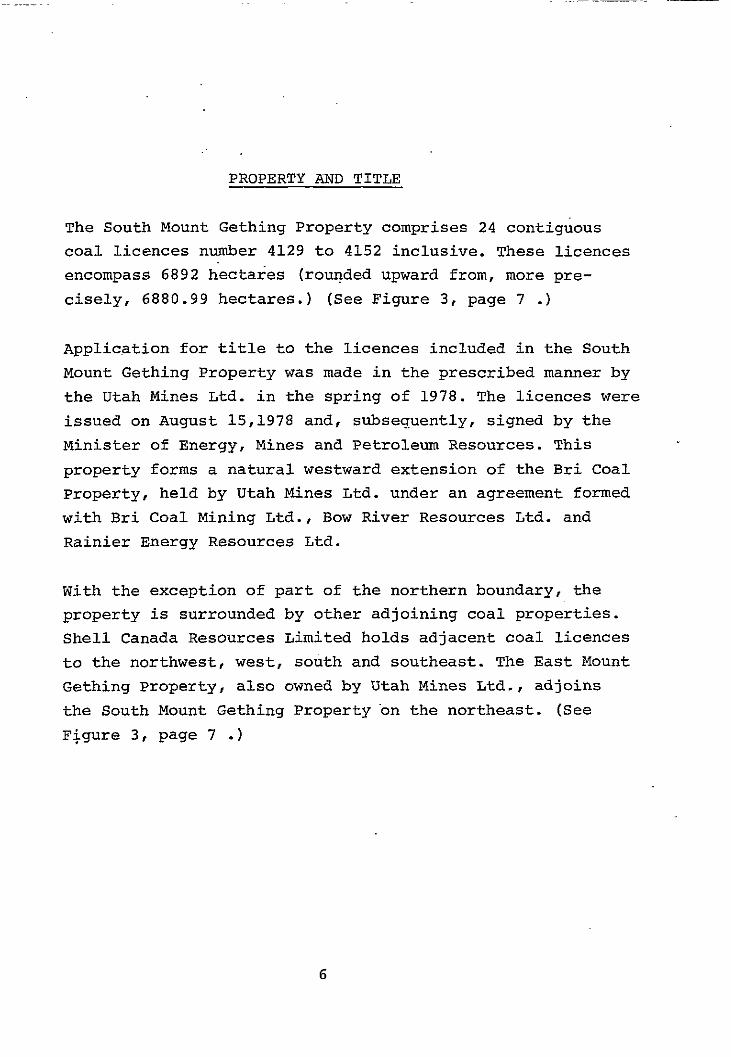
kilometres northwest of the town of Chetwynd. Vancouver is
approximately 770 kilometres south of the property. (See
Figure 1, page 3 , figure 2, 4 .')
Highway 29, joining Chetwynd, Hudson's Hope and Fort St.
John, passes approximately 31 kilometres to the east of the
property. Canfor Limited's (a major forest products company)
Johnson Creek-Track Creek Road, which joins Highway 29 at
19 kilometres south of Hudson's Hope, and several secondary
logging roads provide direct road access to various parts
of the property. (See maps 1 and 2 in pocket.)
2

I COLUMBIA
1 Ft. 9. JOA”
““dav Hop . I
ALBERTA .\
c8oon \ CCCL, \
i “Ypcr’ SOUTH MI GETHING
!
‘;,
'c - 1..
\ . co/gory
-5 \
i.9
-..-..-. ,_..--
..-..- ..-..-..-..
u. S. A.
UTAH MINES LTD.
SOUTH MT. GETHING
LOCATION MAP

I P I
SCALE
FIGURE - 2
REGIONAL MAP
SOUTH MT. GETHING
WILLISTOh’ f-, LAKE
Goadlow 0
Clayhurst
Alternate'access to the Johnson Creek - Track Creek Road
is possible by travelling over the 13.7 kilometres of Utah
Mines Ltd. road from the west end of the W.A.C. Bennett
Dam. Drill access roads to diamond drill hole sites SMG-78-2,
SMG-79-4, SMG-79-5 and SMG-79-6 provide road access to the
northeastern portion of the property. Away from these roads,
access to much of the property is possible only by heli-
copter or on foot. The diamond drill holes in the western
and southern portions of the property have helicopter
landing pads which provide easier access to this portion of the property. (See maps 1 and 2 in pocket.)
5
:
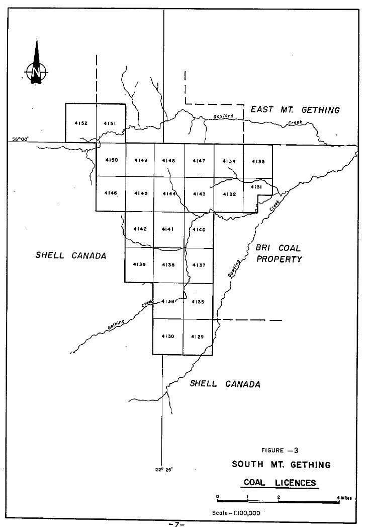
PROPERTY AND TITLE
The South Mount Gething Property comprises 24 contiguous
coal licences number 4129 to 4152 inclusive. These licences
encompass 6892 hectares (rounded upward from, more pre-
cisely, 6880.99 hectares.) (See Figure 3, page 7 .)
Application for title to the licences included in the South
Mount Gething Property was made in the prescribed manner by
the Utah Mines Ltd. in the spring of 1978. The licences were
issued on August 15,1978 and, subsequently, signed by the
Minister of Energy, Mines and Petroleum Resources. This
property forms a natural westward extension of the Bri Coal
Property, held by Utah Mines Ltd. under an agreement formed
with Bri Coal Mining Ltd., Bow River Resources Ltd. and
Rainier Energy Resources Ltd.
With the exception of part of the northern boundary, the
property is surrounded by other adjoining coal properties. Shell Canada Resources Limited holds adjacent coal licences
to the northwest, west, south and southeast. The East Mount
Gething Property, also owned by Utah Mines Ltd., adjoins
the South Mount Gething Property on the northeast. (See
Figure 3, page 7 .)
6
SHELL CANADA
-
Ii
W
PROPERTY
/ SHELL CANADA
FIGURE -3
251 SOUTH MT. GETHING
COAL LICENCES
I e
Scale-I:100,000

PHYSIOGRAPHY
The South Mount Gething Property is situated in the outer
(eastern) belt of the Rocky Mountain Foothills. (See Figure
4, page 9 .) To the west, the margin of the Foothills belt is considered to be the easternmost major fault which
thrusts Paleozoic strata over Mesozoic strata. The eastern
margin is a series of en-echelon thrust faults, which
sepaxate the folded and faulted strata of the Foothills from
the gently dipping to flat-lying strata of the Alberta
Plateau (Holland, 1976.) Within this belt, major fold axes
and thrust faults trend in a northerly to northeasterly
direction with the thrusts dipping to the southwest. Struct- ural deformation is considerable near the western margin of
the Foothills and diminishes in extend and complexity toward
the eastern margin.
The Property is underlain by a broad, south plunging anti- cline.This prominent structural feature is reflected in
the topography of the property. South Mount Gething itself
approximates the form of a slice from a cone, with the apex
to the south. This conic form is contained to the west,
south and east by numerous hills and ridges occurring in a
roughly parabolic pattern. Segments of many streams follow
and accentuate this pattern.
8
T PUYSIOGRAPHIC SUEOIVISIONS NORTHEAST 5. C.
scale : I : /, 900,000
-9-

Topographic relief in the immediate area of the property is
moderate. Elevations range from approximately 770 metres in
Gething Creek Valley at the eastern property boundary, to
1532 metres at the summit of South Mount Gething. Surface
slopes are generally shallow to moderate. A few areas of
steep slopes and vertical cliffs occur on South Mount Gething
to the north and northwest. Stream valleys are commonly
broad and V-shaped with moderate to shallow gradients. Gay-
lard Creek Valley and the lower part of Gething Creek Valley
are alluvium filled and relatively broad and flat bottomed
in form.
10
EXPLORATIQN OF THE SOUTH MOUNT GETHING PROPERTY
Previous Exploration
Coal has been known to exist in the Peace River area since
1792, when Sir Alexander MacKenzie noted the existence of a
"bituminous substance which resembles coal" in Peace River
Canyon. Exploration, specifically designed to test the coal potential of the area covered by South Mount Gething Property,
had not been undertaken prior to the acquisition of the
property by Utah Mines Ltd. in 1978.
General reference to the area is made in various Geological
Survey of Canada and British Columbia Ministry of Energy,
Mines and Petroleum Resources publications (eg. McLearn and
Kindle, 1950; Hughes, 1964; Stott, 1963.) Geological Survey
of Canada Map 11 - 1961 provides a useful basic interpretation
of the geology of the property. There are several reports
which deal with specific adjacent map areas and contain
information which is useful in the interpretation of the
geology of this property (eg. Stott, 1969; LeNobel, 1975,
1977; Anderson'and Armstrong, 1978.)
The 1978 exploration program for the South Mount Gething
Property provided a preliminary appraisal of the coal
potential of the property. A program of geological mapping
and limited diamond drilling was undertaken which resulted
in coverage of the property area at l:lO,OOO scale and the
drilling of three widely spaced diamond drill holes. In total, 606.86 metres of diamond drilling were completed in
the three holes. Thirty-seven samples were taken from the
core recovered from the drill holes and four samples were
taken from trenches.
11
All data and logs derived from the 1978 exploration program
may be referred to in the 1978 Report of Exploration Act-
ivities on South Mount Gething Property by A.T. Armstrong'
of Utah Mines Ltd.
The 1979 exploration program for the South Mount Gething
Property was designed to provide further information on the
extent, metallurgical quality and continuity of coal seams
on the property, pursuant to the 1978 program. Exploration
activities commenced on the property on May 18,1979 and
were concluded on August 15,1979. The determination of the
extent of the thick coal seam intersected in D.D.H. SMG-78-1,
which was drilled during the 1978 program, was considered a
priority. It was also particularly important to determine
the continuity of coal seams from the Bri Coal Property to
the South Mount Gething Property. A program of diamond
drilling and limited geological mapping was undertaken to
provide the information required to fulfill the objectives
of the program;
A limited geological mapping program, designed to fill in
areas not covered in the 1978 program, was undertaken inter- mittently from May 18,1979 to August 15,1979. Traverses
were made along creek valleys and on hill sides where the potential for finding outcrop was greatest. This work was
performed by Utah Mines Ltd. field crews made up of P. Cowley,
3. Ridley and D.N. Duncan, assisted by P. Sell, K. Broadbent
and J. Kozak. Field data and airphoto interpretive data from
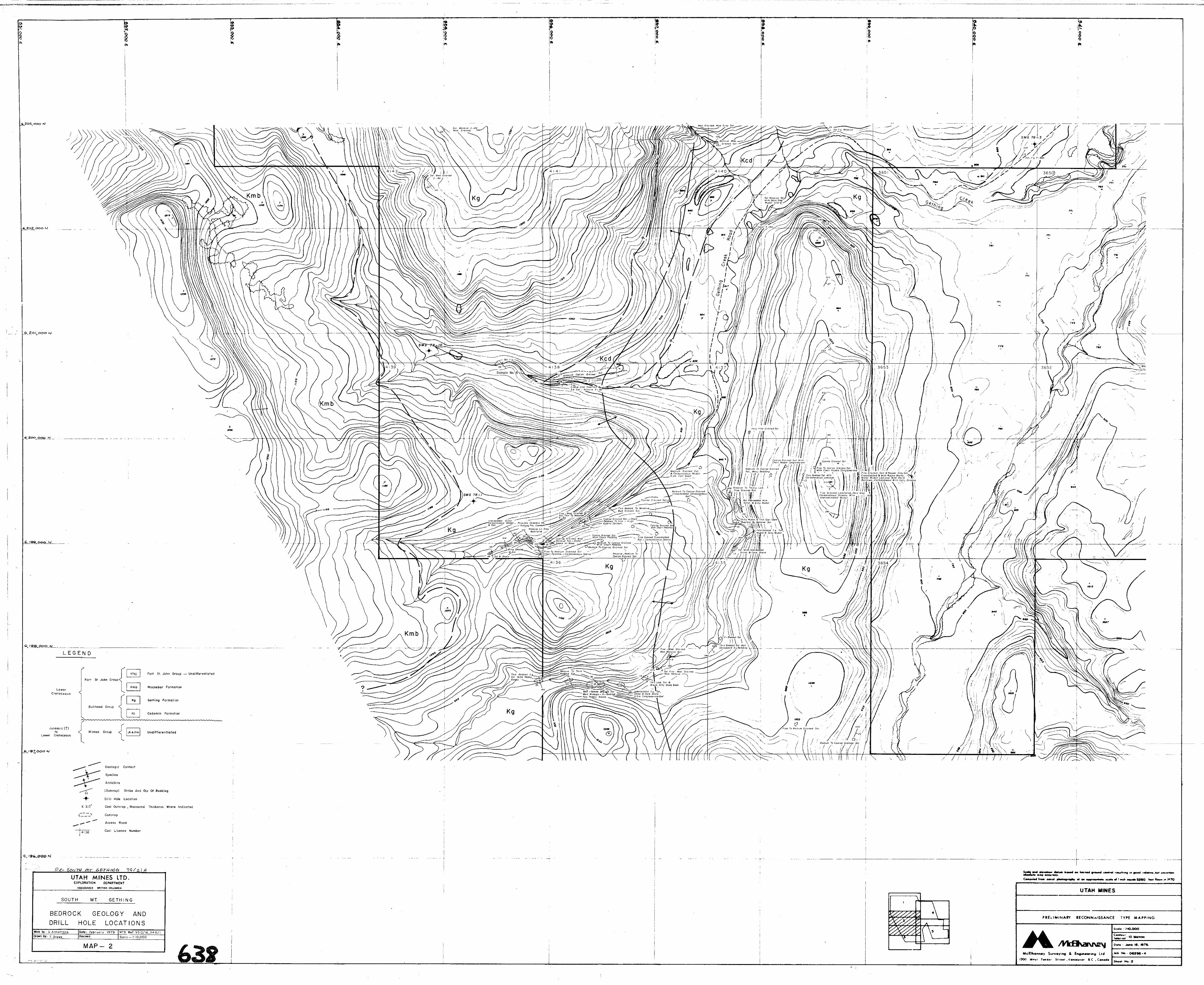
the 1978 and 1979 programs facilitated the development of
the geological interpretation shown on Maps 1, 2 and 3
(included in the map pocket.)
12

The exploration program included the drilling of seven (7)
diamond drill holes (See Figure 5, page 14.) Diamond drilling was performed by Longyear Canada Ltd. using a
Longyear "3%" diamond drilling rig. The drilling rig was
mobilized from Vancouver to the property and drilling
commenced at the first site on May 18,1979. The drilling
crew consisted of W. Castle (foreman), M. Bouchard (runner), J. Perrault (runner) who was later replaced by P. McDonald,
C. Tucker (helper), and P. Pepin (helper) who was later
replaced by G. Rohrback. The drilling equipment was re-
moved from the last site on June 30,1979.
Of the seven diamond drill holes in the 1979 program, three (SMG-79-4, SMG-79-5, and SMG-79-6) were located at the end
of access roads constructed by Utah Mines Ltd. The contractor
for access road and drill site construction was P. Demeule-
meester. The work included the slashing, clearing, clean-up
and general construction of 3021 metres of road, averaging
approximately 10 metres in width. Culverts were installed
across the roads where needed to provide road drainage and
free flow of smailstr.eams.The three sites, each approximately
35 metres in diametex, were also slashed, cleared and levelled.
A temporary mud sumpwas excavatedby bulldozer at each site.
A minor clearing was required at the sites to provide a
location for the water supply pump.
The four helicopter accessible drill sites (SMG-79-7, SMG-79-8, SMG-79-9 and SMG-79-10) were slashed using crews supplied by
P. Demeulemeester. Maple Leaf Helicopters Ltd. of Chetwynd,
B.C. provided a Bell 205 helicopter for the movement of
the Longyear "38" diamond drilling rig and related equipment
13
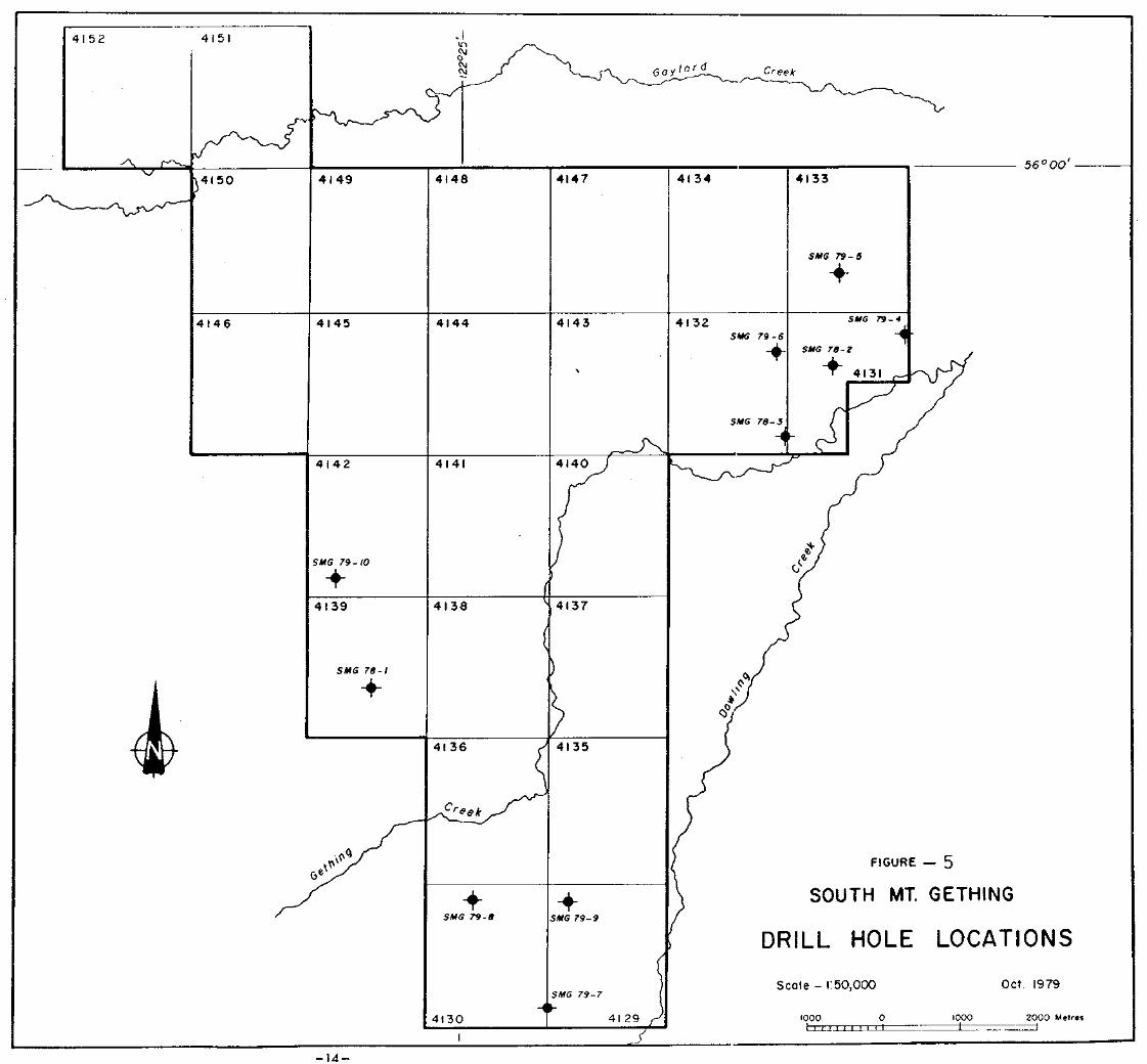
4151
56’00’ 4148 4147 4134 4133 4149
SMG 79-5
+
4132 SMG 79-6
+
SYG 79-4
-4
SYG 78-2
4146 4144 4143
\
SYG 78-3
i
4142 4141
SMG 79- 10
+
4139 1138 4137
SMG 78-1
+
II 36
(
b SOUTH MT. GETHING
DRILL HOLE LOCATIONS
+ + SMG 79-8 MG 79-9
Scale - 1:50,000 ‘MG 79-7
I
II 30
-14-
and supplies between drill sites. Maple Leaf Helicopters Ltd. also provided Bell 206 .Jet Ranger service for crew
changes, moving of supplies and drill core, and trans-
porting slashing crews.
Reclamation of disturbed ground was conducted by P. Demeule-
meester as an ongoing part of the program. Roads and road
accessible drill sites were cleaned up and recontoured
after moving the drilling rig from each site. Mud sumps'
were refilled and levelled. The drill sites and their
access roads were sown with the grass seed mixture
recommended by the Reclamation Branch of the British
Columbia Ministry of Energy, Mines and Petroleum
Resources for forested areas of the Northeast Coal Block.
Upon completion of the,program, culverts were removed,
water bars were installed on all steep road grade and, in
some places, special ditches were excavated to assure
adequate drainage and to minimize erosion. The four heli-
copter drill sites each measured approximately 50m X 100m.
All felled trees were limbed and bucked into four foot
lengths, in compliance with British Columbia'Forest Service
specifications.
All construction equipment required during the 1979
exploration program was provided by P. Demeulemeester. Caterpillar D7G, D6C and D6D bulldozers and a small John
Deere crawler equiped with a cyclone seeder were used in
the course of the program. One or more 3/4 ton, Ford
four-wheel drive pickup trucks were used to transport
personnel, fuel and supplies. This equipment was used for
road and drill site construction and maintenance, reclam-
ation work, drill moves and servicing the drill..
15

A total of 1493 metres of diamond drilling were c,ompleted
in the seven drill holes. The core was logged by 3. Ridley,
A.T. Armstrong, R.B. Anderson and D.N. Duncan of Utah Mines
Ltd. Descriptive lithologic logs and graphic lithologic
logs were prepared,for each hole (included in the map pocket.)
Mechanical logs, consisting of gamma ray and density logs,
were run on each'hole by Utah Mines Ltd. personnel. The
mechanical'logger used was either a portable Gearhart-
Owens Model 06-3200 Widco Logger withanelectric hoist or
a truck mounted Widco Logger with a hydraulic hoist and
a combination down hole tool (logs are included in the map
pocket.)
Forty-six coal samples were taken from core recovered from
the seven drill holes. These samples were submitted for analysis to the Utah International Inc. Minerals Laboratory
at 1190 Bordeaux Drive, Sunnyvale, California, 94086.
Analyses were conducted following the procedures outlined
on the laboratory flow chart on the following page (Table 1.)
Upon completion of the 1979 field program, the drill core
was shipped to the Charlie Lake core storage facility of
the British Columbia Ministry of Energy, Mines and Petroleum
Resources.
16

FLOW CHART FOR ANALYSIS
OF D I’AMOND DRILL HOLE SAMPLES
INCOMING SAMPLE
, AIR DRIED
,,l) CRUSH 3/4" 2) CRUSH 3/S"
I
3) WSIGH TOTAL INCOMINGSAMPLE
SPLIT cl000 GRAMS 'I SPLIT SMALL AMOUNT FOR RUN 3
I WASH (1.4 SPESIFIC GRAVITY)
c t c
1.4 FLOAT 1.4 SINK
1) AIR DRY 1) AIR DRY 2) WEIGH SAMPLE* 2) NEIGH SAMPLE* 3) PULVERIZE (60 MESH) 3) PULVERIZE (60 MESH)
\ v
/ 4) MAKE SAMPLE & DUPLICATE SAMPLE 5) RUN ASSAYS
a) FSI b) %MOISTURE c) %ASH d) %SULPHUR e) %VOLATII.E MATTER
EXCESS SAMPLE OF MINH (R.O.M.) SAMPLE HEAD (R.O.M.)
FOR STORAGE - 1000 GRAMS 1) PULVERIZS 60 MESH 2j MAKE SAMPLE &
DUPLICATE 3) RmJ ASSAYS
a) FSI b) %MOISTJJRE c) SASH d) %SULPHUR I?) *VOLATILE
MATTER
*WEIGHT RECOVERY OF COAL INSIDE SAMPLE
I TABLE - I

GEOLOGY - GENERAL AND LOCAL
The South Mount.Gething Property is underlain.by folded
and faulted sediments of Lower Cretaceous and earlier (?)
age. The oldest rocks exposed on the property are thought
to be the upper units of the Upper Jurassic (?) to lower
Cretaceous Minnes Group. Unconformably overlying these
rocks are sediments of the Lower Cretaceous Bullhead
Group, which comprises Cadomin and Gething Formations.
TheBullhead Group is, in turn, disconformably overlain by
the Fort St. John Group. The Moosebar Formation, the old-
est member of the Fort St. John Group, is the only for- mation of this group which is found on the property.
The Minnes Group contains recessive, fine grained, argill-
aceous sediments of marine and/or continental origin on the
property. These sediments are exposed on the northern
flank of South Mount Gething. The upper portion of the
Minnes Group contains sediments of non-marine origin in
the area to the south of the South Mount Gething Property.
These sediments are referred to by Stott (1968) as the
Unnamed Unit which consists of interbedded fine grained
sandstones, siltstones, mudstones and minor coal seams.
The contact between the Minnes Group and overlying sedi-
ments of the Cadomin Formation of the Bullhead Group is
an abrupt, regional erosional unconformity (Stott; 1968,
Page 14.) This unconformity is present in the Peace River
area and extends north, south and west along the Rocky
18

.-..
Mountain Foothills and into the Alberta Plateau. The total
amount of sediments removed and the exact time interval
involved in this erosional event is not known and may vary
from area to area iti the region.
The majority of the South Mount Gething Property is under-
lain by the Cadomin and Gething Formations of the Bullhead
Group. Stott (1968, page 7) considers the Bullhead Group
and the overlying Fort St. John Group to form a complete
nonmarine and marine sequence:
"The basal succession of Lower Cretaceous coal-
bearing sediments and massive conglomerates is
included in the Bullhead Group. The overlying
Lower Cretaceous marine sediments with tongues
of carbonaceous, sandy sediments are included
in the Fort St. John Group. The lower part of
the sequence records widespread fluvial condi-
tions that developed after initial deposition
of conglomeratic sediments. The upper part re-
cords the complex intertonguing of marine trans-
itional and flood plain environments along the
coast line of'the Early Cretaceous epicontinental
sea."
Typically, the Cadomin Formation section consists of
massive conglomerates containing well rounded pebbles,
cobbles and boulders of extremely resistant rocks. In
the property area, the Cadomin Formation occurs as a
series of coarse grained , massive to coarsely cross-
bedded sandstone beds containing thin bands and lenses
19

of pebble conglomerate. The formation is exposed in the
summit area of South Mount Gething and in an area extend-
ing southeast and south from the summit. The environment
of deposition for the Cadomin Formation is considered to
have been a Piedmont alluvial plain (Stott, l.968, page
108:) The lack of extensive massive conglomeratic beds
in the property area, in favour of coarse grained sand-
stones, indicates that the area was a distal portion of
.the alluvial plain.
The contact between the Cadomin and Gething Formations
is not clearly defined in the property area. McLearn and
Kindle (1950, page 65) noted that the contact may not
occur at the same stratigraphic horizon from area to area.
Irish (1970, page 68) noted that to the northeast of
South Mount Gething Property:
"in Peace River Canyon, coarse sandstones
of the Cadomin Formation grade laterally
into interbedded coal, sandstones and
shale of the Gething Formation, and there-
fore the formations are in part lateral
equivalents."
This indicates that the contact between the two formations
is transitional, not abrupt. Stott (1963, page 3) noted
that the Cadomin and Gething Formations are actually "facies
of one depositional sequence." Thus, there is a transition
from the Cadomin Formation to the Gething Formation both
laterally and up the stratigraphic column. To make mapping
20

and core logging easier, the lower contact of the Gething Formation is placed at the top of the uppermost thick,
coarse grained sandstone bed of the Cadomin Formation.
The character of.the Gething Formation underlying the
property is typical; as described by Irish (1970, page
681, a sequence of:
"Interbedded, grey-and buff- weathering,
medium-to fine grained, grey to dark
brown sandstone, grey to black shales,
dark siltstones and coal seams."
These sediments represent deposition in an aggrading
flood plain environment. Some of the fine grained sand-
stones may represent bar finger and levee deposits and
others may represent flood plain splay deposits (Stott,
1968, page 111). Sedimentary features attributable to
these types of deposits are present in drill core and in
outcrop on the South Mount Gething Property. stott
(1968, page 111) lists some of the features found in sand-
stones in the Gething Formation; well sorted nature but often containing considerable matrix, festoon crossbeds,
laminae of plant debris and thin layers of silt and
clay. The finer silts and clays represent deposition
from water in areas practically devoid of current on the flood plain proper (Stott, 1968, page 112). These silts
and clays accumulated between the river channels and the
swamp and forest areas. The swamp and forest areas are the
source of the present coals and are thought to be of
several differing occurrences. Stott (1968, page 112)
21

suggests that some may have originated in abandoned river
channels, some paralleling major river channels and some on
deltas.
Work by Stott (1969, page 4) indicates a minimum thickness
of 1,600 feet (488 metres) for the Gething Formation in
this' area. The total thickness approaches 1800 feet (549
metres) if a postulated fault is absent. This formation is
but one of several which contain the metallurgical grade
coals which are explored for throughout the Northeast Coal
Block. The Gething Formation underlies much of the property,
extending to the west, south and east from the flanks of
South Mount Gething.
The Bullhead group is overlain by marine sediments of the
Fort St. John Group, which comprises, from oldest to
youngest,the Moosebar Formation, the Gates Formation, the
Hasler Formation, the Goodrich Formation and the Cruiser
Formation (See Table 2, page 24). Of these formations, only
the Moosebar Formation is thought to underlie the property
on the western and southern extremities.
The Moosebar Formation of the Fort St. John Group directly overlies the Gething Formation. It consists mainly of dark
grey to black, rubbly to blocky shales. Often a thin pebbly
basal sandstone to conglomerate lies abruptly on carbon-
aceous Gething Formation sediments. The lower part of the Moosebar Formation is typically strongly glauconitic and
contains thin ash (bentonite) bands. McKechnie (1955, page
7) noted that tine basal conglomerate of the Moosebar
Formation:
22.
II . . . is a typical mud-flats conglomerate
ranging from a few inches to about 4
feet thick, and is composed of well
rounded grey and black chert pebbles
about one guarter inch in diametex
in a mudstone matrix."
Ironstone concretions occur in bands at various levels in
the section. Toward thetopof the formation, the shales
become gritty and thin beds of fine grained sandstone'and
siltstone are present.
23
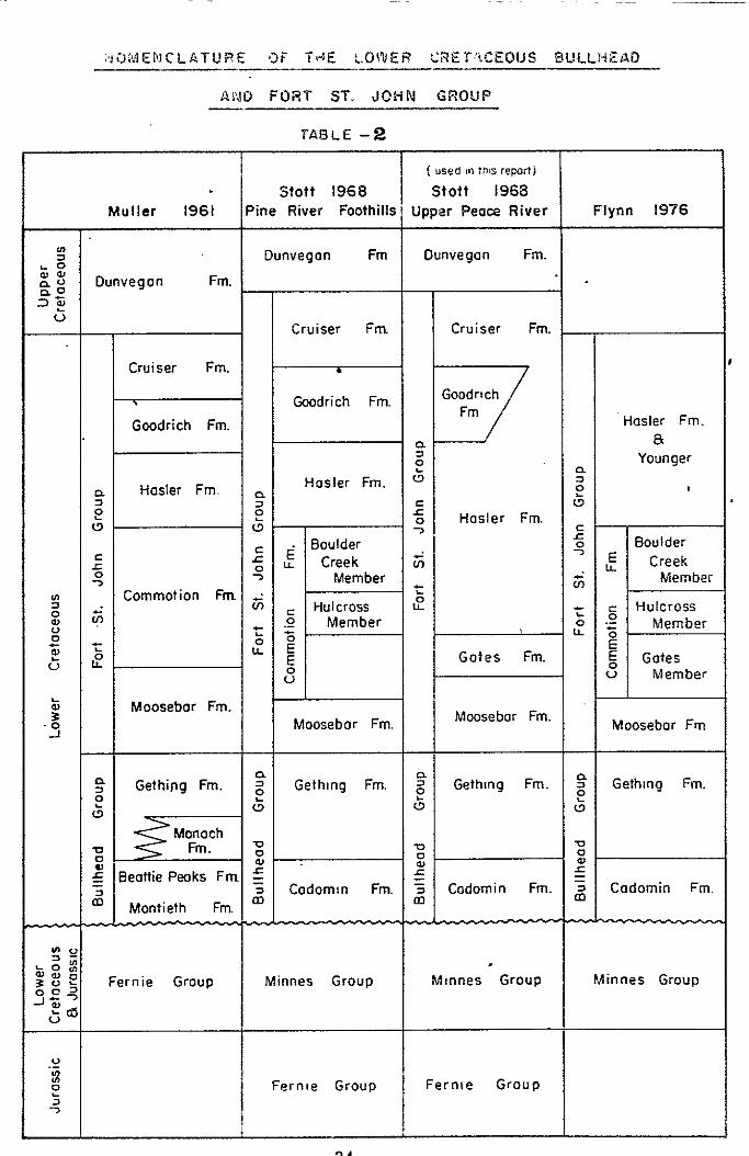
~ro?“~EFICLATURE ai i4E LOlllEt? 2i?E~!fCEOlJS BULL!+ENIJ ---__- -
AM0 FORT ST. JOHN GROUP
TABLE -2
( used I” :nts reporti
Stott 1968 stott 1968 MUller 1961 Pine River Foothills Upper Peace River Flynn 1976
* Dunvegan Fm Dunvegon Fm. 2
%z Dunvegon Fm. -0 3%
G Cruiser Fm. Cruiser Fm.
Cruiser Fm.
Goodrich Fm.
Goodrich Fm. Hasler Fm.
P 8 z Younger L
Hasler Fm. ” 2 P Hasler Fm. a 2 ii 2 ” 5 ; Hosler Fm. l5. ,”
. Boulder E I:
Boulder 2 2 E Creek 2 E
2 Creek
: LL Member s Member
2 Commotion Fm $ Hulcross
; ; Hulcross
2 v, s Member t 5
Member :
f ‘;, ;: ‘;o
; 82 E 2 u E Gotes Fm. 5 Gates
8 ” Member
i! Moosebar Fm.
‘3 Moosebor Fm. Moosebar Fm. Moosebor Fm
5 Gething Fm. ~ 2 Gethmg Fm. z Gethmg Fm. ?$ Gethmg Fm. 2 (3 0 L5 0
Monach n Fm. z n 72
1 Ei ?I
_ Beottie Pwks Fm g f 5
Li Codomtn Fm. 2 Codomin Fm. 2 Cadomin Fm.
Montieth Fm. m
2; gg::
Fernie Group 5 Minnes Group Mrnnes Group Minnes Group :;>
606
.u
3 Fernre Group Ferrite Group
-:
?A

STRUCTURE
The South Mount Gething Property is located within the
Foothills structural belt, which is underlain by folded
and thrust faulted Mesozoic strata (Irish, 1968). The
general trend of the structures'is northwesterly, with
most of the thrust faults dipping in a southwesterly
direction. Where the sediments are thick in this belt,
as in the property area, the dominant form of deformation
is folding.
The property is underlain by Minnes Group and Bullhead
Group sediments which have been folded into a broad, south
plunging anticline. The anticlinal axis, which is some-
what distorted, extends in a southerly direction from the
summit of South Mount Gething. A discontinous thrust fault
to the west of the summit of South Mount Gething has a
strike which is parallel to the trend of the fold axis.
Irish (19681, on his structural map of northeastern British Columbia, shows the South Mount Gething anticline
splitting into two thrust faults to the north of the
property. In the same bulletin, Irish states that, in the
property area, most thrust faults: (1 . ..have resulted from the breaking of tightly compressed anticlines, and begin
and/or terminate in compressed, asymmetrical
anticlines...."'
(Irish, 1968, page 24)
25

The thrust which occurs on South Mount Gething may be a
splay from another thrust which underlines the anticline
at depth.
Aside from the thrust on South Mount Gething, faulting
is not a prominent structural feature in the property
area. Some faulting was noted in the drill core, but the
dip angles of the faults closely approximate bedding dip
angles and are probably the result of slight movement, in
response to folding, along bedding surfaces. Fractures and tight slickensided shears are common in the core and
have been produced as an accommodation to stresses associ-
ated with folding and thrust faulting.
Minor folding has been noted in several road cuts along
the Gething Creek Road and in several localized areas, widely variable bedding orientations were measured which
are suggestive of small scale folding. Bedding orienta-
tions in the upper part of D.D.H. SMG-78-3 and the lower
part of D.D.H. SMG-79-5 are also indicative of small
scale folding.
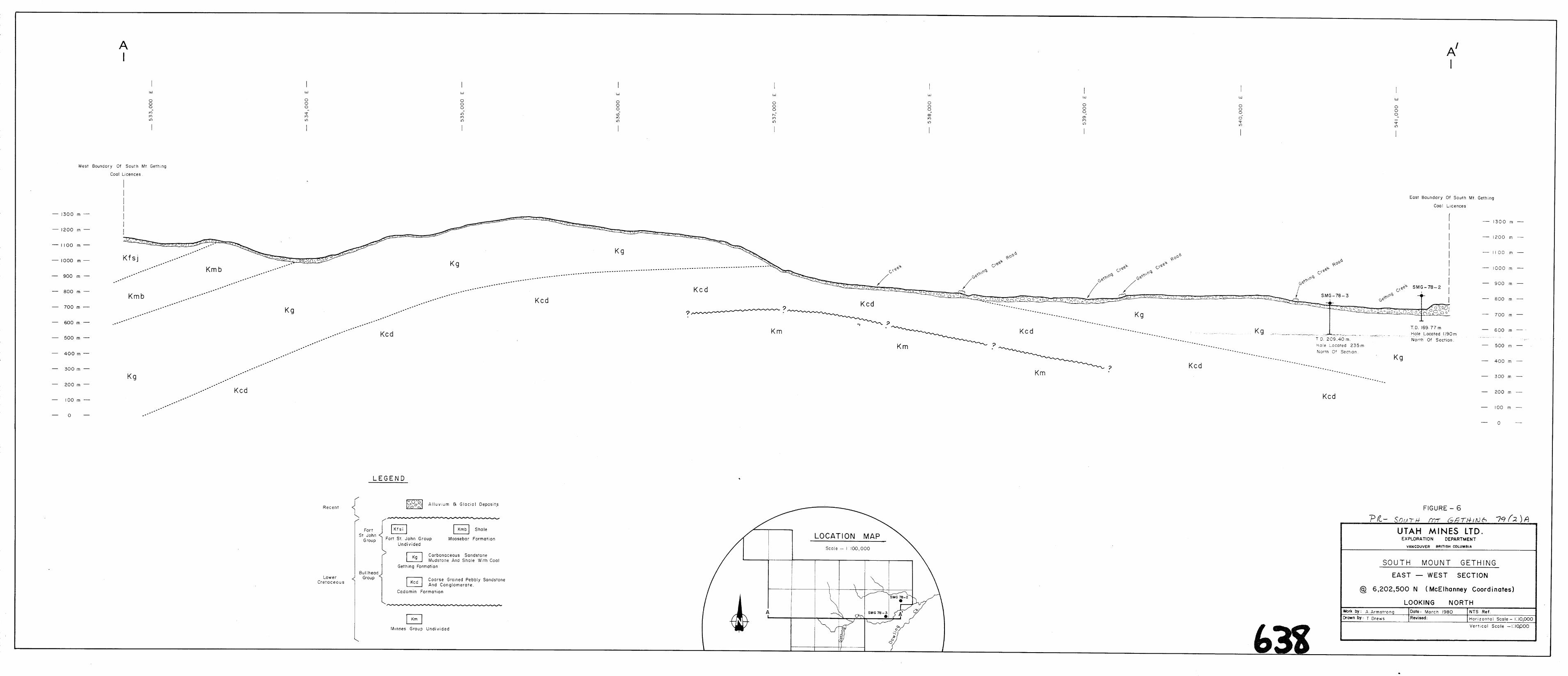
Structural geology for the property area is shown on
l:lO,OOO scale cross sections (Figures 6 and 7) which
are included in the map pocket. A 1:50,000 scale cross
section showing structural form and stratigraphic relation-
ships is found on the following page.
26


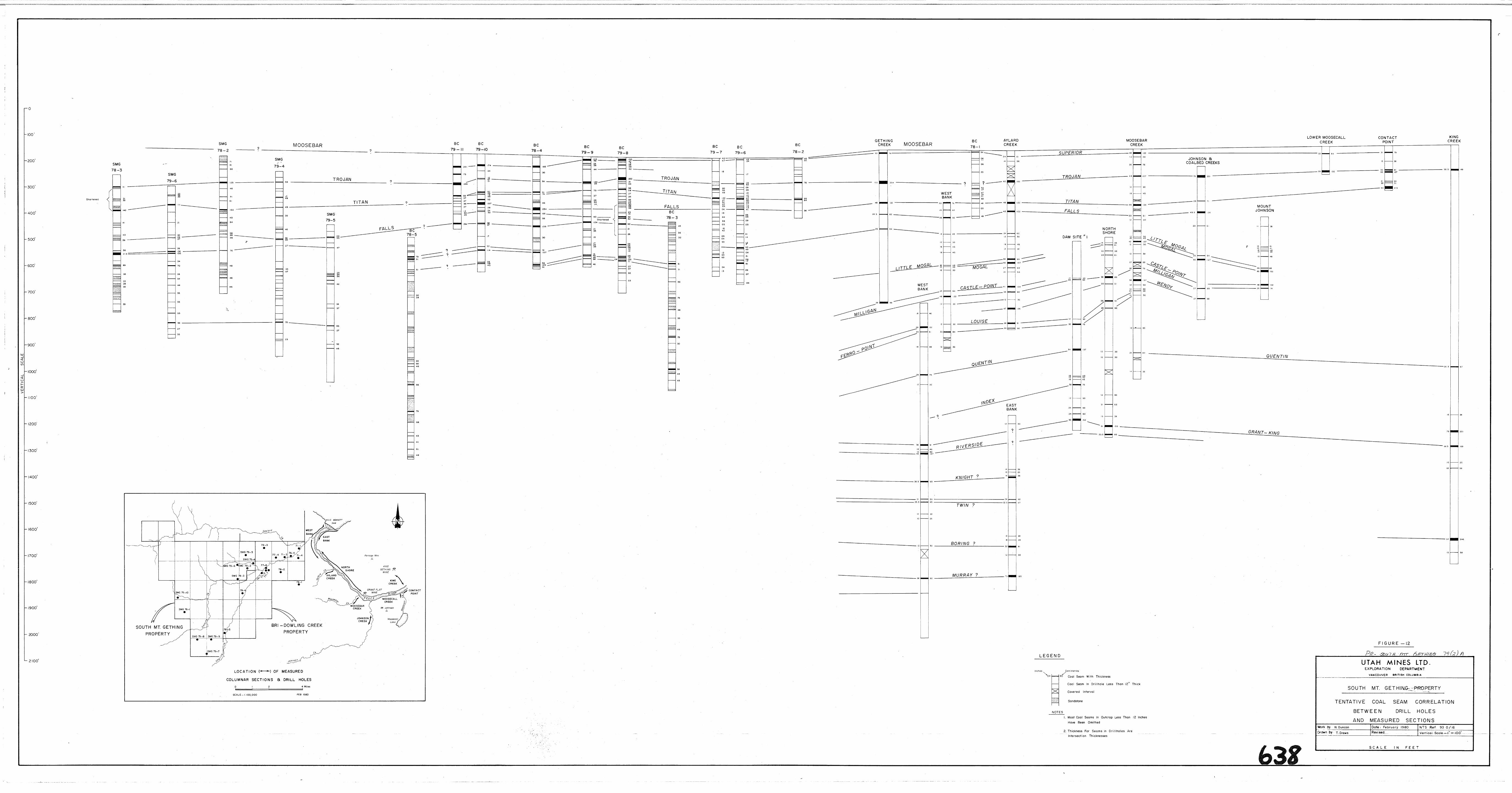
CORRELATION OF COAL SEAMS
In the South Mount Gething Property area, the most precisely correlatable horizon is the contact between the Gething
Formation and the overlying Moosebar Formation. None of the
diamond drill holes on the property intersected this contact
as the Moosebar Formation occurs only on the very edge of the
western property boundary. The sections drilled are thought
to be within the upper portion of the Gething Formation based
on the proximity of the contact to the drill holes. In the Peace River area, the coal seams of the Gething Formation show
significant variability in thickness and lateral extent (Stott,
1969). While coal seams are correlatable over one to two
kilometre distances, correlations are at best tentative when
drill holes are more widely separated. Stott (1969, page 8)
stated that:
"Current work shows that considerable variation
occurs within each individual coal seam, that
thickness may change rapidly, and that both
coal seams and sandstone units are lenticular
and have limited extent."
As a result, correlation of coal seams between drill holes becomes complex, involving physical, chemical and geophysical
drill derived data.
For the purpose of correlation, the diamond drill holes on
the South Mount Gething property have been divided into three
groups. The drill holes in each group are relatively close
together, which allows more definite correlation of the coal
seams between the holes. Correlations for the three groups
are shown in figures 9, 10 and 11 (in the pocket). Between
57

the three groups a definite coal seam correlation is not
,feasible at this time because of lack of drill information in
the intervening areas.'
Diamond drill holes SMG-78-2, SMG-78-3, SMG-79-4, SMG-79-5,
and SMG-79-6, located in the northeast portion of the property,
were included in one group. This group is close to the Bri
Coal Property and information from Bri drill holes was used
in the correlation (see figures 9 and 12 in the pocket).
The "Trojan" seam, the highest named seam in the cored
sections, was intercepted in a group of drill holes consist-
ing of SMG-78-2, SMG-78-3 and SMG-79-4. Diamond drill holes
SMG-79-5 and SMG-79-6 did not intercept the "Trojan" seam and.
it is postulated that the seam subcrops between these holes
and the above three holes. The "Titan" seam located approx-
imately 60 metres below the Gething-Moosebar contact'was cored
in all drill holes except SMG-79-5, which entered the Gething
Formation section below the level of the seam. The seam
maintains a thickness of approximately one metre in diamond
drill holes SMG-78-2, SMG-78-3 and SMG-79-6, but thins in the
direction of SMG-79-4 where it is 0.49 metres thick. The
"Falls" seam, normally found 76 to 90 metres below the Gething-
Moosebar contact, was intercepted in all of the diamond drill
holes in this group. It is thickest in D.D.K. SMG-79-4 and
SMG-79-5 and is split in all the holes except SMG-78-2. The
seams cored below the "Falls" seam were not named. In D.D.H.
SMG-78-3 and SMG-79-6 a thick, split coal seam was cored.
This seam thins rapidly to the northeast in diamond drill
holes SMG-78-2, SMG-79-4 and SMG-79-5.
58

Diamond drill holes.SMG-79-7, SMG-79-8 and SMG-79-9, located
on the southern end of the property, were grouped together for
the purpose of correlation. The correlation for these holes
(figure 10 in pocket) is not considered to be as reliable as
the correlation for the first group as the drill holes are
more widely spaced and nq control data can be used from the
adjoining Bri Property, a separation of two kilometres. The
seams are not named as the exact distance to the Moosebar
Formation - Gething Formation contact is not known. The
sections drilled are thought to be from the upper to middle
portion of the Gething Formation as evidenced by their proximity
to the Moosebar contact to the south and the west of the drill
holes.
Diamond drill holes SMG-78-1 and SMG-79-10 were grouped to-
gether for correlation. This correlation (figure 11 in
pocket) is considered to be very tentative as there is a
need for more drill data in the area. Also, the dips of the
strata in the area are steep, up to 30° from the core axis,
so that a small separation on the surface can be a large
separation in the section. Several thick coal seams are
present in the cored sections. A thick seam at 39.93 metres
from the collar in drill hole SMG-78-1 is thought to be too
high in the section to be cored by SMG-79-10. The upper thick seam in drill hole SMG-79-10, at 49.15 metres from the collar,
thins rapidly to SMG-78-1 where it is only 1.6 feet (0.49
metres) thick. The thick seam toward the base of SMG-78-1
thickens toward SMG-79-10 where it is split into three
benches. The two drilled sections were corrected for dip
(see figure11 in pocket) as an aid in correlating the coal
seams.
59

CONCLUSIONS AND RECOMMENDATIONS
The northeastern, southern and western coal licences of the
South Mount Gething property have potential for the discovery
of economically mineable coal. Exploration work to date has
primariiy involved extensive geological mapping and 2099.86 metres of diamond drilling in 10 widely spaced holes. Most
additional activities are related to this exploration.
The three holes drilled during the 1978 exploration program
were very widely separated and provided an initial examination
of the coal seams underlying the property. The results of this program provided areas of interest for further explora-
tion in 1979.
In 1979, seven widely spaced drill holes, in 3 groups, were
drilled on the property. Diamond drill holes SMG-79-4,
SMG-79-5 and SMG-79-6 further examined the northeastern
portion of the property. The coal seams cored in these holes
were of insufficient thickness to be economically mined by
todays standards, with the exception of the split seam from
92.73 metres to 95.97 metres in D.D.H. SMG-79-6. This seam
was also intersected in D.D.H. SMG-78-3 and further drilling on coal licence 4132 should be undertaken to examine the
extent of this seam.
Diamond drill holes SMG-79-7, SMG-79-8 and SMG-79-9, in the
southern portion of the property, did not intersect any coal
seams of metallurgical quality,thickness and lateral extent
as to lend themselves to mining.
Diamond drill holes SMG-79-10 did not intersect the 5.64
metres thick coal seam cored in D.D.H. SMG-78-1, but two other
60
seams, from 49.15m to 51.03m (1.88m) a.nd from 184.04m to
189.56m (3.75m net coal, with two thick mudstone splits), of
significant thickness were cored. Further drilling on coal licences 4139 and 4142 is necessary to further define the
form and character of the major coal seams encountered in
SMG-78-1 and SMG-79-10. The steep bedding dips, up to 30°
from the core axis, must be considered when locating drill
holes in this area. A program with flexibility in the posi- tioning and final depth of drill holes is imperative.
Further geological mapping is recommended in the northern
portion of the property (in the South Mount Gething area)
and near the southeastern boundary. This mapping would
greatly increase knowledge of the structure and lithology of
the formations underlying the South Mount Gething coal licences.
61

SELECTED BIBLIOGRAPHY
Anderson, R.B., and Armstrong, A.T.,
1979 : .1978 Report of Exploration Activities on the Bri-Dowling Creek Property. (unpublished re- port)
Armstrong, A.T., and Anderson, R;B.,
1979: 1979 Report of Exploration Activities on the Bri-Dowling Creek Property (unpublished re- port)
Armstrong, A.T.,
1979: 19.78 Report of Exploration Activities on the South Mount Gething Property (unpublished re- port)
Dyson, I.P.,
1972:
1976:
Holland,
1976:
Preliminary Report, Peace River Coal Project (unpublished report)
Peace River Coal Project, of Bow River Resources Ltd. & Rainier Energy Resources Ltd. (unpublished report)
Stuart S.,
Landforms of British Columbia, A Physiographic Outline; British Columbia Department of Mines and Petroleum Resources, Bulletin 48.
Hughes, J.E., 1964: Jurassic and Cretaceous Strata of the Bull-
head Succession in Peace and Pine River Foot- hills; British Columbia Department of Mines and Petroleum Resources, Bulletin 51.
1967: Geology of the Pine Valley Mount Wabi to Solitude Mountain Northeastern British Columbia: British Columbia Department of Mines and Pet- roleum Resources, Bulletin 52.
- 62 -

Irish, E.J.W.,
1965: Geology of the Rocky Mountain Foothills Alberta (between latitudes 53'15' and 5<Ol5'); Geological Survey of Canada, Memoir 334.
1968: Structure of the Northern Foothills and East- ern Mountain Ranges, Alberta an8 British Co@mbia, (between latitudes 53 15' and 57 20'); Geological Survey of Canada, Bulletin 168.
1970: Halfway River Map - Area British Columbia: Geological Survey of Canada, Paper 69-11.
leNobe1, D.N.,
1977: Coal Submittal; Gething - Dowling Creek Coal Licences. (private company memo)
1977: Bri Coal. (private company memo)
1977: 1977 Report of Exploration Activities on the East Mount Gething Property. (unpublished re- port)
Mathews, W.H.,
1941: Geology and Coal Resources of the Carbon Creek- Mount Bickford Map - Area; British Columbia Department of Mines, Bulletin 24.
McKechnie, N.D.,
1955: Coal Reserves of the Hasler Creek-Pine River Area: British Columbia Department of Mines, Bulletin 36.
McLearn, F.H., and Kindle, E.D.,
1950: Geology of Northeastern British Columbia; Geo- logical Survey of Canada, Memoir 259.
Muller, J-E.,
1959: Geology, Fine Pass, British Columbia; Geological Survey of Canada, Map 11-1961
Roberts, N. Eric,
1977: Peace River Coal Project of Bow River Resources Ltd./Rainier Energy Resources Ltd. and Bri-Coal Mining Ltd. (unpublished report)
63

Stott. D-F..
1960:
1961:
1961:
1963:
1967:
1968 :
1969:
1969:
Cretaceous Rocks between Smoky and Pine Rivers, Rocky Mountain Foothills, Alberta and British Columbia; Geological Survey of Canada, Paper 60-16
Dawson Creek Map - Area, British Columbia; Geo- logical Survey of Canada, Paper 61-10
Type sections of some formations of the Lower Cretaceous Fort St. John Group near Pine River, British Columbia; Geological Survey of Canada, Paper 61-11
Stratigraphy of the Lower Cretaceous Fort St. John Group and Gething and Cadomin Formations, Foothills of Northern Alberta and British Columbia; Geological Survey of Canada, Paper 62-39
Fernie and Minnes Strata North of Peace River, Foothills of Northeastern British Columbia; Geological Survey of Canada, Paper 67-19 (Fart A)
Lower Cretaceous Bullhead and Fort St. John Groups, between Smoky and Peace Rivers, Rocky Mountain Foothills, Alberta and British Columbia: Geological Survey of Canada, Bulletin 152.
Fernie and Minnes Strata North of Peace River, Foothills of Northeastern British Columbia; Geological Survey of Canada, Paper 67-19 (Part B)
The Gething Formation at Peace River Canyon, British Columbia: Geological Survey of Canada, Paper 68-28.
64

APPENDIX III
COST STATEMENT'
Note: represents a consolidationof the costs included in
the Application to Extend the Term of Licence for Coal Licence Numbers 4129 to 4143 inclusive.
On-Property Costs
1)
2)
3)
4)
5)
6)
Operator's Fees, Salaries and Wages: Professional and Technical
Contractors and Consultants: Longyear Canada Ltd. (includes charges for direct drilling Costs, drill mud and additives, ex- penses for additional staff, etc.)
P. Demeulemeester (includes charges for slashing, clearing and construction of roads, drill sites, reclamation work)
Equipment and Instruments Used: Gearhart-Owen Model 3200 logging unit'
Field Camp Costs: Food Accommodation Fuel Other
Sampling, Analysis and Testing: Laboratory analysis of coal samples performed by Utah International Inc., Minerals Laboratory, Sunnyvale, California
Production of Gamma Ray and Density Logs:
Supplies and Material Costs: Operating and maintenance supplies Office and technical supplies Other supplies and materials
$ 6,650.40
$116,717.33
$ 13,528.OO
$ 4,479.oo
$ 1,867.55 $ 4,181.76
$ 1,380.OO
$ 8,958.OO
$ 4,8.85.75 716.98 797.80

Transportation Costs: Bell 206B Jet Ranger from Maple Leaf Helicopters Ltd. Bell 205 A-l from Maple Leaf Helicopters Ltd. Bell 204B from Maple Leaf Heli- copters Ltd.
l-4 wheel drive Chevrolet Pick-up from Westminster Chev-Olds Leasing
Reclamation Work: Grass seed mixture supplied by Buckerfield,'s Seed Division
Total On-Property Costs
Off-Property Costs
a)
b)
cl
d)
e)
f)
Logistics and field support
Technical and feasibility studies
Preparation of reports
Supplies and services (drafting)
Mobilization and demobilization of equipment
Travelling expenses
Total Off-Property Costs
TOTAL PROJECT COSTS
$ 30,696.83
$ 18,658.88
$ 588.60
$ 2,463.70
$ 677.75
$222,354.43
$ 1,500.00 $ 10,000.00
$ 3,600.OO
$ 3,600.OO
$ 209.00
$ 727.26
$ 19,636.26
$241,990.69
APPENDIX IV
STATEMENT OF QUALIFICATIONS
I, DONALD NORMAN DUNCAN of #303-1985 Woodway Place, Burnaby, British Columbia, do hereby certify that:
I am a graduate of the University of
B;itish Columbia, with a Bachelor of Science Degree in Geology, 1977.
Since graduation I have been engaged
in Mineral and Coal Exploration in
British Columbia, the Yukon and Alaska
for Utah Mines Ltd.
I am a member of the Canadian Institute
of Mining and Metallurgy.
Vancouver, B.C. D.N. Duncan Geologist


DRILL HOLE DATA
D.D.H.' SMG-79-4:
A. WELL C&PLETION REPORT:
Location: - On a newly constructed access road (by Utah Mines Ltd) 462 metres from its junction with
' Canfor's Johnston Creek - Track Creek Road at
Kilonetre 42.23.
- McElhanneyCoordinates: 6,204,135 n Nx542,115n E
- Coal Licence No. 4131
Elevation: 781 metres
Orientation: Vertical
Date Collared: May 18,1979
Date Completed: May 21,1979 Plugged: Yes
serburden Depth: 7.62 metres
Casing Depth: 7.62 metres Casing Size: HW 4.5"-recovered
Final Depth: 222.28 metres
Formations Encountered: 0 to 7.62 m Overburden
7sii2 to ziFF%! E cfg$~p$gg
rnSS?Zs;~~~~~~~

Core Description By: A.T. Armstrong and D.N. Duncan
Coal Seams Sampled: Thickness Sample No. Seam Name Interval Core Density Log
1 Trojan 18.92m to 19.45m 0.53 0.79m
2A 36.80m to 36.97m 0.17m 0.85m
2B 37.15m to 37.64m 0.49m
3A , Falls 81.8lm to 82.20m 0.39m 1.34m
3B Falls 82.36m to 83.25m 0.89m
Loss Run: Gamma and Density - by Utah Mines Ltd.
B. COMMENTS :
During the construction of drill site SMG-79-4 and its
access road, all slashed timber was bucked into short
lengths and buried under the right-of-way. The site was
cleaned up after the removal of the drilling rig on May
21,1979 and reclamation of the road and site was completed
on July 13,1979. Disturbed ground was sown with the grass
seed mixture recommended by the Reclamation Branch of
the British Columbia Ministry of Energy, Mines and Petro-
leum Resources for forested areas of the Northeast Coal
Block.
Below 7.62 metres of overburden, D.D.H. SMG-79-4 penetrated
214.66 metres of Gething Formation sediments. The sediment-
ary sequence encountered is typical of the formation,
consisting of often carbonaceous, interbedded and inter-
laminated, fine to medium grained sandstones, siltstones,
29
mudstones, and coal. Many of the beds and laminae are
mixtures of these components (eg. sandy siltstone, silty-
mudstone, etc.) The sedimentary sequence and textures are
indicative of deposition in an alluvial flood plain
environment.
The sandstones encountered in drilling the hole were
generally ;ine grained, seldom massive with mudstone
or siltstone laminations, commonly crossbedded and salt
and pepper incolour. Sandstone beds became more abundant
in the lower part of the drill hole. The mudstonesand
siltstones cored occurred most often as fine inter-
laminations, often bioturbated by worm burr.owing. The
siltier mudstones and siltstones often displayed textural
features such as ripple marks, cross lamination and
graded bedding. Infrequently, the siltstones and mudstones
contained pyrite nodules and disseminated pyrite, this
could be indicative of a marine incursion into the area..
When a coal seam occuredbelow these pyrite rich sediments,
it commonly had a high pyrite content as well.
Bedding angles, measured from the vertical core axis, ranged from 75 to 85 degrees with the majority being in
the 80 degree range. With many of the highly bioturbated
units, it was difficult or impossible to determine bedding
orientation. Fractures and calcite healed fractures were
noted in only a few rock units , most commonly sandstone.
Minor slickensides occurred in some mudstone units along
carbonaceous surfaces.
30

Forty-two coal seams,. ranging in thickness from 0.02
metres to 0.89 metres, were cored in D.D.H. SMG-79-4. Five seams were removed for analysis in three samples. Samples
number 2 and 3 had mudstone splits of 0.18 metres and 0.16
metres respectively and were divided into two benches. Most
of the seams cored were banded in appearance and many con-
tained abundantvi'trafn.. Canneloid coal was cored in eight
seams, including the upper bench of sample number 3 seam (3A). Disseminated pyrite was observed in three seams, in-
cluding the upper bench of sample number 2 seam (2A).
Head analyses conducted on the five samples taken from
D.D.H. SMG-79-4 (See Appendix II) show considerable
variation in coal quality. Volatile matter contents range
from 17.0% to 21.3%, ash contents range from 2.70% to
22.81% and sulphur concentrations range from 0.66% to 0.96%.
B.T.U. values varied from 11,150 B.T.U./lb. to 14,745 B.T.U./
lb. with the lower values coming from samples with higher
ash content. Free Swelling Indices ranged from 0 to 2 l/2.
A 1.4 specific gravity float separation conducted on each
sample (See Appendix II) produced a better quality product. Ash contents were reduced to less than 4.8% for all the
samples, while B.T.U. values were increased to greater than
14,670 B.T.U./lb. Sulphur concentrations in the separated
fractions did not vary significantly from the Air Dried
analyses. Free Swelling Indices were moderately improved
in some of the samples, but the 0 to 2 l/2 range of values
did not change for the samples as a whole.
31

D.D.H. SMG - 79 - 5
b. WELL COMPLETION REPORT:
Location: - On a newly constructed access road (by
Utah Mines Ltd.) 1,480 metres from its
junction with Canfor's Johnston Creek-
.Track Creek Road at Kilometer 42.23. - McElhanney Coordinates: 6;204,94Om N x
541,260m E.
- Coal Licence No. 4133
Elevation:
Orientation:
Date Collared:
Date Completed:
Plugged:
Overburden Depth:
Casing Depth:
Casing Size:
Final Depth:
Formations Encountered:
Core Description by:
920 metres
Vertical
May 23, 1979
May 26, 1979
No
6.70 metres
6.70 metres
Hw 4.5" - recovered
188.98 metres
0 to 6.70m Overburden
6.70m to 188.98m Gething Formation
A.T. Armstrong and J. Ridley
- 32-

Coal Seams Sampled: Thickness
Sample'No. Seam Name Interval Core Density LO9
1A Falls 20.64m to 20.87m 0.23m 1.37m
1B Falls 21.16m to 21.75m 0.69m
2A 63.05m to 63.28m 0.23m 0.61m
2B 63.36m to 63.90m 0.54m
Logs Run: Gamma and Density - by Utah Mines Ltd.
B. COMMENTS:
Site SMG-79-5 was cleaned up, the mud sump refilled and the
drill site and access road were levelled upon the removal of
the drilling rig. All disturbed ground on the site and the access road were sown with the recommended grass seed mix-
ture on July 14,1979.
Below 6.70 metres of overburden, D.D.H. SMG-79-5 penetrated
182.28 metres of Gething Formation sediments. Mud, silt
and sand components and mixtures of these components occurred
as interlaminations and as discrete beds. Intercalated through-
our this sequence of sediments were a number of coal seams of varying thickness, quality and physical charactex. Toward
the bottom of the section cored by this hole the number and
thickness of sandstone beds increased. Many of these sand-
stone units displayed prominent cross-bedding and foreset
bedding, which is probably representative of deposition in
a stream channel. The sediments and textures cored in this
hole are typical of alluvial flood plain and deltaic environ-
ments of deposition.
33
Bedding angles, measured from the vertical core axis,
ranged.from 0 to 85 degress. The steepest dip angles
occurred toward the base of the drilled section. The
pattern of bedding orientations from 150 metres to 180
metres.below the collar suggests the presence of an
s-shaped fold. Fracturing and calcite healed fractures
were observed throughout the section. Small scale soft
sediment folding was noted in mudstones and siltstones
throughout the drilled section.
Nineteen coal seams, ranging in thickness from 0.02
metres to 0.83 metres were cored in D.D.H. SMG-79-5.
Of these, two seams were removed for analysis. Sample
number 1 comprised two benches (1A and 1B) separated
by an 0.29 metre mudstone split. Sample 1~ was a dull,
canneloid coal with abundant pyrite at the base while
sample number 1B was dull and ashy at the top, changing
to banded durain and vitrain at the base of the seam. Sample number 2 also comprised two benches (2A and 2B)
with a mudstone split 0.08 metres thick separating the
benches. Sample number 2A was dull and canneloid at the
top, becoming brighter, cLeated and pyritic toward the
base. Sample number 2B was a dull coal with a few bright
vitrain streaks throughout the seam.
Head analysis conducted on the coal core samples taken
from D.D,E. SMG-79-5 show considerable variation in the
qualities of the samples. The volatile matter content
of the samples range from 18.50% to 26.70%. B.T.U. values,
which range from 10,011 B.T.U./lb. to 14,569 B.T.U./lb.
_. 34

are inversely proportional to ash contents, which range from 4.00% to 29.4%. Sulphur analyses range from 0.77%
to 0.96% and Free Swelling Indices range from 0 to 3.
Single gravity tests at 1.4 specific gravity were conducted
on all of the samples. The resulting floats all showed a marked decrease in ash content with a corresponding in-
crease in B.T.U.'s. Sulphur contents of the samples were
not significantly reduced, which seems to indicate that the
majority of the sulphur is inherent to the coal. Volatile matter content remained relatively constant and F.S.I. values
were not improved.
- 35 -

D.D.H. SMG-79-6
A. WELL COMPLETION REPORT
Location: - On a newly constructed access road (by Utah Mines Ltd.)
1,079 metres from its junction with drill site SMG-78-2
- McElhanny coordinates: 6,203,95Om Nx 540,428m E
- Coal Licence No. 4132
Elevation: 894 metres
Orientation: Vertical
Date Collared: May 28, 1979
Date Completed: May 31, 1979
Overburden Depth: 16.76 metres
Casing Depth: 17.37 metres
Final Depth: 193.85 metres
Fo?xnations Encountered: 0 to 16.76m
16.76m to 193.85m
Plugged: No
Casing Size: HW 4.5" -
recovered
Overburden
Gething Formation
36

Core Description By: A.T. Armstrong and J. Ridley
Coal Seams Sampled:
Sample No: Seam Name
1A Titan IB Titan
2
3
4
5
Interval Thickness
Core Density Log
38.40m to 39.20m 0.80m 0.60m
39.32m to 39.52m 0.20m 0.30m
92.73m to 94.07m 1.30m l.OOm
94.97m to 95.97m l.OOm 0.75m.
109.40m to llO.ILOm 0.70m 0.68m
175.57m to 176.53m 0.96m 0.90m
Logs Run: Gamma and Density - by Utah Mines Ltd.
B. COMMENTS :
Site SMG-79-6 and the access road leading to it, were
cleaned up, levelled and the mud sump refilled upon
the removal of the drilling rig. Disturbed soil areas
at the site and access road were sown with the recommended
grass seed mixture on July 31,1979.
Below 16.76 metres of overburden, 177.09 metres of
Gething Formation sediments were penetrated. The
sedimentary sequence cored in the drill hole is typical
of the formation, including sandstones, siltstones, mud-
stones, and coal seams. Many of the individual units are
mixtures of these'components (eg. muddy siltstone, silty
sandstone, etc.). The rock units are typically interbedded
to interlaminated. Soft sediment deformation and biotur-
bation often destroy the laminations in the rocks. The
37

sandstone units encountered in the core are typic$lly fine grained and salt and pepper in colour. Toward the
base of the cored section, the sandstone units become
thicker, more abundant and tend to be coarser grained. Sedimentary textures observed in the sandstones include
graded bedding, cross bedding, ripple marks and trough
and festoon cross bedding. Silty mudstone and siltstone
laminae commonly exhibit cross bedding and graded bedding.
The sediments and sedimentary textures and structures
present in the sediments are indicative of deposition in
an aggrading alluvial flood plain environment.
Bedding angles, measured from the vertical core axis,
range from 65 to 80 degrees , with the average bedding
angle being 80 degrees. Fracturing and calcite veins were
observed in a few sections of the core. Most of the
fracturing and movement along slip surfaces appears to
have been confined to the coal seams, especially those
in the upper part of the drilled section, which have been
highly broken. Calcite veinlets were most abundant to-
ward the top of the section where they appeared to heal
fractures. Strong &eakage of the coal seams in the
upper part of the section seriously affected the recovery of coal in the core. In some instances, all the coal in
the section may have been lost upon drilling.
In total, twenty-six coal seams, ranging in thickness from
0.04 metres to 1.30 metres, were cored in D.D.H. SMG-79-6.
Six seams were removed for analysis. Sample number 1 con-
sisted of two benches, A and B, separated by a 0.12 metre
38

mudstone split. Most of the coal seams observed in the
core were composed of vitrain and durain with minor
fusain. Cleating was poor in most seams, however the
highly broken nature of the seams could have disguised
the cleat. Ganneloid coal was cored in sample number 5
toward the top of the coal seam. Sample number 5 also had
a highly pyritic zone in the middle of the seam.
Head analyses, conducted on the six samples taken from
D.D.H. SMG-79-6, show considerable variation in coal
quality. Volatile matter contents for the coal seams
sampled range from 18.90% to 22.50%..Ash contents range
from 1.79% to 28.20% and are inversely proportional to
B.T.U. values, which range from 10,769 B.T.U./lb. to
14,600 B.T.U./lb. Sulphur analyses range from 0.71%
to 0.95%. An interesting result of the sulphur analyses
is the low sulphur content of sample number 5 (0.75%
sulphur), which has a strongly pyritic zone in the middle
of the seam. Free Swelling Indices range in value from
0 to 1 l/2, with the average value being 1.
Single gravity tests at 1.4 specific gravity were conducted
on all the samples except lB, which was included in sample
VLB. In every case except sample number 2, the ash content
of the coal was significantly reduced. B.T.U. values in-
creased in all the samples , while sulphur values were not
significantly altered, with the exception of sample number
lAB, which increased in sulphur content from 0.71% to
1.00%. Volatile matter contents were not significantly
changed, F.S.I. values did not change radically, with the
exception Of sample numbers 1A and GAB, which were increased
to 3 from 1 and 1 l/2 respectively.
39

D.D.H. SMG-79-7
A. NELL COMPLETION REPORT
Location: - In the drainage valley of an east
flowing tributary of Dowling Creek,
near the southern property boundary.
- McElhanneyCoordinates: 6,195,22Om ' NX 537,497m E
- Coal Licence No. 4130
Elevation: 973 metres
Orientation: Vertical
Date Collared: June 4,1979
Date Completed: June 8,1979 Plugged: No
Overburden Depth: 15.85 metres
Casing Depth: 16.46 METRES Casing Size: HW 4.5"- recovered
Final Depth: 248.72 metres
Formations Encountered: 0 to 15.85 m Overburden
15.85m to 248.72 m Gething Formation
40
Core Description By: J. Ridley and A.T. Armstrong.
Coal Seams Sampled: Thickness
Sample No. Seam Name Interval Core Density Log
1 30.22m to 30.89m 0.67m
2 62.70m to 63.25m 0.55m
3A 76.08m to 76.65m 0.57m
3B ' 76.72m to 76.87m 0.15m
4 83.58m to 84.18m 0.60m
5 99.36m to 100.04m 0.68m
6 104.92m to 105.46m 0.54m
7A 105.89m to 105.94m 0.05m
'7B 105.98m to 106.25m 0.27m
?C 106.30m to 106.82m 0.52m
7D 106.88m to 106.97m 0.09m '8 152.24m to 153.00m 0.76m
9 137.24m to 137.77m 0.53m
0.55m
0.60m
0.60m
0.20m
0.80m
0.75m
0.40m
1.05m
1.85m
0.47m
Logs Run: Gamma and Density - by Utah Mines Ltd.
B. COMMENTS:
Site SMG-79-7 was a helicopter accessible site. The site,
which measured approximately 50m x lOOm, was slashed and
all felled timber was limbed and bucked into four foot
lengths or less. Upon the completion of drilling, the site
was cleaned up and seeded with the recommended grass seed
mixture. Grass seed was dispersed only in areas where the
ground had been distrubed by drilling activities.
41

Below 15.85 metres of overburden, D.D.H. SMG-79-7 pene-
trated 232.87 metres of typical Gething Formation sedi-
ments. 'The sedimentary sequence cored consisted of inter-
laminated and interbedded sandstones, siltstones, mudstones
and coal seams. Many individual units were mixtures of the
above components. Bioturbation of some units completely
destroyed all evidence of previous sedimentary textures. The sandstones observed in the core were typically fine
to medium grained and salt and pepper in appearance, with
many units exhibiting pronounced cross bedding and current
ripple laminations. One sandstone unit (from 44.08m to 55.8m beLow the collar) contained bands of pebbles up to
0.05 metres in diameter, numerous small, lensoidal vugs
with fine calcite deposited on the walls, and calcite
lined and healed fractures and brecciated zones. Toward
the middle of the section, several conglomeratic units were
observed, containing highly angular rip-up clasts of sand-
stone and siltstone in a muddy-silty matrix. One muddy coal
seam, at 71.32m to 71.59m below the collar, contained what
appeared to.be bands of volcanic ash.
Bedding angles, measured from the vertical core axis, vary from 65 to 73 degrees with flatter lying strata occurring
in the basal portion of the drill hole. Abundant calcite
healed fractures and brecciated zones, and shear zones
occur in the upper portion of the cored section. This may be
related to the generally steeper dips encountered in the
coal seams, which seem to preferentially accomodate move-
ment parallel to bedding.
42

Twenty-six coal seams, ranging in thickness from 0.04m
to 0.79 metres, were intercepted in D.D.H. SMG-79-7.
Thirteen samples were removed from the core for analysis.
Samples numbered 3B and 7A,B , and D were too thin to be analysed individually and were combined with samples 3A
and 7C respectively. Sample number 3 seam contained a 0.07
metre mudstone split and was divided into two benches.
Sample number 7 seam contained three mudstone splits
and was divided into four benches. Most of the coal seams
observed were banded and well cleated, with four seams
containing shear zones with slickensides. Calcite veinlets
were observed in one thin coal seam toward the top of the
drilled section.
Head analyses conducted on the 13 samples show a wide
variation in coal quality from seam to seam. Volatile
matter contents for the samples range from 19.72% to 28.22%.
B.T.U. values range from 7,444 B.T.U./lb. to 14,095 B.T.U./
lb. and are inversely proportional to ash contents, which
range from 6.00% to 45.67% (the highest ash content is
from sample number 7ABCD, which included the mudstone
splits). Sulphur analyses range from 0.65% to 2.33% with
four seams having greater than 1.00% sulphur. F-S-1. values
range from 0 to 3 l/2, with 12 of the samples having values
of 1 or less.
Single gravity tests at 1.4 specific gravity were conducted on all of the samples. In all of the samples, ash content
was markedly reduced and the B.T.U. values were enhanced
in the float fraction. In most samples volatile matter and
43

sulphur‘contents were not significantly changed. However,
samples number 2 and 7ABCD showed a significant decrease
in sulphur content in the float fractions. F.S.I. values
were generally increased, especially in sample number 8
which increased in valud from 3 l/2 to 7.
44

D:D.H. SMG-79-8
A. WELL COMPLETION REPORT
Location: -On a ridge between two north flowing
tributaries of Gething Creek, near the
southwestern boundary of the property. -McElhanney Coordinates: 6,196,77Om 'Nx 536,595m E
-Coal Licence No. 4130
Elevation:
Orientation:
Date Collared:
Plugged:
Date Completed:
Overburden Depth:
Casing Size:
Casing Depth:
Final Depth:
Formations Encountered:
1011 metres
Vertical
June 11, 1979
Ye?
June 15, 1979
12.68 metres
Hw 4.5" - recovered
17.68 metres
199.03 metres
0 to 17.68m Overburden
17.68m to 199.03m Gething Formation
- 45 -

Core Description By: A.T. Armstrong and J. Ridley
Coal Seams Sampled:
Sample No. Seam Name
1A
1B
2
3A 3B
4A 4B
5A
5B
Thickness Interval Core Density Log
59.73m to 60.14m 0.41m 0.40m
60.43m to 61.39m 0.96m 0.95m
68.29m to 69.17m 0.88m 0.85m
117.54m to 118.47m 0.93m 1.05m
118.76m to 118.88m 0.12m 0.15m
119.3l.m to 119.81m 0.50m 0.45m
120.01m to i20.43m 0.42m 0.20m
126.21.m to 127.14m 0.93m 1.20m
127.25m to 127.3l.m 0.06m
Logs Run: Gamma and Density - by Utah Mines Ltd.
B. COMMENTS
Site SMG-79-8 was a helicopter accessible site, measuring
approximately 50m x 100m. The site was slashed with all
felled trees limbed and bucked to four foot or shorter
lengths. The site was cleaned up after the drill was re-
moved and the approved grass seed mixture was dispersed
where the ground had been disturbed by drilling activities.
Below 17.68 metres of overburden, D.D.H. SMG-79-8 pene-
trated 181.35 metres of Gething Formation strata. The
sediments cored were typical of the Gething Formation:
interlaminated and interbedded sandstones, siltstones,
46
mudstones and coal seams. Frequently, mixtures of the
above'components were observed within the section cored.
Bioturbation, in the form of worm burrows, and soft
sediment deformation in many cases obscured or totally
destroyed layering in individual units. Carbonaceous
debris and coaly streaks were commonly observed on the
bedding planes of many units.
The abundant sandstone units encountered in the drilled
section were generally fine to medium grained. One sand-
stone unit containing pebble bands, with pebbles ranging
up to 0.02 metres in diameter , was observed in the upper part of the section. This sandstone unit was very similar
in composition to the pebbly sandstone unit observed in
the upper part of D.D.H. SMG-79-7. Abundant pyrite nodules
were observed in close association with the pebble bands.
Bedding angles, measured from the vertical core axis, ranged
from 62 to 75 degrees in D.D.H. SMG-79-8. The steeper angles
may have been measured on foreset and large scale cross-
bedded surfaces. Fractures and calcite veins were noted in
only a few rock units. One sandstone unit, in the lower
part of the drilled section, contained a calcite filled
tension fracture which dipped at 20 degrees to the core
axis. In this part of the section many of the units, espec-
ially the coal seams, were crushed and slickensides were
abundant.
47
Twenty-five coal seams were cored.in D.D.H. SMG-79-8,
ranging in thickness from 0.05 metres to 0.96 metres.
Nine coal core samples were removed for analysis. Only
five seams were present with mudstone splits separating
sample-number 1,3,4, and 5 seams into two benches. Sample
number 5B was too thin for analysis and was combined with
sample number 5A to form the sample 5AB. Canneloid coal
was observed in only one seam , which was too thin to be
sampled. Thin, volcanic ash (?) bands were noted in samples
numbered 4B and 5B.
Head analyses conducted on the sampled coal seams show
considerable variation in coal quality between the seams.
Volatile matter contents range from 18.27% to 28.97%.
Ash contents range from 3.53% to 21.35% and are inversely
proportional to B.T.U. values, which range from 11,418
B.T.U./lb to 14,558 B.T.U./lb. Sulphur values range from
0.56% to 1.02% while F.S.I. values range from 0 to 8, with
the majority of the samples having indices of 1 to 1 l/2.
A 1.4 specific gravity float separation was conducted
on each sample. In most cases, a higher quality coal
resulted. In all cases, ash contents were reduced below
4.53% and B.T.U. values exceeded 14,627 B.T.U./lb. Sulphur
content was not changed significantly, except for sample
number 5AB, which increased from 0.93% to 1.09% sulphur
indicating an inherent nature. Free Swelling Indices were
moderately improved with five samples having values in the
range of 2t0 8 l/2.
48
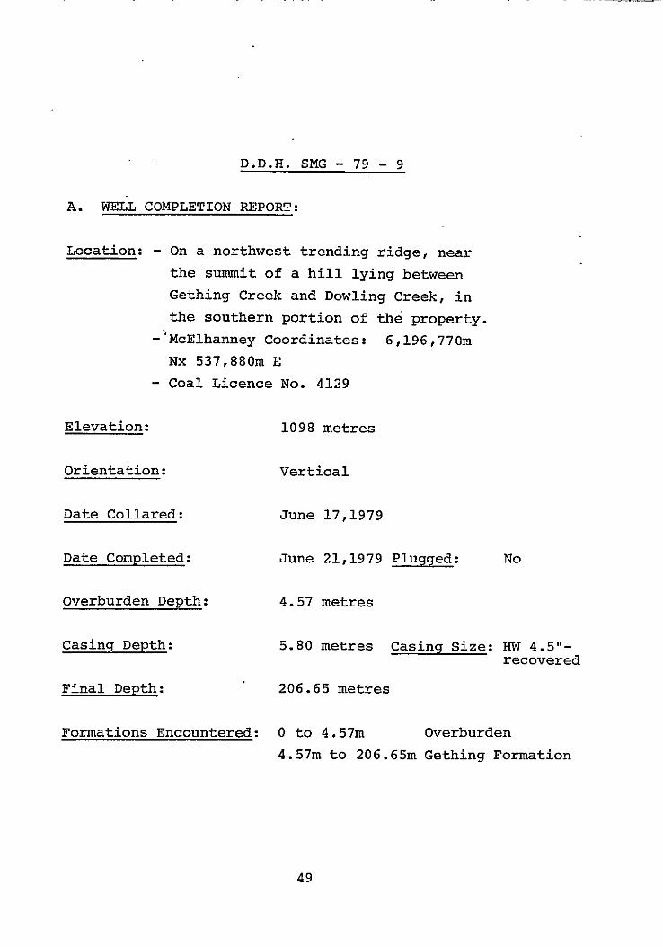
D.D.H. SMG - 79 - 9
A. WELL COMPLETION REPORT:
Location: - On a northwest trending ridge, near
the summit of a hill lying between
Gething Creek and Dowling Creek, in
the southern portion of the property.
-‘McElhanney Coordinates: 6,196,77Om
Nx 537,880m E
- Coal Licence No. 4129
Elevation: 1098 metres
Orientation: Vertical
Date Collared: June 17,1979
Date Completed: June 21,1979 Plugged: No
Overburden Depth: 4.57 metres
Casing Depth: 5.80 metres Casing Size: HW 4.5"- recovered
Final Depth: 206.65 metres
Formations Encountered: 0 to 4.57m Overburden
4.57m to 206.65m Gething Formation
49

Core Description By: A.T. Armstrong and J. Ridley
soal Seams Sampled:
Sample No. Seam Name . Interval Thickness
Core Density Log
1 38.10m to 39.04m 0.94m 1.15m 2 41.66m to 42.18m 0.52m 0.53m
Logs Run: Ganuna and Density - by Utah Mines Ltd.
B. COMMENTS
A clearing, measuring approximately 50m x lOOm, was slashed
for site SMG-79-9. All felled trees were limbed and bucked
into four foot or shorter lengths. All equipment, including
the drilling rig, mud tanks and mixer, and drilling supplies
were flown into the site using a Bell 205 helicopter. Upon removal of the drill, the site was cleaned up and disturbed
ground was seeded with the recommended grass seed mixture.
Below 4.57 metres of overburden, D.D.H. SMG-79-9 cored
202.08 metres of typical Gething Formation sediments. The sediments cored included interbedded to interlaminated
sandstones, siltstones, mudstones and coals. Many of the
units encountered were mixtures of the above components
(eg. silty mudstone 1. Carbonaceous debris was observed
along bedding surfaces throughout the section.
50
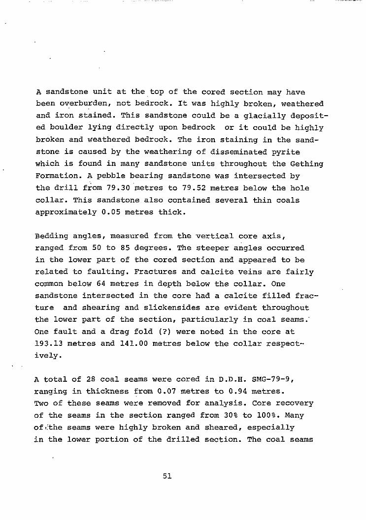
A sandstone unit at the,top of the cored section may have been overburden, not bedrock. It was highly broken, weathered
and iron stained. This sandstone could be a glacially deposit- ed boulder lying directly upon bedrock or it could be highly
broken and weathered bedrock. The iron staining in the sand-
stone is caused by the weathering of disseminated pyrite
which is found in many sandstone units throughout the Gething
Formation. A pebble bearing sandstone was intersected by
the drill from 79.30'metres to 79.52 metres below the hole
collar. This sandstone also contained several thin coals
approximately 0.05 metres thick.
Bedding angles, measured from the vertical core axis,
ranged from 50 to 85 degrees. The steeper angles occurred
in the lower part of the cored section and appeared to be
related to faulting. Fractures and calcite veins are fairly
common below 64 metres in depth below the collar. One
sandstone intersected in the core had a calcite filled frac-
ture and shearing and slickensides are evident throughout
the lower part of the section, particularly in coal seams.‘
One fault and a drag fold (3) were noted in the core at
193.13 metres and 141.00 metres below the collar respect-
ively .
A total of 28 coal seams were cored in D.D.H. SMG-79-9,
ranging in thickness from 0.07 metres to 0.94 metres.
Two of these seams were removed for analysis. Core recovery
of the seams in the section ranged from 30% to 100%. Many
ofLthe seams were highly broken and sheared, especially
in the lower portion of the drilled section. The coal seams
51

cored were generally banded, bxight and well cleated.
Three coal seams (including sample number 1) had ashy
bands and lenses within the coal and two seams contained
pyritic bands. Only one seam of canneloid coal was obser- ved in the cored section.
Analyses of the two coal seams sampled from the cored
section show that the seams are similar in quality. Volatile
matter contents were 26.39% and 27.79%, ash contents were
14.35% and 18.80%, and B.T.U. values were 11,443 B.T.U./
lb and 12,169 B.T.U./lb. Sulphur contents, however, vary
widely for the two samples: sample number 1 contained 0.78%
sulphur, while the sulphur content of sample number 2 was
1.83%. F.S.I. values for samples 1 and 2 were l/2 and 1 l/2
respectively.
A 1.4 specific gravity float separation conducted on the
samples produced an improved product in both cases. Ash
contents were reduced, sulphur contents were lowered to
less than l.OO%, B.T.U. values increased and volatile
matter decreased. F.S.I. values also changed, with sample
number 1 increasing to an index of 2 l/2, while sample
number 2 decreased to a value of 1.
52
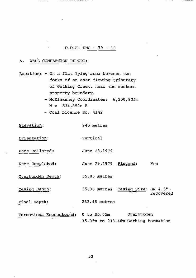
D.D.H.~SMG - 79 - 10
A. WELL COMPLETION REPORT:
Location: - On a flat lying area between two
forks of an east flowing'tributary
of 'Gething Creek, near the western
property boundary.
-'McElhanney Coordinates: 6,200,83%1
N x 534,850n E
- Coal Licence No. 4142
Elevation: 945 metres
Orientation: Vertical
Date Collared: June 23,1979
Date.Completed: June 29,1979 Plugged: Yes
Overburden Depth: 35.05 metres
Casing Depth: 35.96 metres Casing Size: HW 4.5"- recovere,d
Final Depth: 233.48 metres
Formations Encountered: 0 to 35.05m Overburden
35.05m to 233.48m Gething Formation
53
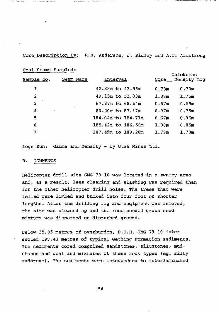
-Desctiption R.B. Anderson, J. Ridley and A.T. Armstrong
Coal Seams Sampled:
Sample No. Seam Name
1
2
3.
4
5
6
7
Interval
42.88m to 43.56m
49.15m to 51.03m
67.87m to 68.54m
86.20m to 87.17m
184.04m.to 184.71m
185.42m to 186.50m
187.49m to 189.28m
Thickness Core Density Log
0.73m 0.70m
1.88m 1.75m
0.67m 0.55m
0.97m 0.75m
0.67m 0.95m
1.08m 0.85m
1.79m 1.70m
Logs Run: Gamma and Density - by Utah Mines Ltd.
B. COMMENTS
Helicopter drill site SMG-79-10 was located in a swampy area
and, as a result, less clearing and slashing was required than for the other helicopter drill holes. The trees that were
felled were limbed and bucked into four foot or shorter
lengths. After the drilling rig and euqipment was removed,
the site was cleaned up and the recommended grass seed
mixture was dispersed on disturbed ground.
Below 35.05 metres of overburden, D.D.H. SMG-79-10 inter-
sected 198.43 metres of typical Gething Formation sediments.
The sediments cored comprised sandstones, siltstones, mud-
stones and coal and mixtures of these rock types (eg. silty
mudstone). The sediments were interbedded to interlaminated
54

and this texture was observed everywhere in the section,
except where bioturbation and soft sediment deformation
has destroyed the bedding. The sedimentary sequence and textures are indictive of deposition inan alluvial flood
plain environment.
The cored section contained abundant sandstone units. A
sandstone.unit in the middle portion of the drilled section
(between 154.28m and 154.44m) contained siltstone rip-up
clasts. A conglomeratic unit was found in the section from
156.90 metres to 157.13 metres below the collar. This
conglomerate is similar to Cadomin Formation conglomerates,
as it is composed of chert pebbles which range from 0.002
metres to 0.02 metres in diameter.
Bedding angles, measured from the vertical core axis, varied
from 35 to 60 degrees. The variation in bedding dip could
be the result of small scale folding of the rocks in response
to faulting. Fractures; calcite veins, calcite filled tension gashes, calcite welded breccia zones and fault gouge were
noted in core throughout the drilled section. Many units were
sheared, especially the coal seams, and displayed prominent slickensides.
Twenty-two coal seams, ranging in thickness from 0.05 metres
to 1.88 metres, were cored in D.D.H. SMG-79-10. Seven of
these seams were removed for analysis in seven samples. Core
recovery of the coal seams was highly variable, ranging from
25% to 100%. Most seams displayed some shearing
- 55 -

and slickensides. The coal seams were generally bright, banded.and cleated. Sample number 2 contained a 0.08 metre ash band near the top of the seam. A calcite vein-
let was observed in'sample number 4 at the top of the
seam and a coal seam at 162.51 metres below the collar
contained abundant pyrite (unsampled)~.
Head analyses conducted on the seven coal samples in-
dicate a wide variation in coal quality from seam to
seam. Volatile matter ranged from 15.53% to 25.61% and
sulphur concentrations ranged from 0.68% to 1.02%. Ash
contents ranged from 3.31 % to 37.25% and were inversely
proportional to B.T.U. values , which ranged from 8,907
B.T.U./lb to 14,587 B.T.U./lb. Free Swelling Indices
ranged from l/2 to 8, with two samples having values of
5 and 8.
Single gravity tests at 1.4 specific gravity were
conducted on all of the samples. The sulphur content increased slightly in all cases. In all float fractions,
ash content was markedly reduced and B.T.U. values in-
creased. Volatile matter did not change significantly in the floats with the exception of sample number 4,
which increased from 15.53% to 20.75%. F.S.I. values were moderately improved in most cases, sample number
3 increased from an index of 5 to an index of 8.
56