1983/22. the mount christie-stanhope coalfield
TRANSCRIPT

1983/22. The Mount Christie-Stanhope coalfield
C.A. Bacon
Abstract
Coal has been mined from the Stanhope-Mount Christie coalfield almost continuously since 1923. The seams occur in a sequence of dominantly lithic sandstone interbedded with minor mudstone, siltstone and coal of the Upper Parmeener Super-Group. These sediments overlie a sequence of dominantly quartzose sandstone which is devoid of coal. To the east, the coalfield is bounded by the Castle Carey Fault.
The coalfield is badly faulted, and meaningful correlation of coal seams, which are up to four metres thick and heavily banded with mudstone, is difficult on the available information. Coal has been mined from the Mount Christie, stanhope, and New Stanhope mines and is still mined from the Fenhope mine. Production from the two largest mines, the Stanhope (1932-1957) and the New Stanhope (1957-1973) was about 175 000 tonnes and 220 000 tonnes respectively.
The inferred reserves are likely to be less than one million tonnes t classed as a very small in situ inferred reserve.
LOCATION AND ACCESS
The Mount Christie-Stanhope-New stanhope coalfield is situated about eight kilometres north-west of Avoca in north-eastern Tasmania.
Bonneys Plains, on the south-western side of Mount Christie, is reached by a road from the Esk Highway at Hanleth, ten kilometres west of Avoca.
GENERAL GEOLOGY
The geology of the Stanhope area is discussed briefly by Twelvetrees (1906) and mentioned by Blissett (1959). Further regional details are given by Threader (1968), western Mining Corporation (1977a, b), Ivett and Taylor (1978), Taylor (1979), Ivett (1979), Bornman (1981), and Bornman and Murphy (1981).
The basement rocks in the Stanhope area are the Siluro-Devonian Mathinna Beds, which are extensively folded micaceous quartzwacke turbidite sequences, with minor mudstone intervals. These rocks were extensively folded during the Tabberabberan Orogeny and have been intruded by the Ben Lomond Granite of Devonian age. Late stage hydrothermal fluids associated with the granite are responsible for areas of tin-tungsten mineralisation around storys Creek and Rossarden to the north-east of the coalfield.
The basement rocks are unconformably overlain by dominantly marine sequences of the Lower Parmeener Super-Group. This sequence is recorded as being at least 150 m thick (Western Mining, 1977a; Taylor, 1979).
Good exposures of Lower Parmeener Super-Group sediments occur east of the Castle Carey fault, and have been subdivided and described by Blissett (1959). Sediments belonging to the Upper Parmeener Super-Group are confined to the upthrown block of country to the west of the Castle
22-1

N N , N
Figure 1.
, .
Scm
(, "
GEOLOGICAL SKETCH NAP
STANHOPE-MT CHRISTIE COALFIELD
Geologist ' C..A. BACON
CONTOUR INTERVAL IOOm.tru
o Major lour".
o Minor MIIru
BLlsSEn .... .H. ,tS' Bull. g".!iIJrr. Tasm. U . 'Ntrst.rn Mini .... C«pOf"QUon.ITos ~ Inc:. 1977. McCLENAGHAN,M.P, BAlllIE, P.W. I'74. Geologtc:ol AUOI 1:150000 uriu Sh .. t SI<SS/Uounc:ut ... .
QUArERNARr o R«.,., A/ilNIum
1'1' e '.1 DoI..,lt. Toful
TERTIARY
BBuoit
JURASSIC
L1(.~sm 001.",.
~ sl/tstoM,roof ~'~~~=~ jUPPER
F:::::.··.) Ouortzow UtldstOIM PARMEENER SOPER-GROlIP
~ Gloc/O·mo,." .. mudst_ LOWER
OEIIONJAN
Ci:l Granit.
?It HiM worMlngs Adi,
- - G.oIog;eof bouMiory ___ Foult,,"otm downtllroll'tl
SId. indk ottd o TAR-.1 WMC. 1917 drilling .... v-n seA 1HO drilling
4t7U.

Carey Fault. These sediments paraconforrnably overlie the Lower Parmeener Super-Group sequences.
Drilling by the Western Mining Corporation (Tas) pty Ltd in 1977 and The Shell Company of Australia in 1980 intersected a sequence of lithic sandstone interbedded with minor mudstone, siltstone, and coal overlying a quartzose sandstone sequence. In the area of Bonneys and Buffalo Plains, Western Mining (1977b) found that quartzose sandstone intervals were occasionally interbedded with the lithic sandstone-siltstonemudstone coal sequence. South of Royal George, an adit was put in on a coal seam with a quartzose sandstone roof, and other, albeit rare examples of quartzose sandstone intervals occurring in or close to the lithic sandstone sequence are also known.
Mapping in the Midlands area (Oatlands and Interlaken Quadrangles) indicates that within the lower part (Middle Triassic) of the lithic sandstone sequence there are intervals of quartzose sandstone, sometimes associated with coal (S.M. Forsyth, in prep.).
Jurassic dolerite has extensively intruded the Parmeener SuperGroup sediments and caps most of the higher ground to the west of the Castle Carey Fault. The dolerite sill capping the Ben Lomond Plateau to the north of the stanhope area is at least 330 m thick (Blissett, 1959). The dolerite has intruded as a series of dykes and transgressive sheets, with minor faulting accompanying the intrusion.
Major faults developed during the Tertiary, with the largest fault being the NW-SE trending Castle Carey Fault, which may be traced for about sixteen kilometres (Blissett, 1959).
These faults graben structures, (Blissett, 1959).
have caused the formation of a number of horst and which form the basis of the present day topography To the south of the stanhope-Mount Christie area the
overall faulting pattern seems to consist of a series of step-faults to the south-east (Taylor, 1979).
Quaternary dolerite talus masks most of the higher hill slopes west of the Castle Carey Fault and alluvium covers much of the lower-lying plain areas.
PREVIOUS MINING HISTORY
Coal was noted as early as 1882 north of Avoca, when Mr R. Stevenson drove a tunnel into a coal seam on Storys Creek four kilometres from the Storeys Creek tin mine [approximately EP594930]. Montgomery (1892) wrote of coal discoveries in the Avoca district and Waller (1901) mentioned coal outcrops in Gipps Creek and on the south-eastern flank of Ben Lomond. James Stevenson found coal near Mount Christie in 1904 and Twelvetrees (1906) reported at length on the Mount Christie and 'Buena Vista' seams. Twelvetrees found three tunnels (one partly collapsed) on the southern flank of Greenstone Hill. The uppermost tunnel had been driven in a north-west direction for 15 m on a 1.8-2.1 m thick seam of coal. A second (collapsed) tunnel was 33 m lower in elevation than the first and had intersected 3.6 m of coal. A third tunnel, a few metres west of the
22-3

'" '" I ",.
Figure 2.
( , ,.
MINE LOCATIONS STANHOPE-MT CHRISTIE COALFIELD
C.A .BACON 1983
GEOLOGY BY WESTERN MINING CORPORATION(TASjINC 1977
QUATERNARY , .... S cm
~ ~ Dolerite Talus
JURASSIC
Dolerite
TRIASSIC 1-:-: ':-:-:1 Lithic sandstone, 1 UPPER :-:-:-:.:- siltstone coal I PARMEENER
• : SUPER-GROUP
~ Mine workings
- - Geological boundary
Fault . relative downthrown side ihdicated .15 Drilling by mine management
I. 9 71 B
\' " ..

collapsed tunnel, had been driven 50 rn on a bearing of 350°. The seam here was 3.6 m thick and dipped at 100 to the west. TWelvetrees (1906) and Hills et al. (1922) thought the exposed seam in both the upper and lower tunnels was the same, repositioned by faulting. These workings, together with many subsequent adits in the same area, became known as the Mount Christie mine.
'Buena Vista' mine
In 1905 one shaft had been sunk on the area of flat ground between Mount Christie and Greenstone Hill (TWe1vetrees, 1906). By 1922, five shafts had been dug on the flat, and three exploratory adits had been dug into the slopes of Mount Christie. These exploratory works, together with other prospecting adits, pits, and trenches to the south and west of Mount Christie, were collectively called the 'Buena Vista' mine by Hills et al. (1922), although no actual mining resulted from these preliminary activities. The workings on the slope of Mount Christie later became the site of the Stanhope mine.
Stanhope (Excelsior) mine
Production from the early, largely prospecting workings known as the Excelsior mine was small (e.g. 7 tonnes in 1923 rising to 23 tonnes in 1928 and 63 tonnes in 1929). The seam worked was badly faulted and banded, with five distinct mudstone bands. The mine was renamed the Stanhope in 1931 and the workings moved eastwards. As the mine workers opened up adits to the east, the a~ea of earlier activity became known as the 'old workings', and pillars were mined for a number of years (1931-1939) from these workings by open-cut methods.
Seam conditions were reported as 'troubled' for much of the mine life, due to extensive faulting and some seam thinning (Annual Reports of Director of Mines, 1931-1956).
A new drive east of a five metre fault and a few hundred metres east of the old workings was opened up in 1937. These are called the new workings at the (old) Stanhope; they are adjacent to, but not connected with the old workings at the (old) Stanhope and 1.3 kID south-east of the workings at the more recent New Stanhope. Coal was mined with a chain type of coal cutter, largely by the bord and pillar method. In 1943 a short wall face was opened up over a 3.0 m fault, and in 1944 the longwall system of mining was adopted briefly. Collapse of the longwall face resulted in a dramatic decrease in output and management quickly reverted to the more suitable bard and pillar method of mining.
The large number of small faults in the area made mining conditions very difficult, often causing developmental work to be abandoned and pillars pulled. Drill holes were put down from 1953-56 around the Stanhope and in the area where the New Stanhope was to open. The main drive of the New Stanhope was started in 1956 and operations finally ceased at the (old) Stanhope in June 1957. Total production from the stanhope (new workings) from 1932-1957 was about 175 000 tonnes.
In the mid 1960s, a bushfire swept over the area of the (old) stanhope mine, and set fire to the seam which is still burning. Parts of the ground surface over the mine workings have collapsed.
22-5

New Stanhope mine
Situated 163 km north-west of the (old) Stanhope mine, production at the New Stanhope mine began in 19576 A washing plant was installed in 1959, working for the first time in 1960. In 1963 a new tunnel known as INo. 21 was driven into the seam adjacent to the 'No. l' or old tunnel.
The seam was 2.1 m thick with a good roof and floor. Pillars in the No. 1 tunnel area were pulled in 1964 and developmental activities concentrated on the N06 2 tunnel area. However by 1969, the geological structure of the No. 2 tunnel area was found to be more complex than anticipated and pillars were extracted. Bad roof falls finally forced the closure of the No. 2 tunnel area, and the No. 1 tunnel area was reopened in 1971 and more pillars extracted. The mine finally closed in 1973 due to the exhaustion of extractable pillars. Total production from the New Stanhope from 1957-1973 was about 220 000 tonnes.
Mount Christie mine
The workings scattered on the southern flank of Greenstone Hill are collectively known as the Mount Christie mine. Hills et al. (1922) noted that no further work other than the three adits described by Twelvetrees (1906) had been done in the area. This was due to the fact that cartage rates to deliver coal to Avoca were prohibitive.
In 1927 a few tonnes of coal were produced from the old workings, which were again opened up briefly in 1940, producing 65 tonnes in that year.
A new tunnel was opened up in 1944, higher up on Greenstone Hill where some drilling had apparently been done (Annual Report of Director of Mines, 1944). The production from these workings was small, and faulted conditions hampered mine development and caused the mine to close in 1947. Minor prospecting works continued until 1958, when the old mine was again re-opened for a short time.
In 1959 a new tunnel was put in, 50 m west of the previous tunnel, and was worked until 1965 by Messrs N. and D. Fenton, who produced 1700-1800 tonnes of coal per year from the mine. The seam in this tunnel was 2.4 m thick, with a 230 mm band of mudstone in the middle, which was separated from the marketable coal by first mining the top ply, then the dirt band, and then the lower ply. The workings closed in 1965 after some pillars had been extracted. Total production from this mine was about 13 000 tonnes.
The Fenhope mine
In 1981 a new mine was opened close to the old workings of the (old) Stanhope mine, and named the Fenhope. The mine is worked solely by the owner, Mr D. Fenton. The seam mined is 3.6 m thick, and has few dirt bands apart from a section 450 rom thick in the middle of the seam, this section consisting of many mudstone bands interbedded with thin plys of coal. The seam is mined in three stages, a top coaly section, the dirty middle section, then the lower coaly section. The 'dirty' middle section of coal is discarded. Total production from the Fenhope to date would be less than 1000 tonnes.
22-6

RECENT EXPLORATION
From 1953-1972 the New Stanhope mine management diamond drilled some 1000 m in the vicinity of the Stanhope and New Stanhope workings. The logging records of these holes are incomplete and the location of holes approximate. A summary of the company drilling was made by V.M. Threader in 1972 and is given in Appendix 3. The positions of these holes are shown on Figure 2.
In 1976 the Western Mining Corporation (Tasmania) pty Limited drilled nine chip holes west of the Stanhope-Fenhope-Mount Christie mine areas on Bonneys and Buffalo Plains. The positions of these holes (TAR 1-9) are marked on Figure 1. The holes were no deeper than 85 m and the total length drilled was 587.3 m. The company was looking for shallow open-cut coal. Only three holes, TAR-2, TAR-3, and TAR-8 intersected minor coal seams, the remainder of the holes being barren. Details of coal intersections and proximate analyses of some of the chip samples are given in Appendices 2 and 3. Further details of the exploration were reported by the Western Mining Corporation (Tasmania) pty Limited (1977a, b) •
The Shell Company of Australia drilled two holes west of the Stanhope area in 1980, one near Turners Hill (AV-12) and one 2 km west of Bonneys Plains (AV-13) (fig. 1). Hole AV-12 encountered 159 m of dolerite, followed by 267 m of interbedded lithic sandstone, siltstone, mudstone, and minor coal; then 64 m of quartzose sandstone overlying a dark grey marine mudstone. Hole AV-13 passed through 307 m of dolerite; the hole was terminated after a further 52 m of interbedded lithic sandstone and siltstone was drilled.
Very few coal seams were found in AV-12, with the thickest seam being only 0.57 m thick.
Most of the Mount Christie-Bonneys Plains area is currently held by Avoca Transport under Exploration Licence 2/82, with the exception of a small area around the Fenhope mine which is held under Mining Lease by Mr D. Fenton.
COAL QUALITY
Details of coal quality are given in Appendices 2 and 3, and a detailed description of the seam at the New Stanhope is given in Appendix 4.
An average analysis for the run of mine coal from the New Stanhope mine is as follows:
Moisture (%) 7-9 Ash (run of mine) (%) 25 Ash (washed coal)(%) 14-18 Volatile carbonaceous
matter (%) 33 Fixed carbon (%) 35 Specific energy (MJ/kg) 25.28
This coal quality would be similar for coal mined in the Stanhope, Mount Christie, and Fenhope mines.
22-7

POTENTIAL FOR FUTURE EXPLORATION
The thickest seam development appears to be between Mount Christie and Mount Rex, in the area of the existing mines. The seams thin drastically to the west and north of Mount Christie, and seldom reach more than one metre in thickness in this area. The area around the Mount Christie and Stanhope mines is regarded as being worked out. A limited supply of coal remains around the area of the Fenhope mine.
The total in situ reserve is not likely to exceed one million tannes, so the reserve is classed as a very small in situ inferred reserve.
The reserves in the area of Bonneys Plains are regarded as insignificant, as no seams of economic thickness (i.e. greater than one metre) are recorded from the area.
REFERENCES
BLISSETT, A.H. 1959. The geology of the Rossarden-Storeys Creek district. Bull.geol.Surv.Tasm. 46.
BORNMAN, J.e. 1981. Exploration Licence 18/77, Avoca, Tasmania. A review of the coal resources and prospectivity. Unpubl.Rep.Shell Co. of Aust. Ltd. CEPR 8/81 [Open file 81-1570] •
BORNMAN, J.C.; MURPHY, P. 1981. Exploration Licence 18/77, Avoca, Tasmania. Progress report 1980. Unpubl.Rep.Shell Co.Aust.Ltd. CEPR 3/81 [Open file 81-1512] .
DICKINSON, D.R. 1945. Ben Lomond coal. Unpubl.Rep.Dep.Mines Tasm. 1945: 12-13.
FORSYTH, S.M. (8313S) .
In prep. Geological atlas 1:50 000 series. Explan.Rep.geol.Surv.Tasm.
Sheet 68 Oat1ands.
HILLS, C.L. i REID, A.M .. ; NYE, P.B.; KEID, H.G.W.; REID, W.D. coal resources of Tasmania. Miner.Resour.geol.Surv.Tasm.
1922. 7.
The
HUGHES, T.D. 1954. Future operations at the Stanhope Colliery. Unpubl. Rep.Dep.Mines Tasm. 1954:143-147.
HUGHES, T.D. 1958. Coal resources at the Stanhope Colliery. Unpubl.Rep. Dep.Mines Tasm. 1958:219.
IVETT, J.K. 1979. Relinquishment report on exploration in the southern part of E.L. 18/77, Avoca. Unpubl.Rep.Shell CO.Aust.Ltd. CEPR 2/79 [Open file 79-1323].
IVETT, J.K.; TAYLOR, D.A. 1978. Exploration Licence 18/77, monthly progress report for period ending 26 July 1978. Shell CO.Aust.Ltd. CEPR 20/78 [Open file 78-1282].
Avoca. Six Unpubl.Rep.
MONTGOMERY, A. 1892. Report on the Ben Lomond district. Rep.Secr.Mines Tasm. 1891-92:25-40.
TAYLOR, D.A. 1979. Exploration Licence 18/77, Avoca. progress report for period ending 26 January 1979. CO.Aust.Ltd. CEPR 4/79 [Open file 79-1334].
22-8
Six monthly Unpubl.Rep.Shell
THREADER, V.M. 1968. An interim report on the geology and coal resources of the north-east Tasmanian coalfields. Unpubl.Rep.Dep.Mines Tasm.
TWELVETREES, W.H. 1906. On coal at Mt Rex. Rep.Secr.Mines Tasm. 1905,1-8.
WALLER, G.A. 1901. Report on the tin mining district of Ben Lomond. Rep.Seer.Mines Tasm. 1900-01,302-342.
WESTERN MINING CORPORATION (TAS.) PTY LTD. 1977a. Exploration Licence 16/76, Avoca, Tasmania. Report for six months from 2 August 1976 to 2 February 1977. Unpubl.Rep.Western Mining Corporation.
WESTERN MINING CORPORATION (TAS.) PTY LTD. 1977b. Exploration Licence 16/76, Avoca, Tasmania. Terminal report. Unpubl.Rep.Western Mining Corporation.
[28 June 1983J
22-9

APPENDIX 1
AMG references of mines and drill holes in the Mount Christie -Mount Rex coalfield.
Mines (see fig. 2)
Mount Christie EP557805
Stanhope (old workings) EP549804
Stanhope (new workings) EP552803
New Stanhope EP542811
Fenhope EP549805
Western Mining Corporation (Tasmania) Pty Ltd 1977 drilling
Hole RL Co-ordinates Total depth (m) (m)
TAR-l 300 EP539770 82.0
TAR-2 300 EP50l750 84.8
TAR-3 260 EP525745 63.5
TAR-4 250 EP524787 60.0
TAR-5 210 EP519743 78.0
TAR-6 195 EP509729 abandoned at 3.8
TAR-7 210 EP510731 60.0
TAR-8 260 EP569751 80.0
TAR-9 300 EP505796 78.0
Shell Company of Australia 1980 drilling
AV12 EP556754 490
AV13 EP483728 359
22-10
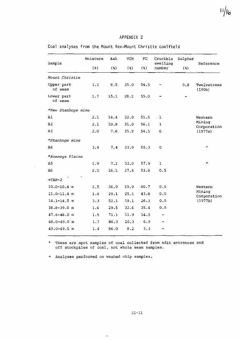
APPENDIX 2
Coal analyses from the Mount Rex-Mount Christie coalfield
Moisture Ash VCM FC Crucible Sulphur Sample swelling Reference
(%) (%) (%) (%) nwnber ( %)
Mount Christie
Upper part 1.2 8.5 35.0 54.5 0.8 Twelvetrees of seam (1906)
Lower part 1.7 15.1 28.2 55.0 of seam
*New Stanhope mine
Al 2.1 14.4 32.0 51.5 1 Western
A2 2.1 10.8 31.0 56.1 1 Mining Corporation
A3 2.0 7.6 35.9 54.5 6 (1977a)
*Stanhope mine
A4 3.4 7.4 33.9 55.3 0 "
*Bonneys Plains
A5 1.9 7.2 33.0 57.9 1 " A6 2.2 16.1 27.4 53.8 0.5
+TAR-2
10.0-10.4 m 2.5 36.9 19.9 40.7 0.5 Western
11.0-11.4 m 1.4 29.1 25.1 43.8 0.5 Mining Corporation
14.1-14.5 m 3.3 52.1 19.1 26.3 0.5 (1977b)
38.8-39.0 m 1.6 29.5 32.6 35.4 0.5
47.6-48.0 m 1.5 71.1 11.9 14.5
48.0-49.0 m 1.7 80.3 10.3 6.9
49.0-49.5 m 1.4 86.0 8.2 3.3
• These are spot samples of coal collected from adit entrances and off stockpiles of coal, not whole seam samples.
+ Analyses performed on washed chip samples.
22-11

FURTHER ANALYSES, NEW STANHOPE MINE
sample* Description Thickness Moisture VCM FC Ash Specific energy Cu Pb Zn (mm) (%) (%) (%) (%) (~jJ/kg) (ppm) (ppm) (ppm)
Adit 1
681214 Roof to band 1 470 2.05 33.9 54.0 10.0 30.24 10 40 10
1215 Between bands 1 & 2 127 8.33 21.7 6.0 64.0 Not done due to 10 120 10 high ash.
1216 Between bands 2 & 3 165 2.34 27.6 37.7 32.4 22.05 40 100 20
1217 Between bands 3 & 4 305 2.22 32.9 43.4 21.5 26.45 20 100 30
121B Bet\o·;een bands 4 & 5 610 3.03 31. 3 44.0 21.7 25.47 20 100 10
tv 1219 Between band 5 and 165 2.63 33.1 41.6 22.7 24.89 10 70 15 tv floor I f-' N
Adit 2
1220 Roo£ to band 1 660 3.70 31.8 36.2 28.3 22.93 Nil 70 15
1221 Between bands 1 & " 152 2.16 28.0 41.9 27.9 23.70 10 30 10 ~
1222 Between bands 2 .. 3 305 1.81 35.3 44.1 18.8 31.66 Nil 30 10
1223 Between bands 3 .. 4 483 1.94 31.0 47.5 19.6 26.17 Nil 40 10
1224 Between band 4 and 292 2.64 33.0 39.4 25.0 23.70 Nil 120 15 floor
* Department of Mines laboratory sample numbers.
("0
-=-6'
'" <oJ I
f-' W
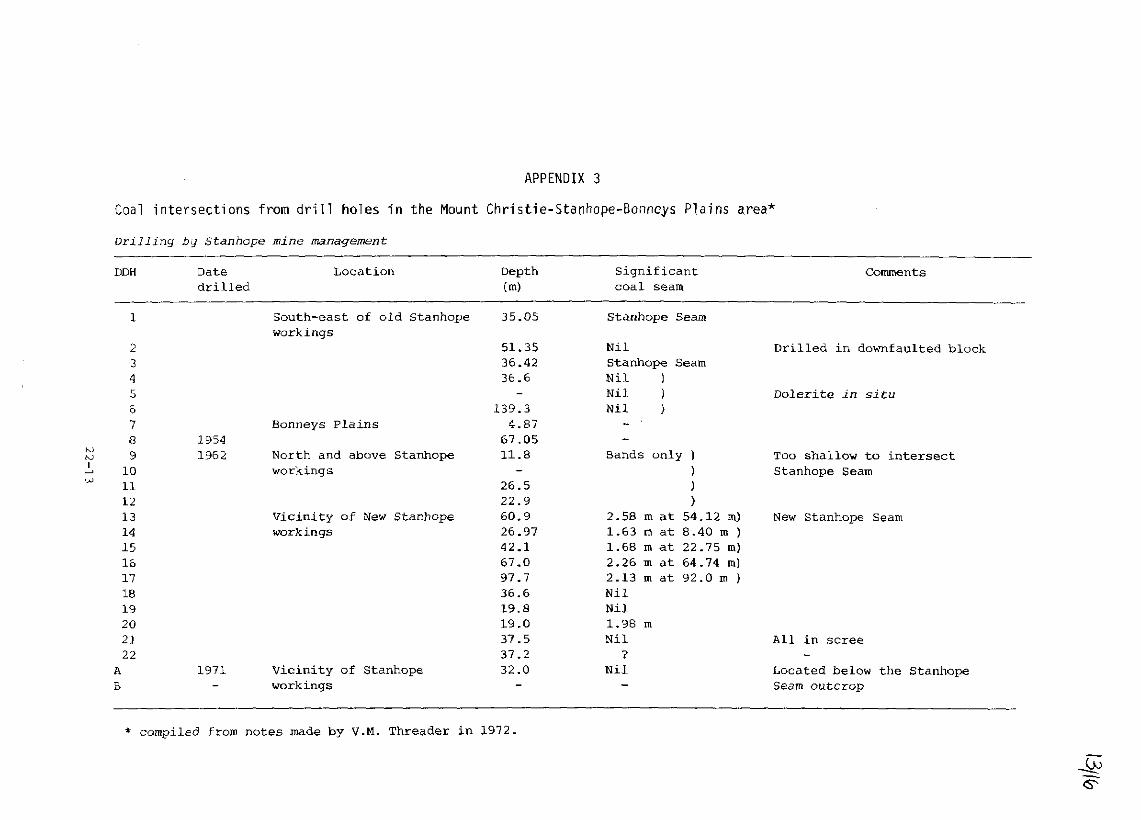
APPENDIX 3
Coal intersections from drill holes in the Mount Christie-Stanhope-Bonncys Plains area*
Drilling by Stanhope mine management
DDH
1
2 3 4 5 & 7 8 9
10 11 12 13 14 15 16 17 18 19 20 21 22
A
B
Date drilled
1954 1962
1971
Location
South-east of old stanhope workings
Bonneys Plains
North and above stanhope workings
Vicinity of New Stanhope workings
Vicinity of Stanhope workings
Depth (m)
35.05
51.35 36.42 36.6
l39.3 4.87
67.05 11.8
26.5 22.9 60.9 26.97 42.1 67.0 97.7 36.6 19.8 19.0 37.5 37.2 32.0
• compiled from notes made by V.M. Threader in 1972.
Significant coal seam
Stanhope Seam
Nil Stanhope Seam Nil ) Nil ) Nil )
Bands only) )
)
)
2.58 1.63 1.68 2.26 2.13 Nil Nil 1.98 Nil
? Nil
m at m at TIl at m at m at
m
54.12 m)
8.40 m ) 22.75 m) 64.74 m)
92.0 TIl )
comments
Drilled in downfaulted block
Dolerite in situ
Too shallow to intersect Stanhope Seam
New Stanhope Seam
All in scree
Located below the Stanhope Seam outcrop

14/lb
Appendix 3 (continued)
Drilling by Western Mining Corporation (Tas) Pty Ltd 1977
DOH From To Thickness Description (m) (m) (m)
TAR-1 37.3 37.4 0.10 Coal
40.7 40.8 0.10 Coal
TAR-2 8.9 9.0 0.10 Coal
10.0 10.4 0.40 Coal
11.0 11.4 0.40 Coal
14.1 14.5 0.40 Coal
21.0 21.1 0.10 Coal
38.0 42.0 4.00 Coal interbedded with carbonaceous shale (40:60)
TAR-3 11.6 11.7 0.10 Coal
19.7 19.8 0.10 Coal
37.4 37.5 0.10 Coal
42.0 42.2 0.20 Coal
43.8 44.1 0.30 Coal
TAR-8 30.8 31.1 0.30 Coal interbedded with carbonaceous shale
34.0 36.0 2.00
No coal was intersected in holes TAR-4, TAR-5, TAR-7, and TAR-9; TAR-6 was abandoned in dolerite scree.
22-14
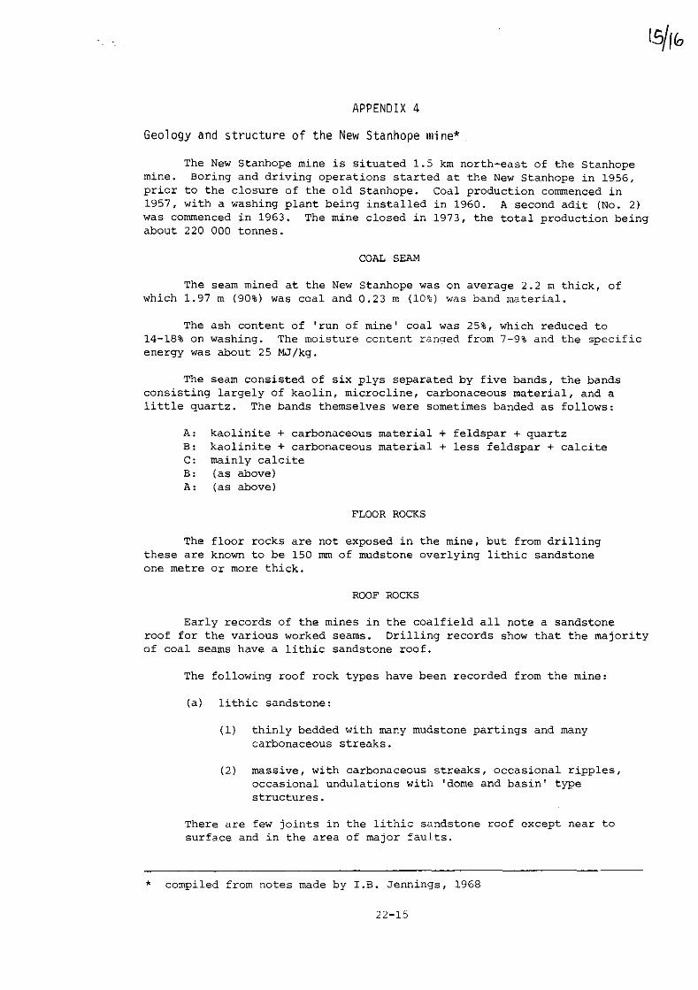
APPENDIX 4
Geology and structure of the New Stanhope mine*
The New Stanhope mine is situated 1.5 krn north-east of the Stanhope mine. Boring and driving operations started at the New Stanhope in 1956, prior to the closure of the old Stanhope. Coal production commenced in 1957, with a washing plant being installed in 1960. A second adit (No.2) was commenced in 1963. The mine closed in 1973, the total production being about 220 000 tonnes.
COAL SEAM
The seam mined at the New Stanhope was on average 2.2 m thick, of which 1.97 m (90%) was coal and 0.23 m (10%) was band material.
The ash content of 'run of mine' coal was 25%, which reduced to 14-18% on washing. The moisture content ranged from 7-9% and the specific energy was about 25 MJ/kg.
The seam consisted of six plys separated by five bands, the bands consisting largely of kaolin, microcline, carbonaceous material, and a little quartz. The bands themselves were sometimes banded as follows:
A: kaolinite + carbonaceous material + feldspar + quartz B: kaolinite + carbonaceous material + less feldspar + calcite c: mainly calcite B: (as above) A: (as above)
FLOOR ROCKS
The floor rocks are not exposed in the mine, but from drilling these are known to be 150 mrn of mudstone overlying lithic sandstone one metre or more thick.
ROOF ROCKS
Early records of the mines in the coalfield all note a sandstone roof for the various worked seams. Drilling records show that the majority of coal seams have a lithic sandstone roof.
The following roof rock types have been recorded from the mine:
(a) lithic sandstone:
(1) thinly bedded with many mudstone partings and many carbonaceous streaks.
(2) massive, with carbonaceous streaks, occasional ripples, occasional undulations with 'dome and basin' type structures.
There are few joints in the lithic sandstone roof except near to surface and in the area of major faults.
* compiled from notes made by I.B. Jennings, 1968
22-15

Appendix 4 (continued)
(b) sandy conglomerate: this occurs in pod-shaped and long shoe-string • streamer , shapes; the rock shows a disrupted framework. Pebbles in the conglomerate are of Mathinna Beds, granite, coal, volcanic breccia, and glaciomarine mudstone.
(c) mudstone: this occurs in northern and southern sections of the mine, is extensively slickensided, and contains abundant carbonaceous fragments and strips.
Occasional Neptunian dykes with sandy ptygmatic folding have been noted in the mine, associated with both the massive sandstone roof and sandy conglomerate patches.
STRUCTURE
The plys in the seam frequently split, splay, and reform throughout the mine. Some of the splits are related to differential compaction and occur close to conglomerate strips and washouts. Some minor faulting «1 m) is associated with these splits; some of these faults are possibly syndepositional.
Larger faults (3-4 m) commonly cr?ss the workings and disrupt the coal seam, and faulting was one of the major setbacks which caused the mine to close.
Smaller disturbances were also common, such as small, curved faults with irregular throws of 0.3-0.5 m. The seam was 'warped' in parts, without actually having faulted and many small scale en echelon faults occurred.
22-16