1990 annual statistics and highlights report · 1990 annual statistics and highlights report ......
TRANSCRIPT
-_-3Jl
NSSDC/WDC-A-R&S 91-14
1990
ANNUAL STATISTICS
AND
HIGHLIGHTS REPORT
National Space Science Data Center
.... I .... : _ _ _ r i ...... _ ) "¢ , _:...... <.... C_Cl 05
i",__: ,,_- _; } t.i ? )
March 1991
[W AGoddard Space Flight Center
Greenbelt, Maryland 20771
https://ntrs.nasa.gov/search.jsp?R=19910021761 2018-07-10T21:31:37+00:00Z

NSSDC/WDC-A-R&S 91-14
1990 ANNUAL STATISTICS AND HIGHLIGHTS REPORT
James L. Green
National Space Science Data Center
Greenbelt, MD 20771
March 1991

Preface
It is my view that the scienceuser community needs rapid accessto archivaldata and
informationabout data,and the NationalSpace ScienceData Center(NSSDC) has been seton
the coursetoprovidejustthat. Five years ago the NSSDC came =on line,_becoming easily
reachableforthousands of scientistsaround the world through the electronicnetworks it
managed and otherinternationalelectronicnetworkstowhich itconnected.Sincethattime,the
datacenterhas developedand implemented over15interactivesystems,operationalnearly24
hours per day,and isreachablethrough DECnet, TCP/IP, _25, and BITnet communication
protocols.
The NSSDC has torn down its walls by becoming a clearinghouse for the science user to find thedata needed through the Master Directory system whether it is at the NSSDC or deposited inover 50 other archives and data management facilities around the world.
The responsefrom the internationalsciencecommunity tothenew %n-linethrust_ofthe data
centerhas been tremendous,with over13,000useraccessestothe NSSDC electronicsystems,
lastyear alone.Thousands ofrequestsfordatahave been satisfied,resultingintheNSSDC's
sendingout a volume ofdatalastyearthatnearlyexceededa quarterofitsholdings.
Iam delightedtoprovidethisdocument,which reportson some ofthehighlightsand distribution
statisticsformost ofthe basicNSSDC operationalservicesforfiscalyear 1990. Itismy
intentiontoprovidethisreporttothe scienceusercommunity on an annual basis.Callitthe
"NSSDC reportcard,"ifyou will.Thisreportwilltellhow wellwe are doinginsupportingthe
spaceand Earth scienceusercommunities.At thispointIwish toexpressmy thanks toWinnie
Humberson (McDonnell Douglas Space Systems Company) forcompilingand preparingthe
document and Len Blasso,Miranda Knowles,and Lynda Williams(ST Systems Corporation)of
the NSSDC publicationsgroup,fortheirhelpinexpeditingthe productionofthispublication.
Ithas taken the NSSDC nearly25 years toaccumulate over6 terabytesof spaceand Earth
sciencedata.The NSSDC isenteringa new eraasNASA aggressivelywhittlesaway atitsspace
flightbacklog.Current archivingplanswithfutureNASA missionsindicatethattheNSSDC's
holdingswillnearlydouble every two years. We expecta massive amount ofdata willbe
deliveredtothe sciencecommunity forfurtheranalysisfrom the archive.Our intentionisto
continuetoproviderapidaccesstolargervolumes ofdataheldattheNSSDC by improvingour
on-lineservicesand topointtootherimportantdataholdingselsewhere.
Dr. James Lauer Green,Director
NationalSpace ScienceData CenterMarch 1991
iii
PRECEDING PAGE BLANK NOT FILMED

Contents
General Services
I. NSSDC On-Line Data and InformationServices(NODIS) ...........................................3
2. The Master Directoryand CatalogInteroperability(MD/CI) ........................................4
3. DistributionofNSSDC Data Via Non-InteractiveModes ..............................................7
4. NSSDC Data Archiveand DistributionService(NDADS) ............................................10
5. VisualReproductionFacility...........................................................................................11
Earth Science Data Systems
1. NASA's Climate Data System (NCDS) ......................................................................... 15
2. Pilot Land Data System (PLDS) ................................................................................... 19
3. Crustal Dynamics Data Information System (CDDIS) ................................................ 23
Space Science Data Systems
1. Coordinated Data Analysis Workshop (CDAW) Program ............................................ 29
2. Satellite Situation Center (SSC) and SPACEWARN ..................................................... 31
3. The Astronomical Data Center (ADC) ............................................................................ 33
4. ROSAT Mission Information and Planning System (MIPS) ........................................ 34
Standards and Technologies
1. NASA/OSSA Office of Standards and Technology (NOST) .......................................... 39
2. The Standards and Technology Information System (STIS) ....................................... 41
NSSDC Publications List for 1990 .......................................................................................... 45
NSSDC Acronyms and Abbreviations List .............................................................................. 53
PRECEDING PAGE LiLAI,iK NO'I FILMED

General Services

1990Annual Statistics and Highlights
1. NSSDC On-Line Data and
Information Services (NODIS)
he NSSDC On-Line Data and Information Serv-ices (NODIS) is a menu-driven utility acces-
sible nearly 24 hours a day, seven days a week to
anyone able to reach the NSSDC computers via diaJ-up or network. This service allows access to on-lineinformation held at NSSDC as well as limited
amounts of on-line data. Data available via NODIS
include International Ultraviolet Explorer (IUE)
extracted spectra data, Nimbus 7 (NIMB) Gridded
Total Ozone Mapping Spectrometer data, Coastal
Zone Color Scanner (CZCS) data, and the OMNI
data set of hourly solar wind parameters. Theinformation services include the NASA Master Di-
rectory (MD); the Personnel Information Manage-
ment System (PIMS), which is an interface to a
personnel data base containing over 30,000 users of
NSSDC services;the American Institute forAero-
nautics and Astronautics (AIAA) Canopus newslet-ter; and the Astronomical Data Center (ADC) On-
Line Information System for Astronomical Cata-
logs. Access to ionospheric, atmospheric, magneto-
spheric magnetic field, and magnetospheric ener-
getic trapped particle models are available for down-
loading or executing. There is also a menu optionthat facilitates requests for off-line data services.The chart below shows the annual session totalsfor
each of the NODIS services.
2500
2000
1500
1000
500
1990 NODIS Session Activity Chart
Oct- Dec
Jul - Sep
Apr - Jun
I Jan - Mar
MD Canop PIMS NIMB OMNI Requ Model IUE CZCS ADC
.olNIIIIIIUIL_ IlC_lt_ PRECEDING PAGE iSL.A,','._ NOT F_LI',_ED
1990 Annual Statistics and HiEhliEhte
2. The Master Directory andCatalog Interoperability
Ior more than five years a project called"CatalogInteroperability" or CI has been seeking toenable rapid and efficient identification, location,and access to data of interest to the science commu-
nity. The project started as a NASA effort but nowincludes representatives from other U.S. federal
agencies, international agencies, and academic in-stitutions. The goal of the CI group is to create aworldwide data information network composed ofinterconnected directory, catalog, and inventory sys-tems.
The first steps to establishing this network were tocreate directories to aid in finding data. The directo-ries contain brief summary information about thedata sets, sufficient for the researchers to determinewhether further investigation is warranted. Theyalso provide automated links to other information
systems that give more detail on data of interest, orthey indicate whom to contact for additional infor-mation. The NASA Master Directory was created toserve this purpose for NASA. The directory servedits purpose very well, and other agencies and inter-national organizations have been given copies of theNASA directory software to perform the same func-tion within their groups. These directories havebeen interconnected via computer network to enable
information sharing to the benefit of all. In addi-tion, the NASA directory at GSFC has been re-quested to serve as the Global Change Master Direc-tory (GCMD) for describing the global change dataholdings of all U.S. federal agencies.
A common format for describing data sets has beendeveloped by the Catalog Interoperability group,
called the Directory Interchange Format (DIF), whichis used as the basis of information to be shared
among the directories. These DIF files can be passedamong the directories to keep their information up-to-date.
THE INTERCONNECTEDDIRECTORY SYSTEM
With the development ofthe DIF, the sharing of
informationamong directorieswas made signifi-
cantlyeasier.An interconnectedsystem ofdirecto-riessharinginformationviaDIF fileexchange was
formed.FigureIshows thepresentand near-future
configurationofthedirectorysystem.These arejust
the directorynodes. Connections to other data
informationsystems (guides/catalogs,inventories)
are not shown. Existingdirectoriesare shown in
boldfacetype.These includethe NOAA Earth Sys-
tem Data Directory(NESDD) and theUSGS Earth
ScienceData Directory(ESDD). During 1990thedi-
rectorynodesinTokyo,Japan (Committee on EarthObservations SatellitesPrototype International
Directory---CEOS_PID), and Munich, Germany
(Deutsches Forschungs Anstalt fuer Luft und
Raumfahrt--DLR), were established.The USGS
EDC (EROS Data Center)nodeinSiouxFalls,South
Dakota, UNEP/GRID (United Nations Environ-mental Programme/Global Resources InformationDatabase) node in Geneva, Switzerland, and CEOSPID CCRS (Canadian Centre for Remote Sensing)node in Ottawa, Canada, will all be operational in
the first half of 1991. (See Figure 1.)
1990 Annual Statisticm and Highlight,
USGS EDC _ UNEP/GRID Geneva
I _ . CEOSPIDCCRS J _'_
I NOAANESDD _ I _ \ _I _ / _ I J _ \ UNEP/GRID
I \USGS ESOO------/ZGIobal"Change Master Directory/ /
JICST JAPAN / Minster Dirlectory (CEOS PID_ /DLR Munich_
CEOS PID JAPAN NAS MD
UNEP/GRID Nairobi
Figure 1: Interconnected Directory System
,MASTER DIRECTORY STATUS
The directories represent the most widely used partof the interoperable data information system. Thisis evident from their ever-increasing usage. The
Master Directory at GSFC has been operational formore than two years, and over 3000 user sessionswere logged during 1990 at this node alone. Sincethe directory is intended to provide quick informa-tion to users and lead them on to actual data sources,wherever those sources may be, users do not neednumerous sessions to obtain results. Thus, over
1000 users were accommodated by the Goddardnode during last year.
The information content of the directory has made
similar progress. As shown in Figure 2 below, over900 entries are contained in the directory, describ-ing the most useful and usable data sets in the fivemajor discipline categories. Since more than onedata set can be described in a single entry (andsometimes tens to hundreds may be aggregated in
this way), there are many more than 900 data sets
described in the directory. Several hundred of these
were added in the past year, and also several hundredof the existing entries were reviewed and revised,sometimes resulting in a net decrease in the numberof entries. This reflects the emphasis on keepinginformation current as well as maintaining quality
and utility of the entries rather than increasingquantity. The number of entries will increase morerapidly as the other directory nodes begin to describetheir data holdings and the data in their surround-ing communities.
Not just data sets are described in the directory.There is also supplementary information about other
data information systems and data archives, organ-ized data collecting campaigns and projects, datasources such as spacecraft or Earth-based observing
platforms, and data sensors that were used to ac-quire the data. The latter two of these informationcategories were added to the directory in 1990. Alsoin the last year, the number of data informationsystems described in the directory has nearly doubledto approximately 60. More than a third of these maybe directly accessed from the directory through anautomated network link. This access is performedautomatically upon request by the user.
1990 Annual Statietics and Highlights
DIRECTORY ACCESS
The best way to reach an understanding of the na-
ture and utility of the directories is to try them.
Figure 3 below shows the procedures for accessing
the directory at NASNGSFC through several net-works or via dial-in line.
Several methods of potential use to increase interop-
erability are currently being applied in limited situ-
ations. Context passing was demonstrated in 1990
using the Master Directory and several remote sys-
tems. A limited form of automated multi-system
searching, which does not assume Standard Query
Language (SQL) data bases in remote systems, is
being developed for ver-
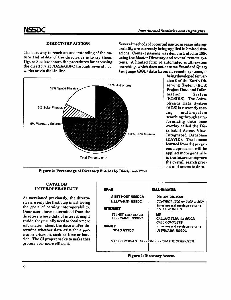
18% Space11% Astronomy
6% Solar Physics
6% Planetary Science
59% Earth Science
Total Entries= 912
Figure 2: Percentage of Directory Entries by Discipline-FYg0
sion 0 of the Earth Ob-
serving System (EOS)Project Data and Infor-
mation System(EOSDIS). The Astro-
physics Data System
(ADS) is currently test-
ing multi-system
searching through a uni-formizing data base
overlay called the Dis-tributed Access View-
Integrated Database(DAVID). The lessons
learned from these vari-
ous approaches will be
applied more generally
in the future to improve
the overall search proc-ess and access to data.
CATALOG
INTEROPERABILITY
As mentioned previously, the directo-
ries are only the first step in achievingthe goals of catalog interoperability.Once users have determined from the
directory where data of interest might
reside, they usually need to obtain moreinformation about the data and/or de-
termine whether data exist for a par-ticular criterion, such as time or loca-
tion. The CI project seeks to make thisprocess ever more efficient.
$ SET HOST NSSDCA
USERNAME: NSSDC
iNlrr=RHErlr
TELNET 128.183.10.4USERNAME: NSSDC
oM_nrGOTO NSSDC
Dial 301-286-9000
CONNECT 1200 (or 2400 or 300)Enter several carriage returnsENTER NUMBER
MD
CALLING 55201 (or 55202)CALL COMPLETE
Enter several carriage returnsUSERNAME: NSSDC
ITALICS/NO/CA TE RESPONSE FROM THE COMPUTER.
IFigure 3: Directory Access
1990 Annual Statistics and Highlights
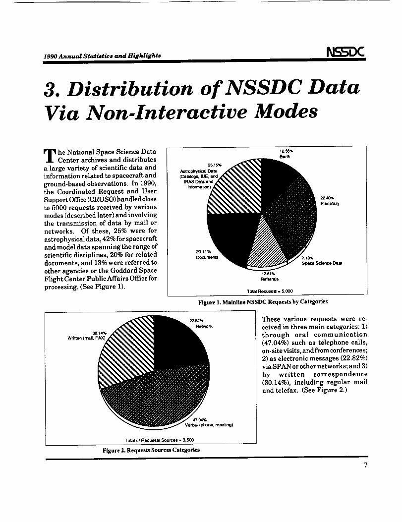
3. Distribution of NSSDC DataVia Non-Interactive Modes
he National Space Science DataCenter archives and distributes
a large variety of scientific data andinformation related to spacecraft and
ground-based observations. In 1990,
the Coordinated Request and User
Support Office (CRUSO) handled close
to 5000 requests received by various
modes (described later) and involving
the transmission of data by mail or
networks. Of these, 25% were for
astrophysical data, 42% for spacecraftand model data spanning the range of
scientific disciplines, 20% for related
documents, and 13% were referred to
other agencies or the Goddard Space
Flight Center Public Affairs Office for
processing. (See Figure 1).
25.15%
Astrophysk_Data(Ca=logs,lUE,and
IRAS Deta and
Information)
12.56%
Firth
12.61%
Referrals
TotJd Requests = 5,000
Figure 1. Mainline NSSDC Requests by Categories
30+14%
Written (mail, FAX)
22.82%
Network
47.04%
Verbal (phone, meeting)
Total of Requests Sources - 3,500
Figure 2. Requests Sources Categories
These various requests were re-
ceived in three main categories: 1)through oral communication
(47.04%) such as telephone calls,
on-site visits, and from conferences;
2) as electronic messages (22.82%)
via SPAN or other networks; and 3)
by written correspondence
(30.14%), including regular mail
and telefax. (See Figure 2.)
1990 Annual Statistics and Highlights
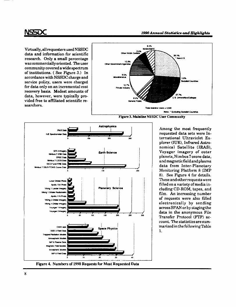
Virtually,allrequestersused NSSDC
data and information for scientific
research. Only a small percentage
was commercially oriented.The user
community covered a wide spectrum
of institutions.( See Figure 3.) In
accordance with NSSDC charge and
service policy,users were charged
fordata only on an incremental cost
recovery basis. Modest amounts of
data, however, were typically pro-vided free to affiliatedscientificre-
searchers.
64%
NASA_SFC
Totm Ma/nl/ne t.hmll. 3.S00
Note: " Exdudng Smmlm _
Figure 3. Mainline NSSDC User Community
Astroll_ysicl
0 100 Z_ 300
OMNI tape
ISEE 3 _ D4em
Trap@4KI l=lacl6s_on
IMP 8 Plato Dela
U_nm: F_ tto(_l
_noq_c Uo_t
IMP $ _ Dm
lo0
Planetary Science
/40
I |j
0P • • - F -
10 20 30
Figure 4. Numbers of 1990 Requests for Most Requested Data
Among the most frequently
requested data sets were In-ternational Ultraviolet Ex-
plorer (IUE), Infrared Astro-
nomical Satellite (IRAS),
Voyager imagery of outerplanets, Nimbus 7 ozone data,
and magnetic field and plasma
data from Inter-PlanetaryMonitoring Platform 8 (IMP
8). See Figure 4 for details.
These and other requests were
filled on a variety of media in-
cluding CD-ROM, tapes, and
film. An increasing numberof requests were also filled
electronically by sending
across SPAN or by staging the
data in the anonymous FileTransfer Protocol (FTP) ac-count. The statistics are sum-
marized in the following Table1.
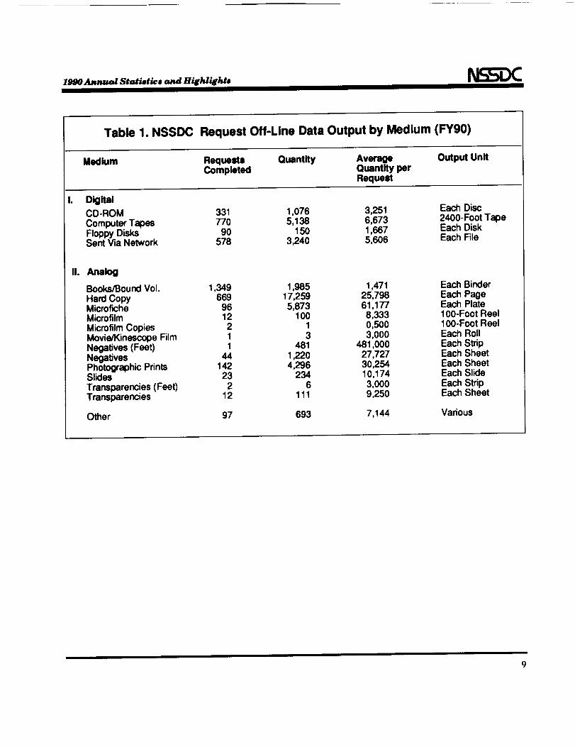
1990 Annual Statistics and HiEhlighte
Table 1. NSSDC Request Off-Line Data Output by Medium (FY90)
Medium Requests Quantity Average Output UnitCompleted Quantity per
Request
DigitalCD-ROM 331Computer Tapes 770Floppy Disks 90Sent Via Network 578
1,076 3,251 Each Disc5,138 6,673 2400-Foot Tape
150 1,667 Each Disk3,240 5,606 Each File
II. _ak_
Books/Bound Vol. 1,349Hard Copy 669Microfiche 96Microfilm 12Microfilm Copies 2Movie/Kinescope Film 1Negatives (Feet) 1Negatives 44Photographic Prints 142Slides 23Transparencies (Feet) 2Transparencies 12
Other 97
1,985 1,471 Each Binder17,259 25,738 Each Page5,873 61,177 Each Plate
100 8,333 100-Foot Reel1 0,500 100-Foot Reel3 3,000 Each Roll
481 481,000 Each Strip1,220 27,727 Each Sheet4,296 30,254 Each Sheet
234 10,174 Each Slide6 3,000 Each Strip
111 9,250 Each Sheet
693 7,144 Various
1990 Annual Statistics and Highlights
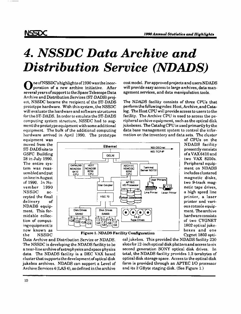
4. NSSDC Data Archive and
Distribution Service (NDADS)ne ofNSSDC's highlightsof1990 was the incor-poration of a new archive initiative. After
severalyears ofsupport tothe Space Telescope Data
Archive and DistributionServices (ST-DADS) proj-
ect,NSSDC became the recipientofthe ST-DADS
prototype hardware. With thissystem, the NSSDCwillevaluate the hardware and software structures
forthe ST-DADS. In order toemulate the ST-DADS
computing system structure,NSSDC had to aug-
ment the prototype equipment with some additional
equipment. The bulk of the additional computing
hardware arrived in April 1990. The prototype
equipment wasmoved from the
ST-DADS site to
GSFC Building
28 in July 1990.
The entire sys-tem was reas-
sembled and put
on line in August
costmodel. For approved projectsand usersNDADS
willprovide easy accessto large archives,data man-
agement services,and data manipulation tools.
r i
The NDADS facilityconsists of three CPUs that
perform the followingroles:Host, Archive, and Cata-
log.The Host CPU willprovide access tousers tothe
facility.The Archive CPU isused to access the pe-
ripheral archive equipment, such as the opticaldisk
jukeboxes. The Catalog CPU isused primarily by the
data base management system to control the infor-
mation on the inventory and data sets. The cluster
of 1990. In No-
vember 1990
NSSDC ac-
cepted the final
delivery of
NDADS equip-ment. This for-
midable collec-
tion of comput-
ing equipment is
Ethemet NSI-DECnet I=
I NSI-TCP/IP
J] I I
HSC 70 J
illDiSksA600Drlves I
CATALOG HOST
NDADSA NDADSB6410 8250
Islt-slt--_arCoup_!r
Disk Drives
SA482
IARCHIVENDADSC
8250CPU
'1APTEC J
I I/O Proc_sor I
1
tTermtnaJ
Server NDTS1
1
Line Printer Laser Printer
now known asthe NSSDC Figure 1. NDADS Facility Configuration
Data Archive and Distribution Service or NDADS.
The NSSDC is developing the NDADS facility to bea near-line archive of astrophysics and space physics
data. The NDADS facility is a DEC VAX based
cluster that supports the development of optical disk
jukebox archives. NDADS can support a Level of
Archive Services 4 (LAS 4), as defined in the archive
of CPUs on the
NDADS facility
presently consistsofa VAX 6410 and
two VAX 8250s.
Peripheral equip-ment on NDADS
includes clustered
magnetic disks,
two 9-track mag-
netic tape drives,
a high speed line
printer, a laser
printer and vari-
ous console equip-ment. The archive
hardware consists
of two CYGNET
1802 optical juke-boxes and one
Cygnet 1803 opti-
cal jukebox. This provided the NDADS facility 230
slots for 12-inch optical disk platters and access to sixsecond generation SONY optical disk drives. In
total, the NDADS facility provides 1.2 terabytes of
optical disk storage space. Access to the optical disk
farm is provided through an APTEC I/O processor
and its 2 GByte staging disk. (See Figure 1.)
l0
1990 Annual Statistics and Highlighte
5. Visual Reproduction Facility
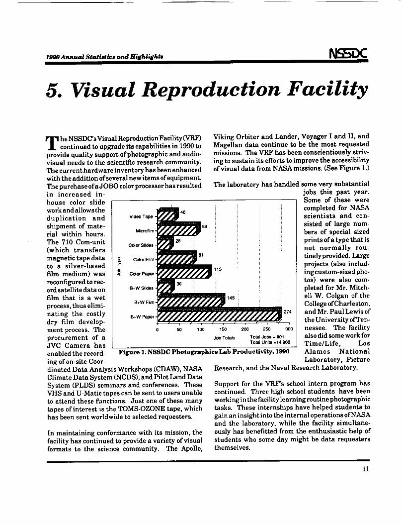
heNSSDC'sVisual ReproductionFacility(VRF)continuedtoupgrade itscapabilitiesin1990 to
providequalitysupportofphotographicand audio-visualneeds to the scientificresearchcommunity.
The currenthardware inventoryhas been enhancedwiththeadditionofseveralnew itemsofequipment.
The purchaseofaJOBO colorprocessorhas resulted
g
4OVideo Tape
Microfilm
28Color Slides
Color Film
Color Paper.
30B+W Slides •
B+W Film=
B+W Paper-
0 50
89
81
lOO
Viking Orbiter and Lander, Voyager I and II, andMagellan data continue to be the most requestedmissions. The VRF has been conscientiously striv-
ing to sustain its efforts to improve the accessibilityof visual data from NASA missions. (See Figure 1.)
Figure 1. NSSDC Photographics Lab Productivity, 1990
in increased in-
house color slide
work and allowsthe
duplication and
shipment of mate-rialwithin hours.
The 710 Com-unit
(which transfers
magnetictapedatato a silver-based
film medium) was
reconfiguredtorec-ordsatellitedataon
filmthat is a wet
process,thuselimi-
nating the costly
dry film develop-
ment process.The
procurement of aJVC Camera has
enabledtherecord-
ing ofon-siteCoot-
The laboratoryhas handled some very substantial
jobs this past year.Some of these were
completed for NASAscientistsand con-
sistedof large num-
bers of specialsized
printsofatypethatis
not normally rou-
tinelyprovided.Large
projects(alsoinclud-
Is ingcustom-sizedpho-
tos) were also com-
pletedforMr. Mitch-
14s ell W. Colgan of theCollege of Charleston,and Mr. Paul Lewis of
the University ofTen-Iso 2oo 2so 3o0 nessee. The facility
jot)Totals TotalJobs-801 alSOdidsome work for
Total Units =14,900 Time/Life, LosAlamos National
dinatedData AnalysisWorkshops (CDAW), NASA
ClimateData System (NCDS), and PilotLand Data
System (PLDS) seminars and conferences.These
VHS and U-Matic tapescan be senttousersunabletoattendthesefunctions.Justone ofthesemany
tapesofinterestisthe TOMS-OZONE tape,whichhas been sentworldwide toselectedrequesters.
In maintainingconformance with itsmission,the
facilityhas continuedtoprovidea varietyofvisual
formats to the sciencecommunity. The Apollo,
Laboratory, Picture
Research,and the Naval Research Laboratory.
Support forthe VRF's schoolinternprogram has
continued.Three high schoolstudents have been
working inthefacilitylearningroutinephotographic
tasks. These internshipshave helped studentsto
gainan insightintotheinternaloperationsofNASAand the laboratory,while the facilitysimultane-
ouslyhas benefittedfrom the enthusiastichelp of
studentswho some day might be data requestersthemselves.
II

Earth Science
Data Systems
PRECEDII'4G PAGE BLANK NOT FILMED

1990 Amnual Statistics and Highlights
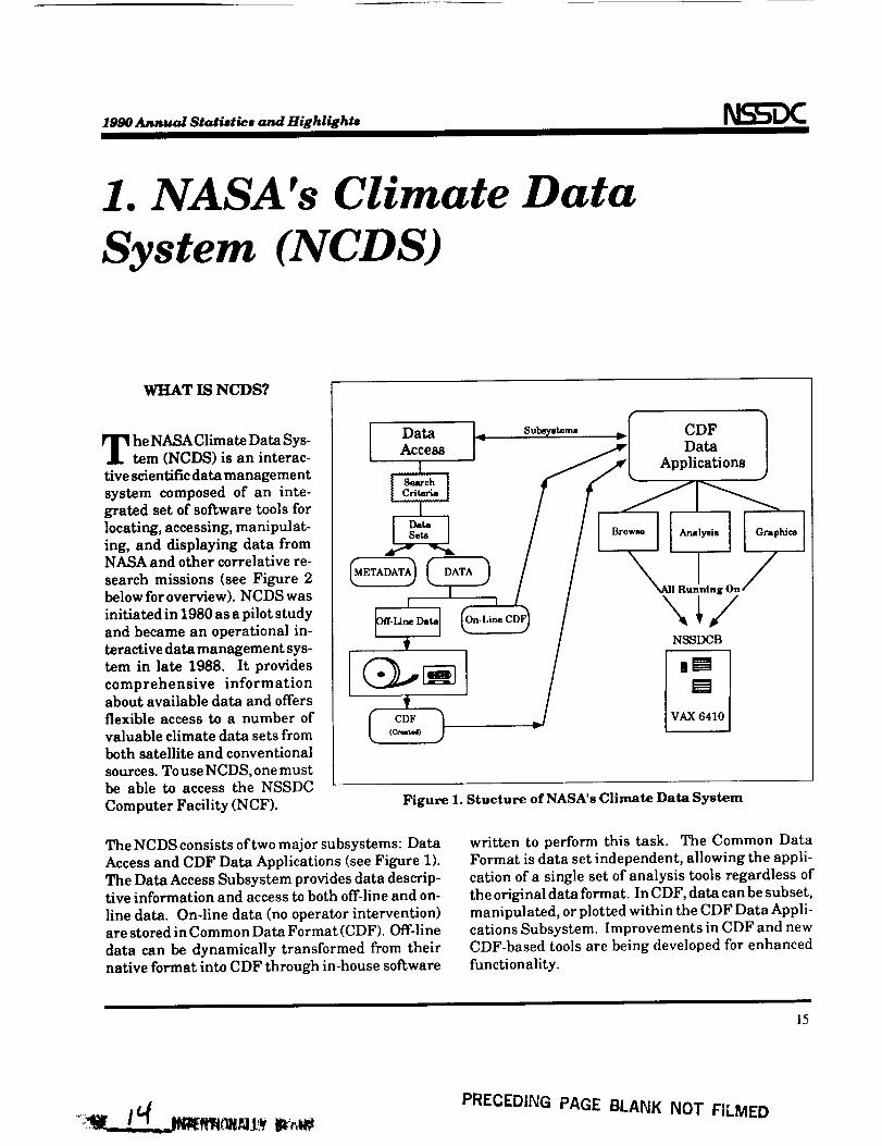
1. NASA's Climate Data
System (NCDS)
WHAT IS NCDS?
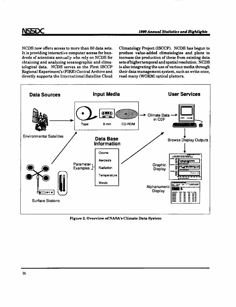
he NASA Climate Data Sys-tem (NCDS) is an interac-tive scientific data managementsystem composed of an inte-grated set of software tools forlocating, accessing, manipulat-ing, and displaying data fromNASA and other correlative re-
search missions (see Figure 2below for overview). NCDSwas
initiated in 1980 as a pilot studyand became an operational in-teractive data management sys-tem in late 1988. It provides
comprehensive informationabout available data and offersflexible access to a number ofvaluable climate data sets fromboth satellite and conventional
sources. To use NCDS, one mustbe able to accessthe NSSDC
Computer Facility(NCF).
Data I<Access
.......... i .......
ID°,- I
(METADATA_ (_ /
o--I
T
It°F)(Cre_l)
S,b_y,_=, _I CDFApplD:at_ions
I RJning On/
/NSSDCB
] '°mv VAX 6410
Figure 1. Stucture of NASA's Climate Data System
The NCDS consistsoftwo major subsystems:Data
Accessand CDF Data Applications(seeFigureI).
The Data AccessSubsystem providesdatadescrip-
tiveinformationand accesstobothoff-lineand on-
linedata. On-linedata(no operatorintervention)
arestoredinCommon Data Format (CDF). Off-line
data can be dynamically transformedfrom theirnativeformatintoCDF through in-housesoftware
written to perform this task. The Common DataFormat is data set independent, allowing the appli-
cation of a single set of analysis tools regardless ofthe original data format. In CDF, data can be subset,manipulated, or plotted within the CDF Data Appli-cations Subsystem. Improvements in CDF and newCDF-based tools are being developed for enhanced
functionality.
15
PRECEDING PAGE BLANK NOT FILMED
1990Annual Statistics and Highlijhts
NCDS now offersaccess tomore than 50 data sets.
Itisproviding interactivecomputer accessfor hun-
dreds of scientistsannually who rely on NCDS for
obtaining and analyzing oceanographic and clima-
tologicaldata. NCDS serves as the First ISCCP
Regional Experiment's (FIRE) Central Archive and
directlysupports the International SatelliteCloud
Climatology Project (ISCCP). NCDS has begun to
produce value-added climatologies and plans to
increase the production ofthese from existing data
setsofhigher temporal and spatialresolution.NCDS
isalsointegrating the use ofvarious media through
theirdata management system, such as write-once,
read-many (WORM) opticalplatters.
Data Sources Input Media User Services
8 mm CD-ROM
Environmental S_
Parameter- IExamples J-
Surface Stations
Data BaseInformation
Ozor'le
Aerosols
Radiation
Temperature
Winds
Climate Data ---_ |"-"-_|in CDF
._ Browse Display Outputs
Display
Alphanumeric IE'&"Display ----
Figure 2. Overview of NASA's Climate Data System
16
1990 Annual Statistics and Highlights
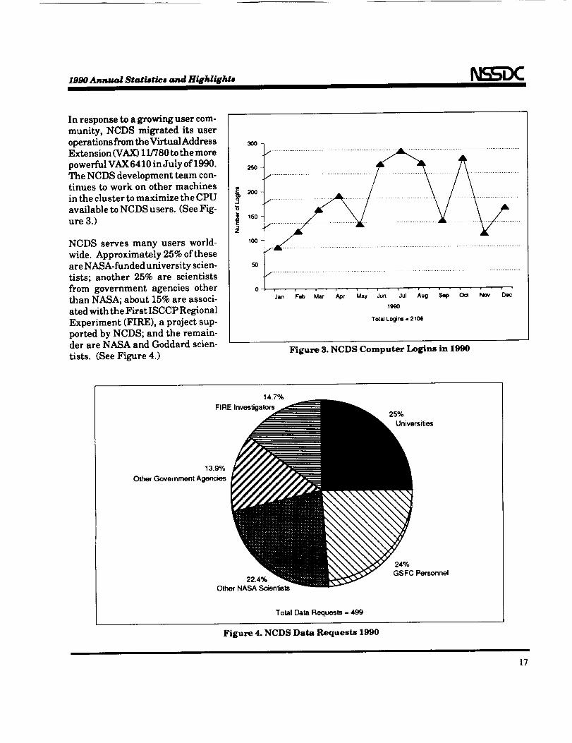
In response to a growing user com-
munity, NCDS migrated its user
operations from the Virtual AddressExtension (VAX) 11/780 to the more
powerful VAX 6410 in July of 1990.
The NCDS development team con-tinues to work on other machines
in the cluster to maximize the CPU
available to NCDS users. (See Fig-ure 3.)
NCDS serves many users world-
wide. Approximately 25% of these
are NASA-funded university scien-
tists; another 25% are scientists
from government agencies other
than NASA; about 15% are associ-
ated with the First ISCCP Regional
Experiment (FIRE), a project sup-
ported by NCDS; and the remain-der are NASA and Goddard scien-
tists. (See Figure 4.)
30o7
25O
2OO
150
oli • - i • i - i - i v - r - - i •
1990
To(aJLogins. 2106
Figure 3. NCDS Computer Logins in 1990
14.7%
FIRE Inves_galors25%
Universities
13.9%
Other Government Agencies
22.4%
Other NASA Scientists
24%
GSFC Personnel
Total _ta Requests = 499
Figure 4. NCDS Data Requests 1990
17
1990 Annual Statistic, and Hilhlights
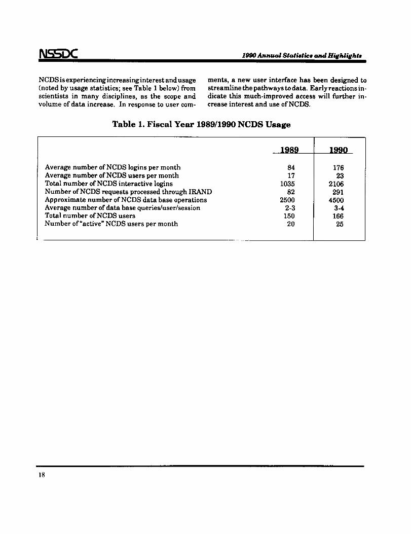
NCDS isexperiencingincreasinginterestand usage(notedby usage statistics;seeTable I below)from
scientistsin many disciplines,as the scope andvolume ofdata increase.In responseto usercorn-
ments, a new user interfacehas been designed tostreamlinethepathways todata.Earlyreactionsin-
dicatethismuch-improved accesswillfurtherin-creaseinterestand use ofNCDS.
Table 1. Fiscal Year 1989/1990 NCDS Usage
Average number ofNCDS loginsper month
Average number ofNCDS usersper month
Totalnumber ofNCDS interactivelogins
Number ofNCDS requestsprocessedthrough IRAND
Approximate number ofNCDS databaseoperations
Average number ofdatabase queries/user/sessionTotalnumber ofNCDS users
Number of"active"NCDS usersper month
8417
103582
25002-3150
20
1990
176
232106
2914500
3-4166
25
18
1990 Annual Statistics and Highlights
2. Pilot Land Data System(PLDS)
BACKGROUND
N ASA's Pilot Land Data System (PLDS) is a dis-tributed information management system de-signed to support NASA's land science community.Ithas sites at the Ames Research Center (ARC) and
Jet Propulsion Laboratory in California and theGoddard Space Flight Center in Maryland. ThePLDS provides a wide range of services including
• Managementofinformationabout scientificdata.
* Accesstoalibraryofscientificdata.
• A data orderingcapability.• Communications.
• Connection todata analysisfacilities.* CD-ROM publication.
• An Earth resourcesbrowse facility.
• Scienceprojectsupport.• User assistance.
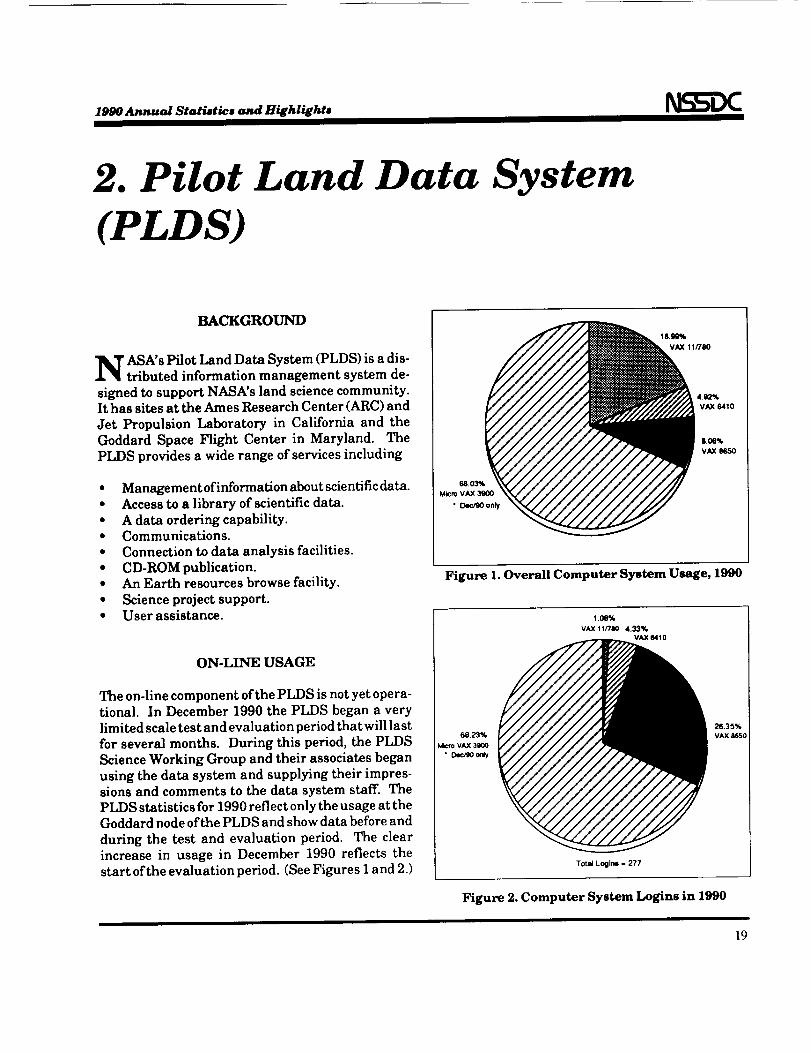
ON-LINE USAGE
The on-linecomponent ofthePLDS isnotyetopera-
tional.In December 1990 the PLDS began a very
limitedscaletestand evaluationperiodthatwilllast
forseveralmonths. During thisperiod,the PLDS
ScienceWorking Group and theirassociatesbegan
usingthe data system and supplyingtheirimpres-
sionsand comments to the data system staff.The
PLDS statisticsfor1990reflectonlytheusage attheGoddard node ofthePLDS and show databeforeand
during the testand evaluationperiod. The clear
increasein usage in December 1990 reflectsthe
startoftheevaluationperiod.(SeeFiguresIand 2.)
68,03%Mcro VAX 3900
Figure 1. Overall Computer System Usage, 1990
1.06%
VAX 11/780 4.33%VAX 6410
68.23%VAX 3900
• Dec/90 only
26.35%VAX 8650
Tot_ Loglns. 277
Figure 2. Computer System Logins in 1990
19
1990 Annual Statistics and Highlights
DEVELOPMENT OPERATIONS
NSN (TCP/IP) Communications
I
Workstation Laser Printer Tape Cartridge
Tape Cartridge
Communications DECnet
I 1__Dial-In Communications
GTE Telenet
39OO
Workstation
Printer - Dot matrix
to NSSDC VAX Cluster
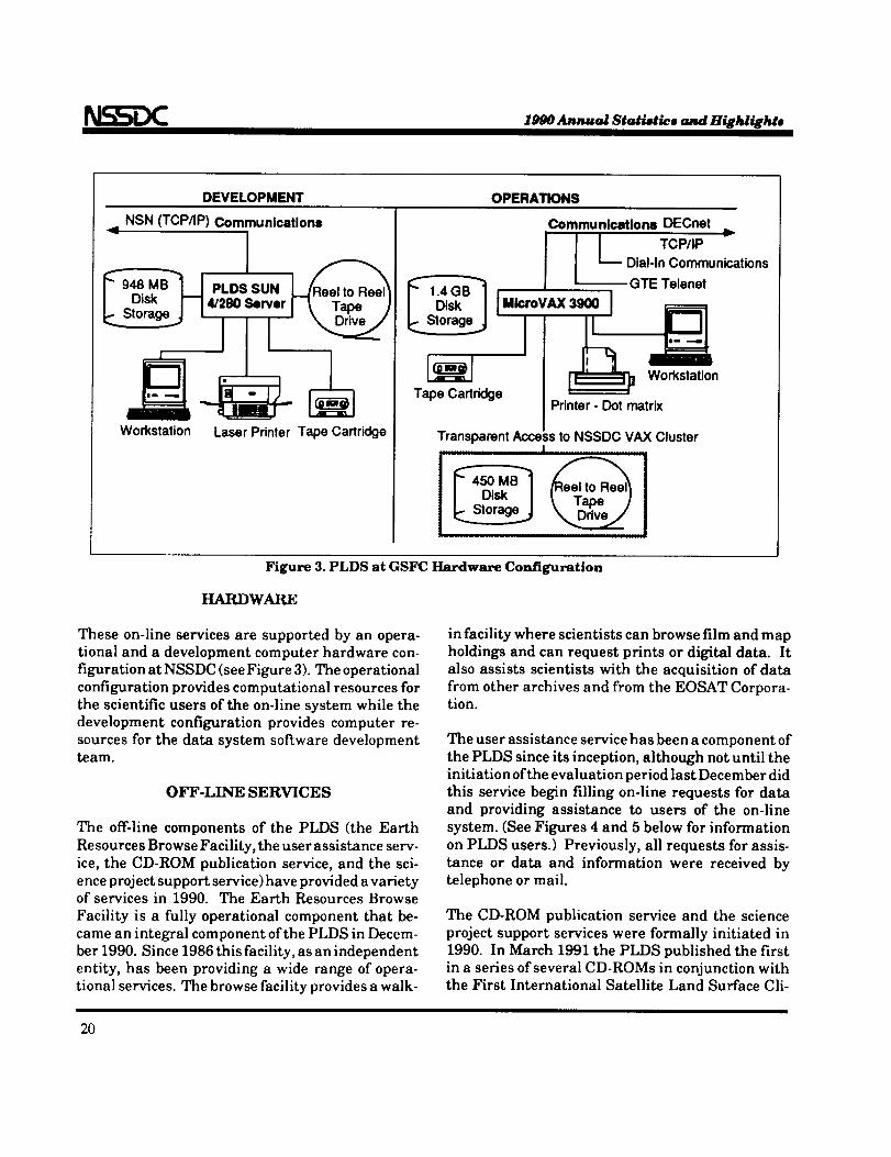
Figure 3. PLDS at GSFC Hardware Configuration
HARDWARE
These on-line services are supported by an opera-
tional and a development computer hardware con-
figuration at NSSDC (see Figure 3). The operational
configuration provides computational resources for
the scientific users of the on-line system while the
development configuration provides computer re-
sources for the data system software developmentteam.
OFF-LINE SERVICES
The off-linecomponents of the PLDS (the Earth
Resources Browse Facility,the user assistanceserv-
ice,the CD-ROM publication service,and the sci-
ence projectsupport service)have provided avarietyof services in 1990. The Earth Resources Browse
Facility is a fullyoperational component that be-
came an integralcomponent ofthe PLDS in Decem-
ber 1990. Since 1986 thisfacility,asan independent
entity,has been providing a wide range of opera-
tionalservices.The browse facilityprovides a walk-
in facility where scientists can browse film and map
holdings and can request prints or digital data. It
also assists scientists with the acquisition of data
from other archives and from the EOSAT Corpora-tion.
The user assistance service has been a component of
the PLDS since its inception, although not until the
initiation of the evaluation period last December did
this service begin filling on-line requests for data
and providing assistance to users of the on-line
system. (See Figures 4 and 5 below for information
on PLDS users.) Previously, all requests for assis-
tance or data and information were received by
telephone or mail.
The CD-ROM publication service and the science
project support services were formally initiated in
1990. In March 1991 the PLDS published the first
in a series of several CD-ROMs in conjunction withthe First International Satellite Land Surface Cli-
2O

1990 Annual Statietlcs and Highlights
matology Program (ISLSCP)
Field Experiment. In 1991 and
coming years this service isex-
pected toexpand greatly. Plans
are already under way forpubli-cationofseveral other data sets
on CD-ROM.
The sciencesupport servicesbe-
came a formal and integral com-
ponent ofthe PLDS in 1990. The
ARC node of the PLDS began
supporting the Oregon Transect
Ecosystems Research projectand
the GSFC node began providingthe on-linedata base forthe First
ISLSCP Field Experiment. Like
the CD-ROM publication serv-
ice,this service is expected to
grow and take on more responsi-
bilityas itmatures.
i ii i
i iJ !
80 90 100110120130140150180170180190200
• P_S [] E_F
l_1gure 4. User Intere©tion, 1990
Private Industry
P_onal Gov.
Foreign Gov.
U.S. Gov.
Univ.
0 10 20 30 40 50 6O 70 80 90
i It
j l
II
II
100 110 120 130 140 150 160 170 180 190 200 210 220 230 240 250
• PLDS [] ERBF
Figure 5. User Profile, 1990
21
1990 Annual Statistics and Highlights
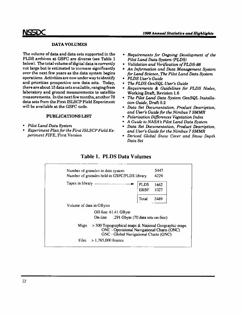
DATA VOLUMES
The volume ofdata and data setssupported in the
PLDS archives at GSFC are diverse (see Table 1
below). The totalvolume ofdigitaldata iscurrently
not large but isestimated toincrease significantly
over the next few years as the data system begins
operations.Activitiesare now under way toidentify
and prioritizeprospective new data sets. Today,
there are about 15 data setsavailable,ranging from
laboratory and ground measurements to satellite
measurements. In the next few months, another 70
data setsfrom the First ISLSCP Field Experiment
willbe available at the GSFC node.
PUBLICATIONS LIST
Pilot Land Data SystemExperiment Plan for the First ISLSCP Field Ex-
periment FIFE, First Version
* Requirements for Ongoing Development of thePilot Land Data System (PLDS)
• Validation and Verifwation of PLDS-88
• An Information and Data Management System
for Land Science, The Pilot Land Data System• PLDS User's Guide
• The PLDS GenSQL User's Guide
• Requirements & Guidelines for PLDS Nodes,
Working DraR, Revision 1.6
• The Pilot Land Data System GenSQL Installa-
tion Guide, Draft 0.2
• Data Set Documentation, Product Description,
and User's Guide for the Nimbus 7 SMMR
• Polarization Differences Vegetation Index
• A Guide to NASA's Pilot Land Data System
• Data Set Documentation, Product Description,and User's Guide for the Nimbus 7 SMMR
• Derived Global Snow Cover and Snow DepthData Set
Table 1. PLDS Data Volumes
Number of granules in data system
Number of granules held in GSFC/PLDS library
Tapes in library
Volume of data in GBytes
Maps
Film
5447
4229
i. [PLDS 1462
ERBF 1027
/Total 2489
Off-line 61.41 GByte
On-line .291 Gbyte (70 data sets on-line)
> 500 Topographical maps & National Geographic mapsONC - Operational Navigational Charts (ONC)GNC - Global Navigational Charts (GNC)
> 1,785,000 frames
22
1990 Annual StatiBtico and Highlighto
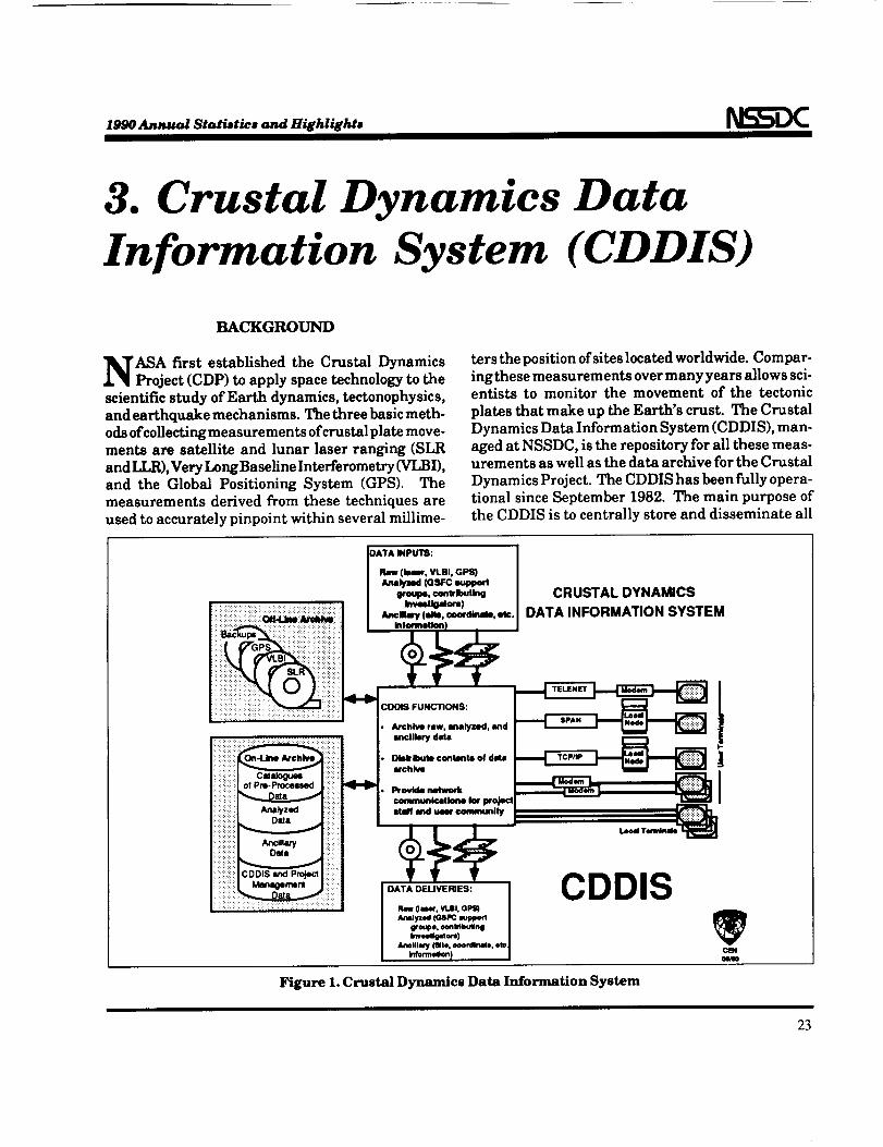
3. Crustal Dynamics DataInformation System (CDDIS)
BACKGROUND
'ASA first established the Crustal DynamicsProject (CDP) to apply space technology to the
scientific study of Earth dynamics, tectonophysics,
and earthquake mechanisms. The three basic meth-
ods of collecting measurements of crustal plate move-
ments are satellite and lunar laser ranging (SLR
and LLR),Very LongBaseline Interferometry (VLBI),
and the Global Positioning System (GPS). Themeasurements derived from these techniques are
used to accurately pinpoint within several millime-
ters the position of sites located worldwide. Compar-
ing these measurements over many years allows sci-entists to monitor the movement of the tectonic
plates that make up the Earth's crust. The Crustal
Dynamics Data Information System (CDDIS), man-
aged at NSSDC, is the repository for all these meas-urements as well as the data archive for the Crustal
Dynamics Project. The CDDIS has been fully opera-
tional since September 1982. The main purpose of
the CDDIS is to centrally store and disseminate all
CRUSTAL DYNAMICS
DATA INFORMATION SYSTEM
AnalyzedD-ta
DATA DELIVERIES:
Raw (laMr, Vt.BI, GI_Analyzed (GSPC mup1_rt
gro_e. _mMbulingImeet_luora)
_111_ (llllo, ooo_lrmte, ere.In/om'.nilon)
CDDIS
M
Figure 1. Crustal Dynamics Data Information System
23

1990 Annual Statistics and Highlights
geodeticdata products acquired by the projectand to
maintain information about the archival ofallproj-
ect relateddata. (See Figure I for an overview and
Figure 2 for the configuration.) The CDDIS is
operational on a dedicated DigitalEquipment Cor-
poration (DEC) MicroVAX IIcomputer with nearly
three GBytes on-line disk (magnetic and erasable
optical)storage. All authorized projectinvestiga-
tors,staff,and cooperating institutionshave access
to the system through the NASA Science Internet
(NSI, both DECnet and TCP/IP), BITnet, and the
GTE Telenet facilitiesas well as dial-uptelephonelines.
GPS DATA ARCHIVE
The CDDIS began the archive ofGlobal Positioning
System (GPS) data for the CDP during FYg0. The
CDDIS GPS archive includes several different cate-
gories of GPS experiments: local, intercomparison
surveys between existing SLR and VLBI monu-
ments, regional surveys, and footprint surveys.
Currently, the CDDIS is archiving data in raw,
receiver format as well as the approved Receiver
INdependent EXchange (RINEX) format. A set oftables in the CDDIS ORACLE data base has been
created to track GPS experiment, session, site, and
satellite information. Sol, ware has been developedto summarize RINEX-formatted GPS data and load
this information into the data base. CDP investiga-
tors can query these tables by time and location to
determine data availability. The data are temporar-
ily archived on line to an erasable optical disk for
archive processing. At that time, users can access
these data and perform remote fde copies to their
home institutions for further analysis. As more GPS
_ CDDIS
_----_ OTHER SYSTEMS
D FUTURE
LOCAL ETHERNET
DECMICROVAX II
:::::::DIS K::::::::I
i:CONTR.i:il
ziiiiiiiiiiiiiiERASABLE iiiii _1
_ OPTICAL DISK DRIVE
i! ,ii............ii!!ii:.ili!!.............i!!!i
cr_l
Figure 2. Configuration of CDDIS Computer System
24
1990 Annual Statistics and Highlights N )C
data arrive at CDDIS, olderdata are archived off line to
magnetic tape.
COMPUTER
DEVELOPMENTS
An erasable opticaldisk unit
(containing two drives) was
installedin the CDDIS com-
puter facility.This device has
increased the on-linestorage
capacity to 2.5 GBytes with
an additional 0.6 GBytes of
"near" on-line storage. Thus
far, these optical disks havebeen utilized to provide on-line access to the CDDIS GPS
data archive.
PUBLICATIONS
'J3.5%U.S.Investigalorz
5.66% 5.86%
JPL Investigators Project Use
16.06%
GSFC Inves_gators
59.12%IntemalJo_al InveslJgators
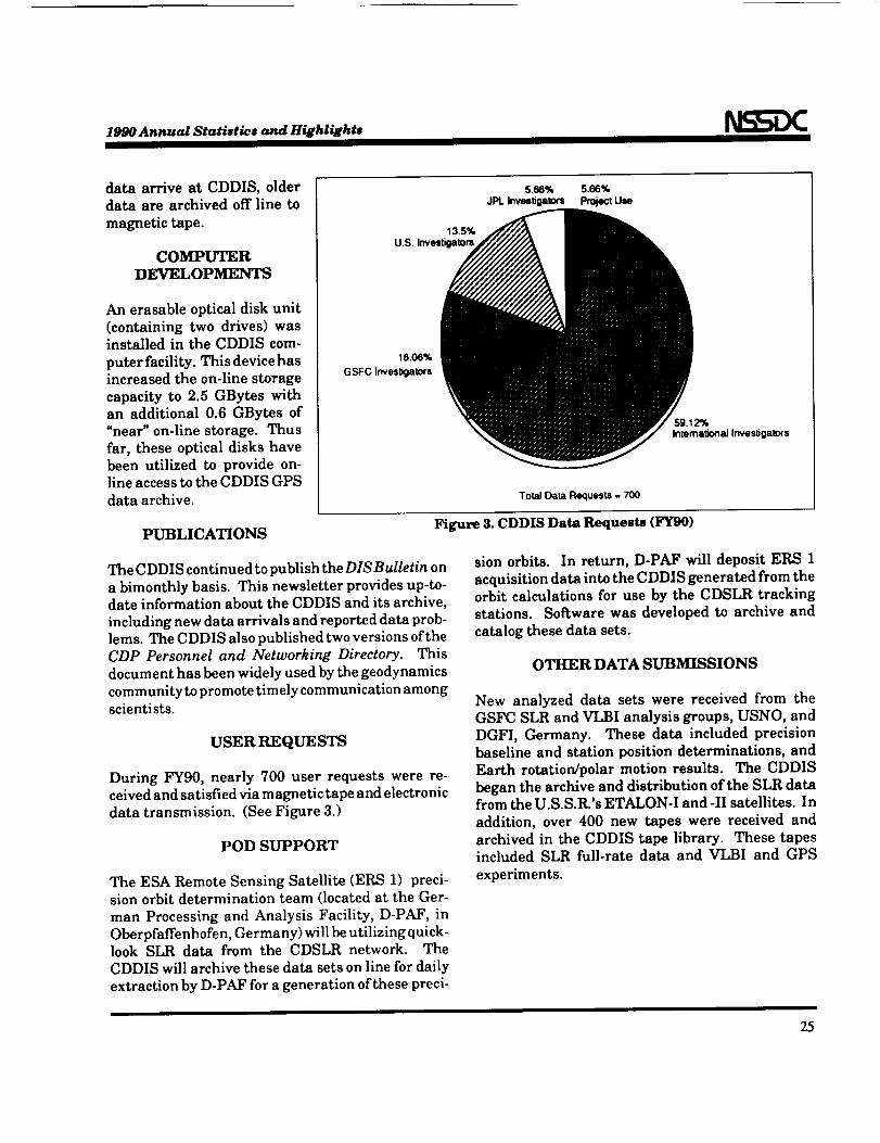
To_l Data Requests = 700
Figure 3. CDDIS Data Requests (FYg0)
The CDDIS continued to publish the DISBulletin on
a bimonthly basis. This newsletter provides up-to-
date information about the CDDIS and its archive,
including new data arrivals and reported data prob-
lems. The CDDIS also published two versions of the
CDP Personnel and Networking Directory. This
document has been widely used by the geodynamics
community to promote timely communication amongscientists.
USER RE QUESTS
During FY90, nearly 700 user requests were re-
ceived and satisfied via magnetic tape and electronic
data transmission. (See Figure 3.)
POD SUPPORT
The ESA Remote Sensing Satellite (ERS 1) preci-
sion orbit determination team (located at the Ger-
man Processing and Analysis Facility, D-PAF, inOberpfaffenhofen, Germany) will be utilizing quick-look SLR data from the CDSLR network. The
CDDIS will archive these data sets on line for dailyextraction by D-PAF for a generation of these preci-
sion orbits. In return, D-PAF will deposit ERS 1
acquisitiondata intothe CDDIS generated from the
orbit calculations for use by the CDSLR tracking
stations. Software was developed to archive and
catalog these data sets.
OTHER DATA SUBMISSIONS
New analyzed data sets were received from the
GSFC SLR and VIii analysis groups, USNO, and
DGFI, Germany. These data included precision
baseline and stationposition determinations, and
Earth rotation/polarmotion results. The CDDIS
began the archive and distributionofthe SLR data
from the U.S.S.R.'sETALON-I and -IIsatellites.In
addition, over 400 new tapes were received and
archived in the CDDIS tape library. These tapes
included SLR full-ratedata and VLBI and GPS
experiments.
25

Space ScienceData Systems
PRECEDING PAGE BLANK NOT FILMED

l_V_OAnnual Star.ties and H_hli_hts
1. Coordinated Data AnalysisWorkshop (CDAW) Program
he CDAW program isan effortby NSSDC tofur-therthe conductand development oftoolsand
techniquesforthe conductoflarge-scalecollabora-tivescientificresearch,using simultaneous data
frommany investigatorstoattacksignificantphysi-
calproblems ofglobalscalethatmay notbe other-
wise addressable.The concept originatedin the
solar-terrestrialcommunity with a need withinthe
InternationalMagnetosphericStudy (IMS)program
to analyze simultaneous data from a varietyofsources to betterunderstand the structureand
dynamics ofsystemsliketheEarth'smagnetosphere.
The CDAW program is distinguished by its combi-nation of a traditional workshop format with assem-
bly of a digital data base where the data and relevantmodels have been cast into a common format, with
supporting software and graphics devices duringthe workshops to allow participants direct interac-tive graphic display and data analysis. NSSDCserves as a focus for the organization and logistics ofthe workshops. The selection of scientific problemsand overall planning are the responsibilities of theinterested science community. Access to the database between workshop meetings is supported overelectronic networks such as NSUDECnet and NSI/
TCP-IP. The CDAW program is one model for howsome aspects of the collaborative work to be includedin the Inter-Agency Consultative Group (IACG) 1990sinitiative in solar-terrestrial science and significantparts of the global science objectives of the GlobalGeospace Science/International Solar-TerrestrialPhysics (GGS/ISTP) program might be carried out.
The currentCDAW workshop series(CDAW 9)was
initiatedwith a major meeting at NSSDC in May
1989. The focus of the CDAW 9 analysisisfive
specificeventsduringthe March-June 1986 Polar
Regions and Outer Magnetosphere International
Study (PROMIS) campaign period.During thePROMIS period,an internationaleffortwas made to
gathersimultaneoussolar-terrestrialobservations
towardthegoalofan improved understandingofthe
relationbetween polar phenomena and physical
processesin the magnetosphere as a whole. The
campaign includedconcurrentimaging ofnorthern
and southernhemisphere auroraby theVikingand
Dynamics Explorerspacecraft,respectively.
The overallCDAW 9effortinvolvesover100 partici-
patingscientistsfrom around theworld and a data
baseincluding14spacecraftand numerous ground-stationobservations.Some 80 distinctdata sets(for
each ofthe fiveCDAW 9 eventsinmost cases)plus
satellite ephemeris data comprise the basic database. CDAW 9 meetings have been (or are to be) heldat Goddard (May 1989, June 1990, June 1991),Stanford University (December 1989), and the So-lar-Terrestrial Environment Laboratory (STELAB)of Nagoya University (August 1990). The workshopin Japan was supported by porting and reinstallingthe data base on local facilities; the other workshopshave been supported by either direct or networkaccess to the data base and software at NSSDC.
Access and use of the data base for the primaryCDAW 9 analysis period is governed by a set of"Rules of the Road" that establish the requirementsto be considered a CDAW 9 participant and for useof the CDAW 9 data in publications.
During the workshops themselves, literally a thou-sand or more plots have been produced for either
29
PRECEDING PAGE BLANK NOT FILMED
1990 Annual Statistics and Highlights
interactivegraphicsterminalorhard copydisplay.
On-going access to the data continues between
workshops. In a number of cases,data have also
been interactivelyextractedfrom thedata basefor
localmanipulationand displayby participants.As
arecentexample atwhat isnow a relativelymaturephase ofthe CDAW 9 analysis,a totalof44 partici-
pant sessionstoaccessand use the database were
loggedin the three months from November 1990
through January 1991.
A specialsessionon initialresultsfromCDAW 9was
heldatthe1990SpringAmerican GeophysicalUnion
(AGU) meeting inBaltimore.CDAW 9 resultswill
be more comprehensively summarized in papers
now inpreparationfortheInternationalAssociation
ofGeomagnetism and Aeronomy (IAGA) meetingto
beheldinVienna,Austria,inAugust 1991.Some of
thestillunfoldingresearchderivingfrom theCDAW9 effortinclude
The relationbetween ultravioletauroralim-
agesand theground magnetometer signatures
thathave been usedinthepasttoimply auroralstructureand motions.
* Cross-tailcurrentdevelopment,fieldlinemap-ping,and substorm onsetmechanisms.
Modeling ofthe instantaneousdistributionof
electricfields,horizontalcurrents,field-aligned
currents,and magnetosphericheating.
• Substorm development as seenindualauroral
imaging.
Work also continues on the underlying softwaresystem to improve both its functionality and itsperformance to meet future analysis needs.
30
1990 Annual Statistics and Highlights
2. Satellite Situation Center
(SSC) and SPACEWARN
uring 1990,the SSC and SPACEWARN officesupportedthefollowingactivities:
• Providingroutinemissionsupport.
• Coordinating/supportinginternationalmulti-
spacecraftresearch.
• Evolvingnew heliosphericorbitalcodestomeet Inter-AgencyConsultativeGroup
(IACG)IInternationalHeliospheric
Study(IHS)/SOLar ConnectiontoTransientInterplanetaryProcesses(SOLTIP) needs.
• Computing and loadingon-lineSSC printfilesand executablecodesforremote access.
• Continuing Committee on Space Research
(COSPAR)/InternationalURSIGRAM and
World Days Service(IUWDS)/SPACEWARN
activities.
• Extending help/oversight/validationoftheSSC codesbeingportedfrom MODCOMP toVMS and UNIX.
PROVIDING ROUTINE MISSION SUPPORT
Support for the DE 1 project office continued.Ephemeris files for DE I and AKEBONO spacecraft,using the (Code 500) Gridded Trajectory Determina-tion System (GTDS) program were produced onmagnetic tapes. There were 27 such files for each ofthese spacecraft, each produced for a future period oftwo weeks, six weeks in advance. The DE 1 fileswere inputted to an SSC code to supply hard copiesof the coordinates of DE 1 every three minutes inseveral coordinate systems of interest. Both DE 1and AKEBONO files were then inputted to another
SSC code to provide list outputs of the times when
both spacecraft would be on any common magneticfield tube. Hard copies of these conjunctions weresupplied to the DE 1 project office (again in advance,for two-week periods). These pairs of list outputswere also networked to Palo Alto and Kyoto investi-gators routinely and occasionally to a few otherresearch scientists on request. Besides those ad-vance predictions of DE 1 coordinates, definitiveephemeris tapes were also produced for the space-craft; ('definitive" signifies that actual orbital ele-ments were used). Inputted ephemeris fries, pre-dicted and definitive, totaled 122 MBytes (equiva-lent to 244,000 VAX blocks), and outputted filestotaled 23 M-Bytes.
Support for the IMP 8 project consisted of producingdefinitive ephemeris tapes for the full year of 1992and inputting the file into an SSC code to provideplots of the spacecraft trajectory in GSE X-Y plane.Each plot covered one full orbit, for a total of 30 plotsfor the year.
Two-line U.S. Space Command (USSPACECOM-previously known as the North Atlantic Air DefenseCommand [NORAD]) orbital element sets of severalthousand orbiting objects were networked threetimes a week to Johnson Space Center (JSC), Hous-ton, Texas. JSC is using these data to support astudy on space debris. The total number of such
tapes (from USSPACECOM) was 156, containing117 MBytes of data.
Orbitalelement setsforten scienceinterestspace-
craftwere extractedfrom theUSSPACECOM tapes
and loadedthreetimesa week intothe "anonymous
31
FTP" network account [ACTIVE]. They occupy 150KBytes in the account. For some foreign investiga-tors who had expressed difficulty in accessing[ACTIVE], the elements were E-mailed periodically.These data were available to over 30 investigators.
COORDINATING/SUPPORTING INTERNA-TIONAL MULTI-SPACECRAFT PROGRAMS
IACG/ACTIVE: The Soviet spacecraft ACTIVE(also known as ACTIVNI or ACTIVNYI) was the
centerpiece of an IACG effort, coordinating jointinvestigations involving ACTIVE, DE 1, AKEBONO,and SCATHA spacecraft and numerous ground-based research stations. The SSC was designated asthe central prediction/coordination center for thiseffort. For each month, January through June, SSCproduced advanced predictions of
• thelocationofACTIVE,
• itsmagnetic fieldfoot-pointintheNorthern
Hemisphere,
• itsmagnetic fieldconjunctionswithDE 1,
AKEBONO, and SCATHA.
These predicted files were made available to all jointinvestigators through on-line files in the *anony-mous FTW' network account [ACTIVE]. The orbit
predict files totaled about 8 MBytes each month, to-taling 48 MBytes until termination of the programin July 1990.
Besidessuchadvanceplanningefforts,theSSC also
computed foreach month definitivefilesof
• the location ofACTIVE,• the magnetic foot-point of ACTIVE using two
different models (quiet and super-disturbed) ofthe field,
• the magnetic field conjunctions of ACTIVEwith DE 1, AKEBONO, and SCATHA,invoking again two different models of themagnetic field.
These files amounted to nearly 70 MBytes, againglobally accessible through the anonymous account.All the ephemeris files, predicted and definitive,
generated as inputs to the SSC computer codes
totaled120 MBytes.
IHS: At the request of the editor of the IHS newslet-ter, plots of the heliographic latitudes of Pioneers 10
and 11 and Voyagers 1 and 2 for the years fromlaunch through 1999 were supplied; these appearedin the IHS newsletter No. 3.
Solar- Terrestrial Energy Program (STEP) / SOL TIP:At the request of the chairman of the SOLTIPworking group, a composite, ecliptic plane projectedplot of all heliospheric spacecraft for mid-1990through mid-1991 was prepared. In addition, SSCpersonnel provided a list of time intervals duringwhich any pair of heliospheric spacecraft would beradially aligned with the Sun during the December1990-January 1991 MAX91 campaign. The list wasincorporated in to the November 1990 MAX91newsletter, distributed by NOAA/SEL in Boulder,Colorado.
Seismic Research: SSC hosted for a month a Soviet
visitor (O. Pokhotelov), sponsored by the UnitedStates Geological Service (USGS), and provided himwith special runs of codes to select instances whenDE 1, AKEBONO, or ACTIVE and San Marco couldhave been on the same flux tubes that emanated
from hundreds of seismic epicenters.
CONTINUING COSPAR/IUWDSSPACEWARN BULLETIN ACTIVITIES
A totalof 4800 telexesfrom USSPACECOM and
ForeignBroadcastInformationService(FBIS)were
obtained to extractinformationfor the monthlypublication,the SPACEWARNBulletin.
A totalof90 telexeswas senttotheCOSPAR distri-
butionlist,announcing new launches of174 space-craftaround the world.
On-line access to the SPACEWARN Bulletin wasinitiated with the December 1990 issue. It was
loaded into the anonymous subdirectoryACTIVE.SPY_ The version of the SPACEWARN
Bulletin is sent to over 600 scientists throughout theworld.
32
1990 Annual Statistics and Highlights
3. The -stronomical,4[, _m_ q
Cen er (ADC)
Data
he Astronomical Data Center (ADC) at theNSSDC isone ofsixmajorinternationalastron-
omy datacenters.The ADC works toprovidescien-tistswith machine-readableastronomicalcatalogs.
Over 600 catalogshave beenmade availablethrough
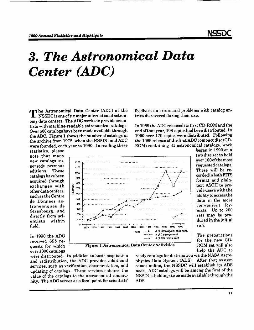
theADC. FigureI shows the number ofcatalogsinthe archivefrom 1978,when the NSSDC and ADC
were founded,each yearto 1990. In readingthese
statistics,please
note that many
new catalogssu-
persede previouseditions. These
catalogshave been
acquired through
exchanges with
otherdatacenters,suchastheCentre
de Donnees as-
tronomiques de
Strasbourg, and
directlyfrom sci-entists within
field.
In 1990 the ADCreceived 655 re-
quests for whichover 1000 catalogswere distributed. In addition to basic acquisitionand redistribution, the ADC provides additional
services, such as verification, documentation, andupdating of catalogs. These services enhance thevalue of the catalogs to the astronomical commu-nity. The ADC serves as a focal point for scientists'
feedbackon errorsand problems with catalogen-
triesdiscoveredduringtheiruse.
In 1989theADC releaseditsfirstCD-ROM and the
endofthatyear,108 copieshadbeendistributed.In
1990 over 170 copieswere distributed.Followingthe 1989 releaseofthefirstADC compact disc(CD-
ROM) containing31 astronomicalcatalogs,work
1100 -_ .........................................................................................................
........................................iiiiiiiiii
197e 1979 19a0 19el 1982 19a3 1984 19as 1_ 19_7 1988 1_ 1990
Year _ # of CataJogs in data base
---o-- # of Catalogs sent
# of CD Rorns sent
Figure 1. Astronomical Data Center Activities
began in 1990 on atwo discsettohold
overI00 ofthemost
requestedcatalogs.These willbe re-
cordedinbothFITS
format and plain-
textASCII to pro-videuserswiththe
abilitytoaccessthedata in the more
convenient for-
mats. Up to 200
sets may be pro-duced intheinitial
run.
The preparationsfor the new CD-ROM set will also
help the ADC to
ready catalogs for distribution via the NASA Astro-physics Data System (ADS). After that systemcomes online, the NSSDC will establish its ADS
node. ADC catalogs will be among the first of theNSSDC's holdings to be made available through theADS.
33
1990 Annual Statistirs and Highlightm
4. ROSAT Mission Informationand Planning System (MIPS)
he ROSAT (German X-ray researchsatellite)projectisa cooperativeprogram between the
FederalRepublic of Germany, the United States,
and theUnited Kingdom. The missionofROSAT is
toadvance the scienceofastrophysicsthrough the
study ofX-ray emissionsfrom non-solarcelestialobjects.The studywillbe performed withan X-ray
observatorythatinitiallywillsurveythe sky forX-
raysourcesand thenwillpointatspecificsourcesfor
extended periodsoftime.
The main instrumentationofROSAT consistsofa
WoltertypeIX-ray telescopewitha carouselplane
assembly carryingaPositionSensitiveProportional
Counter (PSPC) instrument designedand builtby
theFederalRepublicofGermany, and aHigh Reso-
lutionImager (HRI) instrumentdesignedand built
by the United States.The X-ray telescopewillbe
supplementedby an extreme ultraviolet(EUV) tele-
scopewithaWide FieldCamera (WFC) instrument
designed and builtby the United Kingdom. The
United Stateslaunched theROSAT observatoryon
aDelta2 on June 1,1990. The satelliteisina near
perfectorbitof584.6 km x 577.8 km and 53.004
degreesinclination.
The U.S. ROSAT ScienceData Center (USRSDC)
has been developedtosupporttheU.S.portionofthe
ROSAT program. One functionoftheUSRSDC isto
providemissioninformationand proposalsupport
totheU.S.investigators,theprimary taskofwhich
isto assistguest observersin the development of
pointedobservationproposalsforROSAT. As partof
thisfunction,targetlistsforapprovedpointedobser-
vationsby U.S.guestobserversareprovidedtotheInternationalUsers Committee atMPE. To effec-
tively carry out this task, there have been manyactivities performed together by the USRSDC andMPE, such as the creation and maintenance of
several data bases and software packages that willsupport the mission planning tasks and also provideassistance to the guest observer. The mission plan-ning software coordinates and manages incomingrequests from NASA selected guest observers forobserving time on ROSAT instruments. It providesall necessary information and reports to NASAHeadquarters, to the National User Committee, tothe Max Planck Institute, and to guest observers. Itdirectly interfaces with the West German MissionPlanning software at MPE. In addition, the missionplanning support staff extracts technical informa-tion from proposals at the request of U.S. ROSATproposal review committees and provides othersupport including evaluating targets based on pos-sible observing times and viewing windows. Theinformation and reports are available in an on-line
information system for mission planners. Guestobservers may interact with the on-line informationsystem in order to acquire data concerning theROSAT instrumentation approved ROSAT propos-als. The mission planning and mission informationsupport function is provided to the community bythe ROSAT Mission Information and PlanningSystem (MIPS).
The Mission Information and Planning System
(MIPS) isan on-lineinformationretrievalsystemdevisedforthe U.S. ROSAT ScienceData Center
and itsusers.MIPS was designedand implemented
bytheROSAT MissionPlanningTeam attheNSSDC.
MIPS is a menu-driven system builtusing the
INGRES data base management system (DBMS)and itsutilities.
34
1990 Annual Statistics and Highlights
The requirements for MIPS were assessed after
collaboration with EINSTEIN investigators at the
onset of the GSFC involvement in the ROSAT proj-
ect in November 1986. In this evaluation, it was
determined that the general user community or
guest observers require the following information:
• ROSAT approved targets and selected informa-
tion from approved proposals.
• Ability to formulate a ROSAT proposal for sub-mission.
* EINSTEIN sequences and targets.• EXOSAT observations.
• Technical specifications for PSPC and HRI.
• Ability to calculate exposure times for targets,
viewing windows, and coincidences.
• Immediate information concerning ROSAT
through a bulletin board.
• Correspondence among fellow investigators.
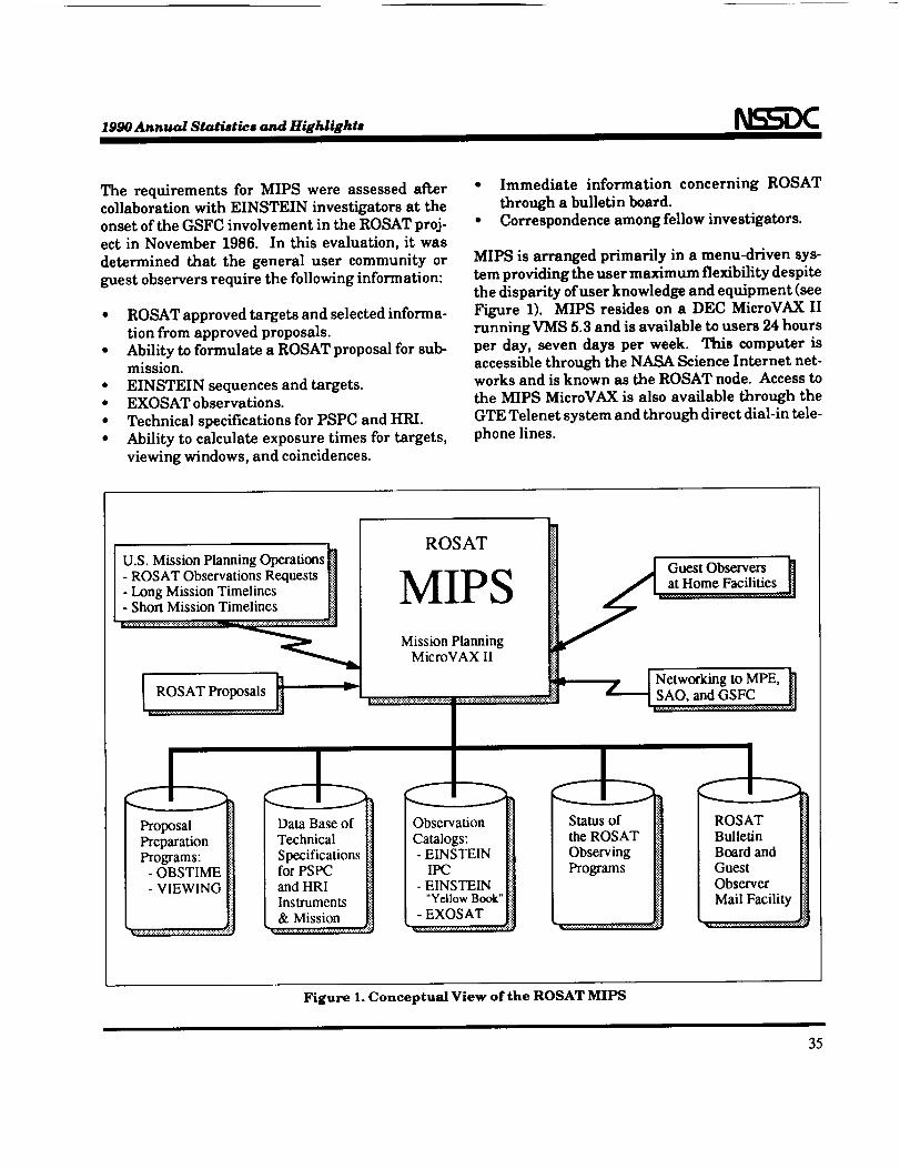
MIPS is arranged primarily in a menu-driven sys-
tem providing the user maximum flexibility despite
the disparity of user knowledge and equipment (see
Figure 1). MIPS resides on a DEC MicroVAX II
running VMS 5.3 and is available to users 24 hours
per day, seven days per week. This computer is
accessible through the NASA Science Internet net-works and is known as the ROSAT node. Access to
the MIPS MicroVAX is also available through the
GTE Telenet system and through direct dial-in tele-
phone lines.
U.S. Mission Planning Operations
- ROSAT Observations Requests n- Long Mission Timelines []
- Short Mission Timelines _iii
ROSAT
"It m-T'r_ _ {_ _ Guest Observers {]I_,/I lIJ _ H / I at Home Facilities
Mission Planning
MicroVAX II
_Networking to MPE, _]
ProposalPreparationPrograms:
- OBSTIME- VIEWING
Data Base ofTechnical
Specificationsfor PSPCand HRIInstruments& Mission
Catalogs: l!il
- EINSTEIN _[i]"wHo Book"[il
Observer [i{
Figure 1. Conceptual View of the ROSAT MIPS
35
1990 Annual $tatiotic# and Highlights
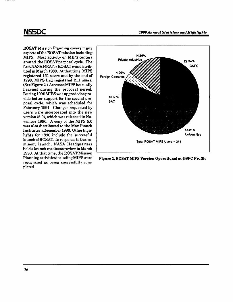
ROSAT Mission Planning covers many
aspectsofthe ROSAT mission including
MIPS. Most activityon MIPS centers
around the ROSAT proposal cycle.The
firstNASA NRA forROSAT was distrib-
uted inMarch 1989. At that time, MIPS
registered 151 users and by the end of
1990, MIPS had registered 211 users.
(See Figure 2.)Access toMIPS isusually
heaviest during the proposal period.
During 1990 MIPS was upgraded topro-
vide better support for the second pro-
posal cycle, which was scheduled for
February 1991. Changes requested by
users were incorporated into the new
version (5.0),which was released in No-
vember 1990. A copy of the MIPS 5.0
was also distributed tothe Max Planck
InstituteinDecember 1990. Otherhigh-
lights for 1990 include the successful
launch ofROSAT. In response tothe im-
minent launch, NASA Headquartersheld alaunch readiness review inMarch
1990. At that time, the ROSAT Mission
Planning activitiesincludingMIPS were
recognized as being successfully com-
pleted.
14.36%PrivateInduslries
4.26%
ForeignCountries
22.34%
GSFC
13.83%SAO
Total ROSAT MIPS Users = 211
45.21%
Universities
Figure 2. ROSAT MIPS Version Operational at GSFC Profile
36
Standardsand
Technologies

1990 Annual Startles ond Hi_i_e _--_
1. NASA/OSSA Office ofStandards and Technology
he NASA/OSSA OfficeofStandards and Tech-nology(NOST) atthe NSSDC has been estab-
lishedby the OfficeofSpace Scienceand Applica-
tions(OSSA) at NASA Headquarters to servethe
space and Earth sciencecommunities in evolving
cost-effective,interoperabledata systems. Ithas
been recognizedthat researchorganizationsthat
promote theuse ofcost-effectivestandardsfortheir
operationswillhave relativelymore resourcesavail-
abletodevotetothegenerationoftrulyuniqueandsignificantadvances in scienceand technology.To
thisend, NOST performs a number of functions
designedtofacilitatetherecognition,development,
adoption,and use of standards by the space andEarth sciencecommunities.
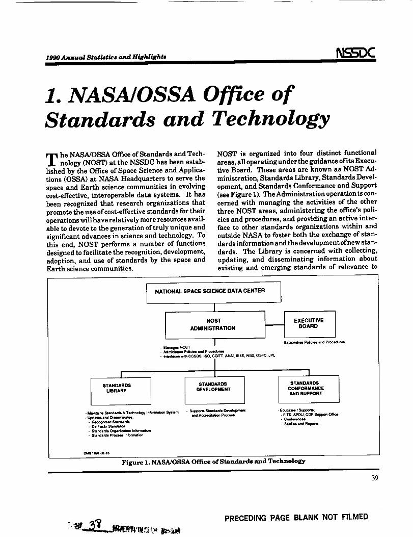
NOST is organized intofour distinctfunctional
areas,alloperatingunder theguidance ofitsExecu-tiveBoard. These areas are known as NOST Ad-
ministration,Standards Library,Standards Devel-
opment, and Standards Conformance and Support
(seeFigure1).The Administrationoperationiscon-
cerned with managing the activitiesofthe other
threeNOST areas,administeringthe office'spoli-
ciesand procedures,and providingan activeinter-
faceto other standards organizationswithin and
outsideNASA tofosterboth the exchange ofstan-
dardsinformationand thedevelopmentofnew stan-
dards. The Libraryisconcerned with collecting,
updating, and disseminating information about
existingand emerging standards of relevanceto
I
STANDARDS
LIBRARY
NATIONAL SPACE SCIENCE DATA CENTER
NOSTADMINISTRATION
I- Manmg_ NOST- Admirl,'-m P_o_ and Procedum_- Inl_rfacel with CCSDS, tSO, CCITT, ANSI, IEEE, NBS, GSFC, JPL
ISTANDARDS
DEVELOPMENT
EXECUTIVE
BOARD
- Estab_ PoliacHIand Pn0cedurm
ISTANDARDS
CONFORMANCE
AND SUPPORT
- I_ie'-rm Su, nd*_s & Technolow Infommion Sysmm- Llpdetl_ and Di_minat_.:
. Recognized Standa_lm- De Facto Standardn- Standards Orglnizalion Iftlormatio_- Standards P_ Information
. Supporm StamdardeDm_ek_n_ntAccmdi/s_on
. Educa'lN / $uppo_:- Fff$, $FDU, GDF $upp,_ O'_k_. Conlenm¢_- $lu&m and FI_,_
OM8 t 9e1-03-15
Figure 1. NASA/OSSA Office of Standards and Technology
39
PRECEDING PAGE BLANK NOT FILMED
1##oA_mm_l 8tati,tb_,and HiEldi_ht,
NASA and NASA-related data systems. Informa-
tionon recognizedstandards(i.e.,standardsdocu-
mented byrecognizedstandardsorganizationssuch
astheInternationalStandardsOrganization[ISO],
American NationalStandardsInstitute[ANSI],and
ConsultativeCommittee forSpace Data Systems
[CCSDS]), and de factostandards (i.e.,specifica-
tions/systemsin wide and stableuse)are the pri-
mary categoriesmaintained in the Library,with
eachbrokenintoa number ofsubcategoriestofacili-
tatesearchingand understanding.Other categoriesincludeinformationon the variousstandards or-
ganizationsand on the standardscreationprocess.Some standardsspecificationsare availableon re-
quest,whileothersmust be obtainedfrom commer-
cialorganizations.Requestsforstandardsinforma-
tionmay be satisfied through the Standards andTechnology Information System (STIS)--an easilyused NOST on-line data base and software systemfor accessinginformation on standards and technol-ogy--electronic mail to the NSSDC account knownas NCF::NOST or [email protected], or bymail request to the NSSDC. The overall Libraryoperation, including STIS, provides an educationalservice to the space and Earth science community.
The StandardsDevelopment operationisconcerned
with the establishment,maintenance, and use of
policies and procedures for the development of newstandards, and the adoption ofexisting standards asNOST standards. These policies and procedurescover the establishment of technical panels to de-
velop standards, the review processes through whichdraft standards must pass, and the logistical sup-port available from NOST. The overall StandardsDevelopment operation provides a mechanism forthe development and accreditation of standards bythe space and Earth science communities.
The StandardsConformance and Supportoperation
isconcernedwithsupportforexistingand emerging
standards. This support ranges from providing
informationtopotentialusers on experiencewith
commercial standardstoafullsupportofficeforthe
use ofa particularstandard.Where a commercial
vendorisnotavailabletosupportaparticularstan-
dard,testingand validationofan implementationof
thestandardmay beprovidedby thisoperation.The
actualoperationsatany one timewilldepend on the
needs ofthe community and the availabilityofre-sources.The overallStandards Conformance and
Supportoperationprovidesa broad range ofeduca-tionaland supportiveservicesto the space andEarth sciencecommunities.
40
1990 Annual Statiatics and Highlighte
2. The Standards and
Technology InformationSystem (STIS)
sing standards is an effective and efficientmethod for controlling time and dollar costs
incurred while performing many functions. Datasystems developed using standards are often less ex-pensive to develop and maintain. They are easier tounderstand and more adaptable to changing re-quirements. The use of widely acknowledged stan-dards results in users' not being dependent on asingle vendor and allows users to produce their datasystems with less risk. Often the use of standards ismandated by higher authorities or required by con-tractual agreements.
The Standards and Technology Information System(STIS) is a centralized electronic library that letsusers know about available standards. The STIS is
supported by the NASA/OSSA Office of Standards
and Technology (NOST) and is a tool to help NOSTaccomplish its mission to facilitate the recognition,development, adoption, and use of standards by thespace and Earth science communities. Besides theinformation on the actual standards and related
documents, this library also contains information
about emerging technologies where standards maynot yet have been developed. This referenced mate-rial may have originated from a variety of sourcessuch as books, technical or popular press articles,
government or industry reports, and reports createdby the NOST staffor NOST adjunct members. NOSTencourages individuals within the community whohave an interest in a particular standard or new
technology area to register as NOST adjunct mem-bers. By doing so they agree to provide reports asnew information comes to them for incorporationinto the STIS under their authorship.
The information displayed for these documents
includes standards identifiers (e.g., ISO 9660), title,source, publication and copyright data, the names ofany identified authors or editors, and the organiza-tion responsible for the document. The staff alsoclassifies the documents with topic and content
codes, assigns a number ofkeywords to aid the userin searching for the documents and often preparesan abstract or comments on the document. If copy-right provisions can be accommodated, the full textof many of the shorter documents is provided. Fu-ture implementations of the STIS are planned toinclude the display of information needed to ordercopies of documents directly from the source. At alltimes NOST may be contacted for ordering informa-tion.
The STIS also contains information on the policiesand procedures of NOST. This provides the userwith on-line information regarding NOST functionsand services.
The STIS is also able to display information on anumber of organizations active in the standardsdevelopment field, including information on the areasin which these organizations are working. Contactpoints within those organizations are provided forusers who need further information.
All the information in the STIS is presented througha series of user friendly menus. Most users find theycan use the system without any help or training.Comments and requests to NOST/STIS may be di-
rectly entered by users at virtually any point.
The STIS may beaccessedthrough theNSSDC On-
LineData and InformationServices(NODIS), whichisdescribedelsewhereinthisdocument.
41

NSSDC PUBLICATIONS LIST
FOR 1990
PRECEDING PAGE BLANK NOT FILMED

1990 Annual Statistics and Highlights
NSSDC CATALOGS
Adelman et al., A Catalog of Stellar Spectophotometry, NSSDC/WDC-A-R&S 90-03, 1990.
A GK3R Catalog, Documentation for the Machine-Readable Version, NSSDC/WDC-A-R&S 90-16, 1990.
Argue et al., A Catalog of Selected Compact Radio Sources, NSSDC/WDC-A-R&S 90-25, 1990.
Arnaud, G. Cameron, An Altas of Stellar Spectra Between 2.00 and 2.45 Micrometers, NSSDC/WDC-A-R&S90-02, 1990.
Catalog of Gamma Ray Observations, NSSDC/WDC-A-R&S 90-20, 1990.
Fairfield, D. H. and T. E. Cayton, 1983 Tail-Era Data Series, Vol. 3, Geosynchronous Particle Measurements,NSSDC/WDC-A-R&S 90-13, 1990.
Fairfield, D. H., and C. T. Russell, PROMIS Series, Vol. 8-Midlatitude Ground Magnetograms, NSSDC/
WDC-A-R&S 90-10, 1990.
Fairfield, D. H., and J. L. Phillips, I983 Tail-Era Data Series, Vol. 1, ISEE 3 Plasma, NSSDC/WDC-A-R&S
90-11, 1990.
Fairfield, D. H., and J. L. Phillips, 1983 Tail-Era Data Series Vol. 2, ISEE 3 Magnetic Field, NSSDC/WDC-A-R&S 90-12, 1990.
Fricke et al., Fifth Fundamental Catalogue (FKS) Part I, NSSDC/WDC-A-R&S 90-01, 1990.
Horowitz, R., and J. H. King, NSSDC Data Listing, NSSDC/WDC-A-R&S 90-06, 1990.
Jupiter-Voyager Reference Star Catalogue-1987, NSSDC/WDC-A-R&S 90-04, 1990.
Saturn-Voyager Reference Star Catalogue-1979, NSSDC/WDC-A-R&S 90-05, 1990.
The HEA O A-1 X-Ray Catalog, Documentation for the Machine-Readable Version, NSSDC/WDC-A-R&S 90-
18, 1990.
The Northern International Reference Stars Catalog, Documentation for the Machine-Readable Version,
NSSDC/WDC-A-R&S 90-17, 1990.
U.S. Naval Observatory Zodiacal Zone Catalog, NSSDC/WDC-A-R&S 90-15, 1990.
Warren, W., Search for Ultraviolet Excess Objects, NSSDC/WDC-A-R&S 90-26, 1990.
NEWSLETrERS/ARTICI_S
Crustal Dynamics Data Information System Bulletin, Carey E. Noll, 5 issues:Vol. 5, No. 3, February 1990.
45
PRECEDING PAGE BLANK NOT FILMED
N__= 1990 Annual Statietics and Highlights
Vol. 5, No. 4, April 1990.
Vol. 5, No. 5, August 1990.Vol. 6, No. 1, October 1990.Vol. 6, No. 2, December 1990.
NSSDCNews, Published Quarterly by NSSDC, 4 issues:
Vol. 6, No. 1, Spring 1990.Vol. 6, No. 2, Summer 1990.Vol. 6, No. 3, Fall 1990.Vol. 6, No. 4, Winter 1990.
Pendergrass, V., J. L. Green, and W. Ames, "Goddard to Implement Massive Data Storage and DeliverySystem," Informations Systems Office Newsletter, Issue 19, p. 10, February 1990.
ROSATNewsletter, U.S. ROSAT Science Data Center (USRSDC), January 1990.
SPACEWARNBULLETIN, IUWDS World Warning Agency for Satellites, World Data Center A for Rocketsand Satellites, 12 issues:
SPX/423, January 1990.SPX/424SPX/425SPX/426SPX/427SPX/428SPX/429SPX/430SPX/431SPX/432SPX/433SPX/434
February 1990.March 1990.
April 1990.May 1990.June 1990.
July 1990.August 1990.September 1990.October 1990.November 1990.December 1990.
Zwickl, R. D., V. L. Thomas, andJ. L. Green, "Two NetworkingUsers Groups Merge," Informations SystemsOffice Newsletter, Issue 19, p. 28, February 1990.
NSSDC REFERENCES/GUIDES
A Guide to the National Space Science Data Center, NSSDC/WDC-A-R&S 90-07, June 1990.
Accessing SPAN from Non-SPAN NOdes, NSSDC/WDC-A-R&S 90-14, 1990.
Bilitza, D., International Reference Ionosphere 1990, NSSDC/WDC-A-R&S 90-22, 1990.
Bilitza, D., Solar-Terrestrial Models and Application Software, NSSDC/WDC-A-R&S 90-19, 1990.
Chang, A. T. C., J. L. Foster, D. K. Hall, H. W. Powell, and Y. L. Chien, Nimbus 7 SMMR Derived GlobalSnow Cover and Snow Depth Data Set, A Data Set Documentation, Product Description, and User's Guide
46
1990 Anmucd Statistics and Highlights
for Nimbus 7 SMMR Derived Global Snow Cover and Snow Depth Data Set, PLDS User Publication, April1990.
Choudhury, B. J., and B. W. Meeson, Data Set Documentation, Product Description, and User's Guide forthe Nimbus 7 SMMR Polarization Differences Vegetation Index, PLDS User Publication, August 1990.
Davis, C., Software for Optical Archive and Retrieval (SOAR) User's Guide, Version 4.1, NSSDC/WDC-A-
R&S 90-24, 1990.
Directory Interchange Format Manual, Version 3.0, NSSDC/WDC-A-R&S 90-27, 1990.
Gaffey, J., H. If, Hills, and R. McGuire, Handbook of Solar-Terrestrial Data Systems, NSSDC/WDC-A-R&S
90-23, 1990.
Klenk, I_ F., J. L. Green and L. A. Treinish, A Cost Model for NASA Data Archiving, Version 2.0, NSSDC/WDC-A-R&S 90-08, 1990.
Mason, S., R. D. Tencati, D. M. Stern, I_ D. Capps, G. Dorman, and D. J. Peters, SPAN Cookbook--A PracticalGuide to Accessing SPAN, NSSDC/WDC-A-R&S 90-21, 1990.
Meeson, B. W., A Guide to NASA's Pilot Land Data System, November 1990.
Meeson, B. W., E. Paylor, and R. Dorsey, Requirements & Guidelines for PLDS Nodes, Working Draft,
Revision 1.6, June 1990.
Meeson, B. W., The Pilot Land Data System GenSQL Installation Guide, Draft 0.2, June 1990.
Meeson, B. W., The PLDS GenSQL User's Guide, May 1990.
Noll, C., ed., Crustal Dynamics Mailing and Networking Directory, Crustal Dynamics Project, June 1990.
Olsen, L. M., and F. Corprew, Revised Standard Data Format Document for FIRE, November 1990.
Olsen, L. M., Data Set Availability Through NASA's Climate Data System, October 1990.
COMPUTER SCIENCE AND PHYSICAL SCIENCE TECHNICAL ARTICLES
Allen, J. H., R. Conkright, D. Bilitza, A. Y. Feldstein, and D. Willis, "N(h) Profile Data at World Data Centers,"
Advances in Space Research, Vol. 10, No. 8, p. 119, 1990.
Batchelor,D. A.,"ObservationalClues to the Energy Release Processin ImpulsiveSolar Bursts,"The
AstrophysicalJournal Supplement Series,Vol.73,pp. 131-135,June 1990.
Bell, E. V., II, I_ E. Reinhard, H. H. Lanning, and D. K. Taylor, "The Efficiency of Scheduling Observationson the Hubble Space Telescope During Early Operations," Bulletin of the American Astronomical Society,
Vol. 22, No. 4, p. 1280, 1990.
47
1990 Annual Statistics and HijhliEhtB
Bilitza, D., "Empirical Modeling of Ion Composition in the Middle and Topside Ionosphere," Advances inSpace Research, Vol. 10, No. 11, p. 7, 1990.
Bilitza,D.,"ProgressReporton IRI Status,"Advances inSpace Research,Vol.10,No. 11,p.3.
Bilitza, D., and I_ Rawer, "New Options for the IRI Electron Density in the Middle Ionosphere," Advancesin Space Research, Vol. 10, No. 11, p. 7, 1990.
Bilitza, D., and W. R. Hoegy, "Solar Activity Variation of Ionospheric Plasma Temperatures," Advances inSpace Research, Vol. 10, No. 8, p. 5, 1990.
Campbell, W. J., and R. F. Cromp, "Evolution of an Intelligent Information Fusion System," Photogrammet-tic Engineering and Remote Sensing, Vol. 56, No. 6, 1990.
Cane, H. V., R. E. McGuire, and T. T. Von Rosonvinge, "Energetic Particle Observations at the Helios-1Spacecraft of Shocks Associated with Coronal Mass Ejections," Journal of Geophysical Research, Vol. 95,pp. 65-75, 1990.
Devicheva,E.A_,etal.,"SpectrometerAboard theEarth SatelliteCosmos-1870 forRecordingGamma-Rays
from Supernova SN 1987A,"trans.D. A. Batchelor,Cosmic Research,Vol.27,No. 5,pp.681-683,1990.
Gaffey, J. D., Jr., _The Distribution of Continuously Created Newborn and Pickup Cometary Ions," Physicsof Space Plasmas, Vol. 9, pp. 245-257, 1990.
Gail,W. B.,U. S. Inan, R. ,_ Helliwell,D. L. Carpenter,S. Krishnaswamy, T. J.Rosenberg, and L.J.
Lanzerotti,"CharacteristicsofWave-ParticleInteractionsDuring Sudden Commencements, 1,Ground-
Based Observations,"Journal ofGeophysicalResearch,Vol.95,No. Al,pp. 119-137,1990.
Green, J. L., "The New Space and Earth Science Information System at NASA's Archive," GovernmentInformation Quarterly, Vol. 7, No. 2, pp. 149-156, 1990.
Kainer,S.,D. Krauss-Varban,J.D. Gaffey,Jr.,and J.L.Burch,"StimulatedEmission ofAKR inRegions
ofaWeakly Unstable ElectronVelocityDistribution,"JournalofGeophysicalResearch,pp.12141-12148,1990.
La. Dous C., "A Catalogue of Low-Resolution IUE Spectra of Dwarf Novae and Nova-Like Stars," SpaceScience Reviews, Vol. 52, pp. 203-706, 1990.
La.Dous C.,F.Geyer,H. Ruder,and J.A. Mattei,"GettingBoundary ConditionsforDwarfNova OutburstModels from AAVSO Observations,"JournaIAAVSO, Vol.18,No. 2,p.102,1990.
Mead, J. M., and Warren, W. H.,Jr.,"The OrganizationofDatabases in Astronomy, EspeciallySpace
Astronomy,"Scientifwand TechnicalData ina New Era,ed.P.S.Glaeser,pp.228-231,1990.
Peredo,M., and J.A. Tataronis,"MultidimensionalCoronal Loop EquilibriawithPlasma Flow,Magnetic
Curvature,and SolarGravity,"BulletinoftheAmerican PhysicalSociety,Vol.35,p.2097, 1990.
48
1990 Anmm=l Stati_tbvs and Highlights
Peredo, M., and J. A. Tataronis, "Three-Dimensional Coronal Loop Equilibria with Plasma Flow, MagneticCurvature and Solar Gravity," Trans., American Geophysical Union, Vol. 71, p. 1517, 1990.
Rawer, K., and D. Bilitza, "International Reference Ionosphere-Plasma Densities: Status 1988,'Advancesin Space Research, Vol. 10, No. 8, p. 5, 1990.
Reelof, L. H., and W. J. Campbell, *Using Expert Systems to Implement a Semantic Data Model of a LargeMass Store System," Telematics and Informatics, Vol. 7, Nos. 3/4, pp. 361-377, 1990.
Rogers, D. P., and L. M. Olsen, "The Diurnal Variability of Marine Stratocumulus Clouds," reprinted fromthe Preprint Volume of the 1990 Conference on Cloud Physics, pp. J51,J56, 1990.
Sanderson, T. M. Albrecht, I( Blank, B. Brett, A. Ciario, J. L. Green, H. K. Hills, P. M. T. Hughes, T. Kamei,A. Kiplinger, R. E. McGuire, J. H. Waite, Jr., and G. Wallum, _vVorld-Wide Interactive Access to ScientificDatabases Via Satellite and Terrestrial Data Network," ESA Bulletin, No. 61, p. 63, February 1990.
Short, N., Jr., and L. Shastri, _rhe Application of Connectionism to Query Planning/Scheduling inIntelligent User Interfaces," Telematics and Informatics, Vol. 7, Nos. 3/4, pp. 209-220, 1990.
Taylor, D. K., H. H. Lanning, I_ E. Reinhard, and E. V. Bell, II, "The Scheduling of Science Activities for theHubble Space Telescope," Bulletin of the American Astronomical Society, Vol. 22, No. 4, p. 1280, 1990.
Warren, W. H., Jr., "Star Catalogs and Surveys," Reference Encyclopedia ofAstronomy andAstrophysics, ed.S. P. Maran, in press, 1990.
PROCEEDINGS
Beier,J.,and J. R. Thieman, "The Global Change Master Directoryand Catalog Interoperability,"
ProceedingsoftheMarine TechnologySymposium, 1990.
Campbell,W. J.,R.F.Cromp, S.E.Hill,C.Goettsche,and E.Dorfman, "IntelligentInformationFusionfor
SpatialData Management," Proceedingsof the Fourth InternationalSymposium on Spatial Data
Handling, Vol.2,1990.
Cromp, R. F., "Knowledge Acquisition Techniques for Spatial Reasoning About Satellite Imagery," Proceed-ings of the Fourth International Symposium on Spatial Data Handling, Vol. 2, pp. 742-751, 1990.
Donohue, D. J., K. J. Harker, and P. M. Banks, "Current Distribution Generated by Conducting BodiesMoving Through a Magnetoplasma," Proceedings of the Third International AIAA /NASA / ASI / ESAConference on Tethers in Space, pp. 50-57, 1990.
Fekete, G., "Rendering and Managing Spherical Data with Sphere Quadtrees," Proceedings Visualization'90, pp. 176-186, 1990.
Fekete,G.,and L.Treinish,"Sphere Quadtrees:A New Data Structureto Support the Visualizationof
Spherically Distributed Data," Proceedings of the SPIE International Society for Optical Engineering,Extracting Meaning from Complex Data: Processing, Display, Interaction, Vol. 1259, pp. 242-253, 1990.
49
1990 Annual 8tatietics and HiEhiiEhte
Green, J. L., _Communications Among Data and Science Centers," Proceedings of the Workshop onGeophysical Informatics, pp. 155-162, 1990.
Green, J. L., _SSDC Applications for Computer Networking," Proceedings of the Workshop on GeophysicalInformatics, pp. 168-175, 1990.
Green, J. L., "NSSDC Data Holdings: Scope, Complexity, and Future Requirements," Proceedings of theWorkshop on Geophysical Informatics, pp. 205-215, 1990.
Green, J. L., _The NSSDC Information Systems, Status, and Plans," Proceedings of the Workshop onGeophysic_ Informatics, pp. 24-32, 1990.
Green, J. L., K. F. Klenk, and L. Treinish, "A Comprehensive Cost Model for NASA Data Archiving,"Proceedings on Space-90"s: Countdown to the 21st Century, 1990.
Jacobs, B. E., "Distributed Access View Integrated Database (DAVID) System," Proceedings of Technology2000, 1990.
King, J. H., "Data Exchange Between WDC-A-R&S and WDC-B2-STP," Proceedings of the Workshop onGeophysical Informatics, pp. 281-284, 1990.
La. Dous C., "A Statistical Analysis of IUE Spectra of Dwarf Novae and Nova-Like Stars," Proceedings ofEvolution in Astrophysics, IUE Astronomy in the Era of New Space Missions, ESA SP-310, p. 415, 1990.
McDonald, F. B., N. Lal, A, Lukasiak, R. E. McGuire, and T. T. Von Rosenvinge, _Observations in the OuterHeliosphere of the Cosmic Ray Receivery Phase of Cycle 21," Proceedings of the Twenty-First InternationalCosmic Ray Conference, Vol. 6, p. 132, 1990.
McDonald, F.B.,N. Lal,A. Lukasiak,R.E. McGuire, and T.T.Von Rosenvinge,_The Modulation Process:
Comparison ofSuccessiveSolarMinimum Cosmic Ray Observations,"Proceedingsofthe Twenty-First
InternationalCosmic Ray Conference,Vol.6,pp.144,1990.
Olsen, L. M., ed., Proceedings of the First NASA Climate Data Workshop, NSSDC/WDC-A-R&S 90-09,1990.
Roelofs,L.H.,and W. J.Campbell,"ApplyingSemantic Data Modeling Techniques toLarge Mass Storage
System Designs,"Proceedingsofthe Tenth IEEE Symposium on Mass StorageSystems,pp.65-76,1990.
Thieman, J. R. _Master Data Directories and Catalog Interoperability," Proceedings of the AIAA/NASASecond International Symposium on Space Information Systems, 1990.
50
NSSDC ACRONYMS ANDABBREVIATIONS LIST

1990 Annual Statistics and HiEhlight#
ADCADSAGUAEMAIAAANSIARCARPAnet
BITnetBMFT
CCRS
CCSDS
CCRS
CDAW
CDDIS
CDF
CDP
CD_ROM
CDS
CEOS_PIDCFA
CFC
CI
CIRA
COADSCODD
COSPAR
CRRES
CRUSO
CTIO
CZCS
DAB
DADS
DADS
DAN
DAVID
DBMS
DEC
DECnet
DIF
DLR
DSUWG
AstronomicalData Center
AstrophysicsData System
American GeophysicalUnion
Atmospheric ExplorerMissionAmerican InstituteforAeronauticsand Astronautics
American NationalStandardsInstitute
Ames Research Center (NASA)
Advanced Research ProjectsAgency Network
Because It's Time (or There) NetworkBundes Ministerium Forschung und Technologie
Canadian Centre for Remote SensingConsultative Committee for Space Data SystemsCanadian Centre for Remote Sensing
Coordinated Data Analysis WorkshopCrustal Dynamics Data Information SystemCommon Data Format
Crustal Dynamics ProjectCompact Disc-Read Only MemoryCentre de Donnees de StrasbourgCommittee on Earth Observations Satellites Prototype International Directory
Harvard Smithsenian Center for AstrophysicsChlorofluorocarbons
Catalog InteroperabilityCOSPAR International Reference Atmosphere
Comprehensive Ocean Atmosphere Data SetCentral On-Line Data DirectoryCommittee on Space ResearchCombined Release and Radiation Effects Satellite (joint NASA/USAF mission)
Coordinated Request and User Support OfficeCerro Tololo Inter-American ObservatoryCoastal Zone Color Scanner
Data Announcement Bulletin
Data Archive and Distribution SystemDocument Availability and Distribution ServicesData Analysis Network (Canada)Distributed Access View Integrated DatabaseData Base Management SystemDigital Equipment CorporationDEC Networking Products (generic family name)
Directory Interchange FormatDeutsches Forschungs Anstaltfuer Luft und Raumfahrt
Data Systems Users Working Group
53
_ _/a_'.t!_!_Tf_11_l_lll _ PRECEDING PAGE BLANK NOT FILMED
N__. 1990 Annual Statistics and Highlights
ECMWFEDCE-HEPnetELSETEOSEOSDISERBERBEERBFERBSEROSESAESDDESOESOCE-SPANEUROHEPnetEUVEXOSAT
European CenterforMidrange Weather ForecastingEOS Data Center
European High Energy PhysicsNetworkElement Set
Earth ObservingSystem
EOS ProjectData and InformationSystem
Nimbus 7Earth RadiationBudget Instrument
Nimbus 7 Earth RadiationBudget Satellite
Earth ResourcesBrowse FacilityNimbus 7 Earth RadiationBudget Satellite
Earth ResourcesObservationSystem
European Space Agency
USGS Earth ScienceData Directory
European Southern Observatory
European Space OperationsCentre
SPAN inEurope
European High Energy PhysicsNetworkExtreme Ultraviolet
European X-Ray ObservationSatellite(ESA)
FBIS
FGGEFIFE
FIRE
FNOC
FRG
FTP
ForeignBroadcastInformationServiceFirstGARP GlobalExperiment
FirstISLSCP FieldExperiment
FirstISCCP RegionalExperiment
U.S.Navy'sFirstNumerical Oceanography Center
FederalRepublicofGermanyANONYMOUS FileTransferProtocol
GCMD
GGSGISGOES
GPSGSFC
HEPnet
HRI
GlobalChange Master Directory
GlobalGeospace Science
GeographicInformationSystemGeostationaryOperationalEnvironmental Satellite(NASA-NOAA)
GlobalPositioningSystem
Goddard Space FlightCenter (NASA)
High Energy PhysicsNetwork (alsoknown as PHYSnet)
High ResolutionInterferometer
IACG
IAGA
ICE
ICSU
IDL
IDM
IGRF
IIFS
Inter-AgencyConsultativeGroupInternationalAssociationofGeomagnetism and Aeronomy
InternationalCometary Explorer
InternationalCouncilofScientificUnions
InteractiveData Language
IntelligentData ManagementInternationalGeomagnetic ReferenceField
IntelligentInformationFusionSystem
54
1990 Annual Statistics and HighlightsI
IMP
IMS
IRAP
IRAS
IRI
ISCCP
ISLSCP
ISO
ISO
ISTP
IUE
IUESIPS
IUI
IUWDS
JIMS
JPL
JSC
KSC
LAS
LAS
LAS4
LLR
MagsatMD
MIDAS
MIPS
MIT
MPE
MPP
MSFC
MSIS
NACS
NASA
NCDS
NCF
NCS
NDADS
NESDD
NGS
NIC
NLQP
InterplanetaryMonitoringPlatform
InternationalMagnetospheric Study;Ion Mass Spectrometer
ISLSCP RetrospectiveAnalysisProjectInfraredAstronomicalSatellite(TheNetherlands-NASA-U.K.)
InternationalReferenceIonosphere
InternationalSatelliteCloud ClimatologyProject
International Satellite Land Surface Climatology ProgramInformation Systems Office
International Standards OrganizationInternational Solar-Terrestrial PhysicsInternationalUltravioletExplorer(satellite,NASA-U.I_-ESA)
IUE SpectralImage ProcessingSystem
IntelligentUser InterfaceInternationalURSIGRAM and World Days Service
CYGNE'ffs Jukebox InterfaceManagement System
JetPropulsionLaboratory(NASA)
Johnson Space Center(NASA)
Kennedy Space Center(NASA)
Land AnalysisSoftware
Land AnalysisSystemLevelofArchiveServices4
Lunar Laser Ranging
Magnetic FieldSatellite
Master DirectoryNASA
Munich Image Data AnalysisSystem
Mission and InformationPlanning System
Massachusetts InstituteofTechnology
Max Planck Institute(FederalRepublicofGermany)
MassivelyParallelProcessor
Marshall Space FlightCenter (NASA)Mass SpectrometerIncoherentScatter(atmospheremodel)
Network AssistedCoordinatedScience
NationalAeronauticsand Space Administration
NASA's Climate Data System (formerlyPCDS)
NSSDC Computer Facility
Network Computing System
NSSDC Data Archiveand DistributionSystem
NOAA Earth System Data Directory
NSSDC GraphicsSystemNetwork InformationCenter
Natural Language Query Processor
55
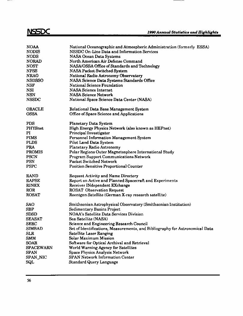
1990 Annual Statistics and Highlights
NOAA
NODIS
NODS
NORAD
NOST
NPSS
NRAO
NSDSSO
NSF
NSI
NSN
NSSDC
ORACLE
OSSA
PDS
PHYSnet
PI
PIMS
PLDS
PRAPROMIS
PSCN
PSN
PSPC
RAND
RAPSE
RINEX
ROR
ROSAT
SAO
SBP
SDSD
SEASAT
SERC
SIMBAD
SLR
SMMSOAR
SPACEWARN
SPAN
SPAN_NIC
SQL
NationalOceanographic and AtmosphericAdministration(formerlyESSA)NSSDC On-Line Data and InformationServices
NASA Ocean Data SystemsNorth American Air Defense Command
NASA/OSSA OfficeofStandards and TechnologyNASA PacketSwitched System
NationalRadio Astronomy Observatory
NASA ScienceData Systems Standards OfficeNationalScienceFoundation
NASA ScienceInternet
NASA ScienceNetwork
NationalSpace ScienceData Center(NASA)
RelationalData Base Management System
OfficeofSpace Scienceand Applications
PlanetaryData System
High Energy PhysicsNetwork (alsoknown as HEPnet)
PrincipalInvestigator
PersonnelInformationManagement System
PilotLand Data System
PlanetaryRadio Astronomy
PolarRegionsOuter Magnetosphere InternationalStudy
Program Support Communications NetworkPacketSwitched Network
PositionSensitiveProportionalCounter
Request Activityand Name Directory
Reporton Activeand Planned Spacecraftand Experiments
ReceiverINdependent EXchange
ROSAT ObservationRequest
Roentgen Satellite(German X-rayresearchsatellite)
SmithsonianAstrophysicalObservatory(SmithsonianInstitution)
SedimentaryBasinsProjectNOAA's SatelliteData ServicesDivision
Sea Satellite(NASA)
Scienceand EngineeringResearch Council
Set ofIdentifications,Measurements, and BibliographyforAstronomicalData
SatelliteLaser RangingSolarMaximum Mission
SoftwareforOpticalArchivaland Retrieval
World Warning Agency forSatellites
Space PhysicsAnalysisNetworkSPAN Network InformationCenter
Standard Query Language
56
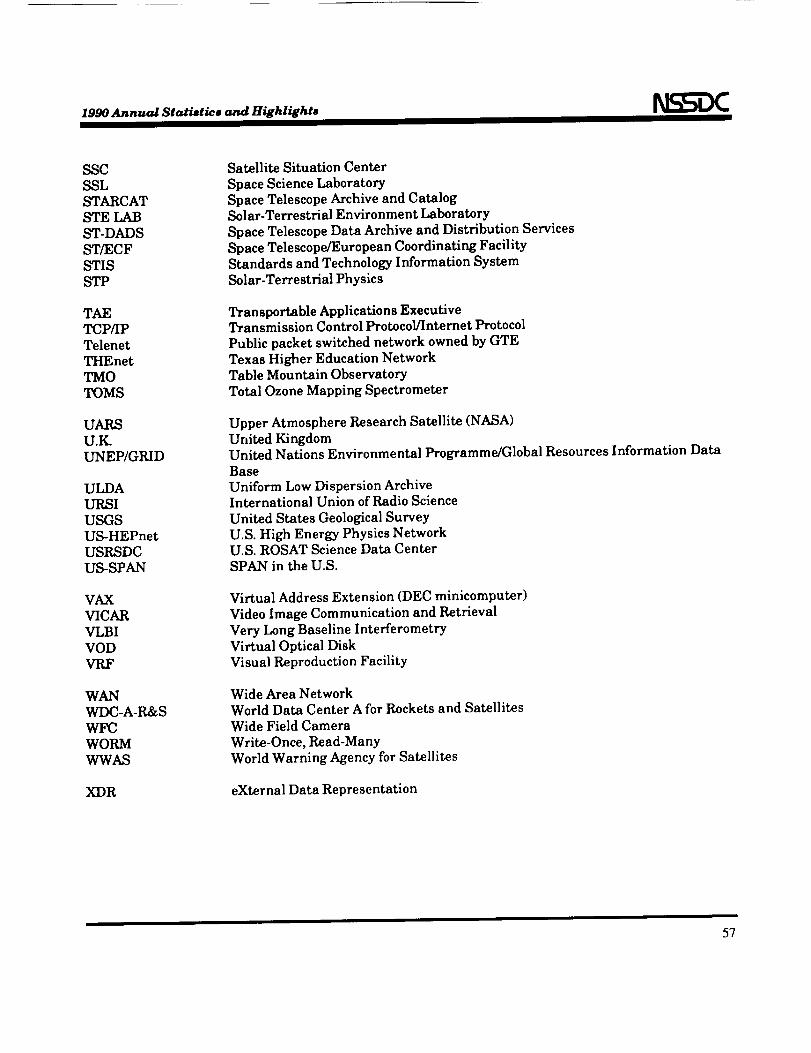
1990 Annual Statistics and Highlightm
SSC
SSL
STARCAT
STE LAB
ST-DADS
ST/ECF
STIS
STP
TAE
TCP/IP
Telenet
THEnet
TMO
TOMS
UARS
U.IL
UNEP/GRID
ULDA
URSI
USGS
US-HEPnet
USRSDC
US-SPAN
VAX
VICAR
VLBI
VOD
VRF
WAN
WDC-A-R&S
WFC
WORM
WWAS
XDR
SatelliteSituation Center
Space Science Laboratory
Space Telescope Archive and Catalog
Solar-TerrestrialEnvironment Laboratory
Space Telescope Data Archive and Distribution Services
Space Telescope/European Coordinating Facility
Standards and Technology Information System
Solar-TerrestrialPhysics
Transportable Applications ExecutiveTransmission Control Protocol/Internet Protocol
Public packet switched network owned by GTE
Texas Higher Education Network
Table Mountain Observatory
Total Ozone Mapping Spectrometer
Upper Atmosphere Research Satellite(NASA)
United Kingdom
United Nations Environmental Programme/Global Resources Information Data
Base
Uniform Low Dispersion Archive
International Union ofRadio Science
United States Geological Survey
U.S. High Energy Physics NetworkU.S. ROSAT Science Data Center
SPAN in the U.S.
Virtual Address Extension (DEC minicomputer)
Video Image Communication and Retrieval
Very Long Baseline Interferometry
Virtual Optical Disk
Visual Reproduction Facility
Wide Area Network
World Data Center A for Rockets and Satellites
Wide Field Camera
Write-Once, Read-Many
World Warning Agency for Satellites
eXternal Data Representation
57