1992 lisle_golconda goldfield
TRANSCRIPT

~
,G5610_ 189_1:8 TASMANIA-ANISLANDOFPOlENfIAL
Geology and geophysics of the Lisle -Golconda goldfield, northeast Tasmania
MJ.ROACH Centre for Ore Deposits and Erploration Studies, University of Tasmania
ABSTRACI'
The Lisle-Golconda goltifield contains a number of different styles of gold mineralislUion. The majority of gold production came from alluvial workings in the Lisle valley. No obvious hard rock source for this alluvial gold has been found.
Studies of gold-grain morphology and internal structure support the contention thai much of the gold at Lisle is of secondary origin. Gold appears 10 have been precipitated within the unconsolidated sedilnents from groundwater containing low concentrations of gold by the action of humic compounds and biological agents.
Many of the gold occurrences within the goldfield are closely spatially associated with cupolas of granodiorite. Regional geophysical data has been used to attempt to cOns/rain the subsurface distribution of granitic rocks within the study area.
GEOLOGY
The Lisle-Golconda goldfield is situated approximately 30 km northeast of LaunceslOn in northeastern Tasmania (fig. 1). The goldfield was tile site of considerable mining activity in the latter baJf of tile 19t1l century, and contains a variety of different styles of gold mineralisation. A nwnber of historical gold mining areas occur witbin tile boundaries of tile region here referred to as tile Lisle-Golconda goldfield. These include tile Lisle, Cradle Creek, Lone Star, Golconda, Panama, Denison and Lebrina goldfields. Detailed descriptions of each of tIlese fields are provided by Thoreau (1882), Twelvelrees (1909) and Reid (1926). The geology of tile region is shown in Figure 2.
The study area lies 10 tile west of tile bulk of the Devonian Scottsdale Batbolitll which intruded tile Mathinna Beds, a thick, poorly-documented succession of regionally metamorphosed turbiditic sediments of presumed Siluro-Devoniau age. The Matbinna Beds crop out over much of the study area, where they consist of steeply-dipping, NW-trending beds of quartzite witll minor fmer-grained interbeds. The IOpography in tile northern portion of the region is subdued, and outaop is poor or obscured by widespread Tertiary sediments and Quaternary alluvium. To the soutll, tile land surface rises abruptly towards a deeply-dissected plateau approximately 600 m above sea level. In the far soutllwest of tile area tile Jurassic dolerite<apped peak of Mount Arthur rises above the plateau 10 a height of over 11 00 metres. Tertiary basalt flows are present, both on tile plateau and at a nwnber of isolated locations at lower levels 10 tile north.
Many of the known sites of gold mineralisation show a close spatial association with small cupolas of granodiorite which have inlruded the Mathinna Beds up 10 10 km west of tile main boundary of tile ScottsdaIe Batholitll. The granodiorite is highly weatllered at the surface, and its outaop is often obscured by surficial sediments. Granodiorite was exposed by mining activities in the Lisle, Golconda, Panama and
Lone Star goldfields. The outcropping areas of granodiorite are interpreted to be the apical regions of a larger subsurface body, tile extent of which is roughly delineated by tile extent of tile mapped area of homfelsed sediments.
A particularly prominent feature of tile intrusions is their surface expression. Marked topographic depressions occur in all areas where the granodiorite is exposed. The strongly-bomfelsed sediments witbin tile contact aureole of the inlrusion are resislant to both chemical and mechanical weathering, while the granodiorite appears to be particularly susceptible to chemical breakdown, and is consequently eroded. The largest of these features is associated with the inlruSion at Lisle (fig. 3). Here the resullant crater-like feature bas dimensions of approximately 4 x 5 km and a deptll of up to 350 metres. '{he slopes on the flanks of tile depression are steep, and considerable thicknesses of talus have been shed from the enclosing ridges into the basin, tile floor of which is flat or gently undulating. The single hydrological outlet from tile Lisle valley is to the north through a narrow, deeply incised gully. The smaller inlrusions, such as at Panama or Golconda, display the same basic form as tile inlruSion at Lisle (fig. 3).
MINERAUSATION
The Lisie-Golconda goldfield is unusual for mining districts in northeast Tasmania in tbat in excess of95% ofall the gold recovered was won from alluvial workings. The vast majority of this production came from the Lisle goldfield, which bas produced an estimated 250,000 ounces of gold. Despite tile high alluvial production no obvious source of the alluvial gold was found.
Gold was first discovered atLisle in 1879 by Charles Bessell. Initial returus from claims on the floor of tile valley of Lisle Creek were very high and a gold rush ensued. By the end of 1879 3000 miners were worldng claims witbin the field (Twelvelrees, 1909). By 1885 most of the highly productive ground had been worked over, and the majority of claims
ROAOI , M. J. 1992. Geology and geophysics of the Lisle-Golconda goldfield, northeast Tasmania Bull. geo/. Surv. Tasm. 70: 189-198.
189
L--
YII

I .. Scm GEOLOGICAL SURVEY BULlETIN 70
*
Launceston
20 km
• Devonian Granitoids
* Gold Mineralisation
~ . ;'&.
*
*
Figure 1
Locality diagram showing the boundaries of the Lisle--Golconda Goldfield, the distribution of Devonian grannie rocks, and gold mineralisation locations from the Tasmania Department of Mines MIRLOCH database.
were abandoned. By 1900 the field as a w.hole was largely abandoned. A large amount of prospecting work was carried out by miners in the 1880s with the aim of fmding the source of the gold at Lisle. With the exception of a few thin quartz veins, both within the granodiorite and theadjacent Mathinna Beds, no source of detrital gold was discovered.
The gold mined at Lisle had a number of unusual characteristics. These were recorded by both Twelvetrees (1909) and Reid (1926):
• The gold was extremely fme in grainsize, generally less than 0.4 mm in diameter. Nuggets were rare.
• Gold was rarely found with vein quartz attached.
• The gold was generally of very bigh fmeness.
• Gold concentrations were highest in wash material immediately overlying the weathered granodiorite surface.
• Gold was often concentrated within sediments with either a bigh organic carbon content qr with wash material stained with manganese oxides.
Production from the Lone Star valley was small, with almost all of the production from alluvial workings. The mineralisation at Lone Star displayed many of the features
190
characteristic of the deposits atLisle.ln contras~ at Golconda and Panama where the underlying intrusion is only just exposed, almost all of the gold came from quartz veins within the granodiorite. Very little alluvial gold was recovered from these fields.
Gold production from the region of Cradle and Tobacco Creeks was from a combination of alluvial workings, thin quartz veins hosted by the Mathinna Beds, and from material referred to by Reid (1926)as "gold impregnated sandstones". Here there is no exposed granodiorite, however many of the mineralised sites lie close to the mapped contact aureole, suggesting the presence of granodiorite at relatively shallow depths.
The majority of the historical production from the Denison and Lebrina goldfields came from well-defmed, roughly east-west trending quartz veins within the Mathinna Beds. These vein deposits are remote from the mapped contact aureole of the granodiorite. Minor amounts of alluvial gold were also recovered from Denison; these deposits were clearly SOUICed from the adjacent quartz veins.
ALLUVIAL GOLD
Samples of alluvial gold from the Lisle and Denison goldfields were obtained by panning. The morphology of the

I
:~ t
'('
520000
'" '" '" on ... ...
'" '" '" '" ... ...
'" '" '" on '" ...
TASMANIA - AN ISLAND OF POlENfIAL
525000 530000 535000
520000 525000 530000 535000
D Torti"", ~I Mlthlnna bacia homf.l .. d
Ju,...1c dolerita MMhirna b.d. - domin .... tly q...ulta
Permian .. dim." •• Mathinna bed. - dominantly .&ate
Figure 2. Geology of the LislEH3olconda Goldfield. Mineralised locations from the MIRLOCH database are shown as black dots. (t:1 00000, AMG grid).
5cm 191
3/11

GEOLOOICAL SURVEY BULLETIN 70
Lisle Goldfield
Azimuth : 190 dq Size : 7 . 0 x 8 . 0 km
Lone Star Goldfield
Azimuth : 190 deg Size : 4 . 6 x 4.2 km
Golconda and Panama Goldfields
Azimuth : 190 deq S i ze : 3 . 3 x 4 . 2 km
Figure 3
Perspective views of the Lisle. Lone Star, Golconda and Panama goldfields. All views are looking towards the south wtth simulated illumination from the
northeast and no vertical exaggeration.
5cm ~I
192
TASMANIA - AN ISLAND OP POlENfIAL
gold grains obtained in this way was recorded using both optical and scanning electron microscopy. Alluvial grains from Denison were clearly derived from the adjacent quartz veins.
Gold grains from Denison were typically larger than those recovered from Lisle, however there was a wide variation within each sample set. The overall morphology of grains from both locations was similar, with grains ranging from sub-rounded to well rounded in both samples. A number of the grains from Denison had pieces of vein quartz embedded within them, but this was not observed in the samples from Lisle. Several grains from Lisle had partial black coatings of oxides; this feature was not observed in the samples from Denison. In detail the grains from Lisle had an irregular or rough surface texture while the majority of those from Denison had a smooth surface. These characteristics suppon the contention that the mode of formation of the alluvial deposits at the two locations was different.
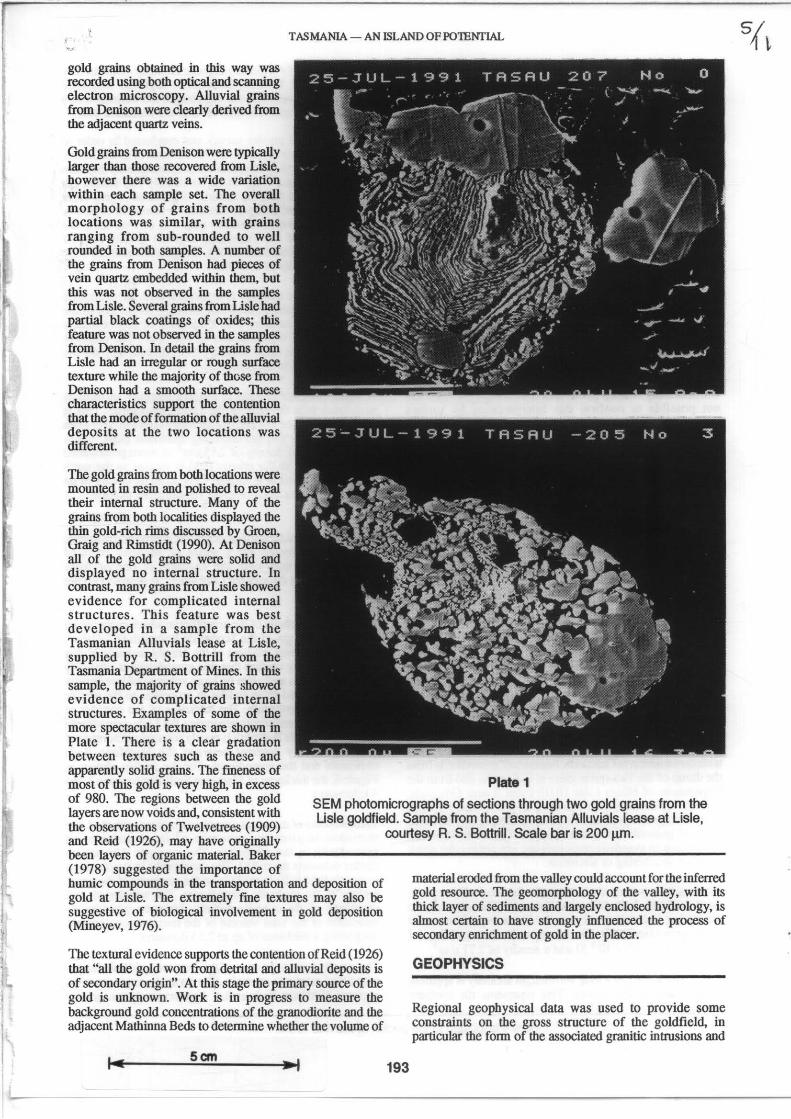
The gold grains from both locations were mounted. in resin and polished to reveal their internal structure. Many of the grains from both localities displayed the thin gold-rich rims discussed by Groen, Graig and Rirnstidt (1990). At Denison all of the gold grains were solid and displayed no internal structure. In contrast, many grains from Lisle showed evidence for complicated internal structures. This feature was best developed in a sample from the Tasmanian Alluvials lease at Lisle, supplied by R. S. Bottrill from the Tasmania Department of Mines. In this sample, the majority of grains showed evidence of complicated internal structures. Examples of some of the more spectacular textures are shown in Plate 1. There is a clear gradation between textures such as these and apparently solid grains. The fmeness of
Plate 1 most of this gold is very high, in excess of 980. The regions between the gold layers are now voids and, consistent with the observations of Twelvetrees (1909) and Reid (1926), may have originally
SEM photomicrographs of sections through two gold grains from the Lisle goldfield. Sample from the Tasmanian Alluvials lease at Lisle,
courtesy R. S. 80nrill. Scale bar is 200 11m.
been layers of organic material. Baker (1978) suggested the importance of humic compounds in the transportation and deposition of gold at Lisle. The extremely fme textures may also be suggestive of biological involvement in gold deposition (Mineyev, 1976).
The textural evidence supports the contention of Reid (1926) that "all the gold won from detrital and alluvial deposits is of secondary origin". At this stage the primary source of the gold is unknown. Work is in progress to measure the background gold concentrations of the granodiorite and the adjacent Mathinna Beds to determine whether the volume of
5cm 193
materia1 eroded from the valley could account for the inferred gold resource. The geomorphology of the valley, with its thick layer of sediments and largely enclosed hydrology, is almost certain to have strongly influenced the process of secondary enriclunent of gold in the placer.
GEOPHYSICS
Regional geophysical data was used to provide some constraints on the gross structure of the goldfield, in particular the form of the associated granitic intrusions and
GEOLOGICAL SURVEY BULUl11N 70
their relationship to known mineralisation. In addition the geophysical data also provided important infOJmation on the composition of the exposed granitic rocks.
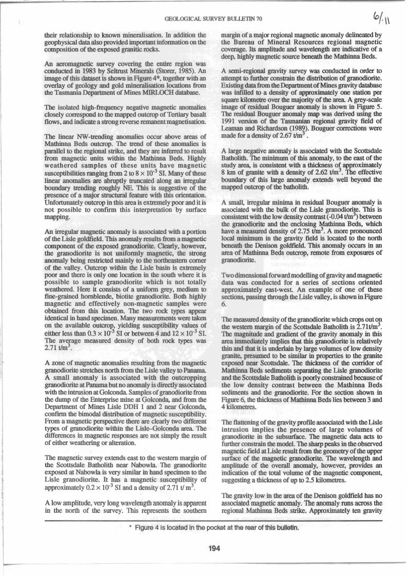
An aeromagnetic survey covering the entire region was conducled in 1983 by Seltrust Minerals (Storer, 1985). An image of this dataset is shown in Figure 4*, together with an overlay of geology and gold mineralisation locations from the Tasmania Department of Mines MIRLOCH database.
The isolaled high-frequency negative magnetic anomalies closely correspond to the mapped outcrop of Tertiary basalt flows, and indicate a strong reverse remauent magnetisation.
The linear NW-trending anomalies occur above areas of Mathinna Beds outcrop. The trend of these anomalies is parallel to the regional strike, and they are inferred to result from magnetic units within the Mathinna Beds. Highly weathered samples of these units have magnetic susceptibilities ranging from 2 to 8 X 10⁻³ SI. Many of these linear anomalies are abruptly truncated along an irregular boundary trending roughly NE. This is suggestive of the presence of a major structural feature with this orientation. Unfortunately outcrop in this area is extremely poor and it is not possible to conflfD1 this interpretation by surface mapping.
An irregular magnetic anomaly is associaled with a portion of the Lisle goldfield. This anomaly results from a magnetic component of the exposed granodiorite. Clearly, however, the granodiorite is not uniformly magnetic, the strong anomaly being restricled mainly to the northeastern comer of the valley. Outcrop within the Lisle basin is extremely poor and there is only one location in the south where it is possible to sample granodiorite which is not totally weathered. Here it consists of a uniform grey, medium to fine-grained hornblende, biotite granodiorite. Both highly magnetic and effectively non-magnetic samples were obtained from this location. The two rock types appeat identical in hand specimen. Many measurements were taken on the available outcrop, yielding susceptibility values of either less than 0.3 x 10⁻³ SI or between 4 and 12 x 10.3 SI. The average measured density of both rock types was 2.71 tlm3•
A wne of magnetic anomalies resulting from the magnetic granodiorite stretches north from the Lisle valley to Panama. A small anomaly is associated with the outcropping granodiorite at Panama but no anomaly is directly associated with the intrnsion at Golconda. Samples of granodiorite from the dump of the Enterprise mine at Golconda, and from the Department of Mines Lisle DDH 1 and 2 near Golconda, confum the bimodal distribution of magnetic susoeptibility. From a magnetic perspective there are clearly two different types of granodiorite within the Lisle-Golconda area The differences in magnetic responses are not simply the result of either weathering or alteration.
The magnetic survey extends east to the western margin of the Scottsdale Batholith near Nabowla. The granodiorite exposed at Nabowla is very similar in hand specimen to the Lisle granodiorite. It has a magnetic susceptibility of approximately 0.2 x 10.3 SI and a density of 2.71 tI m3.
A low amplitude, very long wavelength anomaly is apparent in the north of the survey. This represents the southern
margin of a major regional magnetic anomaly delinealed by the Bureau of Mineral Resources regional magnetic coverage. Its amplitude and wavelength are indicative of a deep, highly magnetic source beneath the Mathinna Beds.
A semi-regional gravity survey was conducled in order to attempt to further constrain the distribution of granodiorite. Existing data from the Department of Mines gravity database was infilled to a density of approximately one station per square kilometre over the ~ority of the area. A grey-scale image of residual Bouguer anomaly is shown in Figure 5. The residnal Bouguer anomaly map was derived using the 1991 version of the Tasmanian regional gravity field of Leamau and Richardson (1989). Bouguer oorrecIions were made for a density of 2.67 11m3 •
A large negative anomaly is associaled with the Scottsdale Batholith. The minimum of this anomaly, to the east of the study area, is consistent with a thickness of approximately 8 km of granite with a density of 2.62 tlm3. The effective boundary of this large anomaly extends well beyond the mapped outcrop of the batholith.
A smaI~ irregular minima in residnal Bouguer anomaly is associaled with the bulk of the Lisle granodiorite. This is consistent with the low density contrast (-0.04 tlm3) between the granodiorite and the enclosing Mathinna Beds, which have a measured density of 2.75 11m3• A more pronounced local minimum in the gravity field is Incated to the north beneath the Denison goldfield. This anomaly occurs in an area of Mathinna Beds outcrop, remote from exposures of granodiorite.
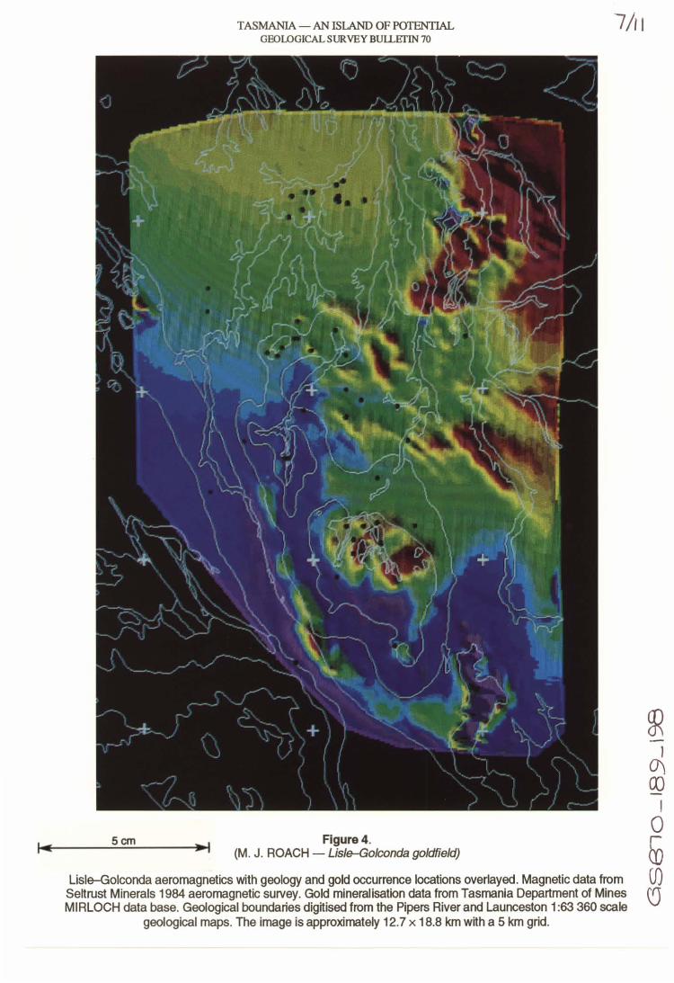
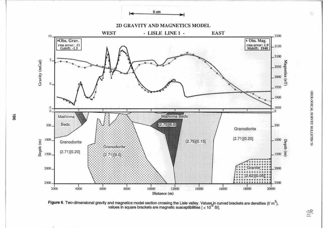
Two dimensional forward modelling of gravity and magnetic data was conducted for a series of sections oriented approximately east-west. An example of one of these sections, passing through the Lisle valley, is shown in Figure 6.
The measured density of the granodiorite which crops out on the western margin of the Scottsdale Batholith is 2.71t1m3• The magnitnde and gradient of the gravity anomaly in this area immediately implies that this granodiorite is relatively thin and that it is underlain by large volumes of low density granite, presumed to be similar in properties to the granite exposed near Scottsdale. The thickness of the corridor of Mathinna Beds sediments separating the Lisle granodiorite and the Scottsdale Batholith is poorly constrained because of the low density contrast between the Mathinna Beds sediments and the granodiorite. For the section shown in Figure 6, the thickness of Mathinna Beds lies between 3 and 4 kilometres.
The flattening of the gravity profile associaled with the Lisle intrusion implies the presence of large volumes of granodiOrite in the subsurface. The magnetic data acts to further constrain the model. The sharp peaks in the observed magnetic field at Lisle result from the geometry of the upper surface of the magnetic granodiorite. The wavelength and amplitude of the overall anomaly, however, provides an indication of the total volume of the magnetic component, suggesting a thickness of up to 2.5 kilometres.
The gravity low in the area of the Denison goldfield has no associaled magnetic anomaly. The anomaly runs across the regional Mathinna Beds strike. Approximately ten gravity
• Rgure 4 is located In the pocket at the rear of this bulletin.
194
Scm
TASMANIA - AN ISLAND OF POTENTIAL GEOLOGICAL SURVEY BUlLETIN 70
Figure 4. (M. J . ROACH - Lisle--Golconda goldfield)
7/11
LislErGolconda aeromagnetics with geology and gold occurrence locations overlayed. Magnetic data from Sen rust Minerals 1984 aeromagnetic survey. Gold mineralisation data from Tasmania Department of Mines MIRLOCH data base. Geological boundaries dig~ised from the Pipers River and Launceston 1:63 360 scale
geological maps. The image is approximately 12.7 x 18.8 km w~h a 5 km grid.

TASMANIA-ANISLANDOFPOlENfIAL 8/11 52eeee
., ., ., ., ~ ~
530000 5~eee0
... ... ., ., ., .,
520eee 53eeee FigureS
5~ee e e
Grey-scale image of residual Bouguer anomaly with geology and gold occurrence locations overlaid. Bouguer reduction density 2.67 V m3, Mantle91 regional field removed
(Leaman and Richardson, 1989) (1 :150 000, AMG grid).
stations fall within its boundary. The anomaly does not correlate with the mapped distribution of Tertiary and Quaternary sediments.
The most likely explanation for this anomaly is the presence of a subsurface granitic intrusion. The Mathinna Beds are exposed across the entire area and there is no additional outcrop information with which to constrain the gravity model. As a resul~ the geometry of the inferred body is detemtined principally by the cbosen density contrasl It is possible, bowever, to place an upper limit on the body's density due to the fact that no contact aureole has been mapped at the surface. This results in an upper estimate of 2.65 tlm3 and implies that the pluton beneath the Denison goldfield has a different composition to the granodiorite exposed at Lisle and Golconda, where the measured density is 2.71 tlm3•
GRANITE CHEMISTRY AND PETROLOGY
The marked variations in the magnetic susceptibility of the various granodiorite units suggested that the these units may also be distinctive geochemically. A suite of15 samples from
Scm 195
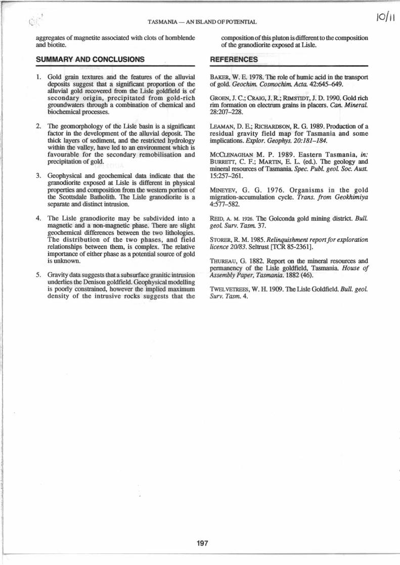
Usle, Golconda, Panama and the western margin of the Scottsdale Batholith, known as the Diddleum pluton (McClenaghan, 1989), were analysed for major and trace elements. Plots of Sr vs Rb and K:zO vs Al:z03 are shown in Figure 7.
There appears to be a fairly clear distinction between the rocks of the Scottsdale Batholith and the granodiorite from the Lisle area. There is also a possible geochemical difference between the magnetic and the non-magnetic rocks from Usle.
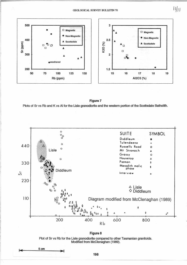
Figure 8 shows a Sr vs Rb plot for selected Tasmanian granitoids, including the analyses from Lisle. The granodiorites from the Usle area fall within a well-defmed field. In tenns of Rb and Sr, the Usle granodiorite is the least fractionated of the Tasmanian granitoids.
Thin sections of the various granite samples were examined in an attempt to explain their variable magnetic properties. All the samples, including those from the Scottsdale Batholith, contain small amounts of finely disseminated magnetite and ilmenite. The strongly magnetic samples from U sle and Golconda were distinguished by the presence of
.... U) ."
.c Q.
'" Q
5cm --I
2D GRAVITY AND MAGNETICS MODEL
WEST - LISLE LINE 1 -IO~~~==,-____ ~~ ____________________________________ ~~~~~ EAST
• Obs. Mag. rms error: .11
Gshift: ·1.5 rms error: 1.9 MshiO: 1940
Granodiorite
2200
=:: .. .. :J
'" -II = d
1950
1900
1850
Granodiorite (2.71 )[0.20J 1000 0
'" ." ;. (2.71 )[0.20J 1500 3'
Distance (m)
++++++ ++++++++++
+++"Granite' +++ .• _"uw +++ ' ..... ; +++"1'" +++++++++++++
!!! :(2.1>2)[0.05'! +++++++++++++
Figure 6. Two-dimensional gravny and magnetics model section crossing the Lisle valley. Value~n curved brackets are densnies (II ml. values in square brackets are magnetic susceptibilnies [ x 10 SIJ.
~
( TASMANIA - AN ISLAND OFP01ENTIAL
aggregates of magnetite associated with clots of hornblende and biotite.
SUMMARY AND CONCLUSIONS
1. Gold grain textures and the features of the alluvial deposits suggest that a significant proportion of the alluvial gold recovered from the Lisle goldfield is of secondary origin, precipitated from gold-rich groundwateIS through a combination of chemical and biochemical processes.
2. The geomorphology of the Lisle basin is a significant factor in the development of the alluvial deposit The thick lay= of sediment, and the restricted hydrology within the valley, have led to an environment which is favourable for the secondary remobilisation and precipitation of gold.
3. Geophysical and geochemical data indicate that the granodiorite exposed at Lisle is different in physical properties and composition from the western portion of the Scottsdale Batholith. The Lisle granodiorite is a separate and distinct intrusion.
4. The Lisle granodiorite may be subdivided into a magnetic and a non-magnetic phase. There are slight geochemical differences between the two lithologies. The distribution of the two phases, and field relationships between them, is complex. The relative importance of either phase as a potential source of gold is unknown.
5. Gravity data suggests that a subsurface granitic intrusion underlies the Denison goldfield. Geophysical modeUing is poorly constrained, however the implied maximum density of the intrusive rocks suggests that the
197
composition of this pluton is different to the composition of the granodiorite exposed at Lisle.
REFERENCES
BAKER, W. E. 1978. The role of humic acid in the transport of gold. Geochim. Cosmochim. Acta. 42:645-649.
GROEN, J. C.; CRAIG, J. R.; RlMSTIDT, J. D. 1990. Gold rich rim formation on electrum grains in placers. Can. MineraL 28:207-228.
LEAMAN, D. E.; RiCHARDSON, R. G. 1989. Production of a residual gravity field map for Tasmania and some implications. &plor. Geoplrys. 20:181-184.
McCLENAGHAN M. P. 1989. Eastern Tasmania, in: BURRETI, C. F.; MARTIN, E. L. (ed.). The geology and mineral resources of Tasmania Spec. Publ. geoL Soc. Aust 15:257-261.
MlNEYEV, G. G. 1976. Organisms in the gold migration-accumulation cycle. Trans. from Geokhimiya 4:577-582.
REID, A. M. 1926. The Golconda gold mining district. BulL geoL Surv. Tasm. 37.
STORER, R. M. 1985. RelinquislunenJ report for exploration licence 20183. Seltrust [fCR 85-2361].
THUREAU, G. 1882. Report on the mineral resources and permanency of the Lisle goldfield, Tasmania. House of Assembly Paper, Tasmania. 1882 (46).
TwEL VETREE'>, W. H. 1909. The Lisle Goldfield. Bull. geol. Surv. Tasm. 4.
GEOLOGICAL SURVEY BULlETIN 70
500 3
• o MagneUc A
• A o Magnetic
• Non-Magnetic • Non-Magnetic
400 2.5 e- li. ScoUsdale ~ A
D~OI ~ AD A ScoUsdal. a. So D A 0 ~ N D <J) :.:
300 A 2 ~ AA •
• weathered
200 1.5 • 50 75 100 125 150 15 16 17 18 19
Rb (ppm) AI203 ("10)
Figure 7
Plots of Sr vs Rb and K vs AI for the Usle granodiorite and the western portion of the Scottsdale Batholtth.
440
330
220
110
0
00
0
0
Lisle 0
0
. Diddleum
0'0 • 'bo
200
SUITE SYMBOL O.ddleum • Tulendeeno + Russell, Rood 0 Mt Stronach • Grassy 0 Houselop to Plemon 0 Meredith rna!.,
pha,e • InterView •
A Lisle o Diddleum
Diagram modified from McClenaghan (1989)
• o. • • 0 •
o to o
400 600 800 Rb
Figure 8 Plot of Sr vs Rb for the Lisle granodiortte compared to other Tasmanian granttoids.
Modified from McClenaghan (1989).
5cm
198
II/II