1997 - gis-t symposium · tim ehlers missouri highway ... 1997. 8 states 27 25 5 2 4 to gis...
TRANSCRIPT

1997
GIS-T SYMPOSIUM STEERING COMMITTEE
Diane Pierzinski, Chair California Dept. of Transportation
Daris W. Ormesher South Dakota Dept. of Transportation
Tim Ehlers Missouri Highway and Transportation Department
Tony Pietropola Pennsylvania Dept. of Transportation
Tom Glancy Minnesota Dept. of Transportation
Ed Shuller North Carolina Dept. of Transportation
D. David Moyer Wisconsin Dept. of Transportation National Geodetic Survey
Chris Levy Oregon Dept. of Transportation
Richard Genrich Nebraska Dept. of Roads
Roger Petzold FHWA Office of Environment and Planning
Ben Williams FHW A; Region 4
Simon Lewis GIS/Trans, Ltd.
David Blake Utah Dept. of Transportation


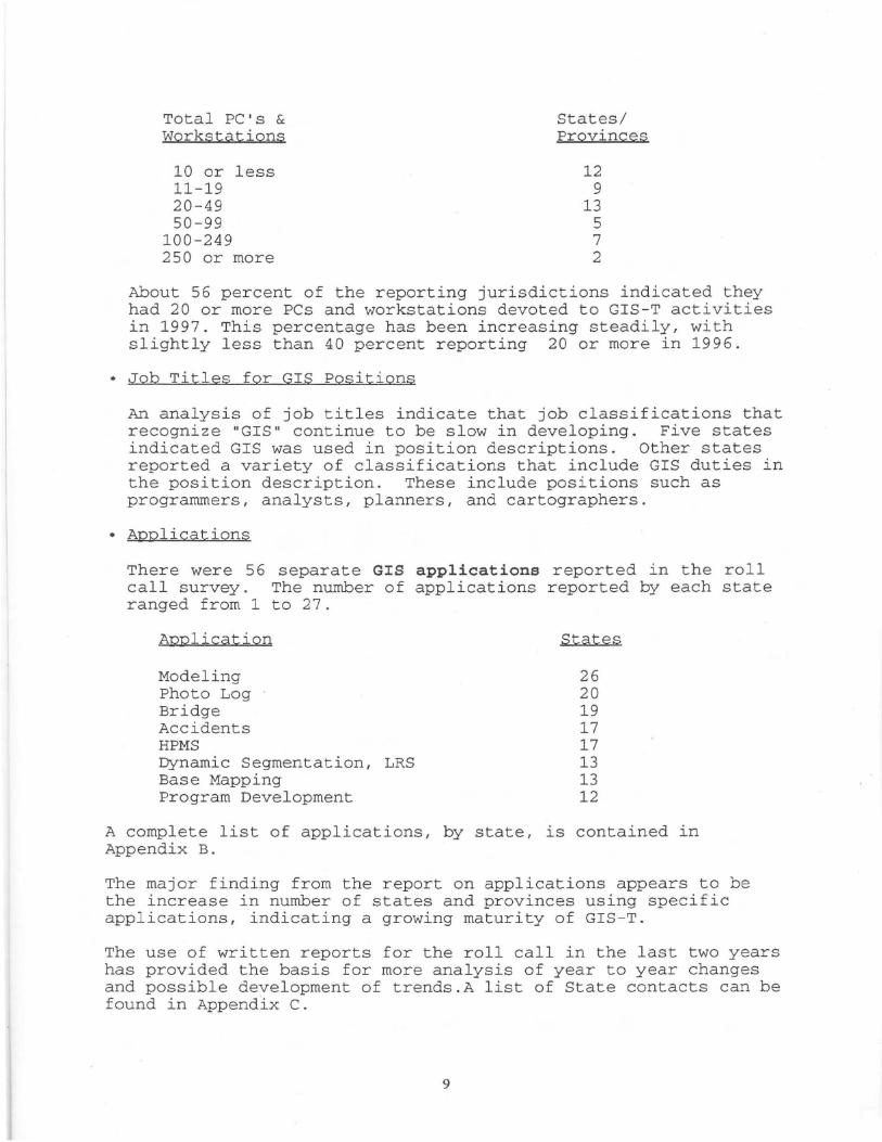
Total Staff
1 2-3 4-5 6-9
10-19 20 or more
States
3 12
4 14
9 4
While there are some states with large numbers of staff devoted to GIS-T, 71 percent of the jurisdictions reported less than 10 staff in these positions. Results from the last three years have been similar, ranging from 70 to 83 percent with less than 10 staff working on GIS-T.
There is also wide variation in the functional areas to which GIS staff are assigned.
GIS Staff Location
Planning Information GIS Cartography or Mapping Engineering
• GIS Software
States
14 9 6 5 3
GIS software is concentrated in two vendors, with relatively few reporting other software resources. ESRI and Intergraph products accounted for 83 percent of the software reported by states and provinces.
GIS Software
Arc Info MGE GDS In-house Other
• Workstations and PCs
The number of workstations and PCs devoted increase in the number reported each year. workstations were reported in use on GIS-T 1997.
8
States
27 25
5 2 4
to GIS continue to Over 2,500 PCs and
related activities in

The second plenary session was Jane Smith Patterson's keynote address on Enterprise Transportation GIS. She discussed a wide variety of GIS-related activities and issues related to her broad experience in government, academia, and the private sector. Among the issues discussed were the following:
Cooperation. Cooperation is important at all levels of government, local, state, federal, or even worldwide. Cooperation is necessary in the creation and use of geographic information, both because of the costs and also because of the limits on data resources available to any one agency. Patterson noted the rich data source that is provided by local government, including ownership parcels, transportation and utility infrastructure, land use, and zoning. She also note that many state agencies can serve as a data source, using the data collected to fulfill their specific mission. These data collected by one state agency can often serve the needs of another local or state agency application, (e.g. ranging from land use planning to health care planning). Patterson provided several examples of the information that was available as a result of the North Carolina Department of Transportation (DOT) "enterprise" approach to their GIS.
Corridor Planning. NCDOT has provided leadership, and in some cases funding, to develop key, statewide data bases for use in their GIS. Data bases used in the planning application includes topography, soil suitability, historic sites, archaeological resources, special plants and animals, and other protected land and water resources.
Digital Orthophotography. A statewide partnership of NCDOT and others (including state and federal agencies), provided millions of dollars in cost sharing funds to procure this 1:12,000 data base. The resulting statewide data base provides a one-time snap shot of the state that is available to all data users.
Examples of the use of these digital maps include land use monitoring, land use planning and coastal zone monitoring. With major Atlantic Coast hurricane exposure, North Carolina needs to be able to respond quickly, with accurate information, for emergency planning, storm damage monitoring, and disaster recovery efforts.
Policy and Standards. Patterson also discussed several state and federal policy and standard efforts that are underway. These included the National Spatial Data Infrastructure (NSDI) that provides the "means to assemble geographic information that describes the arrangements and attributes of features and phenomena on the Earth. The infrastructure includes the materials, technology, and people necessary to acquire, process, store, and distribute such information to meet a wide variety of needs". She noted all sectors of our economy benefit from standards such as NSDI, and provided a number of examples of on-
10

going activities in North Carolina that are supporting the development of standards.
Geographic Information Coordinating Council (GICC). The GICC is a statewide group, appointed by the Governor, with responsibility for a number of geographic information tasks, including the development and review of standards. Other initiatives in which North Carolina and the GICC are involved include the National Information Infrastructure and Internet 2 (the next generation of high speed network functionality).
Patterson concluded that our primary goal as government workers is to provide the best and most reliable information in the most efficient manner. Cooperation and the development and use of standards are two key factors in reaching this goal.
Most of the remainder of Day 1 was devoted to a series of concurrent sessions, the content of which is described later in this document. In the late afternoon and evening, a reception was hosted by the vendors . Also, the Poster session was held in the exhibit hall during the reception. Later in the evening, the Birds of a Feather session (noted earlier), was held to provide an opportunity for attendees to interact with software vendors.
Day 2 - Symposium Program
The Tuesday morning plenary session featured two presentations: one by next years host state of Utah on their plans and what we can expect for GIS-T 98; and a second session featuring speakers from several state DOTs on Implementation of Desktop GIS at State DOTs. Chaired by Simon Lewis, this session provided a good summary of the status of desktop GIS and also resulted in the opportunity for considerable interaction between panel members and the audience.
To facilitate the discussion, panelists were asked to consider a number of questions including:
- How is GIS defined in your organization? - How do you train GIS end-users? - If you were going to start over and build a GIS-T, what
would you do differently the second time? - Has GIS produced staff savings in your organization, and if
so, how many positions have you been able to reduce?
Among the points made by speakers were the following:
- Management must understand that GIS is more than a way to generate maps
- GIS is not a "Plug and Play " technology, it does not happen overnight
- A GIS does not create data
11

- GIS can serve as a data integrator, linking and combining data from a variety of sources
- Data base update: one state found the quality of data improved 10 fold when they moved update responsibility from central office to the districts
- important to identify "owner" for each data layer, for maintenance purposes
- Personnel and institutional issues are most difficult area, but also the areas that produce the biggest benefits
The remainder of Day 2 was devoted to 12 concurrent sessions. An evening barbecue at the Depot concluded the program for Tuesday.
Day 3 - Symposium Program
The Wednesday morning keynote was presented by Jack Dangermond, President of Environmental Systems Research Institute. His topic was the Future of Desktop GIS.
Dangermond focused on two ideas in his presentation:
1. A vision of what GIS technology can do for an organization, and
2. What the future of GIS technology may be.
In discussing the value of GIS, Dangermond noted that value is the result of a number of factors, including: saving time and money, more consistency, better science, cross-cutting thinking, better problems solving, and ultimately better decisions.
He noted that the typical pattern for GIS development is to begin with a project, progress to data sharing within parts of a department, then proceed to a department-wide GIS. Sharing of data leads to coordination of work, and better communication.
Dangermond suggested that the best way to update the GIS data base is to do so based on transactions. This means that whatever unit builds a new road, rebuilds a road or bridge, or makes any other transportation improvement, will also be responsible for seeing that the appropriate changes are made in the data base. He also indicated that within the data model, data is integrated based on coordinate locations.
Dangermond noted that in analyzing the benefits and costs of GIS systems, the number of applications is an important factor, since costs tend to stay relatively flat regardless of the number of applications, while benefits tend to increase linearly, as the number of applications increase.
More and more data will be used, and useful to a greater number of users. For example, we can model transportation flows based on changes in land use. Also data warehousing will increase, making
12

possible detailed market research by combining data from such sources as departments of motor vehicles, credit card companies, and magazine subscriptions. Same approach (as is used for market research) can be used for agriculture production, sales, and marketing, land use monitoring and planning, etc.
Other trends that will have an impact include: Travel optimization will continue to be an important GIS use, to save time and money. (For example, Sears has already limited delivery window to two hours for customer, cut time per delivery by 16 percent, and produced company savings of $26 million per year.)
- In the future, we will measure and record everything that moves in our economy.
- Time lag between data collection and data use will continue to shorten significantly. (Global Positioning Systems (GPS) are a leading indicator of what can be expected.)
-We will continue the move toward "societal GIS", where GIS is used by nearly everyone.
Dangermond also offered some thoughts on how we will move from the present to futures that he outlined. For example, he indicated that there are several types of GIS, including:
- professional GIS - desktop GIS - Embedded GIS components - internet GIS - data base management system GIS
All of these GIS types draw on scaled geodata to carry out functional activities.
Other relevant advances and trends include:
- Now possible to handle spatial data in an RDBMS environment .
- Shared common data models means more GIS users will be focusing on viewing and using data, and less on analysis. This also has implications for the types of software that will be in demand.
- Three dimensional visualization will become more common and more widely used.
There will be a large surge in specialized applications.
- Vendors will open up systems so standard languages can be used for applications development.
13


"I" ;: ;:~ ;: ·~ A 0 " = " I " ~ 0 0 0 0 )> )> )> )> - · -· -· Ill Ill Ill 0 CD Ill ~ 0. - · Ill Ill CD 0 CD 0 0 Ill X. ::!. - -g: 5 ~ "' s· £. ~ ~ Ill iii. 5 ::r ~ o ::!. n> ::1 o ::;: Ill N ~ ~ 0 (!) <li" ~ ii) (!) !!!. c Ill ::! ;;;· 0 9!. U3 a. ~ ::! Ql 0 ::! g "' Ill § (f> Ill 0 ::! ~ 0 (f> Ill - · iii" Ill Ill ~ a. 3 (f> Ill Ill 3
· ~ ::! E a. Ill "' Cil g· o iii. ~ Ill (f> c ~ -u;
XI XI XI I l XI lXI I lXI lXI Accidents ADT
XI I I I I I lXI XI XI Base MaE DeveloEment Bike
XI lXI I I I I lXI I I I IX lXI I I lXI XI XI I X I X 1Brid2e Clean Air Modeling
xlxl I lxl I I I I I I X X X Congestion Management xj Construction
X X X XX Corridor Planning
XI I I lXI I I I I I X X Database Query System X Data Integrity
XIX X Data Management X Decision Support
X Demographics
XI lXI I lXI lXI IX X Dyn. Seg. I Linear Ref Sys. Economic Evaluation BS
XI I I I I I I I I lXI I lXI I !Environmental Facilities Mana2ement
xlxl I lxl I I I I I I I I I I I I lx Functional Classification X X GIS Distribution
X GPS X XX X X X X XX HPMS
X X X X X Highway Inventory
XI I I I X Highway Safety
xlll X X Hydrology
X Incident Management
X X X Interagency Support X X X X lntermodal Planning
X Inventory Applications
xj l J l I I I I I l l l JxJ l l Jx X X IS TEA Land Use
X
lications
XI I I IX Pavement Mana2ement Photo Log
XI I I IX X X X Planning
X X X X Program Development
XI I I I I I Project Management
xJJll X X Right of Way_ X X ROAD LOG
XI I I I I X Roadway Geometries
xj l l X Routin2
Si2n Log XI I I I lXI I I I I I I I
XI I I X X X Trans
X X
X Weather Conditions
WPA


Hardware Software
II)
"' c: ~ z
.c: 0 0 :; vi ~
~ c. u. I!!
!/) Ql f2 ~ ~ z c. ::::> (I) .g iii (I) ~ .!!! <a ~ zt :I z cr C> z () 0 0.. 2 C> '0> Q; ~ ~
c:
~ ::;: ~ "' :g, ~ I!! 1 c. ~
() ·c: c: () !t 5 !! ~ ~ :i ~ :E 1'ii ~ ~ gJ > 0 (!)
Alabama X X Alaska X X X X Arizona X X X X X X
Arkansas X X
Calnornia X X X X
Colorado X X X X X
Connecticut X X X X X
Delaware X X X
Florida X X X X Georgia X X X X X X X X
Hawaii X X X Idaho X X X Illinois X X X X Indiana X X Iowa X X Kansas X X X X X X
Kentucky X X X X X
Louisiana X X
Maine X X
Maryland X X X X
Massachusetts X X
Michigan X X X X
Minnesota X X X
Missouri X X X
Mississippi X X X X
Montana X X X X X X Nebraska X X
(I)
u 0.. ill c: .!2 1ii iii ~ 0 ~
0 "" Stage Budget 3 Pilot Project Complete NIA 4 Base Map Development NIA
5WS Application Development $75,000 15 PC 8WS Implementation NI A 6PC 300 Implementation $500,000
9WS Mature NIA 50 PC
10 Application Development $400,000 GIS Users Group
30 Application Development NIA Database Enhancement
100 Implementation, Stwde Del NIA 12 lmplementationiApplicatio $900,000
Rei. Database deployment 4 Implementation NIA 4 Data Structurirl_l!_ Progress NIA
2WS Implementation NIA 110 GIS Integration NIA 10 Implement. of Strategic Pia NIA
13WS Segment Manager NIA 10PC 5WS Application Development NIA 30PC 50 ws Implementation NIA 60PC
62 Base Map Development NIA
175 Deployment I Developmen $1,000,000
2WS Intermediate I Advanced $200,000 10PC 200 Road Network Developmen NIA
50 Building Infrastructure $700,000 Data and Skill Building
25+ Implementation $560,000
150 Development I Production NIA
NIA Infancy NIA 10WS In Production $600,000
Development
= "' Ui
"" Job Classification 3 Programmer Analyst 3 Cartographer 3 GIS Analyst
2 NI A
24 GIS Research Mgr, RAJ, RAil
7 NIA
6 Transportation Planner
3 Application Support Specialist
NIA NIA 7 GIS Manager, Analyst, Cartograp
1 NIA 8 Research Analtst, Cart()j!r~her 6 NIA
28 2 NIA
13 NIA
6 Engineering Technologists
1 Engineer
2 GIS Manager Senior Program Analyst
5 Engineering Technician Information Technician
6 Programmer Analyst
Transportation Planner 30 NIA
6 Research Analyst GIS
5 NIA
10 Engineer I Analyst
1 NIA 10 Cartographer l,ff,lll
Staff Location Computer Services
Statewide Mapping Unit Planning Un~
Engineering Computer Services Trans. Sys. Into. Prog. GIS Service Center Planning
Bureau of Policy/Piannir GIS Development Div. Financial Managem IRM Section NIA Office of Into. Services
Planning Branch
GIS Section Bureau of Into. Processi Graphic Engineering Div Planning I Data Service Cartography Center
Into. Tech. Section Planning Section Computer Center
Bureau of Into. System
Office of Planning and
Preliminary Engineerirl_l!_ Bureau of T.P. and Dev.
Data Resources Group Planning
Survey & Mapping Secti Cartographic Unit Office of T ransportatior Management Systems Into. Services Division Planning Division Information Services Trans. Planning Division
c.
"' ::;: Ql (I)
"' CD
Yes No
Yes
Yes
Yes
Yes
Yes
Yes
Yes Yes
Yes Yes Yes Yes Yes Yes
Yes
Yes
Yes
Yes
Yes
Yes
Yes
Yes
Yes
Yes Yes
Scale
NIA NIA
1:24,000
1:24,000
1:100,000
1:24,000
1:100,000
1:12,000
1:24,000 1:24,000
1:24,000 1:100,000 1:64,000 1:100,000 1:100,000 1:100,000
1:100,000
1:24.000
1:24,000
1:24,000
1:24,000
1:100,000 1:24,000 1:100,000 1:24,000
1:100,000
1:100,000
NIA 1:24,000
.6-'t:l (1)
~ Po ~· t::O

Hardware Software
~~~ ~1
-g_ ~,(/) .. z -t;, - CJ
a: ... zO~ ~Ef!~iil~~ II~ I~ ~,f2,.c ::l z ::l
~ ~ ll~ Nevada X X
New HarT'j)shire X X
New Jersev X X New Mexico X XIX
New York X XIX
North Carolina X XIX
North Dakota XI I XI I I X
Ohio XI I XI I X X X Oklahoma XIX X
Oregon XIX X X
Pennsylvania XIX X
Rhode Island X X X
South Carolina X X
South Dakota X X X
Tennessee XIX X
Texas X XIX X X
Utah X X X
Vermont X XIX X X
c:
13 iii (/)I~ ~ ~
X
X
X
IJ)
"' 1--" z
.,,~,~ ~.g:; 'C 1: 0
tii ;: <
"' u ~ c: .!2 'lU
~ 0 ~
0
'"' 73 WSjPianning 20PC
Stage
8 !Development Changes
X I I 65 I Windows NT Conversion X I X I 7 WS I Implementation,
15 PC I Maintenance
Budget N/A
N/A
$500,000 $300,000
X 122 WSj3rd Year Implementation IN/ A 300 PC
Environmental Data Dev .. 35 !Digital postmiling
Program Coordination XI 2 WS jlmplementation
30PC X I I 1 5 !Operational X I I 1 5 IGPS Data Collection
X I 10 PC p mplementation 4WS
2 5 I Networking
2 WS jFu/1 Operation 2PC 8 WS I Expansion Studies 4PC
$2,500,000
N/A
N/A N/A
N/A
$1,500,000
N/A
$75,000
XI 9 WS jPrimary Development Stag4$400,000 4PC
X I I 5 WS I Implementation 40 PC Department Expansion
X I X I 21 I R&D prototypes Implementation
20 ICorT'j)leted R.F.P .. Begun Pilot Project
XI 12 !Preliminary
$200,000
NIA
N/A
$750,000
:t: .. Vi
'"'
Development
Job Classification NIAIN/A
2 ICAD I Data Technician CAD I Data Application Engineer
Staff Location N/A
c.. .. ::;:
"' "' ~ I Scale No IN/A
Transportation Planning! Yes 11:24,000
1 6 I GIS Specialist, Graphic Artists I Bureau of GIS Yes 11:12,000 3 I Systems Program Analyst I Planning Division Yes 11:100,000
7 !Cartographer
15 IN/A
2 IN/A
1 5 IN/A 10 IN/A
8
8
3
Systems I Programmer Analyst Programming Tech. Engineering Tech. Computer System Analyst Transportation Planners GIS Specialist
7 /Cartographers
4 IN/A
2 0 I Cartographer
1 0 !Systems Analyst
N/AIN/A
Mapping and GIS Burea~Yes j1: 24,000 1. 250,000
GIS Unh Yes 11:24,000
Information Services jNo jN/ A Planning Division Office of Tech. ServicesiYes 11:24,000 Traffic Engineering !Yes j1: 24,000
Info. Systems Branch Trans. Inventory and Mapping Office of Planning
N/A
N/A
1:100,000 1:24,000,
Yes 11:100,000
Yes 11:24,000
Tes 11:24,000
No 11:24,000
Division of Planning & I No IN/ A Engineering
Mapping Section I Yes 11:24,000
Transportation Planning! Yes 11:24,000 Information Systems Transportation PlanningiYes IN/ A
Yes IN/A 2 !Project Manager ~Planning Construction CADD Specialist Construction
IVirqinia lllllllxlxlxllllllxll l T l-1 I N/A N/A $30o,ooo 6 N/A N/A Yes 1:24,000 > I
I Computer Information Consultan '0 X X Washington X X I 3 WS Preliminary Implementation N/ A 7 Transportation Planning Specialis Geographic Services an Yes 1:24,000 "g
15 PC Cartographer MS 1:500,000 l:l I West Virqinia I I I I X I I I I I I I I I I I I X I I I I I I 3 Early Development N/ A 7 N/ A Trans. Planning Division Yes N/ A ~ Wisconsin I I X r I I X I I I X I 1 I I 1 T I I I I I I I X I 200+ Application Development N/ A N/ A N/ A Information Services Yes 1:100,000 t:!:l Wyoming I I I I I XI I I I I I I I I I JXJJXJJXJJ 10 Preliminary N/A 5 N/A Planning Branch NO N/A

State Primary Contact State
Harvey Elethorp
Alabama 1409 Coliseum Blvd . Louisiana Montgomery, AL 36022 334-242-6587
Karry Kirkpatrick, Statewide Mapping Unit
Alaska 3132 Channel Drive Maine Juneau, AK 99801-7898 907·465·8957
Tony Gonzalez I
Arizona 206 S. 17th Avenue, 104B Maryland
Phoenix, AZ 85007 602-255-7818
Bill Durham, AR State Highway Trans. Building
Arkansas 10324 Interstate 30 MassachuseHs
Little Rock, AR 72209 501 -569-2553
Diane Pierzlnskl
California 1120 N Street, Room 5515 Michigan
Sacramento, CA 95814 916-654-3379
Doug Lang Colorado 4201 East Arkansas Avenue, Room 212 Minnesota
Denver, CO 80222 303-757·9802
Richard Gaulin
Connecticut 2800 Berlin Turnpike Missouri
Newington, CT 06131·7546 860·594·2013 I. Kenneth Richter
Delaware PO Box 778 Mississippi Dover, DE 19903 302-739-4344
Rebecca Clemans, Florida DOT
Florida 605 Suwannee Street, MS 43 Montana Tallahassee , FL 32399·0450 904-488-1954 Darrell Elwell
Georgia 2 Capital Square Nebraska Atlanta, GA 30334 770·986-1361 Vernon Nakamura
Hawaii 869 Punch Bowl Street Nevada Honolulu, HI 96813 808-587-3953 Roger Kassens
Idaho PO Box 7129 New Hampshire Boise, ID 83707-1129 208-334·8224
MaryAnn Paulis Illinois 2300 South Dirkson Parkway New Jersey
Springfield, ILL 62764 217-785-1210 Bill Holloway
Indiana 100 North Senate Avenue New Mexico Indianapolis, IN 46204 317-232-7275 Peggl Knight
Iowa BOO Lincoln Way New York
Ames, lA 50010 515-239-1380 Brian Logan, Cartography Manager
Kansas Docking State Office Building North Carolina
Topeka, KS 66612 913·296·3841
Barry House
Kentucky 125 Holmes Street North Dakota
---Fr<~_nkfurt, KY 40622 502-564-7183
----
Primary Contact State Salim Shaker
PO Box 94245 Ohio Baton Rouge, LA 70804-9245 504-379-1611
Nancy Armentrout, ME DOT State House Station 16 Oklahoma Augusta, ME 04333·0016 207-287-8723 Rose Davis I William Waisek 707 N. Calvert Street, MS C-607 Oregon Ba~lmore, MD 21202 404-545·5529 Elizabeth Harper
10 Park Plaza, Room 4150 Pennsylvania Boston, MA 02115 617-973·8244
Gil Chesbro 425 W. Ottawa, PO Box 30050 Rhode Island Lansing, Ml 48909 517·327-2647
Thomas Glancy, MN DOT 117 University Avenue South Carolina St. Paul, MN 55155 612·296·4256 Tim Ehlers (lnterium)
PO Box 270 South Dakota Jefferson City, MO 65102 573·526-2670 Don Grayson PO Box 1850 Tennessee Jackson Miss. 39215 601-359-7400 Skip Nyburg 2701 Prospect Avenue Texas Helena, MT 406·444·7266 R.L. Genrich, GIS Manager NE Dept. of Roads; PO Box 94759 Utah Lincoln, NE 68509·4759 402-4 79-4550 Frank Tetz, Nevada DOT 1263 S. Stewart Street Vermont Carson City, NV 89712 702·686· 7560 Glenn Davison John 0 Morton Building, Box 463, Hazen Drive Virginia Concord, NH 03302·0483 603·271·3935 Frank McGough 1035 Parkway Avenue Washington Trenton, NJ 066250600 609·530·2641 Glen Condon
1120 Cerrillos Road, SB-3 West Virginia Santa Fe, NM 67504·1149 505-627·5396 Bill Johnson, NY DOT, Mapping & GIS Bureau State Office Campus Wisconsin Albany, NY 12232-0415 516-457-4406 Ed Shutler , NC DOT PO Box 25201 Wyoming Raleigh, NC 27611 919·250·41 06
- -- -
Brad Wentz 606 E. Blvd. Avenue Bismarck, NO 56505 701·326·3736
Primary Contact David Blackstone
25 S. Front Street
Columbus, OH 43216 614-466·4224 Tim Callahan 200 NE 21st Street Oklahoma City, OK 73105 405-521·4159 Greg Sachau
Room 215, Transportation Building
Salem, OR 97310 503-986·321 6 Tony Pietropola
6th Floor, Forum Place Harrisbura, PA 17101 717-767-3200 Ken Marrocco 2 Capitol Hill, Room 336
Providence, AI 02903 401·277-6935 X4470 Dale Larkee
PO Box 191, 955 Park Street Columbia, SC 29202·0191 803-737-1677 Larry Schoenhard
700 E. Broadway Avenue Pierre, SO 57501-2566 605·773·3276 Bel Tolar
Suite 1000, James K. Polk Building Nashville, TN 37243-0344 615-741·3214 Chris Collier
125 E. 11th Street Austin, TX 78701 512-302-2094 Dan B. Nelson PO Box 143600, 4501 South 2700 West Sail Lake Citv, UT 64119-3600 601·965-4551 Bill LaFerriere
133 State Street Montpelier, VT 05633 602·826-2757 Dave Wyant 1401 E. Broad Street Richmond, VA 23112 604-293-1964 Ron Cihon (206) 705·7036 1655 S. 2nd Avenue, PO Box 47364 Olympia, WA 96504·7364 360-709·5510 Dave Kramer
1900 Kanawha Blvd. East, Bldg. 5, Room A-663 Charleston, WV 25305 304-558-3113 Mike Krueger 4602 Sheboygan Ave ., Am. 201-B, PO Box 7962
Madison, WI 53707-7962 715·365·5727 Jim Nelson 5300 Bishop Blvd. Cheyenne,_WY 82001 307-777-4184
I
I
~ "t:l (!)
::s 0.. ~· 0

GIS-T SYMPOSIUM LOCATIONS
1987 Tempe, Arizona
1989 Orlando, Florida
1990 San Antonio, Texas
1991 Orlando, Florida
1992 Portland, Oregon
1993 Albuquerque, New Mexico
1994 Norfolk, Virginia
1995 Sparks, Nevada
1996 Kansas City, Missouri
1997 Greensboro, North Carolina
1998 Salt Lake City, Utah
1999 San Diego, California
2000 Minnesota
2001 Connecticut
2002 Boise, Idaho