1999 utah geological survey special study 97
TRANSCRIPT

by
Douglas A. Sprinkel,Malcolm P. Weiss,Robert W. Fleming,
andGerald L. Waanders
Sprinkel, Weiss, F
leming, W
aanders RE
DE
FIN
ING
TH
E L
OW
ER
CR
ET
AC
EO
US ST
RA
TIG
RA
PH
Y W
ITH
IN T
HE
CE
NT
RA
L U
TA
H F
OR
EL
AN
D B
ASIN
UG
S Special Study 97
SPECIAL STUDY 97UTAH GEOLOGICAL SURVEYa division ofUtah Department of Natural Resources1999
REDEFINING THE LOWER CRETACEOUSSTRATIGRAPHY WITHIN THE CENTRAL
UTAH FORELAND BASIN
REDEFINING THE LOWER CRETACEOUSSTRATIGRAPHY WITHIN THE CENTRAL
UTAH FORELAND BASIN

UTAH GEOLOGICAL SURVEY
REDEFINING THE LOWER CRETACEOUSSTRATIGRAPHY
WITHIN THE CENTRAL UTAH FORELAND BASIN
byDouglas A. Sprinkel1, Malcolm P. Weiss2, Robert W. Fleming3, and Gerald L. Waanders4
1 Utah Geological Survey, PO Box 146100, Ste 3110, Salt Lake City, UT 84114-61002 Dept. of Geological Sciences, University of California, Santa Barbara, CA 93106-9630
3 U.S. Geological Survey, MS-966, PO box 25046, Denver, CO 80225-00464 1611-C Rancho Santa Fe Road, San Marcos, CA 92069
Cover photograph of the type section of theSan Pitch Formation at Christianburg (view to the west)
courtesy of Doug Sprinkel
ISBN 1-55791-643-8
Special Study 97 UTAH GEOLOGICAL SURVEY a division of
1999 Utah Department of Natural Resources

STATE OF UTAHMichael O. Leavitt, Governor
DEPARTMENT OF NATURAL RESOURCESKathleen Clarke, Executive Director
UTAH GEOLOGICAL SURVEYKimm M. Harty, Acting Director
UGS BoardMember Representing Craig Nelson (Chairman) ............................................................................................................... Civil Engineering D. Cary Smith .................................................................................................................................. Mineral Industry C. William Berge ........................................................................................................................... Mineral IndustryE.H. Deedee O’Brien ........................................................................................................................ Public-at-LargeRobert Robison ............................................................................................................................... Mineral IndustryCharles Semborski .......................................................................................................................... Mineral IndustryRichard R. Kennedy ................................................................................................. Economics-Business/ScientificDavid Terry, Director, Trust Lands Administration ......................................................................Ex officio member
UTAH GEOLOGICAL SURVEY
The UTAH GEOLOGICAL SURVEY is organized into five geologic programs with Administration, Editorial, and ComputerResources providing necessary support to the programs. The ECONOMIC GEOLOGY PROGRAM undertakes studies to identify coal,geothermal, uranium, hydrocarbon, and industrial and metallic resources; initiates detailed studies of these resources including mining dis-trict and field studies; develops computerized resource data bases, to answer state, federal, and industry requests for information; andencourages the prudent development of Utah’s geologic resources. The APPLIED GEOLOGY PROGRAM responds to requests fromlocal and state governmental entities for engineering-geologic investigations; and identifies, documents, and interprets Utah’s geologichazards. The GEOLOGIC MAPPING PROGRAM maps the bedrock and surficial geology of the state at a regional scale by county andat a more detailed scale by quadrangle. The GEOLOGIC EXTENSION SERVICE answers inquiries from the public and providesinformation about Utah’s geology in a non-technical format. The ENVIRONMENTAL SCIENCES PROGRAM maintains and publish-es records of Utah’s fossil resources, provides paleontological and archeological recovery services to state and local governments, con-ducts studies of environmental change to aid resource management, and evaluates the quantity and quality of Utah’s ground-waterresources.
The UGS Library is open to the public and contains many reference works on Utah geology and many unpublished documents onaspects of Utah geology by UGS staff and others. The UGS has several computer data bases with information on mineral and energyresources, geologic hazards, stratigraphic sections, and bibliographic references. Most files may be viewed by using the UGS Library. TheUGS also manages a sample library which contains core, cuttings, and soil samples from mineral and petroleum drill holes and engineer-ing geology investigations. Samples may be viewed at the Sample Library or requested as a loan for outside study.
The UGS publishes the results of its investigations in the form of maps, reports, and compilations of data that are accessible to thepublic. For information on UGS publications, contact the Natural Resources Map/Bookstore, 1594 W. North Temple, Salt Lake City, Utah84116, (801) 537-3320 or 1-888-UTAH MAP. E-mail: [email protected] and visit our web site at http://www.ugs.state.ut.us.
UGS Editorial StaffJ. Stringfellow ....................................................................................................................................................EditorVicky Clarke, Sharon Hamre...............................................................................................................Graphic ArtistsPatricia H. Speranza, James W. Parker, Lori Douglas...........................................................................Cartographers
The Utah Department of Natural Resources receives federal aid and prohibits discrimination on the basis of race, color, sex, age, national origin, or disability. Forinformation or complaints regarding discrimination, contact Executive Director, Utah Department of Natural Resources, 1594 West North Temple #3710, Box
145610, Salt Lake City, UT 84116-5610 or Equal Employment Opportunity Commission, 1801 L Street, NW, Washington DC 20507.
Printed on recycled paper 2/00
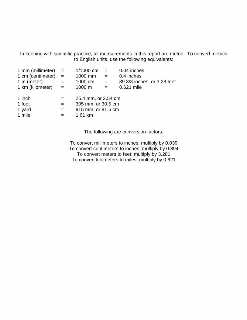
In keeping with scientific practice, all measurements in this report are metric. To convert metricsto English units, use the following equivalents:
1 mm (millimeter) = 1/1000 cm = 0.04 inches1 cm (centimeter) = 1000 mm = 0.4 inches1 m (meter) = 1000 cm = 39 3/8 inches, or 3.28 feet1 km (kilometer) = 1000 m = 0.621 mile
1 inch = 25.4 mm, or 2.54 cm1 foot = 305 mm, or 30.5 cm1 yard = 915 mm, or 91.5 cm1 mile = 1.61 km
The following are conversion factors:
To convert millimeters to inches: multiply by 0.039To convert centimeters to inches: multiply by 0.394
To convert meters to feet: multiply by 3.281To convert kilometers to miles: multiply by 0.621

TABLE OF CONTENTS
ABSTRACT . . . . . . . . . . . . . . . . . . . . . . . . . . . . . . . . . . . . . . . . . . . . . . . . . . . . . . . . . . . . . . . . . . . . . . . . . . . . . . . . . . . 1
INTRODUCTION . . . . . . . . . . . . . . . . . . . . . . . . . . . . . . . . . . . . . . . . . . . . . . . . . . . . . . . . . . . . . . . . . . . . . . . . . . . . . . . 1
LOWER CRETACEOUS STRATIGRAPHY . . . . . . . . . . . . . . . . . . . . . . . . . . . . . . . . . . . . . . . . . . . . . . . . . . . . . . . . . . 2Nomenclature History . . . . . . . . . . . . . . . . . . . . . . . . . . . . . . . . . . . . . . . . . . . . . . . . . . . . . . . . . . . . . . . . . . . . . 3Current Problem and Proposed Resolution . . . . . . . . . . . . . . . . . . . . . . . . . . . . . . . . . . . . . . . . . . . . . . . . . . . . 5Value of Proposed Nomenclature . . . . . . . . . . . . . . . . . . . . . . . . . . . . . . . . . . . . . . . . . . . . . . . . . . . . . . . . . . . 5
Cedar Mountain Formation . . . . . . . . . . . . . . . . . . . . . . . . . . . . . . . . . . . . . . . . . . . . . . . . . . . . . . . . . . . . . . . . . 6Definition and Description . . . . . . . . . . . . . . . . . . . . . . . . . . . . . . . . . . . . . . . . . . . . . . . . . . . . . . . . . . . 6Contacts . . . . . . . . . . . . . . . . . . . . . . . . . . . . . . . . . . . . . . . . . . . . . . . . . . . . . . . . . . . . . . . . . . . . . . . . . 7Geographic Distribution and Thickness . . . . . . . . . . . . . . . . . . . . . . . . . . . . . . . . . . . . . . . . . . . . . . . . 7Age . . . . . . . . . . . . . . . . . . . . . . . . . . . . . . . . . . . . . . . . . . . . . . . . . . . . . . . . . . . . . . . . . . . . . . . . . . . . . 8
San Pitch Formation . . . . . . . . . . . . . . . . . . . . . . . . . . . . . . . . . . . . . . . . . . . . . . . . . . . . . . . . . . . . . . . . . . . . . . 9Definition and Description . . . . . . . . . . . . . . . . . . . . . . . . . . . . . . . . . . . . . . . . . . . . . . . . . . . . . . . . . . . 9Member A . . . . . . . . . . . . . . . . . . . . . . . . . . . . . . . . . . . . . . . . . . . . . . . . . . . . . . . . . . . . . . . . . . . . . . . 10Member B . . . . . . . . . . . . . . . . . . . . . . . . . . . . . . . . . . . . . . . . . . . . . . . . . . . . . . . . . . . . . . . . . . . . . . . 10Member C . . . . . . . . . . . . . . . . . . . . . . . . . . . . . . . . . . . . . . . . . . . . . . . . . . . . . . . . . . . . . . . . . . . . . . 11Contacts . . . . . . . . . . . . . . . . . . . . . . . . . . . . . . . . . . . . . . . . . . . . . . . . . . . . . . . . . . . . . . . . . . . . . . . . 11Geographic Distribution and Thickness . . . . . . . . . . . . . . . . . . . . . . . . . . . . . . . . . . . . . . . . . . . . . . . 13Age . . . . . . . . . . . . . . . . . . . . . . . . . . . . . . . . . . . . . . . . . . . . . . . . . . . . . . . . . . . . . . . . . . . . . . . . . . . . 14
CONCLUSIONS . . . . . . . . . . . . . . . . . . . . . . . . . . . . . . . . . . . . . . . . . . . . . . . . . . . . . . . . . . . . . . . . . . . . . . . . . . . . . . . 17
ACKNOWLEDGMENTS . . . . . . . . . . . . . . . . . . . . . . . . . . . . . . . . . . . . . . . . . . . . . . . . . . . . . . . . . . . . . . . . . . . . . . . . 17
REFERENCES CITED . . . . . . . . . . . . . . . . . . . . . . . . . . . . . . . . . . . . . . . . . . . . . . . . . . . . . . . . . . . . . . . . . . . . . . . . . . 17
FIGURES
Figure 1. Distribution of Lower Cretaceous strata in central Utah . . . . . . . . . . . . . . . . . . . . . . . . . . . . . . . . . . . . . . . . 2Figure 2. History of nomenclature . . . . . . . . . . . . . . . . . . . . . . . . . . . . . . . . . . . . . . . . . . . . . . . . . . . . . . . . . . . . . . . . . 3Figure 3. Photograph of the type section of the San Pitch Formation . . . . . . . . . . . . . . . . . . . . . . . . . . . . . . . . . . . . . 6Figure 4. Isopach map of the Cedar Mountain Formation in central Utah . . . . . . . . . . . . . . . . . . . . . . . . . . . . . . . . . . 8Figure 5. Diagram of the type measured section, San Pitch Formation . . . . . . . . . . . . . . . . . . . . . . . . . . . . . . . . . . . . 9Figure 6. Diagram of the measured section at Chicken Creek . . . . . . . . . . . . . . . . . . . . . . . . . . . . . . . . . . . . . . . . . . 10Figure 7. Diagram of the measured section at upper Deep Creek of member C . . . . . . . . . . . . . . . . . . . . . . . . . . . . 11Figure 8. Diagram of the measured section at Little Salt Creek of members A and B . . . . . . . . . . . . . . . . . . . . . . . . 12Figure 9. Diagram of the measured section at Salina Canyon . . . . . . . . . . . . . . . . . . . . . . . . . . . . . . . . . . . . . . . . . . 13Figure 10. Correlation chart of Middle Jurassic (part) through Upper Cretaceous (part) strata . . . . . . . . . . . . . . . . . . 15Figure 11. North-south fence diagram of the Cedar Mountain and San Pitch Formations . . . . . . . . . . . . . . . . . . . . . 15Figure 12. Isopach map of the San Pitch Formation in central Utah . . . . . . . . . . . . . . . . . . . . . . . . . . . . . . . . . . . . . . 16Figure 13. Age of the Cedar Mountain and San Pitch Formations . . . . . . . . . . . . . . . . . . . . . . . . . . . . . . . . . . . . . . . . 16
TABLES
Table 1. Measured sections of the Cedar Mountain and San Pitch Formations . . . . . . . . . . . . . . . . . . . . . . . . . . . . . 19Table 2. Palynologic assemblage of the San Pitch Formation . . . . . . . . . . . . . . . . . . . . . . . . . . . . . . . . . . . . . . . . . . . 19
REDEFINING THE LOWER CRETACEOUS STRATIGRAPHYWITHIN THE CENTRAL UTAH FORELAND BASIN
byDouglas A. Sprinkel1, Malcolm P. Weiss2, Robert W. Fleming3, and Gerald L. Waanders4
ABSTRACT
Lower Cretaceous strata exposed in theforeland basin of central Utah were divided intotwo lithostratigraphic units, the Cedar Mountainand San Pitch Formations. Together theseformations correlate with both the Cedar MountainFormation exposed on the San Rafael Swell andthe lower part of the Canyon Range Conglomerateexposed in the Canyon Mountains.
The Cedar Mountain and San PitchFormations form an upward-coarseningsuccession of alluvial, fluvial, and lacustrine rocksthat become finer grained and thin southeastwardtoward the San Rafael Swell. The Cedar MountainFormation in central Utah consists of variegatedmudstone, conglomerate, pebbly sandstone, andminor lacustrine limestone. It thickenssoutheastward from a pinch-out near the WestHills to 188 m thick in Salina Canyon and thenthins to 50 m in the San Rafael Swell. The CedarMountain Formation in the San Rafael Swell isBarremian(?) to late Albian, but is no younger thanmiddle Albian in the Gunnison Plateau and vicinity. The overlying San Pitch Formation (a newformation and stratotype) consists ofconglomerate, sandstone, and mudstone. Wedivided it into three informal members based ongrain composition, bed geometry, and topographicexpression. The San Pitch Formation thinssouthward from over 1,100 m in the westernGunnison Plateau to about 85 m in Salina Canyon;from Salina Canyon it grades eastward into theupper unnamed member of the Cedar MountainFormation. The San Pitch Formation is middle tolate Albian; its lower age limit is defined by thepalynomorphs Asteropollis sp., Retitricolpitesgeorgensis, Callialasporites dampieri, andPilosisporites trichapapillosus. Its upper limit isbased on stratigraphic position and palynomorphsfrom the upper part of the Cedar MountainFormation in the San Rafael Swell and San PitchFormation in Salina Canyon.
INTRODUCTION
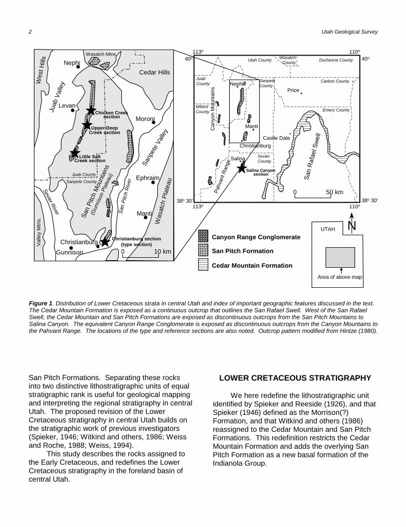
The Lower Cretaceous section of centralUtah consists of fluvial and lacustrine rocks thatwere deposited in a foreland basin along theSevier fold and thrust belt (Armstrong, 1968;DeCelles and others, 1995; Currie, 1997). Thesestrata crop out in the Canyon Mountains, PahvantRange, San Pitch Mountains (Gunnison Plateau isthe name used instead of the San Pitch Mountainsby many geologists), Salina Canyon, and the SanRafael Swell (figure 1); however, their regionalcorrelation has been the subject of muchspeculation. This study focuses on the LowerCretaceous strata exposed east of the CanyonMountains and the Pahvant Range. Fivemeasured sections in the Gunnison Plateau andSalina Canyon, and recovery of criticalpalynomorph assemblages are the basis for thecorrelation of the Lower Cretaceous strata. Mostof the measured sections and palynomorph datawere obtained from the Gunnison Plateau.
The Lower Cretaceous of central Utahconsists of conglomerate, sandstone, variegatedmudstone, and minor lacustrine limestone beds,and was first mentioned by Spieker and Reeside(1926). Subsequent stratigraphic studies incentral Utah intended to identify and correlatethese strata of late Early Cretaceous age have ledto different interpretations and names (Spieker,1946; Stokes, 1972; Fouch and others, 1982;Standlee, 1982; Fouch and others, 1983; Stuecheli and Collinson, 1984; Witkind and others,1986; Schwans, 1988; Weiss and Roche, 1988;Weiss, 1994). Figure 2 summarizes the majorchanges in nomenclature. We assign thesecontroversial strata to the Cedar Mountain and
1 Utah Geological Survey, PO Box 146100, Ste 3110, Salt Lake City, UT84114-6100
2 Dept. of Geological Sciences, University of California, Santa Barbara,CA 93106-9630
3 U.S. Geological Survey, MS-966, PO box 25046, Denver, CO 80225-0046
4 1611-C Rancho Santa Fe Road, San Marcos, CA 92069
2 Utah Geological Survey
Nephi
Levan
Moroni
Ephraim
Manti
Gunnison
Chicken Creeksection
Upper DeepCreek section
Little SaltCreek section
Christianburg section(type section)
40o110o
38o 30'
113o
40o
38o 30'113o 110o
San
Raf
ael S
well
Can
yon
Mou
ntai
ns
Castle Dale
Pahv
ant R
ange
0 50 km
San Pitch Formation
Cedar Mountain Formation
Canyon Range Conglomerate
����������
��������
��������������
����
���������������
����������������������
Manti
Nephi
���������������������������������
����
��������
������������������������������������������������������������������������������������������
���������������������������
��������������������
������������������������
�����������������
���
������������������������������������������������������������������������������������������������������������������������������������������������������������������������������������������������������������������������������������������������������������������������������������������������������������������������������������������������������������������������������������������������������������������������������������������������������������������������������������������������������������������������������������������������������������������������������������������������������������������������������������������������������������������������������������������������������������������������������������������������������������������������������������������������������������������������������������������������������������������������������������������������������������������������������������������������������������������������������������������������������������������������������������������������������
��������������
����������
����������������������������������� �����
����������������������
��������
������������
������������������
��������������������������������
����������
�����
����������������������
���������������������������������������������
����������������
������������������������
������������
��������������������������������������������������������������������������������������������������������
�����������������������������������
����������������������
0 10 km
Juab CountySanpete County
Salina Canyonsection
Price
Salina
Christianburg
N������������������������������������������������������������������������������������������������������������
San
Pitc
h R
iver
Sanp
ete
Valle
yW
asat
ch P
late
au
Cedar Hills
Wes
t Hills
Wasatch Mtns.
Valle
y M
tns.
Sevier River
San
Pitc
h M
ount
ains
(Gun
niso
n Pl
atea
u)
Christianburg
Juab
Val
ley Sanpete
County
Sevier County
Juab County
Millard County Emery County
Carbon County
Wasatch County Duchesne CountyUtah County
UTAH
Area of above map
Figure 1. Distribution of Lower Cretaceous strata in central Utah and index of important geographic features discussed in the text.The Cedar Mountain Formation is exposed as a continuous outcrop that outlines the San Rafael Swell. West of the San RafaelSwell, the Cedar Mountain and San Pitch Formations are exposed as discontinuous outcrops from the San Pitch Mountains toSalina Canyon. The equivalent Canyon Range Conglomerate is exposed as discontinuous outcrops from the Canyon Mountains tothe Pahvant Range. The locations of the type and reference sections are also noted. Outcrop pattern modified from Hintze (1980).
San Pitch Formations. Separating these rocksinto two distinctive lithostratigraphic units of equalstratigraphic rank is useful for geological mappingand interpreting the regional stratigraphy in centralUtah. The proposed revision of the LowerCretaceous stratigraphy in central Utah builds on the stratigraphic work of previous investigators(Spieker, 1946; Witkind and others, 1986; Weissand Roche, 1988; Weiss, 1994).
This study describes the rocks assigned tothe Early Cretaceous, and redefines the LowerCretaceous stratigraphy in the foreland basin ofcentral Utah.
LOWER CRETACEOUS STRATIGRAPHY
We here redefine the lithostratigraphic unitidentified by Spieker and Reeside (1926), and thatSpieker (1946) defined as the Morrison(?)Formation, and that Witkind and others (1986)reassigned to the Cedar Mountain and San PitchFormations. This redefinition restricts the CedarMountain Formation and adds the overlying SanPitch Formation as a new basal formation of theIndianola Group.
Redefining the Lower Cretaceous 3
This Report
Indi
anol
a G
roup
(par
t)
San
Pitc
h Fo
rmat
ion
Sanp
ete
Form
atio
n
Cedar Mountain Formation
Twist Gulch
Formation
Weiss and Roche1988; Weiss 1994
Indi
anol
a G
roup
(par
t)
unna
med
bas
al u
nit
Sanp
ete
Form
atio
n
Cedar Mountain Formation
Twist Gulch
Formation
Schwans
1988In
dian
ola
Gro
up (p
art)
uppe
r mem
ber
Sanp
ete
Form
atio
nlo
wer
m
embe
r
Twist Gulch
Formation
Pige
on C
reek
For
mat
ion
Witkind, Standlee, and Maley 1986
Witkind-Maley Standlee
Indi
anol
a G
roup
(par
t) Sanp
ete
Form
atio
n
Indi
anol
a G
roup
(par
t)
Sanp
ete
Form
atio
n
Ced
ar
Mou
ntai
n Fo
rmat
ion
(low
er
unit)
uppe
r uni
t
Ced
ar M
ount
ain
Form
atio
n
Twist Gulch Formation
Stokes
1972
Indi
anol
a G
roup
(par
t)
Sanp
ete
Form
atio
n
Ced
ar M
ount
ain
Form
atio
n
Twist Gulch
Formation
Spieker
1946
Indi
anol
a G
roup
(par
t)
Sanp
ete
Form
atio
n
Mor
rison
(?) F
orm
atio
n
Twist Gulch
Formation
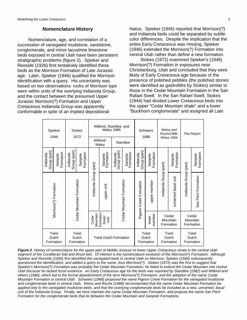
Figure 2. History of nomenclature for the upper part of Middle Jurassic to lower Upper Cretaceous strata in the central Utahsegment of the Cordilleran fold and thrust belt. Of interest is the nomenclature evolution of the Morrison(?) Formation. AlthoughSpieker and Reeside (1926) first identified the variegated beds in central Utah as Morrison, Spieker (1946) subsequentlyquestioned the identification, and added a query to the name, thus Morrison(?). Stokes (1972) was the first to suggest thatSpieker’s Morrison(?) Formation was probably the Cedar Mountain Formation; he failed to extend the Cedar Mountain into centralUtah because he lacked fossil evidence. An Early Cretaceous age for the beds was reported by Standlee (1982) and Witkind andothers (1986), which led to the formal abandonment of the term Morrison(?) Formation, and the adoption of the name CedarMountain Formation in central Utah. Schwans (1988) proposed the name Pigeon Creek Formation for the variegated mudstoneand conglomerate beds in central Utah. Weiss and Roche (1988) recommended that the name Cedar Mountain Formation beapplied only to the variegated mudstone beds, and that the overlying conglomerate beds be included as a new, unnamed, basalunit of the Indianola Group. Finally, we here maintain the name Cedar Mountain Formation, and propose the name San PitchFormation for the conglomerate beds that lie between the Cedar Mountain and Sanpete Formations.
Nomenclature History
Nomenclature, age, and correlation of asuccession of variegated mudstone, sandstone,conglomerate, and minor lacustrine limestonebeds exposed in central Utah have been persistentstratigraphic problems (figure 2). Spieker andReeside (1926) first tentatively identified thesebeds as the Morrison Formation of Late Jurassicage. Later, Spieker (1946) qualified the Morrisonidentification with a query. His uncertainty wasbased on two observations: rocks of Morrison typewere within units of the overlying Indianola Group,and the contact between the presumed UpperJurassic Morrison(?) Formation and UpperCretaceous Indianola Group was apparentlyconformable in spite of an implied depositional
hiatus. Spieker (1946) reported that Morrison(?)and Indianola beds could be separated by subtlecolor differences. Despite the implication that theentire Early Cretaceous was missing, Spieker(1946) extended the Morrison(?) Formation intocentral Utah rather than define a new formation.
Stokes (1972) examined Spieker's (1946)Morrison(?) Formation in exposures nearChristianburg, Utah and concluded that they werelikely of Early Cretaceous age because of thepresence of polished pebbles (the polished stoneswere identified as gastroliths by Stokes) similar tothose in the Cedar Mountain Formation in the SanRafael Swell. In the San Rafael Swell, Stokes(1944) had divided Lower Cretaceous beds intothe upper "Cedar Mountain shale" and a lower"Buckhorn conglomerate" and assigned all Late

4 Utah Geological Survey
Jurassic beds to the Morrison Formation. Stokes(1952) subsequently reaffirmed the name CedarMountain Formation, even as he relegated theBuckhorn conglomerate to member statusbecause of its discontinuous distribution. Stokes(1972) suggested that the beds mapped bySpieker (1946) as Morrison(?) Formation in centralUtah really represented rocks of the LowerCretaceous Cedar Mountain Formation; however,Stokes (1972) did not formally propose anomenclature change because of the lack of fossilevidence to confirm an Early Cretaceous age incentral Utah.
Fossil and radiometric data finally confirmedthat rocks of Early Cretaceous age are in centralUtah. Standlee (1982) reported palynomorphs oflate Early Cretaceous age in rocks from anunspecified location in Chicken Creek, in thenorthwestern part of the Gunnison Plateau. Standlee (1982) subsequently applied the nameCedar Mountain Formation to the conglomeraticlithofacies of the Morrison(?) Formation in theGunnison Plateau. Willis and Kowallis (1988)obtained an Albian age from zircon- and apatite-bearing bentonite beds collected from strataidentified as Morrison(?) Formation in lower SalinaCanyon, which they redefined as the CedarMountain Formation. Evidence of an EarlyCretaceous age for the Morrison(?) Formationnear Christianburg was provided by Stuecheli(1984) and Stuecheli and Collinson (1984). Stuecheli (1984) measured three stratigraphicsections through the Morrison(?) Formationimmediately north of the Christianburg area andfound beds that contained a bivalve and leafimpressions of late Early Cretaceous age. Despitethe Early Cretaceous age for these strata, they didnot propose a change in nomenclature.
Witkind, Standlee, and Maley (1986) firstrecommended formal abandonment of the nameMorrison(?) Formation in central Utah. Theyreassigned the Morrison(?) strata exposed nearChristianburg to the Lower Cretaceous CedarMountain Formation, based on striking lithologicsimilarity (particularly the presence of the"polished stones," calcareous nodules, anduncommon oncolites found in the CedarMountain), stratigraphic position, and palynologicage control. They divided the Cedar Mountain intotwo informal lithologic units; a lower unit consistingmostly of variegated calcareous mudstone bedsand an upper unit consisting mostly of
conglomerate beds. Witkind and his co-authorsagreed that the lower (variegated mudstone) andupper (conglomerate) units are not part of theMorrison Formation as exposed on the San RafaelSwell, and that the lower unit correlates with unitsthat form the upper unnamed member of theCedar Mountain Formation exposed in the SanRafael Swell; however, they disagreed on thenomenclature of the upper unit (figure 2). Standlee (Witkind and others, 1986) favored aninterpretation that included the upper unit as anewly recognized lithofacies of the CedarMountain Formation, based on the EarlyCretaceous age of palynomorphs recovered fromthin mudstone beds in the Gunnison Plateau. Witkind and Maley (Witkind and others, 1986)favored including the upper unit in the overlyingIndianola Group, thus making it a new basal unitthat extends the age of the Indianola Group intothe Early Cretaceous. Witkind and Maley (Witkindand others, 1986) were influenced by the lithologicsimilarity of the conglomerate beds in the upperunit to the widespread conglomerate beds in theIndianola Group, and by the distinctive changefrom mudstone to conglomerate that provides aneasily recognizable contact for mapping purposes.
Schwans (1988) examined the Morrison(?)Formation exposed in central Utah as part of aregional sedimentologic and sequencestratigraphic study. He recognized that the rocktypes exposed near Christianburg are similar tobeds exposed elsewhere in the Gunnison Plateau. He also recognized that beds included in theJurassic Twist Gulch by Spieker (1946; 1949),Hunt (1950), and Hardy and Zeller (1953) werealso similar to beds of the Morrison(?) Formationnear Christianburg. To define formally the LowerCretaceous strata exposed in the GunnisonPlateau and place them in their correct time-stratigraphic position, Schwans (1988) abandonedthe name Morrison(?) Formation and proposed thename Pigeon Creek Formation (figure 2) withstratotype exposures along Pigeon Creek, the firstdrainage north of Chicken Creek and east ofLevan, Utah. He defined the formation to reflectthe significance of unconformity-bounded unitsand their regional sequence-stratigraphicimplications. Schwans (1988) divided the PigeonCreek Formation into two distinct lithologic unitsmuch as Witkind and others (1986) did in theChristianburg area: a lower member that consistspredominantly of red mudstone with variable

Redefining the Lower Cretaceous 5
amounts of conglomerate and subordinatelacustrine limestone, and an upper member thatconsists predominantly of conglomerate beds withintercalated red mudstone.
Even as Schwans (1988) proposed thesechanges, Weiss and Roche (1988) discussed thestratigraphic problem of Spieker's (1946)Morrison(?) Formation. They also recommendedthat the name Morrison(?) Formation (in any form)be abandoned in the Gunnison Plateau andsurrounding area and proposed that the nameCedar Mountain Formation be restricted to thevariegated mudstone beds with the distinctivepolished stones (gastroliths), calcareous nodules,and oncolites (figure 2). Weiss and Roche (1988)assigned the overlying conglomerate beds to theIndianola Group as an unnamed basal unitunderlying the Sanpete Formation, formerlyconsidered the basal formation of the IndianolaGroup (Spieker, 1946). Weiss and Roche (1988)argued that the name Cedar Mountain Formationbe used in the Gunnison Plateau region becauseof lithologic similarities to the upper unnamedmember of the Cedar Mountain Formationexposed in the San Rafael Swell.
Current Problem and Proposed Resolution
Each of the previously described studiescontributed significantly toward understanding thebeds grouped as the Morrison(?) Formation incentral Utah. Although the age of these beds isknown and accepted, contradictions in correlationand nomenclature still exist.
We divide the Lower Cretaceous section incentral Utah into two lithostratigraphic units. Thename Cedar Mountain Formation is assigned tothe predominantly variegated calcareousmudstone beds that Witkind and others (1986)assigned to the lower unit of the Cedar MountainFormation, and that Weiss and Roche (1988), andthat Weiss (1994) assigned to the Cedar MountainFormation, and that Schwans (1988) defined asthe lower member of the Pigeon Creek Formation(figure 2). A new name, the San Pitch Formation,is assigned to the overlying predominantlyconglomerate beds that Witkind and Maley(Witkind and others, 1986) named the upper unitand assigned to the Indianola Group and thatStandlee (Witkind and others, 1986) assigned tothe Cedar Mountain Formation, and that Weiss
and Roche (1988), and that Weiss (1994) calledthe unnamed basal unit of the Indianola Group,and that Schwans (1988) defined as the uppermember of the Pigeon Creek Formation. Thename San Pitch Formation is taken from the SanPitch River that drains the Sanpete Valley. Thetype locality is near Christianburg, Utah andreference sections are at Chicken Creek, DeepCreek, Little Salt Creek, and Salina Canyon (figure1; table 1). Although Christianburg is not found onmodern topographic maps, the farming communitystill exists. Christianburg is at the extremesouthernmost part of the Gunnison Plateauroughly 16 km southwest of Manti, Utah, and 5 kmwest of Gunnison, Utah. We prefer to use thename Christianburg for the type section becauseof its proximity to the farming community ofChristianburg, which is known in the geologicliterature (Spieker, 1949).
Combining these distinctive lithostratigraphicunits into a single formation as proposed byStandlee (Witkind and others, 1986) and bySchwans (1988) is inappropriate because it woulddisregard one of the most easily mapped contactsin central Utah.
Value of Proposed Nomenclature
Adoption of the stratigraphic nomenclatureproposed in the previous section providesgeologists with a recognizable marker both in thesurface and subsurface. Separation of the twoformations also gives geologists a means to mapstructural complexities, to analyze thesedimentologic response to thrusting, and toestablish a temporal relationship of deformation inthe central Utah foreland basin.
Geologists working in central Utah recentlyproved the value of the proposed LowerCretaceous correlation. Sprinkel (1994)recognized the Cedar Mountain Formation inexploratory wells drilled in central Utah. Heestablished a subsurface correlation from JuabValley and the Gunnison Plateau across SanpeteValley and the Wasatch Plateau to the westernpart of the San Rafael Swell. Geologic mapping inand around the Gunnison Plateau (Hunt, 1950;Auby, 1991; Banks, 1991; Biek, 1991; Lawton andWeiss, 1994; Weiss, 1994; Fong, 1995) wasimproved by utilizing the contact that separatesthe variegated mudstone beds from the overlying
6 Utah Geological Survey
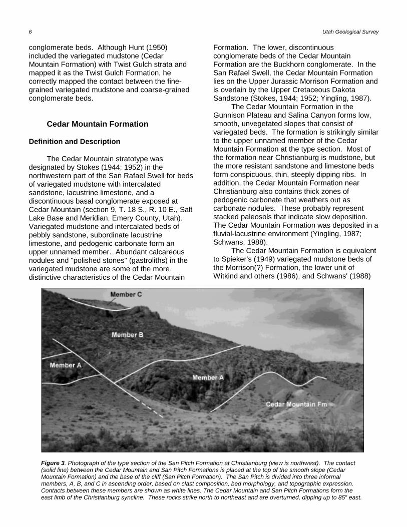
Figure 3. Photograph of the type section of the San Pitch Formation at Christianburg (view is northwest). The contact(solid line) between the Cedar Mountain and San Pitch Formations is placed at the top of the smooth slope (CedarMountain Formation) and the base of the cliff (San Pitch Formation). The San Pitch is divided into three informalmembers, A, B, and C in ascending order, based on clast composition, bed morphology, and topographic expression. Contacts between these members are shown as white lines. The Cedar Mountain and San Pitch Formations form theeast limb of the Christianburg syncline. These rocks strike north to northeast and are overturned, dipping up to 85o east.
conglomerate beds. Although Hunt (1950)included the variegated mudstone (CedarMountain Formation) with Twist Gulch strata andmapped it as the Twist Gulch Formation, hecorrectly mapped the contact between the fine-grained variegated mudstone and coarse-grainedconglomerate beds.
Cedar Mountain Formation
Definition and Description
The Cedar Mountain stratotype wasdesignated by Stokes (1944; 1952) in thenorthwestern part of the San Rafael Swell for bedsof variegated mudstone with intercalatedsandstone, lacustrine limestone, and adiscontinuous basal conglomerate exposed atCedar Mountain (section 9, T. 18 S., R. 10 E., SaltLake Base and Meridian, Emery County, Utah). Variegated mudstone and intercalated beds ofpebbly sandstone, subordinate lacustrinelimestone, and pedogenic carbonate form anupper unnamed member. Abundant calcareousnodules and "polished stones" (gastroliths) in thevariegated mudstone are some of the moredistinctive characteristics of the Cedar Mountain
Formation. The lower, discontinuousconglomerate beds of the Cedar MountainFormation are the Buckhorn conglomerate. In theSan Rafael Swell, the Cedar Mountain Formationlies on the Upper Jurassic Morrison Formation andis overlain by the Upper Cretaceous DakotaSandstone (Stokes, 1944; 1952; Yingling, 1987).
The Cedar Mountain Formation in theGunnison Plateau and Salina Canyon forms low,smooth, unvegetated slopes that consist ofvariegated beds. The formation is strikingly similarto the upper unnamed member of the CedarMountain Formation at the type section. Most ofthe formation near Christianburg is mudstone, butthe more resistant sandstone and limestone bedsform conspicuous, thin, steeply dipping ribs. Inaddition, the Cedar Mountain Formation nearChristianburg also contains thick zones ofpedogenic carbonate that weathers out ascarbonate nodules. These probably representstacked paleosols that indicate slow deposition. The Cedar Mountain Formation was deposited in afluvial-lacustrine environment (Yingling, 1987;Schwans, 1988).
The Cedar Mountain Formation is equivalentto Spieker's (1949) variegated mudstone beds ofthe Morrison(?) Formation, the lower unit ofWitkind and others (1986), and Schwans' (1988)
Redefining the Lower Cretaceous 7
lower member of the Pigeon Creek Formation. Measured sections of the Cedar MountainFormation in the Gunnison Plateau and SalinaCanyon are hereby designated as referencesections for central Utah (figure 1; table 1). Additional measured sections of the CedarMountain Formation are described in Stuecheli(1984), Roche (1985), Yingling (1987), Schwans(1988), and Weiss and Roche (1988).
Contacts
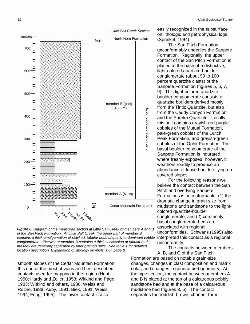
The lower contact unconformably separatesthe fluvial-lacustrine beds of the Lower CretaceousCedar Mountain Formation from the underlyingfluvial-lacustrine beds of the Upper JurassicMorrison Formation in the San Rafael Swell(Stokes, 1952; Yingling, 1987). West of the SanRafael Swell, the Cedar Mountain Formationunconformably overlies the marginal marine bedsof the Middle Jurassic Twist Gulch Formation(Willis, 1986; Willis and Kowallis, 1988; Auby,1991; Banks, 1991; Biek, 1991; Lawton andWeiss, 1994; Sprinkel, 1994; Weiss, 1994). Thus,near Salina Canyon and the Gunnison Plateau,Upper Jurassic strata were either not deposited orwere eroded prior to deposition of LowerCretaceous strata (Sprinkel, 1994). This impliesthat a regional topographic high existed oremerged during Late Jurassic time. In Little SaltCreek, the unconformable contact between CedarMountain and underlying Twist Gulch is angular,although this may be a local feature. A basalconglomerate with interbedded sandstone of theCedar Mountain Formation dips about 20o lessthan the underlying fine-grained, reddish-orangesandstone beds of the Twist Gulch. At ChickenCreek, the base of the Cedar Mountain Formationis placed above a conspicuous 2-m interval of fine-grained, reddish-orange sandstone with horizontallaminae and parting lineation. No basal conglomerate or angular relation was observed atChicken Creek.
Near Christianburg, the lower contact of theCedar Mountain is generally covered; however,where exposed the Cedar Mountains is in faultcontact with the Middle Jurassic Arapien Shale(Weiss, 1994). A few hundred meters north of theexposures near Christianburg, small outcrops ofTwist Gulch, a few meters thick, underlie theCedar Mountain Formation (Weiss, 1994).
The upper contact conformably separatesthe Cedar Mountain Formation from the newlydefined San Pitch Formation. Near Christianburg,the contact is well exposed, sharp, and is at thebase of a prominent cliff (figure 3). The contact isplaced at the base of the lowest thick, reddish-brown conglomerate and above the massive, redand gray mudstone of the Cedar Mountain. AtPigeon Creek (the next drainage north of ChickenCreek), the upper contact is at the base of the firstcobble conglomerate, Schwans (1988), however,placed the contact between his lower and uppermembers of the Pigeon Creek Formation along afault. Similarly, the contact between the San Pitchand Cedar Mountain Formations lies at the base ofthe first conglomerate bed in Chicken Creek. As aresult, the Cedar Mountain Formation is about 100m thinner there than Schwans' (1988) lowermember of the Pigeon Creek Formation.
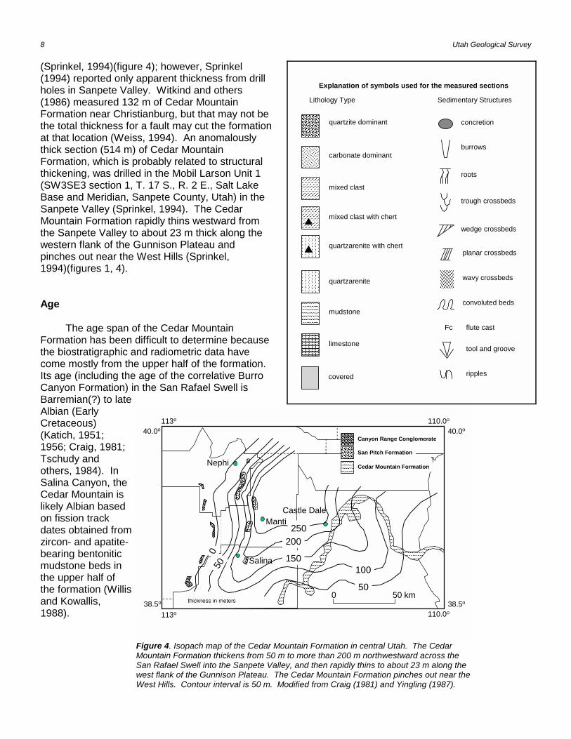
Geographic Distribution and Thickness
The Cedar Mountain Formation forms acontinuous belt of exposures around the flanks ofthe San Rafael Swell (figure 1). Westward fromthe San Rafael Swell, it passes beneath theWasatch Plateau and reappears as adiscontinuous belt of outcrops and isolatedexposures along the margins of the GunnisonPlateau and at the western margin of the WasatchPlateau in Salina Canyon (Hintze, 1980; Jefferson,1982; Stuecheli, 1984; Roche, 1985; Willis, 1986;Witkind and others, 1987; Hintze, 1988; Schwans,1988; Weiss and Roche, 1988; Witkind, 1988;Auby, 1991; Biek, 1991; Lawton and Weiss, 1994;Weiss, 1994). The Cedar Mountain Formationalso crops out at Monks Hollow and BilliesMountain near Thistle, Utah, about 100 km northto northwest of Christianburg (Pinnell, 1972;Young, 1976; Witkind and Page, 1983). Insubsurface drill-hole data, the Cedar MountainFormation can be traced westward from theWasatch Plateau and Sanpete Valley to theGunnison Plateau and Juab Valley (Sprinkel,1994). The Cedar Mountain Formationthickens northwestward across the San RafaelSwell from 50 m to 160 m (Craig, 1981; Yingling,1987)(figure 4). It continues to thicken slightlynorth and northwestward from about 188 m inSalina Canyon to a maximum thickness of a littlemore than 200 m under the Sanpete Valley
8 Utah Geological Survey
Nephi
Manti
40.0o110.0o
38.5o
113o
40.0o
38.5o
113o 110.0o
Salina
Castle Dale
��������
������
����������������
��������������
������������
������������������������������������������������������������������������������������������������������������������������������������������������������������������������������������������������������������������������������������������������������������������������������������������������������������������������������������������������������������������������������������������������������������������������������������������������������������������������������������������������������������������������������������������������������������������������������������������������������������������������������������������������������������������������������������������������������������������������������������������������������������������������������������������������������������������������������������������������������������������������������������������������������������������������������������������������������������������������������������������������������������������������������������������������������������������������������������������������
����������
��������
������������������������
������
������
��������
��������
���������������������������
���
0 50 km
San Pitch Formation
Cedar Mountain Formation
Canyon Range Conglomerate
��������������������
��������������������
��������������������
250200
150100
50
500
thickness in meters
Figure 4. Isopach map of the Cedar Mountain Formation in central Utah. The CedarMountain Formation thickens from 50 m to more than 200 m northwestward across theSan Rafael Swell into the Sanpete Valley, and then rapidly thins to about 23 m along thewest flank of the Gunnison Plateau. The Cedar Mountain Formation pinches out near theWest Hills. Contour interval is 50 m. Modified from Craig (1981) and Yingling (1987).
Explanation of symbols used for the measured sections
Lithology Type Sedimentary Structures
concretion
burrows
roots
trough crossbeds
planar crossbeds���������������������������
wavy crossbeds
Fc flute cast
tool and groove
ripples
wedge crossbeds
convoluted beds
carbonate dominant
quartzite dominant
������������������������������������������������������������
mixed clast
������������������������������
quartzarenite
������������������������������
mudstone
������������������������������
limestone
������������������������������
quartzarenite with chert
������������������������������
mixed clast with chert
������������������������������
covered
(Sprinkel, 1994)(figure 4); however, Sprinkel(1994) reported only apparent thickness from drillholes in Sanpete Valley. Witkind and others(1986) measured 132 m of Cedar MountainFormation near Christianburg, but that may not bethe total thickness for a fault may cut the formationat that location (Weiss, 1994). An anomalouslythick section (514 m) of Cedar MountainFormation, which is probably related to structuralthickening, was drilled in the Mobil Larson Unit 1(SW3SE3 section 1, T. 17 S., R. 2 E., Salt LakeBase and Meridian, Sanpete County, Utah) in theSanpete Valley (Sprinkel, 1994). The CedarMountain Formation rapidly thins westward fromthe Sanpete Valley to about 23 m thick along thewestern flank of the Gunnison Plateau andpinches out near the West Hills (Sprinkel,1994)(figures 1, 4).
Age
The age span of the Cedar MountainFormation has been difficult to determine becausethe biostratigraphic and radiometric data havecome mostly from the upper half of the formation.Its age (including the age of the correlative BurroCanyon Formation) in the San Rafael Swell isBarremian(?) to lateAlbian (EarlyCretaceous)(Katich, 1951;1956; Craig, 1981;Tschudy andothers, 1984). InSalina Canyon, theCedar Mountain islikely Albian basedon fission trackdates obtained fromzircon- and apatite-bearing bentoniticmudstone beds inthe upper half ofthe formation (Willisand Kowallis,1988).
Redefining the Lower Cretaceous 9
Christianburg Section
member C(43.9 m)
member B(96.3 m)
member A(56.7 m)
Sanpete Fm. (part)
Cedar MountainFormation
San
Pitc
h Fo
rmat
ion
pebble
cobble
boulder
��������������������������������������������������������������������������������������������������������������������������������������������������������������������������������������������������������������������������������������������
�����������������������������������������������������������������������������������������������������������������������������������������������������������������������������������������������������������������������������������������������������������������������������������������������������������������������������������������������������������������������������������������������������������������������������������������������������������������
��������������������������������������������������������������������������������������������������������������������������������������������������������������������������������������������������������������������������������������������������������������������������������������������������
���������������������������������������������������������������������������������������������������������������������������������������������������������������
����������������������������������������������������������������������������������������������������������������������������������������������������������������������������
����������������������������������������������������������������������������������������������������������
������������������������������������������������������
���������������������������������������������������������������������������������������������������������������������������������������������������������������������������������������������
���������������������������������������������������������������������������������������������������������������������������������������������������������������������������������������������
������������������������������������������������������
��������������������������
��������������������������������������������������������������������������������
�����������������������������������������������������������������������������������������������������������������������
��������������������������������������������������������������������������������
���������������������������������������
mudsand
����������������������������������������������������������������������������������������������������������������������������������������������������������������������������������������������������������������������������������������������������������������������������������������������������������������������������������������������������������������������������������������������������������������������������������������������������������������������������������������������������������������������������������������������������������������������������������������������������������������������������������������������������������
Arapien Shale (part)
meters
100
200
300
0
����������
Fc
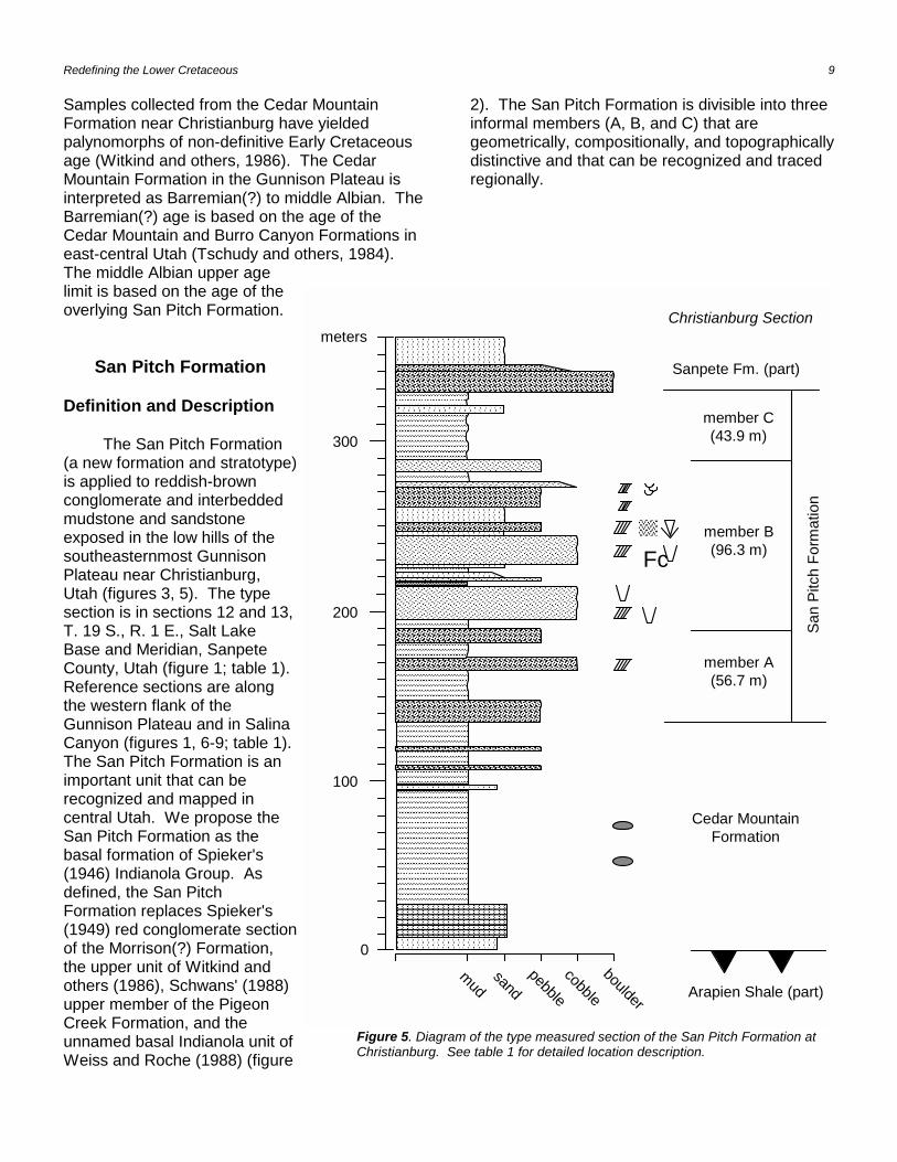
Figure 5. Diagram of the type measured section of the San Pitch Formation atChristianburg. See table 1 for detailed location description.
Samples collected from the Cedar MountainFormation near Christianburg have yieldedpalynomorphs of non-definitive Early Cretaceousage (Witkind and others, 1986). The CedarMountain Formation in the Gunnison Plateau isinterpreted as Barremian(?) to middle Albian. TheBarremian(?) age is based on the age of theCedar Mountain and Burro Canyon Formations ineast-central Utah (Tschudy and others, 1984). The middle Albian upper agelimit is based on the age of theoverlying San Pitch Formation.
San Pitch Formation
Definition and Description
The San Pitch Formation(a new formation and stratotype)is applied to reddish-brownconglomerate and interbeddedmudstone and sandstoneexposed in the low hills of thesoutheasternmost GunnisonPlateau near Christianburg,Utah (figures 3, 5). The typesection is in sections 12 and 13,T. 19 S., R. 1 E., Salt LakeBase and Meridian, SanpeteCounty, Utah (figure 1; table 1).Reference sections are alongthe western flank of theGunnison Plateau and in SalinaCanyon (figures 1, 6-9; table 1). The San Pitch Formation is animportant unit that can berecognized and mapped incentral Utah. We propose theSan Pitch Formation as thebasal formation of Spieker's(1946) Indianola Group. Asdefined, the San PitchFormation replaces Spieker's(1949) red conglomerate sectionof the Morrison(?) Formation,the upper unit of Witkind andothers (1986), Schwans' (1988)upper member of the PigeonCreek Formation, and theunnamed basal Indianola unit ofWeiss and Roche (1988) (figure
2). The San Pitch Formation is divisible into threeinformal members (A, B, and C) that aregeometrically, compositionally, and topographicallydistinctive and that can be recognized and tracedregionally.

10 Utah Geological Survey
Chicken Creek Section
mudsand
pebble
cobbleboulder
����������������������������������������������������������������������������������������������
����������������������������������������������������������������������������������������������������������������������������������������������������������������������������������������������������������������������������������������������������������������������������������������������������������������������������������������������������������������������������������������������������������
����������������������������������������������������������������������������������������������������������������������������������������������������������������������������������������������
������������������������������������������������������������������������������������������������������������������������������������������������������
�����������������������������������������������
���������������������������������������������������������������������������������������������������������������������������������������������
������������������������������������������������������������������������������������������������������������������
������������������������������������������������������������������������������������������������������������������������������������������������������������������������������������������������������������������������������������������������������������������������������������������������������������
����������������������������������������
����������������������������������������
��������������������������������������������������������������������������������
�����������������������������
�����������������������������
member C(294.7 m)
member B(670.7 m)
member A(150.9 m)
Allen Valley Shale (equivalent)Sanpete Formation (equivalent)
Cedar Mountain Fm(23 m)
San
Pitc
h Fo
rmat
ion
100
200
300
400
500
600
700
800
900
1000
1100
1200
0
meters
Funk Valley Fm. (equivalent) (part)
�����������������������������������������������
Figure 6. Diagram of the measured section at Chicken Creek of the Cedar Mountain andSan Pitch Formations. See table 1 for detailed location description. Explanation oflithology symbols is on page 8.
Member A
Member A consists of cobble and pebbleconglomerate interbedded with calcareous tononcalcareous mudstone (figures 5, 6, 8). Theconglomerate is thick to medium bedded withchannel-form geometry and subtle, large-scale,trough cross-stratification. The conglomerate isclast supported and cemented with a reddish-brown calcareous matrix. Clasts within the
conglomerate beds consist ofrounded to subrounded quartziteand carbonates (about 50percent quartzite and 45 percentcarbonate). Member A alsocontains white and grayish-redsandstone and siltstone clasts(about 5 percent). The quartziteclasts are Late Proterozoic toCambrian in age and includewhite to light gray varieties fromthe Caddy Canyon Quartzite(Late Proterozoic), purple tobanded purple varieties from theMutual Formation (LateProterozoic), and very paleorange to pinkish varieties from theTintic Quartzite (Cambrian). Pale-green quartzite andgrayish-green quartzosesandstone clasts are alsoincluded in member A and arederived from the Dutch PeakFormation (Late Proterozoic)and the Ophir Formation(Cambrian), respectively. Clastsderived from the OphirFormation weather to a grayishred purple and grayish olivegreen, but are grayish green ona fresh surface. The Ophirclasts contain coarse sand-sizedquartz, muscovite, andglauconite. Other sandstoneand siltstone clasts identified inmember A were probablyderived from Triassic andJurassic formations.
Member B
Member B consists of cobble and boulderconglomerate interbedded with sandstone andmudstone (figures 5, 6, 8) and forms distinctivestacked tabular beds. Many of the conglomeratebeds in member B contain carbonate-cobbleconglomerate (nearly 100 percent carbonate),which is not common in members A and C. Carbonate clasts are mostly dolostone cementedin a dolomite to dolomitic matrix. This
Redefining the Lower Cretaceous 11
Upper Deep Creek Section
���������������������������������������������������������������������������������������������������������������������������������
��������������������������������������������������������������������������������������
�����������������������������������������������������������������������������������������������������������������������������������������������������������������������������������������������������������������������
�������������������������������������������������������������������������������������������������������������������������������������������������������������������������������������������������������������������������������������������������������������������������������������������������������������������������������������������������������������������
������������������������������������������������������������������������������������������������������������������������������������������������������������������������������������������������������������������������������������������������������������������������������������������������������������������������������������������������������������������������������������������������������������������������������������������������������������������������
��������������������������
�������������������������������������������������������������
��������������������������������������������������������������������������������������������������������
mudsand
pebblecobble
boulder
Sanpete Formation (part)meters
100
200
300
400
0
450
member C(443 m)
member B (part)
San
Pitc
h Fo
rmat
ion
(par
t)
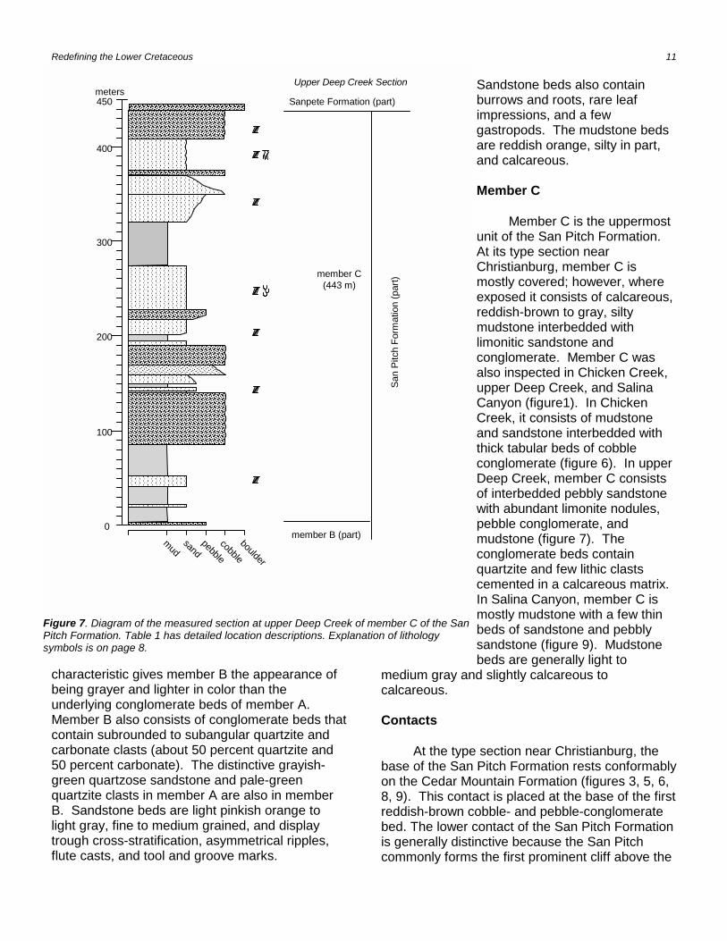
Figure 7. Diagram of the measured section at upper Deep Creek of member C of the SanPitch Formation. Table 1 has detailed location descriptions. Explanation of lithologysymbols is on page 8.
characteristic gives member B the appearance ofbeing grayer and lighter in color than theunderlying conglomerate beds of member A. Member B also consists of conglomerate beds thatcontain subrounded to subangular quartzite andcarbonate clasts (about 50 percent quartzite and50 percent carbonate). The distinctive grayish-green quartzose sandstone and pale-greenquartzite clasts in member A are also in memberB. Sandstone beds are light pinkish orange tolight gray, fine to medium grained, and displaytrough cross-stratification, asymmetrical ripples,flute casts, and tool and groove marks.
Sandstone beds also containburrows and roots, rare leafimpressions, and a fewgastropods. The mudstone bedsare reddish orange, silty in part,and calcareous.
Member C
Member C is the uppermostunit of the San Pitch Formation. At its type section nearChristianburg, member C ismostly covered; however, whereexposed it consists of calcareous,reddish-brown to gray, siltymudstone interbedded withlimonitic sandstone andconglomerate. Member C wasalso inspected in Chicken Creek,upper Deep Creek, and SalinaCanyon (figure1). In ChickenCreek, it consists of mudstoneand sandstone interbedded withthick tabular beds of cobbleconglomerate (figure 6). In upperDeep Creek, member C consistsof interbedded pebbly sandstonewith abundant limonite nodules,pebble conglomerate, andmudstone (figure 7). Theconglomerate beds containquartzite and few lithic clastscemented in a calcareous matrix. In Salina Canyon, member C ismostly mudstone with a few thinbeds of sandstone and pebblysandstone (figure 9). Mudstonebeds are generally light to
medium gray and slightly calcareous tocalcareous.
Contacts
At the type section near Christianburg, thebase of the San Pitch Formation rests conformablyon the Cedar Mountain Formation (figures 3, 5, 6,8, 9). This contact is placed at the base of the firstreddish-brown cobble- and pebble-conglomeratebed. The lower contact of the San Pitch Formationis generally distinctive because the San Pitchcommonly forms the first prominent cliff above the
12 Utah Geological Survey
Little Salt Creek Section
mudsand
pebblecobble
boulder
�������������������������������������������������������������������������������������������������������������������������������������������������������������������������������������������������������������������������������������������������������������������������������������������������������������������������������������������������������������������������������������������������������������������������������������������������������������������������������������������������������������������������������������������������������������������������������������������������������������������������������������������������������������������������������������������������������������������������������������������������������������������������������������������������������������������������������������������������������������������������������������������������������������������������������������������������������������������������������������������������������������������������������������������������������������������������������������������������������������������������������������������������������������������������������������������������������������������������������������������������������������������������������������������������������������������������������
�������������������������������������������������������������������������������������������������������������������������������������
����������������������������������������������������������������������������������������������������������������������������������������������������������������������������������������������������������������������������������������������������������������������������������������������������������������������������������������������������������������������������������������������������������������������������������������������������������������������������������������������������������������������������������������������������������������������������������������������������������������������������������
�������������������������������������������������������������������������
member B (part)(643.6 m)
member A (51 m)
Cedar Mountain Fm. (part)0
100
300
400
500
600
700
200
meters North Horn Formation
San
Pitc
h Fo
rmat
ion
(par
t)
fault
Figure 8. Diagram of the measured section at Little Salt Creek of members A and Bof the San Pitch Formation. At Little Salt Creek, the upper part of member Bcontains a thick amalgamation of stacked, tabular beds of quartzite-dominant cobbleconglomerate. Elsewhere member B contains a thick succession of tabular beds,but they are generally separated by finer grained units. See table 1 for detailedlocation description. Explanation of lithology symbols is on page 8.
smooth slopes of the Cedar Mountain Formation. It is one of the most obvious and best describedcontacts used for mapping in the region (Hunt,1950; Hardy and Zeller, 1953; Witkind and Page,1983; Witkind and others, 1986; Weiss andRoche, 1988; Auby, 1991; Biek, 1991; Weiss,1994; Fong, 1995). The lower contact is also
easily recognized in the subsurfaceon lithologic and petrophysical logs(Sprinkel, 1994).
The San Pitch Formationunconformably underlies the SanpeteFormation. Regionally, the uppercontact of the San Pitch Formation isplaced at the base of a distinctive,light-colored quartzite-boulderconglomerate (about 90 to 100percent quartzite clasts) of theSanpete Formation (figures 5, 6, 7,9). This light-colored quartzite-boulder conglomerate consists ofquartzite boulders derived mostlyfrom the Tintic Quartzite, but alsofrom the Caddy Canyon Formationand the Eureka Quartzite. Locally,this unit contains grayish-red-purplecobbles of the Mutual Formation,pale-green cobbles of the DutchPeak Formation, and grayish-greencobbles of the Ophir Formation. Thebasal boulder conglomerate of theSanpete Formation is induratedwhere freshly exposed; however, itweathers readily to produce anabundance of loose boulders lying oncovered slopes.
For the following reasons webelieve the contact between the SanPitch and overlying SanpeteFormations is unconformable: (1) thedramatic change in grain size frommudstone and sandstone to the light-colored quartzite-boulderconglomerate; and (2) commonly,basal conglomerate beds areassociated with regionalunconformities. Schwans (1995) alsointerpreted this contact as a regionalunconformity.
The contacts between membersA, B, and C of the San Pitch
Formation are based on notable grain-sizechanges, changes in clast composition and matrixcolor, and changes in general bed geometry. Atthe type section, the contact between members Aand B is placed at the top of a calcareous pebblysandstone bed and at the base of a calcareousmudstone bed (figures 3, 5). The contactseparates the reddish-brown, channel-form

Redefining the Lower Cretaceous 13
meters
Jurassic (part)
Cedar MountainFormation(188 m)
San Pitch Fmmember C(84.4 m)
Sanpete Fm (part)
100
200
300
0mud
sandpebble
cobbleboulder
��������������������������������������������������������������������������������������������������
���������������������������������
��������������������������������������������������������������������
�������������������������������������������������������������������������������������������������������������������������������������������������������������
�����������������������������������������������������������������������������������������������������������������������
������������������������������������������������������������������������������������������������������������������������������������������������������������������������������������������������������������������������������������������������������������������������������������������������������������������������������������������������������������������������������������������������������������������������
����������������������������������������������������������������������������������������������������
�������������������������
���������������������������������������������������������������������������
�������������������������
��������������������������������������������������
�������������������������
��������������������������������������������������
Salina Canyon Section
Figure 9. Diagram of the measured section at Salina Canyon of the CedarMountain and San Pitch Formations. See table 1 for detailed locationdescription. Explanation of lithology symbols is on page 8.
conglomerate beds of member A from the lightercolored tabular conglomerate, sandstone, andmudstone beds of member B. At Chicken Creek,the base of member B is placed under thelowermost carbonate-cobble conglomerate bed(figure 6). Above this contact, beds in member Bare typically tabular beds of stacked mudstone,sandstone, and conglomerate. The conglomeratebeds are typically composed of cobble clastscemented with a light-gray calcareous matrix. Thecontact between members B and C at the typesection of the San Pitch Formation is placedbetween the uppermost thickly bedded pebble-conglomerate bed and the base of a mudstone (figures 3, 5).
Geographic Distribution and Thickness
The known geographic distribution ofthe San Pitch Formation is restricted toeasternmost Juab County (West Hills, JuabValley, and western Gunnison Plateau),Sanpete County (eastern GunnisonPlateau, Sanpete Valley, and westernWasatch Plateau) and Sevier County(western Wasatch Plateau) (Sprinkel,1994). The westernmost outcrop of theSan Pitch Formation is along the west flankof the Gunnison Plateau where it forms anapparent continuous belt from an area eastof Nephi, Utah southward to immediatelysouth of Little Salt Creek Canyon (figure 1). Elsewhere in central Utah, the San PitchFormation forms discontinuous outcropsalong the east flank of the GunnisonPlateau and in Salina Canyon (figure 1). The lower part of the Canyon RangeConglomerate, exposed in the CanyonMountains some 30 km west of theGunnison Plateau, is correlative with theSan Pitch Formation (figures 1, 10). DeCelles and others (1995) described theCanyon Range Conglomerate as having alower quartzite petrofacies, a middlecarbonate petrofacies with anapproximately 10-m thick unit of marine fan-delta deposits, and an upper mixedpetrofacies. Although no age data areavailable for the marine fan-delta unit,DeCelles and others (1995) correlated thisunit with pollen-bearing strata of similarstratigraphic position in the Placid OilCompany WCX-USA 1-2 well (section 24,T. 19 S., R. 2 W., Salt Lake Base and
Meridian, Millard County, Utah) and the Placid OilCompany WXC-Barton 1 (section 32, T. 16 S., R.1 W., Salt Lake Base and Meridian, Juab County). The age of the pollen-bearing strata in those wellsis believed to be late Cenomanian to Turonian(Villien and Kligfield, 1986; DeCelles and others,1995). Thus, if the correlation is valid, the lowerquartzite and middle carbonate petrofacies belowthe fan-delta deposits are probably correlative tothe San Pitch Formation (figure 10).
All three members (A, B and C) are recogniz-able in about a 5-km strip from Christianburgnorthward to the Gunnison Reservoir (figure 1). Farther north along the eastern flank of theGunnison Plateau, only incomplete sections(mostly of members A and B) of the San Pitch

14 Utah Geological Survey
Formation are exposed because of structuralcomplexities. All three members are alsorecognizable in about a 25-km strip along the westflank of the Gunnison Plateau. In Salina Canyon,only member C is identified. Members A and Bpinch out east and south of the Gunnison Plateau(figure 11).
The San Pitch Formation is thickest alongthe west flank of the Gunnison Plateau and thinsto the south and east (figure 12). The San PitchFormation in Chicken Creek measured 1,116.3 m. Southward in upper Deep Creek and Little SaltCreek, the total thickness of the San PitchFormation is 1,137.6 m. Near Christianburg, thetype section of the San Pitch is 196.9 m thick andit continues to thin southward to 85.4 m at SalinaCanyon. The San Pitch Formation thinssoutheastward from 1,116.3 m at Chicken Creekto 223.4 m in the Hanson Oil Moroni 1AX well(section 14, T. 15 S., R. 3 E., Salt Lake Base andMeridian, Sanpete County, Utah) in SanpeteValley (Sprinkel, 1994). It continues to thin to 66.8m in the Phillips Petroleum USA E-1 well, on theWasatch Plateau (Sprinkel, 1994). The San PitchFormation grades eastward from the SalinaCanyon exposure and the Phillips USA E-1 wellinto the upper unnamed member of the CedarMountain Formation.
Thickness of the informal members generallyvaries concordantly with the thickness of the SanPitch Formation. Member A is thickest at ChickenCreek (150.9 m). It thins southward to 51.2 m and56.7 m at Little Salt Creek and Christianburg,respectively, and pinches out betweenChristianburg and Salina Canyon (figure 11). Member B is 670.7 m thick at Chicken Creek,643.4 m thick in an incomplete section at Little SaltCreek, and 96.3 m thick at Christianburg. Itpinches out between Christianburg and SalinaCanyon. Member C is 294.7 m thick at ChickenCreek, 443 m thick at upper Deep Creek, 43.9 mthick at Christianburg, and 84.4 m thick at SalinaCanyon.
Age
The San Pitch Formation ranges in age frommiddle to late Albian. Standlee (1982) reported anEarly Cretaceous age (Aptian to late Albian) forrocks now designated as the San Pitch Formation
exposed in Chicken Creek; however, Standlee(1982) failed to properly locate the palynologysample. Subsequently, the location of theStandlee sample within the stratigraphic sectionwas incorrectly reported by Yingling (1987) andSchwans (1988). An Aptian to Albian age was firstassigned by Witkind and others (1986) for thepredominantly conglomerate unit exposed nearChristianburg. Samples were also collected duringthis study for palynologic age determinations fromexposures of the San Pitch Formation nearChristianburg and Chicken Creek in the GunnisonPlateau and Salina Canyon (figure 13; table 2). Most of the datable samples that we collectedwere from the same sample locations as inWitkind and others (1986) near Christianburg anda sample site presumably near the Standlee(1982) location in Chicken Creek.
Concurrent ranges of palynomorphs col-lected from near the base of the San PitchFormation in Chicken Creek and Christianburgindicated a middle Albian age. At Chicken Creek,samples collected from a mudstone near the baseof member A of the San Pitch Formation containedAsteropollis sp., Liliacidites reticulatus, andRetitricolpites georgensis. These taxa do notrange below middle Albian (figure 13). From thesame horizon, palynomorph species Pilosisporitestrichapapillosus, Callialasporites dampieri, andTrilobosporites apiverrucatus were also present. These taxa do not range above middle Albian(figure 13).
The late Albian age of the San PitchFormation is based on: (1) palynomorphs reportedfrom Cedar Mountain beds in the San Rafael Swell(Tschudy and others, 1984), (2) palynomorphscollected for this study from San Pitch beds inSalina Canyon, and (3) the stratigraphic position ofthese palynomorph-bearing beds beneath anunconformity. Palynomorph-bearing sampleswithin the top 20 m of the Cedar MountainFormation in the San Rafael Swell contained anassemblage tentatively of late Albian age(Tschudy and others, 1984). In Salina Canyon, apalynomorph-bearing sample collected at the topof member C contained the palynomorphTigrisporites scurrandus, with a range of middle tolate Albian. Thus, the upper part of member C ofthe San Pitch Formation is likely late Albian in age.

Redefining the Lower Cretaceous 15
Cenomanian
Albian
Aptian
Barremian
Upper Jurassic
Neocomian
Turonian (part)
Upp
er
Cre
tace
ous
(par
t)
Middle Jurassic (part)
Canyon Mountains
SE San Pitch Mountains
W Colorado Plateau
Low
er C
reta
ceou
s
Sanpete Fm.
San Pitch Formation
Cedar Mountain Formation
Twist Gulch Fm.
upper shale member
Morrison Fm.
Dakota Sandstone
Buckhorn Conglomerate
Canyon Range Conglomerate
(part)(hanging wall)
Canyon Range Conglomerate
(footwall)
Allen Valley Shale
Tununk Member of the Mancos Shale
San Rafael Group (part)
Indi
anol
a G
roup
(par
t)
???
Ced
ar M
ount
ain
Fm.
Figure 10. Correlation chart of Middle Jurassic (part) through Upper Cretaceous (part) strata in central and east-central Utah.
������������������������������������������������������������������������
������������������������������������������������������������������������������������������������������������������������
������������������������
������������������������������������������������������������������������������������������������������������������������������������������������������������������������������������������������������������
������������������������
����������������������������������������������������
������������������������
������������������������������������������������������������������������
������������������������������������������������������������
��������������������������������������������������������������������������������������������������������������������������������������������������������
������������������������
������������������������
������������������������������������
����������������
������������������������������������������������������������������
����������������������������������������������������������������������������������������������������
������������������������������������������������������������������������������������������������������������������������������������������������������������������������������������������������������������������������������������������������������������������������������������������������������������������������
�������������������������������������������������������
�����������������������������
�������������������������������������������������������������������������������������������������������������������������������������������������������������������������������������������������������������������������������������������������������������������������������������������������������������������������������������������������������������������������������������������������������������������������������������������������������������������������������������������������������������������������������������������������������������������������������������������������������������������������������������������������������������������
��������������������������������������
����������������������������������������������������������������������������������������������������������������������������������������
����������������������������������������������������
����������������������������������������
������������������������������������������������������������������������������������
������������
�����������������������������������������������������������������������������������������������������������������������
�����������
����������������
����������������������������������������������������������������
���������������
���������������������������������������������������������������������������������������������������������������������������������������������������������������������������������
��������������������������
������������������
������������������������������������
���������������������������
������������������������������������������������������������������������
������������������������������������������������������������������������������
��������������������������
��������������������������
meters
100
200
300
0
40o110o113o
40o
38o 30'113o 110o
Salina
0 50 km
Manti
Castle Dale
Nephi Price1
23
4
5
Jurassic
CedarMountain
Fm.
San Pitch Fm.
Sanpete Fm.
member A
member B
member C
1Chicken Creek
2 and 3upper Deep Creek (2)Little Salt Creek (3)
4Christianburg
5Salina Canyon
fault
38o 30'
���������
Figure 11. North-south fence diagram of the Cedar Mountain and San Pitch Formations from Chicken Creek to Salina Canyon. The Cedar Mountain Formation thickens southward from 23 m at Chicken Creek to 188 m at Salina Canyon. The San PitchFormation dramatically thins from more than 1,100 m at Chicken Creek to about 85 m at Salina Canyon. Members A and B areinterpreted to pinch out between Christianburg and Salina Canyon. Member C pinches out east of Salina Canyon. Explanation oflithology symbols is on page 8. Distance between sections is not to scale.
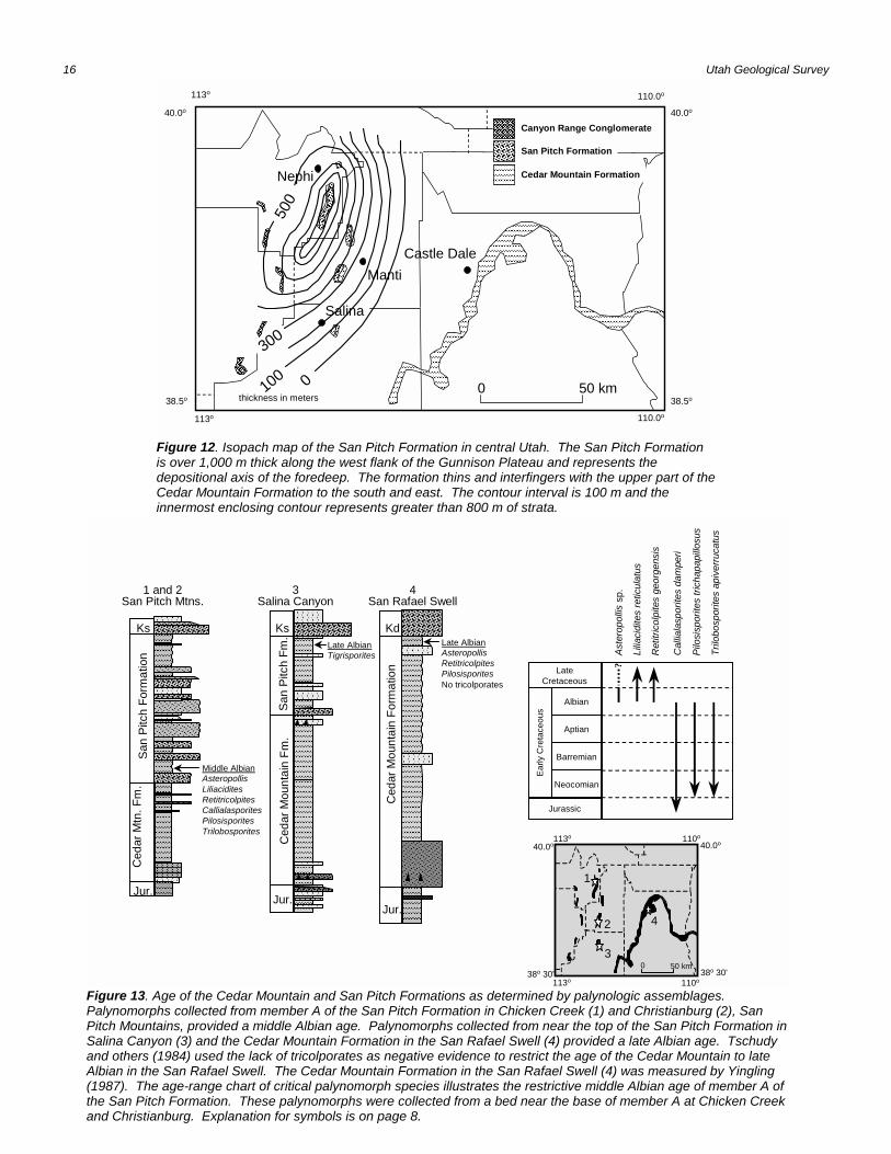
16 Utah Geological Survey
Nephi
Manti
40.0o
110.0o
38.5o
113o
40.0o
38.5o
113o 110.0o
Salina
Castle Dale
300
����������
��������
������������������
����������������
������������
������������������������������������������������������������������������������������������������������������������������������������������������������������������������������������������������������������������������������������������������������������������������������������������������������������������������������������������������������������������������������������������������������������������������������������������������������������������������������������������������������������������������������������������������������������������������������������������������������������������������������������������������������������������������������������������������������������������������������������������������������������������������������������������������������������������������������������������������������������������������������������������������������������������������������������������������������������������������������������������������������������������������������������������������������������������������������������������������������������������������������������������������������������������������������������������������������������������������������������������������������������������������
����������������
������
���������������������
����������
������������
��������������
������
������������������������
������������
0 50 km0100
500
thickness in meters
San Pitch Formation
Cedar Mountain Formation
Canyon Range Conglomerate
����������������
����������������
����������������
Figure 12. Isopach map of the San Pitch Formation in central Utah. The San Pitch Formationis over 1,000 m thick along the west flank of the Gunnison Plateau and represents thedepositional axis of the foredeep. The formation thins and interfingers with the upper part of theCedar Mountain Formation to the south and east. The contour interval is 100 m and theinnermost enclosing contour represents greater than 800 m of strata.
Late AlbianAsteropollisRetitricolpitesPilosisporitesNo tricolporates
1 and 2San Pitch Mtns.
3Salina Canyon
4San Rafael Swell������������������
�����������������������������������������������������������������������������������������������������������������������������������������������������������������������������������
���������������
�����������������������������������������
���������������������������������
���������������
������������������������������������������������������������������������
Kd
Ced
ar M
ount
ain
Form
atio
n
Jur.
San
Pitc
h Fo
rmat
ion
Ced
ar M
tn. F
m.
Ks
Jur.
�������������������������������������������������������������������������������������������������������������������������������������������������������
������������������������������������������������������������������
���������������������������������������������������
������������������������������������������������������
����������
����������������������������������������
����������������������������������������������������������������������
����������
��������������������������
������������������������������������������������������������������������������
�������������
����������������������������������������������������������������������������������������������������������������������������������������������������������������������
Middle AlbianAsteropollisLiliaciditesRetitricolpitesCallialasporitesPilosisporitesTrilobosporites
��������������������������������������������
�������������������������������������������������������������������������������
������������������������������������������
��������������������������������
��������������������������������������������������������������������������������������������������������
������������������������������������������������������������������������������������
������������
������������
������������
������������������������������������
Jur.
Ks
Ced
ar M
ount
ain
Fm.
San
Pitc
h Fm
.
Late AlbianTigrisporites
40.0o110o
38o 30'
113o
40.0o
38o 30'113o 110o
0 50 km
1
2
3
4
Albian
Late Cretaceous
Aptian
Barremian
Neocomian
Jurassic
Early
Cre
tace
ous
Pilo
sisp
orite
s tri
chap
apill
osus
Cal
liala
spor
ites
dam
peri
Ret
itric
olpi
tes
geor
gens
is
Aste
ropo
llissp
.
Trilo
bosp
orite
s ap
iver
ruca
tus
Lilia
cidi
tes
retic
ulat
us
?
Figure 13. Age of the Cedar Mountain and San Pitch Formations as determined by palynologic assemblages. Palynomorphs collected from member A of the San Pitch Formation in Chicken Creek (1) and Christianburg (2), SanPitch Mountains, provided a middle Albian age. Palynomorphs collected from near the top of the San Pitch Formation inSalina Canyon (3) and the Cedar Mountain Formation in the San Rafael Swell (4) provided a late Albian age. Tschudyand others (1984) used the lack of tricolporates as negative evidence to restrict the age of the Cedar Mountain to lateAlbian in the San Rafael Swell. The Cedar Mountain Formation in the San Rafael Swell (4) was measured by Yingling(1987). The age-range chart of critical palynomorph species illustrates the restrictive middle Albian age of member A ofthe San Pitch Formation. These palynomorphs were collected from a bed near the base of member A at Chicken Creekand Christianburg. Explanation for symbols is on page 8.
Redefining the Lower Cretaceous 17
CONCLUSIONS
The Cedar Mountain and San PitchFormations are mappable lithostratigraphic unitsthat redefine the Lower Cretaceous stratigraphywithin the foreland basin of central Utah. Togetherthese formations are correlative with the CedarMountain Formation as exposed on the SanRafael Swell, and with the lower part of theCanyon Range Conglomerate as exposed in theCanyon Mountains.
The Cedar Mountain and San PitchFormations form an upward-coarseningsuccession of alluvial, fluvial, and lacustrine rocksthat become finer grained southeastward towardthe San Rafael Swell. The Cedar MountainFormation attains a maximum thickness of about200 m in the Sanpete Valley area and then thinswestward toward the Gunnison Plateau andeastward toward the San Rafael Swell. The SanPitch Formation attains a maximum thickness ofmore than 1,100 m in the western part of theGunnison Plateau, and then rapidly thins southand east toward the Wasatch Plateau where itpinches out and grades laterally into the upperpart of the Cedar Mountain Formation.
The age of the Cedar Mountain isBarremian(?) to late Albian in the San Rafael Swellregion but is no younger that middle Albian in theGunnison Plateau and surrounding area. The ageof the San Pitch Formation is middle to LateAlbian.
ACKNOWLEDGMENTS
We were fortunate to work in a geologicallychallenging and interesting area of Utah. Wewere also fortunate to interact with manyknowledgeable geologists who also work in thisarea. We thank all of the geologists who, over thecourse of this work, have shared their knowledgeand insight about the geology of central Utah,especially Lehi F. Hintze, Timothy F. Lawton, andGrant C. Willis. We thank Will Aubrey, RayBanks, and Paul Mycka for their assistance inmeasuring the thick and difficult sections. Finally,we thank Timothy F. Lawton, Irving J. Witkind,Bryce T. Tripp, and Grant C. Willis, for reviewingthe manuscript. Their suggestions and commentswere very helpful and significantly improved themanuscript.
REFERENCES CITED
Armstrong, R.L., 1968, Sevier orogenic belt in Nevada andUtah: Geological Society of America Bulletin, v. 79, no.4, p. 429-458.
Auby, W.L., 1991, Provisional geologic map of the Levanquadrangle, Juab County, Utah: Utah GeologicalSurvey Map 135, 13 p., scale 1:24,000.
Banks, R.L., 1991, Provisional geologic map of the FountainGreen North quadrangle, Sanpete and Juab Counties,Utah: Utah Geological Survey Map 134, 21 p., scale1:24,000.
Biek, R.F., 1991, Provisional geologic map of the Nephiquadrangle, Juab County, Utah: Utah GeologicalSurvey Map 137, 21 p., scale 1:24,000.
Craig, L.C., 1981, Lower Cretaceous rocks, southeasternUtah and southwestern Colorado, in Wiegand, G.L.,editor, Geology of the Paradox Basin: Rocky MountainAssociation of Geologists, p. 195-200.
Currie, B.S., 1997, Sequence stratigraphy of nonmarineJurassic-Cretaceous rocks, central Cordilleranforeland-basin system: Geological Society of AmericaBulletin, v. 109, no. 9, p. 1206-1222.
DeCelles, P.G., Lawton, T.F., and Mitra, Gautam, 1995,Thrust timing, growth of structural culminations, andsynorogenic sedimentation in the Sevier orogenic belt,western United States: Geology, v. 23, no. 8, p. 699-702.
Fong, A.W., 1995, Geologic map of the Fountain Green Southquadrangle, Juab and Sanpete Counties, Utah: UtahGeological Survey Miscellaneous Publication 95-1, 18p., scale 1:24,000.
Fouch, T.D., Lawton, T.F., Nichols, D.J., Cashion, W.B., andCobban, W.A., 1982, Chart showing preliminarycorrelation of major Albian to middle Eocene rock unitsfrom Sanpete Valley in central Utah to the Book Cliffsin eastern Utah, in Nielson, D.L., editor, Overthrust beltof Utah: Utah Geological Association Guidebook 10, p.267-272.
Fouch, T.D., Lawton, T.F., Nichols, D.J., Cashion, W.B., andCobban, W.A., 1983, Patterns and timing ofsynorogenic sedimentation in Upper Cretaceous rocksof central and northeast Utah, in Reynolds, M.W., andDolly, E.D., editors, Mesozoic paleogeography of west-central United States Rocky Mountain: Society ofEconomic Paleontologists and MineralogistsPaleogeography Symposium 2, p. 305-336.
Hardy, C.T., and Zeller, H.D., 1953, Geology of the west-central part of the Gunnison Plateau: GeologicalSociety of America Bulletin, v. 64, no. 11, p. 1261-1278.
Hintze, L.F., compiler, 1980, Geologic map of Utah: UtahGeological and Mineral Survey Map A-1, scale1:500,000.
Hintze, L.F., 1988, Geologic history of Utah, Provo: BrighamYoung University Geology Studies Special Publication7, 202 p.
Hunt, R.E., 1950, The geology of the northern part of theGunnison Plateau, Utah: Columbus, The Ohio StateUniversity, Ph.D. dissertation, 267 p.
Jefferson, W.S., 1982, Structural and stratigraphic relations ofUpper Cretaceous to lower Tertiary orogenicsediments of the Cedar Hills, Utah, in Nielson, D.L.,editor, Overthrust belt of Utah: Utah GeologicalAssociation Guidebook 10, p. 65-80.

18 Utah Geological Survey
Katich, P.J., Jr., 1951, Recent evidence for Lower Cretaceousdeposits in the Colorado Plateau: AmericanAssociation of Petroleum Geologists Bulletin, v. 35, no.9, p. 2093-2094.
Katich, P.J., Jr., 1956, Some notes on the Cretaceous faunasof eastern Utah and western Colorado, in Peterson,J.A., editor, Geology and economic deposits of east-central Utah: Intermountain Association of PetroleumGeologists, 7th Annual Field Conference Guidebook,p. 116-119.
Lawton, T.F., and Weiss, M.P., 1994, Interim geologic map ofthe Wales quadrangle, Sanpete County, Utah: UtahGeological Survey Open-File Report 312, 94 p., scale1:24,000.
Pinnell, M.L., 1972, Geology of the Thistle quadrangle, Utah:Provo, Brigham Young University Studies, v. 19, pt. 1,p. 89-130.
Roche, M.G., 1985, Morrison(?) Formation of central Utahreassigned: DeKalb, Northern Illinois University,Master's thesis, 176 p.
Schwans, Peter, 1988, Depositional response of PigeonCreek Formation, Utah, to initial fold-thrust beltdeformation in a differentially subsiding foreland basin,in Schmidt, C.J., and Perry, W.J., editors, Interaction ofthe Rocky Mountain foreland and Cordilleran thrustbelt: Geological Society of America Memoir 171, p.531-556.
Schwans, Peter, 1995, Controls on sequence stacking andfluvial shallow-marine architecture in a foreland basin,in Van Wagoner, J.C., and Bertram, G.T., editors,Sequence stratigraphy of foreland basin deposits:American Association of Petroleum Geologists Memoir64, p. 55-102.
Spieker, E.M., 1946, Late Mesozoic and Early Cenozoichistory of central Utah: U.S. Geological SurveyProfessional Paper 205-D, p. 117-161.
Spieker, E.M., 1949, The transition between the ColoradoPlateau and the Great Basin in central Utah: Salt LakeCity, Utah Geological Society Guidebook to theGeology of Utah, no. 4, 106 p.
Spieker, E.M., and Reeside, J.B., Jr., 1926, UpperCretaceous shoreline in Utah: Geological Society ofAmerica Bulletin, v. 37, p. 429-438.
Sprinkel, D.A., 1994, Stratigraphic and time-stratigraphiccross sections: A north-south transect from near theUinta Mountains axis across the Basin and Rangetransition zone to the western margin of the San RafaelSwell, Utah: U.S. Geological Survey MiscellaneousInvestigations Series I-2184-D, 31 p., scale 1:500,000.
Standlee, L.A., 1982, Structure and stratigraphy of Jurassicrocks in central Utah: their influence on tectonicdevelopment of the Cordilleran foreland thrust belt, inPowers, R.B., editor, Geologic studies of theCordilleran thrust belt: Rocky Mountain Association ofGeologists, p. 357-382.
Stokes, W.L., 1944, Morrison and related deposits in andadjacent to the Colorado Plateau: Geological Societyof America Bulletin, v. 55, no. 8, p. 951-992.
Stokes, W.L., 1952, Lower Cretaceous in Colorado Plateau:American Association of Petroleum Geologists Bulletin,v. 36, no. 9, p. 1766-1776.
Stokes, W.L., 1972, Stratigraphic problems of the Triassicand Jurassic sedimentary rocks of central Utah, inBaer, J.L., and Callaghan, E., editors, Plateau-Basinand Range transition zone: Utah Geological
Association Guidebook 2, p. 21-28.Stuecheli, P.J., 1984, The sedimentology, depositional
setting, and age of the Morrison(?) Formation in centralUtah: Columbus, The Ohio State University, Master'sthesis, 104 p.
Stuecheli, P.J., and Collinson, J.S., 1984, Sedimentology ofsynorogenic conglomerates of the Lower CretaceousMorrison(?) Formation, central Utah [abs.]: GeologicalSociety of America Abstracts with Programs, v. 16, p.200.
Tschudy, R.H., Tschudy, B.D., and Craig, L.C., 1984,Palynological evaluation of Cedar Mountain and BurroCanyon Formations, Colorado Plateau: U.S.Geological Survey Professional Paper 1281, 24 p.
Villien, Alain, and Kligfield, R.M., 1986, Thrusting andsynorogenic sedimentation in central Utah, inPeterson, J.A., editor, Paleotectonics andsedimentation in the Rocky Mountain region: AmericanAssociation of Petroleum Geologists Memoir 41, p.281-306.
Weiss, M.P., 1994, Geologic map of the Sterling quadrangle,Sanpete County, Utah: Utah Geological Survey Map159, 26 p., scale 1:24,000.
Weiss, M.P., and Roche, M.G., 1988, The Cedar MountainFormation (Lower Cretaceous) in the GunnisonPlateau, central Utah, in Schmidt, C.J., and Perry,W.J., editors, Interaction of the Rocky Mountainforeland and Cordilleran thrust belt: Geological Societyof America Memoir 171, p. 557-569.
Willis, G.C., 1986, Geologic map of Salina quadrangle, SevierCounty, Utah: Utah Geological and Mineral SurveyMap 83, 20 p., scale 1:24,000.
Willis, G.C., and Kowallis, B.J., 1988, Newly recognizedCedar Mountain Formation in Salina Canyon, SevierCounty, Utah: Provo, Brigham Young UniversityGeology Studies, v. 35, p. 57-61.
Witkind, I.J., 1988, Geologic map of the Huntington 30' x 60'quadrangle, Carbon, Emery, Grand, and Uintahcounties, Utah: U.S. Geological Survey MiscellaneousInvestigations Series Map I-1631, scale 1:100,000.
Witkind, I.J., and Page, W.R., 1983, Geologic map of theThistle area, Utah County, Utah: Utah Geological andMineral Survey Map 69, scale 1:24,000.
Witkind, I.J., Standlee, L.A., and Maley, K.F., 1986, Age andcorrelation of Cretaceous rocks previously assigned tothe Morrison(?) Formation, Sanpete-Sevier Valleyarea, central Utah: U.S. Geological Survey Bulletin1584, 9 p.
Witkind, I.J., Weiss, M.P., and Brown, T.L., 1987, Geologicmap of the Manti 30' x 60' quadrangle, Carbon, Emery,Juab, Sanpete, and Sevier counties, Utah: U.S.Geological Survey Miscellaneous Investigations Map I-1631, scale 1:100,000.
Yingling, V.L., 1987, Timing of initiation of the SevierOrogeny: Morrison and Cedar Mountain Formationsand Dakota Sandstone, east-central Utah: Salt LakeCity, University of Utah, Master's thesis, 169 p.
Young, G.E., 1976, Geology of Billies Mountain quadrangle,Utah: Provo, Brigham Young University GeologyStudies, v. 23, pt. 1, p. 205-280.

Redefining the Lower Cretaceous 19
Table 1. Measured sections of Cedar Mountain and San Pitch Formations.
Section name Location Quadrangle Measured byChristianburg1 NE¼NE¼ sec. 13, T. 19 S., R. 1 E. to
SE¼SE¼ sec. 12, T. 19 S., R. 1 E.Sanpete County
Sterling D.A. Sprinkel
Christianburg 2 NW¼ sec. 18, T. 19 S.,R. 2 E. toSE¼ sec. 12, T. 19 S.,R. 1 E.Sanpete County
Sterling K.F. Maley (Witkind et al., 1986)
Chicken Creek3 SW¼SE¼ sec. 2, T. 15 S., R. 1 E.,Juab County
Levan D.A. Sprinkel, W. Aubrey, P. Mycka
Little Salt Creek3 SW¼SW¼ sec. 33, T. 15 S., R. 1 E.Juab County
ChrissCanyon
D.A. Sprinkel, M.P. Weiss, R.L.Banks
upper Deep Creek3 SE¼SE¼ sec. 23, T. 15 S., R. 1 E.Juab County
ChrissCanyon
D.A. Sprinkel, M.P. Weiss, R.L.Banks
Salina Canyon3 SE¼NE¼ sec. 33, T. 21 S., R. 1 E.Sevier County
Salina D.A. Sprinkel, W. Aubrey, P. Mycka
1 Type section of the San Pitch Formation2 Reference section of the Cedar Mountain Formation3 Reference section of the Cedar Mountain and San Pitch Formations
Table 2. Palynologic assemblage of the San Pitch Formation.
Site Location Sample Formation Age Species Relative1
Abundance
ChickenCreek
SW¼NE¼NE¼sec. 11,T. 15 S., R. 1 E.,Juab County, Utah
CC10 San Pitchmember A
Aptian tomiddleAlbian
SPORES AND POLLENAraucariacites australisUndifferentiated bisaccatesExesipollenites tumulusSchizopris parvusS. retulatusTaxodiaceaeCicatricosisporites australiensisCingulatisporites sp.Deltoidospora spp.Foraminisporites dailyiLycopodiumsporites sp. A
MICROPLANKTONMicrhystridium sp.
RRRRRRRRRRR
R
ChickenCreek
SW¼NE¼NE¼sec. 11,T. 15 S., R. 1 E.,Juab County, Utah
CC72893-1 San Pitchmember A
middle toearly lateAlbian
SPORES AND POLLENAraucariacites australisUndifferentiated bisaccatesClassopollis classoides?Classopollis spinosusExesipollenites tumulusCallialasporites dampieriTaxodiaceaeAppendicisporites potomacensisCicatricosisporites australiensisC. brevilaesuratusC. halleiC. venustusCingulatisporites distaverrucosusConcavissimisporites punctatusDeltoidospora spp.
AFFRRRRRRRRRRRF
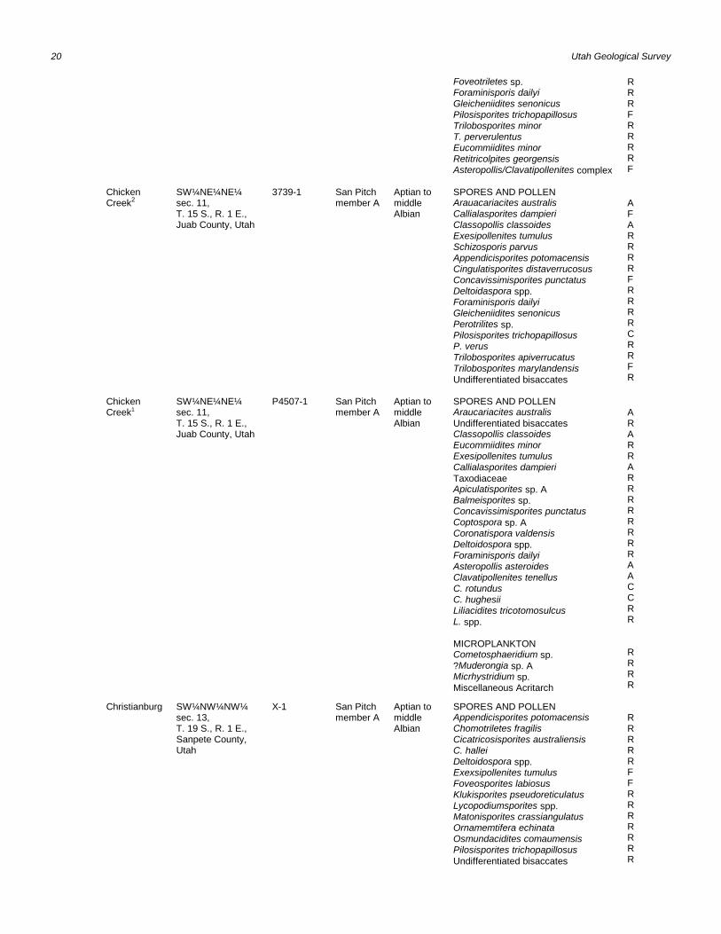
20 Utah Geological Survey
Foveotriletes sp.Foraminisporis dailyiGleicheniidites senonicusPilosisporites trichopapillosusTrilobosporites minorT. perverulentusEucommiidites minorRetitricolpites georgensisAsteropollis/Clavatipollenites complex
RRRFRRRRF
ChickenCreek2
SW¼NE¼NE¼sec. 11,T. 15 S., R. 1 E.,Juab County, Utah
3739-1 San Pitchmember A
Aptian tomiddleAlbian
SPORES AND POLLENArauacariacites australisCallialasporites dampieriClassopollis classoidesExesipollenites tumulusSchizosporis parvusAppendicisporites potomacensisCingulatisporites distaverrucosusConcavissimisporites punctatusDeltoidaspora spp.Foraminisporis dailyiGleicheniidites senonicusPerotrilites sp.Pilosisporites trichopapillosusP. verusTrilobosporites apiverrucatusTrilobosporites marylandensisUndifferentiated bisaccates
AFARRRRFRRRRCRRFR
ChickenCreek1
SW¼NE¼NE¼sec. 11,T. 15 S., R. 1 E.,Juab County, Utah
P4507-1 San Pitchmember A
Aptian tomiddleAlbian
SPORES AND POLLENAraucariacites australisUndifferentiated bisaccatesClassopollis classoidesEucommiidites minorExesipollenites tumulusCallialasporites dampieriTaxodiaceaeApiculatisporites sp. ABalmeisporites sp.Concavissimisporites punctatusCoptospora sp. ACoronatispora valdensisDeltoidospora spp.Foraminisporis dailyiAsteropollis asteroidesClavatipollenites tenellusC. rotundusC. hughesiiLiliacidites tricotomosulcusL. spp.
MICROPLANKTONCometosphaeridium sp.?Muderongia sp. AMicrhystridium sp.Miscellaneous Acritarch
ARARRARRRRRRRRAACCRR
RRRR
Christianburg SW¼NW¼NW¼sec. 13,T. 19 S., R. 1 E.,Sanpete County,Utah
X-1 San Pitch member A
Aptian tomiddleAlbian
SPORES AND POLLENAppendicisporites potomacensisChomotriletes fragilisCicatricosisporites australiensisC. halleiDeltoidospora spp.Exexsipollenites tumulusFoveosporites labiosusKlukisporites pseudoreticulatusLycopodiumsporites spp.Matonisporites crassiangulatusOrnamemtifera echinataOsmundacidites comaumensisPilosisporites trichopapillosusUndifferentiated bisaccates
RRRRRFFRRRRRRR
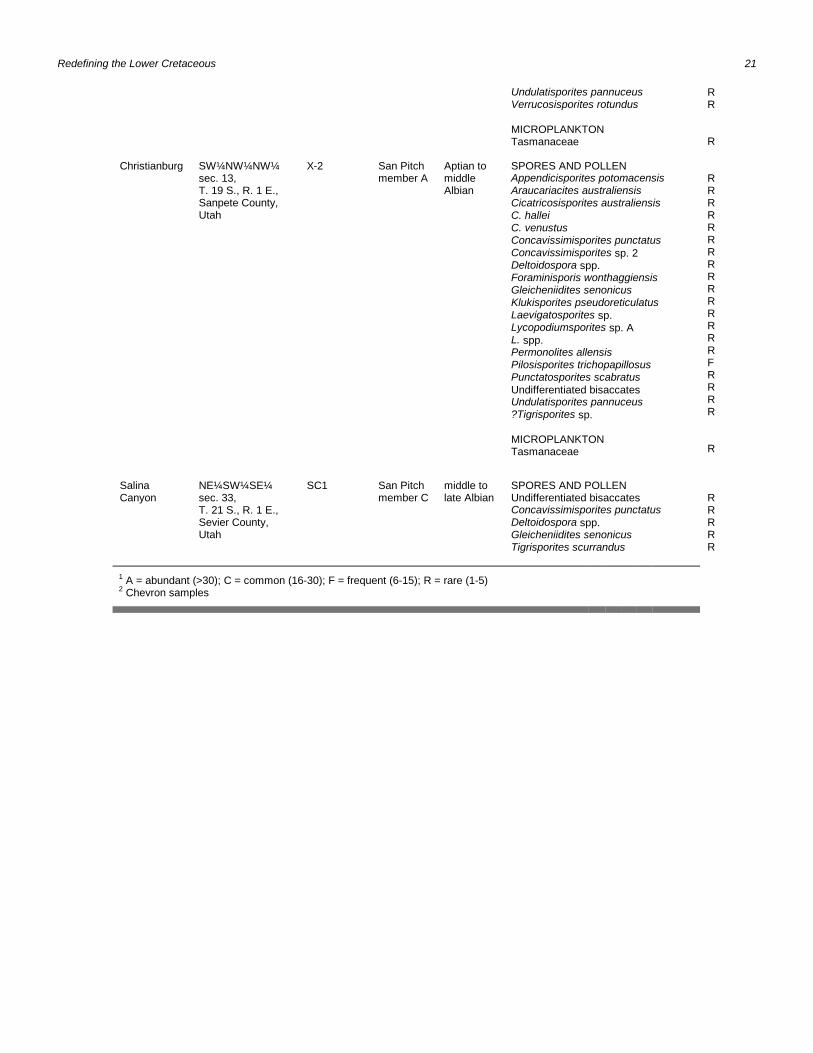
Redefining the Lower Cretaceous 21
Undulatisporites pannuceusVerrucosisporites rotundus
MICROPLANKTONTasmanaceae
RR
R
Christianburg SW¼NW¼NW¼sec. 13,T. 19 S., R. 1 E.,Sanpete County,Utah
X-2 San Pitch member A
Aptian tomiddleAlbian
SPORES AND POLLENAppendicisporites potomacensisAraucariacites australiensisCicatricosisporites australiensisC. halleiC. venustusConcavissimisporites punctatusConcavissimisporites sp. 2Deltoidospora spp.Foraminisporis wonthaggiensisGleicheniidites senonicusKlukisporites pseudoreticulatusLaevigatosporites sp.Lycopodiumsporites sp. AL. spp.Permonolites allensisPilosisporites trichopapillosusPunctatosporites scabratusUndifferentiated bisaccatesUndulatisporites pannuceus?Tigrisporites sp.
MICROPLANKTONTasmanaceae
RRRRRRRRRRRRRRRFRRRR
R
SalinaCanyon
NE¼SW¼SE¼sec. 33,T. 21 S., R. 1 E., Sevier County,Utah
SC1 San Pitchmember C
middle tolate Albian
SPORES AND POLLENUndifferentiated bisaccatesConcavissimisporites punctatusDeltoidospora spp.Gleicheniidites senonicusTigrisporites scurrandus
RRRRR
1 A = abundant (>30); C = common (16-30); F = frequent (6-15); R = rare (1-5)2 Chevron samples