1st speaker -jennifer betsworth · 1st speaker-jennifer betsworth downs house and farm ... thriving...
TRANSCRIPT

1st Speaker -Jennifer Betsworth
Downs House and Farm
5973 Sound Avenue, Riverhead, Suffolk County
[Façade / Historic Aerial] The Downs House and Farm, located on Sound Avenue in hamlet of
Northville, is significant under Criterion A at the local level for its long and varied agricultural
use which helps illustrate the changing trends in agricultural practice in Suffolk County.
Established as a separate farm in 1873 by Harrison Downs, it has been owned and occupied by
family members since that date and continues to operate as a commercial farm today.
[Rear house w/farmstand] The farm initially functioned as more of a gentleman’s retreat in the
late 19th century, but was operated as a typical Eastern Long Island potato farm through much of
the 20th century. Currently, it is operated by the fifth and sixth generations of the family who
renamed the property Ty Llwyd, a welsh phrase that means brown house. Recently, like many
farms in the area, it has specialized in ways that serve primarily a retail customer base and have a
thriving farmstand selling raw milk, fresh eggs, and farm-grown vegetables directly to
customers.
[Living room / Stair] The Downs House and Farm is also significant under Criterion C as a
regionally rare example of the Italianate style in a rural setting and its vernacular farm complex.
The nominated property includes the ca. 1874 Harrison Downs house and a complex of early-
twentieth century agricultural buildings.
[Kitchen] The house started as a gentleman’s country retreat and was built in the Italianate style
more appropriate to an urban setting than to its farm location. No other examples of Italianate
farmhouses exist in the historic agricultural community on Sound Avenue. The Downs family
modified the house in 1921 by adding a wide, wrap-around front porch to make it more like other
farmhouses in the area.
[Barn] The property also includes a ca. 1917 English type barn that is a good example of the barn
plan that was common in the area from the 17th century through the 1930s.
[Farmyard] Furthermore, the farm itself offers an excellent example of the typical layout of a
North Fork farm in the late 19th and early 20th century. The narrow “bowling alley” style farm
has a cluster of buildings close to the road and a long agricultural parcel to the rear.
[Wash house / Camp Upton Building / Old Chicken House / Dairy Barn]
[Historic ag photos – Leland Downs 1928, potato harvest 1950] * just a note here that I hope
SRB enjoyed nomination – written by a family member who had access to an incredible amount
of detailed information about the farm. So often we speak about ag more broadly, so I found the
focus very interesting.

Fitch Office
532-574 Abeel Street, Kingston, Ulster County
[Façade / Historic Image] The Fitch Brothers Bluestone Company Dispatch Office, located on
the north side of the Rondout Creek in the former hamlet of Wilbur, is significant under Criterion
A in the areas of commerce and industry for its association with the Fitch family’s substantial
role in Ulster County’s bluestone industry. Ezra Fitch began working for his brother-in-law’s
shipping company on the Twaalfskill Creek during the 1830s. Within a decade, he expanded and
became head of the business, which exported products arriving on the Delaware and Hudson
canal to New York City.
[Historic Image] After his brother, Simeon, and cousin, William, began working at Fitch and
Reed, the company’s focus turned to the nascent bluestone industry. By the mid-19th century,
Ezra Fitch and Company was among the largest bluestone exporters in the world. They built this
office building in 1870 to reflect their success. The Fitch Company’s bluestone quarrying,
transportation, processing, and shipping business employed over a thousand men at its height and
was a cornerstone of the economy of the Village of Wilbur through the company’s closure
around 1900.
[Detail / S. Elevation] The Fitch office is additionally significant under Criterion C for its
remarkable bluestone design by J.A. Wood. Wood, a prolific architect based out of
Poughkeepsie, designed a building that served both as a showpiece for the company and a
celebration of bluestone as a building material.
[Other elevations] By blending romantic and picturesque architectural influences with the
modern Second Empire style, Wood created a striking, but efficient, office building that balanced
the monumentality of bluestone with rhythm, lightness, and touch of grandeur. A testament to
both the success of the building and the company, the office appears in numerous photographs
and local publications in the decade after its completion.
[Interior] After the company went out of business, the office largely sat unoccupied and soon
became known as the Ghost of the Rondout. It was rehabilitated as a residence during the 1970s
and remains one today.

Attlebury School
6917 Route 82, Stanford, Dutchess County
[Façade, North Elevation] Attlebury School, located on the west side of Route 82 in the Town of
Stanford, is significant under Criterion A at the local level for its association with rural education
in the town during the early twentieth century. Built in 1910 after the hamlet of Attlebury’s
nineteenth-century school burned in an accidental fire, the modest one-room frame schoolhouse
served not only as a center of education but also a hub for the rural community.
[South Elevation] In contrast to the old school, a repurposed house, the new school building’s
form and design are clearly drawn from nineteenth century models of one-room schoolhouse
construction that advocated for simple, comfortable, well-lighted schools. Attlebury’s new
modest, one-story, front-gabled building with a bank of windows on the south wall and an
interior division into a cloakroom vestibule and classroom space clearly follows this well-
established, if a bit outmoded, pattern.
[Historic Photo] By the early twentieth century, Attlebury was dominated by family-operated
dairy farms. Children from the area typically walked to school each day of the nine-month term.
By the turn of the century, African-American families had begun moving to the area as tenant
farmers; their children were welcomed into the small school.
[Hall, Rear wall] Within a few decades, efforts were being made to replace one-room, rural
schoolhouses across the state. After 35 years of use, the Attlebury Schoolhouse was closed in
1945; children from the hamlet were sent to the Pine Plains Central School which had been built
over a decade earlier.
[Corner, Chalkboard wall] After its closure, the school was largely neglected until 1975 when it
was the focus of a Bicentennial restoration project. In 2013,the Stanford Historical Society
purchased the school from the Pine Plains School District and has done work to stabilize the
building. The historical society is excited to be the steward of the only remaining rural district
school in Stanford that remains unconverted, on its original site, and intact to its historic
appearance and plans to revive the building for historic programming, education, and community
events.
VISITORS IN ATTENDANCE: Carol Hanlon…
Bodine’s Tavern
2 Bodine Tavern, Montgomery, Orange County
[Façade / c. 1950 façade] Bodine’s Tavern, built ca. 1809, is located on the south side of the
Walkill River in the Town of Montgomery. The building is significant under Criterion C as an
example of vernacular, early 19th century middling frame housing in the town and under
Criterion A in the area of commerce for its long use as a tavern on the Minisink and Montgomery
Turnpike.
[Side elev] The hamlet of Ward’s Bridge, situated at a bend in the Walkill, began growing into a
thriving agricultural and commercial center after the Newburgh and Cochecton Turnpike was
routed through it during the first decade of the 19th century; a secondary road going south, the
Minisink and Montgomery Turnpike, was chartered in 1809. Around the same time, James
Bodine purchased land south of the turnpike’s crossing over the Walkill and built a small house
and tavern to cater to traffic along the new turnpike.
[Rear elev] The side-hall, frame building on a raised stone foundation had a kitchen in the lower
story and a dining room on the main floor. With his wife, Elizabeth Crist, Bodine maintained a
small agricultural operation in addition to the tavern. Adam and Eliza Bodine obtained the
property during the early 1830s and expanded the building into a saltbox shape to provide
additional amenities and space for guests. The property remained in the Crist and Bodine
families and was used as a small-scale tavern for over 75 years.
[Hallway] – note the orientation of the staircase, leads up to small attic bedroom
[Basement fireplace]
[Dining Room / Fireplace]
[Kitchen addition]
Calvary Methodist Episcopal Church
2190 Adam Clayton Powell Blvd., New York, New York County
Columbia Draft
[Façade] Calvary Methodist Episcopal Church is significant under Criterion A for its association
with two of Harlem’s largest Methodist congregations and the changing character of the
population of the neighborhood. The church is additionally significant under Criterion C for its
striking Romanesque revival design by John Rochester Thomas, a prolific New York architect.
[Façade] After the residential development of Harlem into an upper middle class neighborhood
in the late nineteenth century, residents began funding the construction of magnificent Protestant
church buildings. Calvary Methodist Episcopal, one of the fastest growing congregations in the
new neighborhood, built the largest church in the city in two building campaigns, beginning in
1887 and expanding in 1890. By 1898, the congregation had grown to nearly 1800 members.
[Door / Tower] As African-Americans increasingly moved into Harlem during the early 20th
century, attendance at white churches declined while African-American congregations grew. In
1923, Calvary Methodist Episcopal approved the sale of their building to Salem Methodist
Episcopal, a large African-American congregation that had begun as a mission in 1902.
[Hall / Sanctuary] The sanctuary overflowed for Calvary’s closing service on September 24,
1924; both congregations were represented by the service and among the attendants, reflecting a
sense of unity and continuity for the building. From the beginning, Salem hosted numerous and
diverse events that reflected the ideas and experiences of the African-American community and
the influences of the Harlem Renaissance and Civil Rights Movement.
[Sanctuary / Sanctuary] During the early 1950s, the church survived a vast neighborhood
transformation when the buildings surrounding it were demolished to make way for the St.
Nicholas Houses, an affordable housing project planned by Robert Moses; its value, both as a
piece of architecture and a stable community institution, likely saved it from demolition.
[Community Center] As the congregation continued to grow and expand its services for the
community, which now included the housing project, it began to discuss the creation of a new
community center. Nearly a decade of effort resulted in its construction adjacent to the church in
1967. 28 classes were held in the building soon after it opened, and the Salem Athletic Crescent
Club, a premier amateur boxing club established in 1911 with Sugar Ray Robinson at the helm
which had long operated from the church basement, made the center its new home.
Letter of Support from LPC

Beth Olam Cemetery
2 Cypress Hills Street, Kings & Queens Counties
[Gates] Beth Olam Cemetery is a roughly triangular cemetery located in the cemetery belt on the
border between Brooklyn and Queens; it was the second to be incorporated in the area. It is
significant under Criteria A and C as an example of a designed rural cemetery containing burials
from and jointly owned by three of New York City’s oldest Jewish congregations: Shearith
Israel, a traditional Sephardic synagogue established in 1654 in New Amsterdam, B’nai
Jeshurun, an Ashkenazic offshoot established in 1825, and Shaaray Tefila, which split from
B’nai Jeshurun in 1845.
[Overview] In 1851, Shearith Israel consecrated the new cemetery and split it with B’nai
Jeshurun; in 1856, the latter split half of its land with Shaaray Tefila. Beth Olam exhibits a
variety of funerary art and architecture, ranging from intricate single mid-19th century marble
graves to monumental Art Deco mausoleums to small, polished contemporary headstones. It also
offers an unusual representation of Sephardic and Askenazic funerary customs side by side; for
example, early Sephardic monuments are commonly laid parallel to the ground while Ashkenazi
monuments are vertical.
[Metaher House] In 1886, Shearith Israel hired Calvert Vaux to design a new Metaher House, a
small building used for the purification of the dead and ceremonies, and entry gates for the
cemetery. He also constructed a sweeping circular drive leading from the new gates to the
chapel.
[Monuments/Steps/Levy Monument] By the late 19th century, in contrast to Shearith Israel’s
Orthodix Sephardic traditions, B’nai Jeshurun’s Orthodox Ashkenazic members began to
liberalize their worship and burial traditions. Secular funerary iconography gradually became
more common. The monument dedicated to Uriah Phillips Levy, located in the Shearith Israel
section, was quite controversial due to its size and Levy’s request to have a statue in his image
on the monument; Levy had been a member of both Shearith Israel and B’nai Jeshurun during
his lifetime, but his monument is more closely aligned with the latter’s tradition.
[Mausoleums x2] During the early twentieth century, mausoleums became popular among
members of B’nai Jeshurun and some members of Shaaray Tefila. There are no mausoleums in
the Shearith Israel sections due to the Orthodox resistance to above-ground burials. Beth Olam’s
mausoleums, which are constructed in many different architectural styles, are notable not only as
examples of funerary art but also for their relative rarity as a resource type in Jewish cemeteries.
Almost every mausoleum at Beth Olam was constructed by Adler’s Monument and Granite
Works, showcasing the variety and resources available to a single monument company in the
early 20th century.

[Mausoleum, stained glass] Several mausoleums feature detailed bronze work, and almost every
one has at least one stained or art glass window. While Adler’s constructed the mausoleums,
families commissioned various manufacturers for these decorative details. Many include Jewish
symbols, such as menorahs and oil lamps, while others show biblical figures like Deborah or
Moses.
Beth Olam’s representation of three different congregations, evolving burial traditions, and of the
multiplicity and history of New York’s Jewish community makes it a particularly remarkable
historic cemetery.
Letter of Support from LPC
2nd Speaker Jennifer Walkowski:
South Junior High School
561 Porter Rd, Niagara Falls, Niagara County
POS 1922-23
SLIDE 1:
South Junior High School is locally significant under Criterion C in Architecture as
an example of school standardization in the early twentieth century, and more
specifically, of the junior high school typology that emerged nationwide in the
early 20th century to serve intermediate grades and to promote student retention
past elementary school. South Junior High School is one of two junior high schools
constructed in Niagara Falls in 1922-1923, the other of which was torn down in the
1990s.
SLIDE 2:
South Junior High School was designed by local architects Carlos Chipman Lacy
and Norton H. Kirkpatrick of the Associated Architects in conjunction with
William B. Ittner, a prior commissioner of school buildings for the St. Louis Board
of Education and member of the National Education Association’s Committee on
Administration of Secondary Education.
The building was designed to reflect the new junior high school concept that
developed in the early twentieth century. The combination of gymnasiums,
laboratories, and uniform classrooms reflected the emerging junior high school
curriculum, which promoted physical activity, hands-on learning, and a schedule in
which uniform groups of students moved between classes. The Niagara Falls
School District undertook an innovative task in building a junior high school while
the concept of the junior high was first developing.
SLIDE 3:
At the time the Niagara Falls School District commissioned South Junior and
North Junior High Schools in 1919, the school district had thirteen elementary
schools and one high school. The rapid and continued growth of the city through
the 19th and early 20th century strained the school district’s infrastructure. The
addition of two junior high schools not only provided additional instruction space
but also represented a new trend in education, specifically serving intermediate
ages. While constructed specifically to be a junior high school, South Junior High
School housed high school students during its first year in service, after a fire
leveled the existing high school in 1922. Returning to its original intention the
following year, South Junior served as a junior high school from 1924 to 1985,
when it closed due to low enrollment.
SLIDE 4:
South Junior High School later housed the Community Education Center and has
been vacant since about 2000. While the vacant building has extensive water
damage to its plaster due to a roof leak, the building remains highly intact, with the
majority of its character defining spaces and architectural features remaining intact
to the 1920s era. While the damage appears worse than it is, we did submit a draft
of this nomination to the National Park Service for review with the Part 1 tax credit
application, and it was approved. Currently, development plans are underway to
convert the building into affordable housing, some luxury units, and mixed use
development, giving a long-vacant building a new lease on life.
This is South Junior High School, are there any questions?
Edmund B. Hayes Hall
3435 Main Street, Buffalo
Built 1925/26
SLIDE 1:
Edmund B. Hayes Hall (Hayes Hall) is significant as the historical and current
visual symbol for the University at Buffalo South Campus. The building is
significant under criterion A in the area of Education for its role as the primary
administration and services building of the University of Buffalo between the
1920s and the 1970s. Hayes Hall is also significant under criterion C in the area of
Architecture, as a good representative example of a Georgian Revival collegiate
building.
SLIDE 2:
The building originated as part of the Erie County Almshouse and Farm. When
established in 1851, the Almshouse was located on 153-acres in a remote, largely
rural area at the very north-eastern corner of the City of Buffalo. Between 1873
and 1878 a massive stone Second Empire style building was constructed as the
County’s center to house and treat the poor and the mentally ill.
SLIDE 3:
Acquired in 1909 from the former Erie County Almshouse and Farm, the
architectural firm of Cyrus K. Porter & Sons transformed Hayes Hall from the
Second Empire stone building into a Georgian Revival edifice in 1925/26. The
building became the cornerstone of a new campus for the University of Buffalo
being developed for the “Great University,” which brought together separate
individual colleges and programs, scattered through the city, to establish one main,
modern college center for the city. Much like older college campuses with their
signature main halls, Hayes Hall was envisioned and established to serve as the
centerpiece of the campus, embodying the sense of rational logic, permanence and
prestige of the new University of Buffalo educational system.
SLIDE 4:

Hayes Hall is perhaps an early example of “adaptive reuse” in Buffalo as much of
the building’s original exterior “shell” was reused for the new administrative
building. The redesign of the building reflects the early twentieth century trend
towards utilizing Classical and Colonial Revival details to instill a sense of order,
logic, and permanence to educational buildings during this time.
The period of significance begins with construction of the alterations to the former
Almshouse building in 1925/26 to establish the University of Buffalo as the “Great
University,” and ends in 1962 when the private university merged with the State
University of New York (SUNY) system. This era represents the period during
which Hayes Hall served as the primary administrative building for the entire
University of Buffalo, after which these services were transferred to UB’s newly
constructed North Campus location , following the school’s integration into the
SUNY system. This period also encompasses major alterations to the building as
well as the significant change of functional use to become an academic building.
SLIDE 5:
While the exterior of the building was intended to inspire a sense of permanence
and tradition, the interior of the building demonstrates upgrades and alterations
occurring through the college building’s life as a way to keep pace with the
developing technological and educational standards as a means to attract students
and staff. While it retains the basic historic layout, with an axial plan and double-
loaded corridors flanked with smaller rooms and spaces, the building’s interior has
undergone several campaigns of updates necessary for the evolution of technology
and education in the 20th and 21st centuries. Hayes was first “modernized” in the
mid-1950s in a response to increased enrollment and a need for additional
classroom space. At this time the foyer, the major public space, was modernized
with new lighting, lowered ceiling heights, wall treatment and display cabinets.
Recently, Hayes Hall has undergone another round of modern interior updates,
intended to update the building for current technology and educational standards.
The bells located in the upper level of the bell tower, shown in the upper right
corner, were actually manufactured right here in Waterford, by the Meneely
Company. The building now houses offices for the University’s School of
Architecture and Planning and still is regarded as the flagship building of the
University at Buffalo’s South Campus.

This is Edmund B. Hayes Hall, are there any questions?
3rd Speaker Virginia Bartos : NR Presentation text 22 March 2016
And now for something completely different—at least in my experience. . .this is
The Canandaigua Historic District Boundary Amendment, City of Canandaigua,
Ontario County NY
Slide 1: Every once and a while, we have to revisit one of our older listings, and
this time it’s the Canandaigua Historic District, listed in 1984. The listing was
result of a larger study that examined the city and identified potential historic
districts and important buildings worthy of adding to the State and National
Registers. Just a brief bit of background: Canandaigua evolved from pioneer
settlement to premier village and celebrated its city centennial last year. If you’ve
never been to Canandaigua, it’s the county seat and is probably best known for its
lake-based tourism. When I lived in Canandaigua in the 1980s, it was largely a
bedroom community for Rochester businesses, most notably Kodak, but now the
largest employer in the city is the Veterans Administration hospital—as you recall,
the hospital was one of preservation award recipients last December.
Slide 2: One of the constants of the city is that is still follows the plan that was
laid out around 1790 by Oliver Phelps and his surveyor Colonel Walker. In short,
the heart of the settlement was the government center and still is with the county

courthouse and City Hall in this section. North of the center is largely residential
with a variety of nineteenth century architecture, as you can see in the other
slides. I should point out that the white house in the center of the bottom left
slide is the oldest brick house in the city, built in 1808.
Slide 3: The other major area of the city that traces back to the original lay out is
the commercial section that leads to the lake. As explained in the boundary
amendment document, this area began developing its current character in the
mid nineteenth century with the construction of large masonry block buildings,
the first being the Bemis Block seen on the lower right.
Slide 4: That’s Canandaigua’s background in a nutshell—now on to the boundary
amendment. The map on the left is the one you received with the document. The
blue line represents the listed boundary and we discovered a couple of issues
with the transfer of maps to the new CRIS system and after a closer examination
of the listing. The first was that the listed boundary bisected a number of
properties, i.e., failed to follow the property lines and the red line indicates this
correction, which impacted about a dozen properties, one of them being the
Granger Homestead, which now adds the portion of the property with their
historic barns. Another problem discovered was the two listed buildings on Sly
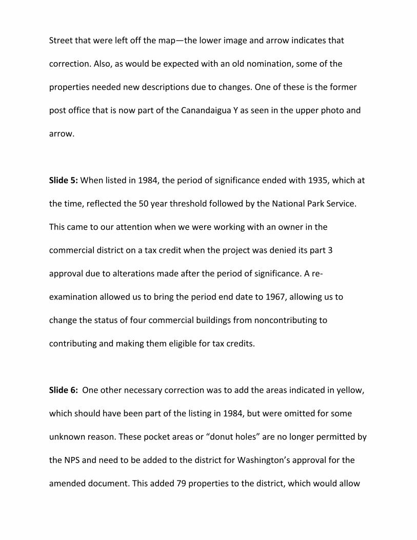
Street that were left off the map—the lower image and arrow indicates that
correction. Also, as would be expected with an old nomination, some of the
properties needed new descriptions due to changes. One of these is the former
post office that is now part of the Canandaigua Y as seen in the upper photo and
arrow.
Slide 5: When listed in 1984, the period of significance ended with 1935, which at
the time, reflected the 50 year threshold followed by the National Park Service.
This came to our attention when we were working with an owner in the
commercial district on a tax credit when the project was denied its part 3
approval due to alterations made after the period of significance. A re-
examination allowed us to bring the period end date to 1967, allowing us to
change the status of four commercial buildings from noncontributing to
contributing and making them eligible for tax credits.
Slide 6: One other necessary correction was to add the areas indicated in yellow,
which should have been part of the listing in 1984, but were omitted for some
unknown reason. These pocket areas or “donut holes” are no longer permitted by
the NPS and need to be added to the district for Washington’s approval for the
amended document. This added 79 properties to the district, which would allow
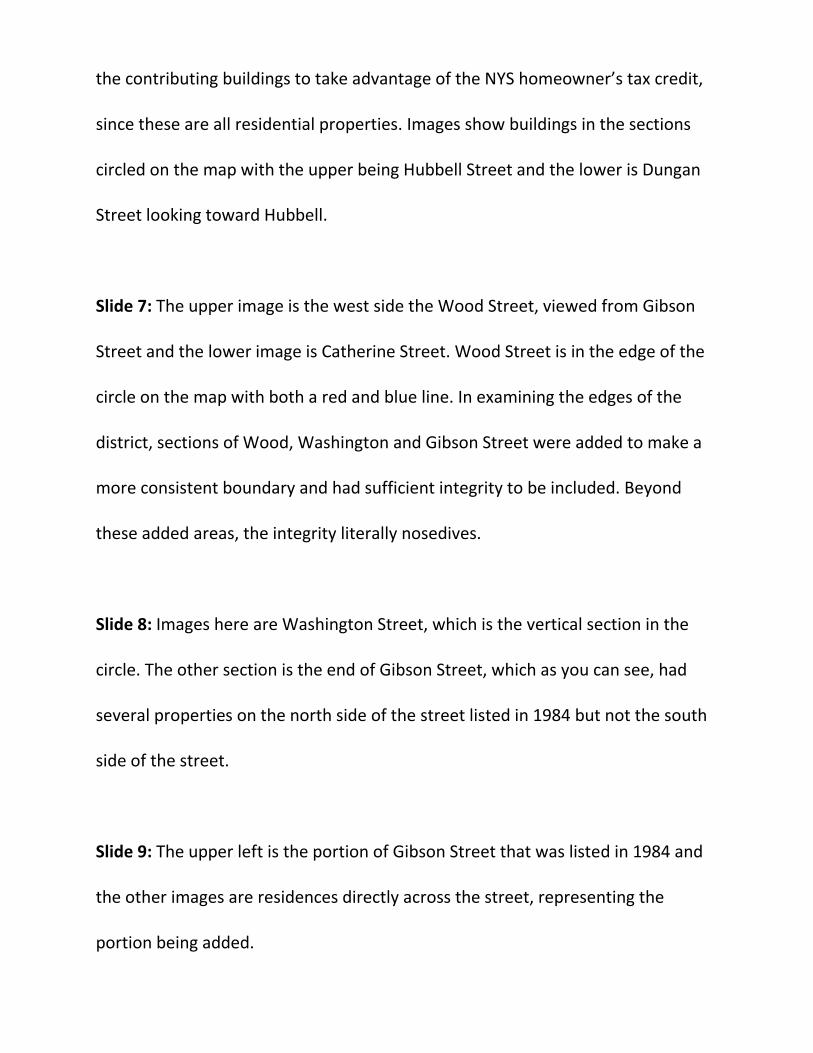
the contributing buildings to take advantage of the NYS homeowner’s tax credit,
since these are all residential properties. Images show buildings in the sections
circled on the map with the upper being Hubbell Street and the lower is Dungan
Street looking toward Hubbell.
Slide 7: The upper image is the west side the Wood Street, viewed from Gibson
Street and the lower image is Catherine Street. Wood Street is in the edge of the
circle on the map with both a red and blue line. In examining the edges of the
district, sections of Wood, Washington and Gibson Street were added to make a
more consistent boundary and had sufficient integrity to be included. Beyond
these added areas, the integrity literally nosedives.
Slide 8: Images here are Washington Street, which is the vertical section in the
circle. The other section is the end of Gibson Street, which as you can see, had
several properties on the north side of the street listed in 1984 but not the south
side of the street.
Slide 9: The upper left is the portion of Gibson Street that was listed in 1984 and
the other images are residences directly across the street, representing the
portion being added.

Slide 10: After the Dungan-Hubbell section, the largest added portion is Park
Place and Park Street, so named due to being around a historic park along Gibson
Street.
Slide 11: The upper right shows the northwest section of Park Place and the
others are Park Street, which runs perpendicular from Park Place. Closing the
holes in the district and expanding the period of significance were the two major
changes to the district. Also being added is a discussion in the statement of
significance of Criterion A in the area of community planning and development,
which emphasizes the city continued adherence to Oliver Phelps’s plan and
justifies the expansion for the end date to 1967.
Questions? Comments?
4th Speaker William Krattinger agenda items/significance overviews
New York State Board for Historic Preservation 22 March 2016
First Methodist Church of Lansingburgh, Troy, Rensselaer County
The former First Methodist Church of Lansingburgh, now home to the Joy of Troy Seventh-Day Adventist
Church, is a historic mid-nineteenth century religious building the physical features of which reflect the
original building campaign and subsequent modifications rendered in 1875 and 1903. The original edifice was
constructed with walls of common brick and represents a modified meetinghouse type, containing as it does
two levels of interior space; a worship space accessed by stairs occupies the upper floor, while social and
educational needs were accommodated in finished space at first-floor level. The church’s exterior was cast in
distinctive Greek Revival-style terms with pilastered exterior walls, a fully pedimented gable, and relatively
austere detailing; in many ways it represented the aesthetic once coined as “bricklayer’s Greek,” given its brick
pilasters and frieze and simplified detail. In 1875 the building was extended at the rear to accommodate the
installation of an organ, and in 1903 a thorough Colonial Revival updating was undertaken within and without,
which included the extensive installation of new oak woodwork and a deeply coffered ceiling in the worship
space, in addition to the introduction of stained glass windows. As first built, the church relates closely to
other Methodist churches built in Troy in this period, and in particular the North Troy Methodist Church
erected ca. 1858, which survives, though in somewhat degraded form. While the dates of the original
construction campaign and major renovations are well established, neither the names of the builders nor those
of any professionals who were involved in the design are presently known. It functioned as a Methodist
church from the time of its completion until closing in 2007. The building remains a conspicuous landmark in
this part of Lansingburgh and while no longer associated with the Methodist Church it nevertheless remains in
active religious use. It is being nominated to the NRHP in association with Criterion C, in the area of
architecture, as a mid-nineteenth century house of worship augmented and otherwise updated during in the
post-Civil War period and during the first years of the twentieth century.
New York, Westchester & Boston Railway Highbrook Avenue Bridge, Pelham, Westchester County
The NYW&B Railway Highbrook Avenue Bridge, located in the Village of Pelham, Westchester County and
completed in 1911, is a reinforced concrete-arch structure that once conveyed the right-of-way of this regional
commuter rail line over the road surface below. It today remains but a fragment of the former NYW&B, which
was inaugurated in 1912 as a subsidiary of the New Haven Railroad, but which failed to survive the decade of
the 1930s. It was designed for the NYW&B by the architect Edward T. Fellheimer, whose professional career
is closely linked with railroad engineering and design; the contractors responsible for its erection, Lathrop &
Shea, were based out of New Haven, Connecticut. All of the NYW&B’s built infrastructure, inclusive of
bridges and stations, was designed by Stem & Fellheimer, a partnership of Fellheimer and Allen H. Stem. The
nominated bridge was one of four reinforced concrete-arch structures built for the NYW&B and was erected at
a time when this technology was gaining broad appeal for vehicular and railroad bridge construction. Its route
traversed Pelhamwood, whose residents it served during its quarter-century of operation; this high-scale
residential development was aided by the presence of the new commuter line, which offered convenient rail
service to distant points. The bridge is being nominated in association with NRHP Criterion C, in the area of
Engineering, as an important and relatively early example of reinforced concrete-arch railroad bridge
construction, the design of which is credited directly to Edward T. Fellheimer. It remains a significant and
highly visible vestige of the NYW&B and survives with a relatively high degree of physical integrity.
Columbia Turnpike East Tollhouse, Hillsdale, Columbia County
The Columbia Turnpike East Tollhouse is a rare and significant survival from New York State’s turnpike era.
This historic overland transportation route, chartered in 1799, helped shape the development and growth of
adjacent areas of Columbia County, New York, following its completion, as well as parts of Berkshire County,
Massachusetts; from the terminal point on the Hudson River, at Hudson, transportation of goods to distant
markets was effected. The turnpike remained in operation as a toll road until its closure in 1906, by which
time its importance as a travel artery had been greatly diminished by new and more efficient modes of
transportation. During its heyday the turnpike served as a valuable conduit for agricultural products and
livestock from New York and Massachusetts farms and for the shipment of other regional products and
material, including marble from stone quarries in western Massachusetts. The nominated building served as
the easternmost of a series of toll houses established by the company, which collected revenue from travelers
on the Columbia Turnpike from the Massachusetts border to its terminal point at Hudson. Its physical features
suggest it was constructed in the 1830s to replace an earlier building, which had by all indications been located
further to the west. Toll collectors resided with their families and were tasked with collecting usage fees and
operating the gate that restricted movement at points along the road. While the gate that once spanned the road
was by all indications removed over a century ago, the dwelling itself survives with its basic form and spatial
features intact to the nineteenth century and with any number of interpretable interior features. It remains an
important legacy of the early nineteenth century turnpike era, which witnessed the creation of incorporated toll
roads that were of tremendous benefit to commerce, communication and settlement of new areas in New York
State. NRHP significance is being claimed in association with Criterion A, in the area of Transportation, given
the building’s vital and longstanding historic association with the former Columbia Turnpike—the historic
route of which largely survives to this day— and additionally under Criterion C, in the area of Architecture, as
a largely intact example of domestic architecture built specifically as a toll keeper’s house.
William Connors Paint Manufacturing Company Building, Troy, Rensselaer County

The William Connors Paint Manufacturing Company building is a historically and architecturally significant
resource located in the City of Troy, Rensselaer County, New York. While perhaps better known for its once
robust iron industry and the manufacture of textiles, and in particular detachable cuffs and collars, during the
late nineteenth and early twentieth century, Troy was also once home to other industries, among them the
highly successful Connors paint business. Taking advantage of the development of ready-mixed paints in the
1870s, Connors rose to national pre-eminence and continued to produce paint well into the twentieth century.
The nominated building meets NRHP Criterion A in the area of Industry for its association with Connors’s
successful business enterprise, which came at a time when paint manufacturing was becoming increasingly
automated. In addition, the Connors Paint Manufacturing Company building is significant under NRHP
Criterion C, in the areas of Architecture and Engineering. Among the last of the River Street factories to use
water drawn from the Hudson River to power its machinery, it remains a largely intact specimen of period
industrial architecture which evolved over multiple building campaigns. While the east elevation, fronting on
River Street, served as the building’s principal public elevation, commercial functions were dispensed on the
opposite rear west elevation; there a narrow stone quay provided communication with the Hudson River,
thereby facilitating water-borne shipping and receiving. Parts of this sea wall and the quay still exist. As for its
engineering importance, a tail race in the form of a 15-foot wide stone and concrete vault extends from inside
the turbine room of the building through the sea wall and is incorporated into the building's foundation; this is
by all indications the last existing hydraulic tailrace in Troy and thus recalls the importance of water power to
the city’s industrial development.
5th Speaker Emilie Gould:
Crescent Corset Company, Cortland, Cortland County • Prepared by Cynthia Carrington Carter – C to the 9th power!
• Nomination driven by Housing Redevelopment for Tax Credits
• Locally-significant
• Criterion A: Commerce/Industry and Social History
• First wholly-owned subsidiary of JC Penney Company – which
based its business model on low cost
• Major employer of Cortland’s Italian population
• Criterion C: Architecture
• Excellent example of early 20th C daylight industrial building
• Only 4 other corset factories on the NR
• Period of Significance: 1923 (Date of construction of first section) to 1971
(Company sold out of local control)
• Single building = 5 connected sections built between 1923 and 1966
• Uniform façade along Main Street
• Five wings behind the sections (partly infilled outside the historic
period)
• Windows on the façade to be restored to their original dimensions

• Part of Cortland’s corset history
• Local area (Village of McGraw) associated with the development of
Warner Bros. “health corset” in the late 19th century; Warner’s
moved to Bridgeport, CT in 1877 but new companies opened
because of the trained workforce
• Five (plus) corset businesses through early 20th century
• Glyndon Crocker joined the Miller Corset Company (formerly
McGraw Corset Company) in 1913
• 1920 – Crocker organized Crescent Corset Co as JC Penney’s first
wholly-owned subsidiary
• Workers were early 20th C. Italian immigrants to US men to Wickwire
Co., women to Crescent
• Manufacturing process split up between different wings/floors
• Sanborn Maps show functions from Stock Room and Cutting on
lower floor to sewing and inspection on top floor, and offices and
shipping in the middle
Leyden Common School No. 2, Talcottville, Lewis County
• Nomination developed by Town/County Historian Jerry Perrin
• Six letters of local support
• Locally-significant
• Criterion A: Education – associated with the development of the
educational system in Lewis County
• Built as a Common School in 1871
• Incorporated into a Centralized School District in 1940
• Second-last one-room school in use in Lewis County One of
the last Rural Schools to close in 1963
• Criterion C: Architecture
• Unusual one-room cruciform design, with pitched intersecting
gable roofs
• Simple, yet substantial structure w Greek Revival details
• Separate vestibules for boys and girls
• Initial construction and alterations over the years mirror the
development of public education in Lewis County and NY State
• NYS Education Department focused on improving rural
education in 1910s and 1920s
• Size – Quite large; period of dairy prosperity
• Ventilation – Met standards for 35 students; center stove
later moved to side on East side
• Lighting – Windows added after 1910 to meet state
standards
• Desks – Early desks replaced with individual seating
• Sanitation – Lagged behind FORCED CLOSURE
• Period of Significance – 1870 (Date of Construction) to 1963 (Closure)
• Information on individual teachers shows most to be local daughters
• Not college-educated; certified by the elected Superintendent of
Schools
• Currently, Town of Leyden Town Hall
• Plumbing only installed within the last 25 years
CCC Camp Speculator (S-90) and 4-H Camp Sacandaga, Lake
Pleasant, Hamilton County
• Most intact set of CCC buildings in NYS according to historian Martin
Podskoch and Chuck Vandrei – NYS had the largest CCC program of 208
camps
• Building list somewhat misleading – most “non-contributing” are
small 4-H cabins
• Recreation Building
• Education Building (now Dining Hall)
• Barracks #1
• Men’s Lavatory/Latrine
• Women’s Bath House
• Gates and Flag Circle
• State Significance
• Criterion A: Social History – as one of the few eastern US camps
with a wide assortment of CCC buildings
• Criterion A: Recreation – for construction of State campgrounds
and for association with the 4-H Movement
• Criterion C: Architecture – Built to common plans (2nd Military
Corps: NY, NJ, Del)
• Period of Significance = 1934 (Permanent camp established on the
property) to 1966 (Fifty years from present)
• Operated as CCC Camp Speculator (S-90) between 1934 and 1942
• Housed both veterans and “junior” CCC enlistees
• Helped build 7 DEC campgrounds in that period, as well as plant
trees, remove gooseberries (ribes), fight fires, look for missing
persons
• Some surviving structures in those campgrounds – superintendent’s
buildings, etc. – CHUCK VANDREI and I will be looking for some
of these to add to nomination
• Notable mural at Adirondack Museum – replica still in place at camp
• CCC Art Program – Artist Hans Held (triggered research by Kathleen
Duxbury)
• Buildings given to 4-H Clubs of Fulton, Montgomery, Oneida Counties in
early 1945
• Good fit between missions of CCC and 4-H
• Both emphasized rural life and good citizenship
• Current set of buildings established by 1953
• CCC Resources scavenged by the Army during the war
• Auction when the property was given to the 4-H in early 1945
• 4-H did not own land until 1967 so, retained CCC buildings
• Great respect for the Flag Circle
• Additional buildings (not yet contributing due to age) built in 1970s
• 4-H Camp closed 2004; buildings sat vacant; Camp Teoka; new
Director
6th Speaker Kath LaFrank
JULIUS’ BAR
New York City, New York County
Sponsor: NYC LGBT Heritage Project
Julius’ Bar is significant under criterion A for its association with an important early event in the
modern gay rights movement. The “Sip-in” that took place there on April 21, 1966 – 50 years
ago next month – played a role in increasing the public’s awareness of discriminatory practices
towards homosexuals and helped to end some of those practices by establishing the right to
public assembly and the right to public accommodation for gay men and lesbians. It is an early
example of organized political action towards LGBT civil rights in New York, it is seen as a
turning point in the treatment of homosexuals in the city, and it has been discussed in many of
the key histories of the lesbian and gay rights movement

Julius’ Bar is located in two corner buildings at the corner of Waverly Place and w. 10th St in the
Greenwich Village Historic District. The corner building was constructed in 1826 as a 2 ½ story
frame building with a brick front [you can see the outline of its original roof]; the 2-story portion
behind it was built by1845 by the same owner; they were connected by 1855, and in 1874 the
roof was raised – giving it the configuration you see here. In the 1920s or 30s, the building was
stripped and stuccoed– an attempt at an “English village” theme that was popular in the village at
that time. And in the 1980s, the upper walls of the front section were rebuilt and re-stuccoed
The building has a long history as a bar, having served that function since the 1860s. Its interior
configuration is believed to date from about 1900. During prohibition, it was a speakeasy;
following that it became a popular local bar, serving celebrities, newspaper people, sports fans,
and, as one guidebook stated, everyone from “Madison Ave Bohemians to Villagers, from
college boys to strays from other boroughs”
Julius’ is also in the heart of Greenwich Village, which has a long history as a center for the gay
community New York City. As that community substantially increased and became more visible
in the late 1950s and early 1960s, a larger crowd of gay men began to congregate at Julius’;
however, it was never exclusively a gay bar, and the gay crowd that frequented Julius’ was a
more conservative one that blended in with everyone else – which is probably why they were
tolerated – as the then-owners were not particularly supportive of gay rights.
The series of events that led to the sip-in began before the opening of the 1964 World’s Fair,
when there was an effort [promoted by Robert Moses] to crackdown on gay bars: The goal was
to raid them, to take away their licenses, to close them if possible… The two most common
ways to do this were both sanctioned by the State Liquor Authority
The first was entrapment, whereby a “handsome” policeman would dress as he thought a gay
person might, make contact with another young man, and bust the bar as soon as any suggestion
was made. The State Liquor then used these police reports to refuse to renew licenses.
The second method was directly enabled by the State Liquor Authority’s rule forbidding service
to disorderly persons. More to the point, the SLA considered the mere presence of a homosexual
in an establishment to be disorderly. Therefore, owners could be cited simply for serving a drink

to a homosexual. After raids like this, bars were stigmatized, lost business, and were often
forced to close or to make payoffs to the mob for protection against the police.
Enter the Mattachine Society, formed in 1951, one of the earliest and most important
organizations to fight for gay rights. In 1965, the New York chapter of this group was
determined to change some of the laws that inhibited the lives of gay and lesbian New Yorkers
and to gain as much publicity as possible in doing so.
They focused on bars for two reasons:
First, bars were one of the few places that lesbians and gays could gather in public and the
society saw these crackdowns is as a violation of the 1st amendment’s right to free assembly
And second, the society felt that refusing to serve gays was a violation of the spirit of the Civil
Rights Act of 1966, which guaranteed equal accommodation to all Americans
The goal of the Mattachine Society was to publicize the discrimination that lesbians and gay men
faced doing even the most ordinary of things that every other American could do and to
challenge the SLA to clarify its regulations publically
The plan was for four members to gather at a bar, announce they were homosexuals and ask to
be served. They were served at two other bars before they arrived at Julius’, where they were
denied, as seen in this memorable photo.
Although the SLA refused to act on the complaint filed by these individuals, it did deny that such
a rule existed, stating that it was up to the bartender to decide who to serve.
At the same time, in a contemporary lawsuit based on entrapment at Julius’ [but not related to the
sip in], an appellate court ruled that a place could not lose its license because of a single incident
of alleged solicitation. After that, the SLA said that it had no policy on serving gays and that
nothing in the law prevented a bartender from serving a homosexual.
The sip in marked real progress against discrimination. It raised publicity, put the State Liquor
Authority and the NYC police department on notice that they were being scrutinized, and
substantially reduced the number of crackdowns. It was also symbolic turning point for gays and
lesbians in NYC. Securing these two important rights – to gather in public and to be

accommodated – made it much easier for gay and lesbian bars to flourish and for the bar to
become a central meeting place for gay and lesbian New Yorkers over the next few decades.
Letter of support form owner
CALLICOON DOWNTOWN HISTORIC DISTRICT
Callicoon, Sullivan County
Sponsor: Town of Delaware
Preserve New York and Sullivan Renaissance
74 contributing; 2 nc
The hamlet of Callicoon is laid out along the banks of the Delaware River – which you can see to
the left - across from PA in the far southwestern corner of Sullivan County – The small
community is terraced on the steep hillsides that form the north side of the valley and is it laid
out on both sides of the New York and Erie Railroad, which bisects it.
This district was drawn to take in the tightest concentration of resources associated with
Callicoon’s downtown area, including commercial, religious and civic buildings, and it includes
two previously listed resources. We believe that it could be expanded to include the small
residential area as well. As you can see from the map, the hamlet really isn’t that big. But the
sponsors wanted to start with buildings that could take advantage of the commercial tax credit.
This district is sponsored by the town of Delaware and was funded by the Preservation League
and Sullivan Renaissance
Callicoon was sparsely settled by the end of the 18th century and had some mill sites around the
confluence of the Delaware and Callicoon Creek, which is at the bottom of the map. It also had
landings for rafting on the flood plain along the river, as did many riverside communities along
the Delaware; but it became more important as a service community, especially after the railroad
came through in 1848, bringing tourists, which is still Callicoon’s most important industry. The
early 19th century settlers were primarily from New England; however, Callicoon’s population in
the second half of the 19th century was predominantly composed of German immigrant families,
as well as some Irish immigrants.
After the railroad was built, the hamlet coalesced as two main streets, upper and lower, both
facing the tracks, with the railroad station between them, almost in the exact center of the
district. Along with the 1899 station, which replaced the original one, there are also a few other
railroad-related buildings are along the right-of-way – including this pair of 1928 concrete coal
silos.
Most of the buildings on lower main street were constructed in a short period of time after 1888,
when a fire wiped out almost every building on the street. Today, the streetscape is a nearly
unbroken line of two-story wood-frame buildings with first story commercial spaces and
residential units above. They are characterized by flat roofs, parapet fronts, bracketed cornices,
paneled friezes and several second story porches. The last building is the stone-faced Callicoon
National Bank, 1913; it had a masonic room on the second floor, but it’s now a library, and it
was individually listed on the register in 1994
This is the 1899 railroad station, between upper and lower main....
The buildings on upper main, which was not affected by the fire, are a mix of older and newer,
including the Olympia Hotel, c1930; and the Western Hotel, c1852 [with many later alterations],
which is said to be the oldest commercial building in the hamlet.
Upper Main St is also the site of my favorite building, the 1948 Callicoon Movie Theater
[originally the Arden], which combines a sophisticated Art Moderne facade with a Quonset hut
shed, and is typical of other small scale theaters in the Catskills
And at the far northern end of upper main, we end with the 1908 school, which operated until
1951.
We extended the district up along Rte 97 to include the Methodist Church [1871], a hospital and
some other institutional bldgs. Most of these buildings also pre-date the fire, and the church was
previously listed on the register as well. [1993]
Finally, the district includes a few streets connecting upper and lower main, such as Highview
Avenue, which contains residences built by some of Callicoon’s successful businessmen, who
were able to move from apartments over their places of business to large houses on the bluffs
above the river.
Callicoon declined during the later 20th century and was pretty downtrodden before the NPS
introduced the Upper Scenic and Recreational River Initiative in 1978; as part of that program,
efforts were taken to revitalize local economies through renewed tourism – and Callicoon greatly
benefitted from those efforts. The Callicoon Downtown Historic District is significant under
criteria A and C as a quintessential example of a 19th century Delaware Valley hamlet,
illustrating its early settlement, commercial and architectural zenith during the railroad era, and
20th century revitalization
Our public meeting was attended mostly by business owners, and they seemed enthused about
the economic development opportunities that might follow register listing
LEMUEL F. VIPPER HOUSE
Richfield Springs Vicinity, Otsego County
Sponsor: Owner
This property was brought to my attention by Carl Sterns, who is doing the very careful
restoration that you see in progress here, and Jessie Ravage, who researched and prepared the
nomination – so between those two… a very thorough examination of this house is underway.
The house had been empty and abandoned for decades, suffering extreme neglect and requiring a
full-scale refurbishment.
The Lemuel F. Vipper House is located just south of Richfield Springs, Otsego County. It was
built in a small industrial settlement known as Federal Corner, which existed from about 1775 to
about 1850. Federal Corner was on a road that connected to the Mohawk Valley and it was near
the route of the Third Great Western Turnpike, which opened in 1808. No evidence of that
community survives today.
We believe the house was built in the first decade of the 19th century for Lemuel Vipper, who
had arrived with his family from New London CT in the 1790s. One of the community’s
prominent citizens, Vipper operated a large iron forge on the site in the first quarter of the
nineteenth century.
The house is the product of two distinct building periods. The original house, built c1810, is a
two-story, five-bay by two-bay structure with a side gabled roof. Some reused rafters in the attic
suggest that it replaced an earlier and smaller house on the site. The center hall plan, with four
symmetrical rooms on each floor, is typical of the type, and, interestingly, no one can find any
evidence that there were ever fireplaces or chimneys . Although it’s early for stoves, the fact that
Vipper operated a foundry may explain it. The house generally retains the plan, organization of
spaces and many small bits of trim and decoration from the 1830 period – as well as 1830s split
lathe, much of which was revealed when the later plaster proved too damaged to save.
The second major construction period is 1890, when the house received new windows, new
plaster and lathe, new central sliding doors to the parlor, a new stair, possibly in a new location, a
new division of spaces on the first floor – as double parlors on both sides of the hall were
converted into large single rooms, and a new ell on the back, possibly on the foundation of a
smaller and earlier one. We’re curious about the ell, since there were only two women living
here at the time, and Jessie suspects that the house was redone to accommodate tourists.
Despite the ongoing work, the major division of spaces, character-defining features and much
original trim is intact – and in fact, more have been revealed through the demolition of severely
deteriorated plaster and lathe.
There is also a small stone smokehouse from the 1830s.
Large and stylish, the Vipper house is similar in its massing, symmetrical plan, and restrained
Federal era embellishment to others built at regular intervals along the turnpike in Otsego and
Madison counties. Its long setback from the road and siting where Vipper could overlook the
lake and the hamlet testify to his standing in Federal Corner, where he lived until his retirement
in 1840. The Vipper House is significant under criteria A and C in the areas of settlement and
architecture. It represents the early settlement of New England industrialists in the now lost
hamlet of Federal Corner and the prosperity and status they found here.
It is also a somewhat rare example of the type of two-story, five-bay Neoclassical residences
brought to northern Otsego County by New Englanders in the late 1700s and early 1800s and
shows adaptations during the period of significance to accommodate new uses.
