2 bow lane - · pdf file2 bow lane bourton-on-the-water gloucestershire archaeological ......
TRANSCRIPT
October 2011
Client: Maryam Khan
Issue No: 1
OA Job No: 5158
NGR: SP 167 206
2 Bow LaneBourton-on-the-Water
Gloucestershire
Archaeological Watching Brief Report
Arc
ha
eo
log
ica
l Wa
tch
ing
Brie
f


Archaeological Watching Brief Report v.1
Oxford Archaeological Unit Limited is a Registered Charity No: 285627
© Oxford Archaeology (ii) September 2011

Archaeological Watching Brief Report v.1
2 Bow Lane, Bourton-on-the-Water, Gloucestershire
Archaeological Watching Brief Report
Written by Mike Sims
and illustrated by Julia Collins
Table of Contents
Summary.......................................................................................................................................2
1 Introduction..............................................................................................................................2
1.1 Scope of work............................................................................................................2
1.2 Location, geology and topography.............................................................................2
1.3 Archaeological and historical background.................................................................2
2 Project Aims and Methodology..............................................................................................2
2.1 Aims...........................................................................................................................2
2.2 Methodology...............................................................................................................2
3 Results......................................................................................................................................2
3.1 Description of deposits...............................................................................................2
3.2 Finds..........................................................................................................................2
3.3 Environmental remains..............................................................................................2
4 Discussion and conclusions..................................................................................................2
Appendix A. Archaeological Context Inventory.......................................................................3
Appendix B. Bibliography and references...............................................................................4
B.1 Appendix numbered heading 1...................................................................................4
Appendix C. Summary of Site Details.......................................................................................5
List of Figures
Fig. 1 Site location
Fig. 2 Site Plan
Fig. 3 Sections
© Oxford Archaeology Page 1 of 7 August 2010

Archaeological Watching Brief Report v.1
Summary
On the 12th of September 2011 Oxford Archaeology conducted an archaeologicalwatching brief during the excavation of foundations for a new extension at 2 BowLane, Bourton-on-the-Water, Gloucestershire (NGR: SP 167 206). Evidence formedieval ridge and furrow working was observed together with post-medievallandscaping. A fragment of Romano-British pottery was recovered but no evidencefor occupation was encountered.
1 INTRODUCTION
1.1 Scope of work1.1.1 Oxford Archaeology (OA) was commissioned by Maryam Khan to undertake an
archaeological watching brief during the excavation of the foundations for a newextension at 2 Bow Lane, Bourton-on-the-Water, Gloucestershire (NGR: SP 167 206).
1.1.2 The work was undertaken as a condition of planning permission (planning ref:10/02617FUL) which required that a programme of archaeological mitigation recordingbe undertaken during the period of intrusive groundworks.
1.1.3 A brief was set by Charles Parry, Senior Archaeological Officer for GloucestershireCounty Council, detailing the local authority's requirements for work to discharge theplanning condition (GCC, 2011) and OA produced a Written Scheme of Investigation(WSI) showing how it would meet these requirements (OA, 2011).
1.2 Location, geology and topography1.2.1 The site lies within the south-west corner of the town of Bourton-on-the-Water on a
gentle north-facing slope leading down to the River Windrush (Fig. 1).
1.2.2 The area of proposed development currently consists of residential property frontingonto Bow Lane with the extension being built within a terraced garden to the north-eastof the property (Fig. 2).
1.2.3 The underlying geology of the area is mapped as alluvial and terrace deposits overlyingLower Lias Clay (British Geological Survey, sheet no. 217).
1.3 Archaeological and historical background1.3.1 The archaeological and historical background to the town and the area around the site
has been described in detail in Gloucestershire Historic Towns Survey: Bourton-on-the-Water (GCCAS 1998), and will not be reproduced here.
1.3.2 The development site itself lies within Bourton-on-the-Water's medieval town.
2 PROJECT AIMS AND METHODOLOGY
2.1 Aims2.1.1 The aims of the watching brief were to:
(i) Preserve by record any archaeological deposits, structures or features encounteredduring the course of ground intrusions;
© Oxford Archaeology Page 2 of 7 August 2010
Archaeological Watching Brief Report v.1
(ii) Seek to establish the extent, nature and date of any archaeological deposits,structures or features encountered within the scope of the ground intrusion;
(iii) To secure the analysis, conservation and long-term storage of anyartefactual/ecofactual material recovered from the site;
(iv) To disseminate results through the production of a client ('grey literature') report.
2.2 Methodology2.2.1 The watching brief was conducted as a continuous archaeological monitoring during
any works which had the potential to disturb or destroy below-ground archaeologicalremains. These works included a topsoil strip across the area of the development andthe excavation of the foundations.
2.2.2 All features and deposits were issued with unique context numbers, and contextrecording was in accordance with established OA practices. Bulk finds were collectedby context. Black-and-white negative photographs together with digital colourphotographs were taken of all recorded sections and features. A general photographicrecord was also made.
2.2.3 Site plans were drawn at an appropriate scale (normally 1:50 or 1:100) with larger scaleplans of features as necessary. Section drawings of features as appropriate, andsample sections were drawn at a scale of 1:20.
3 RESULTS
3.1 Description of deposits3.1.1 The following is an overall description of the stratigraphy recorded, with local variations
being described in more detail.
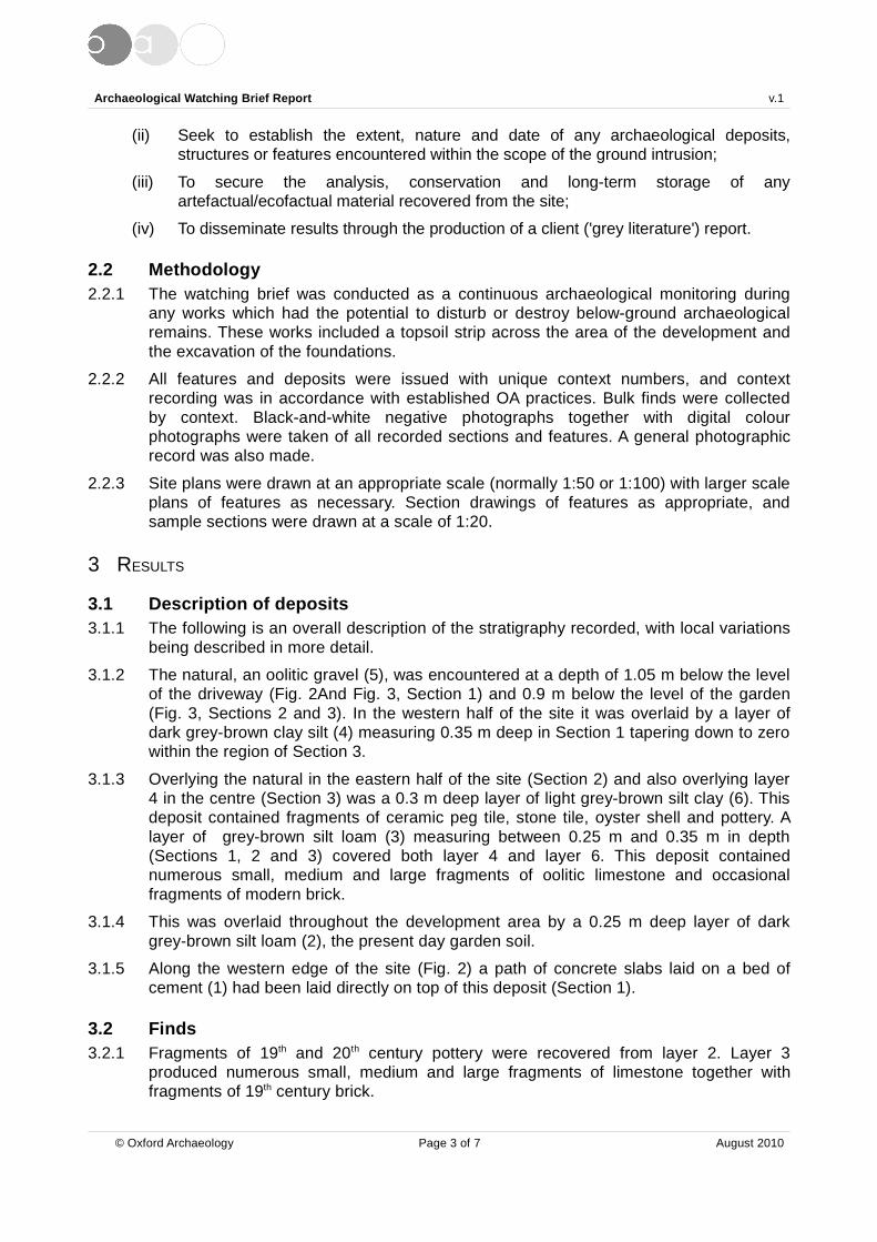
3.1.2 The natural, an oolitic gravel (5), was encountered at a depth of 1.05 m below the levelof the driveway (Fig. 2And Fig. 3, Section 1) and 0.9 m below the level of the garden(Fig. 3, Sections 2 and 3). In the western half of the site it was overlaid by a layer ofdark grey-brown clay silt (4) measuring 0.35 m deep in Section 1 tapering down to zerowithin the region of Section 3.
3.1.3 Overlying the natural in the eastern half of the site (Section 2) and also overlying layer4 in the centre (Section 3) was a 0.3 m deep layer of light grey-brown silt clay (6). Thisdeposit contained fragments of ceramic peg tile, stone tile, oyster shell and pottery. Alayer of grey-brown silt loam (3) measuring between 0.25 m and 0.35 m in depth(Sections 1, 2 and 3) covered both layer 4 and layer 6. This deposit containednumerous small, medium and large fragments of oolitic limestone and occasionalfragments of modern brick.
3.1.4 This was overlaid throughout the development area by a 0.25 m deep layer of darkgrey-brown silt loam (2), the present day garden soil.
3.1.5 Along the western edge of the site (Fig. 2) a path of concrete slabs laid on a bed ofcement (1) had been laid directly on top of this deposit (Section 1).
3.2 Finds3.2.1 Fragments of 19th and 20th century pottery were recovered from layer 2. Layer 3
produced numerous small, medium and large fragments of limestone together withfragments of 19th century brick.
© Oxford Archaeology Page 3 of 7 August 2010

Archaeological Watching Brief Report v.1
3.2.2 Fragments of earlier peg tile together with a shard of pottery provisionally identified asa fragment of Romano-British native ware and an oyster shell were recovered fromlayer 6. Finds other than the 19th century brick were retained.
3.3 Environmental remains3.3.1 It was not thought that significant additional information would be obtained by palaeo-
environmental sampling of the deposits observed.
4 DISCUSSION AND CONCLUSIONS
4.1.1 Layer 5 is the underlying natural geology of the area, a terrace gravel.
4.1.2 Examination of the sections recorded and the composition of the deposits overlying thenatural geology suggest thats the stratigraphy observed represents evidence of ridgeand furrow working of the area, with layer 4 forming the ridge and layer 6 furrow fill. Theline of the furrow appears to run north-east to south-west.
4.1.3 Layer 3 is a construction layer probably formed when the present, or adjacent, housewas built. Layer 2 is a modern landscaping layer of topsoil and turf.
4.1.4 It is probable that the ridge and furrow working is medieval or early post-medieval indate and may be associated with the construction of Bow House in the 17th century. Theshard of Romano-British pottery recovered from context 6 may indicate Romano-Britishactivity nearby but the absence of truncated features or concentrated find scatterssuggests that the area was outside the main focus of activity, which was probablycentred around the river crossing on the Fosse way approximately 1200 m to the north-west.
© Oxford Archaeology Page 4 of 7 August 2010

Archaeological Watching Brief Report v.1
APPENDIX A. ARCHAEOLOGICAL CONTEXT INVENTORY
Context Type Depth Width Length Comments Finds Date1 Layer 0.2 m 0.9 m > 10 m Concrete slab
path and base- C20th
2 Layer 0.25 m 9 m > 9 m Garden soil Pottery,brick, tile
C19th/C20th
3 Layer 0.25 m– 0.35
m
9 m > 9 m Construction layer Stone, brick,tile
C19th/C20th
4 Layer 0.35 m 5. 5 m > 9 m Plough ridge - C14th/C18th
5 Layer > 0.1 m > 9 m > 9 m Natural terracegravel
- -
6 Layer 0.3 m > 3 m > 9 m Furrow fill Brick, tile,pottery
C14th/C18th
© Oxford Archaeology Page 5 of 7 August 2010

Archaeological Watching Brief Report v.1
APPENDIX B. BIBLIOGRAPHY AND REFERENCES
GCC, 2011 2 Bow Lane, Bourton-on-the-Water, Gloucestershire: Brief for a programmeof archaeological mitigation recording
GCCAS, 1998 Gloucestershire County Council Archaeological Service: GloucestershireHistoric Towns Survey – Cotswold District Archaeological Assessments -Bourton-on-the-Water
OA, 2011 2 Bow Lane, Bourton-on-the-Water, Gloucestershire: Written Scheme ofInvestigation for an Archaeological Watching Brief
© Oxford Archaeology Page 6 of 7 August 2010

Archaeological Watching Brief Report v.1
APPENDIX C. SUMMARY OF SITE DETAILS
Site name: 2 Bow Lane, Bourton-on-the-Water, Gloucestershire
Site code: BOTWBL 11
Grid reference: Centred at NGR SP 167 206
Type of watching brief: Monitoring of the machine excavation of foundation trenches fora new extension
Date and duration of project: 13th September 2011, 1 day
Area of site: Approximately 100 m2
Summary of results: The watching brief observed evidence for probable medievalridge and furrow working overlaid by a modern constructionlayer and landscaping. A fragment of Romano-British potterywas recovered but no evidence for occupation wasencountered.
Location of archive: Corinium Museum, Cirencester, Gloucestershire
© Oxford Archaeology Page 7 of 7 August 2010


413000
414000
415000
416000
417000
418000
419000
420000
217000
218000
219000
220000
221000
222000
223000
224000
Figure 1: Site location
!
!
!
!
!
!LONDON
OXFORD
EXETER
CARDIFF
BIRMINGHAM
MANCHESTER
!!
!
!
!
!
!
!
!
!
!
!
!
!
!
!
!
!
!
!
!
!
!
A44
A40
A424
A429
A417
A361
A46
A436
A4095
A429
A429
Cheltenham
Cirencester
Witney
Signet
Enstone
Salford
Burford
Filkins
Fulbrook
Broadway
Kilkenny
Daylesford
Foss Cross
Seven Springs
Lower Oddington
Broughton Poggs
Moreton-in-Marsh
Stow-on-the-Wold
Bourton-on-the-Hill
GLOUCESTERSHIRE
OXFORDSHIRE
WARWICKSHIRE
WORCESTERSHIRE
1:50,000
1:5,000,000 1:500,000
Site location
\\ser
verg
o*A
toH
*2 B
ow L
ane,
Bou
rton
on
the
Wat
er*B
OT
HW
BL1
1BO
TH
WB
LWB
*jm
*22.
09.1
1
Reproduced by permission of the Ordnance Survey on behalf of The Controller of Her Majesty's Stationary Office (c) Crown Copyright. 1996 All rights reserved. License No. AL 100005569


Site
loca
tion
Not
to s
cale
Sec
tion
2
Sec
tion
3
Sec
tion
1
Gar
age
Pat
h
Lim
it of
tops
oil s
trip
Fig
ure
2: S
ite p
lan
Driv
eway
N
Pla
n 2
Hou
se
4167
11/
2205
53
4167
11/
2205
67
Serv
ergo
:/oau
pubs
1_A
toH
*BO
TWB
L11*
BO
TWB
LWB
*2 B
ow L
ane,
Bou
rton
on th
e W
ater
*jc*
22.0
9.11
Tren
chin
g

2
3
4
5
2
3
6
5
2
3
64
5
1
SW NE130.55 m OD
130.42 m OD
130.46 m OD
Figure 3: Sections
SWNE
NWSE
1:25
0 1 m
Section 3
Section 2
Section 1
Serv
ergo
:/oau
pubs
1_A
toH
*BO
TWB
L11*
BO
TWB
LWB
*2 B
ow L
ane,
Bou
rton
on th
e W
ater
*jc*
22.0
9.11

Di rec to r : D av i d J enn i ngs , BA M I FA F SA
Oxf o rd A rchaeo l ogy L td i s a
P r i va te L i m i ted C om pany , N o : 1618597
and a Reg i s te red Char i t y , No : 285627
OA Nor thMi l l 3Moor LaneLancas te r LA1 1GF
t : +44 ( 0 ) 1524 541 000f : +44 ( 0 ) 1524 848 606e : oanor th@thehuman jou r ney .ne tw :h t tp : / / thehuman jou r ney .ne t
Head Of f ice/Reg i s te red O f f ice/OA Sou th
Janus HouseOsney MeadOxfo rd OX2 0ES
t : +44 ( 0 ) 1865 263 800f : +44 ( 0 )1865 793 496e : i n fo@ox fo rda rch .co .ukw : h t t p : / / t h e h u m a n j o u r n e y . n e t
OA Eas t
15 T r a fa lga r WayBar H i l lCambr idgesh i reCB23 8SQ
t : +44 (0 )1223 850500f : +44 (0 )1223 850599e : oaeas t@thehuman jou r ney .ne tw :h t tp : / / thehuman jou r ney .ne t