2 points to white rock east area plan
DESCRIPTION
The Plan Formerly Known as the Ferguson Road InitiativeTRANSCRIPT

AGENDA ITEM # 49KEY FOCUS AREA: Economic Vibrancy
AGENDA DATE: March 27, 2013
COUNCIL DISTRICT(S): 7
DEPARTMENT: Sustainable Development and Construction
CMO: Ryan S. Evans, 670-3314
MAPSCO: 38 T; U; V 38 W; X; Y; Z 39 S; W 48 A; B; C; D; F; G________________________________________________________________
SUBJECT
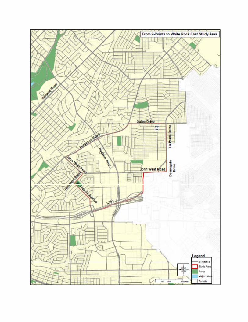
A public hearing to receive comments regarding adoption of the 2 Points to White Rock East Area Plan, which defines issues, goals, and recommendations related to planning and implementation for future development in the area bounded by St. Francis Avenue, Hunnicut Road, Lakeland Drive, Ferguson Road, Oates Drive, La Prada Drive, Deansgate Drive, John West Road, Dallas City Limits and IH-30 and a resolution adopting the study - Financing: No cost consideration to the City
BACKGROUND
The 2 Points to White Rock East Area Plan is the result of a grassroots, neighbor-led planning effort. It was conceived under the auspices of the Ferguson Road Initiative and the Truett Crime Watch. The 2 Points to White Rock East (WRE) Advisory Committee was formed in 2010 with the assistance of the City Councilmember from District 7. The WRE Advisory Committee is made up of individuals who represent neighborhoods, business owners, and property owners within the designated 2 Points to White Rock East study area (see attached map).
The WRE planning effort was assisted by professional urban planners who contributed their services pro-bono. Staff from the Strategic Planning Division of the Sustainable Development and Construction provided general guidance and support. There were three public meetings/events and 15 Advisory Committee meetings held between December 2009 and September 2012 to receive community input.
The 2 Points to White Rock East Area Plan has the following sections: Consensus Vision, Introduction, Land Use, Transportation, Quality of Life, Urban Design, Economic Development, and Implementation.

Agenda Date 03/27/2013 - page 2
BACKGROUND (Continued)
The Consensus Vision and Introduction sections provide context-specific policy direction through a description of the project background, study area characteristics, and community-based vision developed to serve as an ongoing guide for future land development.
The Land Use section of the plan provides more specific land use policy guidance and identifies seven Strategic Opportunity Areas, illustrating in more detail the types of future development desired in the WRE study area.
The Transportation, Quality of Life, Urban Design, and Economic Development sections further help define specific criteria desired by the community within the WRE study area. The Implementation section is intended to provide direction to the WRE community for using the area plan to help realize the vision.
PRIOR ACTION / REVIEW (COUNCIL, BOARDS, COMMISSIONS)
On February 7, 2013, the City Plan Commission recommended approval of the 2 Points to White Rock East Area Plan.
FISCAL INFORMATION
No cost consideration to the City.
MAP
Attached.

COUNCIL CHAMBER
March 27, 2013
WHEREAS, on December 5, 2009, a kick-off community meeting was held with support from the City Councilmember for District 7, to initiate the 2 Points to White Rock East Area Plan for the study area bounded by St. Francis Avenue, Hunnicut Road, Lakeland Drive, Ferguson Road, Oates Drive, La Prada Drive, Deansgate Drive, John West Road, Dallas City Limits and IH-30; and
WHEREAS, the 2 Points to White Rock East Advisory Committee representing the study area neighborhood residents, business owners, and property owners, worked with the assistance of volunteer consultants and general guidance by city staff to develop the 2 Points to White Rock East Area Plan; and
WHEREAS, three public meetings and 15 Advisory Committee meetings were held to receive community input between December 2009 and September 2012; and
WHEREAS, the 2 Points to White Rock East Area Plan defines issues, goals and recommendations and provides planning and implementation guidance for future development for the 2 Points to White Rock East study area; Now Therefore,
BE IT RESOLVED BY THE CITY COUNCIL OF THE CITY OF DALLAS:
SECTION 1. That the 2 Points to White Rock East Area Plan is hereby adopted as a reference and guide to benefit the citizens of the 2 Points to White Rock East study area community.
SECTION 2. That the City Council directs the City Manager to consider the 2 Points to White Rock East Area Plan in conjunction with other adopted plans on future actions affecting the 2 Points to White Rock East study area.
SECTION 3. That this resolution shall take effect immediately from and after its passage in accordance with the provisions of the Charter of the City of Dallas, and it is accordingly so resolved.
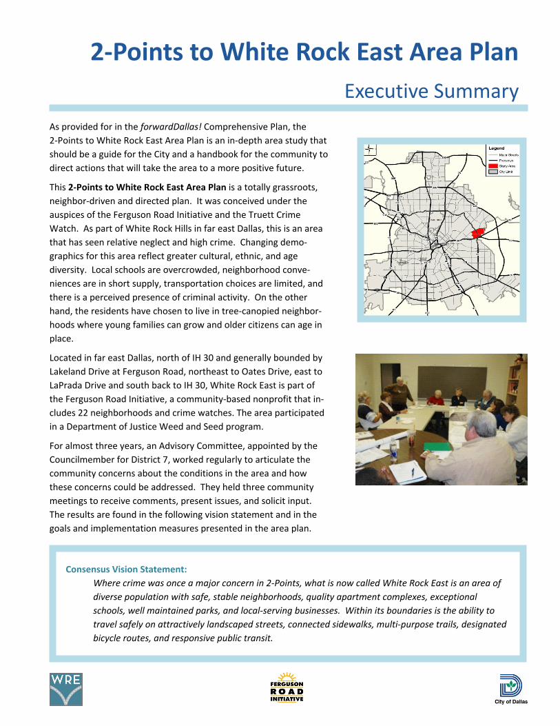
As provided for in the forwardDallas! Comprehensive Plan, the2-Points to White Rock East Area Plan is an in-depth area study thatshould be a guide for the City and a handbook for the community todirect actions that will take the area to a more positive future.
This 2-Points to White Rock East Area Plan is a totally grassroots,neighbor-driven and directed plan. It was conceived under theauspices of the Ferguson Road Initiative and the Truett CrimeWatch. As part of White Rock Hills in far east Dallas, this is an areathat has seen relative neglect and high crime. Changing demo-graphics for this area reflect greater cultural, ethnic, and agediversity. Local schools are overcrowded, neighborhood conve-niences are in short supply, transportation choices are limited, andthere is a perceived presence of criminal activity. On the otherhand, the residents have chosen to live in tree-canopied neighbor-hoods where young families can grow and older citizens can age inplace.
Located in far east Dallas, north of IH 30 and generally bounded byLakeland Drive at Ferguson Road, northeast to Oates Drive, east toLaPrada Drive and south back to IH 30, White Rock East is part ofthe Ferguson Road Initiative, a community-based nonprofit that in-cludes 22 neighborhoods and crime watches. The area participatedin a Department of Justice Weed and Seed program.
For almost three years, an Advisory Committee, appointed by theCouncilmember for District 7, worked regularly to articulate thecommunity concerns about the conditions in the area and howthese concerns could be addressed. They held three communitymeetings to receive comments, present issues, and solicit input.The results are found in the following vision statement and in thegoals and implementation measures presented in the area plan.
Consensus Vision Statement:Where crime was once a major concern in 2-Points, what is now called White Rock East is an area ofdiverse population with safe, stable neighborhoods, quality apartment complexes, exceptionalschools, well maintained parks, and local-serving businesses. Within its boundaries is the ability totravel safely on attractively landscaped streets, connected sidewalks, multi-purpose trails, designatedbicycle routes, and responsive public transit.
2-Points to White Rock East Area PlanExecutive Summary

2 2-Points to White Rock East Area Plan Executive Summary
The 2-Points to White Rock East Area Plan is comprised of thefollowing sections, each with its own goals and implementationmeasures.
The Introduction provides a detailed overview of current condi-tions in the study area and the planning process used to developthe plan.
The Land Use section details the existing land use and zoning andpresents ideas for changes. Seven very conceptual StrategicOpportunities Areas are described, consistent with an agreedupon Land Use Consensus Vision. Instead of relying on currentzoning to improve the area, the plan uses the Building Blocks offorwardDallas! to further articulate the community’s vision. TheseBuilding Blocks could then be applied to specific locations in cooper-ation with private investment.
The desire to “age in place”, provide safe access to schools andshopping, and mobility to and from the area were the drivers inthe development of the Transportation section. The transporta-tion section is intended to influence the growth, development,and stability of the community, including: roadway character,existing thoroughfare network, transit service, bicycle facilities,sidewalk distribution, trail network expansion, gateways,wayfinding, and signalization.
An area plan generally focuses on Land Use and Transportation,but at the first community meeting the residents identified otherareas of concern in the SWOT analysis under the title, Quality ofLife. Subjects covered include, Police, Fire, Code Compliance,Parks and Recreation, Library, Schools, and Housing.
Interest in how Urban Design criteria could be applied in thestudy started with the SWOT analysis and continued through theadvisory committee meetings and stakeholder interviews.Concerns about the function and appearance resulted in theidentification of urban design concepts and elements that wouldimprove the overall image of White Rock East.
In terms of Economic Development, White Rock East has manysimilarities to the other parts of the City where there are dimin-ished market demands and general lack of investment. However,the proximity to downtown Dallas and transportation accessibilitymerits optimism for exploring the steps necessary for a viableeconomic future. With cooperation from the private sector, theresidents and the City can work with interested parties toencourage renewed economic activities.

2-Points to White Rock East Area Plan Executive Summary 3
The Implementation section provides direction for using the areaplan. Intended to serve as one of the City's guides, it will aid inmaking much needed improvements in this part of Dallas. Thereare relatively few large infrastructure projects which will need tobe factored in to the City’s budget and planning processes. Forthe citizens in the study area, this plan is their handbook tounderstand and support improvements to White Rock East. Thereis a table with each section’s specific goals and accompanyingmeasures to accomplish the vision—identifying responsibilities forcarrying out the actions and associated timeframes (ongoing,short, medium and long) of when these measures will beaddressed.
Many measures do not require direct action or initiation by theCity, only responsiveness and support. Others will require directparticipation by City departments as well as elected and appointedofficials. Some of the measures are very tangible, envisioningsimple, changes to signalization or traffic control. Others seek tobetter coordinate community wishes into planning, budgeting,code enforcement, and public safety. Finally, others are veryaspirational, pursuing long-term desires for the community. ThePlan lists the following top short terms measures.
■ Walkability survey/sidewalk inventory
■ Improved traffic signalization/crosswalks at Buckner atJohn West and North Buckner at Peavy
■ Continuous school zone adjacent to Bishop Lynch andTruett Elementary on Peavy
■ Sidewalk construction or improvements on majorstreets (Ferguson, La Prada, North Buckner)
■ Consideration of zoning changes in Regional Retail andLimited Office districts to revitalize both retail and resi-dential areas
■ New classroom wing for Truett Elementary School
■ TxDOT improvements to appearance of North Bucknerat IH 30 for an eastern gateway to Dallas
■ Lakeland at Ferguson Streetscape improvements (incurrent NIL)
■ Stop signs on Gross at Rustown
■ Economic Redevelopment Plan for North Buckner,beginning with a market study

4 2-Points to White Rock East Area Plan Executive Summary
Some of the longer term goals and implementation measures include the following.■ A trail network integrating the community with existing trails and sidewalks
■ Redevelopment of under-utilized tracts following an economic development market study for moreurban mixed-use development
■ Development of crime watches in multi-family complexes and better cooperation with public safetyofficials leading to Gold Star designation.
■ Sidewalk rehabilitation programs in neighborhoods
■ Bike Plan facilities expansion
■ Potential for another elementary school to reduce overcrowding
■ New fire station
■ Wayfinding and neighborhood identification markers
From 2-Points to White Rock East, this area plan provides the foundation for the goals to be achieved through theimplementation measures that have been put forward by those residents and businesses who will work togetherto provide a better future in far east Dallas.
Building Blocks and Strategic Opportunity Areas
2-Points to White Rock East
Area Plan
November 2012
Foreword
This 2-Points to White Rock East Area Plan is a totally grassroots, neighbor-driven and directed plan. It
was conceived under the auspices of the Ferguson Road Initiative and the Truett Crime Watch. As part of
White Rock Hills in far east Dallas, this is an area that has seen relative neglect and high crime.
Residents and interested individuals have invested their time in the development of inclusive consensus
visions and implementation measures. For over two years the Advisory Committee, appointed by the
Councilmember for District 7, worked to articulate their concerns about the conditions in the area and
how these concerns should be addressed. The result is an in-depth study that should be a guide for the
City and a handbook for the community to direct actions that will take the area to a more positive future.
ACKNOWLEDGEMENTS
From 2-Points to White Rock East November 2012 i
The 2-Points to White Rock East Area Plan would not have been possible without the following
individuals and organizations.
Advisory Committee
Ellen Childress
John Childress
Georgia King
Kerry Goodwin
Gus Garcia
Eileen Williams
Vicki Sanger
Desi Tanner
Kimberly Humphries
Pat Copeland
Lauren Roberts
Planning Consultants
Robert Prejean, AICP
Cheri Solieau, AICP
Support Organizations
Ferguson Road Initiative
New Hope Lutheran Mission
White Rock Church of Christ
City of Dallas Department of Sustainable Development and Construction
Theresa O’Donnell, Director
Peer Chacko, AICP, Assistant Director Strategic Planning Division
David Schleg, AICP
Shilpa Ravande, AICP
Tanya Brooks
Max Kalhammer
Richard Mason, AICP, ASLA, Texas Department of Transportation
Todd Plesko and Linicha Hunter, Dallas Area Rapid Transit
JBH Communications (website: www.2pointstowhiterockeast.com)
Color Box Design & Letterpress (logo)
PolyMetric Group, LLC (editor)
And a special thanks to the Honorable Carolyn R. Davis, Dallas City Councilmember, District 7
TABLE OF CONTENTS
From 2-Points to White Rock East November 2012 ii
Forward ....................................................................................................................................................... i
Acknowledgements .................................................................................................................................... ii
Consensus Vision.................................................................................................................................... V-1
Introduction ............................................................................................................................................. I-1
Land Use ............................................................................................................................................... LU-1
Transportation ........................................................................................................................................ T-1
Quality of Life ....................................................................................................................................... QL-1
Urban Design ........................................................................................................................................ UD-1
Economic Development ....................................................................................................................... ED-1
Implementation ................................................................................................................................... IM-1
Appendices
Appendix A – Ferguson Road Initiative Letter
Appendix B – Community Meetings
Appendix C – Advisory Committee Agendas
Appendix D – Media Coverage of Plan
Appendix E – History and Place of White Rock East
Appendix F – Changes to Bus Routes

THE CONSENSUS VISION
2-Points to White Rock East November 2012 V-1
For over three years, residents and stakeholders worked to envision the future of White Rock East in far
east Dallas. The resulting Consensus Vision was formulated based on the desires and dreams to
transition from the negative aspects associated with the 2-Points name to the more positive name of
White Rock East. The ability to look beyond the present and consider what would best serve the area
now and in the future led to creative ideas for the protection, revitalization, repurposing and
redevelopment of the residential and commercial parts of the area to have walkable stable
neighborhoods, new mixed-use developments and responsive local businesses.
Although the neighbors are very diverse in age, culture, attitude, and education, their ideas about
housing, crime, education, and transportation coalesced into the Consensus Vision. The work on the
vision focused on improving neighborhoods and assuring a quality of life that included improved
mobility for all ages. Instead of lamenting about crime statistics, residents began to understand what
policies and processes would be needed to improve both perceptions and physical conditions.
The Consensus Vision was developed over the course of several advisory committee meetings guided by
the input from the first community meeting. While aspirations were tempered with reality, the
following vision was developed to define what the area should be in the reasonably near future. When
the vision was revealed at the second community meeting, it was met with resounding approval!
Consensus Vision Statement
Where crime was once a major concern in 2-Points, what is now called White Rock East is an area of
diverse population with safe, stable neighborhoods, quality apartment complexes, exceptional
schools, well maintained parks, and local-serving businesses. Within its boundaries is the ability to
travel safely on attractively landscaped streets, connected sidewalks, multi-purpose trails, designated
bicycle routes, and responsive public transit.
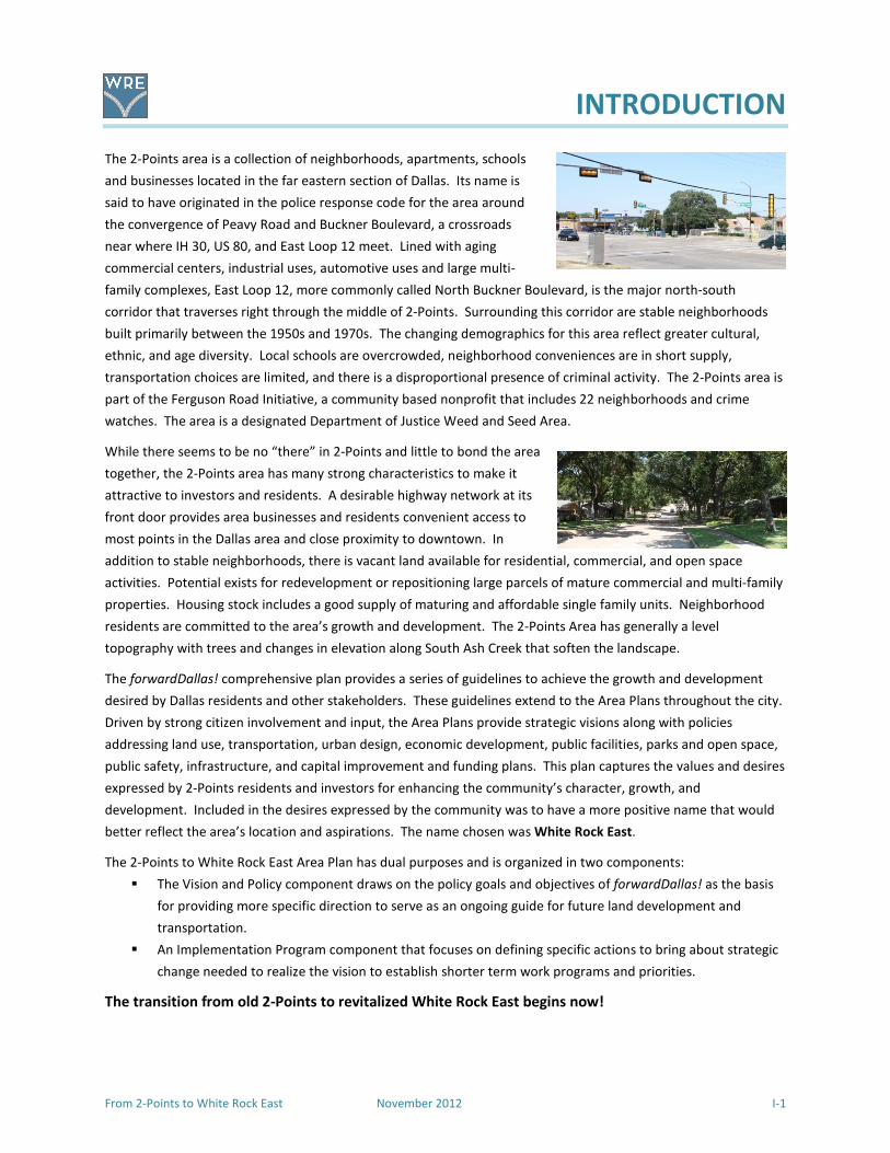
INTRODUCTION
From 2-Points to White Rock East November 2012 I-1
The 2-Points area is a collection of neighborhoods, apartments, schools
and businesses located in the far eastern section of Dallas. Its name is
said to have originated in the police response code for the area around
the convergence of Peavy Road and Buckner Boulevard, a crossroads
near where IH 30, US 80, and East Loop 12 meet. Lined with aging
commercial centers, industrial uses, automotive uses and large multi-
family complexes, East Loop 12, more commonly called North Buckner Boulevard, is the major north-south
corridor that traverses right through the middle of 2-Points. Surrounding this corridor are stable neighborhoods
built primarily between the 1950s and 1970s. The changing demographics for this area reflect greater cultural,
ethnic, and age diversity. Local schools are overcrowded, neighborhood conveniences are in short supply,
transportation choices are limited, and there is a disproportional presence of criminal activity. The 2-Points area is
part of the Ferguson Road Initiative, a community based nonprofit that includes 22 neighborhoods and crime
watches. The area is a designated Department of Justice Weed and Seed Area.
While there seems to be no “there” in 2-Points and little to bond the area
together, the 2-Points area has many strong characteristics to make it
attractive to investors and residents. A desirable highway network at its
front door provides area businesses and residents convenient access to
most points in the Dallas area and close proximity to downtown. In
addition to stable neighborhoods, there is vacant land available for residential, commercial, and open space
activities. Potential exists for redevelopment or repositioning large parcels of mature commercial and multi-family
properties. Housing stock includes a good supply of maturing and affordable single family units. Neighborhood
residents are committed to the area’s growth and development. The 2-Points Area has generally a level
topography with trees and changes in elevation along South Ash Creek that soften the landscape.
The forwardDallas! comprehensive plan provides a series of guidelines to achieve the growth and development
desired by Dallas residents and other stakeholders. These guidelines extend to the Area Plans throughout the city.
Driven by strong citizen involvement and input, the Area Plans provide strategic visions along with policies
addressing land use, transportation, urban design, economic development, public facilities, parks and open space,
public safety, infrastructure, and capital improvement and funding plans. This plan captures the values and desires
expressed by 2-Points residents and investors for enhancing the community’s character, growth, and
development. Included in the desires expressed by the community was to have a more positive name that would
better reflect the area’s location and aspirations. The name chosen was White Rock East.
The 2-Points to White Rock East Area Plan has dual purposes and is organized in two components:
� The Vision and Policy component draws on the policy goals and objectives of forwardDallas! as the basis
for providing more specific direction to serve as an ongoing guide for future land development and
transportation.
� An Implementation Program component that focuses on defining specific actions to bring about strategic
change needed to realize the vision to establish shorter term work programs and priorities.
The transition from old 2-Points to revitalized White Rock East begins now!

INTRODUCTION
I-2 November 2012 From 2-Points to White Rock East
The Study Area
The study area covers approximately 1,522 acres within the boundaries of Ferguson Road on the
northeast from Lakeland to Oates, east along Oates to La Prada, then south on La Prada to John West,
west on John West to a point on the Mesquite city limits line and Eastfield College, then south to R. L.
Thornton Freeway (IH 30/US 80), then westerly along the freeway to St. Francis, then north to Hunnicutt
to Lakeland, and back to Ferguson. North Buckner Boulevard, a major thoroughfare crosses the area
from Ferguson Road to the freeway. The area is located entirely within City Council District 7.
Map I-1 - White Rock East Parcel Boundary courtesy of Department of Sustainable Development and Construction
Map I-1 - White Rock East – Parcel Boundary

INTRODUCTION
From 2-Points to White Rock East November 2012 I-3
The Planning Process
The concept that there could be an area plan for the White Rock East area began with the adoption of
forwardDallas!, the comprehensive plan the City of Dallas adopted in June 2006. Enlightened citizens of
the area saw that an area plan using the strategic planning program in the comprehensive plan would
give them the opportunity to revitalize their area with new ideas for residential and commercial
development, while protecting their stable neighborhoods. The focus of much thinking and activities
had been on the reduction of crime though a Department of Justice Weed and Seed strategy initiated by
the umbrella citizens group, the Ferguson Road Initiative. Initial area plan discussions were held in
March 2008 and June 2009.
With encouragement from the City Councilmember, a community meeting was held in December 2009
with over thirty interested residents attending. The follow up to this meeting was the establishment of
an advisory committee. This committee was comprised of interested residents and representatives of
organizations that would be involved in the development of a plan to guide land use decisions,
infrastructure improvements, and solutions to traffic and streets problems. Improvements to the
appearance and conditions should reduce crime and promote a safe, desirable place to live, work, shop
and play.
When early discussions with involved citizens in the White Rock East area were held, the participants
expressed their concern about crime, gangs, and gun shots—mostly associated with the numerous
apartment complexes. While these are still a problem, there has been a significant reduction in crime
due to the combined efforts of the Department of Justice Weed and Seed strategy through the Ferguson
Road Initiative and dedication of the members of area crime watches and neighborhood associations.
These successes enabled the residents to focus on what was good about the area and what would be
needed to continue to improve this part of the overall community.
Advisory Committee Meetings
The advisory committee met regularly beginning in January 2010. Given the limitations of City staff and
that the area plan was not on the first list of plans listed in forwardDallas!, it was agreed to use the pro
bono services of a professional planner who lived nearby to facilitate the development of the plan. The
Strategic Planning staff provided initial guidance and base maps for the study area. Two additional
professional planners joined the planning team and contributed their services to the planning process.
December 5, 2009 Kickoff Community meeting with overview of the study process and
requirements and a SWOT analysis (Appendix A)
January 30, 2010 Review of SWOT (see summary following the list of meetings)
April 1, 2010 Land Use, Zoning and Demographics Discussion
April 24, 2010 Introduction to Goals and Objectives
May 29, 2010 Follow-up on goals, introduction to Transportation issues
July 10, 2010 Land Use issues in the community and Transportation continued
August 28, 2010 Stakeholder Interview briefing and discussion of DART services

INTRODUCTION
I-4 November 2012 From 2-Points to White Rock East
September 18, 2010 First draft of Existing Conditions/relationship to forwardDallas! Building
Blocks, policies and infrastructure needs
November 13, 2010 Land Use discussion, Consensus Vision discussion and Stakeholder results
January 8, 2011 Review of first Draft of Plan
March 26, 2011 Second Community Meeting for community update the on the progress of
the planning process and explanation of goals and Strategic Opportunity
Areas
June 4, 2011 Review and distribution of the Draft Plan to the Advisory Committee for
editing and comments
July 9, 2011 Discussion of edits and changes to the Draft Plan
July 29, 2011 Submittal of draft to City staff for review, comment and input
April 8, 2012 Comments and input received from Staff
May 29, 2012 Meeting with City staff to discuss review comments
June 28, 2012 Meeting to discuss revisions
August 19, 2012 Meeting to set third Community Meeting date and review draft
September 5, 2012 Revisions completed and resubmitted to City
September 15, 2012 Third Community Meeting at White Rock Hills Branch Library
Resubmittal of proposed final documents
Briefing at City Plan Commission
Recommendation by City Plan Commission to City Council
Adoption by Resolution by City Council
Community Meetings
The first Community Meeting was held on December 5, 2009 at the New Hope Community Center on
Peavy Road. Approximately 30 people attended to participate in a SWOT (Strengths, Weaknesses,
Opportunities and Threats) analysis of the White Rock East area, then referred to as 2-Points.
The SWOT analysis identified a wide variety of issues in the area. From area maps, concerns were
expressed then documented and summarized to form the basis of the existing conditions and concerns.
� Strengths included the new library, Bishop Lynch High School, Lakeland Post Office, Nexus
Center, New Hope Center, three parks with their improvements, tree canopy, places for new
businesses, location close to major roads and downtown, Eastfield College, area churches, well
built homes, the Weed and Seed strategy, and interested, involved residents.
� Weaknesses were identified as continued presence of gangs, the number of under-maintained
homes and apartment complexes, distressed appearance of streets, motel, sexually oriented
business, overabundance of automotive shops, payday loan places, underutilized shopping
areas, lack of a grocery store, insufficient DART service, inability to get around—sidewalks in

INTRODUCTION
From 2-Points to White Rock East November 2012 I-5
poor condition or nonexistent, hard to cross intersections, uninterested residents, lack of nice
shops, lack of places for families to eat, overcrowded schools, and lack of proactive code
compliance and enforcement.
� Opportunities were identified as preservation of stable neighborhoods, use of the creeks for
trails, continued improvements to the schools, repurposing of large stores and shopping areas,
improved DART service, sidewalks improvements, bike lanes and street corridor beautification.
� Threats were perceived as the continued presence of the gangs—particularly at the apartment
complexes, regional retail zoning that allows many uses, no incentive for new businesses to
locate, types of existing businesses, lack of transit ridership, and no funding for improvements.
Key Assets
The area has a number of key assets with the number one being the close proximity to Downtown Dallas
and other areas of the DFW Metroplex by way of IH 30, Buckner Boulevard or Ferguson Road. Other
assets include:
� Eastfield College immediately adjacent to the east
� Stable single-family neighborhoods with affordable housing
� A diversity of ethnicities
� DART serves area, but with limited service
� Three public parks with new improvements
� The new library in the study area
� Creeks that provide the potential for trails
� Large trees and shaded neighborhoods
� Active crime watches and neighborhood associations
� Areas ripe for redevelopment and re-purposing
Key Challenges for the Plan
The key challenges are much the same as those in other areas of Dallas; however, there has been a
concentrated focus in the area on the reduction of criminal activities. As in other area plans, the
challenges are:
� Aging infrastructure: the area was developed mainly in the 1950s and 1960s
� Existing zoning that includes a large amount of Regional Retail and Limited Office which are not
being used as originally intended
� Aging and under maintained multi-family housing
� Unappealing streetscapes that lack landscaping
� Discontinuous and/or deteriorating sidewalks
� Underutilized shopping centers
� Proliferation of auto service uses
� Lack of grocery store and restaurants
� Underserved bus routes and paratransit services
� Traffic signals and signage
� Reactive rather than proactive code enforcement
� Continued crime
� Underperforming schools
INTRODUCTION
I-6 November 2012 From 2-Points to White Rock East
The second Community Meeting was held on Saturday, March 26, 2011 at the White Rock Church of
Christ on Ferguson Road in the study area. Approximately 80 people, including a number of children,
attended. The PowerPoint presentation addressed the planning process, showed the results of the
SWOT analysis, provided a summary of the stakeholder interviews, explained Building Blocks and
introduced the concepts of strategic opportunity areas. The presentation is included in Appendix A. The
announcement of the meeting as well as meeting coverage was carried by several local newspapers.
The sections of the draft and meeting presentation were also posted on the plan’s website:
www.2pointstowhiterockeast.com.
Business Outreach
In preparation for the second Community Meeting, members of the Advisory Committee circulated
5,000 flyers as invitations to the meeting. They personally contacted over 60 businesses (list provided in
Appendix A) along the commercial corridors to explain the plan, the process, draft documents and ask to
display the flyer. They were well received by the government offices, locally owned and operated
businesses and retail establishments. Many said that the time of the meeting might preclude their
attendance, but offered support in displaying the flyer. One of the franchise operators printed 2,000
flyers and a representative attended the meeting. Flyers were also given to schools and churches for
distribution. The businesses were re-contacted for the next community meeting.
A third Community Meeting was held on September 15, 2012 at the new White Rock Hills Library.
Elements of the final draft were presented to over 40 attendees. The presentation is in the Appendix A.
Following the meeting, the final draft was submitted to City Staff for review, prior to consideration by
City Plan Commission and City Council.
Existing Plans
In 1984, the Land Use Study - Buckner/John West, a plan for the area around that intersection was
prepared by the staff of the City of Dallas, Department of Planning & Development, to guide the future
land use development and zoning in that immediate area. The impetus for this plan was a number of
rezoning requests.
There is the 1998 Urban Design Area Plan for the both sides of Ferguson Road from IH 30 to Lakeland
Drive. Parts of this plan have been implemented, mainly the improvements to Highland Road from
Ferguson to St Francis. Proposed improvements on Ferguson at IH 30, Highland and Lakeland were
developed and added to the Needs Inventory List (NIL) for future city bond elections.
In 2006, the City of Dallas adopted forwardDallas! as its comprehensive plan. The Vision Illustration
shows this area as primarily Residential Neighborhoods and Business Center or Commercial Corridor
along the southern part of Buckner and IH 30.
This area was included in a Public Improvement District (PID) Feasibility Study prepared for the Ferguson
Road Initiative by Le Tourneau University in 2006. The area was identified as Areas B and C, having the
potential to sustain economic, public, and social benefits.

INTRODUCTION
From 2-Points to White Rock East November 2012 I-7
Meetings with City of Dallas Departments
The planning team met with the following City department staff to discuss their issues and plans for the
study area. Their input was invaluable in developing the plan.
Peer Chacko, David Schleg and Shilpa Ravande, Strategic Planning Division
Michael Hellman, Parks and Recreation Department
Keith Manoy and Tanya Brooks, Transportation Planning
Sue Alvarez, Steve Parker, and Peter Blanchette, Stormwater Management
Cobbie Ransom and Aldo Fritz, Housing Department
Eduardo Valerio, Water Utilities, Water/Wastewater (by telephone and email)
Max Kalhammer, Dallas Bike Plan
Arturo Del Castillo, City Design Studio
Todd Plesko, Dallas Area Rapid Transit (by telephone and email)
The following sections are an overview of the existing conditions.

INTRODUCTION
I-8 November 2012 From 2-Points to White Rock East
Demographics and Housing Characteristics
The following chart provides an overview of the population and housing statistics for the study area for
both the 2000 and 2010 Census. The following numbers indicate a stable population. There were
several new multi-family developments built in the years between the 2000 and 2010 Census. It is not
apparent that an appreciable number of units were demolished. The same appears to hold true for
single family and townhomes. A new single-family neighborhood was started, stalled, and appears to be
building again. As shown in the table below, not all of the same data was available in each Census.
Demographics for 2-Points to White Rock East
2000 2010
Total Population 19,337 19,345
Age Distribution
Under 5 years old 1,982 10% 2,145 11%
5-19 years old 4,883 25% 4,573 24%
20-64 years old 10,884 56% 11,170 58%
65 and older 1,588 8% 1,457 8%
Gender
Male 9,019 47% 9,026 47%
Female 10,318 53% 10,319 53%
Race/Ethnicity
White 4,651 23.6% 2,923 15%
Black 8,020 41.5% 7,348 38%
Hispanic* 5,403 27.9% 8,401 43%
Asian 1,086 5.6% 374 2%
Other 132 1.4% 304 2%
Housing/Households
Total Households
Total Housing Units 7623 8,405
Total Occupied Units 7,078
Rental Units 5,222 68.5%
Vacant 1327 Source: Census Data, 2000 and 2010. The study area includes Census Tracts 122.10, 122.11, 123.01, and 123.02
*Although Hispanic is not technically a race, showing this ethnicity is important and realistic numbers were available for 2000 and 2010
The population totals and distributions over the 10 year period indicate a basically stable population as
far as number, gender and age distribution. There is a decline in the White population and an increase
in those who identified themselves as Hispanic. Both Black and Asian populations declined slightly.
There is concern that there could be an undercount in the apartments who are home to a number of
residents who do not speak English.
It is assumed that the study area will grow in population with more younger families. The potential
repurposing of older multi-family to lower density and the proposed mixed use development fronting on
IH 30 at Buckner Boulevard are assumed to offset each other.

INTRODUCTION
From 2-Points to White Rock East November 2012 I-9
Existing Development Patterns
The study area boundaries are Ferguson Road on the northeast from Lakeland to Oates, east along
Oates to La Prada, then south on La Prada to John West, west on John West to a point on the Mesquite
city limits line, then south to R. L. Thornton Freeway (IH 30/US 80), then westerly along the freeway to
St. Francis, then northwest to Hunnicutt then northeast to Lakeland, and back northwest to Ferguson.
North Buckner Boulevard (Loop 12), a major thoroughfare crosses the area from Ferguson Road to IH 30.
The area covers approximately 1,522 acres.
Current land uses in the area include single-family residences, multi-family apartments, large and small
shopping centers, strip center commercial, nine churches, social service providers, two elementary
schools, one middle school, a private high school, post office, two large car dealerships, industrial uses,
offices, a motel, a sexually oriented business, general retail establishments, auto services, and three
parks.
Area Description
Beginning at the intersection of Oates and Ferguson, the first land uses
are commercial ones. At the corner is an automotive repair shop. To the
east is an aging strip shopping center with a variety of small businesses—
novelty store, a resale/thrift store, a gym, tobacco store, tattoo parlor,
ice cream parlor and vacant space. The center has seen a succession of
owners and is marginally maintained with limited landscaping and
lighting with deteriorating parking lot surface. Often the parking lot is
used for overnight parking by large trucks.
East from the shopping center toward La Prada and south of Oates is a
large single-family neighborhood comprised of small brick and frame
houses. The area appears to be transitioning to one of larger families as
evidenced by on-street parking. The houses are well maintained, but the
area is beginning to show its age.
Along La Prada south of Oates, the single-family neighborhood continues down to an institutional use
and then apartments. To the east is the City of Mesquite and Eastfield College. La Prada then divides
with apartments in the middle and a strip shopping center, La Prada Shopping Center, facing west.
Between John West and IH 30 (R. L. Thornton Freeway) is a large undeveloped tract. Facing the freeway
is a large manufacturing facility and a car dealership. Tuning north on Buckner Boulevard there are
several automotive businesses and an industrial plant in a former big box store. On the east side of
Buckner and north of the extension of Chenault is a compressed gas plant and then a large underutilized
shopping center that extends to north.
Beginning at the intersection of La Prada and John West are several very large apartment complexes
that extend north to the single-family neighborhood and west to Hillview Terrace, a single-family
neighborhood developed in the 1970s that includes Hillview Park. On the south side of John West is the
single-family neighborhood, Lake Pointe Place.
The area that fronts IH 30 west of Buckner to Dilido and on both sides of Chenault has a large car
dealership, mixed industrial uses, office/warehouse uses, Lang Middle school, a motel, a sexually-
INTRODUCTION
I-10 November 2012 From 2-Points to White Rock East
oriented business, and several vacant tracts. East of Dilido there are several apartment complexes and
an office building for a large utility provider. To the north between Chenault and accessible from John
West are apartment complexes and a senior living facility.
White Rock Village is a single-family neighborhood best known for aviation-related street names and the
former site of the White Rock Airport. It is north of St. Francis and extends to John West. It includes the
Lakeland Hills Park. To the north as Lakeland transitions into John West, there is S. S. Conner
Elementary School, Fire Station # 53 and a large church. Encompassing the area is Eastwood Hills, a
neighborhood of well maintained single family homes.
From southwest to northeast along the east side of Ferguson, starting at the Lakeland intersection,
there is the United States Post Office, a strip shopping center, apartment complex and five churches. On
Hibiscus, near the intersection, of Ferguson is the new White Rock Hills Library. Where Ferguson crosses
Buckner are several apartment complexes. At the corner of Peavy and Ferguson is Bishop Lynch High
School. South of the high school on Peavy is Truett Elementary School which is surrounded by the Truett
neighborhood. Proceeding east on Peavy are several single-family neighborhoods, apartment
complexes, one mid-rise office building and another underutilized big box shopping center. Automotive
uses fill in between other uses. Peavy then joins Buckner to create the area often called 2-Points. Dallas
Housing Authority’s Lakeland Manor is one block southwest of Buckner on Peavy.
From Peavy along both sides of Buckner to the southeast are a variety of small retail uses. At the
intersection of John West and Buckner, there are two big box type shopping centers—one of which is
the location of a bingo establishment. The other one is the former site of a major grocery store and a
number of social services offices with small retail. Between John West and IH 30 is a large well
maintained apartment complex and popular local restaurants.
Existing Zoning
The White Rock East Area is home to a variety of districts as shown on Map LU2 in the Land Use section.
Single-family zoning district is R-7.5(A) which allows detached residences on lots of 7,500 square feet or
greater. There is an R-5(A), 5,000 square foot lot district, north of John West, east of Buckner. There
are five areas zoned for attached dwelling units developed as townhomes in TH districts. Other areas
are zoned for apartments in MF-1, MF-2 and MF-3 districts.
Regional Retail (RR), Community Service (CS) and Community Retail (CR) districts, interspersed with Light
Industrial (LI), are along Buckner and the IH 30 frontage. At the corner of Oates and Ferguson and at
Lakeland and Ferguson are CR districts. Those more regional serving districts do not currently address
the needs and interest of the area. Primarily, they allow more uses that tend to negatively impact the
adjacent residential areas.
Area Circulation
The White Rock East study area is crisscrossed and bordered by several notable East Dallas roads. The
roadway network helps to move local residents around the area with their daily tasks and commuters
through the area to get to their destinations. Two Texas Department of Transportation roadways are
within the study area boundaries. IH 30 borders the study area on the south while North Buckner
Boulevard, also known as Loop 12, bisects the study area from north to south. The other roadways in
the study area are owned and managed by the City of Dallas. The only other road that bisects the study

INTRODUCTION
From 2-Points to White Rock East November 2012 I-11
area is John West Road, from west to east. Peavy Road, a north-south roadway, splits off from North
Buckner Boulevard to serve neighborhoods to the north. Other roads in the study area help define the
peripheral boundaries of the study area, including Ferguson Road to the northwest, Oates Drive to the
north, La Prada Drive to the east, and Lakeland Drive as a partial western boundary. A further
description of White Rock East major roadways is detailed in the Transportation section.
Parks and Open Space
There are three parks in the study area, Lakeland Hills Park on St. Francis, Hillview Park on Homeway
and Ferguson Park on Gross. All three parks have undergone major improvements in the past three
years. Lakeland Hills Park is the site of the first skate park in the Dallas Park System and is used
extensively. All three parks have seen the addition of internal loop walking paths. New playground
equipment has been installed. Harry Stone Recreation Center is to the north on Millmar and White Rock
Lake is close by to the northwest. A recreation center is proposed close-by to the study area on the
north side of the intersection of Highland Road at Ferguson Road.
What is missing is a trail system that could use creek banks and vacant property to provide off street
connections from the parks to neighborhoods, schools, and particularly to the new library on Hibiscus.
Trails that connect areas, as well as places to walk, were very important issues to those attending the
first community meeting.
Stormwater Infrastructure
The study area is transected by several forks of Ash Creek. Areas immediately adjacent to the creeks are
in floodways or flood plains. There are no immediate projects, but any improvements, such as clearing
and trail development should be coordinated with Stormwater Management.
A new approach is “Green Infrastructure” which recognizes and gives greater value to the natural
elements that serve the local ecological system. These natural elements include waterways, riparian
environments, wetlands and marshes, recharge zones, springs, woodlands, and grasslands. Taken as a
whole, these natural elements function together serving an area's ecology. The approach is called iSWM
for integrated storm water management.
Water and Wastewater
Water and wastewater improvements, both under construction and proposed are shown on the
following map.
LAND USE
From 2-Points to White Rock East November 2012 LU-1
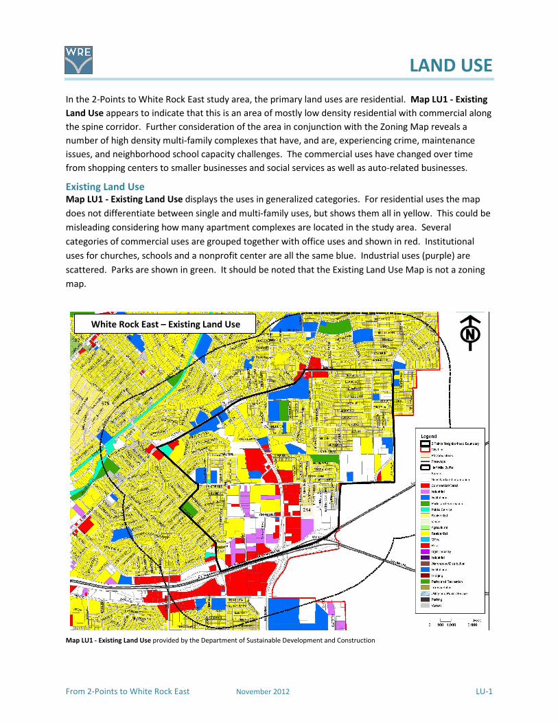
In the 2-Points to White Rock East study area, the primary land uses are residential. Map LU1 - Existing
Land Use appears to indicate that this is an area of mostly low density residential with commercial along
the spine corridor. Further consideration of the area in conjunction with the Zoning Map reveals a
number of high density multi-family complexes that have, and are, experiencing crime, maintenance
issues, and neighborhood school capacity challenges. The commercial uses have changed over time
from shopping centers to smaller businesses and social services as well as auto-related businesses.
Existing Land Use Map LU1 - Existing Land Use displays the uses in generalized categories. For residential uses the map
does not differentiate between single and multi-family uses, but shows them all in yellow. This could be
misleading considering how many apartment complexes are located in the study area. Several
categories of commercial uses are grouped together with office uses and shown in red. Institutional
uses for churches, schools and a nonprofit center are all the same blue. Industrial uses (purple) are
scattered. Parks are shown in green. It should be noted that the Existing Land Use Map is not a zoning
map.
Map LU1 - Existing Land Use provided by the Department of Sustainable Development and Construction
White Rock East – Existing Land Use

LAND USE
LU-2 November 2012 From 2-Points to White Rock East
A closer look shows that commercial land uses range from offices to automotive repair shops to largely
underutilized shopping centers with big box buildings. In the large shopping center at the corner of John
West and Buckner Boulevard many of the businesses have moved away and have been replaced by
lower tier shops not consistent with area’s interest and needs. The maintenance and appearance of this
area has deteriorated over time to where it has become a less than desirable place to shop. Social
services offices are shown as retail. At the first community meeting, it was noted that in the areas
designated as commercial do not actually represent the existing uses because all commercial, retail and
office uses are designated in red on the map.
Area Neighborhoods
There are a number of stable neighborhoods in and around the study area shown on Map LU2 – Area
Neighborhoods. These areas are ones with well built housing dating from the 1960s and 1970’s. There
is a fairly new housing development east of Buckner Boulevard off of John west.
Map LU2 – Study Area Neighborhoods

LAND USE
From 2-Points to White Rock East November 2012 LU-3
Area Zoning
Zoning establishes the regulation of permitted uses and physical dimensions (height, setbacks, lot
coverage, etc.) allowed in individual districts. Zoning districts in the study area include: Single-family
Residential, R-7.5(A); Townhomes, TH1(A); Multi-family, MF1(A), MF2(A) and MF3(A); Community Retail,
(CR); Commercial Services, CS; Limited Office, LO-1 and LO-3; and Light Industrial, LI. There are six
Planned Development Districts (PDDs), including Bishop Lynch High School, S.S. Conner Elementary
School, Lang Middle School, the Vineyards Apartments, Light Pointe, and a social services facility.
Requirements for each district are detailed in the City of Dallas Development Code.
Map LU3 – White Rock East Area Zoning shows the locations of the districts.
Map LU3 – Zoning Map provided by the Department of Sustainable Development and Construction
Currently much of the zoning allows more intensive and potentially incompatible uses (bars, sexually-
oriented businesses, small auto sales and service, payday loans, tobacco shops, etc.) in the Regional
Retail district that may not promote the long term viable future. The Consensus Vision was developed
as a result of a significant on-going collaborative effort among residents, business owners, social service
providers and faith communities. The current zoning does not support the community in their efforts to
ensure positive development and redevelopment of the area by attracting desirable housing, businesses
and services and rejecting high-density, multi-family housing and businesses that limit revitalization of
the neighborhoods. Along Buckner Boulevard, the zoning districts are mostly Regional Retail, the least
restrictive of commercial categories that basically allows everything but residential uses. Many of the
buildings in that area have seen better days. The big box stores are no longer national or local chain
White Rock East Neighborhood - Zoning
LAND USE
LU-4 November 2012 From 2-Points to White Rock East
retail and social services (which are very needed) occupy what was once prime retail space. Lower rent
auto repair and tire shops are now in what were once gasoline service stations. On the other hand, two
major automobile dealerships have maintained their high visibility in good repair at the intersection of
Buckner and IH 30. Uses such as convenience stores, dollar stores, bingo halls, bars, sexually-oriented
businesses, fast food establishments and vacant retail space are prevalent. With few exceptions,
residents have to drive out of the study area to enjoy family restaurants or retail shopping.
Residentially, the White Rock East area is comprised of stable, but threatened, single-family
neighborhoods adjacent to very dense multi-family developments and areas that have evolved into
lower echelon retail and industrial sites. The desired uses are ones that would enhance, not detract
from the safety and stability for all residents. Accessibility to jobs, shopping, parks, and schools is critical
to the future of the community.
The Land Use Consensus Vision
Land Uses in White Rock East include desirable single-family residences, multi-family units in a safe
environment, successful consumer-oriented businesses interspersed in mixed use development,
neighborhood parks and schools linked together in a system of attractive roadways, sidewalks and trails.
Extending the Vision of forwardDallas!, the Land Use Vision describes the potential for future
development for the area in terms of building location, type and scale. Described in two ways, the
vision first outlines the envisioned land development patterns for the study area . The second is through
policy recommendations on future land use patterns for the study area as a whole. These
recommendations include growth targets for the area that provide a quantitative basis for planning
future transportation, housing, and infrastructure.
The Land Use Consensus Vision was developed by the Advisory Committee over a period of several
months with input from residents and businesses at their open meetings. Time was spent on gaining an
understanding of the relationship of land use, zoning and the components of the Dallas comprehensive
plan, forwardDallas!, to be able to express the desire to improve the area.
Instead of relying on current zoning to improve the area, the Building Blocks of forwardDallas! were
reviewed and applied to further articulate the community’s future vision of the study area. The
following is a discussion of how the Building Blocks relate to and could be applied to specific locations in
the study area.
� Buckner Boulevard is considered a Commercial Center or Corridor.
� Residential Neighborhood Building Block protects the existing neighborhoods from
encroachments from adjacent uses.
� Urban Neighborhoods for the existing multi-family areas opens the way for more creative
residential development.
� Urban (Walkable) Mixed Use might be considered in the repurposing of the large shopping
centers.
� Industrial is included as a current use for discussion purposes as several large businesses are
located in the area.
LAND USE
From 2-Points to White Rock East November 2012 LU-5
The following paragraphs are excerpts, directly quoted from the Vision Illustration of forwardDallas!, for
Building Blocks that should be considered for the 2-Points Area as it becomes White Rock East. After
each excerpt is a discussion of how areas are currently functioning and how another land use might be
considered.
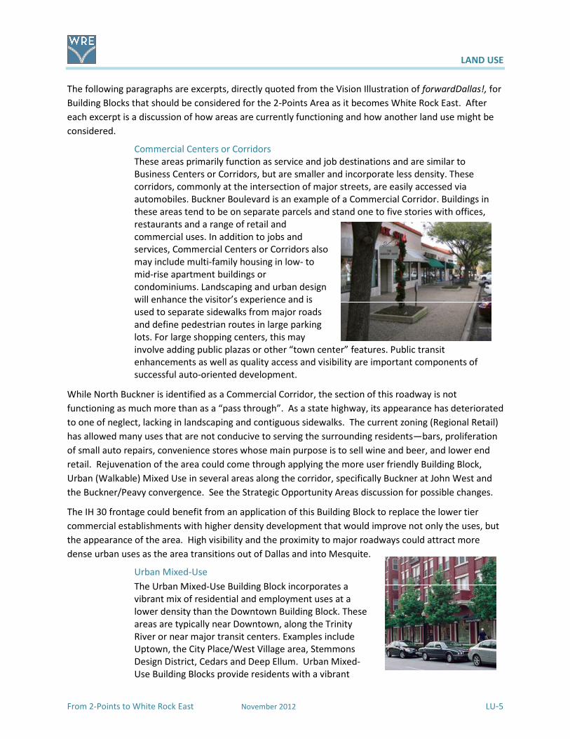
Commercial Centers or Corridors
These areas primarily function as service and job destinations and are similar to
Business Centers or Corridors, but are smaller and incorporate less density. These
corridors, commonly at the intersection of major streets, are easily accessed via
automobiles. Buckner Boulevard is an example of a Commercial Corridor. Buildings in
these areas tend to be on separate parcels and stand one to five stories with offices,
restaurants and a range of retail and
commercial uses. In addition to jobs and
services, Commercial Centers or Corridors also
may include multi-family housing in low- to
mid-rise apartment buildings or
condominiums. Landscaping and urban design
will enhance the visitor’s experience and is
used to separate sidewalks from major roads
and define pedestrian routes in large parking
lots. For large shopping centers, this may
involve adding public plazas or other “town center” features. Public transit
enhancements as well as quality access and visibility are important components of
successful auto-oriented development.
While North Buckner is identified as a Commercial Corridor, the section of this roadway is not
functioning as much more than as a “pass through”. As a state highway, its appearance has deteriorated
to one of neglect, lacking in landscaping and contiguous sidewalks. The current zoning (Regional Retail)
has allowed many uses that are not conducive to serving the surrounding residents—bars, proliferation
of small auto repairs, convenience stores whose main purpose is to sell wine and beer, and lower end
retail. Rejuvenation of the area could come through applying the more user friendly Building Block,
Urban (Walkable) Mixed Use in several areas along the corridor, specifically Buckner at John West and
the Buckner/Peavy convergence. See the Strategic Opportunity Areas discussion for possible changes.
The IH 30 frontage could benefit from an application of this Building Block to replace the lower tier
commercial establishments with higher density development that would improve not only the uses, but
the appearance of the area. High visibility and the proximity to major roadways could attract more
dense urban uses as the area transitions out of Dallas and into Mesquite.
Urban Mixed-Use
The Urban Mixed-Use Building Block incorporates a
vibrant mix of residential and employment uses at a
lower density than the Downtown Building Block. These
areas are typically near Downtown, along the Trinity
River or near major transit centers. Examples include
Uptown, the City Place/West Village area, Stemmons
Design District, Cedars and Deep Ellum. Urban Mixed-
Use Building Blocks provide residents with a vibrant

LAND USE
LU-6 November 2012 From 2-Points to White Rock East
blend of opportunities to live, work, shop and play within a closely defined area.
Buildings range from high-rise residential or midrise commercial towers to townhomes
and small corner shops. Good access to transit is a critical element. Similar to
Downtown, the Urban Mixed-Use Building Blocks offer employment and housing
options and are important economic growth areas for businesses. People on foot or bike
can enjoy interesting storefronts at ground level with benches, public art, on-street
parking and wide sidewalks, creating an appealing streetscape. Large parking areas and
other auto-oriented land uses are typically located at the edges.
While the Buckner Corridor is not generally thought of as close to Downtown, it really is not all that far
away on IH 30 and surface streets—between seven and eight miles. The large front loaded parking lots
are a thing of the past and bringing buildings closer to the street with the ability to have more friendly
walkable mixed uses could spur repurposing of large tracts of land into new development with new
businesses and new types of residences.
Residential Neighborhoods
This Building Block represents the life-blood of Dallas, the
traditional neighborhood of single-family detached
homes. Dallas has many neighborhoods that match this
description, including Winnetka Heights, Preston Hollow,
Lakewood and Wheatley Place. Single-family dwellings
are the dominant land use in these areas. Some shops,
restaurants or institutional land uses such as schools and
religious centers that serve neighborhood residents may
be located at the edges or at key intersections.
Neighborhood “pocket parks” provide open space for
families. Individual lot size, front yard and side yard setbacks, garage orientation and
scale of the home varies from neighborhood to neighborhood. These areas rely
primarily on cars for access, although traffic on neighborhood streets is expected to be
low. Cut through traffic or spill over from commercial areas will be strongly discouraged.
While public transit may be available, typically it involves longer walks to bus stops or
the need to drive to park and ride facilities. Newly developed neighborhoods may
provide better pedestrian access to community services through shorter block lengths,
narrower streets, sidewalks and greenbelts with hike and bike trails and might also
provide improved access to transit service. Public investment will focus on protecting
quality of life by providing amenities such as parks, trails, road improvements and strong
code enforcement.
This Building Block and the following one should be applied to all of the residential neighborhoods for
protection from commercial encroachment, crime reduction and increased code enforcement.
Neighborhoods of Eastwood Hills, Hillridge and others may benefit from this approach.

LAND USE
From 2-Points to White Rock East November 2012 LU-7
Urban Neighborhoods
Urban Neighborhoods, including Oak Lawn, the
Grand Avenue area in South Dallas, the area
near Jefferson Boulevard and the Vickery
Meadow area, are predominately residential
but are distinguished from other
neighborhoods by the wide variety of housing
options they provide and easy access to public
transit. Housing choices should include single-
family detached dwellings, townhomes and
low- to midrise condominiums or apartments. These neighborhoods will have
concentrations of shops and offices along key corridors or at key intersections, providing
important services and job opportunities within walking distance of residences. These
areas may have mixed-use buildings with
ground floor shops. Areas currently developed
with single-family or duplex uses should
generally be maintained unless redevelopment
is addressed through an Area Planning process.
Urban Neighborhood streets will be very
pedestrian friendly, providing excellent
connectivity to shopping, schools and other
community services. Emphasis should be placed on slowing traffic through use of on-
street parking and other similar traffic calming measures. Public investments in these
areas will focus on parks, pathways, transit stops, pedestrian-oriented landscaping and
road improvements.
Urban neighborhoods provide a range of housing options, including single-family detached dwellings
and townhomes. They can locate the intensity away from the adjacent corridor, respecting existing
single-family neighborhoods. This Building Block is applicable to neighborhoods with smaller homes
where it could encourage the renewal and repurposing of the aging multi-family complexes and retail
land uses that are typically located at the edges. The adjacent smaller shopping centers should reflect a
connection to the adjacent neighborhoods and provide more neighborhood services.
Industrial Areas
Industrial Areas, which offer important
employment opportunities, occupy large
areas of land and usually are near major
roads and heavy rail lines. Evolving
technology and the need for freight
movement through Dallas to the rest of the
country and internationally means this
sector can offer good opportunities for jobs.
Logistics and warehousing, a growing
industry with strong potential for upward mobility of skilled workers, would thrive in
such areas. Examples include Southport and the Agile Port, parts of West Dallas along I-
30, and the Stemmons industrial area. These areas include a mix of low- and medium-
density industrial buildings and industrial yards and have large surface parking for cars
and trucks. Industrial Areas rely on quality road access and may be linked to rail for
LAND USE
LU-8 November 2012 From 2-Points to White Rock East
freight purposes. Street lanes are wide and intersections are large. Transit, sidewalks
and other pedestrian improvements are limited.
There are several areas that are either zoned and/or functioning as industrial development. They are
generally close to the IH 30 corridor. Long term redevelopment scenarios in adjacent areas may
encourage these uses to locate further away from the neighborhoods to more appropriate industrial
locations, but for now several of these are viable industrial businesses and employment centers.
Strategic Opportunity Areas
Strategic Opportunity Areas (SOAs) are focal points for positive change within the study area. These
areas merit special consideration. Areas that might best benefit from a targeted approach were
identified in the development of the area plan. Seven areas are identified on the following Map LU4 -
Strategic Opportunity Areas and are shown in very conceptual improvement illustrations to these areas
on the following pages. They are conceptual, generalized visions of how these areas could be catalysts
for new development to the specific tracts and surrounding opportunities for redevelopment.
The Strategic Opportunity Areas are visions for future development on private and public property. Any
future development of the selected areas is entirely contingent upon the interest of the owners,
perspective businesses, developers and the economy of the area. Contact with one of the owners
resulted in changes to the initial conceptual design to accommodate his development. Several other
owners found the SOA for their locations to be very interesting for the future. Other owners are either
not local, did not respond when contacted, or current contact information was not available.
The realization of these visions is dependent on working with the individual property owners, their
interests, their investments, and could involve modifications and amendments to existing public streets.
This approach would require vetting for feasibility at the time there is a specific development proposal.
These are not proposed as firm plans for the site, but as the term Strategic Opportunity Areas indicates,
the areas are ones that have been identified as having have potential for development or
redevelopment.

From 2-Points to White Rock East
Map LU4 – Strategic Opportunity Area
November 2012
LAND USE
LU-9
LAND USE
From 2-Points to White Rock East November 2012 LU-10
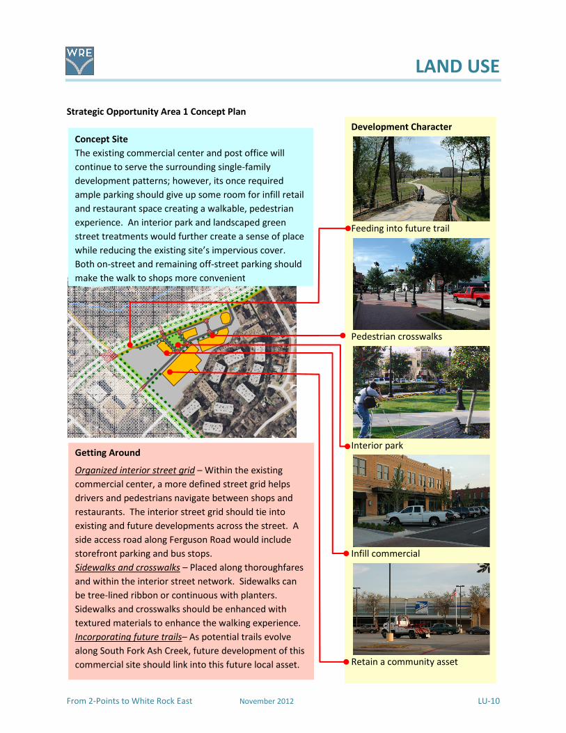
Strategic Opportunity Area 1 Concept Plan
Concept Site
The existing commercial center and post office will
continue to serve the surrounding single-family
development patterns; however, its once required
ample parking should give up some room for infill retail
and restaurant space creating a walkable, pedestrian
experience. An interior park and landscaped green
street treatments would further create a sense of place
while reducing the existing site’s impervious cover.
Both on-street and remaining off-street parking should
make the walk to shops more convenient
Development Character
Feeding into future trail
Pedestrian crosswalks
Interior park
Infill commercial
Retain a community asset
Getting Around
Organized interior street grid – Within the existing
commercial center, a more defined street grid helps
drivers and pedestrians navigate between shops and
restaurants. The interior street grid should tie into
existing and future developments across the street. A
side access road along Ferguson Road would include
storefront parking and bus stops.
Sidewalks and crosswalks – Placed along thoroughfares
and within the interior street network. Sidewalks can
be tree-lined ribbon or continuous with planters.
Sidewalks and crosswalks should be enhanced with
textured materials to enhance the walking experience.
Incorporating future trails– As potential trails evolve
along South Fork Ash Creek, future development of this
commercial site should link into this future local asset.

LAND USE
From 2-Points to White Rock East November 2012 LU-11
Strategic Opportunity Area 2 Concept Plan
Development Character
Townhouse / urban single family
Storefront double row parking
Central focus points
Higher density residential
Landscaped major roadways
Getting Around
Street grid – A traditional street grid with central focus
points or landmarks to help guide users and visitors.
Sidewalks, crosswalks, and plazas – Textured materials
for sidewalks and crosswalks to enhance the walking
experience, plus plazas to create a sense of arrival.
Transit – Rerouting DARTs local and crosstown bus
routes onto a future street grid and connecting to a
possible transit center south of Chenault Street.
Concept Site – Buckner Boulevard at John West
This site spans the three corners of the North Buckner
Boulevard-John West Road intersection. Currently, this
area is a mish-mash of commercial buildings showing
their disuse. Being close to the study area’s center
point, this site is a logical location to establish a vibrant
mix of live, work, shop, and play activities. This would
include higher density mixed use, office, and residential
along a landscaped North Buckner Boulevard and near
Chenault Street plus lower density storefronts facing
on-street double row parking within the interior of the
site. The aging multi-family complex would give way to
an urban neighborhood focused around a public space.
LAND USE
LU-12 November 2012 From 2-Points to White Rock East
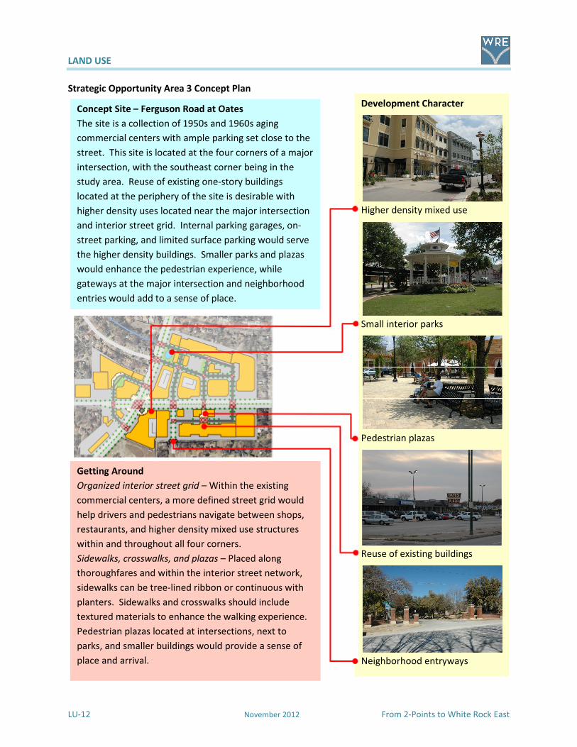
Strategic Opportunity Area 3 Concept Plan
Development Character
Higher density mixed use
Small interior parks
Pedestrian plazas
Reuse of existing buildings
Neighborhood entryways
Concept Site – Ferguson Road at Oates
The site is a collection of 1950s and 1960s aging
commercial centers with ample parking set close to the
street. This site is located at the four corners of a major
intersection, with the southeast corner being in the
study area. Reuse of existing one-story buildings
located at the periphery of the site is desirable with
higher density uses located near the major intersection
and interior street grid. Internal parking garages, on-
street parking, and limited surface parking would serve
the higher density buildings. Smaller parks and plazas
would enhance the pedestrian experience, while
gateways at the major intersection and neighborhood
entries would add to a sense of place.
Getting Around
Organized interior street grid – Within the existing
commercial centers, a more defined street grid would
help drivers and pedestrians navigate between shops,
restaurants, and higher density mixed use structures
within and throughout all four corners.
Sidewalks, crosswalks, and plazas – Placed along
thoroughfares and within the interior street network,
sidewalks can be tree-lined ribbon or continuous with
planters. Sidewalks and crosswalks should include
textured materials to enhance the walking experience.
Pedestrian plazas located at intersections, next to
parks, and smaller buildings would provide a sense of
place and arrival.

LAND USE
From 2-Points to White Rock East November 2012 LU-13
Strategic Opportunity Area 4 Concept Plan
Strategic Opportunity Area 5 Concept Plan
Aerial © 2011 Google
Concept Site
Existing development patterns include several aging
multi-family complexes and commercial properties.
The concept plan replaces the aging structures with
new single family detached and townhouses units that
reflect the surrounding neighborhoods. Concept uses
the local creek and woodlands meandering through as a
‘green spine’ that links together nearby neighborhoods
and enhances the area’s aesthetic appeal.
Getting Around
Trails and footpaths – Paths through the woodlands
should work with the surrounding terrain and be used
for pleasure, exploring, and getting to destinations.
Sidewalks and pathways – Sidewalks and mid-block
pathways should be incorporated into all developments
to encourage a safe walking experience.
Roadways – Landscaped buffers should be incorporated
along major roadways, while residential streets should
enhance the built environment, terrain, and woodlands.
Development Character
Higher density townhouses
Mid-block pathways
Landscaped buffers along roads
Woodlands, creeks, and trails
Single family detached housing
Getting Around
Landscaped roadways – Incorporating landscaping
along North Buckner Boulevard and Peavy Road using
public right-of-way and working with developers of
adjacent properties as the properties are redeveloped.
Future roadway linkages – Developing future roadways
to eventually link into future development
opportunities west of North Buckner Boulevard.
Trails – Connecting future commercial developments to
a possible trail network, and having trails define the
edge of urban single-family housing development.
Concept Site - Buckner/Peavy/2-Points
This location has the potential to define the character of
the community in a positive way; however, existing
development diminishes the community’s image. An
aging apartment community east of Peavy Road could
be replaced with urban single-family detached housing,
townhouses, plus a centralized neighborhood park. The
area between North Buckner Boulevard and Peavy Road
could be redeveloped into a concentration of
neighborhood-serving commercial buildings with a
‘Flatiron’ style building at the triangular south end. The
north end should have a creekside overlook mixed use
building with restaurants, offices, and residential units.
In between would be a mix of neighborhood serving
shops and restaurants.

LAND USE
LU-14 November 2012 From 2-Points to White Rock East
Strategic Opportunity Area 5 Concept Plan
Development Character
Higher density townhouses
Mid-block pathways
Landscaped buffers along roads
Woodlands, creeks, and trails
Single-family detached housing
Concept Site – Between Buckner and Peavy
Existing development patterns include an aging multi-
family complex and commercial properties. The
concept plan replaces the aging structures with new
single-family detached and townhouse units that reflect
the surrounding neighborhoods. The concept uses the
local creek and woodlands meandering through as a
“green spine” that links together nearby neighborhoods
and enhances the area’s aesthetic appeal.
Getting Around
Trails and footpaths – Paths through the woodlands
should work with the surrounding terrain and be used
for pleasure, exploring, and getting to destinations.
Sidewalks and pathways – Sidewalks and mid-block
pathways should be incorporated into all developments
to encourage a safe walking experience.
Roadways – Landscaped buffers should be incorporated
along major roadways, while landscaping on residential
streets should enhance the built environment, terrain,
and woodlands.
LAND USE
From 2-Points to White Rock East November 2012 LU-15
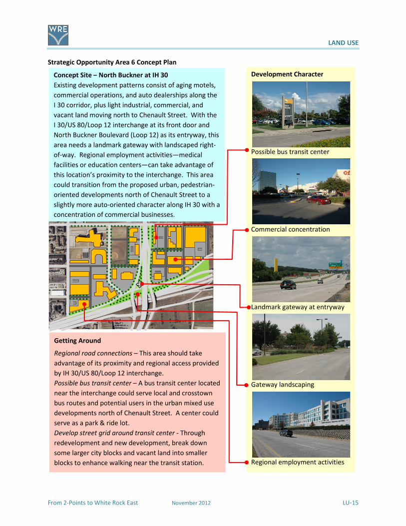
Strategic Opportunity Area 6 Concept Plan
Concept Site – North Buckner at IH 30
Existing development patterns consist of aging motels,
commercial operations, and auto dealerships along the
I 30 corridor, plus light industrial, commercial, and
vacant land moving north to Chenault Street. With the
I 30/US 80/Loop 12 interchange at its front door and
North Buckner Boulevard (Loop 12) as its entryway, this
area needs a landmark gateway with landscaped right-
of-way. Regional employment activities—medical
facilities or education centers—can take advantage of
this location’s proximity to the interchange. This area
could transition from the proposed urban, pedestrian-
oriented developments north of Chenault Street to a
slightly more auto-oriented character along IH 30 with a
concentration of commercial businesses.
Development Character
Possible bus transit center
Commercial concentration
Landmark gateway at entryway
Gateway landscaping
Regional employment activities
Getting Around
Regional road connections – This area should take
advantage of its proximity and regional access provided
by IH 30/US 80/Loop 12 interchange.
Possible bus transit center – A bus transit center located
near the interchange could serve local and crosstown
bus routes and potential users in the urban mixed use
developments north of Chenault Street. A center could
serve as a park & ride lot.
Develop street grid around transit center - Through
redevelopment and new development, break down
some larger city blocks and vacant land into smaller
blocks to enhance walking near the transit station.
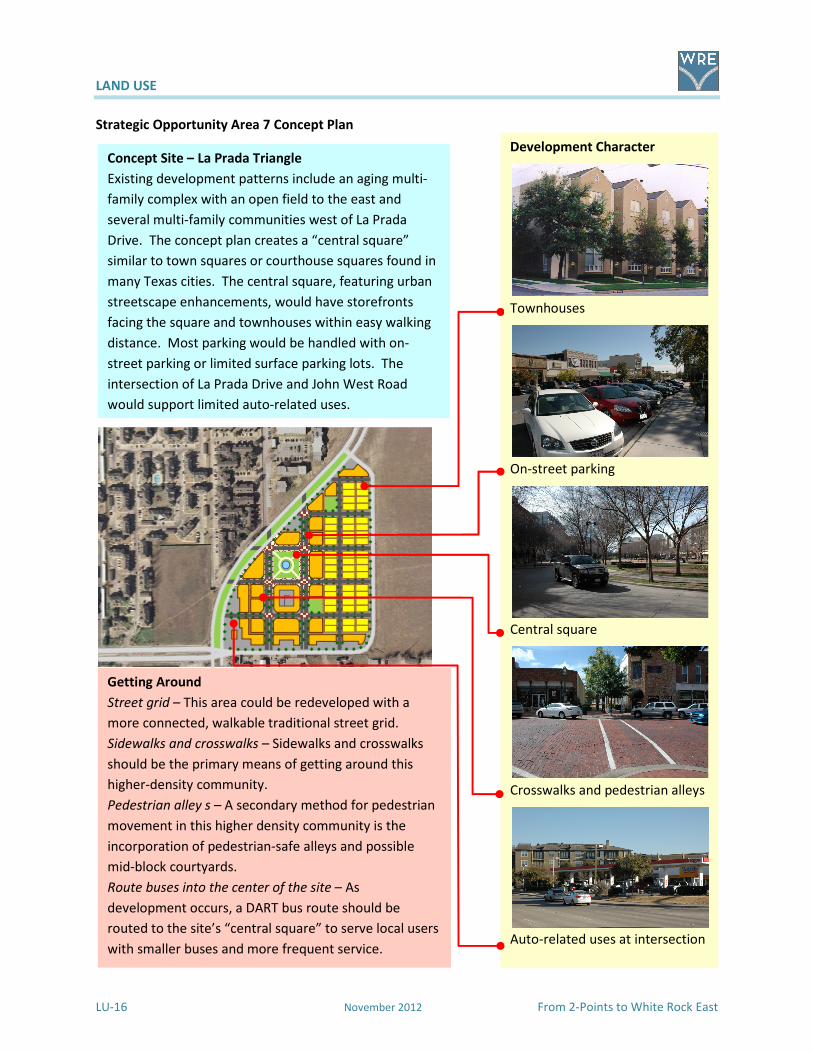
LAND USE
LU-16 November 2012 From 2-Points to White Rock East
Strategic Opportunity Area 7 Concept Plan
Development Character
Townhouses
On-street parking
Central square
Crosswalks and pedestrian alleys
Auto-related uses at intersection
Concept Site – La Prada Triangle
Existing development patterns include an aging multi-
family complex with an open field to the east and
several multi-family communities west of La Prada
Drive. The concept plan creates a “central square”
similar to town squares or courthouse squares found in
many Texas cities. The central square, featuring urban
streetscape enhancements, would have storefronts
facing the square and townhouses within easy walking
distance. Most parking would be handled with on-
street parking or limited surface parking lots. The
intersection of La Prada Drive and John West Road
would support limited auto-related uses.
Getting Around
Street grid – This area could be redeveloped with a
more connected, walkable traditional street grid.
Sidewalks and crosswalks – Sidewalks and crosswalks
should be the primary means of getting around this
higher-density community.
Pedestrian alley s – A secondary method for pedestrian
movement in this higher density community is the
incorporation of pedestrian-safe alleys and possible
mid-block courtyards.
Route buses into the center of the site – As
development occurs, a DART bus route should be
routed to the site’s “central square” to serve local users
with smaller buses and more frequent service.
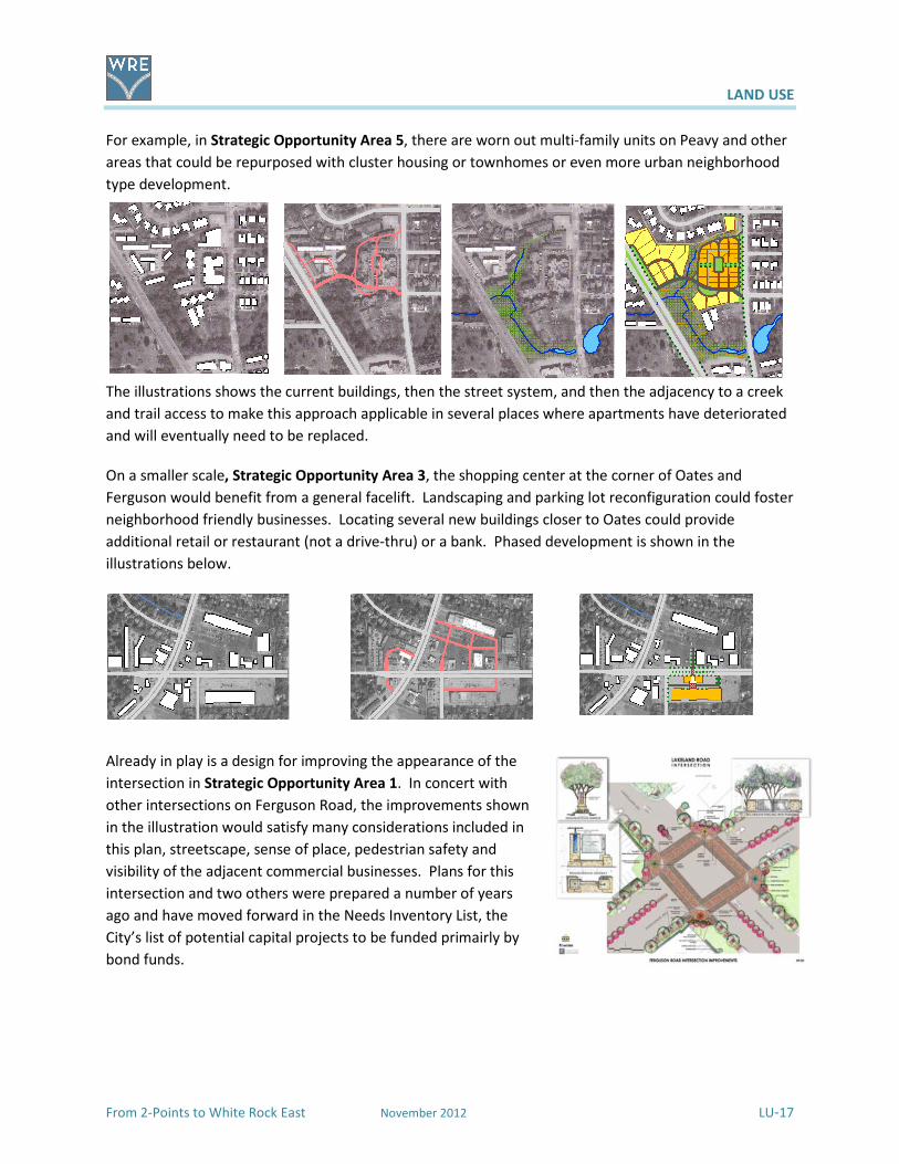
LAND USE
From 2-Points to White Rock East November 2012 LU-17
For example, in Strategic Opportunity Area 5, there are worn out multi-family units on Peavy and other
areas that could be repurposed with cluster housing or townhomes or even more urban neighborhood
type development.
The illustrations shows the current buildings, then the street system, and then the adjacency to a creek
and trail access to make this approach applicable in several places where apartments have deteriorated
and will eventually need to be replaced.
On a smaller scale, Strategic Opportunity Area 3, the shopping center at the corner of Oates and
Ferguson would benefit from a general facelift. Landscaping and parking lot reconfiguration could foster
neighborhood friendly businesses. Locating several new buildings closer to Oates could provide
additional retail or restaurant (not a drive-thru) or a bank. Phased development is shown in the
illustrations below.
Already in play is a design for improving the appearance of the
intersection in Strategic Opportunity Area 1. In concert with
other intersections on Ferguson Road, the improvements shown
in the illustration would satisfy many considerations included in
this plan, streetscape, sense of place, pedestrian safety and
visibility of the adjacent commercial businesses. Plans for this
intersection and two others were prepared a number of years
ago and have moved forward in the Needs Inventory List, the
City’s list of potential capital projects to be funded primairly by
bond funds.

LAND USE
LU-18 November 2012 From 2-Points to White Rock East
Goals and Implementation Measures for Better Land Use
Goal Implementation Measure
Goal LU.1: Land use and zoning that preserves and protects existing stable neighborhoods to be safe, livable and walkable.
LU.1.1: Consider the Building Blocks as land use guidelines for zoning changes desired by area residents.
LU.1.2: Consider the recommendations outlined in the Strategic Opportunity Areas in zoning cases and public improvements.
LU.1.3: Encourage redevelopment with townhomes and cluster homes for lower density in lieu of multi-family when there is site redevelopment.
LU.1.4: Ensure code compliance in the existing more densely populated areas as well as the residential areas.
LU.1.5: Solicit more direct input from the residents for changes in development and zoning on an ongoing basis.
LU.1.6: Add accessory dwelling units to zoning districts to allow secondary rental residential units as a permitted or specific use.
Goal LU.2: Appropriate zoning for commercial areas that best addresses the community’s needs and desires along major thoroughfares and at strategic intersections.
LU.2.1: Consider more urban types of development along major thoroughfares as identified in form-based zoning districts.
LU.2.2: Identify and pursue removal of problem uses and structures that may be nonconforming or illegal.
LU.2.3: Implement the uses and zoning districts that are desired and/or needed in the community and apply Building Blocks.
LU.2.4: Promote desirable infill through rezoning, expedited permitting and incentives.
LU.2.5: Solicit repurposing of existing under-performing retail development through public/private partnerships.
Goal LU.3: Appropriate zoning for residential districts that are desired and/or needed in the community.
LU.3.1: Work with elected officials, City staff, and multi-family property owners to redevelop existing multi-family sites near local neighborhoods for townhouse and single family housing units.
LU.3.2: Encourage best practice examples from across the nation in which older multi-family complexes and derelict sites redeveloped in owner-occupied housing.
LU.3.3: Use this White Rock East Area Plan and forwardDallas! to guide desired uses and zoning districts and/or form-based districts in the area.
LU.3.4: Request initiation of appropriate zoning for areas of incompatibility and to encourage redevelopment in Strategic Opportunity Areas.

LAND USE
From 2-Points to White Rock East November 2012 LU-19
Goal Implementation Measure
LU.3.5: Promote urban types of development on major thoroughfares using form-based code districts for higher density mixed use.
LU.3.6: Promote Complete Streets and Green Streets for major roadways to promote more urban development patterns.
LU.3.7: Explore joint effort with Mesquite and Dallas County Community College District coordinating planning and design for future development patterns near the intersection of John West Road and La Prada Drive/Big Town Boulevard.
From Current Land Use to Building Blocks to Future Land Use and Zoning
This area plan focuses on both protecting the study area and imagining the potential for redevelopment
using the Building Blocks of forwardDallas!. It presents opportunities to revitalize commercial corridors
and adjacent neighborhoods with emphasis placed on safety and mobility.
The initial instructions for the Plan indicated that specific zoning changes should not be specifically
defined; therefore a delineated specific future land use map is not presented in this document.
However, review comments indicated that “an area plan should accomplish the uses for zoning districts
that are desired and/or needed in the community”, (Goal LU.1, Actions LU.1.1 and 1.2).
Instead, a bubble map, using the Strategic Opportunities Areas, is presented to show the potential for
rezoning. The areas are intended as conceptual guides based on the deliberations of the Advisory
Committee with input from the residents and business owners at three community meetings, face-to-
face meetings, and advisory committee meetings. The following areas that could be considered for
different zoning districts are:
� Both side of North Buckner from IH 30 to the Peavy convergence - urban mixed use/main
street
� IH 30 Frontage - urban mixed use
� Southeast of the intersection of Ferguson at Oates - neighborhood commercial
� La Prada Triangle - urban neighborhood including townhomes
� Peavy/Buckner Triangle - urban neighborhood
Further refinements would come with specific rezoning requests or initiation by the property owners.
Another approach (by property owners) to improved land use could be considered in the creation of a
Planned Development District (PDD).
These proposed conceptual changes to land use and possibly to rezoning in the White Rock East area
could revitalize this area and attract new and better residences and businesses—resulting in stable
neighborhoods and thriving commercial ventures.
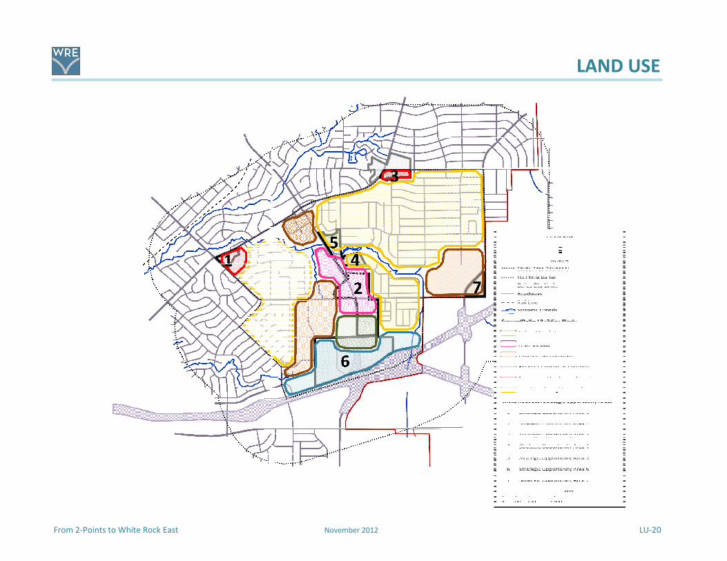
From 2-Points to White Rock East
November 2012
LAND USE
LU-20

TRANSPORTATION
From 2-Points to White Rock East November 2012 T-1
In communities across the country, most land use patterns work in conjunction with the transportation
systems. Communities’ development patterns are not static, but are constantly changing to adjust to
socio-economic needs, demographic changes, new technology, and market trends. Transportation
systems are subject to similar adjustment, ranging from technological improvements to desires for
alternative means of movement and from fiscal limitations to changing community values.
The White Rock East Transportation section addresses nine items that will have a future role in
influencing the growth, development, and stability of the community. The nine items consist of the
following:
� Roadway character
� Existing thoroughfare network
� Transit service
� Bicycle
� Sidewalks
� Trail network expansion
� Gateways
� Wayfinding
� Signalization
These nine items were expressed by community stakeholders as important to improve the image of the
area and help to bond the various neighborhoods and commercial areas into a stable and prominent
community in the Dallas area. Transportation items will focus equally on the needs of all users—the
disabled, pedestrians, bicyclists, motorists, and transit users. Transportation facilities will be developed
in context with surrounding or anticipated development while incorporating infrastructure systems and
local values concerning community enhancements and aesthetics.
Transportation Consensus Vision Statement
The transportation network serving White Rock East focuses equally on the needs and activities of all
users. It works in context with adjacent development patterns. Addressing the roadway character of
the area’s existing thoroughfare network of safe and attractive roads ensures positive pedestrian
experience by the realization of a continuous sidewalk system, adds value to surrounding land uses,
and links various areas of the community through sidewalks, bike routes and trails. Ultimate success
is found in desirable streets, highways, sidewalks, and trails that promote the safe movement of
pedestrians and vehicles while enhancing the community’s image.
This section provides an overview of transportation concepts, issues and approaches, followed by details
of what is needed in the area with implementation measures to improve the overall function of White
Rock East.

TRANSPORTATION
T-2 November 2012 From 2-Points to White Rock East
Seneca Park Road in Louisville, Kentucky
Roadway Character
Road right-of-way accounts for a large
percentage of land in urban areas. Roadways
have been traditionally treated as a utilitarian
transportation system to move people and
goods in motorized vehicles from one place to
another. In the development of roadways,
consideration has been given to roadway design
and how roads interact with other users, the
surrounding built environment, and the road’s
impact on the nearby waterways; however, the
primary emphasis in road building has been in
managing traffic volume and movement in a safe and efficient manner. While roads provide a conduit
for getting around, roads and their right-of-way should play an important role in defining and interacting
with the surrounding built and natural environment.
Instead of being an afterthought, the roadway character should lead the way in the planning and design
of safe and attractive roads for all users. Many times, roads provide the first impression of an area as
well as a lasting memory for residents or visitors. Roadway character plays to the senses, whether it is
the sound and feel of tires crossing different surface textures or the visual stimulus enjoyed whether
driving down a road or walking alongside. Roadways will continue to perform a utilitarian role in the
urban fabric; however, roads should also have an appeal and quality that complements both the
adjacent built and natural environment as well as non-motorized users of the right-of-way, including
pedestrians, bicyclists, transit riders, and people with disabilities.
For residents of the White Rock East area there is a desire to have streets and major highways that
promote the safe movement of pedestrians and vehicles while enhancing the community’s image. This
includes landscape and streetscape improvements along major roads and street beautification for local
streets. The City of Dallas is currently reconsidering how their roadways should function for all users.
These include policy decisions as well as planning and design considerations that reflect the
community’s social, cultural, economic, and physical values. The components that should be applied to
the roadway character of White Rock East streets include Complete Streets, Context Sensitive Design,
and Green Streets. Below is a brief description of each.
Complete Streets
Complete Streets is a movement in communities to make urban roadways safe and convenient for
all users. Roadways and intersections are required to serve the needs of motorists, bicyclists, transit
users, and pedestrians, including those with disabilities. Complete Streets is policy driven to bring
about institutional changes from standard roadway development practices that tend to be focused
primarily on vehicular needs. The level of service for pedestrians, transit riders, and bicyclists should
be on par with automobile-oriented needs. Complete Streets can be implemented on many
roadways in the community.

TRANSPORTATION
From 2-Points to White Rock East November 2012 T-3
Context Sensitive Design
Context Sensitive Design, sometimes referred to as Context Sensitive Solutions, incorporates
collaborative planning and design practices to ensure that road improvements are designed to fit
within the surrounding context. Stakeholder input is included throughout the process. Context
Sensitive Design provides a flexible way to address all modes of travel by including a team of
professionals.
Green Streets
Besides moving traffic and linking locations, the impervious surface of roadways collects rain waters
and diverts these waters to curbs and gutters that can quickly overwhelm local creeks and rivers.
Urban roadways are part of a community’s stormwater conveyance system that is considered a
component of a community’s “gray infrastructure”. Gray infrastructure includes stormwater
sewers, wastewater sewers, and utility lines. Municipal roadway planning and design practices
across the country are looking at implementing Green Streets design criteria as part of their green
infrastructure to manage and reduce stormwater runoff and protect water resources from
pollutants. Green Streets are primarily designed and built as a stormwater management system
within a road’s right-of-way that filter pollutants through vegetative bioretention treatments and
enhance soil filtration. Green Streets also enhance the aesthetic qualities for adjacent properties by
replacing the hardscape curbs and gutters with a softscape of street tree plantings, vegetated
swales, landscaped bioretention features, and permeable paving materials. Green Streets can help
improve the street environment for bicyclist and pedestrians and add to the overall pedestrian
experience. These roadway designs are applicable to the design and construction of local alleys.
Existing Thoroughfare Network
Communities across the country use a functional classification system to rank and define the functions
of their existing and future roadway networks. Functional classification systems focus on the service
roadways should perform in handling vehicular traffic, ranging from high access/low mobility to low
access/high mobility. The roadway types for most functional classification systems include freeways,
principal arterials, minor arterial streets, collector streets, and local streets.
The City of Dallas has a functional classification system for its existing thoroughfare network consisting
of three roadway types:
� Arterial Streets – Principal and Minor;
� Collector Streets - Community and Residential; and
� Local Streets.
The three roadway types are identified in the White Rock East study area and half-mile buffer. The
existing thoroughfare network in the White Rock East area is graphically shown on Map T1 - Existing
Thoroughfare Network in the White Rock East Study Area. The map shows the three roadway types
plus freeways and local streets in the study area. The text below describes the attributes of the three
roadway types plus freeways and local streets.

TRANSPORTATION
T-4 November 2012 From 2-Points to White Rock East
Map T1 - Existing Thoroughfare Network in the White Rock East Study Area
Freeways
As either intra-regional or inter-regional facilities,
freeways are high speed, long distance roadways
that can run through many cities and counties.
Typically, freeways handle large volumes of traffic
and provide the greatest mobility for getting
around. In urban areas freeways are designed to be
limited-access roadways with grade separated cross
streets. There is no direct driveway access to the
freeway except using the exit/entry lanes along
parallel frontage roads. Within the study area
boundaries is one freeway, IH 30. Outside the study
area but within the half-mile buffer is a second
freeway, US 80.
IH 30 near the US 80 interchange
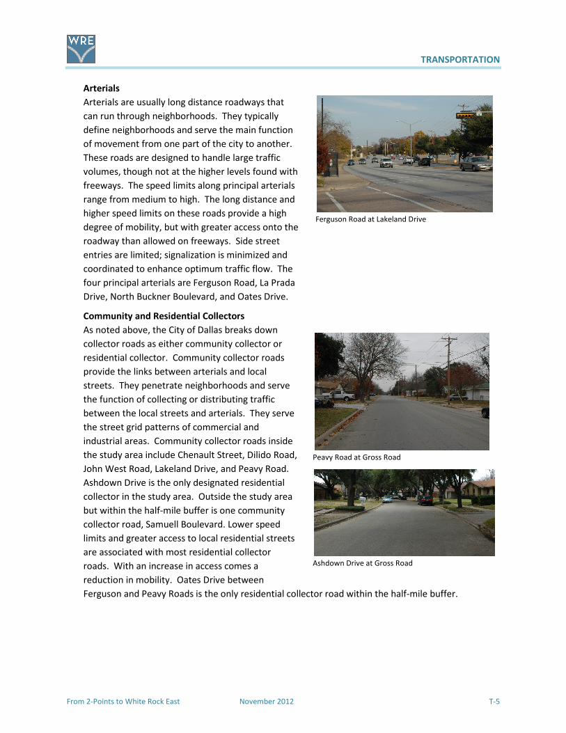
TRANSPORTATION
From 2-Points to White Rock East November 2012 T-5
Ashdown Drive at Gross Road
Arterials
Arterials are usually long distance roadways that
can run through neighborhoods. They typically
define neighborhoods and serve the main function
of movement from one part of the city to another.
These roads are designed to handle large traffic
volumes, though not at the higher levels found with
freeways. The speed limits along principal arterials
range from medium to high. The long distance and
higher speed limits on these roads provide a high
degree of mobility, but with greater access onto the
roadway than allowed on freeways. Side street
entries are limited; signalization is minimized and
coordinated to enhance optimum traffic flow. The
four principal arterials are Ferguson Road, La Prada
Drive, North Buckner Boulevard, and Oates Drive.
Community and Residential Collectors
As noted above, the City of Dallas breaks down
collector roads as either community collector or
residential collector. Community collector roads
provide the links between arterials and local
streets. They penetrate neighborhoods and serve
the function of collecting or distributing traffic
between the local streets and arterials. They serve
the street grid patterns of commercial and
industrial areas. Community collector roads inside
the study area include Chenault Street, Dilido Road,
John West Road, Lakeland Drive, and Peavy Road.
Ashdown Drive is the only designated residential
collector in the study area. Outside the study area
but within the half-mile buffer is one community
collector road, Samuell Boulevard. Lower speed
limits and greater access to local residential streets
are associated with most residential collector
roads. With an increase in access comes a
reduction in mobility. Oates Drive between
Ferguson and Peavy Roads is the only residential collector road within the half-mile buffer.
Ferguson Road at Lakeland Drive
Peavy Road at Gross Road
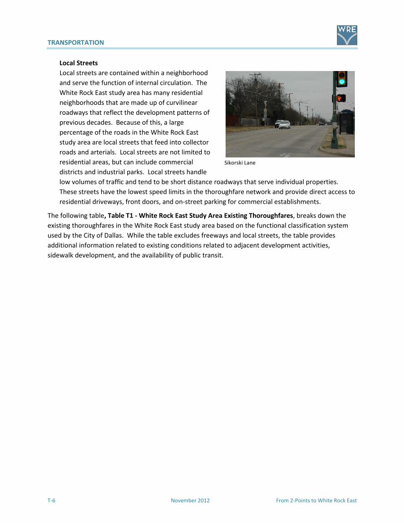
TRANSPORTATION
T-6 November 2012 From 2-Points to White Rock East
Sikorski Lane
Local Streets
Local streets are contained within a neighborhood
and serve the function of internal circulation. The
White Rock East study area has many residential
neighborhoods that are made up of curvilinear
roadways that reflect the development patterns of
previous decades. Because of this, a large
percentage of the roads in the White Rock East
study area are local streets that feed into collector
roads and arterials. Local streets are not limited to
residential areas, but can include commercial
districts and industrial parks. Local streets handle
low volumes of traffic and tend to be short distance roadways that serve individual properties.
These streets have the lowest speed limits in the thoroughfare network and provide direct access to
residential driveways, front doors, and on-street parking for commercial establishments.
The following table, Table T1 - White Rock East Study Area Existing Thoroughfares, breaks down the
existing thoroughfares in the White Rock East study area based on the functional classification system
used by the City of Dallas. While the table excludes freeways and local streets, the table provides
additional information related to existing conditions related to adjacent development activities,
sidewalk development, and the availability of public transit.
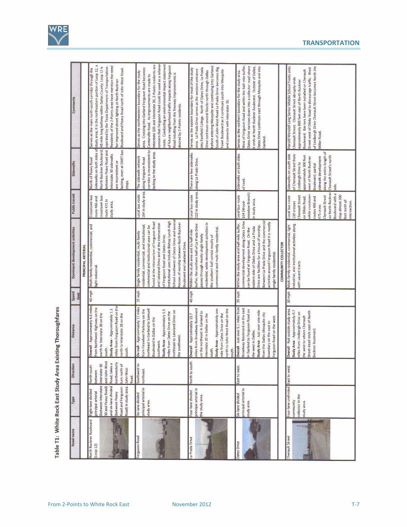
TRANSPORTATION
From 2-Points to White Rock East November 2012 T-7

TRANSPORTATION
T-8 November 2012 From 2-Points to White Rock East

TRANSPORTATION
From 2-Points to White Rock East November 2012 T-9
Route 164 along Ferguson Road
Transit Service
In the White Rock East study area transit service is provided by Dallas Area Rapid Transit (DART). The
neighborhoods and businesses in the study area were developed at a time when auto-oriented,
suburban-style developments were the norm. Today, many White Rock East residents continue use
their vehicles to commute or run errands; however, a growing portion of the population has a greater
need for public transportation. Those using public transportation either have limited means for getting
around or choose to take public transit rather than hassle with a vehicle. Like all areas of the City, the
White Rock East area has residents that have disabilities that require paratransit service to get to work,
go shopping, or visit friends. The White Rock East area has a young working-age population struggling to
get ahead through their education or job skills. The area also has a growing population of older
residents with age-related limitations or desiring to age in place but requiring special services to
maintain their independent lifestyles. The need for expanded public transit service that is safe,
convenient, responsive, and beneficial to the needs of local users and businesses is important for the
integrity and health of this community.
When the planning process began DART served the White Rock East study area with four bus routes.
Two bus routes–Route 110 and Route 164 are local and provide service to downtown Dallas as well as
locations beyond the study area. The remaining two bus routes are referred to as crosstown and
provide service to areas outside of downtown Dallas. The crosstown bus routes are Route 467 and
Route 475. Currently, fixed-rail transit service is not planned for the White Rock East study area.
Additional information on current and proposed changes to the bus routes are in Appendix E.
Map T2 - Existing Dallas Area Rapid Transit Bus Routes in the White Rock East Study Area shows the
four bus routes serving the White Rock East study area and half-mile buffer. Listed below is general
information the aforementioned bus routes.
Route 110 provides daily service to downtown Dallas. This
route enters the study area along St. Francis Avenue at IH 30.
From St. Francis Avenue the bus line continues along Senate
Street, Dilido Road, and onto John West Road. On weekdays
the bus line continues along La Prada Drive and Oates Drive
before turning into the Eastfield College campus (by special
arrangement with the college as it is in Mesquite). On
Saturdays and Sundays the bus line does not provide service to
Eastfield College. Instead, the bus route circles back around at
La Prada Drive. In the study area there is a bus transfer point
for bus Route 467 and Route 475 at the intersection of John
West Road and North Buckner.
Route 164 provides daily service to downtown Dallas from the
study area. Route 164 enters the study area along Ferguson
Road at Lakeland Drive. From this intersection the bus route
continues along Ferguson Road to Oates Drive. At Ferguson
Road and Oates Drive service for Route 164 splits, with the
main route continuing on Ferguson Road and later Shiloh Road

TRANSPORTATION
T-10 November 2012 From 2-Points to White Rock East
to its eventual terminus at the South Garland Transit Center. A second route referred to as
the Woodmeadow Branch proceeds down Oates Drive before leaving the study area at
Shiloh Road. From Shiloh Road this bus route takes a winding route to its eventual
destination at Woodmeadow Parkway near LBJ Freeway. In the study area Route 164 has
two transfer points, one at Ferguson Road and North Buckner for bus Route 475 and the
other at Ferguson Road and Peavy Road for bus Route 466.
Route 466 provides crosstown bus service from Methodist Charlton Medical Center in southwest
Dallas to the White Rock Station seven days a week and the South Garland Transit Center on
weekdays and Saturdays. This bus route passes through the study area along North Buckner, John
West Road, and Peavy Road. In the study area Route 466 has three transfer points–at North
Buckner Boulevard and John West Road for Route 475, John West Road and Peavy Road for Route
110, and Peavy Road and Ferguson Road for Route 164.
Map T2 - Existing Dallas Area Rapid Transit Bus Routes in the White Rock East Study Area (2010)

TRANSPORTATION
From 2-Points to White Rock East November 2012 T-11
Route 475 provides cross-town bus service from the South Garland Transit Center to St. Francis Avenue
and Samuell Boulevard seven days a week and further south to Seagoville Road and St. Augustine Road
on weekdays and Saturdays. This bus route passes through the study area along North Buckner, John
West Road, Peavy Road, and back onto North Buckner. In the study area Route 475 has two transfer
points - at North Buckner Boulevard and John West Road for Route 110 and Route 466, and North
Buckner Boulevard at Ferguson Road for Route 164.
Area Transit Desires
A desire for the expansion of DART bus service into White Rock East neighborhoods was expressed by
local residents. Expansion into the Cloverdale neighborhood along Gross Road and along Lakeland
Drive/John West Road from Ferguson Road to the Eastfield campus was identified. DART indicated that
it will continue to look at the possibility of expanding neighborhood service coverage, but that funds
continue to shrink—limiting the ability to expand routes. It is hoped that the desires of this plan will
encourage further investigation into the transit needs of White Rock East. There may the potential to
expand bus service in cooperation with neighborhoods adjacent to the City of Mesquite, which is not a
DART participating city.
Along with the desire for expanded bus service, local residents mentioned the need for enhancements
to DART service. Residents cited the need for additional covered bus stops at locations with higher
numbers of users. DART has indicated that the installation of shelters and benches is based on the
locations meeting the designated minimum boardings.
Timely maintenance and pick-up of trash around bus stops would help to improve the area’s image and
boost local civic awareness. Even moving the bus stop at John West Road near South Fork Ash Creek
away from the creek would discourage bus users from throwing litter into the creek. DART has indicated
that they will look into this problem.
Supporting the enhancements to DART service would be improvements to the study area’s sidewalk
network. Sidewalks that are incomplete, in poor condition, or missing altogether hamper the ability to
walk to a bus stop, which may or may not have a bench, let alone a shelter.
Like in most urban areas, a certain percentage of the residents in the White Rock East area have
disabilities that limit their ability to move about. DART’s paratransit service is a curb-to-curb shared-ride
program provided to people with disabilities who cannot use DART buses or trains. When this
document was written the program used diesel power mini-buses to pick up users. White Rock East
residents that use DART’s paratransit service have noted that the service needs improving. Issues
brought up by users of this service include the long 48-hour notice to schedule a ride that is not always
reliable, unpredictable driver courtesy, vehicles with uncomfortable rides, and the high prices charged
to users of this service at $6.00 per ride.
Users of DART’s paratransit service have stated that they will continue to monitor the agency’s service
for people with disabilities. This includes researching paratransit services provided by transit agencies in
communities across the country; soliciting more community input from disabled citizens; further
developing an existing guide for people with disabilities regarding transit services; ensuring DART transit
police transparency and accountability; working with national organizations with similar interests; and
getting the word out to the community through DART representatives, the media, and community
TRANSPORTATION
T-12 November 2012 From 2-Points to White Rock East
groups. DART has indicated that there will be significant changes to paratransit service beginning in
October 2012 with a mix of larger and smaller new vehicles. Additional information is in the Appendiex.
There is also a strong desire to expand DART-on-Call into White Rock East now that DART’s Green Line is
operating. DART-on-Call could economically and conveniently meet many of the transportation needs of
the elderly, the disabled, the young, and those without personal transportation who wish to be mobile
within the community. DART has indicated that there is no expansion of DART-on-Call in the study area
in the near future as the on call services address fixed routes that are under performing. While current
transit routes meet performance standards, the community would continue to support additional on-
call services to meet the needs of older citizens and ones with disabilities.
Bicycle
Whether it is for better health, to economize, or a holistic approach to life, residents of Dallas in the
White Rock East area are seeking simpler means to get around. For bicyclists, moving through the
streets of Dallas and the White Rock East area can be challenging as most of the streets in the area were
designed to handle motor vehicles. As a result of the 1985 Dallas Bike Plan, commuter and recreational
cyclists in the Dallas area have been relying on a numbered and signed network of east-west and north-
south routes that was not formalized until the early 1990s.
The 2011 Dallas Bike Plan was adopted in June 2011. The planned bicycle network, the Dallas Bikeway
System, will include on-street and off-street facilities. New types of on-street and off-street bicycle
facilities such as “shared lanes markings”, “bike lanes”, and buffered bike lanes will be introduced to the
context-sensitive recommendations of the Bike Plan. As a general implementation strategy, the Plan
calls for an emphasis on linking existing Bike infrastructure together and establishing safe and more
convenient access to transit services. Below is a listing and description of the Bike Plan’s recommended
main types of bicycle facilities that could be used in the White Rock East area.
Map T3 - 2011 Dallas Bike Plan showing the White Rock East Study Area.
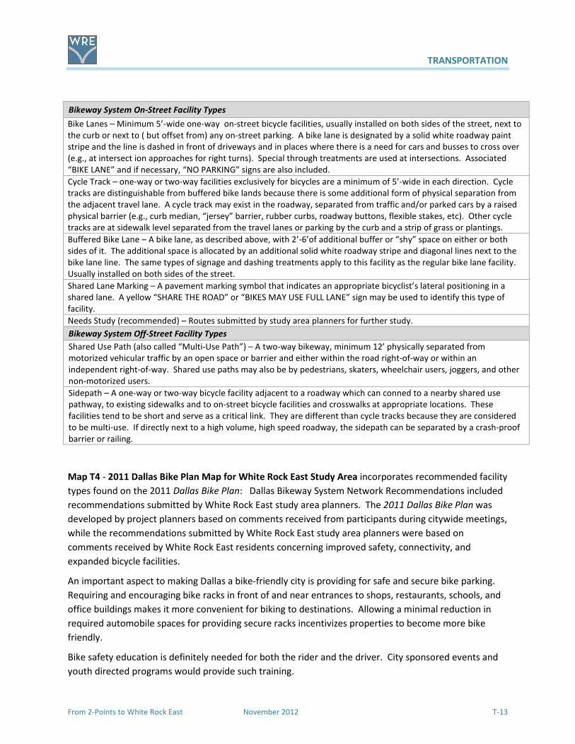
TRANSPORTATION
From 2-Points to White Rock East November 2012 T-13
Bikeway System On-Street Facility Types
Bike Lanes – Minimum 5’-wide one-way on-street bicycle facilities, usually installed on both sides of the street, next to
the curb or next to ( but offset from) any on-street parking. A bike lane is designated by a solid white roadway paint
stripe and the line is dashed in front of driveways and in places where there is a need for cars and busses to cross over
(e.g., at intersect ion approaches for right turns). Special through treatments are used at intersections. Associated
“BIKE LANE” and if necessary, “NO PARKING” signs are also included.
Cycle Track – one-way or two-way facilities exclusively for bicycles are a minimum of 5’-wide in each direction. Cycle
tracks are distinguishable from buffered bike lands because there is some additional form of physical separation from
the adjacent travel lane. A cycle track may exist in the roadway, separated from traffic and/or parked cars by a raised
physical barrier (e.g., curb median, “jersey” barrier, rubber curbs, roadway buttons, flexible stakes, etc). Other cycle
tracks are at sidewalk level separated from the travel lanes or parking by the curb and a strip of grass or plantings.
Buffered Bike Lane – A bike lane, as described above, with 2’-6’of additional buffer or “shy” space on either or both
sides of it. The additional space is allocated by an additional solid white roadway stripe and diagonal lines next to the
bike lane line. The same types of signage and dashing treatments apply to this facility as the regular bike lane facility.
Usually installed on both sides of the street.
Shared Lane Marking – A pavement marking symbol that indicates an appropriate bicyclist’s lateral positioning in a
shared lane. A yellow “SHARE THE ROAD” or “BIKES MAY USE FULL LANE” sign may be used to identify this type of
facility.
Needs Study (recommended) – Routes submitted by study area planners for further study.
Bikeway System Off-Street Facility Types
Shared Use Path (also called “Multi-Use Path”) – A two-way bikeway, minimum 12’ physically separated from
motorized vehicular traffic by an open space or barrier and either within the road right-of-way or within an
independent right-of-way. Shared use paths may also be by pedestrians, skaters, wheelchair users, joggers, and other
non-motorized users.
Sidepath – A one-way or two-way bicycle facility adjacent to a roadway which can conned to a nearby shared use
pathway, to existing sidewalks and to on-street bicycle facilities and crosswalks at appropriate locations. These
facilities tend to be short and serve as a critical link. They are different than cycle tracks because they are considered
to be multi-use. If directly next to a high volume, high speed roadway, the sidepath can be separated by a crash-proof
barrier or railing.
Map T4 - 2011 Dallas Bike Plan Map for White Rock East Study Area incorporates recommended facility
types found on the 2011 Dallas Bike Plan: Dallas Bikeway System Network Recommendations included
recommendations submitted by White Rock East study area planners. The 2011 Dallas Bike Plan was
developed by project planners based on comments received from participants during citywide meetings,
while the recommendations submitted by White Rock East study area planners were based on
comments received by White Rock East residents concerning improved safety, connectivity, and
expanded bicycle facilities.
An important aspect to making Dallas a bike-friendly city is providing for safe and secure bike parking.
Requiring and encouraging bike racks in front of and near entrances to shops, restaurants, schools, and
office buildings makes it more convenient for biking to destinations. Allowing a minimal reduction in
required automobile spaces for providing secure racks incentivizes properties to become more bike
friendly.
Bike safety education is definitely needed for both the rider and the driver. City sponsored events and
youth directed programs would provide such training.

TRANSPORTATION
T-14 November 2012 From 2-Points to White Rock East
Map T4 - 2011 Dallas Bike Plan Map for White Rock East Study Area
The 2011 Dallas Bike Plan is the first of many steps to improve and ensure safe bicycle facilities and
routes through the White Rock East area. It is important that residents and businesses work to
implement the Plan’s infrastructure recommendation and to identify future improvements for bike
riding and safety for White Rock East neighborhoods, parks, institutions, and commercial areas.
Sidewalks
Discussions at the community meetings and advisory committee saw a gradual shift from the focus on
crime to the critical need for sidewalks. An important component to a community’s transportation
program is a well connected sidewalk network. In the study area, there are concerns by those who wish
to age in place and children who need a safe route to school. There are obvious voids in area sidewalks
and lack of maintenance. Currently the sidewalks along major roads, particularly Ferguson Road, La
Prada and North Buckner are not continuous; are narrow; are in disrepair; and may not be in ADA
compliance. Where they are missing entirely, people still walk on the paths best described as “goat
trails”—narrow dirt paths that hug the curb.

TRANSPORTATION
From 2-Points to White Rock East November 2012 T-15
South Fork Ash Creek near Peavy Road
For sidewalks on local streets, the current policies look to the residents for cost sharing, but missing
sidewalks are often in areas that do not front residential uses. What is needed is safe connections to
transit stops, schools, churches, and activity and retail centers for those who cannot or do not depend
on the car. Ashdown, Cadenza, and Rustown Drives, while residential streets, serve as connections to
the major streets, but lack the necessary sidewalks. On the west side of La Prada there is not a
continuous sidewalk, but usage by pedestrians is obvious in the paths parallel to the street and across a
large vacant tract.
With sidewalks comes the need for safe intersection crossings. There are intersections on North
Buckner at Peavy and John West where it is dangerous to cross as the signal timing and small medians
make the crossing difficult. This is discussed in Signalization later in this section.
In a city that professes to want to be walkable, a system of safe and accessible sidewalks and crosswalks
can meet the needs of the people in the study area. Such a network must be developed and maintained
sidewalks and crosswalks along local arterial and collector roads to help link different destinations in the
community. A well-managed sidewalk network serves locations where pedestrians come together and
have a greater need to walk to employment centers, higher density residential areas, and commercial
districts. Such a network needs to handle current needs and be adaptable for future users, such as
higher density redevelopment opportunities that encourage accommodations for pedestrians. As
potential local trails are developed, access between area sidewalks and future trails must be developed.
To accomplish this network for the short and long range future, the conditions of the sidewalks could be
surveyed in a “walkability checklist” with criteria provided by the City and performed by the residents to
identify where sidewalks are needed or in bad repair. This would be followed up by recommendations
for inclusion of the needs in the Needs Inventory List. Consideration should be given to a different
approach to the construction and repair in residential areas whereby the City would take a larger role, a
change from current policy.
It was also discussed that the residents could work with the City and private property owners along the
proposed South Fork Ash Creek greenway corridor to identify opportunities linking the surrounding
neighborhood sidewalk network with the greenway trails as the local trail network develops.
Trail Network Expansion
Trails are multi-functional pathways used by
people for recreational walking and biking as well
as commuting. While on-street routes do exist,
people tend to think of a trail as located in a
natural or park-like setting. Trail development in
the White Rock East study area is limited to loop
walkways at Ferguson Road Park, Hillview Park,
and Lakeland Hills Park. In discussions with
residents of the White Rock East Study Area, it
was noted that better connections could bond
the community and that the study area lacks
trails like those found in other sections of the
City. Comments and markings on study area

TRANSPORTATION
T-16 November 2012 From 2-Points to White Rock East
maps identify South Fork Ash Creek as both a neglected waterway that tarnishes the community’s image
and as a linear opportunity that would help link the community, connect with local public institutions
such as the new White Rock Hills Branch Library, and enhance the area’s character and aesthetics.
South Fork Ash Creek meanders through central and northern portions of the study area. The wooded
creek flows from east to west downstream to Ash Creek and eventually to White Rock Creek. The
riparian woodlands that serve this creek cannot be missed, whether driving along roads that cross this
creek or viewing aerials of the study area. For the White Rock East area it is a break in the man-made
landscape of subdivisions, apartment complexes, commercial centers, and parking lots. Backing up to
the creek are large tracts of undeveloped land, potential redevelopment sites, residential
neighborhoods, and public and private institutions that could be enhanced by protecting the creek
corridor as a local greenway.
Greenways are distinct linear areas of land and water that are protected from further development and
are prime locations for trails. Linear areas would include ridgelines, shorelines, and waterways, but
could also include corridors that connect such topographical features. Greenways are integral for their
local natural and recreational resources. Greenways protect scenery, provide recreation, enhance
property values, and further social interaction. Because of their linear characteristics and potential
access to adjacent communities, greenways provide a location for off-road trail development to link
communities and encourage alternative means of movement.
A graphic representation of a conceptual greenway corridor/trail system expansion through the
northern half of the study area is shown on Map T5 - Proposed Greenway Corridor/Trail System
Expansion in the White Rock East Study Area. The conceptual greenway corridor follows along the path
of South Fork Ash Creek and includes three of its tributaries, Wonderlight Branch, Ripplewood Branch,
and Chenault Branch. The area around North Buckner/IH 30 is the high point within the White Rock East
Study Area and supplies the headwaters for South Fork Ash Creek and two of its branches.
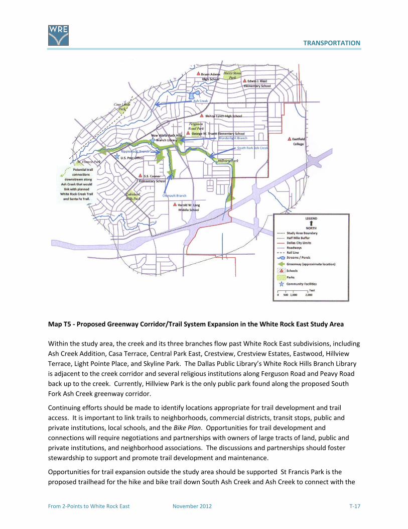
TRANSPORTATION
From 2-Points to White Rock East November 2012 T-17
Map T5 - Proposed Greenway Corridor/Trail System Expansion in the White Rock East Study Area
Within the study area, the creek and its three branches flow past White Rock East subdivisions, including
Ash Creek Addition, Casa Terrace, Central Park East, Crestview, Crestview Estates, Eastwood, Hillview
Terrace, Light Pointe Place, and Skyline Park. The Dallas Public Library’s White Rock Hills Branch Library
is adjacent to the creek corridor and several religious institutions along Ferguson Road and Peavy Road
back up to the creek. Currently, Hillview Park is the only public park found along the proposed South
Fork Ash Creek greenway corridor.
Continuing efforts should be made to identify locations appropriate for trail development and trail
access. It is important to link trails to neighborhoods, commercial districts, transit stops, public and
private institutions, local schools, and the Bike Plan. Opportunities for trail development and
connections will require negotiations and partnerships with owners of large tracts of land, public and
private institutions, and neighborhood associations. The discussions and partnerships should foster
stewardship to support and promote trail development and maintenance.
Opportunities for trail expansion outside the study area should be supported St Francis Park is the
proposed trailhead for the hike and bike trail down South Ash Creek and Ash Creek to connect with the

TRANSPORTATION
T-18 November 2012 From 2-Points to White Rock East
Gateway arch over boulevard in Solana
recently completed Santa Fe Trail and the future White Rock Creek Trail. Along the South Ash Creek and
Ash Creek corridors are locations where trails expansion could occur as incremental development, such
as City-owned land and along utility easements. Other possibilities for trail expansion include areas to
the east, southeast, and south by working with Eastfield College, City of Mesquite, and TxDOT to identify
potential trail connections, and north along Lakeland Drive to the Arboretum using both trails and
sidewalks.
Gateways
Gateways are an important way to identify an
area. For people passing through a community or
those living in a community, gateways serve
different roles that relate to movement and
place. As a transition points, gateways provide a
sense of entering and leaving an area. A
community’s identity can be further established
through the use of gateways. Passing through a
gateway can also give a sense of anticipation and
arrival. Gateways can be used for regional
destinations, campuses, parks, retail districts,
corporate centers, sports and entertainment
complexes, and neighborhood entrances. The
Ferguson Road Initiative proposes gateways along Ferguson Road at IH 30, Highland Road, and Lakeland
Drive. Casa View would like gateways along Ferguson Road at North Buckner and at Oates Drive.
Various means can be used to create a gateway. Gateways can take the form of a monument, an
archway, a water feature, an architectural feature, or a unique arrangement of plantings. Art work,
landscaping, lighting, and signage can be incorporated into a gateway location. Depending on the site
and its relation to the greater area, gateways can vary in configuration and scale. Gateways should
relate to the area being identified and be in context to the area’s history, topography, landscape, and
building materials. Besides being entrance points to an area, gateways should draw attention to an
area’s scenic views, focal points, and man-made structures such as buildings or bridges.
The White Rock East study area lacks any noticeable gateway that helps to define the community. A
person traveling through the study area has no indication that they have entered or left the community.
For a person living or working in the White Rock East area there is no anticipation of arrival and no
noticeable bearing to help establish any semblance of place and identity. Instead, it is one
neighborhood that rolls out from an adjacent neighborhood, and a monotonous stream of commercial
structures that has no place and no limits. The residents and businesses agree that designations of
gateway identification structures would enhance the entrances to the study area and its sense of place.
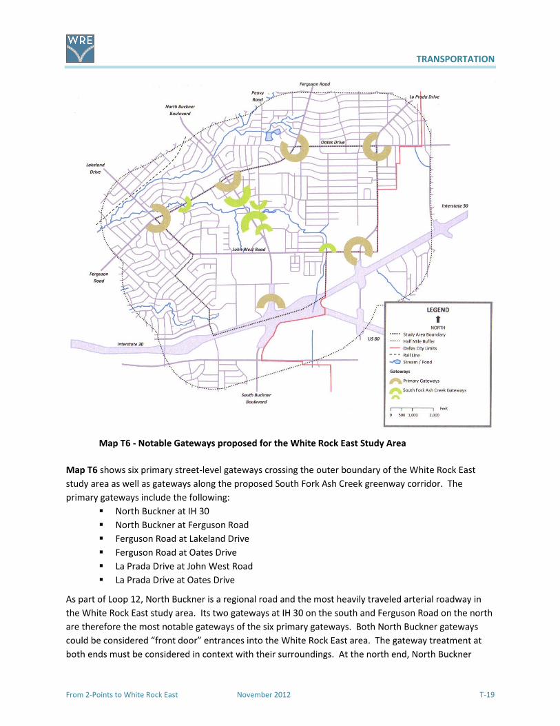
TRANSPORTATION
From 2-Points to White Rock East November 2012 T-19
Map T6 - Notable Gateways proposed for the White Rock East Study Area
Map T6 shows six primary street-level gateways crossing the outer boundary of the White Rock East
study area as well as gateways along the proposed South Fork Ash Creek greenway corridor. The
primary gateways include the following:
� North Buckner at IH 30
� North Buckner at Ferguson Road
� Ferguson Road at Lakeland Drive
� Ferguson Road at Oates Drive
� La Prada Drive at John West Road
� La Prada Drive at Oates Drive
As part of Loop 12, North Buckner is a regional road and the most heavily traveled arterial roadway in
the White Rock East study area. Its two gateways at IH 30 on the south and Ferguson Road on the north
are therefore the most notable gateways of the six primary gateways. Both North Buckner gateways
could be considered “front door” entrances into the White Rock East area. The gateway treatment at
both ends must be considered in context with their surroundings. At the north end, North Buckner
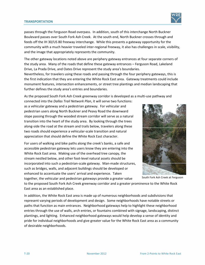
TRANSPORTATION
T-20 November 2012 From 2-Points to White Rock East
South Fork Ash Creek at Ferguson
passes through the Ferguson Road overpass. In addition, south of this interchange North Buckner
Boulevard passes over South Fork Ash Creek. At the south end, North Buckner crosses through and
feeds off the IH 30/US 80 freeway interchange. While this presents a gateway opportunity for the
community with a much heavier traveled inter-regional freeway, it also has challenges in scale, visibility,
and the image that appropriately represents the community.
The other gateway locations noted above are periphery gateway entrances at four separate corners of
the study area. Many of the roads that define these gateway entrances – Ferguson Road, Lakeland
Drive, La Prada Drive, and Oates Drive represent the study area’s boundaries.
Nevertheless, for travelers using these roads and passing through the four periphery gateways, this is
the first indication that they are entering the White Rock East area. Gateway treatments could include
monument features, intersection enhancements, or street tree plantings and median landscaping that
further defines the study area’s entries and boundaries.
As the proposed South Fork Ash Creek greenway corridor is developed as a multi-use pathway and
connected into the Dallas Trail Network Plan, it will serve two functions:
as a vehicular gateway and a pedestrian gateway. For vehicular and
pedestrian users along North Buckner and Peavy Road the downward
slope passing through the wooded stream corridor will serve as a natural
transition into the heart of the study area. By looking through the trees
along-side the road at the stream and trails below, travelers along these
two roads should experience a vehicular-scale transition and natural
appreciation that should define the White Rock East character.
For users of walking and bike paths along the creek’s banks, a safe and
accessible pedestrian gateway lets users know they are entering into the
White Rock East area. Making use of the overhead tree canopy, the
stream nestled below, and other foot-level natural assets should be
incorporated into such a pedestrian-scale gateway. Man-made structures,
such as bridges, walls, and adjacent buildings should be developed or
enhanced to accentuate the users’ arrival and experience. Taken
together, the vehicular and pedestrian gateways provide a greater value
to the proposed South Fork Ash Creek greenway corridor and a greater prominence to the White Rock
East area as an established place.
In addition, the White Rock East area is made up of numerous neighborhoods and subdivisions that
represent varying periods of development and design. Some neighborhoods have notable streets or
paths that function as main entrances. Neighborhood gateways help to highlight these neighborhood
entries through the use of walls, arch entries, or fountains combined with signage, landscaping, distinct
plantings, and lighting. Enhanced neighborhood gateways would help develop a sense of identity and
pride for individual neighborhoods and give greater value for the White Rock East area as a community
of desirable neighborhoods.

TRANSPORTATION
From 2-Points to White Rock East November 2012 T-21
A bright, colorful land mark entryway tower into the Solana business
park in Westlake, Texas, helps travelers get oriented along the SH 114
corridor.
Wayfinding
In urban settings, wayfinding is the
process people use to navigate through
built environments using visual
indicators in getting from one place to
another. Wayfinding can include both
natural features and man-made
structures. Natural features could
include waterways, hills and bluffs or
vegetation; while man-made structures
include but are not limited to a water
tower, art work, fountain, distinctive
sign, or recognizable building.
Wayfinding that is done well helps to
minimize confusion for the user by
incorporating familiar features and
ample directional markers.
The White Rock East study area is a vast, built landscape. While the area lacks large, multi-building
employment centers, medical complexes, or clusters of public buildings, the White Rock East area
contains various residential and commercial developments mixed with several points of interest.
Navigating around this area can be challenging for both residents and visitors. South Fork Ash Creek
provides the only natural feature in the area. The IH 30/US 80 interchange at North Buckner, a multi-
story office building, and the high-voltage transmission towers serve as the only notable landmarks to
gauge location. While street signs in the area are sufficient, signs giving direction are few.
As the study area develops, wayfinding should be focused on a distinct manner of internal navigation
incorporating gateways, sign design, architectural treatments, and public spaces. Wayfinding should be
used as part of the redevelopment of commercial districts. It should also be used to emphasize local
institutions, highlight the potential enhancements along South Fork Ash Creek greenway corridor, and
even locate residential neighborhoods. Listed below are three potential settings where wayfinding
would benefit the White Rock East community.
Transportation Features Can Foster Redevelopment of Commercial Districts
The study area currently lacks a recognizable hub that serves the surrounding neighborhoods and local
institutions. As the study area plan becomes a reality, redevelopment opportunities will transform the
aging commercial properties at the intersection of North Buckner and John West Road into a higher
density urban district that mixes retail, office, and residential activities with civic parks, plazas, and
boulevards. Architectural features, distinctive entryways, and sign treatments will help guide users into
the higher density commercial districts. This is where the Complete Streets program is appropriate.
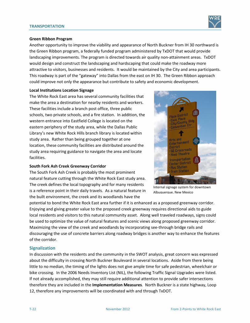
TRANSPORTATION
T-22 November 2012 From 2-Points to White Rock East
Internal signage system for downtown
Albuquerque, New Mexico
Green Ribbon Program
Another opportunity to improve the viability and appearance of North Buckner from IH 30 northward is
the Green Ribbon program, a federally funded program administered by TxDOT that would provide
landscaping improvements. The program is directed towards air quality non-attainment areas. TxDOT
would design and construct the landscaping and hardscaping that could make the roadway more
attractive to visitors, businesses and residents. It would be maintained by the City and area participants.
This roadway is part of the “gateway” into Dallas from the east on IH 30. The Green Ribbon approach
could improve not only the appearance but contribute to safety and economic development.
Local Institutions Location Signage
The White Rock East area has several community facilities that
make the area a destination for nearby residents and workers.
These facilities include a branch post office, three public
schools, two private schools, and a fire station. In addition, the
western entrance into Eastfield College is located on the
eastern periphery of the study area, while the Dallas Public
Library’s new White Rock Hills branch library is located within
study area. Rather than being grouped together at one
location, these community facilities are distributed around the
study area requiring guidance to navigate the area and locate
facilities.
South Fork Ash Creek Greenway Corridor
The South Fork Ash Creek is probably the most prominent
natural feature cutting through the White Rock East study area.
The creek defines the local topography and for many residents
is a reference point in their daily travels. As a natural feature in
the built environment, the creek and its woodlands have the
potential to bond the White Rock East area further if it is enhanced as a proposed greenway corridor.
Enjoying and giving greater value to the proposed creek greenway requires directional aids to guide
local residents and visitors to this natural community asset. Along well traveled roadways, signs could
be used to optimize the value of natural features and scenic views along proposed greenway corridor.
Maximizing the view of the creek and woodlands by incorporating see-through bridge rails and
discouraging the use of concrete barriers along roadway bridges is another way to enhance the features
of the corridor.
Signalization
In discussion with the residents and the community in the SWOT analysis, great concern was expressed
about the difficulty in crossing North Buckner Boulevard in several locations. Aside from there being
little to no median, the timing of the lights does not give ample time for safe pedestrian, wheelchair or
bike crossing. In the 2006 Needs Inventory List (NIL), the following Traffic Signal Upgrades were listed.
If not already accomplished, they may still require additional attention to provide safer intersections
therefore they are included in the Implementation Measures. North Buckner is a state highway, Loop
12, therefore any improvements will be coordinated with and through TxDOT.
TRANSPORTATION
From 2-Points to White Rock East November 2012 T-23
Updates to signalization at the following intersections are needed.
� North Buckner at Peavy
� John West at La Prada
� La Prada at Oates
� Buckner at John West
� Lakeland at Ferguson
� Ferguson at Peavy
Goals and Implementation Measures for Better Transportation
Goal Implementation Measure
Goal T.1: Safe and accessible sidewalks/crosswalks to serve the needs of local residents and businesses, encourage walking for healthy living and expand transportation options.
T.1.1: Develop a walkability checklist to inventory sidewalks and crosswalks for accessibility to schools, obstructions, transit stops, activity and retail centers in compliance with ADA guidelines. T.1.2: Use the results of the walkability checklist to initiate improvements to the network of sidewalks along major thoroughfares, arterial and collector roads with sidewalks in the street right-of-way to connect neighborhoods to schools, shopping and transit stops along arterial and collector roads.
� North Buckner Boulevard (Loop 12) � Ferguson Road � La Prada Drive � Rustown Drive � Cadenza Lane � Ashdown Drive
T.1.3: Investigate the feasibility for a desired pedestrian access from the study area to the Dallas Arboretum and White Rock Lake by developing sidewalks along Lakeland Drive from Ferguson Road to Garland Road. T.1.4: Work with the City and property owners along the proposed South Fork Ash Creek greenway corridor to identify opportunities linking the surrounding neighborhood sidewalk network with the greenway trails.
Goal T.2: Enhanced Dallas Area Rapid Transit (DART) service that is safe, convenient, responsive, and beneficial to the needs of users, neighborhood residents, and businesses.
T.2.1: Expand on-call paratransit services (DART On-Call). T.2.2: Consider revisions and expansions to bus routes to meet residents’ needs. T.2.3: Consider locating transit station for park and ride and commuter services near the intersection of Buckner and IH 30.

TRANSPORTATION
T-24 November 2012 From 2-Points to White Rock East
Goal Implementation Measure
Goal T3: Streets and major highways that enhance the community’s image and promote the safe movement of pedestrians and vehicles through streetscape and landscape improvements along major road corridors.
T.3.1: Identify and secure funding for development of streetscape and landscape improvements along Peavy Road, North Buckner Boulevard (Loop 12), and Ferguson Road corridors. T.3.2: Evaluate the need for a left-turn signal and designated left turn lane at the intersection of Ferguson and Peavy Roads. T.3.3: Identify options for local street beautification and safety, including landscaping, “Green Streets” infrastructure and opportunities to bury or move overhead utility lines. T.3.4: Encourage joint efforts between the City, Dallas County, DISD, and TxDOT to implement “Complete Streets” and “Green Streets” standards with their facilities. T.3.5: Work with developers, property owners, and public entities to implement local street beautification and safety. T.3.6: Improve street lighting at North Buckner Boulevard (Loop 12) and Peavy Road. T.3.7: Provide adequate times for pedestrians to use signalized crosswalks along
� North Buckner Boulevard (Loop 12) � Chenault Street � Ferguson Road � John West Road � Lakeland Drive � La Prada Drive � Oates Drive � Peavy Road.
T.3.8: Consider a stop sign at the intersection of Gross Road and Ashdown Drive.
Goal T.4: Extension of the Bike Plan and designation of routes into the study area.
T.4.1: Designate on-street bikeway facilities. � La Prada Drive into Eastfield College � Chenault Street from Dilido Road to
North Buckner � North Buckner from Samuell to Garland
Road T.4.2: Designate off-street bikeway facilities. Add multi-use pathways along South Fork Ash Creek and its tributaries as extensions of the Dallas Trail Network Plan. T.4.3: Improve roadway crossings for bikes and pedestrians.
� Chenault Street at Dilido Road � Chenault Street at North Buckner � Dilido Road at John West Road � Ferguson Road at Lakeland Drive � Ferguson Road at North Buckner � Ferguson Road at Oates Drive � Lakeland Drive/John West Road between
TRANSPORTATION
From 2-Points to White Rock East November 2012 T-25
Goal Implementation Measure
Green Meadow Drive and Hunnicut Road � La Prada Drive at Carol Brown Road (west
entrance to Eastfield College) � La Prada Drive at John West Road � North Buckner at John West Road � Oates Drive at La Prada Drive � Oates Drive at Shiloh Road � Peavy Road at Gross Road
T.4.4: Confirm Dallas Bikeway System bike routes shown in this plan are in the 2011 Dallas Bike
Plan. T.4.5: Install bikeway system facilities as recommended in the 2011 Dallas Bike Plan or as recommended upon further analysis by City staff with opportunities for input from area residents and business owners. T.4.6: Require the installation of secure bicycle racks for new commercial and institutional developments and encourage secure bicycle racks at existing commercial and institutional properties. T.4.7: Support parking requirements that allow the reduction of required parking spaces when secure bicycle parking is provided. T.4.8: Establish a bicycle safety program for parents and children by working with local public and private schools and community organizations.
Goal T.5: A trail network that bonds the study area and reaches into the surrounding buffer area.
T.5.1: Encourage creation of South Fork Ash Creek trail network including nearby trails and linear parks to link together neighborhoods, local institutions (libraries, schools, churches, etc.), and commercial centers. T.5.2: Work with property owners of large tracts of land and public/private institutions on possible trail corridor connections along South Fork Ash Creek and its tributaries. T.5.3: Support and promote trail development and maintenance through a community-based organization made up of local residents, property owners, and business and community leaders. T.5.4: Explore options to connect hike and bike trail on South Fork Ash Creek to Ash Creek and the Santa Fe Trail (outside study area). T.5.5: Coordinate with the City of Mesquite and TxDOT to identify potential trail connections east, southeast and south of the study area.
TRANSPORTATION
T-26 November 2012 From 2-Points to White Rock East
Goal Implementation Measure
Goal T.6: Improve signalization to provide safe crossings.
T.6.1: Update signalization at: � North Buckner at Peavy Road � Peavy Road at Gross Road � John West Road at La Prada Drive � La Prada Drive at Oates Drive � North Buckner at John West Road � Lakeland Road at Ferguson Road � Ferguson Road at Peavy Road
Goal T.7: Better function and appearance using new methods to improve the street system.
T.7.1: Include White Rock East‘s major streets in the Complete Streets initiative. T.7.2: Apply Context Sensitive Design and Green Streets actions to the street system in study area.
T.7.3: Work with TxDOT to design and install corridor plantings and landscaping along North Buckner from IH 30 north to John West Road and Ferguson Road. (Green Ribbon program) T.7.4: Include intersection enhancements on North Buckner with monument features that highlight the area’s character and history. T.7.5: Incorporate study area gateway design into redevelopment of commercial districts working with local artists to create public art features to serve as community landmarks. T.7.6: Install directional signs in redeveloped commercial districts. T.7.7: Create an internal signage system that highlights local destinations including directions to trailheads, parks, and parking areas. T.7.8: Develop architectural features and focal points along proposed greenway corridors as reference points and to familiarize frequent commuters.
Goal T.8: Improve the appearance of North Buckner with gateway features and landscaping through the Green Ribbon program.
T.8.1: Initiate discussions with TxDOT. T.8.2: Involve adjacent property owners and businesses in grant application, design of improvements, and future maintenance. T.8.3: Install landscaping, hardscape and entry features.
In conclusion, transportation is a broad topic with many moving parts. Improvements in the inclusive
network of streets, sidewalks, trails, transit, bikeways, signage and signalization will work jointly with
land use implementation measures to ensure that the community’s Consensus Vision will be achieved.
The goals and actions suggested in this section should be used as a handbook by the community to
coordinate with the appropriate City departments for the transportation improvements identified and
desired by the residents of White Rock East.
QUALITY OF LIFE
From 2-Points to White Rock East November 2012 QL-1
Everyone everywhere wants a safe and attractive place to live, work and play. Residents and business
owners in far east Dallas are no exception. The study area for this 2-Point to White Rock East Area Plan
is a completed Weed and Seed grant program that focused primarily on the reduction in crime. While
this has been a successful program, there is a continuing need to focus on crime reduction while
identifying issues that directly influence the quality of everyday life in far east Dallas. This plan is a
handbook for the residents that has assesses the important issues and gives them measures to solving
the problems.
Although an area plan generally focuses on Land Use and Transportation, the residents at the first
community meeting identified other areas of concern in the SWOT analysis that could be grouped under
the title, Quality of Life. They realized that not all of the issues are strictly ones that can be addressed in
this plan, but they wanted to bring attention to them. The residents like living in the White Rock East
area. They chose to live here and would much rather see improvements made that would make it more
feasible to stay put. Reduction in crime, new businesses, sidewalks, trails, housing options and street
safety and beautification are priorities on their “to do” list.
Exhibits and details from the Community Meetings are in Appendix A.
Quality of Life Consensus Vision
Enhance the quality of life in the White Rock East area through continued crime reduction, responsive
public safety, improved parks, new trails, an accessible library, a variety of housing choices with
businesses that meet the residents’ needs.
Public Safety
Police
There is mutual respect and cooperation between the residents and the police officers assigned to the
area. Legal and code enforcement efforts have helped curb crime and certainly need to be continued,
even expanded. The patrol watches and investigative units are managed by the North East Division of
the Dallas Police Department. There has been a successful approach to the reduction of crime through
the application of the Department of Justice Weed and Seed program.
There are active neighborhood and crime watch organizations that function not only to protect their
neighborhoods, keep up with the police activities and recently as Volunteers in Patrol (VIPs), but as
general watchdogs for many activities in the communities. The crime reports tend to come from the
higher density apartment complexes where rules are not fully enforced. New approaches to reducing
crime in the study area could be the establishment of crime watch groups in the multi-family complexes.
The Dallas Police Department’s Gold Star Certification Program is a cooperative effort by law
enforcement, apartment managers/owners and apartment residents to abate crime and to enhance the
quality of life for citizens living within multi-family communities. To become a Gold Star Property, the
apartment community has to successfully complete all three phases of the program and demonstrate a
willingness to work with the Dallas Police Department. There are several such complexes in the study
area and the interest and opportunity for others to achieve this certification.

QUALITY OF LIFE
QL-2 November 2012 From 2-Points to White Rock East
Crime related issues from the SWOT analysis at the Community Meeting on December 5, 2009 include:
� High crime areas: Abshire area, northwest corner John West at Bucker, John West at La Prada,
Oates Plaza including drug dealing
� New and existing gang activities
� Not enough visible DPD in area
� Gunfire
� Transient nature of a large percentage of the population (due to rental units)
� Fearful residents in neighborhoods
� Loitering around the barbershop and other uses at Oates Plaza
� Need to get area businesses involved
� Need more police patrol including inside apartment complexes
� Continue successful truancy enforcement
� Drug dealing
To continue to maintain a vigilant approach to crime and crime reduction, the implementation measures
that are recommended are found in the Implementation Chart and at the end of this section.
Fire
The White Rock East area is served by Fire Station Number 53
located at 1407 John West at the intersection of John
West/Lakeland/Green Meadow Drive. Engine 53, Truck 53 and
Rescue 53 units respond out of this station. The fire station
also serves the community as a “safe house” for children.
The station was built in 1965. According to the Needs
Inventory List (NIL), it is slated for roof replacement and
eventual building replacement.
No comments were made during the SWOT analysis with regard to fire protection and emergency
response. Everybody seemed very positive about service. In order to continue to maintain the quality
of service recommended implementation measures are in the Chart at the end of this section.
Code Enforcement/Compliance
The residents appreciate the activities of the Code Enforcement/Compliance arm of the City, but know
that there is more that can be done. It is understood that there are economic restraints, but more code
enforcement personnel are needed. The area needs a proactive, rather than reactive, approach to code
violations. Several years ago the position of a shared community prosecutor from the City Attorney’s
office was created and has been successful in prosecuting a large number of code violations. These
violations include building maintenance, safety issues, and high grass/weeds. Specific concerns were
expressed at the first community meeting regarding code enforcement including:
� Poorly maintained apartments: Buckner at Ferguson, John West and on Peavy
� Trash along major streets particularly along North Buckner and John West
� Need to enforce code on alley clean-up and repair of sidewalks and alleys
� Trash and brush in the creeks at New Hope and Hillview Terrace
� Serious concerns about retail spaces adjacent to New Hope, abandoned for years and full of junk
� Parking lots unmaintained
� Tattoo parlor and bars/lounges not consistent with needs, desires of residents
QUALITY OF LIFE
From 2-Points to White Rock East November 2012 QL-3
� Trash everywhere
� Irresponsible multi-family and single-family property owners who allow criminals to rent
� Stray dogs
� Adult oriented business near IH 30 not appropriate near neighborhoods
� Vacant and derelict buildings
� Additional code enforcement personnel needed
Specific implementation measures that would address the list above through code enforcement and
compliance are found at the end of this section.
Parks and Recreation
Parks are very important elements of the neighborhoods as they are enjoyed by all segments of the
population. All three parks in the study area have seen major improvements in the past five years. More
improvements are already programmed and are in the Needs Inventory List (NIL) and included in the
Dallas Parks and Recreation Department Long Range Development Plan, A Renaissance Plan. Lakeland
Hills Park on St Francis has new playground equipment, the first skatepark in Dallas, and a perimeter
walking path. Ferguson Park on Gross Road has similar improvements as does Hillview Park. All the
parks see very active use. Future plans include lighting and pavilions. The participants in the SWOT
analysis for the area plan identified several other improvements they would like to see in the area
including:
� Spray park (one has been added since the planning process began)
� Dog park
� Running path (added recently)
� Basketball court (possible conversion of underused tennis courts to multi-purpose courts)
� Youth center
Also identified as very important, even crucial, was the desire for a trail system that would use the areas
around and in the forks of Ash Creek for recreation as well as pedestrian and bike routes. It should be
noted that a multi-generational recreation center is proposed on a site fairly close to the study area on
Highland Road at Ferguson. Area residents will then have more recreational opportunities than are
currently provided at Harry Stone Recreation Center on Milmar, which was recently reopened after
extensive renovations. This makes the trails and sidewalks even more important as a means for those of
all ages that do not drive to reach the recreation centers. The potential trails are identified in the
Transportation section of this area plan.
Implementation measures for Parks and Recreation needs and desires are found in the chart at the end
of this section.
Library
The residents of the area are absolutely delighted that the new White Rock Hills branch of the Dallas
Public Library System is now open. The new library is conveniently located on Hibiscus at Ferguson in
the study area. This facility makes the need for sidewalk and trail linkages to and from neighborhoods
even more important. For optimum effect, the new library branch operations and maintenance must be
a priority for White Rock East and the entire surrounding area now known as White Rock Hills.
Since this planning process started, the library has opened and the White Rock Hills Library Friends has
been organized. Ideas for continued support are in the chart at the end of this section.
QUALITY OF LIFE
QL-4 November 2012 From 2-Points to White Rock East
Schools
There are three Dallas Independent School District (DISD) schools in the study area, S. S. Conner
Elementary on Green Meadow at Lakeland, George W. Truett Elementary on Gross Road, and Howard
Lang Middle School on Chenault Road.
Parental involvement and community outreach to parents is critical to the improvement of these
education facilities. While the area plan cannot directly change the activities of the schools, it can
recommend improvements that will make the schools safer to get to and less overcrowded with the
implementation in the future of lower density land uses.
From the SWOT analysis it was expressed that Truett Elementary School concerns are as follows:
� Grounds are not maintained
� Trash is not picked up
� Lawn not mowed
� 35 unsightly rotting portable buildings need replacement
� Overcrowded (at more than 200% capacity according to school enrollment data)
� Cafeteria can’t accommodate all students
� Additional gym space
� New classroom wing
Since the planning process began, many improvements have been made to Truett. A new principal and
active neighbors, with the help of the new trustee and responsive district personnel, have seen most of
the items mentioned in the SWOT analysis addressed. However, the school is still operating at almost
double its capacity. A new wing, like nearby Conner and Bayles have, would alleviate the overcrowding
until another school could be built in the area. This would most likely require DISD to allocate bond
funds to build the improvements.
Specific items were not identified for S. S. Conner and Lang Middle School although they may be
encountering some of the same problems. Also within the study area is Bishop Lynch High School.
Located at the corner of Ferguson and Peavy Roads, the well maintained campus includes classrooms,
an auditorium, a stadium, and accessory buildings. Motivated by this area plan, several members of the
Advisory Committee have been very successful in securing many improvements to the facilities at Truett
Elementary School.
Another consideration would be the location of a charter school in the study area. There are several
large tracts and buildings that could accommodate such a school. Reduced overcrowding and new
educational opportunities would then be available to the area residents. Dallas has a number of fine
charter schools, but there are none in far east Dallas. Research and contacts will need to be initiated to
determine the feasibility of a charter school.
Public Works/Infrastructure
Streets, alleys, water mains and lines, sewer (sanitary and stormwater), sidewalks, and trails are all a
part of the local infrastructure. Since this area was built over 50 years ago much of the infrastructure is
aging and needs repair and replacement. The Needs Inventory List (NIL) identifies projects that require
capital expenditures that are often paid for with bond funds. Streets, Public Works and the Water

QUALITY OF LIFE
From 2-Points to White Rock East November 2012 QL-5
Department manage the local utilities components. Operations and maintenance funding comes from
the General Fund or designated enterprise funds.
New approaches that enhance the urban environment in appearance and function should be
considered. One of the more fragile components of the infrastructure system is stormwater
management. Low Impact Development and Green Infrastructure are now being included in a regional
approach called integrated Stormwater Management (iSWM).
Housing
With a variety of housing options in the study area, 2-Points to White Rock East, there is tremendous
opportunity to become what is now being called a “lifecycle community”. A lifestyle community is one
in which all ages are included and their needs addressed—from young children to aging adults. The
housing types are small starter homes, mid size single-family, townhomes and apartments—a village.
There are approximately 12,491 housing units in the study area, split almost evenly between owner-
occupied and rental units. Demographic information does not differentiate whether the rental units are
in multi-family complexes or are single-family homes.
Recent research by the Advisory Committee indicates an upswing in owner occupied single-family
homes in several areas. This is proving to be a significant improvement to the area!
City of Dallas Housing Department
The Housing Department offers a range of programs to assist neighborhood residents in maintaining the
quality of their communities. One program that can help to improve housing and neighborhoods is
People Helping People which assists senior and disabled homeowners with minor exterior home repairs
and weatherization. Neighborhood associations and crime watches should become aware of this
program and include this information in their communication and outreach efforts. Here is an
opportunity to assist those with the desire to “age in place” but need help with the maintenance of their
property.
In February 2003, the City Council approved the Neighborhood Investment Program (NIP) to focus
housing/land bank, public infrastructure improvements, code enforcement, economic development and
other City resources in designated targeted Community Development Block Grant (CBDG)
neighborhoods. Program emphasis is placed on:
� Leveraging private development and other community investments;
� Facilitating sustainable neighborhood redevelopment through community partnerships and
stakeholders; and
� Targeting City, stakeholders and public/private resources.
Currently the City has five such programs, mainly in the southern and western portions of the City. This
study area in the far eastern portion of the City has generally been neglected or overlooked for such a
program due to lack of available information and advocacy. The study area would benefit greatly by
inclusion in the NIP program.
In February 2008, the City Council approved the Neighborhood Enhancement Program (NEP) as a
companion to the NIP. The NEP provides funding for streetscape improvements, landscaping and
neighborhood gateway initiatives, pedestrian amenities, and related architectural/engineering work.

QUALITY OF LIFE
QL-6 November 2012 From 2-Points to White Rock East
Projects are selected to maximize neighborhood impact under the NIP and are coordinated by the
Housing Department. The study area is a logical candidate for these programs.
Dallas Housing Authority
The Dallas Housing Authority has one facility in the study area, Lakeland Manor. It is a 185 unit multi-
story building for the elderly and disabled.
Section 8, the low income housing assistance program, is coordinated by the Housing Authority.
Landlords may voluntarily in which landlords may participate in this program. The purpose is to
distribute low and moderate income renters in the community rather than concentrate them in a single
building or complex. Rental vouchers may be available to renters for single-family and multi-family
units. While there does not appear to be a definitive list of where such assistance is available in the
study area, three complexes are identified: Lakeland Manor, Buckner Village and Casa Ridge as locations
of Section 8 recipients.
New Opportunities
As White Rock East ages and redevelops, there will be a need for new and different housing types. The
Land Use Vision identifies new housing in mixed use developments closer to transit, single family at a
more urban density, active senior housing and live-work housing. Changes to land uses and
improvement in the economy should foster the repurposing of deteriorating multi-family units and using
vacant land for townhomes and cluster development. With the help of the City’s Housing Department
the area could attract development and design organizations. Both nonprofit and commercial
developers should be encouraged to develop in this area so convenient to Downtown.
Goals and Implementation Measures for Quality of Life
The following is a chart that shows the Implementation Measures for each of the components of this
Quality of Life section. More details may be found in the full chart at the end of the Implementation
section.
Goal Implementation Measure
Goal QL.1: Code Compliance. Improve the study area’s image using codes, regulations, programs, and enforcement to clean up, stabilize, and enhance neighborhoods.
QL.1.1: Community leaders will work with property owners, local businesses, institutions, and local organizations to develop methods that educate, clean up, and aggressively monitor trash “hot spots” to pursue violators.
QL.1.2: Identify and pursue removal of structures and uses that are derelict, nonconforming or illegal.
QL.1.3: Support area organizations that educate property owners, local businesses, and institutions about trash pickup, graffiti, local maintenance, and beautification.
QL.1.4: Conduct annual issues inventory, review what worked and what needs improvements, and share annual inventory/review with community.
QL.1.5: Work with Dallas Animal Services and neighborhood groups to manage the pet population by educating residents about the need to spay and neuter their pets, report animal hoarding, animal abuse, and sightings of stray cats and dogs.
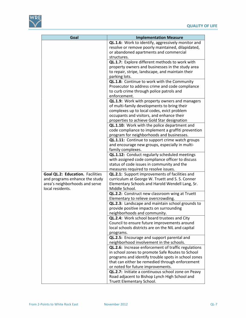
QUALITY OF LIFE
From 2-Points to White Rock East November 2012 QL-7
Goal Implementation Measure
QL.1.6: Work to identify, aggressively monitor and resolve or remove poorly maintained, dilapidated, or abandoned apartments and commercial structures.
QL.1.7: Explore different methods to work with property owners and businesses in the study area to repair, stripe, landscape, and maintain their parking lots.
QL.1.8: Continue to work with the Community Prosecutor to address crime and code compliance to curb crime through police patrols and enforcement.
QL.1.9: Work with property owners and managers of multi-family developments to bring their complexes up to local codes, evict problem occupants and visitors, and enhance their properties to achieve Gold Star designation
QL.1.10: Work with the police department and code compliance to implement a graffiti prevention program for neighborhoods and businesses.
QL.1.11: Continue to support crime watch groups and encourage new groups, especially in multi-family complexes.
QL.1.12: Conduct regularly scheduled meetings with assigned code compliance officer to discuss status of code issues in community and the measures required to resolve issues.
Goal QL.2: Education. Facilities and programs enhance the study area’s neighborhoods and serve local residents.
QL.2.1: Support improvements of facilities and curriculum at George W. Truett and S. S. Conner Elementary Schools and Harold Wendell Lang, Sr. Middle School.
QL.2.2: Construct new classroom wing at Truett Elementary to relieve overcrowding.
QL.2.3: Landscape and maintain school grounds to provide positive impacts on surrounding neighborhoods and community.
QL.2.4: Work school board trustees and City Council to ensure future improvements around local schools districts are on the NIL and capital programs.
QL.2.5: Encourage and support parental and neighborhood involvement in the schools.
QL.2.6: Increase enforcement of traffic regulations in school zones to promote Safe Routes to School programs and identify trouble spots in school zones that can either be remedied through enforcement or noted for future improvements.
QL.2.7: Initiate a continuous school zone on Peavy Road adjacent to Bishop Lynch High School and Truett Elementary School.

QUALITY OF LIFE
QL-8 November 2012 From 2-Points to White Rock East
Goal Implementation Measure
QL.2.8: Investigate the potential for locating a charter school in the study are to relieve overcrowding and provide new educational opportunities.
Goal QL.3: Parks & Recreation. Ensure quality parks and trails that meet the community’s expectations.
QL.3.1: Maintain or improve upkeep of Ferguson Park, Hillview Park, and Lakeland Hills Park by working with staff.
QL.3.2: Continue to add improvements to area parks as identified in the Renaissance Plan and NIL.
QL.3.3: Create park advocate groups or use existing crime watches and neighborhood organizations to adopt the parks and focus on the planning, design, landscaping, and security.
QL.3.4: Identify possible park locations adjacent to future trails to incorporate additional features such as a spray park, dog park, and recreation center with running path and basketball courts.
QL.3.5: Pursue funding of projects with staff and elected officials for improvements that are listed in the NIL.
QL.3.6: Initiate discussions with officials of the YMCA of Metropolitan Dallas or similar provider to provide programs in the study area.
QL.3.7: Link community facilities by trails while preserving open space (see Transportation).
QL.3.8: Program trail improvement through public/private cooperation.
Goal QL.4: Public Safety. A community that is a safe and desirable place to live.
QL.4.1: Continue successful Weed and Seed strategy by area neighborhood associations and crime watches.
QL.4.2: Promote, develop, and implement Crime Prevention Through Environmental Design (CPTED) program.
QL.4.3: Support the Volunteers In Police (VIP), Citizens Offering Police Support (COPS), Crime Watch Executive Board (CWEB), Community Emergency Response Team (CERT) programs
QL.4.4: Work with apartment owners to reduce crime in their complexes by enforcement of lease rules and HUD rules through education and communication as well as enforcement.
QL.4.5: Consider a community police substation as a presence in the community and place of rest and paperwork for the officers working in the area.
QL.4.6: Continue DPD programs to coordinate with community leaders/crime watches/neighborhood associations, businesses, schools, and public and private institutions to identify and monitor “hot spots” of criminal activity such as drug dealing, prostitution, burglary, and loitering.
QUALITY OF LIFE
From 2-Points to White Rock East November 2012 QL-9
Goal Implementation Measure
QL.4.7: Use monthly local crime data to inform residents and business owners of local trends and educate citizens on the causes of crime and how to prevent criminal activity.
QL.4.8: Maintain/increase visible DPD patrols with aggressive monitoring of high crime areas.
� Dilido Road at Senate Street � Abshire Lane � NW corner of North Buckner and John
West Road � La Prada Drive north of John West Road � Ferguson Road at Oates Drive � North Buckner (Loop 12) and Peavy Road
at South Fork Ash Creek
QL.4.9: Support DFD local fire station and their role in the community.
QL.4.10: Perform necessary repairs on fire station.
QL4.11: Adhere to the NIL for future replacement of the fire station facilities.
QL4.12: Keep staffing at the required level to maintain superior response times.
Goal QL.5: Housing: A wide range of attractive, affordable, accessible housing options
QL.5.1: Apply to be NIP and NEP programs.
QL.5.2: Develop a program with local architects and designers to apply inexpensive improvement solutions to enhance the marketability of the older housing stock and encourage future owner-occupied residents.
QL.5.3: Review housing programs across the country for remodeling Post-World War II housing and make it available to prospective homeowners, local realtors, and development professionals.
Q.L5.4: Monitor rental units for compliance with city codes and HUD requirements.
Goal QL.6: Library. Support the new White Rock Hills Library
QL.6.1: Support operations, maintenance and materials acquisition for the new branch library.
QL.6.2: Support the local “Friends of the Library” group for the White Rock Hills Library.
QL.6.3: Support the creation of linkages of trails and sidewalks connecting the library to the residences and businesses.
Goal QL.7: Public Works/Infrastructure. Ensure a healthy environment with adequate infrastructure.
QL.7.1: Continue to reconstruct and replace aging infrastructure.
QL.7.2: Explore and adopt new methods and materials for design and construction of streets, alleys, parking lots, and drainage ways.
Given the accessible location of White Rock East in the DFW Metroplex, the recommended
Implementation Measures will serve to rejuvenate and enhance its residential and commercial
features. These proposed improvements can and will lead to a more sustainable future for the study
area and for far east Dallas, a better quality of life for all.

URBAN DESIGN
From 2-Points to White Rock East November 2012 UD-1
Corner of North Buckner at John
West Road
All communities strive to leave a positive lasting impression of
their area to visitors, friends, and potential investors.
Whether it is because of local pride, self satisfaction,
economic gain, or just “keeping up with the Joneses”,
community form and aesthetics are an important part of a
community’s psychological scorecard. Urban design plays an
important role in combining function and appearance of a
community and how it is perceived by residents, investors,
and visitors. Places that are easy on the eyes, simple to
maneuver about, value their natural assets, and are sensitive
to details within their public spaces tend to leave positive
memories that attract people back.
Urban design incorporates natural and man-made assets along with intangible assets, such as local
history and a local quirkiness, as part of their local ingredients for creating place and bringing folks back
for more. This section provides the basis for understanding the elements of urban design that could be
applied to various features in the study area. Its purpose is to enlighten and educate the community to
imagine some of these features in the improvements that can enhance appearance of the study area.
Key Issues
Starting with the SWOT analysis at the first community meeting and continuing through the several
advisory committee meetings, stakeholder interviews, and the second community meeting, a series of
key issues emerged that focused on the urban design and overall image for White Rock East. These key
issues included the following.
An identifiable central location with a positive image: One of the things that seems apparent entering
White Rock East is that there is no “there” there. Today’s popular
desire is “creating place” for a community. The closest thing to place
in White Rock East is the collection of aging 1970s and 1980s
shopping centers that the neighbors seem to avoid. Centrally located
in the study area, these commercial centers are mostly acres of
poorly maintained and half used asphalt parking lots with aging retail
structures as far removed from the street as possible. The current
built environment does not entice a traveler to stay and visit.
Instead, it looks intimidating—creating a negative image for the area.
Older shopping center at NE corner of North
Buckner and John West Road

URBAN DESIGN
UD-2 November 2012 From 2-Points to White Rock East
North Buckner
Sikorski Lane in White Rock Village
No sidewalk along Hunnicut Road near
S. S. Conner Elementary School
South Fork Ash Creek off Peavy Road
Landscaping major roadways: The major roadway corridors in White
Rock East create that first impression of the community for residents
and investors, which can also be a lasting impression. As
stakeholders, residents and business owners cited the need for
corridor landscaping along major roadways to improve the aesthetics
in the community. North Buckner and Peavy Road, which run through
the middle of the study area, were noted as prime corridors needing
landscape improvements. Other major roads include Ferguson Road,
John West Road, La Prada Drive, Oates Drive, and along IH 30.
Enhancing neighborhoods: White Rock East is made up of many neighborhood subdivisions built from
the 1950s through the 1970s. Although these houses have charm,
houses in these neighborhoods are now thirty to fifty-years old and
require some significant updating to make them attractive to today’s
lifestyles. While these neighborhoods represent the suburban
housing and streets patterns popular during their development, such
neighborhoods are also attractive to today’s buyers seeking tree-
lined neighborhoods and housing at an affordable price with good
proximity to intown amenities, entertainment, and employment
opportunities. Enhancing what made these neighborhoods popular when they were built would further
the neighborhoods’ value to the whole community.
A fully developed and useable sidewalk system: In some neighborhoods in White Rock East sidewalks
are provided, but in others sidewalks are lacking or in poor condition
for the users. In many instances, sidewalks are blocked by objects
that are inconvenient for able body uses and a challenge for those
with disabilities, and in some instances sidewalks are lacking where
they are required the most. Residents noted issues with local
sidewalks, including some that were not wide enough, others that
ended abruptly, some were uneven or were not sloped, and a lack of
sidewalks leading from neighborhoods and commercial centers to
DART bus stops.
South Fork Ash Creek as a greenway with trails and activities: While not the highest point in eastern
Dallas County, the interchange of IH 30/US 80/Loop 12 is located near
a high point where several named and un-named streams originate.
The branches of South Fork Ash Creek start from this high point,
flowing from east to west through the study area. The riparian
woodlands along this creek provide a break from the developed
environment that residents have expressed a desire to protect and
enhance. A greenway and trail system along the creek would help
link together various neighborhoods, thereby bonding the White
Rock East area.

URBAN DESIGN
From 2-Points to White Rock East November 2012 UD-3
North Buckner north of IH 30
Preston Center is an example of a more pedestrian-friendly
shopping environment that incorporates vehicle needs.
The built and natural/open space environment along
Oak Lawn’s Turtle Creek.
Gateways: The White Rock East area could be mistaken for any other suburban community in the Dallas
area. The aging shopping centers and auto-oriented uses that line
North Buckner Boulevard and the “hole-in-the-wall” establishments
that are lining IH 30 do not present a positive community image that
residents expressed a desire to have for the area. At key entrances
into White Rock East there is a lack of any visible landmarks or
identifying object that represents the community in a positive
manner. Landscaped gateways at key entrances into White Rock
East would help instill a positive community identity for residents,
visitors, and investors.
Most communities have a built environment and natural/open environments. The built environments
are those fixed man-made additions that include, but are not limited to, roads, structures, overhead
lines, signage, and parking lots. The natural / open
environment includes conditions void of current
development, which in White Rock East includes parts
of South Fork Ash Creek and various tracts of vacant
land. The relationship between the built and
natural/open environments should include a balance
and flow among the streets, sidewalks, and buildings
with nearby open spaces and ecological amenities.
White Rock East is dominated by a collection of
neighborhoods. Houses within these neighborhoods
represent various price points but not at the extreme
ends of housing market. Despite the dominance of so
many neighborhoods, the community is divided in two by dated commercial and multi-family activities
along North Buckner. Residents have expressed the need for creating stronger physical linkages within
the community. The absence of a stable and visually attractive central core that serves the needs of
residents detracts from the many positives White Rock East has to offer and does not help to bond the
community. In addition to the lackluster appearance along North Buckner, local residents are
disheartened by the declining development
patterns along the I 30 corridor, which serves as a
major entryway into White Rock East at North
Buckner Boulevard.
As noted above, urban design’s role in combining
function and appearance is important for
establishing a positive impression for an area such
as White Rock East. In existing residential
subdivisions, accentuating the positive attributes of
these areas will be important for enhancing their
viability as neighborhoods. For new residential
communities neighborhood development patterns

URBAN DESIGN
UD-4 November 2012 From 2-Points to White Rock East
Residents’ input into gateway design
treatments for White Rock East
that promote walking, biking, and better connectivity along with housing having front porches and
residential structures fronting onto public greens would foster local cohesion and support neighborhood
identity. The desire to retrofit and repurpose the greyfield commercial centers along North Buckner and
Ferguson Road into more intense higher density commercial and mixed use centers will require greater
care be given to the layout and design of pedestrian and vehicular spaces.
Urban design should also be mindful of current initiatives demanded by the public in the built and
natural environments. Many of these initiatives are meant to address design and building practices that
have resulted in hardships to certain segments of society or have had negative impacts on the natural
environment. These initiatives include, but are not limited to, the Americans with Disabilities Act,
Complete Streets, and Green Streets plus related stormwater management Low Impact Development
(NCTCOG’s iSWM). Going forward, urban design in White Rock East will need to address these schemes.
Role of Urban Design
Perceptions of a community can be formed by the physical
environment that exists. The facades and materials of buildings,
the design of roadways, the inclusion of sidewalks and street trees,
and treatment of signage and overhead lines help define the level
of importance for the built environment. As important as
characterizing the perceived livability of a community is how the
natural environment is treated and integrated into the built
environment. Urban design plays a major role in both
environments for creating either a positive or negative perception
of a community. Urban design for a community should:
� Reflect the values of the community;
� Consider the surrounding built and natural
environment;
� Address how public spaces should be used;
� Give direction for major public investments; and
� Provide guidance related to public and private
development.
The White Rock East area is dominated by its built environment. It includes mostly 1950s through 1970s
neighborhood housing subdivisions along with an assortment of 30+ year-old commercial buildings
located along major roadways. The natural environment is limited to the riparian woodlands along
South Fork Ash Creek plus some remaining vacant tracts of land. To enrich the community, urban design
will play a major role in White Rock East’s future growth and development as the area experiences new
investments through preservation and redevelopment based on local values.
Urban Design Concepts and Elements
As the White Rock East Area undergoes renewed investment and community enhancements, several
urban design concepts and elements will need to be applied that correspond to local residents’ values
and desires. Urban design concepts deal with broad urban forms that help to define, bond, and give
identity to the entire community. The urban design elements are those ingredients within the urban
design concepts that give it character, define its place, and make it memorable. The urban design

URBAN DESIGN
From 2-Points to White Rock East November 2012 UD-5
concepts and elements described below are general guidelines to help decision makers and stakeholders
better understand the local setting and character. For more detailed understanding, further study,
planning, and design work would be required. In addition to the whole study area, the urban design
concepts and elements should be referenced for the seven Strategic Opportunity Areas to achieve the
community’s values, desires, and identity.
There are five urban design concepts within the White Rock East area.
1. Commercial centers – Concentrations of retail, restaurant, service, and entertainment allow for
a balance of residential and office activities. Open space needs to help define its location.
2. Gateways – Key entry points define either when coming into the community along major travel
corridors or notable physical zones that a traveler passes through in association with an area.
3. Greenways – Linear open space can be set aside for public enjoyment and moving about,
typically along a stream, beach, ridgeline, and even alongside a utility easement.
4. Neighborhoods – Primarily residential areas with associated secondary needs, such as schools,
parks, and smaller retail centers, should foster a personal relationship and identity with place as
home.
5. Roadway corridors – Notable roadways within the community should be recognizable, safe, and
leave a positive impression about the area.
There are 22 urban design elements that support urban design concepts for the White Rock East area.
Listed below are descriptions of the urban design elements followed by a table that relates the elements
to the concepts .
Alleys –A public right-of-way usually placed at the rear of a property, alleys have been traditionally
designed for trash removal, off-street parking access, utility
easements, and drainage. Alleys in new neighborhoods should be
designed for residential garages loaded from the property’s rear to
reduce curb cuts and sidewalk disruptions along streets. New
neighborhood alleys should allow the opportunity for rear property
rental units in the back of residential properties which might require
adjustments to current city codes allowing for rear property entries
and addressing CPTED (Crime Prevention Through Environmental
Design) standards. Alleys in commercial areas should be designed and built for service and product
deliveries, but also include possible pedestrian encroachment as “cut-through spaces” for getting from
one block to another, access to rear entry retail establishments and offices and paths to mid-block or
back entry parking. Alleys should be wide enough for emergency, utility, and sanitation vehicles and
incorporate signage for identifying addresses of properties.

URBAN DESIGN
UD-6 November 2012 From 2-Points to White Rock East
Building facades -Primarily, the vertical front of a building that people see, building facades can also
include the sides and rear portions of a building when these building
sections are facing a public edge along a street or pedestrian path.
Because building facades help define this public edge, building
design guidelines and regulations should carefully describe building
materials, colors, and textures; building height, order, and
proportion; encroachment; window and door openings; and lighting.
Bus transit corridors – A corridor designed and developed for
catering to pedestrians of all needs for transit within a linear urban
environment. Development patterns along the bus transit
corridor coordinate building developments, street space, and
pedestrian needs in context with transit service stretched over
several city blocks. Transit corridors usually feature wide
sidewalks with benches, localized maps, ticket dispensers, and
information kiosks, plus bicycle storage units, fountains, and
encroachments of nearby retail and restaurants.
Colors, materials, and textures – Colors, materials, and textures, when incorporated into a building
design, streetscape, or landscape, can either excite or deaden the
senses. This reaction can be subjective; therefore, careful analysis
by a professional architect or landscape architect is important.
Working with a community and taking into consideration the area’s
surrounding character will figure into the choices of colors,
materials, and textures.
Crosswalks – Crosswalks are well defined transition points where pedestrian and vehicular traffic
converge. Well marked crosswalks help direct pedestrians to
places where they can safely cross a roadway, which helps
improve driver awareness and traffic movement by restricting
pedestrian crossings to designated locations. Roadway
crosswalks should be well marked and maintained to ensure
awareness for both pedestrian and driver. In locations with high
pedestrian movements, pedestrian crosswalk signage and an in-
road warning light system could be incorporated to enhance
pedestrian and driver awareness.
Landscaped roadways – There are several major thoroughfares and highways that pass through or
define the periphery of the White Rock East area. Many of these
roadways have wide medians or broad shoulders as part of their
right-of-way, but lack much landscaping except for some basic tree
plantings and mowed grass. Enhanced landscaping along these
roadways would help the visual and aesthetic appeal of the area,

URBAN DESIGN
From 2-Points to White Rock East November 2012 UD-7
further advance vehicular and pedestrian safety by creating perceived green barriers, and using Low
Impact Development methods (see Stormwater management) foster water quality and water
conservation. Two highways in the White Rock East area are owned and managed by the Texas
Department of Transportation (TxDOT—North Buckner (Loop 12) and IH 30. Any improvements to
North Buckner and IH 30 need to involve local stakeholders in the roadways’ design that balances social,
economic, and physical purposes that can be realized through Context Sensitive Solutions. In addition,
the Green Ribbon Program by TxDOT could be considered to address the landscaping needs for both of
these State-owned and managed roadways.
Lighting – One of the largest users of lighting in a community is street lights. To ensure public safety,
hold down cost, and be aesthetically pleasing, there are several
factors that determine what type of light bulbs to use, including
heat production, light distribution, light color, and bulb life-span and
replacement. Most light bulbs used in today’s street lights are
either high pressure sodium (HPS) or metal halide. HPS are the most
energy efficient street light bulb, producing a lot of light with little
heat and lasting a long time; however, the light HPS produces is
orange, which is not as desirable as a white light. Metal halide has been popular for producing the most
energy efficient white light, desirable in neighborhoods, but for municipalities metal halide starts out
bright for the first few years and then dims, requiring replacement. Recent breakthroughs in Light
Emitting Diode (LED) technology have made this decades-old light source a more attractive choice with
communities. LED produces a very intense and energy efficient white light compared with metal halide
and has a longer life span. In addition, LED lights are more directional, removing dark gaps between
street lights and creating the most continuous light along roadways. Because of the wide range of
colors that can be produced using LED technology, it is becoming a popular light choice for highlighting
buildings and monuments.
Mid-block paths – A footpath placed in the middle of a long residential block allows easy pedestrian
movement from one neighborhood street to the next neighborhood
street or access into adjacent parks.
Neighborhood entries – Enhanced entryways into community neighborhoods help define the
neighborhood’s style and ambiance, while letting residents and
visitors know they are entering a neighborhood that takes pride in
its image.

URBAN DESIGN
UD-8 November 2012 From 2-Points to White Rock East
Parking – Parking for vehicles includes on-street parking and off-street parking. On-street parking
includes both parallel parking and diagonal parking with landscaped
buffers between parked vehicles and the pedestrian path. To
supplement the need for additional parking in areas with greater
activity, off-street surface and garage parking will likely be required.
Off-street surface parking lots should be located in the rear of
buildings with dedicated pedestrian paths that are lighted and
landscaped to direct people from their parked vehicles to the main
building entrance. When possible, off-street parking garage
structures should be wrapped by a building or buildings to enhance
the urban streetscape. Signage for off-street parking should be
visible from the street and easy to understand. Shared parking
between nearby establishments having different operation hours
should be encouraged. In areas with commercial and/or institutional
activities, maximum parking space restrictions should be set to
encourage less space set aside for parking vehicles to promote a mix
of activities.
Public greens – Parks enhance the character and value of surrounding properties through the placement
of this public green amenity. Public greens can be situated as a focal
point or terminus for public streets within a residential or
commercial area, or serve as a public commons enclosed on three
sides by developed properties.
Public plazas – More formalized open areas located in higher density, more intense pedestrian settings,
public plazas provide a break in the urban setting. Similar to public
greens in where they can be located, public plazas can sometimes
have less green, but more hardscape treatments in the design and
include added amenities such as a notable fountain or memorial
structure.
Road side green buffers – Designed and developed as linear greenbelts along notable community
roadways, road side green buffers would incorporate shade trees
and landscaping to create a park-like setting to enhance local roads
and neighborhoods and provide another method for community
wayfinding.
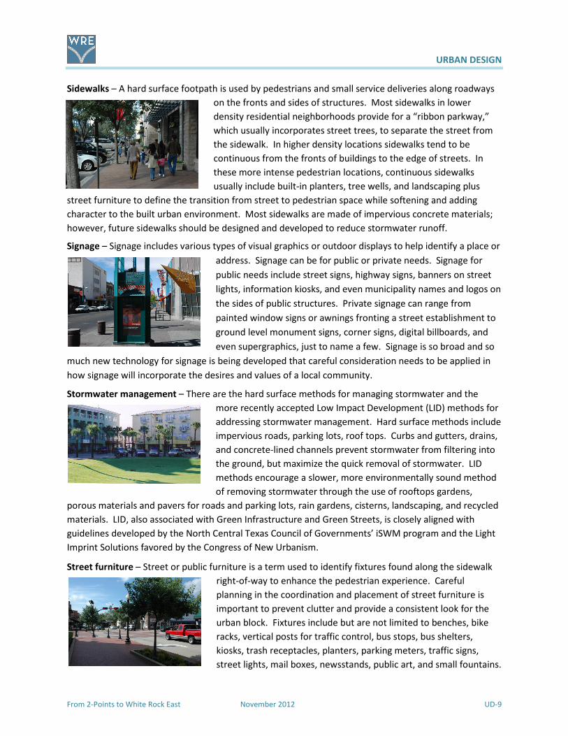
URBAN DESIGN
From 2-Points to White Rock East November 2012 UD-9
Sidewalks – A hard surface footpath is used by pedestrians and small service deliveries along roadways
on the fronts and sides of structures. Most sidewalks in lower
density residential neighborhoods provide for a “ribbon parkway,”
which usually incorporates street trees, to separate the street from
the sidewalk. In higher density locations sidewalks tend to be
continuous from the fronts of buildings to the edge of streets. In
these more intense pedestrian locations, continuous sidewalks
usually include built-in planters, tree wells, and landscaping plus
street furniture to define the transition from street to pedestrian space while softening and adding
character to the built urban environment. Most sidewalks are made of impervious concrete materials;
however, future sidewalks should be designed and developed to reduce stormwater runoff.
Signage – Signage includes various types of visual graphics or outdoor displays to help identify a place or
address. Signage can be for public or private needs. Signage for
public needs include street signs, highway signs, banners on street
lights, information kiosks, and even municipality names and logos on
the sides of public structures. Private signage can range from
painted window signs or awnings fronting a street establishment to
ground level monument signs, corner signs, digital billboards, and
even supergraphics, just to name a few. Signage is so broad and so
much new technology for signage is being developed that careful consideration needs to be applied in
how signage will incorporate the desires and values of a local community.
Stormwater management – There are the hard surface methods for managing stormwater and the
more recently accepted Low Impact Development (LID) methods for
addressing stormwater management. Hard surface methods include
impervious roads, parking lots, roof tops. Curbs and gutters, drains,
and concrete-lined channels prevent stormwater from filtering into
the ground, but maximize the quick removal of stormwater. LID
methods encourage a slower, more environmentally sound method
of removing stormwater through the use of rooftops gardens,
porous materials and pavers for roads and parking lots, rain gardens, cisterns, landscaping, and recycled
materials. LID, also associated with Green Infrastructure and Green Streets, is closely aligned with
guidelines developed by the North Central Texas Council of Governments’ iSWM program and the Light
Imprint Solutions favored by the Congress of New Urbanism.
Street furniture – Street or public furniture is a term used to identify fixtures found along the sidewalk
right-of-way to enhance the pedestrian experience. Careful
planning in the coordination and placement of street furniture is
important to prevent clutter and provide a consistent look for the
urban block. Fixtures include but are not limited to benches, bike
racks, vertical posts for traffic control, bus stops, bus shelters,
kiosks, trash receptacles, planters, parking meters, traffic signs,
street lights, mail boxes, newsstands, public art, and small fountains.

URBAN DESIGN
UD-10 November 2012 From 2-Points to White Rock East
Street grid – A street grid incorporates the layout of streets at right angles to one another creating
rectangular and square city blocks. While considered to be
repetitive and monotonous, a street grid provides an easy to
understand network of roads as well as easy movement and
connectivity.
Trees – Traditionally, trees were used to enhance roadway appearance by softening the urban
surroundings with greenery and shade. Today, there is a greater
appreciation of benefits realized from street trees. By providing
shade, street trees provide protection by moderating sunlight. The
tree canopy helps lower temperature levels in urban areas, which is
appreciated during hot summer months. Street trees can benefit a
city’s drainage infrastructure by absorbing stormwater precipitation
through a tree’s leaf system and, when using Low Impact
Development stormwater methods, absorbing runoff through the
trees’ root system. Street trees planted along the shoulders of roads have been found to reduce traffic
speeds in urban areas and create a safer pedestrian experience by creating a barrier between vehicles
and people. As part of the urban forest, street trees can help to clean the air of pollutants. The value of
residential and commercial properties along tree-lined streets is higher in comparison to similar
structures along a non tree-line street. Paving life along roadways can be extended since shade from
street trees helps to reduce the expansion and contraction asphalt undergoes through daily
temperature fluctuations. In areas with greater pedestrian activity, grates used around street trees
should allow for stormwater to penetrate through while providing a safe surface for different types of
pedestrian footwear.
Trails – Sometimes referred to as footpaths, trails are linear pathways that provide a convenient and
healthy means of movement removed from urban streets. Trails
tend to follow through open spaces, such as parks and preserves,
and along semi-public spaces, such as overhead utility easements
and former railroad rights-of-way. In urban areas, it is important
that trails link into the surrounding sidewalk network as well as
neighborhoods, retail centers, and major employment centers.
Most over land trails in North Texas fall into three different user
types—biking trails, equestrian trails, and hiking trails. Multi-use trails combine two or more trail types
within the trail right-of-way. Sometimes trail segregation is desirable to restrict some types of trail
activity that could conflict or present safety issues with another trail activity. Trail segregation can be
controversial with some trail users advocating greater education in using trails for all trail users. Signage
placed at points along trails provides users information concerning location, distance traveled, notable
roadways, local history, and trail rules and etiquette. Trails can be hard surface paved path or soft
surface paths of crushed rock or fine wood chips. Issues to consider in developing a trail system include
the trail users, trail width, drainage, and long-term maintenance and oversight.

URBAN DESIGN
From 2-Points to White Rock East November 2012 UD-11
Wayfinding – In getting from one place to another, wayfinding includes the various methods people use
to familiarize and navigate an area. Maps and street signs are the
primary method used in wayfinding; however, without a map in an
urban setting people use physical or visual cues to negotiate an
area. These can include focal points, landmarks, and vistas. Focal
points can include a terminus, arrival points or traffic circles along a
roadway corridor. Another method people use to know their
location is through landmarks, which include highly visible built
structures that range from monuments to noteworthy signage and from prominent civic buildings to
water towers. Certain vistas in Dallas help visitors and travelers find their way in the city and around
White Rock East. Far out vistas could include the downtown Dallas skyline while more localized vistas
would include the riparian environment of South Fork Ash Creek.
Urban Design Elements
Co
mm
erc
ial
cen
ters
Ga
tew
ay
s
Gre
en
wa
ys
Ne
igh
bo
rho
od
s
Ro
ad
wa
y
corr
ido
rs
Alleys C N
Building facades C N
Bus transit corridors C R
Colors, materials, and textures C GT GW N R
Crosswalks C N R
Focal points C N R
Landscaped roadways C GT GW R
Lighting C GT N R
Mid-block paths C N
Neighborhood entries GT GW N
Parking C
Public greens C GT N R
Public plazas C GT R
Road side green buffers GW R
Sidewalks C GT N R
Signage C GW R
Stormwater management C GT GW N R
Street or public furniture C GT GW N R
Street grid C
Trees C GT GW N R
Trails C GW N R
Wayfinding C GT GW N R
URBAN DESIGN
UD-12 November 2012 From 2-Points to White Rock East
Using the Building Blocks
The forwardDallas! Comprehensive Plan Vision includes ten Building Blocks that provide guidance for
the future built environment of Dallas communities. These Building Blocks capture development
patterns that exist in the city and incorporate new methods for addressing the City’s built form. The
generalized descriptions include the need for urban design elements to help augment the built form
within the Building Blocks. As identified in forwardDallas! vision, there are two dominant categories
that define the Building Blocks.
1. Walkable, Mixed-Use Building Blocks – Includes both pre-World War II areas of adaptive reuse
commercial/industrial structures and more recent development patterns that promote a
healthy mix of housing, jobs, and shopping in a pedestrian-oriented, walkable community.
Moving about by walking, biking, and public transit is the preferred option, and traffic tends to
move slower as roadways are built for all users within shorter, walkable city blocks.
2. Conventional, Separate-Use Building Blocks – Includes areas typical of post-World War II
suburban development patterns with distinct areas for housing, jobs, and shopping that are
more auto-oriented. Commercial areas are characterized by large surface parking lots with large
commercial buildings at the periphery and drive-up, convenience establishments located along
major thoroughfares. Biking and walking tend to be limited to neighborhood areas and
connections into nearby greenways and trails.
The White Rock East study area includes six Building Blocks.
� Business Centers
� Commercial Centers
� Main Streets
� Residential Neighborhoods
� Urban Mixed-Use
� Urban Neighborhoods
Each of the six White Rock East Building Blocks reflects distinct characteristics of the two dominant
categories described above. The White Rock East area represents a maturing community with stable
single-family residential neighborhoods, but with some commercial centers that have out-lived their
usefulness and do not contribute to the whole community in a positive way. For the White Rock East
area, what is significant is the morphing of some single use category characteristics into a more vibrant
balance of uses that will serve the community and foster a positive identity and place.

URBAN DESIGN
From 2-Points to White Rock East November 2012 UD-13
Goal and Implementation Measures
The purpose of the Urban Design section is to inspire improvements in the study area. In the Consensus
Vision, attractive neighborhoods and streetscapes are envisioned where unattractive frontages now
exist. Through the following goal and implementation measures, it is anticipated that the vision will be
realized and White Rock East’s appearance will express the really nice place it can be.
Goal Implementation Measure
Goal UD.1: Create attractive
neighborhoods and streets with
landscaping and streetscape
amenities that welcome residents
and visitors to White Rock East.
UD.1.1: Consider inclusion in the Neighborhood Enhancement Program.
UD.1.2: Encourage application of the elements of urban design to new development and redevelopment using the guidelines in the Plan.
UD.1.3: Work with neighborhoods to install identification signs (“toppers”) to identify areas.
UD.1.4: Encourage the creation of public/private partnerships to improve the appearance of neighborhoods and commercial areas.
UD.1.5: Coordinate design elements with Implementation Actions in the Transportation section.

ECONOMIC DEVELOPMENT
From 2-Points to White Rock East November 2012 ED-1
In far east Dallas there is the need and the desire for better neighborhood-serving commercial
establishments, particularly a grocery store, more places to eat, and quality shopping. Over the past
two decades, businesses have moved away leaving neglected buildings and high vacancies. The
replacements are auto-related, lower tier retail, and social services. Absentee owners and changing
demographics precipitated some of the downward trend for what was once a very viable commercial
area. Market demands have diminished or changed over time—leading to the exit of larger chain stores
and emergence of lower rent apartment complexes. For the White Rock East study area, there are
many similarities to the southern parts of the City with the appearance of abandonment or lack of
interest. The area’s location close to downtown Dallas, accessible by car and transit, deserves to have
its economic potential explored and addressed as it is a gateway into the City from the east.
Impediments to a more robust economy in the study areas are less restrictive commercial zoning
districts, unsafe pedestrian crossings, unappealing appearance of the major boulevard, lax code
compliance, negatively perceived market conditions, ill maintained apartment complexes and a lingering
perception of criminal activity. There are three primary commercial areas, the North Buckner corridor,
the Lakeland/ Ferguson intersection and a strip shopping center on Oates, south of Ferguson. The
Regional Retail district created in the 1980s on North Buckner now allows many uses that are not
compatible with adjacent residential uses. Rezoning to more compatible zoning districts is an option
that should be studied in conjunction with economic realities and possibilities to attract new and
improved businesses. Replacing under-performing uses with ones desired by the community could be
better supported in changes to zoning districts that allow mixed residential and commercial uses in a
more urban environment or neighborhood focused businesses and repurposing of older apartments to
townhomes. These changes are suggested in the conceptual Strategic Opportunity Areas in the Land
Use section of this area plan.
This is not to say that there are not a number of very viable businesses and industries in the area that
work well with the residents’ concepts of what could make this a more attractive place to work, eat and
shop, particularly along the North Buckner/Loop12 corridor. But North Buckner is a very wide state road
that is difficult to drive and unfriendly to pedestrians. Sidewalks and landscaping intermittent at best.
This is where urban design and transportation issues can coincide with land use to improve appearance
and safety that can, in turn, foster better business opportunities. At Oates Plaza, an absentee owner has
neglected the appearance and allowed non neighborhood business to locate in the center. On the other
hand, the shopping center on Ferguson at Lakeland has seen some improvements. A post office, dry
cleaners, small restaurant and chain pharmacy are currently in place. Still some of the businesses, a
“dollar” store, tobacco retailer and alternative financial institution are not what the adjacent
neighborhood said they preferred in the SWOT analysis conducted at the beginning of the study.
The apartments in the area are relatively low rent and under maintained. Recent crime reports indicate
that crimes of robbery, burglary, drugs and assault are localized within the apartment complexes and
that there are now relatively few crimes committed in the adjacent single-family neighborhood. The
lower crime rates in the whole area are directly attributable to the activities supported by the
Department of Justice Weed and Seed grant and the diligence of the area crime watches.
Redevelopment and repurposing of some of the apartment units are addressed in the Land Use section
of this plan.
ECONOMIC DEVELOPMENT
ED-2 November 2012 From 2-Points to White Rock East
Economic Development Partners
Over the past 15 years, the grassroots organization of neighborhood associations, crime watches,
churches, business leaders, and the Ferguson Road Initiative (FRI) have worked to promote economic
development in this part of Dallas. In 2011, FRI recognized that there was a need for a business
organization like a “chamber of commerce” to support area businesses and encourage new businesses
to locate in far east Dallas. Because FRI wanted to retain its residential membership rather than change
to a chamber, the Community Connection was created. This new FRI outreach enables businesses and
service providers to join together to support existing businesses and to attract businesses. Until
recently, there has been little interaction with the East Dallas Chamber of Commerce; however the
Community Connection is working with them on cooperative projects and membership to foster
economic development. Area neighborhood associations and crime watches also want to be involved in
supporting local businesses and fostering new development.
Ferguson Road Initiative has an established relationship with the City’s Office of Economic
Development. When work was begun on this area plan, it was recommended that the FRI economic
development plan be used. However the FRI plan is not entirely adaptable to the White Rock East area
when looking at the changes that need to occur. A different approach is needed.
Economic Development Tools
The City’s Office of Economic Development and its partners offer a variety of programs designed to
assist small businesses in Dallas. These programs include assistance with business operations, training
programs, administrative assistance and other services. These services are delivered through eight
Business Assistance Centers throughout Dallas. Availability of these services to small business in the
study area could perhaps be coordinated through the Ferguson Road Initiative/Community Connection.
Eventually the economy will improve and the prime location of affordable residences and business
location opportunities in the study area will be discovered. For renewal and repurposing, there will
need to be public and private investment efforts. There are certain tools available for incentives for
business development that may be appropriately used in White Rock East. In Dallas, special districts are
used to assist with revitalization and development that achieves an adopted community vision. The use
of these tools will rely heavily on private investment and assemblage of tracts to be feasible. Presented
below are simplified descriptions of possible tools that could be considered in the future.
The most common district used to support capital investment is the Tax Increment Finance (TIF)
District. A TIF can be a valuable tool in an area where existing property values are low and planned
development will result in a significant increase in property value. In a TIF, a base’ property value is
established. The TIF plan is created with specific assumptions about development, future value, and
capital investment. As development occurs and the property value increases, taxes are levied on the
new property value. The taxes related to the ‘base’ value are provided to the appropriate taxing entities.
The taxes related to the ‘increment’ of new property value are provided to the TIF fund. In this way, new
private investment covers the cost of the infrastructure needed to support the area’s development. In
Dallas, the TIF policy would require a developer to propose a viable development worth at least $100
million in initial investments. This may be difficult to achieve in the study area given the numerous
individual property owners, customer base and property values, but it should at least be an option. The
steps to create a TIF would include the preparation of a Project Plan and a Reinvestment Zone Plan for

ECONOMIC DEVELOPMENT
From 2-Points to White Rock East November 2012 ED-3
the area, formation of a TIF Board, and approval of the TIF by the Dallas City Council. When there is a
major developer in the area that could be in a position to redevelop areas in cooperation with other
landowners, this approach could be considered.
Other special districts are Business Improvement Districts (BIDs) and Public Improvement Districts
(PIDs). Primary characteristics of these districts are that these activities are overseen by a Board of
Directors (and often, a paid staff member) and they are paid for by special assessments of the property
within the district. Creation of a BID or PID requires the support of property owners in the area as well
as the City Council. Activities of these types of districts could include enhanced clean-up operations,
programs of signage and banners to identify the area, enhanced landscape maintenance to name a few.
The limits to which property owners are willing to assess themselves to provide funding for these
operations would be the deciding factor in the creation of a PID or BID. Should there be an interest in
such a district, it would need to be coordinated with the Ferguson Road Initiative as a part of their
overall economic development plan for discussion with property owners to determine whether, and at
what level, there might be support for special district creation. As special districts the PID and BID are
similar in that a BID might be more appropriate in a non-residential area whereas a PID could work in an
area with a mix of residential and non-residential uses.
Coordination between City departments is needed in areas ripe for revitalization that are relatively built
out and have infrastructure in place. The Department of Sustainable Development and Construction
reviews zoning, platting, stormwater management, building codes, building permits economic
development, as well as coordinating with TxDOT. Guidelines and requirements for this express review
service are found on the City’s website.
Assessment of Opportunities
This section is included to provide additional insight into issues identified in the other sections of the
area plan, particularly Land Use, Transportation, Urban Design and Code Compliance. Issues in those
chapters will require a cross pollination of ideas to begin to achieve the desired revitalization of the
area.
In order to address a move to more appropriate zoning, there needs to be a focused approach to
understanding what would be necessary to attract the desired businesses. A study of the local market
area by qualified economists or real estate analysts and development of a strategy would be the basis
for finding and incentivizing new development. The steps to develop a sustainable and comprehensive
market strategy are as follows:
1. The WRE area must first stabilize by maintaining any positive market forces and prospective
market enhancements in terms of new, meaningful development;
2. A WRE coalition of residents and businesses must work with City departments to promote WRE
as a viable economic area for existing and new businesses; and
3. Transformation of WRE into an economic center will require an understanding of the current
market forces, economic development incentives, zoning modifications, market re-branding,
aesthetic enhancements and community (residential and nonresidential) participation.

ECONOMIC DEVELOPMENT
ED-4 November 2012 From 2-Points to White Rock East
Implementation Measures
Given the accessible location of White Rock East in the DFW Metroplex, the recommended
Implementation Measures will serve to rejuvenate and enhance residential and commercial features
that can be implemented in this gateway to Dallas. These proposed measures can and will lead to a
more sustainable future for the study area and far east Dallas.
As identified in the SWOT analysis and subsequent work on the plan, the following goal and
implementation measures were developed.
Goal Implementation Measure
Goal ED.1: Vibrant economic locations with sound businesses that provide local needs and services
ED.1.1: Work with businesses and property owners to improve the study area’s overall ability to attract businesses consistent with the needs and desires of citizens. ED.1.2: Conduct Market Study to assess the potential for desired and needed businesses and coordinate with appropriate zoning districts. ED.1.3: Investigate the feasibility of creating special districts that would allow taxes to be used for improvements. ED.1.4: Support the Community Connection of FRI which functions like a chamber of commerce in supporting existing business, attracting new businesses and monitoring economic development. ED.1.5: Encourage a quicker zoning and permitting review process that fosters quality, desired development and protects community interests.
These are measures that will understandably take time and effort, but improvements to the area will be
improvements for the whole city.

IMPLEMENTATION
From 2-Points to White Rock East November 2012 IM-1
The purpose of this section is to provide direction for implementation of the area plan and for continued
involvement in monitoring progress in the study area. This 2-Points to White Rock East Area Plan is
intended to serve as the one of the City's guides, in conjunction with related City plans and reports, to
help guide city staff, elected and appointed officials, and citizens in making decisions about land use,
transportation, economic development and infrastructure improvements that will aid, not hinder, much
needed improvements in this part of Dallas. There are relatively few large infrastructure projects, but
they will need to be factored into the City’s budget and planning processes.
For the citizens in the study area, this plan is their handbook to understand and support programs and
improvements to White Rock East. Particularly in the Quality of Life section, there are many measures
that do not require direct action or initiation by the City, only responsiveness and support.
Plan implementation includes the use of the both the broad and more specific policies detailed in
forwardDallas!, along with the recommended implementation measures stated herein, as a general
guide for decision-making in zoning and development cases as delineated in the Development Code.
Commitment to Implementation
Perhaps the most important method of implementing the Area Plan comes from the on-going
commitment by elected and appointed officials, city staff members, and citizens to use the Plan. It must be
understood as a useful and capable tool to direct the City's future. The policies of forward Dallas!, the City’s
comprehensive plan, along with the measures outlined in this document, should be available for ready
reference for all development cases and construction projects. This Plan should be cross referenced in other
planning studies and zoning case reports and used in informal discussions in the local community. High
visibility and citizen monitoring will make the plan a successful, dynamic, and powerful tool for guiding the
future growth in the study area.
Implementation measures, another name for actions, were developed in concert with vision and goals
described in each of the plan elements. These are specific steps that are recommended to better
implement the plan. Each of the measures should be considered in context and within budgetary
constraints. Some proposed measures may identify the need for a specific study, or call for actions, such
as the formation of a new committee.
Responsibility for Implementation
The responsibilities for actually initiating and monitoring the vision, goals, and implementation measures
of the Plan are multi-tiered.
� Citizens are responsible for bringing forward issues, concerns and problems to the attention of
the City staff. They are also responsible for monitoring planning and related problems that
affects their immediate community as well as the City as a whole.
� City Staff should review all the development issues associated with zoning and land use for
compliance with the Area Plan. Recommendations for consideration of area needs based on
citywide technical criteria should be the rationale for staff recommendation of projects to be
included in budgets and bond elections.
� City Plan Commission should be informed as to the existence of the Plan and reference it as a tool
for decision making for growth and development to assure that new development and
redevelopment are in accordance with the community needs.
IMPLEMENTATION
IM-2 November 2012 From 2-Points to White Rock East
� City Council should consider the recommendations of the Plan in conjunction with other relevant
adopted citywide and area plans in the approval or denial of development cases and in yearly
budgetary considerations and bond projects.
Updates to the Area Plan
Circumstances will continue to change and the 2-Points to White Rock East Area Plan will require
modifications and refinements to continue to be useful. Some of its recommendations will be found
unworkable and other solutions will continue to emerge. Needed refinements and changes should be
carefully noted and thoroughly considered. As change occurs, however, the consensus visions should
remain the central theme and provide a unifying element.
Advisory Committee Participation in Continued Planning
The Advisory Committee, citizens who shared in developing the Plan's visions and implementation
actions, who participated in public meetings and almost monthly committee meetings are fully vested
in seeing that progress comes to this part of Dallas. The many ideas and comments contributed by citizens
during the Plan's development were incorporated and shaped the resulting goals and recommendations.
These engaged citizens (and many others) should continue to be involved in implementation and
maintenance of this Plan. They should be advocates as well as watchdogs for the Area Plan over the long term.
This Plan is their handbook to bring the desired future for White Rock East
Implementation Measures
A series of proposed implementation measures (actions) were developed after reviewing the vision and
goals described in the plan elements. These are desired actions identified through this community-led
planning effort. Some measures call for a specific project or action. Some may identify the need for a
specific study. Some are “quick fixes”. Some require major investment. In addition to "new" initiatives,
some support the continuation of ongoing City policies and programs that are needed to enhance what
is already on the ground.
The Implementation Measures that are at the top of the list for on-going, immediate and short term
action are:
� Walkability Survey/Sidewalk inventory
� Improved traffic signalization and crosswalks at Buckner and John West and Buckner at
Peavy
� Continuous school zone adjacent to Bishop Lynch and Truett Elementary
� Sidewalk construction or improvements on major streets (Ferguson Road, La Prada,
Buckner)
� Consideration of zoning changes in Regional Retail and Limited Office districts to revitalize
both retail and residential areas.
� Classroom wing for Truett Elementary School
� TxDOT improvements to appearance on Buckner at IH 30
� Lakeland at Ferguson Streetscape improvements (in current NIL)
� Petition for stop signs on Gross at Rustown
� Economic Redevelopment Plan for North Buckner beginning with a market study.

From 2-Points to White Rock East November 2012 I-3
Implementation Table
This extensive table was created to put all the goals and implementation measures in one place. It is
the combined list of goals and implementation measures that are intended to move the community
forward. While the proposed implementation measures (actions) are guides, they can be a powerful
influence on zoning decisions, redevelopment and public projects. In addition to the goals and
measures, the suggested responsibilities for each measure are identified as well as the status in the
Needs Inventory List (NIL). The chart below is the key to Implementation Table IM1.
Key for Implementation Table
Short 0 to 3 years S
Medium 3 to 10 years M
Long 10 to 15 years+ L
Ongoing Current and continuing O
Needs Inventory List 2012 List ����
Needs Inventory List Proposed Future List ����
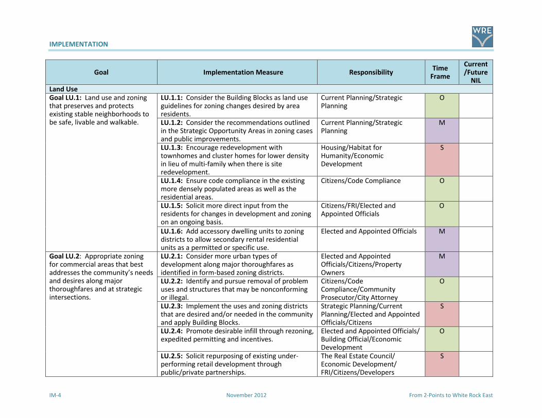
IMPLEMENTATION
IM-4 November 2012 From 2-Points to White Rock East
Goal Implementation Measure Responsibility Time
Frame
Current/Future
NIL
Land Use
Goal LU.1: Land use and zoning that preserves and protects existing stable neighborhoods to be safe, livable and walkable.
LU.1.1: Consider the Building Blocks as land use guidelines for zoning changes desired by area residents.
Current Planning/Strategic Planning
O
LU.1.2: Consider the recommendations outlined in the Strategic Opportunity Areas in zoning cases and public improvements.
Current Planning/Strategic Planning
M
LU.1.3: Encourage redevelopment with townhomes and cluster homes for lower density in lieu of multi-family when there is site redevelopment.
Housing/Habitat for Humanity/Economic Development
S
LU.1.4: Ensure code compliance in the existing more densely populated areas as well as the residential areas.
Citizens/Code Compliance O
LU.1.5: Solicit more direct input from the residents for changes in development and zoning on an ongoing basis.
Citizens/FRI/Elected and Appointed Officials
O
LU.1.6: Add accessory dwelling units to zoning districts to allow secondary rental residential units as a permitted or specific use.
Elected and Appointed Officials M
Goal LU.2: Appropriate zoning for commercial areas that best addresses the community’s needs and desires along major thoroughfares and at strategic intersections.
LU.2.1: Consider more urban types of development along major thoroughfares as identified in form-based zoning districts.
Elected and Appointed Officials/Citizens/Property Owners
M
LU.2.2: Identify and pursue removal of problem uses and structures that may be nonconforming or illegal.
Citizens/Code Compliance/Community Prosecutor/City Attorney
O
LU.2.3: Implement the uses and zoning districts that are desired and/or needed in the community and apply Building Blocks.
Strategic Planning/Current Planning/Elected and Appointed Officials/Citizens
S
LU.2.4: Promote desirable infill through rezoning, expedited permitting and incentives.
Elected and Appointed Officials/ Building Official/Economic Development
O
LU.2.5: Solicit repurposing of existing under-performing retail development through public/private partnerships.
The Real Estate Council/ Economic Development/ FRI/Citizens/Developers
S
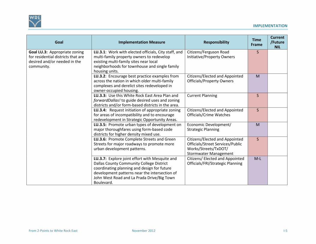
IMPLEMENTATION
From 2-Points to White Rock East November 2012 I-5
Goal Implementation Measure Responsibility Time
Frame
Current/Future
NIL
Goal LU.3: Appropriate zoning for residential districts that are desired and/or needed in the community.
LU.3.1: Work with elected officials, City staff, and multi-family property owners to redevelop existing multi-family sites near local neighborhoods for townhouse and single family housing units.
Citizens/Ferguson Road Initiative/Property Owners
S
LU.3.2: Encourage best practice examples from across the nation in which older multi-family complexes and derelict sites redeveloped in owner-occupied housing.
Citizens/Elected and Appointed Officials/Property Owners
M
LU.3.3: Use this White Rock East Area Plan and forwardDallas! to guide desired uses and zoning districts and/or form-based districts in the area.
Current Planning S
LU.3.4: Request initiation of appropriate zoning for areas of incompatibility and to encourage redevelopment in Strategic Opportunity Areas.
Citizens/Elected and Appointed Officials/Crime Watches
S
LU.3.5: Promote urban types of development on major thoroughfares using form-based code districts for higher density mixed use.
Economic Development/ Strategic Planning
M
LU.3.6: Promote Complete Streets and Green Streets for major roadways to promote more urban development patterns.
Citizens/Elected and Appointed Officials/Street Services/Public Works/Streets/TxDOT/ Stormwater Management
S
LU.3.7: Explore joint effort with Mesquite and Dallas County Community College District coordinating planning and design for future development patterns near the intersection of John West Road and La Prada Drive/Big Town Boulevard.
Citizens/ Elected and Appointed Officials/FRI/Strategic Planning
M-L
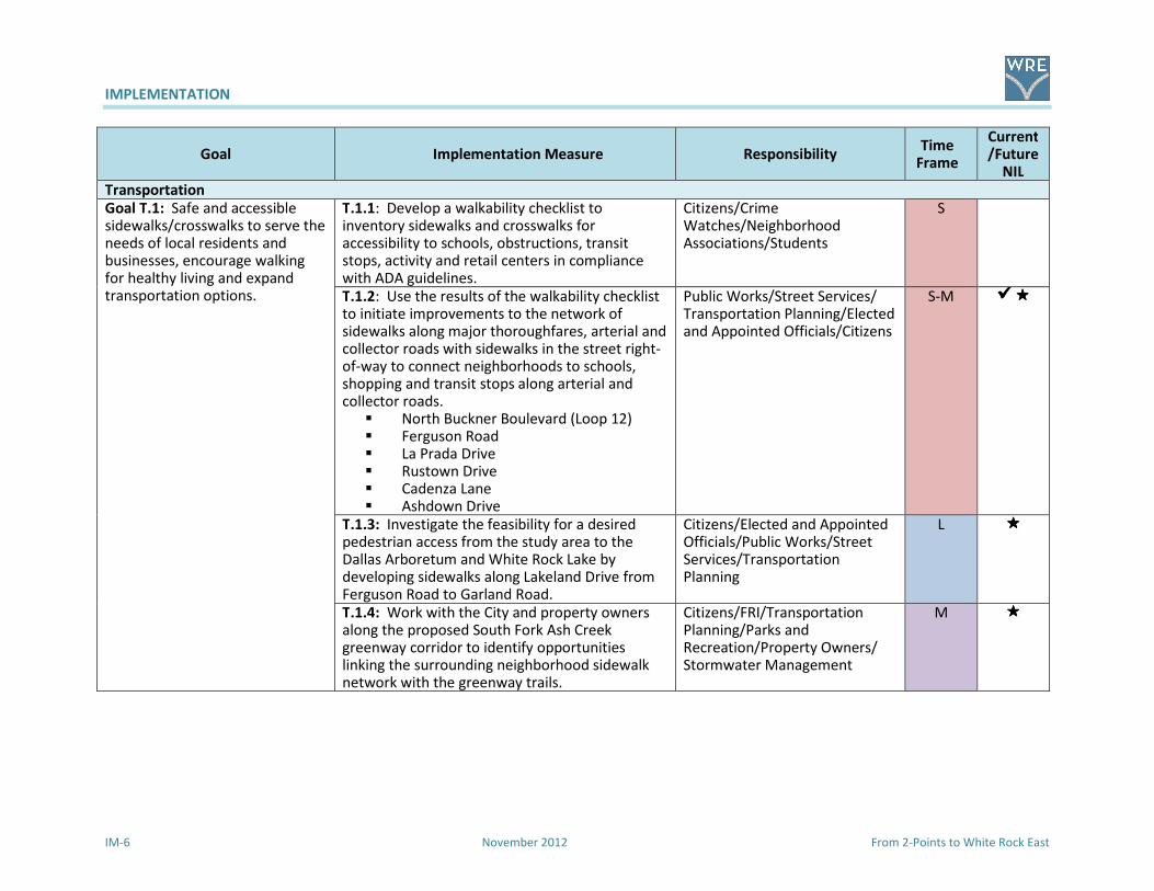
IMPLEMENTATION
IM-6 November 2012 From 2-Points to White Rock East
Goal Implementation Measure Responsibility Time
Frame
Current/Future
NIL
Transportation
Goal T.1: Safe and accessible sidewalks/crosswalks to serve the needs of local residents and businesses, encourage walking for healthy living and expand transportation options.
T.1.1: Develop a walkability checklist to inventory sidewalks and crosswalks for accessibility to schools, obstructions, transit stops, activity and retail centers in compliance with ADA guidelines.
Citizens/Crime Watches/Neighborhood Associations/Students
S
T.1.2: Use the results of the walkability checklist to initiate improvements to the network of sidewalks along major thoroughfares, arterial and collector roads with sidewalks in the street right-of-way to connect neighborhoods to schools, shopping and transit stops along arterial and collector roads.
� North Buckner Boulevard (Loop 12) � Ferguson Road � La Prada Drive � Rustown Drive � Cadenza Lane � Ashdown Drive
Public Works/Street Services/ Transportation Planning/Elected and Appointed Officials/Citizens
S-M ��������
T.1.3: Investigate the feasibility for a desired pedestrian access from the study area to the Dallas Arboretum and White Rock Lake by developing sidewalks along Lakeland Drive from Ferguson Road to Garland Road.
Citizens/Elected and Appointed Officials/Public Works/Street Services/Transportation Planning
L ����
T.1.4: Work with the City and property owners along the proposed South Fork Ash Creek greenway corridor to identify opportunities linking the surrounding neighborhood sidewalk network with the greenway trails.
Citizens/FRI/Transportation Planning/Parks and Recreation/Property Owners/ Stormwater Management
M ����
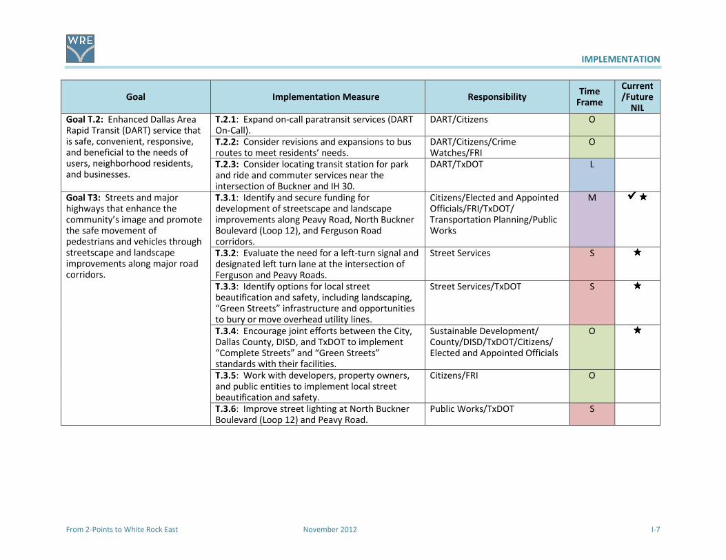
IMPLEMENTATION
From 2-Points to White Rock East November 2012 I-7
Goal Implementation Measure Responsibility Time
Frame
Current/Future
NIL
Goal T.2: Enhanced Dallas Area Rapid Transit (DART) service that is safe, convenient, responsive, and beneficial to the needs of users, neighborhood residents, and businesses.
T.2.1: Expand on-call paratransit services (DART On-Call).
DART/Citizens O
T.2.2: Consider revisions and expansions to bus routes to meet residents’ needs.
DART/Citizens/Crime Watches/FRI
O
T.2.3: Consider locating transit station for park and ride and commuter services near the intersection of Buckner and IH 30.
DART/TxDOT L
Goal T3: Streets and major highways that enhance the community’s image and promote the safe movement of pedestrians and vehicles through streetscape and landscape improvements along major road corridors.
T.3.1: Identify and secure funding for development of streetscape and landscape improvements along Peavy Road, North Buckner Boulevard (Loop 12), and Ferguson Road corridors.
Citizens/Elected and Appointed Officials/FRI/TxDOT/ Transportation Planning/Public Works
M ��������
T.3.2: Evaluate the need for a left-turn signal and designated left turn lane at the intersection of Ferguson and Peavy Roads.
Street Services S ����
T.3.3: Identify options for local street beautification and safety, including landscaping, “Green Streets” infrastructure and opportunities to bury or move overhead utility lines.
Street Services/TxDOT S ����
T.3.4: Encourage joint efforts between the City, Dallas County, DISD, and TxDOT to implement “Complete Streets” and “Green Streets” standards with their facilities.
Sustainable Development/ County/DISD/TxDOT/Citizens/ Elected and Appointed Officials
O ����
T.3.5: Work with developers, property owners, and public entities to implement local street beautification and safety.
Citizens/FRI O
T.3.6: Improve street lighting at North Buckner Boulevard (Loop 12) and Peavy Road.
Public Works/TxDOT S

IMPLEMENTATION
IM-8 November 2012 From 2-Points to White Rock East
Goal Implementation Measure Responsibility Time
Frame
Current/Future
NIL
T.3.7: Provide adequate times for pedestrians to use signalized crosswalks along
� North Buckner Boulevard (Loop 12) � Chenault Street � Ferguson Road � John West Road � Lakeland Drive � La Prada Drive � Oates Drive � Peavy Road.
Public Works/TxDOT S ����
T.3.8: Consider a stop sign at the intersection of Gross Road and Ashdown Drive.
Street Services/Citizens S ����
Goal T.4: Extension of the Bike Plan and designation of routes into the study area.
T.4.1: Designate on-street bikeway facilities. � La Prada Drive into Eastfield College � Chenault Street from Dilido Road to
North Buckner � North Buckner from Samuell to Garland
Road
Transportation Planning M ����
T.4.2: Designate off-street bikeway facilities. Add multi-use pathways along South Fork Ash Creek and its tributaries as extensions of the Dallas Trail Network Plan.
Transportation Planning/Parks and Recreation
M ����
T.4.3: Improve roadway crossings for bikes and pedestrians.
� Chenault Street at Dilido Road � Chenault Street at North Buckner � Dilido Road at John West Road � Ferguson Road at Lakeland Drive � Ferguson Road at North Buckner � Ferguson Road at Oates Drive � Lakeland Drive/John West Road between
Green Meadow Drive and Hunnicut Road � La Prada Drive at Carol Brown Road (west
entrance to Eastfield College) � La Prada Drive at John West Road
Street Services/Public Works/TxDOT/Transportation Planning
S-M ����

IMPLEMENTATION
From 2-Points to White Rock East November 2012 I-9
Goal Implementation Measure Responsibility Time
Frame
Current/Future
NIL
� North Buckner at John West Road � Oates Drive at La Prada Drive � Oates Drive at Shiloh Road � Peavy Road at Gross Road
T.4.4: Confirm Dallas Bikeway System bike routes shown in this plan are in the 2011 Dallas Bike
Plan.
Transportation Planning O
T.4.5: Install bikeway system facilities as recommended in the 2011 Dallas Bike Plan or as recommended upon further analysis by City staff with opportunities for input from area residents and business owners.
Transportation Planning/Street Services/Citizens/Businesses
S
T.4.6: Require the installation of secure bicycle racks for new commercial and institutional developments and encourage secure bicycle racks at existing commercial and institutional properties.
Current Planning/Citizens/ Elected and Appointed Officials
S
T.4.7: Support parking requirements that allow the reduction of required parking spaces when secure bicycle parking is provided.
Current Planning/City Plan Commission/ZOAC/Citizens/ Elected and Appointed Officials
S
T.4.8: Establish a bicycle safety program for parents and children by working with local public and private schools and community organizations.
Citizens/DISD/FRI/Boy Scouts M
Goal T.5: A trail network that bonds the study area and reaches into the surrounding buffer area.
T.5.1: Encourage creation of South Fork Ash Creek trail network including nearby trails and linear parks to link together neighborhoods, local institutions (libraries, schools, churches, etc.), and commercial centers.
Citizens/Parks and Recreation/FRI/Transportation Planning/Strategic Planning/ Elected and Appointed Officials
M ����
T.5.2: Work with property owners of large tracts of land and public/private institutions on possible trail corridor connections along South Fork Ash Creek and its tributaries.
Citizens/Parks and Recreation/FRI/ Transportation Planning/Elected and Appointed Officials
M

IMPLEMENTATION
IM-10 November 2012 From 2-Points to White Rock East
Goal Implementation Measure Responsibility Time
Frame
Current/Future
NIL
T.5.3: Support and promote trail development and maintenance through a community-based organization made up of local residents, property owners, and business and community leaders.
Citizens/Elected and Appointed Officials
S
T.5.4: Explore options to connect hike and bike trail on South Fork Ash Creek to Ash Creek and the Santa Fe Trail (outside study area).
Citizens/Elected and Appointed Officials/Transportation Planning/Parks and Recreation
L ����
T.5.5: Coordinate with the City of Mesquite and TxDOT to identify potential trail connections east, southeast and south of the study area.
TxDOT/Parks and Recreation/Transportation Planning/Citizens/Elected and Appointed Officials
L ����
Goal T.6: Improve signalization to provide safe crossings.
T.6.1: Update signalization at: � North Buckner at Peavy Road � Peavy Road at Gross Road � John West Road at La Prada Drive � La Prada Drive at Oates Drive � North Buckner at John West Road � Lakeland Road at Ferguson Road � Ferguson Road at Peavy Road
Street Services/Citizens/Elected and Appointed Officials/TxDOT
S ��������
Goal T.7: Better function and appearance using new methods to improve the street system.
T.7.1: Include White Rock East‘s major streets in the Complete Streets initiative.
Citizens/Elected and Appointed Officials/Strategic Planning/Transportation Planning
S-M
T.7.2: Apply Context Sensitive Design and Green Streets actions to the street system in study area.
TxDOT/Strategic Planning/Transportation Planning/Public Works/ Citizens/Elected and Appointed Officials
M
T.7.3: Work with TxDOT to design and install corridor plantings and landscaping along North Buckner from IH 30 north to John West Road and Ferguson Road. (Green Ribbon program)
City Councilmember for District/ TxDOT/Public Works
M
T.7.4: Include intersection enhancements on North Buckner with monument features that highlight the area’s character and history.
TxDOT/Elected and Appointed Officials/Citizens
S ��������

IMPLEMENTATION
From 2-Points to White Rock East November 2012 I-11
Goal Implementation Measure Responsibility Time
Frame
Current/Future
NIL
T.7.5: Incorporate study area gateway design into redevelopment of commercial districts working with local artists to create public art features to serve as community landmarks.
TxDOT/Citizens/Elected and Appointed Officials/Property Owners/Citizens
M ����
T.7.6: Install directional signs in redeveloped commercial districts.
FRI/Neighborhood Groups/Citizens/Transportation Planning/Street Services
M ����
T.7.7: Create an internal signage system that highlights local destinations including directions to trailheads, parks, and parking areas.
FRI/Neighborhood Groups/ Transportation Planning/ Street Services
L
T.7.8: Develop architectural features and focal points along proposed greenway corridors as reference points and to familiarize frequent commuters.
FRI/Transportation Planning/Street Services/TxDOT
L
Goal T.8: Improve the appearance of North Buckner with gateway features and landscaping through the Green Ribbon program.
T.8.1: Initiate discussions with TxDOT. City Councilmember for District/TxDOT
O
T.8.2: Involve adjacent property owners and businesses in grant application, design of improvements, and future maintenance.
Citizens/Transportations Planning/TxDOT
S
T.8.3: Install landscaping, hardscape and entry features.
TxDOT/Public Works M
Quality of Life
Goal QL.1: Code Compliance. Improve the study area’s image using codes, regulations, programs, and enforcement to clean up, stabilize, and enhance neighborhoods.
QL.1.1: Community leaders will work with property owners, local businesses, institutions, and local organizations to develop methods that educate, clean up, and aggressively monitor trash “hot spots” to pursue violators.
Citizens/Local Businesses/Code Compliance/Community Prosecutor/DPD
O
QL.1.2: Identify and pursue removal of structures and uses that are derelict, nonconforming or illegal.
FRI/Citizens/Code Compliance/Community Prosecutor
O
QL.1.3: Support area organizations that educate property owners, local businesses, and institutions about trash pickup, graffiti, local maintenance, and beautification.
Citizens/FRI/ Code Compliance/Community Prosecutor
O

IMPLEMENTATION
IM-12 November 2012 From 2-Points to White Rock East
Goal Implementation Measure Responsibility Time
Frame
Current/Future
NIL
QL.1.4: Conduct annual issues inventory, review what worked and what needs improvements, and share annual inventory/review with community.
Citizens/FRI/ Code Compliance/Elected and Appointed Officials
O
QL.1.5: Work with Dallas Animal Services and neighborhood groups to manage the pet population by educating residents about the need to spay and neuter their pets, report animal hoarding, animal abuse, and sightings of stray cats and dogs.
Citizens/Local Veterinarians/Dallas Animal Services
O
QL.1.6: Work to identify, aggressively monitor and resolve or remove poorly maintained, dilapidated, or abandoned apartments and commercial structures.
Citizens/Code Compliance/ Community Prosecutor
O
QL.1.7: Explore different methods to work with property owners and businesses in the study area to repair, stripe, landscape, and maintain their parking lots.
Citizens/FRI/ Code Compliance/ Community Prosecutor
O
QL.1.8: Continue to work with the Community Prosecutor to address crime and code compliance to curb crime through police patrols and enforcement.
Citizens/Community Prosecutor/ Code Compliance/DPD
O
QL.1.9: Work with property owners and managers of multi-family developments to bring their complexes up to local codes, evict problem occupants and visitors, and enhance their properties to achieve Gold Star designation
Citizens/FRI/Crime Watches O
QL.1.10: Work with the police department and code compliance to implement a graffiti prevention program for neighborhoods and businesses.
Citizens/DPD O
QL.1.11: Continue to support crime watch groups and encourage new groups, especially in multi-family complexes.
Citizens/Crime Watches/ FRI/DPD
O

IMPLEMENTATION
From 2-Points to White Rock East November 2012 I-13
Goal Implementation Measure Responsibility Time
Frame
Current/Future
NIL
QL.1.12: Conduct regularly scheduled meetings with assigned code compliance officer to discuss status of code issues in community and the measures required to resolve issues.
Citizens/Crime Watches/FRI/Code Compliance
O
Goal QL.2: Education. Facilities and programs enhance the study area’s neighborhoods and serve local residents.
QL.2.1: Support improvements of facilities and curriculum at George W. Truett and S. S. Conner Elementary Schools and Harold Wendell Lang, Sr. Middle School.
Citizens/PTA/DISD/Crime Watches/FRI
O
QL.2.2: Construct new classroom wing at Truett Elementary to relieve overcrowding.
Citizens/PTA/DISD/Crime Watches/FRI
O-S
QL.2.3: Landscape and maintain school grounds to provide positive impacts on surrounding neighborhoods and community.
Citizens/DISD/FRI/Crime Watches/Neighborhood Groups
O-S
QL.2.4: Work school board trustees and City Council to ensure future improvements around local schools districts are on the NIL and capital programs.
Citizens/PTA/DISD/Elected and Appointed Officials
O
QL.2.5: Encourage and support parental and neighborhood involvement in the schools.
Citizens/Elected and Appointed Officials/PTA
O
QL.2.6: Increase enforcement of traffic regulations in school zones to promote Safe Routes to School programs and identify trouble spots in school zones that can either be remedied through enforcement or noted for future improvements.
DPD/Citizens/Street Services (Safe Routes to School)/TxDOT
O
QL.2.7: Initiate a continuous school zone on Peavy Road adjacent to Bishop Lynch High School and Truett Elementary School.
DISD/Bishop Lynch/Truett Crime Watch/Streets Services
S
QL.2.8: Investigate the potential for locating a charter school in the study are to relieve overcrowding and provide new educational opportunities.
Citizens/FRI/Charter Schools S
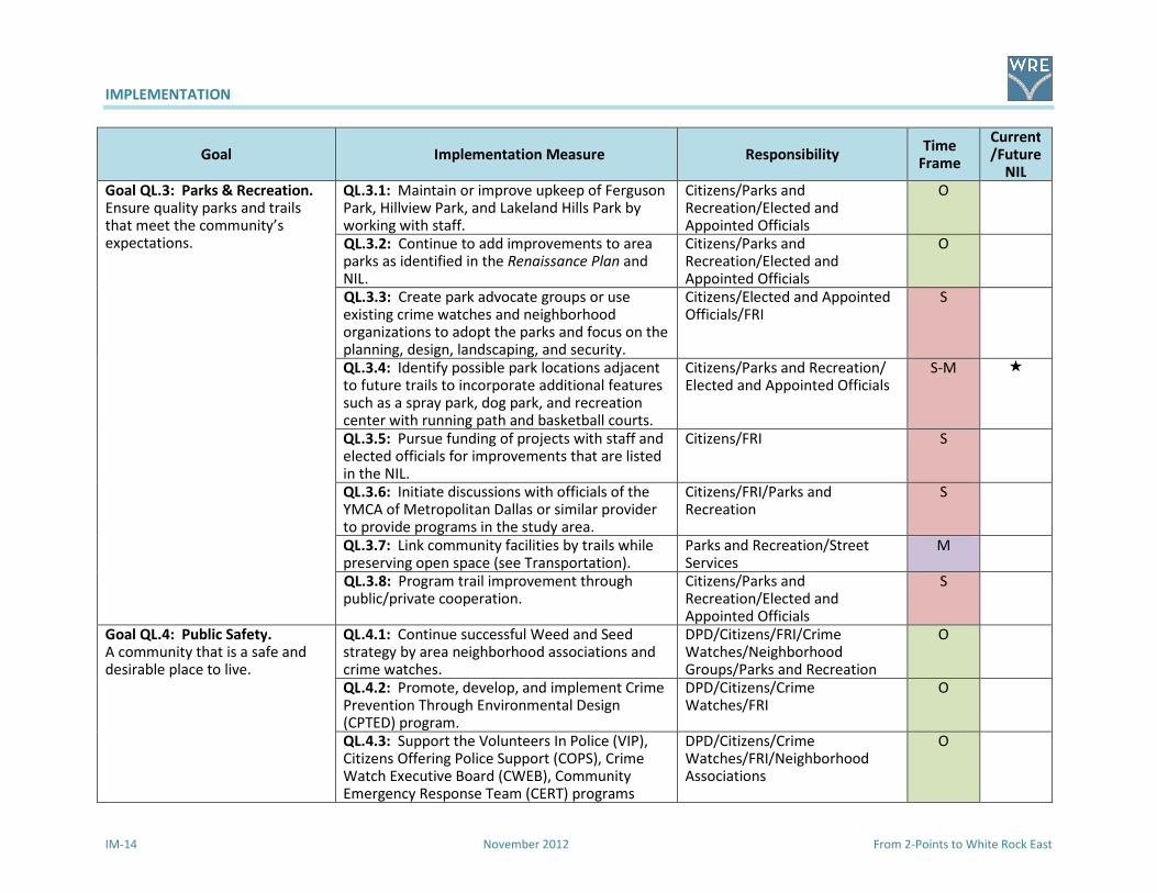
IMPLEMENTATION
IM-14 November 2012 From 2-Points to White Rock East
Goal Implementation Measure Responsibility Time
Frame
Current/Future
NIL
Goal QL.3: Parks & Recreation. Ensure quality parks and trails that meet the community’s expectations.
QL.3.1: Maintain or improve upkeep of Ferguson Park, Hillview Park, and Lakeland Hills Park by working with staff.
Citizens/Parks and Recreation/Elected and Appointed Officials
O
QL.3.2: Continue to add improvements to area parks as identified in the Renaissance Plan and NIL.
Citizens/Parks and Recreation/Elected and Appointed Officials
O
QL.3.3: Create park advocate groups or use existing crime watches and neighborhood organizations to adopt the parks and focus on the planning, design, landscaping, and security.
Citizens/Elected and Appointed Officials/FRI
S
QL.3.4: Identify possible park locations adjacent to future trails to incorporate additional features such as a spray park, dog park, and recreation center with running path and basketball courts.
Citizens/Parks and Recreation/ Elected and Appointed Officials
S-M �
QL.3.5: Pursue funding of projects with staff and elected officials for improvements that are listed in the NIL.
Citizens/FRI S
QL.3.6: Initiate discussions with officials of the YMCA of Metropolitan Dallas or similar provider to provide programs in the study area.
Citizens/FRI/Parks and Recreation
S
QL.3.7: Link community facilities by trails while preserving open space (see Transportation).
Parks and Recreation/Street Services
M
QL.3.8: Program trail improvement through public/private cooperation.
Citizens/Parks and Recreation/Elected and Appointed Officials
S
Goal QL.4: Public Safety. A community that is a safe and desirable place to live.
QL.4.1: Continue successful Weed and Seed strategy by area neighborhood associations and crime watches.
DPD/Citizens/FRI/Crime Watches/Neighborhood Groups/Parks and Recreation
O
QL.4.2: Promote, develop, and implement Crime Prevention Through Environmental Design (CPTED) program.
DPD/Citizens/Crime Watches/FRI
O
QL.4.3: Support the Volunteers In Police (VIP), Citizens Offering Police Support (COPS), Crime Watch Executive Board (CWEB), Community Emergency Response Team (CERT) programs
DPD/Citizens/Crime Watches/FRI/Neighborhood Associations
O
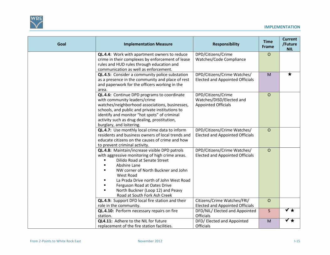
IMPLEMENTATION
From 2-Points to White Rock East November 2012 I-15
Goal Implementation Measure Responsibility Time
Frame
Current/Future
NIL
QL.4.4: Work with apartment owners to reduce crime in their complexes by enforcement of lease rules and HUD rules through education and communication as well as enforcement.
DPD/Citizens/Crime Watches/Code Compliance
O
QL.4.5: Consider a community police substation as a presence in the community and place of rest and paperwork for the officers working in the area.
DPD/Citizens/Crime Watches/ Elected and Appointed Officials
M ����
QL.4.6: Continue DPD programs to coordinate with community leaders/crime watches/neighborhood associations, businesses, schools, and public and private institutions to identify and monitor “hot spots” of criminal activity such as drug dealing, prostitution, burglary, and loitering.
DPD/Citizens/Crime Watches/DISD/Elected and Appointed Officials
O
QL.4.7: Use monthly local crime data to inform residents and business owners of local trends and educate citizens on the causes of crime and how to prevent criminal activity.
DPD/Citizens/Crime Watches/ Elected and Appointed Officials
O
QL.4.8: Maintain/increase visible DPD patrols with aggressive monitoring of high crime areas.
� Dilido Road at Senate Street � Abshire Lane � NW corner of North Buckner and John
West Road � La Prada Drive north of John West Road � Ferguson Road at Oates Drive � North Buckner (Loop 12) and Peavy
Road at South Fork Ash Creek
DPD/Citizens/Crime Watches/ Elected and Appointed Officials
O
QL.4.9: Support DFD local fire station and their role in the community.
Citizens/Crime Watches/FRI/ Elected and Appointed Officials
O
QL.4.10: Perform necessary repairs on fire station.
DFD/NIL/ Elected and Appointed Officials
S ��������
QL4.11: Adhere to the NIL for future replacement of the fire station facilities.
DFD/ Elected and Appointed Officials
M ��������
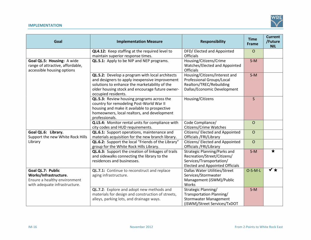
IMPLEMENTATION
IM-16 November 2012 From 2-Points to White Rock East
Goal Implementation Measure Responsibility Time
Frame
Current/Future
NIL
QL4.12: Keep staffing at the required level to maintain superior response times.
DFD/ Elected and Appointed Officials
O
Goal QL.5: Housing: A wide range of attractive, affordable, accessible housing options
QL.5.1: Apply to be NIP and NEP programs. Housing/Citizens/Crime Watches/Elected and Appointed Officials
S-M
QL.5.2: Develop a program with local architects and designers to apply inexpensive improvement solutions to enhance the marketability of the older housing stock and encourage future owner-occupied residents.
Housing/Citizens/Interest and Professional Groups/Local Realtors/TREC/Rebuilding Dallas/Economic Development
S-M
QL.5.3: Review housing programs across the country for remodeling Post-World War II housing and make it available to prospective homeowners, local realtors, and development professionals.
Housing/Citizens S
Q.L5.4: Monitor rental units for compliance with city codes and HUD requirements.
Code Compliance/ Citizens/Crime Watches
O
Goal QL.6: Library. Support the new White Rock Hills Library
QL.6.1: Support operations, maintenance and materials acquisition for the new branch library.
Citizens/ Elected and Appointed Officials /FRI/Library
O
QL.6.2: Support the local “Friends of the Library” group for the White Rock Hills Library.
Citizens/ Elected and Appointed Officials /FRI/Library
O
QL.6.3: Support the creation of linkages of trails and sidewalks connecting the library to the residences and businesses.
Strategic Planning/Parks and Recreation/Street/Citizens/ Services/Transportation/ Elected and Appointed Officials
S-M ����
Goal QL.7: Public Works/Infrastructure. Ensure a healthy environment with adequate infrastructure.
QL.7.1: Continue to reconstruct and replace aging infrastructure.
Dallas Water Utilities/Street Services/Stormwater Management (iSWM)/Public Works
O-S-M-L ��������
QL.7.2: Explore and adopt new methods and materials for design and construction of streets, alleys, parking lots, and drainage ways.
Strategic Planning/ Transportation Planning/ Stormwater Management (iSWM)/Street Services/TxDOT
S-M
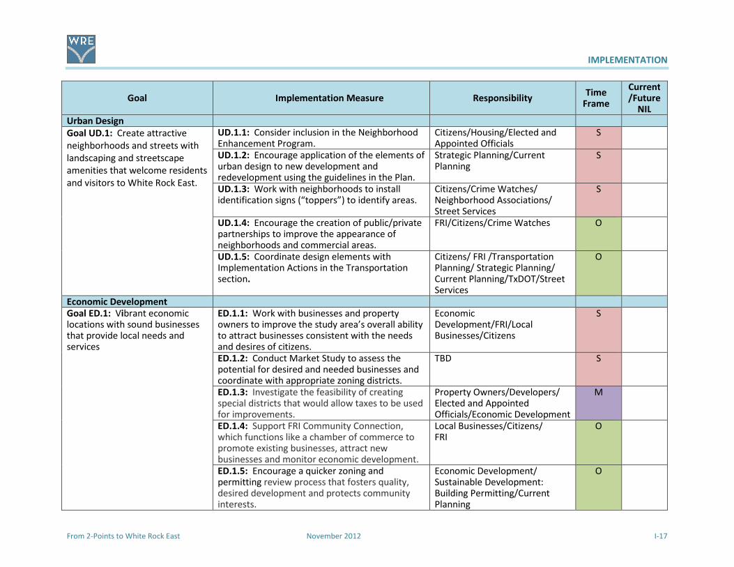
IMPLEMENTATION
From 2-Points to White Rock East November 2012 I-17
Goal Implementation Measure Responsibility Time
Frame
Current/Future
NIL
Urban Design
Goal UD.1: Create attractive
neighborhoods and streets with
landscaping and streetscape
amenities that welcome residents
and visitors to White Rock East.
UD.1.1: Consider inclusion in the Neighborhood Enhancement Program.
Citizens/Housing/Elected and Appointed Officials
S
UD.1.2: Encourage application of the elements of urban design to new development and redevelopment using the guidelines in the Plan.
Strategic Planning/Current Planning
S
UD.1.3: Work with neighborhoods to install identification signs (“toppers”) to identify areas.
Citizens/Crime Watches/ Neighborhood Associations/ Street Services
S
UD.1.4: Encourage the creation of public/private partnerships to improve the appearance of neighborhoods and commercial areas.
FRI/Citizens/Crime Watches O
UD.1.5: Coordinate design elements with Implementation Actions in the Transportation section.
Citizens/ FRI /Transportation Planning/ Strategic Planning/ Current Planning/TxDOT/Street Services
O
Economic Development
Goal ED.1: Vibrant economic locations with sound businesses that provide local needs and services
ED.1.1: Work with businesses and property owners to improve the study area’s overall ability to attract businesses consistent with the needs and desires of citizens.
Economic Development/FRI/Local Businesses/Citizens
S
ED.1.2: Conduct Market Study to assess the potential for desired and needed businesses and coordinate with appropriate zoning districts.
TBD S
ED.1.3: Investigate the feasibility of creating special districts that would allow taxes to be used for improvements.
Property Owners/Developers/ Elected and Appointed Officials/Economic Development
M
ED.1.4: Support FRI Community Connection, which functions like a chamber of commerce to promote existing businesses, attract new businesses and monitor economic development.
Local Businesses/Citizens/ FRI
O
ED.1.5: Encourage a quicker zoning and permitting review process that fosters quality, desired development and protects community interests.
Economic Development/ Sustainable Development: Building Permitting/Current Planning
O

FERGUSONROADINITIATIVE• WE'RERISING •
February 17, 2009
P.O . BOX 570417· DALLAS , TEXAS 75357·214.324 .51 16 • FERGUSONROAD.ORG
The Honorable Carolyn DavisCity Councilmember District 7Dallas City Hall1500 MarillaDallas, Texas 75201
RE: Ferguson Road Initiative 2-Points Weed & Seed Land UseAJrban Design/Economic Development Area Study
Dear Councilmember Davis:
On behalf of theFerguson Road Initiative (FRI) 2-Points Weed & Seed area, werespectfully request theconsideration of addng a LandUse/Urban Design/Economic Development Area Study to the list of areas plans to be addressed by the City of Dallas under the areaplanning initiatives of forwardDallas!. FRI, representing the White Rock Hills community, has identified a pressing need to develop astudy that will guide the development and redevelopment of this far east Dallas area in terms of appropriate land use, zoning, crimeprevention and economic development
It is first and foremost ourdesire for this study tobea grassrootseffort, onethat will require minimal guidance and assistance bytheCitystaff. We are currently in theprocess of talking with several universities as to howthey might assist us in thedevelopment of such aplan. However until this approach is implementable, weare asking tobeonthelistofarea plans tobedeveloped bytheCity.
Our proposed study area boundaries are: Buckner Boulevard onthe North and East, Interstate 30; South: Ferguson Road onthewestand includes Dilido, John West, LaPrada and Chenault Streets.
We will be appointing anAdvisory Committee from theimmediate and surrounding neighborhoods to initiate a comprehensive review ofexisting economic development conditions in our neighborhoods. Essential public input from resident and businesses will create ourgoals. The study will include strategic analyses of issues and community desires, compilation of existing land uses and zoning,recommended future land use and zoning changes while addressing urban design, crime prevention initiatives, economic developmentincentives, neighborhood stabilization recommendations and a consensus on what actions are needed to implement the plan. Thenames of theAdvisory Committee will besubmitted foryour review and approval.
As stated above, we hope that the assistance from the City staff will be limited to identifying and assisting with the process andprocedure to develop a plan that will bepresented to theCity Plan Commission and ultimately adopted bytheCity Council asa guide forthe immedate and long range future of 2-Points and White Rock Hills. We are ready to began meeting, making ourarea plans andhaving community-wide meetings. This public-private partnership will begood forourcommunity and theCity.
We would greatly appreciate your support of this proposed study. Thank you forallyou doforthis portion ofyour district
Sincerely,
William M. ColemanPresident, Ferguson Road Initiative
C: Peer Chacko, AICP, Assistant Director, Long Range Planning, Ann Bagley, AlCP, City Plan Commissioners: District 7~
O ur MISSION is to transform White Rack Hills into a safe , beautiful, prosperous and proud community by inspiring hope and working together to achieve a sha red vision.
LE ADE RSHIP • IN TEGRITY • COMM UNITY • RESPECT • STEWA RDSHIP

COMMUNITY MEETING 1
From 2-Points to White Rock East November 2012
Agenda Community Meeting
2-Points Area Plan
Saturday, December 5, 2009
9:30 to 11:30
I. Welcome and Introductions (10 minutes)
II. Purpose of the Meeting (5 minutes)
III. City of Dallas Requirements for Area Plan (10 minutes)
IV. Breakout Group Discussion (1 hour) a. Current Conditions and Issues b. Desires and Dreams
c. Mapping Exercise
V. Reconvene for Reports from Groups (30 minutes)
VI. Next Steps (5 minutes)
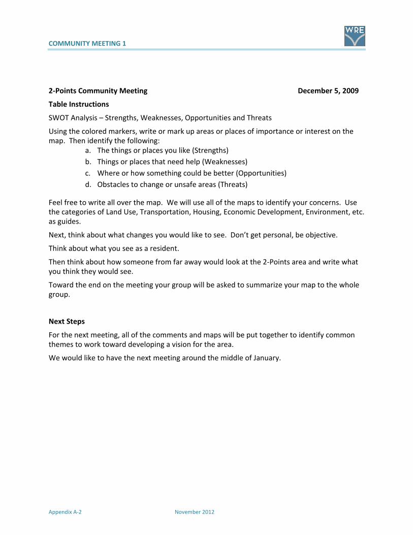
COMMUNITY MEETING 1
Appendix A-2 November 2012
2-Points Community Meeting December 5, 2009
Table Instructions
SWOT Analysis – Strengths, Weaknesses, Opportunities and Threats
Using the colored markers, write or mark up areas or places of importance or interest on the
map. Then identify the following:
a. The things or places you like (Strengths)
b. Things or places that need help (Weaknesses)
c. Where or how something could be better (Opportunities)
d. Obstacles to change or unsafe areas (Threats)
Feel free to write all over the map. We will use all of the maps to identify your concerns. Use
the categories of Land Use, Transportation, Housing, Economic Development, Environment, etc.
as guides.
Next, think about what changes you would like to see. Don’t get personal, be objective.
Think about what you see as a resident.
Then think about how someone from far away would look at the 2-Points area and write what
you think they would see.
Toward the end on the meeting your group will be asked to summarize your map to the whole
group.
Next Steps
For the next meeting, all of the comments and maps will be put together to identify common
themes to work toward developing a vision for the area.
We would like to have the next meeting around the middle of January.

COMMUNITY MEETING 1
From 2-Points to White Rock East November 2012
SWOT Notes and Maps - pictures
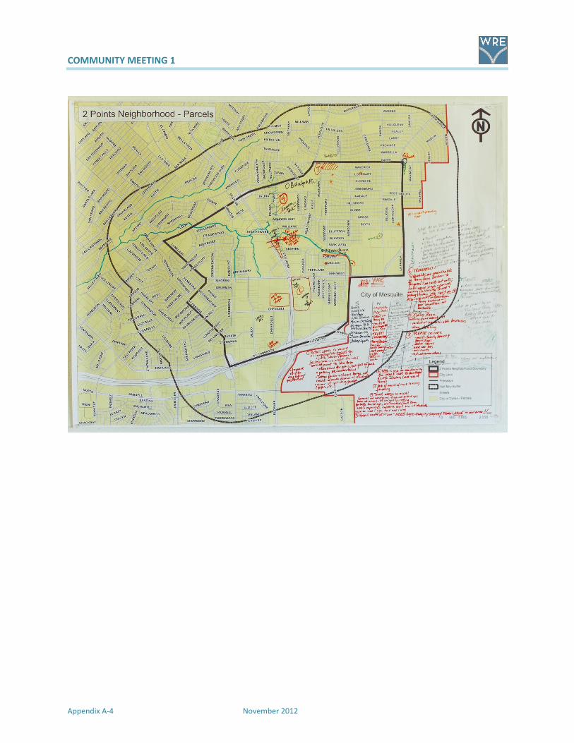
COMMUNITY MEETING 1
Appendix A-4 November 2012
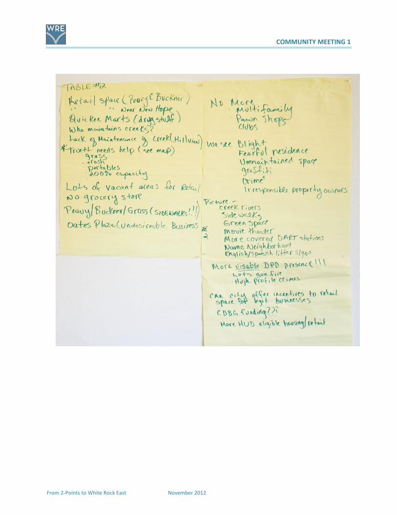
COMMUNITY MEETING 1
From 2-Points to White Rock East November 2012
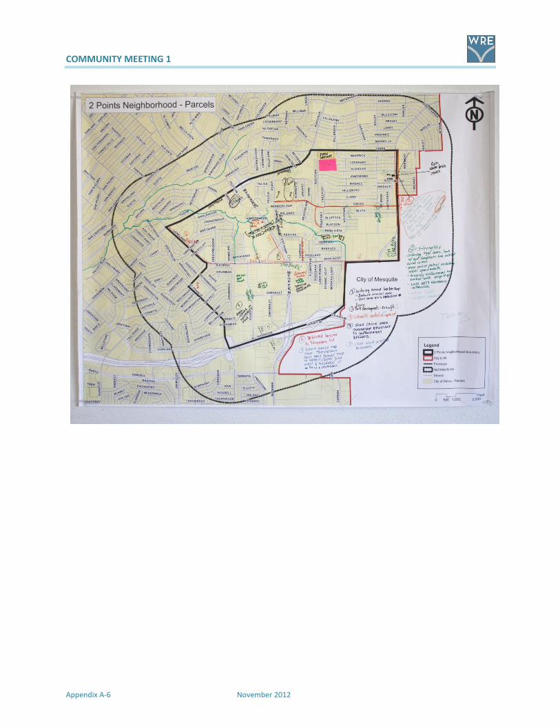
COMMUNITY MEETING 1
Appendix A-6 November 2012

COMMUNITY MEETING 1
From 2-Points to White Rock East November 2012

COMMUNITY MEETING 1
Appendix A-8 November 2012

COMMUNITY MEETING 1
From 2-Points to White Rock East November 2012
COMMUNITY MEETING 1
From 2-Points to White Rock East November 21012
Summary of Summaries 2-Points Area Plan
The following is a combination of the concerns of the comments from the December 5, 2009 meeting. They are divided into categories that will be
used in the creation of the land use study document.
Land Use
Current uses
Desired Uses
Zoning
Transportation
Streets
Sidewalks
DART
Trails
Quality of Life
Public Safety
Code Enforcement
Parks and Recreation
Education
Economic Development
What can be done?
Public Works /Infrastructure

COMMUNITY MEETING 1
From 2-Points to White Rock East November 2012
Land Use Transportation Quality of Life Economic Development Public Works/Infrastructure
Poorly maintained
apartments Buckner at
Ferguson
No sidewalks on Lakeland
from Ferguson to Garland
Road
Poorly maintained
apartments Buckner at
Ferguson
Oates Plaza weakness Drainage problems behind
Michael along Mesquite city
limits line
Walgreens and Post Office
corner of Buckner and
Ferguson
Sidewalks needed on
Buckner
Abshire - high crime area Shopping center on
southeast corner is a
weakness
Need to enforce code on
alley clean-up and repair of
sidewalks and alleys
New library will be near
corner of Ferguson and
Hibiscus
Sidewalks on Highland
(outside of study area, but
inside ½ mile buffer)
Northwest corner John
West at Bucker – high
crime area
Buckner near Chenault
check cashing a weakness
Would like landscaping
along Peavy
Truitt Elementary+ Left turn light needed at
Ferguson and Peavy
Trash along Buckner along
John West a weakness
Retail underutilized - NEED
GOOD QUALITY GROCERY
STORE – NONE IN OUR
AREA!!
Creeks at New Hope and
Hillview Terrace
Bishop Lynch + No sidewalks whole
distance of Ferguson
St Francis Goons? Oates Plaza—nothing
good about it
Vacant or undesirable
businesses
Peavy/Buckner corridor
needs beautification
Ferguson Park + Gross – speeding cares,
school zone
John West at La Prada
Shiloh Village Gangsters
Could City offer incentives
to desirable businesses?
Lack of maintenance of
creek causing flooding ++
New Hope Community
Church +
We need a trail along Ash
Creek from Hillview Park
to Peavy
Apartments need police
presence
People driving out of our
neighborhood to meet
their needs
WHO is responsible for
maintaining the creek next
to New Hope and Little
Scholars (west side of
Peavy)?
Eastfield College to the
east +
No bus service in area of
Gross
Need to enforce code on
alley clean-up and repair
of sidewalks and alleys
Undesirable businesses Sidewalks are unwalkable on
Peavy from Buckner to
Ferguson—no curb cut
outs—handicapped persons
and parents walking children
to Truitt just can’t do it.
Sidewalks on Gross from
Peavy eastward—poor
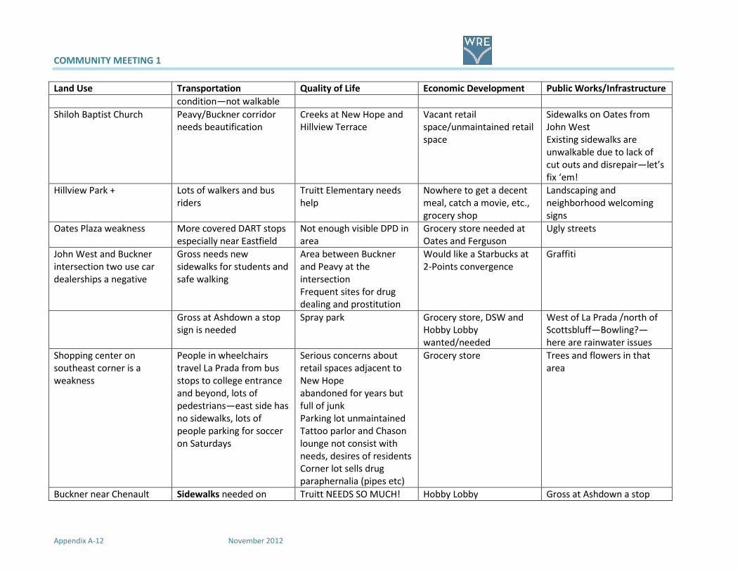
COMMUNITY MEETING 1
Appendix A-12 November 2012
Land Use Transportation Quality of Life Economic Development Public Works/Infrastructure
condition—not walkable
Shiloh Baptist Church Peavy/Buckner corridor
needs beautification
Creeks at New Hope and
Hillview Terrace
Vacant retail
space/unmaintained retail
space
Sidewalks on Oates from
John West
Existing sidewalks are
unwalkable due to lack of
cut outs and disrepair—let’s
fix ‘em!
Hillview Park + Lots of walkers and bus
riders
Truitt Elementary needs
help
Nowhere to get a decent
meal, catch a movie, etc.,
grocery shop
Landscaping and
neighborhood welcoming
signs
Oates Plaza weakness More covered DART stops
especially near Eastfield
Not enough visible DPD in
area
Grocery store needed at
Oates and Ferguson
Ugly streets
John West and Buckner
intersection two use car
dealerships a negative
Gross needs new
sidewalks for students and
safe walking
Area between Buckner
and Peavy at the
intersection
Frequent sites for drug
dealing and prostitution
Would like a Starbucks at
2-Points convergence
Graffiti
Gross at Ashdown a stop
sign is needed
Spray park Grocery store, DSW and
Hobby Lobby
wanted/needed
West of La Prada /north of
Scottsbluff—Bowling?—
here are rainwater issues
Shopping center on
southeast corner is a
weakness
People in wheelchairs
travel La Prada from bus
stops to college entrance
and beyond, lots of
pedestrians—east side has
no sidewalks, lots of
people parking for soccer
on Saturdays
Serious concerns about
retail spaces adjacent to
New Hope
abandoned for years but
full of junk
Parking lot unmaintained
Tattoo parlor and Chason
lounge not consist with
needs, desires of residents
Corner lot sells drug
paraphernalia (pipes etc)
Grocery store
Trees and flowers in that
area
Buckner near Chenault Sidewalks needed on Truitt NEEDS SO MUCH! Hobby Lobby Gross at Ashdown a stop

COMMUNITY MEETING 1
From 2-Points to White Rock East November 2012
Land Use Transportation Quality of Life Economic Development Public Works/Infrastructure
check cashing a weakness Gross, La Prada, Rustown
(south of Gross)
Grounds not maintained
Trash not picked up
Lawn not mowed
35 unsightly, rotting
portable buildings
Overcrowded (at more
than 200% capacity)
Cafeteria can’t
accommodate all students
Need additional gym
Need additional wing
sign is needed
Identify locations of Ash
Creek
Sidewalks at
Buckner/Peavy/John West
Dog park
Running path
Basketball court
Youth center (in the old
steakhouse building)
Bowling alley Buckner at Peavy need
better street lights
Bus line need from
Ferguson along
Lakeland/John West to La
Prada
Oates Plaza drug dealing The lights change too soon
at 2-Points. Pedestrians do
not have time to cross John
West and Buckner. OR build
a sky walk
John West at La Prada -
High residential area large
families
Sidewalks needed on
Cadenza
Name our neighborhood
No more
Check cash
Pay day loans
Tire shops
Used car shops
Sex or drug paraphernalia
shop
Extend bus line along John
West/Lakeland from La
Prada to Ferguson
Get Truitt where it needs
to be

COMMUNITY MEETING 1
Appendix A-14 November 2012
Land Use Transportation Quality of Life Economic Development Public Works/Infrastructure
Nexus Sidewalk Buckner/Peavy
Gunfire
Crime, crime, crime!!!
Little Scholars Blight
Mission East D Trash everywhere
Wilkinson Center Irresponsible multi-family
and single property
owners allow criminals to
rent
Work Force One Transient nature of a large
percentage of the
population (due to MF and
SF rentals
Lamplighter Motel
problem
Fearful residents
Retail on Peavy not good Stray dogs
Concrete and broken
down buildings
Graffiti
PLEASE no more
Multi-family housing
Pawn shops
Dollar stores
Used car lots
Mini-marts
Cash advance stores
La Prada north of John
west—high crime area
Develop Buckner land
(Peavy to Gross) into
parkland or desirable
ownership—movie
theater?, Ice rink?,
something??
Restaurants!! Plenty of
Loitering around
barbershop at 2-Points
Enforce criminal code.
Get area businesses
involved

COMMUNITY MEETING 1
From 2-Points to White Rock East November 2012
Land Use Transportation Quality of Life Economic Development Public Works/Infrastructure
existing vacant space
Buckner at King Edward—
a park or YMCA
Basketball court, youth
center
New library coming on
Hibiscus ++
Dilido and Chenault—dog
park and running track
would be nice
Park Development near
Truitt
High crime area Dilido and
Senate—ownership
resistant to improvement
Close adult oriented
businesses on Buckner at
IH-30
Close adult oriented
businesses on Buckner at
IH-30
Enforcing legal codes and
laws with apartment
complexes has helped
curb crime.
More police patrol
including inside
apartments
Truancy enforcement has
worked well. Keep it up.
Drug dealing
YMCA
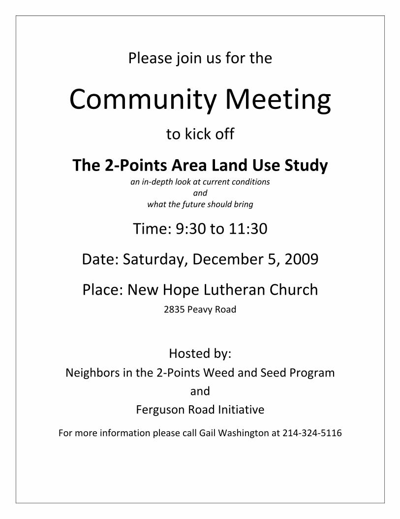
Please join us for the
Community Meeting to kick off
The 2-Points Area Land Use Study an in-depth look at current conditions
and
what the future should bring
Time: 9:30 to 11:30
Date: Saturday, December 5, 2009
Place: New Hope Lutheran Church 2835 Peavy Road
Hosted by:
Neighbors in the 2-Points Weed and Seed Program
and
Ferguson Road Initiative
For more information please call Gail Washington at 214-324-5116
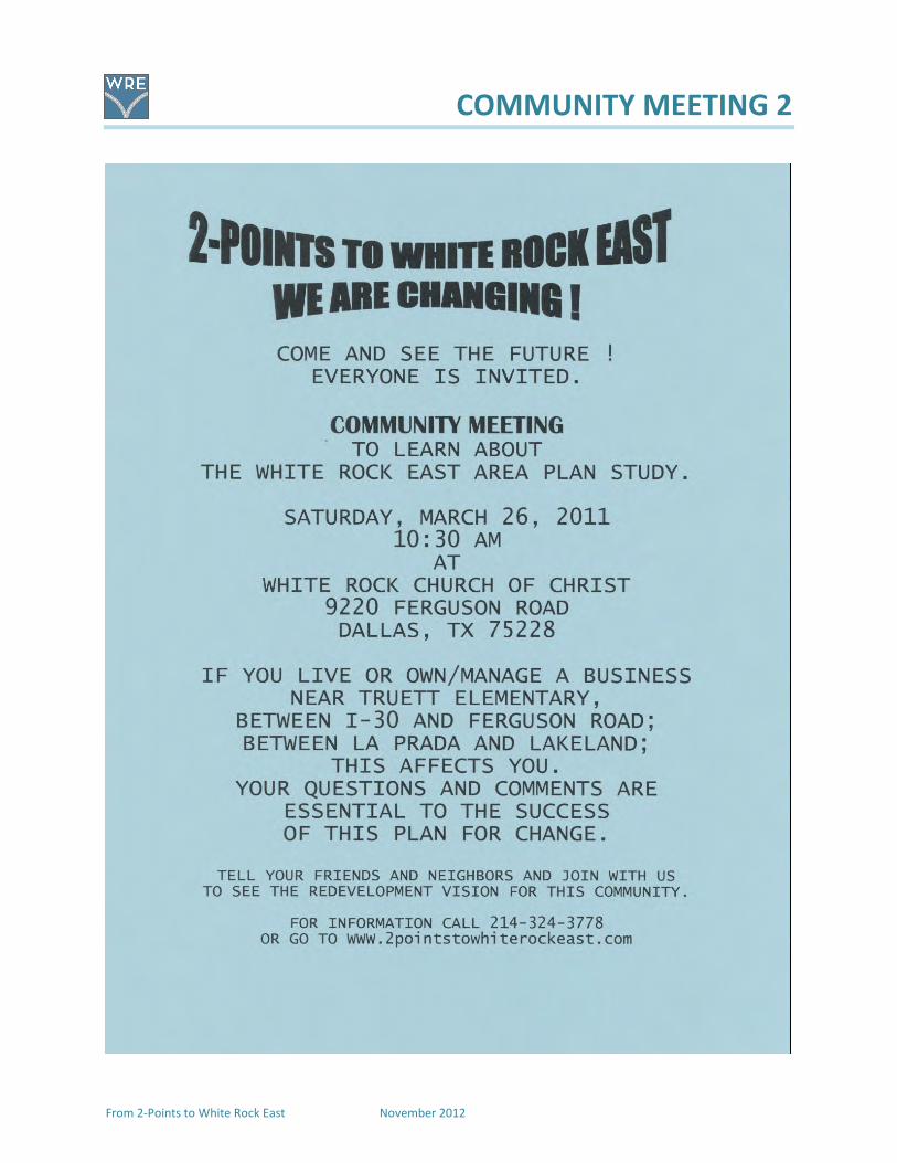
COMMUNITY MEETING 2
From 2-Points to White Rock East November 2012

COMMUNITY MEETING 2
November 2012 From 2-Points to White Rock East

COMMUNITY MEETING 2
From 2-Points to White Rock East November 2012
Comments by Desi Danner
Welcome to our meeting this morning. My name is Desi Tanner and I am a member of the Advisory
Committee for a proposed plan for the future of our area in far east Dallas. We are so glad that you
could join us in this presentation of an overview of the 2-Points to White Rock East Area Plan. This is a
work in progress and your review, consideration and input are very important.
Let me give you a bit of background on how we got to where we are today. About three years ago, a
number of neighbors came to a meeting to discuss the future of the Weed and Seed area called 2-
Points. You may have heard that the grant actually got its name from a police call for assistance. It was
decided that since the City of Dallas had a new comprehensive plan, forward Dallas! to guide future
growth and development, our area need to be a part of the big picture, yet focus on our specific needs
and desires. What started with a discussion that focused on crime has now evolved into this area plan
with guidelines for our collective future.
Well, it took a little while to get going, but in December 2009 we held our first community meeting at
New Hope. At this meeting a SWOT (Strengths, Weakness, Opportunities, and Threats) analysis was
conducted. We looked at the good, the bad, the ugly and all the possibilities.
For the next year or so, an advisory committee of interested neighbors, with assistance from a team of
professional planners, met almost monthly to work on the area plan. We learned about goals,
objectives and actions; about land use—zoning, building blocks, about transportation—roads, bikes,
sidewalks buses—what we could expect and what we couldn’t. We focused on our collective purpose:
protect our neighborhoods, request and support sidewalks, trails and other infrastructure
improvements, enhancing the appearance and safety of our roadways, and promoting quality
redevelopment.
One of the important outcomes of the planning process was the name change—from 2-Points to White
Rock East. We feel that the new name reflects the new attitude and new ideas for our part of Dallas.
We want you all to be a part of the plan!
Let me introduce the members of the Advisory Committee: Ellen Childress, John Childress, Eileen
Williams, Georgia King, Gus Garcia, Lauren Roberts, Vicki Sanger, Pat Copeland, Kimberly Humphries and
Kerry Goodwin.
They have on badges to identify them and we hope that you will visit with them after the presentation.
Thank you again for coming out today. After the presentations we will be happy to answer your
questions. Don’t forget to fill out the input sheets you got when you signed in.
Now— here is Bob Prejean to give you an overview of the new area plan.
AFTER THE PowerPoint
Thank you, Bob. We also want to recognize our Councilmember for District 7 who has supported our
work and we really appreciate her. We also want to thank the New Hope Center and the White Rock
Church of Christ for allowing us to hold our meetings. And thank you all for coming today!
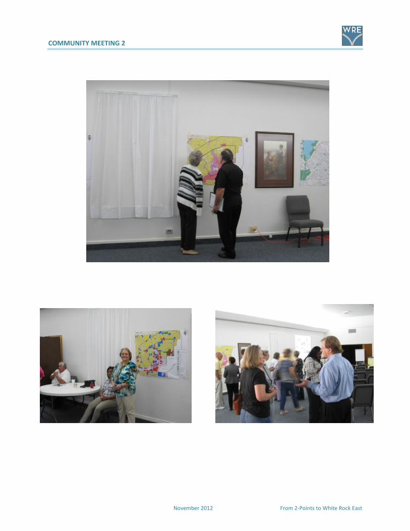
COMMUNITY MEETING 2
November 2012 From 2-Points to White Rock East
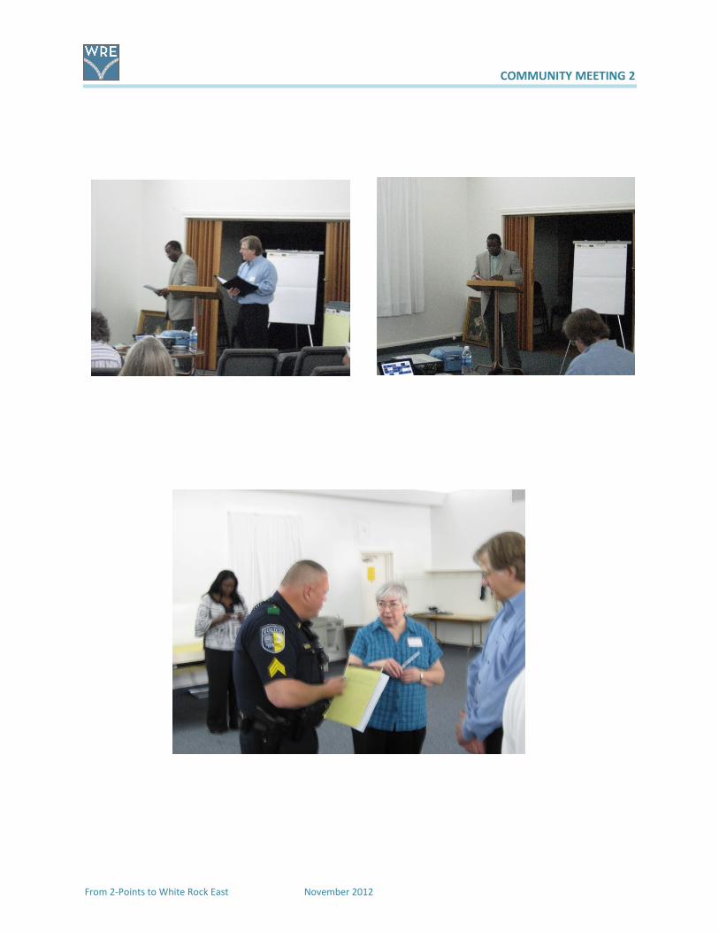
COMMUNITY MEETING 2
From 2-Points to White Rock East November 2012

COMMUNITY MEETING 2
November 2012 From 2-Points to White Rock East

COMMUNITY MEETING 2
From 2-Points to White Rock East November 2012

COMMUNITY MEETING 2
November 2012 From 2-Points to White Rock East
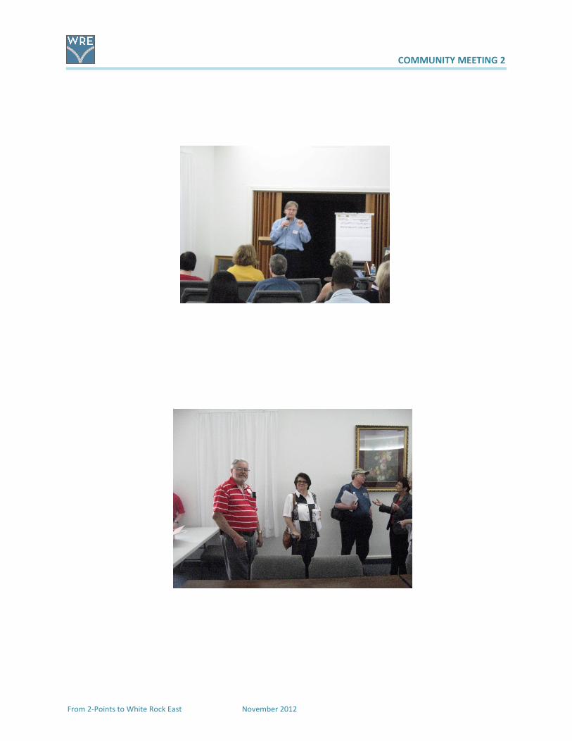
COMMUNITY MEETING 2
From 2-Points to White Rock East November 2012
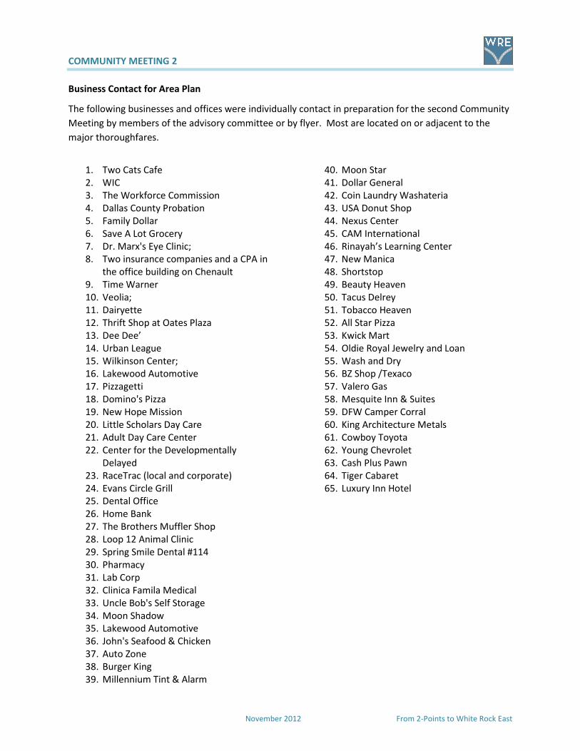
COMMUNITY MEETING 2
November 2012 From 2-Points to White Rock East
Business Contact for Area Plan
The following businesses and offices were individually contact in preparation for the second Community
Meeting by members of the advisory committee or by flyer. Most are located on or adjacent to the
major thoroughfares.
1. Two Cats Cafe
2. WIC
3. The Workforce Commission
4. Dallas County Probation
5. Family Dollar
6. Save A Lot Grocery
7. Dr. Marx's Eye Clinic;
8. Two insurance companies and a CPA in
the office building on Chenault
9. Time Warner
10. Veolia;
11. Dairyette
12. Thrift Shop at Oates Plaza
13. Dee Dee’
14. Urban League
15. Wilkinson Center;
16. Lakewood Automotive
17. Pizzagetti
18. Domino's Pizza
19. New Hope Mission
20. Little Scholars Day Care
21. Adult Day Care Center
22. Center for the Developmentally
Delayed
23. RaceTrac (local and corporate)
24. Evans Circle Grill
25. Dental Office
26. Home Bank
27. The Brothers Muffler Shop
28. Loop 12 Animal Clinic
29. Spring Smile Dental #114
30. Pharmacy
31. Lab Corp
32. Clinica Famila Medical
33. Uncle Bob's Self Storage
34. Moon Shadow
35. Lakewood Automotive
36. John's Seafood & Chicken
37. Auto Zone
38. Burger King
39. Millennium Tint & Alarm
40. Moon Star
41. Dollar General
42. Coin Laundry Washateria
43. USA Donut Shop
44. Nexus Center
45. CAM International
46. Rinayah’s Learning Center
47. New Manica
48. Shortstop
49. Beauty Heaven
50. Tacus Delrey
51. Tobacco Heaven
52. All Star Pizza
53. Kwick Mart
54. Oldie Royal Jewelry and Loan
55. Wash and Dry
56. BZ Shop /Texaco
57. Valero Gas
58. Mesquite Inn & Suites
59. DFW Camper Corral
60. King Architecture Metals
61. Cowboy Toyota
62. Young Chevrolet
63. Cash Plus Pawn
64. Tiger Cabaret
65. Luxury Inn Hotel
2-Points to White Rock East Area PlanMarch 26, 2011
White Rock Church of Christ
Agenda
Bayles Elementary School Folklorico Dance Troupe
Study Area
Purpose of Plan
Planning Process
Community Input
Existing Conditions
forwardDallas! Building Blocks
Consensus Vision
Goals and Objectives
Growth and Development Options
Seven Strategic Opportunity Areas
Implementation
Next Steps

Study Area
2-Points to White Rock East overview
• Located entirely with City Council District 7 (Councilmember
Carolyn Davis)
• 1,522 acres
• Once was home to White Rock Airport
• Most neighborhoods developed between 1950s and 1970s
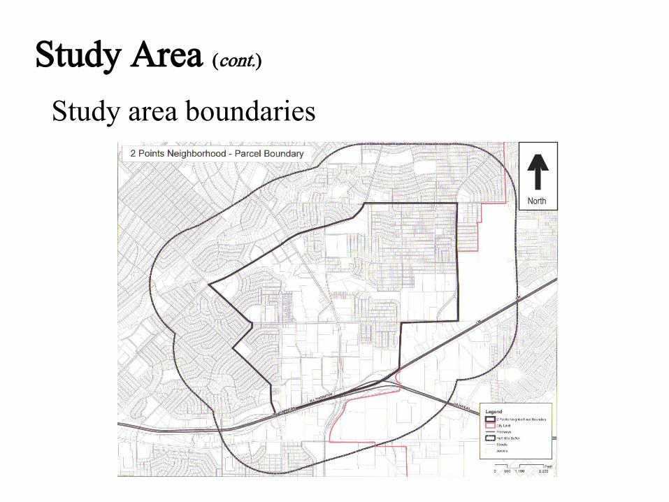
Study Area (cont.)
Study area boundaries
^North
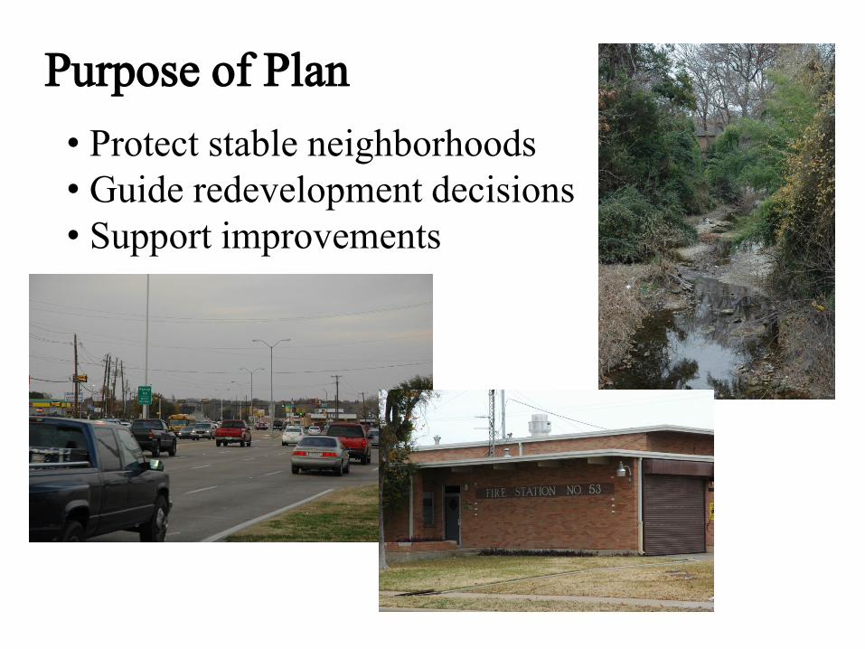
Purpose of Plan
• Protect stable neighborhoods
• Guide redevelopment decisions
• Support improvements
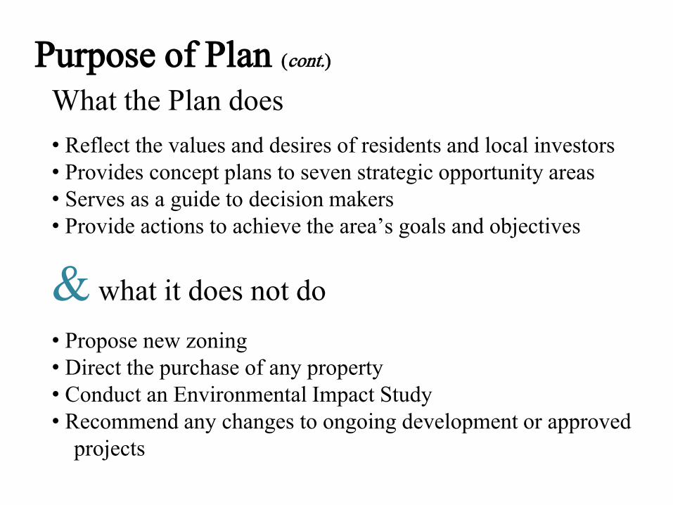
Purpose of Plan (cont.)
What the Plan does
• Reflect the values and desires of residents and local investors
• Provides concept plans to seven strategic opportunity areas
• Serves as a guide to decision makers
• Provide actions to achieve the area’s goals and objectives
& what it does not do
• Propose new zoning
• Direct the purchase of any property
• Conduct an Environmental Impact Study
• Recommend any changes to ongoing development or approved
projects
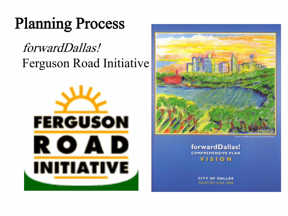
Planning Process
forwardDallas!Ferguson Road Initiative

Community Input
Advisory Committee
SWOT Analysis
Stakeholder Interviews

Community Input (cont.)
Advisory Committee
• December 5, 2009 – Kickoff community meeting
• January 30, 2010 – Review of SWOT
• April 1, 2010 – Land use, zoning, and demographics
• April 24, 2010 – Introduction to goals & objectives
• May 29, 2010 – Goals & objectives follow-up; transportation issues
• July 10, 2010 – Transportation and land use issues
• August 28, 2010 – Stakeholder interview briefing; DART
• September 18, 2010 – First draft of existing conditions; relationship to
forwardDallas!• November 13, 2010 – Land use and consensus vision discussion;
stakeholder interview results
• January 8, 2011 – Review of first draft of plan
• February 26, 2011 – Review seven strategic opportunity area concept
plans; discussed upcoming March 26th community meeting
• March 26, 2011 – Community Meeting
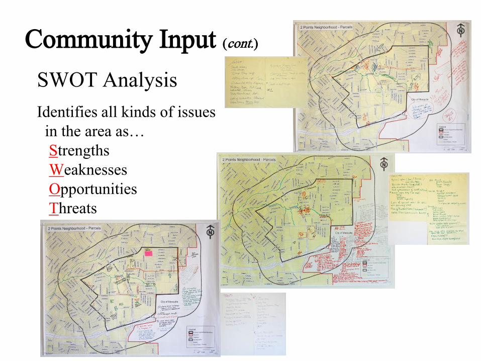
Community Input (cont.)
SWOT Analysis
Identifies all kinds of issues
in the area as…
Strengths
Weaknesses
Opportunities
Threats

Community Input (cont.)
SWOT Analysis (cont.)
Strengths
• New library
• Post office
• Bishop Lynch High School
• Three area parks (Lakeland, Ferguson, & Hillview Parks)
• Eastfield College
• Tree canopy
• Proximity to major highways and downtown Dallas
• Area churches
• Well built single family houses
• Weed and Seed program
• Involved residents
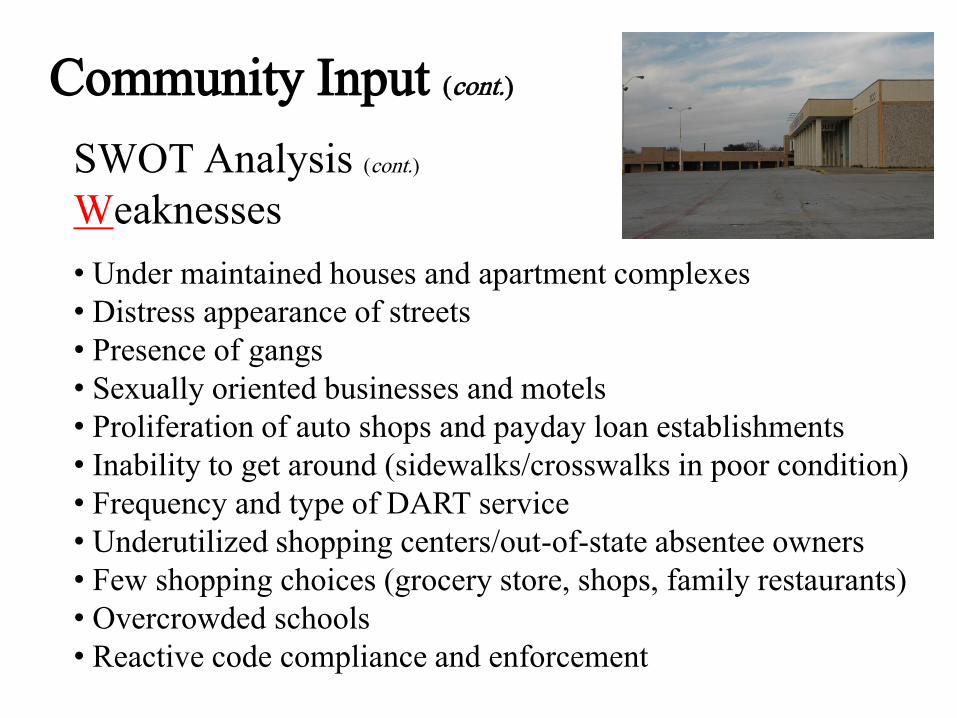
Community Input (cont.)
SWOT Analysis (cont.)
Weaknesses
• Under maintained houses and apartment complexes
• Distress appearance of streets
• Presence of gangs
• Sexually oriented businesses and motels
• Proliferation of auto shops and payday loan establishments
• Inability to get around (sidewalks/crosswalks in poor condition)
• Frequency and type of DART service
• Underutilized shopping centers/out-of-state absentee owners
• Few shopping choices (grocery store, shops, family restaurants)
• Overcrowded schools
• Reactive code compliance and enforcement
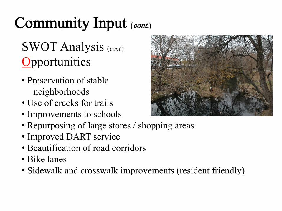
Community Input (cont.)
SWOT Analysis (cont.)
Opportunities
• Preservation of stable
neighborhoods
• Use of creeks for trails
• Improvements to schools
• Repurposing of large stores / shopping areas
• Improved DART service
• Beautification of road corridors
• Bike lanes
• Sidewalk and crosswalk improvements (resident friendly)
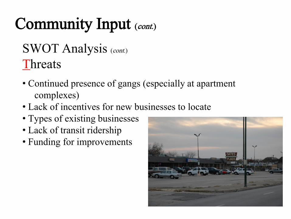
Community Input (cont.)
SWOT Analysis (cont.)
Threats
• Continued presence of gangs (especially at apartment
complexes)
• Lack of incentives for new businesses to locate
• Types of existing businesses
• Lack of transit ridership
• Funding for improvements
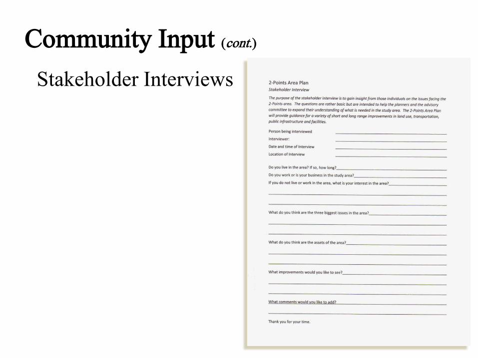
Community Input (cont.)
Stakeholder Interviews
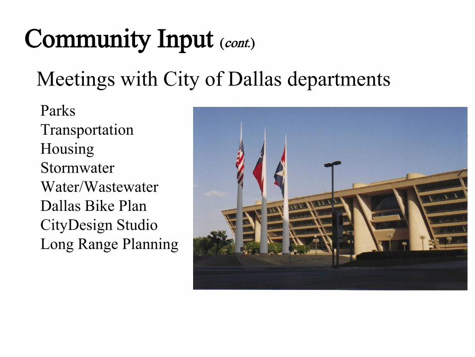
Community Input (cont.)
Meetings with City of Dallas departments
Parks
Transportation
Housing
Stormwater
Water/Wastewater
Dallas Bike Plan
CityDesign Studio
Long Range Planning

forwardDallas! Building Blocks
Ten Building Blocks
Business Centers or Corridors
Campus
Commercial Centers or Corridors
Downtown
Industrial Areas

forwardDallas! Building Blocks (cont.)
Ten Building Blocks (cont.)
Main Street
Residential Neighborhoods
Transit Centers or Multi-Modal Corridors
Urban Mixed-Use
Urban Neighborhoods

forwardDallas! Building Blocks (cont.)
Study Area Building Blocks

Existing Conditions
Demographics (2000 Census)Source: 2000 Census and City of Dallas
• Total population – 23,652
Race/Ethnicity Study Area Percentage
Black 41%
Hispanic 28%
White 24%
Asian 6%
Other 1%

Existing Conditions (cont.)
Demographics (2000 Census) (cont.)Source: 2000 Census and City of Dallas
• Median family income - $29,605
• Per capita income - $13,786
• Families below poverty level in 1999 - 112
Sex Study Area
Percentage
Dallas County
Percentage
United States
Percentage
Females 53% 50% 51%
Males 47% 50% 49%

Existing Conditions (cont.)
Demographics (2000 Census) (cont.)Source: 2000 Census and City of Dallas
Age Study Area
Actual
Study Area
Percentage
Dallas County
Percentage
United States
Percentage
Below 5 years of age 1,982 8% 8% 7%
5 to 19 4,883 21% 23% 22%
20 to 64 13,028 55% 61% 59%
65 and over 3,759 16% 8% 12%
Educational
Attainment
Study Area
Actual
Study Area
Percentage
Dallas County
Percentage
United States
Percentage
No high school 7,640 24% 25% 19%
High school graduates 7,907 25% 22% 29%
Some college 8,720 28% 21% 21%
College graduates 4,484 14% 23% 22%
Post graduates 2,718 9% 9% 9%
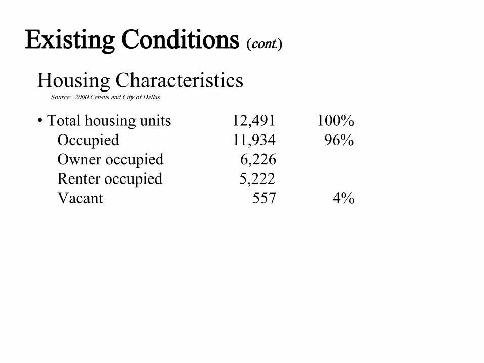
Existing Conditions (cont.)
Housing CharacteristicsSource: 2000 Census and City of Dallas
• Total housing units 12,491 100%
Occupied 11,934 96%
Owner occupied 6,226
Renter occupied 5,222
Vacant 557 4%
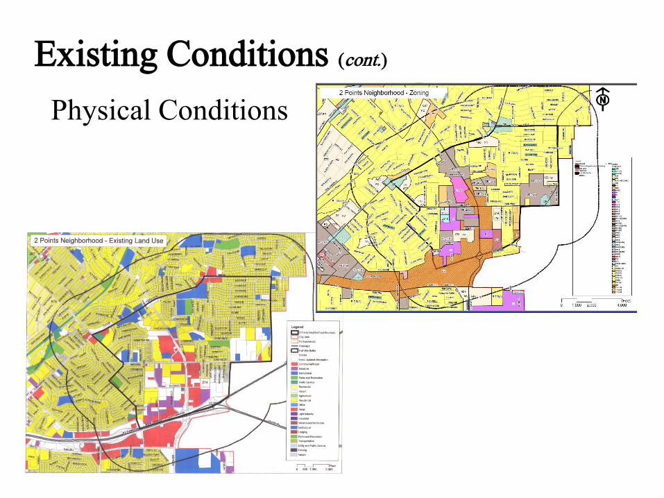
Existing Conditions (cont.)
Physical Conditions
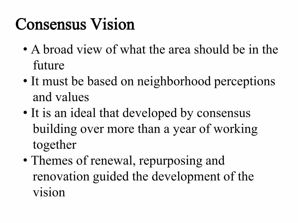
Consensus Vision
• A broad view of what the area should be in the
future
• It must be based on neighborhood perceptions
and values
• It is an ideal that developed by consensus
building over more than a year of working
together
• Themes of renewal, repurposing and
renovation guided the development of the
vision
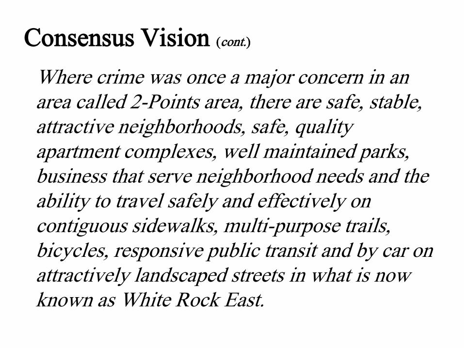
Consensus Vision (cont.)
Where crime was once a major concern in an area called 2-Points area, there are safe, stable, attractive neighborhoods, safe, quality apartment complexes, well maintained parks, business that serve neighborhood needs and the ability to travel safely and effectively on contiguous sidewalks, multi-purpose trails, bicycles, responsive public transit and by car on attractively landscaped streets in what is now known as White Rock East.
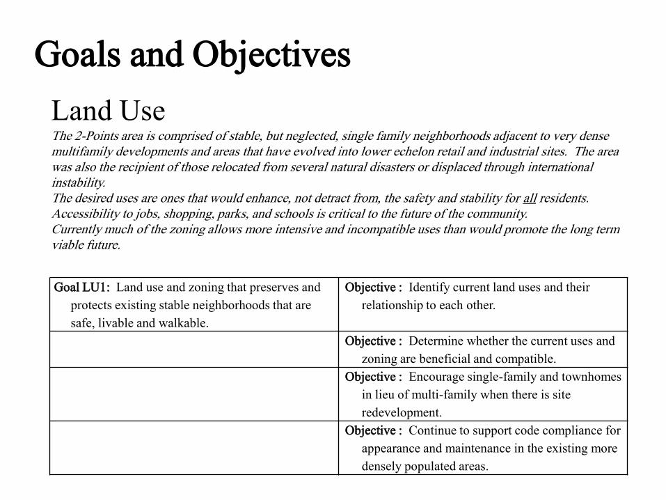
Goals and Objectives
Land UseThe 2-Points area is comprised of stable, but neglected, single family neighborhoods adjacent to very dense multifamily developments and areas that have evolved into lower echelon retail and industrial sites. The area was also the recipient of those relocated from several natural disasters or displaced through international instability. The desired uses are ones that would enhance, not detract from, the safety and stability for all residents. Accessibility to jobs, shopping, parks, and schools is critical to the future of the community. Currently much of the zoning allows more intensive and incompatible uses than would promote the long term viable future.
Goal LU1: Land use and zoning that preserves and
protects existing stable neighborhoods that are
safe, livable and walkable.
Objective : Identify current land uses and their
relationship to each other.
Objective : Determine whether the current uses and
zoning are beneficial and compatible.
Objective : Encourage single-family and townhomes
in lieu of multi-family when there is site
redevelopment.
Objective : Continue to support code compliance for
appearance and maintenance in the existing more
densely populated areas.
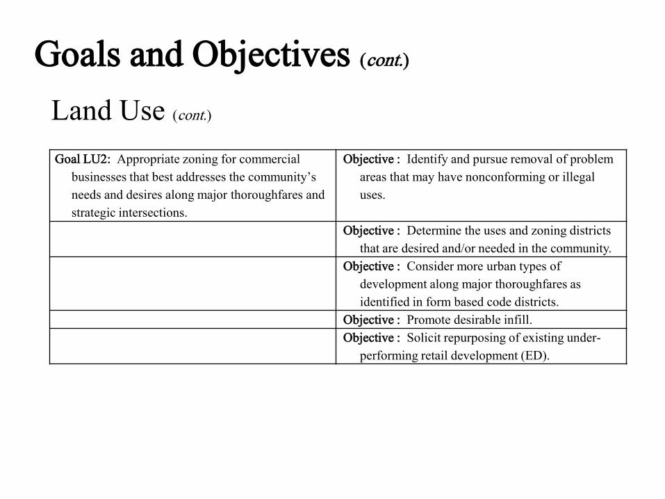
Goals and Objectives (cont.)
Land Use (cont.)
Goal LU2: Appropriate zoning for commercial
businesses that best addresses the community’s
needs and desires along major thoroughfares and
strategic intersections.
Objective : Identify and pursue removal of problem
areas that may have nonconforming or illegal
uses.
Objective : Determine the uses and zoning districts
that are desired and/or needed in the community.
Objective : Consider more urban types of
development along major thoroughfares as
identified in form based code districts.
Objective : Promote desirable infill.
Objective : Solicit repurposing of existing under-
performing retail development (ED).
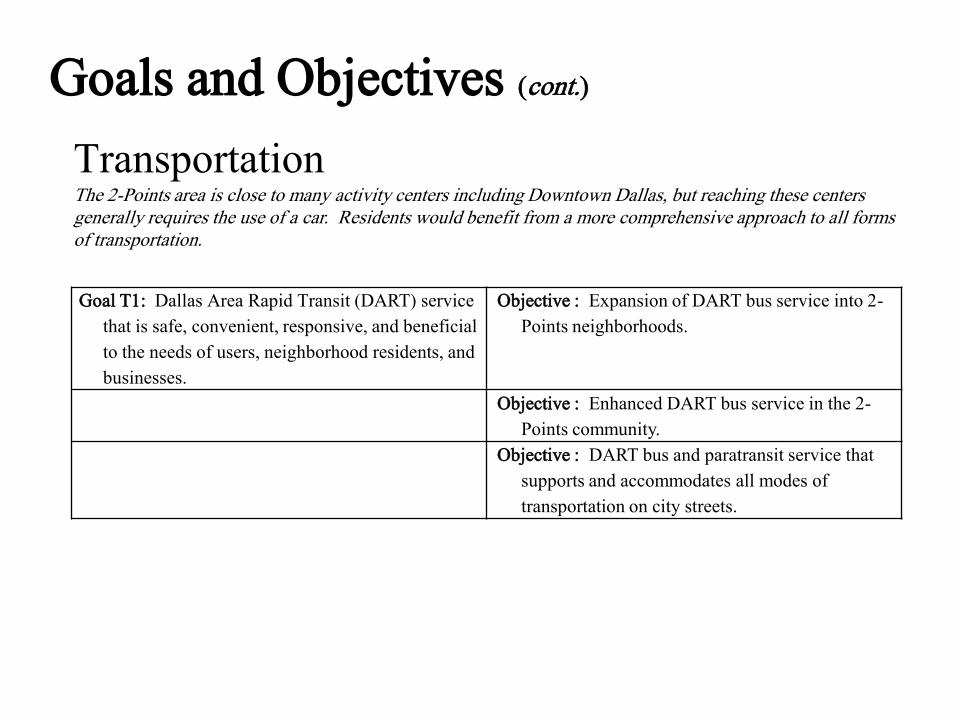
TransportationThe 2-Points area is close to many activity centers including Downtown Dallas, but reaching these centers generally requires the use of a car. Residents would benefit from a more comprehensive approach to all forms of transportation.
Goal T1: Dallas Area Rapid Transit (DART) service
that is safe, convenient, responsive, and beneficial
to the needs of users, neighborhood residents, and
businesses.
Objective : Expansion of DART bus service into 2-
Points neighborhoods.
Objective : Enhanced DART bus service in the 2-
Points community.
Objective : DART bus and paratransit service that
supports and accommodates all modes of
transportation on city streets.
Goals and Objectives (cont.)

Transportation (cont.)
Goal T2: Safe and accessible sidewalks to serve the
needs of local residents and businesses and
encourage walking for healthy living and expand
transportation options.
Objective : Identify improvements for walking
within the 2-Points residential neighborhoods and
commercial areas.
Objective : Develop a network of sidewalks and
crosswalks along arterial and collector roads that
links together the 2-Points study area and provides
access to notable amenities in the surrounding
buffer area.
Objective : Ensure sidewalks provide access to local
trails.
Goal T3: Streets and major highways that enhance
the community’s image and promote the safe
movement of pedestrians and vehicles.
Objective : Streetscape and landscape improvements
along major road corridors in the 2-Points area.
Objective : Street beautification and safety for local
streets.
Objective : Enhancing the safe movement of
pedestrians and vehicles in the 2-Points area.
Goals and Objectives (cont.)

Transportation (cont.)
Goal T4: A trail network that bonds the study area
and surrounding buffer area.
Objective : A trail network along South Ash Creek,
the creek’s tributaries, and to nearby trails and
linear parks to link together neighborhoods, local
institutions, and commercial centers.
Goal T5: A bicycle plan for the study area and
surrounding buffer area.
Objective : Identify improvements for biking
movement and safety within the 2-Points
residential neighborhoods, commercial areas, and
in the surrounding neighborhoods.
Goals and Objectives (cont.)

Quality of LifeAs a community of several maturing neighborhoods, aging commercial structures, and crowded schools, the 2-Points area is undergoing changes to its community profile and grappling to find its identity while projecting a positive image for its residents, business community, and others outside the area. By focusing on code compliance, education, parks and recreation, and public safety, community leaders working with residents, businesses, public and private institutions, and local governments can take strategic steps to enhance the livability of 2-Points as an attractive place to live, work, shop, and play.
Goal QL1: Codes, regulations, programs, and
enforcement to clean up, stabilize, and improve
local neighborhoods and improve the study area’s
image.
Objective : Community leaders working with
property owners, local businesses, institutions,
and local organizations to develop a program that
educates, cleans up, and aggressively monitors
trash ‘hot spots’ to pursue violators.
Objective : Work with Dallas Animal Control and
neighborhood groups to manage the pet
population by educating residents about the need
to spay and neuter their pets, report animal
hoarding, and report sightings of stray cats and
dogs.
Goals and Objectives (cont.)

Quality of Life (cont.)
Goal QL1: Codes, regulations, programs, and
enforcement to clean up, stabilize, and improve
local neighborhoods and improve the study area’s
image.
Objective : Community leaders working with Code
Compliance to identify, aggressively monitor, and
resolve or remove poorly maintain, dilapidated, or
abandoned apartments and commercial structures.
Objective : Explore different methods to work with
property owners and businesses in the study area
to repair, mark out, landscape, and maintain their
parking lots.
Objective : Develop different methods to encourage
property owners and businesses to incorporate
‘Green Infrastructure’ improvements for their
parking lots to reduce stormwater runoff.
Goals and Objectives (cont.)

Quality of Life (cont.)
Goal QL2: Education facilities and programs that
enhance the study area’s neighborhoods and serve
local residents.
Objective : Maintain and improve truancy program
at local schools.
Objective : Expand Truitt Elementary school
facilities to replace unsightly portable buildings,
incorporate additional gym, expand cafeteria, and
accommodate current student levels.
Objective : Make improvements to the school
grounds and facilities of S.S. Conner Elementary
School and Harold Wendell Lang Sr. Middle
School as needed.
Objective : Landscape and maintain school grounds
to have a positive impact on surrounding
neighborhoods and community.
Objective : Address the educational needs of
residents relocated to area from natural disasters
or displaced through international instability.
Goals and Objectives (cont.)

Quality of Life (cont.)
Goal QL3: Park, recreation, and open space
amenities that bond and enhance the image of the
study area.
Objective : Maintain or improve upkeep of Ferguson
Park, Hillview Park, and Lakeland Hills Park.
Objective : Identify a location adjacent to a future
trail for a community park incorporating a spray
park, dog park, and recreation center complete
with a running path and basketball courts.
Objective : Open discussions with officials of the
YMCA of Metropolitan Dallas about opening a
branch location within the study area.
Objective : Identify locations along South Ash Creek
and its tributaries for parks and open space.
Goals and Objectives (cont.)
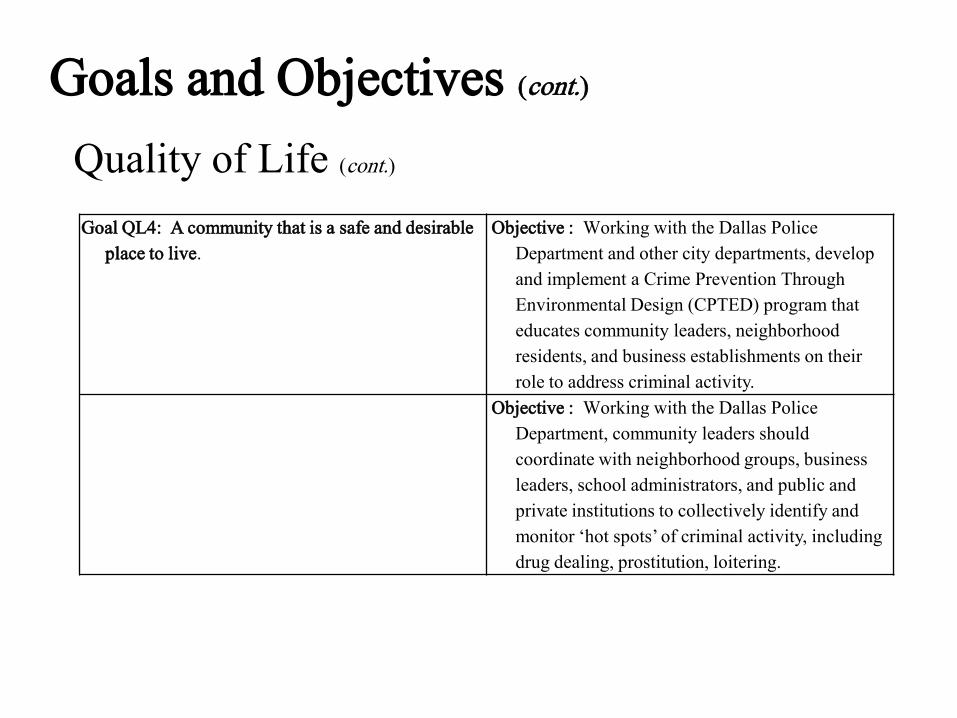
Quality of Life (cont.)
Goal QL4: A community that is a safe and desirable
place to live.
Objective : Working with the Dallas Police
Department and other city departments, develop
and implement a Crime Prevention Through
Environmental Design (CPTED) program that
educates community leaders, neighborhood
residents, and business establishments on their
role to address criminal activity.
Objective : Working with the Dallas Police
Department, community leaders should
coordinate with neighborhood groups, business
leaders, school administrators, and public and
private institutions to collectively identify and
monitor ‘hot spots’ of criminal activity, including
drug dealing, prostitution, loitering.
Goals and Objectives (cont.)
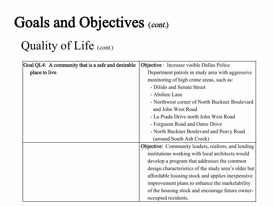
Quality of Life (cont.)
Goal QL4: A community that is a safe and desirable
place to live.
Objective : Increase visible Dallas Police
Department patrols in study area with aggressive
monitoring of high crime areas, such as:
- Dilido and Senate Street
- Abshire Lane
- Northwest corner of North Buckner Boulevard
and John West Road
- La Prada Drive north John West Road
- Ferguson Road and Oates Drive
- North Buckner Boulevard and Peavy Road
(around South Ash Creek)
Objective: Community leaders, realtors, and lending
institutions working with local architects would
develop a program that addresses the common
design characteristics of the study area’s older but
affordable housing stock and applies inexpensive
improvement plans to enhance the marketability
of the housing stock and encourage future owner-
occupied residents.
Goals and Objectives (cont.)
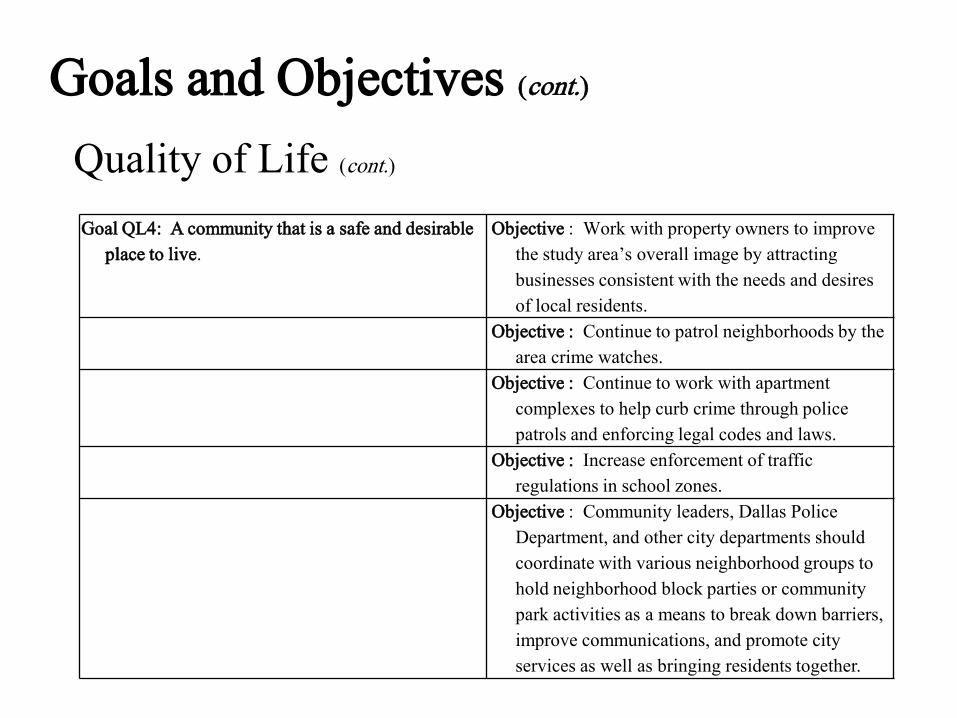
Quality of Life (cont.)
Goal QL4: A community that is a safe and desirable
place to live.
Objective : Work with property owners to improve
the study area’s overall image by attracting
businesses consistent with the needs and desires
of local residents.
Objective : Continue to patrol neighborhoods by the
area crime watches.
Objective : Continue to work with apartment
complexes to help curb crime through police
patrols and enforcing legal codes and laws.
Objective : Increase enforcement of traffic
regulations in school zones.
Objective : Community leaders, Dallas Police
Department, and other city departments should
coordinate with various neighborhood groups to
hold neighborhood block parties or community
park activities as a means to break down barriers,
improve communications, and promote city
services as well as bringing residents together.
Goals and Objectives (cont.)

Economic DevelopmentThe 2-Points area benefits from its location at I-30 and Loop12 in East Dallas; however, commercial developments along 2-Points major roadway corridors represents various development patterns, many of which are outdated and do not present a positive community image. The area also suffers from a lack of identity and name recognition that does not reflect the community’s character and values. Addressing the area’s image and identity along with repositioning the area’s commercial districts would benefit local residents and businesses, spur employment opportunities, and enhance property values.
Goal ED1: Positive community identity. Objective : Enhance the community’s identity,
image, and perception for local residents and
non-residents
Goal ED2: Pedestrian-oriented commercial districts
that benefit local residents and businesses.
Objective : Determine the appropriate types of
commercial development and medical facilities
needed within the study area.
Objective : Solicit repurposing of existing under-
performing retail development (LU).
Objective : Reposition obsolete commercial
properties adjacent to existing neighborhoods.
Goal ED3: Development patterns along I-30 that
enhances the area’s image.
Objective : Address abandoned, derelict, or
obsolete buildings, signs, and parking areas.
Objective : Determine the appropriate types of
development along the I-30 corridor.
Goals and Objectives (cont.)

Public Works/Infrastructure2-Points is an area of aging infrastructure and benign neglect that would benefit by directing improvements to streets, sidewalks, alleys, water, sewer storm and waste water systems.
Goal PWI1: Neighborhood involvement and city
services to preserve, support, and enhancement
neighborhood development and integrity.
Objective : Improve the image of the 2-Points area
through neighborhood monitoring, public
investment, and city enforcement.
Objective : Promote neighborhood identity and
pride.
Goal PWI2: Enhance the conditions of local
waterways.
Objective : Minimize the threat of stormwater
runoff.
Goals and Objectives (cont.)
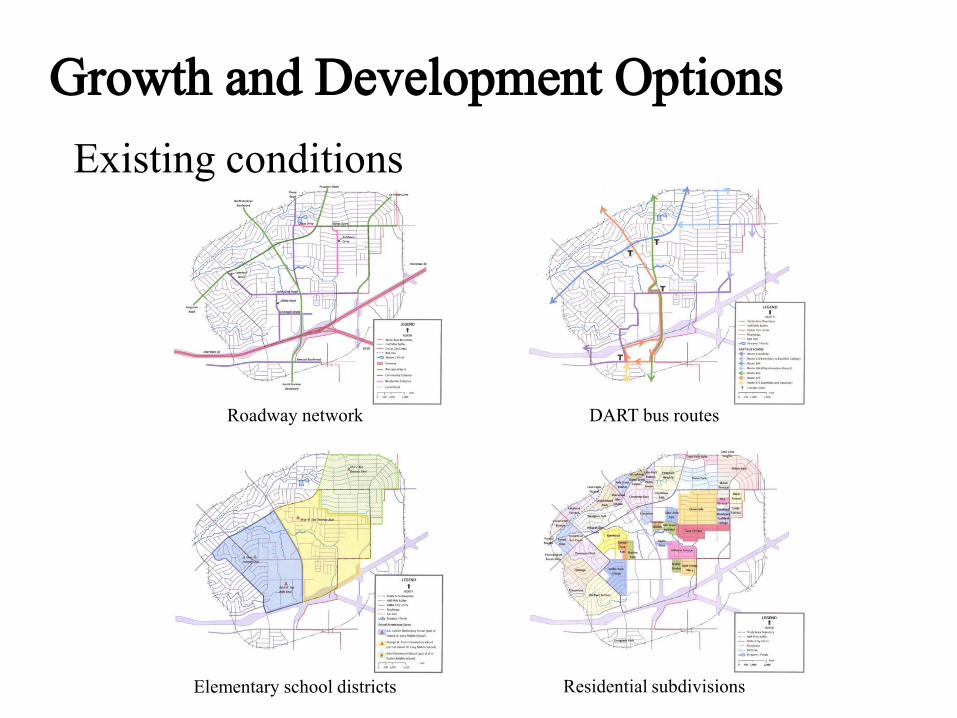
Growth and Development Options
Existing conditions
Roadway network DART bus routes
Elementary school districts Residential subdivisions
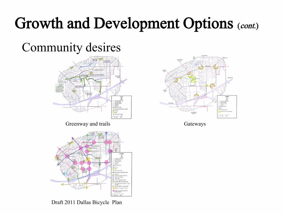
Growth and Development Options (cont.)
Community desires
Greenway and trails Gateways
Draft 2011 Dallas Bicycle Plan

Seven Strategic Opportunity Areas
Strategic Opportunity Area locations

Seven Strategic Opportunity Areas (cont.)
Analyzing and repurposing
Existing building footprints Identifying possible street grid Streetscape treatments and
phased in developments
Concept plan build-out

Strategic Opportunity Area #1
Concept planThe existing commercial center and post office will
continue to serve the surrounding single family
development patterns; however, its once required ample
parking should give up some room for infill retail and
restaurant space creating a walkable, pedestrian
experience. An interior park and landscaped green street
treatments would further create a sense of place while
reducing the existing site’s impervious cover. Both
on-street and remaining off-street parking should make
the walk to shops more convenient.
Getting around• Organized interior street grid
• Sidewalks and crosswalks
• Incorporating future trails
Seven Strategic Opportunity Areas (cont.)
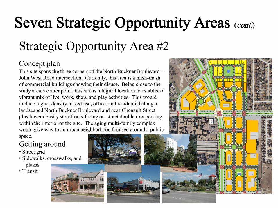
Strategic Opportunity Area #2
Concept planThis site spans the three corners of the North Buckner Boulevard –
John West Road intersection. Currently, this area is a mish-mash
of commercial buildings showing their disuse. Being close to the
study area’s center point, this site is a logical location to establish a
vibrant mix of live, work, shop, and play activities. This would
include higher density mixed use, office, and residential along a
landscaped North Buckner Boulevard and near Chenault Street
plus lower density storefronts facing on-street double row parking
within the interior of the site. The aging multi-family complex
would give way to an urban neighborhood focused around a public
space.
Getting around• Street grid
• Sidewalks, crosswalks, and
plazas
• Transit
Seven Strategic Opportunity Areas (cont.)
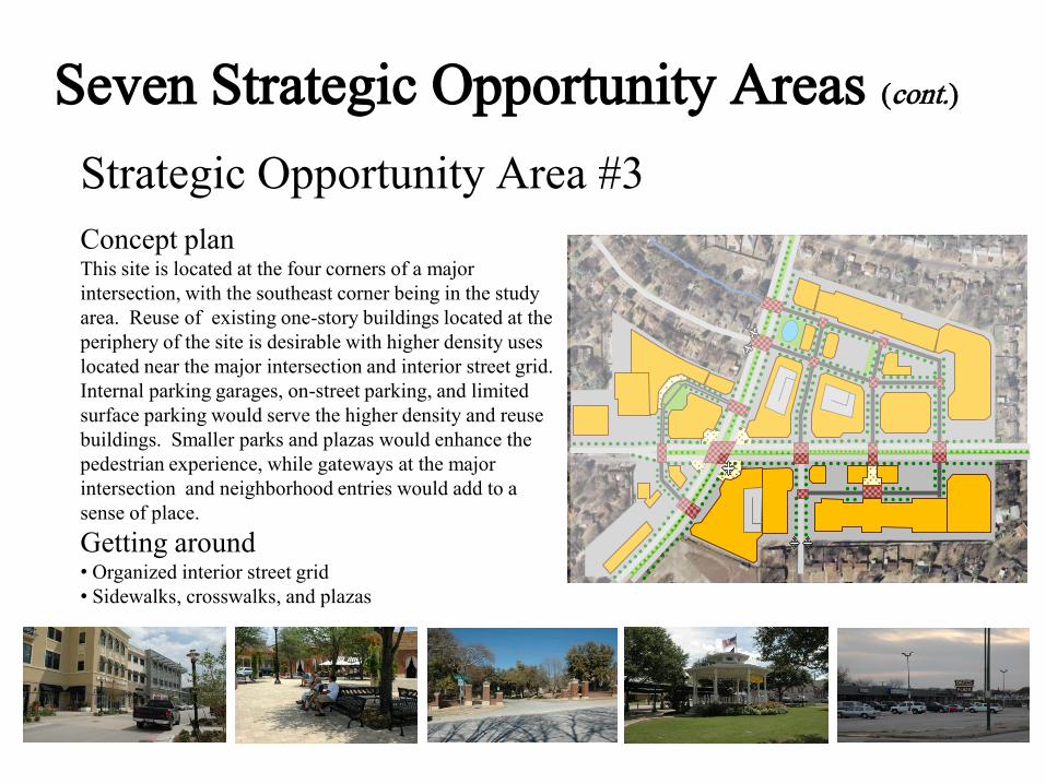
Strategic Opportunity Area #3
Concept planThis site is located at the four corners of a major
intersection, with the southeast corner being in the study
area. Reuse of existing one-story buildings located at the
periphery of the site is desirable with higher density uses
located near the major intersection and interior street grid.
Internal parking garages, on-street parking, and limited
surface parking would serve the higher density and reuse
buildings. Smaller parks and plazas would enhance the
pedestrian experience, while gateways at the major
intersection and neighborhood entries would add to a
sense of place.
Getting around• Organized interior street grid
• Sidewalks, crosswalks, and plazas
Seven Strategic Opportunity Areas (cont.)

Strategic Opportunity Area #4
Concept planThis location has the potential to define the character of
the community in a positive way; however, existing
development diminishes the community’s image. An
aging apartment community east of Peavy Road should
be replaced with urban single family detached housing,
townhouses, plus a centralized neighborhood park. The
area between North Buckner Boulevard and Peavy Road
should be redeveloped into a concentration of
neighborhood serving commercial buildings with a
‘Flatiron’ style building at the triangular south end. The
north end should have a creekside overlook mixed use
building with restaurants, offices, and residential units.
In between would be a mix of neighborhood serving
shops and restaurants.
Getting around• Landscaped roadways
• Future roadway linkages
• Trails
Seven Strategic Opportunity Areas (cont.)

Strategic Opportunity Area #5
Concept planThe concept plan replaces
aging structures with new
single family detached
and townhouses units that
reflect the surrounding
neighborhoods. Concept
uses the local creek and
woodlands meandering
through as a ‘green spine’
that links together nearby
neighborhoods and
enhances the area’s
aesthetic appeal.
Getting around• Trails and footpaths
• Sidewalks and mid-block
footpaths
• Roadways
Seven Strategic Opportunity Areas (cont.)

Strategic Opportunity Area #6
Concept planWith the I-30/US 80/Loop 12 interchange at its front
door and North Buckner Boulevard (Loop 12) as its
entryway, this area needs a landmark gateway with
landscaped right-of-way. Promote regional employment
activities such as medical facilities or education centers
that can take advantage of location’s proximity to the
interchange. Transition this area from the proposed urban,
pedestrian-oriented developments north of Chenault Street
to a slightly more auto-oriented character along I-30 with
a concentration of commercial of commercial businesses.
Getting around• Regional road connections
• Parallel roadway network to support I-30
• Possible bus transit center
Seven Strategic Opportunity Areas (cont.)
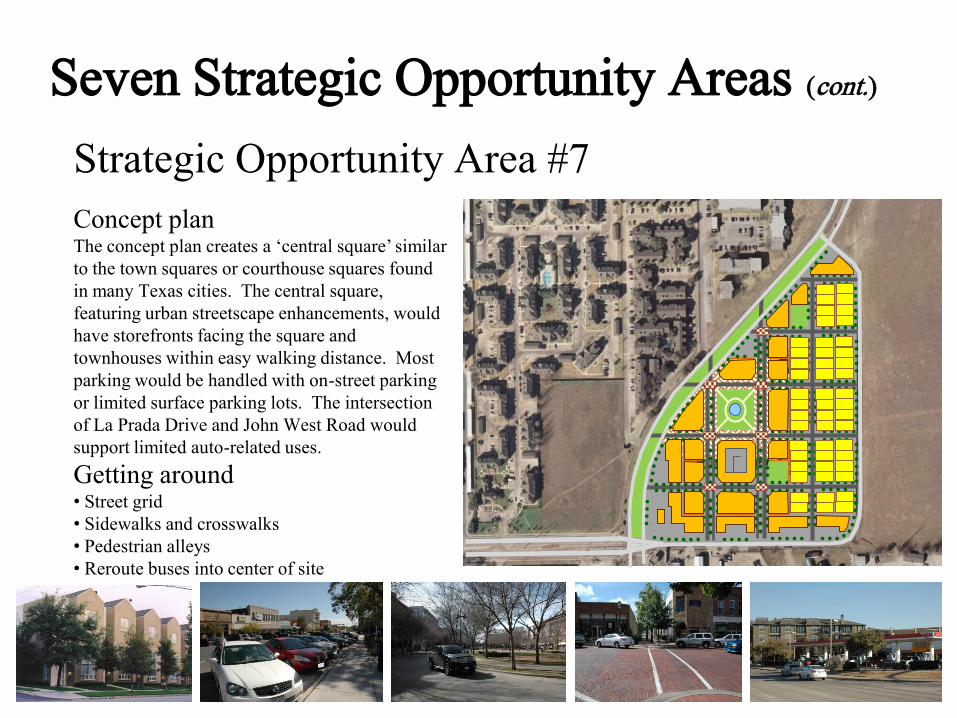
Strategic Opportunity Area #7
Concept planThe concept plan creates a ‘central square’ similar
to the town squares or courthouse squares found
in many Texas cities. The central square,
featuring urban streetscape enhancements, would
have storefronts facing the square and
townhouses within easy walking distance. Most
parking would be handled with on-street parking
or limited surface parking lots. The intersection
of La Prada Drive and John West Road would
support limited auto-related uses.
Getting around• Street grid
• Sidewalks and crosswalks
• Pedestrian alleys
• Reroute buses into center of site
Seven Strategic Opportunity Areas (cont.)

Implementation
• Develop action items to move plan forward
• Monitor progress on plan
• Communicate timely updates to revise plan

Next Steps
• Meet with businesses
• Finish draft
• Put on web site
• Review by Dallas City Staff
• Needed corrections, additions, edits
• Format document for presentation and review,
including: • Quality of Life briefing
• Briefing at Dallas City Plan Commission
• Dallas City Plan Commission submittal for recommendation
• Briefing at Dallas City Council
• Submittal for Dallas City Council approval

Acknowledgements
White Rock East Area Study Advisory Committee
Honorable Carolyn R. Davis, City Council District 7
Ferguson Road Initiative
City of DallasSustainable Development and Construction Department
Strategic Planning Division
Ellen Childress John Childress
Pat Copeland Gus Garcia
Kerry Goodwin Kimberly Humphries
Georgia King Lauren Roberts
Vicki Sanger Desi Tannes
Eileen Williams

http://www.2pointstowhiterockeast.com/
Thank you!Please visit our website at:
And please visit the forwardDallas! and Ferguson Road Initiative websites at:
http://www.dallascityhall.com/forwardDallas/index.html
http://www.fergusonroad.org/
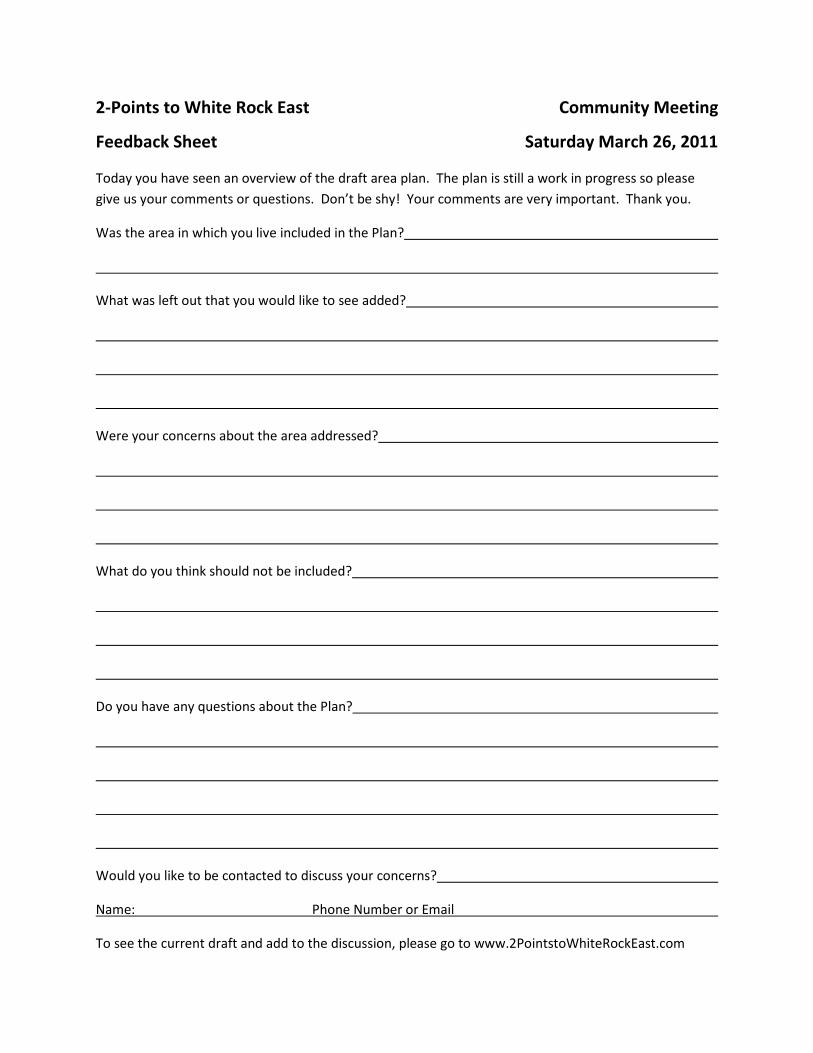
2-Points to White Rock East Community Meeting
Feedback Sheet Saturday March 26, 2011
Today you have seen an overview of the draft area plan. The plan is still a work in progress so please
give us your comments or questions. Don’t be shy! Your comments are very important. Thank you.
Was the area in which you live included in the Plan?
What was left out that you would like to see added?
Were your concerns about the area addressed?
What do you think should not be included?
Do you have any questions about the Plan?
Would you like to be contacted to discuss your concerns?
Name: Phone Number or Email
To see the current draft and add to the discussion, please go to www.2PointstoWhiteRockEast.com
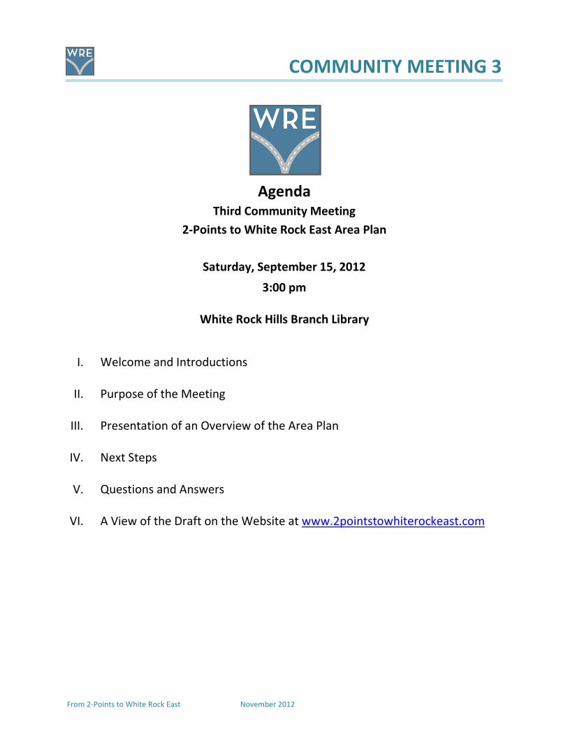
COMMUNITY MEETING 3
From 2-Points to White Rock East November 2012
Agenda
Third Community Meeting
2-Points to White Rock East Area Plan
Saturday, September 15, 2012
3:00 pm
White Rock Hills Branch Library
I. Welcome and Introductions
II. Purpose of the Meeting
III. Presentation of an Overview of the Area Plan
IV. Next Steps
V. Questions and Answers
VI. A View of the Draft on the Website at www.2pointstowhiterockeast.com
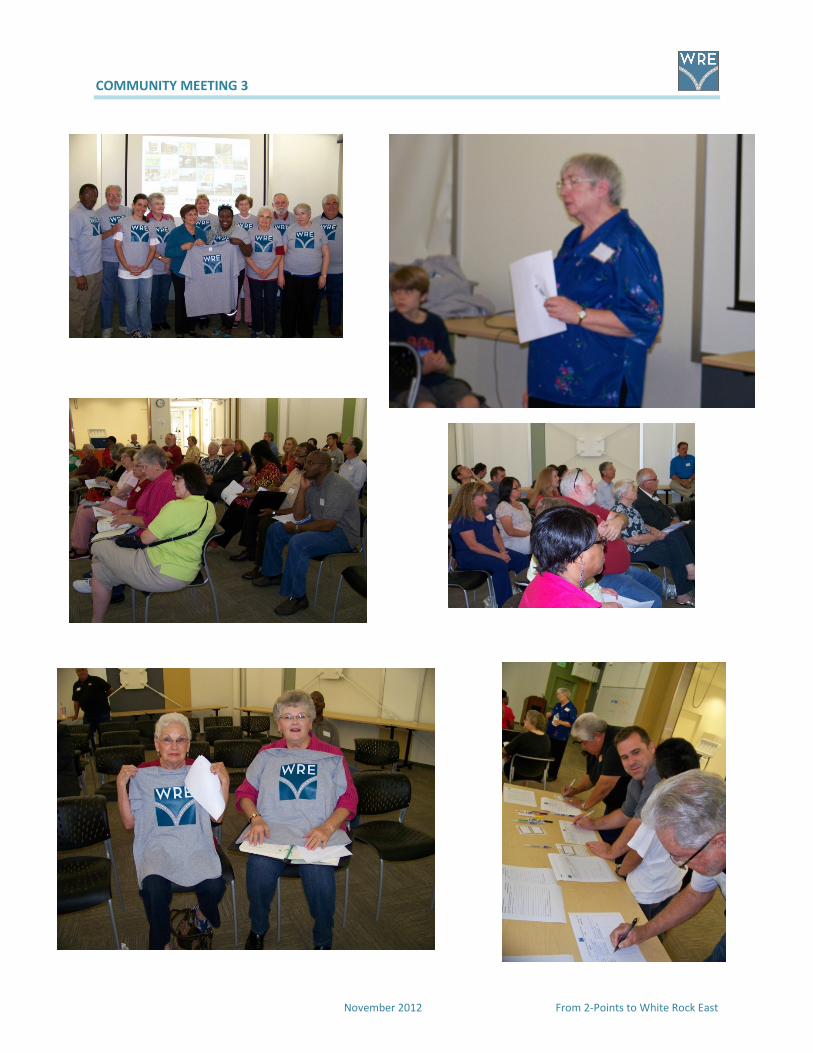
COMMUNITY MEETING 3
November 2012 From 2-Points to White Rock East

September 2, 2012
To: Residents and Business Owners/Managers
From: Advisory Committee for Area Plan Study, 2-Points to White Rock East
An Invitation to the Final Community-wide Meeting Regarding the Redevelopment Plan for far east Dallas along the Ferguson /Oates Corridor from Lakeland to La Prada.
For three years, a group of citizens here in far east Dallas near Truett Elementary and Bishop Lynch High School have been meeting with urban planners who are skilled in the planning and development of urban neighborhoods to better reflect the vision and opportunities for homeowners and businesses within the community and deflect the onslaught of urban decay that we have seen creeping into our neighborhoods and shopping and business centers. We have talked to our neighbors, called on businesses in the area, sat down with agency directors and pastors of churches during the past three years and held two community meetings and one area-wide survey to solicit the ideas, opinions, hopes, and wishes of the people who live and work in this part of far east Dallas.
Residents should be enabled to live comfortably in their homes, walk safely along their streets, enjoy shopping nearby, send their children to good schools, find recreation or rest in neighborhood centers or public parks, and enjoy the growth of public transportation for commuting to work and entertainment venues We hope to see the future development and growth of small businesses in our area as well as a diverse array of markets and restaurants designed to serve an equally diverse population.
We have chosen to change our neighborhood designation from 2-Points, which was a location based on police calls, to White Rock East which connects us , quite rightly, with White Rock Hills and the south side of the lake. We have endeavored to create a vision and workable plan for our area that will blend with the Ferguson Road Initiative’s plan for the Ferguson Road Corridor.
The final draft of our Land Use Plan and Redevelopment Vision for this community will be presented in a public meeting Saturday , September 15, 2012 at 3 PM at the new White Rock Hills Branch Library, 9150 Ferguson Road, directly behind the White Rock Church of Christ. Please come, bring your family and friends, and share your ideas and comments about the future of White Rock East.
The Advisory Committee for White Rock East, John and Ellen Childress, Coordinators 214-324-3778 [email protected]
Members: Desi Tanner, Gus Garcia, Georgia King, Pat Copeland, Eileen Williams, Lauren Roberts, Kimberly Humphries
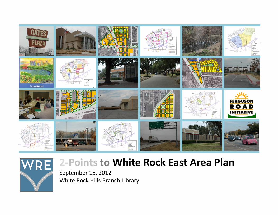
2-Points to White Rock East Area PlanSeptember 15, 2012
White Rock Hills Branch Library
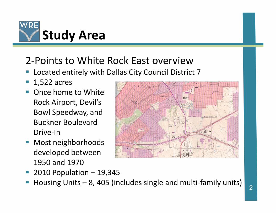
Study Area
2-Points to White Rock East overview� Located entirely with Dallas City Council District 7
� 1,522 acres
� Once home to White
Rock Airport, Devil’s
2
Bowl Speedway, and
Buckner Boulevard
Drive-In
� Most neighborhoods
developed between
1950 and 1970
� 2010 Population – 19,345
� Housing Units – 8, 405 (includes single and multi-family units)

Study Area (cont)
Study Area boundaries
^North
3

Purpose of Plan
� Protect stable neighborhoods
� Connect homes and activities
� Improve safety and mobility
� Guide redevelopment decisions
� Support improvements
4
� Support improvements
Purpose of Plan (cont)
What the Plan does….� Reflects the values and desires of residents and
businesses
� Provides very conceptual plans for seven strategic
opportunity areas
5
opportunity areas
� Serves as one of the City’s guides for decisions
� Provide actions to achieve the area’s goals and
objectives
� Is a handbook for the community

Planning Process
forwardDallas!
Ferguson Road Initiative
6

Community Input
Advisory Committee
SWOT Analysis
Stakeholder Interviews
7
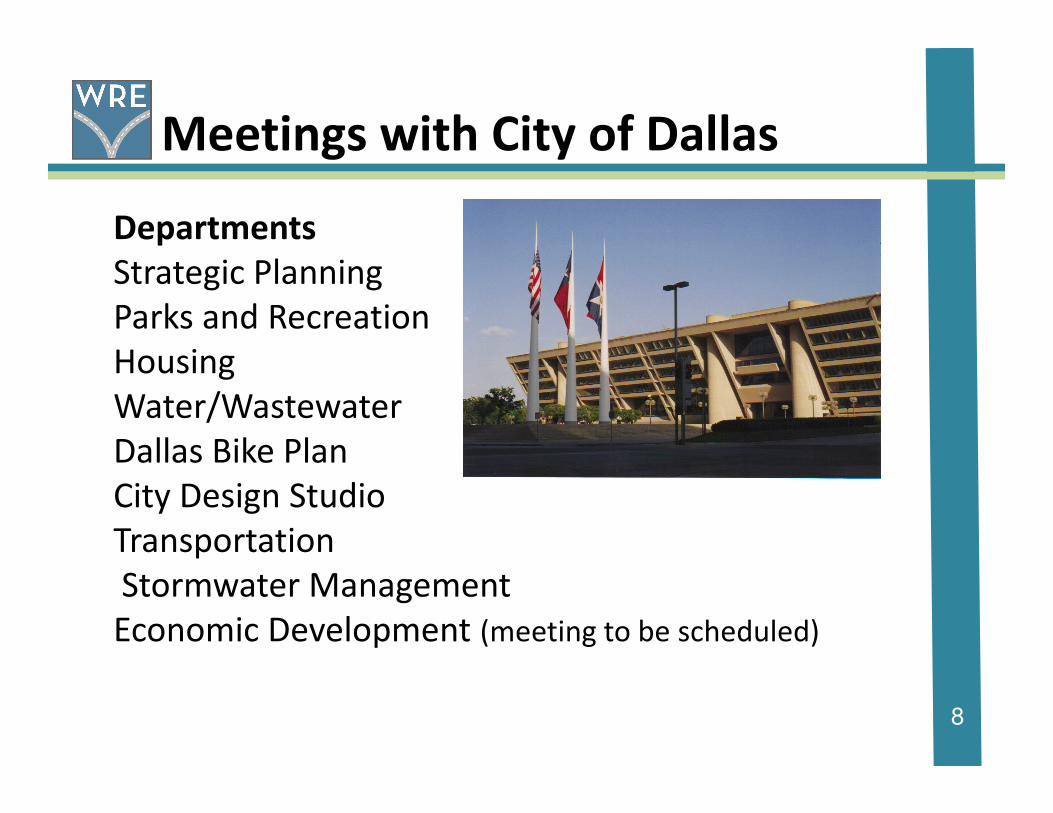
Meetings with City of Dallas
Departments
Strategic Planning
Parks and Recreation
Housing
Water/Wastewater
8
Water/Wastewater
Dallas Bike Plan
City Design Studio
Transportation
Stormwater Management
Economic Development (meeting to be scheduled)

Lots and lots of
Advisory Committee meetings,
meetings with businesses
9
meetings with businesses
and with neighbors
The results follow!

Consensus Vision
� A broad view of what the area should be in the future
� It must be based on neighborhood perceptions and values
� It is an ideal that developed by consensus
10
� It is an ideal that developed by consensus
building over more than a year of working together
� Includes themes of renewal, repurposing and
renovation guided the development of the
vision
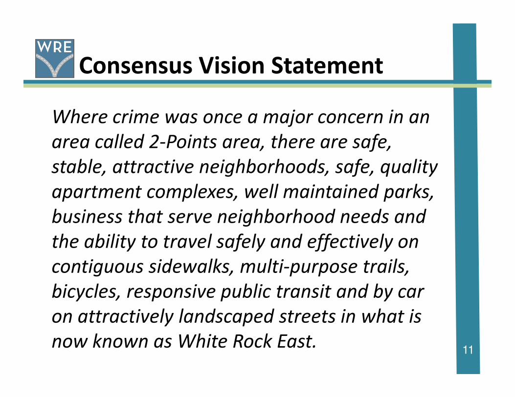
Consensus Vision Statement
Where crime was once a major concern in an
area called 2-Points area, there are safe,
stable, attractive neighborhoods, safe, quality
apartment complexes, well maintained parks,
11
apartment complexes, well maintained parks,
business that serve neighborhood needs and
the ability to travel safely and effectively on
contiguous sidewalks, multi-purpose trails,
bicycles, responsive public transit and by car
on attractively landscaped streets in what is
now known as White Rock East.

Did you notice the new name?
White Rock East
12

Sections of the Area Plan
Land Use
Transportation
Quality of Life
Urban Design
13
Urban Design
Economic Development (still under development)
Implementation

Land Use
Land Use Consensus Vision
Land Uses in White Rock East include desirable single
family residences, multi-family units in a safe
environment, successful consumer-oriented businesses
14
environment, successful consumer-oriented businesses
interspersed in mixed use development, neighborhood
parks and schools linked together in a system of
attractive roadways, sidewalks and trails.

Existing Conditions
Land Use (cont)
15
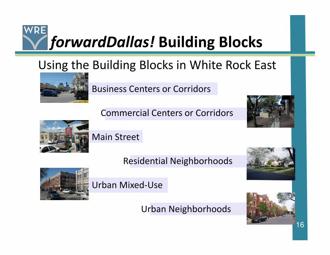
forwardDallas! Building Blocks
Using the Building Blocks in White Rock East
Business Centers or Corridors
Commercial Centers or Corridors
16
Main Street
Residential Neighborhoods
Urban Mixed-Use
Urban Neighborhoods
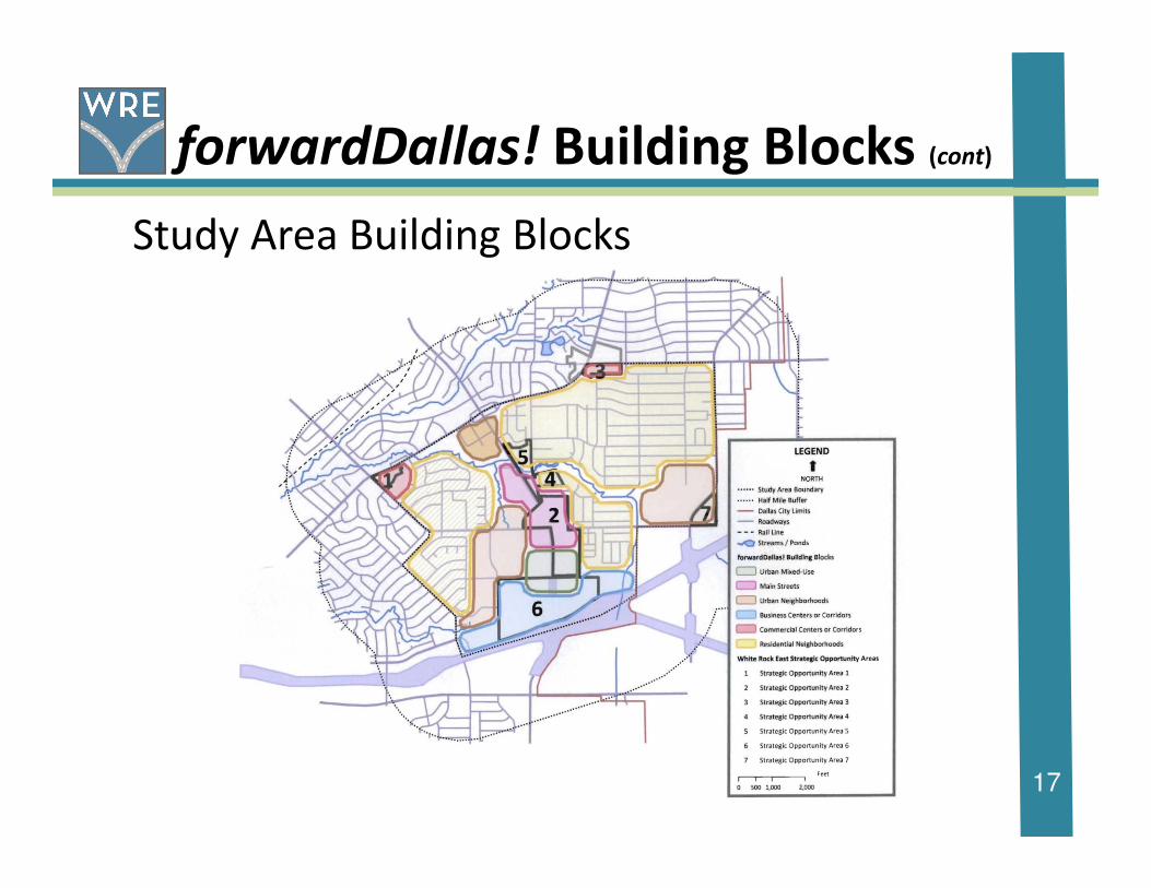
forwardDallas! Building Blocks (cont)
Study Area Building Blocks
17

Strategic Opportunity Areas
Strategic Opportunity Area locations
18

Strategic Opportunity Areas (cont)
Creating a Strategic Opportunity Areas
conceptual plan through analyzing and
repurposing
19
Existing building footprints Identifying possible street grid Streetscape treatments and phased in developments
Conceptual plan build-out

For Example:
Strategic Opportunity Area #2
Strategic Opportunity Areas (cont)
20

Transportation
Transportation Consensus VisionThe transportation network serving White Rock East
focuses equally on the needs and activities of all users. It
works in context with adjacent development patterns.
Addressing the roadway character of the area’s existing
21
Addressing the roadway character of the area’s existing
thoroughfare network of safe and attractive roads ensures
the positive pedestrian experience by the realization of a
continuous sidewalk system, greater value to surrounding
land uses, and links various areas of the community
through sidewalks bike routes and trails. Ultimate success
is found in its desirable streets, highways, sidewalks, and
trails that promote the safe movement of pedestrians and
vehicles while enhancing the community’s image.
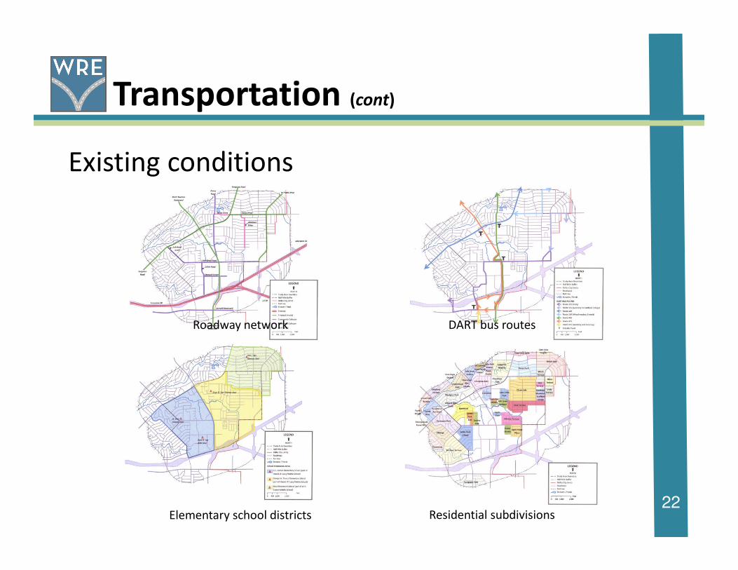
Transportation (cont)
Existing conditions
22
Roadway network DART bus routes
Elementary school districts Residential subdivisions
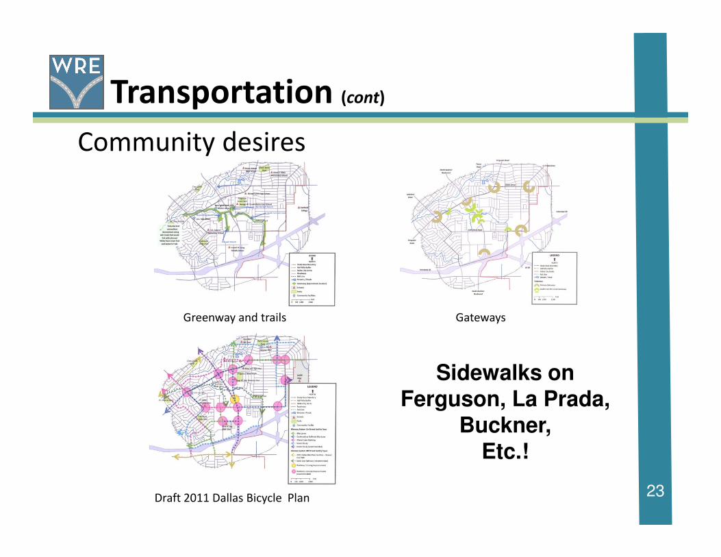
Transportation (cont)
Community desires
23
Greenway and trails Gateways
Draft 2011 Dallas Bicycle Plan
Sidewalks on Ferguson, La Prada,
Buckner,Etc.!

Quality of Life
Quality of Life Consensus Vision
Enhance the quality of life in the White Rock
East area through continued crime reduction,
responsive public safety, improved parks, new
24
responsive public safety, improved parks, new
trails, an accessible library, a variety of
housing choices with businesses that meet
the residents’ needs.
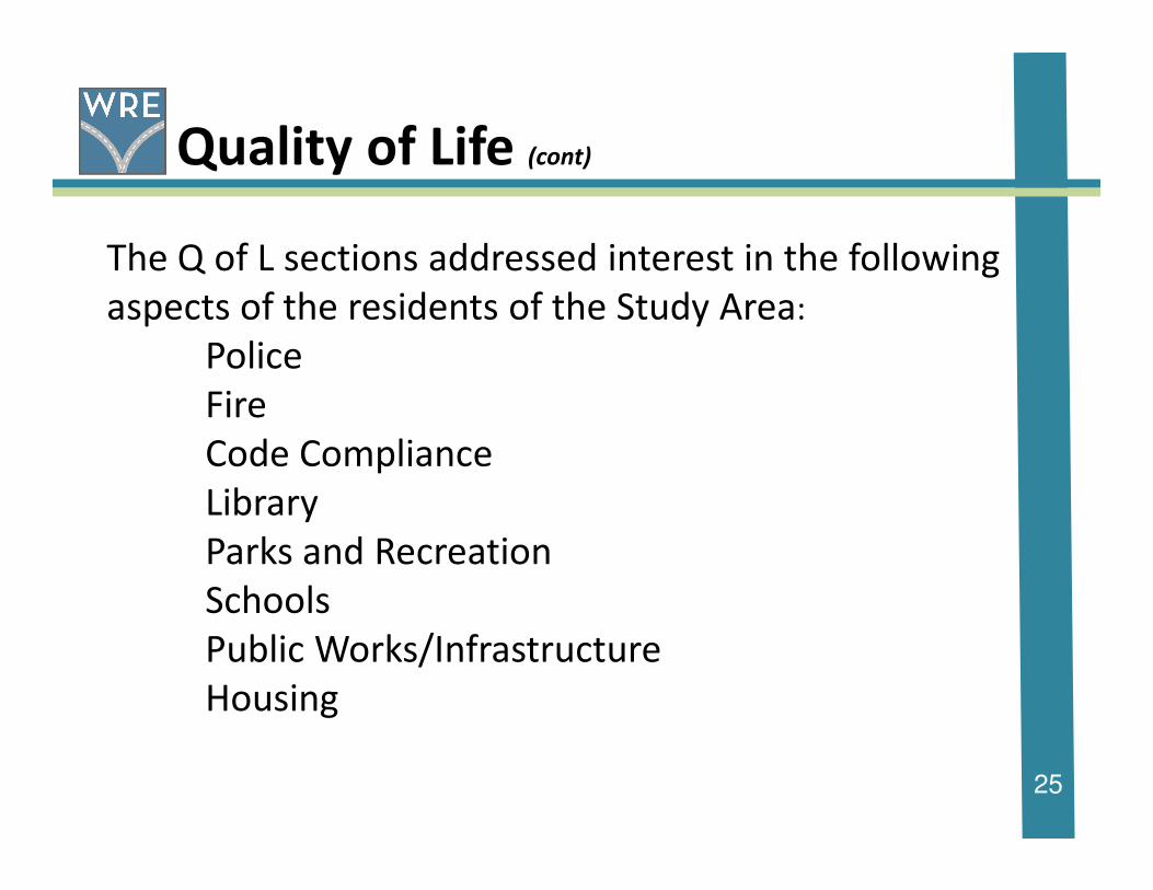
Quality of Life (cont)
The Q of L sections addressed interest in the following
aspects of the residents of the Study Area:
Police
Fire
Code Compliance
25
Code Compliance
Library
Parks and Recreation
Schools
Public Works/Infrastructure
Housing
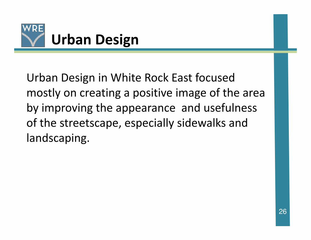
Urban Design
Urban Design in White Rock East focused
mostly on creating a positive image of the area
by improving the appearance and usefulness
of the streetscape, especially sidewalks and
26
of the streetscape, especially sidewalks and
landscaping.

Economic Development
Under construction, but will look at ways to
improve the business environment in the study
area.
27
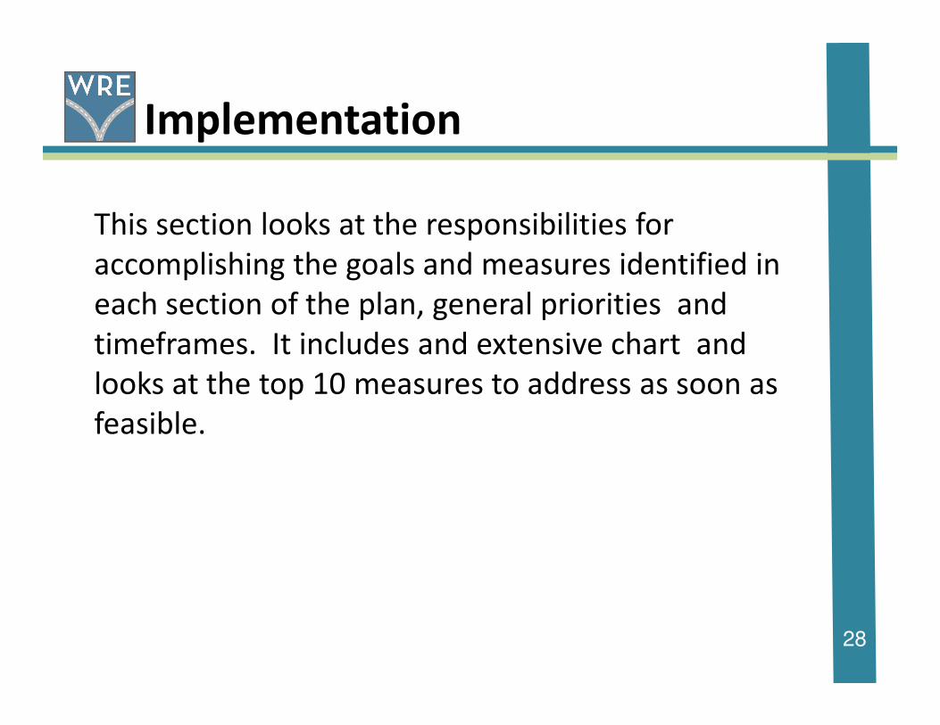
Implementation
This section looks at the responsibilities for
accomplishing the goals and measures identified in
each section of the plan, general priorities and
timeframes. It includes and extensive chart and
looks at the top 10 measures to address as soon as
28
looks at the top 10 measures to address as soon as
feasible.

Implementation (cont)
29

1. Walkability Survey/Sidewalk inventory
2. Improved traffic signalization and crosswalks at Buckner and John West
and Buckner at Peavy
3. Continuous school zone adjacent to Bishop Lynch and Truett Elementary
4. Sidewalk construction on improvements on major streets
5. Consideration of zoning changes in Regional Retail and Limited Office
Implementation (cont)
30
5. Consideration of zoning changes in Regional Retail and Limited Office
districts to revitalize both retail and residential areas.
6. Easier way to have accessory residential units (need better explanation
of use and current process)
7. TxDOT improvements to appearance on Buckner at IH 30
8. Lakeland at Ferguson Streetscape improvements (in current NIL)
9. Petition for stop signs on Gross at Rustown
10.Economic Redevelopment Plan for Buckner beginning with a market study.

Next Steps
� Receive additional input and review
� Finalize plan documents
� Briefing City of Dallas City Plan Commission
� Dallas City Plan Commission submittal for
recommendations to Dallas City Council
31
recommendations to Dallas City Council
� Briefing City of Dallas Quality of Life
Committee
� Briefing at Dallas City Council
� Submittal for Dallas City Council adoption by
resolution
� Get to work on implementation!

Acknowledgements
White Rock East Area Study Advisory Committee
Ellen Childress John Childress
Pat Copeland Gus Garcia
Kerry Goodwin Kimberly Humphries
Georgia King Lauren Roberts
32
Honorable Carolyn R. Davis, City Council District 7
Ferguson Road Initiative
City of DallasSustainable Development and Construction Department
Strategic Planning Division
Vicki Sanger Desi Tanners
Eileen Williams

Thank you!
Please visit our website at:
http://www.2pointstowhiterockeast.com/
Please visit our website at:
And please visit the forwardDallas! and
Ferguson Road Initiative websites at:
http://www.dallascityhall.com/forwardDallas/index.html
http://www.fergusonroad.org/

Agenda
Community Meeting 2
2-Points Area Plan
Saturday, January 30, 2010
10:00 – 12:00
New Hope Community Church
I. Welcome and Introductions
II. Purpose of the Meeting
III. Review of December 5, 2009 meeting and map exercise
IV. Discussion of additions or omissions
V. Review Weed and Seed information
VI. Request for names for stakeholder interviews
VII. Pick three to five specific projects for immediate attention
VIII. Next Steps
Agenda
Community Meeting
2-Points Area Plan
Thursday, April 1, 2010
7:00 to 9:00 PM
I. Welcome and Introductions
II. Purpose of the Meeting
III. Review and Discussion of Land Use and Zoning
IV. Introduction to vision, goals etc. for an Area Plan
V. Next Steps – set dates for future meetings

Agenda
Advisory Committee Meeting
2-Points Area Plan
Saturday, April 24, 2010
10:00 AM to 12:00 Noon
I. Purpose of the Meeting
II. Revisit Area Land Uses and Zoning
III. Look at forwardDallas!, the City’s Comprehensive Plan and its relationship
to 2-Points
IV. Begin discussion of vision, goals, policies, actions etc. for Land Use
V. Next Steps
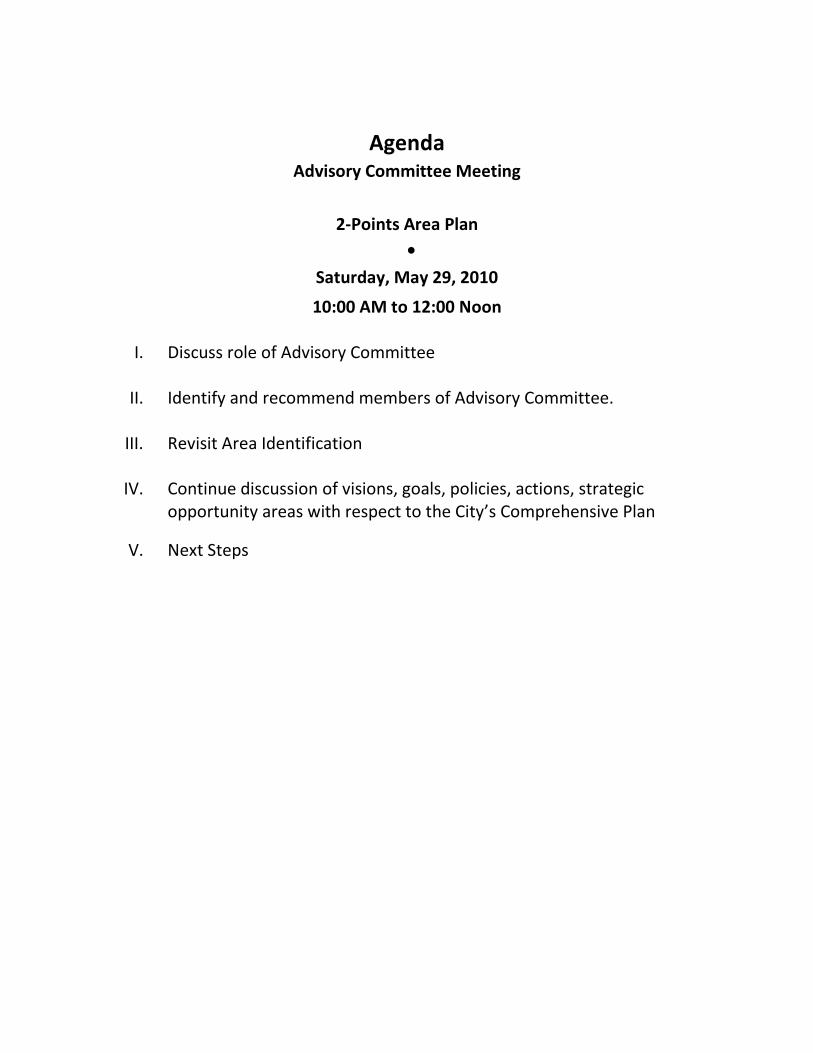
Agenda
Advisory Committee Meeting
2-Points Area Plan
•
Saturday, May 29, 2010
10:00 AM to 12:00 Noon
I. Discuss role of Advisory Committee
II. Identify and recommend members of Advisory Committee.
III. Revisit Area Identification
IV. Continue discussion of visions, goals, policies, actions, strategic
opportunity areas with respect to the City’s Comprehensive Plan
V. Next Steps

Agenda
Advisory Committee Meeting
2-Points Area Plan
Saturday, July 10, 2010
10:00 AM to 12:00 Noon
New Hope Center
2835 Peavy Road
I. Identify and recommend additional members of Advisory Committee.
II. Identify possible stakeholders/property owners in for interviews
III. Revisit Area Identification by identifying locations and names of
neighborhoods
IV. Continue discussion of goals, objectives and actions in strategic
opportunity areas with respect to the City’s Comprehensive Plan
focusing on Transportation.
V. Next Steps:
• Next meeting date: August 28
• Begin thinking about where and when to have the next area
meeting in September, October or early November

Agenda
Advisory Committee Meeting
2-Points Area Plan
Saturday, August 28, 2010
10:00 AM to 12:00 Noon
New Hope Center
2835 Peavy Road
I. Request assistance for stakeholders/property owners interviews
II. Present Introduction
III. Discuss Demographic and Land Use Overview.
IV. Next Steps
V. Set next meeting dates
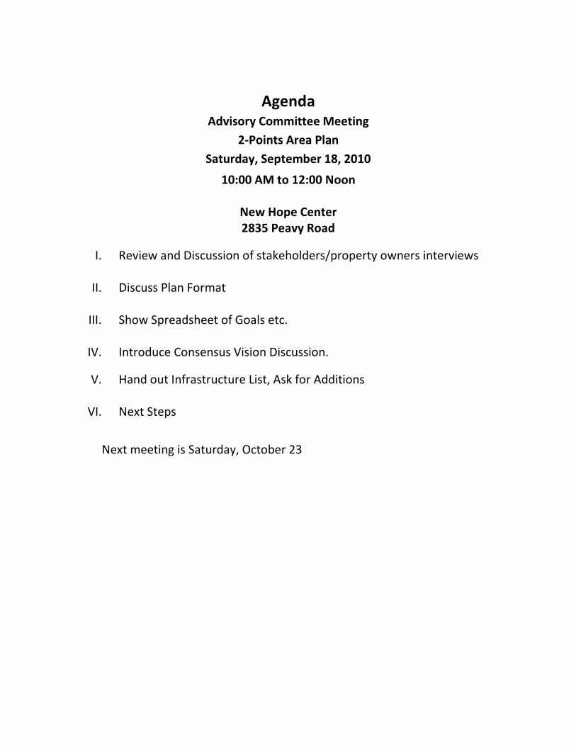
Agenda
Advisory Committee Meeting
2-Points Area Plan
Saturday, September 18, 2010
10:00 AM to 12:00 Noon
New Hope Center
2835 Peavy Road
I. Review and Discussion of stakeholders/property owners interviews
II. Discuss Plan Format
III. Show Spreadsheet of Goals etc.
IV. Introduce Consensus Vision Discussion.
V. Hand out Infrastructure List, Ask for Additions
VI. Next Steps
Next meeting is Saturday, October 23

Agenda
Advisory Committee Meeting
2-Points Area Plan
Saturday, November 13, 2010
10:00 AM to 12:00 Noon
New Hope Center
2835 Peavy Road
I. Report on Meetings with City and DART
II. Discussion Overall Vision Statement
III. Review Land Use Section
IV. Review Transportation Section
V. Discuss Garland Road Corridor Study and How It Relates 2-Points
VI. Next Steps
Next meeting is Saturday, December 11, 2010
Next Community Meeting? January 15, 2011?

Agenda
Advisory Committee Meeting
2-Points Area Plan
Saturday, January 29, 2011
10:30 AM to 12:30 PM
New Hope Center
2835 Peavy Road
I. Discussion of the Draft Plan
II. Reports on continuing work
III. Surprise
IV. Preparation for community meeting on February 26, 2011 at White Rock
Church of Christ
Flyer
Translation of flyer into Spanish
Distribution of Flyer
Where? Schools, Churches, Businesses
Contacts?
How many?
Who will print?
PR for the meeting
FRI
Newspapers
Other
Prep meeting date and time
V. Next steps

Agenda
Advisory Committee Meeting
2-Points Area Plan
Saturday, February 26, 2011
10:30 AM to 12:30 PM
New Hope Center
2835 Peavy Road
I. Presentation – RaceTrac Specific Use Permit (SUP) Wine and Beer Sales
II. Reports on continuing work
III. Preparation for community meeting on March 26, 2011 at White Rock
Church of Christ
Flyer
Translation of flyer into Spanish
Distribution of Flyer
Where/how distribute? Schools, Churches, Businesses
Contacts?
How many flyers?
Who will print?
PR for the meeting
FRI (write up in e-blast)
Newspapers
Other
Prep meeting date and time
IV. Next steps
Community Meeting
Submittal to city staff for review
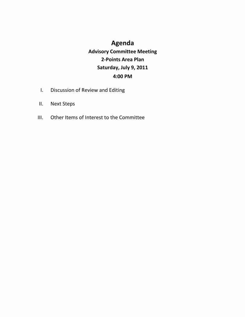
Agenda
Advisory Committee Meeting
2-Points Area Plan
Saturday, July 9, 2011
4:00 PM
I. Discussion of Review and Editing
II. Next Steps
III. Other Items of Interest to the Committee
Agenda
Advisory Committee
2-Points to White Rock East Area Plan
Sunday, March 4, 2012
2:00 PM
I. Purpose of the Meeting
II. Review and Discussion of Action Plan
III. Next Steps
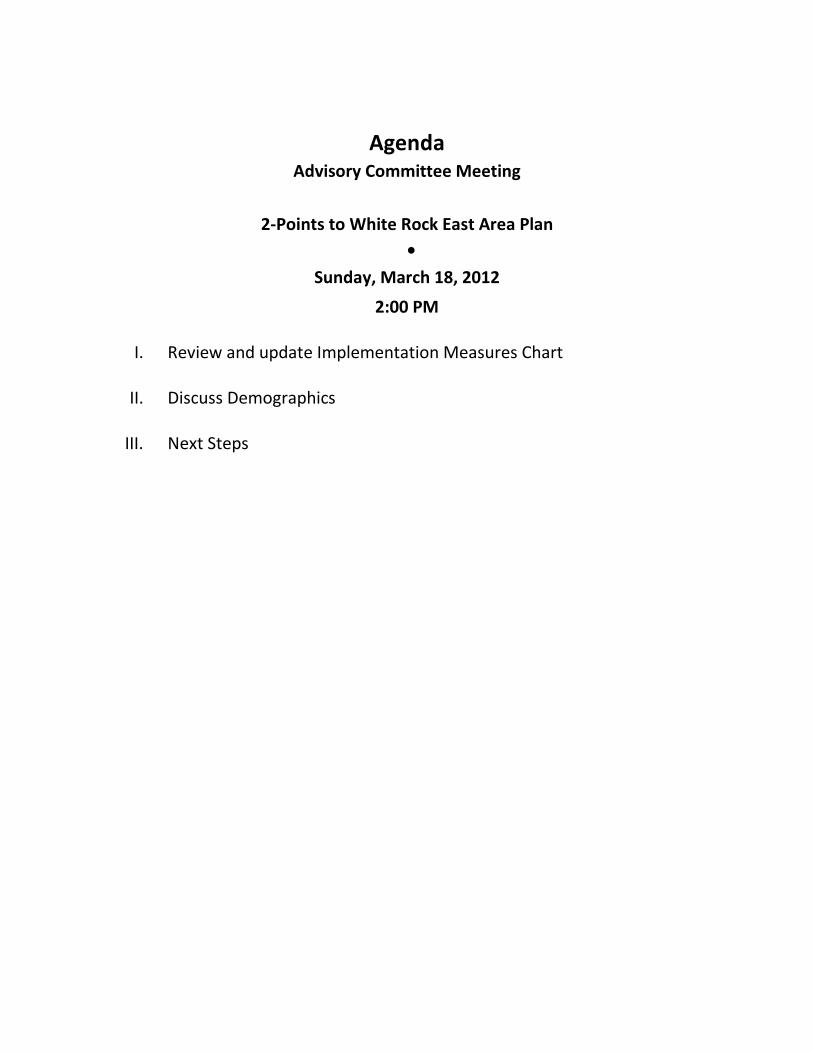
Agenda
Advisory Committee Meeting
2-Points to White Rock East Area Plan
•
Sunday, March 18, 2012
2:00 PM
I. Review and update Implementation Measures Chart
II. Discuss Demographics
III. Next Steps
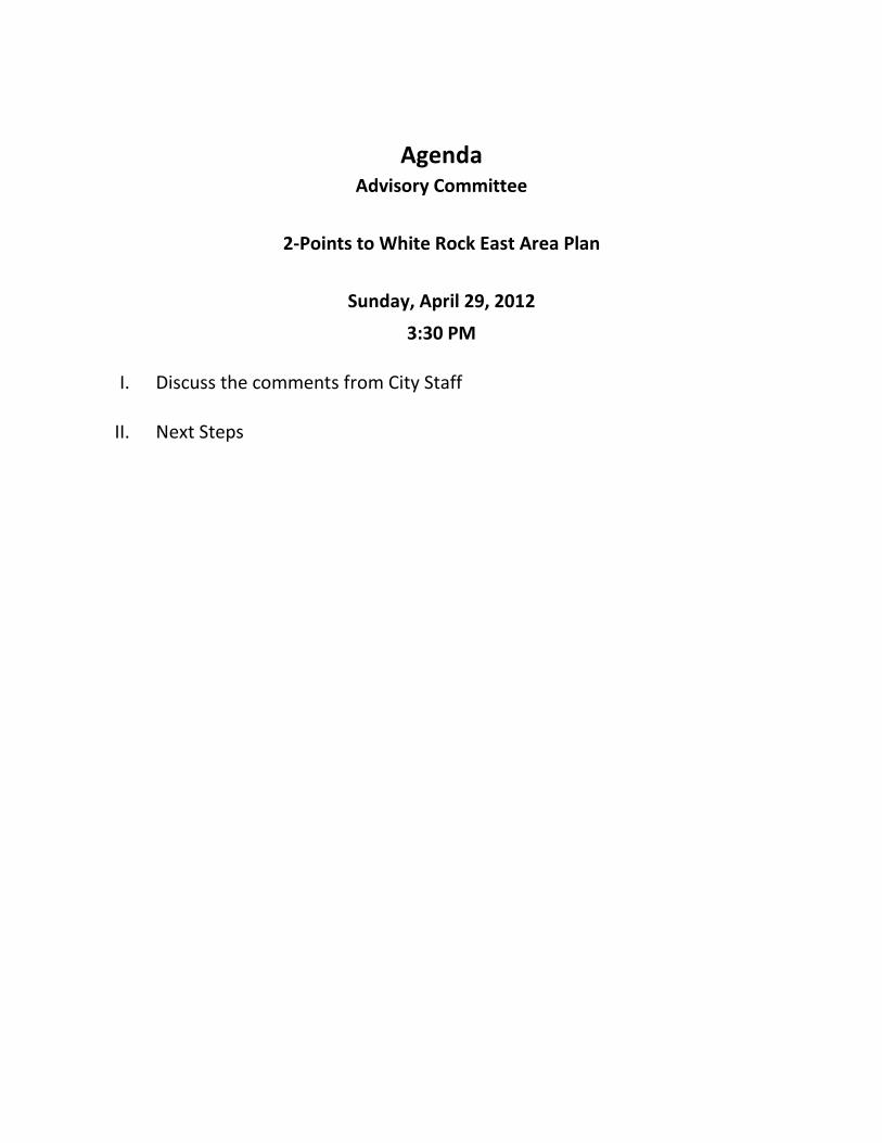
Agenda
Advisory Committee
2-Points to White Rock East Area Plan
Sunday, April 29, 2012
3:30 PM
I. Discuss the comments from City Staff
II. Next Steps
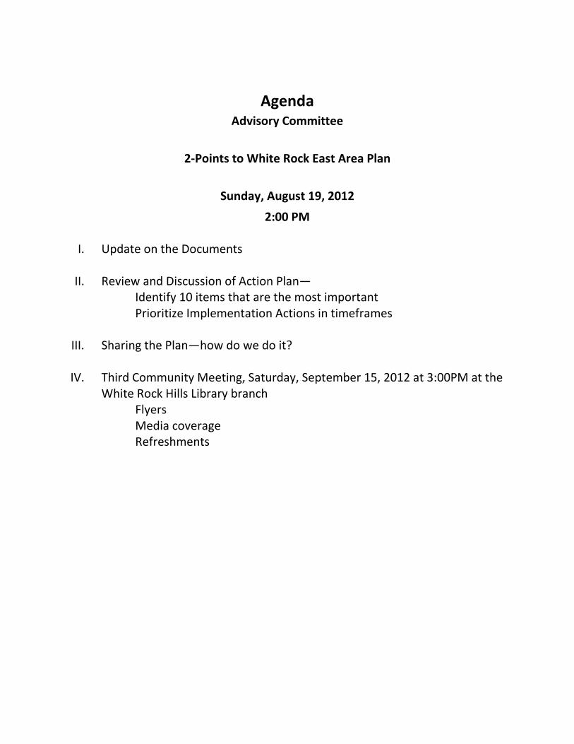
Agenda
Advisory Committee
2-Points to White Rock East Area Plan
Sunday, August 19, 2012
2:00 PM
I. Update on the Documents
II. Review and Discussion of Action Plan—
Identify 10 items that are the most important
Prioritize Implementation Actions in timeframes
III. Sharing the Plan—how do we do it?
IV. Third Community Meeting, Saturday, September 15, 2012 at 3:00PM at the
White Rock Hills Library branch
Flyers
Media coverage
Refreshments
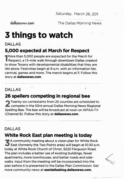
Saturday, March 26, 20n
dallasnews.com- - - --
The Dallas Morning News
3 things to watchDALLAS
5,000 expected at March for Respect
l More than 5,000 people are expected for the March forRespect, a 1.5-mi le walk through downtown Dallas created
to show Texans with developmental disabilities that they arenot alone. Festivities begin at 9 a.m. with an information fair,carnival, games and more. The march beg ins at n. Follow th isstory at dallasnews.com.
DALLAS
26 spellers competing in regional bee
2Twenty-six contestants from 25 counties are scheduled tocompete in the 53rd annual Dallas Morn ing News Regional
Spelling Bee. The bee w ill be broadcast at noon on WFAA-TV(Channel 8). Follow this story at dallasnews.com.
DALLAS
White Rock East plan meeting is today
3 A community meeting about a vision plan for White RockEast (formerly the Two Points area) will begin at 10:30 a.m.
today at White Rock Church of Chr ist, 9220 Ferguson Road.The plan includes a better use of exist ing bu ild ings, fewerapartments, more townhouses, and better roads and side walks. Input from the meeting will be incorporated into theplan before it is presented to the Dallas Plan Commission . Getmo re community news at eastdallasblog.dallasnews.com.
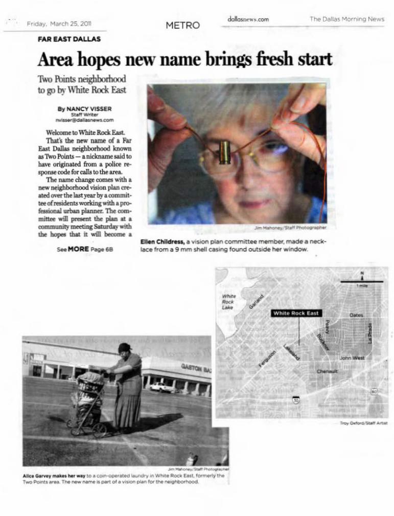
F,oOay. M~,ch 25, 2011 METROcIoIo.nono•.«>m
,AA lAST DIl l! &5
.-r-a-.... . _plMc.........n...... ' obw•..-• .-..IK, from • 9 "'"' ..... CM""il found DUU",," '- .._
. , HANCT VlSU q-,. , .w._
Area hopes new name brings fresh startT....'O 1\Jint<; Ill'igbboriloodto goby White Rock East
W....... Io W]oiteRociEul
ThaI'I tbf """ lIa/1lt uf .. ForEut o.IW~ knownuTwo I'oinu - ..nicl<twntWd 10"""" onpo<<:l fmm .. pol;". ..spo_ <:ode (oreal\s10 the .......
The lWne clwtgecornel with ..lIO'W IWi&bborbood vioioa plan eft
aced ...... the Iutyear by.. """,miIraal-odmts.....mr.c with..pn:o"-ionaI ..n- pIaru>er.n.e ..,..,....m. will pr-..t the pIaa &{ ........m.,. uweliac s.cunlaJ withtho~ IbaI iI will~ ..
s.. MOAE "-68
•,
I,
.-
-
... ' --
wM. R.,.. h.'=- /
.._._____ _ to.o.--__,"'w_RgdtMt,__r .' .............. _01 ...__ _..,.. ..... _ • • d

68 F,oday. March ] 5. XIIMETRO
I,
•,,-
--I
......".- lbe_datdoo b IXW>buo t. ."jnow~dn,.,.~Inand maktdUJwo 'hat doo' 6tout .....0. WId wiliIo.,.," o,ll_-...Somdoj'o ....-niI)'..-;'"WI1I tq;n al)O:3O lUll.al Wh_ RorkC!owdlala.n..\1220~ Ibd. lnpodrmm tho! mmingwill ht inoof..pnIlld. into the planbri<n it it
p_ -.t ... tIoo o.a.. """~n - ' . , -.I ~, l'rln
dle(1)-Co.",]1b< y,10itIP R.d bot pIaa it
inlmded tol*nd 'Orith theaI&nd Road V.. ion. .micb .....adopud~thoCit)' CowldI thio
~ and. the """zu.- Ro.Ilnitiatiwk pion b ~K.-i and -breo-e-.\ "....
Villi Martin, b<>ard I'f"IIi-,."""'""-'- dent for W ftorgu_ Road Ini
tiotive, prailtd W """' of w1b ....... 1M -Wo..-~ .......,' m;n..,.
Iload'. It . - _' . doe 1"" oj". wbicb _ ~0..po..;..:c_.......t~~ • ......wwith..n-~to 'A'hib:Rod. r-." Il<Jbnt ro.;...am..._~_cha". h~b "1'ho IJIDd ~ it Ihal
....ofthean. ·I _ : hlprm:- th<Te'o &oi"l! 10 ht • comproimityto tho:.,., th lidPofWhiIi hrnsive~' klf thl: nut 20Rod. .. am oWr ..... ,..... IioIIII will"""'" OUI fil 1M
ij;li• • boeodo.. CDInmIiIiiIy."~ __Odocr _ tJIooI by Iat-
....anthl:..,-_........jor nn..r-..; IIoe JO..rninu!I'd""" 10<Iowntuom; the slur<!)'brid """- (indod'" tomI'l -&" 01 by ordoM:t Oill"Work.a o&.rtby.--.... _ n- De.......w,.ndtitpart.".~
ISO. Bishop~ H;,;h,. . pn.vm CatIooIi<odI<>:>l, ..... lieI inWhi~ Rod< r-.
l.1iildrr. noIlcI IioIIII .....btcMo an d '" '"..,. )IlJIDII .
... f -an-qin.
T1oth<¥" tIial_~and~t willlIbofa,.".\\'hi~ Rode f.-t.
~.........nw~pIon .............---. -.:0If000:tthinp.• bI1Iof _ <Le>:ialin& bWIdiJllll, r..." 4*_ .... _
-ruoo.-. pot~ parb, hikI.......and <:rtlrk Ul.i1J, and better roadsa>dl ido-waIb.
-=
W"" . R",, " h"
/--~
GO&OOCommunIty~1"9
....,,""'" pi.-> Ie<W""'. Roc.E..' (I.,. .......... 'haTwc Poon.._)_~.. I:).50.m
s....-. _ iIloct<Ctud>dO"""' \Q20 r .. g . iIlOaOlG__d ..... -.OOIO__.a-_~"""'_c:om.
Childresa ,.;(I .be joinod •handful fil oIl...-rosidmtt ln ....,;.m,themn..WIld:l pt<JCfthI.after bor""- _ bwz\ariIodill 2006. Ila:i thea, • ~bit) beWpmlifto al ......and'-lDDI'1lin&' 9 mm WIl.,..i"ll ",·os bu>d outside underher bedroom window. Shelunwd it into • -+J.ao _ •.,...,tdallMtfir;ht.
,..,. booal.nI drilkd • boIrin iI, • I put II""' • dlai Itold (Cky C<JunoiI )Camlm Davis that I wooJd..-r it until I didn~ heat I(IIn",. ...ymo:w," Mid Childn.,
'"'" l:tOdits DIrvia ",;m hripialcoddr..tJ>otp ...
"Wt otiIl ., i . ' ..... boll iI~ bft,a al a.a .....montha. I haven' I..t it on in .Jon,; I;me,"Child.-said.
More than just a new name
KUido "'"~ projoao .....du~, •
....'hRP Rtrl EaoI .. """"'It.numb.,. fil ,..;pbomooocbal"'ll~_Road th.t_~ in !he I950s tl:>oupIDo 19?00 _Id<ftd __t- do:a,. "'",i" ......o...c..,. Ioou_ "'"oeallcl to !he stun!); &ford.abIt MIl-. And thty _ tho!.. . oign that ~ neir;hbnrhoodtwill........~
WbiwRtrl EMt, ....-.t~ • INrIIbot fil ......Ioto....... in IDo J-rt filfar EIIIl o.n. _~ Ilutk.... Boulnan:l CUIi -=- r~lI>lnlerola~30.
1 1t".....<iIM""'&l- .......... _~w..-d\aI.--A f iplioq ""' 1M __
mi1sooft .....t.itlo """'" tbol.ilueknfto Boulnan:l .. 'inodwith &«i"ll mmrn=ial~indll5tlial u-. autotnoJtive .............__....1Ildi-.....IT ......1 I _ I.«aI. .....
- ,-uowdod. ""icI -hood ............. ania tbart""PPY.~ c:hoia""'" limited, and tJ>m, is • dil .pI'O(l<lI'1iona p<aerIO! fil aim;'naI a<1Mtj<"n. ........
~filttwmn..pt ...........
~ PIJinlI --nmc)'OIl """" II>bear DrI tJ>ot poIioo.,.,...... for poI~ oaIJs. You'dbcar 'CllIl= down at """'f'bintt.. II .... '*lname. .....IDo ,",*,,--Ibd," Aid~a aI -...irIeo __
b.,. '"'" the nu.a AftlICrime Wa/dl. "Wt <kcio:II'd !hatp.u1 fil bringi"ll thit ...,. up..... "" P'l ~ l'mln that nidr......... Ow '"'" boodiOllPOid38~"

WHITE ROCK LAKE WEEKLY PAGE 5
FRI making headway with neighborhood plansBy Brooks Powell
East Dallas' FergusonRoad Initiative has reachedanother major milestone in itsl3-year history. In the comingweeks, community leaderswill present a redevelopmentplan for the 2-Points neighborhood, now called WhiteRock East , to the Dallas CityPlan Commission . The planincludes recommendations forfuture economic developmentand improving transportation,land use and quality of life inthe area.
Saturday morning, March26 , a group of approximately100 residents representing 35community and neighborhoodassociations in the area met toreview the plan and provide
final feedback before it is sentbefore the Plan Commission. .
The White Rock Eastcommittee met over thecourse of the last year todetermine the best means toovercome a number of obsta- c1es facing the neighborhood,including deteriorating infrastructure, underperformingschools, crime , suboptimalzoning , aesthetics concernsrelated to aging properties andshuttered businesses, and alack of services like grocerystores and restaurants.
Kerry Goodwin, "Weedand Seed" coordinator forthe Ferguson Road Initiative, which coordinated the2-Points committee, saideducation is a major concern.Truett Elementary, a Dallas
ISD school in the neighborhood , is at 200 percentcapacity and has 36 portableclassrooms on site , Goodwinsaid-evidence that sweepingchange s are needed .
"Part of this committee 'sfunction was to tell DISD thatthis is not acceptable," saidGoodwin.vYou have to planbetter to serve the children inour neighborhood," -
The White Rock Eastplan will address future permits for multi-family housingin the area so that the numberof residents will be balancedwith the number of spacesavailable in classrooms .
2-Point s, the name givenby Dallas Police to the area
see FRI on page 8
<
~-/"'........
FRI cont'd from.page 5
surrounding the intersectionsof Bucker Blvd ., Peavy Rd.and Ferguson Rd., is part ofthe Ferguson Road Initiative , a 501(c)3 organizationfounded in 1998 dedicated tothe "complete restoration" of .the White Rock Hills community, according to its website .
Crime has been significantly reduced in the areathrough a series of so-called"weed and seed" grants fromthe U.S. Dept: of Justice . Aportion of the funds providesmore law enforcement officersto address street crime andviolent crime, drug sales andgang activity . Sixty percentof the federal funds providedin the White Rock East areago toward additional officersand enforcement efforts. Asa result, in the last 10 years ,violent crime has dropped 61percent, and overall crime hasdropped 25 percent.
Now that crime is downand the area is safer , theplan , which has receivedunanimously support from 'residents, will tell city staff
APRIL 1 - 7, 20 11
and administrators what kindsof deve lopment they want toreturn to the area .
Goodwin said in addi- .' tion to Dallas lSD , partnersin the Ferguson Road Initia
. tive include the Texas Dept .of Transportation , which
. oversees construction andmaintenance at Bucker Blvd.,
. and DART, which providespublic transportation. Councilmembers Sheffie Kadaneand Carolyn Davis have alsobeen instrumental in helpingto guide planning and proposeways the city can assist.
The Ferguson RoadInitiative is also celebratingthe groundbreaking of the firstpublic library in the area. Thefacility will include i 8,000square feet of books, studyspace and classrooms andwill cost approximately $8million . Land for a recreationcenter has also been acquired.
Goodwin said the newfacilities will be welcomeadditions and are a testamentto the positive outlook for thearea. "The city is taking noteof the fact that the neighborhood is demanding change ,"Goodw in said.'
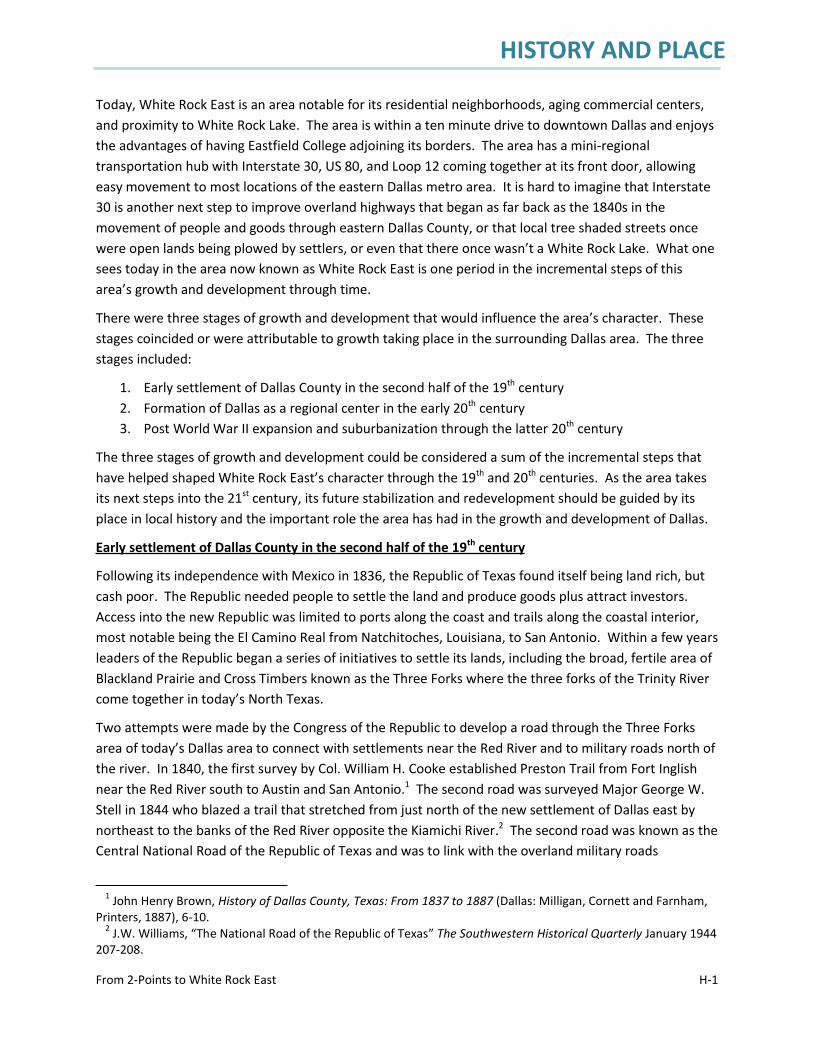
HISTORY AND PLACE
From 2-Points to White Rock East H-1
Today, White Rock East is an area notable for its residential neighborhoods, aging commercial centers,and proximity to White Rock Lake. The area is within a ten minute drive to downtown Dallas and enjoysthe advantages of having Eastfield College adjoining its borders. The area has a mini-regionaltransportation hub with Interstate 30, US 80, and Loop 12 coming together at its front door, allowingeasy movement to most locations of the eastern Dallas metro area. It is hard to imagine that Interstate30 is another next step to improve overland highways that began as far back as the 1840s in themovement of people and goods through eastern Dallas County, or that local tree shaded streets oncewere open lands being plowed by settlers, or even that there once wasn’t a White Rock Lake. What onesees today in the area now known as White Rock East is one period in the incremental steps of thisarea’s growth and development through time.
There were three stages of growth and development that would influence the area’s character. Thesestages coincided or were attributable to growth taking place in the surrounding Dallas area. The threestages included:
1. Early settlement of Dallas County in the second half of the 19th century2. Formation of Dallas as a regional center in the early 20th century3. Post World War II expansion and suburbanization through the latter 20th century
The three stages of growth and development could be considered a sum of the incremental steps thathave helped shaped White Rock East’s character through the 19th and 20th centuries. As the area takesits next steps into the 21st century, its future stabilization and redevelopment should be guided by itsplace in local history and the important role the area has had in the growth and development of Dallas.
Early settlement of Dallas County in the second half of the 19th century
Following its independence with Mexico in 1836, the Republic of Texas found itself being land rich, butcash poor. The Republic needed people to settle the land and produce goods plus attract investors.Access into the new Republic was limited to ports along the coast and trails along the coastal interior,most notable being the El Camino Real from Natchitoches, Louisiana, to San Antonio. Within a few yearsleaders of the Republic began a series of initiatives to settle its lands, including the broad, fertile area ofBlackland Prairie and Cross Timbers known as the Three Forks where the three forks of the Trinity Rivercome together in today’s North Texas.
Two attempts were made by the Congress of the Republic to develop a road through the Three Forksarea of today’s Dallas area to connect with settlements near the Red River and to military roads north ofthe river. In 1840, the first survey by Col. William H. Cooke established Preston Trail from Fort Inglishnear the Red River south to Austin and San Antonio.1 The second road was surveyed Major George W.Stell in 1844 who blazed a trail that stretched from just north of the new settlement of Dallas east bynortheast to the banks of the Red River opposite the Kiamichi River.2 The second road was known as theCentral National Road of the Republic of Texas and was to link with the overland military roads
1 John Henry Brown, History of Dallas County, Texas: From 1837 to 1887 (Dallas: Milligan, Cornett and Farnham,Printers, 1887), 6-10.
2 J.W. Williams, “The National Road of the Republic of Texas” The Southwestern Historical Quarterly January 1944207-208.
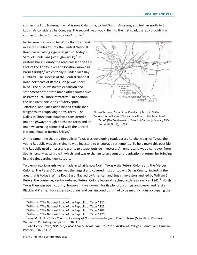
HISTORY AND PLACE
From 2-Points to White Rock East H-2
connecting Fort Towson, in what is now Oklahoma, to Fort Smith, Arkansas, and further north to St.Louis. As considered by Congress, the second road would tie into the first road; thereby providing aconnection from St. Louis to San Antonio.3
In the area that would be White Rock East andin eastern Dallas County the Central NationalRoad passed along a general path of today’sSamuell Boulevard (old Highway 80).4 Ineastern Dallas County the road crossed the EastFork of the Trinity River at a location known asBarnes Bridge,5 which today is under Lake RayHubbard. The success of the Central NationalRoad northeast of Barnes Bridge was short-lived. The quick westward expansion andsettlement of the state made other routes suchas Preston Trail more attractive.6 In addition,the Red River port cities of Shreveport,Jefferson, and Port Caddo helped establishedfreight routes supplying North Texas. TheDallas to Shreveport Road was considered amajor highway through northeast Texas and itsmain western leg connected with the CentralNational Road at Barnes Bridge.7
At the same time that the Republic of Texas was developing roads across northern part of Texas, theyoung Republic was also trying to woo investors to encourage settlements. To help make this possiblethe Republic used empresario grants to attract outside investors. An empresario was a carryover fromSpanish and Mexican rule in which land was exchange to an agent or organization in return for bringingin and safeguarding new settlers.
Two empresario grants were made in what is now North Texas – the Peters’ Colony and the MercerColony. The Peters’ Colony was the largest and covered most of today’s Dallas County, including thearea that is today’s White Rock East. Backed by American and English investors and led by William S.Peters, the Louisville, Kentucky-based Peters’ Colony began attracting settlers as early as 1841.8 NorthTexas then was open country; however, it was known for its plentiful springs and creeks and fertileBlackland Prairie. For settlers to obtain land certain conditions had to be met, including occupying the
3 Williams, “The National Road of the Republic of Texas” 220.4 Williams, “The National Road of the Republic of Texas” 222.5 Williams, “The National Road of the Republic of Texas” 209.6 Williams, “The National Road of the Republic of Texas” 220.7 Jerry M. Flook, Forney Country: A History of Northwestern Kaufman County, Texas (Marceline, Missouri:
Walsworth Publishing Company, 1998), 33.8 John Henry Brown, History of Dallas County, Texas: From 1837 to 1887 (Dallas: Milligan, Cornett and Farnham,
Printers, 1887), 14-15.
Central National Road of the Republic of Texas in DallasSource: J.W. Williams, “The National Road of the Republic of
Texas” (The Southwestern Historical Quarterly, January 1944,Vol. XLVII, No. 3), p. 219.
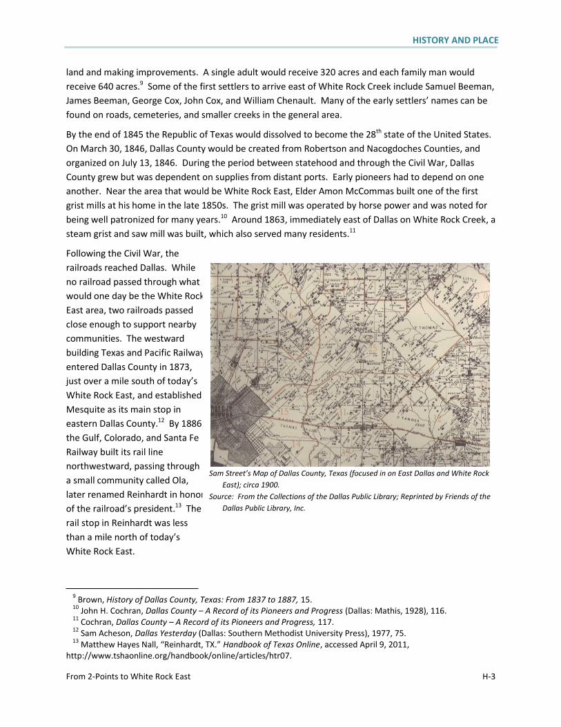
HISTORY AND PLACE
From 2-Points to White Rock East H-3
land and making improvements. A single adult would receive 320 acres and each family man wouldreceive 640 acres.9 Some of the first settlers to arrive east of White Rock Creek include Samuel Beeman,James Beeman, George Cox, John Cox, and William Chenault. Many of the early settlers’ names can befound on roads, cemeteries, and smaller creeks in the general area.
By the end of 1845 the Republic of Texas would dissolved to become the 28th state of the United States.On March 30, 1846, Dallas County would be created from Robertson and Nacogdoches Counties, andorganized on July 13, 1846. During the period between statehood and through the Civil War, DallasCounty grew but was dependent on supplies from distant ports. Early pioneers had to depend on oneanother. Near the area that would be White Rock East, Elder Amon McCommas built one of the firstgrist mills at his home in the late 1850s. The grist mill was operated by horse power and was noted forbeing well patronized for many years.10 Around 1863, immediately east of Dallas on White Rock Creek, asteam grist and saw mill was built, which also served many residents.11
Following the Civil War, therailroads reached Dallas. Whileno railroad passed through whatwould one day be the White RockEast area, two railroads passedclose enough to support nearbycommunities. The westwardbuilding Texas and Pacific Railwayentered Dallas County in 1873,just over a mile south of today’sWhite Rock East, and establishedMesquite as its main stop ineastern Dallas County.12 By 1886the Gulf, Colorado, and Santa FeRailway built its rail linenorthwestward, passing througha small community called Ola,later renamed Reinhardt in honorof the railroad’s president.13 Therail stop in Reinhardt was lessthan a mile north of today’sWhite Rock East.
9 Brown, History of Dallas County, Texas: From 1837 to 1887, 15.10 John H. Cochran, Dallas County – A Record of its Pioneers and Progress (Dallas: Mathis, 1928), 116.11 Cochran, Dallas County – A Record of its Pioneers and Progress, 117.12 Sam Acheson, Dallas Yesterday (Dallas: Southern Methodist University Press), 1977, 75.13 Matthew Hayes Nall, “Reinhardt, TX.” Handbook of Texas Online, accessed April 9, 2011,
http://www.tshaonline.org/handbook/online/articles/htr07.
Sam Street’s Map of Dallas County, Texas (focused in on East Dallas and White RockEast); circa 1900.
Source: From the Collections of the Dallas Public Library; Reprinted by Friends of theDallas Public Library, Inc.
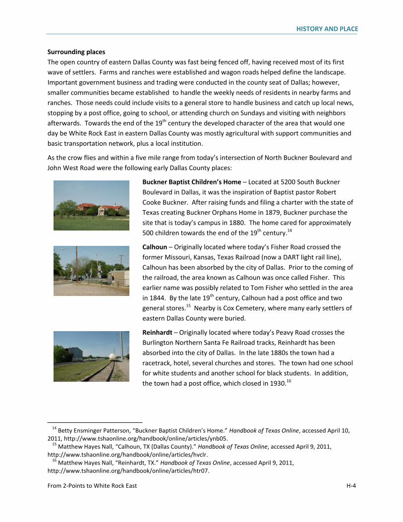
HISTORY AND PLACE
From 2-Points to White Rock East H-4
Surrounding placesThe open country of eastern Dallas County was fast being fenced off, having received most of its firstwave of settlers. Farms and ranches were established and wagon roads helped define the landscape.Important government business and trading were conducted in the county seat of Dallas; however,smaller communities became established to handle the weekly needs of residents in nearby farms andranches. Those needs could include visits to a general store to handle business and catch up local news,stopping by a post office, going to school, or attending church on Sundays and visiting with neighborsafterwards. Towards the end of the 19th century the developed character of the area that would oneday be White Rock East in eastern Dallas County was mostly agricultural with support communities andbasic transportation network, plus a local institution.
As the crow flies and within a five mile range from today’s intersection of North Buckner Boulevard andJohn West Road were the following early Dallas County places:
Buckner Baptist Children’s Home – Located at 5200 South BucknerBoulevard in Dallas, it was the inspiration of Baptist pastor RobertCooke Buckner. After raising funds and filing a charter with the state ofTexas creating Buckner Orphans Home in 1879, Buckner purchase thesite that is today’s campus in 1880. The home cared for approximately500 children towards the end of the 19th century.14
Calhoun – Originally located where today’s Fisher Road crossed theformer Missouri, Kansas, Texas Railroad (now a DART light rail line),Calhoun has been absorbed by the city of Dallas. Prior to the coming ofthe railroad, the area known as Calhoun was once called Fisher. Thisearlier name was possibly related to Tom Fisher who settled in the areain 1844. By the late 19th century, Calhoun had a post office and twogeneral stores.15 Nearby is Cox Cemetery, where many early settlers ofeastern Dallas County were buried.
Reinhardt – Originally located where today’s Peavy Road crosses theBurlington Northern Santa Fe Railroad tracks, Reinhardt has beenabsorbed into the city of Dallas. In the late 1880s the town had aracetrack, hotel, several churches and stores. The town had one schoolfor white students and another school for black students. In addition,the town had a post office, which closed in 1930.16
14 Betty Ensminger Patterson, “Buckner Baptist Children’s Home.” Handbook of Texas Online, accessed April 10,2011, http://www.tshaonline.org/handbook/online/articles/ynb05.
15 Matthew Hayes Nall, “Calhoun, TX (Dallas County).” Handbook of Texas Online, accessed April 9, 2011,http://www.tshaonline.org/handbook/online/articles/hvclr.
16 Matthew Hayes Nall, “Reinhardt, TX.” Handbook of Texas Online, accessed April 9, 2011,http://www.tshaonline.org/handbook/online/articles/htr07.
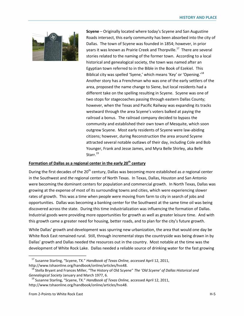
HISTORY AND PLACE
From 2-Points to White Rock East H-5
Scyene – Originally located where today’s Scyene and San AugustineRoads intersect, this early community has been absorbed into the city ofDallas. The town of Scyene was founded in 1854; however, in prioryears it was known as Prairie Creek and Thorpville.17 There are severalstories related to the naming of the former town. According to a localhistorical and genealogical society, the town was named after anEgyptian town referred to in the Bible in the Book of Ezekiel. ThisBiblical city was spelled ‘Syene,’ which means ‘Key’ or ‘Opening.’18
Another story has a Frenchman who was one of the early settlers of thearea, proposed the name change to Siene, but local residents had adifferent take on the spelling resulting in Scyene. Scyene was one oftwo stops for stagecoaches passing through eastern Dallas County;however, when the Texas and Pacific Railway was expanding its trackswestward through the area Scyene’s voters balked at paying therailroad a bonus. The railroad company decided to bypass thecommunity and established their own town of Mesquite, which soonoutgrew Scyene. Most early residents of Scyene were law-abidingcitizens; however, during Reconstruction the area around Scyeneattracted several notable outlaws of their day, including Cole and BobYounger, Frank and Jesse James, and Myra Belle Shirley, aka BelleStarr.19
Formation of Dallas as a regional center in the early 20th century
During the first decades of the 20th century, Dallas was becoming more established as a regional centerin the Southwest and the regional center of North Texas. In Texas, Dallas, Houston and San Antoniowere becoming the dominant centers for population and commercial growth. In North Texas, Dallas wasgrowing at the expense of most of its surrounding towns and cities, which were experiencing slowerrates of growth. This was a time when people were moving from farm to city in search of jobs andopportunities. Dallas was becoming a banking center for the Southwest at the same time oil was beingdiscovered across the state. During this time industrialization was influencing the formation of Dallas.Industrial goods were providing more opportunities for growth as well as greater leisure time. And withthis growth came a greater need for housing, better roads, and to plan for the city’s future growth.
While Dallas’ growth and development was spurring new urbanization, the area that would one day beWhite Rock East remained rural. Still, through incremental steps the countryside was being drawn in byDallas’ growth and Dallas needed the resources out in the country. Most notable at the time was thedevelopment of White Rock Lake. Dallas needed a reliable source of drinking water for the fast growing
17 Susanne Starling, “Scyene, TX.” Handbook of Texas Online, accessed April 12, 2011,http://www.tshaonline.org/handbook/online/articles/hvs48.
18 Stella Bryant and Frances Miller, “The History of Old Scyene” The ‘Old Scyene’ of Dallas Historical andGenealogical Society January and March 1977, 6.
19 Susanne Starling, “Scyene, TX.” Handbook of Texas Online, accessed April 12, 2011,http://www.tshaonline.org/handbook/online/articles/hvs48.
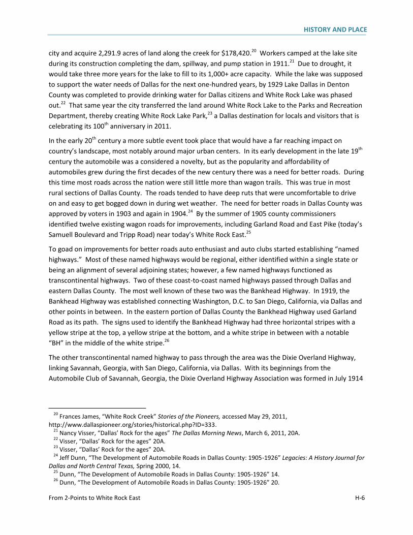
HISTORY AND PLACE
From 2-Points to White Rock East H-6
city and acquire 2,291.9 acres of land along the creek for $178,420.20 Workers camped at the lake siteduring its construction completing the dam, spillway, and pump station in 1911.21 Due to drought, itwould take three more years for the lake to fill to its 1,000+ acre capacity. While the lake was supposedto support the water needs of Dallas for the next one-hundred years, by 1929 Lake Dallas in DentonCounty was completed to provide drinking water for Dallas citizens and White Rock Lake was phasedout.22 That same year the city transferred the land around White Rock Lake to the Parks and RecreationDepartment, thereby creating White Rock Lake Park,23 a Dallas destination for locals and visitors that iscelebrating its 100th anniversary in 2011.
In the early 20th century a more subtle event took place that would have a far reaching impact oncountry’s landscape, most notably around major urban centers. In its early development in the late 19th
century the automobile was a considered a novelty, but as the popularity and affordability ofautomobiles grew during the first decades of the new century there was a need for better roads. Duringthis time most roads across the nation were still little more than wagon trails. This was true in mostrural sections of Dallas County. The roads tended to have deep ruts that were uncomfortable to driveon and easy to get bogged down in during wet weather. The need for better roads in Dallas County wasapproved by voters in 1903 and again in 1904.24 By the summer of 1905 county commissionersidentified twelve existing wagon roads for improvements, including Garland Road and East Pike (today’sSamuell Boulevard and Tripp Road) near today’s White Rock East.25
To goad on improvements for better roads auto enthusiast and auto clubs started establishing “namedhighways.” Most of these named highways would be regional, either identified within a single state orbeing an alignment of several adjoining states; however, a few named highways functioned astranscontinental highways. Two of these coast-to-coast named highways passed through Dallas andeastern Dallas County. The most well known of these two was the Bankhead Highway. In 1919, theBankhead Highway was established connecting Washington, D.C. to San Diego, California, via Dallas andother points in between. In the eastern portion of Dallas County the Bankhead Highway used GarlandRoad as its path. The signs used to identify the Bankhead Highway had three horizontal stripes with ayellow stripe at the top, a yellow stripe at the bottom, and a white stripe in between with a notable“BH” in the middle of the white stripe.26
The other transcontinental named highway to pass through the area was the Dixie Overland Highway,linking Savannah, Georgia, with San Diego, California, via Dallas. With its beginnings from theAutomobile Club of Savannah, Georgia, the Dixie Overland Highway Association was formed in July 1914
20 Frances James, “White Rock Creek” Stories of the Pioneers, accessed May 29, 2011,http://www.dallaspioneer.org/stories/historical.php?ID=333.
21 Nancy Visser, “Dallas’ Rock for the ages” The Dallas Morning News, March 6, 2011, 20A.22 Visser, “Dallas’ Rock for the ages” 20A.23 Visser, “Dallas’ Rock for the ages” 20A.24 Jeff Dunn, “The Development of Automobile Roads in Dallas County: 1905-1926” Legacies: A History Journal for
Dallas and North Central Texas, Spring 2000, 14.25 Dunn, “The Development of Automobile Roads in Dallas County: 1905-1926” 14.26 Dunn, “The Development of Automobile Roads in Dallas County: 1905-1926” 20.

HISTORY AND PLACE
From 2-Points to White Rock East H-7
that identified a year-round, ocean to ocean highway.27 The Dixie Overland Highway entered easternDallas County from Forney following the East Pike into the city of Dallas. The highway’s signs featured ablue border with red letters “DOH” centered on a white background.28 By 1926 named highways werebeing replaced by a United States Numbered Highways. The Dixie Overland Highway was one of the fewnamed highways to evolve into the US highway network, with most of the route being today’s US 80.29
Improvements to the local road network and the growing popularity of the automobile helped foster inthe development of suburbs, further expanding Dallas outward. A 1930 map of Dallas showed severalresidential neighborhood streets expanding eastward pass White Rock Creek, including Forest Hills,Parkdale, and what is called today the Peninsula in Lake Highlands.30 Eight years later a transit map ofthe city showed the initial streets that are part of today’s Little Forest Hills and Casa Linda Estates.31
Post World War II expansion and suburbanization through the latter 20th century
Dallas, like the rest of the nation, was caught up in the events of World War II during the first half of the1940s. The years following the war brought with it rapid growth and development in the Dallas area.What would one day be today’s White Rock East experienced some of the greatest changes in itslandscape and character. The first phase of developments were not urban or suburban, but wereconsidered desirable at the periphery of the city due to noise issues and the need for large, inexpensivetracts of land. These early developments also took advantage of the area’s expanding transportationnetwork that allowed them to be outside the city’s bedroom communities but within easy drivingdistance. An overlapping second phase of developments was more suburban in character, withresidential neighborhoods, schools, and shopping centers.
List below are first phase notable developments that influenced today’s White Rock East:
White Rock Airport – Located at what would be the southeast corner of Lakeland Drive-JohnWest Road and Hunnicut Road, the airport was started in 1941 with a sod runway.32 Betweenthe old airport and North Buckner Boulevard was the former Buckner Boulevard Drive-In. Overthe next thirty years the airport was improved with an asphalt north-south runway, a grassrunway, and several airplane hangars. During the late 1960s and early 1970s the airport sitewas getting too valuable to serve as an airport and several attempts were made to get it zonedfor higher density apartments and duplexes. Sometime during the mid-1970s theairport eventually did closed and the former airport site was turned into White Rock Village – a
27 Richard F. Weingroff, “U.S. Route 80 The Dixie Overland Highway” Highway History, U.S. Department ofTransportation, Federal Highway Administration, accessed June 2, 2011,http://www.fhwa.dot.gov/infrastructure/us80.cfm
28 Jeff Dunn, “The Development of Automobile Roads in Dallas County: 1905-1926” Legacies: A History Journal forDallas and North Central Texas, Spring 2000, 21.
29 Richard F. Weingroff, “U.S. Route 80 The Dixie Overland Highway” Highway History, U.S. Department ofTransportation, Federal Highway Administration, accessed June 2, 2011,http://www.fhwa.dot.gov/infrastructure/us80.cfm
30 Map of Dallas – 1930 (Dallas: M.H. West, January 1, 1930), From the Collections of the Dallas Public Library.31 Map 8, Dallas – 1938, From the Collections of the Dallas Public Library.32 Polly Sherwood, “Cotton Patch Landing is Birth of Airport” Dallas Time Herald” December 6, 1944, 13.

HISTORY AND PLACE
From 2-Points to White Rock East H-8
single family housing development by house builder Fox &Jacobs.33 Many of the streets in White Rock Village reflectnames in aviation, including Cessna, Grumman, O’Hare,Lindbergh, Sikorski, and Rickenbacker.Buckner Boulevard Drive-In – Located at 3333 North BucknerBoulevard, the Buckner Boulevard Drive-In opened June 1948and closed sometime during the early 1980s.34 The drive-intheater, notable for its circus clown face on the back of theoutdoor screen, had a capacity for approximately 400 cars.The site for the former Buckner Boulevard Drive-In has nowbeen redeveloped into a mini-warehouse establishment.
Devil’s Bowl Speedway – Opened in 1949, the original dirtracetrack was located near the Buckner Boulevard Drive-Inand White Rock Airport north of John West Road.35 The earlycircle dirt track was notable for its modified jalopys, noise,and flying dust. In 1968 the Devil’s Bowl Speedway moved toits current location on Lawson Road in Mesquite.
Wintergarden Ballroom – Located at 1616 John West Road,the building that used to house the Wintergarden Ballroomnow serves as a storage structure. The building was built inthe late 1960s and used to feature named rock groups. While December 6, 1944, “The Dallas Times
some sources indicate that the entertainment venue closingin the late 1970s, Cole Directory indicates its existence into1987.36
Extending beyond the first phase developments are several noteworthy second phase developmentsthat still define White Rock East’s character. These include the following:
Interstate 30 – Interstate 30 is a 367 mile long route stretching from North Little Rock, Arkansas,on the east to Interstate 20 west of Fort Worth. The general path of Interstate 30 follows aparallels path with US 67 between Little Rock and Dallas. During the 1950s US 67 was improvedto a twin highway from east of Dallas (at Samuell Boulevard at Jim Miller Road) to Rockwall andlater upgraded to Interstate standards during the early 1960s. Between downtown Dallas andMesquite the freeway referred to as East R.L. Thornton Freeway. The section betweendowntown Dallas and Loop 12 (North Buckner Boulevard) is eight-lanes plus an HOV lane. Thissection is planned to be reconstructed under the Eastern Gateway project to 12 lanes by 2020.
33 Fox & Jacobs advertisement, Dallas Times Herald, May 22, 1977, p. H-3.34 “Interstate Theater Collection” accessed June 2, 2011,
http://www.dallaslibrary2.org/texas/archives/07701.html.35 Devil’s Bowl Speedway, accessed April 6, 2011, http://www.devilsbowl.com/HISTORY.html36 1987-88 Cole Director for Dallas and Suburbs, Cole Publications, 1987, .
Herald” story about the earlybeginnings of White Rock Airportin 1941 (Dallas Public Library).

HISTORY AND PLACE
From 2-Points to White Rock East H-9
George W. Truett Elementary School – Located at 1811 Gross Road, the school was opened in1957 to serve the new residential neighborhoods being built nearby. Part of the DallasIndependent School District (DISD), Truett Elementary serves pre-kindergarten through fifthgrades. The school is name in honor of Dr. George Washington Truett, who began his ministryat First Baptist Church in Dallas and serve as its pastor for 47 years.37
Big Town Shopping Center –Proclaimed the ‘City ofShops’ in a 34-pagenewspaper sectiondedicated to the new mall,the 600,000 square-foot BigTown Shopping Center wasthe first enclosed, air-conditioned shopping mall inthe Southwest.38 Developedby Gerri Von Frellick ofDenver, the 77-acre retailcenter with 7,000 parkingspaces represented Dallas’emerging suburbanlifestyle.39 Despite its claimto fame, the last anchortenant closed in the early2000s and the mall was torndown several years later.The mall has since beendemolished. It was locatedat 800 Big Town ShoppingCenter, southeast of US 80and North BucknerBoulevard and within thebuffer area surroundingWhite Rock East.
Bishop Lynch High School –Located at 9750 FergusonRoad, Bishop Lynch High
37 George W. Truett Elementary School, Dallas Independent School District, accessed May 31, 2011,http://www.dallasisd.org/schools/realtor_new.cfm?id_con=156.
38 “City of Shops – Big Town Offering New Idea” Dallas Times Herald, February 25, 1959, Section 2-E.39 “City of Shops – Big Town Offering New Idea” Section 2-E.
February 25, 1959, “Dallas Times Herald” 34-page spread about the opening ofBig Town Shopping Center (Dallas Public Library).

HISTORY AND PLACE
From 2-Points to White Rock East H-10
School opened in 1963 with less than 400 students. The school now has over 1,000 students ingrades nine through twelve. Founded by the Dominican Order in the Roman Catholic Diocese ofDallas, this co-educational Catholic high school is named in honor of Joseph Patrick Lynch, whoserved as Bishop of Dallas from 1911 until his death in 1954. Bishop Lynch remains the longest-serving Catholic bishop in the United States.40
S.S. Conner Elementary School – Located at 3037 Greenmeadow Drive, S.S. Conner ElementarySchool is part of the DISD. Conner Elementary, which opened in 1965, serves pre-kindergartenthrough fifth grades. The school is name in honor of Samuel Sherman Conner,41 a successfulPleasant Grove businessman, land owner, and promoter of education for all who served thecommunity until he died at 80 in 1946. In the DISD’s history three schools have been named inhis honor – a high school, a middle school, and today’s elementary school in White Rock East.42
Eastfield College – One of seven colleges that make up the Dallas County Community CollegeDistrict, Eastfield College opened on September 14, 1970 to serve eastern Dallas, Mesquite, andGarland.43 At one time the college campus was identified as the site for the Casa View CountryClub.44 The main campus’ address is 3737 Motley Drive in Mesquite; however, the college alsohas a western entrance fronting White Rock East on La Prada Drive. Eastfield College providesacademic, occupational, technical, and continuing education opportunities to enhance students’learning achievement. Eastfield College also has a Pleasant Grove satellite campus.
During Dallas’ Post World War II suburban expansion, several neighborhood subdivisions and shoppingcenters that make up today’s White Rock East as well as those nearby were developed. These includedthe following (approximate years):
White Rock East (shopping centers and community services in italics)1955-1957 – Cloverdale1955 – Casa Terrace1961-1962 – Eastwood1963-1964 - Crestview1968 – Hillview Terrace1972 – Safeway (turned bingo hall) at the northeast corner of North Buckner Boulevard at John West
Road1974 – Buckner Plaza at the northeast corner of North Buckner Boulevard at John West Road1976 – White Rock Village1977 – East Town at the northwest corner of North Buckner Boulevard at John West Road1979 – US Post Office at Ferguson Road and Lakeland Drive1984-1985 – Westglen Shopping Center at Ferguson Road and Lakeland Drive
40 “Bishop Lynch, 81, Dies; Rites Set” The Dallas Morning News, August 19, 1954, 1.41 S.S. Conner Elementary School, Dallas Independent School District, accessed May 31, 2011,
http://www.dallasisd.org/schools/realtor_new.cfm?id_con=136.42 S.S. Conner Elementary School43 “On-Time Opening Slated for Two Junior Colleges” The Dallas Morning News September 10, 1970, 2A.44 City of Dallas, Department of City Planning and Department of Parks & Recreation, Parks & Open Spaces –
Dallas Metropolitan Area: A Master Plan Report (Dallas: City of Dallas, April 1959) 99.

HISTORY AND PLACE
From 2-Points to White Rock East H-11
1985 – Towne Market at the southeast corner of North Buckner Boulevard at John West Road2006 – Light Pointe Place
Areas surrounding White Rock East (shopping centers in italics)1946 – Casa Linda Shopping Center at North Buckner Boulevard and Garland Road1948 – Lakeland Terrace1953-1956 – Casa View Oaks1954 – Peavy Park1954 – Casa View Heights1954-1955 – Westglen Park1955 – Casa View Crest1955 – Shiloh Park1955-1959 (+ recent developments) – Casa View Shopping Center at Ferguson Road at Gus
Thomasson Road1956 – Oates Plaza1956-1957 – Crest View Park
Neighborhood subdivisions in White Rock East.

HISTORY AND PLACE
From 2-Points to White Rock East H-12
1957 – Ferguson Village at the northeast corner of Ferguson Road at Oates Drive1957-1958 – Ferguson Heights1957-1965 – Claremont1961-1962 – Claremont Park1961-1962 – Hillridge1962-1963 - Crestview1963-1979 – Buckner Terrace1963-1965 – Lindenwood Park
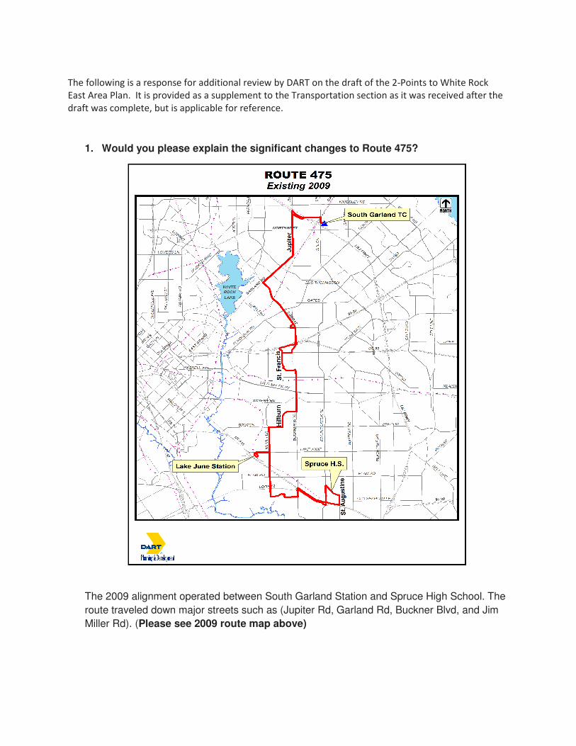
The following is a response for additional review by DART on the draft of the 2-Points to White Rock
East Area Plan. It is provided as a supplement to the Transportation section as it was received after the
draft was complete, but is applicable for reference.
1. Would you please explain the significant changes to Route 475?
The 2009 alignment operated between South Garland Station and Spruce High School. The
route traveled down major streets such as (Jupiter Rd, Garland Rd, Buckner Blvd, and Jim
Miller Rd). (Please see 2009 route map above)
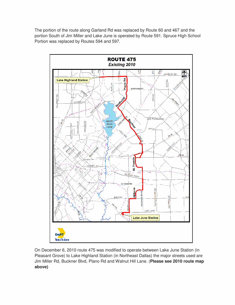
The portion of the route along Garland Rd was replaced by Route 60 and 467 and the
portion South of Jim Miller and Lake June is operated by Route 591. Spruce High School
Portion was replaced by Routes 594 and 597.
On December 6, 2010 route 475 was modified to operate between Lake June Station (in
Pleasant Grove) to Lake Highland Station (in Northeast Dallas) the major streets used are
Jim Miller Rd, Buckner Blvd, Plano Rd and Walnut Hill Lane. (Please see 2010 route map
above)

2. Does the new Route 467 exactly replace 466, if not what is the route?
(The above map represents the 2009 alignment before 2010 changes).
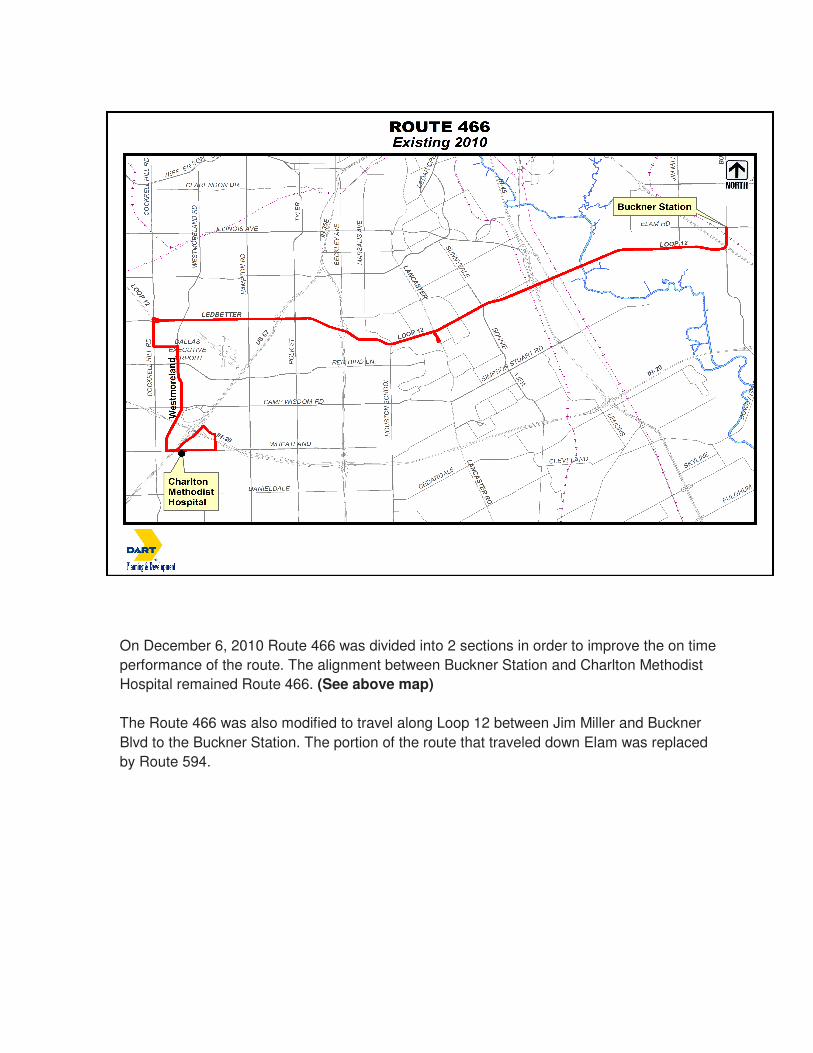
On December 6, 2010 Route 466 was divided into 2 sections in order to improve the on time
performance of the route. The alignment between Buckner Station and Charlton Methodist
Hospital remained Route 466. (See above map)
The Route 466 was also modified to travel along Loop 12 between Jim Miller and Buckner
Blvd to the Buckner Station. The portion of the route that traveled down Elam was replaced
by Route 594.

The alignment between Buckner Station and South Garland Transit Center became Route
467. The portion that went to White Rock Station along Buckner Blvd between Garland Rd
and Northwest Hwy was discontinued due to low ridership on that section. (See above map)

3. Can you share the proposed changes to Route 110?
(The above map represents the 2010 alignment before 2012 changes).

On July 30, 2012 all trips on Route 110 were modified to serve over IH-30 Frwy/HOV Lane to Ferguson Road and continue its regular alignment to East Field College. This route no longer goes to Fair Park, along East Grand or to the Culver/Winslow area. Each trip on Route 111 now does that. (See above map)
4. Is there an easy map of these routes that you could send so that we can make our map show the latest?
I have attached the 2009 maps and 2010 maps for comparison for Route 466 and 475. Route 110 maps are for 2011 and 2012. The latest maps for Route 466, 467, & 475 are for 2010 and the latest map for Route 110 is 2012. Please let me know if you have any additional questions or need clarification concerning my responses. Thanks.