2.0 esri software evolution
TRANSCRIPT

System Design Strategies J-6017
2.0 ESRI Software Evolution For more than 33 years, ESRI has continued to develop evolving GIS software technology supporting functional requirements identified by the GIS user community. ESRI software developers leverage the latest computer hardware and software technology to maintain ESRI leadership in the GIS marketplace. ESRI aligns its resources to provide the best software and services available to support GIS customer needs. This section provides an overview of ESRI software and associated product technologies. Understanding the primary role for each member of the ESRI software family will help users identify current application needs and provide a clear vision for migration to a successful enterprise GIS solution. Figure 2-1 provides an overview of the ESRI software history and the associated third party technologies supporting effective GIS enterprise evolution.
Figure 2-1 GIS Enterprise Evolution
Desktop ViewersQuery and Analysis
Project ResearchAd Hoc MappingGeneral Operations
ArcView GISArcView GIS19921992
Shapefiles
Desktop ViewersQuery and Analysis
Project ResearchAd Hoc MappingGeneral Operations
ArcView GISArcView GIS19921992
Shapefiles
ArcInfoArcInfo19821982
GIS DepartmentProfessional
Data DevelopmentData MaintenanceGIS ProjectsMap Production
ArcInfo Coverage/Librarian
Local Area NetworksGIS File Servers
ArcInfoArcInfo19821982
GIS DepartmentProfessional
Data DevelopmentData MaintenanceGIS ProjectsMap Production
ArcInfo Coverage/Librarian
ArcInfoArcInfo19821982
GIS DepartmentProfessional
Data DevelopmentData MaintenanceGIS ProjectsMap Production
ArcInfo Coverage/Librarian
Local Area NetworksGIS File Servers
MapObjectsMapObjectsArcInfo ODEArcInfo ODE
19961996
DistributedOperations
Specific OperationsWork ManagementDelivery RoutingEmergency ResponseEmbedded Applications
ArcStormArcStorm
MapObjectsMapObjectsArcInfo ODEArcInfo ODE
19961996
DistributedOperations
Specific OperationsWork ManagementDelivery RoutingEmergency ResponseEmbedded Applications
ArcStormArcStormSpatial Database EngineSpatial Database Engine
19971997
XX--EmulationEmulationWindows Terminal ClientsWindows Terminal Clients
Wide Area Networks
Application ServersTerminal Servers
Remote Users
XX--EmulationEmulationWindows Terminal ClientsWindows Terminal Clients
Wide Area Networks
Application ServersTerminal Servers
Remote Users
XX--EmulationEmulationWindows Terminal ClientsWindows Terminal Clients
Wide Area Networks
Application ServersTerminal Servers
Remote Users
Spatial Database EngineSpatial Database Engine19971997
InternetGIS Operations
ArcView IMSArcView IMSMapObjects IMSMapObjects IMS
InternetMap Products
Map ServersWeb Servers
ArcIMSArcIMS19971997
Data PublishingData Integration
InternetGIS Operations
ArcView IMSArcView IMSMapObjects IMSMapObjects IMS
InternetMap Products
Map ServersWeb Servers
ArcIMSArcIMS19971997
Data PublishingData Integration
ArcView IMSArcView IMSMapObjects IMSMapObjects IMS
InternetMap Products
Map ServersWeb Servers
ArcView IMSArcView IMSMapObjects IMSMapObjects IMS
InternetMap Products
ArcView IMSArcView IMSMapObjects IMSMapObjects IMS
InternetMap Products
Map ServersWeb Servers
ArcIMSArcIMS19971997
Data PublishingData Integration
ArcIMSArcIMS19971997
Data PublishingData Integration
ArcGIS 9ArcGIS 9-- ArcEngine ArcEngine -- ArcGIS ServerArcGIS Server
20042004
DistributedGeodatabase
ArcGIS 9ArcGIS 9-- ArcEngine ArcEngine -- ArcGIS ServerArcGIS Server
20042004
DistributedGeodatabase
ArcSDEArcSDE19991999
Desktop InterfaceEnterprise GISPersonal GISQuery / Analysis
ArcGIS DesktopArcGIS Desktop-- ArcInfo 1999ArcInfo 1999-- ArcEditor 2000ArcEditor 2000-- ArcViewArcView
Intelligent Data
Enterprise GIS Operations
ArcSDEArcSDE19991999
Desktop InterfaceEnterprise GISPersonal GISQuery / Analysis
ArcGIS DesktopArcGIS Desktop-- ArcInfo 1999ArcInfo 1999-- ArcEditor 2000ArcEditor 2000-- ArcViewArcView
Intelligent Data
Enterprise GIS Operations
Geography NetworkGeography Network
FederatedGIS Operations
Web Search EnginesCollaborative Operations Mapping ServicesWeb Commerce
Web Data Sources
Geography NetworkGeography Network
FederatedGIS Operations
Web Search EnginesCollaborative Operations Mapping ServicesWeb Commerce
Web Data Sources
Many ESRI customers have developed effective enterprise solutions with the Workstation ARC/INFO® and ArcView® GIS software provided in the 1990s. The new ArcGIS® software provides operational capabilities that were not available with the older technology. Many ESRI customers are in the process of migrating their data and applications from the old file-based technology to the current ArcGIS object-based geodatabase architecture. New customers are supporting enterprise GIS solutions directly with the ArcGIS software technology.
ESRI Technical Reference Document 2-1

System Design Strategies 2.0 ESRI Software Evolution J-6017
2.1 ESRI GIS Software Environment The traditional environment for GIS applications is on the user desktop. ESRI desktop applications include ArcInfo®, ArcEditor™, ArcView, and custom applications developed using MapObjects® or ArcGIS Engine software. ArcInfo 8 deployed ArcInfo Workstation and ArcGIS Desktop software integrated with ArcSDE® geodatabase. ArcGIS 9 further deploys ArcObjects™ technology in ArcGIS Server and ArcGIS Engine software. Web mapping services can provide GIS information products and geoprocessing services for use by every user desktop through standard Web browser clients.
Figure 2-2 GIS Workstations/Services
ArcInfo GIS Workstation ArcInfoSpatial Data DevelopmentSpatial Data MaintenanceSpatial Data ConversionGIS ProjectsMap Production
UNIXand
Windows
ArcInfo GIS Workstation ArcInfoSpatial Data DevelopmentSpatial Data MaintenanceSpatial Data ConversionGIS ProjectsMap Production
UNIXand
Windows
ArcView 3.xArcView GIS ApplicationsQuery and AnalysisAd Hoc MappingGeneral Operations
UNIXand
Windows
ArcView 3.xArcView GIS ApplicationsQuery and AnalysisAd Hoc MappingGeneral Operations
UNIXand
Windows
MapObjects ApplicationsEmbedded ApplicationsSpecific OperationsWork ManagementDelivery RoutingEmergency Response
MapObjects
MicrosoftWindows
MapObjects ApplicationsEmbedded ApplicationsSpecific OperationsWork ManagementDelivery RoutingEmergency Response
MapObjects
MicrosoftWindows
ArcIMS Web Geo-Publishing-Maps-Data-MetaDataGeography Network
Web Map Services
UNIXand
Windows
ArcIMS Web Geo-Publishing-Maps-Data-MetaDataGeography Network
Web Map Services
UNIXand
Windows
ArcGIS Desktop• ArcInfo• ArcEditor • ArcViewArcMapArcCatalogArcToolboxGeoDatabase
Windows
ArcGIS Desktop• ArcInfo• ArcEditor • ArcViewArcMapArcCatalogArcToolboxGeoDatabase
Windows
MapObjects JavaEmbedded Java ApplicationsJavaBean Mapping Components ArcIMS ConnectivityArcGIS Engine (Windows)Controls, Objects, Tools
Windowsand
UNIX
MapObjects JavaEmbedded Java ApplicationsJavaBean Mapping Components ArcIMS ConnectivityArcGIS Engine (Windows)Controls, Objects, Tools
Windowsand
UNIXArcGIS Server Shared Object Server-Web Services-Web Applications-Client/Server
Windowsand
UNIX
ArcGIS Server Shared Object Server-Web Services-Web Applications-Client/Server
Windowsand
UNIX
2.1.1 ESRI ArcGIS Software
ArcGIS Desktop Software. ArcGIS is a scalable family of software comprising a complete geographic information system, built on industry standards, that is rich in functionality, and works out of the box. Organizations deploy the software of ArcGIS—ArcView, ArcEditor, ArcInfo, ArcSDE, ArcIMS, and ArcGIS Server—in a configuration appropriate for their needs.
ArcGIS is used for the creation, management, integration, analysis, display, and dissemination of spatial data and geoprocessing services. Strong visualization, editing, and analysis, along with advanced data management, distinguish the ArcGIS software family as the leading GIS software.
ESRI Technical Reference Document 2-2

System Design Strategies 2.0 ESRI Software Evolution J-6017
ArcInfo. ArcInfo is the complete GIS data creation, update, query, mapping, and analysis system. Professionals use ArcInfo for spatial data automation since it includes the most comprehensive collection of GIS tools available. As part of the ArcGIS software family, ArcInfo includes all the functionality of ArcView and ArcEditor and adds the advanced geoprocessing and data conversion capabilities that make it the de facto standard for GIS. ArcEditor. ArcEditor is a state-of-the-art GIS data visualization, query, and creation solution. Designed for the Windows desktop, ArcEditor can create and edit spatial data in an ArcSDE geodatabase. As part of the ArcGIS software family, ArcEditor contains all the capabilities users find in ArcView while adding capabilities for managing geodatabase schema and advanced editing of geodatabases. ArcView. ArcView is the world's most popular desktop GIS and mapping software, with more than 500,000 copies in use worldwide. ArcView provides geographic data visualization, query, analysis, and integration capabilities along with the ability to create and edit geographic data. ArcView is designed with an easy-to-use, Windows-like user interface and includes VBA for customization. ArcView consists of three desktop applications: ArcMap™, ArcCatalog™, and ArcToolbox™. ArcMap provides data display, query, and analysis. ArcCatalog provides geographic and tabular data management, creation, and organization. ArcToolbox provides basic data conversion. ArcGIS Engine. ArcGIS Engine provides an ArcObjects developer framework for custom application development. With ArcGIS Engine, developers can incorporate full ArcObjects functionality within their application environment. This is an optimum programming environment for developers who wish to incorporate current GIS technology in their Windows or Linux applications.
ArcSDE Database Software. ArcSDE is the tool that allows you to store and manage
spatial data in your chosen DBMS. ArcSDE is open; it works with a variety of different databases—including Oracle, Informix, IBM DB2, and Microsoft SQL Server—that scale from work groups to large enterprise databases.
ArcSDE plays a fundamental role in a multi-user GIS. With ArcSDE, your ArcGIS software (ArcInfo, ArcEditor, ArcView, and ArcIMS) can work directly with spatial data managed in your DBMS.
GIS Web Services. Two levels of software technology are available to deploy GIS on
the Web. ArcIMS provides optimum performance and scalability for standard data publishing and simpler Web services. ArcGIS Server provides a development environment for deployment of ArcGIS Web applications and services that require use of ArcObjects technology.
ESRI Technical Reference Document 2-3
System Design Strategies 2.0 ESRI Software Evolution J-6017
ArcIMS Web Services. ArcIMS software is the foundation for distributing GIS data and applications on the Internet. By providing a common platform for exchanging and sharing GIS resources, ArcIMS provides unique opportunities to leverage data from within the organization and to integrate information from other agencies. Key features of ArcIMS include data integration, standards-based communication, the Internet-enabling technology for ArcGIS, easy-to-use framework, a multi-tier architecture, support for a wide range of clients, highly scalable server architecture, and a wide range of GIS capabilities. ArcIMS supports Windows and UNIX platforms. ArcGIS Server Web Services. ArcGIS Server software provides the full complement of ArcGIS ArcObjects for deployment on the Web. ArcGIS Server was initially deployed with the ArcGIS 9 software release. ArcGIS Server is supported on Windows and UNIX platforms.
2.1.2 ESRI Legacy GIS Software
ArcInfo Workstation. ArcInfo Workstation provides an exhaustive set of GIS tools representing over 33 years of software development effort, making this product the leading GIS professional software available today. ArcInfo Workstation includes a full set of tools to support spatial data development, maintenance, and conversion activities. For many users, this has been the primary software used by GIS professionals to support geographic studies, analysis, and map production. ArcInfo Workstation is supported on both UNIX and Windows workstations. Most all of the traditional ArcInfo Workstation technology is now supported in the new ArcGIS desktop environment.
ArcView 3. ArcView 3 is a user-friendly desktop GIS software, initially developed to
support a growing population of query and analysis users within the ArcInfo community. ArcView is able to directly read ArcInfo coverages and to store spatial views in a new GIS shapefile data format. ArcView quickly became very popular, significantly expanding the number of GIS users. It was not long before the number of ArcView users outnumbered ArcInfo users. GIS professionals continue to use ArcInfo to create and maintain spatial data resources and to support high-technology spatial analysis and map products. ArcView provides a simple GIS data access tool supporting general office query and analysis functions and producing simple ad hoc map products. A variety of ArcView extensions have been developed since the initial ArcView release to support the needs of the growing desktop user market, and ArcView is now the leading desktop application throughout the GIS community. ArcView 3 is supported on Microsoft Windows and UNIX platforms.
MapObjects. MapObjects was developed using new Microsoft programming standards
for Windows environments. ESRI took advantage of this new object-oriented environment with the release of MapObjects software. With MapObjects, developers can include map products within standard Microsoft application environments. This opened a new world of product opportunities and spawned rapid expansion of the ESRI developer community. MapObjects became a new standard for incorporating GIS in vertical market product solutions. MapObjects is able to read and display ArcInfo coverages, ArcInfo
ESRI Technical Reference Document 2-4
System Design Strategies 2.0 ESRI Software Evolution J-6017
LIBRARIAN files, shapefiles, and Spatial Database Engine™ (ArcSDE) layers data sources. This is an optimum programming environment to support custom GIS Windows-based applications.
MapObjects Java provides JavaBean mapping components to support Java programmers.
ArcInfo LIBRARIAN. As the number of GIS users increase, software management tools are needed to support data maintenance operations. Users update features on a spatial coverage by copying the layer to memory on their workstation and making the appropriate changes, then replacing the updated layer on the GIS data server. Conflicts can occur when multiple users are responsible for updating data on the same layers.
ArcInfo includes a LIBRARIAN database management module that provides a controlled multi-user data maintenance environment and supports more efficient management of spatial data resources. ArcInfo LIBRARIAN is a file-based storage solution that provides a continuous tile structure for all data layers on the GIS data server within a single database environment. Users are able to extract individual tiles within a coverage for editing, and the associated tiles within ArcInfo LIBRARIAN are "write locked" to avoid data changes during the update process. Once editing is complete, the updated tile is returned to the ArcInfo LIBRARIAN database and the associated tile is released for other users to update. ArcInfo LIBRARIAN provides an effective and simple way for several people to maintain and manage large continuous GIS data libraries.
ArcStorm Data Server. Large enterprise GIS operations identified a need for enhanced transaction management of ArcInfo spatial data resources. ArcStorm™ software satisfies this need by providing feature-level transaction management, transaction history, and commit logic to support large GIS operational environments. ArcStorm includes several server processes that support transaction management and check-in/checkout processing. An ArcStorm weather service daemon manages the ArcStorm data files and generates additional processes as required for user transactions. ArcInfo provides functions to support maintenance of the ArcStorm libraries. ArcView is able to directly read ArcStorm data using standard NFS protocol (CIFS for Windows servers). Client workstation processes support all read operations. ArcSDE replaces ArcStorm for ArcGIS technology.
2.2 Organizational GIS Evolution GIS implementations grew in size and complexity throughout the 1990s. GIS started on the user desktops and evolved to support GIS operations with department-level file servers. A majority of the GIS community is currently supported by department-level GIS architectures. Figure 2-3 provides an overview of a department-level GIS architecture.
ESRI Technical Reference Document 2-5

System Design Strategies 2.0 ESRI Software Evolution J-6017
Figure 2-3 Departmental GIS
Department File ServersDepartment File ServersDepartment File Servers
LANLAN
GIS UserGIS User
GIS UserGIS User
GIS UserGIS UserGIS UserGIS User
GIS UserGIS UserGIS UserGIS User
As GIS within a typical organization evolved over time, several departments would have local GIS operations which require data resources from other departments within the organization. The organizational wide area network (WAN) became a way of sharing data between department servers. Data standardization and integrity issues would surface within the organization, since data was developed and managed from different department-level sources. The initial Spatial Database Engine (SDE®) release in the mid 1990s supported enterprise data warehouse operations, and many organizations combined department GIS data resources on a central ArcSDE data warehouse. GIS staff were established within IT departments to integrate enterprise-wide GIS data resouces within the data warehouse providing integrated data standards across the organization. The common data warehouse provided a reliable shared GIS data source for departments throughout the organization. This was a very common migration path for local government GIS operations.
ESRI Technical Reference Document 2-6

System Design Strategies 2.0 ESRI Software Evolution J-6017
Figure 2-4 provides an overview of organizational architecture alternatives.
Figure 2-4 Organizational GIS
Department File Servers
Distributed Client/ServerDepartmental GIS
Parks
Utilities
Arc Desktops
Assessor
Department File Servers
Distributed Client/ServerDepartmental GIS
Parks
Utilities
Arc Desktops
Assessor
Distributed Client/ServerDepartmental GIS
Parks
Utilities
Arc Desktops
Assessor
ParksParks
UtilitiesUtilities
Arc Desktops
Assessor
Arc Desktops
AssessorAssessor WANWAN
ArcSDE
IT
Centralized Data Warehouse
ArcSDE
IT
ArcSDE
IT
Centralized Data Warehouse
Data WarehouseDepartmental GIS Operations
Centralized Data Sharing
WAN
Arc Desktops
Parks
Utilities
Assessor
Data WarehouseDepartmental GIS Operations
Centralized Data Sharing
WAN
Arc Desktops
Parks
Utilities
Assessor
ArcSDE
ITCentralized Database
ArcSDE
IT
ArcSDE
ITCentralized Database
Centralized DatabaseEnterprise GIS Operations
Centralized Data Administration
WAN
ArcTerminals/Browsers
Parks
Utilities
Assessor
Centralized DatabaseEnterprise GIS Operations
Centralized Data Administration
WAN
ArcTerminals/Browsers
Parks
Utilities
Assessor
ArcIMS/WTS(server consolidation)ArcIMS/WTS(server consolidation)
The electric and gas industry started using GIS in the early 1990s to support management of their power distribution facilities. Most of these implementations were supported by a central database. Remote users were supported with terminal access to application compute servers (terminal servers) located in the central computer facility with the GIS database. Many organizations today are migrating their department file-based GIS database environments to a single central enterprise ArcSDE database and supporting terminal client access to these consolidated server environments. Departments retain responsibility for their data resources, updating and maintaining this data through terminal access to central ArcGIS applications. The central IT computer center supports general administration tasks, such as data backups, operating system upgrades, platform administration, and so forth. Users throughout the organization are provided browser access to published ArcIMS services over the Intranet. The complexity and sophistication of the ArcSDE geodatabase make central administration and support the most productive alternative for most organizations. 2.3 Community GIS Evolution Year 2000 introduced a growing Internet awareness, demonstrating the tremendous value of sharing information between organizations and nations. Internet access was extended from
ESRI Technical Reference Document 2-7

System Design Strategies 2.0 ESRI Software Evolution J-6017
the workplace to the home, rapidly expanding the user community. Communities and companies developed and deployed services to customers over the Internet. The Internet provided opportunities for organizations to share data and services between organizations. Users had access to data and services from a multitude of organizations through the Internet. ESRI introduced the Geography NetworkSM, a metadata search engine that collected information about GIS data and provided direct Internet links between the customer and the data or service provider. ArcIMS provided a way for organizations throughout the world to share GIS data and services. The Geography Network provides a foundation to bring GIS data and services together, supporting a rapidly expanding infrastructure of worldwide communities sharing information about the world we all live in. Promotion of data standards and improved data collection technologies unlock enormous possibilities for GIS information products to help us better understand and improve our world. GIS data resources are expanding exponentially. A few years ago, GIS data servers would seldom require a database over 25 to 50 Gigabytes in size. Today we are seeing a growing number of GIS implementations with ArcSDE data servers supporting database environments with over a Terabyte of GIS data.
Figure 2-5 Community GIS
ArcSDEArcIMS
GIS Data MartsArcSDEArcIMS
GIS Data Marts
Internet GIS OperationsShared Database Environments
Data Integration
WWW
Internet GIS OperationsShared Database Environments
Data Integration
WWWWWW
ArcSDE
ArcIMS/Terminal Servers
Application Service Providers
ArcSDE
ArcIMS/Terminal Servers
Application Service Providers
ArcSDE
ArcIMS/Terminal Servers
Application Service Providers
Geography NetworkGeography Network
RegionalMetadataRegionalMetadataRegionalMetadata
WWWWWWWWW
ArcSDE
IT
WAN
ArcTerminals/Browsers
Centralized Database
Parks
Utilities
Assessor
ArcIMS/WTS
Enterprise GIS OperationsDepartment and Central Database
Data Integration
Arc Desktops
ArcSDE
IT
ArcSDE
IT
WAN
ArcTerminals/Browsers
Centralized Database
Parks
Utilities
Assessor
ArcIMS/WTS
Enterprise GIS OperationsDepartment and Central Database
Data Integration
Arc Desktops
City GIS
Arc Terminals/Browsers
Arc Desktops
Company GISCounty GIS
City GISCity GIS
Arc Terminals/Browsers
Arc Desktops
Company GIS
Arc Desktops
Company GISCounty GISCounty GIS
State-level agencies are consolidating data to support municipalities and commercial activities throughout their states. National agencies are consolidating data to support their user requirements and sharing data between state and national communities. Community-level data marts are being established to consolidate GIS data resources and support Internet data sharing to organizations throughout county and state regional areas.
ESRI Technical Reference Document 2-8

System Design Strategies 2.0 ESRI Software Evolution J-6017
Many organizations are outsourcing their IT operations to commercial Internet Service Providers (ISPs). Application Service Providers (ASPs) support organizations with IT administration, providing opportunities for smaller organizations to take advantage of high-end GIS database and application solutions to support their business needs. State governments are hosting applications and data for smaller municipalities throughout their states so the smaller communities can take advantage of GIS technology in supporting their local operations. Regional Geography Networks (G.Net) sites support sharing data throughout regional areas and within large state and federal agencies. ArcIMS software provides a metadata search engine that can be used by organizations to share their data and support their community operations. Cities can establish metadata sites to promote local commercial and public interests. States can consolidate metadata search engines for sharing data and services with municipalities throughout the state. Law enforcement can establish search engines to support national datasets. Businesses can establish metadata search engines to support distributed operational environments. 2.4 Expanding GIS Technology Trends GIS software and computer infrastructure technology continue to expand capabilities and introduce new business opportunities. Organizations are expanding operations to incorporate mobile users as an integral part of their enterprise workflow. Improved availability and capacity of wireless technology supports mobile communication connectivity for a growing number of GIS users.
ESRI Technical Reference Document 2-9

System Design Strategies 2.0 ESRI Software Evolution J-6017
Figure 2-6 Mobile and Wireless GIS Technology
Database and Web technology standards provide new opportunities to better manage and support user access to a rapidly growing volume of geospatial data resources. Web services and rich XML communication protocols support efficient data migration between distributed database and storage locations. Web search engines and standard Web mapping services support integrated geospatial information products published from a common portal environment with data provided from a variety of distributed service locations.
ESRI Technical Reference Document 2-10
System Design Strategies 2.0 ESRI Software Evolution J-6017
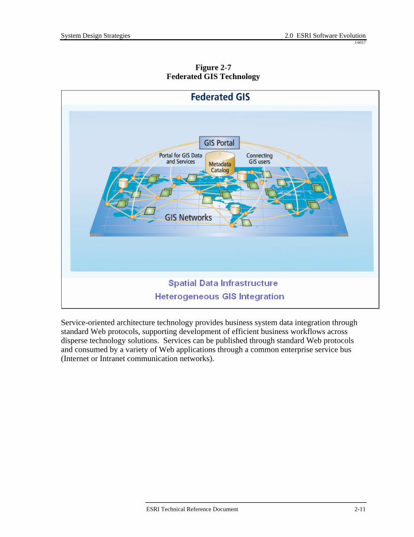
Figure 2-7 Federated GIS Technology
Service-oriented architecture technology provides business system data integration through standard Web protocols, supporting development of efficient business workflows across disperse technology solutions. Services can be published through standard Web protocols and consumed by a variety of Web applications through a common enterprise service bus (Internet or Intranet communication networks).
ESRI Technical Reference Document 2-11
System Design Strategies 2.0 ESRI Software Evolution J-6017
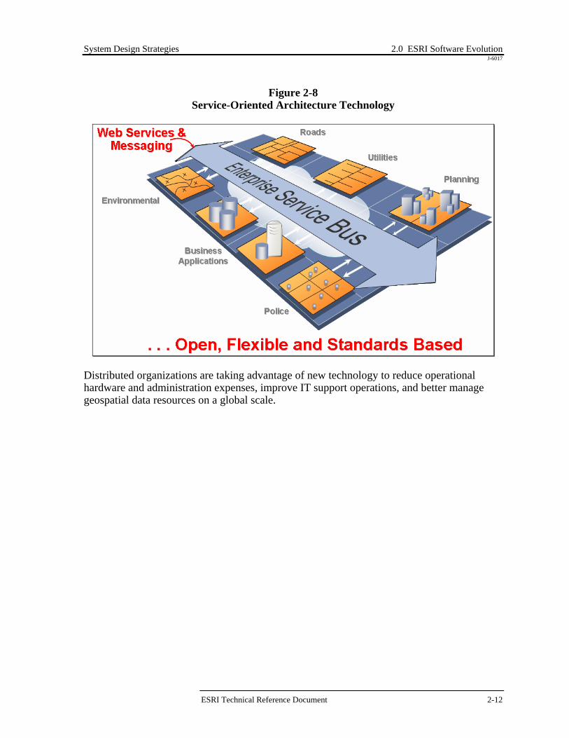
Figure 2-8 Service-Oriented Architecture Technology
Distributed organizations are taking advantage of new technology to reduce operational hardware and administration expenses, improve IT support operations, and better manage geospatial data resources on a global scale.
ESRI Technical Reference Document 2-12

System Design Strategies 2.0 ESRI Software Evolution J-6017
Figure 2-9 Global Enterprise Operations
The example architecture above provides an architecture solution that supports operations management at a Regional level with support for central management of distributed operational geospatial data resources. Distributed remote user sites can be supported by personal desktop workstations or through terminal access to central Windows Terminal Server compute farms. Operational requirements may dictate local desktop processing for heavy operations and remote access to central shared environments for team collaboration and data sharing. Regional data resources can be managed and supported at the Regional data centers, with remote access for disconnected editing and geodatabase replication (synchronization) of remote personal database environments. Commercial data purchased and compiled at Corporate headquarters can be distributed to global data centers to support unique Regional operations management and integration of available geospatial data resources. Geospatial Web services can publish commercial data layers for use as a data source for remote user desktop applications. Regional geospatial Web services can be consumed by Corporate Web Portal technology to support single site data discovery and composite global map products. Proper system architecture design and bandwidth utilization can ensure real time access to required global data resources in support of peak user workflow requirements. 2.5 GIS Technology Alternatives Current GIS technology is available to support a rapidly expanding spectrum of GIS user needs. Solutions are supported by ESRI products integrated with a variety of vendor-enabling technologies.
ESRI Technical Reference Document 2-13

System Design Strategies 2.0 ESRI Software Evolution J-6017
Figure 2-10 ESRI Core GIS Technology
PDAPDACellCell
PDAPDACellCellArc Browsers
-Map Products-Analysis-Operations-Studies
Arc Browsers-Map Products-Analysis-Operations-Studies
Geography NetworkGeography Network
G.NET Architecture
WAN
Arc Terminals-Analysis-Maintenance-Operations-Studies
WTS
WANWAN
Arc Terminals-Analysis-Maintenance-Operations-Studies
Arc Terminals-Analysis-Maintenance-Operations-Studies
WTSWTS
100 Mbps Ethernet
ArcSDEServer
File/ImageServer
DBMSServer
100 Mbps Ethernet
ArcSDEServer
File/ImageServer
DBMSServer
100 Mbps Ethernet100 Mbps Ethernet
ArcSDEServer
File/ImageServer
DBMSServer
ArcSDEServer
ArcSDEServer
File/ImageServer
File/ImageServer
DBMSServerDBMSServer
Storage Area Network
Files-Coverages-Shapes-Images
ArcSDE-Georelational-GeoDatabase
Attributes-Customers-Facilities-Documentation
Data Resources
Storage Area Network
Files-Coverages-Shapes-Images
ArcSDE-Georelational-GeoDatabase
Attributes-Customers-Facilities-Documentation
Data Resources
Arc 8 Mobile Users-Data Updates-Analysis
Arc 8 Mobile Users-Data Updates-Analysis
Arc 8 Mobile Users-Data Updates-Analysis
Arc 8 Laptops-Data Updates-Analysis
Arc 8 Laptops-Data Updates-Analysis
Remote Sites
WebArcIMS
Web Browsers-Data Download-Maps on Demand-Data Shipping
WWW
Remote Sites
WebArcIMS
Web Browsers-Data Download-Maps on Demand-Data Shipping
WWW
Remote Sites
WebArcIMS
Web Browsers-Data Download-Maps on Demand-Data Shipping
WWW
Remote Sites
WebArcIMS
Web Browsers-Data Download-Maps on Demand-Data Shipping
WWW
Remote Sites
WebArcIMS
Web Browsers-Data Download-Maps on Demand-Data Shipping
WWW
WebArcIMS
Web Browsers-Data Download-Maps on Demand-Data Shipping
WWW
ArcIMS
Web Browsers-Data Download-Maps on Demand-Data Shipping
WWW
Web Browsers-Data Download-Maps on Demand-Data Shipping
Web Browsers-Data Download-Maps on Demand-Data Shipping
WWWWWW
Arc Desktops-Analysis-Maintenance-Operations-Studies
Arc Desktops-Analysis-Maintenance-Operations-Studies
ArcGIS Architecture
RegionalMetadataRegionalMetadataRegionalMetadata
Data storage and data management technologies are growing in importance as organizations continue to develop and maintain larger volumes of GIS data. Direct connect storage solutions are evolving to Storage Area Networks (SANs) enhancing IT options for managing a large volume of data resources. Supported data servers include file servers, ArcSDE servers, and attribute data servers. Desktop ArcGIS applications are supported on local workstation clients. These same applications can be supported for remote clients using Windows Terminal Servers. Windows Terminal Servers can also support local terminal clients. ArcIMS provides published map servers to Web browser clients throughout the organization. ArcIMS can also provide public map services to clients across the Internet. ArcGIS clients are able to connect to ArcIMS as intelligent browser clients, enabling connection to unlimited data resources through the Internet Geography Network as well as organization resources served through ArcIMS services. Users can access applications from home or from other locations. Mobile ArcGIS users can create red-line datasets in the field and submit them to a central ArcIMS site for final processing. ArcGIS desktop applications can include ArcIMS services as data sources with local ArcSDE and file servers, expanding desktop map production and analysis to include available Internet data sources. The "ArcGIS architecture" is supported by a combination of ArcSDE data sources, ArcIMS Web services, and ArcGIS desktop technology.
ESRI Technical Reference Document 2-14

System Design Strategies 2.0 ESRI Software Evolution J-6017
Implementation of the Geography Network metadata search engines, along with local metadata sites supported by ArcIMS 4 software, rapidly expands user access to data sources beyond the organization. This "G.Net architecture" expands traditional organizational GIS information resources to include Internet data sources, providing a rich data environment to support growing GIS user needs. A variety of design alternatives enable organizations to develop an enterprise GIS solution that best supports their user requirements. 2.6 GIS Software Selection Selecting the right software and the most effective deployment architecture is very important. ArcGIS technology provides many alternative architecture solutions and a wide variety of software, all designed to support specific user workflow needs.
Figure 2-11 GIS Software Technology Alternatives
GIS Data Source. Operations may be supported on local disk or CD-ROM, shared file servers, ArcSDE DBMS servers, or Web data sources. Local data sources support high performance application workflow with minimum network latency. Remote data sources allow connection to a variety of published data sources, with the drawback of potential bandwidth congestion and performance issues. There are
ESRI Technical Reference Document 2-15

System Design Strategies 2.0 ESRI Software Evolution J-6017
architecture solutions that reduce the performance issues and support distributed data access.
Desktop Applications. The highest level of functionality and productivity is supported with the ArcGIS desktop applications. Most professional GIS users and GIS power users will be more productive with the ArcGIS Desktop software. These applications can be supported on the user workstation or through terminal access to software executed on central Windows Terminal Server farms. Some of the more powerful ArcGIS Desktop software extensions perform best on the user workstation with a local data source, while most ArcGIS Desktop use workflows can be supported more efficiently on a terminal server farm. Selecting the appropriate application deployment strategy can have a significant impact on user performance, administrative support, and infrastructure implementations.
Web Services. The ArcIMS and ArcGIS Server technologies provide efficient support for a wide variety of more focussed GIS user workflows. Web services also provide a very efficient way to share data to support remote client workflows. ArcIMS provides the most efficient way to publish standard map information products. ArcGIS Server provides enhanced functionality to support more advanced user workflows and services. Web services are a cost-effective way to leverage GIS resources to support users throughout the organization and associated user community.
Mobile Services. A growing number of GIS operations are supported by more loosely connected mobile GIS solutions. ArcGIS technology supports continuous workflow operations that include disconnected editing and remote wireless operations. A disconnected architecture solution can significantly reduce infrastructure costs and improve user productivity for some operational workflows. Leveraging mobile services can provide alterative solutions to support a variety of user workflow environments.
Selecting the proper software and architecture deployment strategy can have a significant impact on user workflow performance, system administration, user support, and infrastructure requirements. 2.7 GIS Configuration Alternatives GIS environments commonly begin with single-user workstations at a department level within the organization. Many organizations start with a single GIS manager and evolve from a department level to an enterprise operation. This was common through the early 1990s, as many organizations worked to establish digital representation of their spatial data. Once this data is available, organizations expand their GIS operations to support enterprise business operations.
ESRI Technical Reference Document 2-16

System Design Strategies 2.0 ESRI Software Evolution J-6017
Spatial data is presented as layers of graphic lines, points, or polygons stored in a proprietary file format as GIS layers, similar to traditional Mylar sheets. These layers are overlaid by the client application to render a map image. Spatial data can be stored in proprietary file formats or as spatial feature types within a database table. Standard file formats include coverages and shapefiles. ArcInfo LIBRARIAN provides a tiled coverage format supporting data maintenance operations. ArcStorm includes a variety of server processes to manage database integrity with associated tabular attribute data sources. Data can be shared between users in a variety of ways. Most organizations today have user workstations connected to local area network (LAN) environments and locate shared spatial data on dedicated server platforms. User applications connect to shared data sources to support GIS operations.
Centralized Data Configuration Alternative
The most simple system architecture is supported by a central GIS database. A central database architecture supports one copy of the production database environment, minimizing administrative management requirements and ensuring data integrity.
Figure 2-12
Centralized Computing Environment
Data/ServerConsolidation
WHY CONSOLIDATE?•Reduce HW cost•Reduce admin cost•Low implementation risk•Integrated operations•Improved data access•Improved security•Reduce network traffic
WHY CONSOLIDATE?•Reduce HW cost•Reduce admin cost•Low implementation risk•Integrated operations•Improved data access•Improved security•Reduce network traffic
Data/ServerConsolidationData/Server
Consolidation
WHY CONSOLIDATE?•Reduce HW cost•Reduce admin cost•Low implementation risk•Integrated operations•Improved data access•Improved security•Reduce network traffic
WHY CONSOLIDATE?•Reduce HW cost•Reduce admin cost•Low implementation risk•Integrated operations•Improved data access•Improved security•Reduce network traffic
Map ServerWeb Server
Browser
Browser
Map ServerWeb Server
Browser
Map ServerWeb Server
Browser
Browser
ArcSDE Server Attribute ServerFile Server
Geographic Date ResourcesArcSDE Server Attribute ServerFile Server
Geographic Date ResourcesGeographic Date Resources
LANLANLAN
WorkstationsWorkstationsWorkstationsWorkstations
WTS
WAN
Terminals
WTS
WANWAN
Terminals
ESRI Technical Reference Document 2-17

System Design Strategies 2.0 ESRI Software Evolution J-6017
GIS desktop applications can be supported on user workstations located on the central LAN, each with access to central GIS data sources. Data sources can include GIS file servers, ArcSDE database servers, and related attribute data sources. Remote user access to central data sources can be supported by central Windows Terminal Server farms, providing low bandwidth display and control of central application environments. Centralized application farms minimize administration requirements and simplify application deployment and support throughout the organization. Source data is retained within the central computer facility, improving security and simplifying backup requirements. A variety of ArcIMS map services can support standard browser clients throughout the organization. Web mapping services support low bandwidth access to published GIS information products and services. Distributed computing technology today can support consolidated architectures at a much lower risk and cost than similar distributed environments. For this reason, many organizations are in the process of consolidating their data and server resources. GIS can benefit from consolidation for many of the same reasons experienced by other enterprise business solutions. Centralized GIS architectures are generally easier to deploy, manage, and support than distributed architectures and provide the same user performance and functionality.
Distributed Data Configuration Alternative
Distributed solutions are supported by replicated copies of the data at the remote locations, establishing local processing nodes that must be maintained consistent with the central database environment. Data integrity is critical in this type of environment, requiring controlled procedures with appropriate commit logic to ensure changes are replicated to the associated data servers.
ESRI Technical Reference Document 2-18

System Design Strategies 2.0 ESRI Software Evolution J-6017
Figure 2-13 Distributed Computing Environment
ArcInfo or ArcView GIS Clients
RegionalData
Server
ArcInfo or ArcView GIS Clients
RegionalData
Server
ArcInfo or ArcView GIS Clients
RegionalData
Server
ArcInfo or ArcView GIS Clients
RegionalData
Server
ArcInfo or ArcView GIS Clients
RegionalData
Server
ArcInfo or ArcView GIS Clients
RegionalData
Server
ArcInfo or ArcView GIS Clients
RegionalData
Server
Data Replication Data ReplicationData Replication
Data Replication Data Replication
Data Replication
ArcInfo or ArcView GIS Clients
CentralData
Server
ArcInfo or ArcView GIS Clients
CentralData
Server
ArcInfo or ArcView GIS Clients
CentralData
Server
DISTRIBUTED DATA SOLUTIONS•Increase HW cost•Increase admin cost•High implementation risk•Disconnected operations•Limited data access•Reduced security•Increased network traffic
DISTRIBUTED DATA SOLUTIONS•Increase HW cost•Increase admin cost•High implementation risk•Disconnected operations•Limited data access•Reduced security•Increased network traffic
Why use distributed architecture?•Organizational Precedence•Management Confidence•Physical Security•Infrastructure Limitations
Why use distributed architecture?•Organizational Precedence•Management Confidence•Physical Security•Infrastructure Limitations
Distributed database environments generally increase initial system cost (more hardware and database software requirements) and require additional on-going system administration and system maintenance requirements. Distributed solutions are provided to support specific user needs and generally increase system complexity, cost, and system deployment timelines. In many cases, standard database solutions do not support replication of spatial data. GIS users with distributed database requirements must modify their data models and establish procedures to administratively support data replication. DBMS vendors have recognized the necessity to provide a spatial data replication option, and new releases are supporting some levels of spatial data replication. ESRI is also working on a solution to support geodatabase syncronization between multiple ArcSDE servers. The complexity of current geodatabase environments have complicated implementation of an automated efficient spatial replication solution. 2.8 ESRI ArcGIS Implementation Many ESRI customers have been working with ESRI products and data formats for many years. As a result, there are a large number of custom applications and datasets that have been developed and maintained in various locations throughout the GIS community. This
ESRI Technical Reference Document 2-19

System Design Strategies 2.0 ESRI Software Evolution J-6017
proliferation of data and applications has resulted in a variety of data and application environments. The ArcGIS technology is particularly suitable for an enterprise GIS implementation and can help ease the transition from the existing "stovepipe" GIS environments into a true enterprise implementation. The geodatabase technology in particular will provide tangible benefits in accomplishing this transition. The ArcGIS technology is also suitable to those new users who are spatially enabling their existing tabular data resources to support implementation of enterprise GIS operations. Many spatial data resources are available to support organizations as they migrate their operations to take advantage of GIS technology. Geodatabases come in two varieties—personal and multi-user1. Personal geodatabases, implemented in Microsoft Access, are suitable for project-level GIS. Multi-user databases deployed using ArcSDE require a DBMS such as Oracle, Microsoft SQL Server, Informix, or DB2. Storing spatial and attribute data directly in a commercial database gives a geodatabase capabilities that are not available, or are more difficult to achieve, with other formats. Some of these benefits are listed below.
A uniform repository for geographic data. All geographic data is centrally stored and managed in one database.
Data entry and editing are more efficient. The use of subtypes, domains, and
validation rules helps maintain database integrity and reduces database maintenance.
Sets of features are continuous. Geodatabases can accommodate very large sets of features without tiles or other spatial partitions.
Multi-user editing. ArcSDE geodatabase environments use a data management
framework called versioning that lets multiple users access and edit features simultaneously and reconciles any conflicts.
Feature-linked annotation. Geodatabase annotation can be linked to the feature that it
describes. When the linked feature is moved or deleted, the related label is moved or deleted.
Users work with more intuitive data objects. A properly designed geodatabase
contains data objects that correspond to the user's model of data. Instead of generic points, lines, and areas, users work with objects of interest such as parcels, roads, and lakes.
Using a geodatabase can be simple and straightforward. Geodatabases can be
created, accessed, and managed through the standard menus and tools in ArcCatalog, ArcToolbox, and ArcMap. However, the geodatabase model supports intelligent
1 This section has been derived from the article by Colin Childs, ArcUser, July–Sept 2001.
ESRI Technical Reference Document 2-20

System Design Strategies 2.0 ESRI Software Evolution J-6017
features, rules, and relationships that advanced users can employ in complex GIS applications.
In addition to the benefits of the geodatabase technology, the ArcGIS desktop applications provide a Windows-based suite of GIS data query, analysis, and management tools. These tools often provide comparable functionality to the applications that have been developed by ESRI users in the past using custom ARC Macro Language (AML™) and Avenue™ applications. The commercial off-the-shelf (COTS) ArcGIS functionality can also be extended as needed using the COM-based ArcObjects technology. ArcIMS and ArcReader™ provide additional GIS capabilities for users who need browse and query access. Transitioning from existing data and applications to the ArcGIS technology will provide tangible benefits and efficiences for the GIS community. 2.8.1 Data Transition Strategies GIS data is traditionally stored, updated, and managed at the local workgroup level. This results in duplication of many of the data themes and additional effort in reconciling the various datasets when aggregation of this data is required at higher levels within the organization. This aggregation becomes even more difficult when the schemas for the various workgroup datasets are inconsistent. An important first step in resolving the difficulties with aggregating data for enterprise-level analysis is to define data standards to which all data managers are required to adhere. The standardization process, however, can be time-consuming and institutionally difficult because of differences in local business processes and geographies. Depending on the business area, the prospect for data standardization may be more or less challenging. ArcGIS provides a number of tools that can help in the standardization and management of data. On the database design side, ArcCatalog and/or Visio's UML CASE tool can be used to define a geodatabase schema. The schema defines entities (feature and object classes) and their definition (field size and type, nullability, default values, domains, etc.), as well as relationships between entities. These schemas can be defined from scratch, from existing agency designs or developed based on the geodatabase template models provided by ESRI at http://arconline.esri.com/arconline/datamodels.cfm. Implementing the standardization can be accomplished in several ways. Three of the alternatives for implementing data standards are (1) centralization of data storage and access through terminal server technology, (2) disconnected editing and reconciliation of centrally managed data, and (3) periodic aggregation of local datasets adhering to enterprise data standards. The simplest way to integrate data would be to enforce the schema definition so that all data imported into the ArcSDE database conforms to a single definition. This could be done through process or by centralizing the database and providing local access to the centralized database. The advantages to this approach include the centralization of data administration responsibilities and tight enforcement of the database schema.
ESRI Technical Reference Document 2-21

System Design Strategies 2.0 ESRI Software Evolution J-6017
An alternative to centralization is to define data standards for the essential elements of the schema and allow local users to extend the "essential" model to include their value-added information. In this manner, the custodians responsible for aggregating local datasets would be able to map the required fields to the enterprise standard and ignore the additional information as desired. ArcCatalog provides an in-the-box graphical user interface (as well as programmable objects) for mapping the fields from one schema to another. ArcGIS layer files also provide tools for aliasing field names in the physical model to local names that may be more user-friendly. This can ease the difficulty of standardization when local nomenclature is different. The advantages to this approach include the flexibility for allowing local users to add additional fields into the schema for their local business needs. Regardless of the alternative that is chosen, the migration of existing GIS data will be required at some level. Although ArcGIS supports the management, query, and analysis of shapefiles and coverages, the content of the existing data would eventually need to be massaged to adhere to enterprise standards. In cases where the data is edited and maintained by multiple users, transitioning to a multi-user geodatabase in ArcSDE will provide the most robust model for managing data transactions. Figure 2-14 below provides a data migration road map to convert legacy ArcInfo and ArcView datasets to both SDE simple layers (non-geodatabase) and into the geodatabase data model. It also shows how SDE simple layers can be integrated into the geodatabase data model and the different components and processes involved.
ESRI Technical Reference Document 2-22

System Design Strategies 2.0 ESRI Software Evolution J-6017
Figure 2-14 Data Migration Road Map
DBMS TablesColumns (attributes)Rows (features)
ArcGIS Architecture
GeoDatabase
Layers ==> Feature Class (Tables)Attributes ==> Object Class (Tables)
Layers ==> Feature Class (Tables)Attributes ==> Object Class (Tables)
ArcSDE Admin Commands
SDE Layers(Simple Layers)ArcSDE Admin Commands
SDE Layers(Simple Layers)
Non-versionedUnregistered withGeoDatabase
Legacy Systems
CoveragesLibrarianShapefilesImage FilesArcStorm
File Server
Chart SymbolsMigration Options
Data Access
Edit Versions(Reconcile/post)
VersionedMulti-userEditing
Object Relational(Data Model)
Business Process Data Model Object Relational(Data Model)
Business Process Data Model Relationships/Domains
SDE Layers(simple layers)
ArcCatalog/ArcToolbox) SDE Layers(simple layers)
ArcCatalog/ArcToolbox)Non-Versioned/Registered
Default Version
Register with GeoDatabase
The options for migrating data from simpler to more robust data structures are as follows:
Move file-based data (shapefiles, coverages, librarian tiles, etc.) to ArcSDE simple layers using the ArcSDE administration tools (command line). At this level, ArcSDE provides an improved data warehouse environment for an enterprise spatial data source.
After creating ArcSDE layers, they may be registered with the geodatabase. Once a
layer is registered with the geodatabase, the resulting feature class can be versioned to support multi-user data maintenance operations. Domains, relationship classes, and other object-relational behavior can be added to feature classes, further extending the geodatabase capabilities.
Users can also move file-based data directly into the geodatabase using ArcCatalog or
ArcToolbox. This migration path allows the user to create new feature classes or append updates to existing geodatabase feature classes. This is the preferred migration path once a geodatabase is established.
ESRI Technical Reference Document 2-23

System Design Strategies 2.0 ESRI Software Evolution J-6017
Legacy ArcInfo and ArcView clients will be able to view and query data in the default version of the new geodatabase. ArcIMS Image and Feature services also access the default version of the ArcSDE geodatabase. 2.8.2 Application Transition Strategies In addition to the diversity of database schemas supported in the GIS community, there are also numerous custom applications that have been developed for managing and analyzing the data. While many of the different customer business processes may have unique aspects, the fundamental responsibilities for managing GIS data resources should be the same. As such, some of the applications required for managing GIS data resources could be standardized. Developing data standards is an important step in creating common GIS applications. Even so, the ArcGIS desktop tools provide a wealth of functionality for managing and analyzing data regardless of the data schema. Legacy applications include ArcInfo custom applications, ArcView 3 custom applications, and ArcView 3 standard clients. Many of the functions developed in the custom applications are included in the ArcGIS standard clients or can be incorporated in the data models, which will reduce the requirements for custom application programming with the ArcGIS technology. Technology upgrades include migration of clients to ArcIMS software-published map services, ArcGIS desktop client applications (ArcView 8, ArcEditor 8, or ArcInfo 8), or custom ArcGIS applications. The transition to ArcGIS from an existing operational environment will require a number of steps.
Training. Users should be trained in the capabilities and use of the COTS ArcGIS technology. Training a group of super users or domain experts first will provide the background required for the next step in the transition: the application gap analysis.
Needs Assessment and Gap Analysis. A user application needs assessment and gap analysis should be completed to document functions required by each GIS user and to identify any functions that are not supported directly in the COTS ArcGIS desktop software. This analysis should identify those users who can migrate directly to ArcGIS and those users who must wait for custom ArcGIS applications. Custom applications can be built using any COM-compliant programming language (e.g., Visual Basic, C++) with the ArcObjects technology.
Power User Migration. Power users include GIS specialists who are trained in GIS analysis and technology. Many of their current tasks are undertaken on an ad hoc basis and do not require custom applications. Many power users should be able to migrate directly to the standard ArcGIS desktop product without custom development. ArcGIS desktop provides access to ArcIMS data sources and to versions and object relationships in the ArcSDE geodatabase.
ESRI Technical Reference Document 2-24

System Design Strategies 2.0 ESRI Software Evolution J-6017
Operational User Migration. Some customization may be required to support migration of standard desktop operations that currently are supported by custom ArcInfo applications. Many of the basic edit operations may be supported directly with the standard ArcEditor desktop. There may also exist ArcView applications that can be supported with the ArcIMS technology for query and analysis.
Figure 2-15 provides an application migration road map from legacy applications that use AML, Avenue, and COTS ArcView 3.x technology.
Figure 2-15 Application Migration Road Map
IntegratedIntegrated
ArchitectureArchitecture
DBMS TablesColumns (attributes)Rows (features)
ArcGIS Architecture IntegratedIntegratedArchitectureArchitecture
DBMS TablesColumns (attributes)Rows (features)
IntegratedIntegratedArchitectureArchitectureIntegratedIntegrated
ArchitectureArchitecture
DBMS TablesColumns (attributes)Rows (features)
ArcGIS Architecture
ArcIMS
Browser
ArcIMS
Browser
ArcIMS
Browser
ArcIMSArcIMSArcIMS
BrowserBrowser
File Server
PersonalGeoDatabase
ArcGIS
Custom ArcGIS
File Server
PersonalGeoDatabase
ArcGIS
Custom ArcGIS
PersonalGeoDatabase
ArcGIS
Custom ArcGIS
PersonalGeoDatabase
ArcGIS
Custom ArcGIS
PersonalGeoDatabase
ArcGIS
Custom ArcGIS
PersonalGeoDatabase
ArcGIS
PersonalGeoDatabase
ArcGISArcGIS
Custom ArcGIS
GeoDatabaseGeoDatabase
Layers ==> Feature Class (Tables)Attributes ==> Object Class (Tables)
ArcSDE Admin Commands
SDE Layers(Simple Layers)
Non-versionedUnregistered withGeoDatabase
Layers ==> Feature Class (Tables)Attributes ==> Object Class (Tables)
ArcSDE Admin Commands
SDE Layers(Simple Layers)
Layers ==> Feature Class (Tables)Attributes ==> Object Class (Tables)
Layers ==> Feature Class (Tables)Attributes ==> Object Class (Tables)
ArcSDE Admin Commands
SDE Layers(Simple Layers)ArcSDE Admin Commands
SDE Layers(Simple Layers)
Non-versionedUnregistered withGeoDatabase
Non-versionedUnregistered withGeoDatabase
Legacy Systems
CoveragesLibrarianShapefilesImage FilesArcStorm
File Server
Avenue ArcView 3
AML ArcInfo
ArcView 3
Legacy Systems
CoveragesLibrarianShapefilesImage FilesArcStorm
File Server
Avenue ArcView 3
AML ArcInfo
ArcView 3
CoveragesLibrarianShapefilesImage FilesArcStorm
File Server
Avenue ArcView 3Avenue ArcView 3
AML ArcInfoAML ArcInfo
ArcView 3ArcView 3
Chart SymbolsMigration Options
Data Access
Chart SymbolsMigration Options
Data Access
Edit Versions(Reconcile/post)
VersionedMulti-userEditing
Edit Versions(Reconcile/post)
VersionedMulti-userEditing
VersionedMulti-userEditing
Object Relational(Data Model)
Business Process Data Model Relationships/Domains
Object Relational(Data Model)
Business Process Data Model Relationships/Domains
Object Relational(Data Model)
Business Process Data Model Object Relational(Data Model)
Business Process Data Model Relationships/Domains
SDE Layers(simple layers)
ArcCatalog/ArcToolbox)Non-Versioned/Registered
Default Version
SDE Layers(simple layers)
ArcCatalog/ArcToolbox)Non-Versioned/Registered
SDE Layers(simple layers)
ArcCatalog/ArcToolbox) SDE Layers(simple layers)
ArcCatalog/ArcToolbox)Non-Versioned/Registered
Default Version
Register with GeoDatabaseRegister with GeoDatabase
User ApplicationNeeds Assessment
AML=> ArcObjectsAvenue => ArcObjects/ArcIMS
User ApplicationNeeds Assessment
AML=> ArcObjectsAvenue => ArcObjects/ArcIMS
User ApplicationNeeds Assessment
AML=> ArcObjectsAvenue => ArcObjects/ArcIMS
User ApplicationNeeds Assessment
AML=> ArcObjectsAvenue => ArcObjects/ArcIMS
*ArcMap Service includes access to version data layers
Note that the migration path from each of the existing platforms has a path from the existing implementation directly into ArcGIS without requiring any customization. It should also be noted that some ArcView 3 users might be able to perform their query and analysis functions through a thin browser client connected to an ArcIMS service. During the transition from the existing environment to the ArcGIS environment, there may be a need for continued use of existing AML applications. ArcInfo Workstation provides this capability, though the data accessed by existing AMLs would need to remain in coverage format until the existing code is updated to work with ArcSDE data or users become familiar with the ArcGIS Desktop tool.
ESRI Technical Reference Document 2-25

System Design Strategies 2.0 ESRI Software Evolution J-6017
ESRI Technical Reference Document 2-26