2006 chevrolet corvette navigation manual msetting radio station presets to set preset radio...
TRANSCRIPT

Overview ........................................................ 1-1Overview .................................................. 1-2
Features and Controls ..................................... 2-1Features and Controls ................................ 2-2
Navigation Audio System ................................ 3-1Navigation Audio System ............................ 3-2
Voice Recognition ........................................... 4-1Voice Recognition ...................................... 4-2
Index .................................................................1
2006 Chevrolet Corvette Navigation Manual M

GENERAL MOTORS, GM, the GM Emblem,CHEVROLET, the CHEVROLET Emblem, the nameCORVETTE, and the CORVETTE Emblems areregistered trademarks of General Motors Corporation.
The information in this manual supplements theowner manual. This manual includes the latestinformation available at the time it was printed. Wereserve the right to make changes in the product afterthat time without notice. For vehicles first sold inCanada, substitute the name General Motors of CanadaLimited for Chevrolet Motor Division whenever itappears in this manual.
Keep this manual with the owner manual in the vehicle,so it will be there if it is needed. If the vehicle is sold,leave this manual in the vehicle.
Canadian OwnersFor Canadian owners that would like to obtain a Frenchlanguage manual, see “Canadian Owners” in theIndex of your vehicle’s owner manual.
Litho in U.S.A.Part No. 10382039 A First Printing ©2005 General Motors Corporation. All Rights Reserved.
ii

Overview .........................................................1-2Navigation System Overview ............................1-2Getting Started ...............................................1-4Cleaning the Display .....................................1-12
Section 1 Overview
1-1

OverviewNavigation System Overview
1-2

A. g (Voice Recognition) Key. See “Hard Keys”under Using the Navigation System on page 2-2 formore information.
B. SRCE (Source) Key. See “Hard Keys” under Usingthe Navigation System on page 2-2 for moreinformation.
C. NAV (Navigation) Key. See “Hard Keys” under Usingthe Navigation System on page 2-2 for moreinformation.
D. e / z (Audio/Screen Adjust) Key. See “HardKeys” under Using the Navigation System onpage 2-2 for more information.
E. QO SEEK R (Seek/Tune) Key. See “HardKeys” under Using the Navigation System onpage 2-2 for more information.
F. Power Volume Knob. See “Hard Keys” under Usingthe Navigation System on page 2-2 for moreinformation.
G. X DVD (DVD Map Database Eject) Key. See“Installing the Map DVD” under Maps on page 2-3for more information.
H. XB (CD Eject) Key. See “CD Player onpage 3-14 for more information.
I. CD SlotJ. DVD Map Database SlotK. Navigation System Screen
L. X (Open/Close Faceplate) Key. See “Hard Keys”under Using the Navigation System on page 2-2for more information.
1-3

Getting StartedBefore you begin to operate the navigation system,read this manual thoroughly to become familiar withit and to understand how the system works.
Keeping your mind on the drive is important for safedriving. See “Defensive Driving” in the Index ofyour vehicle’s owner manual for more information.Get familiar with your vehicle’s navigation system soyou can use it with less effort and take full advantage ofits features. Your navigation system includes not onlynavigation, but also audio functions. While yourvehicle is parked:
• Familiarize yourself with all of its controls: hardkeys on the faceplate and touch-sensitive screenbuttons.
• Familiarize yourself with its operation.
• Set up your audio by presetting your favoritestations, setting the tone, and adjusting thespeakers. Then, when driving conditions permit,you can tune to your favorite stations usingthe presets and steering wheel controls(if equipped).
• Set up the navigation features that can only bedone before you begin driving, such as enteringan address or a preset destination.
Entering a destination or alphanumeric text requiresmany steps, so you can only perform these operationswhen the vehicle is in PARK (P). You will noticethat touch-sensitive screen buttons leading to thealphanumeric keyboard are dimmed out while driving.
Other functions may also be locked out while driving andthey too will appear grayed out on the screen — butall functions are available when parked. Some functionscan be performed while driving, as long as you cando so without diverting too much of your attention fromyour driving.
{CAUTION:
This system provides you with a far greateraccess to audio stations and song listings.Giving extended attention to entertainmenttasks while driving can cause a crash and youor others can be injured or killed. Always keepyour eyes on the road and your mind on thedrive — avoid engaging in extended searchingwhile driving.
1-4

{CAUTION:
Looking at the moving map on the navigationscreen frequently or for too long while drivingcan cause a crash and you or others can beinjured or killed. Keep your eyes and mind onthe road and avoid looking too long or toooften at the moving map on the navigationscreen. Use the voice guidance directionswhenever possible.
The navigation system allows you to do the following:• Plan a route with provided turn-by-turn route
and map guidance with voice prompts.• Select a destination using various methods
and choices.• Receive broadcast announcements on traffic and
emergency alert communications.
The information in the system may not always becomplete. Road conditions such as prohibited turns,detours, and construction zones, change frequently.It is important to consider whether you can followthe directions given by the system for the currentconditions.
Each time you enter the navigation system, theCAUTION screen will display. Touch Agree to proceedinto the system. For information on changing thelanguage, see “Driver Information Center (DIC)” in theIndex of your vehicle’s owner manual.
When getting started, you may set the navigationsystem to your preference using various options.You will also need to know how to perform variousfunctions to begin route guidance. Reference thefollowing topics for further information:
1-5

Setting Radio Station PresetsTo set preset radio stations, do the following:
1. Press the power/volume knob to turn thesystem on.
2. Press the SRCE hard key and select the desiredband (AM, FM1, FM2, XM1, or XM2 (if equipped)).
3. Use the TUNE/SEEK arrows to tune to thedesired station.
4. Press and hold one of the six preset screenbuttons, at the bottom of the screen, until youhear a beep or see the station displayed on theselected preset button.
5. Repeat the steps for each preset.
See “Preset Station Menu” under Navigation AudioSystem on page 3-2 for more information.
Setting the TimeTo set the time, do the following:
1. Press the power/volume knob to turn thesystem on.
2. Press and hold the time display in the upper rightcorner of any screen.
3. Select the 12H or 24H screen button to display thetime in standard or military time.
4. Press and hold the Hour and Min. (minute) arrowbuttons to increase or to decrease the time.
5. Select the appropriate time zone screen button.
6. Select the Daylight Saving Time screen button,if necessary.
The radio will use the GPS satellite to set the time.The vehicle needs to be in an open area to receive thesignal. See “Clock” under Navigation Audio Systemon page 3-2 for more information.
1-6

Setting the Region, Entering anAddress and Point of Interest, andStoring a Home Destination andPreset DestinationsBefore entering an Address, Point of Interest, Home, orPreset Destination, select the appropriate region thatcontains the final destination. Your vehicle mustbe stopped to perform this operation.
Setting the RegionTo set the region, do the following:
1. Press the power/volume knob to turn thesystem on.
2. Insert the DVD map disc. See “Installing the MapDVD” under Maps on page 2-3 for more information.
3. A notice may appear. Touch the Agree screenbutton to proceed.If the radio is already on with a map disc inserted,press the NAV hard key.
4. Press the MENU screen button.
5. Press the < Enter Destination screen button.
6. Press the Region screen button.
7. Select the appropriate region numbered screenbutton that contains your final destination.
The system will return to the Enter Destination menu.See Enter Destination on page 2-11 for moreinformation.
Entering an AddressTo set a destination by entering a street address, do thefollowing:
1. Press the power/volume knob to turn thesystem on.
2. Insert the DVD map disc. See “Installing the MapDVD” under Maps on page 2-3 for more information.
3. A notice may appear. Touch the Agree screenbutton to proceed.If the radio is already on with a map disc inserted,press the NAV hard key.
4. Press the MENU screen button.
5. Press the < Enter Destination screen button. Verifythat the selected Region is correct.
6. Press the 2 Address screen button.
1-7

7. Enter the street name using the alpha keypad onthe screen.Do not enter directional information or street type,and use the space symbol screen button (U)between street or city names. For example, thestreet name N. Royal Oak Rd. should be entered asroyalUoak. Use the backspace (V) screenbutton if an incorrect character has been entered.
8. Select the desired street name with the correctdesignation (Dr., Ln., St., etc.) from the list.
9. If there is more than one city, the system willdisplay the list of cities that have a street withthat name. Select a city from the list or select theInput Name screen button to input the city name.
10. Enter the house number using the numeric keypadon the screen and touch the OK screen button.A map screen will appear with the destinationmarked.
11. Select the h (destination) symbol screen button.
12. Select the Guide screen button.
13. Once you begin driving you will hear an audioprompt to “Proceed to the highlighted route.”You are now in route guidance mode.
See “Address” under Enter Destination on page 2-11 formore information.
Entering a Point of Interest (POI)To set a destination by entering a Point ofInterest (POI), do the following:1. Press the power/volume knob to turn the
system on.2. Insert the DVD map disc. See “Installing the Map
DVD” under Maps on page 2-3 for more information.3. A notice may appear. Touch the Agree screen
button to proceed.If the radio is already on with a map disc inserted,press the NAV hard key.
4. Press the MENU screen button.
5. Press the < Enter Destination screen button. Verifythat the selected Region is correct.
6. Press the K Point of Interest screen button.
7. Enter the specific title of the POI in the Name space(i.e. Washington Monument) using the alphakeypad on the screen.
8. Select the POI from the list.
9. If there is more than one city, the system willdisplay the list of cities that have a street withthat name. Select a city from the list or select theInput Name screen button to input the city name.A map screen will appear with the destinationmarked.
1-8

10. Select the h (destination) symbol screen button.
11. Select the Guide screen button.
12. Once you begin driving you will hear an audioprompt to “Proceed to the highlighted route.”You are now in route guidance mode.
Using the Category or City selections will aid the systemin finding your POI by limiting the search options. See“Point of Interest (POI)” under Enter Destination onpage 2-11 for more information.
Storing a Home Destination1. Press the power/volume knob to turn the
system on.
2. Insert the DVD map disc. See “Installing the MapDVD” under Maps on page 2-3 for more information.
3. A notice may appear. Touch the Agree screenbutton to proceed.If the radio is already on with a map disc inserted,press the NAV hard key.
4. Press the MENU screen button.
5. Press the N Stored Locations screen button.
6. Press the L Home screen button.
7. Press the Add screen button.
8. Press the Address screen button and enter alladdress information.
9. Press the OK screen button.A map screen will appear with the destinationmarked.
10. Press the OK screen button.
11. Press the back arrow screen button.
The L Home icon will be highlighted on the EnterDestination screen. See “Using Your Home orPreset Destinations” later in this section for moreinformation.
1-9

Storing a Preset Destination1. Press the power/volume knob to turn the
system on.
2. Insert the DVD map disc. See “Installing the MapDVD” under Maps on page 2-3 for more information.
3. A notice may appear. Touch the Agree screenbutton to proceed.If the radio is already on with a map disc inserted,press the NAV hard key.
4. Press the MENU screen button.
5. Press the N Stored Locations screen button.
6. Press the & Previous Dest. screen button.
7. Press the Add screen button, then select thenumbered preset button for the destination toappear as.
8. Press the Address screen button and enter alladdress information.
9. Press the OK screen button.A map screen will appear with the destinationmarked.
10. Press the OK screen button.
11. Press the back arrow screen button.The numbered preset destination will be highlightedon the Enter Destination screen. See “UsingYour Home or Preset Destinations” next in thissection for more information.
Using Your Home or PresetDestinationsThese destinations are available for selectionwhile driving.
1. Press the power/volume knob to turn thesystem on.
2. Insert the DVD map disc. See “Installing the MapDVD” under Maps on page 2-3 for more information.
3. A notice may appear. Touch the Agree screenbutton to proceed.If the radio is already on with a map disc inserted,press the NAV hard key.
4. Press the MENU screen button.
5. Press the < Enter Destination screen button.
1-10

6. Select the L(Home symbol) or one of the availablepreset destination symbols. A map screen willappear with the destination marked.
7. Select the h (destination) symbol screen button.
8. Select the Guide screen button.
9. Once you begin driving you will hear an audioprompt to “Proceed to the highlighted route.”You are now in route guidance mode.
Canceling GuidanceGuidance will be canceled once you arrive at your finaldestination. To cancel guidance prior to arrival at thefinal destination, do the following:
1. Press the NAV hard key to access the map screen.
2. Press the MENU screen button on themap screen.
3. Press the E Route Options screen button.
4. Press the Cancel Guidance screen button.
5. Press the Yes screen button to confirm cancellation.
Stored LocationsOnce a destination has been stored, the addressinformation can then be edited and deleted. See StoredLocations on page 2-30 for more information on otherfeatures that can be stored, edited, and deleted.
To delete the stored home destination, do the following:
1. Press the power/volume knob to turn thesystem on.
2. Insert the DVD map disc. See “Installing the MapDVD” under Maps on page 2-3 for more information.
3. A notice may appear. Touch the Agree screenbutton to proceed.If the radio is already on with a map disc inserted,press the NAV hard key.
4. Press the MENU screen button.
5. Press the N Stored Locations screen button.
6. Press the L Home screen button.
7. Press the Delete screen button.
8. A confirmation pop-up screen will appear: selectYes to delete; select No to cancel the operation.
1-11

To delete a waypoint or a stored preset destination,do the following:
1. Press the power/volume knob to turn the system on.
2. Insert the DVD map disc. See “Installing the MapDVD” under Maps on page 2-3 for more information.
3. A notice may appear. Touch the Agree screenbutton to proceed.If the radio is already on with a map disc inserted,press the NAV hard key.
4. Press the MENU screen button.
5. Press the N Stored Locations screen button.
6. Press the $ Dest. & Way Pt. or the & PreviousDest. screen button.
7. Press the Delete screen button, then select the waypoint or the numbered preset button to delete.
8. A confirmation pop-up screen will appear: selectYes to delete; select No to cancel the operation.
Guidance VolumeTo adjust the volume of voice guidance prompts,do the following:.
1. Press the NAV hard key to access the map screen.
2. Press the MENU screen button on themap screen.
3. Press the I Navigation Set Up screen button.
4. Press the > Guidance Volume screen button.
5. Select the desired volume or select Off. The systemwill play back the new volume level.
See “Guidance Volume” under Navigation Set Up onpage 2-41 for more information.
Cleaning the DisplayIf the panel or the display is stained, wipe it with a dry,soft cloth, such as a silicon cloth.
Notice: If you use abrasive cleaners when cleaningglass surfaces, you could scratch the glass.When cleaning the glass, use only a soft cloth anddo not spray cleaner directly on the system.
Do not apply spray cleaner directly to the system, thecleaner could affect the mechanical parts.
Do not wipe the panel with a hard cloth or use a volatileliquid such as thinner or alcohol, it could scratch thesurface or erase the characters.
1-12

Features and Controls ......................................2-2Using the Navigation System ...........................2-2Maps ............................................................2-3Symbols ........................................................2-5Nav. (Navigation) Menu .................................2-11Enter Destination ..........................................2-11Stored Locations ...........................................2-30Navigation Set Up .........................................2-41
Route Options ..............................................2-49Keyless Access System .................................2-55Global Positioning System (GPS) ....................2-55Vehicle Positioning ........................................2-56Problems with Route Guidance .......................2-57If the System Needs Service ..........................2-58Ordering Map DVDs ......................................2-58Database Coverage Explanations ....................2-58
Section 2 Features and Controls
2-1

Features and Controls
Using the Navigation SystemThis section presents basic information to operate thenavigation system.
Use the hard keys located on the navigation systemalong with the available touch screen buttons onthe navigation screen to operate the system. SeeNavigation System Overview on page 1-2 for moreinformation.
Once the vehicle is moving, various functions will bedisabled to reduce driver distractions.
Hard KeysThe following hard keys are located on the navigationsystem:
X (Open/Close Faceplate): Press this key located atthe bottom of the Navigation Screen to open or closethe faceplate.
XB (Eject CD): Press the eject CD key next to theCD loading slot to eject CDs. See CD Player onpage 3-14 for more information.
X DVD (Eject Map Database DVD): Press the ejectDVD key next to the DVD loading slot to eject themap DVD. See “Installing the Map DVD” under Maps onpage 2-3 for more information.
Power/Volume Knob: Press the power/volume knob toturn the audio and navigation systems on and off.Turn the knob to increase or decrease the volume tothe audio system.
g (Voice Recognition): Press this key to activate thevoice recognition system. See Voice Recognition onpage 4-2 for more information.
NAV (Navigation): Press this key to access the mapscreen. If this key is pressed when a map screenis displayed and you are in route guidance, the systemwill repeat the last voice command.
SRCE (Source): Press this key to access the audiosource screen. See Navigation Audio System onpage 3-2.
e / z (Audio/Screen Adjust): Press this key toaccess the Audio Adjust and Screen Adjust screens.See Navigation Audio System on page 3-2.
QO SEEK R (Seek/Tune): Press the seek/tunearrows to go to the next or previous radio stationand stay there, or to tune in a station. See NavigationAudio System on page 3-2.
2-2

Alpha-Numeric KeypadLetters of the alphabet, symbols, punctuation, andnumbers will be displayed on the navigation screen asan alpha or numeric keypad. The alpha keypad willbe displayed when the system needs input of a city orstreet name. Touch the Sym. (symbol) screen buttonat the bottom of the alpha keypad to access the numerickeypad when inputting a house address, punctuationmark, or other character. Touch A - Z to return tothe alpha keypad.
All characters are touch-sensitive screen buttons.Touch a character to select it.
U (Space): Touch this screen button to enter aspace between characters or the words of a name.
V (Back space): Touch this screen button ifan incorrect character has been selected.
To make name selections easier, the system will onlyallow you to select a character which can follow the lastone entered. For example, if a Z is entered, a T willnot be available to select. The system will highlight theavailable characters.
If a name is not available after input, it may need to beinputted differently, the map DVD database may notcontain that information, or the correct search area hasnot been selected. See Database CoverageExplanations on page 2-58 for more information.
Touch-Sensitive ButtonsTouch-sensitive buttons, or screen buttons, are locatedon the screen. When a screen button has beenselected, a beep will sound. These buttons will behighlighted when a feature is available. There are alsosome toggle screen buttons that will be light colorwhen active.
MapsThis section includes basic information that you need toknow about the map database.
Regional MapsThe maps are stored on a DVD. The 48 contiguousUnited States and portions of Canada are containedon one disc.
If a regional map does not contain a specific city,the map DVD may not contain the city or it may bemisspelled.
Refer to the Navigation System Map Disc manual toview a detailed explanation of map coverage anddetailed city lists in each region. This manual will bein the map DVD case when the vehicle is delivered fromthe factory.
2-3

Installing the Map DVDWhen your vehicle is delivered from the factory, thedealer may have installed the map DVD. If the map DVDwas not installed, do the following:
Read the following steps completely before operatingthis feature.
1. Turn the ignition on.
2. Push theZ (open/close faceplate) button and thefaceplate will open.
3. Load the map DVD into the DVD slot by inserting itpartway. The system will pull it in.
4. Wait until the DVD is loaded properly and thenpush theZ(open/close faceplate) button toclose the faceplate.
Once the map DVD is inserted correctly, the system willdisplay the CAUTION screen.
Agree: Touch this screen button to proceed to thenavigation system.
The map will appear showing your current vehicleposition.
Setting the Search AreaSee Enter Destination on page 2-11 for information onchanging the search area.
Map AdjustmentsThe system allows you to adjust the scale of view onthe map. Also, as you drive, the map will scrollautomatically based on the direction you are traveling.
Map Scales
To view a larger or smallerscale of the map, touchthe map scale arrows.
You can change the level of map detail by either zoomingin or zooming out using the arrow screen buttons or bytouching the scale on the bar. The system will adjust themap accordingly. The scale of a map can range from1/32 of a mile (0.05 km) to 128 miles (256 km).
2-4

Scrolling the Map
Touch anywhere on themap screen twice and thescroll symbol will appear.Use this feature toscroll across the map.
If scrolling while your vehicle is in PARK (P), the systemwill scroll initially at a slower rate. It will increase ifyou continue touching the map screen.
If scrolling while your vehicle is in motion, the systemwill scroll to that location and stop.
If you have used the scroll feature to scroll the map andyour vehicle icon becomes lost, press the NAV(navigation) hard key to return to the current vehiclelocation on the map.
You can use the scroll feature on the map to set adestination. See “Map” under Enter Destinationon page 2-11 for more information.
SymbolsThe following symbols are the most common symbolsthat will appear on a map screen.
Your vehicle is shown asthis symbol. It indicates thecurrent position andheading direction of yourvehicle on the map.
This symbol will appear onthe map after a route hasbeen planned markingyour final destination.
2-5

When a waypoint hasbeen planned, you will seethis symbol on the map.
The waypoint symbol will be numbered from 1 through 5depending on how many waypoints have been set.
This symbol indicates thedistance to the finaldestination. It only appearswhen time is not available.
This symbol indicates thedistance and the estimatedtime remaining to the finaldestination or arrival time,depending on the optionselected. See NavigationSet Up on page 2-41 formore information.
This symbol shows thestraight-line distance to thefinal destination.
This symbol may appear before you start driving on theroute or if you are on a road where navigationguidance cannot be given. See Database CoverageExplanations on page 2-58 for more information.
2-6

This symbol indicatesthe map with North Up(North Up mode).
While in North Up mode, North will always be at the topof the map screen regardless of which direction thevehicle is traveling. Touch this screen symbol to switchbetween North Up and Heading Up modes.
This Heading Up modesymbol indicates the mapwith the vehicle traveldirection up.
The shaded triangle indicates the North direction. Whilein Heading Up mode, the direction your vehicle istraveling will always be at the top of the map screen.The vehicle icon will always be headed in the directionyour vehicle is traveling. Touch this screen symbolto switch between Heading Up and North Up modes.
This No GPS symbol willappear in the upper rightcorner of the map screenwhen your vehicle is notreceiving a GlobalPositioning System (GPS)satellite signal.
See Global Positioning System (GPS) on page 2-55 formore information.
When a name is too long tobe displayed, an arrowsymbol will appear. Touchthe right or left arrowscreen button to scrollthrough the entire name.
This symbol indicates theposition of the nextguidance maneuver.
2-7

Touch this symbol to setthe current route as thedestination.
Touch this symbol to entera waypoint along thecurrent route.
Touch this symbol to storethe location on the screenas a memory point.
Map Appearance
Select this symbol from themap screen to display themap appearance options.
Select from one of the following six options that allowyou different views and information of the map screen.Availability of these options depends on the currentroute. The current view will be highlighted.
Select the single mapmode to display more ofthe map with a window thatgives the direction anddistance to the upcomingmaneuver.
2-8

Select the dual viewsymbol to display two mapscreens that will allowdifferent scale levels andheading direction foreach window.
Touch anywhere inside the right screen and the EDITRIGHT SCREEN screen will display. Change the scalelevel, 2D and 3D view, and to turn the POIs on and off.To change the heading direction, touch the north up orheading up symbol.
Select the turn listsymbol to display thenext three upcomingmaneuvers on the mapscreen when on routeguidance.
Directional arrows, street name, and distanceto the next turn will display. As you approach thenext turn, the system will automatically display azoomed-in view of the upcoming maneuver.
Select the arrow guidancesymbol to display the nextturn on the map screenwhen on route guidance.
Directional arrows, street name, and distance to thenext turn will display. As you approach the next turn, thesystem will automatically display a zoomed-in view ofthe upcoming maneuver.
Select this symbol todisplay only the nextmaneuver along with asmall map of themaneuver.
When approaching the next maneuver, the system willdisplay a guidance window of the maneuver. This optioncan be turned off by the USER SETTINGS screen.
2-9

Select the highwayguidance symbol to displayhighway guidance onthe map screen.
The upcoming exit number, distance to the exit,available POIs at the exit, and a window with thedirection and distance to the next maneuver will display.
Use the up and down arrows to scroll through the list.To view the available POIs for an exit, select theexit, then select the Map screen button.
The system will display highway guidance any timeyou have a planned route on a highway or freeway.To turn this feature off, see “User Settings” underNavigation Set Up on page 2-41 for more information.
Auto RerouteWhen a destination has been set and you are off of theplanned route, the system will automatically plan anew route. The new route will be highlighted onthe screen.
Traveling Across RegionsWhen driving through regions, the map screen willupdate to display your current location. To plana destination in a different region, you must change theregion for the map DVD to access the correctinformation. To do so, do one of the following:
1. Change the selected region in the search areawhen you get closer to the area you are travelingto. See Enter Destination on page 2-11 or,
2. Change the selected region in the search areawhen entering your destination and route settings.See Enter Destination on page 2-11.For example, if you were traveling from Michigan toFlorida, make sure that Florida is included on theselected region. Enter a destination in Florida underthe ENTER DESTINATION menu.
2-10

Nav. (Navigation) MenuPress the NAV hard key to access the map screen. Pressthe MENU touch screen button on the map screen.
From this screen all of the navigation system featurescan be accessed.
Enter DestinationPress the < Enter Destination screen button to accessthe ENTER DESTINATION screen. From this screen,several options are available to plan a route by enteringdestination points.
Once a destination entry is complete, regardless ofwhich method was used, a map screen with thedestination previewed will display. You can changeroute preferences, route options, map appearances, oradd a waypoint at this time. You may also set thedestination without making any further changes. See“Getting Started on Your Route” later in this section formore information on your choices once a destinationhas been entered.
This menu has two pages. To view the second page,press the 1/2 arrow button.
2-11

RegionThe ENTER DESTINATION screen displays a map ofthe United States and a part of Canada divided into11 regions.
Before selecting a destination entry method, review thesearch area map to make sure your destination islocated in the highlighted region.
Touch the Region screen button from the ENTERDESTINATION screen to see a list of states included inthe highlighted region, or to change the region. TheSEARCH AREA screen will display. Touch thenumbered screen button to the left of the search areamap that corresponds with the numbered regionyou wish to select or to view a list of states included inthat region. Touch the down arrow to the left of thesearch area map to select CAN (Canada). Oncethe region has been selected, the region will behighlighted on the map. Touch the back key to return tothe ENTER DESTINATION screen.
2-12

AddressThe address destination entry method allows you toinput an address by providing the system with a streetname or city.
2 Address: Touch this screen button to access theADDRESS screen. You can enter the address oneof two ways: street first or city first.
To input the street name first, do the following:1. Touch the Street screen button from the address
menu and start inputting the street name using thealpha keypad. A list of available street nameswill automatically display if there are less than
five street names available. Select the List screenbutton at any time to view the available streetnames. The box at the end of the Street entry fieldwill contain the number of street names availablein the current generated list.
2. Select the desired street name with the correctdesignation (Dr., Ln, St., etc.) from the list.
3. If the system determines that the street is found inonly one city within the search area that city willautomatically be selected.If there is more than one city, the system willdisplay the list of cities that have a street with thatname. Select a city from the list or select theInput Name screen button to input the city name.
4. The house number screen will display, enter thehouse number using the numeric keypad.
5. Once the correct house number is selected, pressthe OK screen button.A map screen will appear with the destinationmarked.
6. Select the h (destination) symbol screen button.
7. Select the Guide screen button.See “Getting Started on Your Route” later in thissection for more information.
2-13

To input the city name first, do the following:
1. Touch the City screen button.
2. Select from the choices shown on the city screen:Any City, 5 Nearest Cities, Input City Name, or fromthe Last 5 Cities used.
• Any City — The system will request input of astreet name, then generate a list of all citiescontaining that street name. Select a city fromthe list.
• 5 Nearest Cities — The system will display a listof five cities closest to your vehicle’s currentposition. Select a city from the list.
• Input City Name — The keypad will display forinputting the city name. Input the city nameand then select the city from the list.
• Last 5 Cities — The city names of the last fivecities that were stored as a previous destinationwill display. Select a city from the list.
3. The screen to input the street name and housenumber will display. Input the street name usingthe alpha keypad. A list of available street nameswill display if there are less than five streetnames available. Select the List screen button atany time to view the available street names.The box at the end of the Street entry field willcontain the number of street names available in thecurrent generated list.
4. Select the desired street name with the correctdesignation (Dr., Ln, St., etc.) from the list.
5. The house number screen will display, enter thehouse number using the numeric keypad.Once the correct house number is selected, a mapscreen will appear with the destination marked.
6. Select the h (destination) symbol screen button.
7. Select the Guide screen button.See “Getting Started on Your Route” later in thissection for more information.
2-14

Point of Interest (POI)The Point of Interest (POI) destination entry methodallows you to select a destination from the POI list.
K Point of Interest: Touch this screen button fromthe ENTER DESTINATION screen to access thePOINT OF INTEREST screen. This screen has threeoptions to select/input the destination. Either inputthe name of the POI using the alpha keypad, select acategory from the category list, or select the city byselecting the City screen button.
To input the POI name, do the following:
1. Use the alpha keypad to enter the POI name.Touch Sym. (symbol) to select symbols andnumbers for the POI, touch Others to select specialcharacters for the POI, or touch A - Z to return tothe alpha keypad.A list of POIs will appear using the information fromthe alpha keypad input. A list of available POIswill display when there are less than five POIsavailable. Touch the List screen button at any timeto view the available POIs.
2. Select the desired POI from the list.
3. If the system determines that the POI is found inonly one city within the search area that city willautomatically be selected.If there is more than one city, the system willdisplay the list of cities that have a POI with thatname. Select a city from the list or select the InputName screen button to input the city name.Once all of the information is selected, a mapscreen will appear with the destination marked.
4. Select the h (destination) symbol screen button.
5. Select the Guide screen button.See “Getting Started on Your Route” later in thissection for more information.
2-15

To select a POI from a category, do the following:
1. Touch the Category screen button from the POINTOF INTEREST screen to view a list of POIcategories.
2. Select a category, and then a sub-category.
3. The system will display available POIs in theselected sub-category or if the list is too longthe system will display the alpha keypad.
4. If the alpha keypad is displayed, input the POIname until a list of available POIs appear.
5. Select the POI from the list.
6. If the system determines that the POI is found inonly one city within the search area that city willautomatically be selected.If there is more than one city, the system willdisplay the list of cities that have a POI with thatname. Select a city from the list or select the InputName screen button to input the city name.Once all of the information is selected, a mapscreen will appear with the destination marked.
7. Select the h (destination) symbol screen button.
8. Select the Guide screen button.See “Getting Started on Your Route” later in thissection for more information.
2-16

To select a POI by inputting a city name, do thefollowing:
1. Select the City screen button, then select: Any City,5 Nearest Cities, Input City Name, or from the Last5 Cities used.
• Any City — The system will request input of a POIname, then generate a list of all cities containingthat POI name. Select a city from the list.
• 5 Nearest Cities — The system will display a listof five cities closest to your vehicle’s currentposition. Select a city from the list.
• Input City Name — The keypad will display forinputting the city name. Input the city name andthen select the city from the list.
• Last 5 Cities — The city names of the lastfive cities that were stored as a previousdestination will display. Select a city from the list.
2. Use the alpha keypad to enter the POI name.Touch Sym. (symbol) to select symbols andnumbers for the POI, touch Others to select specialcharacters for the POI, or touch A - Z to return tothe alpha keypad.
3. A list of POIs will appear using the information fromthe alpha keypad input. A list of available POIs willdisplay when there are less than five POIs available.Touch the List screen button at any time to view thelist of available POIs.
4. Select the desired POI from the list.A map screen will appear with the destinationmarked.
5. Select the h (destination) symbol screen button.
6. Select the Guide screen button.See “Getting Started on Your Route” later in thissection for more information.
2-17

MapThe map destination entry method allows you to selecta destination by scrolling on the map.
I Select from Map: Touch this screen button from theENTER DESTINATION screen to enter the mapdestination entry method, then do the following:
1. Touch the map for the desired area you wish to setas your destination.
2. Use the zoom in/out function to view the direction ofthe desired area.
3. Pressing/holding and dragging on the map willactivate fast scrolling. Press/touch once on thearea to which you would like to move the currentposition mark.Once the scroll symbol is on the location, theaddress information will display on the map screen.
4. Select the h (destination) symbol screen button.
5. Select the Guide screen button.See “Getting Started on Your Route” later in thissection for more information.
2-18

EmergencyThe emergency destination entry method allows you toenter a destination by selecting from three categories:Police Station, Hospital, or Dealer.
| Emergency: Touch this screen button from theENTER DESTINATION screen to access theEMERGENCY screen. The system will display theaddress, longitude, and latitude information of yourvehicles current position.
To use this destination entry method, do the following:
1. Select a category. A list of destination(s) will displaywith the name of the destination and the distancefrom your vehicle’s current position.
2. Select a destination point from the list. Touch NameSort to sort the list by name, or Dist Sort to sort thelist by distance from the vehicle’s current position.After selecting a destination from the list, a mapscreen will appear with the destination marked.
3. Select the h (destination) symbol screen button.
4. Select the Guide screen button.See “Getting Started on Your Route” later in thissection for more information.
2-19
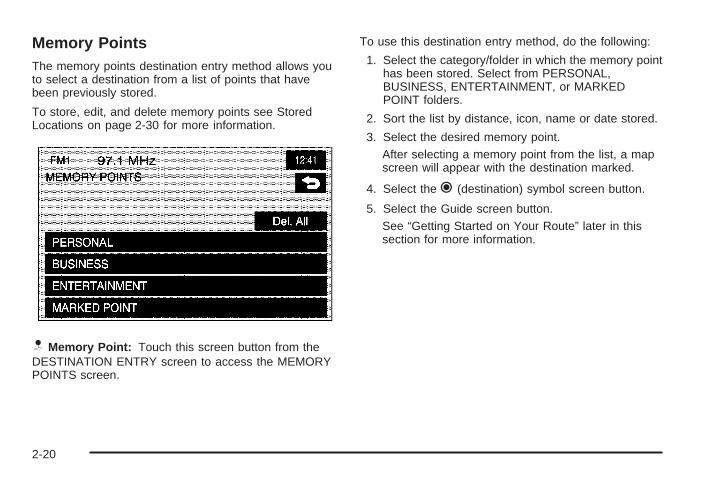
Memory PointsThe memory points destination entry method allows youto select a destination from a list of points that havebeen previously stored.
To store, edit, and delete memory points see StoredLocations on page 2-30 for more information.
N Memory Point: Touch this screen button from theDESTINATION ENTRY screen to access the MEMORYPOINTS screen.
To use this destination entry method, do the following:
1. Select the category/folder in which the memory pointhas been stored. Select from PERSONAL,BUSINESS, ENTERTAINMENT, or MARKEDPOINT folders.
2. Sort the list by distance, icon, name or date stored.
3. Select the desired memory point.After selecting a memory point from the list, a mapscreen will appear with the destination marked.
4. Select the h (destination) symbol screen button.
5. Select the Guide screen button.See “Getting Started on Your Route” later in thissection for more information.
2-20

Previous DestinationThe previous destination entry method allows youto select a destination from a list of previousdestination points.
h Previous Destination: Touch this screen buttonfrom the ENTER DESTINATION screen to access thePREVIOUS DEST screen. The system will store upto 100 points that have been previously input. As newdestinations are entered, the system will automaticallydelete the oldest destinations and add the new entries.
To use the previous destination entry method, do thefollowing:
1. Select a previous destination from the list. Use theSort by Name/Date function as necessary. Alsofrom this menu you can select the previousstart point option. This option is available while thevehicle is moving.To use the previous start point option from thePREVIOUS DEST screen, select the PreviousStart Point screen button.
2. After selecting a destination from the list, a mapscreen will appear with the destination marked.
3. Select the h (destination) symbol screen button.
4. Select the Guide screen button.See “Getting Started on Your Route” later in thissection for more information.
2-21

IntersectionThe intersection destination entry method allows you toset two intersecting streets as your destination.
? Intersection: Touch this screen button fromthe ENTER DESTINATION screen to access theINTERSECTION screen.
To use this destination entry method, do the following:
1. Enter the first of two streets in the intersection.A list of available street names will display whenthere are less than five available. Touch theList screen button at any time to view the availablestreet names.
2. Select a street from the list, or continue to spell thestreet name to further reduce the number ofavailable street names.
3. After the first street has been selected, enter thesecond street name. The List button may againbecome available.
4. Select the second street from the list, or continue tospell the street name to further reduce the numberof available street names.After both streets have been selected, a mapscreen will appear with the destination marked.
5. Select the h (destination) symbol screen button.
6. Select the Guide screen button.See “Getting Started on Your Route” later in thissection for more information.
2-22
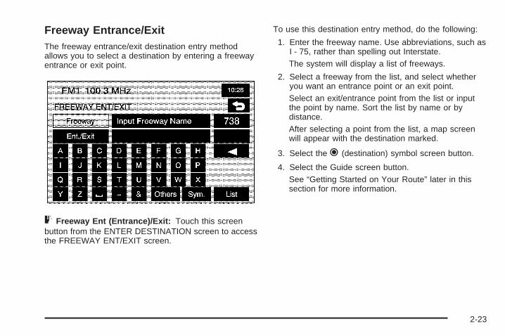
Freeway Entrance/ExitThe freeway entrance/exit destination entry methodallows you to select a destination by entering a freewayentrance or exit point.
= Freeway Ent (Entrance)/Exit: Touch this screenbutton from the ENTER DESTINATION screen to accessthe FREEWAY ENT/EXIT screen.
To use this destination entry method, do the following:
1. Enter the freeway name. Use abbreviations, such asI - 75, rather than spelling out Interstate.The system will display a list of freeways.
2. Select a freeway from the list, and select whetheryou want an entrance point or an exit point.Select an exit/entrance point from the list or inputthe point by name. Sort the list by name or bydistance.After selecting a point from the list, a map screenwill appear with the destination marked.
3. Select the h (destination) symbol screen button.
4. Select the Guide screen button.See “Getting Started on Your Route” later in thissection for more information.
2-23

Phone NumberThe phone number destination entry method allows youto select a destination by entering a phone number.The phone number must be in the list of POIs thatis contained on the map DVD for the system to retrievethe destination.
U Phone Number: Touch this screen button from theENTER DESTINATION screen to access the PHONENUMBER screen.
To use this destination entry method, do the following:
1. Input the phone number of a POI using thenumeric keypad.If the phone number can be found on the mapDVD, a map screen will appear with the destinationmarked. If the phone number is dependent onthe area code, a list of POIs will appear to selectfrom. Once a POI is selected, a map screenwill appear with the destination marked.
2. Select the h (destination) symbol screen button.
3. Select the Guide screen button.See “Getting Started on Your Route” later in thissection for more information.
2-24

CoordinatesThe coordinates destination entry method allows you toselect a destination by entering latitude and longitudecoordinates.
) Coordinates: Touch this screen button from theENTER DESTINATION screen to access theCOORDINATES screen.
To use this destination entry method, do the following:
1. Touch N (North) or S (South) next to LAT (latitude)to enter the direction of the latitude coordinate.
2. Input the numeric portion of the latitude coordinateusing the keypad.
3. Touch E (East) or W (West) next to LONG(longitude) to enter the direction of the longitudecoordinate.
4. Input the numeric portion of the longitude coordinateusing the keypad.
5. Once both coordinates are entered, touch the OKscreen button.A map screen will appear with the destinationmarked.If the coordinates are outside of the coverage areaon the map, you will be informed that there isno information on that location.
6. Select the h (destination) symbol screen button.
7. Select the Guide screen button.See “Getting Started on Your Route” later in thissection for more information.
2-25

Preset DestinationThe preset destination entry method allows you to set adestination by choosing from one of five previouslystored destinations. Besides home, these are the onlydestinations available to set while the vehicle is moving.
To store, edit, or delete a preset destination, see“Dest. & Way Pt. (Destination & Way Point” underStored Locations on page 2-30.
To use this destination entry method, do the following:
1. Select a preset destination number button fromthe ENTER DESTINATION screen. The screenbuttons are located on the bottom of the screen.A map screen will appear with the destinationmarked.
2. Select the h (destination) symbol screen button.
3. Select the Guide screen button.See “Getting Started on Your Route” later in thissection for more information.
HomeThis feature allows you to plan a route to one previouslystored destination that you have selected as a home. If ahome destination is not stored, the home button will notbe available. Besides preset destinations one throughfive, this destination is the only other one available to setwhile the vehicle is moving or by voice recognition.
To store, edit, or delete a home location, see StoredLocations on page 2-30.
L(Home): Touch this screen button from the ENTERDESTINATION screen to set a home destination.
To use this destination entry method, do the following:
1. Touch the Home button from the ENTERDESTINATION screen.
2. The system will then set your preset homedestination as the current destination. To store apreset home destination, see Stored Locationson page 2-30.A map screen will appear with the destinationmarked.
3. Select the h (destination) symbol screen button.
4. Select the Guide screen button.See “Getting Started on Your Route” later in thissection for more information.
2-26

Getting Started on Your RouteOnce a destination has been entered, you can performone of the following options:
h (Destination): Touch this button to set the entereddestination as it is, without further adjustment.
o (Waypoint): Touch this button to enter this point asa waypoint along the route. This feature allows youto enter up to five stops on the way to your destination.See “Dest. & Way Pt. (Destination & Way Point)”under Stored Locations on page 2-30 for moreinformation about adding and deleting waypoints.
Route Preference: Touch this screen button to accessthe ROUTE PREFERENCES screen to adjust theroute preferences. The current setting is displayed inthe Route Preference section of the map screen.See “Route Pref.” under Route Options on page 2-49for more information.
Once the route preferences have been set, the systemwill display the map screen.
2-27

After selecting the h (destination) symbol, the followingscreen buttons will become available.
Chg. (Change) Route: Touch this screen button to goto the Route Options menu. See Route Options onpage 2-49 for more information.
Guide: Touch this screen button to start route andvoice prompt guidance.
Three RoutesThe 3 routes screen will give you a selection of selectingthree different routes to get you to your destinations.To use the 3 routes option, do the following:
1. Select the 3 routes button on the map screen.
The system will calculate up to three different versionsof your current route in three different colors: Quick,Normal, and Short. The routes are shown with distanceto destination and estimated travel time, or selectthe Info screen button to access the INFO FOR3 ROUTES screen.
2-28

From this screen, you can view the following information:
• G (Estimated Travel Time) — This icon showsthe route’s estimated time of travel.
• J (Straight-Line Distance) — This iconshows the route’s straight-line distance todestination.
• W (Toll Road) — This icon shows the distancetraveled on toll roads.
• c (Freeway Travel) — This icon shows thedistance traveled on freeways.
• b (Ferry) — This icon shows the distancetraveled by ferry.
• { (Time Restricted Roads) — This iconshows the distance traveled on time-restrictedroads.
2. Select the Quick, Normal, or Short screen button.A map screen will appear with the destinationmarked.
3. Select the Guide screen button to start route andvoice guidance.
2-29

Stored Locations
Select the N Stored Locations screen button from theNAV. MENU to access the STORED LOCATIONSscreen. From this screen, you can access the followingoptions:
Memory PointsN Memory Points: This feature allows you to storememory points. You can store them in the fourcategories listed: Personal, Business, Entertainment,and Marked Point. These category names can bechanged for your convenience.
To store a point:1. Touch the Memory Points screen button from the
STORED LOCATIONS screen.2. Select one of the folders/categories listed.3. Select the Add screen button.4. Select the desired method of entering a destination
to enter the memory point. See Enter Destination onpage 2-11 for more information. A map screen willappear displaying the selected memory pointlocation.
5. If available, touch the INFO button to view theaddress information of the selected point.
6. Touch OK to store the point as a memory point.
2-30

To edit the name of a stored point:
1. Touch the Memory Points screen button from theSTORED LOCATIONS screen.
2. Select the folder/category that the memory pointexists in.
3. Select the List screen button.
4. Select the memory point to edit. Use the sortfeature to sort by distance, icon, name, or dateas needed.
5. Touch the Name screen button from the EDITMEMORY POINT screen.
6. Use the backspace screen button to delete thecurrent name or use the alpha keypad to makechanges.Select the Show Name On screen button to havethe name of the point appear on the map screen.
7. Touch the back screen button to store the change.
To change the icon associated with a memory point:
1. Touch the Memory Points screen button fromthe STORED LOCATIONS screen.
2. Select the folder/category that the memory pointexists in.
3. Select the List screen button.
4. Select the memory point to edit. Use the sortfeature to sort by distance, icon, name, or dateas needed.
5. Touch the Icon screen button from the EDITMEMORY POINT screen.
6. Select the desired icon. There are two pages(52) icons, six icons that have sounds associatedwith them, and a No Icon button to select from.Select the With Sound screen button, and the soundicons will display. To hear the sound of the icon,touch the Sound screen button next to each icon.If the sound icons are used, the associated soundwill be heard when the vehicle is approximately650 ft (200 m) from the memory point.Select the No Icon screen button to not have anicon associated with the point.The new icon will display in the EDIT MEMORYPOINT screen, next to the Icon screen button.
7. Touch the back screen button to store the change.
2-31

To move the memory point from one folder/category toanother:
1. Touch the Memory Points screen button from theSTORED LOCATIONS screen.
2. Select the folder/category that the memory pointcurrently exists in.
3. Select the List screen button.
4. Select the memory point to edit. Use the sortfeature to sort by distance, icon, name, or dateas needed.
5. Touch the Category screen button from the EDITMEMORY POINT screen.
6. Touch the new folder/category button you want tomove the memory point to.The system will display a message confirmingthe move.
To modify the position of the stored point:
1. Touch the Memory Points screen button from theSTORED LOCATIONS screen.
2. Select the folder/category that the memory pointexists in.
3. Select the List screen button.
4. Select the memory point to edit. Use the sortfeature to sort by distance, icon, name, or dateas needed.
5. Touch the Position screen button from the EDITMEMORY POINT screen.The system will display the map screen with thedestination marked.
6. Touch the map to move the position of thememory point.
7. Touch OK when you have moved the memory pointto the appropriate location.
8. The system will return to the EDIT MEMORYPOINT screen and will display the new address,longitude, and latitude for the changedmemory point.
2-32

To change the phone number of a memory point:
1. Touch the Memory Points screen button from theSTORED LOCATIONS screen.
2. Select the folder/category that the memory pointexists in.
3. Select the List screen button.
4. Select the memory point to edit. Use the sortfeature to sort by distance, icon, name, or dateas needed.
5. Touch the Tel. (telephone) screen button from theEDIT MEMORY POINT screen.
6. Use the numeric keypad to change thephone number.
7. Touch OK to store the changed phone number.
To delete a memory point:
1. Touch the Memory Points screen button from theSTORED LOCATIONS screen.
2. Select the folder/category that the memorypoint exists in.
3. Select the Delete screen button.
4. Select the memory point to delete from the DELETEPOINT screen. Use the sort feature to sort bydistance, icon, name or date as needed.
5. The system will display the map screen with theposition address and a pop-up confirmationmessage. Select Yes to delete the point; selectNo to return to the DELETE POINTS screen and notdelete the point.
To delete all of the memory points in a folder/category:
1. Touch the Memory Points screen button fromthe STORED LOCATIONS screen.
2. Select the desired folder/category.
3. Select the Del.All screen button.
4. The system will display a pop-up confirmationmessage. Select Yes to delete all the points inthe folder/category; select No to cancel theoperation.
To change the name of the folder/category:
1. Touch the Memory Points screen button from theSTORED LOCATIONS screen.
2. Select the desired folder/category.
3. Select the Edit Category screen button.
4. Use the alpha keypad to change the name of thefolder/category.
5. Touch the OK screen button to save the changes.
2-33

Avoid Area
3 Avoid Area: This feature allows you to store anarea to be avoided while planning a route. Up to10 points can be stored.
To store an avoid area point, do the following:
1. Touch the Avoid Area screen button from theSTORED LOCATIONS screen.
2. Touch the Add screen button from the AVOIDAREA screen.
3. Select the desired method of entering a destinationto enter the memory point. See Enter Destinationon page 2-11 for more information. A mapscreen will appear displaying the selected memorypoint location.
4. If desired, reduce or enlarge the area around thepoint you want to avoid by using the Reduce orEnlarge screen buttons.It is recommended that when avoiding locations onfreeways, you reduce the avoid area to theminimum scale. This will produce an X on the maprather than a box. This will ensure that thesystem knows you want to avoid the freeway itself,not necessarily the area around the freeway.
5. Touch OK to store the area.
2-34

To change the name of the point to be avoided:
1. Touch the Avoid Area screen button from theSTORED LOCATIONS screen.
2. Touch the List screen button from the AVOIDAREA screen.
3. Select the point to be changed.
4. Touch the Name screen button.
5. Use the alpha keypad to add or to changethe name.Select the Show Name On screen button to havethe name of the point appear on the map screen.
6. Touch the OK screen button to save the changes.
To change the position of the point to be avoided:
1. Touch the Avoid Area screen button from theSTORED LOCATIONS screen.
2. Touch the List screen button from the AVOIDAREA screen.
3. Select the point to be changed.
4. Touch the Position screen button.
5. Touch the map to move the location.
6. If desired, reduce or enlarge the area around thepoint you want to avoid by using the Reduce orEnlarge screen buttons.
7. Touch OK to store the area.
To delete a point to be avoided:
1. Touch the Avoid Area screen button from theSTORED LOCATIONS screen.
2. Touch the Delete screen button from the AVOIDAREA screen.
3. Select the point to delete. Use the scrolling arrowsas needed.
4. The system will display the map screen with thename of the point and a pop-up confirmationmessage. Touch Yes to have the point deleted;touch No to cancel the function.
To delete all of the points to be avoided:
1. Touch the Avoid Area screen button from theSTORED LOCATIONS screen.
2. Touch the Del.All screen button from the AVOIDAREA screen.
3. The system will display a pop-up confirmationmessage. Touch Yes to have all of the pointsdeleted; touch No to cancel the function.
2-35
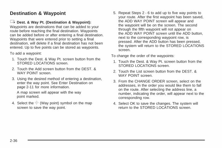
Destination & Waypoint
6 Dest. & Way Pt. (Destination & Waypoint):Waypoints are destinations that can be added to yourroute before reaching the final destination. Waypointscan be added before or after entering a final destination.Waypoints that were entered prior to setting a finaldestination, will delete if a final destination has not beenentered. Up to five points can be stored as waypoints.
To add a waypoint:
1. Touch the Dest. & Way Pt. screen button from theSTORED LOCATIONS screen.
2. Touch the Add screen button from the DEST. &WAY POINT screen.
3. Using the desired method of entering a destination,enter the way point. See Enter Destination onpage 2-11 for more information.A map screen will appear with the waypoint marked.
4. Select the o (Way point) symbol on the mapscreen to save the way point.
5. Repeat Steps 2 - 6 to add up to five way points toyour route. After the first waypoint has been saved,the ADD WAY POINT screen will appear andthe waypoint will be on the screen. The secondthrough the fifth waypoint will not appear onthe ADD WAY POINT screen until the ADD button,next to the corresponding waypoint row, ispressed. After the ADD button has been pressed,the system will return to the STORED LOCATIONSscreen.
To change the order of the waypoints:
1. Touch the Dest. & Way Pt. screen button from theSTORED LOCATIONS screen.
2. Touch the List screen button from the DEST. &WAY POINT screen.
3. From the CHANGE ORDER screen, select on theaddresses, in the order you would like them to fallon the route. After selecting the address line, anumber, indicating the order, will appear next to thecorresponding row.
4. Select OK to save the changes. The system willreturn to the STORED LOCATIONS screen.
2-36

To change the location of a way point:
1. Touch the Dest. & Way Pt. screen button from theSTORED LOCATIONS screen.
2. Touch the List screen button from the DEST. &WAY POINT screen.
3. Touch the Chg. Loc. screen button from theCHANGE ORDER screen.
4. From the CHANGE LOCATION screen, select theaddress of the location to change. A map screenwill display with the destination marked.
5. Touch on the map to move the location of thewaypoint.
6. Touch the OK screen button to save the changes.The system will return to the STORED LOCATIONSscreen.
To delete a way point from the current route:
1. Touch the Dest. & Way Pt. screen button from theSTORED LOCATIONS screen.
2. Touch the Delete screen button from the DEST. &WAY POINT screen.
3. Select the way point/destination to delete.
4. The system will display a pop-up confirmationmessage. Choose Yes to delete the way point;touch No to cancel this operation.
To delete all of the way points on the route:
1. Touch the Dest. & Way Pt. screen button from theSTORED LOCATIONS screen.
2. Touch the Del.All screen button from the DEST. &WAY POINT screen.
3. The system will display the map screen with apop-up confirmation message. Choose Yes todelete all of the way points; touch No to cancel thisoperation.
2-37

Home
L Home: This feature allows you to store, delete, andedit a home point destination.
To store the home destination, do the following:
1. Touch the Home screen button from the STOREDLOCATIONS screen.
2. Select the Add screen button.
3. Select a destination entry method from the SETHOME screen. See Enter Destination on page 2-11for more information.
4. Set the destination and touch OK.
5. Touch OK on the map screen and the destinationwill be stored. The home icon will now behighlighted on the ENTER DESTINATION screen.
To edit the home destination, do the following:
1. Touch the Home screen button from the STOREDLOCATIONS screen.
2. Select List from the HOME screen to change thelocation.
3. Touch the map to move the location of the point.
4. Touch OK to save the change.
To delete the home point, do the following:
1. Touch the Home screen button from the STOREDLOCATIONS screen.
2. Select Delete from the HOME screen.
3. The system will display the map screen with apop-up confirmation message. Select Yes to deletethe stored home position; select No to cancel theoperation.
2-38

Previous Destination
B Previous Dest. (Previous Destination): Thesystem will automatically store up to 100 points thathave been previously input. As new destinationsare entered, the system will automatically delete theoldest destinations and add the new entries. See EnterDestination on page 2-11 for more information.To delete a specific destination from the previousdestinations list, do the following:1. Touch the Previous Dest. screen button from the
STORED LOCATIONS screen.2. Touch the Delete screen button.3. Select a destination from the list.4. The system will display the map screen with a
pop-up confirmation message. Select Yes todelete the stored destination; select No to cancelthe operation.
To delete all destinations from the previous destinationslist, do the following:1. Touch the Previous Dest. screen button from the
STORED LOCATIONS screen.2. Touch the Del.All screen button.3. The system will display the map screen with a
pop-up confirmation message. Select Yes todelete all of the stored destinations; select No tocancel the operation.
Preset Destination
A Preset Dest. (Preset Destination): This featureallows you to store up to five preset destinations.These destinations are stored on the numberedbuttons shown on the bottom of the ENTERDESTINATION screen.
To store a preset destination, do the following:
1. Touch the Preset Dest. screen button from theSTORED LOCATIONS screen.
2. Select Add to add a preset destination, then selectthe numbered preset button for the destination toappear as.
3. Select a destination entry method from the STOREPRESET DEST. screen. See Enter Destination onpage 2-11 for more information.
4. Set the destination and touch OK.
5. Touch OK on the map screen and the destinationwill be stored. The preset destination numberwill now be highlighted on the ENTERDESTINATION screen.
2-39
To edit the name of a preset destination, do thefollowing:
1. Touch the Preset Dest. screen button from theSTORED LOCATIONS screen.
2. Select the List screen button.
3. Select the preset destination to edit.
4. Touch the Name screen button and use the alphakeypad to edit or add the name.Select the Show Name On screen button to havethe name appear on the map screen.
5. Touch the OK screen button to save the change.The new name will display.
To change the position of a preset destination, do thefollowing:
1. Touch the Preset Dest. screen button from theSTORED LOCATIONS screen.
2. Select the List screen button.
3. Select the preset destination to change.
4. Touch the Position screen button from the EDITPRESET DEST. screen. The system will displaythe map screen with the destination marked.
5. Touch the map to move the position of thememory point.
6. Touch the OK screen button to save the change.
To add or change the phone number of a presetdestination, do the following:
1. Touch the Preset Dest. screen button from theSTORED LOCATIONS screen.
2. Select the List screen button.
3. Select the preset destination to change.
4. Touch the Tel. (telephone) screen button anduse the numeric keypad to input or change thephone number.
5. Touch the OK screen button to save the change.
To delete a preset destination:
1. Touch the Preset Dest. screen button from theSTORED LOCATIONS screen.
2. Select the Delete screen button.
3. Select the memory point to delete from theDELETE PRESET DEST. screen.
4. The system will display the map screen with theposition address and a pop-up confirmationmessage. Select Yes to delete the point; selectNo to cancel the operation and to return tothe DELETE PRESET DEST. screen.
2-40

To delete all of the preset destinations:
1. Touch the Preset Dest. screen button from theSTORED LOCATIONS screen.
2. Select the Del.All screen button.
3. The system will display a pop-up confirmationmessage. Select Yes to delete all of the presetdestinations; select No to cancel the operation.
Memory Point Icons Display: Select this screenbutton to display memory point icons on the map.The button will be highlighted when the memory pointicons are being displayed on the map.
Calculate: Touch this button to calculate your route.This button is available after a destination has been set.
Navigation Set Up
Select the MENU screen button to access the NAV.MENU screen.
I Navigation Set Up: Touch this screen buttonfrom the NAV. MENU screen to access theNAVIGATION SET UP screen. Several system optionsare available for adjustment.
2-41

Two-Dimensional/Three-Dimensional(2D/3D) View
8 2D/3D View: Touch this screen button from theNAVIGATION SET UP screen. This feature allowsyou to change the view of the map between a2-dimensional and 3-dimensional view.
Map Screen 2D/3D: This will change the view of allmap screens.
Guidance Screen 2D/3D: This will change the view ofthe map screen while driving during route guidance.
n / q (Scroll Arrows): Select the up or down arrowsto tilt the view of the map screen.
4 (Back): Select this screen button to save thechanges.
Default: Press this button to cancel your changes andgo back to the default settings (2D and 2D).
2-42

Quick POI Selection
C Quick POI Selection: This feature allows youto select the POI categories you want available onthe Quick POI (Q-POI) screen.
To replace the default POI categories on the Quick POI(Q-POI) screen, do the following:
1. Select the C Quick POI Selection screenbutton from the NAVIGATION SET UP menu.This screen will display the list of POI categories.
2. Select the POI category that you would like tochange. The category to change will display withthe list of categories to select from.Select the All Category List screen button to displayall categories and sub-categories.
3. Select a different POI category. The POI categoryicon to change will be replaced with the new POIcategory icon at the top of the screen. This POI willnow be available on the Q-POI screen.
2-43

Quick POIOnce categories have been selected on the Q-POISELECTION screen, the POI categories are nowavailable on the Quick POI screen. From this screenyou can select the POI icons that you would like todisplay on the map screen. You can either select a POIfor a final destination or as a waypoint. The Quick POIscreen is available when the scale is 1⁄2 mile (1 km)or less.
To use the QUICK POIscreen, select the POIscreen button fromthe map screen.
The POI categories that were selected on the Q-POISELECTION screen will display.
To have the POI icons appear on the map screen,select the POI category. The POI category iconwill display at the top of the screen.
List Categories: Select this screen button to displaymore categories to select from.
2-44

All Local POIs
1. Select this screen button to select a POI as adestination. A list of all of the local POIs withina 5 mi. (8 km) radius of your vehicle’s currentposition will display. This list is generated from thePOI categories that have been selected andappear at the top of the QUICK POI screen.Use the Sort by Dist. (distance), Icon, Name, orRoute screen buttons. Use the up and down scrollarrow screen buttons to scroll through the list.
2. Select the POI. The map screen will displaywith the scroll symbol around the selected POI.The name and the POI information will also displayon the map screen.
3. Select the h (destination) symbol screen button.
4. Select the Guide screen button.See “Getting Started on Your Route” for moreinformation.
All Category List: This screen button will appear oncethe List Categories screen button has been selected.Press this screen button to display a list ofsub-categories.
Show: Select this screen button to display themap screen.
Delete: To delete a category, do one of the following:
• To delete the last added POI category, selectthe Delete screen button.
• To delete a specific POI category, select that POIcategory from the list.
POI Off: Select this screen button to delete all of thePOI categories in the list.
2-45

Calibration
5 Calibration: Touch this screen button from theNAVIGATION SET UP screen. This feature allows youto recalibrate the navigation system.
The Calibration screen, allows the adjustment of yourvehicle’s position or the vehicle speed signal.
To correct the position of your vehicle on the map(for example, if your vehicle has been shipped) or tochange to the current position.
1. Select the Position/Direction screen button.The map screen will display with your vehicle’scurrent position.
2. To change your vehicle’s position, touch themap screen.Use the zoom in/out function to view the direction ofthe desired area.Pressing/holding and dragging on the map willactivate fast scrolling. Press/touch once on thearea to which you would like to move the currentposition mark.
3. Touch the OK screen button once your vehicle is inthe current position.If a route had already been set, the map screen willdisplay, select Guide to change your route toyour vehicle’s new position.Once the process of changing your vehicle’s currentposition is complete, the map screen will display withrotate arrow screen buttons around your vehicle.
4. To change the direction of your vehicle, press eitherarrow screen button to rotate your vehicle to thecorrect direction.
5. Once your vehicle is facing the correct direction,select the OK screen button.
See Problems with Route Guidance on page 2-57 formore information.If there are tire pressure differences or a spare tire isinstalled, the system will automatically re-calibrate thesystem but it may take longer. To calibrate the vehiclespeed signal, touch the Distance screen button. SeeVehicle Positioning on page 2-56 for more information.
2-46

User Settings
J User Settings: Touch this screen button from theNAVIGATION SET UP screen. This feature allowsyou to turn on and off several route options.
From this screen, you can adjust the following:
Road Restriction Warnings: This option instructs thesystem to notify you when the current route hastraffic restrictions.
Arrival Time G (Time of Arrival): This option willdisplay the estimated time of arrival to the destination.
Arrival Time \ (Time to Destination): This option willdisplay the amount of drive time estimated to arrive atthe destination.
Guidance Screen: This option will turn the guidancescreen on and off.
Freeway Information: This option will display freewayexit information. This is only available on freewaysduring route guidance.
2-47

Restore System Defaults
D Restore System Defaults: Select this featurefrom the NAVIGATION SET UP screen to changeall adjustable system settings to factory defaults.
OK: Select this screen button to restore the systemdefaults.
Average speed Default: Select this option to set theaverage speed to default. The system monitors thespeed on different roads and updates the average speedthe vehicle travels at. This average speed is used tocalculate the time it will take to reach the destinationwhen you set a route.
Guidance Volume
> Guidance Volume: This feature allows you toadjust the volume of voice guidance prompts. Select Offto turn voice guidance prompts off.
2-48

Route Options
Select Change Route from the NAV. MENU screen toaccess the ROUTE OPTIONS screen. This menuhas many features to customize route guidance. A routemust first be set to use these features. See EnterDestination on page 2-11 for more information onentering a destination.
Search ConditionH Search Conditn (Search Condition): Thisfeature will access the SEARCH CONDITION screen.
The search condition screen allows you to viewyour current destination and to change the planningmethods between each destination. Each distancebetween waypoints and final destination can havean individual setting.
n / q (Scroll Arrows): Use the up and downarrows to scroll through each route.
Quick/Normal/Short: Select one of the routepreference options to change the planning method.
Calculate: After selecting the new methods, selectCalculate to plan the route with the changes. The mapscreen will display.
2-49
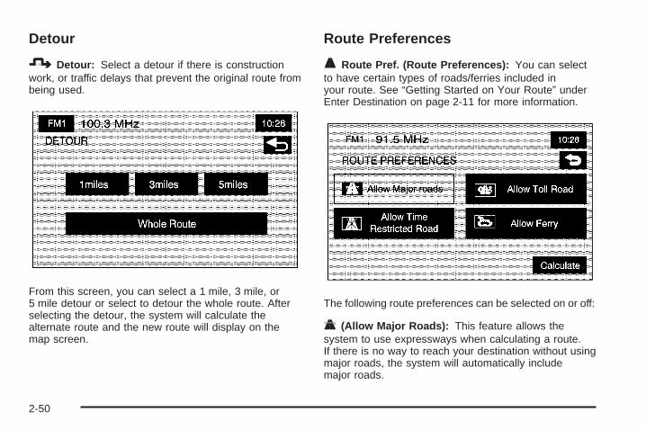
Detour
7 Detour: Select a detour if there is constructionwork, or traffic delays that prevent the original route frombeing used.
From this screen, you can select a 1 mile, 3 mile, or5 mile detour or select to detour the whole route. Afterselecting the detour, the system will calculate thealternate route and the new route will display on themap screen.
Route Preferences
F Route Pref. (Route Preferences): You can selectto have certain types of roads/ferries included inyour route. See “Getting Started on Your Route” underEnter Destination on page 2-11 for more information.
The following route preferences can be selected on or off:
c (Allow Major Roads): This feature allows thesystem to use expressways when calculating a route.If there is no way to reach your destination without usingmajor roads, the system will automatically includemajor roads.
2-50

l (Allow Time Restricted Road): This feature allowsthe system to use time restricted roads whencalculating a route. These are roads that may be closedduring the winter season.
W (Allow Toll Road): This feature allows the systemto use toll roads or pay roads when calculating a route.
b (Allow Ferry): This feature allows the system touse ferries when calculating a route.
Calculate: Select this screen button to update thechanges in the current route. The map screen willdisplay.
If any of these features are turned off, the button will bedark and there will be a red slash through the iconon the map screen.
Once the route preferences have been set, select theback button to return to the previous screen.
Destination and Waypointo Dest. & Way Pt. (Destination and Waypoint):This feature allows you to edit the selected destinationand waypoints using this screen. See “Dest. andWay Pt. (Destination and Way Point)” under StoredLocations on page 2-30 for information on storingdestinations and waypoints.
Up to five waypoints and one destination can beentered. The following functions are available:
Add: This button will access the Store Dest. &Waypoint screen. You can add a waypoint or changethe destination.
List: Touch this button to change the order of the stopsin the route and to change the location of the stops.
Delete/Del. All: These buttons allow you to deletewaypoints on the route or to delete the entire route.
2-51

Display route
9 Display route: Select this button from the ROUTEOPTIONS menu to view the entire route. The startpoint and destination, the time it will take to reach thedestination, and distance, including the distancethat is routed on each road type will display.
Turn List: Edit the route by selecting the Turn Listscreen button. A list of every turn on the route willdisplay. With the turn list displayed, you can select toavoid streets/turns on the route.
Avoid: To avoid a street, select the Avoid screenbutton next to the turn. To cancel the avoided turn,select Avoid again to deselect it.
Reroute: After selections have been made, press theReroute screen button to replan the route.
Delete: To cancel an avoided turn after the routehas been replanned, press the Delete screen button.A list of all of the avoided turns will display. Selectthe street that you want to add back to the route.A confirmation window will display. Select Yes tohave the avoided street added back to the route.The Turn List screen will display.
Del. All (Delete All): To cancel all of the avoidedturns after the route has been replanned, press theDelete screen button. A list of all of the avoided turnswill display. Select the Del. All screen button.A confirmation window will display. Select Yes tohave all of the avoided streets added back to theroute. The Turn List screen will display.
2-52

Route Preview
G Route Preview: Select this button from theROUTE OPTIONS menu to preview the entire route ineither direction and to edit the route.
Use the screen buttons at the bottom of the navigationscreen to move through the route.
bt (Skip to Start Point): Touch this screen buttonto skip backward to the start point, the previouswaypoint, or the previous available POI, depending onthe mode selected.
bq (Scroll to Start Point): Touch this screen buttonto start a smooth scroll of the route backwards to thestart point, previous waypoint, or the previous availablePOI, depending on the mode selected. Touch thisbutton again to increase the scroll speed.
j (Pause): Touch this screen button to pause thesmooth scroll. Push either scroll button (bqr h)to restart the scroll.
rh (Scroll to Destination): Touch this screen buttonto start a smooth scroll of the route toward thedestination, next waypoint or next available POI,depending on the mode selected. Touch this buttonagain to increase the scroll speed.
uh (Skip to Destination): Touch this screen buttonto skip forward to the destination, next waypoint ornext available POI, depending on the mode selected.
Edit: Touch this screen button to change the waythe skip/scroll function operates. You can select to havethe skip/scroll go to the start point/destination or tothe next available POI or waypoint.
2-53

To next Dest. (Destination) or WP (Waypoint): Selectthis button to have the skip/scroll functions skip/scrollto the next destination or waypoint.
To next POI: To select this option, a POI categorymust be selected. Select this button to have theskip/scroll functions skip/scroll to the next available POIfor the category. To change the POI category, touchthe corresponding screen button next to the category.Touch the Delete screen button to have no POIs appearon the map. The default POIs are the same as thosein the Quick POI group listing.
Calculate: Touch this screen button to calculate theroute with the changes.
Once the route has been calculated, this screen willdisplay. From this map screen, touch Guide tobegin route guidance or touch Chg. route to return tothe ROUTE OPTIONS screen.
Cancel Guidance: Touch this screen button to cancelthe current route.
2-54

Keyless Access SystemWhen you start your vehicle you will see Driver 1 orDriver 2 displayed on the driver information center (DIC).The number on the back of the RKE transmittercorresponds to driver 1 or driver 2. The navigationsystem can store memory points, audio presets, systemsettings, and last know audio mode for driver 1 anddriver 2 individually. See “Vehicle Personalization” in theindex of your vehicle’s owner manual for moreinformation.
Global Positioning System (GPS)The Navigation System determines the position of yourvehicle by using satellite signals, various vehiclesignals and map data.
At times, other interferences such as the satellitecondition, road configuration, the condition of the vehicleand/or other circumstances can interfere with theNavigation’s ability to determine the accurate position ofthe vehicle.
The GPS shows the accurate current position of yourvehicle using signals sent by the GPS Satellites ofthe United States Department of Defense. When yourvehicle is not receiving signals from the satellites,a symbol will appear on the map screen. Refer toSymbols on page 2-5.
This system may not be available/or interference mayoccur if the following happens:
• Signal obstructions caused by tall buildings, largetrucks, tunnels,
• objects located on top of the instrument panel,
• satellites will not send signals if they are beingrepaired or improved,
• after-market glass tinting has been applied to thevehicle’s windows.
Notice: Do not apply after-market glass tinting tothe vehicle’s windows. Glass tinting will interferewith the system’s ability to receive GPS signals andcause the system to malfunction. You might haveto replace the window to correct the problem.This would not be covered by your warranty.
For more information if you are experiencing a problem,see If the System Needs Service on page 2-58 andProblems with Route Guidance on page 2-57.
2-55

Vehicle PositioningAt times, the position of the vehicle on the map may beinaccurate due to one or more of the followingreasons:
• The road system has changed.
• The vehicle is driving on slippery road surfacessuch as in sand, gravel and/or snow.
• The vehicle is traveling on winding roads.
• The vehicle is on a long straight road.
• The vehicle is approaching a tall building or alarge vehicle.
• The surface streets run parallel to a freeway.
• The vehicle has just been transferred by a vehiclecarrier or a ferry.
• The current position calibration is set incorrectly.
• The vehicle is traveling at high speed.
• The vehicle changes directions more than once, orwhen the vehicle is turning on a turn table in aparking lot.
• The vehicle is entering and/or exiting a parking lot,garage or a lot with a roof.
• The GPS signal is not received.
• A roof carrier is installed on your vehicle.
• The vehicle is equipped with tire chains.
• The tires are replaced.
• The tire pressure for your tires is incorrect.
• The tires are worn.
• The first time the map DVD is inserted.
• The battery is disconnected for several days.
• The vehicle is driving in heavy traffic where drivingis at low speeds, and the vehicle is stopped andstarted repeatedly.
If you experience problems with your system, you mayneed to calibrate the system. This may be due totire pressure differences, or if a spare tire is installed.To calibrate the system, see Navigation Set Up onpage 2-41.
2-56

Problems with Route GuidanceInappropriate route guidance may occur under one ormore of the following conditions:
• You have not turned onto the road indicated.
• Route guidance may not be available when usingautomatic rerouting for the next right or left turn.
• The route may not be changed when usingautomatic rerouting.
• There is no route guidance when turning at anintersection.
• Plural names of places may be announcedoccasionally.
• It may take a long time to operate automaticrerouting during high-speed driving.
• Automatic rerouting may display a route returning tothe set waypoint if you are heading for a destinationwithout passing through a set waypoint.
• The route prohibits the entry of a vehicle due to aregulation by time or season or any other regulationwhich may be given.
• Some routes may not be searched.
• The route to the destination may not be shown ifthere are new roads, if roads have recentlychanged or if certain roads are not listed on themap DVD. See Ordering Map DVDs on page 2-58.
To recalibrate the vehicle’s position on the map, seeNavigation Set Up on page 2-41.
2-57

If the System Needs ServiceIf your system needs service and you have followed thesteps listed here and still are experiencing problems,see your dealer for assistance. For more information oncalibrating the system, see Navigation Set Up onpage 2-41.
Ordering Map DVDsThe map DVD in your vehicle is the most up-to-dateinformation available when your vehicle was purchased.The map DVD is updated once a year, provided thatthe map information has changed. To order a new mapDVD, contact your dealer.
Database Coverage ExplanationsThe United States, excluding Alaska and Hawaii, andportions of Canada are contained on one DVD disc.The map database contains three different levelsof coverage: detailed areas, non-detailed areas, andlimited guidance areas.
• Detailed areas are available for the United Statesand Canada and are primarily located aroundmetropolitan areas.
• Limited guidance areas are only available for theUnited States. The roads are displayed on themap, but route and voice guidance is not available.
• Non-detailed areas are available for Canadaonly. Major roads are included dependingupon available coverage.
For more detailed information on database coverage,see the Navigation System Map Disc manual includedinside the map DVD case.
2-58
Navigation Audio System ..................................3-2CD Player ...................................................3-14Six-Disc CD Changer ....................................3-19Radio Personalization with Home
and Away Feature .....................................3-23
Section 3 Navigation Audio System
3-1

Navigation Audio SystemNotice: Before adding any sound equipment toyour vehicle, such as an audio system, CD player,CB radio, mobile telephone, or two-way radio, makesure that it can be added by checking with yourdealer. Also, check federal rules covering mobileradio and telephone units. If sound equipment canbe added, it is very important to do it properly.Added sound equipment may interfere withthe operation of your vehicle’s engine, radio, orother systems, and even damage them. Yourvehicle’s systems may interfere with the operationof sound equipment that has been added.
Notice: The chime signals related to seat belts,parking brake, and other functions of your vehicleoperate through the navigation system. If thatequipment is replaced or additional equipment isadded to your vehicle, the chimes may not work.Make sure that replacement or additional equipmentis compatible with your vehicle before installingit. See “Accessories and Modifications” in the Indexof your vehicle’s owner manual.
Your vehicle has a feature called Retained AccessoryPower (RAP). With RAP, the audio system can beplayed even after the ignition is turned off. See“Retained Accessory Power (RAP)” in the Index of yourvehicle’s owner manual for more information.
The audio system is operated using the navigationsystem menus.
Playing the Radio
Power/Volume Knob: Press this knob to turn the audiosystem on and off. Turn the knob to increase ordecrease the volume to the audio system.
¦O SEEK ¥: Press and hold the up or downarrow until a beep is heard to go to the next or previousstation and stay there. Press and hold either arrow toperform a fast seek.
SRCE (Source): Press this hard key to display themain audio screen.
3-2

Audio Adjust Screen
e / z (Audio/Adjust Screen): Press this key toview the audio and screen settings.
Automatic Volume Control (AVC): With AVC, theaudio system will adjust automatically to make upfor road and wind noise as you drive, by increasing thevolume as vehicle speed increases.
To use AVC, set the volume to your desired level andthen touch the ON screen button. To turn AVC off,select the OFF screen button.
If your vehicle has the Bose® audio system, it includesBose AudioPilot® noise compensation technology.When turned on, AudioPilot® continuously adjusts theaudio system to compensate for background noise,so that your audio always sounds the same at the setvolume level. This feature is most effective at lowervolume settings where background noise can affect howwell you hear the music being played through yourvehicle’s audio system. At higher volume settings theremay be little or no adjustments by AudioPilot®.
To use AudioPilot®, set the volume to your desired leveland then touch the ON screen button. To turn AVCoff, select the OFF screen button.
Preset Selection: This feature allows you to programlocal presets which you can recall by touchingHOME. You may also program presets while you aretraveling to another area and store them under AWAY.See “Preset Station Menu” later in this section formore information.
The Home and Away feature is not available forXM™ Satellite Radio Service, if equipped.
3-3
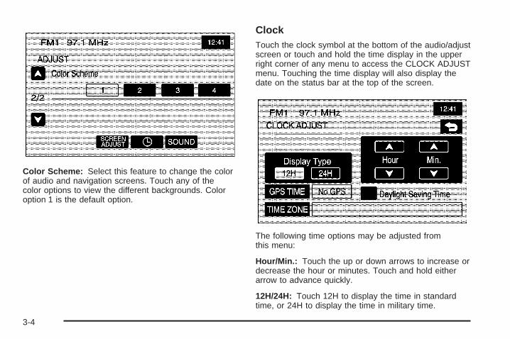
Color Scheme: Select this feature to change the colorof audio and navigation screens. Touch any of thecolor options to view the different backgrounds. Coloroption 1 is the default option.
ClockTouch the clock symbol at the bottom of the audio/adjustscreen or touch and hold the time display in the upperright corner of any menu to access the CLOCK ADJUSTmenu. Touching the time display will also display thedate on the status bar at the top of the screen.
The following time options may be adjusted fromthis menu:
Hour/Min.: Touch the up or down arrows to increase ordecrease the hour or minutes. Touch and hold eitherarrow to advance quickly.
12H/24H: Touch 12H to display the time in standardtime, or 24H to display the time in military time.
3-4
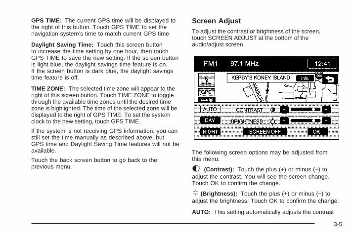
GPS TIME: The current GPS time will be displayed tothe right of this button. Touch GPS TIME to set thenavigation system’s time to match current GPS time.
Daylight Saving Time: Touch this screen buttonto increase the time setting by one hour, then touchGPS TIME to save the new setting. If the screen buttonis light blue, the daylight savings time feature is on.If the screen button is dark blue, the daylight savingstime feature is off.
TIME ZONE: The selected time zone will appear to theright of this screen button. Touch TIME ZONE to togglethrough the available time zones until the desired timezone is highlighted. The time of the selected zone will bedisplayed to the right of GPS TIME. To set the systemclock to the new setting, touch GPS TIME.
If the system is not receiving GPS information, you canstill set the time manually as described above, butGPS time and Daylight Saving Time features will not beavailable.
Touch the back screen button to go back to theprevious menu.
Screen AdjustTo adjust the contrast or brightness of the screen,touch SCREEN ADJUST at the bottom of theaudio/adjust screen.
The following screen options may be adjusted fromthis menu:
K (Contrast): Touch the plus (+) or minus (−) toadjust the contrast. You will see the screen change.Touch OK to confirm the change.
!(Brightness): Touch the plus (+) or minus (−) toadjust the brightness. Touch OK to confirm the change.
AUTO: This setting automatically adjusts the contrast
3-5

and brightness of the screen based on outside lightingconditions.
DAY: This setting leaves the screen in day mode.Day mode is best suited for daylight conditions.
NIGHT: This setting leaves the screen in night mode.Night mode is best suited for nighttime conditions.
SCREEN OFF: Touch SCREEN OFF to turn off thescreen. Press the NAV, SRCE, ore/ z (audio adjust)hard key to turn the screen back on.
OK: Touch OK to save the changes and exit this menu.
SOUND: Touch SOUND to access the SOUNDmenu. See “Sound Menu” later in this section for moreinformation.
Finding a StationPress the SRCE hard key to display the operationscreen of the current audio source. Each operationscreen has an audio source screen button, (AM, FM1,FM2, XM1, XM2, if equipped, and CD). Touch thedesired audio source to select it.
3-6

Preset Station MenuUp to 30 stations, 6 AM, 6 FM1, 6 FM2, 6 XM1, and6 XM2, if equipped, can be programmed for home andfor away (XM does not have the home and awayfeature). To store presets, do the following:
1. Turn the audio system on.
2. Press the SRCE hard key.
3. Touch AM, FM1, FM2, XM1, or XM2, if equipped, todisplay the desired source. The preset station menuwill appear.
4. Tune to the desired station by using theTUNE/SEEK arrows.
5. Touch SOUND to set the bass, mid-range, treble,and Auto Tone Control (ATC) for your preset, ifdesired. See “Sound Menu” later in this section formore information.
6. Touch and hold one of the six numbered presetscreen buttons for more than two seconds untilyou hear a beep.
7. Repeat the steps for each preset and source.
SCAN: To scan stations, touch SCAN. The radio will goto a station, play for a few seconds, then go on to thenext station. Touch SCAN again to stop scanning.
To scan preset stations, touch and hold SCAN fortwo seconds. It will only scan the audio source it is in,with the exception of FM 1 and FM 2, which will bothbe scanned if in that source. Touch SCAN again tostop scanning.
RDS (Radio Data System): See “Radio Data System(RDS)” later in this section for more information.
Info (Information): See “Radio Data System (RDS)”later in this section for more information.
AutoSet: Touch this screen button to replace currentlystored preset stations with the strongest stationsavailable in the immediate area. Touch it again to returnto the original preset stations.
SOUND: See “Sound Menu” following in this section formore information.
3-7

Sound MenuTouch SOUND at the bottom of the main audio screenor source menu to change the tone, ATC, fade, andbalance for all sources. The audio system has aseparate setting for these features for each sourcepreset. However, the audio system keeps one fade andone balance setting for all audio sources.
To adjust sound settings, do the following:
• Touch the plus (+) or minus (−) signs to adjusttreble, mid-range, and bass, if you are in the Manualmode of ATC.
• Touch the L (left) or R (right) to adjust the balanceof the speakers.
• Touch the F (front) or R (Rear) to adjust the fade ofthe speakers.
• Touch the ATC screen button to adjust the ATCsetting. See “Adjusting the Speakers” later inthis section for more information.
After adjustments are made, touch the back screenbutton. This will take you back to the preset stationmenu. Whenever you touch that screen button,the previously stored information you have entered foreach preset station will be recalled.
3-8

Adjusting the Speakers
ATC (Auto Tone Control): The ATC feature is used toprovide a choice of six different listening experiences.ATC can be used while listening to the audio system orthe CD player. The audio system can store separateATC settings for each source and preset station.
To save ATC settings for your preset stations, use theSOUND menu and touch ATC. See “Preset Stations”earlier in this section for more information.
Radio Data System (RDS)The audio system has a Radio Data System (RDS).RDS features are available for use only on FM stationsthat broadcast RDS information. With RDS, the radiocan do the following:
• Seek to stations broadcasting the selected type ofprogramming
• Receive announcements concerning local andnational emergencies
• Display messages from radio stations
• Seek to stations with traffic announcements
RDS (Radio Data System): Touch RDS to usealternate RDS functions located in the preset menu.When you touch RDS, you will only have aboutfive seconds to choose RDS ON/OFF, TA, INFO, PTY,or Select PTY. If you do not make a selection, thesystem will return to the previous menu.
If you are tuned to a station broadcasting RDSinformation, the station’s Program Service (PS) andProgram Type (PTY) will replace the station’s frequencyon the status line at the top of the display. After aboutfive seconds, if available, the PTY will be replacedon the display by the station’s PTY name. The PTY andPTY name may be the same or different.
3-9

If the audio system is tuned to a station that is notbroadcasting RDS information, the station’s frequencywill remain on the display.
The RDS feature relies upon receiving specificinformation from RDS stations. These features will onlywork when RDS information is available.
TA (Traffic Announcement): Touch TA to receive trafficannouncements. The audio system will turn on theTA display. TA will appear on the display if the currentstation broadcasts traffic announcements. If the currentstation does not broadcast traffic announcements, theaudio system will seek to a station which will. When theaudio system finds a station which broadcasts trafficannouncements, it will stop. If no station is found,TA will turn off.
While a traffic announcement plays, the audio systemuses TA volume. To increase TA volume, use theVOL up or down buttons during the announcement.See “Voice Guidance Volume Settings” under NavigationSet Up on page 2-41 for more information.
When a traffic announcement comes on the current radiostation, you will hear it even if the volume is muted or aCD is playing. If the CD player was being used, the CDwill stay in the player and resume play at the point whereit stopped.
Touch RDS followed by TA again to turn TA off.
INFO (Information): When RDS is on, if the currentstation has a message, INFO will appear on the display.Touch INFO from the preset menu to view the message.If the whole message does not appear on the display,parts of the message will appear every three secondsuntil the message is completed. Once the completemessage has been displayed, INFO will disappear fromthe display until another new message is received.INFO will remain available to allow you to display theentire message again.
PTY (Program Type): PTY allows you to seek onlystations with types of programs you want to listen to.This button is used to turn on and off ProgramType (PTY) features.
With RDS on, touch RDS, followed by PTY. The PTYdisplay will turn on. Touch RDS followed by this buttonagain to turn the PTY display off.
Select PTY (Select Program Type): With RDS andPTY on, touch RDS, then Select PTY. The PTYmenu will appear. Use the up and down arrows toselect a PTY.
When the PTY display is on, press TUNE/SEEK orSCAN to find radio stations of the PTY selected. The lastPTY selected will be used for seek and scan modes.If a station with the selected PTY is not found, STATIONNOT FOUND will appear on the display. If both PTYand TA are on, the audio system will search for stationswith traffic announcements and the selected PTY.
3-10

PTY (Program Type) Presets: The six presets letyou return to your favorite PTYs. These presets havefactory PTY preset stations. See “RDS ProgramType (PTY) Selections” later in this section. You canset up to 12 PTYs, 6 FM1 and 6 FM2. To save aPTY preset, do the following:
1. Touch FM1 or FM2.
2. Touch RDS to enter the RDS menu.
3. Touch RDS ON/OFF to turn RDS on.
4. Touch PTY.
5. Touch Select PTY and select the desired PTY fromthe list.
6. Touch and hold one of the six presets for morethan two seconds until you hear a beep. Wheneveryou touch that numbered preset for less thantwo seconds, the PTY you set will return.
7. Repeat the steps for each preset.
Once you have stored a PTY for each of your presetstations, you can recall a PTY preset by touchingthe preset station for less than two seconds. Then useTUNE/SEEK or SCAN to locate a station for thatPTY selection.
ALERT: This type of announcement warns of nationalor local emergencies. You will not be able to turnoff alert announcements. ALERT appears on the displaywhen an alert announcement plays. The audio systemuses TA volume during these announcements. Toincrease volume, use the VOL up and down buttonsduring the announcement. See “Voice Guidance VolumeSettings” under Navigation Set Up on page 2-41 formore information. When an alert announcement comeson the tuned radio station you will hear it even if thevolume is muted or a CD is playing. If the CD player isplaying, the player will stop for the announcementand resume when the announcement is finished.
3-11

XM™ Satellite Radio ServiceXM™ is a satellite radio service that is based in the48 contiguous United States. XM™ offers over100 coast-to-coast channels including music, news,sports, talk, and children’s programming. XM™ providesdigital quality audio and text information, includingsong title and artist name. A service fee is required inorder to receive the XM™ service. For more information,contact XM™ at www.xmradio.com or call1-800-852-XMXM (9696).
INFO (Information): Touch INFO while in XM™ modeto retrieve various pieces of information related tothe current song or channel. By touching INFO, you mayretrieve four different categories of information thatcycle through: Artist Name/Feature, Song/Program Title,Channel Category, and other Additional Informationthat may be broadcast on that channel. AdditionalInformation messages may only be available atcertain times or on certain programs. If an AdditionalInformation message is being broadcast on thetuned channel, INFO will appear on the display.
Each of the four information types may have multiplepages of text. To reach a category, touch INFO onceand wait until the desired type is displayed. If there aremultiple pages of text for the information selectedtype, the radio will automatically display all the pagesfor that type at a rate of about one page everythree seconds before timing out and returning to thedefault display.
XL (Explicit Language Channels): XL on the radiodisplay, after the channel name, indicates content withexplicit language. These channels, or any others,can be blocked at a customer’s request, by calling1-800-852-XMXM (9696).
3-12

XM Radio Messages
Radio Display Message Condition Action RequiredXM Updating Updating encryption code The encryption code in the receiver is being updated, and no
action is required. This process should take no longer than30 seconds.
No XM signal Loss of signal The system is functioning correctly, but the vehicle is in alocation that is blocking the XM™ signal. When you moveinto an open area, the signal should return.
Loading XM Acquiring channel audio(after 4 second delay)
The audio system is acquiring and processing audio and textdata. No action is needed. This message should disappearshortly.
Channel Off Air Channel not in service This channel is not currently in service. Tune to anotherchannel.
Channel Unavail Channel no longeravailable
This previously assigned channel is no longer assigned.Tune to another channel. If this channel was one of thepresets, choose another channel for that preset button.
No Artist Info Artist Name/Featurenot available
No artist information is available at this time on this channel.The system is working properly.
No Title Info Song/Program Titlenot available
No song title information is available at this time on thischannel. The system is working properly.
No CAT Info Category Name notavailable
No category information is available at this time on thischannel. The system is working properly.
Not Found No channel available forthe chosen category
There are no channels available for the category youselected. The system is working properly.
No Information No Text/Informationalmessage available
No text or informational messages are available at this timeon this channel. The system is working properly.
3-13

Radio Display Message Condition Action RequiredXM Theftlocked Theft lock active The XM™ receiver in the vehicle may have previously been
in another vehicle. For security purposes, XM™ receiverscannot be swapped between vehicles. If this message isreceived after having your vehicle serviced, check withyour dealer.
XM Radio ID Radio ID label(channel 0)
If tuned to channel 0, this message alternate with theXM™ Radio eight digit radio ID label. This label is needed toactivate the service.
Unknown Radio ID not known(should only be ifhardware failure)
If this message is received when tuned to channel 0,you may have a receiver fault. Consult with your dealer.
Check XM Receiver Hardware failure If this message does not clear within a short period of time,the receiver may have a fault. Consult with your dealer.
CD PlayerTo load/eject a music CD, do the following:
1. Turn the ignition on.
2. Press the faceplate tilt hard key. This will openthe faceplate of the system.
3. Press the eject hard key with the CD symbol.If a CD is already loaded, the CD will eject fromthe slot.
4. Gently remove the CD from the slot and returnit to its case.
5. Insert the music CD into the slot. The system willpull the disc into the player.
6. Press and release the faceplate tilt hard key toclose the faceplate.
Whenever the faceplate is opened, a warning messagewill display reminding you to close the faceplate assoon as possible.
3-14

Playing a CDOnce a music CD is loaded, the CD player menu willappear on the display.
If the ignition or radio is turned off with a CD in theplayer it will stay in the player. When the ignition or radiois turned on, the CD will start to play where it stopped,if it was the last selected audio source.
As each new track starts to play, the track number willappear on the display.
The CD player can play the smaller 3 inch (8 cm) singleCDs with an adapter ring. Full-size CDs and thesmaller CDs are loaded in the same manner.
If playing a CD-R the sound quality may be reduceddue to CD-R quality, the method of recording, the qualityof the music that has been recorded, and the way theCD-R has been handled. There may be an increasein skipping, difficulty in finding tracks, and/or difficulty inloading and ejecting. If these problems occur, checkthe bottom surface of the CD. If the surface of the CD isdamaged, such as cracked, broken, or scratched, theCD will not play properly. If the surface of the CDis soiled, see “Care of Your CDs” in the Index of yourvehicle’s owner manual.
If there is no apparent damage, try a known good CD.
Notice: If you add any label to a CD, insert morethan one CD into the slot at a time, or attemptto play scratched or damaged CDs, you coulddamage the CD player. When using the CD player,use only CDs in good condition without anylabel, load one CD at a time, and keep the CD playerand the loading slot free of foreign materials,liquids, and debris.
Do not add any label to a CD, it could get caught in theCD player. If a CD is recorded on a personal computerand a description label is needed, try labeling the top ofthe recorded CD with a soft marker instead.
If an error appears on the display, see “CD Messages”later in this section.
3-15

r (Play): Touch this button to begin playing a CD.
RANDOM: Touch this button to hear the tracks inrandom, rather than sequential, order. Touch RANDOMagain to turn off random mode.
SCAN TRACKS: Touch this button to hear thefirst 10 seconds of each track on the disc. Touch thisbutton again to stop scanning. The CD will mutewhile scanning.
REPEAT TRACK: Touch this button to repeat theselected track.
r (Rewind): Touch this button to rewind quicklythrough a track selection.
j (Pause): Touch this button to pause CD play.Touch it again to resume play or touch the play button.
[ (Forward): Touch this button to fast forwardquickly through a track selection.
¦O SEEK ¥: Touch the up arrow to seek to thenext selection on the CD. If playing the last track ofthe disc, touching the up arrow will seek to the first trackof the disc. Touch the down arrow to seek to theprevious selection on the CD. If playing the first track ofthe disc, touching the down arrow will seek to thelast track of the disc. The sound will mute while seeking.
3-16

Using an MP3MP3 FormatWhen creating an MP3 disc, the following is a list ofguidelines. If the customer does not follow theseguidelines when recording a CD-R(W), the CD maynot play.
• ID3 tag information is displayed by the radio if it isavailable. The radio supports ID3 tag informationv1.0 or v1.1. The radio will display a filename,song name, artist name, album name, anddirectory name.
• Maximum 32 characters, including spaces, in a fileor folder name.
• Maximum number of folders is 500 with 500 fileswith a maximum hierarchy of eight folders. It isrecommended to keep the depth of folders toa minimum in order to keep down the complexityand confusion in trying to locate a particularfolder during playback.
• The files can be recorded on a CD-R or CD-RWwith a maximum capacity of 700MB.
• DVD with MP3 are not playable on this system.
• The radio will not play a mixed mode CD-R/RW, adisc recorded with both *.cda and *.mp3 files.
• The player will support a disc with multiple sessions,but it is not required that the disc be finalized. It isrecommended to record the disc all at once.
• Recording format mode 2 or mode 2XA with Romeoor Joliet file system is not supported with this player.
• All applicable Mode 1 recording formats aresupported.
• MPEG 2.5 is not supported with this player. Fileformats MPEG 1 and MPEG 2 with all bit rates(including variable) except less than 16kbps aresupported with this player.
• Long files or folder names or a combination of a largenumber of files and folders may cause the player tobe unable to play up to the maximum number of filesor folders or affect the reading speed and timeto play.
3-17

Playing an MP3If playing a CD-R the sound quality may be reduceddue to CD-R quality, the method of recording, the qualityof the music that has been recorded, and the way theCD-R has been handled. There may be an increasein skipping, difficulty in finding tracks, and/or difficulty inloading and ejecting. If these problems occur, checkthe bottom surface of the CD. If the surface of the CD isdamaged, such as cracked, broken, or scratched, theCD will not play properly. If the surface of the CDis soiled, see “Care of Your CDs” in the Index of yourvehicle’s owner manual.
If there is no apparent damage, try a known good CD.
Notice: If you add any label to a CD, insert morethan one CD into the slot at a time, or attemptto play scratched or damaged CDs, you coulddamage the CD player. When using the CD player,use only CDs in good condition without anylabel, load one CD at a time, and keep the CD playerand the loading slot free of foreign materials,liquids, and debris.
Do not add any label to a CD, it could get caught in theCD player. If a CD is recorded on a personal computerand a description label is needed, try labeling the top ofthe recorded CD with a soft marker instead.
r (Play): Select this screen button to begin playingthe disc.
r (Reverse): Press and hold this screen button toreverse through the current track.
[ (Fast forward): Press and hold this screen buttonto fast forward through the current track.
j (Pause): Select this screen button to pause play.Select this button or the play button to resume play.
SCAN TRACKS: Select this screen button to hear thefirst 10 seconds of each track, in the current folder.Press this button again to stop scanning.
3-18

RANDOM: Select this screen button to play the tracks,in the current folder, in random, rather than sequential,order. Select this button again to turn off random play.
REPEAT TRACK: Select this screen button torepeat the track currently playing. Press the buttonagain to turn off repeat play.
TRACK SELECT: Select this screen button to displaythe MP3 folder/file structure. Use the up/down arrowsto scroll through the list. Select the folder or trackto play. Press the 4 (return) screen button to go backto the main screen.
HOME: Select this screen button to allow you to go tothe Home folder. This is the folder on the disc whichcontains the current track playing.
# (Folder Up): Select this screen button to go to theprevious folder.
rq (Seek): Press the up arrow to seek to the nexttrack on a disc. If playing the last track, pressing theup arrow will seek to the first track of the current folder.
Press the down arrow to go to the beginning of thecurrent track or to the previous track on a disc. If playingthe first track, pressing the down arrow will seek tothe last track on the current folder.
Six-Disc CD ChangerIf your vehicle has the CD changer, you can play up tosix discs continuously. Normal size discs may beplayed using the trays supplied in the magazine. Thesmaller discs (8 cm) can be played only with speciallydesigned trays.
You must first load the magazine with CDs before youcan play a CD. Each of the six trays holds one CD.
Load the trays from bottom to top, placing a disc in thetray label side up. If you load a disc label side down,the disc will not play and an error will occur. Repeat thisprocedure for loading up to six discs in the magazine.
3-19

Once you have loaded the discs into the magazine,slide the CD changer door open. Push the magazine intothe changer in the direction of the arrow marked ontop of the magazine.
Close the door by sliding it all the way to the right.When the door is closed, the changer will beginchecking for discs in the magazine. This will continuefor up to one and a half minutes, depending on thenumber of discs loaded. You may hear noise, but this isnormal. The CD changer is initializing.
3-20

To eject the magazine from the player, slide the CDchanger door all the way open. Press the EJECT button,located inside of the changer door, and the magazinewill eject. Remember to keep the door closed wheneverpossible to keep dirt and dust from getting inside thechanger.
To eject CDs from the magazine, you must push theRELEASE switch on the bottom of the magazineto release the CDs.
Press the CD hard key to access the six-disc CDchanger screen. You can also use the system’s DVDplayer for single CD play once the map DVD is removed.See “CD/DVD Player” later in this section for moreinformation.
If no CD is loaded in the CD/DVD Player and you pressthe CD hard key, the message “No CD loaded” willappear on the display.
The numbered buttons, 1 through 6, represent the orderof the CDs loaded in the changer. If there are onlytwo CDs loaded, only buttons 1 and 2 will be availableto choose from.
r (Play): Touch this button to begin playing a CD.
RANDOM DISC: Touch this button to hear the tracks inrandom, rather than sequential, order on the CDselected. Press the TUNE/SEEK hard key to randomlyseek through the tracks on this CD. Touch RANDOMDISC again to turn off random play.
SCAN TRACKS: Touch this button to hear thefirst 10 seconds of each track on the selected CD.Touch this button again to stop scanning. The CD willmute while scanning.
CD Changer Screen
3-21

REPEAT TRACK: Touch this button to repeat the trackon the selected CD. Touch this button again to turnoff repeated play.
r (Rewind): Touch this button to rewind quicklythrough a track selection.
j (Pause): Touch this button to pause CD play.Touch it again to resume play or touch the play button.
RANDOM ALL: Touch this button to hear the tracks,on all of the loaded CDs in the CD changer, in random,rather than sequential order. Press the TUNE/SEEKhard key while RANDOM ALL is on to randomlyseek within that CD. Touch RANDOM ALL again to turnoff random play.
SCAN DISCS: Touch this button to hear the first10 seconds of first track on each loaded CD. Touch thisbutton again to stop scanning. The CD will mutewhile scanning.
REPEAT DISC: Touch this button to repeat theselected CD. Touch REPEAT DISC again to turn offrepeat play.
[ (Forward): Touch this button to fast forward quicklythrough a track selection.
«TUNE SEEK ª: Press the up arrow to seek to thenext selection on the CD. If playing the last track ofthe CD, pressing the up arrow will seek to the first trackof the next CD. Press the down arrow to seek to theprevious selection on the CD. If playing the first track ofthe CD, pressing the down arrow will seek to the lasttrack on the selected CD. The sound will mutewhile seeking.
RDS (Radio Data Systems): See “Radio Data Systems(RDS)” under Navigation Audio System on page 3-2for information on this button.
SOUND: See “Sound Menu” under Navigation AudioSystem on page 3-2 for information on this button.
CD Changer ErrorsCD ERROR could be displayed for the following:
• The road is too rough. The CD should play whenthe road is smoother.
• The CD is dirty, scratched, wet, or not loaded labelside up.
• The air is very humid. If so, wait about an hour andtry again.
If any error occurs repeatedly or if an error cannot becorrected, please contact your GM dealer.
3-22

Radio Personalization with Homeand Away FeatureIf your vehicle has this feature, you can recall the latestaudio system settings as adjusted the last time yourvehicle was operated. This feature allows two differentdrivers to store and recall their own audio systemsettings. The settings recalled by the audio system aredetermined by which remote keyless entry transmitter(1 or 2) was used to enter the vehicle. The numberon the back of the remote keyless entry transmittercorresponds to driver 1 or to driver 2. The audio systemsettings will automatically adjust to where they werelast set by the identified driver.
Your audio system can store HOME and AWAY presetstations. HOME and AWAY preset stations allowyou to use one set of preset radio settings in the areawhere you live, and another set when you go out oftown. That way, you will not need to reprogramyour preset stations every time you travel.
To select HOME and AWAY preset stations, do thefollowing:
1. With the audio system on, touch the Audio hard keyand turn the audio system off.
2. Touch the HOME or AWAY button from thepreset screen.The next time the audio system is turned on, thesystem will recall the last active preset selection.
When battery power is removed and later applied,you will not have to reset your home audio systempreset stations because the audio system remembersthem. However, you will have to reset your awayradio preset stations.
3-23

✍ NOTES
3-24

Voice Recognition ............................................4-2
Section 4 Voice Recognition
4-1

Voice RecognitionThe navigation system’s voice recognition allows forhands-free operation of navigation and audio systemfeatures. Voice recognition can be used when theignition is on or in ACC or when Retained AccessoryPower (RAP) is active.
This feature only works if the map DVD is inserted.If you try to use voice recognition without the map DVDinserted, the system will display “Please insert thenavigation map DVD to use the voice recognitionfeature.”
To use voice recognition, do the following:
1. Press this talk symbolhard key and release itwhen you hear a beep.The audio system, if on,will mute.
2. Clearly state one of the commands listed on thefollowing pages. For example, say “FM1.”
3. The system will tell you the command beingimplemented. For example, the system willsay “FM1 Radio” and change the audio system tothe FM1 source.
You may end voice recognition by not speaking anycommands. After about five seconds of silence,the system will automatically cancel voice recognition.
At times, the system may not understand a spokencommand. If this happens, try again. If a spokencommand is not available, the system will providefeedback based on availability.
While using voice recognition, make sure to keepinterior noise levels to a minimum. Otherwise, thesystem might not recognize voice commands.
The system will only recognize commands spokenin English.
Voice Recognition CommandsThe following list shows all of the voice commandsavailable for the navigation system with a briefdescription of each. Any words shown in squarebrackets are optional. If there are words shown inparentheses, choose one of the options. To usethe voice commands, refer to the instructions listedpreviously.
4-2

Help CommandsThese commands are universal and will enable you touse the help prompts available from the system.
Command Help/List: This command will enable thesystem to provide the available commands for thenavigation radio.
Cancel: This command cancels the voice recognitionfunction.
Radio CommandsRadio: This command will change the audio system tothe next radio audio source.
AM: This command will change the audio system to theAM audio source.
FM1: This command will change the audio system tothe FM1 audio source.
FM2: This command will change the audio system tothe FM2 audio source.
XM1: This command will change the audio system tothe XM1 audio source.
XM2: This command will change the audio system tothe XM2 audio source.
Power On, Audio On: These commands will turn thesystem’s power on.
Power Off, Audio Off: These commands will turn thesystem’s power off.
Seek Up: This command will cause the selected audiosource to seek to the next strongest station.
Seek Down: This command will cause the selectedaudio source to seek down to the next strongest station.
CD Player CommandsTrack Up: This command will cause the CD player toskip to the next track.
Previous Track: This command will cause the CDplayer to go to the previous track.
Track Down: This command will cause the CD playerto go to the beginning of the track or go to theprevious track if the track has elapsed nine seconds.
Screen CommandsScreen Day Mode, Day Mode On: These commandswill adjust the system’s screen setting to the day mode.
Screen Night Mode, Night Mode On: These commandswill adjust the system’s screen setting to the night mode.
Screen Auto Mode, Auto Mode On: These commandswill adjust the system’s screen setting to auto mode.
Screen Off: This command will turn the system’sscreen display off.
4-3

Position Commands
Current Position, Current Location, Show CurrentPosition, Show Current Location: These commandswill cause the system to display the vehicle’s currentlocation on the map screen.
Map: This command will cause the system to displaythe map screen.
Map Commands
Zoom In: This command will cause the system to zoomin when on the map screen.
Zoom In Maximum: This command will cause thesystem to zoom in to the minimum available map scalewhen on the map screen.
Zoom Out: This command will cause the system tozoom out when on the map screen.
Zoom Out Maximum: This command will cause thesystem to zoom out to the maximum available map scalewhen on the map screen.
Heading Up, Change to Heading Up: These commandswill cause the system to display the Vehicle Up headingwhen on the map screen.
North Up, Change to North Up: These commands willcause the system to display the North Up headingwhen on the map screen.
Map Direction, Change Map Direction: Thesecommands will cause the system to change the vehicle’sdirection from North up to heading up or heading upto North up on the map screen.
Mark, Mark This Point: These commands will causethe system to mark the location as a memory point whileon the map screen.
Right Map Zoom In: This command will cause thesystem to zoom in on the right map when in dualmap mode.
Right Map Zoom In (Maximum/Minimum Scale):This command will cause the system to zoom in to theminimum available map scale on the right map whenin dual map mode.
Right Map Zoom Out: This command will cause thesystem to zoom out on the right map when in dualmap mode.
Right Map Zoom Out (Maximum/Maximum Scale):This command will cause the system to zoom out to themaximum available map scale on the right map whenin dual map mode.
4-4
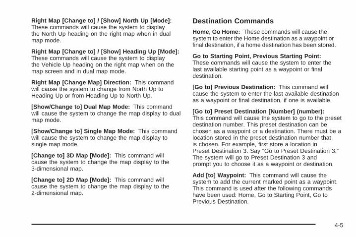
Right Map [Change to] / [Show] North Up [Mode]:These commands will cause the system to displaythe North Up heading on the right map when in dualmap mode.
Right Map [Change to] / [Show] Heading Up [Mode]:These commands will cause the system to displaythe Vehicle Up heading on the right map when on themap screen and in dual map mode.
Right Map [Change Map] Direction: This commandwill cause the system to change from North Up toHeading Up or from Heading Up to North Up.
[Show/Change to] Dual Map Mode: This commandwill cause the system to change the map display to dualmap mode.
[Show/Change to] Single Map Mode: This commandwill cause the system to change the map display tosingle map mode.
[Change to] 3D Map [Mode]: This command willcause the system to change the map display to the3-dimensional map.
[Change to] 2D Map [Mode]: This command willcause the system to change the map display to the2-dimensional map.
Destination CommandsHome, Go Home: These commands will cause thesystem to enter the Home destination as a waypoint orfinal destination, if a home destination has been stored.
Go to Starting Point, Previous Starting Point:These commands will cause the system to enter thelast available starting point as a waypoint or finaldestination.
[Go to] Previous Destination: This command willcause the system to enter the last available destinationas a waypoint or final destination, if one is available.
[Go to] Preset Destination [Number] (number):This command will cause the system to go to the presetdestination number. This preset destination can bechosen as a waypoint or a destination. There must be alocation stored in the preset destination number thatis chosen. For example, first store a location inPreset Destination 3. Say “Go to Preset Destination 3.”The system will go to Preset Destination 3 andprompt you to choose it as a waypoint or destination.
Add [to] Waypoint: This command will cause thesystem to add the current marked point as a waypoint.This command is used after the following commandshave been used: Home, Go to Starting Point, Go toPrevious Destination.
4-5

Enter Destination: This command will cause thesystem to add the current marked point as the finaldestination. This command is used after the followingcommands have been used: Home, Go to Starting Point,Go to Previous Destination.
Guidance CommandsRepeat Guidance, Repeat Voice: These commandswill cause the system to repeat the last availablevoice prompt guidance command if a destination hasbeen set.
Louder: This command will cause the system toincrease the volume of the navigation voice prompts.
Softer: This command will cause the system todecrease the volume of the navigation voice prompts.
Voice Guidance Off: This command will cause thesystem to turn off the navigation voice prompts ifa destination has been set.
Voice Guidance On: This command will cause thesystem to turn on the navigation voice prompts.
[Change to] Arrow (Guide/Guidance): Thesecommands will cause the system to change to ArrowGuidance screen view in the Guidance Menu if adestination has been set.
[Change to] Turn List (Guide/Guidance): Thesecommands will cause the system to change to Turn ListGuidance screen view in the Guidance Menu if adestination has been set.
[Change to] Freeway (Guide/Guidance): Thesecommands will cause the system to change toFreeway Guidance screen view in the Guidance Menuif a destination has been set. This command is onlyavailable if you are on a freeway.
[Change to] Intersection (Guide/Guidance):These commands will cause the system to change toIntersection Guidance screen view in the GuidanceMenu if a destination has been set. This command isonly available when the next turn is less than 0.5 mile(800 m) away for city streets and 2 miles (2 km) awayfor freeways.
Entire Route, Entire Rout Map, Route Overview:These commands will cause the system to display theentire route if a destination has been set.
Reroute: This command will cause the system togenerate an alternate route to a set destination while ona planned route.
Detour, Detour Entire Route: These commands willcause the system to activate the detour featurewhen driving a planned route.
4-6

Next Waypoint Map: This command will cause thesystem to display the map view of the next waypointlocation if one has been set.
(First/Second/Third/Fourth/Fifth) Waypoint Map:This command will cause the system to display the mapview of the named waypoint location if it has been set.
Destination Map: This command will cause the systemto display the map view of the final destination locationif one has been set.
Yes: This command will confirm system talkback.
No: This command will cancel a command.
(Delete/Cancel) Destination: This command will causethe system to cancel the current destination.
(Delete/Cancel) All Waypoints and Destination:This command will cause the system to cancel allcurrently set waypoints and the final destination.
Quick: This command will cause the system to selectthe Quick route when a destination has been set.
Normal: This command will cause the system to selectthe Normal route when a destination has been set.
Short: This command will cause the system to selectthe Short route when a destination has been set.
Point of Interest (POI) CommandsThe following commands will cause the system todisplay icons if they are available on the map screenwhen the map scale is set to 1⁄2 mile (1 km) or less.
Automobile Commands
• Auto Service And Maintenance, Auto Service,Maintenance
• Automobile Club, Triple A
• Car Park
• Car Wash
• Gas Station, Gas
• Other Automotive
• Parking
• Parking Garage
• Parking Lot
• Rental Car Agency
4-7

Entertainment Locations
• Amusement Park
• Botanical garden
• Campground
• Casino
• Cinema
• Golf Course
• Horse Racing
• Marina
• Museum
• National and State Parks
• Park & Recreation, Parks & Recreation
• Performing Arts
• Ski Resort, Skiing
• Speedway
• Sport Complex, Stadium
• Tourist Attraction
• Video Rental
• Winery
• Zoological garden
Financial and Government Offices
• ATM
• Bank
• Business Facility
• City Hall
• Civic Center, Community Center
• Convention Center, Exhibition Center
• Court House
• Government Offices
• Higher Education, University, College
• Hospital
• Library
• Other Financial Services
• Police Station
• Post Office
• School
• City Center
4-8

Personal Services
• Beauty and Barber Shops
• Dry Cleaning
• Health and Fitness Club
Restaurant Locations
• American Restaurant, American Food
• Chinese Restaurant, Chinese Food
• Coffee House
• Continental Restaurant, Continental Food
• French Restaurant, French Food
• Ice Cream Parlor
• Italian Restaurant, Italian Food
• Japanese Restaurant, Japanese Food
• Mexican Restaurant, Mexican Food
• Other Restaurant, Other Food
• Restaurant, I’m Hungry
• Seafood Restaurant, Seafood
• Show Restaurant
• Thai Restaurant, Thai Food
Shopping Locations• Convenience Store
• Department Store
• Grocery Store
• Home and Garden
• Other Retail Store
• Pharmacy
• Shopping, Shopping Mall
• Specialty Food Store
Transportation• Airport• Bus Station• Ferry Terminal• Historical Monument• Hotel• Park & Ride• Rest Area, Rest Stop• Tourist Information• Train Station
POI Off: This command will cause the system to turnoff POIs so they do not appear on the map screen.
4-9

✍ NOTES
4-10

AAddress ......................................................... 2-13Alpha-Numeric Keypad ...................................... 2-3Audio Adjust Screen ......................................... 3-3Audio System .................................................. 3-2Auto Reroute .................................................. 2-10Avoid Area ..................................................... 2-34
CCalibration ..................................................... 2-46Canadian Owners ................................................ iiCanceling Guidance ........................................ 1-11CD
Six-Disc Changer ......................................... 3-19CD Changer Errors ......................................... 3-22Cleaning the Display ....................................... 1-12Coordinates ................................................... 2-25
DDatabase Coverage Explanations ...................... 2-58Destination & Waypoint .................................... 2-36Destination and Waypoint ................................. 2-51Detour ........................................................... 2-50Display, Cleaning ............................................ 1-12Display route .................................................. 2-52
EEmergency .................................................... 2-19Enter Destination ............................................ 2-11
FFinding a Station .............................................. 3-6Freeway Entrance/Exit ..................................... 2-23
1

GGetting Started, Navigation ................................ 1-4Getting Started on Your Route .......................... 2-27Global Positioning System (GPS) ...................... 2-55Guidance Volume ................................... 1-12, 2-48
HHard Keys ....................................................... 2-2Home .................................................... 2-26, 2-38
IInstalling the Map DVD ..................................... 2-4Intersection .................................................... 2-22
MMap .............................................................. 2-18Map Adjustments .............................................. 2-4
Map Appearance .............................................. 2-8Map Scales ..................................................... 2-4Maps .............................................................. 2-3Memory Points ....................................... 2-20, 2-30
NNavigation
Getting Started ............................................. 1-4System Overview .......................................... 1-2Using the System .......................................... 2-2
OOrdering
Map DVDs ................................................. 2-58Overview, Navigation System ............................. 1-2Owners, Canadian ............................................... ii
2

PPhone Number ............................................... 2-24Playing a CD ................................................. 3-15Playing the Radio ............................................. 3-2Point of Interest (POI) ..................................... 2-15Preset Destination ................................... 2-26, 2-39Preset Station Menu ......................................... 3-7Previous Destination ................................ 2-21, 2-39Problems with Route Guidance ......................... 2-57
QQuick POI Selection ........................................ 2-43
RRadio ............................................................. 3-2
Personalization with Home andAway Feature .......................................... 3-23
Radio Data System (RDS) ................................. 3-9Region .......................................................... 2-12
Regional Maps ................................................. 2-3Restore System Defaults .................................. 2-48Route Preferences .......................................... 2-50Route Preview ................................................ 2-53
SScrolling the Map ............................................. 2-5Search Condition ............................................ 2-49Setting Radio Station Presets ............................. 1-6Setting the Region, Entering an Address and
Point of Interest, and Storing a HomeDestination and Preset Destinations ................. 1-7
Setting the Search Area .................................... 2-4Setting the Time ............................................... 1-6Six-Disc CD Changer ...................................... 3-19Sound Menu .................................................... 3-8Stored Locations ............................................. 1-11Symbols .......................................................... 2-5System Needs Service, If ................................. 2-58
3

TTouch-Sensitive Buttons ..................................... 2-3Traveling Across Regions ................................. 2-10Two-Dimensional/Three-Dimensional
(2D/3D) View .............................................. 2-42
UUser Settings ................................................. 2-47Using an MP3 ................................................ 3-17Using Your Home or Preset Destinations ............ 1-10
VVehicle Positioning .......................................... 2-56Voice Recognition ............................................. 4-2Voice Recognition Commands ............................ 4-2
XXM Radio Messages ....................................... 3-13XM™ Satellite Radio Service ............................ 3-12
4