2007 nissan navigation owner's manual nissan all-model-navi.pdf · for the nissan navigation...
TRANSCRIPT

Thank you for purchasing a NISSAN vehicle.
This user’s manual is for the navigation systemonly. This manual contains operating instructionsfor the NISSAN Navigation System offered inyour NISSAN vehicle.
Please read this manual carefully to ensure safeoperation of the navigation system.
. Because of possible specification changesand optional equipment, sections of thismanual may not apply to your vehicle.
. All information, specifications and illustra-tions in this manual are those in effect at thetime of printing. NISSAN reserves the rightto change specifications or design at anytime without notice.
. Do not remove this manual from the vehiclewhen selling this vehicle. The next user ofthis navigation system may need the manual.
FOREWORD

Table ofContents Getting started 2
Setting a destination 4
Introduction 1
Other settings 8
Map settings 3
Route guidance 5
Storing a location/route 6
General system information 9
Troubleshooting guide 10
Viewing technical information 7
Index 11

How to use this manual . . . . . . . . . . . . . . . . . . . . . . . . . . . . . . . . . . . . . . . 1-2For safe operation . . . . . . . . . . . . . . . . . . . . . . . . . . . . . . . . . . . . . . . . . . . . . . 1-2
Reference symbols . . . . . . . . . . . . . . . . . . . . . . . . . . . . . . . . . . . . . . . . . 1-2
Safety information . . . . . . . . . . . . . . . . . . . . . . . . . . . . . . . . . . . . . . . . . . . . . . 1-3Laser product. . . . . . . . . . . . . . . . . . . . . . . . . . . . . . . . . . . . . . . . . . . . . . . . . . . . 1-4
1 Introduction
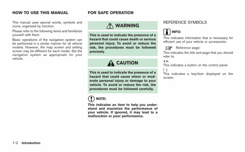
This manual uses special words, symbols andicons, organized by function.
Please refer to the following items and familiarizeyourself with them.
Basic operations of the navigation system canbe performed in a similar manner for all vehiclemodels. However, the map screen and settingscreen may be different for each model. Set thenavigation system as appropriate for yourvehicle.
WARNING
This is used to indicate the presence of ahazard that could cause death or seriouspersonal injury. To avoid or reduce therisk, the procedures must be followedprecisely.
CAUTION
This is used to indicate the presence of ahazard that could cause minor or mod-erate personal injury or damage to yourvehicle. To avoid or reduce the risk, theprocedures must be followed carefully.
NOTE:
This indicates an item to help you under-stand and maximize the performance ofyour vehicle. If ignored, it may lead to amalfunction or poor performance.
REFERENCE SYMBOLS
INFO:
This indicates information that is necessary forefficient use of your vehicle or accessories.
Reference page:
This indicates the title and page that you shouldrefer to.
<>:This indicates a button on the control panel.
[ ]:This indicates a key/item displayed on thescreen.
HOW TO USE THIS MANUAL FOR SAFE OPERATION
1-2 Introduction

This system is primarily designed to help youreach your destination, and it also performsother functions as outlined in this manual.However, you, the driver, must use the systemsafely and properly. Information concerning roadconditions, traffic signs and the availability ofservices may not always be up-to-date. Thesystem is not a substitute for safe, proper andlegal driving.
Before using the navigation system, please readthe following safety information. Always use thesystem as outlined in this manual.
WARNING
. When the driver wants to operate thenavigation system, first park the vehi-cle in a safe location and set theparking brake. Operating the systemwhile driving can distract the driverand may result in a serious accident.
. Do not rely on route guidance alone.Always be sure that all driving man-euvers are legal and safe in order toavoid accidents.
. Do not disassemble or modify thissystem. If you do, it may result inaccidents, fire or electrical shock.
. Do not use this system if you noticeany malfunctions such as a frozenscreen or the lack of sound. Continueduse of the system may result inaccidents, fire or electrical shock.
. If you notice any foreign objects in thesystem hardware, spill liquid on thesystem or notice smoke or a smellcoming from it, stop using the systemimmediately and contact a NISSANdealer. Ignoring such conditions maylead to accidents, fire or electricalshock.
CAUTION
. Do not keep the navigation systemrunning with the engine stopped.Doing so may discharge the vehiclebattery. When you use the navigationsystem, always keep the engine run-ning.
. Some states/provinces may have lawslimiting the use of video screens whiledriving. Use this system only where itis legal to do so.
SAFETY INFORMATION
Introduction 1-3

This navigation system is certified as a Class 1laser product.
The navigation system complies with DHHSRules 21 CFR Chapter 1, Subchapter J.
WARNING
. Do not disassemble or modify thissystem. There are no user serviceableparts in this navigation system.
. If maintenance, adjustments and op-erations other than those specified inthis manual are attempted, injury dueto laser radiation and exposure couldoccur.
LASER PRODUCT
1-4 Introduction

2 Getting started
Control buttons and functions . . . . . . . . . . . . . . . . . . . . . . . . . . . . . . . 2-2Control panel . . . . . . . . . . . . . . . . . . . . . . . . . . . . . . . . . . . . . . . . . . . . . . . . 2-3
Start-up screen . . . . . . . . . . . . . . . . . . . . . . . . . . . . . . . . . . . . . . . . . . . . . . . . . 2-6Menu screen types and how to operate. . . . . . . . . . . . . . . . . . . 2-7
Menu screens and their purposes . . . . . . . . . . . . . . . . . . . . . . 2-7Using controls to adjust values, levels, etc.. . . . . . . . . . . 2-9Map menu screen . . . . . . . . . . . . . . . . . . . . . . . . . . . . . . . . . . . . . . . . 2-10
Functions disabled while driving . . . . . . . . . . . . . . . . . . . . . . . . . . 2-13Operating maps. . . . . . . . . . . . . . . . . . . . . . . . . . . . . . . . . . . . . . . . . . . . . . . 2-14
How to view map screen . . . . . . . . . . . . . . . . . . . . . . . . . . . . . . . 2-14Map screen types . . . . . . . . . . . . . . . . . . . . . . . . . . . . . . . . . . . . . . . . 2-15Switching map view. . . . . . . . . . . . . . . . . . . . . . . . . . . . . . . . . . . . . . 2-16Moving around within a map . . . . . . . . . . . . . . . . . . . . . . . . . . . 2-18
Changing the scale of a map . . . . . . . . . . . . . . . . . . . . . . . . . . 2-19Storing your home location/address. . . . . . . . . . . . . . . . . . . . . . 2-20
How to store your home . . . . . . . . . . . . . . . . . . . . . . . . . . . . . . . . 2-20Character (letter and number) input screen . . . . . . . . 2-23Phone number input screen . . . . . . . . . . . . . . . . . . . . . . . . . . . . 2-25List screen . . . . . . . . . . . . . . . . . . . . . . . . . . . . . . . . . . . . . . . . . . . . . . . . . 2-27
Setting a destination . . . . . . . . . . . . . . . . . . . . . . . . . . . . . . . . . . . . . . . . . 2-28Searching for a destination . . . . . . . . . . . . . . . . . . . . . . . . . . . . . 2-28Starting route guidance . . . . . . . . . . . . . . . . . . . . . . . . . . . . . . . . . 2-31Deleting a route . . . . . . . . . . . . . . . . . . . . . . . . . . . . . . . . . . . . . . . . . . . 2-33
Setting the voice guidance . . . . . . . . . . . . . . . . . . . . . . . . . . . . . . . . . 2-35Turning voice guidance on/off . . . . . . . . . . . . . . . . . . . . . . . . . 2-35Adjusting voice guidance volume . . . . . . . . . . . . . . . . . . . . . 2-37

NAI0479
CONTROL BUTTONS ANDFUNCTIONS
2-2 Getting started

NAI0402
CONTROL PANEL
Armada, Maxima, Murano, Pathfinder,Quest, Titan
&1 < > (DAY/NIGHT):
Push to switch between the day screen andthe night screen.
&2 <BACK>/<PREV>:
Push to return to the previous screen. In asettings screen, this button can also be
used to apply the setting.
&3 JOYSTICK and <ENTER>:
Move to highlight an item on the screen, ormove on the map, etc. Then push to selectthe highlighted item.
&4 <SETTING>:
Push to access the system settings.
&5 <TRIP>:
Push to display the trip computer. Refer tothe Owner’s Manual of your vehicle.
&6 <DEST>:
Push to enter a destination. Various methodsfor entering a destination are available.
“4. Setting a destination”.
&7 <ROUTE>:
Push to access guidance control functions(guidance cancellation, route priority, way-point setting on the route, etc.).
&8 <MAP>:
Push to display the current location mapscreen.
&9 <GUIDE VOICE>:
Push to repeat voice guidance for a guidepoint.
&10 < > (ZOOM IN/ZOOM OUT):
Push to switch to the zoom mode to changethe map scale.
Getting started 2-3

NAI0403
350Z
&1 <MAP>:
Push to display the current location mapscreen.
&2 <DEST>:
Push to enter a destination. Various methodsfor entering a destination are available.
“4. Setting a destination”.
&3 <ROUTE>:
Push to access guidance control functions(guidance cancellation, route priority, way-point setting on the route, etc.).
&4 JOYSTICK and <ENTER>:
Move to highlight an item on the screen, ormove on the map, etc. Then push to selectthe highlighted item.
&5 <INFO>:
Push to display the navigation information,such as GPS and version information, etc.
&6 <SETTING>:
Push to access the system settings.
&7 <VOICE>:
Push to repeat voice guidance for a guidepoint.
&8 <ZOOM IN>/<ZOOM OUT>:
Push to switch to the zoom mode to changethe map scale.
&9 <BACK>:
Push to return to the previous screen. In asettings screen, this button can also beused to apply the setting.
&10 < > (DAY/NIGHT):
Push to switch between the day screen andthe night screen. Push and hold to togglethe display on and off.
2-4 Getting started

&11 <CANCEL>:
Push to return to the map screen or cancelthe route that has already been set.
Getting started 2-5

NAV2701
1. The navigation system starts when theignition switch is turned to the ACC or ONposition.
NAV2702Armada, Maxima, Murano, Pathfinder, Quest, Titan
2. As the start-up screen is displayed, read theprecautions carefully, highlight [OK] andpush <ENTER>.
NAV3022350Z
INFO:
If you do not push <ENTER> for more than 30seconds, the status screen will be displayed.Push <DEST> , <MAP> , <ROUTE> ,<INFO>, <SETTING> or <TRIP> to returnto the start-up screen.
START-UP SCREEN
2-6 Getting started

NAI0406
MENU SCREENS AND THEIR PUR-POSES
Push <DEST>, <ROUTE>, <TRIP>, <INFO>or <SETTING> to display the correspondingmenu screen.
How to select a menu item
Example: <DEST> screen
1. Tilt the joystick up and down. An item ishighlighted accordingly.
2. To select the preferred menu item, highlightthe item and push <ENTER>.
INFO:
Some items in the menu contain furtherdetails, which are displayed on the right sideof the screen when the menu item ishighlighted. This allows you to previewdetails of the item. These details appearonly on the menu screen displayed bypushing <DEST>.
MENU SCREEN TYPES AND HOWTO OPERATE
Getting started 2-7

NAV3061
3. Depending on the item you selected, adetailed menu screen, a character inputscreen or a setting screen, etc. is displayed.On the screen displayed, make adjustments,input information, etc. accordingly.
NAV2704
4. Push <BACK>/<PREV> to return to theprevious screen without applying anychanges.
Push <MAP> to return to the currentlocation map screen without applying anychanges.
INFO:
Depending on the menu selected, pushing<MAP> may not return you to the currentlocation map screen.
2-8 Getting started

NAI0407
USING CONTROLS TO ADJUST VA-LUES, LEVELS, ETC.
Use the joystick to adjust the volume of the voiceguidance and the display brightness.
How to adjust
1. Highlight the preferred setting item andpush <ENTER>. The color of the corre-sponding adjustment item changes.
2. Use the joystick, and the value or barindicating levels increases or decreasesaccordingly.
3. Push <ENTER> or <BACK>/<PREV> toapply the setting.
Getting started 2-9

NAV2705
MAP MENU SCREEN
Push <ENTER> while the current location mapscreen or a scrolled map screen is displayed todisplay the menu corresponding to that screen.
This menu allows you to quickly use helpfulfunctions, such as setting a destination easilyand searching for facilities nearby.
To select a menu item, use the methoddescribed in “Menu screen types and how tooperate”.
Current location map screen
If <ENTER> is pushed while the currentlocation map screen is displayed, the followingoptions are available.
. Store Location:Allows you to store the current vehiclelocation in the Address Book. The storedlocation can be retrieved as necessary to setit as a destination (waypoint).
“STORING A LOCATION” (page 6-2)
. Nearby:Allows you to search for points of interestnear the current vehicle location, such asrestaurants and gas stations, etc.
“SETTING A NEARBY PLACE”(page 4-47)
. Map View:Switches the map type. It is used to switchbetween Plan View and BirdviewTM and setthe left screen display.
“SWITCHING THE MAP VIEW”(page 3-4)
. Heading:Switches the orientation of the map. “NorthUp” or “Heading Up” are the availableoptions.
“SETTINGS OF HEADING/LONGRANGE MAP VIEW” (page 3-15)
. Landmark Icons:Allows you to display certain points ofinterest near the current vehicle location onthe map, such as restaurants and gasstations, etc.
“DISPLAYING LANDMARK ICONS”(page 3-22)
2-10 Getting started

. Store Tracking:Allows you to store in the Address Book theroute that you have travelled from thestarting point to the current location.
“STORING A TRACKED ROUTE”(page 6-14)
Getting started 2-11

NAV2706
Scrolled location map screen
If <ENTER> is pushed while a scrolled mapscreen is displayed, the following options areavailable.
. New Dest:Allows you to set the destination to thelocation where you pushed <ENTER>. If adestination is already set, the location will beset as the new destination.
“SETTING FROM MAP” (page 4-20)
. Add to Route:Allows you to set the location where youpushed <ENTER> as the destination or awaypoint.
This is available only when the suggestedroute is already set.
“Setting a destination or waypoint”(page 5-20)
. Nearby:Allows you to search for points of interestnear the location where you pushed<ENTER> and set it as a destination orwaypoint.
Use the same search method as the one forPOI.
“SETTING A NEARBY PLACE”(page 4-47)
. Store Location:Allows you to store the location where youpushed <ENTER> in the Address Book.The stored location can be retrieved to set itas a destination or waypoint.
“STORING A LOCATION” (page 6-2)
. Delete:Allows you to delete a stored location,destination or waypoint. To delete it, placethe cross pointer over the correspondingicon.
2-12 Getting started

NAV2707
To ensure safe driving, some functions cannotbe operated while driving.
The on-screen functions that are not availablewhile driving will be “grayed-out” or muted.
Park the vehicle in a safe location and thenoperate the navigation system.
FUNCTIONS DISABLED WHILEDRIVING
Getting started 2-13

NAV2708
HOW TO VIEW MAP SCREEN
The navigation system displays various informa-tion on the map screen.
Screen information
&1 Vehicle icon:
Indicates the current vehicle location andthe direction that you are traveling.
&2 Guide point:
Indicates a guide point on the route.
&3 GPS indicator:
Indicates the GPS reception condition ofsignals from the satellites.* Green: positioning is possible* Gray: positioning is not possible
&4 Remaining time and distance to thedestination:
Indicates the remaining time and distance tothe destination.
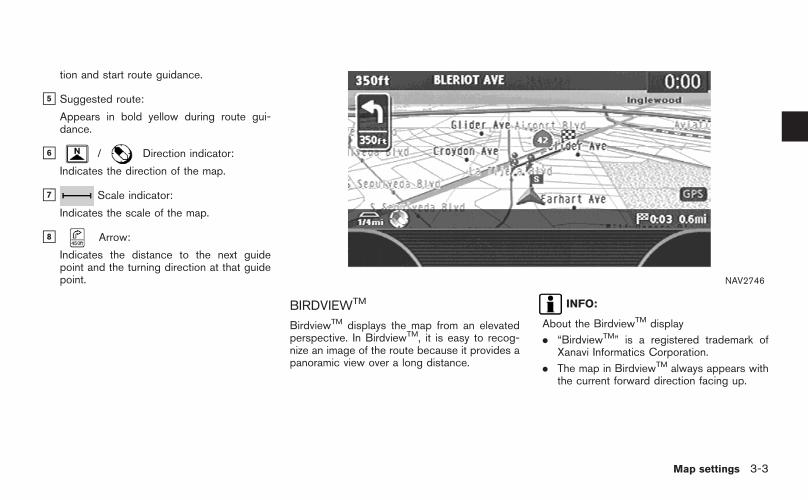
&5 Suggested route:
Appears in bold yellow during route gui-dance.
&6 / Direction indicator:
Indicates the direction of the map.
&7 Scale indicator:
Indicates the scale of the map.
&8 Arrow and distance:
Appears on the upper left corner of thescreen when the suggested route is set.
Indicates the distance to the next guidepoint and the turning direction at that guidepoint. This function can be turned on or off.
INFO:
. Roads with a width of 10 ft (3 m) or less maynot be displayed on the map.
. The system may require a long time forpositioning. The GPS indicator may remaingray for 3 to 4 minutes after the system isstarted. This is not a malfunction.
OPERATING MAPS
2-14 Getting started

MAP SCREEN TYPES
Two types of map views are available: Plan Viewand BirdviewTM.
NAV2709
Plan View
Plan View displays the map in a 2-dimensionalenvironment similar to a road map.
NAV2710
BirdviewTM
BirdviewTM displays the view from an elevatedperspective. In BirdviewTM, it is easy to recog-nize an image of the route because it provides apanoramic view over a long distance.
Getting started 2-15

NAV2711
SWITCHING MAP VIEW
1. Push <ENTER> while the current locationmap screen is displayed.
NAV2712
2. Highlight [Map View] and push <ENTER>.
NAV2713
3. Highlight the preferred map view and push<ENTER>. The indicator of the selectedmap view illuminates.
“SWITCHING THE MAP VIEW”(page 3-4)
4. Push <MAP> to return to the currentlocation map screen.
2-16 Getting started

INFO:
. When you select a map view, a preview ofthat view is displayed on the right side of thescreen.
. You can also switch the map view using thefollowing procedure.
1) Push <SETTING>.
2) Highlight [Navigation] and push<ENTER>.
3) Highlight [Map View] and push<ENTER>.
Getting started 2-17

NAI0408
MOVING AROUND WITHIN A MAP
You can manually move across the map to viewthe surrounding areas or a preferred location.
1. Tilt the joystick corresponding to the direc-tion that you want to move across the map.Keep tilting the joystick to continuouslymove across the map in that direction. Onceyou start moving on the map, the crosspointer appears.
2. Returning to the current location map screen
Push <MAP> or <BACK>/<PREV> toreturn to the current location map screen,and the cross pointer disappears.
2-18 Getting started

NAI0409
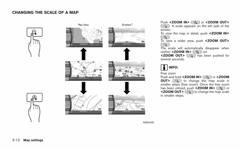
CHANGING THE SCALE OF A MAP
Push <ZOOM IN> ( ) or <ZOOM OUT>( ). A scale appears on the left side of thescreen.
To view the map in detail, push <ZOOM IN>( ).
To view a wider area, push <ZOOM OUT>( ).
The scale will automatically disappear whenneither <ZOOM IN> ( ) nor <ZOOMOUT> ( ) has been pushed for severalseconds.
INFO:
Free zoomPush and hold <ZOOM IN> ( ) or <ZOOMOUT> ( ) to change the map scale insmaller steps (free zoom). Once the free zoomhas been utilized, push <ZOOM IN> ( ) or<ZOOM OUT> ( ) to change the map scalein smaller steps.
Getting started 2-19

HOW TO STORE YOUR HOME
If your home location is already stored in theAddress Book, it can be easily retrieved to setthe route to your home.
The procedure to store your home location is thesame as for storing any other location.
“4. Setting a destination”
As an example, the procedure for storing yourhome location by searching for a destination byaddress is described here.
NAI0410
1. Push <DEST>.
NAV2714
2. Highlight [Address Book] and push<ENTER>.
STORING YOUR HOME LOCATION/ADDRESS
2-20 Getting started

NAV2715
3. Highlight [Home Location (Add New)] andpush <ENTER>.
NAV3023
4. A confirmation message is displayed. Con-firm the contents of the message, highlight[Yes] and push <ENTER>.
NAV3048
5. Highlight [Street Address] and push<ENTER>. A character input screen isdisplayed.
Getting started 2-21

NAV3062
6. Enter the address of your home, highlight[OK] and push <ENTER>.
The map screen is displayed.“SETTING A STREET ADDRESS”(page 4-5)
NAV3050
7. Using the joystick, adjust your home locationif necessary.
8. After adjust ing the locat ion, push<ENTER>.
NAV3051
9. A message is displayed and your homelocation is stored.
10. Push <MAP> to return to the currentlocation map screen.
The home icon is displayed on the map.
INFO:
You can also perform the same setting bypushing <SETTING> and selecting [Naviga-tion].
“STORING A LOCATION BY SEARCH-ING” (page 6-2)
2-22 Getting started

CHARACTER (letter and number) INPUTSCREEN
You will have to enter alphanumeric characterswhen setting a destination, searching for afacility or editing the stored locations, etc.
NAV3063
1. Use the joystick to highlight a character onthe displayed keyboard.
NAV3064
2. Push <ENTER>. The highlighted characteris entered.
Getting started 2-23
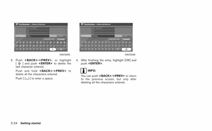
NAV3065
3. Push <BACK>/<PREV>, or highlight[ ] and push <ENTER> to delete thelast character entered.
Push and hold <BACK>/<PREV> todelete all the characters entered.
Push [ ] to enter a space.
NAV3066
4. After finishing the entry, highlight [OK] andpush <ENTER>.
INFO:
You can push <BACK>/<PREV> to returnto the previous screen, but only afterdeleting all the characters entered.
2-24 Getting started

PHONE NUMBER INPUT SCREEN
You can enter a phone number as a searchmethod to look for a point of interest.
INFO:
Only the locations included in the database inthe map DVD-ROM can be searched by thephone number.
NAV2723
1. Use the joystick to highlight a number on thedisplayed keyboard.
NAV2724
2. Push <ENTER>. The highlighted number isentered.
Getting started 2-25

NAV2725
3. Push <BACK>/<PREV>, or highlight[ ] and push <ENTER> to delete thelast number entered.
Push and hold <BACK>/<PREV> todelete all the numbers entered.
NAV2726
4. After finishing the entry, highlight [Map] andpush <ENTER>.
INFO:
You can push <BACK>/<PREV> to return tothe previous screen, but only after deleting allthe numbers entered.
2-26 Getting started

NAV2727
LIST SCREEN
After searching for a point of interest, a listscreen is displayed.
Depending on the list displayed, it can besorted.
Items displayed in a list
&1 Highlight the preferred item from the list andpush <ENTER> to select it.If a location or facility name is not completelydisplayed (due to length), highlight the itemto show the hidden part of the name.
&2 Distance from the current location
&3 Direction to the point of interest
&4 If the entire list cannot be displayed on thescreen, the system displays the total numberof items in the list and the entry number ofthe selected item. Tilt the joystick upward ordownward to scroll the list.
&5 Highlight and push <ENTER> to sort thelist by shortest distance.
&6 Highlight and push <ENTER> to sort thelist in the original order.
&7 When the list is sorted by the shortestdistance, you can confirm the selectedlocation in the preview on the right side ofthe screen.
Getting started 2-27

SEARCHING FOR A DESTINATION
As an example, the method for setting an airportas the destination using [Points of Interest] isdescribed here.
NAI0410
1. Push <DEST>.
NAV2728
2. Highlight [Points of Interest] and push<ENTER>.
SETTING A DESTINATION
2-28 Getting started

NAV2729
3. Highlight [Travel] and push <ENTER>.
NAV2730
4. From the category list, highlight [AIRPORT]and push <ENTER>.
The character input screen is displayed.
NAV3067
5. Highlight [OK] and push <ENTER>.
A list screen is displayed.
INFO:
You can enter the city name and facilityname to narrow down your search.
Getting started 2-29

NAV2732
6. Highlight the preferred airport from the listand push <ENTER>.
NAV2733
INFO:
By selecting [By Distance], you can sort thelist by the shortest distance.
The position of the selected location isdisplayed in the preview on the right sideof the screen.
NAV2734
7. The selected destination is displayed at thecenter of the map. Highlight [OK] afterconfirming the location of the displayeddestination, and push <ENTER>.
INFO:
The system sets the destination to theselected location and starts calculating aroute.
2-30 Getting started

NAV2735
INFO:
Even after setting a destination, you can adjustthe location of the destination, store the route,etc. if necessary.
“OPERATIONS AFTER SETTING ADESTINATION” (page 4-50)
NAV2736
STARTING ROUTE GUIDANCE
After setting the destination and performingroute calculation, the suggested route is dis-played.
1. Highlight [Start] and push <ENTER>.
NAV2737
2. Once route guidance is started, the systemnavigates you through the guide pointsusing visual and voice guidance.
Getting started 2-31

NAV2738
3. When approaching a guide point, thesystem automatically changes to the splitscreen and shows an enlarged view of theintersection in the left screen.
NAV2739
4. When arriving at the destination, routeguidance automatically ends.
2-32 Getting started

DELETING A ROUTE
To delete a route already set, use the followingprocedure. If you delete a route, the destinationis also deleted.
NAI0411
1. Push <ROUTE>.
NAV2740
2. Highlight [Cancel Route Guidance] andpush <ENTER>.
Getting started 2-33

NAV2741
3. A confirmation message is displayed. High-light [Yes] and push <ENTER>.
INFO:
If a route is cancelled, [Cancel Route Guidance]changes to [Resume Route Guidance].
Highlight [Resume Route Guidance] and push<ENTER> to reactivate the cancelled route.
This is available only until a new route is set.
NAI0412
Delete the route using <CANCEL> (onlyfor 350Z)
1. Push <CANCEL>.
NAV3024
2. A confirmation message is displayed. High-light [Yes] and push <ENTER>.
2-34 Getting started

TURNING VOICE GUIDANCE ON/OFF
You can activate or deactivate voice guidanceand adjust the volume.
NAI0413
For Armada, Maxima, Murano, Pathfinder,Quest, Titan
1. Push <SETTING>.
NAV3052
2. Highlight [Guidance Voice] and push<ENTER>. The indicator illuminates if voiceguidance is activated.
SETTING THE VOICE GUIDANCE
Getting started 2-35

NAI0411
For 350Z
1. Push <ROUTE>.
NAV3047
2. Highlight [Guidance Settings] and push<ENTER>.
NAV2743
3. Highlight [Guidance Voice] and push<ENTER>. The indicator illuminates if voiceguidance is activated.
2-36 Getting started

NAV3026
INFO:
You can also activate or deactivate voiceguidance using the following procedure.
1) Push <SETTING>.
2) Highlight [Volume and Beeps] and push<ENTER>.
3) Highlight [Guidance Voice] and push<ENTER>.
ADJUSTING VOICE GUIDANCE VO-LUME
You can adjust the volume of voice guidance.
NAI0413
For Armada, Maxima, Murano, Pathfinder,Quest, Titan
1. Push <SETTING>.
Getting started 2-37

NAV3053
2. Highlight [Guidance Volume] and push<ENTER>.
NAV3054
3. Adjust the voice guidance volume using thejoystick.
NAI0413
For 350Z
1. Push <SETTING>.
2-38 Getting started

NAV2742
2. Highlight [Volume and Beeps] and push<ENTER>.
NAV2744
3. Highlight [Guidance Volume] and push<ENTER>.
NAV2745
4. Adjust the voice guidance volume using thejoystick.
Getting started 2-39

MEMO
2-40 Getting started

3 Map settings
Map types . . . . . . . . . . . . . . . . . . . . . . . . . . . . . . . . . . . . . . . . . . . . . . . . . . . . . . . . 3-2Plan view . . . . . . . . . . . . . . . . . . . . . . . . . . . . . . . . . . . . . . . . . . . . . . . . . . . . . 3-2BirdviewTM. . . . . . . . . . . . . . . . . . . . . . . . . . . . . . . . . . . . . . . . . . . . . . . . . . . . 3-3
Switching the map view. . . . . . . . . . . . . . . . . . . . . . . . . . . . . . . . . . . . . . . 3-4Available views . . . . . . . . . . . . . . . . . . . . . . . . . . . . . . . . . . . . . . . . . . . . . . 3-5
Moving a map . . . . . . . . . . . . . . . . . . . . . . . . . . . . . . . . . . . . . . . . . . . . . . . . . . . 3-7Plan view . . . . . . . . . . . . . . . . . . . . . . . . . . . . . . . . . . . . . . . . . . . . . . . . . . . . . 3-7BirdviewTM. . . . . . . . . . . . . . . . . . . . . . . . . . . . . . . . . . . . . . . . . . . . . . . . . . . . 3-8Returning to the current vehicle location . . . . . . . . . . . . . . 3-9Map scrolling information . . . . . . . . . . . . . . . . . . . . . . . . . . . . . . . 3-10
Changing the scale of a map . . . . . . . . . . . . . . . . . . . . . . . . . . . . . . 3-12Map scale . . . . . . . . . . . . . . . . . . . . . . . . . . . . . . . . . . . . . . . . . . . . . . . . . . 3-13
Other settings for the map screen. . . . . . . . . . . . . . . . . . . . . . . . 3-15Settings of heading/long range map view. . . . . . . . . . . 3-15Changing the BirdviewTM angle . . . . . . . . . . . . . . . . . . . . . . . 3-17Changing the scale of the left screen. . . . . . . . . . . . . . . . 3-20
Map icons . . . . . . . . . . . . . . . . . . . . . . . . . . . . . . . . . . . . . . . . . . . . . . . . . . . . . . 3-22Displaying landmark icons . . . . . . . . . . . . . . . . . . . . . . . . . . . . . . 3-22Map symbols. . . . . . . . . . . . . . . . . . . . . . . . . . . . . . . . . . . . . . . . . . . . . . . 3-24

Two types of map views are available: Plan Viewand BirdviewTM.
PLAN VIEW
Plan View displays the map in a 2-dimensionalenvironment similar to a road map.
NAV2708
Screen information
&1 Vehicle icon:
Indicates the current vehicle location andthe direction that you are traveling.
&2 Guide point:
Indicates a guide point on the route.
&3 GPS indicator:
Indicates the GPS reception condition ofsignals from the satellites.* Green: positioning is possible* Gray: positioning is not possible
&4 Remaining time and distance to thedestination:
Indicates the approximate remaining timeand distance to the destination. This indi-cator will appear when you set the destina-
MAP TYPES
3-2 Map settings
tion and start route guidance.
&5 Suggested route:
Appears in bold yellow during route gui-dance.
&6 / Direction indicator:
Indicates the direction of the map.
&7 Scale indicator:
Indicates the scale of the map.
&8 Arrow:
Indicates the distance to the next guidepoint and the turning direction at that guidepoint. NAV2746
BIRDVIEWTM
BirdviewTM displays the map from an elevatedperspective. In BirdviewTM, it is easy to recog-nize an image of the route because it provides apanoramic view over a long distance.
INFO:
About the BirdviewTM display
. “BirdviewTM” is a registered trademark ofXanavi Informatics Corporation.
. The map in BirdviewTM always appears withthe current forward direction facing up.
Map settings 3-3

The map view can be changed between PlanView and BirdviewTM. The map can also bedisplayed in the split screen mode.
NAV2711
1. Push <ENTER> while the current locationmap screen is displayed.
NAV2712
2. Highlight [Map View] and push <ENTER>.
SWITCHING THE MAP VIEW
3-4 Map settings

NAV2747
3. Highlight the preferred map view and push<ENTER>. The indicator of the selectedmap view illuminates.
4. Push <MAP> to return to the currentlocation map screen.
AVAILABLE VIEWS
. Plan View:Switches to Plan View.
. BirdviewTM:Switches to BirdviewTM.
. Split (Plan View):Changes to the split screen mode and bothhalves display maps in Plan View.
. Split (BirdviewTM):Changes to the split screen mode and theleft half displays the map in Plan View andthe right half displays the map in BirdviewTM.
INFO:
. When you select a map view, a preview ofthat view is displayed on the right side of thescreen.
. When you select [Split (Plan View)] or [Split(BirdviewTM)], [Change Map Scale for Left]becomes available. This is used to changethe scale of the map in the left screen.
“CHANGING THE SCALE OF THELEFT SCREEN” (page 3-20)
Map settings 3-5

NAV2748Split (Plan View)
NAV2749Split (BirdviewTM)
NAV2750
INFO:
You can also set the map view using thefollowing procedure.
1) Push <SETTING>.
2) Highlight [Navigation] and push <ENTER>.
3) Highlight [Map View] and push <ENTER>.
3-6 Map settings

NAI0408
The operations for moving across the map aredifferent between Plan View and BirdviewTM.
PLAN VIEW
Tilt the joystick corresponding to the directionthat you want to move across the map. Keeptilting the joystick to continuously move acrossthe map in that direction.
Once you start moving across the map, thecross pointer appears.
MOVING A MAP
Map settings 3-7

NAI0414
BIRDVIEWTM
The joystick allows movement in the followingways.
Keep tilting the joystick to continuously moveacross the map in that direction.
&1 Rotates the map clockwise.
&2 Rotates the map counterclockwise.
&3 Moves the cross pointer on the map upward.
&4 Moves the cross pointer on the map down-ward.
Once you start moving on the map, the crosspointer appears.
3-8 Map settings

NAI0415
RETURNING TO THE CURRENT VEHI-CLE LOCATION
Push <MAP>.The current location map screen is displayed.
INFO:
. The previous screen can be displayed bypushing <BACK>/<PREV>. You can alsoreturn to the current location map screen byrepeatedly pushing <BACK>/<PREV>.
. Depending on the menu selected, pushing<MAP> may not return you to the currentlocation map screen.
Map settings 3-9

MAP SCROLLING INFORMATION
Information about the location, on which thecenter of the cross pointer is placed by scrollingon the map, can be set to be displayed.
1. Push <SETTING>.
NAV3055Armada, Maxima, Murano, Pathfinder, Quest, Titan
NAV3029350Z
2. Highlight [Navigation] and push <ENTER>.
NAV2752
3. Highlight [Map Scrolling Information] andpush <ENTER>.
3-10 Map settings
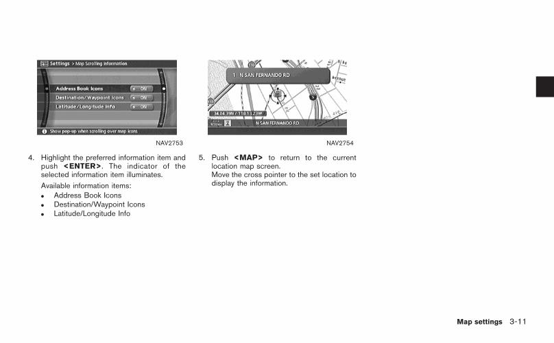
NAV2753
4. Highlight the preferred information item andpush <ENTER>. The indicator of theselected information item illuminates.
Available information items:. Address Book Icons. Destination/Waypoint Icons. Latitude/Longitude Info
NAV2754
5. Push <MAP> to return to the currentlocation map screen.Move the cross pointer to the set location todisplay the information.
Map settings 3-11
NAI0409
Push <ZOOM IN> ( ) or <ZOOM OUT>( ). A scale appears on the left side of thescreen.To view the map in detail, push <ZOOM IN>( ).To view a wider area, push <ZOOM OUT>( ).The scale will automatically disappear whenneither <ZOOM IN> ( ) nor<ZOOM OUT> ( ) has been pushed forseveral seconds.
INFO:
Free zoomPush and hold <ZOOM IN> ( ) or <ZOOMOUT> ( ) to change the map scale insmaller steps (free zoom). Once the free zoomhas been utilized, push <ZOOM IN> ( ) or<ZOOM OUT> ( ) to change the map scalein smaller steps.
CHANGING THE SCALE OF A MAP
3-12 Map settings

MAP SCALE
The following scales are available depending onthe map view.
. In Plan View:Widest (1/51,200,000) to the most detailed(1/5,000)
. In BirdviewTM:Widest (1/20,480,000) to the most detailed(viewpoint height at 1/25,000)
Scale level of the Plan View display
Map scale Actual distance
1:51.2 million 400 miles (640 km)
1:5.12 million 32 miles (64 km)
1:1.28 million 8 miles (16 km)
1:320,000 2 miles (4 km)
1:160,000 1 mile (2 km)
1:80,000 1/2 mile (1 km)
1:40,000 1/4 mile (500 m)
1:20,000 1/8 mile (200 m)
1:10,000 1/16 mile (100 m)
1:5,000 1/32 mile (50 m)
NAV2755Example: The most detailed level
NAV2756Example: The widest level
Map settings 3-13

Scale level of the BirdviewTM display
Map scale Distance between grids
1:20.48 million 160 miles (256 km)
1:5.12 million 32 miles (64 km)
1:2.56 million 16 miles (32 km)
1:1.28 million 8 miles (16 km)
1:640,000 4 miles (8 km)
1:320,000 2 miles (4 km)
1:160,000 1 mile (2 km)
1:80,000 1/2 mile (1 km)
1:40,000 1/4 mile (500 m)
1:25,000 1/6 mile (250 m)
NAV2757Example: The most detailed level
NAV2758Example: The widest level
3-14 Map settings
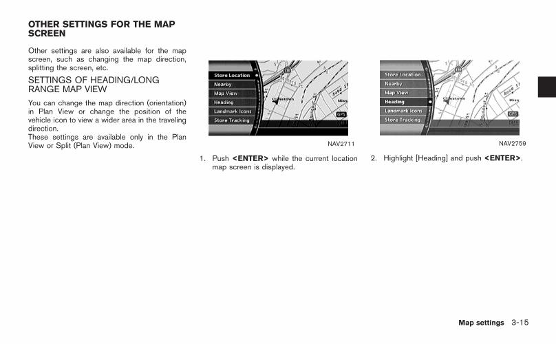
Other settings are also available for the mapscreen, such as changing the map direction,splitting the screen, etc.
SETTINGS OF HEADING/LONGRANGE MAP VIEW
You can change the map direction (orientation)in Plan View or change the position of thevehicle icon to view a wider area in the travelingdirection.These settings are available only in the PlanView or Split (Plan View) mode. NAV2711
1. Push <ENTER> while the current locationmap screen is displayed.
NAV2759
2. Highlight [Heading] and push <ENTER>.
OTHER SETTINGS FOR THE MAPSCREEN
Map settings 3-15

NAV2760
3. Highlight the preferred map orientation andpush <ENTER>. The indicator of theselected map orientation illuminates.
INFO:
[Long Range Map View] is displayed onlywhen you select [Heading Up].
4. Push <MAP> to return to the currentlocation map screen.
Available map orientations
. North Up:North is set at the top of the map.
. Heading Up:The traveling direction is set at the top of themap.
. Long Range Map View:The vehicle icon is located slightly lowerthan the center of the screen. This offers awider view in the traveling direction.
. BirdviewTM Angle:This changes the BirdviewTM angle.
NAV2761North Up
NAV2762Heading Up
3-16 Map settings

NAV2763Long Range Map View
INFO:
If the map orientation is switched, the icondisplayed in the lower left corner is alsoswitched.
: North Up
: Heading Up
NAV2764
INFO:
You can also set the orientation of the map usingthe following procedure.
1) Push <SETTING>.
2) Highlight [Navigation] and push <ENTER>.
3) Highlight [Heading] and push <ENTER>.
CHANGING THE BIRDVIEWTM ANGLE
This changes the BirdviewTM angle.This setting is available only in the BirdviewTM orSplit (BirdviewTM) mode.
Map settings 3-17

NAV2711
1. Push <ENTER> while the current locationmap screen is displayed.
NAV2759
2. Highlight [Heading] and push <ENTER>.
NAV2765
3. Highlight [BirdviewTM Angle] and push<ENTER>.
INFO:
This setting is available only when the mapview is set to the BirdviewTM or Split(BirdviewTM) mode.
3-18 Map settings

NAV2766
4. Adjust the BirdviewTM angle by moving thecursor in the direction of [ ] or [ ].
5. Push <MAP> to return to the currentlocation map screen.
NAV2764
INFO:
You can also set the BirdviewTM angle using thefollowing procedure.
1) Push <SETTING>.
2) Highlight [Navigation] and push <ENTER>.
3) Highlight [Heading] and push <ENTER>.
4) Highlight [BirdviewTM Angle] and push<ENTER>.
Map settings 3-19

CHANGING THE SCALE OF THE LEFTSCREEN
When the split screen is displayed, you canchange the scale of the left screen.
NAV2711
1. Push <ENTER> while the current locationmap screen is displayed.
NAV2712
2. Highlight [Map View] and push <ENTER>.
3-20 Map settings

NAV2767
3. Highlight [Change Map Scale for Left] andpush <ENTER>.
INFO:
[Change Map Scale for Left] is displayedonly when the map view is in the Split (PlanView) or Split (BirdviewTM) mode.
NAV2768
4. Highlight [Map Scale] and push <ENTER>.Adjust the map scale by moving the cursorin the direction of [+] or [−].Use the joystick to adjust the scale of themap.After finishing the setup, push <ENTER> or<BACK>/<PREV> to apply the scalesetting.
5. Push <MAP> to return to the currentlocation map screen.
NAV2750
INFO:
You can also change the scale of the left screenusing the following procedure.
1) Push <SETTING>.
2) Highlight [Navigation] and push <ENTER>.
3) Highlight [Map View] and push <ENTER>.
4) Highlight [Change Map Scale for Left] andpush <ENTER>.
Map settings 3-21

Some landmarks in the surrounding area can bedisplayed as icons on the screen.
DISPLAYING LANDMARK ICONS
This allows you to display or hide the landmarkicons by type.
Landmark icons that can be displayed
. Restaurant
. Gas Station
. Hotel
. ATM
. Rest Area
NAV2711
1. Push <ENTER> while the current locationmap screen is displayed.
NAV2769
2. Highlight [Landmark Icons] and push<ENTER>.
MAP ICONS
3-22 Map settings

NAV2770
3. Highlight the preferred icon and push<ENTER>.The icon display setting toggles on and offeach time you push <ENTER>.The indicator of the selected icon illumi-nates.
NAV2771
4. Push <MAP> to return to the currentlocation map screen.The activated landmark icons are displayedon the map.
NAV2772
INFO:
You can also set the landmark icons using thefollowing procedure.
1) Push <SETTING>.
2) Highlight [Navigation] and push <ENTER>.
3) Highlight [Landmark Icons] and push<ENTER>.
Map settings 3-23

MAP SYMBOLS
This navigation system uses symbols to display facilities.
NAI0416
3-24 Map settings

NAI0417
Map settings 3-25

Road color
The road types are differentiated by colors.
Freeway: Pink with red border
Main road: Amber
Narrow street: Gray
Road with incomplete map data: Dark green
3-26 Map settings

4 Setting a destination
Destination screen. . . . . . . . . . . . . . . . . . . . . . . . . . . . . . . . . . . . . . . . . . . . . . 4-2Basic operation . . . . . . . . . . . . . . . . . . . . . . . . . . . . . . . . . . . . . . . . . . . . . 4-2
Setting a street address/residence as thedestination. . . . . . . . . . . . . . . . . . . . . . . . . . . . . . . . . . . . . . . . . . . . . . . . . . . . . . . . 4-4
Setting a Street Address . . . . . . . . . . . . . . . . . . . . . . . . . . . . . . . . . 4-5Setting a City Center . . . . . . . . . . . . . . . . . . . . . . . . . . . . . . . . . . . . 4-10Setting an Intersection . . . . . . . . . . . . . . . . . . . . . . . . . . . . . . . . . . 4-14Setting from map . . . . . . . . . . . . . . . . . . . . . . . . . . . . . . . . . . . . . . . . . 4-20
Setting a stored location as the destination . . . . . . . . . . . . 4-22Setting your home . . . . . . . . . . . . . . . . . . . . . . . . . . . . . . . . . . . . . . . . 4-23Setting from Address Book . . . . . . . . . . . . . . . . . . . . . . . . . . . . 4-25Setting a previous destination . . . . . . . . . . . . . . . . . . . . . . . . . 4-28Setting the previous starting point . . . . . . . . . . . . . . . . . . . . 4-30
Setting from stored routes. . . . . . . . . . . . . . . . . . . . . . . . . . . . . . 4-32Setting a facility as the destination . . . . . . . . . . . . . . . . . . . . . . . 4-33
Setting a point of interest. . . . . . . . . . . . . . . . . . . . . . . . . . . . . . . 4-34Setting a freeway entrance/exit . . . . . . . . . . . . . . . . . . . . . . . . 4-43Setting by phone number . . . . . . . . . . . . . . . . . . . . . . . . . . . . . . . 4-46Setting a nearby place . . . . . . . . . . . . . . . . . . . . . . . . . . . . . . . . . . 4-47
Operations after setting a destination. . . . . . . . . . . . . . . . . . . . 4-50Available setting items. . . . . . . . . . . . . . . . . . . . . . . . . . . . . . . . . . . 4-50Adjusting the location of the destination . . . . . . . . . . . . 4-51Adding additional destinations to a route . . . . . . . . . . . 4-52Viewing information about the searched location4-53Storing a location. . . . . . . . . . . . . . . . . . . . . . . . . . . . . . . . . . . . . . . . . 4-54

There are several methods you can use to setyour destination. Understand the advantages ofeach method and select the best method forfinding and setting your destination.
BASIC OPERATION
1. Push <DEST>.
2. Highlight the preferred destination settingmethod and push <ENTER>.
NOTE:
There may be a case that you cannotsearch by pointing at “Street Address”,“Intersection” and “Point of Interest(POI)”. This is because the map DVD-ROM data of Nunavut in Canada is un-developed. NAV2773
Available setting items
. Street Address:Searches for a destination by address.
. Address Book:Searches for a destination from the list ofstored home and the stored locations.
. Previous Destinations:Searches for a destination from the previousdestinations.
. Points of Interest:Searches for a destination from variouscategories of businesses or locations.
DESTINATION SCREEN
4-2 Setting a destination

. Others
— Phone Number:Searches for a destination by the tele-phone number.
— Nearby Places:Searches for a business/location nearyour vehicle.
— Previous Starting Point:Sets the previous starting point as thedestination.
— Stored Route:Selects a stored route.
— Freeway Entrance/Exit:Searches for a destination from a free-way entrance/exit.
— Intersection:Searches for a destination from inter-sections.
— City Center:Sets the center of a city as the destina-tion.
Setting a destination 4-3

If you know the address of a friend or businessor you are going to a central location (touristspot, etc.) in a city, the following settingmethods are available.
. Setting a Street AddressIf you know the address of your destination,use this method to enter the address andthen have the system calculate a route. Youcan also search for a location near thepreferred destination by entering the housenumber if the map DVD-ROM contains therelevant data.
. Setting a City CenterThis allows you to have the system calculatea route to the center of a city, without settinga specific location.
. Setting an IntersectionThis allows you to set the destination to anintersection of any two streets, and thenhave the system calculate a route.
SETTING A STREET ADDRESS/RESIDENCE AS THE DESTINATION
4-4 Setting a destination

NAV2825
SETTING A STREET ADDRESS
1. Highlight [Street Address] and push<ENTER>.A character input screen is displayed. NAV3068
INFO:
Character input screen for Street Address
&1 Region:
The region previously entered is auto-matically displayed. It can be changed.
&2 City:
“All” is displayed, and all cities in theregion are available. Route calculationconditions can be narrowed down byentering the name of the city.
&3 Street:
Enter the name of a street.
&4 House No. :
A house number can be entered.
&5 Symbols/A-Z:
Symbol keys are displayed by high-l ight ing [Symbols] and pushing<ENTER>. Alphabet keys are dis-played by highlighting [A-Z] and push-ing <ENTER>.
Setting a destination 4-5

NAV3069
2. Enter the house number, highlight [OK] andpush <ENTER>.If you do not know the house number,highl ight [OK] or [Skip] and push<ENTER>.
NAV3070
3. Enter the name of the street. After finishingthe entry, highlight [OK] and push<ENTER>. A list of cities is displayed.
NAV2829
4. Highlight the correct city of the destinationfrom the list and push <ENTER>.
4-6 Setting a destination

NAV2830
5. The selected destination is displayed at thecenter of the map. Highlight [OK] afterconfirming the location of the displayeddestination, and push <ENTER>.The system sets the destination to theselected location and starts calculating aroute.
NAV2831
INFO:
Even after setting a destination, you canadjust the location of the destination, storethe route, etc.
“OPERATIONS AFTER SETTING ADESTINATION” (page 4-50)
NAV3071
Changing the region
1. Highlight [Region] and push <ENTER> tochange the region.
Setting a destination 4-7

NAV3072
2. Highlight the preferred region and push<ENTER>.A character input screen is displayed.
NAV3073
Specifying a city
1. Highlight [City] and push <ENTER> tonarrow down the route calculation condi-tions by entering the name of the city.
NAV3074
2. Enter the name of the city, highlight [OK] andpush <ENTER>.A list screen is displayed.
INFO:
. Highl ight [Al l Cit ies] and push<ENTER> to include all cities in theregion as the route calculation condition.
. Highlight [Last 5 Cities] and push<ENTER> to display 5 cities recentlyset as destinations.
4-8 Setting a destination
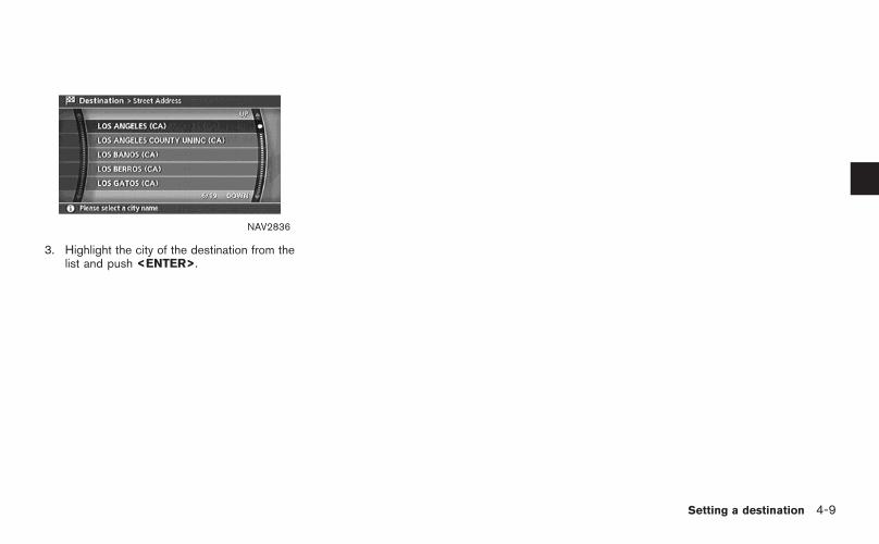
NAV2836
3. Highlight the city of the destination from thelist and push <ENTER>.
Setting a destination 4-9

NAV2787
SETTING A CITY CENTER
1. Highlight [Others] and push <ENTER>.
NAV2837
2. High l ight [Ci ty Center ] and push<ENTER>.A character input screen is displayed.
NAV3075
INFO:
Character input screen for City Center
&1 Region:
The region previously entered is auto-matically displayed. It can be changed.
&2 City:
“All” is displayed, and all cities in theregion are available. Route calculationconditions can be narrowed down byentering the name of the city.
4-10 Setting a destination

&3 Symbols/A-Z:
Symbol keys are displayed by high-l ight ing [Symbols] and pushing<ENTER>. Alphabet keys are dis-played by highlighting [A-Z] and push-ing <ENTER>.
NAV3076
3. Highlight [City] and push <ENTER> tonarrow down the route calculation condi-tions by entering the name of the city.Enter the name of the city, highlight [OK] andpush <ENTER>.A list screen is displayed.
INFO:
Highlight [Last 5 Cities] and push<ENTER> to display 5 cities recently setas destinations.
NAV2840
4. Highlight the preferred destination from thelist and push <ENTER>.The position of the selected location isdisplayed in the preview on the right sideof the screen.
Setting a destination 4-11
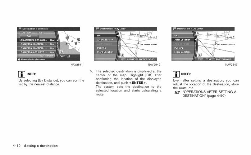
NAV2841
INFO:
By selecting [By Distance], you can sort thelist by the nearest distance.
NAV2842
5. The selected destination is displayed at thecenter of the map. Highlight [OK] afterconfirming the location of the displayeddestination, and push <ENTER>.The system sets the destination to theselected location and starts calculating aroute.
NAV2843
INFO:
Even after setting a destination, you canadjust the location of the destination, storethe route, etc.
“OPERATIONS AFTER SETTING ADESTINATION” (page 4-50)
4-12 Setting a destination

NAV3077
Changing the region
1. Highlight [Region] and push <ENTER> tochange the region.
NAV3078
2. Highlight the preferred region and push<ENTER>.A character input screen is displayed.
Setting a destination 4-13

NAV2787
SETTING AN INTERSECTION
1. Highlight [Others] and push <ENTER>.
NAV2846
2. H igh l igh t [ In te rsect ion ] and push<ENTER>.A character input screen is displayed.
4-14 Setting a destination

NAV3079
INFO:
Character input screen for Intersection
&1 Region:
The region previously entered is auto-matically displayed. It can be changed.
&2 City:
“All” is displayed, and all cities in theregion are available. Route calculationconditions can be narrowed down byentering the name of the city.
&3 1st Street:
Enter the name of the 1st street of thedestination intersection.
&4 2nd Street:
Enter the name of the 2nd street of thedestination intersection.
&5 Symbols/A-Z:
Symbol keys are displayed by high-l ight ing [Symbols] and pushing<ENTER>. Alphabet keys are dis-played by highlighting [A-Z] and push-ing <ENTER>.
Setting a destination 4-15

NAV3080
3. Enter the name of the 1st street.After finishing the entry, highlight [OK] andpush <ENTER>.A list screen is displayed.
NAV2849
4. Highlight a street as the 1st street from thelist and push <ENTER>.
NAV3081
5. Enter the name of the 2nd street.After finishing the entry, highlight [OK] andpush <ENTER>.A list screen is displayed.
4-16 Setting a destination

NAV2851
6. Highlight a street as the 2nd street from thelist and push <ENTER>.
NAV2852
7. The selected destination is displayed at thecenter of the map. Highlight [OK] afterconfirming the location of the displayeddestination, and push <ENTER>.The system sets the destination to theselected location and starts calculating aroute.
NAV2853
INFO:
Even after setting a destination, you canadjust the location of the destination, storethe route, etc.
“OPERATIONS AFTER SETTING ADESTINATION” (page 4-50)
Setting a destination 4-17

NAV3082
Changing the region
1. Highlight [Region] and push <ENTER> tochange the region.
NAV3083
2. Highlight the preferred region and push<ENTER>.A character input screen is displayed.
NAV3084
Specifying a city
1. Highlight [City] and push <ENTER> tonarrow down the route calculation condi-tions by entering the name of the city.
4-18 Setting a destination

NAV3085
2. Enter the name of the city, highlight [OK] andpush <ENTER>.A list screen is displayed.
INFO:
. Highl ight [Al l Cit ies] and push<ENTER> to include all cities in theregion as the route calculation condition.
. Highlight [Last 5 Cities] and push<ENTER> to display 5 cities recentlyset as destinations.
NAV2858
3. Highlight the city of the destination from thelist and push <ENTER>.A character input screen is displayed.
Setting a destination 4-19

SETTING FROM MAP
This allows you to search for a destination byscrolling the map, and then have the systemcalculate a route to the destination.
NAV2859
1. Scroll the map, place the cross pointer overthe preferred location, and push <ENTER>.
INFO:
. Adjust the map scale to search for alocation more effectively.
. The point on the blinking road where thecenter of the cross pointer is locatedcan be set as a destination.
NAV2860
2. Highlight [New Dest] and push <ENTER>.
INFO:
For the items except for [New Dest], refer to“Map menu screen”.
“Scrolled location map screen”(page 2-12)
4-20 Setting a destination

NAV2861
3. The system sets the destination to theselected location and starts calculating aroute.
NAV2862
INFO:
If you set the destination on a freeway, aconfirmation message is displayed.
Setting a destination 4-21

The following setting methods are availablewhen setting the destination to your home orany location stored in the Address Book.
. Setting your homeThis allows you to set your home as thedestination and have the system calculate aroute. It is useful especially when you aresearching for a route to return to your home.
“STORING A LOCATION” (page 6-2)
. Setting from Address BookThis allows you to set the destination to alocation stored in the Address Book andhave the system calculate a route. To utilizethis function more effectively, destinationsthat you often travel to should be stored inadvance.
“STORING A LOCATION” (page 6-2)
. Setting a Previous DestinationThis allows you to set the destination to alocation that you have previously set as thedestination and have the system calculate aroute. Up to 100 previous destinations willbe automatically stored.If the number of previous destinationsexceeds 100, the oldest one will bereplaced by the new one.
. Setting the Previous Starting PointThis allows you to set the destination to thestarting point of the previous route guidanceand have the system calculate a route.
. Setting from Stored RoutesYou can select a preferred route from thestored routes.
SETTING A STORED LOCATION ASTHE DESTINATION
4-22 Setting a destination

NAV2774
SETTING YOUR HOME
1. Highlight [Address Book] and push<ENTER>.
NAV2775
2. Highlight [Home Location] and push<ENTER>.
INFO:
If you have not stored your home yet, thesystem will automatically display a screen forstoring it.
“STORING A LOCATION” (page 6-2)
NAV2776
3. A confirmation message is displayed, andthe system sets your home as the destina-tion.
Setting a destination 4-23

NAV2777
4. Your home is displayed at the center of themap, and the system starts calculating aroute.
4-24 Setting a destination

NAV2774
SETTING FROM ADDRESS BOOK
1. Highlight [Address Book] and push<ENTER>.A list screen is displayed.
NAV2778
2. Highlight the preferred location from the listand push <ENTER>.
NAV2779
INFO:
Selecting [Sort List] displays a list of varioussort functions.To use the sort functions, stored locationsmust be set in advance.
“EDITING THE STORED HOME ANDLOCATION” (page 6-16)
Setting a destination 4-25
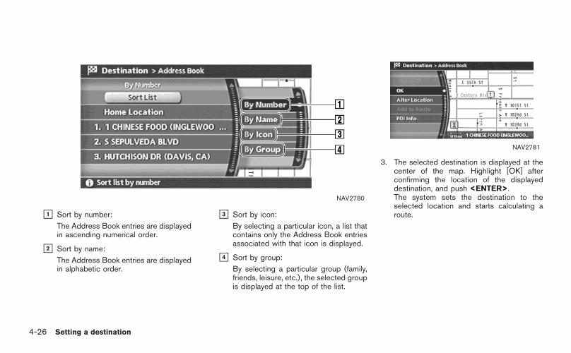
NAV2780
&1 Sort by number:
The Address Book entries are displayedin ascending numerical order.
&2 Sort by name:
The Address Book entries are displayedin alphabetic order.
&3 Sort by icon:
By selecting a particular icon, a list thatcontains only the Address Book entriesassociated with that icon is displayed.
&4 Sort by group:
By selecting a particular group (family,friends, leisure, etc.), the selected groupis displayed at the top of the list.
NAV2781
3. The selected destination is displayed at thecenter of the map. Highlight [OK] afterconfirming the location of the displayeddestination, and push <ENTER>.The system sets the destination to theselected location and starts calculating aroute.
4-26 Setting a destination

NAV2782
INFO:
Even after setting a destination, you canadjust the location of the destination, storethe route, etc.
“OPERATIONS AFTER SETTING ADESTINATION” (page 4-50)
Setting a destination 4-27

NAV2783
SETTING A PREVIOUS DESTINATION
1. Highlight [Previous Destinations] and push<ENTER>.
NAV2784
2. Highlight the preferred destination from thelist and push <ENTER>.
NAV2785
3. The selected destination is displayed at thecenter of the map. Highlight [OK] afterconfirming the location of the displayeddestination, and push <ENTER>.The system sets the destination to theselected location and starts calculating aroute.
4-28 Setting a destination

NAV2786
INFO:
Even after setting a destination, you canadjust the location of the destination, storethe route, etc.
“OPERATIONS AFTER SETTING ADESTINATION” (page 4-50)
Setting a destination 4-29

NAV2787
SETTING THE PREVIOUS STARTINGPOINT
1. Highlight [Others] and push <ENTER>.
NAV2788
2. Highlight [Previous Starting Point] and push<ENTER>.
NAV2789
3. The starting point of the route of theprevious route guidance is displayed at thecenter of the map. Highlight [OK] afterconfirming the location of the displayeddestination, and push <ENTER>.The system sets the destination to theselected location and starts calculating aroute.
4-30 Setting a destination

NAV2790
INFO:
Even after setting a destination, you canadjust the location of the destination, storethe route, etc.
“OPERATIONS AFTER SETTING ADESTINATION” (page 4-50)
Setting a destination 4-31

NAV2787
SETTING FROM STORED ROUTES
1. Highlight [Others] and push <ENTER>.
NAV2791
2. Highlight [Stored Routes] and push<ENTER>.A list screen is displayed.
NAV2792
3. Highlight the preferred route from the listand push <ENTER>.The route to the destination is set.
INFO:
The stored route includes only locations(destination and waypoints) and route cal-culation conditions, not the route itself.Therefore, when the destination is set usinga stored route, a different route may besuggested if the current vehicle location isdifferent from the one when the route wasstored.
4-32 Setting a destination

When you are setting the destination to a facility,the following methods are available.
. Setting a Point of InterestThis allows you to find a facility by type, andthen have the system calculate a route tothat destination. Specify the region and cityof the destination to find it more quickly.
. Setting a Freeway Entrance/ExitThis allows you to set the destination to anentrance or exit of a freeway, and then havethe system calculate a route.
. Setting by Phone NumberIf you know the telephone number of thefacility, use this to find the facility by enteringthe number, and then have the systemcalculate a route.
. Setting a Nearby PlaceThis allows you to set the destination to afacility located near the current vehiclelocation or another location that you moveto by scrolling the map, and then have thesystem calculate a route.If there is any particular facility type that youintend to use frequently, you can store it inthe list of nearby facilities.
“CUSTOMIZING NEARBY PLACES”(page 6-33)
SETTING A FACILITY AS THEDESTINATION
Setting a destination 4-33

NAV2728
SETTING A POINT OF INTEREST
1. Highlight [Points of Interest] and push<ENTER>.
NAV2793
2. Highlight the main category and push<ENTER>.
INFO:
Highlight [By Name] and push <ENTER> toinclude all categories in the route calculationconditions.
NAV2794
3. Highlight the subcategory and push<ENTER>.A character input screen is displayed.
4-34 Setting a destination

NAV3086
INFO:
Character input screen for Points of Interest
&1 Region:
The region previously entered is auto-matically displayed. It can be changed.
&2 City:
“All” is displayed, and all cities in theregion are available. Route calculationconditions can be narrowed down byentering the name of the city.
&3 Category:
The preferred facility type can beselected.
&4 Name:
The name of the destination facility canbe selected.
&5 Nearby POI:
The system will search for the facility,based on the type selected, near thecurrent vehicle location.
&6 Symbols/A-Z:
Symbol keys are displayed by high-l ight ing [Symbols] and pushing<ENTER>. Alphabet keys are dis-played by highlighting [A-Z] and push-ing <ENTER>.
Setting a destination 4-35

NAV3087
4. Highlight [Name] and push <ENTER>.Enter the name of the destination facility.
NAV3088
5. After finishing the entry, highlight [OK] andpush <ENTER>.A list screen is displayed.
NAV2798
6. Highlight the preferred destination facilityfrom the list and push <ENTER>.
4-36 Setting a destination

NAV2799
INFO:
By selecting [By Distance], you can sort thelist by the nearest distance.The position of the selected location isdisplayed in the preview on the right sideof the screen.
NAV2800
7. The selected destination is displayed at thecenter of the map. Highlight [OK] afterconfirming the location of the displayeddestination, and push <ENTER>.The system sets the destination to theselected location and starts calculating aroute.
NAV2801
INFO:
Even after setting a destination, you canadjust the location of the destination, storethe location, etc.
“OPERATIONS AFTER SETTING ADESTINATION” (page 4-50)
Setting a destination 4-37

NAV3089
Changing the region
1. Highlight [Region] and push <ENTER> tochange the region.
NAV3090
2. Highlight the preferred region and push<ENTER>.A character input screen is displayed.
NAV3091
Specifying a city
1. Highlight [City] and push <ENTER> tonarrow down the route calculation condi-tions by entering the name of the city.
4-38 Setting a destination

NAV3092
2. Enter the name of the city, highlight [OK] andpush <ENTER>.
INFO:
. Highl ight [Al l Cit ies] and push<ENTER> to include all cities in theregion as the route calculation condition.
. Highlight [Last 5 Cities] and push<ENTER> to display 5 cities recentlyset as destinations.
NAV2806
3. Highlight the city of the destination facilityfrom the list, and push <ENTER>.A character input screen is displayed.
Setting a destination 4-39

Category list
Restaurant
Restaurant allAfrican, American, Austrian, Balkan, Barbecue/Southern, Belgian, Bistro, Bohemian, Brewpub, British isles, Cajun/Caribbean, Californian, Canadian,Chinese, Continental, Dutch, East European, Fast food, Filipino, French, German, Greek, Grill, Hawaiian/Polynesian, Hungarian, Indian, Indonesian/Malaysian, International, Italian, Japanese, Jewish/Kosher, Korean, Latin American, Maltese, Mexican, Middle Eastern, Oriental, Other, Pizza, Polish,Portuguese, Russian, Sandwich, Scandinavian, Seafood, Soul food, South American, South-western, Southeast Asian, Spanish, Steak house,Swiss, Thai, Turkish, Unknown, Vegetarian, Vietnamese
ShoppingGrocery store
Grocery store all7-Eleven, AM PM, Casey’s General Store, Circle K, Convenient Food Stores, Cumberland Farms, Dairy Mart,Dominion Stores, Holiday Station Store, Kash-N-Karry, Loblaw, Others, Pantry, Stop-N-Go, Uni Mart Inc., WhiteHen Pantry
Shopping
Auto service
Auto dealerships
Automobile club
Gas station
Gas station allAmoco, Arco, Beacon (Valero), Chevron, Citgo, Conoco, Esso, Exxon, Getty, Gulf, Husky, Marathon, Mobil,Mohawk, Others, Petro-Canada, Phillips 66, Pioneer, Shell, Sinclair, Sunoco, Texaco, Ultramar (Velero), UltramarUSA, Unocal 76, Valero
Rental car agency
Auto service & maintenance
NISSAN dealer
INFINITI dealer
4-40 Setting a destination

Travel
Airport
Border crossing
Bus station
Commuter rail station
Ferry terminal
Hotel
Hotel allAmerica Inn & Suites, Amerihost (Cendant), Amerisuites, Baymont Inn & Suites, Best Western, CandlewoodSuites, Clarion, Country Hearth Inn, Country Inn Suites (Carlson Group), Courtyard by Marriott, Crossland Motel,Crowne Plaza, Days Inn, Double Tree (Hilton Group), Drury Inn/Pear Tree by Drury, Econo Lodge, EmbassySuites, Extended Stay, Fairfield Inn, Four Seasons, Hampton Inn, Hawthorn Suites, Hilton, Hilton Garden Inn,Holiday Inn, Holiday Inn Express, Homestead, Homewood, Howard Johnson, Hyatt, Intercontinental, JamesonInns/Signature Inns, Knights Inn (Cendant), La Quinta Inn, Leows Hotels, Microtel Inn & Suites, Motel 6/Studio 6,Others, Park Inn (Carlson Group), Quality, Radisson, Ramada Inn, Red Roof Inn, Renaissance (Marriott),Residence Inns, Ritz Carlton, Rodeway Inn (Choice), Scottish Inn, Sheraton, Shilo Inn, Shoney’s Inn, Sleep Inn(Choice), Spring Hill Suites (Marriott), St Regis (Starwood), Staybridge Suites, Studio Plus, Super 8, TownePlace Suites (Marriott), Travelodge, Venture Inns, Village (Cendant), W Hotels, Westin, Wingate Inn (Cendant),Wyndham
Automobile club
Rental car agency
Rest area
Ski resort
Tourist attraction
Tourist information
Train station
Auto service & maintenance
Setting a destination 4-41

BankingATM
Bank
Hospital
CommunityCity hall, Community center, Convention/Exhibition center, Court house, Historical monument, Hospital, Library, Marina, Museum, Police station,Park/Recreation area, School, Sports center, Sports complex, Performing arts, Higher education
LeisureAmusement park, Bowling center, Casino, Movie theater, Convention/Exhibition center, Golf course, Historical monument, Ice skating park, Marina,Museum, Nightlife, Park/Recreation area, Ski resort, Sports center, Sports complex, Performing arts, Tourist attraction, Tourist information, Winery
Parking
Parking lot
Park & Ride
Parking garage
Others Border crossing, Business facility, Court house, Historical monument, Police station, School, Higher education
4-42 Setting a destination

NAV2787
SETTING A FREEWAY ENTRANCE/EXIT
1. Highlight [Others] and push <ENTER>.
NAV2807
2. Highlight [Freeway Entrance/Exit] and push<ENTER>.A character input screen is displayed.
NAV3093
3. Select a region and enter the name of thefreeway.
4. After finishing the entry, highlight [OK] andpush <ENTER>.
Setting a destination 4-43

NAV2809
5. Highlight the freeway of the destination fromthe list, and push <ENTER>.
NAV2810
6. Highlight [Entrance] or [Exit] and push<ENTER>.A list screen is displayed.
NAV2811
7. Select the preferred destination from the list.The position of the selected location isdisplayed in the preview on the right sideof the screen. Then, push <ENTER>.
4-44 Setting a destination

NAV2812
INFO:
By selecting [By Distance], you can sort thelist by the nearest distance.
NAV2813
8. The selected destination is displayed at thecenter of the map. Highlight [OK] afterconfirming the location of the displayeddestination, and push <ENTER>.The system sets the destination to theselected location and starts calculating aroute.
NAV2814
INFO:
Even after setting a destination, you canadjust the location of the destination, storethe route, etc.
“OPERATIONS AFTER SETTING ADESTINATION” (page 4-50)
Setting a destination 4-45

NAV2787
SETTING BY PHONE NUMBER
INFO:
. If the area code of the specified telephonenumber does not exist in the map data, thesystem will not search for the location.
. Only the locations included in the databasein the map DVD-ROM can be searched bythe phone number. Personal phone numberscannot be used to search for a location.
1. Highlight [Others] and push <ENTER>.
NAV2815
2. Highlight [Phone Number] and push<ENTER>.The telephone number input screen isdisplayed.
NAV2816
3. Enter the telephone number including thearea code.
4. After finishing the entry, highlight [Map] andpush <ENTER>.
“PHONE NUMBER INPUT SCREEN”(page 2-25)
4-46 Setting a destination

NAV2817
5. The selected destination is displayed at thecenter of the map. Highlight [OK] afterconfirming the location of the displayeddestination, and push <ENTER>.The system sets the destination to theselected location and starts calculating aroute.
NAV2818
INFO:
Even after setting a destination, you canadjust the location of the destination, storethe route, etc.
“OPERATIONS AFTER SETTING ADESTINATION” (page 4-50)
NAV2787
SETTING A NEARBY PLACE
1. Highlight [Others] and push <ENTER>.
Setting a destination 4-47

NAV2819
2. Highlight [Nearby Places] and push<ENTER>.
NAV2820
3. Highlight the preferred destination facilityand push <ENTER>.A list screen is displayed.
INFO:
If there is any particular facility type that youintend to use frequently, you can store it inthe list of nearby facilities.
“CUSTOMIZING NEARBY PLACES”(page 6-33)
NAV2821
4. Highlight the preferred destination from thelist, and push <ENTER>.The position of the selected location isdisplayed in the preview on the right sideof the screen.
4-48 Setting a destination

NAV2822
INFO:
If the suggested route is already set, byhighlighting [Show Along Route] and push-ing <ENTER>, the system displays only thefacilities located along the route.
NAV2823
5. The system sets the destination to theselected location and starts calculating aroute.
INFO:
If the route is already set, the selectedlocation becomes a waypoint.
NAV2824
INFO:
You can also set the destination by pushing<ENTER> in the current location mapscreen and selecting [Nearby].
Setting a destination 4-49

The following operations are available after youset a destination.
INFO:
The menu will not be displayed if you select,[Stored Route] or [Nearby Places] from theDestination menu.
NAV2863
AVAILABLE SETTING ITEMS
. OK:Sets the destination. If the route is alreadyset, the location becomes the new destina-tion, and the route is recalculated.
. Alter Location:Displays a map screen where you can adjustthe location of the destination.
. Add to Route:Allows you to add a waypoint to the routealready set.
. POI Info:Allows you to view information about thefacility that you have set as the destination ifit is included in the map DVD-ROM data.
. Store Location:Allows you to store the location in theAddress Book.
OPERATIONS AFTER SETTING ADESTINATION
4-50 Setting a destination

ADJUSTING THE LOCATION OF THEDESTINATION
You can adjust the location of the destination bymoving the cross pointer across the map.
NAV2864
1. Set the destination using an appropriatemethod.
2. Highlight [Alter Location] and push<ENTER>.
NAV2865
3. Adjust the location by moving the crosspointer across the map and push<ENTER>.The location of the destination is modified.
Setting a destination 4-51

ADDING ADDITIONAL DESTINATIONSTO A ROUTE
Even after the route is already set, you can add asearched location as a new destination orwaypoint to that route.If the route has not been set, [Add to Route]cannot be selected.
NAV2866
1. Set the destination using an appropriatemethod.
2. Highlight [Add to Route] and push<ENTER>.
NAV2867
3. Highlight [Destination] or [Waypoint] andpush <ENTER>.
4-52 Setting a destination

VIEWING INFORMATION ABOUT THESEARCHED LOCATION
Information (street address and phone number)about facilities stored in the map DVD-ROMdata can be displayed.
NAV2868
1. Set the destination using an appropriatemethod.
2. Highlight [POI Info] and push <ENTER>.
NAV2869
3. Information about the location is displayed.
4. Push <ENTER>, or highlight [Back] andpush <ENTER> to return to the previousscreen.
Setting a destination 4-53

STORING A LOCATION
A searched location can be stored in theAddress Book. Then it can be easily retrievedand set as a destination (or waypoint).
NAV2870
1. Set the destination using an appropriatemethod.
2. Highlight [Store Location] and push<ENTER>.
NAV2871
3. The location is stored in the Address Book.The corresponding icon is displayed at theset location on the map.
4-54 Setting a destination

5 Route guidance
Procedures after setting a destination . . . . . . . . . . . . . . . . . . . . . 5-2Available items after setting a destination. . . . . . . . . . . . . 5-2Starting route guidance . . . . . . . . . . . . . . . . . . . . . . . . . . . . . . . . . . . 5-3Selecting a route . . . . . . . . . . . . . . . . . . . . . . . . . . . . . . . . . . . . . . . . . . . 5-3Confirming a route. . . . . . . . . . . . . . . . . . . . . . . . . . . . . . . . . . . . . . . . . . 5-4Adding a destination or waypoint . . . . . . . . . . . . . . . . . . . . . . . 5-5
About route guidance. . . . . . . . . . . . . . . . . . . . . . . . . . . . . . . . . . . . . . . . . . 5-7Voice guidance during route guidance. . . . . . . . . . . . . . . . . 5-7Guidance screens and preview mode . . . . . . . . . . . . . . . . . 5-8
Route setting . . . . . . . . . . . . . . . . . . . . . . . . . . . . . . . . . . . . . . . . . . . . . . . . . . 5-10Basic operation . . . . . . . . . . . . . . . . . . . . . . . . . . . . . . . . . . . . . . . . . . . 5-10
Setting conditions for the route calculation . . . . . . . . . . . . . 5-12Route priority settings . . . . . . . . . . . . . . . . . . . . . . . . . . . . . . . . . . . 5-12Detailed route priorities. . . . . . . . . . . . . . . . . . . . . . . . . . . . . . . . . . 5-13
Change/edit route . . . . . . . . . . . . . . . . . . . . . . . . . . . . . . . . . . . . . . . . . . . . 5-15Basic operation . . . . . . . . . . . . . . . . . . . . . . . . . . . . . . . . . . . . . . . . . . . 5-15
Setting a detour route . . . . . . . . . . . . . . . . . . . . . . . . . . . . . . . . . . . 5-17Recalculate route . . . . . . . . . . . . . . . . . . . . . . . . . . . . . . . . . . . . . . . . . 5-18Editing a route. . . . . . . . . . . . . . . . . . . . . . . . . . . . . . . . . . . . . . . . . . . . . 5-19
Confirming a route. . . . . . . . . . . . . . . . . . . . . . . . . . . . . . . . . . . . . . . . . . . . 5-26Basic operation . . . . . . . . . . . . . . . . . . . . . . . . . . . . . . . . . . . . . . . . . . . 5-26Using turn list. . . . . . . . . . . . . . . . . . . . . . . . . . . . . . . . . . . . . . . . . . . . . . 5-27Using route preview. . . . . . . . . . . . . . . . . . . . . . . . . . . . . . . . . . . . . . 5-27Confirming by simulation . . . . . . . . . . . . . . . . . . . . . . . . . . . . . . . . 5-28
Route guidance settings . . . . . . . . . . . . . . . . . . . . . . . . . . . . . . . . . . . . 5-29Basic operation . . . . . . . . . . . . . . . . . . . . . . . . . . . . . . . . . . . . . . . . . . . 5-29Visual guidance settings . . . . . . . . . . . . . . . . . . . . . . . . . . . . . . . . 5-31Voice guidance settings. . . . . . . . . . . . . . . . . . . . . . . . . . . . . . . . . 5-32Set average speeds. . . . . . . . . . . . . . . . . . . . . . . . . . . . . . . . . . . . . . 5-33
Deleting/reactivating a route . . . . . . . . . . . . . . . . . . . . . . . . . . . . . . . 5-35Deleting a route . . . . . . . . . . . . . . . . . . . . . . . . . . . . . . . . . . . . . . . . . . . 5-35Reactivating a route . . . . . . . . . . . . . . . . . . . . . . . . . . . . . . . . . . . . . . 5-36

After you set a destination using an appropriatemethod and select [OK], the system startscalculating a route to the destination.
Select the preferred setting item and push<ENTER>.
INFO:
If you have not performed any operations on thesystem for several seconds, [Start] is automati-cally selected, and the system starts routeguidance.
NAV2872
AVAILABLE ITEMS AFTER SETTING ADESTINATION
. Start:Starts route guidance to the selecteddestination.
“STARTING ROUTE GUIDANCE”(page 5-3)
. More Routes:Displays 3 alternative routes.
“SELECTING A ROUTE” (page 5-3)
. Route Info:Displays the route information.
“CONFIRMING A ROUTE”(page 5-4)
. Add Way Pt.:Allows you to edit the route by adding adestination or waypoint.
“ADDING A DESTINATION ORWAYPOINT” (page 5-5)
PROCEDURES AFTER SETTING ADESTINATION
5-2 Route guidance

NAV2873
STARTING ROUTE GUIDANCE
1. Highlight [Start] and push <ENTER>.Route guidance starts.
NAV2874
SELECTING A ROUTE
1. Highl ight [More Routes] and push<ENTER>.
2. Highlight the preferred route condition andpush <ENTER>.
3. Push <BACK>/<PREV> to return to theprevious screen.
NAV2875
Available route conditions
&1 Short. Time (Blue):Prioritizes by the shortest time.
&2 Min. FWY (Red):Minimizes the use of freeways.
&3 Short. Dist. (Green):Prioritizes by the shortest distance.
INFO:
. After you select a route, a preview isdisplayed on the right side of the screen.
. The 3 routes may not always be different.
Route guidance 5-3

NAV2876
CONFIRMING A ROUTE
1. Highlight [Route Info] and push <ENTER>.
2. Highlight the preferred information item andpush <ENTER>.
3. Push <BACK>/<PREV> to return to theprevious screen.
NAV2877
Available information
. Preview:Allows you to confirm the route by scrollingon the map manually.
“USING ROUTE PREVIEW”(page 5-27)
. Simulation:Allows you to view a simulation of the route.
“CONFIRMING BY SIMULATION”(page 5-28)
5-4 Route guidance

ADDING A DESTINATION OR WAY-POINT
Before starting route guidance, you can adddestinations and/or waypoints.
A total of 6 destinations or waypoints can be set.
NAV2878
1. Highlight [Add Way Pt.] and push<ENTER>.
NAV2879
2. Set additional destinations or waypoints andpush <ENTER>.
INFO:
The method of searching for a location is thesame as the one for a destination.
“4. Setting a destination”
Route guidance 5-5
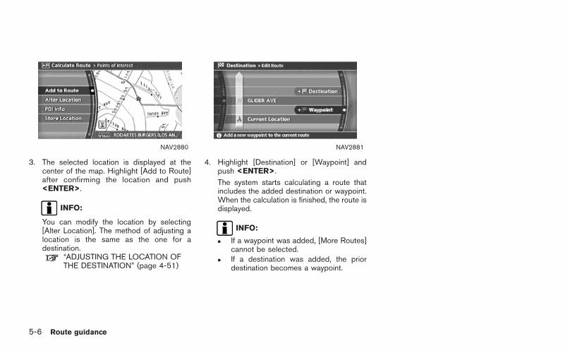
NAV2880
3. The selected location is displayed at thecenter of the map. Highlight [Add to Route]after confirming the location and push<ENTER>.
INFO:
You can modify the location by selecting[Alter Location]. The method of adjusting alocation is the same as the one for adestination.
“ADJUSTING THE LOCATION OFTHE DESTINATION” (page 4-51)
NAV2881
4. Highlight [Destination] or [Waypoint] andpush <ENTER>.
The system starts calculating a route thatincludes the added destination or waypoint.When the calculation is finished, the route isdisplayed.
INFO:
. If a waypoint was added, [More Routes]cannot be selected.
. If a destination was added, the priordestination becomes a waypoint.
5-6 Route guidance

After setting the route, select [Start] to beginroute guidance.
Throughout route guidance, the system navi-gates you through the guide points using visualand voice guidance.
CAUTION
The navigation system’s visual and voiceguidance is for reference purposes only.The contents of the guidance may beinappropriate depending on the situa-tion.
When driving along the suggested route,follow all traffic regulations (e.g., one-way traffic).
“ROUTE GUIDANCE” (page 9-11)
VOICE GUIDANCE DURING ROUTEGUIDANCE
When approaching a guide point (intersection orcorner), destination, etc. during route guidance,voice guidance announces the remaining dis-tance and/or turning direction.
Push <VOICE>/<GUIDE VOICE> to repeatvoice guidance.
NAI0418
Example of voice guidance
&1 “In about one quarter mile (400 meters),right (left) turn.”“Right (left) turn ahead.”
&2 “In about one quarter mile (400 meters)freeway entrance on your right onto (roadnumber and direction).”“Freeway entrance on your right onto (roadnumber and direction).”
&3 “In about one mile (1.6 kilometers), exit onyour right.”“Take the second exit on your right.”
&4 “You have arrived at your destination. Endingroute guidance.”
ABOUT ROUTE GUIDANCE
Route guidance 5-7

GUIDANCE SCREENS AND PREVIEWMODE
Route guidance displays map screens andvarious information according to the situation.
NAV2882
When route guidance starts, the Small TurnArrow on Map is displayed in the upper leftcorner of the map screen. This arrow indicatesthe turning direction at the next guide point(corner or intersection). The distance is alsodisplayed. At the top of the screen, the distanceto the next guide point and the name of the nextstreet to turn on to are displayed. Also, theremay be cases that next street names areannounced.
The Small Turn Arrow on Map can be enabled ordisabled by the user.
“ROUTE GUIDANCE SETTINGS”(page 5-29)
NAV2883
Enlarged intersection view
When approaching a guide point, the systemautomatically changes to the split screen andshows an enlarged view of the intersection in theleft screen. After passing through the intersec-tion, the system automatically returns to the fullscreen mode.
To switch to the full screen mode while theenlarged intersection view is displayed, push<MAP>.
5-8 Route guidance

NAV2884
Junction guidance
While driving on a freeway, when the vehicle isapproximately 1 mile (approximately 2 km) from ajunction, the system automatically switches tothe split screen and displays an enlarged view ofthe junction (3D) in the left screen.
After passing the junction, the system automa-tically returns to the full screen mode.
To switch to the full screen mode while theenlarged junction view is displayed, push<MAP>.
NAV2885
Turn list
Depending on the setting, the system canconstantly display the split screen and showthe turn list in the left screen. When approachinga guide point, the left screen automaticallyswitches to an enlarged view of the intersection.
To switch to the full screen mode, push<MAP>.
“ROUTE GUIDANCE SETTINGS”(page 5-29)
Route guidance 5-9

During route guidance, you can modify the routeconditions or confirm the route information. Setthe appropriate route condition according toyour purpose.
BASIC OPERATION
1. Push <ROUTE>.
2. Highlight the preferred setting item andpush <ENTER>.
3. Push <MAP> to return to the currentlocation map screen.
WARNING
Always stop the vehicle in a safe loca-tion before modifying the route condi-tions.
Modifying the route conditions whiledriving may cause an accident.
NAV2886
Available setting items
. Cancel Route Guidance/Resume RouteGuidance:Allows you to cancel the current routeguidance. A cancelled route can also bereactivated. If the suggested route is can-celled, [Cancel Route Guidance] changes to[Resume Route Guidance].
“DELETING/REACTIVATING AROUTE” (page 5-35)
. Change/Edit Route:Allows you to change or edit the routealready set.
“CHANGE/EDIT ROUTE”(page 5-15)
. Route Priority:Allows you to change the route calculationconditions anywhere along the route.
“SETTING CONDITIONS FOR THEROUTE CALCULATION” (page 5-12)
ROUTE SETTING
5-10 Route guidance

. Route Information:Allows you to confirm the route by the routeinformation or simulation.
“CONFIRMING A ROUTE”(page 5-26)
. Guidance Settings:You can set various guidance information tobe displayed during route guidance andactivate or deactivate route and/or voiceguidance.
“ROUTE GUIDANCE SETTINGS”(page 5-29)
Route guidance 5-11
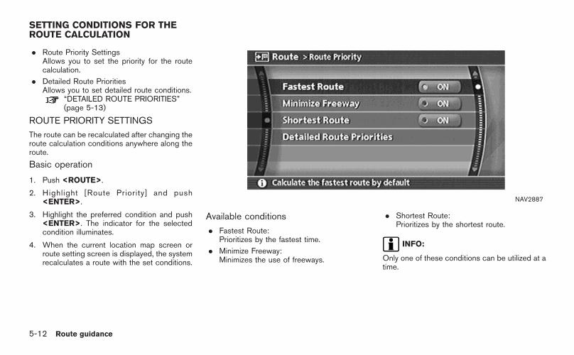
. Route Priority SettingsAllows you to set the priority for the routecalculation.
. Detailed Route PrioritiesAllows you to set detailed route conditions.
“DETAILED ROUTE PRIORITIES”(page 5-13)
ROUTE PRIORITY SETTINGS
The route can be recalculated after changing theroute calculation conditions anywhere along theroute.
Basic operation
1. Push <ROUTE>.
2. Highlight [Route Priority] and push<ENTER>.
3. Highlight the preferred condition and push<ENTER>. The indicator for the selectedcondition illuminates.
4. When the current location map screen orroute setting screen is displayed, the systemrecalculates a route with the set conditions.
NAV2887
Available conditions
. Fastest Route:Prioritizes by the fastest time.
. Minimize Freeway:Minimizes the use of freeways.
. Shortest Route:Prioritizes by the shortest route.
INFO:
Only one of these conditions can be utilized at atime.
SETTING CONDITIONS FOR THEROUTE CALCULATION
5-12 Route guidance

DETAILED ROUTE PRIORITIES
Detailed conditions can be set for the routecalculation.
Basic operation
1. Push <ROUTE>.
2. Highlight [Route Priority] and push<ENTER>.
3. Highlight [Detailed Route Priorities] andpush <ENTER>.
4. Highlight the preferred condition and push<ENTER>. The indicator for the selectedcondition illuminates.
5. When the current location map screen orroute setting screen is displayed, the systemrecalculates a route with the set conditions.
NAV2888
Available setting items
. Minimize Toll Roads:Minimizes the use of toll roads.
. Use Time Restricted Roads:Uses any roads subject to time restrictions.
. Use Avoid Area Settings:Enables the avoid area setting.
. Use Ferries:Includes the use of ferries.
. Auto Reroute:If the vehicle deviates from the suggestedroute, the system automatically recalculatesa route that leads the vehicle to thesuggested route.
Route guidance 5-13

INFO:
. The recalculated route may not be theshortest route because the system priori-tizes easy-to-drive roads for safety reasons.
. If you set the route conditions from [RoutePriority], all sections in the route are subjectto the same route conditions even thoughyou have set different route conditions fordifferent sections in [Edit Route].
. If [Use Time Restricted Roads] is deacti-vated, the system calculates a route withoutany consideration of the regulations con-cerning the time or day of the week. There-fore, the suggested route may include a roadsubject to traffic regulations concerning thetime or day of the week. When driving alongthe route, always follow all regulations.
. If the system cannot calculate any alternativeroutes, it displays the previous route.
. If the vehicle overly deviates from thesuggested route, the system calculates anew route.
5-14 Route guidance

You can calculate a detour for a section of theroute, edit the route or store the route.
BASIC OPERATION
1. Push <ROUTE>.
2. Highlight [Change/Edit Route] and push<ENTER>.
3. Highlight the preferred setting item andpush <ENTER>.
4. Push <MAP> to return to the currentlocation map screen.
NAV2889
Available setting items
. Detour:If you want to detour from the suggestedroute, you can calculate a route detouring fora specified distance.
“SETTING A DETOUR ROUTE”(page 5-17)
. Recalculate Route:When you have deviated from the sug-gested route, you can recalculate a routefrom the current location to the destinationmanually or automatically.
“RECALCULATE ROUTE”(page 5-18)
. Edit Route:You can edit the route and adjust thesettings for route calculation.
“EDITING A ROUTE” (page 5-19)
CHANGE/EDIT ROUTE
Route guidance 5-15

. Store Current Route:A calculated route can be stored. A max-imum of 5 routes can be stored. Storedroutes can be easily retrieved and set as thesuggested route.
“STORING A ROUTE” (page 6-12)
5-16 Route guidance

NAV2890
SETTING A DETOUR ROUTE
1. Highlight [Detour] and push <ENTER>.
NAV2891
2. Highlight a detour distance and push<ENTER>.
After calculating the detour, the system displaysthe detour route on the map.
INFO:
. When the vehicle has deviated from thesuggested route, [Detour] cannot be se-lected.
. If the system cannot calculate a detour withthe specified conditions, it displays theprevious suggested route.
. If the vehicle is traveling very fast, the detourroute may start from a location that thevehicle has already passed.
Route guidance 5-17

NAV2892
RECALCULATE ROUTE
1. Highlight [Recalculate Route] and push<ENTER>.
NAV2893
2. A message is displayed, and the route isrecalculated.
NAV2894
3. Set the route conditions. After finishing thesett ing, highl ight [Start] and push<ENTER>.
“PROCEDURES AFTER SETTING ADESTINATION” (page 5-2)
5-18 Route guidance

NAV2895
EDITING A ROUTE
1. Highlight [Edit Route] and push <ENTER>.
2. Highlight the preferred condition and push<ENTER>.
3. Push <BACK>/<PREV> to return to theprevious screen. Push <MAP> to return tothe current location map screen.
NAV2896
Available setting items
&1 Current destination:Allows you to change or delete the destina-tion.
“Editing/deleting a destination or way-point” (page 5-22)
&2 Current waypoint:Allows you to change or delete the way-point.
“Editing/deleting a destination or way-
point” (page 5-22)
&3 Condition for calculating a route to thedestination:Allows you to change the conditions forcalculating a route to the destination.
“Changing route calculation conditions”(page 5-24)
&4 Condition for calculating a route to awaypoint:Allows you to change the conditions forcalculating a route to a waypoint.
Route guidance 5-19

“Changing route calculation conditions”(page 5-24)
&5 Allows you to add a destination.“Setting a destination or waypoint”(page 5-20)
&6 Allows you to add a waypoint.“Setting a destination or waypoint”(page 5-20)
Setting a destination or waypoint
You can add a destination or waypoint to theroute already set.
A total of 6 destinations or waypoints can be set.
Adding a destination or waypoint
NAV2897
1. Highlight [Destination] or [Waypoint] andpush <ENTER>.
INFO:
If you select [Destination], the currentdestination is changed to a waypoint.
5-20 Route guidance

NAV2898
2. Set a destination or waypoint. The method ofsearching for a destination or waypoint is thesame as the one for a destination.
“4. Setting a destination”
NAV2899
3. The selected location is displayed at thecenter of the map. Highlight [Add to Route]after confirming the location and push<ENTER>.
INFO:
Even after setting a destination/waypoint,you can adjust the destination/waypointlocation, store the route, etc.
“OPERATIONS AFTER SETTING ADESTINATION” (page 4-50)
NAV2900
4. Return to the Edit Route screen.
Set the route conditions as necessary.
5. Push <MAP> to return to the currentlocation map screen. The route you haveset is automatically displayed.
INFO:
The prior route is automatically deleted.
Route guidance 5-21

Editing/deleting a destination or way-point
You can modify or delete the destination orwaypoint already set.
INFO:
If you modify or delete a location when asuggested route is already set, the priorsuggested route will be recalculated accord-ingly. NAV2901
1. Highlight a destination or waypoint that isalready set and push <ENTER>.
NAV2902
2. Highlight [Alter Locn.] to modify the locationand push <ENTER>.
“ADJUSTING THE LOCATION OFTHE DESTINATION” (page 4-51)
5-22 Route guidance

NAV2903
3. Highlight [Delete] and push <ENTER> todelete the location.
NAV2904
4. A confirmation message is displayed. Con-firm the contents of the message, highlight[Yes] and push <ENTER>.
The destination or waypoint is deleted fromthe route.
INFO:
If the destination is deleted, the final waypoint ofthe route becomes the destination.
Route guidance 5-23
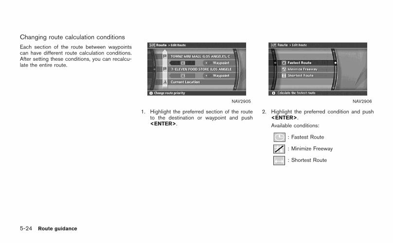
Changing route calculation conditions
Each section of the route between waypointscan have different route calculation conditions.After setting these conditions, you can recalcu-late the entire route.
NAV2905
1. Highlight the preferred section of the routeto the destination or waypoint and push<ENTER>.
NAV2906
2. Highlight the preferred condition and push<ENTER>.
Available conditions:
: Fastest Route
: Minimize Freeway
: Shortest Route
5-24 Route guidance

NAV2907
3. The system automatically recalculates aroute according to the conditions set.
The screen will automatically return to the[Edit Route] screen after route calculation.
NAV2908
4. The icon corresponding to the set routecondition is displayed. Push <MAP> toreturn to the current location map screen.
INFO:
. The recalculated route may not be theshortest route because the system priori-tizes easy-to-drive roads for safety reasons.
. If you set the route conditions from [RoutePriority], all sections in the route are subjectto the same route conditions even thoughyou have set different route conditions fordifferent sections in [Edit Route].
Route guidance 5-25

When the suggested route is displayed aftercalculation, you can confirm the route informa-tion or simulate the suggested route.
BASIC OPERATION
1. Highlight [Route Information] and push<ENTER>.
2. Highlight the preferred item and push<ENTER>.
NAV2909
Available items
. Turn list:Displays the details of the suggested route.
“USING TURN LIST” (page 5-27)
. Where am I? (Armada, Maxima, Murano,Pathfinder, Quest, Titan):Allows you to display the information aboutthe vehicle location on the route whendriving according to route guidance.
“VIEWING INFORMATION ABOUTCURRENT VEHICLE LOCATION”(page 7-3)
. Preview:Allows you to confirm the suggested routeby scrolling the map.
“USING ROUTE PREVIEW”(page 5-27)
. Simulation:Allows you to simulate the suggested route.This function provides a detailed image ofthe route with voice guidance.
“CONFIRMING BY SIMULATION”(page 5-28)
CONFIRMING A ROUTE
5-26 Route guidance
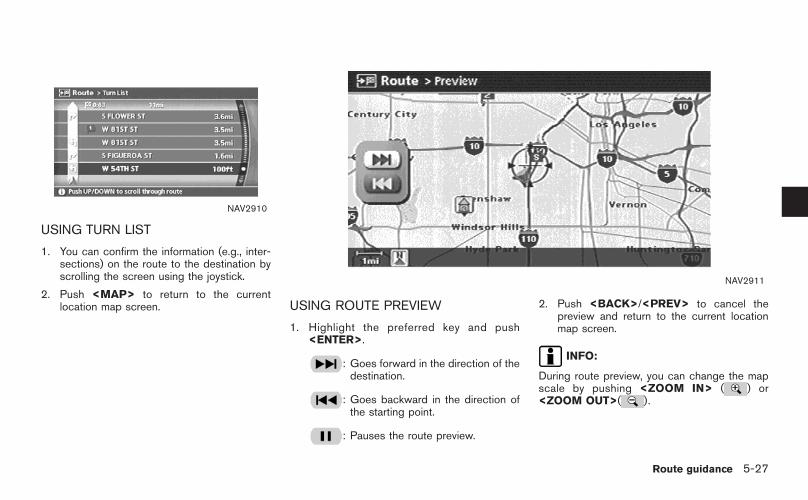
NAV2910
USING TURN LIST
1. You can confirm the information (e.g., inter-sections) on the route to the destination byscrolling the screen using the joystick.
2. Push <MAP> to return to the currentlocation map screen.
NAV2911
USING ROUTE PREVIEW
1. Highlight the preferred key and push<ENTER>.
: Goes forward in the direction of thedestination.
: Goes backward in the direction ofthe starting point.
: Pauses the route preview.
2. Push <BACK>/<PREV> to cancel thepreview and return to the current locationmap screen.
INFO:
During route preview, you can change the mapscale by pushing <ZOOM IN> ( ) or<ZOOM OUT>( ).
Route guidance 5-27

NAV2912
CONFIRMING BY SIMULATION
1. Highlight the preferred key and push<ENTER>.
: Pauses the simulation.
: Resumes the simulation.
: Ends the simulation.
2. Push <BACK>/<PREV> to cancel thesimulation and return to the current locationmap screen.
INFO:
During simulation, you can change the mapscale by pushing <ZOOM IN> ( ) or<ZOOM OUT> ( ).
5-28 Route guidance

You can set various guidance information to bedisplayed during route guidance and activate ordeactivate route and/or voice guidance.
BASIC OPERATION
1. Highlight [Guidance Settings] and push<ENTER>.
2. Highlight the preferred item and push<ENTER>.
3. Push <BACK>/<PREV> to return to theprevious screen. Push <MAP> to return tothe current location map screen.
NAV2913
Available setting items
. Guidance Screen Default:Sets the default display screen for routeguidance.
“VISUAL GUIDANCE SETTINGS”(page 5-31)
. Route Guidance:Activates or deactivates route guidance.Route guidance is activated when theindicator illuminates. Route information isnot available when route guidance is set toOFF.
. Guidance Voice (350Z):Activates or deactivates voice guidance.
The indicator illuminates if voice guidance isactivated.
“SETTING THE VOICE GUIDANCE”(page 2-35)
. Small Turn Arrow on Map:Activates or deactivates the Small TurnArrow on Map (simplified turn indicator)displayed in the upper left corner of the mapscreen. The indicator illuminates if the Small
ROUTE GUIDANCE SETTINGS
Route guidance 5-29

Turn Arrow on Map is displayed.
. Voice Announcements:Sets how many times voice guidance isrepeated for guide points.
“VOICE GUIDANCE SETTINGS”(page 5-32)
. Set Average Speeds:Allows you to set an average vehicle speedfor each type of road, which is reflected inthe calculation of the required time to thedestination.
“SET AVERAGE SPEEDS”(page 5-33)
5-30 Route guidance

NAV2914
VISUAL GUIDANCE SETTINGS
1. Highlight [Guidance Screen Default] andpush <ENTER>.
2. The indicator of the selected type ofguidance illuminates.
NAV2915
Intersection Map: Enlarged intersection view
INFO:
Push <MAP> to switch to the full map screen.
NAV2916
Turn list: Right/Left turn list
INFO:
. Turn list can be scrolled using the joystick.
. Pushing <MAP> toggles between the fullmap screen and enlarged intersection view.
Route guidance 5-31

VOICE GUIDANCE SETTINGS
You can set how many times voice guidance isrepeated.
NAV2917
1. Highlight [Voice Announcements] and push<ENTER>.
NAV2918
2. Highlight [Twice] or [Three Times] and push<ENTER>.
The indicator for the selected number ofrepetitions illuminates.
3. Push <MAP> to return to the currentlocation map screen.
5-32 Route guidance

SET AVERAGE SPEEDS
You can calculate the required time to thedestination based on the set vehicle speeds.
Basic operation
1. Highlight [Set Average Speeds] and push<ENTER>.
2. Highlight the preferred item and push<ENTER>.
3. Use the joystick to make an adjustment. Thespeed can be increased/decreased by 5MPH (5 km/h).
4. After finishing the setting, push <ENTER>or <BACK>/<PREV> to activate thesetting.
5. Push <BACK>/<PREV> to return to theprevious screen. Push <MAP> to return tothe current location map screen.
NAV2919
Available setting items
. Auto:If set to ON, the system automaticallycalculates the required time to the destina-tion, the indicator illuminates and the speedsettings cannot be changed.
. Freeway:Allows you to adjust the average vehiclespeed on a freeway by moving the joystick inthe direction of [+] or [−].
. Main Road:Allows you to adjust the average vehiclespeed on a main road by moving the joystickin the direction of [+] or [−].
. Town Road:Allows you to adjust the average vehiclespeed on a town road by moving the joystickin the direction of [+] or [−].
. Residential:Allows you to adjust the average vehiclespeed in a residential area by moving thejoystick in the direction of [+] or [−].
Route guidance 5-33

. Reset:Sets the average vehicle speeds to thedefault values.
5-34 Route guidance

You can delete a route already set at any time. Ifyou delete a route, the destination and way-points are also deleted.
It is also possible to reactivate the route that youdeleted.
NAV2920
DELETING A ROUTE
1. Highlight [Cancel Route Guidance] andpush <ENTER>.
NAV2921
2. A confirmation message is displayed. High-light [Yes] and push <ENTER>.
The route is deleted along with the destina-tion and waypoints.
DELETING/REACTIVATING A ROUTE
Route guidance 5-35

NAV2922
REACTIVATING A ROUTE
1. Highlight [Resume Route Guidance] andpush <ENTER>.
NAV2923
2. A confirmation message is displayed. High-light [Yes] and push <ENTER>.
The route you have deleted is reactivated.
INFO:
If you set a new route, the deleted route cannotbe reactivated.
5-36 Route guidance
6 Storing a location/route
Storing a location. . . . . . . . . . . . . . . . . . . . . . . . . . . . . . . . . . . . . . . . . . . . . . . 6-2Storing a location by searching . . . . . . . . . . . . . . . . . . . . . . . . . 6-2Storing the current vehicle location. . . . . . . . . . . . . . . . . . . . . 6-5Storing a location by moving the map . . . . . . . . . . . . . . . . . 6-6Avoid area settings . . . . . . . . . . . . . . . . . . . . . . . . . . . . . . . . . . . . . . . . . 6-7
Storing a route . . . . . . . . . . . . . . . . . . . . . . . . . . . . . . . . . . . . . . . . . . . . . . . . 6-12Storing a tracked route. . . . . . . . . . . . . . . . . . . . . . . . . . . . . . . . . . . . . . 6-14Editing the address book . . . . . . . . . . . . . . . . . . . . . . . . . . . . . . . . . . . 6-15
Basic operation . . . . . . . . . . . . . . . . . . . . . . . . . . . . . . . . . . . . . . . . . . . 6-15Editing the stored home and location . . . . . . . . . . . . . . . . 6-16
Minor adjustment of the stored home andlocations . . . . . . . . . . . . . . . . . . . . . . . . . . . . . . . . . . . . . . . . . . . . . . . . . . . . 6-17Editing the stored route . . . . . . . . . . . . . . . . . . . . . . . . . . . . . . . . . 6-25Editing the stored tracking. . . . . . . . . . . . . . . . . . . . . . . . . . . . . . 6-26Editing the avoid area . . . . . . . . . . . . . . . . . . . . . . . . . . . . . . . . . . . 6-27
Deleting a stored item . . . . . . . . . . . . . . . . . . . . . . . . . . . . . . . . . . . . . . . 6-28Deleting a stored item individually . . . . . . . . . . . . . . . . . . . . 6-28Deleting an individual item on the map . . . . . . . . . . . . . . 6-30Deleting all stored items . . . . . . . . . . . . . . . . . . . . . . . . . . . . . . . . 6-31
Customizing nearby places . . . . . . . . . . . . . . . . . . . . . . . . . . . . . . . . . 6-33

Locations that you often visit can be stored inthe Address Book. The stored locations can beeasily retrieved to set them as a destination orwaypoint.
INFO:
. The Address Book can store up to 100locations.
. New information placed in the same storageposition will overwrite the old data.
STORING A LOCATION BY SEARCH-ING
After you have searched for a location aspreviously described, you can store the locationfor future use.
1. Push <SETTING>.
NAV3055Armada, Maxima, Murano, Pathfinder, Quest, Titan
NAV3029350Z
2. Highlight [Navigation] and push <ENTER>.
STORING A LOCATION
6-2 Storing a location/route

NAV2930
3. Highlight [Address Book] and push<ENTER>.
NAV2931
4. Highlight [Stored Location] and push<ENTER>.
NAV2932
5. Highlight [Home Location (Add New)] or[None (Add New)] and push <ENTER>.
Storing a location/route 6-3

NAV2933
6. Highlight the appropriate method to searchfor a location and push <ENTER>.
“4. Setting a destination”
NAV2934
7. When your preferred location is displayed atthe center of the map, confirm the locationand push <ENTER>.A message is displayed, and the location isstored in the Address Book.
INFO:
You can adjust a location by selecting [AlterLocation] using the same method as the onefor a destination.
“ADJUSTING THE LOCATION OFTHE DESTINATION” (page 4-51)
NAV2935
8. Adjust the location of the stored item andedit the contents of the stored item asnecessary.After finishing the setting, highlight [OK] andpush <ENTER>.
6-4 Storing a location/route
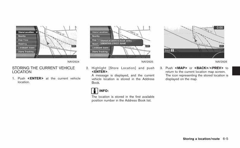
NAV2924
STORING THE CURRENT VEHICLELOCATION
1. Push <ENTER> at the current vehiclelocation.
NAV2925
2. Highlight [Store Location] and push<ENTER>.A message is displayed, and the currentvehicle location is stored in the AddressBook.
INFO:
The location is stored in the first availableposition number in the Address Book list.
NAV2926
3. Push <MAP> or <BACK>/<PREV> toreturn to the current location map screen.The icon representing the stored location isdisplayed on the map.
Storing a location/route 6-5

NAV2927
STORING A LOCATION BY MOVINGTHE MAP
1. Move to the preferred location on the mapand push <ENTER>.
NAV2928
2. Highlight [Store Location] and push<ENTER>.A message is displayed, and the location isstored in the Address Book.
INFO:
The location is stored in the first availableposition number in the Address Book list.
NAV2929
3. Push <MAP> to return to the currentlocation map screen.The icon representing the stored location isdisplayed on the map.
6-6 Storing a location/route

AVOID AREA SETTINGS
An Avoid Area can be stored.The Avoid Area is an area that you want toexclude from a route, such as a road that isalways congested.Once you store Avoid Areas, the system avoidsthose areas when calculating a route.Up to 5 Avoid Areas can be stored.
1. Push <SETTING>.
NAV3055Armada, Maxima, Murano, Pathfinder, Quest, Titan
NAV3029350Z
2. Highlight [Navigation] and push <ENTER>.
NAV2936
3. Highlight [Avoid Area Settings] and push<ENTER>.
INFO:
You can also access and store an AvoidArea from the Address Book.
Storing a location/route 6-7

NAV2937
4. Highlight [None (Add New)] and push<ENTER>.
INFO:
A maximum of 5 Avoid Areas can be stored.“DELETING A STORED ITEM”(page 6-28)
NAV2938
5. Highlight the appropriate method to searchfor a location and push <ENTER>.
“4. Setting a destination”
NAV2939
6. Set the following items for the searchedlocation.
Available setting items. Rename. Alter Location. Resize Area. FWY. Delete
7. After finishing the setting, highlight [OK] andpush <ENTER>.
6-8 Storing a location/route

NAV2940
Rename
1. A character input screen is displayed.
2. Enter the preferred name.
3. Highlight [OK] and push <ENTER>.NAI0419
Alter Location
1. Using the joystick, adjust the location of theAvoid Area.
2. After adjust ing the locat ion, push<ENTER>.
Storing a location/route 6-9

NAV2941
Resize Area
Select the range from 5 available levels.
After selecting the range, push <ENTER>.
INFO:
Push <ZOOM IN> ( ) or <ZOOM OUT>( ) to change the scale of the map.
6-10 Storing a location/route
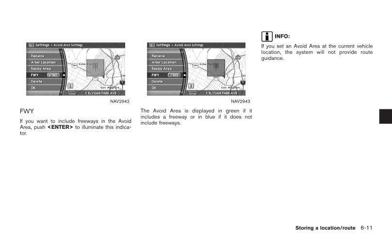
NAV2942
FWY
If you want to include freeways in the AvoidArea, push <ENTER> to illuminate this indica-tor.
NAV2943
The Avoid Area is displayed in green if itincludes a freeway or in blue if it does notinclude freeways.
INFO:
If you set an Avoid Area at the current vehiclelocation, the system will not provide routeguidance.
Storing a location/route 6-11

A calculated route can be stored.A maximum of 5 routes can be stored.Stored routes can be easily retrieved and set asthe suggested route.
INFO:
Stored route includes only locations (destinationand waypoints) and route calculation conditions,not the route itself.
1. Push <ROUTE>.NAV2944
2. Highlight [Change/Edit Route] and push<ENTER>.
NAV2945
3. Highlight [Store Current Route] and push<ENTER>.
STORING A ROUTE
6-12 Storing a location/route
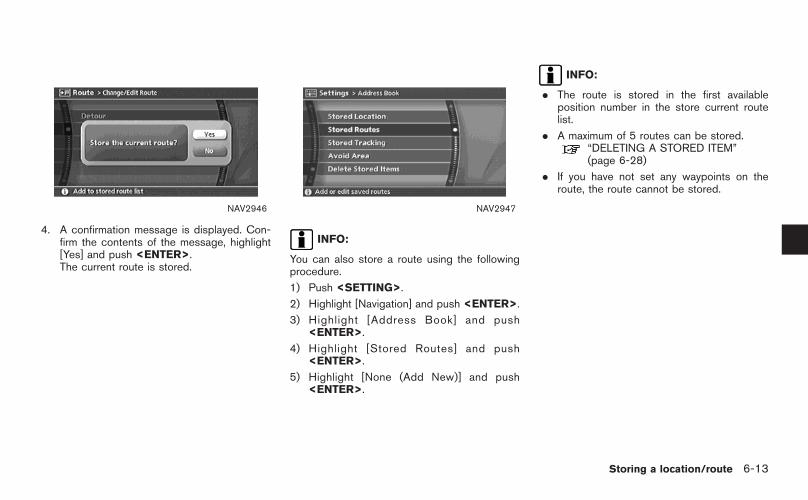
NAV2946
4. A confirmation message is displayed. Con-firm the contents of the message, highlight[Yes] and push <ENTER>.The current route is stored.
NAV2947
INFO:
You can also store a route using the followingprocedure.
1) Push <SETTING>.
2) Highlight [Navigation] and push <ENTER>.
3) Highlight [Address Book] and push<ENTER>.
4) Highlight [Stored Routes] and push<ENTER>.
5) Highlight [None (Add New)] and push<ENTER>.
INFO:
. The route is stored in the first availableposition number in the store current routelist.
. A maximum of 5 routes can be stored.“DELETING A STORED ITEM”(page 6-28)
. If you have not set any waypoints on theroute, the route cannot be stored.
Storing a location/route 6-13

You can store the route you have traveled up tothe current location. A maximum of 5 trackedroutes can be stored.A tracked route must not exceed 12 miles (20km) in distance.The stored tracked route can be displayed onthe map as necessary.
1. Push <ENTER>.
NAV2948
2. Highlight [Store Tracking] and push<ENTER>.
INFO:
A maximum of 5 tracked routes can bestored.
“DELETING A STORED ITEM”(page 6-28)
NAV2949
3. A confirmation message is displayed.Confirm the contents of the message, high-light [Yes] and push <ENTER>.The tracked route you have traveled isstored.
4. Push <MAP> or <BACK>/<PREV> toreturn to the current location map screen.
INFO:
The tracked route is stored in the first availableposition number in the store tracking list.
STORING A TRACKED ROUTE
6-14 Storing a location/route

Items stored in the Address Book can bemodified. You can edit these settings to makethe navigation system more useful.
BASIC OPERATION
1. Push <SETTING>.
2. Highlight [Navigation] and push <ENTER>.
3. Highlight [Address Book] and push<ENTER>.
4. Highlight the preferred item and push<ENTER>.
5. Push <BACK>/<PREV>to return to theprevious screen. Push <MAP> to return tothe current location map screen.
NAV2950
Available items
. Stored Location:Edits the information of a stored home andlocation.
“EDITING THE STORED HOME ANDLOCATION” (page 6-16)
. Stored Routes:Edits the information of a stored route.
“EDITING THE STORED ROUTE”(page 6-25)
. Stored Tracking:Edits the information of a stored trackedroute.
“EDITING THE STORED TRACKING”(page 6-26)
. Avoid Area:Edits the information of a stored Avoid Area.
“EDITING THE AVOID AREA”(page 6-27)
EDITING THE ADDRESS BOOK
Storing a location/route 6-15

. Delete Stored Items:Deletes a stored location or route.
“DELETING ALL STORED ITEMS”(page 6-31)
NAV2951
EDITING THE STORED HOME ANDLOCATION
1. Highlight the preferred stored home locationor stored location and push <ENTER>.
INFO:
Selecting [Sort List] displays a list of varioussort functions.To use the sort functions, stored locationsmust be set in advance.
“MINOR ADJUSTMENT OF THESTORED HOME AND LOCATIONS”(page 6-17)
NAV2952
2. Highlight the preferred item and push<ENTER>.
Available setting items
. Edit:Edits the stored location information.
. Alter Location:Adjusts the location of the stored location.
. Delete:Deletes the stored location.
. OK:Applies the settings.
6-16 Storing a location/route

MINOR ADJUSTMENT OF THESTORED HOME AND LOCATIONS
When you select [Edit], you can edit thefollowing items of the home or stored location.
. Show Icon on Map
. Name (only for stored locations)
. Icon
. Sound
. Direction
. Distance
. Phone No.
. Group (only for stored locations)
. Entry Number (only for stored locations)
NAV2953
Show Icon on Map
Displays the home icon or the stored locationicon on the map.
1. Highlight [Show Icon on Map] and push<ENTER>.
2. The indicator illuminates when the item isset. Then the system displays the icon onthe map.
NAV2954
Name (only for stored locations)
Changes the name of a stored location.
1. Highlight [Name] and push <ENTER>.A character input screen is displayed.
Storing a location/route 6-17

NAV2955
2. Enter the preferred name for the storedlocation.
“CHARACTER (letter and number)INPUT SCREEN” (page 2-23)
3. Highlight [OK] and push <ENTER>.The name is stored.
NAV2956
Icon
Changes the icon of the home or stored locationto the preferred one. By changing the icons, youcan utilize the [By Icon] option of the sortfunction more effectively.
1. Highlight [Icon] and push <ENTER>.A list of icons is displayed.
NAV2957
2. Highlight the preferred icon by scrolling thel ist using the joyst ick. Then push<ENTER>.
6-18 Storing a location/route

Icon List:
NAI0420
Storing a location/route 6-19

NAV2958
Sound
Sets the tone of the arrival alarm that soundswhen the vehicle approaches the home or astored location.
1. Highlight [Sound] and push <ENTER>.A sound list is displayed.
NAV2959
2. Highlight the preferred alarm tone by scrol-ling the list using the joystick. Then push<ENTER>.The indicator of the selected alarm toneilluminates.
Sound list:
None
Chime
Melody
Sound
Dog
Cat
Wave
Church bell
Music box 1
Music box 2
Marimba
Trumpet
Horn
Scratch
6-20 Storing a location/route

NAV2960
Direction
Sets the alarm to sound when approaching froma specific direction.
1. Highlight [Direction] and push <ENTER>.The home or stored location is displayed atthe center of the map.
NAV2961
2. Set the direction that sounds the alarmusing the joystick. Then push <ENTER>.The selected direction is set.
INFO:
After the direction is set, if you highlight[Direction] and push <ENTER> once again,a confirmation message is displayed. Con-firm the contents of the message, highlight[Yes] and push <ENTER>.The set direction is cancelled.
NAV2962
Distance
Sets the alarm to sound when reaching aspecific distance to the home or stored location.
1. Highlight [Distance] and push <ENTER>.
Storing a location/route 6-21

NAV2963
2. Highlight the preferred distance option andpush <ENTER>.The indicator of the selected distanceilluminates.
Available distance options:
. 150 feet (50 m)
. 300 feet (100 m)
. 1000 feet (300 m)
. 1500 feet (500 m)
NAI0421
INFO:
Once you set the direction and distance tosound an alarm, the system will sound the alarmwhen the vehicle icon passes a half circle outlineon the map, as shown in the figure.Example: Set to 300 feet (100 m) distance,upward direction
&1 Stored location icon
&2 Vehicle icon
&3 Setting range
NAV2964
Phone No.
Stores the telephone number of the home or astored location.
1. Highlight [Phone No.] and push <ENTER>.The telephone number entry screen isdisplayed.
6-22 Storing a location/route

NAV2965
2. Enter the telephone number of the home orstored location.
“PHONE NUMBER INPUT SCREEN”(page 2-25)
3. Highlight [OK] and push <ENTER>.The telephone number is stored.
INFO:
If the phone number of your home or a location isstored, the phone number can be used to searchfor the destination even if it is not included in themap DVD-ROM data.
NAV3094
Group (only for stored locations)
This allows you to group the stored locations.By grouping the stored locations, you can utilizethe [By Group] option of the sort function moreeffectively.
1. Highlight [Group] and push <ENTER>.
NAV2967
2. Highlight the preferred group and push<ENTER>.When the indicator of the selected groupilluminates, the stored location is classifiedinto the applicable group.
Storing a location/route 6-23
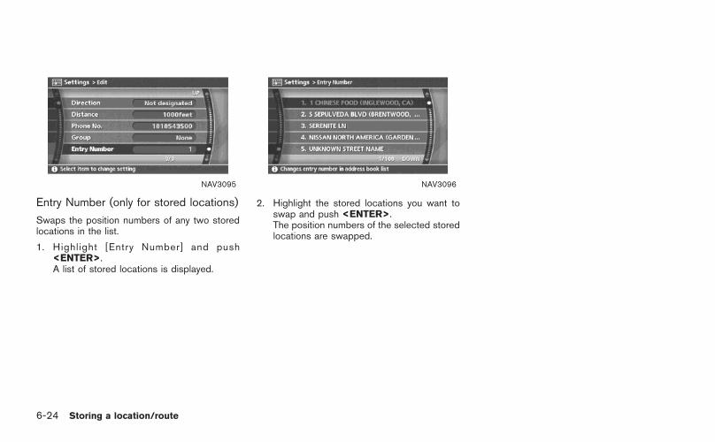
NAV3095
Entry Number (only for stored locations)
Swaps the position numbers of any two storedlocations in the list.
1. Highlight [Entry Number] and push<ENTER>.A list of stored locations is displayed.
NAV3096
2. Highlight the stored locations you want toswap and push <ENTER>.The position numbers of the selected storedlocations are swapped.
6-24 Storing a location/route

NAV2970
EDITING THE STORED ROUTE
1. Highlight the preferred stored route andpush <ENTER>.
2. Tilt the joystick to the right to select the Editscreen.The setting items are highlighted.
3. Highlight the preferred item and push<ENTER>.
4. After finishing the setting, highlight [OK] andpush <ENTER>.
INFO:
If you select [None (Add New)], the systemstores the current route.
NAV2971
Available setting items
. Rename:Changes the name.
“CHARACTER (letter and number)INPUT SCREEN” (page 2-23)
. Replace:Overwrites the stored route to the currentroute.
. Delete:Deletes the stored route.
. OK:Applies the settings.
Storing a location/route 6-25

NAV2972
EDITING THE STORED TRACKING
1. Highlight the preferred stored tracked routeand push <ENTER>. The [Show] indicatorfor the stored tracked route illuminates, andthe route is displayed on the map.Tilt the joystick to the right to highlight [Edit].
INFO:
. Current tracking is displayed up to 62miles (100 km).
. Stored tracking is displayed up to 12miles (20 km).
NAV2973
2. Highlight the preferred item and push<ENTER>.
Available setting items (Current tracking)
. Map:Displays the tracked route up to the currentlocation.
. Delete:Deletes the tracked route up to the currentlocation.
NAV2974
Available setting items (Stored tracked routes)
. Map:Displays a stored tracked route on the map.
. Rename:Changes the name.
“CHARACTER (letter and number)INPUT SCREEN” (page 2-23)
. Replace:Overwrites the stored tracked route to thecurrent tracked route.
. Delete:Deletes the stored tracked route.
. OK:Applies the settings.
6-26 Storing a location/route
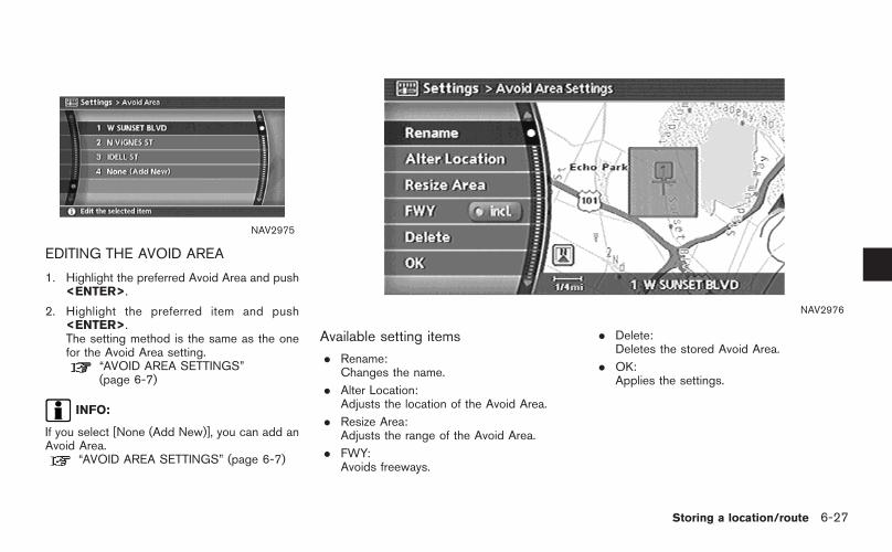
NAV2975
EDITING THE AVOID AREA
1. Highlight the preferred Avoid Area and push<ENTER>.
2. Highlight the preferred item and push<ENTER>.The setting method is the same as the onefor the Avoid Area setting.
“AVOID AREA SETTINGS”(page 6-7)
INFO:
If you select [None (Add New)], you can add anAvoid Area.
“AVOID AREA SETTINGS” (page 6-7)
NAV2976
Available setting items
. Rename:Changes the name.
. Alter Location:Adjusts the location of the Avoid Area.
. Resize Area:Adjusts the range of the Avoid Area.
. FWY:Avoids freeways.
. Delete:Deletes the stored Avoid Area.
. OK:Applies the settings.
Storing a location/route 6-27

You can delete locations and routes stored inthe Address Book.Two deletion methods are available, deleting anindividual item and deleting all stored items.
NOTE:
Deleted items cannot be restored.Before deleting an item, always make surethat the item is truly not necessary.
NAV2977
DELETING A STORED ITEM INDIVIDU-ALLY
1. Highlight [Address Book] and push<ENTER>.
NAV2978
Example: [Stored Location] is selected
2. Highlight the preferred item for deletion andpush <ENTER>.
DELETING A STORED ITEM
6-28 Storing a location/route

NAV2979
3. Highlight the preferred location/route fordeletion and push <ENTER>.
NAV2980
4. Highlight [Delete] and push <ENTER>.
NAV2981
5. A confirmation message is displayed. Con-firm the contents of the message, highlight[Yes] and push <ENTER>.The stored item is deleted from the AddressBook.
Storing a location/route 6-29

NAV2982
DELETING AN INDIVIDUAL ITEM ONTHE MAP
1. Align the cross pointer over the preferredstored location for deletion by moving on themap. Then push <ENTER>.
NAV2983
2. Highlight [Delete] and push <ENTER>.
NAV2984
3. A confirmation message is displayed. Con-firm the contents of the message, highlight[Yes] and push <ENTER>.The stored item is deleted from the AddressBook.
6-30 Storing a location/route

NAV3055Armada, Maxima, Murano, Pathfinder, Quest, Titan
NAV3029350Z
DELETING ALL STORED ITEMS
1. Highlight [Navigation] and push <ENTER>.
NAV2930
2. Highlight [Address Book] and push<ENTER>.
NAV2985
3. Highlight [Delete Stored Items] and push<ENTER>.
Storing a location/route 6-31

NAV2986
4. Highlight the preferred item for deletion andpush <ENTER>.
Items that can be deleted. Delete Home Location:
Deletes the home location.. Delete Stored Locations:
Deletes all stored locations.. Delete Stored Routes:
Deletes all stored routes.
. Delete Current Tracking:Deletes the current tracked route.
. Delete Stored Tracking:Deletes all stored tracked routes.
. Delete Avoid Areas:Deletes all stored Avoid Areas.
. Delete Previous Destinations:Deletes all previous destinations.
. Delete Previous Starting Point:Deletes the previous starting point.
NAV2987
5. A confirmation message is displayed. Con-firm the contents of the message, highlight[Yes] and push <ENTER>.The stored items are deleted from theAddress Book.
6-32 Storing a location/route

You can change the categories used forsearching facilities nearby.
The modified list of facilities can be used forsearching for a location using [Nearby Places].
“SETTING A NEARBY PLACE”(page 4-47)
NAV3055Armada, Maxima, Murano, Pathfinder, Quest, Titan
NAV3029350Z
1. Highlight [Navigation] and push <ENTER>.
NAV2988
2. Highlight [Nearby Places Custom Settings]and push <ENTER>.
CUSTOMIZING NEARBY PLACES
Storing a location/route 6-33

NAV2989
3. Highlight the preferred item and push<ENTER>.The main category list is displayed.
NAV2990
4. Highlight a main category and push<ENTER>.The sub category list is displayed.
NAV2991
5. Highlight a sub category and push<ENTER>.The category setting is modified.
6. Push <MAP> to return to the currentlocation map screen.
6-34 Storing a location/route
7 Viewing technical information
Information screen (350Z only) . . . . . . . . . . . . . . . . . . . . . . . . . . . . . . 7-2Basic operation . . . . . . . . . . . . . . . . . . . . . . . . . . . . . . . . . . . . . . . . . . . . . 7-2
Viewing information about current vehicle location. . . . . . 7-3Basic operation . . . . . . . . . . . . . . . . . . . . . . . . . . . . . . . . . . . . . . . . . . . . . 7-3
Viewing GPS current location information . . . . . . . . . . . . . . . . 7-4Basic operation . . . . . . . . . . . . . . . . . . . . . . . . . . . . . . . . . . . . . . . . . . . . . 7-4
Viewing navigation system version information. . . . . . . . . . . 7-5Basic operation . . . . . . . . . . . . . . . . . . . . . . . . . . . . . . . . . . . . . . . . . . . . . 7-5

This screen allows you to set or view variousinformation that is helpful for using the vehiclesafely and comfortably, such as maintenanceinformation, current location information, GPSinformation and map DVD version.
BASIC OPERATION
1. Push <INFO>.
2. Highlight the preferred item and push<ENTER>.
NAV3097
Available items
. Maintenance:Refer to the Owner’s Manual of your vehicle.
. Where am I?:“VIEWING INFORMATION ABOUTCURRENT VEHICLE LOCATION”(page 7-3)
. GPS Satellite Info:“VIEWING GPS CURRENT LOCA-TION INFORMATION” (page 7-4)
. Navigation Version:“VIEWING NAVIGATION SYSTEMVERSION INFORMATION”(page 7-5)
INFORMATION SCREEN (350Z only)
7-2 Viewing technical information

This allows you to display the information aboutthe vehicle location on the route when drivingaccording to route guidance.
BASIC OPERATION
Armada, Maxima, Murano, Pathfinder, Quest,Titan:
1. Push <ROUTE>.
2. Highlight [Route Information] and push<ENTER>.
3. Highlight [Where am I?] and push<ENTER>.
4. Push <BACK>/<PREV> to return to theprevious screen.Push <MAP> to return to the currentlocation map screen.
350Z:
1. Push <INFO>.
2. Highlight [Where am I?] and push<ENTER>.
3. Push <BACK> to return to the previousscreen.Push <MAP> to return to the currentlocation map screen.
NAV2993
Contents of vehicle location information
&1 Next Street:
Displays the next street on the route.
&2 Current Street:
Displays the current street on the route.
&3 Previous Street:
Displays the previous street on the route.
&4 Displays the distance to the next intersec-tion on the route.
&5 Displays the distance traveled from theprevious intersection on the route.
VIEWING INFORMATION ABOUTCURRENT VEHICLE LOCATION
Viewing technical information 7-3

This allows you to display GPS information, suchas the positioning status, latitude/longitude,altitude and satellite locations.
BASIC OPERATION
Armada, Maxima, Murano, Pathfinder, Quest,Titan:
1. Push <SETTING>.
2. Highlight [Navigation] and push <ENTER>.
3. Highlight [GPS Satellite Info] and push<ENTER>.
4. Push <BACK>/<PREV> to return to theprevious screen.Push <MAP> to return to the currentlocation map screen.
350Z:
1. Push <INFO>.
2. Highlight [GPS Satellite Info] and push<ENTER>.
3. Push <BACK> to return to the previousscreen.Push <MAP> to return to the currentlocation map screen.
NAV2994
Contents of GPS information
&1 Calculation:
Displays the GPS positioning method.
3-dimension Calculating the latitude, longitudeand altitude by four or more satellites.
2-dimension Calculating the latitude, longitudeand altitude by three or more satel-lites.
Out of range Cannot calculate because no GPSsatellites can be located.
VIEWING GPS CURRENT LOCATIONINFORMATION
7-4 Viewing technical information

&2 Latitude/Longitude:
Displays the latitude/longitude.
&3 Approx Altitude:
Displays the approximate altitude.
&4 Positioning status:
It indicates that satellites are available.
It indicates that satellites are beingsearched for.
NAV3201
This allows you to display the map DVD-ROMversion information.
BASIC OPERATION
Armada, Maxima, Murano, Pathfinder, Quest,Titan:
1. Push <SETTING>.
2. Highlight [Navigation] and push <ENTER>.
3. Highlight [Navigation Version] and push<ENTER>.
4. Push <BACK>/<PREV> to return to theprevious screen.Push <MAP> to return to the currentlocation map screen.
350Z:
1. Push <INFO>.
2. Highlight [Navigation Version] and push<ENTER>.
3. Push <BACK> to return to the previousscreen.Push <MAP> to return to the currentlocation map screen.
VIEWING NAVIGATION SYSTEMVERSION INFORMATION
Viewing technical information 7-5

MEMO
7-6 Viewing technical information

8 Other settings
Settings screen(Armada, Maxima, Murano, Pathfinder, Quest, Titan) . . . 8-2
Basic operation . . . . . . . . . . . . . . . . . . . . . . . . . . . . . . . . . . . . . . . . . . . . . 8-2Display settings . . . . . . . . . . . . . . . . . . . . . . . . . . . . . . . . . . . . . . . . . . . . . 8-3System settings screen . . . . . . . . . . . . . . . . . . . . . . . . . . . . . . . . . . . 8-6Language and unit settings. . . . . . . . . . . . . . . . . . . . . . . . . . . . . . . 8-7Clock settings . . . . . . . . . . . . . . . . . . . . . . . . . . . . . . . . . . . . . . . . . . . . . 8-10
Setting screen (350Z) . . . . . . . . . . . . . . . . . . . . . . . . . . . . . . . . . . . . . . . 8-12Basic operation . . . . . . . . . . . . . . . . . . . . . . . . . . . . . . . . . . . . . . . . . . . 8-12
Display settings . . . . . . . . . . . . . . . . . . . . . . . . . . . . . . . . . . . . . . . . . . . 8-13Volume adjustment . . . . . . . . . . . . . . . . . . . . . . . . . . . . . . . . . . . . . . . 8-16Clock settings . . . . . . . . . . . . . . . . . . . . . . . . . . . . . . . . . . . . . . . . . . . . . 8-17Language and unit settings. . . . . . . . . . . . . . . . . . . . . . . . . . . . . 8-19
Map color settings. . . . . . . . . . . . . . . . . . . . . . . . . . . . . . . . . . . . . . . . . . . . 8-22Adjusting the current vehicle location . . . . . . . . . . . . . . . . . . . . 8-23Reset all navigation settings to default . . . . . . . . . . . . . . . . . . 8-25

The navigation system can be customized tomake it easier for you to use.
BASIC OPERATION
1. Push <SETTING>.
2. Highlight the preferred setting item andpush <ENTER>.
NAV3056
Available setting items
. Display:“DISPLAY SETTINGS” (page 8-3)
. Vehicle Electronic Systems:Refer to the Owner’s Manual of your vehicle.
. System Settings:Allows you to adjust the time setting,language/measurement unit setting andON/OFF setting of beeps used in thesystem.
. Navigation:Allows you to adjust various settings of thenavigation system. Refer to the instructionsin the relevant sections.
. Guidance Voice:Select to toggle the voice guidance functionbetween on and off. The indicator lightilluminates when the voice guidance func-tion is set to on.
SETTINGS SCREEN (Armada,Maxima, Murano, Pathfinder, Quest,Titan)
8-2 Other settings

. Guidance Volume:Adjust the volume level of voice guidance bytilting the joystick in the direction of [+] or[−].
DISPLAY SETTINGS
This menu allows you to turn on and off thedisplay and adjust the image quality.
Basic operation
1. Highlight [Display] and push <ENTER>.
2. Highlight the preferred adjustment item andpush <ENTER>.
3. Use the joystick to adjust to the preferredsetting.
4. After setting, push <ENTER> or <BACK>/<PREV> to apply the setting.
5. Push <BACK>/<PREV> to return to theprevious screen. Push <MAP> to return tothe current location map screen.
NAV3099
Available setting items
. Brightness/Contrast:Allows you to adjust the screen brightnessand contrast.
. Display off:Allows you to turn on/off the screen.
“Display off” (page 8-4)
. Lower Display Setting:Refer to the Owner’s Manual of your vehicle.
Other settings 8-3

NAV3100
Display off
To turn off the display, push <ENTER> and turnthe [Display off] indicator on, and hold < >(Day/Night) for more than 2 seconds.
NAV3101
When any button is pushed with the display off,the display turns on. The display will automati-cally turn off 3 seconds after the operation isfinished.To turn on the display, push < > (Day/Night)for more than 2 seconds.
NAV3102
Brightness
Adjust the display brightness by tilting thejoystick in the direction of [+] or [−].
INFO:
The preview of the map screen is displayed onthe upper portion of the screen, if the previousscreen showed a map.
8-4 Other settings

NAV3103
Contrast
Adjust the display contrast by tilting the joystickin the direction of [+] or [−].
INFO:
The preview of the map screen is displayed onthe upper portion of the screen, if the previousscreen showed a map.
NAI0480
Map Background
Push < > (Day/Night) to choose the back-ground color. Adjust the background colorbrightness by tilting the joystick in the directionof [+] or [−].
INFO:
When you turn the headlight switch on, thebackground color is changed.
NAV3003Bright background color
NAV3004Dark background color
Other settings 8-5

SYSTEM SETTINGS SCREEN
Allows you to set system settings such aslanguage/measurement unit setting.
Basic operation
1. Highlight [System Settings] and push<ENTER>.
2. Highlight the preferred adjustment item andpush <ENTER>.
3. Push <BACK>/<PREV> to return to theprevious screen. Push <MAP> to return tothe current location map screen.
NAV3030
Available setting items
. Language/Unit:“LANGUAGE AND UNIT SETTINGS”(page 8-7)
. Clock:“CLOCK SETTINGS” (page 8-10)
. Beep Setting:Select to toggle the beep function betweenon and off. The indicator light illuminateswhen the beep function is set to on.The beep that sounds when pushing andholding a button or when a prohibitedoperation is performed cannot be set to off.
8-6 Other settings

LANGUAGE AND UNIT SETTINGS
This allows you to change the language andmeasurement unit used in the system.
NAV3031
Language settings
1. Highlight [Language/Units] and push<ENTER>.
NAV3032
2. Highlight the preferred setting item andpush <ENTER>. The indicator light of theselected item illuminates.
Available languages
— English
— Francais
Other settings 8-7
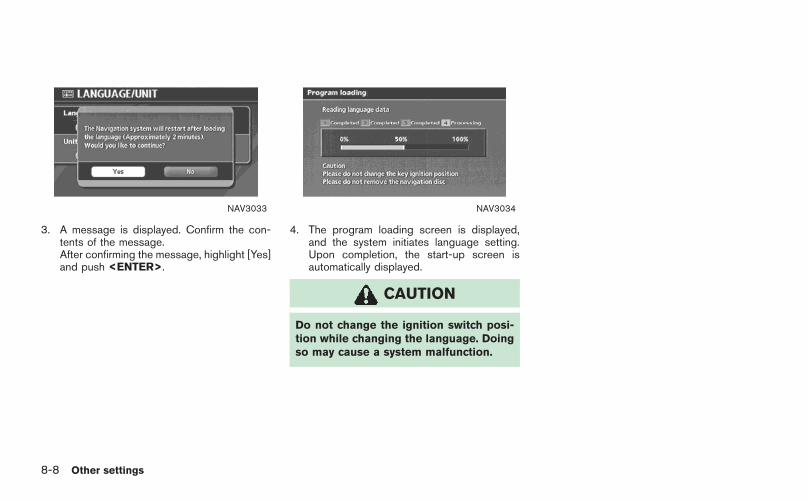
NAV3033
3. A message is displayed. Confirm the con-tents of the message.After confirming the message, highlight [Yes]and push <ENTER>.
NAV3034
4. The program loading screen is displayed,and the system initiates language setting.Upon completion, the start-up screen isautomatically displayed.
CAUTION
Do not change the ignition switch posi-tion while changing the language. Doingso may cause a system malfunction.
8-8 Other settings

NAV3031
Unit settings
1. Highlight [Language/Units] and push<ENTER>.
NAV3035
2. Highlight [Unit] and tilt the joystick to theright or left or push <ENTER> to highlightthe preferred unit.The indicator of the selected unit illuminates.
Available units
— US:mile, MPH, 8F, MPG
— Metric:km, km/h, 8C, L/100 km
3. Push <BACK>/<PREV> to return to theprevious screen.Push <MAP> to return to the currentlocation map screen.
Other settings 8-9

CLOCK SETTINGS
This allows you to change the clock settings.
Basic operation
1. Highlight [Clock] and push <ENTER>.
2. Highlight the preferred adjustment item.
3. Use the joystick to adjust to the preferredsetting.
4. After setting, push <ENTER> or <BACK>/<PREV> to apply the setting.
5. Push <BACK>/<PREV> to return to theprevious screen. Push <MAP> to return tothe current location map screen.
NAV3036
Setting items
. Hour:Set the hour.Adjust the hour by tilting the joystick in thedirection of [+] or [−].
. Minutes:Set the minutes.Adjust the minutes by tilting the joystick inthe direction of [+] or [−].
. Auto Adjust:The time currently set is reset to the GPStime.
. Daylight Saving Time:Select to toggle the daylight saving timesetting between on and off. The indicatorlight illuminates when the daylight savingtime setting is set to on.
8-10 Other settings
. Select Time Zone:Select an appropriate time zone from the listthat appears when you select this item.
— Pacific
— Mountain
— Central
— Eastern
— Atlantic
— Newfoundland
Other settings 8-11

The navigation system can be customized tomake it easier for you to use.
BASIC OPERATION
1. Push <SETTING>.
2. Highlight the preferred setting item andpush <ENTER>.
NAV3037
Available setting items
. Display:“DISPLAY SETTINGS” (page 8-13)
. Navigation:Allows you to adjust various settings of thenavigation system. Refer to the instructionsin the relevant sections.
. Volume and Beeps:“VOLUME ADJUSTMENT”(page 8-16)
. Clock:“CLOCK SETTINGS” (page 8-17)
. Language/Unit:“LANGUAGE AND UNIT SETTINGS”(page 8-19)
SETTING SCREEN (350Z)
8-12 Other settings

DISPLAY SETTINGS
This menu allows you to turn on and off thedisplay and adjust the image quality.
Basic operation
1. Highlight [Display] and push <ENTER>.
2. Highlight the preferred adjustment item andpush <ENTER>.
3. Use the main directional buttons or thecenter dial to adjust to the preferred setting.
4. After setting, push <ENTER> or <BACK>to apply the setting.
5. Push <BACK> to return to the previousscreen. Push <MAP> to return to thecurrent location map screen. NAV3104
Available setting items
. DisplayAllows you to turn on/off the screen.
“Display” (page 8-14)
. BrightnessAllows you to adjust the screen brightness.
“Brightness” (page 8-14)
. ContrastAllows you to adjust the screen contrast.
“Contrast” (page 8-15)
Other settings 8-13
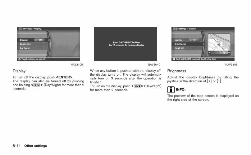
NAV3105
Display
To turn off the display, push <ENTER>.The display can also be turned off by pushingand holding < > (Day/Night) for more than 2seconds.
NAV3040
When any button is pushed with the display off,the display turns on. The display will automati-cally turn off 3 seconds after the operation isfinished.To turn on the display, push < > (Day/Night)for more than 2 seconds.
NAV3106
Brightness
Adjust the display brightness by tilting thejoystick in the direction of [+] or [−].
INFO:
The preview of the map screen is displayed onthe right side of the screen.
8-14 Other settings

NAV3107
Contrast
Adjust the display contrast by tilting the joystickin the direction of [+] or [−].
INFO:
The preview of the map screen is displayed onthe right side of the screen.
NAI0480
Background Color
Push < > (Day/Night) to choose the back-ground color. Adjust the background colorbrightness by tilting the joystick in the directionof [+] or [−].
INFO:
When you turn the headlight switch on, thebackground color is changed.
NAV3044Bright background color
NAV3045Dark background color
Other settings 8-15

VOLUME ADJUSTMENT
This allows you to turn on and off, as well asadjust, the voice guide function and the beepfunction.
Basic operation
1. Highlight [Volume and Beeps] and push<ENTER>.
2. Highlight the preferred adjustment item andpush <ENTER>.
3. Use the joystick to adjust the volume.Push <ENTER> to set ON/OFF.
4. After setting, push <ENTER> or <BACK>to apply the setting.
5. Push <BACK> to return to the previousscreen. Push <MAP> to return to thecurrent location map screen.
NAV3007
Setting items
. Guidance Volume:Adjust the volume level of voice guidance bytilting the joystick in the direction of [+] or[−].
. Guidance Voice:Select to toggle the voice guidance functionbetween on and off. The indicator lightilluminates when the voice guidance func-tion is set to on.
. Button Beeps:Select to toggle the beep function betweenon and off. The indicator light illuminateswhen the beep function is set to on.The beep that sounds when pushing andholding a button or when a prohibitedoperation is performed cannot be set to off.
8-16 Other settings

CLOCK SETTINGS
This allows you to change the clock settings.
Basic operation
1. Highlight [Clock] and push <ENTER>.
2. Highlight the preferred adjustment item andpush <ENTER>.
3. Use the joystick to adjust to the preferredsetting.Push <ENTER> to set ON/OFF.
4. After setting, push <ENTER> or <BACK>to apply the setting.
5. Push <BACK> to return to the previousscreen. Push <MAP> to return to thecurrent location map screen. NAV3008
Setting items
. On-screen Clock:Select to toggle the clock display located inthe top right corner of the display betweenon and off. The indicator light illuminateswhen the clock display is set to on.
. Clock Format:Use the joystick to change the clock formatbetween 12-hour and 24-hour.
. Offset Adjust:Use the joystick to adjust the offset value(between −59 and +59).
. Daylight Saving Time:Select to toggle the daylight saving timesetting between on and off. The indicatorlight illuminates when the daylight savingtime setting is set to on.
Other settings 8-17

. Time Zone:Select an appropriate time zone from the listthat appears when you select this item.
— Pacific
— Mountain
— Central
— Eastern
— Atlantic
— Newfoundland
8-18 Other settings

LANGUAGE AND UNIT SETTINGS
This allows you to change the language andmeasurement unit used in the system.
NAV3009
Language settings
1. Highlight [Language/Units] and push<ENTER>.
NAV3010
2. Highlight [Select Language] and push<ENTER>.
Other settings 8-19

NAV3011
3. Highlight the preferred setting item andpush <ENTER>. The indicator light of theselected item illuminates.
Available languages
— English
— Francais
NAV3012
4. A message is displayed. Confirm the con-tents of the message.After confirming the message, highlight [Yes]and push <ENTER>.
NAV3013
5. The program loading screen is displayed,and the system initiates language setting.Upon completion, the start-up screen isautomatically displayed.
CAUTION
Do not change the ignition switch posi-tion while changing the language. Doingso may cause a system malfunction.
8-20 Other settings

NAV3009
Unit settings
1. Highlight [Language/Units] and push<ENTER>.
NAV3014
2. Highl ight [Select Units] and push<ENTER>.
NAV3015
3. Highlight the preferred unit and push<ENTER>.The indicator of the selected unit illuminates.
Available units
— US:mile, MPH, 8F, MPG
— Metric:km, km/h, 8C, L/100 km
4. Push <BACK> to return to the previousscreen.Push <MAP> to return to the currentlocation map screen.
Other settings 8-21

This allows you to change the map color.
NAV3005
1. Highlight [Navigation] and push <ENTER>.
2. Highlight [Map Color Settings] and push<ENTER>.
NAV3006
3. Highlight the preferred map color and push<ENTER>. The indicator light of the se-lected color illuminates.
Available map colors
Warm: Sets warm colors for the mapcoloring.
Cool: Sets cool colors for the map color-ing.
INFO:
You can confirm the effect of your setting on thepreview displayed on the right side of thescreen.
MAP COLOR SETTINGS
8-22 Other settings

If the vehicle icon indicating the current vehiclelocation is not located in the correct position,you can correct the position of the vehicle iconon the map screen.
INFO:
. Regardless of the map view setting, the mapis displayed in Plan View when adjusting theposition of the vehicle icon.
. When you correct the position of the vehicleicon, the map is automatically displayed inthe North Up mode. After finishing thecorrection, the map restores the currentorientation setting.
. The position and direction of the vehicle iconmay be misaligned depending on theexternal conditions and environment.
. If the vehicle icon is misaligned, drive for awhile in a location where the GPS signalscan be received. This may correct theposition of the vehicle icon.
“CURRENT VEHICLE LOCATION”(page 9-3)
NAV3016
1. Highlight [Navigation] and push <ENTER>.
2. Highlight [Adjust Current Location] andpush <ENTER>.The current location map screen is dis-played.
NAV3017
3. Adjust the position of the vehicle icon usingthe joystick.After adjusting the position of the vehicleicon, push <ENTER>.
ADJUSTING THE CURRENT VEHICLELOCATION
Other settings 8-23

NAV3018
4. Adjust the direction of the vehicle icon usingthe joystick.After adjusting the direction of the vehicleicon, push <ENTER>.
NAV3019
5. A message is displayed, and the adjustedvehicle location is stored.
8-24 Other settings

This allows you to restore various settings(display, volume level, etc.) to the defaultsettings.
INFO:
The memory contents, such as the storedlocations, will not be deleted.
NAV3020
1. Highlight [Navigation] and push <ENTER>.
2. Highlight [Reset ALL navigation settings todefault] and push <ENTER>.
NAV3021
3. A confirmation message is displayed. Con-firm the contents of the message, highlight[Yes] and push <ENTER>.
RESET ALL NAVIGATION SETTINGSTO DEFAULT
Other settings 8-25

MEMO
8-26 Other settings

9 General system information
Features of this navigation system . . . . . . . . . . . . . . . . . . . . . . . . . . 9-2Route guidance . . . . . . . . . . . . . . . . . . . . . . . . . . . . . . . . . . . . . . . . . . . . . 9-2Points of interest (POI) directory . . . . . . . . . . . . . . . . . . . . . . . . 9-2Address book. . . . . . . . . . . . . . . . . . . . . . . . . . . . . . . . . . . . . . . . . . . . . . . . 9-2Avoid area . . . . . . . . . . . . . . . . . . . . . . . . . . . . . . . . . . . . . . . . . . . . . . . . . . . . 9-2Automatic reroute. . . . . . . . . . . . . . . . . . . . . . . . . . . . . . . . . . . . . . . . . . . 9-2Detour . . . . . . . . . . . . . . . . . . . . . . . . . . . . . . . . . . . . . . . . . . . . . . . . . . . . . . . . . 9-2BirdviewTM . . . . . . . . . . . . . . . . . . . . . . . . . . . . . . . . . . . . . . . . . . . . . . . . . . . 9-3Voice guidance. . . . . . . . . . . . . . . . . . . . . . . . . . . . . . . . . . . . . . . . . . . . . . 9-3
Current vehicle location . . . . . . . . . . . . . . . . . . . . . . . . . . . . . . . . . . . . . . . 9-3Display of current vehicle location . . . . . . . . . . . . . . . . . . . . . . 9-3What is GPS (Global Positioning System)?. . . . . . . . . . 9-3Accuracy of positioning . . . . . . . . . . . . . . . . . . . . . . . . . . . . . . . . . . . 9-4Incorrect display of vehicle position . . . . . . . . . . . . . . . . . . . . 9-6Detailed Map Coverage Areas (MCA) for thenavigation system. . . . . . . . . . . . . . . . . . . . . . . . . . . . . . . . . . . . . . . . . . . 9-8When a gray road is displayed on the map . . . . . . . . . . 9-9
Route calculation . . . . . . . . . . . . . . . . . . . . . . . . . . . . . . . . . . . . . . . . . . . . . . . 9-9Route guidance . . . . . . . . . . . . . . . . . . . . . . . . . . . . . . . . . . . . . . . . . . . . . . . 9-11
Basics of voice guidance . . . . . . . . . . . . . . . . . . . . . . . . . . . . . . . 9-11Directions provided and the distances to guidepoints. . . . . . . . . . . . . . . . . . . . . . . . . . . . . . . . . . . . . . . . . . . . . . . . . . . . . . . . 9-11Repeating voice guidance . . . . . . . . . . . . . . . . . . . . . . . . . . . . . . 9-14Notes on voice guidance . . . . . . . . . . . . . . . . . . . . . . . . . . . . . . . 9-14
Map DVD-ROM.. . . . . . . . . . . . . . . . . . . . . . . . . . . . . . . . . . . . . . . . . . . . . . 9-15How to order map DVD-ROM updates. . . . . . . . . . . . . . 9-15About the map DVD-ROM .. . . . . . . . . . . . . . . . . . . . . . . . . . . . 9-15Map DVD-ROM drive location . . . . . . . . . . . . . . . . . . . . . . . . . 9-16Disc replacement . . . . . . . . . . . . . . . . . . . . . . . . . . . . . . . . . . . . . . . . . 9-18How to handle the DVD-ROM.. . . . . . . . . . . . . . . . . . . . . . . . 9-19
How to handle the display. . . . . . . . . . . . . . . . . . . . . . . . . . . . . . . . . . 9-20Characteristics of a liquid crystal display. . . . . . . . . . . . 9-20Maintenance of the display . . . . . . . . . . . . . . . . . . . . . . . . . . . . . 9-20

ROUTE GUIDANCE
The main features of the NISSAN NavigationSystem are visual guidance and voice guidancein selected map coverage areas. Utilizing anetwork of GPS (Global Positioning System)satellites, the NISSAN Navigation System tracksyour location on the map and navigates you to apreferred location.
Once you set the destination in a map coveragearea, the NISSAN Navigation System willcalculate a route from your current location toyour destination. The real-time map display andturn-by-turn voice guidance leads the driveralong the route.These features can be especially helpful whendriving to unfamiliar locations.
The system may be unable to set a destinationand/or calculate a route when the destination isoutside the map coverage area. Additionally,voice guidance may not be available if thedestination is outside the map coverage area.For more information on how to set a destina-tion, refer to section 4.
POINTS OF INTEREST (POI) DIREC-TORY
The NISSAN Navigation System offers anextensive Points of Interest (POI) directory inmap coverage areas. This directory includes a
wide variety of destinations ranging from gasstations, ATMs, and restaurants to casinos, skiresorts, shopping centers and businesses. Byaccessing the Points of Interest directory, youcan search for addresses and phone numbersfor a destination, and just by pushing a button,the NISSAN Navigation System will calculate aroute to the destination.
The POI directory has many uses. For example,the directory can be sorted by the various typesof restaurants near your current location. If youneed an ATM or gas station, the NISSANNavigation System can navigate you to theclosest preferred location.
For more information on how to use the Points ofInterest directory, refer to section 4.
ADDRESS BOOK
The Address Book can store up to 100 locationsfrom map coverage areas into a personaldirectory. This is especially useful for frequentlyvisited locations, such as clients, relatives andfriends. The Address Book function allows easyaccess to frequently visited locations whensetting them as your destination.
For more information on how to use the AddressBook, refer to section 6.
AVOID AREA
The Avoid Area function allows you to identifyareas or freeways that you would like theNISSAN Navigation System to avoid whencalculating routes. For example, if a freeway orarea is always congested with traffic, you canset the NISSAN Navigation System to calculateroutes that exclude that freeway or area.
For more information on the Avoid Area function,refer to section 6.
AUTOMATIC REROUTE
If you deviate from the suggested route, theNISSAN Navigation System will automaticallyrecalculate a new route to your destination.
For more information on the Automatic reroutefunction, refer to section 5.
DETOUR
If you want to make a detour due to trafficconditions, you can use the Detour function tocalculate an alternative route. The NISSANNavigation System can calculate a route usingsecondary roads that will return you to primaryroads after a specified number of miles.
For more information on the Detour function,refer to section 5.
FEATURES OF THIS NAVIGATIONSYSTEM
9-2 General system information

NAV2710
BIRDVIEWTM
Two map types, 2-dimensional Plan View and 3-dimensional BirdviewTM, are available in theNISSAN Navigation System. BirdviewTM dis-plays the map from an elevated perspective. InBirdviewTM, it is easy to recognize an image ofthe route because it provides a panoramic viewover a long distance.
For more information on BirdviewTM, refer tosection 3.
NAV2704
VOICE GUIDANCE
Route guidance is provided through voice andvisual instructions. Voice guidance announcesthe appropriate directions when approaching anintersection at which you need to turn.
For more information on voice guidance, refer tosection 5.
DISPLAY OF CURRENT VEHICLE LO-CATION
This navigation system combines the dataobtained from the vehicle (by gyro sensor) andfrom GPS (Global Positioning System) satellitesto calculate the current location of the vehicle.This position is then displayed throughout routeguidance to a destination.
WHAT IS GPS (Global PositioningSystem)?
GPS is a position detecting system that usessatellites deployed by the U.S. government. Thisnavigation system receives radio signals fromthree or more different satellites that orbit13,049 miles (21,000 km) above the earth inspace, and detects the position of the vehicle byutilizing the principle of triangulation.
CURRENT VEHICLE LOCATION
General system information 9-3

NAV3046
ACCURACY OF POSITIONING
The color of the GPS indicator in the lower rightcorner of the screen indicates the accuracy ofpositioning as follows:
. Green: positioning is possible
. Gray: positioning is not possible
INFO:
For approximately 3 or 4 minutes after startingthe system, the GPS indicator remains gray,even if accurate positioning is possible.
Positioning adjustment
When the system judges that the vehicleposition information is not accurate based onvehicle speed and gyro sensor data calculations,
the system will automatically adjust the positionof the vehicle icon using GPS signals.
Receiving signals from GPS satellites
The reception of GPS signals can be weak,depending on the environment. Vehicles in thefollowing areas/environments may not receiveGPS signals (indicator color: gray).
NAI0422
* Inside tunnels or parking garages
NAI0423
* Areas with numerous tall buildings
9-4 General system information

NAI0424
* Under multi-layered highways
NAI0425
* Under many big trees
INFO:
The GPS antenna is located on the instrumentpanel inside the vehicle. Do not place anyobjects, especially mobile phones or transcei-vers, on the instrument panel. Because thestrength of the GPS signal is approximately onebillionth of that of TV waves, phones andtransceivers will affect or may totally disruptthe signal.
Display of GPS information
GPS information can be displayed.“VIEWING GPS CURRENT LOCATIONINFORMATION” (page 7-4)
NOTE:
Route guidance provided by the navigationsystem does not take carpool lane drivinginto consideration, especially when car-pool lanes are separated from other roadlanes.
General system information 9-5

INCORRECT DISPLAY OF VEHICLEPOSITION
The following cases may affect the displayaccuracy of the vehicle’s position or travelingdirection. The accuracy will return to normal ifthe driving conditions return to normal.
NAI0426
* When there is a similar road nearby.
NAI0427
* When the vehicle is traveling in an area with a gridpattern road system.
NAI0428
* When the vehicle is passing through a large Y-shaped intersection/junction.
NAI0429
* When the vehicle is traveling on a continuous,slowly curving road.
9-6 General system information

NAI0430
* When the vehicle is traveling on a road withrepeating S-shaped curves.
NAI0431
* When the vehicle is on a loop bridge.
NAI0432
* When the vehicle is on a snow-covered orunpaved road.
NAI0433
* When repeatedly turning left or right, or driving inzigzags.
NAI0434
* When the vehicle is rotated on a parking lotturntable while the ignition switch is off.
NAI0435
* When driving on a road not displayed on the mapscreen or a road that has been changed due toadditional construction or other reasons.
General system information 9-7

NAI0436
* When the GPS positioning accuracy is low.
INFO:
. The vehicle icon may be misaligned whenstarting the vehicle just after starting theengine.
. The vehicle icon may also be misaligned ifdifferent sized tires or tire chains areinstalled.
. The system has a function that automaticallycorrects the vehicle icon position when it ismisaligned from the actual position.
. Vehicle position correction by GPS may notfunction when the vehicle is stopped.
. If the vehicle icon position does not return tonormal even after driving for a while, correctthe vehicle icon position manually.
“ADJUSTING THE CURRENT VEHI-CLE LOCATION” (page 8-23)
DETAILED MAP COVERAGE AREAS(MCA) FOR THE NAVIGATION SYS-TEM
This system is designed to help you reach yourdestination, and it also performs other functionsas outlined in this manual. However, you, thedriver, must use the system safely and properly.Information concerning road conditions, trafficsigns and the availability of services may notalways be up-to-date. The system is not asubstitute for safe, proper and legal driving.Map data covers select metropolitan areas in theUnited States.Map data is available on map DVD-ROMs. Forinformation about map DVD-ROMs, contact aNISSAN dealer or call the NISSAN NAVIGA-TION SYSTEM HELPDESK. See the contactinformation on the inside front cover of thismanual.
Map data includes two types of areas: “Detailedcoverage areas” providing all detailed road dataand other areas showing “Main roads only”.
NOTE:
Detailed map data is not available in manyareas and is generally limited to selectmajor metropolitan areas.
For information on which metropolitan areas arein detailed coverage areas, please refer to theNISSAN Navigation System Software Booklet(included). When you purchase an updated mapDVD-ROM, a new software booklet will beincluded.
9-8 General system information

WHEN A GRAY ROAD IS DISPLAYEDON THE MAP
. When you are driving on a road displayed ingray after the vehicle has deviated from thesuggested route during route guidance,automatic rerouting may not start immedi-ately.
. The navigation system does not provideroute guidance for roads displayed in darkgreen. Therefore, if the destination is set ona road displayed in dark green, the enlargedmap display will return to the ordinary mapscreen at some point on a suggested routethat is near the destination. Also, voiceguidance will stop at some point on asuggested route that is near the destination.
. POI information and street names nearroads displayed in gray may not be con-tained in the map data.
. There may be cases that carpool lanes areincluded on a suggested route when theautomatic rerouting function is activated,even if the “Use Time Restricted Roads” isturned off.
“SETTING CONDITIONS FOR THEROUTE CALCULATION”(page 5-12)
. The navigation system does not provideroute guidance for roads displayed in darkgreen.
. If the destination is set on a dark green road,the enlarged map display will switch to theordinary map screen at some point andsuggest a route that is near the destination.The distance and direction to the endpointof the suggested route will be displayed inthe lower right corner of the screen.Also, at this time, voice guidance willannounce, “En route to your destination,some roads contain incomplete map data.Turn guidance will not be provided in thisarea”.
When approaching the endpoint of thesuggested route, voice guidance will an-nounce, “Entering the road with incompletemap data. Please use the direction arrowand distance information to proceed to yourdestination.”To reach your destination, refer to the map
screen. Always follow actual roads andregulations and drive safely.
. The suggested route may not be the short-est, nor are other circumstances such astraffic jams considered.
. Because of the inevitable difference in roadconditions and circumstances between thetime you use this system and the time theinformation was produced for the DVD,there may be discrepancies in roads andregulations. In such cases, follow the actualinformation available.
. During route calculation, the map will notscroll, however the vehicle icon will movewith the actual vehicle’s movement.
. During route calculation, buttons such as<MAP> , <DEST> , <ZOOM OUT>( ) and <ZOOM IN> ( ) will bedisabled.
. In some cases, after the calculation iscomplete, the calculated route may not beimmediately displayed.
. Waypoints that have been passed will bedisregarded by rerouting calculation.
. If you scroll the map while the suggestedroute is being drawn, it may take more timeto finish drawing.
ROUTE CALCULATION
General system information 9-9

. If waypoints are set, the system calculatesmultiple routes between waypoints simulta-neously, and the following may result.
— If one section between waypoints cannotbe calculated, none of the route will bedisplayed.
— The route may not connect completely atsome waypoints.
— The route may require a U-turn close tosome waypoints.
. Route calculation may not be completed inthe following cases.
— If there is no main road within a range of1.5 miles (2.5 km) from the vehicle, amessage saying so will appear on thescreen. Try recalculating when the vehi-cle is closer to a main road.
— If there is no main road within a range of1.5 miles (2.5 km) from the destination orwaypoint, a message saying so willappear on the screen. Try setting thelocation closer to a main road.
— If the vehicle is too close to thedestination or if there are no roads tothe destination, a message saying so willappear on the screen.
— If it is impossible to reach the destinationor waypoints because of traffic regula-tions, etc.
— If the only route to reach the destinationor waypoints is extremely complicated.
— If the destination, current vehicle positionor waypoint is within the “Avoid Area”.
— If a part of the route is included in the“Avoid Area”.
. The following may occur when the route isdisplayed.
— If you calculate a route on a main road,the starting point of the route may notexactly match the current vehicle loca-tion.
— The endpoint of the route may notexactly match the destination.
— If you calculate a route on a main road,the system may display a route fromanother main road. This may be becausethe position of the vehicle icon is notaccurate. In this case, park the vehicle ina safe location and reset the vehicleicon, or continue driving to see if theposition of the vehicle icon is automati-cally adjusted before recalculating theroute.
— There are cases in which the systemshows an indirect route to reach thedestination or waypoints, if you set themfrom stored or facility information. Inorder to correct this, you must be carefulabout the traffic direction, especiallywhen lanes with different travel direc-tions are shown separately, such asinterchanges and service areas.
— This system makes no distinction be-tween limited traffic control and totalcontrol (blockage). It may show anindirect route even if the road is usable.
— Even if the freeway preference is set toOFF, a route that uses the freeway maybe suggested.
— Even if the preference is set to OFF, aroute that uses a ferry line may besuggested.
— Ferry lines, excluding those that are onlyfor pedestrians, bicycles and motor-cycles, are stored in this system. Takeinto consideration the travel time re-quired and operational condition beforedeciding whether to use them or not.
9-10 General system information

INFO:
The announcement of the street name duringroute guidance is available only when English isset as the language for the system. Streetnames are not announced if French is set for thesystem.
BASICS OF VOICE GUIDANCE
Voice guidance announces which direction toturn when approaching an intersection in whicha turn is necessary.
NOTE:
. There may be some cases in whichvoice guidance and actual road condi-tions do not correspond. This mayoccur because of discrepancies be-tween the actual road and the informa-tion on the DVD-ROM, or it is due to thevehicle’s speed.
. In case voice guidance does not corre-spond to the actual road conditions,follow the information obtained fromtraffic signs or notices on the road.
. Route guidance provided by the navi-gation system does not take carpoollane driving into consideration, espe-cially when carpool lanes are separatedfrom other road lanes.
DIRECTIONS PROVIDED AND THEDISTANCES TO GUIDE POINTS
Directions will differ, depending on the roadtype.
INFO:
Distances may vary, depending on the vehiclespeed.
ROUTE GUIDANCE
General system information 9-11

NAI0437
Notification of an intersection on anordinary road
1. “In about one quarter mile (400 meters),right (left) turn.”
2. “Right (left) turn ahead.”
NAI0438
Notification of consecutive intersectionson an ordinary road
When the road has three or more consecutiveintersections ahead, voice guidance will an-nounce the following.
1. “In about one quarter mile (400 meters),right (left) turn, then left (right) turn.”
2. “Right (left) turn ahead, then left (right) turn.”
NAI0439
Notification of a freeway entrance
1. “In about one quarter mile (400 meters)freeway entrance on your right onto (roadnumber and direction).”
2. “Freeway entrance on your right onto (roadnumber and direction).”
9-12 General system information

NAI0440
Notification of a freeway junction
1. “In about one mile (1.6 kilometers), keep tothe right (left) onto (road number anddirection), then in about one quarter mile(400 meters) keep to the left (right).”
2. “Keep to the right (left) onto (road numberand direction), then in about one quartermile (400 meters) keep to the left (right)onto (road number and direction).”
3. “Keep to the left (right) onto (road numberand direction).”
NAI0441
Notification of a freeway exit
1. “In about one mile (1.6 kilometers), exit onyour right.”
2. “Take the second exit on your right.”
General system information 9-13

Notification when approaching the des-tination
Ordinary road:When approaching the destination, voice gui-dance will announce, “You have arrived at yourdestination. Ending route guidance.” To finallyreach your destination, refer to the map screen.
Dark green road:After passing the last turning point on asuggested route, voice guidance will announce,“The route to your destination includes roadsthrough incomplete map areas. Voice guidancewill not be provided in these areas.” Whenapproaching the endpoint of the suggestedroad, voice guidance will announce, “Enteringthe road with incomplete map data. Please usethe direction arrow and distance information toproceed to your destination.”
REPEATING VOICE GUIDANCE
This function is available throughout routeguidance, from the time after the route calcula-tion is completed until the vehicle arrives at thedestination.
Push <VOICE>/<GUIDE VOICE>.Voice guidance will be repeated.
INFO:
. If you push <VOICE>/<GUIDE VOICE>when you have deviated from the suggestedroute and when the automatic reroutefunction is off, voice guidance will announce,“Proceed to the highlighted route.”
. If you push <VOICE>/<GUIDE VOICE>when you are going in the wrong direction,voice guidance will announce: “Please makea legal U-turn if possible.”
NOTES ON VOICE GUIDANCE
. Voice guidance in this system should beregarded as a supplementary function.When driving your vehicle, check the routeon the map and follow the actual roads andtraffic regulations.
. Voice guidance is activated only for inter-sections with certain conditions. There maybe cases that the vehicle has to turn, butvoice guidance is not provided.
. Voice guidance contents may vary, depend-ing on the direction of the turn and the typeof intersection.
. The voice guidance timing will vary depend-ing on the situation.
. When the vehicle has deviated from thesuggested route, voice guidance is notavailable. The system will not announce thisto you. Refer to the map and recalculate theroute.
“RECALCULATE ROUTE”(page 5-18)
. Voice guidance may not accurately corre-spond with road numbers and directions atfreeway junctions.
. Voice guidance may not accurately corre-spond to street names at freeway exits.
9-14 General system information
. The displayed street names may sometimesdiffer from the actual names, or “UN-KNOWN STREET NAME” may be dis-played.
. Voice guidance is not available when the[Guidance Voice] indicator is not illuminated.
. Voice guidance will start when the vehicleenters the suggested route. Refer to themap for directions to the starting point of theroute.
. When approaching a waypoint, voice gui-dance will announce, “You have arrived atwaypoint 1 (2, 3, 4,...).” Voice guidance willswitch to the next section of the route. Whenvoice guidance is not available, refer to themap for directions.
. In some cases, voice guidance ends beforearrival at the destination. Refer to thedestination icon on the map to reach thedestination.
. If the system recognizes on which side thedestination (waypoint) is located, voiceguidance will announce “on the right/left”after announcing the arrival at the destina-tion.
. Voice guidance may be partially operationalor inoperative due to the angle of roads at anintersection.
HOW TO ORDER MAP DVD-ROMUPDATES
To order updated map DVD-ROMs or additionalmap DVD-ROMs, contact the NISSAN NAVI-GATION SYSTEM HELPDESK. See the contactinformation on the inside front cover of thismanual.
ABOUT THE MAP DVD-ROM
1. This map DVD-ROM has been prepared byZENRIN CO., LTD. under license fromNavigation Technologies Corporation.ZENRIN CO., LTD. has added, processedand digitized data based on the digital roadmap data of Navigation Technologies Cor-poration. Due to the production timing of themap data, some new roads may not beincluded in this map data or some of thenames or roads may be different from thoseat the time you use this map DVD-ROM.
2. Traffic control and regulation data used inthis map DVD-ROM may be different fromthose at the time you use this map DVD-ROM due to the data production timing.When driving your vehicle, follow the actualtraffic control signs and notices on theroads.
3. Reproducing or copying this map softwareis strictly prohibited by law.
Published by NISSAN North America, Inc.
*C 2002 Navigation Technologies. All rightsreserved. “Certain business data provided byinfoUSA.com, Inc. Copyright 2002. All rightsreserved”.
MAP DVD-ROM
General system information 9-15

MAP DVD-ROM DRIVE LOCATION
Maxima map DVD-ROM drive location
INFO:
The DVD-ROM drive is located behind the coverplate located inside the covered storage box.When you purchase this system, a map DVD-ROM is provided.
NOTE:
Please be very careful when handling thedisc.
NAI0481
1. Open the covered storage box.
NAI0482
NAI0483
2. Use a suitable tool wrapped with a protec-tive cloth to open the cover, and thenremove the cover.
9-16 General system information

NAI0445
Armada, Pathfinder, Quest and Titanmap DVD-ROM drive location
INFO:
The DVD-ROM drive is located under the frontpassenger seat.When you purchase this system, a map DVD-ROM is provided.
NOTE:
Please be very careful when handling thedisc.
Slide the front passenger seat back for easieraccess to the DVD-ROM drive.The DVD-ROM drive is mounted under the frontpassenger seat with the slot facing the front ofthe vehicle.
NAI0446
350Z map DVD-ROM drive location
INFO:
The DVD-ROM drive is located on the rearparcel shelf.When you purchase this system, a map DVD-ROM is provided.
NOTE:
Please be very careful when handling thedisc.
Murano map DVD-ROM drive location
INFO:
The DVD-ROM drive is located behind a coverlocated on the right side of the center console,next to the passenger legroom area.When you purchase this system, a map DVD-ROM is provided.
NOTE:
Please be very careful when handling thedisc.
General system information 9-17

NAI0447
NAI0448
Use a suitable tool wrapped with a protectivecloth to open the cover: remove the cover.
DISC REPLACEMENT
CAUTION
. The included map DVD-ROM is de-signed specifically for your navigationsystem. Do not use it in anothersystem as it could cause a malfunc-tion.
. Do not allow the system to get wet.Excessive moisture, such as spilledliquids, may cause the system tomalfunction.
NAI0449
1. To insert a disc:Place the disc in the slot. It will be drawn inautomatically. You do not have to push it inall the way.
9-18 General system information
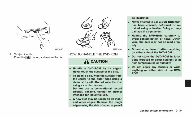
NAI0450
2. To eject the disc:Press the button, and remove the disc.
NAI0451
HOW TO HANDLE THE DVD-ROM
CAUTION
. Handle a DVD-ROM by its edges.Never touch the surface of the disc.
. To clean a disc, wipe the surface fromthe center to the outer edge using aclean, soft cloth. Do not wipe the discusing a circular motion.Do not use a conventional recordcleaner, benzine, thinner or alcoholintended for industrial use.
. A new disc may be rough on its innerand outer edges. Remove the roughedges using the side of a pen or pencil
as illustrated.
. Never attempt to use a DVD-ROM thathas been cracked, deformed or re-paired using adhesive. Doing so maydamage the equipment.
. Handle the DVD-ROM carefully toavoid contamination or flaws. Other-wise, the data may not be read prop-erly.
. Do not write, draw or attach anythingon either side of the DVD-ROM.
. Do not store the DVD-ROM in loca-tions exposed to direct sunlight or inhigh temperatures or humidity.
. Do not apply any stickers or writeanything on either side of the DVD-ROM.
General system information 9-19

The display is a liquid crystal display and shouldbe handled with care.
WARNING
Never disassemble the display. Someparts utilize extremely high voltage.Touching them may result in seriouspersonal injury.
CHARACTERISTICS OF A LIQUIDCRYSTAL DISPLAY
. If the temperature inside the vehicle isespecially low, the display will stay relativelydim or the movement of the images may beslow. These conditions are normal. Thedisplay will function normally when theinterior of the vehicle has warmed up.
. Some pixels in the display are darker orbrighter than others. This condition is aninherent characteristic of liquid crystal dis-plays, and it is not a malfunction.
. You may also notice a remnant of theprevious display image on the screen. Thisscreen burn is inherent in displays, and it isnot a malfunction.
INFO:
The screen may become distorted by strongmagnetic fields.
MAINTENANCE OF THE DISPLAY
CAUTION
. To clean the display, never use arough cloth, alcohol, benzine, thinnerand any kind of solvent or paper towelwith a chemical cleaning agent. Theywill scratch or deteriorate the panel.
. Do not splash any liquid such as wateror car fragrance on the display. Con-tact with liquid will cause the systemto malfunction.
If you need to clean the display screen, use adry, soft cloth. If additional cleaning is necessary,use a small amount of neutral detergent with asoft cloth. Never spray the screen with water ordetergent. Dampen the cloth first, then wipe thescreen.
HOW TO HANDLE THE DISPLAY
9-20 General system information

10 Troubleshooting guide
Customer assistance. . . . . . . . . . . . . . . . . . . . . . . . . . . . . . . . . . . . . . . . . 10-2Basic operations . . . . . . . . . . . . . . . . . . . . . . . . . . . . . . . . . . . . . . . . . . . . . . 10-3Vehicle icon . . . . . . . . . . . . . . . . . . . . . . . . . . . . . . . . . . . . . . . . . . . . . . . . . . . . 10-4
Map DVD-ROM.. . . . . . . . . . . . . . . . . . . . . . . . . . . . . . . . . . . . . . . . . . . . . . 10-6Route calculation and visual guidance . . . . . . . . . . . . . . . . . . . 10-7Voice guidance. . . . . . . . . . . . . . . . . . . . . . . . . . . . . . . . . . . . . . . . . . . . . . . . 10-9

For assistance or inquiries about the NISSANNavigation System, please contact:The NISSAN NAVIGATION HELPDESK. Seethe contact information on the inside front coverof this manual.
CUSTOMER ASSISTANCE
10-2 Troubleshooting guide

Symptom Possible cause Possible solution
No image is displayed. The brightness is at the lowest setting. Adjust the brightness of the display.
The display is turned off. Push and hold < > (Day/Night) to turn on thedisplay.
No voice guidance is available.orThe volume is too high or too low.
The volume is not set correctly, or it is turned off. Adjust the volume of voice guidance.
Voice guidance is not provided for certain streets (roadsdisplayed in gray).
This is not a malfunction.
No map is displayed on the screen. The map DVD-ROM is not inserted, or it is insertedupside down.
Insert the map DVD-ROM correctly.
A screen other than map screen is displayed. Push <MAP>.
The pickup lens of the DVD unit is dirty. The pickup lens can become dirty depending on howyou use the vehicle. Contact a NISSAN dealer forcleaning of the pickup lens.
The screen is too dim. The movement is slow. The temperature in the interior of the vehicle is low. Wait until the interior of the vehicle has warmed up.
Some pixels in the display are darker or brighter thanothers.
This condition is an inherent characteristic of liquidcrystal displays.
This is not a malfunction.
Some menu items cannot be selected. Some menu items become unavailable while the vehicleis driven.
Park the vehicle in a safe location, and then operate thenavigation system.
NOTE:
Locations stored in the Address Book and other memory functions may be lost if the vehicle’s battery is disconnected or becomesdischarged.If this occurs, service the vehicle’s battery as necessary and re-enter the information in the Address Book.
BASIC OPERATIONS
Troubleshooting guide 10-3

Symptom Possible cause Possible solution
Names of roads and locations differbetween Plan view and BirdviewTM.
This is because the quantity of the displayed information is reduced so thatthe screen does not become too crowded. There is also a chance thatnames of the roads or locations may be displayed multiple times, and thenames appearing on the screen may be different because of a processingprocedure.
This is not a malfunction.
The vehicle icon is not displayed in thecorrect position.
The vehicle was transported after the ignition switch was pushed off, forexample, by a ferry or car transporter.
Drive the vehicle for a while on a road where GPSsignals can be received.
The position and direction of the vehicle icon may be incorrect dependingon the driving environments and the levels of positioning accuracy of thenavigation system.
This is not a malfunction. Drive the vehicle for a whileto automatically correct the position and direction ofthe vehicle icon.
“CURRENT VEHICLE LOCATION”(page 9-3)
When the vehicle is traveling on a newroad, the vehicle icon is located onanother road nearby.
Because the new road is not stored in the map data, the systemautomatically places the vehicle icon on the nearest road available.
Updated road information will be included in the nextversion of the map DVD-ROM.
The screen does not switch to the nightscreen even after turning on the head-lights.
The daytime screen was set the last time the headlights were turned on. Set the screen to the night screen mode using< > (Day/Night) when you turn on the head-lights.
“DISPLAY SETTINGS” (page 8-3)
The map does not scroll even when thevehicle is moving.
The current location map screen is not displayed. Push <MAP>.
The vehicle icon is not displayed. The current location map screen is not displayed. Push <MAP>.
The GPS indicator on the screen re-mains gray.
GPS signals cannot be received under certain conditions, such as in aparking garage, on a road with many tall buildings, etc.
Drive on an open, straight road for a while.
GPS signals cannot be received because objects are placed on theinstrument panel.
Remove the objects from the instrument panel.
A sufficient number of GPS satellites is not available. Please wait for the satellites to move to locationsavailable for your navigation system.
VEHICLE ICON
10-4 Troubleshooting guide

Symptom Possible cause Possible solution
The location of the vehicle icon ismisaligned from the actual position.
When using tire chains or replacing the tires, speed calculations based onthe speed sensor may be incorrect.
Drive the vehicle for a while (at approximately 19MPH for about 30 minutes) to automatically correctthe vehicle icon position.If this does not correct the vehicle icon position,contact a NISSAN dealer.
The map data has a mistake or is incomplete (the vehicle icon position isalways misaligned in the same area).
Updated road information will be included in the nextversion of the map DVD-ROM.
Troubleshooting guide 10-5

Symptom Possible cause Possible solution
The message “Error” appears. The map DVD-ROM is dirty or damaged. Check the map DVD-ROM and wipe it clean with a soft cloth, following thecautions and instructions on page 9-19.
If you see any damage, replace the map DVD-ROM.
MAP DVD-ROM
10-6 Troubleshooting guide

Symptom Possible cause Possible solution
Waypoints are not included in the autoreroute calculation.
Waypoints that you have already passed are not included in the autoreroute calculation.
If you want to go to that waypoint again, you need to editthe route.
Route information is not displayed. Route calculation has not yet been performed. Set the destination and perform route calculation.
You are not driving on the suggested route. Drive on the suggested route.
Route guidance is set to off. Turn on route guidance.
Route information is not provided for certain types of roads (roadsdisplayed in gray).
This is not a malfunction.
The auto reroute calculation (or detourcalculation) suggests the same route asthe one previously suggested.
Route calculations took priority conditions into consideration, but thesame route was calculated.
This is not a malfunction.
A waypoint cannot be added. Five waypoints are already set on the route, including ones that youhave already passed.
A maximum of 5 waypoints can be set on the route. Ifyou want to go to 6 or more waypoints, perform routecalculations multiple times as necessary.
The suggested route is not displayed. Roads near the destination cannot be calculated. Reset the destination to a main or ordinary road, andrecalculate the route.
The starting point and destination are too close. Set a more distant destination.
The starting point and destination are too far away. Divide your trip by selecting one or two intermediatedestinations, and perform route calculations multipletimes.
There are time restricted roads (by the day of the week, by time) nearthe current vehicle location or destination.
Set [Use Time Restricted Roads] to off.“SETTING CONDITIONS FOR THE ROUTECALCULATION” (page 5-12)
A part of the route is not displayed. The suggested route includes narrow streets (roads displayed in gray). This is not a malfunction.
The part of the route that you havealready passed is deleted.
A route is managed by sections between waypoints. If you passed thefirst waypoint, the section between the starting point and the waypointis deleted. (It may not be deleted depending on the area.)
This is not a malfunction.
ROUTE CALCULATION AND VISUALGUIDANCE
Troubleshooting guide 10-7

Symptom Possible cause Possible solution
An indirect route is suggested. If there are restrictions (such as one-way streets) on roads close to thestarting point or destination, the system may suggest an indirect route.
Adjust the location of the starting point or destination.
The system may suggest an indirect route because route calculationdoes not take into consideration some areas such as narrow streets(gray roads).
Reset the destination to a main or ordinary road, andrecalculate the route.
The landmark information does notcorrespond to the actual information.
This may be caused by insufficient or incorrect data on the DVD-ROM. Updated information will be included in the next versionof the map DVD-ROM.
The suggested route does not exactlyconnect to the starting point, waypoints,or destination.
There is no data for route calculation closer to these locations. Set the starting point, waypoints and destination on amain road, and perform route calculation.
10-8 Troubleshooting guide

Symptom Possible cause Possible solution
Voice guidance is not available. Voice guidance is only available at certain intersections marked with .In some cases, voice guidance is not available even when the vehicleshould make a turn.
This is not a malfunction.
The vehicle has deviated from the suggested route. Go back to the suggested route or request routecalculation again.
Voice guidance is set to off. Turn on voice guidance.
Route guidance is set to off. Turn on route guidance.
The guidance content does not correspondto the actual condition.
The content of voice guidance may vary, depending on the types ofintersections at which turns are made.
Follow all traffic rules and regulations.
VOICE GUIDANCE
Troubleshooting guide 10-9

MEMO
10-10 Troubleshooting guide

11 IndexCURRENT LOCATION MAP SCREEN<ENTER>
Store Location page 6-2
Nearby page 4-47
Map View Plan View page 3-4
BirdviewTM page 3-4
Split (Plan View) page 3-4
Split (BirdviewTM) page 3-4
Change Map Scale for left page 3-20
Heading North Up page 3-15
Heading Up page 3-15
Long Range Map View page 3-15
Birdview Angle page 3-17
Landmark Icons page 3-22
Store Tracking page 6-14

SCROLL LOCATION MAP SCREEN<ENTER>
New Dest Start page 5-3
More Routes page 5-3
Route Info page 5-4
Add Way Pt. page 5-5
Add to Route Edit Route page 5-19
Nearby page 4-47
Store Location page 6-2
Delete page 6-30

DESTINATION SCREEN<DEST>
Street Address page 4-5
Address Book Home Location page 4-23
Stored Location page 4-25
Previous Destinations page 4-28
Points of Interest page 4-34
Others Phone Number page 4-46
Nearby Places page 4-47
Previous Starting Point page 4-30
Stored Routes page 4-32
Freeway Entrance/Exit page 4-43
Intersection page 4-14
City Center page 4-10

ROUTE SCREEN<ROUTE>
Cancel Route Guidance page 5-35
Resume Route Guidance page 5-36
Change/Edit Route Detour page 5-17
Recalculate Route page 5-18
Edit Route page 5-19
Store Current Route page 6-12
Route Priority Fastest Route page 5-12
Minimize Freeway page 5-12
Shortest Route page 5-12
Detailed Route Priorities page 5-13
Route Information Turn list page 5-27
Where am I? page 7-3
Preview page 5-27
Simulation page 5-28

Guidance Settings Guidance Screen Default page 5-31
Route Guidance page 5-29
Guidance Voice page 5-29
Small Turn Arrow on Map page 5-29
Voice Announcements page 5-32
Set Average Speeds page 5-33

SETTING SCREEN (ARMADA, MAXIMA, MURANO, PATHFINDER, QUEST, TITAN)<SETTING>
Display Brightness/Contrast page 8-3
Display off page 8-4
System Settings Language/Units Language page 8-7
Unit page 8-9
Clock Hours page 8-10
Minutes page 8-10
Auto Adjust page 8-10
Daylight Saving Time page 8-10
Select Time Zone page 8-10
Beep Setting page 8-6

Navigation Landmark Icons page 3-22
Map View page 3-4
Heading page 3-15
Guidance Settings page 5-29
Address Book Stored Location page 6-16
Stored Routes page 6-25
Stored Tracking page 6-26
Avoid Area page 6-27
Delete Stored Items page 6-31

Avoid Area Settings page 6-7
Tracking Display Settings page 6-26
Nearby Places Custom Settings page 6-33
Map Scrolling Information page 3-10
Map Color Settings page 8-22
Adjust Current Location page 8-23
GPS Satellite Info page 7-4
Navigation Version page 7-5
Reset ALL navigation settings to default page 8-25
Guidance Voice page 8-2
Guidance Volume page 8-2

SETTING SCREEN (350Z)<SETTING>
Display Display page 8-14
Brightness page 8-14
Contrast page 8-15
Navigation Landmark Icons page 3-22
Map View page 3-4
Heading page 3-15
Guidance Settings page 5-29
Address Book Stored Location page 6-16
Stored Routes page 6-25
Stored Tracking page 6-26
Avoid Area page 6-27
Delete Stored Items page 6-31

Avoid Area Settings page 6-7
Tracking Display Settings page 6-26
Nearby Places Custom Settings page 6-33
Map Scrolling Information page 3-10
Map Color Settings page 8-22
Adjust Current Location page 8-23
Reset ALL navigation settings to default page 8-25

Volume and Beeps Guidance Volume page 8-16
Guidance Voice page 8-16
Button Beeps page 8-16
Clock On-screen Clock page 8-17
Clock Format page 8-17
Offset Adjust page 8-17
Daylight Saving Time page 8-17
Time Zone page 8-17
Language/Units Select Language page 8-19
Select Units page 8-21
INFORMATION SCREEN (350Z)<INFO>
Where am I? page 7-3
GPS Satellite Info page 7-4
Navigation Version page 7-5

A
About route guidance . . . . . . . . . . . . . . . . . . . . . . . . . . . . . . . 5-7About the map DVD-ROM . . . . . . . . . . . . . . . . . . . . . . . . 9-15Adding a destination or waypoint. . . . . . . . . . . . . . . . . . . 5-5Adding additional destinations to a route . . . . . . . . 4-52Address book . . . . . . . . . . . . . . . . . . . . . . . . . . . . . . . . . . . . . . . . 9-2Adjusting the current vehicle location . . . . . . . . . . . . 8-23Adjusting the location of the destination . . . . . . . . . 4-51Adjusting voice guidance volume. . . . . . . . . . . . . . . . . 2-37Automatic reroute . . . . . . . . . . . . . . . . . . . . . . . . . . . . . . . . . . . . 9-2Avoid area settings . . . . . . . . . . . . . . . . . . . . . . . . . . . . . . . . . . 6-7
B
Background Color . . . . . . . . . . . . . . . . . . . . . . . . . . . . . . . . . 8-15Basics of voice guidance . . . . . . . . . . . . . . . . . . . . . . . . . 9-11BirdviewTM. . . . . . . . . . . . . . . . . . . . . . . . . . . . . . . . . 3-3, 3-8, 9-3Brightness . . . . . . . . . . . . . . . . . . . . . . . . . . . . . . . . . . . . . 8-4, 8-14
C
Change/edit route . . . . . . . . . . . . . . . . . . . . . . . . . . . . . . . . . 5-15Changing the BirdviewTM angle . . . . . . . . . . . . . . . . . . 3-17Changing the scale of a map . . . . . . . . . . . . . . 2-19, 3-12Changing the scale of the left screen. . . . . . . . . . . . 3-20Character (letter and number) input screen . . . . . 2-23Characteristics of a liquid crystal display . . . . . . . . 9-20Clock settings. . . . . . . . . . . . . . . . . . . . . . . . . . . . . . . 8-10, 8-17Confirming a route . . . . . . . . . . . . . . . . . . . . . . . . . . . . 5-4, 5-26Confirming by simulation . . . . . . . . . . . . . . . . . . . . . . . . . . 5-28Control panel. . . . . . . . . . . . . . . . . . . . . . . . . . . . . . . . . . . . . . . . . 2-3Current vehicle location . . . . . . . . . . . . . . . . . . . . . . . . . . . . . 9-3Customer assistance . . . . . . . . . . . . . . . . . . . . . . . . . . . . . . 10-2Customizing nearby places . . . . . . . . . . . . . . . . . . . . . . . 6-33
D
Deleting a route . . . . . . . . . . . . . . . . . . . . . . . . . . . . . 2-33, 5-35Deleting a stored item . . . . . . . . . . . . . . . . . . . . . . . . . . . . . 6-28Deleting a stored item individually . . . . . . . . . . . . . . . . 6-28Deleting all stored items . . . . . . . . . . . . . . . . . . . . . . . . . . 6-31Deleting an individual item on the map . . . . . . . . . . 6-30Destination screen . . . . . . . . . . . . . . . . . . . . . . . . . . . . . . . . . . . 4-2Detailed route priorities. . . . . . . . . . . . . . . . . . . . . . . . . . . . 5-13Detour . . . . . . . . . . . . . . . . . . . . . . . . . . . . . . . . . . . . . . . . . . . . . . . . 9-2Directions provided and the distances toguide points . . . . . . . . . . . . . . . . . . . . . . . . . . . . . . . . . . . . . . . . 9-11Disc replacement . . . . . . . . . . . . . . . . . . . . . . . . . . . . . . . . . . 9-18Display of current vehicle location. . . . . . . . . . . . . . . . . . 9-3Display settings . . . . . . . . . . . . . . . . . . . . . . . . . . . . . . . 8-3, 8-13Displaying landmark icons. . . . . . . . . . . . . . . . . . . . . . . . . 3-22
E
Editing a route . . . . . . . . . . . . . . . . . . . . . . . . . . . . . . . . . . . . . 5-19Editing the address book . . . . . . . . . . . . . . . . . . . . . . . . . 6-15Editing the avoid area . . . . . . . . . . . . . . . . . . . . . . . . . . . . . 6-27Editing the stored home and location . . . . . . . . . . . . 6-16Editing the stored route . . . . . . . . . . . . . . . . . . . . . . . . . . . 6-25Editing the stored tracking . . . . . . . . . . . . . . . . . . . . . . . . 6-26
F
For safe operation . . . . . . . . . . . . . . . . . . . . . . . . . . . . . . . . . . . 1-2Free zoom . . . . . . . . . . . . . . . . . . . . . . . . . . . . . . . . . . . 2-19, 3-12Functions disabled while driving. . . . . . . . . . . . . . . . . . 2-13
G
Guidance screens and preview mode . . . . . . . . . . . . . 5-8
H
Heading Up . . . . . . . . . . . . . . . . . . . . . . . . . . . . . . . . . . . . . . . . 3-16How to handle the display . . . . . . . . . . . . . . . . . . . . . . . . 9-20How to handle the DVD-ROM. . . . . . . . . . . . . . . . . . . . 9-19How to order map DVD-ROM updates . . . . . . . . . . 9-15How to store your home . . . . . . . . . . . . . . . . . . . . . . . . . . 2-20How to use this manual . . . . . . . . . . . . . . . . . . . . . . . . . . . . . 1-2How to view map screen. . . . . . . . . . . . . . . . . . . . . . . . . . 2-14
I
Incorrect display of vehicle position . . . . . . . . . . . . . . . . 9-6Information screen (350Z only) . . . . . . . . . . . . . . . . . . . . . 7-2
L
Language setting . . . . . . . . . . . . . . . . . . . . . . . . . . . . . 8-7, 8-19Laser product . . . . . . . . . . . . . . . . . . . . . . . . . . . . . . . . . . . . . . . . 1-4List screen. . . . . . . . . . . . . . . . . . . . . . . . . . . . . . . . . . . . . . . . . . 2-27Long Range Map View . . . . . . . . . . . . . . . . . . . . . . . . . . . . 3-16
M
Maintenance of the display. . . . . . . . . . . . . . . . . . . . . . . . 9-20Map color settings . . . . . . . . . . . . . . . . . . . . . . . . . . . . . . . . . 8-22Map DVD-ROM. . . . . . . . . . . . . . . . . . . . . . . . . . . . . 9-15, 10-6Map DVD-ROM drive location . . . . . . . . . . . . . . . . . . . . 9-16Map icons . . . . . . . . . . . . . . . . . . . . . . . . . . . . . . . . . . . . . . . . . . 3-22Map menu screen. . . . . . . . . . . . . . . . . . . . . . . . . . . . . . . . . . 2-10Map scale . . . . . . . . . . . . . . . . . . . . . . . . . . . . . . . . . . . . . . . . . . 3-13Map screen types. . . . . . . . . . . . . . . . . . . . . . . . . . . . . . . . . . 2-15Map scrolling information. . . . . . . . . . . . . . . . . . . . . . . . . . 3-10Map symbols . . . . . . . . . . . . . . . . . . . . . . . . . . . . . . . . . . . . . . . 3-24Map types . . . . . . . . . . . . . . . . . . . . . . . . . . . . . . . . . . . . . . . . . . . . 3-2Menu screen types and how to operate . . . . . . . . . . . 2-7

Menu screens and their purposes . . . . . . . . . . . . . . . . . . 2-7Minor adjustment of the stored home andlocations . . . . . . . . . . . . . . . . . . . . . . . . . . . . . . . . . . . . . . . . . . . . 6-17Moving a map . . . . . . . . . . . . . . . . . . . . . . . . . . . . . . . . . . . . . . . . 3-7Moving around within a map . . . . . . . . . . . . . . . . . . . . . . 2-18
N
North Up. . . . . . . . . . . . . . . . . . . . . . . . . . . . . . . . . . . . . . . . . . . . 3-16Notes on voice guidance. . . . . . . . . . . . . . . . . . . . . . . . . . 9-14
O
Operating maps. . . . . . . . . . . . . . . . . . . . . . . . . . . . . . . . . . . . 2-14Operations after setting a destination . . . . . . . . . . . . 4-50Other settings for the map screen . . . . . . . . . . . . . . . 3-15
P
Phone number input screen. . . . . . . . . . . . . . . . . . . . . . . 2-25Plan view . . . . . . . . . . . . . . . . . . . . . . . . . . . . . . . . . . . . . . . 3-2, 3-7Points of interest (POI) directory . . . . . . . . . . . . . . . . . . . 9-2Procedures after setting a destination . . . . . . . . . . . . . 5-2
R
Reactivating a route . . . . . . . . . . . . . . . . . . . . . . . . . . . . . . . 5-36Recalculate route . . . . . . . . . . . . . . . . . . . . . . . . . . . . . . . . . . 5-18Reference symbols . . . . . . . . . . . . . . . . . . . . . . . . . . . . . . . . . . 1-2Repeating voice guidance. . . . . . . . . . . . . . . . . . . . . . . . . 9-14Reset all navigation settings to default . . . . . . . . . . . 8-25Returning to the current vehicle location. . . . . . . . . . . 3-9Route calculation . . . . . . . . . . . . . . . . . . . . . . . . . . . . . . . . . . . . 9-9Route calculation and visual guidance . . . . . . . . . . . 10-7Route guidance . . . . . . . . . . . . . . . . . . . . . . . . . . . . . . . 9-2, 9-11Route guidance settings . . . . . . . . . . . . . . . . . . . . . . . . . . 5-29
Route priority settings . . . . . . . . . . . . . . . . . . . . . . . . . . . . . 5-12Route setting . . . . . . . . . . . . . . . . . . . . . . . . . . . . . . . . . . . . . . . 5-10
S
Safety information. . . . . . . . . . . . . . . . . . . . . . . . . . . . . . . . . . . . 1-3Searching for a destination . . . . . . . . . . . . . . . . . . . . . . . 2-28Selecting a route. . . . . . . . . . . . . . . . . . . . . . . . . . . . . . . . . . . . . 5-3Set average speeds . . . . . . . . . . . . . . . . . . . . . . . . . . . . . . . 5-33Setting a City Center . . . . . . . . . . . . . . . . . . . . . . . . . . . . . . 4-10Setting a destination. . . . . . . . . . . . . . . . . . . . . . . . . . . . . . . 2-28Setting a detour route . . . . . . . . . . . . . . . . . . . . . . . . . . . . . 5-17Setting a freeway entrance/exit . . . . . . . . . . . . . . . . . . . 4-43Setting a nearby place . . . . . . . . . . . . . . . . . . . . . . . . . . . . 4-47Setting a point of interest . . . . . . . . . . . . . . . . . . . . . . . . . 4-34Setting a previous destination . . . . . . . . . . . . . . . . . . . . 4-28Setting a Street Address. . . . . . . . . . . . . . . . . . . . . . . . . . . . 4-5Setting an Intersection . . . . . . . . . . . . . . . . . . . . . . . . . . . . 4-14Setting by phone number . . . . . . . . . . . . . . . . . . . . . . . . . 4-46Setting conditions for the route calculation. . . . . . 5-12Setting from Address Book . . . . . . . . . . . . . . . . . . . . . . . 4-25Setting from map . . . . . . . . . . . . . . . . . . . . . . . . . . . . . . . . . . 4-20Setting from stored routes . . . . . . . . . . . . . . . . . . . . . . . . 4-32Setting screen . . . . . . . . . . . . . . . . . . . . . . . . . . . . . . . . 8-2, 8-12Setting the previous starting point . . . . . . . . . . . . . . . 4-30Setting the voice guidance. . . . . . . . . . . . . . . . . . . . . . . . 2-35Setting your home . . . . . . . . . . . . . . . . . . . . . . . . . . . . . . . . . 4-23Settings of heading/long range map view . . . . . . . 3-15Start-up screen . . . . . . . . . . . . . . . . . . . . . . . . . . . . . . . . . . . . . . 2-6Starting route guidance . . . . . . . . . . . . . . . . . . . . . . 2-31, 5-3Storing a location . . . . . . . . . . . . . . . . . . . . . . . . . 6-2, 6-5, 6-6Storing a route . . . . . . . . . . . . . . . . . . . . . . . . . . . . . . . . . . . . . 6-12Storing a tracked route. . . . . . . . . . . . . . . . . . . . . . . . . . . . 6-14Storing the current vehicle location . . . . . . . . . . . . . . . . 6-5Storing your home location/address . . . . . . . . . . . . . 2-20
Switching the map view . . . . . . . . . . . . . . . . . . . . . . . . . . . . . 3-4System settings screen . . . . . . . . . . . . . . . . . . . . . . . . . . . . . 8-6
T
Turn list . . . . . . . . . . . . . . . . . . . . . . . . . . . . . . . . . . . . . . . . . . . . . . . 5-9Turning voice guidance on/off . . . . . . . . . . . . . . . . . . . . 2-35
U
Unit setting. . . . . . . . . . . . . . . . . . . . . . . . . . . . . . . . . . . . 8-9, 8-17Using controls to adjust values, levels, etc.. . . . . . . . 2-9Using route preview . . . . . . . . . . . . . . . . . . . . . . . . . . . . . . . 5-27Using turn list . . . . . . . . . . . . . . . . . . . . . . . . . . . . . . . . . . . . . . 5-27
V
Vehicle icon . . . . . . . . . . . . . . . . . . . . . . . . . . . . . . . . . . . . . . . . 10-4Viewing GPS current location information . . . . . . . . . 7-4Viewing information about current vehiclelocation . . . . . . . . . . . . . . . . . . . . . . . . . . . . . . . . . . . . . . . . . . . . . . . 7-3Viewing information about the searchedlocation . . . . . . . . . . . . . . . . . . . . . . . . . . . . . . . . . . . . . . . . . . . . . 4-53Viewing navigation system version information . . . . 7-5Visual guidance settings . . . . . . . . . . . . . . . . . . . . . . . . . . 5-31Voice guidance. . . . . . . . . . . . . . . . . . . . . . . . . . . . . . . . 9-3, 10-9Voice guidance during route guidance. . . . . . . . . . . . . 5-7Voice guidance settings . . . . . . . . . . . . . . . . . . . . . . . . . . . 5-32Volume adjustment. . . . . . . . . . . . . . . . . . . . . . . . . . . . . . . . . 8-16