2012 esri health conference agenda/media/files/pdfs/...9:00 am–10:30 am featured panel—telling...
TRANSCRIPT

Esri Health GIS ConferenceAugust 20–22, 2012 | Scottsdale, Arizona

1
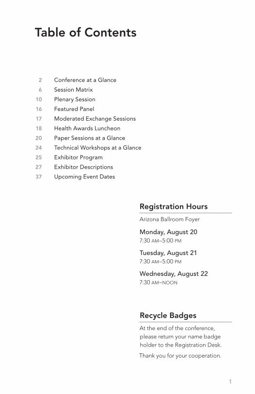
2 Conference at a Glance
6 Session Matrix
10 Plenary Session
16 Featured Panel
17 Moderated Exchange Sessions
18 Health Awards Luncheon
20 Paper Sessions at a Glance
24 Technical Workshops at a Glance
25 Exhibitor Program
27 Exhibitor Descriptions
37 Upcoming Event Dates
Table of Contents
Registration Hours
Arizona Ballroom Foyer
Monday, August 207:30 am–5:00 pm
Tuesday, August 217:30 am–5:00 pm
Wednesday, August 227:30 am–noon
Recycle Badges
At the end of the conference, please return your name badge holder to the Registration Desk.
Thank you for your cooperation.
2
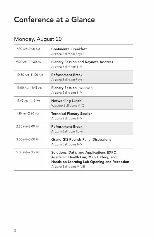
Monday, August 20
7:30 am–9:00 am Continental BreakfastArizona Ballroom Foyer
9:00 am–10:30 am Plenary Session and Keynote AddressArizona Ballrooms I–IV
10:30 am–11:00 am Refreshment BreakArizona Ballroom Foyer
11:00 am–11:45 am Plenary Session (continued)
Arizona Ballrooms I–IV
11:45 am–1:15 pm Networking LunchVaquero Ballrooms A–C
1:15 pm–2:30 pm Technical Plenary Session Arizona Ballrooms I–IV
2:30 pm–3:00 pm Refreshment BreakArizona Ballroom Foyer
3:00 pm–5:00 pm Grand GIS Rounds Panel DiscussionsArizona Ballrooms I–IV
5:00 pm–7:30 pm Solutions, Data, and Applications EXPO; Academic Health Fair; Map Gallery; and Hands-on Learning Lab Opening and ReceptionArizona Ballrooms V–VIII
Conference at a Glance

3
Tuesday, August 21
8:00 am–9:00 am Continental Breakfast in Solutions, Data, and Applications EXPOArizona Ballrooms V–VIII
8:00 am–noon Solutions, Data, and Applications EXPO and Hands-on Learning LabArizona Ballrooms V–VIII
9:00 am–10:30 am Featured Panel—Telling Compelling Stories with Your GISArizona Ballrooms I–IV
10:30 am–11:00 am Refreshment Break in Solutions, Data, and Applications EXPOArizona Ballrooms V–VIII
11:00 am–noon Moderated Exchange SessionsVaquero Ballrooms E–G
noon–1:30 pm Hosted Health Awards LuncheonVaquero Ballrooms A–C
1:30 pm–2:45 pm Paper SessionsVaquero Ballrooms E–G
2:45 pm–3:15 pm Refreshment Break Vaquero Ballroom Foyer
3:15 pm–4:30 pm Paper SessionsVaquero Ballrooms E–G
5:00 pm–6:30 pm Health and Human Services User Group Social Vaquero Ballrooms A–C
8:00 pm–9:00 pm Town Hall Meeting—Global Health Care Facility Database InitiativeVaquero Ballroom E 1
4
Wednesday, August 22
7:00 am–8:00 am Continental Breakfast Vaquero Ballroom Foyer
8:00 am–9:15 am Technical WorkshopsVaquero Ballrooms E–F
9:15 am–9:30 am Refreshment Break Vaquero Ballroom Foyer
9:30 am–10:45 am Technical WorkshopsVaquero Ballrooms E–F
10:45 am–11:00 am Refreshment Break Vaquero Ballroom Foyer
11:00 am–12:15 pm Technical WorkshopsVaquero Ballrooms E–F
1:00 pm–3:00 pm Site Visit to the Arizona T-Health Institute*
Meet in the hotel lobby; the bus will depart from the hotel
at 12:45 pm.
Conference at a Glance
* Preregistration Required

Come visit us at booth #107to see our Health Indicators App.
critigen.com/solutions/health-indicators
Trademarks provided under license from Esri. All other trademarks are the property of their respective owners.

6
Session Matrix Tuesday, August 21
Vaquero Ballroom E 1
Vaquero Ballroom E 2
Vaquero Ballroom F 1
Vaquero Ballroom F 2
Vaquero Ballroom G 1
8:00
am Continental Breakfast in Solutions, Data, and Applications EXPO
Arizona Ballrooms V–VIII
9:00
am Featured Panel—Telling Compelling Stories with Your GIS
Arizona Ballrooms I–IV
10:3
0 a
m Refreshment Break in Solutions, Data, and Applications EXPOArizona Ballrooms V–VIII
11:0
0 a
m MES Geomedicine MES Enterprise GIS MES Health Surveillance 3.0
no
on Hosted Health Awards Luncheon
Vaquero Ballrooms A–C
1:30
pm HS Health Surveillance,
Part IHP Health Policy, Part I BE Built Environment,
Part IEH Environmental Health, Part I AHC Access to Health Care, Part I
2:45
pm Refreshment Break
Vaquero Ballroom Foyer
3:15
pm HS Health Surveillance,
Part IIHP Health Policy, Part II BE Built Environment,
Part IIEH Environmental Health, Part II AHC Access to Health Care, Part II
5:00
pm Health and Human Services User Group Social
Vaquero Ballrooms A–C
8:00
pm Town Hall Meeting—Global Health Care Facility Database
InitiativeVaquero Ballroom E 1
AHC Access to Health Care
BE Built Environment
EH Environmental Health
HP Health Policy
HS Health Surveillance
MES Moderated Exchange Session
TECH Esri Technical Session

7
Vaquero Ballroom E 1
Vaquero Ballroom E 2
Vaquero Ballroom F 1
Vaquero Ballroom F 2
Vaquero Ballroom G 1
8:00
am Continental Breakfast in Solutions, Data, and Applications EXPO
Arizona Ballrooms V–VIII
9:00
am Featured Panel—Telling Compelling Stories with Your GIS
Arizona Ballrooms I–IV
10:3
0 a
m Refreshment Break in Solutions, Data, and Applications EXPOArizona Ballrooms V–VIII
11:0
0 a
m MES Geomedicine MES Enterprise GIS MES Health Surveillance 3.0
no
on Hosted Health Awards Luncheon
Vaquero Ballrooms A–C
1:30
pm HS Health Surveillance,
Part IHP Health Policy, Part I BE Built Environment,
Part IEH Environmental Health, Part I AHC Access to Health Care, Part I
2:45
pm Refreshment Break
Vaquero Ballroom Foyer
3:15
pm HS Health Surveillance,
Part IIHP Health Policy, Part II BE Built Environment,
Part IIEH Environmental Health, Part II AHC Access to Health Care, Part II
5:00
pm Health and Human Services User Group Social
Vaquero Ballrooms A–C
8:00
pm Town Hall Meeting—Global Health Care Facility Database
InitiativeVaquero Ballroom E 1

8
Session Matrix Wednesday, August 22
AHC Access to Health Care
BE Built Environment
EH Environmental Health
HP Health Policy
HS Health Surveillance
MES Moderated Exchange Session
TECH Esri Technical Session
Vaquero Ballroom E 1 Vaquero Ballroom F 1
7:00
am Continental Breakfast
Vaquero Ballroom Foyer
8:00
am TECH Spatial Pattern Analysis:
Mapping Trends and ClustersTECH Community Analyst: Analytical and Data Tools, Part I
9:15
am Refreshment Break
Vaquero Ballroom Foyer
9:30
am TECH Modeling Spatial
Relationships Using Regression Analysis
TECH Community Analyst: Analytical and Data Tools, Part II
10:4
5 a
m Refreshment BreakVaquero Ballroom Foyer
11:0
0 a
m TECH Spatial Statistics: Best Practices

10
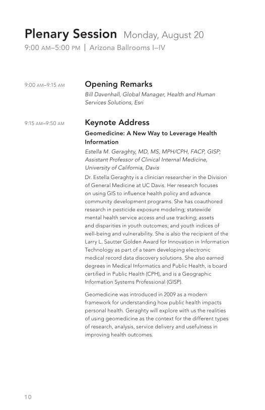
9:00 am–9:15 am Opening Remarks Bill Davenhall, Global Manager, Health and Human Services Solutions, Esri
9:15 am–9:50 am Keynote Address Geomedicine: A New Way to Leverage Health Information
Estella M. Geraghty, MD, MS, MPH/CPH, FACP, GISP; Assistant Professor of Clinical Internal Medicine, University of California, Davis
Dr. Estella Geraghty is a clinician researcher in the Division
of General Medicine at UC Davis. Her research focuses
on using GIS to influence health policy and advance
community development programs. She has coauthored
research in pesticide exposure modeling; statewide
mental health service access and use tracking; assets
and disparities in youth outcomes; and youth indices of
well-being and vulnerability. She is also the recipient of the
Larry L. Sautter Golden Award for Innovation in Information
Technology as part of a team developing electronic
medical record data discovery solutions. She also earned
degrees in Medical Informatics and Public Health, is board
certified in Public Health (CPH), and is a Geographic
Information Systems Professional (GISP).
Geomedicine was introduced in 2009 as a modern
framework for understanding how public health impacts
personal health. Geraghty will explore with us the realities
of using geomedicine as the context for the different types
of research, analysis, service delivery and usefulness in
improving health outcomes.
Plenary Session Monday, August 209:00 am–5:00 pm | Arizona Ballrooms I–IV

11
9:50 am–10:30 am Featured Plenary SpeakerUsing GIS for Infectious Diseases, Prevention, and Control in Europe
Virginia Estévez Adán, PhD, Senior GIS Expert—Surveillance and Response Support Unit (SRS), European Centre for Disease Prevention and Control (ECDC), Stockholm, Sweden
Dr. Virginia Estévez Adán’s work at the European CDC is
focused on developing GIS competencies and modern GIS
analytical tools, as well as establishing and maintaining
close links with pan-European and other international
public health bodies working with GIS. This presentation
will provide an overview of the main GIS developments
established at the ECDC over the last several years and
how internal geospatial standards for geocoding and
mapping health and disease data will be addressed in their
ongoing work, both within and among the ECDC’s expert
staff. Estévez is a Spanish national and holds a degree in
Geography and a PhD in Environmental Sciences.
10:30 am–11:00 am Refreshment BreakArizona Ballroom Foyer

12
Plenary Session Monday, August 20 (continued)
9:00 am–5:00 pm | Arizona Ballrooms I–IV
11:00 am–11:45 am Featured Plenary SpeakerHealth and Social Surveillance: Thoughts about a Collaborative Platform
John Brownstein, PhD, Harvard School of Medicine and Boston Children’s Hospital
In an age of incredible information technology the world
still struggles—from the poorest to the richest nation—in
having real-time data easily accessible and useful when it
comes to knowing the health and social care conditions
in real-time. Maybe it’s not possible but perhaps it is and
we simply need to think and act harder on the resources
we already have. Dr. Brownstein will discuss with us his
experience and ideas on how we need to take a much
different look at this challenge and perhaps collaborate in
a much different way to bring such an idea to reality.
Brownstein is an Associate Professor at Harvard Medical
School and directs the Computational Epidemiology
Group at the Children’s Hospital Informatics Program in
Boston, Massachusetts. He is a spatial epidemiologist
from Yale University, and his research has been focused
on the surveillance, control and prevention of disease. He
is a cofounder of HealthMap.org. Brownstein also serves
as an adviser to the World Health Organization, Institute
of Medicine, the US Department of Health and Human
Services, and the White House and has received many
prestigious awards for his work in public health. His work
is frequently reported in the New England Journal of Medicine, Science, Nature, New York Times, the Wall Street Journal and on CNN, National Public Radio, and the BBC.
13
11:45 am–1:15 pm Networking LunchVaquero Ballrooms A–C
1:15 pm–2:30 pm Technical Plenary SessionThinking Differently about Maps and GIS
Paul Doherty, Esri Technical Marketing
How ArcGIS Is Changing Spatial Research
Lauren Scott, Chief Engineer, Spatial Statistics, Esri
2:30 pm–3:00 pm Refreshment BreakArizona Ballroom Foyer

14
3:00 pm–5:00 pm Grand GIS Rounds Panel Discussions Bill Davenhall, Global Manager, Health and Human Services Solutions, Esri (Moderator)
Health Data Liberation
CMS Data: Medicare/Medicaid Data Innovations—Allison Oelschlaeger, CMS, DHHS Community Health Indicators Data Portal—Ed Carl and Michael Topmiller, HealthLandscape
National Health System Reforms and GIS
United States: Community Health Management System—Dora Barilla, Loma Linda University Medical CenterUnited Kingdom: GIS Innovations within the NHS-Wales—Stephen Leece, Esri (UK) Ltd.
New Health Applications
Health Indicators: A National iPad Health Application—Tyler Huehmer, Critigen LabsMyHospital: A Global ArcGIS Mobile Server Data Collection Application—Christina Bivona-Tellez, Esri, and Chris Goz, Critigen Labs
GIS in Health Education
Health GeoInformatics: How an Academic Health Science Center Teaches GIS—Seth Wiafe, Loma Linda University School of Public Health
Plenary Session Monday, August 20 (continued)
9:00 am–5:00 pm | Arizona Ballrooms I–IV

© 2012 iVantage Health Analytics • www.iVantageHealth.com
You've spent years being educated, perfecting your skills, and gettingyour PhD from the school of hard knocks. But when it comes tohospital planning, your data doesn’t make things easier — until now.
Introducing SmartData™ from iVantage Health Analytics™.
We’ve taken all the ways traditional data are presented — sent themschool, taught them teamwork, presentation skills and decisionmaking to create SmartData™.
Data that are seamless regardless of the source. Data that are visual and easy to manipulate. Data that give you information never before available.
Get smart with SmartData™ by calling 615.932.8400 or [email protected]
We offer a PhD inMarket Planning,Operational Efficiency,Financial Strength,and Quality.Minus 4 years. Minus Tuition.
Not for you. For your data.

16
Telling Compelling Stories with Your GIS Panelists
Kristen Kurland, Professor, Carnegie Mellon University, Heinz College and School of Architecture (Moderator)
Steve Sternberg, Deputy Editor, Health Rankings, US News & World Report, Washington, DC
Steve Doig, Knight-Ridder Chair, Arizona State University, Phoenix, Arizona
Tom Johnson, Institute for Analytic Journalism, Santa Fe, New Mexico
Brian Peterson, Director, Communications, Esri, Redlands, California
Refreshment Break in Solutions, Data, and Applications EXPO10:30 am–11:00 am | Arizona Ballrooms V–VIII
Featured Panel Tuesday, August 219:00 am–10:30 am | Arizona Ballrooms I–IV
17
Moderated Exchange Sessions Tuesday, August 2111:00 am–noon
GeomedicineVaquero Ballroom E 1
Presenter: Estella M. Geraghty, MD, MS, MPH/CPH, FACP, GISP; Assistant Professor of Clinical Internal Medicine, University of California, Davis
Moderator: Angelica Baltazar, Health and Human Services Industry Specialist, Esri
Enterprise GISVaquero Ballroom F 1
Presenter: Virginia Estévez Adán, PhD, Senior GIS Expert—Surveillance and Response Support Unit (SRS), European Centre for Disease Prevention and Control (ECDC), Stockholm, Sweden
Moderator: Christina Bivona-Tellez, Health and Human Services Industry Manager, Esri
Health Surveillance 3.0Vaquero Ballroom G 1
Presenter: John Brownstein, PhD, Harvard School of Medicine and Boston Children’s Hospital
Moderator: Bill Davenhall, Global Manager, Health and Human Services Solutions, Esri
18
Alabama Department of Children’s Affairs and Alabama Criminal Justice Information Center
Bailey, Stephanie—US Centers for Disease Control and Prevention
Baystate Health System, Springfield, Massachusetts
Cabell-Huntington Health Department, West Virginia
California Department of Health Services
California Health & Human Services Agency, Office of Statewide Health Planning and Development
CDC Emergency Operations Center, Atlanta, Georgia
CDC Lead Poisoning Prevention Branch
CDC National Center for Health Statistics
Children’s Environmental Health Initiative (CEHI), Duke University
Health Awards Luncheon Tuesday, August 21noon–1:30 pm | Vaquero Ballrooms A–C
Previous Health Award Winners City of New York Department of Health & Mental Hygiene
Connecticut Department of Public Health
Dartmouth Atlas of Health Care
Denver Managed Care
Florida Department of Health, Division of Environmental Health
Florida Department of Public Health
France Ministry of Health & Social Protection
Gardner Associates, Concord, Massachusetts
GISCorps
Guilford County Public Health Department
Health and Human Services Secretary’s Command Center, Washington, DC
Health Data Initiative (US Department of Health and Human Services, Institute of Medicine)
The annual awards luncheon honors organizations in the areas of GIS vision, service, and communication.
Each year, the Esri health and human services staff honors the work of several organizations that we believe make all health and human services GIS professionals proud. From among hundreds of outstanding and worthwhile initiatives, we select the three organizations that represent the best examples of vision, service, and communication we have witnessed in the preceding year and where Esri technology has played a significant role.

19
Health InfoTechnics
Health Protection Agency, United Kingdom
Helsana Versicherungen AG, Switzerland
Kentucky Department of Public Health, Public Safety Branch
Loma Linda University Adventist Health Sciences
Massachusetts Department of Public Health
Mecklenburg Emergency Medical Services
Ministry of Environment Safety and Environmental Healthcare, Hungary
NASA Goddard Space Flight Center
National Association of County and City Health Officials
National Cancer Institute
Naval Medical Research Center Detachment
Nebraska Health and Human Services System
New Jersey Department of Health and Senior Services
New Jersey Division of Health Emergency and Preparedness and Response
New York City Department of Health and Mental Hygiene
New Zealand Ministry of Health
Niigata University, Graduate School of Medical and Dental Sciences, Japan
Norwegian Public Health Institute
Ohio Department of Health
Oklahoma Department of Health
Pacific EMPRINTS
Rhode Island Department of Health
Ripley, Bruce—Department of Veterans Affairs
Rural Policy Research Institute, Center for Rural Health Policy Analysis
San Diego Health and Human Services Agency
Saskatoon Health Region
Sault Ste. Marie Innovation Centre
Sault Ste. Marie Innovation Centre and Algoma Public Health
South Carolina Department of Health and Environmental Control
South Carolina Department of Health and Environment, Division of Biostatistics and Health GIS
Uniformed Services University of Health Sciences
United Nations Joint Logistics Centre, Italy
University of California, Davis
University of Kentucky
University of Mississippi Medical Center
University of Nebraska Medical Center
World Health Organization

20
Paper Sessions at a Glance Tuesday, August 211:30 pm–2:45 pm
Health Surveillance, Part IVaquero Ballroom E 1
Measles Outbreak in Yemen, 2011–2012 Ibrahim Anesi, WHO/EPI
CDC Influenza Division FluView InteractiveMichael Dinan, Booz Allen Hamilton, Inc.
Prioritizing HIV Prevention Efforts in the Most Impacted Areas: A Syndemic Spatial Analysis of HIV and STD Disease BurdenMike Janson, County of Los Angeles Department of Public Health, Division of HIV and STD Programs
Health Policy, Part I Vaquero Ballroom E 2
Using Spatial Health Intelligence in Health Planning: The Case Study of Logan Beaudesert, AustraliaOri Gudes, Griffith University
Development of a Multidimensional Health Care Access Index Stephen Jones, Blue Cross Blue Shield of Tennessee
The ADUSH Geoportal Server: GIS Data at Your FingertipsKevin Willis, Veterans Health Administration
Built Environment, Part IVaquero Ballroom F 1
Assessing the Food Landscape of a Rural LiveWell Colorado Community Lisa Harner, Kaiser Permanente
Geospatial Technologies: Beyond Space ManagementSucheta Kulkarni, University of Michigan Medical School
21
Using GIS for Modeling the Demand on Health Care Facilities at Jeddah City Abdulkader Murad, King Abdulaziz University
Predictive Modeling of Health Outcomes in Hampton Roads, VirginiaSteve Sedlock, Virginia Network for Geospatial Health Research, Inc.
Environmental Health, Part IVaquero Ballroom F 2
Elevated Blood Lead Levels: Environmental Risks and Opportunities for Outreach Stephanie Foster, Geospatial Research, Analysis, and Services Program (GRASP), ATSDR/CDC
Exploring the Relationship between Lung Cancer and Geological Formations in KentuckyTimothy Hare, Institute for Regional Analysis and Public Policy, Morehead State University
Kianda Case Study: Resource Allocation and Slum Mapping Lisa Hilmi, University of Pennsylvania
Access to Health Care, Part I Vaquero Ballroom G 1
Travel Time for Accessing Behavioral Health CareM. Tabor Griswold, University of Nevada School of Medicine
Use of GIS for Maternal and Child Health Surveillance Momin Kazi, Aga Khan University
Time Is a Factor: GIS and Stroke Care in the Veterans Health Administration Eric Litt, Department of Veterans Affairs
Geospatial Considerations Associated with the Affordable Care Act’s (ACA) Evolving Models of Health CareDavid Schutt, Stanford University Medical Center

22
Health Surveillance, Part IIVaquero Ballroom E 1
GIS Visual Maps to Monitor Polio Immunization Activities in KarachiMomin Kazi, Aga Khan University
Tuberculosis Cluster Distribution in Santo Domingo Health Area Venecia Ramirez, Ministerio de Salud
The Relationship between Obesity and Poverty Using Bivariance Spatial Visualization Michael Topmiller, HealthLandscape
Health Policy, Part II Vaquero Ballroom E 2
A GIS-Based Application to Support Health Care Provider Decision Making and Community Health Care Needs Assessment Yoonmi Lee, Claremont Graduate University
Understanding Variations in BMI among VHA PatientsAmy Sadler, Veterans Health Administration
American Community Survey ToolboxElaine Hallisey, Geospatial Research, Analysis, and Services Program (GRASP), ATSDR/CDC
The ADUSH GeoPortal Server: GIS Data at Your Fingertips Kevin Willis, Veterans Health Administration
Built Environment, Part IIVaquero Ballroom F 1
The Policy Implications of Geocoding Positional Accuracy on Population EstimatesStephanie Foster, Geospatial Research, Analysis, and Services Program (GRASP), ATSDR/CDC
Paper Sessions at a Glance Tuesday, August 213:15 pm–4:30 pm

23
Los Angeles County Department of Public Health GIS Map Viewer Douglas Morales, Los Angeles County Department of Public Health
Mapping Pathways: Lessons Learned from Applied Epidemiology and GIS Training for Tribal Communities Kate Watkins, University of Nebraska Medical Center
Recent ArcGIS Enhancements and Health Care Planning Kevin Willis, Veterans Health Administration
Environmental Health, Part IIVaquero Ballroom F 2
Using Administrative Medical Claims Data to Estimate Underreporting of Infectious Zoonotic Diseases Stephen Jones, Blue Cross Blue Shield of Tennessee
The National Toxic Substance Incidents Program (NTSIP) Interactive Mapping Tool Melissa Smith, CDC/ATSDR/Division of Toxicology and Human Health Sciences; Geospatial Research, Analysis, and Services Program
Accidental Childhood Poisoning: Putting Mr. Yuk on the Map Margaret Nguyen, Children’s Hospital of Pittsburgh
Access to Health Care, Part II Vaquero Ballroom G 1
Travel Time Analysis for Patients with Acute Respiratory Failure David Wallace, University of Pittsburgh
Closing the Gap: Increasing Veterans’ Access to VHA Primary CareLauren Wilson, Department of Veterans Affairs/VRHRC-ER
Visualizing the United States Health Care Work Force Ed Carl, HealthLandscape

24
Technical Workshops at a Glance Wednesday, August 22
Spatial Pattern Analysis: Mapping Trends and ClustersVaquero Ballroom E 18:00 am–9:15 am
Lauren M. Scott, PhD, and Lauren Rosenshein, MA, Spatial Statistics Product Engineers, Esri
Community Analyst: Analytical and Data Tools, Part IVaquero Ballroom F 18:00 am–9:15 am
Brenda Wolfe, Community Analyst Product Manager, Esri
Modeling Spatial Relationships Using Regression AnalysisVaquero Ballroom E 19:30 am–10:45 am
Lauren M. Scott, PhD, and Lauren Rosenshein, MA, Spatial Statistics Product Engineers, Esri
Community Analyst: Analytical and Data Tools, Part IIVaquero Ballroom F 19:30 am–10:45 am
Brenda Wolfe, Community Analyst Product Manager, Esri
Spatial Statistics: Best PracticesVaquero Ballroom E 111:00 am–12:15 pm
Lauren M. Scott, PhD, and Lauren Rosenshein, MA, Spatial Statistics Product Engineers, Esri

Exhibitor ProgramMonday, August 20 5:00 pm–7:30 pm
Tuesday, August 21 8:00 am–noon
26
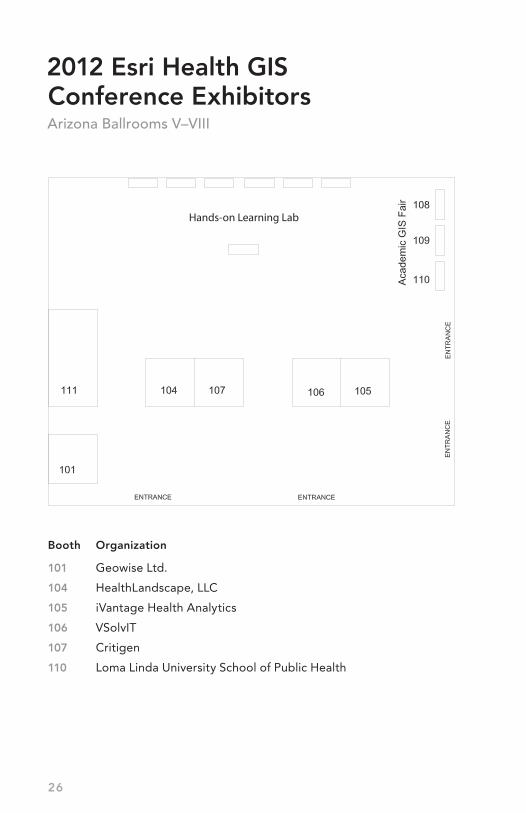
2012 Esri Health GIS Conference ExhibitorsArizona Ballrooms V–VIII
Booth Organization
101 Geowise Ltd.
104 HealthLandscape, LLC
105 iVantage Health Analytics
106 VSolvIT
107 Critigen
110 Loma Linda University School of Public Health
Hands-on Learning Lab
27
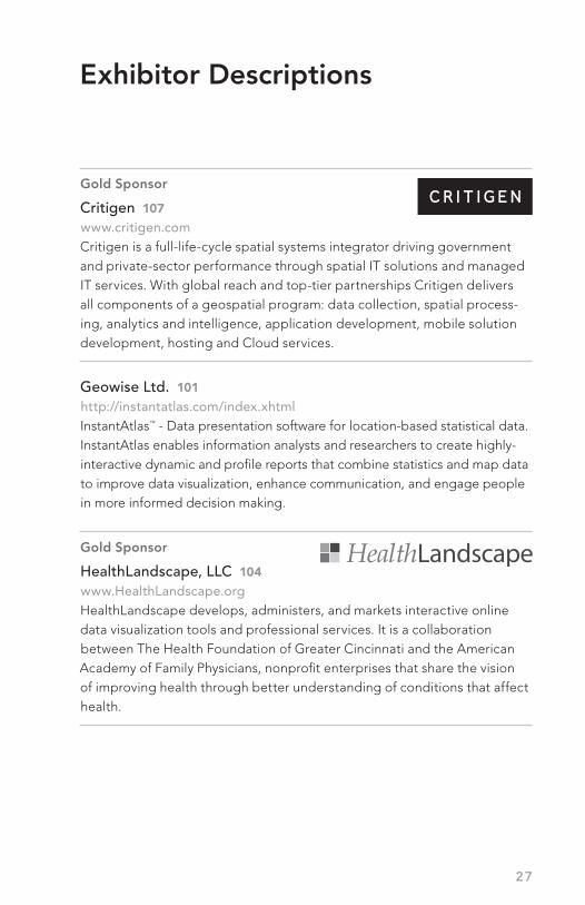
Gold Sponsor
Critigen 107www.critigen.com Critigen is a full-life-cycle spatial systems integrator driving government and private-sector performance through spatial IT solutions and managed IT services. With global reach and top-tier partnerships Critigen delivers all components of a geospatial program: data collection, spatial process-ing, analytics and intelligence, application development, mobile solution development, hosting and Cloud services.
Geowise Ltd. 101 http://instantatlas.com/index.xhtmlInstantAtlas™ - Data presentation software for location-based statistical data. InstantAtlas enables information analysts and researchers to create highly-interactive dynamic and profile reports that combine statistics and map data to improve data visualization, enhance communication, and engage people in more informed decision making.
Gold Sponsor
HealthLandscape, LLC 104www.HealthLandscape.org HealthLandscape develops, administers, and markets interactive online data visualization tools and professional services. It is a collaboration between The Health Foundation of Greater Cincinnati and the American Academy of Family Physicians, nonprofit enterprises that share the vision of improving health through better understanding of conditions that affect health.
Exhibitor Descriptions

28
Gold Sponsor
iVantage Health Analytics 105www.iVantageHealth.comiVantage Health Analytics supports strategic decision making by integrating diverse data and delivering information through innovative platforms. Our ability to merge internal and external data brings a new dimension in identifying and implementing business initiatives. We offer a single source for market intelligence, performance measurement, and clinical and functional benchmarking.
Loma Linda University School of Public Health 110www.llu.edu/public-healthLoma Linda University School of Public Health offers geoinformatics programs for the current and future public health work force. Graduate MPH and certificate programs are offered on our Southern California campus. Individual courses can also be completed online.
Gold Sponsor
VSolvIT 106www.VSolvit.comVSolvit (pron.: We*Solve*it) is an award winning 8(a)/SDB/woman owned technology services provider that specializes in GIS/IT integration. VSolvit aspires to be your partner in geoenabling your organization. Our cloud/web-based applications have been launched from the White House (USDA KYF2) and by commercial health care organizations.
Exhibitor Descriptions (continued)

( We Solve it )
Technology Services
Where Opportunity ... ... Meets Solution
SBA Certified 8(a)/SDB, DBE, MBE, WBE Woman Owned Small Business
Geographic Information System (GIS) Cloud Computing Application Development Database Management & Integration Modeling & Analysis Program Management
www.vsolvit.com
(805) 750-9135 | [email protected]
VIST US AT BOOTH 106 Ask us about our projects in healthcare GIS.
Ask us about our GIS app launch at the U.S. Whitehouse.
2011 USDA Woman Owned Business of the Year
Trademarks provided under license from Esri

Notes
30

31
Notes

Notes
32

33
Notes

Notes
34

35
Notes

Notes
36
Esri Southwest User ConferenceSeptember 17–19, 2012Denver, Colorado, USA
Esri Electric and Gas GIS ConferenceOctober 7–10, 2012Salt Lake City, Utah, USA
Esri Mid-Atlantic User ConferenceDecember 11–12, 2012Baltimore, Maryland, USA
GeoDesign SummitJanuary 24–25, 2013Redlands, California, USA
Esri Federal GIS ConferenceFebruary 25–27, 2013 Washington, DC, USA
Esri Partner Conference March 23–26, 2013Palm Springs, California, USA
Esri Developer SummitMarch 25–29, 2013Palm Springs, California, USA
Esri Southeast User ConferenceApril 29–May 1, 2013Jacksonville, Florida, USA
Esri International User ConferenceJuly 8–12, 2013San Diego, California, USA
Esri Health GIS ConferenceOctober 2013
Upcoming Event Dates
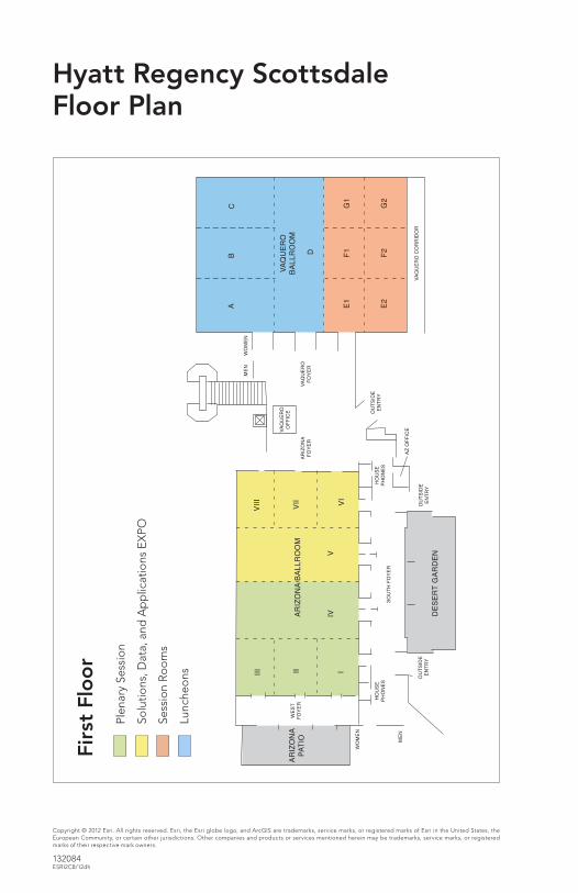
Hyatt Regency Scottsdale Floor Plan
Copyright © 2012 Esri. All rights reserved. Esri, the Esri globe logo, and ArcGIS are trademarks, service marks, or registered marks of Esri in the United States, the European Community, or certain other jurisdictions. Other companies and products or services mentioned herein may be trademarks, service marks, or registered marks of their respective mark owners.
132084ESRI2C8/12dh
Plen
ary
Sess
ion
Solu
tions
, Dat
a, a
nd A
pp
licat
ions
EX
PO
Sess
ion
Ro
om
s
Lunc
heo
ns
Firs
t Fl
oo
r