2014 environmental statistics compendium
DESCRIPTION
2014 Environmental Statistics CompendiumTRANSCRIPT
GOVERNMENT OF BERMUDA Cabinet OfficeDepartment of Statistics
ENVIRONMENTAL STATISTICSCOMPENDIUM20
14

Published by:
Research Division P. O. Box HM 3015
Hamilton, HM MX, Bermuda
Telephone: (441) 297-7761Fax: (441) 295-8390
E-mail: [email protected] Website: www.statistics.gov.bm
CONTENTS
Foreword................................................................................................................................................ 1Data.Notes............................................................................................................................................. 2Measuring.Units.Conversion.Table....................................................................................... 2Contributors.......................................................................................................................................... 2
1. POPULATION.AND.HOUSEHOLDS...............................................3
Table 1.1 Population and Population Density ................................................................................................5Chart 1.1 Population Density ......................................................................................................................5Table 1.2 Number of Households by Type of Dwelling ....................................................................................6Table 1.3 Number of Households by Type of Tenure .......................................................................................6Table 1.4 Number of Households by Number of Bedrooms .............................................................................7Table 1.5 Number of Households by Size of Household .................................................................................8
2. TOURISM.....................................................................................................9
Table 2.1 Air Arrivals, Cruise Ship Arrivals, Tourist Nights Spent, Tourism Intensity and Penetration Ratios .........12Chart 2.1 Growth in Air Passengers, Cruise Passengers and Total Visitors .......................................................12Chart 2.2 Tourists to Residents, Cruise Passengers to Residents and Visitors to Residents Ratios .....................13Chart 2.3 Tourism Intensity and Penetration Ratios ......................................................................................13Table 2.2 Visitor Expenditure and Number Employed in Tourism ....................................................................14Table 2.3 Number of Properties, Number of Rooms per km2, and Occupancy Rate .........................................14Chart 2.4 Number of Hotel Rooms Available ...............................................................................................15Chart 2.5 Occupancy Rate ........................................................................................................................15Table 2.4 Tourist Arrivals by Type of Accommodation ...................................................................................15Table 2.5 Tourist Arrivals by Country of Origin ..............................................................................................16Table 2.6 Estimated Electricity Consumption by Tourists ...............................................................................16Chart 2.6 Tourists’ Estimated Electricity Consumption and Growth .................................................................16
3. ENVIRONMENTAL.HEALTH.AND.WEATHER........................ 17
Table 3.1 Reported Cases of Environmentally-Related Diseases by Sex .........................................................19Chart 3.1 Growth in Reported Cases of Environmentally-Related Diseases by Sex and Total .............................20Chart 3.2 Reported Cases of Environmentally-Related Diseases by Cause ......................................................20Table 3.2 Rainfall in Inches and Days by Month of Year and Total..................................................................21Table 3.3 Mean Air Temperature ...............................................................................................................22Chart 3.3 Total Number of Inches of Rainfall and Rain Days ........................................................................23Chart 3.4 Mean Daily Maximum, Minimum and Mean Daily Air Temperature ..................................................23Table 3.4 Mean Relative Humidity .............................................................................................................24Chart 3.5 Mean Relative Humidity .............................................................................................................24
4. NATURAL.AND.ENVIRONMENTAL.DISASTERS.................26
Table 4.1 Natural Disaster ........................................................................................................................28Table 4.2 Incidences of Fire by Type ..........................................................................................................29Chart 4.1 Total Incidences of Fires .............................................................................................................29
5. ENERGY,.MINERALS.AND.TRANSPORT................................30
Table 5.1 Value of Imported Fuel by Type ...................................................................................................32Table 5.2 Value of Imported Mineral Fuels, Mineral Oils, and Related Products Consumed by Type ...................33Table 5.3 Electricity Consumption by Type of Consumer ...............................................................................33Table 5.4 Growth in Electricity Consumption by Type of Consumer ................................................................34Chart 5.1 Growth in Electricity Consumption by Type of Consumer and Total Consumption ...............................34Table 5.5 Percent of Total Electricity Consumption by Type of Consumer ........................................................34Table 5.6 Registered Road Vehicles ...........................................................................................................35Chart 5.2 Growth in Registered Road Vehicles ............................................................................................35
6. AGRICULTURE.......................................................................................36
Table 6.1 Imported Fertilizers by Type ........................................................................................................38Table 6.2 Imported Pesticides by Type .......................................................................................................38Chart 6.1 Growth in Imported Fertilizers and Pesticides ................................................................................39
7. LAND.USE................................................................................................40
Table 7.1 Land Use, as of 2001 ................................................................................................................42Map 7.1 Land Use Survey .......................................................................................................................43Table 7.2.1 Land Use by Parish, City and Town in Acres, as of 2001 ................................................................44Table 7.2.2 Land Use by Parish, City and Town in Acres, as of 2001 ................................................................45
8. COASTAL.AND.MARINE.RESOURCES....................................46
Table 8.1 Total and Protected Marine Area .................................................................................................48Chart 8.1 Protected Marine Area as a Percentage of Total Marine Area ..........................................................48Table 8.2 Marine Protected Areas by Category and Area ..............................................................................49Table 8.3.1 Marine Protected Areas Around Bermuda.....................................................................................50Table 8.3.2 Marine Protected Areas Around Bermuda.....................................................................................51Map 8.1 Marine Protected Area ...............................................................................................................52Table 8.4 Quantity of Fish Landings by Type ................................................................................................53Table 8.5 Total Catch by Hours at Sea, Average Catch of Fishing Area and Number of Registered Fishermen .....53Chart 8.2 Growth in Total Catch and Total Hours at Sea ...............................................................................54Chart 8.3 Number of Registered Fishermen ................................................................................................54Table 8.6 Number of Households and Population of Coastal Areas ................................................................55Chart 8.4 Number of Households and Population of Coastal Areas, (Census Years) .........................................55 9. BIODIVERSITY.......................................................................................56
Table 9.1 Protected Area ..........................................................................................................................58Chart 9.1 Protected Land Area as a Percentage of Total Land Area ...............................................................59Chart 9.2 Total Protected Area as a Percentage of Total Area ........................................................................59Map 9.1 Terrestrial Protected Areas Including Marine Parks ........................................................................60Table 9.2 Protected Areas by Category and Area .........................................................................................61
10.FORESTRY...............................................................................................62
Table 10.1 Protected Forest Area as a Percentage of Total Land Area ..............................................................64Chart 10.1 Protected Forest Area as a Percentage of Total Land Area ..............................................................64
11.AIR................................................................................................................65
Table 11.1 Air Emissons from Tynes Bay Waste to Energy Incinerator ..............................................................67Table 11.2 Average Concentrations for Government (BIOS) and BELCO-Operated Ambient Air Monitoring Sites ...68Table 11.3 Maximum Concentrations for Ambient Air Monitoring Sites ...........................................................69Figure 11.1 24-hour Average PM10 Concentration, 2013 ................................................................................70Figure 11.2 24-hour Average PM10 Concentration, 2012 ................................................................................70Map 11.1 24-hour Average PM10 Concentration ..........................................................................................71
12.WASTE.......................................................................................................72
Table 12.1 Generation of Waste by Source ...................................................................................................75Chart 12.1 Recyclables Exported to the United States by Bermuda (20’ Container Loads) .................................75Table 12.2 Management of Municipal Waste ................................................................................................76Table 12.3 Management of Special Waste ...................................................................................................76Table 12.4 Management of Municipal Waste by Type ....................................................................................77
13.WATER.......................................................................................................78
Table 13.1 Renewable Freshwater Resources ...............................................................................................80Table 13.2 Water Use Balance ....................................................................................................................81Table 13.3 Freshwater Abstraction ..............................................................................................................82Table 13.4 Water Supply Industry (ISIC 36) ..................................................................................................83Table 13.5 Total Water Use .........................................................................................................................83Table 13.6 Percentage of Population Connected to Wastewater Treatment .....................................................84Map 13.1 Water Resources Protection Area ................................................................................................85
.. ANNEX.......................................................................................................86
Terrestrial Protected Areas Including Marine ParksMap Key ................................................................................................................................................87Map 01 ................................................................................................................................................88Map 02 ................................................................................................................................................89Map 03 ................................................................................................................................................90Map 04 ................................................................................................................................................91Map 05 ................................................................................................................................................92Map 06 ................................................................................................................................................93Map 07 ................................................................................................................................................94Map 08 ................................................................................................................................................95Map 09 ................................................................................................................................................96Map 10 ................................................................................................................................................97


1
FOREWORD
The Department of Statistics is pleased to release its fifth issue of the Environmental Statistics Compendium. In alignment with the Department’s mission to collect, process and analyze relevant statistical information, and in keeping with its mandate to collaborate with Government Ministries and Departments for the collation and distribution of statistics to the general public, this publication is produced annually. It reflects the collation of existing data sourced from the activities of both Government and non-governmental entities that are involved in either monitoring, controlling or promoting awareness about issues affecting Bermuda’s environment.
Additionally, the delivery of this report supports the combined efforts of the United Nations Statistics Division (UNSD) and the Caribbean Community (CARICOM) to strengthen capacity and harmonize the compilation of social, gender and environmental statistics and indicators in the CARICOM Region for the achievement of the UN Millennium Development Goals by 2015.
The Environmental Statistics Compendium is structured into 13 sections which include: 1. Population and Households2. Tourism3. Environmental Health and Weather4. Natural and Environmental Disasters5. Energy, Minerals and Transport6. Agriculture7. Land Use8. Coastal and Marine Resources9. Biodiversity 10. Forestry 11. Air12. Waste 13. Water
The figures in the Environmental Statistics Compendium are mainly annual totals and totals for calendar months representing the period 2009 to 2013. The Department gratefully acknowledges the continued support of all subject area experts and stakeholders who committed to providing the statistical data and information needed to compile and publish this report.
Melinda WilliamsActing DirectorDepartment of Statistics
April 2015
2
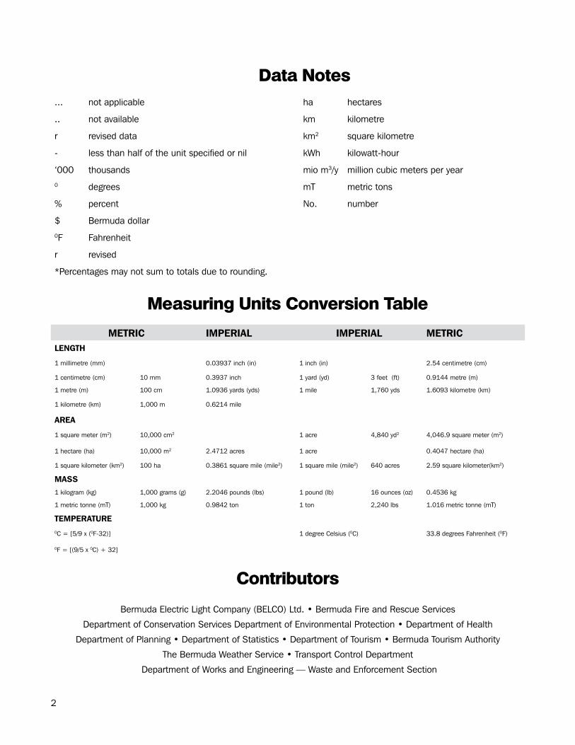
Data.Notes
... not applicable ha hectares
.. not available km kilometre
r revised data km2 square kilometre
- less than half of the unit specified or nil kWh kilowatt-hour
‘000 thousands mio m3/y million cubic meters per year0 degrees mT metric tons
% percent No. number
$ Bermuda dollar0F Fahrenheit
r revised
*Percentages may not sum to totals due to rounding.
Measuring.Units.Conversion.Table
METRIC IMPERIAL IMPERIAL METRICLENGTH
1 millimetre (mm) 0.03937 inch (in) 1 inch (in) 2.54 centimetre (cm)
1 centimetre (cm) 10 mm 0.3937 inch 1 yard (yd) 3 feet (ft) 0.9144 metre (m)
1 metre (m) 100 cm 1.0936 yards (yds) 1 mile 1,760 yds 1.6093 kilometre (km)
1 kilometre (km) 1,000 m 0.6214 mile
AREA
1 square meter (m2) 10,000 cm2 1 acre 4,840 yd2 4,046.9 square meter (m2)
1 hectare (ha) 10,000 m2 2.4712 acres 1 acre 0.4047 hectare (ha)
1 square kilometer (km2) 100 ha 0.3861 square mile (mile2) 1 square mile (mile2) 640 acres 2.59 square kilometer(km2)
MASS1 kilogram (kg) 1,000 grams (g) 2.2046 pounds (lbs) 1 pound (lb) 16 ounces (oz) 0.4536 kg
1 metric tonne (mT) 1,000 kg 0.9842 ton 1 ton 2,240 lbs 1.016 metric tonne (mT)
TEMPERATURE0C = [5/9 x (0F-32)] 1 degree Celsius (0C) 33.8 degrees Fahrenheit (0F)
0F = [(9/5 x 0C) + 32]
Contributors
Bermuda Electric Light Company (BELCO) Ltd. • Bermuda Fire and Rescue Services
Department of Conservation Services Department of Environmental Protection • Department of Health
Department of Planning • Department of Statistics • Department of Tourism • Bermuda Tourism Authority
The Bermuda Weather Service • Transport Control Department
Department of Works and Engineering — Waste and Enforcement Section

3
POPULATIONAND HOUSEHOLDS
4
Section.1:.Population.and.Households
Population
Bermuda’s civilian non-institutionalized population (which excludes non-sheltered persons) is projected to decrease over time. This is a result of net emigration (emigration greater than immigration) exceeding natural increase every year.
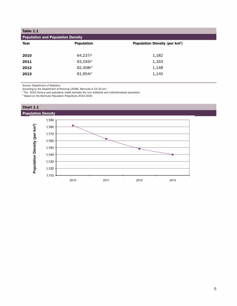
According to the Population Projections for 2013, Bermuda’s civilian population was estimated to be 61,954 persons. This represents a 0.73 percent decrease from the 62,408 persons estimated to be living in Bermuda in 2012. It is estimated that the population density of Bermuda for 2013 was 1,140 persons per square kilometer; a decrease of 8 persons per square kilometer from 2012 (see Table 1.1).
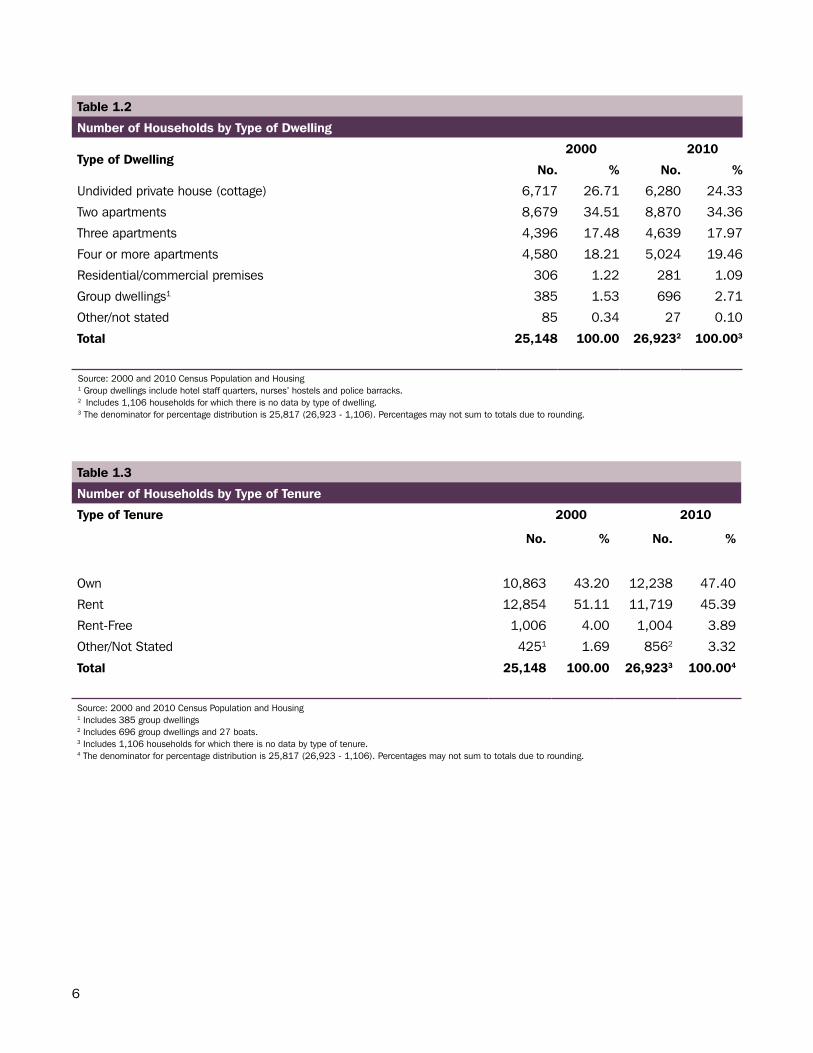
Households
The 2010 Census reported 26,923 households (see Table 1.2) in Bermuda which represented a 7.06% increase in the number of households since 2000. This rise can be attributed to Bermuda’s growing population during the decade. The growing number of households may lead to environmental concerns such as waste disposal and water supply.
5
Table 1.1
Population and Population Density
Year Population Population Density (per km2)
2010 64,237r1 1,182
2011 63,193r2 1,163
2012 62,408r2 1,148
2013 61,954r2 1,140
Source: Department of StatisticsAccording to the Department of Planning (2008), Bermuda is 54.34 km2.1 The 2010 Census year population totals excludes the non-sheltered and institutionalized population. 2 Based on the Bermuda Population Projections 2010-2020.
Chart 1.1
Population Density
1,110
1,120
1,130
1,140
1,150
1,160
1,170
1,180
1,190
2010 2011 2012 2013
Popu
latio
n D
ensi
ty (p
er k
m2 )
6
Table 1.2
Number of Households by Type of Dwelling
Type of Dwelling 2000 2010
No. % No. %
Undivided private house (cottage) 6,717 26.71 6,280 24.33
Two apartments 8,679 34.51 8,870 34.36
Three apartments 4,396 17.48 4,639 17.97
Four or more apartments 4,580 18.21 5,024 19.46
Residential/commercial premises 306 1.22 281 1.09
Group dwellings1 385 1.53 696 2.71
Other/not stated 85 0.34 27 0.10
Total 25,148 100.00 26,9232 100.003
Source: 2000 and 2010 Census Population and Housing1 Group dwellings include hotel staff quarters, nurses’ hostels and police barracks.2 Includes 1,106 households for which there is no data by type of dwelling. 3 The denominator for percentage distribution is 25,817 (26,923 - 1,106). Percentages may not sum to totals due to rounding.
Table 1.3
Number of Households by Type of Tenure
Type of Tenure 2000 2010
No. % No. %
Own 10,863 43.20 12,238 47.40
Rent 12,854 51.11 11,719 45.39
Rent-Free 1,006 4.00 1,004 3.89
Other/Not Stated 4251 1.69 8562 3.32
Total 25,148 100.00 26,9233 100.004
Source: 2000 and 2010 Census Population and Housing 1 Includes 385 group dwellings 2 Includes 696 group dwellings and 27 boats. 3 Includes 1,106 households for which there is no data by type of tenure. 4 The denominator for percentage distribution is 25,817 (26,923 - 1,106). Percentages may not sum to totals due to rounding.
7
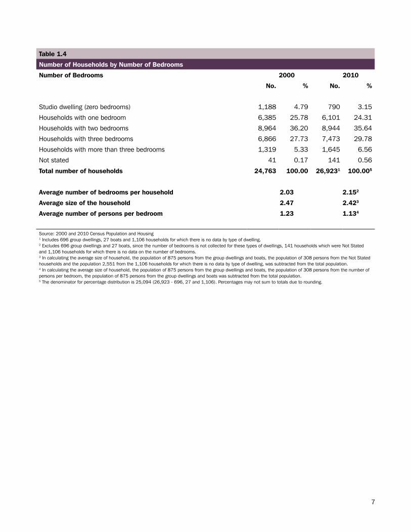
Table 1.4
Number of Households by Number of Bedrooms
Number of Bedrooms 2000 2010
No. % No. %
Studio dwelling (zero bedrooms) 1,188 4.79 790 3.15
Households with one bedroom 6,385 25.78 6,101 24.31
Households with two bedrooms 8,964 36.20 8,944 35.64
Households with three bedrooms 6,866 27.73 7,473 29.78
Households with more than three bedrooms 1,319 5.33 1,645 6.56
Not stated 41 0.17 141 0.56
Total number of households 24,763 100.00 26,9231 100.005
Average number of bedrooms per household 2.03 2.152
Average size of the household 2.47 2.423
Average number of persons per bedroom 1.23 1.134
Source: 2000 and 2010 Census Population and Housing1 Includes 696 group dwellings, 27 boats and 1,106 households for which there is no data by type of dwelling.2 Excludes 696 group dwellings and 27 boats, since the number of bedrooms is not collected for these types of dwellings, 141 households which were Not Stated and 1,106 households for which there is no data on the number of bedrooms.3 In calculating the average size of household, the population of 875 persons from the group dwellings and boats, the population of 308 persons from the Not Stated households and the population 2,551 from the 1,106 households for which there is no data by type of dwelling, was subtracted from the total population.4 In calculating the average size of household, the population of 875 persons from the group dwellings and boats, the population of 308 persons from the number of persons per bedroom, the population of 875 persons from the group dwellings and boats was subtracted from the total population.5 The denominator for percentage distribution is 25,094 (26,923 - 696, 27 and 1,106). Percentages may not sum to totals due to rounding.
8
Millennium Development Goal 7
Indicator 32
Proportion of households with access to secure tenure
100%
The percentage of the population that do not live in slums. A slum household is a group of individuals living under the same roof who lack one or more of the following conditions: security of tenure, structural quality and durability of dwellings, access to safe water, access to sanitation facilities, and sufficient living area.
Secure tenure refers to household persons who own or are purchasing their homes, renting privately or are in social housing or sub-tenancy. Households without secure tenure are defined as squatters (whether or not they pay rent), homeless and households with no formal agreement.
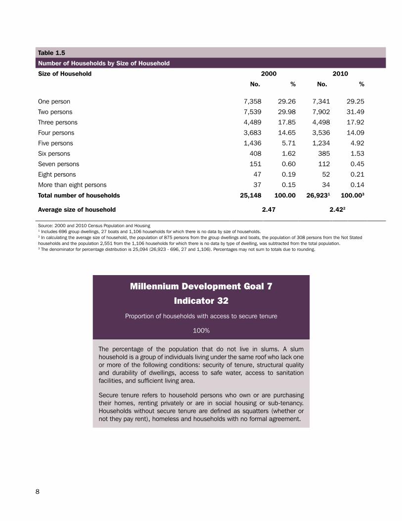
Table 1.5
Number of Households by Size of Household
Size of Household 2000 2010
No. % No. %
One person 7,358 29.26 7,341 29.25
Two persons 7,539 29.98 7,902 31.49
Three persons 4,489 17.85 4,498 17.92
Four persons 3,683 14.65 3,536 14.09
Five persons 1,436 5.71 1,234 4.92
Six persons 408 1.62 385 1.53
Seven persons 151 0.60 112 0.45
Eight persons 47 0.19 52 0.21
More than eight persons 37 0.15 34 0.14
Total number of households 25,148 100.00 26,9231 100.003
Average size of household 2.47 2.422
Source: 2000 and 2010 Census Population and Housing1 Includes 696 group dwellings, 27 boats and 1,106 households for which there is no data by size of households.2 In calculating the average size of household, the population of 875 persons from the group dwellings and boats, the population of 308 persons from the Not Stated households and the population 2,551 from the 1,106 households for which there is no data by type of dwelling, was subtracted from the total population.3 The denominator for percentage distribution is 25,094 (26,923 - 696, 27 and 1,106). Percentages may not sum to totals due to rounding.

9
TOURISM
10
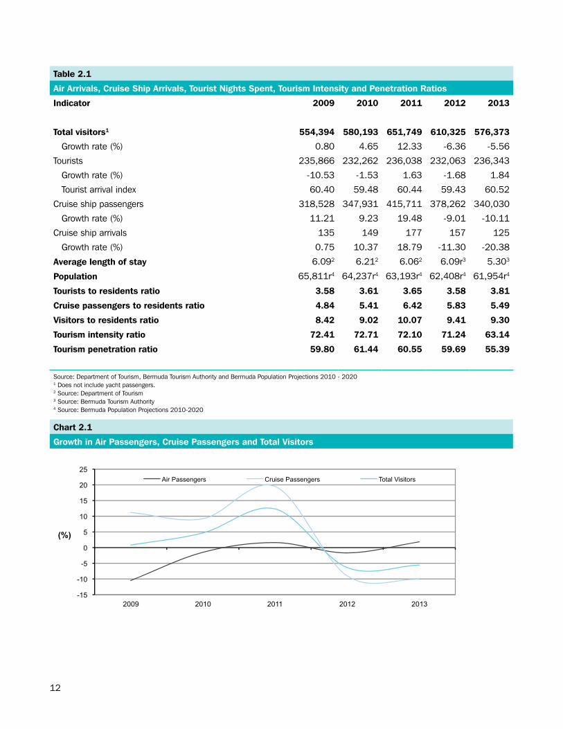
Section.2:.Tourism.Bermuda’s tourism industry is the largest source of revenue to the economy after international business. The recurrent global economic crisis has had a negative impact on Bermuda’s tourism industry.
Tourist Arrivals
The total number of visitors coming to Bermuda in 2013 decreased by 5.56 percent since 2012. This decrease was attributed mainly to a 10.11% reduction in cruise ship passengers due to 32 less cruise ships arriving in Bermuda (see Table 2.1). Overall, Bermuda has seen an increase in air arrivals of 1.84 percent over the previous year.
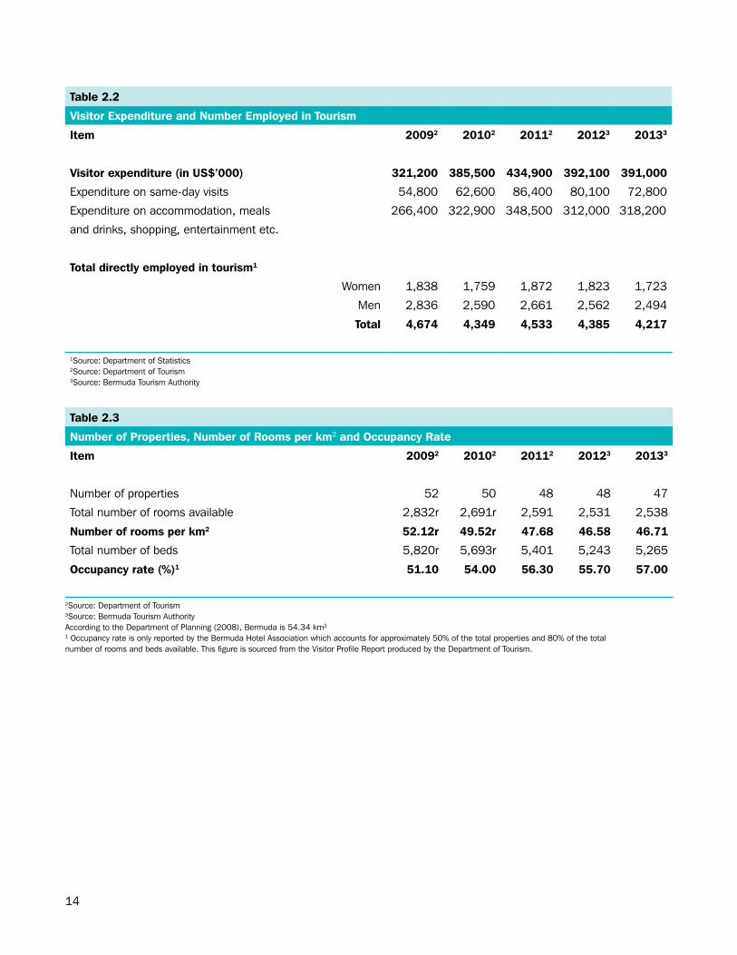
Visitor Expenditure
Visitor expenditure has fluctuated during the past five years. Aggregate expenditure peaked at $435 million in 2011; however, it dropped to $391 million in 2013 (see Table 2.2).
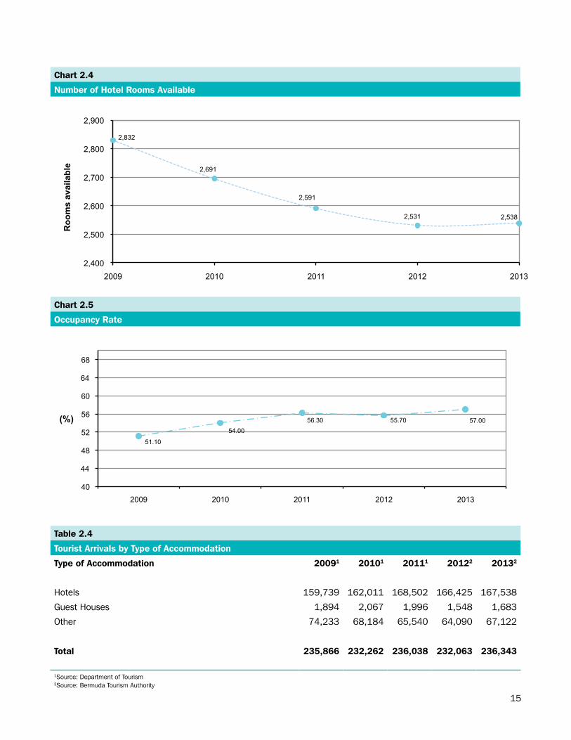
Tourist Properties
In 2013, there were 2,538 rooms with a total of 5,265 beds, located on 47 properties around Bermuda. The occupancy rate of 57.00 percent in 2013 was a 1.30 percent increase from the previous year (see Table 2.3).
Visitor Accommodation
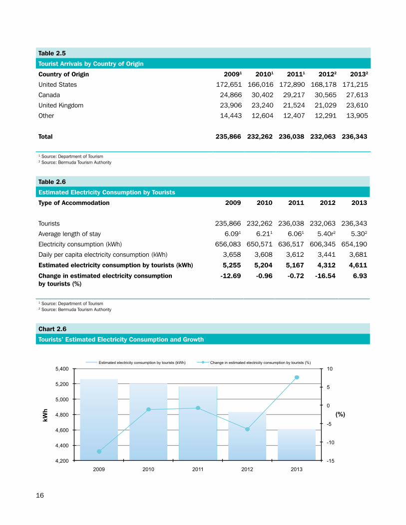
In 2013, 70.89 percent of all tourists chose accommodations at one of Bermuda’s hotels (see Table 2.4). There were 28.40 percent staying in other types of accommodations, while 0.71 percent stayed at a guest house. The average length of stay on the island for a tourist was 5.30 days for 2013. Estimated electricity consumption by tourists was 4,611 kWh in 2013 (see Table 2.6), an increase of 6.93 percent over the electricity consumption by tourists in 2012.
Origin of Tourists
Visitors from the United States, Bermuda’s largest tourism market (72.44%), totaled 171,215 in 2013. This represented an increase of 1.81 percent over the 168,178 visitors from the United States in 2012 (see Table 2.5).
11
NOTE TO READER
Average Length of Stay: intended length of stay or number of nights spent, unless otherwise stated.
Estimated Electricity Consumption by Tourists: a more direct tourism pressure indicator. It is estimated as the national daily per capita electricity consumption times the number of tourist arrivals by the average length of stay, per one million population.
Index of Social Pressure or Ratio of Tourists (or Visitors) to the Local Population: measures the number of tourists (or visitors) to one resident of the country at any given point in time.
Number of Hotel Rooms per km2: commonly accessible indirect proxy to measure tourism’s imprint on the physical environment. It is the number of hotel rooms available divided by the total land area (53.35 km2).
Occupancy Rate: it is calculated by dividing the monthly or yearly sum of room nights used by the number of room nights available for use, then multiplying the quotient by 100 to express as a percentage.
Tourism: the activities of persons travelling to and staying in places outside their usual environment for not more than one consecutive year for leisure, business, and other purposes.
Tourist: a person travelling to and staying in places outside his or her usual environment for not more than one consecutive year but who stays for more than 24 hours in a destination for leisure, business, and other purposes.
Tourist Arrivals: all stay-over visitors, not cruise passenger arrivals, given most cruise ships stop at multiple destinations, the total number of arrivals at all destinations is considerably larger than the number of cruise passengers visiting the region.
Tourism Expenditure: the total expenditure made by a visitor or on behalf of a visitor for and during his/her trip and stay at a destination.
Tourism Intensity/Density Ratio: measures the average daily tourist density per km2. It is the number of tourists per unit of land area at any given point in time. That is, number of tourists times average stay divided by land area (53.35 km2) times 365. It shows how tourists are spread on the territory on average, and gives a general indication of pressures on land use due to tourism, with regard to a reference period (e.g. year) or in peak season.
Tourism Penetration Ratio: measures the average daily tourist density per 1,000 population. It is number of tourists per 1,000 inhabitants of the country at any given point in time. That is, the number of tourists multiplied by the average length of stay divided by the population times 365.
Visitor: any person traveling to a place other than his/her usual environment for less than 12 months and whose main purpose of the visit is other than the exercise of an activity remunerated from within the place visited.
Source: CARICOM Environment Programme
12
Table 2.1
Air Arrivals, Cruise Ship Arrivals, Tourist Nights Spent, Tourism Intensity and Penetration Ratios
Indicator 2009 2010 2011 2012 2013
Total visitors1 554,394 580,193 651,749 610,325 576,373
Growth rate (%) 0.80 4.65 12.33 -6.36 -5.56
Tourists 235,866 232,262 236,038 232,063 236,343
Growth rate (%) -10.53 -1.53 1.63 -1.68 1.84
Tourist arrival index 60.40 59.48 60.44 59.43 60.52
Cruise ship passengers 318,528 347,931 415,711 378,262 340,030
Growth rate (%) 11.21 9.23 19.48 -9.01 -10.11
Cruise ship arrivals 135 149 177 157 125
Growth rate (%) 0.75 10.37 18.79 -11.30 -20.38
Average length of stay 6.092 6.212 6.062 6.09r3 5.303
Population 65,811r4 64,237r4 63,193r4 62,408r4 61,954r4
Tourists to residents ratio 3.58 3.61 3.65 3.58 3.81
Cruise passengers to residents ratio 4.84 5.41 6.42 5.83 5.49
Visitors to residents ratio 8.42 9.02 10.07 9.41 9.30
Tourism intensity ratio 72.41 72.71 72.10 71.24 63.14
Tourism penetration ratio 59.80 61.44 60.55 59.69 55.39
Source: Department of Tourism, Bermuda Tourism Authority and Bermuda Population Projections 2010 - 20201 Does not include yacht passengers.2 Source: Department of Tourism3 Source: Bermuda Tourism Authority4 Source: Bermuda Population Projections 2010-2020
Chart 2.1
Growth in Air Passengers, Cruise Passengers and Total Visitors
-15
-10
-5
0
5
10
15
20
25
2009 2010 2011 2012 2013
(%)
Air Passengers Cruise Passengers Total Visitors
13
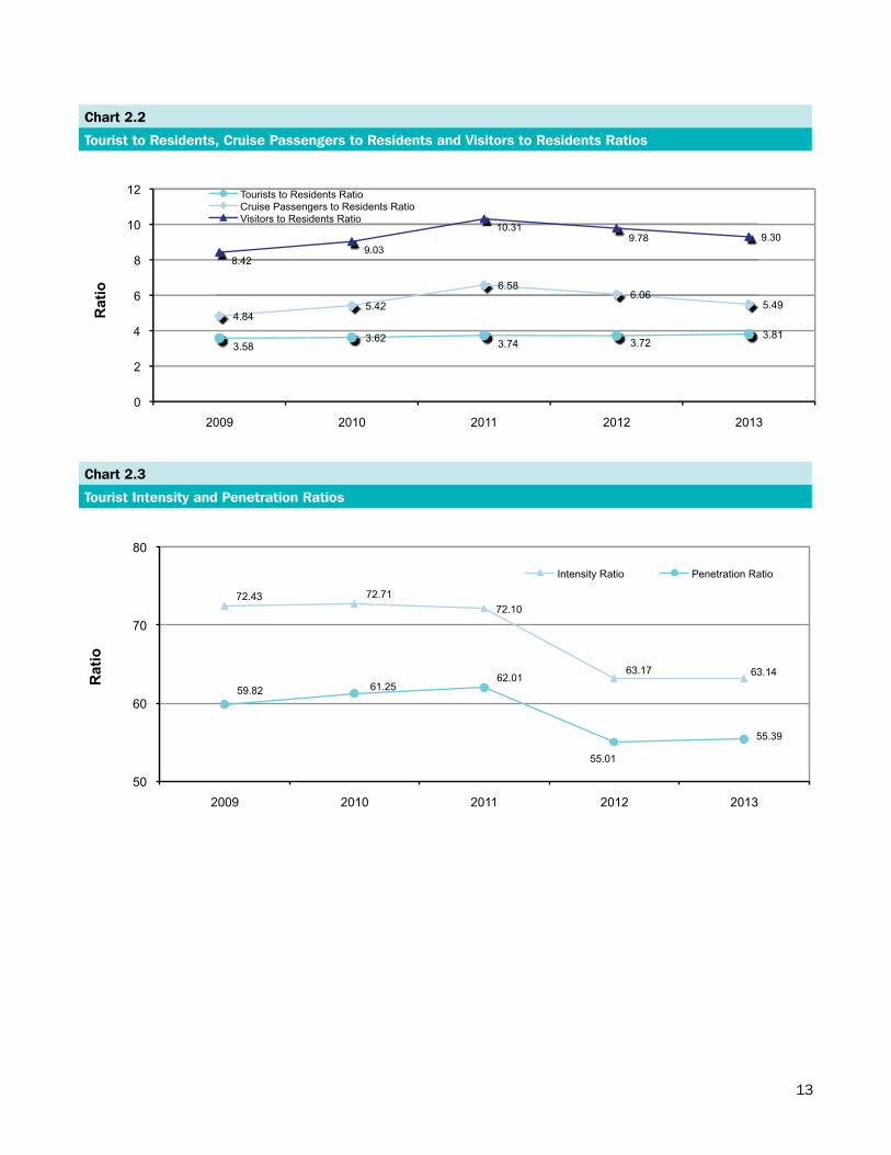
Chart 2.2
Tourist to Residents, Cruise Passengers to Residents and Visitors to Residents Ratios
3.58 3.62 3.74 3.72
3.81
4.84 5.42
6.58 6.06
5.49
8.42 9.03
10.31 9.78 9.30
0
2
4
6
8
10
12
2009 2010 2011 2012 2013
Rat
io
Tourists to Residents Ratio Cruise Passengers to Residents Ratio Visitors to Residents Ratio
Chart 2.3
Tourist Intensity and Penetration Ratios
72.43 72.71 72.10
63.17 63.14
59.82 61.25 62.01
55.01
55.39
50
60
70
80
2009 2010 2011 2012 2013
Rat
io
Intensity Ratio Penetration Ratio
14
Table 2.2
Visitor Expenditure and Number Employed in Tourism
Item 20092 20102 20112 20123 20133
Visitor expenditure (in US$’000) 321,200 385,500 434,900 392,100 391,000
Expenditure on same-day visits 54,800 62,600 86,400 80,100 72,800
Expenditure on accommodation, meals 266,400 322,900 348,500 312,000 318,200
and drinks, shopping, entertainment etc.
Total directly employed in tourism1
Women 1,838 1,759 1,872 1,823 1,723
Men 2,836 2,590 2,661 2,562 2,494
Total 4,674 4,349 4,533 4,385 4,217
1Source: Department of Statistics2Source: Department of Tourism3Source: Bermuda Tourism Authority
Table 2.3
Number of Properties, Number of Rooms per km2 and Occupancy Rate
Item 20092 20102 20112 20123 20133
Number of properties 52 50 48 48 47
Total number of rooms available 2,832r 2,691r 2,591 2,531 2,538
Number of rooms per km2 52.12r 49.52r 47.68 46.58 46.71
Total number of beds 5,820r 5,693r 5,401 5,243 5,265
Occupancy rate (%)1 51.10 54.00 56.30 55.70 57.00
2Source: Department of Tourism3Source: Bermuda Tourism AuthorityAccording to the Department of Planning (2008), Bermuda is 54.34 km2
1 Occupancy rate is only reported by the Bermuda Hotel Association which accounts for approximately 50% of the total properties and 80% of the total number of rooms and beds available. This figure is sourced from the Visitor Profile Report produced by the Department of Tourism.
15
Chart 2.4
Number of Hotel Rooms Available
2,832
2,691
2,591
2,531 2,538
2,400
2,500
2,600
2,700
2,800
2,900
2009 2010 2011 2012 2013
Roo
ms
avai
labl
e
Chart 2.5
Occupancy Rate
51.10
54.00 56.30 55.70 57.00
40
44
48
52
56
60
64
68
2009 2010 2011 2012 2013
(%)
Table 2.4
Tourist Arrivals by Type of Accommodation
Type of Accommodation 20091 20101 20111 20122 20132
Hotels 159,739 162,011 168,502 166,425 167,538
Guest Houses 1,894 2,067 1,996 1,548 1,683
Other 74,233 68,184 65,540 64,090 67,122
Total 235,866 232,262 236,038 232,063 236,343
1Source: Department of Tourism2Source: Bermuda Tourism Authority
16
Table 2.5
Tourist Arrivals by Country of Origin
Country of Origin 20091 20101 20111 20122 20132
United States 172,651 166,016 172,890 168,178 171,215
Canada 24,866 30,402 29,217 30,565 27,613
United Kingdom 23,906 23,240 21,524 21,029 23,610
Other 14,443 12,604 12,407 12,291 13,905
Total 235,866 232,262 236,038 232,063 236,343
1 Source: Department of Tourism2 Source: Bermuda Tourism Authority
Table 2.6
Estimated Electricity Consumption by Tourists
Type of Accommodation 2009 2010 2011 2012 2013
Tourists 235,866 232,262 236,038 232,063 236,343
Average length of stay 6.091 6.211 6.061 5.40r2 5.302
Electricity consumption (kWh) 656,083 650,571 636,517 606,345 654,190
Daily per capita electricity consumption (kWh) 3,658 3,608 3,612 3,441 3,681
Estimated electricity consumption by tourists (kWh) 5,255 5,204 5,167 4,312 4,611
Change in estimated electricity consumptionby tourists (%)
-12.69 -0.96 -0.72 -16.54 6.93
1 Source: Department of Tourism2 Source: Bermuda Tourism Authority
Chart 2.6
Tourists’ Estimated Electricity Consumption and Growth
-15
-10
-5
0
5
10
4,200
4,400
4,600
4,800
5,000
5,200
5,400
2009 2010 2011 2012 2013
(%)
kWh
Estimated electricity consumption by tourists (kWh) Change in estimated electricity consumption by tourists (%)
17
ENVIRONMENTAL HEALTHAND WEATHER
18
Section.3:.Environmental.Health.and.Weather.Environmental Health
Environmental health refers to all aspects of human health and disease that are determined by factors in the environment. It refers to the theory and practice of assessing and controlling factors in the environment that can potentially affect a person’s health (World Health Organization, 2009).
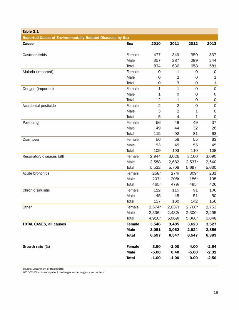
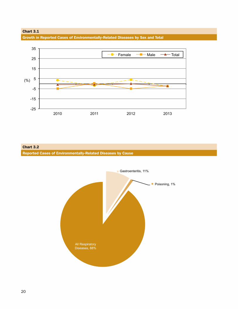
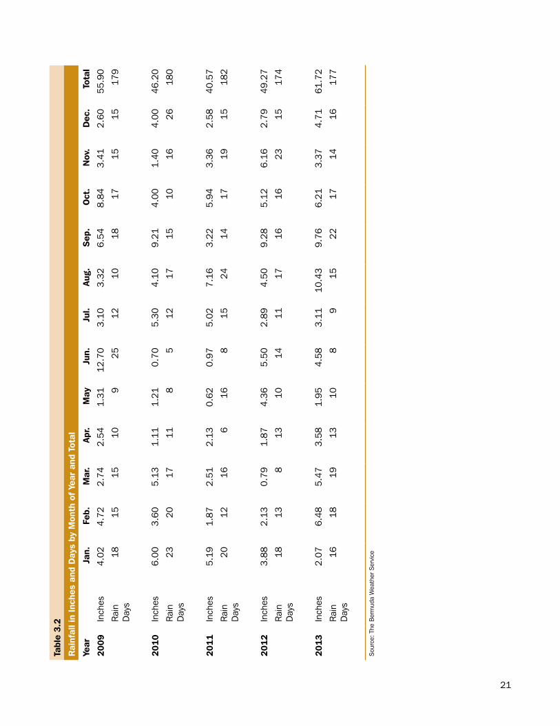
Bermuda’s subtropical weather and high humidity contribute to the occurrence of human health conditions on the island such as asthma and bronchitis. In 2013, there were 6,383 reported cases of environmentally-related diseases in Bermuda. A total of 5,630 or 88.20% of these cases were classified as respiratory diseases. Females had the greatest distribution of environmentally-related diseases at 55.26% while males accounted for 44.74% (see Table 3.1).
Gastroenteritis is defined as a “condition that causes irritation and inflammation of the stomach and intestines. Viral infection is the most common cause of gastroenteritis, but bacteria, para sites, and food-borne illness (such as shellfish) can be the offending agent. Viruses and bacteria are very contagious and can spread through contaminated food or water.” (Emedicinehealth, 2009). In 2013, gastroenteritis accounted for 9.10% or 581 cases of the environmentally-related diseases in Bermuda.
Weather
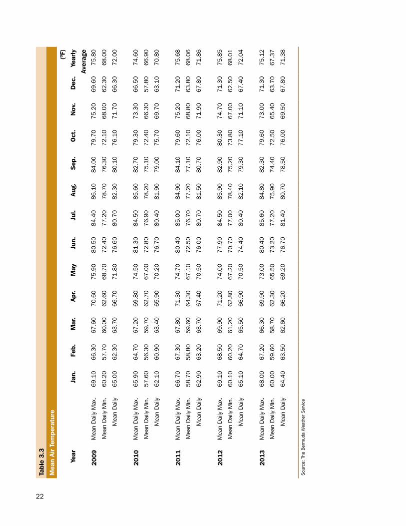
The amount of rain that fell on Bermuda increased by 25.27% during the period 2012-2013. The Bermuda Weather Service reported that Bermuda collected 61.72 inches of rainfall from 177 rain days during 2013. The most rain days was recorded in September while June had the least (see Table 3.2).
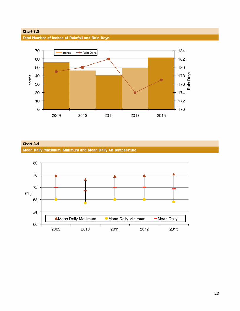
July was the hottest month in Bermuda during 2013 with an average daily temperature of 81.400F. The coolest month was March (62.600F). Over the last five years, the annual average air temperature in Bermuda has remained around 71.620F. During that period, the average daily maximum temperature was 75.410F while the average daily minimum temperature was 67.670F (see Table 3.3).
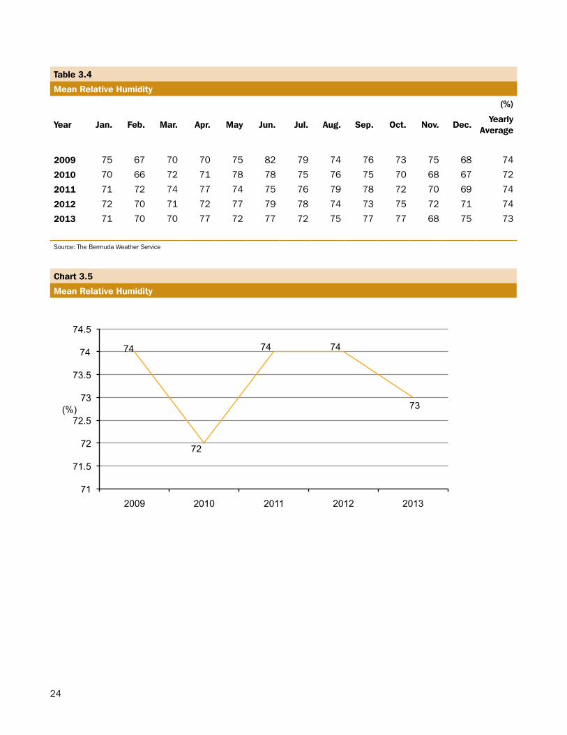
Over the past five years, 2009 to 2013, the average humidity was 73.40%. In 2013, April, June, September and Oc-tober were the months with the highest humidity (77.00%) and the lowest was November (68.00%) (see Table 3.4).
19
Table 3.1
Reported Cases of Environmentally-Related Diseases by Sex
Cause Sex 2010 2011 2012 2013
Gastroenteritis Female 477 349 359 337Male 357 287 299 244
Total 834 636 658 581Malaria (imported) Female 0 1 0 0
Male 0 2 0 1Total 0 3 0 1
Dengue (imported) Female 1 1 0 0Male 1 0 0 0
Total 2 1 0 0Accidental pesticide Female 2 2 0 0
Male 3 2 1 0 Total 5 4 1 0Poisoning Female 66 48 49 37
Male 49 44 32 26Total 115 92 81 63
Diarrhoea Female 56 58 55 63Male 53 45 55 45Total 109 103 110 108
Respiratory diseases (all) Female 2,944 3,026 3,160 3,090Male 2,588 2,682 2,537r 2,540Total 5,532 5,708 5,697r 5,630
Acute bronchitis Female 258r 274r 309r 231Male 207r 205r 186r 195Total 465r 479r 495r 426
Chronic sinusitis Female 112 115 91 106Male 45 45 51 50Total 157 160 142 156
Other Female 2,574r 2,637r 2,760r 2,753Male 2,336r 2,432r 2,300r 2,295Total 4,910r 5,069r 5,060r 5,048
TOTAL CASES, all causes Female 3,546 3,485 3,623 3,527Male 3,051 3,062 2,924 2,856Total 6,597 6,547 6,547 6,383
Growth rate (%) Female 3.50 -2.00 4.00 -2.64Male -5.00 0.40 -5.00 -2.32Total -1.00 -1.00 0.00 -2.50
Source: Department of Health/BHB 2010-2013 includes inpatient discharges and emergency encounters.
20
Chart 3.1
Growth in Reported Cases of Environmentally-Related Diseases by Sex and Total
-25
-15
-5
5
15
25
35
2010 2011 2012 2013
(%)
Female Male Total
Chart 3.2
Reported Cases of Environmentally-Related Diseases by Cause
Gastroenteritis, 11%
Poisoning, 1%
All Respiratory Diseases, 88%
21
Tabl
e 3.2
Rai
nfal
l in
Inch
es a
nd D
ays
by M
onth
of
Year
and
Tot
al
Year
Jan.
Feb.
Mar
.Ap
r.M
ayJu
n.Ju
l.Au
g.S
ep.
Oct
.N
ov.
Dec
.To
tal
2009
Inch
es4.
024.
722.
742.
541.
3112
.70
3.10
3.32
6.54
8.84
3.41
2.60
55.9
0
Rai
n D
ays
1815
1510
925
1210
1817
1515
179
2010
Inch
es6.
003.
605.
131.
111.
210.
705.
304.
109.
214.
001.
404.
0046
.20
Rai
n D
ays
2320
1711
85
1217
1510
1626
180
201
1In
ches
5.19
1.87
2.51
2.13
0.62
0.97
5.02
7.16
3.22
5.94
3.36
2.58
40.5
7
Rai
n D
ays
2012
166
168
1524
1417
1915
182
201
2In
ches
3.88
2.13
0.79
1.87
4.36
5.50
2.89
4.50
9.28
5.12
6.16
2.79
49.2
7
Rai
n D
ays
1813
813
1014
1117
1616
2315
174
2013
Inch
es2.
076.
485.
473.
581.
954.
583.
1110
.43
9.76
6.21
3.37
4.71
61.7
2
Rai
n D
ays
1618
1913
108
915
2217
1416
177
Sou
rce:
The
Ber
mud
a W
eath
er S
ervi
ce
22
Tabl
e 3.
3
Mea
n Ai
r Te
mpe
ratu
re
(0 F)
Year
Jan.
Feb.
Mar
.Ap
r.M
ayJu
n.Ju
l.Au
g.S
ep.
Oct
.N
ov.
Dec
.Ye
arly
Aver
age
2009
Mea
n D
aily
Max
.69
.10
66.3
067
.60
70.6
075
.90
80.5
084
.40
86.1
084
.00
79.7
075
.20
69.6
075
.80
Mea
n D
aily
Min
.60
.20
57.7
060
.00
62.6
068
.70
72.4
077
.20
78.7
076
.30
72.1
068
.00
62.3
068
.00
Mea
n D
aily
65.0
062
.30
63.7
066
.70
71.8
076
.60
80.7
082
.30
80.1
076
.10
71.7
066
.30
72.0
0
2010
Mea
n D
aily
Max
.65
.90
64.7
067
.20
69.8
074
.50
81.3
084
.50
85.6
082
.70
79.3
073
.30
66.5
074
.60
Mea
n D
aily
Min
.57
.60
56.3
059
.70
62.7
067
.00
72.8
076
.90
78.2
075
.10
72.4
066
.30
57.8
066
.90
Mea
n D
aily
62.1
060
.90
63.4
065
.90
70.2
076
.70
80.4
081
.90
79.0
075
.70
69.7
063
.10
70.8
0
2011
Mea
n D
aily
Max
.66
.70
67.3
067
.80
71.3
074
.70
80.4
085
.00
84.9
084
.10
79.6
075
.20
71.2
075
.68
Mea
n D
aily
Min
.58
.70
58.8
059
.60
64.3
067
.10
72.5
076
.70
77.2
077
.10
72.1
068
.80
63.8
068
.06
Mea
n D
aily
62.9
063
.20
63.7
067
.40
70.5
076
.00
80.7
081
.50
80.7
076
.00
71.9
067
.80
71.8
6
2012
Mea
n D
aily
Max
.69
.10
68.5
069
.90
71.2
074
.00
77.9
084
.50
85.9
082
.90
80.3
074
.70
71.3
075
.85
Mea
n D
aily
Min
.60
.10
60.2
061
.20
62.8
067
.20
70.7
077
.00
78.4
075
.20
73.8
067
.00
62.5
068
.01
Mea
n D
aily
65.1
064
.70
65.5
066
.90
70.5
074
.40
80.4
082
.10
79.3
077
.10
71.1
067
.40
72.0
4
2013
Mea
n D
aily
Max
.68
.00
67.2
066
.30
69.9
073
.00
80.4
085
.60
84.8
082
.30
79.6
073
.00
71.3
075
.12
Mea
n D
aily
Min
.60
.00
59.6
058
.70
62.3
065
.50
73.2
077
.20
75.9
074
.40
72.5
065
.40
63.7
067
.37
Mea
n D
aily
64.4
063
.50
62.6
066
.20
69.2
076
.70
81.4
080
.70
78.5
076
.00
69.5
067
.80
71.3
8
Sou
rce:
The
Ber
mud
a W
eath
er S
ervi
ce
23
Chart 3.3
Total Number of Inches of Rainfall and Rain Days
170
172
174
176
178
180
182
184
0
10
20
30
40
50
60
70
2009 2010 2011 2012 2013
Rai
n D
ays
Inch
es
Inches Rain Days
Chart 3.4
Mean Daily Maximum, Minimum and Mean Daily Air Temperature
60
64
68
72
76
80
2009 2010 2011 2012 2013
(0F)
Mean Daily Maximum Mean Daily Minimum Mean Daily
24
Table 3.4
Mean Relative Humidity
(%)
Year Jan. Feb. Mar. Apr. May Jun. Jul. Aug. Sep. Oct. Nov. Dec.Yearly
Average
2009 75 67 70 70 75 82 79 74 76 73 75 68 74
2010 70 66 72 71 78 78 75 76 75 70 68 67 72
2011 71 72 74 77 74 75 76 79 78 72 70 69 74
2012 72 70 71 72 77 79 78 74 73 75 72 71 74
2013 71 70 70 77 72 77 72 75 77 77 68 75 73
Source: The Bermuda Weather Service
Chart 3.5
Mean Relative Humidity
74
72
74 74
73
71
71.5
72
72.5
73
73.5
74
74.5
2009 2010 2011 2012 2013
(%)
25
Millennium Development Goal 7
Indicator 30
Proportion of population with sustainable accessto an improved water source
100 %
The percentage of the population who use any of the following types of water supply for drinking: piped water, public tap, borehole or pump, protected well, protected spring or rainwater to the total population, expressed as a percentage. Improved water sources do not include vendor-provided water, bottled water, tanker trucks or unprotected wells and springs.
Access to safe water refers to the percentage of the population with reasonable access to an adequate supply of safe water in their dwelling or within a convenient distance of their dwelling.
Millennium Development Goal 7
Indicator 31
Proportion of population with access to improved sanitation
100 %
The percentage of the population with access to improved excreta disposal. Facilities such as sewers or septic tanks, poor-flush latrines and simple pit latrines are assumed to be adequate, provided that they are not public. To be effective, facilities must be correctly constructed and properly maintained.
26
NATURAL ANDENVIRONMENTAL DISASTERS
27
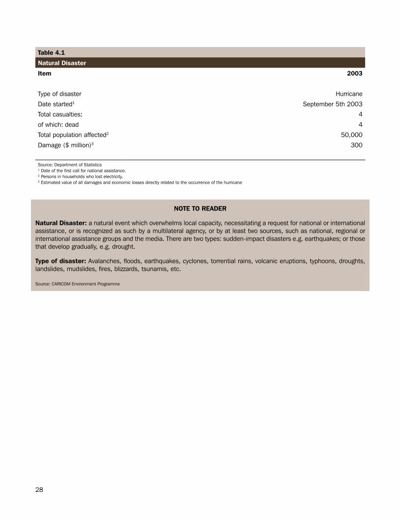
Section.4:.Natural.and.Environmental.Disasters.Hurricanes
Natural and environmental disasters are very rare in Bermuda. The last natural disaster was Hurricane Fabian, a category 3 hurricane, which made landfall on September 5th, 2003. The hurricane resulted in four deaths and an estimated $300 million in damages across the Island (see Table 4.1).
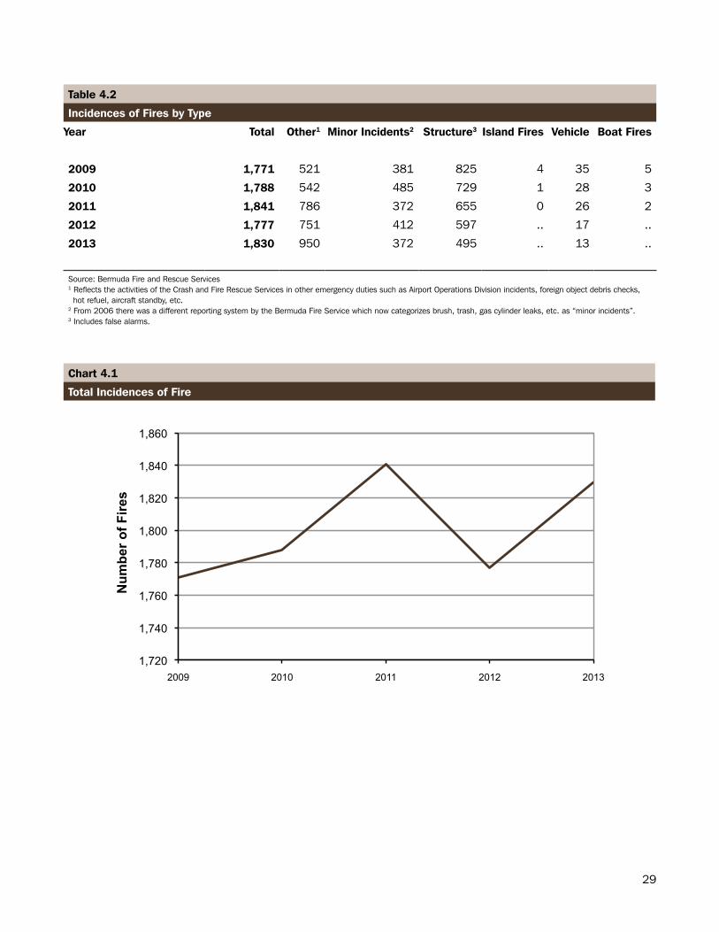
Fires
The number of fires reported in 2013 increased to 1,830 (see Table 4.2). This represents an increase of 2.98% over total fires in 2012. The majority of fires were classified in the “other” category.
28
Table 4.1
Natural Disaster
Item 2003
Type of disaster Hurricane
Date started1 September 5th 2003
Total casualties: 4
of which: dead 4
Total population affected2 50,000
Damage ($ million)3 300
Source: Department of Statistics1 Date of the first call for national assistance.2 Persons in households who lost electricity.3 Estimated value of all damages and economic losses directly related to the occurrence of the hurricane
NOTE TO READER
Natural Disaster: a natural event which overwhelms local capacity, necessitating a request for national or international assistance, or is recognized as such by a multilateral agency, or by at least two sources, such as national, regional or international assistance groups and the media. There are two types: sudden-impact disasters e.g. earthquakes; or those that develop gradually, e.g. drought.
Type of disaster: Avalanches, floods, earthquakes, cyclones, torrential rains, volcanic eruptions, typhoons, droughts, landslides, mudslides, fires, blizzards, tsunamis, etc.
Source: CARICOM Environment Programme
29
Table 4.2
Incidences of Fires by Type
Year Total Other1 Minor Incidents2 Structure3 Island Fires Vehicle Boat Fires
2009 1,771 521 381 825 4 35 5
2010 1,788 542 485 729 1 28 3
2011 1,841 786 372 655 0 26 2
2012 1,777 751 412 597 .. 17 ..
2013 1,830 950 372 495 .. 13 ..
Source: Bermuda Fire and Rescue Services1 Reflects the activities of the Crash and Fire Rescue Services in other emergency duties such as Airport Operations Division incidents, foreign object debris checks, hot refuel, aircraft standby, etc. 2 From 2006 there was a different reporting system by the Bermuda Fire Service which now categorizes brush, trash, gas cylinder leaks, etc. as “minor incidents”.3 Includes false alarms.
Chart 4.1
Total Incidences of Fire
1,720
1,740
1,760
1,780
1,800
1,820
1,840
1,860
2009 2010 2011 2012 2013
Num
ber o
f Fire
s
30
ENERGY, MINERALSAND TRANSPORT
31
Section.5:.Energy,.Minerals.and.Transport.The section on Energy, Minerals and Transport comprises of information on the types of fuels imported to Bermuda such as gasoline, diesel and propane. It also contains data on electricity consumption by type of consumer and the types of vehicles operating on Bermuda’s roads.
Fuels
In 2013, the value of petroleum oils and oils from bituminous mineral, other than crude imported into Bermuda was $154 million, an increase of 59.30 percent from the total value imported in 2012 (see Table 5.1).
Mineral Fuels
Of the types of mineral fuels and oils imported to Bermuda, petroleum oils and gases were the most consumed with a combined import value of $158 million in 2013 (see Table 5.2).
Electricity
The volume of electricity consumption in 2013 was nearly 587 million kilowatt-hours (kWh), 3.24% lower than the 606 million kWh consumed in 2012. The commercial sector accounted for over half (295 million kWh) of all electricity consumed in Bermuda (see Table 5.3).
Transport
Bermuda’s unique traffic laws permit drivers to have only one car per dwelling unit. In 2013, there were 46,947 registered road vehicles on Bermuda’s roads, with private cars accounting for almost half (45.93%) of this total. In 2013, nearly one-third (31.97%) of all vehicles registered in Bermuda were motorcycles (see Table 5.6).
32
Table 5.1
Value of Imported Fuel1 by Type
Type 2010 2011 2012 2013
Value ($) Value ($) Value ($) Value ($)
Light oils & preparations (i.e. motor spirits) 19,085,734 19,064,278 11,703,867 32,608,135
Gas oils (diesel) 12,975,113 8,400,691 6,307,623 17,208,412
Gas oils (heavy atmospheric) 18,558,234 25,483,946 8,170,259 20,237,831
Kerosene & other medium oils(not including gas oils)
712,494 6,398,003 6,485,207 17,546,376
Fuel oils not elsewhere specified 37,862,445 22,288,504 60,161,139 61,480,353
Other lubricating oils & greases, etc. 3,931,518 3,893,602 3,676,570 4,826,875
Other waste oils 503,130 110,435 130,544 29,677
Total 93,628,668 85,639,459 96,635,208 153,937,660
Source: Department of Statistics 1 Petroleum oils and oils obtained from bituminous minerals, other than crude.
33
Table 5.2
Value of Imported Mineral Fuels, Mineral Oils and Related Products Consumed by Type
2009 2010 2011 2012 2013
Type ($) ($) ($) ($) ($)
Coal, briquettes 22,938 31,638 20,949 9,552 10,833
Lignite 70.56 203.17 1,648 540 -
Peat 100,961 102,642 70,076 63,675 76,793
Coke and semi coke 107,963 108,648 107,284 72,643 93,740
Coal gas, water gas 614.68 222.48 589 750 -
Tar distilled 8,343 3,608 4,198 1,032 644
Oils and other products 27,202 8,037 10,401 323 5,632
Pitch and pitch coke 19,775 1,151 3,578 - -
Petroleum oils 11.36 323.59 193 - -
Petroleum oils other than crude 109,479,394 93,628,668 85,639,459 96,635,208 153,937,660
Petroleum gases and other gaseous hydrocarbons 2,305,416 3,140,447 2,932,380 1,614,583 3,040,172
Petroleum jelly 178,059 129,000 43,886 37,887 38,266
Petroleum coke 47,773 3,846 15,105 1,588 98,307
Other bitumen and asphalt 18,886 2,868 25,923 1,061 5,167
Bituminous mixtures 654,786 607,499 524,230 612,298 469,124
Electrical energy 2,201 0 2,212 42,705 -
Total 112,974,394 97,768,800 89,402,111 99,093,845 157,776,338
Source: Department of Statistics
Table 5.3
Electricity Consumption by Type of Consumer
Year Per Capita Electricity Consumption Total Type
(kWh) (‘000 kWh) Residential Commercial Other 1
(‘000 kWh) (‘000 kWh) (‘000 kWh)
2009 10,188 656,082 271,682 326,727 57,673
2010 10,128 650,571 276,824 320,527 53,220
2011 10,073 636,517 265,243 316,356 54,918
2012 9,716 606,346 249,749 307,269 49,328
2013 9,470 586,704 244,421 295,043 47,240
Source: Bermuda Electric Light Company Ltd.1 Includes street lighting paid by Parish Councils and sales to Government for offices, distillation plant, etc.
34
Table 5.4
Growth in Electricity Consumption by Type of Consumer
Year
Growth Total Electricity
Consumption
Type
Residential%
Commercial %
Other %
2009 1.73 1.20 2.40 0.50
2010 -0.84 1.80 -1.80 -7.70
2011 -2.16 -4.20 -1.30 3.20
2012 -4.74 -5.80 -2.90 -10.10
2013 -3.24 -2.13 -3.98 -4.23
Chart 5.1
Growth in Electricity Consumption by Type of Consumer and Total Consumption
-12
-10
-8
-6
-4
-2
0
2
4
2009 2010 2011 2012 2013
(%)
Total Residential Commercial Other
Table 5.5
Percent of Total Electricity Consumption by Type of Consumer
Year Total
Type
Residential %
Commercial %
Other %
2009 100 41.40 49.70 8.70
2010 100 42.50 49.20 8.10
2011 100 41.70 49.70 8.60
2012 100 41.20 50.70 8.10
2013 100 41.66 50.29 8.05
Source: Bermuda Electric Light Company Ltd.Percentages may not sum to totals due to rounding.
35
Table 5.6
Registered Road Vehicles1,2
Type 2009 2010 2011 2012 2013
Private Cars 22,626 22,315 21,991 21,707 21,564
Buses, Minibuses & Limousines 178 178 179 185 187
Taxis 598 595 588 579 581
Trucks 4,026 3,967 3,870 3,746 3,655
Trailers 318 320 313 321 288
Farm Tractors 26 23 22 26 25
Ambulances & Fire Engines 48 48 46 41 44
Military Vehicles 34 33 33 36 32
Tractors & Tractor Trailers 451 429 418 393 376
Light Private Cars 129 119 107 94 81
Auxiliary Cycles3 6,190 5,586 5,232 4,754 4,458
Motor Cycles & Scooters 15,514 15,317 15,163 14,887 15,009
Construction Vehicles4 82 78 71 72 60
Government Private (GP) Vehicles5 250 254 247 257 252
Other6 4017 400 381 361 335
Total 50,871 49,662 48,661 47,459 46,947
Source: Transport Control Department1 Number of vehicles for which a valid license was in effect as of December 31st . 2 This table format was revised in 2014. 3 Includes livery cycles 4 Includes cement mixers 5 Includes cars, classes A-H and minibuses.6 Includes classic cars, community service vehicles, doctors’ cars, garbage trucks, hearses, instructional vehicles, loaner vehicles, locomotives, police utility vehicles, public carriages and sporting associations.7 Includes amphibious vehicles
Chart 5.2
Growth in Registered Road Vehicles
-3
-2
-1
0
1
2
3
4
5
6
2009 2010 2011 2012 2013
(%)
36
AGRICULTURE
37
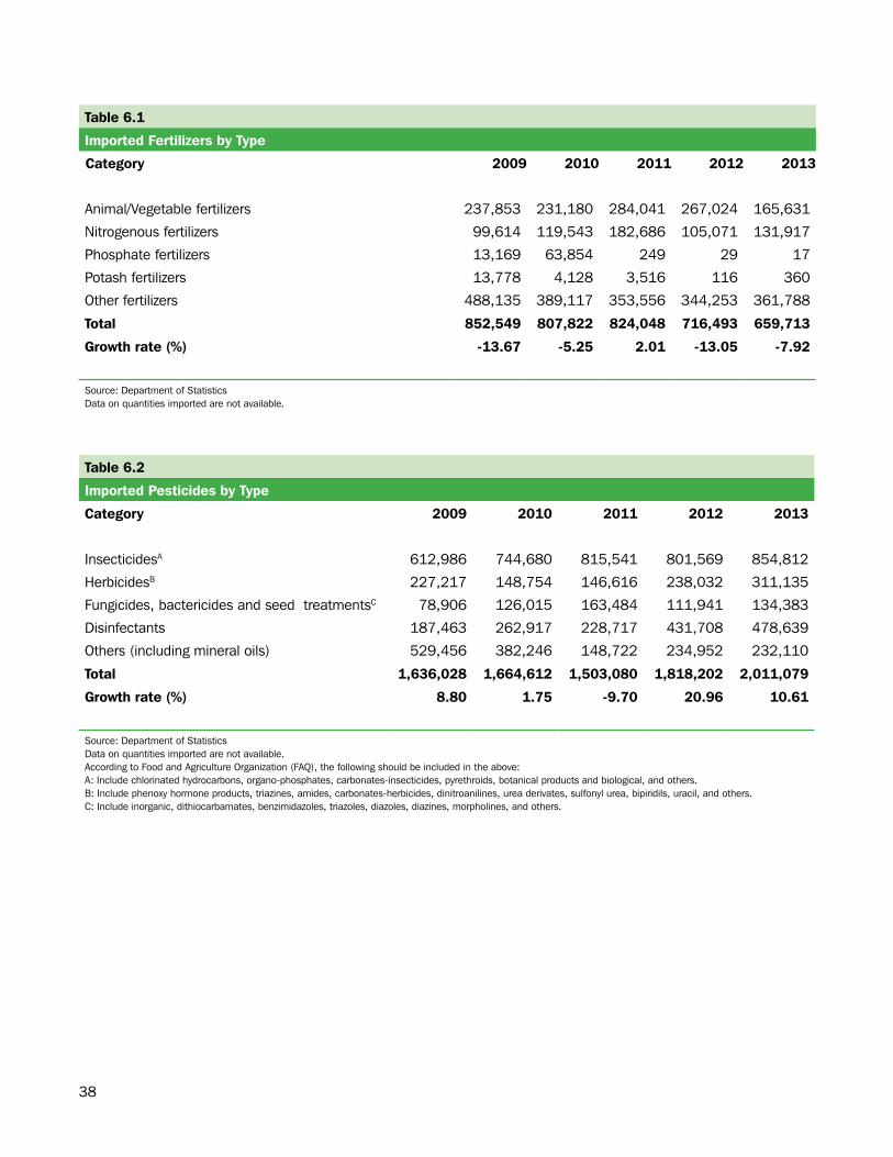
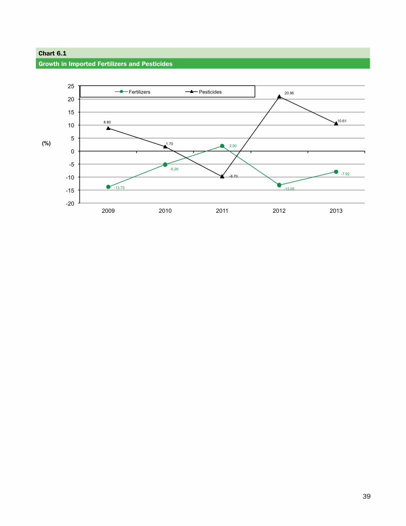
Section.6:.Agriculture.The Agriculture section includes tables, charts and information on the imported fertilizers and pesticides in Bermuda.
Fertilizers and Pesticides
In 2013, the aggregate value of fertilizers imported into Bermuda totaled $659,713 representing a decrease of 7.92% from the previous year (see Table 6.1). The total value of pesticides imported in 2013 climbed to $2 million representing an increase of 10.61% since 2012 (see Table 6.2). In 2013, insecticides accounted for 42.51% of the total value of imported pesticides.
38
Table 6.1
Imported Fertilizers by Type
Category 2009 2010 2011 2012 2013
Animal/Vegetable fertilizers 237,853 231,180 284,041 267,024 165,631
Nitrogenous fertilizers 99,614 119,543 182,686 105,071 131,917
Phosphate fertilizers 13,169 63,854 249 29 17
Potash fertilizers 13,778 4,128 3,516 116 360
Other fertilizers 488,135 389,117 353,556 344,253 361,788
Total 852,549 807,822 824,048 716,493 659,713
Growth rate (%) -13.67 -5.25 2.01 -13.05 -7.92
Source: Department of StatisticsData on quantities imported are not available.
Table 6.2
Imported Pesticides by Type
Category 2009 2010 2011 2012 2013
InsecticidesA 612,986 744,680 815,541 801,569 854,812
HerbicidesB 227,217 148,754 146,616 238,032 311,135
Fungicides, bactericides and seed treatmentsC 78,906 126,015 163,484 111,941 134,383
Disinfectants 187,463 262,917 228,717 431,708 478,639
Others (including mineral oils) 529,456 382,246 148,722 234,952 232,110
Total 1,636,028 1,664,612 1,503,080 1,818,202 2,011,079
Growth rate (%) 8.80 1.75 -9.70 20.96 10.61
Source: Department of StatisticsData on quantities imported are not available.According to Food and Agriculture Organization (FAQ), the following should be included in the above:A: Include chlorinated hydrocarbons, organo-phosphates, carbonates-insecticides, pyrethroids, botanical products and biological, and others.B: Include phenoxy hormone products, triazines, amides, carbonates-herbicides, dinitroanilines, urea derivates, sulfonyl urea, bipiridils, uracil, and others.C: Include inorganic, dithiocarbamates, benzimidazoles, triazoles, diazoles, diazines, morpholines, and others.
39
Chart 6.1
Growth in Imported Fertilizers and Pesticides
-13.70
-5.20
2.00
-13.05
-7.92
8.80
1.70
-9.70
20.96
10.61
-20
-15
-10
-5
0
5
10
15
20
25
2009 2010 2011 2012 2013
(%)
Fertilizers Pesticides

40
LAND USE
41
Section.7:..Land.Use.The Land Use section includes tables and charts pertaining to land usage in Bermuda. The data in this section was collected in 2001 by the Department of Planning and has not been updated.
Land Use
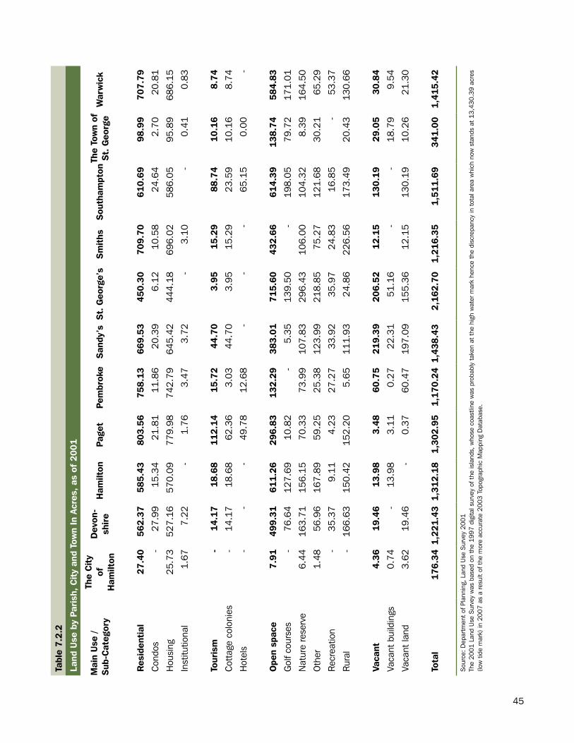
In 2001, residential properties occupied 45.10 percent of all land in Bermuda, covering roughly 5,984 acres of land. Nearly 4,417 acres were dedicated to open space land use, which comprises of golf courses, nature reserves, other recreation and rural areas. This represented about one-third of Bermuda’s land. Land used for commercial purposes (such as retail and office space) accounted for nearly 1.70 percent of all occupied land space in Bermuda (see Table 7.1).
A comparison of land use by parish showed that St. George’s holds the largest share of land with 2,162.70 acres. Of this total, one-third covered open space. The parish of St. George is known for its golf courses, nature reserves, recreational and other rural open spaces. In contrast, the City of Hamilton occupies the least amount of land in Bermuda (176.34 acres), with less than 4.49 percent deemed open space (see Table 7.2.2). This is reflected by the large concentration of commercial, institutional and utility activity located within the city limits (see Table 7.2.1) Map 7.1 displays the land usage by category in Bermuda.
42
Table 7.1
Land Use as of 2001
Main Use Sub-Category Total Area (Acres) Percentage DistributionCommercial Mixed-use 36.45 0.27
Office 63.03 0.48Retail 126.16 0.95Total 225.64 1.70
Industrial General 200.42 1.51Light industrial 64.37 0.49
Quarry 56.81 0.43Total 321.61 2.42
Institutional Education 254.20 1.92Government 63.97 0.48
Hospital 30.32 0.23Police 59.07 0.45Prison 16.76 0.13
Religious 87.48 0.66Social 12.24 0.09Total 524.04 3.95
Open space Golf courses 808.77 6.10Nature reserve 1,258.08 9.48
Other 946.23 7.13Recreation 240.92 1.82
Rural 1,162.82 8.76Total 4,416.82 33.29
Residential Condos 162.25 1.22Housing 5,799.45 43.71
Institutional 22.18 0.17Total 5,983.89 45.10
Tourism Cottage colonies 204.68 1.54Hotels 127.61 0.96Total 332.29 2.50
Utilities Airport 548.42 4.13Docks 36.82 0.28BELCO 37.95 0.29
Transport 44.04 0.33Waste 67.07 0.51Total 734.29 5.53
Vacant Vacant buildings 119.9 0.90Vacant land 610.27 4.60
Total 730.17 5.50Total 13,268.74 100.00
Source: Department of Planning, Land Use Survey 2001The 2001 Land Use Survey was based on the 1997 digital survey of the islands, whose coastline was probably taken at the high water mark hence the discrepancy in total area which now stands at 13,430.39 acres (low tide mark) in 2007 as a result of the more accurate 2003 Topographic Mapping Database.
43
- 45
-
M
ap 7
.1
La
nd U
se S
urve
y
As
of 2
001
Source: D
epartm
ent o
f Plann
ing
44
Tabl
e 7.2
.1
Land
Use
by
Pari
sh, C
ity
and
Tow
n In
Acr
es, a
s of
200
1
Mai
n U
se /
Sub
-Cat
egor
yTh
e C
ity
of
Ham
ilton
Dev
on-
shir
eH
amilt
onPa
get
Pem
brok
eS
andy
’sS
t. G
eorg
e’s
Sm
ith’
sS
outh
ampt
onTh
e To
wn
of
St.
Geo
rge
War
wic
k
Com
mer
cial
66.7
910
.82
11.
0116
.39
27.1
626
.95
32.5
02.
9210
.16
11.0
59.
89
Mix
ed-u
se32
.18
--
--
--
--
4.27
-
Offi
ce16
.93
4.19
-6.
5715
.11
-18
.96
--
0.45
0.83
Ret
ail
17.6
86.
6311
.01
9.82
12.0
526
.95
13.5
42.
9210
.16
6.33
9.06
Indu
stri
al12
.34
18.8
547.
454.
1255
.59
13.9
199
.55
21.1
021
.79
8.91
18.0
0
Gen
eral
5.96
11.3
411
.49
0.74
52.9
413
.91
66.5
99.
4618
.91
1.30
7.78
Ligh
t in
dust
rial
6.38
7.51
-3.
382.
65-
32.9
6-
2.88
7.62
1.00
Qua
rry
--
35.9
6-
--
-11
.63
--
9.22
Inst
itut
iona
l30
.65
72.6
212
.95
66.4
396
.85
60.5
848
.08
15.8
130
.66
34.2
955
.10
Educ
atio
n4.
3535
.96
8.89
27.9
347
.78
25.2
827
.30
11.2
916
.96
20.4
228
.04
Gov
ernm
ent
12.5
411
.03
-8.
8725
.49
1.15
1.48
--
2.94
0.47
Hos
pita
l0.
5111
.26
-14
.74
0.62
3.18
--
--
-
Polic
e1.
149.
33-
-1.
3015
.43
15.4
7-
6.83
0.54
9.02
Pris
on5.
25-
-4.
592.
81-
1.53
--
-2.
57
Rel
igio
us6.
585.
044.
0610
.30
15.6
711
.85
2.31
4.52
6.87
10.0
010
.28
Soc
ial
0.28
--
-3.
183.
68-
--
0.39
4.71
Uti
litie
s26
.88
23.8
311
.43
-23
.77
20.3
560
6.21
6.71
5.07
9.81
0.22
Airp
ort
--
--
--
548.
42-
--
-
Doc
ks10
.28
0.36
--
0.29
15.0
86.
54-
0.33
3.70
0.22
BEL
CO
0.46
4.37
--
20.3
20.
124.
106.
711.
430.
44-
Tran
spor
t16
.14
4.97
0.58
-3.
162.
4810
.18
-3.
313.
22-
Was
te-
14.1
310
.84
--
2.67
36.9
8-
-2.
44-
Sou
rce:
Dep
artm
ent
of P
lann
ing,
Lan
d U
se S
urve
y 20
01Th
e 20
01 L
and
Use
Sur
vey
was
bas
ed o
n th
e 19
97 d
igita
l sur
vey
of t
he is
land
s, w
hose
coa
stlin
e w
as p
roba
bly
take
n at
the
hig
h w
ater
mar
k he
nce
the
disc
repa
ncy
in t
otal
are
a w
hich
now
sta
nds
at 1
3,43
0.39
ac
res
(low
tid
e m
ark)
in 2
007
as a
res
ult
of t
he m
ore
accu
rate
200
3 To
pogr
aphi
c M
appi
ng D
atab
ase.
45
Tabl
e 7.2
.2
Land
Use
by
Pari
sh, C
ity
and
Tow
n In
Acr
es, a
s of
200
1
Mai
n U
se /
Sub
-Cat
egor
y
The
Cit
y of
H
amilt
on
Dev
on-
shir
eH
amilt
onPa
get
Pem
brok
eS
andy
’sS
t. G
eorg
e’s
Sm
iths
Sou
tham
pton
The
Tow
n of
S
t. G
eorg
eW
arw
ick
Res
iden
tial
27.4
0562
.37
585.
4380
3.56
758.
1366
9.53
450.
3070
9.70
610.
6998
.99
707.
79
Con
dos
-27
.99
15.3
421
.81
11.8
620
.39
6.12
10.5
824
.64
2.70
20.8
1
Hou
sing
25.7
352
7.16
570.
0977
9.98
742.
7964
5.42
444.
1869
6.02
586.
0595
.89
686.
15
Inst
itutio
nal
1.67
7.22
-1.
763.
473.
72-
3.10
-0.
410.
83
Tour
ism
-14
.17
18.
6811
2.14
15.7
244
.70
3.95
15.2
988
.74
10.1
68.
74
Cot
tage
col
onie
s-
14.1
718
.68
62.3
63.
0344
.70
3.95
15.2
923
.59
10.1
68.
74
Hot
els
--
-49
.78
12.6
8-
--
65.1
50.
00-
Ope
n sp
ace
7.91
499
.31
611.2
629
6.83
132.
2938
3.01
715.
6043
2.66
614.
3913
8.74
584.
83
Gol
f cou
rses
-76
.64
127.
6910
.82
-5.
3513
9.50
-19
8.05
79.7
217
1.01
Nat
ure
rese
rve
6.44
163.
7115
6.15
70.3
373
.99
107.
8329
6.43
106.
0010
4.32
8.39
164.
50
Oth
er1.
4856
.96
167.
8959
.25
25.3
812
3.99
218.
8575
.27
121.
6830
.21
65.2
9
Rec
reat
ion
-35
.37
9.11
4.23
27.2
733
.92
35.9
724
.83
16.8
5-
53.3
7
Rur
al-
166.
6315
0.42
152.
205.
6511
1.93
24.8
622
6.56
173.
4920
.43
130.
66
Vaca
nt4.
3619
.46
13.
983.
4860
.75
219.
3920
6.52
12.1
513
0.19
29.0
530
.84
Vaca
nt b
uild
ings
0.74
-13
.98
3.11
0.27
22.3
151
.16
--
18.7
99.
54
Vaca
nt la
nd3.
6219
.46
-0.
3760
.47
197.
0915
5.36
12.1
513
0.19
10.2
621
.30
Tota
l 1
76.3
4 1,
221
.43
1,3
12.
18
1,30
2.95
1,
170.
24 1
,438
.43
2,16
2.70
1,
216.
35
1,51
1.69
3
41.0
0 1,
415.
42
Sou
rce:
Dep
artm
ent
of P
lann
ing,
Lan
d U
se S
urve
y 20
01Th
e 20
01 L
and
Use
Sur
vey
was
bas
ed o
n th
e 19
97 d
igita
l sur
vey
of t
he is
land
s, w
hose
coa
stlin
e w
as p
roba
bly
take
n at
the
hig
h w
ater
mar
k he
nce
the
disc
repa
ncy
in t
otal
are
a w
hich
now
sta
nds
at 1
3,43
0.39
acr
es
(low
tid
e m
ark)
in 2
007
as a
res
ult
of t
he m
ore
accu
rate
200
3 To
pogr
aphi
c M
appi
ng D
atab
ase.
46
COASTAL AND MARINE RESOURCES
47
Section.8:.Coastal.and.Marine.Resources.
Bermuda’s coastal and marine resources are valued entities to its inhabitants. This is primarily because the entire population lives on coastal land and a large percentage use Bermuda’s waterways for transportation or commercial fishing. This section includes information on various marine areas by name, locations, activities permitted in these areas and the date they were established in Bermuda. It also provides information about Bermuda’s fishing industry.
Marine Protected Areas by Category and Area
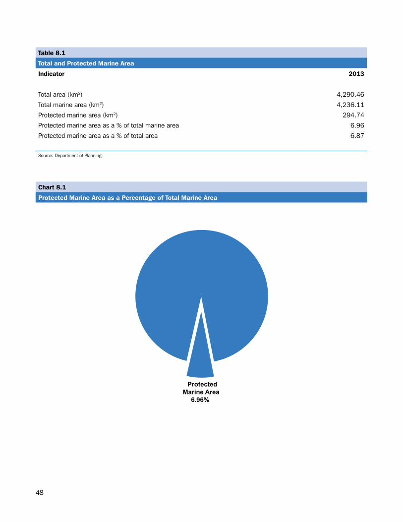
In 2013, the total marine area of Bermuda was 4,236.11 km2, of which 6.96% or 294.74 km2 was classified as protected area (see Table 8.1 and Chart 8.1). There are 29 protected dive sites located in Bermuda covering an area of 13.70 km2. A total of twelve marine parks have been established in Bermuda covering an area of 1.858 km2, two seasonal fisheries protected areas that measure 153.36 km2 and two coral reef preserves, (one each on the north and south shores) which occupy a total of 131.07 km2 (see Table 8.2).
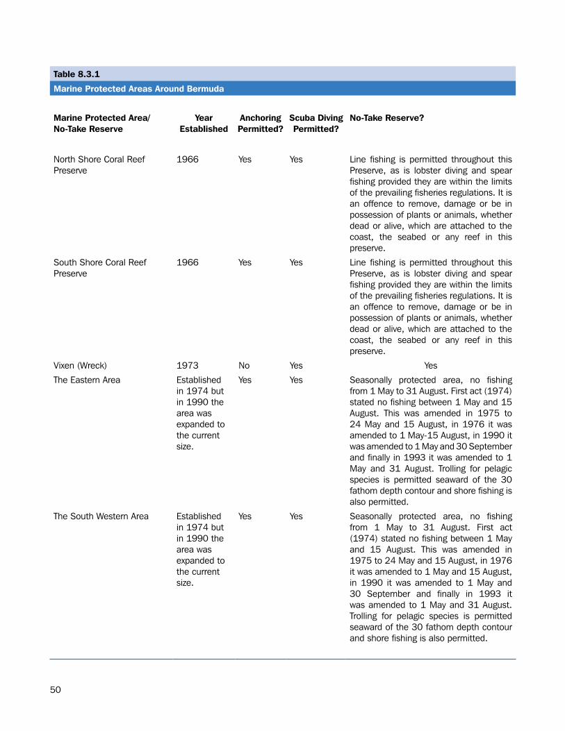
Tables 8.3.1 and 8.3.2 list the various marine protected areas around Bermuda by the year they were established, whether anchoring or scuba diving is permitted and limitations with respect to fishing and extraction of plants and animal species.
Map 8.1 displays the outline of Bermuda’s terrestrial area and identifies the protected seasonal fisheries areas, protected coral reefs and protected dive sites. Fisheries The total quantity of fish landings by species from the years 2009 to 2013 are shown in Table 8.4. In 2013, the total catch was 497.26 metric tons (mT), a decrease of 2.48% from the 509.88 (mT) caught in 2012. The tuna and pelagic species is the most popular catch at 140.97mT or 28.35% of fish landings. In 2013, a total of 315 registered fishermen in Bermuda spent 84,106 hours at sea (see Table 8.5). The 11.52% decrease in registered fishermen accounted for 1,623 less hours (-1.90%) at sea over the previous year.
48
Chart 8.1
Protected Marine Area as a Percentage of Total Marine Area
Protected Marine Area
6.96%
Table 8.1
Total and Protected Marine Area
Indicator 2013
Total area (km2) 4,290.46
Total marine area (km2) 4,236.11
Protected marine area (km2) 294.74
Protected marine area as a % of total marine area 6.96
Protected marine area as a % of total area 6.87
Source: Department of Planning
49
Table 8.2
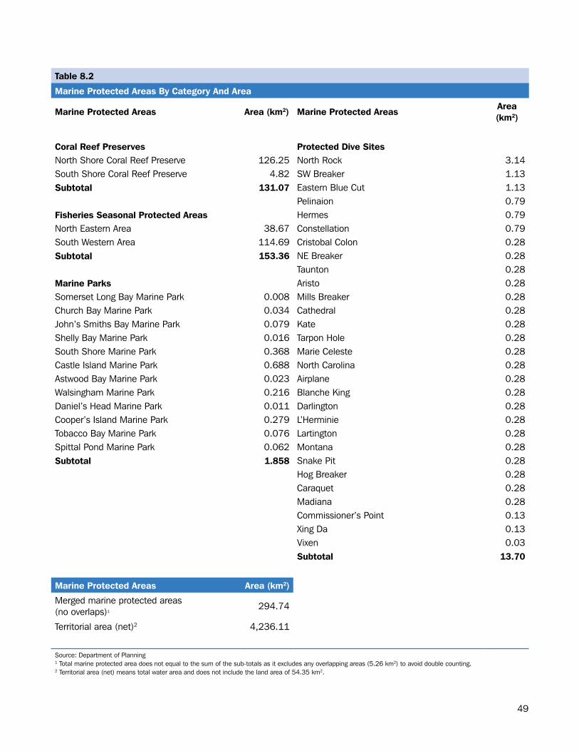
Marine Protected Areas By Category And Area
Marine Protected Areas Area (km2) Marine Protected AreasArea (km2)
Coral Reef Preserves Protected Dive SitesNorth Shore Coral Reef Preserve 126.25 North Rock 3.14South Shore Coral Reef Preserve 4.82 SW Breaker 1.13Subtotal 131.07 Eastern Blue Cut 1.13
Pelinaion 0.79Fisheries Seasonal Protected Areas Hermes 0.79North Eastern Area 38.67 Constellation 0.79South Western Area 114.69 Cristobal Colon 0.28Subtotal 153.36 NE Breaker 0.28
Taunton 0.28Marine Parks Aristo 0.28Somerset Long Bay Marine Park 0.008 Mills Breaker 0.28Church Bay Marine Park 0.034 Cathedral 0.28John’s Smiths Bay Marine Park 0.079 Kate 0.28Shelly Bay Marine Park 0.016 Tarpon Hole 0.28South Shore Marine Park 0.368 Marie Celeste 0.28Castle Island Marine Park 0.688 North Carolina 0.28Astwood Bay Marine Park 0.023 Airplane 0.28Walsingham Marine Park 0.216 Blanche King 0.28Daniel’s Head Marine Park 0.011 Darlington 0.28Cooper’s Island Marine Park 0.279 L’Herminie 0.28Tobacco Bay Marine Park 0.076 Lartington 0.28Spittal Pond Marine Park 0.062 Montana 0.28Subtotal 1.858 Snake Pit 0.28
Hog Breaker 0.28Caraquet 0.28Madiana 0.28Commissioner’s Point 0.13Xing Da 0.13Vixen 0.03Subtotal 13.70
Marine Protected Areas Area (km2)
Merged marine protected areas(no overlaps)1
294.74
Territorial area (net)2 4,236.11
Source: Department of Planning1 Total marine protected area does not equal to the sum of the sub-totals as it excludes any overlapping areas (5.26 km2) to avoid double counting.2 Territorial area (net) means total water area and does not include the land area of 54.35 km2.
50
Table 8.3.1
Marine Protected Areas Around Bermuda
Marine Protected Area/No-Take Reserve
YearEstablished
Anchoring Permitted?
Scuba Diving Permitted?
No-Take Reserve?
North Shore Coral Reef Preserve
1966 Yes Yes Line fishing is permitted throughout this Preserve, as is lobster diving and spear fishing provided they are within the limits of the prevailing fisheries regulations. It is an offence to remove, damage or be in possession of plants or animals, whether dead or alive, which are attached to the coast, the seabed or any reef in this preserve.
South Shore Coral Reef Preserve
1966 Yes Yes Line fishing is permitted throughout this Preserve, as is lobster diving and spear fishing provided they are within the limits of the prevailing fisheries regulations. It is an offence to remove, damage or be in possession of plants or animals, whether dead or alive, which are attached to the coast, the seabed or any reef in this preserve.
Vixen (Wreck) 1973 No Yes Yes
The Eastern Area Established in 1974 but in 1990 the area was expanded to the current size.
Yes Yes Seasonally protected area, no fishing from 1 May to 31 August. First act (1974) stated no fishing between 1 May and 15 August. This was amended in 1975 to 24 May and 15 August, in 1976 it was amended to 1 May-15 August, in 1990 it was amended to 1 May and 30 September and finally in 1993 it was amended to 1 May and 31 August. Trolling for pelagic species is permitted seaward of the 30 fathom depth contour and shore fishing is also permitted.
The South Western Area Established in 1974 but in 1990 the area was expanded to the current size.
Yes Yes Seasonally protected area, no fishing from 1 May to 31 August. First act (1974) stated no fishing between 1 May and 15 August. This was amended in 1975 to 24 May and 15 August, in 1976 it was amended to 1 May and 15 August, in 1990 it was amended to 1 May and 30 September and finally in 1993 it was amended to 1 May and 31 August. Trolling for pelagic species is permitted seaward of the 30 fathom depth contour and shore fishing is also permitted.
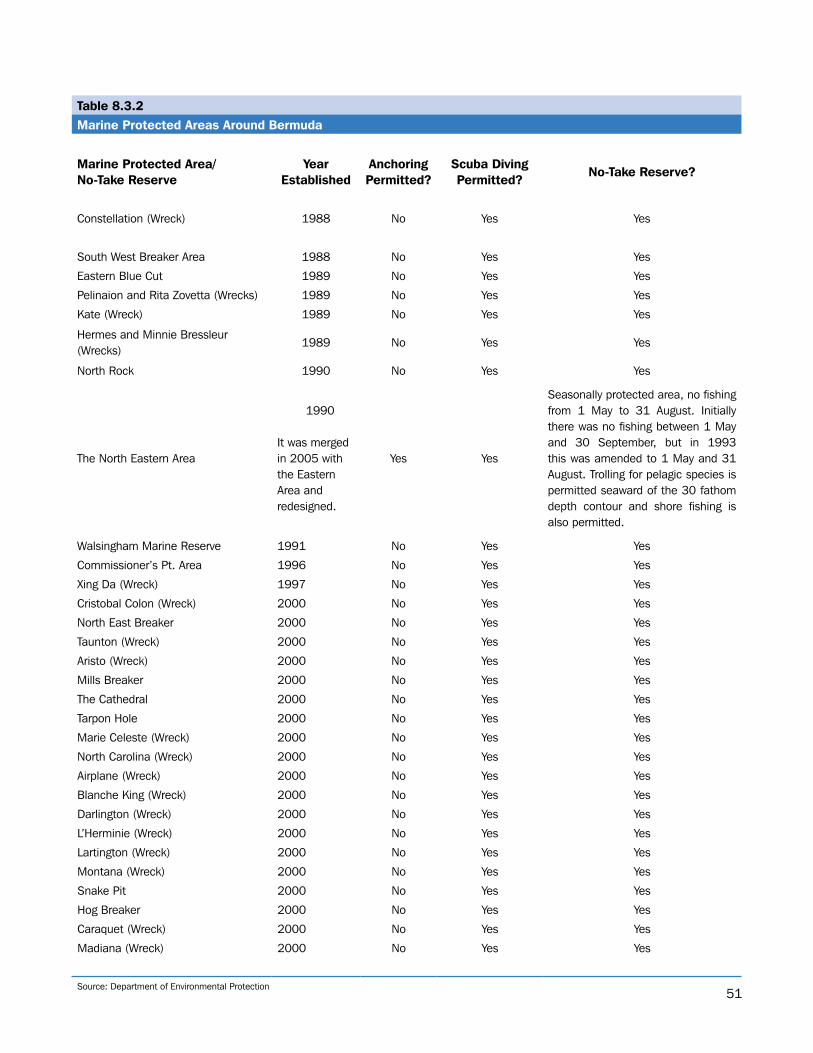
51
Table 8.3.2Marine Protected Areas Around Bermuda
Marine Protected Area/No-Take Reserve
Year Established
Anchoring Permitted?
Scuba DivingPermitted?
No-Take Reserve?
Constellation (Wreck) 1988 No Yes Yes
South West Breaker Area 1988 No Yes Yes
Eastern Blue Cut 1989 No Yes Yes
Pelinaion and Rita Zovetta (Wrecks) 1989 No Yes Yes
Kate (Wreck) 1989 No Yes Yes
Hermes and Minnie Bressleur (Wrecks)
1989 No Yes Yes
North Rock 1990 No Yes Yes
The North Eastern Area
1990 It was merged in 2005 with the Eastern Area and redesigned.
Yes Yes
Seasonally protected area, no fishing from 1 May to 31 August. Initially there was no fishing between 1 May and 30 September, but in 1993 this was amended to 1 May and 31 August. Trolling for pelagic species is permitted seaward of the 30 fathom depth contour and shore fishing is also permitted.
Walsingham Marine Reserve 1991 No Yes Yes
Commissioner’s Pt. Area 1996 No Yes Yes
Xing Da (Wreck) 1997 No Yes Yes
Cristobal Colon (Wreck) 2000 No Yes Yes
North East Breaker 2000 No Yes Yes
Taunton (Wreck) 2000 No Yes Yes
Aristo (Wreck) 2000 No Yes Yes
Mills Breaker 2000 No Yes Yes
The Cathedral 2000 No Yes Yes
Tarpon Hole 2000 No Yes Yes
Marie Celeste (Wreck) 2000 No Yes Yes
North Carolina (Wreck) 2000 No Yes Yes
Airplane (Wreck) 2000 No Yes Yes
Blanche King (Wreck) 2000 No Yes Yes
Darlington (Wreck) 2000 No Yes Yes
L’Herminie (Wreck) 2000 No Yes Yes
Lartington (Wreck) 2000 No Yes Yes
Montana (Wreck) 2000 No Yes Yes
Snake Pit 2000 No Yes Yes
Hog Breaker 2000 No Yes Yes
Caraquet (Wreck) 2000 No Yes Yes
Madiana (Wreck) 2000 No Yes Yes
Source: Department of Environmental Protection
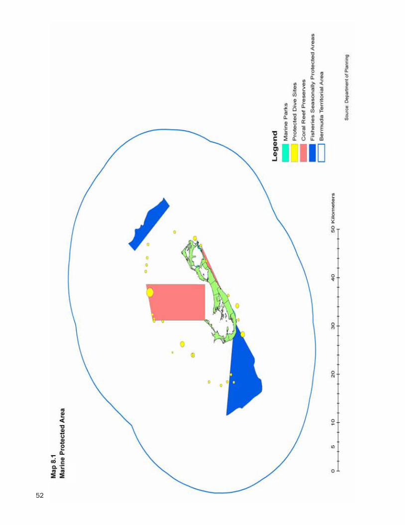
52
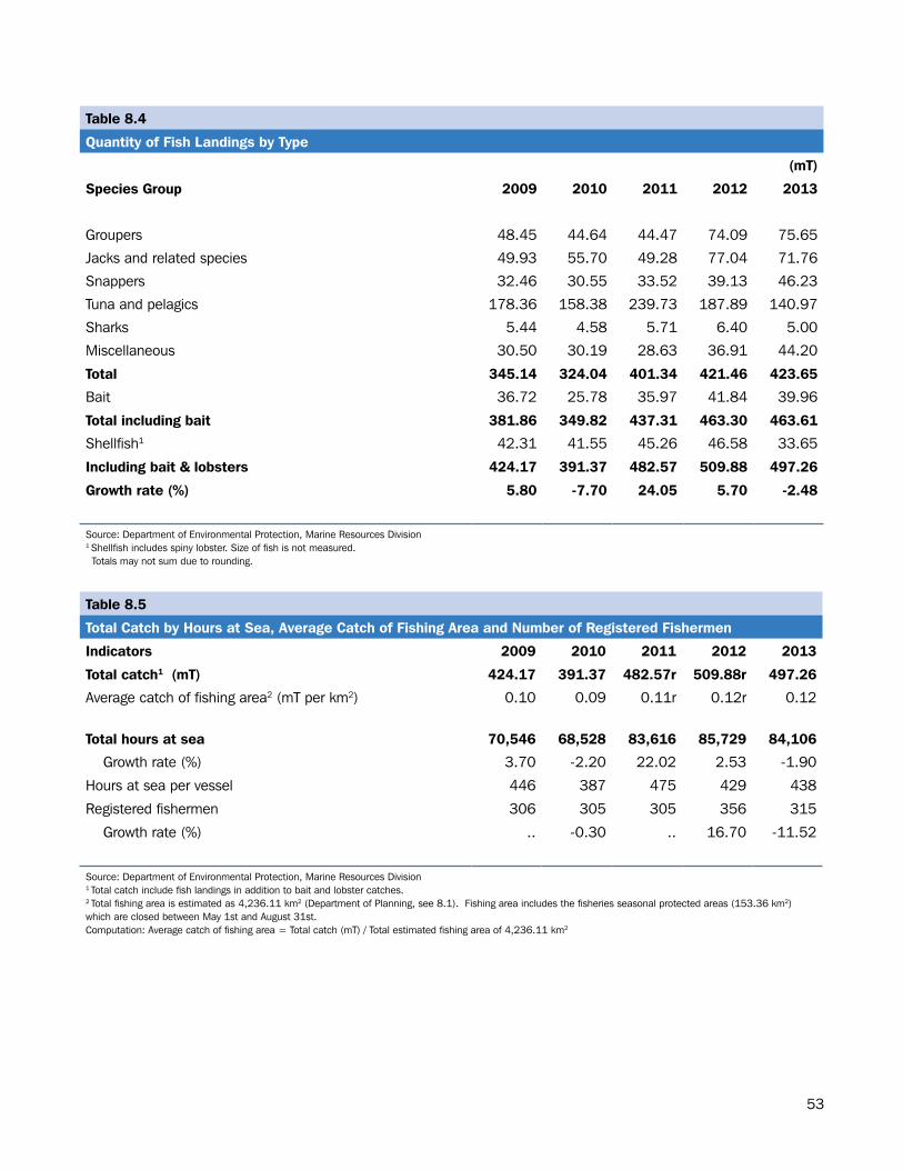
53
Table 8.4
Quantity of Fish Landings by Type
(mT)
Species Group 2009 2010 2011 2012 2013
Groupers 48.45 44.64 44.47 74.09 75.65
Jacks and related species 49.93 55.70 49.28 77.04 71.76
Snappers 32.46 30.55 33.52 39.13 46.23
Tuna and pelagics 178.36 158.38 239.73 187.89 140.97
Sharks 5.44 4.58 5.71 6.40 5.00
Miscellaneous 30.50 30.19 28.63 36.91 44.20
Total 345.14 324.04 401.34 421.46 423.65
Bait 36.72 25.78 35.97 41.84 39.96
Total including bait 381.86 349.82 437.31 463.30 463.61
Shellfish1 42.31 41.55 45.26 46.58 33.65
Including bait & lobsters 424.17 391.37 482.57 509.88 497.26
Growth rate (%) 5.80 -7.70 24.05 5.70 -2.48
Source: Department of Environmental Protection, Marine Resources Division1 Shellfish includes spiny lobster. Size of fish is not measured. Totals may not sum due to rounding.
Table 8.5
Total Catch by Hours at Sea, Average Catch of Fishing Area and Number of Registered Fishermen
Indicators 2009 2010 2011 2012 2013
Total catch1 (mT) 424.17 391.37 482.57r 509.88r 497.26
Average catch of fishing area2 (mT per km2) 0.10 0.09 0.11r 0.12r 0.12
Total hours at sea 70,546 68,528 83,616 85,729 84,106
Growth rate (%) 3.70 -2.20 22.02 2.53 -1.90
Hours at sea per vessel 446 387 475 429 438
Registered fishermen 306 305 305 356 315
Growth rate (%) .. -0.30 .. 16.70 -11.52
Source: Department of Environmental Protection, Marine Resources Division1 Total catch include fish landings in addition to bait and lobster catches.2 Total fishing area is estimated as 4,236.11 km2 (Department of Planning, see 8.1). Fishing area includes the fisheries seasonal protected areas (153.36 km2) which are closed between May 1st and August 31st.Computation: Average catch of fishing area = Total catch (mT) / Total estimated fishing area of 4,236.11 km2
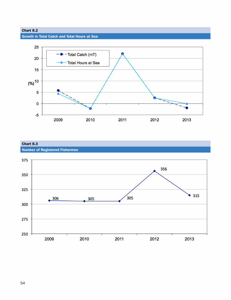
54
Chart 8.2
Growth in Total Catch and Total Hours at Sea
Chart 8.3
Number of Registered Fishermen
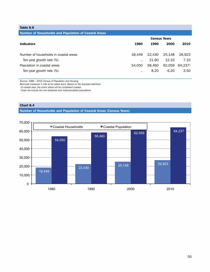
55
Table 8.6
Number of Households and Population of Coastal Areas
Census Years
Indicators 1980 1990 2000 2010
Number of households in coastal areas 18,449 22,430 25,148 26,923
Ten-year growth rate (%) .. 21.60 12.10 7.10
Population in coastal areas 54,050 58,460 62,059 64,2371
Ten-year growth rate (%) .. 8.20 6.20 3.50
Source: 1980 - 2010 Census of Population and HousingBermuda measures 1 mile at its widest point. Based on the standard definition of coastal area, the entire island will be considered coastal. 1 Does not include the non-sheltered and institutionalized populations
Chart 8.4
Number of Households and Population of Coastal Areas (Census Years)
18,449 22,430
25,148 26,923
54,050 58,460
62,059 64,237
0
10,000
20,000
30,000
40,000
50,000
60,000
70,000
1980 1990 2000 2010
Coastal Households Coastal Population
56
BIODIVERSITY
57
Section.9:.Biodiversity.
Biodiversity refers to the number and variety of species of plant and animal life within a particular ecosystem. It also encompasses variation in the genetic makeup of each species and the different ecosystems that they form. Biodiversity has direct consumptive value in food, agriculture, medicine and industry and has aesthetic and recreational value. (CARICOM Environment Programme)
This section contains information on the protected land areas in Bermuda such as protected coastal reserves, protected open space, historical cave areas and parks.
Protected Area: Land and Water
In 2013, Bermuda’s total protected area inclusive of land and water was 319.66 square kilometers (km2). This represented almost 7.45 percent of the total area (6.87% water and 0.58% land) (see Table 9.1).
As a proportion of the total land area (54.35 km2), protected land area represented 45.84 percent or 24.92 km2 while protected water areas represented 6.96 percent or 294.74 km2 of total water area (see Table 9.1).
A breakdown of protected land area shows that conservation base zones (open space, waste reserves, nature reserves and parks) totaled 19.28 km2. Conservation areas (agriculture and woodland reserves) accounted for 7.19 km2, cave protection areas occupied 4.48 km2 and historical protected areas less than 1.00 km2 (see Table 9.2).
Map 9.1 displays the terrestrial protected areas including marine parks by category across Bermuda.
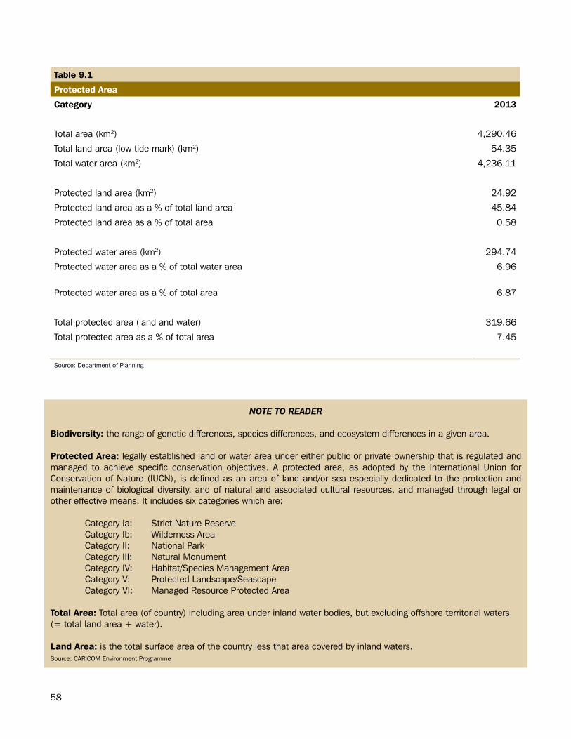
58
Table 9.1
Protected Area
Category 2013
Total area (km2) 4,290.46
Total land area (low tide mark) (km2) 54.35
Total water area (km2) 4,236.11
Protected land area (km2) 24.92
Protected land area as a % of total land area 45.84
Protected land area as a % of total area 0.58
Protected water area (km2) 294.74
Protected water area as a % of total water area 6.96
Protected water area as a % of total area 6.87
Total protected area (land and water) 319.66
Total protected area as a % of total area 7.45
Source: Department of Planning
NOTE TO READER
Biodiversity: the range of genetic differences, species differences, and ecosystem differences in a given area.
Protected Area: legally established land or water area under either public or private ownership that is regulated and managed to achieve specific conservation objectives. A protected area, as adopted by the International Union for Conservation of Nature (IUCN), is defined as an area of land and/or sea especially dedicated to the protection and maintenance of biological diversity, and of natural and associated cultural resources, and managed through legal or other effective means. It includes six categories which are:
Category Ia: Strict Nature ReserveCategory Ib: Wilderness Area Category II: National ParkCategory III: Natural MonumentCategory IV: Habitat/Species Management AreaCategory V: Protected Landscape/SeascapeCategory VI: Managed Resource Protected Area
Total Area: Total area (of country) including area under inland water bodies, but excluding offshore territorial waters (= total land area + water).
Land Area: is the total surface area of the country less that area covered by inland waters.Source: CARICOM Environment Programme
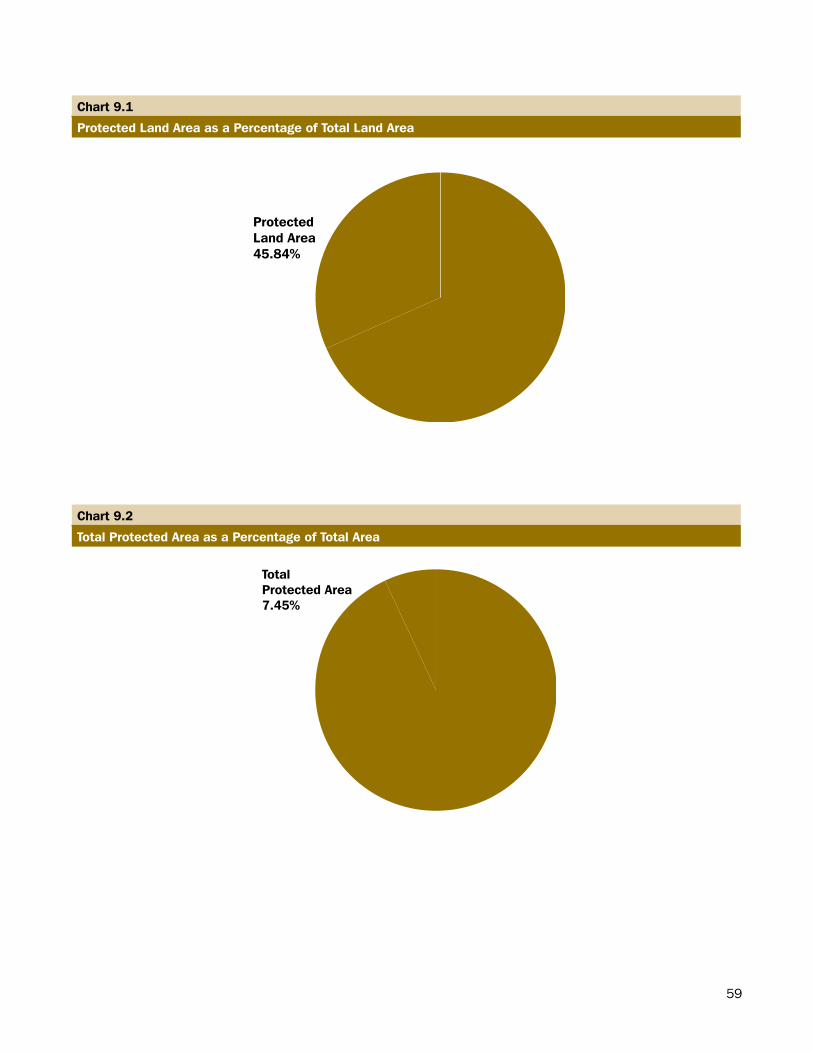
59
Chart 9.1
Protected Land Area as a Percentage of Total Land Area
ProtectedLand Area45.84%
Chart 9.2
Total Protected Area as a Percentage of Total Area
TotalProtected Area7.45%
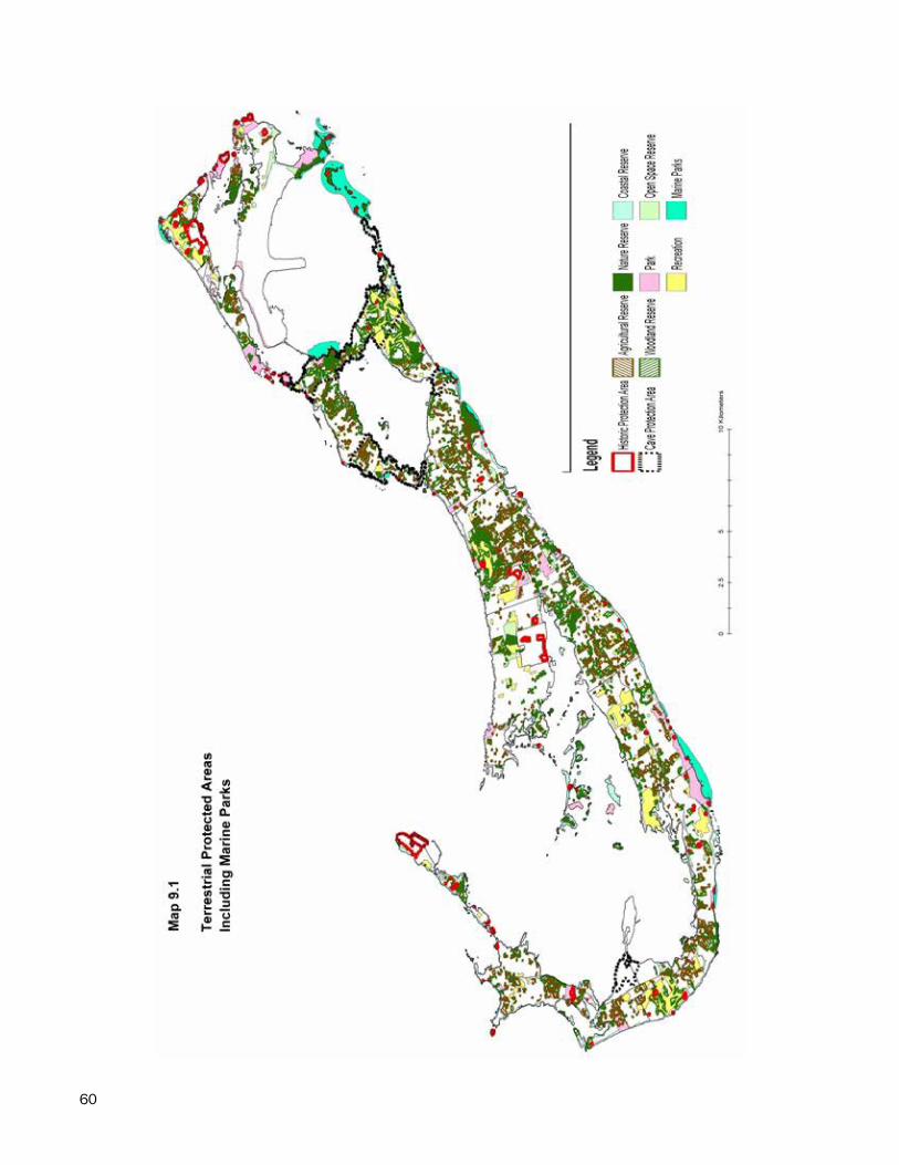
60
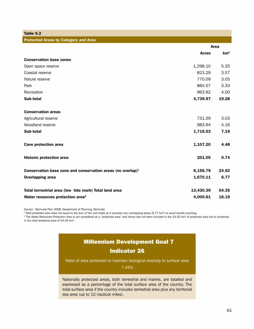
61
Millennium Development Goal 7
Indicator 26
Ratio of area protected to maintain biological diversity to surface area
7.45%
Nationally protected areas, both terrestrial and marine, are totalled and expressed as a percentage of the total surface area of the country. The total surface area if the country includes terrestrial area plus any territorial sea area (up to 12 nautical miles).
Table 9.2
Protected Areas by Category and Area
Area
Acres km2
Conservation base zones
Open space reserve 1,298.10 5.35
Coastal reserve 823.29 3.57
Nature reserve 770.09 3.05
Park 884.57 3.33
Recreation 963.92 4.00
Sub-total 4,739.97 19.28
Conservation areas
Agricultural reserve 731.59 3.03
Woodland reserve 983.94 4.16
Sub-total 1,715.53 7.19
Cave protection area 1,107.20 4.48
Historic protection area 201.05 0.74
Conservation base zone and conservation areas (no overlap)1 6,156.79 24.92
Overlapping area 1,670.11 6.77
Total terrestrial area (low tide mark) Total land area 13,430.39 54.35
Water resources protection area2 4,000.61 16.19
Source: Bermuda Plan 2008, Department of Planning, Bermuda1 Total protected area does not equal to the sum of the sub-totals as it excludes any overlapping areas (6.77 km2) to avoid double counting.2 The Water Resources Protection Area is not considered as a “protected area” and hence has not been included in the 24.92 km2 of protected area but is contained in the total terrestrial area of 54.35 km2.

62
FORESTRY
63
Section.10:.Forestry
The forestry section of the Environmental Statistics Compendium includes a table with information on forest area in Bermuda.
Forestry
In 2013, Bermuda’s total forest area was 4.16 square kilometers (km2). This represented 7.65% of Bermuda’s total land area.
NOTE TO READER
Forest: Land under forestry or no land use, spanning more than 0.005 km2 (0.5 hectares); with trees higher than 5 meters and a canopy cover of more than 10 percent, or trees able to reach these thresholds in situ. This section includes mangroves and forests on wetlands according to the above height and canopy coverage.
Protected Area: A protected area, as adopted by the International Union for Conservation of Nature (IUCN), is defined as an area of land and/or sea especially dedicated to the protection and maintenance of biological diversity, and of natural and associated cultural resources, and managed through legal or other effective means.
Total Area: Total area (of country) including area under inland water bodies, but excluding offshore territorial waters (= total land area + water).
Land Area: is the land area excluding area under inland or tidal water bodies.Source: CARICOM Environment Programme
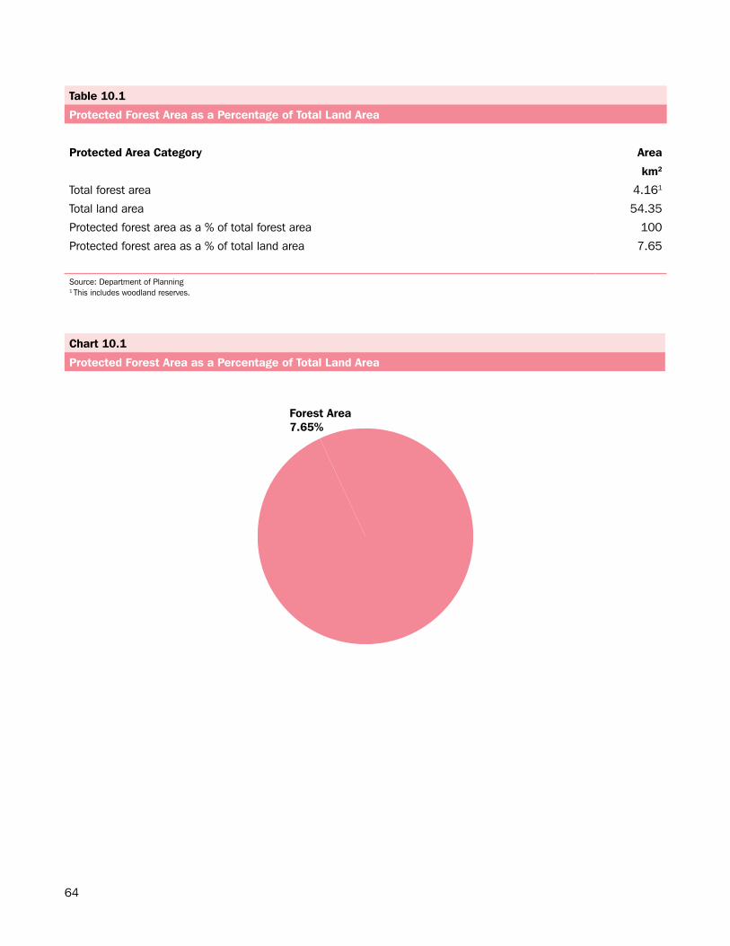
64
Chart 10.1
Protected Forest Area as a Percentage of Total Land Area
Forest Area7.65%
Table 10.1
Protected Forest Area as a Percentage of Total Land Area
Protected Area Category Area
km2
Total forest area 4.161
Total land area 54.35
Protected forest area as a % of total forest area 100
Protected forest area as a % of total land area 7.65
Source: Department of Planning1 This includes woodland reserves.
65
AIR
66
Section.11:.Air
The air quality in Bermuda is a valued part of its natural resources. Six ambient air monitoring sites have been set up island-wide to monitor air quality and keep levels of pollutants within the Bermuda limit (Clean Air Regulations 1993) (Map 11.1).
This section includes information on air emissions by pollutants from the various ambient air monitoring sites. Table 11.2 provides the average annual, hourly and daily concentrations of the various pollutants from the different monitoring sites.
Table 11.3 illustrates the maximum concentration for pollutants at the various collection sites. In 2013, the Langton Hill monitoring site recorded a daily maximum concentration of sulfur dioxide (SO2) of 127.00 µg/m3. This recording was the highest among all six monitoring sites; however, the recording fell below the Bermuda limit of 150.00 µg/m3 set by the Clean Air Regulations 1993.
Figures 11.1 and 11.2 highlight the average fine Particular Matter (PM10) concentration for 2013 on a daily basis. Note that exceedances of PM10 (i.e. particular matter <10µm diameter) can arise from natural sources (i.e. pollen, sea aerosols, dust) as well as from combustion of petroleum and other combustibles. Bermuda is currently determining what PM2.5 limit shall be introduced. The data in Figure 11.1 shows that between April and May the busy road at East Broadway was very close to reaching the 24 hour mean limit of average PM10 concentration in comparison to the other listed sites.
Map 11.3 highlights the locations of the six ambient air monitoring sites in Bermuda.
Unit Unit Measure
µg/m3 Micrograms
NO2 Nitrogen Dioxide
SO2 Sulfur Dioxide
ppb parts per billion
TSP Total Suspended Particles
PM10/PM2.5 Fine Particulate Matter
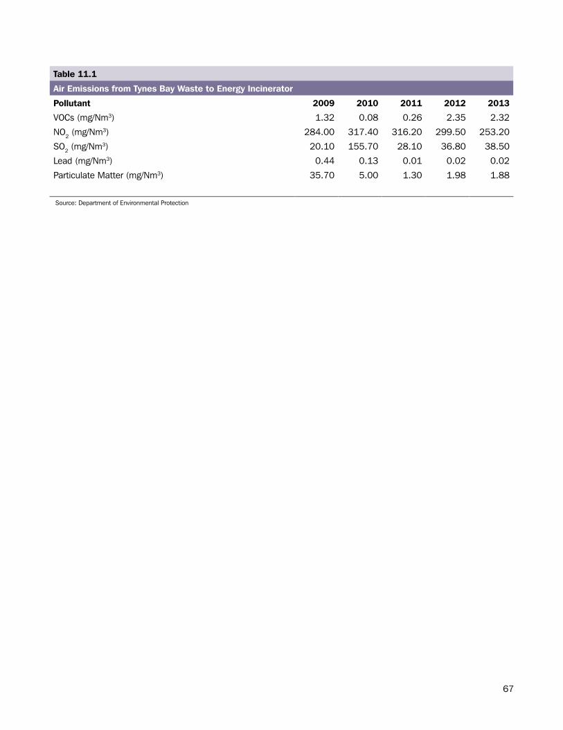
67
Table 11.1
Air Emissions from Tynes Bay Waste to Energy Incinerator
Pollutant 2009 2010 2011 2012 2013
VOCs (mg/Nm3) 1.32 0.08 0.26 2.35 2.32
NO2 (mg/Nm3) 284.00 317.40 316.20 299.50 253.20
SO2 (mg/Nm3) 20.10 155.70 28.10 36.80 38.50
Lead (mg/Nm3) 0.44 0.13 0.01 0.02 0.02
Particulate Matter (mg/Nm3) 35.70 5.00 1.30 1.98 1.88
Source: Department of Environmental Protection
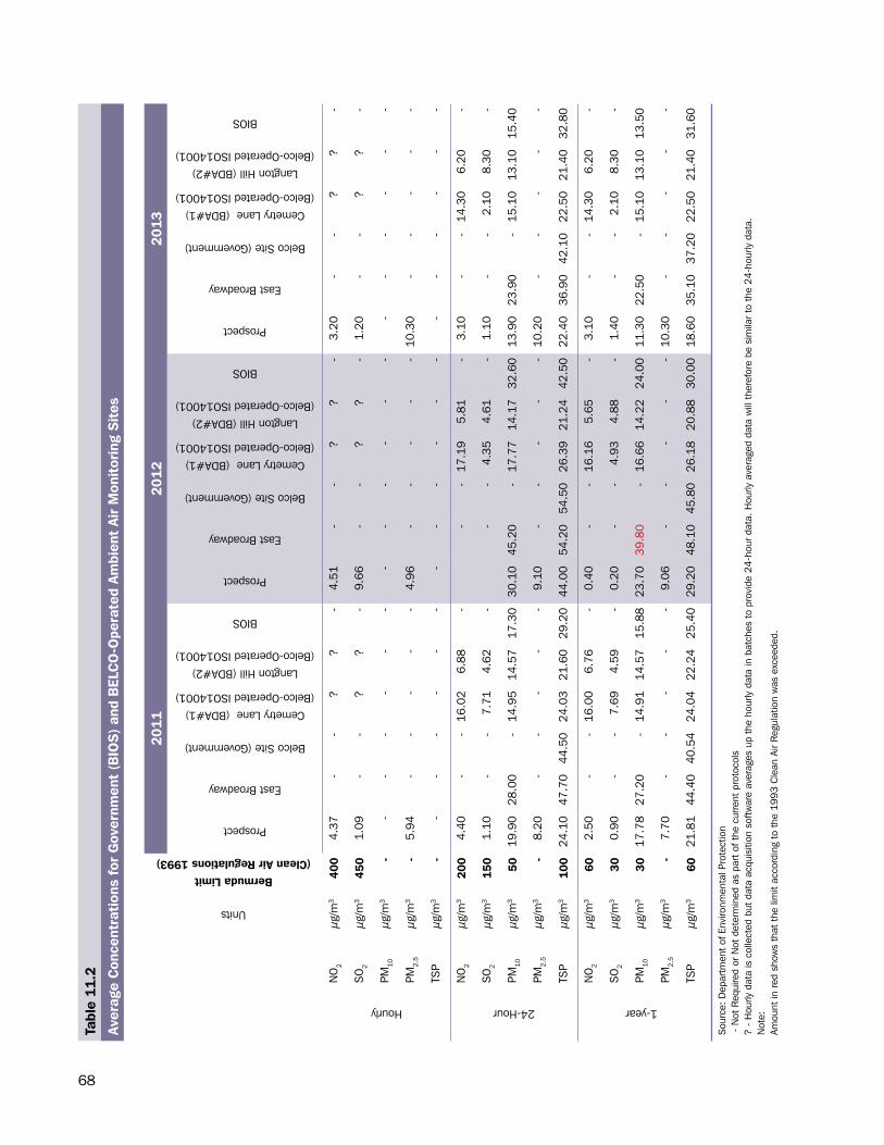
68
Tabl
e 11
.2
Aver
age
Con
cent
rati
ons
for
Gov
ernm
ent
(BIO
S)
and
BEL
CO
-Ope
rate
d Am
bien
t Ai
r M
onit
orin
g S
ites
Units
Bermuda Limit (Clean Air Regulations 1993)
201
120
1220
13
Prospect
East Broadway
Belco Site (Government)
Cemetry Lane (BDA#1) (Belco-Operated ISO14001)
Langton Hill (BDA#2) (Belco-Operated ISO14001)
BIOS
Prospect
East Broadway
Belco Site (Government)
Cemetry Lane (BDA#1) (Belco-Operated ISO14001)
Langton Hill (BDA#2) (Belco-Operated ISO14001)
BIOS
Prospect
East Broadway
Belco Site (Government)
Cemetry Lane (BDA#1) (Belco-Operated ISO14001)
Langton Hill (BDA#2) (Belco-Operated ISO14001)
BIOS
Hourly
NO
2µg
/m3
400
4.37
--
??
-4.
51-
-?
?-
3.20
--
??
-
SO
2µg
/m3
450
1.09
--
??
-9.
66-
-?
?-
1.20
--
??
-
PM10
µg/m
3-
--
--
--
--
--
--
--
--
--
PM2.
5µg
/m3
-5.
94-
--
--
4.96
--
--
-10
.30
--
--
-
TSP
µg/m
3-
--
--
--
--
--
--
--
--
--
24-Hour
NO
2µg
/m3
200
4.40
--
16.0
26.
88-
--
17.1
95.
81-
3.10
--
14.3
06.
20-
SO
2µg
/m3
150
1.10
--
7.71
4.62
--
-4.
354.
61-
1.10
--
2.10
8.30
-
PM10
µg/m
350
19.9
028
.00
-14
.95
14.5
717
.30
30.1
045
.20
-17
.77
14.1
732
.60
13.9
023
.90
-15
.10
13.1
015
.40
PM2.
5µg
/m3
-8.
20-
--
--
9.10
--
--
-10
.20
--
--
-
TSP
µg/m
310
024
.10
47.7
044
.50
24.0
321
.60
29.2
044
.00
54.2
054
.50
26.3
921
.24
42.5
022
.40
36.9
042
.10
22.5
021
.40
32.8
0
1-year
NO
2µg
/m3
602.
50-
-16
.00
6.76
-0.
40-
-16
.16
5.65
-3.
10-
-14
.30
6.20
-
SO
2µg
/m3
300.
90-
-7.
694.
59-
0.20
--
4.93
4.88
-1.
40-
-2.
108.
30-
PM10
µg/m
330
17.7
827
.20
-14
.91
14.5
715
.88
23.7
039
.80
-16
.66
14.2
224
.00
11.3
022
.50
-15
.10
13.1
013
.50
PM2.
5µg
/m3
-7.
70-
--
--
9.06
--
--
-10
.30
--
--
-
TSP
µg/m
360
21.8
144
.40
40.5
424
.04
22.2
425
.40
29.2
048
.10
45.8
026
.18
20.8
830
.00
18.6
035
.10
37.2
022
.50
21.4
031
.60
Sou
rce:
Dep
artm
ent
of E
nviro
nmen
tal P
rote
ctio
n -
Not
Req
uire
d or
Not
det
erm
ined
as
part
of t
he c
urre
nt p
roto
cols
? -
Hou
rly d
ata
is c
olle
cted
but
dat
a ac
quis
ition
sof
twar
e av
erag
es u
p th
e ho
urly
dat
a in
bat
ches
to
prov
ide
24-h
our
data
. Hou
rly a
vera
ged
data
will
the
refo
re b
e si
mila
r to
the
24-
hour
ly d
ata.
Not
e:
Amou
nt in
red
sho
ws
that
the
lim
it ac
cord
ing
to t
he 1
993
Cle
an A
ir R
egul
atio
n w
as e
xcee
ded.
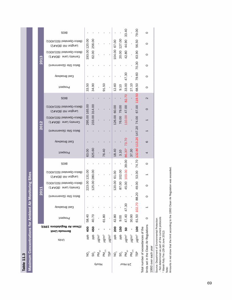
69
Tabl
e 11
.3
Max
imum
Con
cent
rati
ons
for
Ambi
ent
Air
Mon
itor
ing
Sit
es
Units
Bermuda Limit (Clean Air Regulations 1993)
201
120
1220
13
Prospect
East Broadway
Belco Site (Government)
Cemetry Lane (BDA#1) (Belco-Operated ISO14001)
Langton Hill (BDA#2) (Belco-Operated ISO14001)
BIOS
Prospect
East Broadway
Belco Site (Government)
Cemetry Lane (BDA#1) (Belco-Operated ISO14001)
Langton Hill (BDA#2) (Belco-Operated ISO14001)
BIOS
Prospect
East Broadway
Belco Site (Government)
Cemetry Lane (BDA#1) (Belco-Operated ISO14001)
Langton Hill (BDA#2) (Belco-Operated ISO14001)
BIOS
Hourly
NO
2pp
b40
058
.40
--
223.
0013
1.00
-63
.00
--
295.
0016
5.00
-33
.50
--
193.
0012
0.00
-
SO
2pp
b45
040
.70
--
125.
0028
0.00
-32
5.60
--
233.
0031
4.00
-34
.90
--
62.0
025
6.00
-
PM10
µg/m
3-
--
--
--
--
--
--
--
--
--
PM2.
5µg
/m3
-61
.80
--
--
-76
.40
--
--
-91
.50
--
--
-
TSP
µg/m
3-
--
--
--
--
--
--
--
--
--
24-Hour
NO
2pp
b20
042
.80
--
120.
0061
.00
-18
.40
--
126.
0060
.00
-12
.60
--
104.
0067
.00
-
SO
2pp
b15
09.
00-
-87
.00
102.
00-
3.10
--
76.0
079
.00
-9.
10-
-20
.00
127.
00-
PM10
µg/m
350
47.4
047
.30
-45
.00
103.
0039
.00
86.3
0173
.70
-11
0.00
47.0
082
.70
33.0
047
.30
-42
.80
44.9
033
.40
PM2.
5µg
/m3
-30
.90
--
--
-37
.30
--
--
-27
.10
--
--
-
TSP
µg/m
310
061
.50
102.
7088
.20
49.0
053
.00
74.7
013
2.80
113.
2014
7.20
74.0
067
.00
119.
5068
.50
79.6
070
.30
63.9
056
.50
79.0
0
Tota
l num
ber
of e
xcee
danc
es o
f the
lim
its s
et in
the
Cle
an A
ir R
egul
atio
ns
1993
ove
r ea
ch y
ear
01
00
10
46
11
02
00
00
00
Sou
rce:
Dep
artm
ent
of E
nviro
nmen
tal P
rote
ctio
n -
Not
det
erm
ined
as
part
of t
he c
urre
nt p
roto
cols
1 M
arsh
Fol
ly F
ire (
29-3
0 Ju
ne 2
012)
Not
e:
Amou
nts
in r
ed s
how
tha
t th
e lim
it ac
cord
ing
to t
he 1
993
Cle
an A
ir R
egul
atio
n w
as e
xcee
ded.
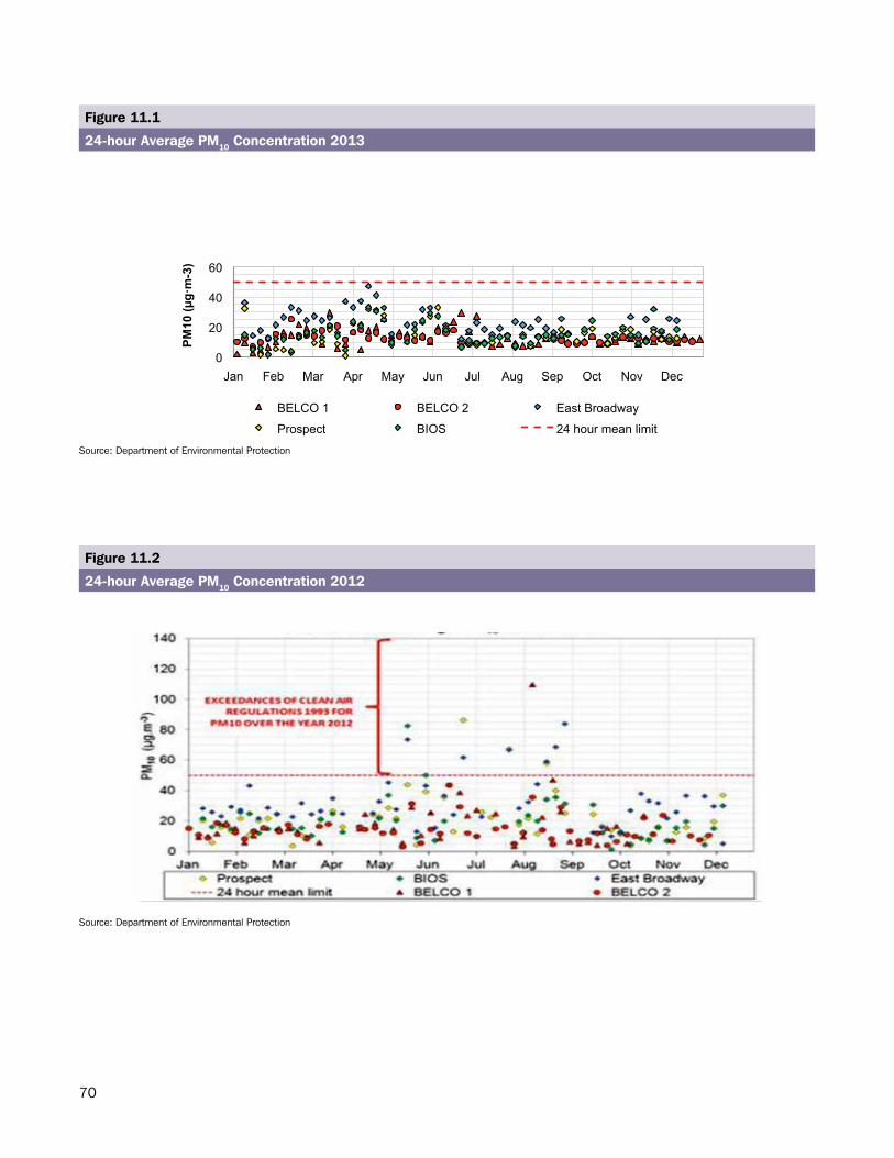
70
0
20
40
60
Jan Feb Mar Apr May Jun Jul Aug Sep Oct Nov Dec
PM10
(g
m-3
)
BELCO 1 BELCO 2 East Broadway
Prospect BIOS 24 hour mean limit
Figure 11.1
24-hour Average PM10 Concentration 2013
Figure 11.2
24-hour Average PM10 Concentration 2012
Source: Department of Environmental Protection
Source: Department of Environmental Protection
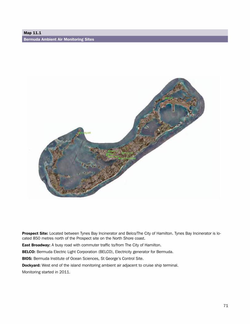
71- 67 -
Map 11.1
Bermuda Ambient Air Monitoring Sites
Prospect Site: Located between Tynes Bay Waste to Energy Facility and Belco/Hamilton City.
East Broadway: A busy roadside with commuter traffic into Hamilton City.
BELCO: Bermuda Electric Light Company (BELCO), Electricity generator for Bermuda.
BIOS: Bermuda Institute of Ocean Sciences, St George's. Control Site.
Dockyard: West end of the island monitoring ambient air adjacent to cruise ship terminal. Moni-toring started 2011.
Tynes Bay Waste to Energy Facility is located 850 metres due north of the Prospect site on the North Shore coast.
Prospect Site: Located between Tynes Bay Incinerator and Belco/The City of Hamilton. Tynes Bay Incinerator is lo-cated 850 metres north of the Prospect site on the North Shore coast.
East Broadway: A busy road with commuter traffic to/from The City of Hamilton.
BELCO: Bermuda Electric Light Corporation (BELCO), Electricity generator for Bermuda.
BIOS: Bermuda Institute of Ocean Sciences, St George’s Control Site.
Dockyard: West end of the island monitoring ambient air adjacent to cruise ship terminal.
Monitoring started in 2011.
Map 11.1
Bermuda Ambient Air Monitoring Sites
72
WASTE
73
Section.12:.Waste
The section on waste comprises information regarding the generation and disposal of solid waste in Bermuda. The 2013 numbers are estimates except for those related to incineration.
Generation
The total waste collected in 2013 was 84,600 tonnes, an increase of 2,600 tonnes from 2012. Household waste accounted for 28,300 tonnes for 2013 while waste from other sources accounted for 56,300 tonnes (Table 12.1).
Management
The Waste Management Section of the Ministry of Public Works follows a Comprehensive Waste Management Strategy (CWMS) to divide waste handling into:
1. Waste reduction2. Recycling3. Composting4. Energy from waste (Incineration)5. Land creation (Land-filling)6. Special disposal of hazardous waste
In 2013, 1,600 tonnes of waste was recycled, 15,000 tonnes of horticultural waste was composted, 58,000 tonnes of waste was incinerated to generate electricity and 10,000 tonnes of waste was land-filled (Table 12.2).
Waste Reduction
Waste reduction aims to limit the amount of garbage produced thereby reducing environmental and economic costs associated with collection, processing and disposal.
The Waste Management Section continues to educate and conduct waste audits with schools and businesses. Data generated from these waste audits is being applied as a means to minimize waste and divert resources. Waste reduction results in a lessening of the environmental impact of doing business, costs of waste removal and wasteful consumption patterns which can affect bottom line results.
Recycling
Recycling was estimated to be unchanged at 127 container loads of materials either exported for the US recycling market or reused on island in 2013 (Chart 12.1).
Recycling or the reprocessing of materials helps to reduce the burden on the Tynes Bay Waste to Energy incinerator by removing non-combustible items from the waste-stream, reduces dependence on land-filling and is an environmentally sound choice whenever possible.
Composting
Approximately 15,000 tonnes of horticultural waste was composted in 2013 using the windrow composting technique. The end product is a soil amendment that is available to the public for horticultural practices.
Special Waste
Special wastes are items requiring specific handling and disposal due to their potentially hazardous nature. These
74
materials are consolidated and packaged in Bermuda according to the United States Environmental Protection Agency (US EPA) standards and exported to the United States where they are processed for the reuse or recycling markets whenever possible (see starred items, Chart 12.1). Where recycling or reuse is not possible Special Waste is disposed of at US EPA certified controlled land-fill disposal sites. The respective amounts are shown in Table 12.3.
In 2013, Bermuda exported 501 tonnes of Special Waste for either the recyclables market or safe disposal.
Note to Reader
Waste: This is any article or substance (including scrap metal or other surplus arising from the application of a process) which is not liquid and either requires to be disposed of as being unwanted, broken, worn out, contaminated or otherwise spoilt or useless, or in relation to a particular person, has been discarded by.
Household Waste: This is waste that comes from a private dwelling, being a dwelling that is not considered as commercial premises; or waste from premises operated by a charity registered under the Charities Act 1978.
Source: The Waste and Litter Control Act, 1987
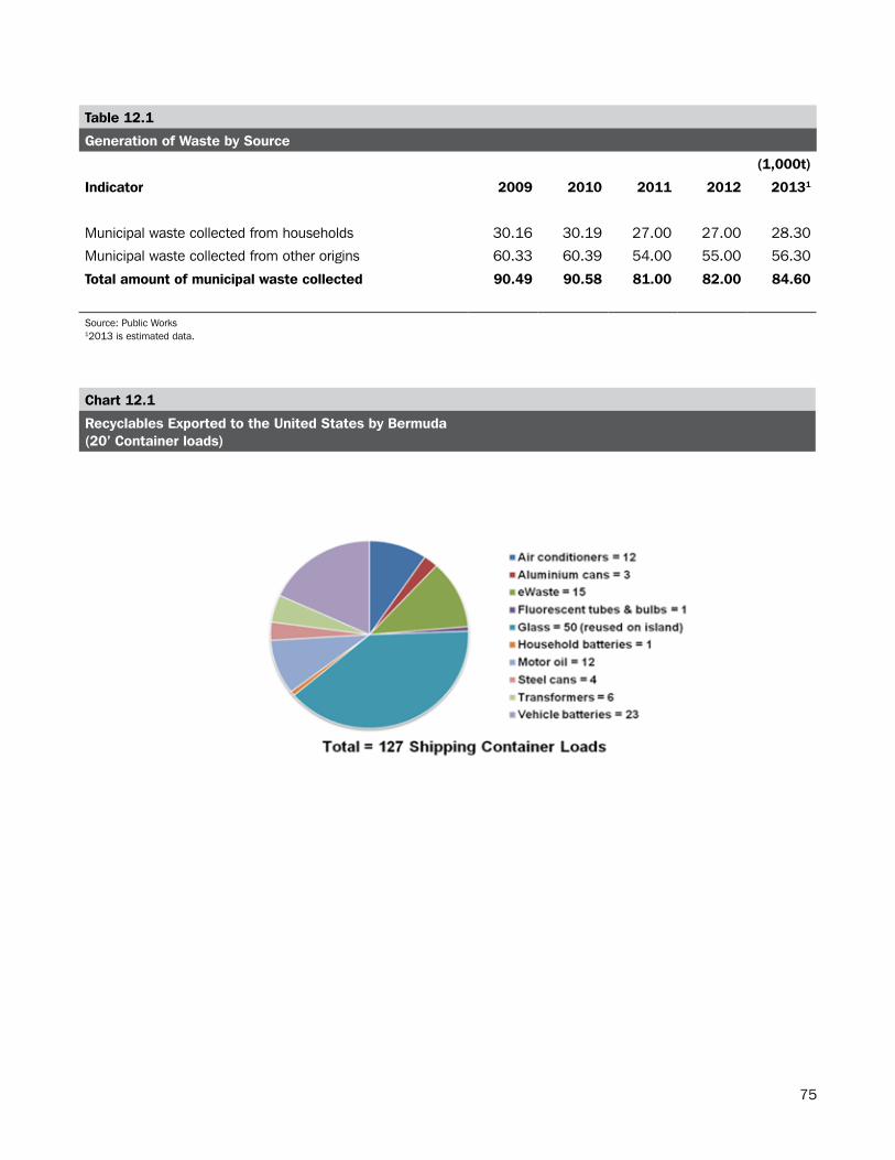
75
Table 12.1
Generation of Waste by Source
(1,000t)
Indicator 2009 2010 2011 2012 20131
Municipal waste collected from households 30.16 30.19 27.00 27.00 28.30
Municipal waste collected from other origins 60.33 60.39 54.00 55.00 56.30
Total amount of municipal waste collected 90.49 90.58 81.00 82.00 84.60
Source: Public Works12013 is estimated data.
Chart 12.1
Recyclables Exported to the United States by Bermuda(20’ Container loads)
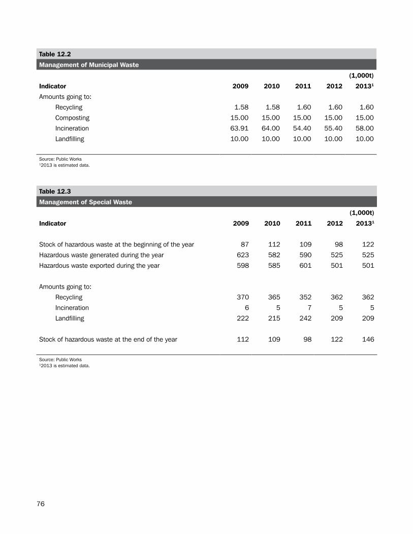
76
Table 12.2
Management of Municipal Waste
(1,000t)
Indicator 2009 2010 2011 2012 20131
Amounts going to:
Recycling 1.58 1.58 1.60 1.60 1.60
Composting 15.00 15.00 15.00 15.00 15.00
Incineration 63.91 64.00 54.40 55.40 58.00
Landfilling 10.00 10.00 10.00 10.00 10.00
Source: Public Works12013 is estimated data.
Table 12.3
Management of Special Waste
(1,000t)
Indicator 2009 2010 2011 2012 20131
Stock of hazardous waste at the beginning of the year 87 112 109 98 122
Hazardous waste generated during the year 623 582 590 525 525
Hazardous waste exported during the year 598 585 601 501 501
Amounts going to:
Recycling 370 365 352 362 362
Incineration 6 5 7 5 5
Landfilling 222 215 242 209 209
Stock of hazardous waste at the end of the year 112 109 98 122 146
Source: Public Works12013 is estimated data.
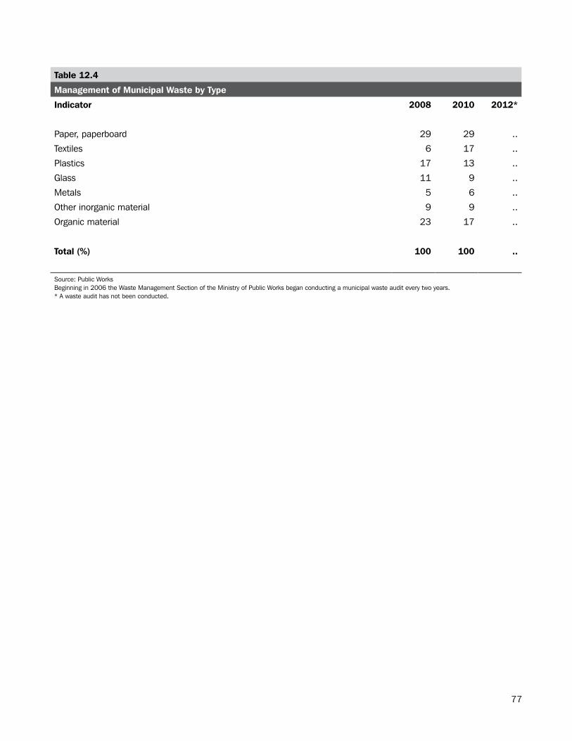
77
Table 12.4
Management of Municipal Waste by Type
Indicator 2008 2010 2012*
Paper, paperboard 29 29 ..
Textiles 6 17 ..
Plastics 17 13 ..
Glass 11 9 ..
Metals 5 6 ..
Other inorganic material 9 9 ..
Organic material 23 17 ..
Total (%) 100 100 ..
Source: Public WorksBeginning in 2006 the Waste Management Section of the Ministry of Public Works began conducting a municipal waste audit every two years.* A waste audit has not been conducted.
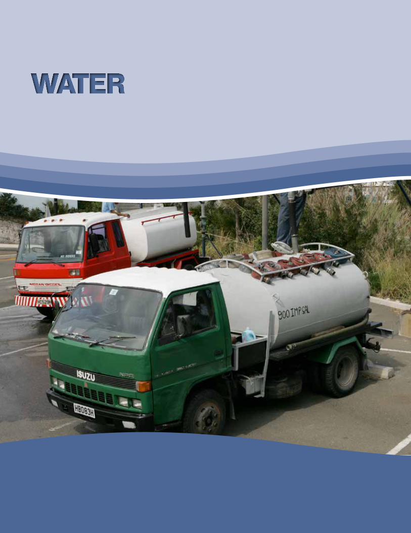
78
WATER
79
Section.13:.Water
Water is an essential ingredient for all life and is used in the production of almost all goods. It is therefore vital to monitor the state of water resources and to ensure sustainable use of this important commodity.
In 2012, the total volume of atmospheric wet precipitation (rain, dew, etc.) falling on the island was 67.92 mio m3/y (See Table 13.1). The total fresh water made available for use was 3.52 mio m3/y (See Table 13.2).
Map 13.1 shows water resource protection areas in Bermuda as of 2007.
* Note: At the time of publishing, data for 2010 to 2013 were not available for some tables.
80
Table 13.1
Renewable Freshwater Resources
mio m3/y
Category 2010 2011 2012 2013
Precipitation 63.78 56.05 67.92 ..
Actual evapotranspiration .. .. .. ..
Internal flow .. .. .. ..
Renewable freshwater resources .. .. .. ..
Regular freshwater resources 95% of the time .. .. .. ..
Source: Department of Environmental Protection
NOTE TO READER
Precipitation: total volume of atmospheric wet precipitation (rain, dew, etc.) falling on the territory of the country over one year.
Actual evapotranspiration: total actual volume of evaporation from the ground, wetlands, and natural water bodies and transpiration of plants.
Internal flow: total volume of river run-off and groundwater generated over the period of a year, in natural conditions, exclusively by precipitation into a territory. It is equal to the precipitation less actual evapotranspiration.
Renewable freshwater resources: equal internal flow plus any inflow of surface and groundwaters.
Regular freshwater resources 95% of the time: portion of the total freshwater resource that can be depended on for annual water development during 19 out of 20 consecutive years, or at least 95% of the years included in longer consecutive periods. This item yields information about the average annual long-term availability of freshwater for use in human activities.
Source: United Nations Statistics Division (UNSD) and United Nations Enviroment Programme (UNEP)
81
Table 13.2
Water Use Balance
mio m3/y
Category 2010 2011 2012 2013
Net freshwater abstracted .. .. 1.74 ..
Desalinated water .. .. 1.54 ..
Total freshwater made available for use .. .. 3.52 ..
Wastewater generated .. .. .. ..
of which: Discharged to marine water bodies .. .. .. ..
Consumptive water use .. .. .. ..
Water consumption .. .. .. ..
Source: Department of Environmental Protection
NOTE TO READER
Net freshwater abstracted: water removed from any source either permanently or temporarily less any water returned without use.
Desalinated water: total volume of water obtained from desalination of (that is, removal of salt from) seawater and brackish water.
Total freshwater made available for use: net freshwater abstraction plus desalinated water plus any reused water or import
Wastewater: water which is of no further value to the purpose for which it was used because of its quality, quantity or time of occurrence. However, wastewater from one user can be a potential supply to a user elsewhere. Cooling water is included.
Wastewater generated: the quantity of wastewater generated including wastewater that is delivered to another use for reuse, and wastewater that is discharged after use to inland water bodies or to the sea.
Consumptive water use: water that was abstracted but is no longer available for use because it has evaporated, transpired, been incorporated into products and crops, or consumed by man or livestock.Water losses due to leakages during the transport of water between the point(s) of abstraction and the point(s) of use are not considered a consumptive use and are excluded.
Water consumption: water that was abstracted but is no longer available for use because it has evaporated, been transpired, incorporated into products and crops, consumed by man or livestock, ejected directly to the sea, or otherwise removed from freshwater resources. Water losses due to leakages during the transport of water between the point(s) of abstraction and the point(s) of use are excluded. Total water consumption equals consumptive water use plus discharges to the sea. Water consumption should not be confused with water use which is a different concept in water statistics.
Source: United Nations Statistics Division (UNSD) and United Nations Environment Programme (UNEP)
82
Table 13.3
Freshwater Abstraction
mio m3/y
Category 2010 2011 2012 2013
Water abstracted
Gross freshwater abstracted .. .. 1.74 ..
Water abstraction by water supply industry (ISIC 36) .. .. .. ..
Self abstraction for own use by:
Households .. .. .. ..
Other economic activities .. .. .. ..
Surface water abstracted
Gross fresh surface water abstracted .. .. .. ..
Self abstraction for own use by:
Households .. .. .. ..
Other economic activities .. .. .. ..
Groundwater abstracted
Gross fresh groundwater abstracted .. .. .. ..
Groundwater abstraction by water supply industry (ISIC 36) .. .. .. ..
Self abstraction for own use by:
Households .. .. .. ..
Other economic activities .. .. 0.00 0.00
Source: Department of Environmental Protection
NOTE TO READER
Fresh surface water: freshwater which flows over, or rests on, the surface of a land mass; natural watercourses such as lakes, streams, etc., as well as artificial watercourses such as irrigation, industrial and navigation canals, drainage systems, and artificial reservoirs. Water obtained through bank filtration and includes as fresh surface water but sea-water, and transitional waters, such as brackish swamps, lagoons, and estuarine areas are not considered fresh surface water.
Fresh groundwater: freshwater which is being held in, and can usually be recovered from, or via, an underground formation. All permanent and temporary deposits of water, both artificially charged and naturally, in the subsoil, or sufficient quality for at least seasonal use. It includes springs, both concentrated and diffused, which may be subaqueous.
Gross fresh groundwater abstracted: fresh groundwater removed from the ground, either permanently or temporarily. It includes abstraction by the water supply industry (Industrial Standard Industrial Classification (ISIC) 36) and direct abstraction by other activities, and water abstracted but returned without use, such as mine water and drainage water. Artificial recharge is not deducted. Water abstraction by water supply industry: water abstraction by economic units engaged in collection, purification and distribution of water (including desalting of sea water to produce water as the principal product of interest, and excluding system operation for agricultural purposes and treatment of wastewater solely in order to prevent pollution).
Source: United Nations Statistics Division (UNSD) and United Nations Environment Programme (UNEP)
83
Table 13.4
Water Supply Industry (ISIC 36)
mio m3/y
Category 2010 2011 2012 2013
Net freshwater delivered by water supply industry (ISIC 36) 1.01 .. .. ..
of which delivered to:
Households 0.75 .. .. ..
Other economic activities 0.25 .. .. ..
Percentage of population supplied by water supply industry (ISIC 36) (%) 10.00 .. .. ..
Source: Department of Environmental Protection
NOTE TO READER
Net freshwater delivered by water supply industry: water delivered by public water supply industry to the user minus freshwater losses during transport.
Population supplied by water supply industry (ISIC 36): the percentage of the resident population connected to the water supply.
Source: United Nations Statistics Division (UNSD) and United Nations Environment Programme (UNEP)
Table 13.5
Total Water Use
mio m3/y
Category 2010 2011 2012 2013
Freshwater use, total .. .. .. ..
of which used by:
Households .. .. .. ..
Other economic activities .. .. .. ..
Source: Department of Environmental Protection
NOTE TO READER
Freshwater use: the quantity of freshwater that is actually used in a year by end users including water delivered by the water supply industry (ISIC 36), water directly abstracted for own use and water received from other parties. It excludes freshwater returned without use.
Source: United Nations Statistics Division (UNSD) and United Nations Environment Programme (UNEP)
84
Table 13.6
Percentage of Population Connected to Wastewater Treatment
Category 2010 2011 2012 2013
Population connected to wastewater collecting system .. .. .. ..
Population connected to wastewater treatment .. .. .. ..
of which at least secondary treatment .. .. .. ..
Population with independent wastewater treatment (e.g. septic tanks) .. .. .. ..
Source: Department of Environmental ProtectionThere are 4 wastewater treatment plants
NOTE TO READER
Population connected to wastewater collecting system: the percentage of resident population connected to the wastewater collecting system (sewerage). Wastewater collecting systems may deliver wastewater plants or may discharge it without treatment to the environment.
Population connected to wastewater treatment: the percentage of the resident population whose wastewater is treated at wastewater treatment plants.
Population with independent wastewater treatment (e.g. septic tanks): the percentage of resident population whose wastewater is treated in individual, often private facilities such as septic tanks.
Source: United Nations Statistics Division (UNSD) and United Nations Environment Programme (UNEP)
85

86
ANNEX
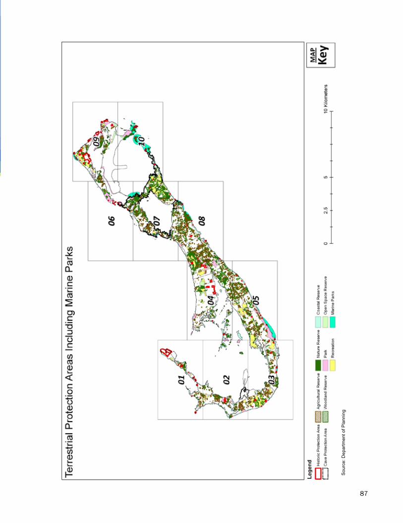
87
- 77
-
Sou
rce:
Dep
artm
ent o
f Pla
nnin
g
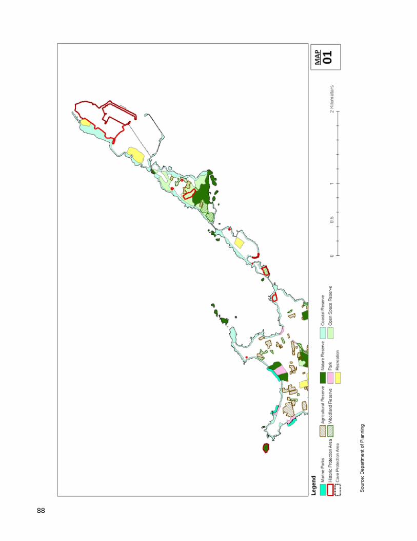
88
- 78
-
Sou
rce:
Dep
artm
ent o
f Pla
nnin
g
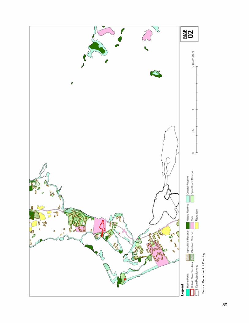
89
- 79
-
Sou
rce:
Dep
artm
ent o
f Pla
nnin
g
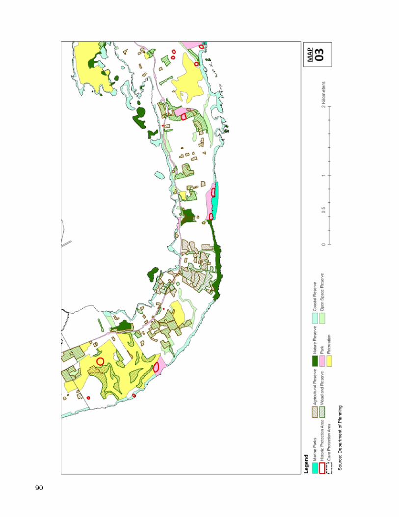
90
- 80
-
Sou
rce:
Dep
artm
ent o
f Pla
nnin
g
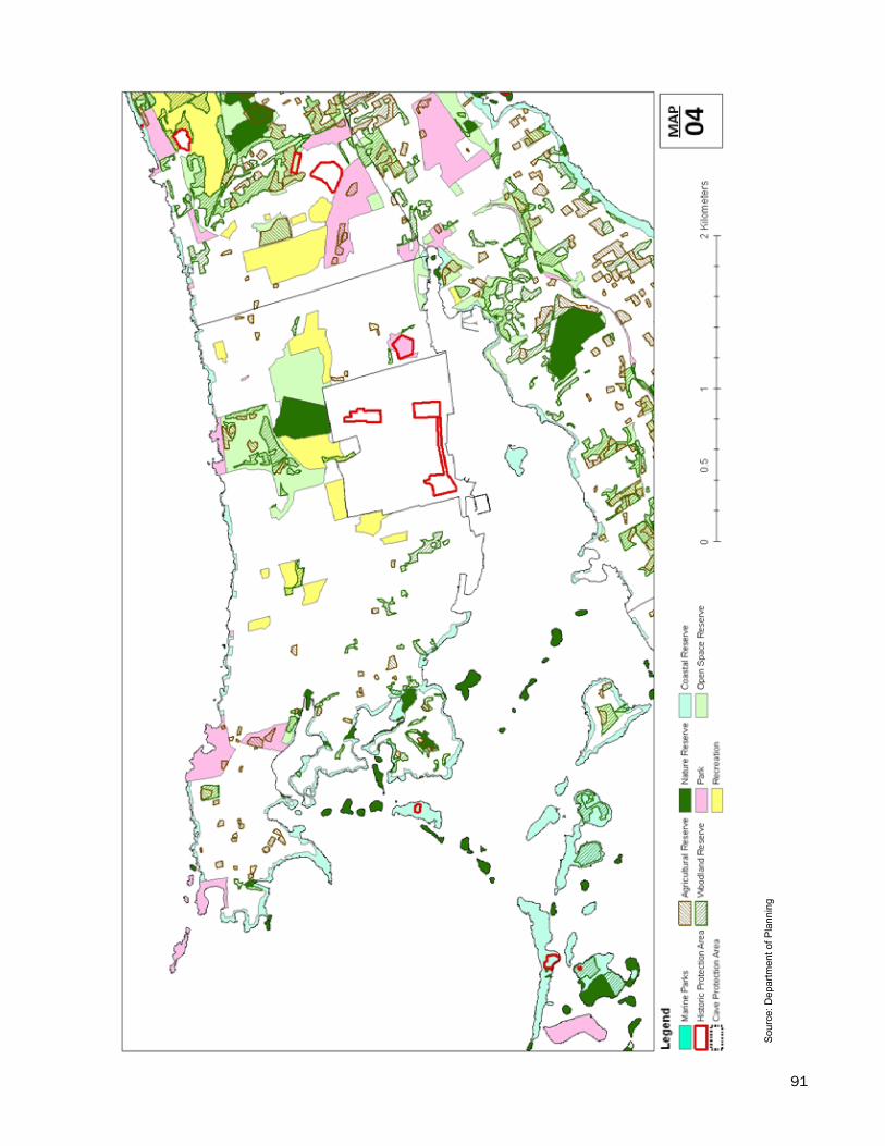
91
- 81
-
Sou
rce:
Dep
artm
ent o
f Pla
nnin
g
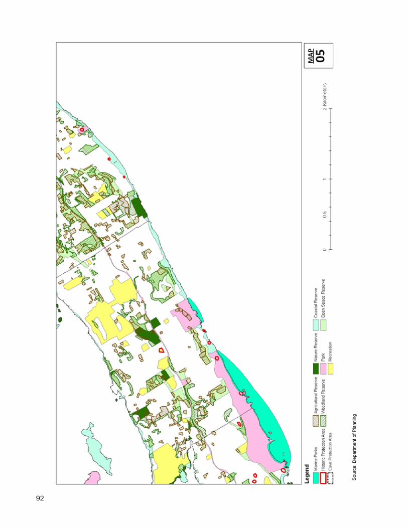
92
- 82
-
Sou
rce:
Dep
artm
ent o
f Pla
nnin
g
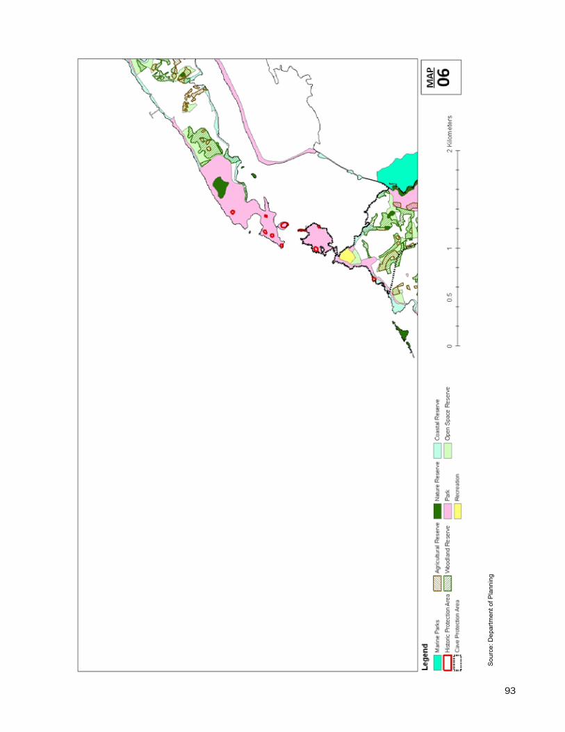
93
- 83
-
Sou
rce:
Dep
artm
ent o
f Pla
nnin
g
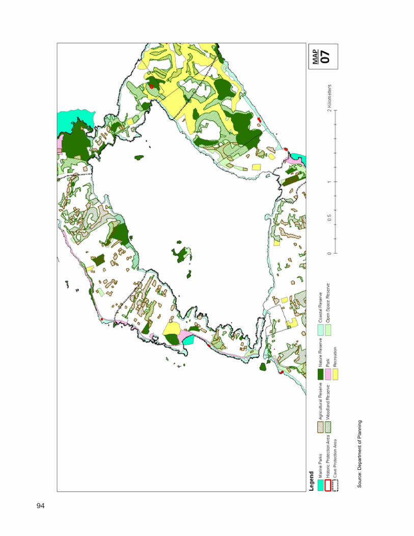
94
- 84
-
Sou
rce:
Dep
artm
ent o
f Pla
nnin
g
95
- 85
-
Sou
rce:
Dep
artm
ent o
f Pla
nnin
g
96
- 86
-
Sou
rce:
Dep
artm
ent o
f Pla
nnin
g
97
- 87
-
Sou
rce:
Dep
artm
ent o
f Pla
nnin
g

98