2014 wisconsin land & water annual progress report · 2014 wisconsin land & water annual...
TRANSCRIPT

Photos: WI DNR
2014 Wisconsin Land & Water Annual Progress Report
2014-2015 Land and Water Conservation Board MembersMark Cupp - Chair
Dale Hood
Lynn Harrison
Eric Birschbach
Robin Leary
Dave Solin
George Mika
John Petty - DATCP
Mary Anne Lowndes - DNR
Caitlin Frederick - DOA
Advisors
Francisco Arriaga - UW-CALS
Ken Genskow - UWEX
Brad Pfaff - USDA-FSA
Jimmy Bramblett - USDA-NRCS
Kurt Calkins - WI Land + Water
Jim Vandenbrook - WI Land + Water
Agency ContactsLisa Schultz - DATCP
Corinne Billings - DNR
Acknowledgments
ContentsWisconsin’s Innovators: New Approaches to Conservation ................................. 1
In Pleasant Valley, A Simple Solution .................................................................... 3
Cover Crop Fever .................................................................................................. 7
DNR and DATCP Notice of Discharge Cost-Share Grants .................................. 12
The Wild, Wild West ............................................................................................ 13
Make Way for Windbreaks and Wetlands ........................................................... 15

2014 Annual Land & Water Conservation Report
1
If we were the bragging kind here in Wisconsin, we might brag that all the biggest names in environmental conservation are native sons. But of course, we’re Midwest-modest, so we don’t brag.
But if someone asked who conceived and launched Earth Day? Wisconsin Senator Gaylord Nelson, of course. Or if someone asked who was the first professor of wildlife management in the world? That would be University of Wisconsin Professor Aldo Leopold. Who was the leader of the effort to set aside the Boundary Waters Canoe Area Wilderness? Sigurd Olson, a product of northern Wisconsin. Who is the Father of National Parks and founder of the Sierra Club? John Muir, a Portage farm boy who studied at UW before heading west.
Not that we’re bragging, you understand. But Wisconsin has always been an innovator and a leader
when it comes to conservation. It’s not only those four “big trees,” as some have called them.
It is also Coon Valley in southwestern Wisconsin. While the soil in the Dust Bowl was blowing away in the early 1930s, the soil in Coon Valley was washing away. It became the laboratory where the Soil Conservation Service (now the Natural Resources Conservation Service) worked out water erosion-control practices with the help of the Civilian Conservation Corps – and Aldo Leopold, among many other experts.
It is our leadership in setting water quality standards for phosphorus. It is our Runoff Risk Advisory Forecast.
Cooperation. Conservation. Innovation. In Wisconsin, it’s what we do. “
“Wisconsin’s Innovators: New Approaches to Conservation
Photo: Vernon County Land Conservation Dept.
Contour strip cropping on a farm in the Coon Valley watershed, the birthplace of soil and water conservation.

2014 Annual Land & Water Conservation Report
2
It is our tight working relationship among federal, state and local agencies – a relationship so close that it is virtually seamless to the public. In many other states, such cooperation would represent a major innovation.
Creativity and innovation in any endeavor help get the job done. That is why we chose to focus the 2014 Wisconsin Land and Water Conservation Annual Report on new approaches to conservation.
In this report, you will read about the Pleasant Valley Watershed Project, an experiment in “precision conservation” that is showing rather dramatic runoff reductions and making farmers’ lives easier. Cover crops are another innovation that farmers are embracing to prevent erosion, absorb nutrients, and generate healthier, more productive soil. A farm in Waushara County embraces windbreak assistance offered by a special Central Wisconsin partnership. And in Shawano County, conservation staff choose cooperation over regulation to help a family farm correct a source of manure discharge.
Cooperation. Conservation. Innovation. In Wisconsin, it’s what we do.
Not that we’re bragging. 2014 DNR Expenditure
DNR Grant Type Total Project Costs
State Share Reimbursed
Targeted Resource Management
$1,833,540 $1,147,428
Notice of Discharge $283,335 $239,366
Urban NPS Planning $301,707 $166,115
Urban NPS Construction $3,009,202 $819,848
Total $5,427,784 $2,372,756
2014 DATCP Expenditure
Local Staffing Support
$8,880.000
Local BMP Cost-Share
$4,840,351
Total $13,720,351
WI Conservation Funds Spent in 2014
*Not all 2014 reimbursement requests were processed and recorded at the time this report was created.
Federal NRCSFederal FSAOtherLocalState
51%
6%5%4%
31%
Distribution of conservation funds spent by WI county conservation departments in 2014. (As reported to DATCP)
Photo: WI DNR

2014 Annual Land & Water Conservation Report
3
In Pleasant Valley, a Simple Solution: Fix What’s Broken
In life and conservation, there are no magic bullets. But you still need a target if you want to solve problems.
That was, perhaps, the greatest lesson learned in the Pleasant Valley Watershed Project in Wisconsin’s southwestern Driftless Region. Rather than making assistance available and waiting for farmers to approach them, conservation professionals inventoried the watershed to find areas sending high amounts of phosphorus and sediment runoff to the stream, and reached out to farmers operating in those areas.
“What we really wanted to test was, ‘Does this method of focusing conservation efforts where they will be most effective work?’,” says Laura Ward Good, a University of Wisconsin-Madison soil scientist who worked on the research-based project. “Now we can say yes, that can work.”
Two years of U.S. Geological Survey and University of Wisconsin water quality monitoring data from 2013 and 2014 show a 37 percent decrease in phosphorus loading from Pleasant Valley during storm events, compared to a nearby control watershed where no action was taken.
“We can say with 90 percent confidence that this project made a real reduction in phosphorus losses”, adds Good. “Farmers who changed their management practices reduced both their estimated phosphorus and sediment losses by about half, keeping an estimated average of 4,400 pounds of phosphorus and 1,300 tons of sediment out of the water each year.”
The Nature Conservancy was a partner in the seven-year project aimed at stopping sediment and phosphorus from running into the Pecatonica River, which ultimately drains to the Mississippi River and the Gulf of Mexico. It was one of 10 partners, with funding coming from another six organizations. They set up a carefully constructed experiment to test their “precision conservation” hypothesis, and ended up showing
immediate water quality improvements with more expected over the long term.
The partnership drew on the talents and strengths of a range of academic, government, and non-government entities, requiring research abilities, relationship building, scientific knowledge, and practical agricultural skills. “We all had a role to play,” says The Nature Conservancy’s Steve Richter.
This project’s genesis was in the Wisconsin Buffer Initiative (WBI), an effort in the early 2000s to work out ways to reduce the sediment and nutrients entering streams from farm fields. The WBI recommended
focusing on watersheds of a manageable size that are likely to show results, and inventorying those watersheds to identify the fields and pastures that were contributing relatively high amounts of phosphorus and sediment. At the same time, The Nature Conservancy
Conservation partners discuss a new stream crossing on a farm in the Pleasant Valley Branch watershed.
We emphasized that this was a low-cost way of making significant changes.“
“

2014 Annual Land & Water Conservation Report
4
was getting interested in playing a bigger role in addressing water concerns in Wisconsin, so it was “a perfect meeting of the minds,” Richter says. It was a chance to test the idea of precision conservation – targeting problem areas — instead of the traditional approach of federal and state agencies setting up programs and waiting for farmers to come to them.
So the Pleasant Valley Watershed Project was born. With its hills and valleys, countless streams, and agricultural diversity, southwest Wisconsin was the perfect laboratory.
The groups chose two neighboring watersheds that were similar in terms of size (about 12,000 acres), cropland (about 5,000 acres), topography, and farming
operations (a mix of animal agriculture and cropping, with herd sizes ranging from 40 to 300 head of cattle). Both were tributaries to the Pecatonica River. Both would be subject to the same weather and both were experiencing removal of lands from the Conservation Reserve Program – factors that could increase runoff. One was the Pleasant Valley Branch, which became the experimental area with farms identified for runoff-reduction projects. The other was the Ridgeway Branch, which would serve as a control.
The first step was to get pre-implementation baseline measurements for sediment and nutrient levels in the water in both the treatment and control watersheds. That was a three-year process, conducted by the U.S. Geological Survey with WBI funding and using gauges at the mouths of both watersheds. In 2008, door-to-door visits to most of the 62 landowners in the Pleasant Valley Watershed were made to interview farmers, take soil samples, and calculate soil loss with RUSLE2 and phosphorus delivery using the Wisconsin Phosphorus Index. From this data, researchers identified 10 farms contributing relatively more phosphorus to the Pleasant Valley branch.
Conservation staff approached farmers – not with fingers pointed, but with helping hands extended. It was all one-on-one, conducted mostly by Dane County Land and Water Resources staff Curt Diehl, Pat Sutter and Duane Wagner; Green County Conservationist Todd Jenson; UW-Extension on-farm research
coordinator Jim Leverich; and USDA Natural Resources Conservation Service staff members Jason Thomas (Green County) and Adam Dowling (Dane County).
Eight of those first 10 farmers signed up for conservation practices right away, one took a couple of years, and one adjusted farming practices without cost-sharing, recalls The Nature Conservancy’s Steve Richter. Also, the project added another six farms in a second tier of implementation. There were no organizing meetings called by the researchers, but there was conversation among farmers over many hands of euchre and steadfast efforts to build relationships between the farmers and the staff members working on the project.
Dane County Conservation Specialist, Curt Diehl, talks to a farmer in the Pleasant Valley Branch watershed.

2014 Annual Land & Water Conservation Report
5
“It was a social science example of landowners talking to landowners, and of researchers and conservationists earning landowners’ trust,” he says.
Farmers signed on because they wanted to be good neighbors. But there were financial incentives available through the Natural Resources Conservation Service’s Environmental Quality Incentive and Wildlife Habitat Incentive programs, and the partners looked at the entire farm to find solutions that fit into the existing farm operations. Implementation started with some reduced tillage in 2010, with most of the change occurring in 2011 and 2012.
Some of the projects at a glance:
• On a beef farm where cattle had free access to Lee Valley Creek, and where rainwater ran off the feeding area to the creek, the farmer opted to build a feeding shelter with a gravel and concrete pad around it, and to fence cattle out of the creek, leaving just two animal crossings.
• On a crop farm, the operator switched from chisel plowing to no-till and used a nutrient management plan to apply only as much fertilizer as the crops needed.
• On a dairy farm where rain carried manure from the barnyard through a culvert and into a creek, the solution was adding a catch basin, grass waterway and buffer strip to capture manure-laden runoff and keep it out of the stream.
Reducing tillage and other changes in field and pasture practices made the greatest impact, Richter
said. These were not high-cost solutions. That was one of the most important lessons learned.
Jim Leverich, who worked with farmers to find solutions suited to their operations, says, “We went through an analysis and explored different options with each farmer to make sure that whatever BMPs (best management practices) were selected made sense for them from an economic standpoint and environmentally. It generally takes a fair amount of time to adopt BMPs,
because they can affect many other parts of the operation.” For example, if a farmer wants to plant rye as a cover crop, he needs a place to store that rye. So adopting a BMP may require adding some facilities,” Leverich explains.
All told, from 2010 to 2012, Pleasant Valley farmers converted 2,100 acres of cropland to no-till, installed 8 barnyard runoff systems, fenced 4 miles of streams and built 14 cattle crossings. In 2013 and 2014, monitoring results showed a 37 percent reduction in phosphorus in the stream, as compared to the reference stream during rainfall and snowmelt that carried runoff to the stream. Monitoring continues, and water quality in the Pleasant
Acres covered by nutrient management plans on Wisconsin farms have been steadily increasing since 2004.
Reducing tillage and other changes in field and pasture practices made the greatest impact.“
“OtherDNR/NRCS cost shareDNR CAFO programLocal ordinancesDATCP cost share and farmland preservation program
2004-2014 Nutrient Management Plan Acres Reported by Program
In thousands of acres

2014 Annual Land & Water Conservation Report
6
Valley Branch is expected to improve over several years as more long-term changes kick in.
“The county staff were so willing to engage the farmers, and go to them and gain their trust and work with them to make changes. It shows the real value of county staff going out in the field and not just waiting for people to come to them,” Richter says. “It also shows the value of nutrient management planning. We emphasized that this was a low-cost way of making significant changes. It’s not that we didn’t spend money in barnyards, but the most significant change was from field and pasture management practices.”
UW faculty and staff were instrumental in setting up the research design. “This was a unique project because of the research element,” Richter says. “We don’t expect every watershed in Wisconsin to do the measurements, but you need a few. That was critical for the partnership.”
He notes also that water quality improvements might not be so rapid in every part of the state, especially in larger watersheds. But, he predicts, “It still would work to identify and focus on farms and fields where you’re likely to see success.”
Project PartnersDane County Land Conservation DivisionGreen County Land and Water Conservation DepartmentIowa County Land Conservation DepartmentThe Nature ConservancyU.S. Geological SurveyUSDA Natural Resources Conservation ServiceUniversity of Wisconsin-ExtensionUniversity of Wisconsin-MadisonWisconsin Department of Agriculture, Trade and
Consumer ProtectionWisconsin Department of Natural Resources
Project FundersMonsanto and McKnight Foundation (gifts to The Nature Conservancy)U.S. Geological SurveyUSDA National Institute of Food and AgricultureUSDA Natural Resources Conservation ServiceWisconsin Department of Natural Resources
This map shows the percentage of acres in Wisconsin covered by nutrient management plans in 2014. (As reported to DATCP)

2014 Annual Land & Water Conservation Report
7
Wisconsin soils have a fever, and the prescription is….more cover crops! From the sands of Pepin County to the coulees of Crawford County, farmers across the state are taking note of the role cover crops can play in improving soil health and water quality. County conservation department and USDA-Natural Resources Conservation Service (NRCS) staff are there working with farmers to host demonstration events, helping with cost-share sign-ups, and providing technical assistance. This series of stories highlights counties that are taking a lead to promote the many benefits this conservation practice can provide.
Crawford County: Conservation In The Sky
If you make your way to Crawford County in the summer, you will see not only the ridges and valleys that characterize southwest Wisconsin, but also a lot of corn, soybeans, and hay. Come fall, you’ll find a different picture. Many crops have been harvested, leaving bare fields susceptible to erosion from wind, rain, and snowmelt. Crawford County conservationist Dave Troester and NRCS District conservationist Karyl Fritsche are looking to change the post-harvest landscape.
Cover crops, when planted in the fall, can potentially save farmers money by lowering fertilizer costs and providing additional feed for animals, not to mention the benefits to soil health, preventing soil erosion, and improving water quality. Certain cover crops can help trap nutrients before they leach through soil during the fall season when standard crops aren’t available to use them.
“Anything we can do to help keep the soil in place on the slopes is important. Cover crops are an excellent way to secure that soil,” says Fritsche.
It started with the national USDA-NRCS effort to improve soil health, which provided an opportunity for landowners to sign up for cost-share assistance for cover crops through the Environmental Quality Incentives Program (EQIP). Troester thought the program made sense, but didn’t see it being used much in Crawford County. So he started brainstorming with Fritsche on how they could remove obstacles preventing farmers from participating in the program.
One problem, specifically, was how to get cover crops planted later in the growing season. Crawford County’s steep topography, smaller fields, and lack of available planting equipment all made seeding a challenge in the short time frame they had. The two jokingly contemplated just sowing the seed with a plane. After more careful thought, they realized an aerial application would indeed be the way to go. They needed a large acreage to bid out the project successfully, so they started going door to door to recruit participants. Beginning with the larger cash grain operations in the area, they had many discussions with farmers in May, and by the end of June, eight operators had signed up to seed nearly 1,800 acres. With cost share, the cover crop seeding would cost farmers only a few dollars per
acre, without the need for additional planting. All they had to do was provide some maps and complete some paperwork- NRCS and the county took care of the rest of the logistics.
Troester and Fritsche put the project out for bid and awarded a contract to Ag Tech Air, an Illinois-based company familiar with agricultural aerial applications. Using digitized maps and shapefiles, the company knew exactly what should be seeded and where.
The morning of September 15, the plane flew up to
Cover Crop Fever
Anything we can do to help keep the soil in place on the slopes is important. “
“Aerial cover crop seeding application in Crawford County.

2014 Annual Land & Water Conservation Report
8
the Boscobel airport and loaded two seed mixes: one of oats and oilseed radish, and one of winter cereal rye. The oat and radish mix was a bit more popular, since rye requires an herbicide to kill it off the following spring. Over the next week and a half, the plane flew and the seeds dropped. Stationed at the airport, a specialized truck was used to refuel the plane and fill the plane’s hopper with cover crop seeds. One foggy morning and a day of strong winds kept the plane grounded for a bit, but overall the process was a breeze.
Troester and Fritsche watched the plane seed one of the fields, flying at 50-60 feet above the ground. Afterwards they checked a one-foot plot, came back a few days later to gather data, and did the same later in the fall and in the following spring. Weather data was gathered at the Boscobel airport. A gentle rain right after seeding helped the crop, but the fall was dry and cool, so results weren’t as productive as they had initially hoped. However, the farmers seemed happy with the results.
Swede Knutson, one of the participating farmers, thought the whole process was wonderful and said he would do it again.
According to Knutson, “The more you can keep something living on the soil, the better it is for your farm. I have nothing but good things to say about it, and I would definitely recommend it to other farmers in Crawford or Vernon County. The aerial application was excellent, too. It is the way to go. If I were to drill in the seed, I don’t think I could do it as quickly or efficiently. My bean ground is definitely an excellent place for cover crops.”
Every farmer’s experience was slightly different. In Knutson’s case, the oats and radish didn’t seem to get enough growth, which could have been due to some herbicide carryover. He’s hoping to change herbicide and see how next year goes. The winter cereal rye had good cover all winter, and maintained into the spring. He didn’t have any problems killing it off, and actually left some in the grassed waterway to help prevent erosion. Being close to the Mississippi River, he doesn’t want to see any more soil leaving his property and going downriver. Next year, he would like to see how tillage radish works, based on feedback he’s received from other farmers, and is open to experimenting with clover to get nitrogen credits for the next year’s corn crop.
“It seemed like it helped with weed control, too,” Knutson says, “I didn’t have any weed problems where there were cover crops. And I definitely think it helped stop erosion.”
Crawford County has signed up an additional 800 acres for this fall due to word-of-mouth advertising by farmers, a press release, and a handful of informational meetings. The 2015 aerial application will feature two different seed mixes to provide participants with more options: spring barley, oats, crimson clover, and winter cereal rye with crimson clover.
The hope is that the program will continue on without county or federal involvement. “We’re hoping that when the cost-share is done, their eyes will be opened to the benefits of cover crops and they’ll consider planting them without financial assistance,” said Troester.
Green County: We’ve Got It Covered
Green County’s got it covered. With cover crops, that is. This county, also in the driftless area, has many steep hills and very shallow soils that need protecting. The cover crop effort started when Green County Land and Water Conservation Department conservation technician Tonya Gratz and NRCS District conservationist Jason Thomas attended a soil health field day in Arlington, Wisconsin. NRCS soil health guru Ray Archuleta spoke on the topic and they were convinced of the benefits: fertilizer savings, healthier soil, better water absorption. What’s not to like?
Tillage radish cover crop growing on Green County farmland.

2014 Annual Land & Water Conservation Report
9
Thomas spoke with the farmer currently renting the county farm and he sacrificed a half acre for them to try test plots. Heritage Seeds located in Madison, Wisconsin, donated seeds and the County borrowed a seed drill to get things started. The conservationists planted 13 plots in 10 foot wide strips. Despite lack of rain, all of the plots turned out very well, except for the peas. Because the ground was hard and dry at planting, the peas quickly germinated when rain fell and then died.
To share their experiences, Green County LCD and NRCS staff went on the radio, put out newsletters, ran articles in the local paper, and presented the idea at a county committee meeting. But mostly, it was the neighbors of the county farm who spread the word. The County hosted two field days that fall and had between eight and 20 farmers attend each one. A third field day was planned, but early cold weather prevented it from occurring. Even so, the field days garnered interest.
According to Green County Conservationist Todd Jenson, “We have a lot of EQIP applicants for cover crop cost-share assistance. During summer of 2014, we had a tremendous sign-up with hundreds of acres. And most of this was due to word of mouth. One farmer who signed up got about eight of his neighbors to sign up and do the same”. With the larger volume of people signing up, everyone in the LCD office stepped up to help farmers interested in trying out cover crops. Some farmers tried aerial seeding, which worked to varying degrees, and others used more traditional planting methods.
The County and NRCS held another field day this spring so farmers could see what overwintered and what
didn’t. They pulled up plants to show the crops’ root structures and the attached nitrogen nodules that had developed over the year. The county plans to hold more demonstration days, one on the east side of the county and one on the west side, to continue to promote this new conservation practice. Winter rye has been the most popular by far, followed by mixes that include brassicas (plants in the mustard family). Some have seen success with tillage radish, even if it meant a few surprise visitors.
“Some farmers said they put in turnips and radish and the deer just loved them. They went straight for the cover crops,” said Jenson.
Sauk County: Planting Seeds Of Partnership
Sauk County still has quite a bit of dairying, and that is good news for the cover crop movement. Partially located in southwestern Wisconsin’s driftless area, the county’s landscape varies from steep slopes to flat sandy areas near Spring Green along the Wisconsin River. The unique landscape creates natural resource concerns that include erosion and the potential for nitrogen to reach groundwater. This, in turn, creates an opportunity for cover crops, particularly after corn is harvested for silage.
Like their Green County counterparts, Serge Koenig and Melissa Keenan traveled from their Sauk County Conservation, Planning and Zoning Department office to Arlington to see Ray Archuletta present on cover crops and soil health in the summer of 2014. They were hooked immediately. Koenig states, “It seemed like the right thing for our county, so we started thinking about
ways to promote it.”
The 265-acre, tillable county farm just south of Reedsburg, seemed like a natural place to start. They approached the farmer currently renting the county farm, who had planted some of the acres in wheat, and found he was willing to plant a cover crop following harvest. Sauk County’s conservation department director and the land conservation committee of county supervisors were on board with testing out the new approach, so they approved funding. The county hosted a field day at the site to showcase the changes and is looking to host more in the future. Staff also monitored soil, plant growth, and nutrient levels in the spring and fall to measure effects over time.
Spring barley and turnip cover crops flourish at the Green County test plots.

2014 Annual Land & Water Conservation Report
10
The next step was to begin working with other landowners in the area. However, Keenan and Koenig didn’t need a new strategy or marketing plan to promote cover crops. It just became part of their existing daily routine. According to Keenan, “One important part of our success was that we already have relationships developed with most of our county producers. It was just a matter of asking them if it would be something they are interested in doing. We have four staff that are always out meeting with landowners and producers, so if we are already out there, a conversation can give them much more information than any brochure or fact sheet we could hand out.”
Participating farmers began planting cover crops using funding provided by the USDA-NRCS Regional Conservation Partnership Program (RCPP). The local RCCP project was dedicated to improving water quality in the Baraboo River watershed, a waterbody under consideration for listing as a state impaired water. Most of the farmers contacted had already heard about the effort and were excited to join. Others were more hesitant, concerned about extra time and effort it might require.
“The cost-share funding from NRCS was helpful, and a great opportunity for farmers to try something they were on the fence about,” says Koenig.
NRCS and Sauk County conservation staff are now partnering with a team of professionals to brainstorm and deal with issues relating to water quality, soil health, and cover crop implementation.
In the meantime, reports of farmers’ experiences and innovations are rolling in. After planting winter rye on corn silage ground, one farmer was surprised at how easy it was to drive through his field in the spring, because the ground was covered in vegetation instead of the usual spring mud. The county farm renter was
able to get into bottom fields earlier than normal, attributing the ease of moving machinery in and out of the field to planted rye, which helps water filter down into the soil instead of pooling on the surface. Another farmer mixed rye seed with urea used to top dress corn when enough sunlight was available to allow the rye to germinate; by the time the corn becomes dormant, the rye should be established.
Sauk County conservation staff plan to continue the efforts through 2019 and perhaps beyond. As long as the land conservation committee and department leadership are on board, they will keep moving forward. They hope for enough growth in future years to capture data on nitrogen crediting and other benefits. As for the farmers, they too continue to innovate. Some are considering experimenting with aerial application or planting cover crops on fields of corn for grain. Either way, the partnerships between NRCS, Sauk County, producers, and local agribusinesses will be a benefit for the areas’ natural resources and farmland for years to come.
Pepin County: Farm Like A ChampPepin County, like much of northwest Wisconsin,
has steep hills and a lot of corn and bean rotations in its agricultural areas. The region’s sandy soils add to the equation, making the potential for soil erosion and nutrient loss a concern.
Pepin County conservationist Chase Cummings knew benefits from cover crops could vary. He was unsure how effective cover crops would be at preventing nutrients, especially nitrates, from leaching through the sands into groundwater, or preventing erosion on the steep slopes.
According to Cummings, “If you actually calculate soil loss in the RUSLE 2 model after putting in cover crops, the erosion loss goes up due to extra soil disturbance. But I think the more important message is overall soil health and how cover crops help increase organic matter, pore space and infiltration. We need something growing on these slopes all of the time to slow the erosion down.”
So in 2013, the Pepin County Land Conservation Department (LCD) partnered with Natural Resources Conservation Service district conservationist Dennis Reimers and University of Wisconsin-Extension agricultural agent Mike Travis to apply for a Cover Crop Champion Grant through the National Wildlife Federation (NWF). NWF feels that cover crops are important not only for water quality and soil erosion prevention, but also for wildlife habitat benefits.
A handful of soil from a Sauk County farm shows the soil health, root structure, and organisms that cover crops build.

2014 Annual Land & Water Conservation Report
11
After a successful application, the partners received a $7,800 grant in 2014 for work involving Cover Crop Champion farmers. Brian Prissel of Prissel Valley Farms and Mike Brion of Brion Dairy were named the county’s Cover Crop Champions. Both farms had experience using cover crops on their corn and bean fields and had worked with the county on past conservation projects. In addition, each farm has a trout stream running through the property, which the county monitors for water quality. One of the streams is recommended for addition to the state’s 303(d) list of impaired
waterbodies, making water quality and land use in that area an even higher priority.
LCD staff and UWEX agent Mike Travis used the grant funding for six test plots, four field days, and two workshops. They developed press releases, radio scripts, newsletters and other materials to promote the benefits of cover crops and the field days. The Pepin County Farm Management Club became involved to help with promotion as well. Legacy Seed, Black’s Valley Ag, and the Countryside Co-op provided seeds for the plots, including radish, rye, crimson clover, turnips, and winter peas. Local farmers provided seed drills and planting equipment.
The Cover Crop Champions hosted field days and spoke about their experiences with test plots, trials, and experimenting with different seed mixes. In addition to the 10 acres of test plots, farmers could view soil test pits to see how cover crop roots affect different layers of soil. LCD and NRCS staff were available to answer questions about technical assistance and cost-sharing available through the USDA-NRCS Environmental Quality Incentives Program (EQIP). Almost 30 crop advisors and agronomists attended the events as well.
“One of the greatest successes was to see the
champions step up as local advocates for cover cropping,” says Reimers. “During a field day, one of our prominent dairy farmers had an ‘aha moment,’ and we even had a local tomato producer move from high tillage practices to planting cover crops for pest management and committing to minimum tillage.”
In total, the county received about 200 contacts from interested farmers. About half decided to implement some type of cover crop on their farms.
The LCD is processing results from the test plots, based on soil and plant tissue tests taken before and after planting. The ground is now planted into corn, so more information will be available after fall harvest. One lesson learned was that tillage radish alone does not work for Pepin County’s topography and soils. There wasn’t enough vegetation to hold the soil on its own. However, next year they will try it mixed with other seeds.
Some participating farmers have noticed improvements on their own fields; organic matter and water-holding capacity have increased on sandy soils. Some dairy farmers have seen a forage benefit, depending on their rotation and the weather. Planting cover crops diversified their rotation and opened up opportunities to meet forage needs, saving on feed costs.
Although the project hasn’t generated specific benefits for wildlife just yet, partners are convinced habitat benefits can be seen in the bigger picture. NWF understands that farmers are the main stewards of the land, and wants to help them make well informed, conservation-minded decisions on agricultural land. For NWF, this is a win-win. In its view, conservation on farmland ultimately benefits wildlife and everything connected to it.
According to Cummings, “Conservation usually ends up coming back to timing and growing degree days. Instead of growing a longest-day variety of corn, some farmers could try a shorter-day variety to get cover crops planted early enough. If not, cereal rye might be the go-to for our area. It comes down to a farmer’s willingness to go against the grain and try something different. Change can be difficult, even when you can see the benefits.”
The county successfully applied for another grant for 2015 and hopes for continued success. In the next round, staff hope to broaden the time window for cover crop planting to allow for more experimentation with different types of crops and seed mixes. Optimism for the future abounds. Cummings adds, “This has been a great program, and the main fruit of our efforts will be borne in subsequent growing seasons.”
A cover crop’s root measurement on display at a Pepin County field day.

2014 Annual Land & Water Conservation Report
12
The Notice of Intent/Notice of Discharge Grant Program provides funds to counties for cost-sharing of manure and process wastewater discharge projects under ch. NR 243, Wis. Adm. Code. Funding is available from both DNR and DATCP. Cost-share reserve amounts were identified in the 2014 Joint Final Allocation Plan. For CY 2014, there were three review periods for NOI/NOD grant applications: April 15, June 16 and August 15. A total of 15 grant
applications were received and jointly reviewed by DNR and DATCP. Fourteen projects were selected for funding; DNR funded 10, DATCP funded 3, and one project was jointly funded by both DNR and DATCP. One grant application, which is accounted for on the table**, was received and awarded in 2013 but funded with 2014 funds. Table 1 summarizes the grant allocations for the CY 2014 NOI/NOD Grant Program.
DNR/DATCP 2014 Notice of Intent (NOI)/ Notice of Discharge (NOD) Cost Share Grants
Table 1: Funded Projects
County Award Funding Agency
Buffalo $150,000 DNR
Columbia $100,000* DNR
Jackson $79,950 DNR
Jackson $56,000 DNR
La Crosse $78,680 DNR
Lincoln $83,300 DNR
Manitowoc $10,500 DATCP
Marathon $101,920 DNR
Racine** $3,640 DNR
Taylor $87,000 DNR
Taylor $55,500 DATCP
Vernon $88,620 DNR
Vernon $20,910 DNR
Waupaca $150,000 DNR
Winnebago $64,000 DATCP
Wood $70,000*** DATCP
Total Awarded $1,200,000
* This project will be funded over two years by DNR; phase 1 is for $100,000 and phase 2 is for $150,000 which will be funded out of 2015 funds.*** This project will be funded over two years by DATCP; phase 1 is $70,000 and phase 2 is approximately $65,000 which will be funded out of 2015 funds.

2014 Annual Land & Water Conservation Report
13
Shawano County: The Wild, Wild West
Western Shawano County has a rich agricultural and natural resource heritage and at times, is fondly referred to as the “wild, wild west.” Full of wildlife and scenery important to the community, the area is also home to the Embarrass River. A number of small tributaries feed the river as it passes through the landscape, making the Middle Branch Embarrass River a popular spot for locals and visitors looking to hook a brown trout.
In spring of 2009, the Wisconsin Department of Natural Resources (DNR) received a call from a trout fisherman concerned about manure entering the river near where he was fishing. That call led conservation officials to a local heifer-raising operation.
A discharge of this type violated the county’s Livestock Waste Management Ordinance and the state’s Agricultural Performance Standards.
Back in 2001, the Shawano County Board updated the manure storage ordinance to include the state’s Agricultural Performance Standards. Up until that point, the county ordinance regulated only the construction of manure storage facilities. Including the new requirements meant that the county, as well as the state, was responsible for ensuring landowners followed standards such as meeting tolerable soil loss on cropland, following a nutrient management plan, and preventing runoff from feedlots or manure storage from reaching waters of the state. Since that time, implementing and communicating the new ordinance requirements has been a steady work in progress.
Fortunately, Wisconsin’s Farmland Preservation program gives the Shawano County Land Conservation Department (LCD) the opportunity to work with about 280 landowners who claim the state’s Farmland Preservation tax credit, which also requires compliance with state agricultural performance standards.
According to Shawano County Conservationist Scott Frank, “We rely on other people’s eyes to inform us of where there are issues with manure or soil erosion so we can work with landowners that need our assistance.”
And now those other people’s eyes had seen that runoff into the Embarrass River. So, on June 4, 2009, DNR staff Casey Jones and then-county conservationist Ron Ostrowski visited the farm, near the Middle Branch Embarrass River and tucked away from the average passerby. The county saw an opportunity to build a relationship with a farmer and
provide valuable technical and financial assistance.
Shortly thereafter, the DNR issued the farm a letter outlining steps to be taken to remove the source of manure runoff. DNR provided some funding, and the landowners agreed to install interim practices to get the discharge under control. These shorter-term solutions were completed that summer, and included moving some fences away from the river, constructing new fences around a drainage way leading to the river, seeding or mulching areas adjacent to the river and drainage way, installing bale ditch checks, and seeding down the drainage way itself. In short, they moved the cattle away from the river and stabilized bare soil in the area so grass could slow water and filter pollutants.
Still, the operation needed a long-term plan, including design and installation of permanent practices, to fully satisfy the NOD and prevent future discharges.
In 2010 and 2011, Brian Hanson, a conservation technician at the Shawano County LCD, designed buffers to reduce the feedlot area from 14 acres of earthen feedlot to 4.5 acres, which would significantly reduce phosphorus loading to the river. At the time, manure was also scraped from one concrete lot and put in a short-term (about 30 days) manure storage. However, the storage unit had a “weep hole” that would allow manure and water to escape during overflow times, which would then wash into the ditch. The hole was sealed off, but there was a definite need for long-term manure storage. Conservation staff encouraged the farmer to install clean water
A young boy fishes a Wisconsin trout stream.
Photo: WI DNR
2014 Annual Land & Water Conservation Report
14
diversions, feedlot runoff controls and additional manure storage to further decrease the likelihood of future runoff.
The process to acquire funding for those practices began in April 2011, when Shawano County LCD applied for a DNR small-scale Targeted Runoff Management (TRM) grant and the landowners applied for a USDA-NRCS Environmental Quality Incentives Program grant. The goal was to ensure that all runoff from the barnyard area and manure storage would be collected and clean water would be diverted from outdoor feedlots. Getting to that point took some time, however.
“It took us a year to get our ducks in a row and get the grants in place,” said Frank.
Conservation staff were challenged with developing a design that would work for the farm operation, while also addressing runoff. To add to the complexity, the farm was undergoing a change in ownership. Changing the current system had the operators, as well as future owner, feeling uneasy. Their top priority was a healthy and clean environment for animals that would meet customers’ expectations and ensured continued business. They weren’t sure what challenges or consequences a new system would have in store.
Frank said, “We tried not to be too aggressive or pushy. Sometimes you need to feel the situation out, and know that if you push too hard you may not get anywhere. There were times when we’d wait a number of months until they made a decision on a design feature that would work best for the farm. A lack of patience by us or unwillingness of the landowners could have ended the process and started a legal matter, but all of us knew that was not the desired path. In the end, it took a long time, but we were able to work together to
get practices in place and avoid further enforcement by the state.”
With grant funding secured and plans and permits in place, the major construction work began. In 2013, the first practices installed were roof gutters and an underground outlet. In 2014, Brian Hanson oversaw the ag-waste project implementation. A $150,000 TRM grant funded a roof, manure transfer systems, closing short-term storage, and a portion of a new manure storage facility.
When all was said and done, the conservation practices created a zero discharge system where all waste is collected into reception tanks and pumped to the new, long-term waste storage. The farm also worked with a private consultant to develop a nutrient management plan to ensure stored manure would be spread effectively on nearby cropland. All earthen animal lots were seeded down and vegetated, removing animals’ access and nutrient runoff to the stream.
Fully operational, the new system prevents phosphorus and manure from discharging into the river, and the farm is in full compliance with county ordinance and state standards.
DNR staff Erin Hanson and conservationist Scott Frank visited the site in May 2015. Much has changed on the farm since the first visit back in 2009. What was once a father-and-son operation is now under new ownership, but still managed by the family. Both are happy with the new system, although at first they were apprehensive about the switch to a zero discharge system. They had a change of heart.
According to Frank, “During our visit you could just tell how happy they were. It was very uplifting to see their support and appreciation for the new system. It really is a night-and-day difference from where the operation was before and where it is now.”
As for the river, you can see a marked change in the nearly 100-foot stretch where the discharge had previously entered. Flow from the nearby ditch is slowed, erosion is reduced, and more vegetation helps filter water that enters the river during rain storms. In addition to benefitting water quality and the farm operation, the projects benefitted the local economy when local contractors were hired to do construction work.
Frank adds, “It was definitely a rewarding feeling after our visit to the farm in May. It was uplifting to know the project was complete, protecting the resource, and the farmer was pleased with the results.”
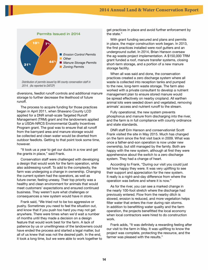
Permits Issued in 2014
Erosion Control PermitsOtherManure Storage PermitsZoning Permits
31%
7%18%
44%
Distribution of permits issued by WI county conservation staff in 2014. (As reported to DATCP)

2014 Annual Land & Water Conservation Report
15
Waushara County:Make Way for Windbreaks and Wetlands
When John and Christine Lauritzen took ownership of her family farm, they wanted to restore the land.
“We wanted a good farm operation, yet we wanted to return it to the way it used to be. We just thought something should be done out there,” John says. “Out there” is a 160-acre plot in the Town of Springwater, a region of small lakes and wetlands in the northeast corner of Waushara County – one of Wisconsin’s sand counties.
Waushara County Conservationist Ed Hernandez adds geographic detail: “The parcel is surrounded by wetlands, a small private lake to the northeast, and within 500 feet of a tributary creek to the Pine River. The landowners have great passion and vision to protect this parcel for long-term agriculture production, wildlife habitat development and water quality protection.”
John and Christine own and operate Lauritzen BP and Sport Shop in Wild Rose and weren’t farming the land themselves. They had a renter who was cropping the land. Christine’s father, Roger Colligan, had worked about 10 years ago with Waushara County conservation staff on a priority watershed project. That project started with the U.S. Fish and Wildlife Service, which connected Roger with the county land conservation office. It was a major undertaking, with some cropland removed from production and replaced with a replanted native prairie. Two new shallow water scrapes, a quarter to a half acre in size and just two to three feet deep, gave ducks and other waterfowl a spot to land.
Fast-forward to 2014 and that wish to do something out there. “I knew my father-in-law had worked with the county before, so I called Ed,” John recalls. “Ed was my go-to guy and I trusted their input at the county.” He and his son Tom approached Ed about establishing windbreaks. Ed, in turn, brought in his colleagues from the Central Wisconsin Windshed Partnership Group.
The group, headquartered at Hancock Agricultural Research Station, is a cooperative venture involving conservation committees and departments in Adams,
Juneau, Marathon, Marquette, Portage, Waupaca, Waushara, and Wood counties. Others partners are the Wisconsin Potato and Vegetable Growers Association and the vegetable processing industry; Golden Sands Resources Conservation and Development; USDA Natural Resources Conservation Service; University of Wisconsin and UW Cooperative Extension Service; and the Wisconsin Department of Agriculture, Trade and Consumer Protection. The CWWP designs and plants
More than four miles of tree planting resulted from a project that the Lauritzen family undertook, with a great deal of help from the Central Wisconsin Windshed Partnership Group and the Waushara County Zoning and Land Conservation Department.

2014 Annual Land & Water Conservation Report
16
windbreaks for wildlife habitat, using fast-growing, disease-resistant species. It also provides other services including seeder rental, custom spraying, chemical burndowns, and public information and education.
The Lauritzens’ property is about 160 acres, with some woods and about 110-120 acres of agricultural land. Ed and his staff met with the Lauritzens many times throughout the planning and design, prior to the Windshed Partnership planting 95 acres with 10 rows of white spruce, Norway spruce, and white oak, ranging from 1,140 feet up to 3,400 feet long. All told, they have more than 4 miles of windbreak.
“The land is upwind of water resources,” Ed says, so besides keeping soil where it’s needed on the farm, the windbreaks will also keep silt out of surface waters.
The total cost of the project was just over $43,000. It qualified for state cost-sharing, so the Lauritzens’ portion was less than $15,000. As part of the cost-share agreement, the Waushara County Land Conservation and Zoning Office required a nutrient management plan for the farm, which their renter is incorporating into his cropping practices.
John’s pleased with what he’s seen so far. The windshed group weeds and replants dead trees for the first three years, and he estimates that 95 percent of the trees have survived to
date. It’s too early to tell if the trees are doing their job, he says, but they look great.
Ed Hernandez sees a loftier goal when he looks at this project. “John was looking to protect the land for his family and grandchildren,” he says.
And that’s certainly doing something out there.
A shallow water scrape installed in another project 10 years ago on the Lauritzen property provides a rest stop for waterfowl and a waterhole for deer and other wildlife.
From left, Shannon Rohde, Windshed Partnership project manager; Chris and John Lauritzen; and their son, Tom.

2014 Annual Land & Water Conservation Report
17
Best Management Practice Installed Amount UnitsAccess Roads and Cattle Crossings 400 FeetBarnyard Runoff Control Systems 6 NumberCritical Area Stabilization 10 AcresDiversions 300 FeetHeavy Use Area Protection 1 AcresLivestock Watering Facilities 2 NumberManure Storage System Closure 3 NumberManure Storage Systems 10 NumberMilking Center Waste Control Systems 3 NumberNutrient Management 130 AcresRelocating or Abandoning Animal Feeding Operations 1 NumberRoof Runoff Systems 3 NumberRoofs 2 NumberUnderground Outlets 160 FeetWaste Transfer Systems 9 NumberWastewater Treatment Strips 1 AcresWater and Sediment Control Basins 2 NumberWaterway Systems 1 AcresWaste Transfer Systems 11 NumberWastewater Treatment Strips 2 AcresWaterway Systems 4 Acres
Best Management Practice Installed Amount UnitsInformation & Education Activities 1 NumberUrban Detention System 7 NumberUrban Stormwater/Erosion Plan 3 Number
Best Management Practices Installed – 2014 Table 1: WI DNR Agricultural Best Management Practices Installed in 2014
Table 2: DNR Urban Stormwater Best Management Practices Installed in 2014
* Not all 2014 reimbursements were processed and recorded at the time this report was created.
* Not all 2014 reimbursements were processed and recorded at the time this report was created.
Continued on next page

2014 Annual Land & Water Conservation Report
18
Table 3: Environmental Quality Incentives Program, Top 40 Practices by Financial Investment - FY 2014
Practice Contracts FY 2013 DollarsWaste Storage Facility 39 $3,525,645Cover Crop 255 $1,092,044Nutrient Management 353 $953,589Heavy Use Area Protection 78 $756,509Streambank and Shoreline Protection 75 $671,544Waste Transfer 47 $660,687Fence 163 $643,711Grade Stabilization Structure 71 $427,800Irrigation System, Sprinkler 16 $398,641Pumping Plant 31 $373,734Comprehensive Nutrient Management CAP 39 $301,000Integrated Pest Management 35 $297,283Lighting System Improvement 2 $296,667Grassed Waterway 158 $295,674Prescribed Grazing 174 $270,840Comprehensive Nutrient Management Plan 35 $249,635Mulching 218 $246,553Irrigation Pipeline 10 $200,041Seasonal High Tunnel for Crops 28 $183,846Access Road 34 $181,591Obstruction Removal 118 $142,653Roofs and Cover 3 $135,635Vegetated Treatment Area 26 $134,850Forage and Biomass Planting 58 $133,849Subsurface Drain 40 $131,337Waste Treatment 2 $128,665Stream Crossing 54 $125,223Underground Outlet 57 $114,007Roof Runoff Structure 31 $98,189Stream Habitat Improvement 29 $97,941Forest Stand Improvement 52 $97,055Critical Area Planting 231 $95,616Tree and Shrub Establishment 39 $93,221Waste Facility Closure 10 $88,577Lined Waterway or Outlet 15 $87,998Tree and Shrub Preparation 45 $69,184Conservation Cover 26 $61,294Brush Management 52 $60,904Residue and Tillage Management 27 $55,340Forest Trails and Landings 16 $44,617

2014 Annual Land & Water Conservation Report
19
Table 4: Environmental Quality Incentives Program, Top 40 Practices - FY 2014
Practice Contracts FY 2013 DollarsNutrient Management 353 $953,589Cover Crop 255 $1,092,044Critical Area Planting 231 $95,616Mulching 218 $246,553Prescribed Grazing 174 $270,840Fence 163 $643,711Grassed Waterway 158 $295,674Obstruction Removal 118 $142,653Heavy Use Area Protection 78 $756,509Streambank and Shoreline Protection 75 $671,544Grade Stabilization Structure 71 $427,800Forage and Biomass Planting 58 $133,849Underground Outlet 57 $114,007Stream Crossing 54 $125,223Forest Stand Improvement 52 $97,055Brush Management 52 $60,904Waste Transfer 47 $660,687Tree and Shrub Site Preparation 45 $69,184Subsurface Drain 40 $131,337Waste Storage Facility 39 $3,525,645Comprehensive Nutrient Management Plan CAP 39 $301,000Tree and Shrub Establishment 39 $93,211Watering Facility 36 $17,582Comprehensive Nutrient Management Plan 35 $249,635Integrated Pest Management 35 $297,283Access Road 34 $181,591Pumping Plant 31 $373,734Roof Runoff Structure 31 $98,189Stream Habitat Improvement 29 $97,941Prescribed Burning 29 $39,089Seasonal High Tunnel for Crops 28 $183,846Pipeline 28 $37,369Residue and Tillage Management 27 $55,340Vegetated Treatment Area 26 $134,850Conservation Cover 26 $61,294Diversion 23 $21,271Upland Wildlife Habitat Management 21 $12,735Spoil Spreading 20 $39,176Forest Management Plan 20 $22,758Irrigation System, Sprinkler 16 $398,641

2014 Annual Land & Water Conservation Report
20
Crop Erosion Control Practices Amount Installed (Acres, Feet or Number)
CREP Equivalent 24.30 Acres Animal Trails and Walkways 2,559.00 Feet Cover and Green Manure Crop 628.40 Acres Critical Area Stabilization 28 Diversions 12,208 Feet Field Windbreaks 48,241 Feet Filter Strips 1.12 Acres Grade Stabilization Structure 49Riparian Buffers 103.11 Acres Sinkhole Treatment 9Streambank and Shoreline Protection 24,143 Feet Subsurface Drains 4 Terrace Systems 800 Feet Underground Outlet 17Water and Sediment Control Basins 10Waterway Systems 148.99 Acres Stream Bank Crossing 3,497 Feet
Manure Management Practices Amount Installed (Acres, Feet or Number)
Manure Storage Systems 15 Manure Storage Closure 37Barnyard Runoff Control Systems 30Access Roads 20,091 Feet Livestock Fencing 19,886 Feet Livestock Watering Facilities 26Milking Center Waste Control Systems 4 Nutrient Management 60,038.36 Acres Roofs 1 Roof Runoff Systems 15 Waste Transfer Systems 13 Wastewater Treatment Strips 648 Feet
Table 5: DATCP Best Management Practices Installed in 2014
Continued on next page

2014 Annual Land & Water Conservation Report
21
Table 6: DATCP Best Management Practices Installed in 2014 Continued
Other Practices Amount Installed (Acres, Feet, or Number)
Prescribed Grazing Permanent Fencing 43,010 Feet Prescribed Grazing Establish Permanent Pasture (seeding) 103 Acres Well Decommissioning 153 Wetland Development or Restoration 5.30 Acres Feed Storage Runoff Control Systems 2.02 Conservation Reserve Enhancement Program (Net) $301,708.77
Sunset at the Lauritzen Farm in Waushara County, Wisconsin.

ARM PUB 254.inddRevised 7/15
The report is available on the following website:http://datcp.wi.gov/Environment/Land_and_Water_Conservation/Annual_Reporting
Wisconsin Department of Agriculture, Trade & Consumer Protection
Bureau of Land and Water Resources2811 Agriculture Drive
PO Box 8911Madison, WI 53708-8911
608-224-4611http://datcp.state.wi.us
DATCP and DNR provide equal opportunity in their employment programs, services and functions under an Affirmative Action Plan. If you have questions, please write to the Equal Opportunity Office, Department of the Interior, Washington, D.C., 20240. This
publication is available in alternate format upon request. Please contact the DATCP LWRB at (608) 224-4611 for information.
Wisconsin Department of Natural Resources
Bureau of Watershed Management 101 S. Webster St.
WT/3Madison, WI 53703Fax: 608–267–2800http://dnr.wi.gov/