2015 broken hill resources investment symposium - geological survey of new south wales - phil...
TRANSCRIPT

Uncovering the Curnamona and surrounds: a New South Wales perspec:ve
Phil Gilmore Ac-ng Manager, Regional Mapping & Explora-on Geoscience
Geological Survey of NSW

Contents • Where is ‘Curnamona and surrounds’? • Why does GSNSW care?
• What has GSNSW been doing?

‘Curnamona and surrounds’ • Includes:
• NSW part of the Curnamona Craton
• Parts of the Delamerian and Thomson orogens
• Younger basins – Palaeozoic, Mesozoic, Cenozoic

Why do we care? • Mineral and energy endowment
• Elephant country • Proven concepts • Lots of smoke (>4800 mineral occurrences) • Under explored • Infrastructure and know-‐how
• 1.7 billion years of geology to research • Cri-cal area for eastern Australian geodynamics • Challenges of cover

Curnamona Craton • Broken Hill and Olary domains • ~1710 –1640 Ma deposi-on of metasedimentary and
metavolcanic rocks (Willyama Supergroup) plus intrusions • ~?1640–1580 Ma intense deforma-on and metamorphism
in the Olarian Orogeny • ~1600–1580 Ma intrusive rocks (e.g. Mundi-‐type)
Joel Fitzherbert’s talk • And of course the Broken Hill ore body
• 300 Mt @ 20% combined Pb + Zn, 80 g/t Ag • A$75 billion in ground value
Large et al. (2002)

Curnamona Craton • Despite huge advances in understanding the forma-on of the ore body and
explora-on models for BHT … it’s a challenge • Some basic rules (stra-graphy and classic indicators) • But need mul--‐tool and mul--‐scale explora-on … and drilling
Groves et al. (2008) Stevens (2004)

Curnamona Craton • Other economic systems known
– e.g. Pyrite Hill cobalt • 20.8 Mt @ 1.87lb/t (850ppm) Co1
• What about other mineralised systems?
– Proven processes – Economic? – IOCG?
Source: Reid (2009) after Stevens et al. 2008, Cooper and Tuckwell 1974
1 – Broken Hill Prospecting (2011)

Delamerian Orogen • Neoproterozoic to Cambrian rocks • Unconformably overlie Broken Hill and Olary domains • Range of sedimentary and igneous protoliths • First deformed in Delamerian Orogeny (~510-‐495 Ma)
Glen Phillip’s talk
Thomson Orogen
Delamerian Orogen
Arrowie Basin

Iron ore (magne-te) • e.g. Hawsons (Carpentaria) • Hosted in Braemar Ironstone (~660Ma) • 215 Mt @ mass recovery 16.2% magne-te for 35 Mt
premium-‐grade concentrate (indicated) 1
MVT or stra-form base metals • MVT intersected at Dome 5 in basal conglomerates and
carbonate sequences <300m cover (age uncertain) • 0.8 m @ 4.9% Pb, 19.2% Zn and 83g/t Ag in DF6
• Variscan Mines aqer Teck, Platsearch
Thomson Orogen
Delamerian Orogen
Arrowie Basin
Dome 5
Hawsons
1 – maiden resource, Carpentaria, March 2014

Ni (± Cu, PGE) • Red Hill (Impact Resources) drilling lodes within
ultramafic sills and dykes • Age uncertain but cross cut Willyama SG • Rodinian riqing ~830Ma?
• Orthomagma-c systems in Koonenberry Belt • Discovered by Inco • Hosted in Neoproterozoic (~585 Ma) alkali
basalts and ultramafic lavas and intrusions
Thomson Orogen
Delamerian Orogen
Arrowie Basin
Mt Arrowsmith
Red Hill

Cu-‐Zn-‐Pb-‐Ag • Cambrian mafic-‐peli-c volcanic associated massive
sulfide (VAMS) systems • FW – MORB basalt, HW – exhala-ves • Resource (indicated) at Grasmere:
• 3.02 Mt grading 1.15% Cu, 0.3% Zn, 0.06 g/t Au, and 2.53 g/t Ag1
• Structural repe--on and upgrading
Pb-‐Ag • Thackaringa-‐style veins • Orogenic veins
• Delamerian Orogeny ~500 Ma
Thomson Orogen
Delamerian Orogen
Arrowie Basin
Grasmere Thackaringa
1. Black Range Minerals 2006

Post-‐Delamerian Orogeny • Porphyry Cu-‐Au (polymetallic)
– Mount Daubeny basin • Late Silurian pull-‐apart basin with Cu, Pb, Ag mineralisa-on
– Under explored calc-‐alkaline diorites (e.g. Quarry Hill)
• Porphyry poten-al?
Thomson Orogen
Delamerian Orogen
Arrowie Basin
Mt Daubeny
Quarry Hill

Post-‐Delamerian Orogeny • Bendigo-‐style orogenic Au in slates • Mainly east of Koonenberry Fault – 300 km
strike • Benambran-‐aged (~440 Ma) mineralisa-on
Thomson Orogen
Delamerian Orogen
Arrowie Basin
Warratta
Greenfield and Reid (2006) Victorian Goldfields (Ramsay, 1998)

Devonian basins • Darling Basin • Actually range from Late Silurian to
Carboniferous – though mostly Devonian • ~ 8000m of sedimentary rocks in dis-nct
structural depressions

Mesozoic basins • Eromanga Basin: Jurassic to Cretaceous (~199-‐93 Ma) • Berri Basin: Lower Cretaceous (~125-‐100 Ma) • Terrestrial to marine sedimentary rock sequences in
both basins • Gold in basal Eromanga Basin
Eromanga Basin
Berri Basin
Emergent .The Granites
. Easter Monday . Tunnel Hill
Tibooburra Inlier
Work and slides by Steve Hill
Tunnel Hill
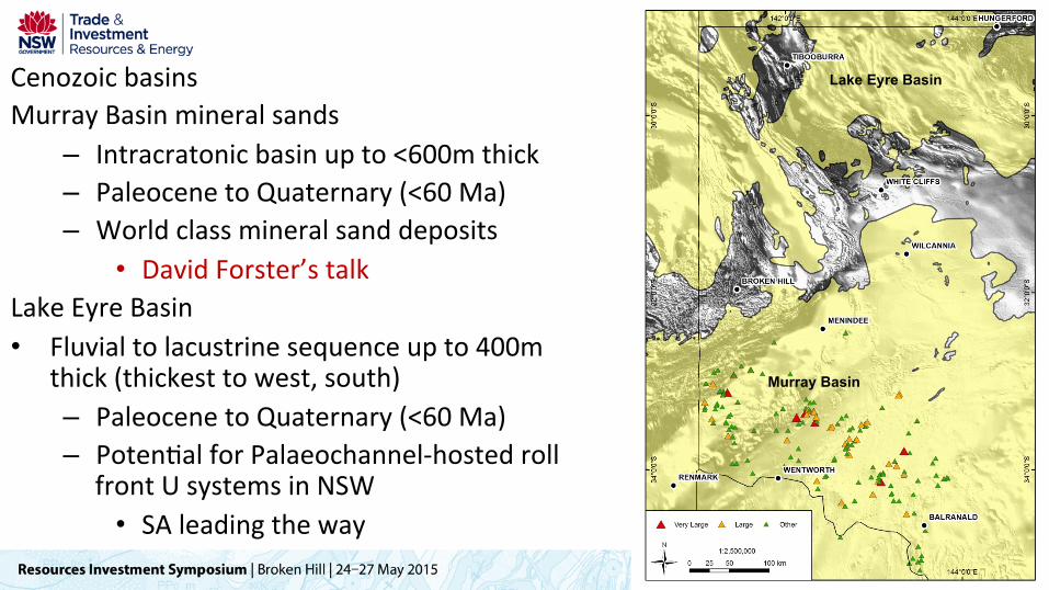
Cenozoic basins Murray Basin mineral sands
– Intracratonic basin up to <600m thick – Paleocene to Quaternary (<60 Ma) – World class mineral sand deposits
• David Forster’s talk Lake Eyre Basin • Fluvial to lacustrine sequence up to 400m
thick (thickest to west, south) – Paleocene to Quaternary (<60 Ma) – Poten-al for Palaeochannel-‐hosted roll
front U systems in NSW • SA leading the way
Lake Eyre Basin
Murray Basin

What has GSNSW been doing?
What have the Romans ever done for us?

Geophysics and spectral data • Available by 250k map sheet • Aeromagne-c
– 25 m grid, 160 000 line km • Radioelement
– Reprocessed data – Special uranium stretches
• Gravity – 2x2 km grid
• Spectral – ASTER, HyMap, Hylogger
• Plus seismic, poten-al-‐field / 3D modelling and lessons for interpre-ng (Rosemary’s talk)

New genera-on mapping – Seamless • Best available mapping • Consistent geodatabase • No map sheet or scale capture issues • Strato-‐tectonic layers
• Curnamona, Delamerian, Devonian etc • Consistent stra-graphy • Avribu-on in two streams
• Source – scale, how captured • Geological – age, lithology, deposi-onal
environment etc

Seamless geology – what’s in? • Previous mapping
– 25k lithological and 100k stra-graphic mapping from 1970s and 1980s
• Previous compila-on – Bill et. al’s ‘bheimoth’ (BHEI 2009) – –Palaeoproterozoic to Neoproterozoic

Seamless geology – what’s in? • Koonenberry Belt
– 4 x 25k geology – 12 x 100k geology – 4 x 100k regolith
• Geophysical-‐geological and solid geology interpreta-ons – Loch Lilly-‐Kars – Koonenberry Belt 250k solid
geology – Milparinka 250k, Cobham Lake
250k and western division
1. Sharp et al. 2006 2. Gilmore et al. 2010. 3. Hegarty 2011, 2010, in prep. respec-vely

Mineral systems • Broken Hill special 250k metallogenic map
– Includes updated classifica-ons and review of metamorphism (Joel’s talk)
• Koonenberry Belt – Mineral systems study (2010)
• Ongoing research – e.g. intrusion related Sn, REE, U
• Collabora-on with Geoscience Australia – Pb isotope map (Huston et al. 2013) – MUM geochronology Koonenberry
Juvenile
Evolved
Approximate uncertainty
Huston et al (2013)

Drilling support • Coopera-ve drilling in the area
– Impact Minerals (Red Hill) • $121k to test below workings • Intersected high grade Ni and Cu
– Ausmon Resources (Nuntherungie) • $39k to test porphyry system • S-ll to be drilled
• EC Andrews Drillcore Facility in Broken Hill – 80 000m storage, viewing

GDW • Geoscien-fic Data Warehouse
– GSNSW maps georeferenced – GSNSW point data (e.g. geochron) – Open file explora-on data
• An example from our system – 18 500 drill holes – 5 400 have Cu assays, – 13 600 have Pb assays – Max value per hole plots
hvp://dwh.minerals.nsw.gov.au/CI/warehouse
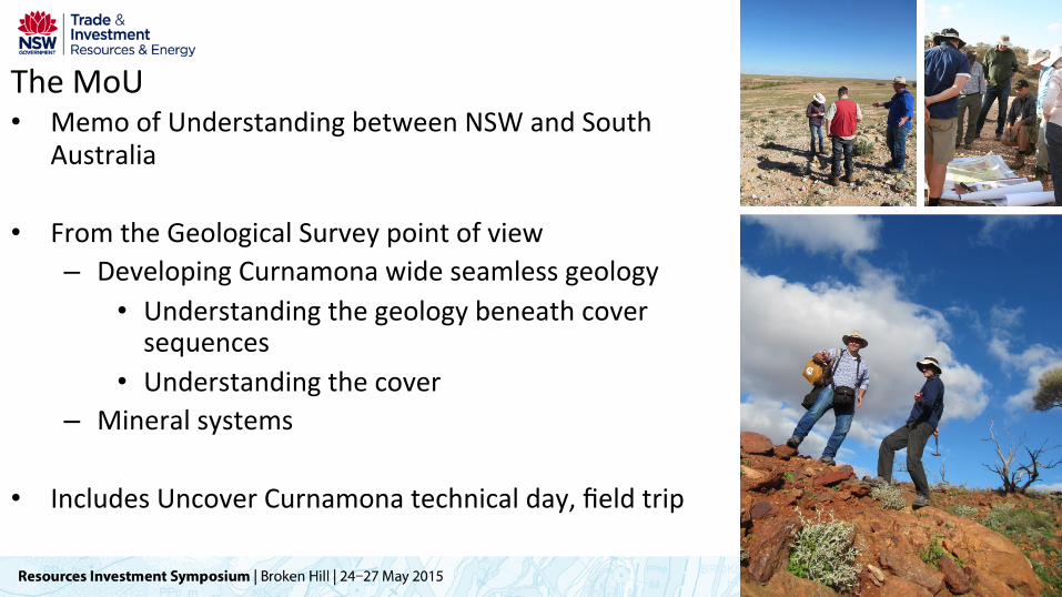
The MoU • Memo of Understanding between NSW and South
Australia
• From the Geological Survey point of view – Developing Curnamona wide seamless geology
• Understanding the geology beneath cover sequences
• Understanding the cover – Mineral systems
• Includes Uncover Curnamona technical day, field trip

Conclusions • ‘Curnamona and surrounds’ = massive area
– A lot of metal – A lot of concepts – A lot of poten-al
• GSNSW wants to see more mines – So aiming to reduce explora-on risk
• Precompe--ve data • Coopera-ve drilling • Ideas • Technology
• Internally and via collabora-on

Thanks