2016–2030 global air navigation plan · circumstances can be a double-edged sword. though a sure...
TRANSCRIPT

Doc 9750-AN/963 Fifth Edition – 2016
2016–2030Global Air Navigation Plan

© 2016, International Civil Aviation Organization
Published in Montréal, Canada
International Civil Aviation Organization 999 Robert-Bourassa Boulevard Montréal, Quebec, Canada H3C 5H7
www.icao.int
Disclaimer
This report makes use of information, including air transport and safety related data and statistics, which is furnished to the International Civil Aviation Organization (ICAO) by third parties. All third- party content was obtained from sources believed to be reliable and was accurately reproduced in the report at the time of printing. However, ICAO specifically does not make any warranties or representations as to the accuracy, completeness, or timeliness of such information and accepts no liability or responsibility arising from reliance upon or use of the same. The views expressed in this report do not necessarily reflect individual or collective opinions or official positions of ICAO Member States.
Note – The United Nations’ definitions of regions are used in the report.
This document focusses primarily on scheduled commercial flights as this type of traffic accounts for more than 60 per cent of total fatalities.
The scheduled commercial flights data were obtained from the Official Airline Guide (OAG).

Achieve sustainable growth of the global civil aviation system.
The International Civil Aviation Organization is the global forum of States for international civil aviation. ICAO develops policies, standards, undertakes compliance audits, performs studies and analyses, provides assistance and builds aviation capacity through the cooperation of Member States and stakeholders.
A. Safety Enhance global civil aviation safety.
B. AirNavigationCapacityandEfficiency Increase capacity and improve efficiency of the global civil aviation system.
C. Security and Facilitation Enhance global civil aviation security and facilitation.
D. Economic Development of Air Transport Foster the development of a sound and economically-viable civil aviation system.
E. Environmental Protection Minimize the adverse environmental effects of civil aviation activities.
ICAO’s Vision
Our Mission
2017–2019 Strategic Objectives

GANP 2016–20302
Although the ICAO work programme is endorsed by the ICAO Assembly on a triennial basis, the Global Plan offers a long-term vision that will assist ICAO, States and industry to ensure continuity and harmonization among their modernization programmes.
To find a balance between consolidation and keeping pace with new developments, the GANP will have a more comprehensive update with the 2019 edition, aligned with the Block periods.
This edition of the GANP begins by outlining the executive-level context for the air navigation challenges ahead, as well as the need for a strategic, consensus-based and transparent approach to address these challenges.
The fifth edition of the ICAO Global Air Navigation Plan (GANP) is designed to guide complementary and sector-wide air transport progress over 2016–2030 and is approved triennially by the ICAO Council.
The GANP represents a rolling, 15-year strategic methodology which leverages existing technologies and anticipates future developments based on State/industry agreed operational objectives. The Block Upgrades are organized in non-overlapping six-year time increments starting in 2013 and continuing through 2031 and beyond. This structured approach provides a basis for sound investment strategies and will generate commitment from States, equipment manufacturers, operators and service providers.
ICAO’s 15-year Plan Addressing Global Air Navigation

GANP 2016–2030 3
The GANP explores the need for more integrated aviation planning at both the regional and State level and addresses required solutions by introducing the consensus-driven Aviation System Block Upgrades (ASBU) systems engineering modernization strategy.
In addition, it identifies issues to be addressed in the near future alongside financial aspects of aviation system modernization. The increasing importance of collaboration and partnership as aviation recognizes and addresses its multidisciplinary challenges ahead is also stressed.
The GANP also outlines implementation issues involving the near-term performance-based navigation (PBN) and Block 0 Modules and the Planning and Implementation Regional Groups (PIRGs) that will be managing regional projects.
Descriptions of implementation programmes being pursued by ICAO complete Chapter 2, while Chapter 3 explores the role of the new ICAO Air Navigation Report in conjunction with the performance-based approach for the implementation of the ASBUs.
Eight appendices provide supplementary information relating to the evolution of the GANP, online support documentation, detailed description of ASBU Modules, and the Technology Roadmaps supporting the Block Upgrades, as well as financial guidance to implement the Modules.

Executive Summary............................................................................................................................. 6Addressing Growth and Realizing the Promise of Twenty-first Century Air Traffic Management (ATM) ........6New Capabilities to Serve the Aviation Community ....................................................................................... 8What does the Global Air Navigation Plan’s Strategic Approach mean for my State? ............................... 10
Introduction · Presentation of the Global Air Navigation Plan .................... 12
Chapter 1 · ICAO’s 10 Key Air Navigation Policy Principles ............................ 16
Chapter 2 · Implementation: Turning Ideas into Action ..................................... 20
Our Priorities ................................................................................................................................................. 21Module Priorities and Minimum Path ........................................................................................................... 23ICAO Tools Supporting ASBU Modules Implementation .............................................................................. 24Training, Recruiting and Human Performance Considerations .................................................................. 25Flexibility of GANP Implementation ............................................................................................................. 26ATM Logical Architecture .............................................................................................................................. 27Guidance on Financial aspects ...................................................................................................................... 27
Chapter 3 · Aviation System Performance ..................................................................... 28
Global Air Navigation Report and Performance/Implementation Monitoring ........................................... 29Performance-based Approach for Implementing the ASBUs ..................................................................... 29
Appendix 1 · Global Air Navigation Plan Evolution & Governance ............ 32
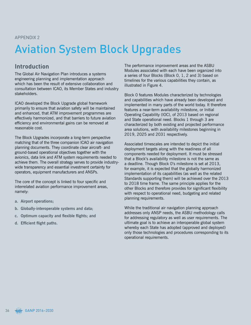
Appendix 2 · Aviation System Block Upgrades .......................................................... 36
Introduction ................................................................................................................................................... 36Schematic Diagram of Block Upgrades ........................................................................................................ 40Block 0 ............................................................................................................................................................ 46Block 1 ............................................................................................................................................................ 63Block 2 ............................................................................................................................................................ 81Block 3 ............................................................................................................................................................ 85
Contents
Appendix 3 · Online Support Documentation ............................................................... 88
ICAO documentation for the ASBUs .............................................................................................................. 89Standardization Roadmap ............................................................................................................................. 90Linkage with Third Edition GANP .................................................................................................................. 90
Appendix 4 · Frequency Spectrum Considerations ............................................... 92
Appendix 5 · Technology Roadmaps .................................................................................... 94
Communication .............................................................................................................................................. 95Navigation .................................................................................................................................................... 100Surveillance ................................................................................................................................................. 106Information Management .............................................................................................................................112Avionics .........................................................................................................................................................116Automation ................................................................................................................................................... 122
Appendix 6 · Module Dependencies ................................................................................... 124
Appendix 7 · ATM Logical Architecture .......................................................................... 126
Appendix 8 · Financial and Coordination Aspects of Implementation ...... 128
General Description .................................................................................................................................... 128Methodology ................................................................................................................................................ 131
Appendix 9 · Acronym Glossary ............................................................................................ 134

3.3 billionPassengers annually
(carried on scheduled traffic, 2014)
$6.4 trillionValue of air cargo annually
(2012)
$2.4 trillionContributed to global GDP annually(direct, indirect and induced, 2012)
$
GANP 2016–20306
EXECUTIVE SUMMARY
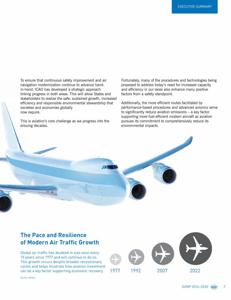
It is no mystery then why air traffic growth has so consistently defied recessionary cycles since the mid-1970s, expanding two-fold once every 15 years. It resisted these recessions precisely because it served as one of our most effective tools for ending them – an important consideration for governments at every level in a challenging economic environment.
But even as air transport’s speed and efficiency significantly facilitate economic progress, its growth under certain circumstances can be a double-edged sword. Though a sure sign of increased living standards, social mobility and generalized prosperity on the one hand, unmanaged air traffic growth can also lead to increased safety risks in those circumstances when it outpaces the regulatory and infrastructure developments needed to support it.
Air transport plays a major role in driving sustainable economic and social development. It directly and indirectly supports the employment of 58.1 million people, contributes over $2.4 trillion to global Gross Domestic Product (GDP), and carries over 3.3 billion passengers and $6.4 trillion worth of cargo annually.
Aviation achieves its impressive level of macro-economic performance by serving communities and regions through clear cycles of investment and opportunity. Infrastructure development generates initial employment and the ensuing airport and airline operations generate new supplier networks, tourism influxes and access for local producers to distant markets. These burgeoning trade and tourism economies then continue to expand, fostering wider and more sustainable regional growth.
The operational and economic context for the Global Air Navigation Plan
Addressing Growth and Realizing the Promise of Twenty-first Century Air Traffic Management (ATM)
Driving Economic Recovery
Aviation’s Global ImpactsSource: ATAG; ICAO
2022200719921977
The Pace and Resilience
15 years since 1977 and will continue to do so. This growth occurs despite broader recessionary cycles and helps illustrate how aviation investment can be a key factor supporting economic recovery.
Source: Airbus
GANP 2016–2030 7
EXECUTIVE SUMMARY
Fortunately, many of the procedures and technologies being proposed to address today’s need for increased capacity and efficiency in our skies also enhance many positive factors from a safety standpoint.
Additionally, the more efficient routes facilitated by performance-based procedures and advanced avionics serve to significantly reduce aviation emissions – a key factor supporting more fuel-efficient modern aircraft as aviation pursues its commitment to comprehensively reduce its environmental impacts.
To ensure that continuous safety improvement and air navigation modernization continue to advance hand-in-hand, ICAO has developed a strategic approach linking progress in both areas. This will allow States and stakeholders to realize the safe, sustained growth, increased efficiency and responsible environmental stewardship that societies and economies globally now require.
This is aviation’s core challenge as we progress into the ensuing decades.
The Pace and Resilience ofModernAirTrafficGrowthGlobal air traffic has doubled in size once every 15 years since 1977 and will continue to do so. This growth occurs despite broader recessionary cycles and helps illustrate how aviation investment can be a key factor supporting economic recovery.
Source: Airbus

GANP 2016–20308
EXECUTIVE SUMMARY
Air Navigation has witnessed some important improvements in recent decades, and yet, a considerable remainder of the global Air Navigation system is still limited by conceptual approaches that arose in the twentieth century. These legacy Air Navigation capabilities limit air traffic capacity and growth and are responsible for unnecessary gas emissions being deposited into our atmosphere.
A fully-harmonized global air navigation system built on modern performance-based procedures and technologies is a solution to these concerns. This goal has been on the minds of Communications, Navigation and Surveillance/Air Traffic Management (CNS/ATM) planners for many years. Because technology never stands still, the realization of a strategic path to such a globally harmonized system has proven elusive.
The solution to this impasse lies at the heart of ICAO’s core mission and values. Only by bringing together the States and stakeholders from every corner of the aviation community can a viable solution to twenty-first century Air Navigation be determined.
The Aviation System Block Upgrades (ASBU) methodology and its Modules define a programmatic and flexible global systems engineering approach allowing all States to advance their Air Navigation capacities based on their specific operational requirements.
This will permit all States and stakeholders to realize global harmonization, increased capacity, and environmental efficiency that modern air traffic growth now demands in every region around the world.
If the air transport system is to continue to drive global economic prosperity and social development to the extent that the aviation community and the world have grown accustomed, especially in the face of expected regional traffic growth projections and the pressing need for more determined and effective climate-related stewardship, States must fully embrace the new Block Upgrade process and follow a unified path to the future global Air Navigation system.
The Global Air Navigation Plan’s Aviation System Block Upgrades methodology is a programmatic and flexible global systems engineering approach that allows all Member States to advance their Air Navigation capacities based on their specific operational requirements. The Block Upgrades will enable aviation to realize the global harmonization, increased capacity, and improved environmental efficiency that modern air traffic growth now demands in every region around the world.
New Capabilities to Serve the Aviation CommunityProviding flexibility for Member States through the consultative and cooperative Aviation System Block Upgrades methodology

GANP 2016–2030 9
EXECUTIVE SUMMARY
GANP Fifth Edition Aviation System Block Upgrades Methodology
The ICAO Block Upgrades (dark blue columns) refer to the target availability timelines for a group of operational improvements (technologies and procedures) that will eventually realize a fully-harmonized Global Air Navigation System. The technologies and procedures for each Block have been organized into unique Modules (smaller white squares) which have been determined and cross-referenced based on the specific Performance Improvement Area to which they relate. ICAO has produced the systems engineering for its Member States so that they need only consider and adopt the Modules appropriate to their operational need.
By way of example, Block 0 (2013) features Modules characterized by operational improvements which have already been developed and implemented in many parts of the world today. It therefore has a near-term implementation period of 2013–2018, whereby 2013 refers to the availability of all components of its particular performance Modules and 2018 refers to the target implementation deadline. It is not the case that all States will need to implement every Module, and ICAO will be working with its Member States to help each determine exactly which capabilities they should have in place based on their unique operational requirements.
Airportoperations
PerformanceImprovement Areas
Block 0(2013)
Block 1(2019)
Block 2(2025)
Block 3(2031 onward)
Globallyinteroperable
systems and data
Optimumcapacity and
flexible flights
Efficient flight paths
Module
PerformanceImprovement Areas
Block 0(2013)
Block 1(2019)
Block 2(2025)
Block 3(2031 onward)
Globallyinteroperable
systems and data
Module B0–FICE
Performance capability:
Increased interoperability,efficiency and capacitythrough ground-groundintegration.
Bx = Block Number xFICE = Thread Acronym
Module B1–FICE
Performance capability:
Increased interoperability,efficiency and capacitythrough FF-ICE, Step 1 application beforedeparture.
Module B2–FICE
Performance capability:
Improved coordinationthrough multi-centreground-ground integration(FF-ICE, Step 1 & Flight Object, SWIM) including execution phase.
Module B3–FICE
Performance capability:
Improved operationalperformance throughthe introduction of Full FF-ICE.
A Module ‘Thread’ is associated with a specific performance improvement area. Some of the Modules in each consecutive Block feature the same Thread Acronym, indicating that they belong to the same performance improvement area as it progresses toward (in this case) its target of ‘globally interoperable systems and data’ which considers Flight and Flow Information in a collaborative environment (FF-ICE). Every Module under the Block Upgrade approach will similarly serve to progress towards one of the four target Performance Improvement Areas.

EXECUTIVE SUMMARY
GANP 2016–203010
The 2016–2030 ICAO Global Air Navigation Plan presents all States with a comprehensive planning tool supporting a harmonized global Air Navigation system. It identifies all potential performance improvements available today, details the next generation of ground and avionics technologies that will be deployed worldwide, and provides the investment certainty needed for States and Industry to make strategic decisions for their individual planning purposes.
Ongoing Air Navigation improvement programmes being undertaken by a number of ICAO Member States (SESAR in Europe; NextGen in the United States; CARATS in Japan; SIRIUS in Brazil, and others in Canada, China, India and the Russian Federation) are consistent with the ASBU Methodology. These States mapped their planning to respective Block Upgrade Modules in order to ensure the near- and longer-term global interoperability of their Air Navigation solutions.
The GANP’s Block Upgrade planning approach also addresses user needs, regulatory requirements and the needs of Air Navigation Service Providers and Airports. This ensures a single source for comprehensive planning.
What does the Global Air Navigation Plan’s Strategic Approach mean for my State?Understanding near-term implementation and reporting requirements

EXECUTIVE SUMMARY
GANP 2016–2030 11
Basic Modules to implement as a minimum path to support global interoperability were discussed at the Twelfth Air Navigation Conference (AN-Conf/12). They will be defined in the next triennium and be taken in account in the Regional Priorities agreed to by the Planning and Implementation Regional Groups (PIRGs). As the GANP progresses, Module implementation will be fine-tuned through regional agreements in the ICAO PIRG process.
The PIRG process will further ensure that all required supporting procedures, regulatory approvals and training capabilities are set in place. These supporting requirements will be reflected in regional online Air Navigation Plans (eANPs) developed by the PIRGs, ensuring strategic transparency, coordinated progress and certainty of investment.
With respect to all of these regional and State planning efforts, the detailed information available in the GANP’s Technology Roadmaps (Appendix 5) and Module descriptions (Appendix 2) will significantly facilitate the development of business cases for any operational benefit being considered (Chapter 2 and Appendix 8).
• Obliges States to map their national or regional programmes against the harmonized GANP, but provides themwithfargreatercertaintyofinvestment.
• Requires active collaboration among States through the PIRGsinordertocoordinateinitiativeswithinapplicableregional Air Navigation Plans.
• Provides required tools for States and regions to develop comprehensive business case analyses as they seek to realizetheirspecificoperationalimprovements.
• Provides a vision of the evolution of the Global ATM system and the potential requirements to industry, for better anticipation in its products.
THE 2016–2030 GLOBAL AIR NAVIGATION PLAN

INTRODUCTION

INTRODUCTION
GANP 2016–2030 13
ICAO is an organization of Member States with the objective of developing principles and techniques for international air navigation, fostering the planning and development of international transport and promoting the development of all aspects of international civil aeronautics.
The ICAO Global Air Navigation Plan (GANP) is an overarching framework that includes key civil aviation policy principles to assist ICAO Regions, subregions and States with the preparation of their Regional and State air navigation plans.
The objective of the GANP is to increase capacity and improve efficiency of the global civil aviation system whilst improving or at least maintaining safety. The GANP also includes strategies for addressing the other ICAO Strategic Objectives.
The GANP includes the Aviation System Block Upgrades (ASBU) framework, its Modules and its associated Technology Roadmaps covering inter alia communications, surveillance, navigation, information management and avionics.
The ASBUs are designed to be used by the Regions, subregions and States when they wish to adopt the relevant Blocks or individual Modules to help achieve harmonization and interoperability by their consistent application across the Regions and the world.
The GANP, along with other high-level ICAO plans, will help ICAO Regions, subregions and States establish their air navigation priorities for the next 15 years.
The GANP outlines ICAO’s 10 key civil aviation policy principles guiding global, regional and State air navigation planning.
Presentation of the Global Air Navigation Plan

GANP 2016–203014
INTRODUCTION
2010
Figure 1: The development of Air Traffic Flows from 2010 to 2030 (OAG based forecast)
The 2010 data on aircraft movements traffic was sourced from the Official Airline Guide (OAG) and grouped by 32 major traffic flows worldwide over a network of 43 559 routes between 4 300 cities. The projections for the years 2020 and 2030 are a by-product from the results of a “commercial aircraft fleet-mix” forecast model developed by the ICAO Secretariat in 2013. The main function of the model is the prediction of the aircraft fleet mix (aircraft by seat class) operated on each route. The commercial aircraft fleet is grouped into 9 seat classes (depending on the number of seats on the aircraft). The model uses as input ICAO forecasts by traffic flow along with assumptions on the future evolution of load factors, aircraft utilization, aircraft retirement curves among other parameters. The model output includes the aircraft fleet mix operated on each route along with the number of movements, available seats and aircraft utilization. The 2010 network remains constant.
Yearly aircraft movements
Legend
2101-46512
1001-2100
401-1000
166-400
1-165

GANP 2016–2030 15
INTRODUCTION
2020
2030

ICAO’s 10 Key Air Navigation Policy PrinciplesCHAPTER 1
CHAPTER 1
GANP 2016–2030 17
AIR N
AVIGATIO
N P
OLIC
Y PR
INC
IPLES
1.Commitment to the implementation of ICAO’s Strategic Objectives and Key Performance Areas
ICAO Regional and State Air Navigation Planning will cover each of ICAO’s Strategic Objectives and all 11 ICAO Key Performance Areas.
2.Aviation safety is the highest priority
In Air Navigation planning and in establishing and updating their individual Air Navigation Plans, ICAO Regions and States will give due consideration to the safety priorities set out in the Global Aviation Safety Plan (GASP).
3.Tiered approach to air navigation planning
ICAO’s Global Aviation Safety Plan and Global Air Navigation Plan will guide and harmonize the development of ICAO Regional and individual State Air Navigation Plans.
ICAO Regional Air Navigation Plans, developed by the Regional Planning and Implementation Groups (PIRGs), will also guide and harmonize the development of individual State Air Navigation Plans.
When developing their Regional Air Navigation Plans, PIRGs should address their intra and inter-regional issues.
4.Global Air Traffic Management Operational Concept (GATMOC)
The ICAO-endorsed Global Air Traffic Management Operational Concept (Doc 9854) and companion manuals, which include inter alia, the Manual on Air Traffic Management System Requirements (Doc 9882) and the Manual on Global Performance of the Air Navigation System (Doc 9883), will continue through their evolution, to provide a sound global conceptual basis for global air navigation and air traffic management systems.
5.Global air navigation priorities
ICAO should develop provisions and supporting material and provide training in line with the global air navigation priorities described in this plan.
6.Regional and State air navigation priorities
ICAO Regions, subregions and individual States through the PIRGs should establish their own Air Navigation priorities to meet their individual needs and circumstances in line with the Global Air Navigation Priorities.

CHAPTER 1
GANP 2016–203018
8.Use of ASBU Blocks and Modules
Although the GANP has a global perspective, it is not intended that all ASBU Modules are to be applied around the globe.
When the ASBU Blocks and Modules are adopted by regions, subregions or States they should be followed in close accordance with the specific ASBU requirements to ensure global interoperability and harmonization of air traffic management.
It is expected that some ASBU Modules will be essential at the global level and therefore may eventually be the subject of ICAO mandated implementation dates (minimum path).
7.Aviation System Block Upgrades (ASBUs), Modules and Roadmaps
The ASBUs, Modules and Roadmaps form a key attachment to the GANP, noting that they will continue to evolve as more work is done on refining and updating their content and in subsequent development of related provisions, supporting material and training.

CHAPTER 1
GANP 2016–2030 19
AIR N
AVIGATIO
N P
OLIC
Y PR
INC
IPLES
10.Review and evaluation of air navigation planning
ICAO should review the GANP every three years and, if necessary, all relevant Air Navigation Planning documents through the established and transparent process.
The appendices to the GANP should be analysed annually by the Air Navigation Commission to ensure they remain accurate and up to date.
The progress and effectiveness of ICAO Regions and States against the priorities set out in their respective regional and State air navigation plans should be annually reported, using a consistent reporting format, to ICAO. This will assist regions and States in adjusting their priorities to reflect actual performance and address any emerging air navigation issues.
9.Cost-benefit and financial issues
The implementation of air navigation measures, including those identified in the ASBUs, can require significant investment of finite resources by ICAO Regions, subregions, States and the aviation community.
When considering the adoption of different Blocks and Modules, ICAO Regions, subregions and States should undertake cost-benefit analyses to determine the business case for implementation in their particular region or State.
The new guidance material on cost benefit analysis will assist States in implementing the GANP.

Implementation: Turning Ideas into ActionCHAPTER 2

CHAPTER 2
GANP 2016–2030 21
IMP
LEMEN
TATION
: TUR
NIN
G ID
EAS INTO
ACTION
PBN departure routes to be developed in more locations, particularly in mountainous terrain, and assist with capacity improvements by enabling parallel runway departures. The focus of all this work is to address all related issues, ensuring a complete deliverable improvement to the end users.
Implementation of PBN in terminal airspace is seen as a key enabler for the advanced terminal operations envisaged by a mature ATM modernization programme, and the developments planned for the concept will ensure its widest possible applicability.
Strategic development
Whilst improving the PBN concept functionality is important, a need has also been identified to develop a long-term strategy which would reduce the number of specifications to a more streamlined set, which would still offer full support for all PBN operations, current or planned.
Another major initiative in this area relates to the increasing harmonization and standardization of PBN terminology and references across all areas, from operational approvals to chart names. This will improve understanding of the concept and help to drive increased and safer use of PBN worldwide.
Assistance for implementation
In light of the importance of PBN, the following have been highlighted by States and the aviation stakeholders as the key areas for ICAO to focus its efforts to ensure effective and coordinated implementation:
• The need for guidance material, workshops and symposia on all aspects of PBN including regulatory oversight issues (as recommended by the High Level Safety Conference 2015), the design and validation of procedures, aircraft operations approval, stakeholder consultation, etc.;
• Online learning packages;
• In classroom courses to ensure that PBN requirements and Standards are fully understood and properly implemented;
ICAO will focus its efforts over the next three years on the development and implementation of performance-based navigation (PBN), continuous descent operations (CDO), continuous climb operations (CCO) and air traffic flow management (ATFM), including runway sequencing capabilities (AMAN/DMAN).
Considering the flexibility that ICAO has intentionally built into its Block Upgrade approach, there are nevertheless some elements of the GANP that will need to be considered for worldwide applicability. The characterization of the particular Block Modules that are considered necessary for the future safety or regularity of international Air Navigation, and which may eventually become an ICAO Standard, is essential to the success of the GANP. Compliance with existing standards is also key to this success.
In this context, a wide synchronization of global or regional deployment timelines will sometimes be necessary as well as consideration with respect to possible implementation agreements or mandates. Also, any ASBU implementation in international airspace that requires mandatory equipage and capabilities must first have a Regional Agreement and be incorporated into the Regional Supplementary Procedures (Doc 7030).
PBN: Our Highest implementation priorityIn line with the continued focus on PBN as the highest priority for Air Navigation, ICAO’s PBN Programme is working to further improve and develop the PBN concept, whilst also striving to assist States with successful implementation of PBN routes and procedures.
Enhanced functionality
Several PBN advanced functions and options are being developed which will increase PBN usability in challenging environments, allowing safer access to more airports and improved route efficiencies. Additionally the development of RNP AR (authorization required) Departures will enable
Our Priorities

CHAPTER 2
GANP 2016–203022
ICAO Continuous Descent Operations (CDO) Manual (Doc 9931) and Continuous Climb Operations (CCO) Manual (Doc 9993) provide guidance in the design, implementation and operation of environmentally friendly arrivals and departures. In order for this to be fully implemented, ATM tools and techniques, especially arrival and departure management tools, have to be implemented and/or updated to ensure that arrival and departure flows are smooth and appropriately sequenced.
Air traffic flow managementAir traffic flow management (ATFM) is an enabler of air traffic management (ATM) efficiency and effectiveness. It contributes to the safety, environmental sustainability, efficiency and cost-effectiveness of an ATM system. ATFM aims at enhancing safety by ensuring the delivery of safe densities of traffic and by minimizing traffic surges. Its purpose is, when needed, to balance traffic demand and available capacity.
Successful and efficient ATFM relies on the clear definition of capacities (i.e. number of flights that can be handled by an airport or a en-route sector), as well as on the analysis of forecasted traffic flows (amount of traffic that is expected at an airport or an en-route sector). Therefore, ATFM also relies heavily on the exchange of information related to flight plans, airspace availability and capacity. ATFM allows the various system stakeholders to collaboratively reconcile system resource constraints with economic and environmental priorities. The range of possible ATFM measures spans from limited speed variations to ground delay programs to address the most severe disruption cases. ATFM is therefore a scalable process, that can be designed to answer very local capacity issues up to systemic capacity/demand imbalances.
The number of States that manage traffic flows and implement ATFM procedures grows steadily. ICAO, having established ATFM as one of its priorities, has strived to provide extensive support to the much needed development of flow management worldwide. ATFM is a major enabler for Safety which covers increased efficiency of ATM as a whole.
The nature of ATFM transcends borders and frontiers.Managing traffic flows impact adjacent airspaces, and sends ripple effects that can be felt at the level of an entire region. In that light, establishing a common international reference was paramount. ICAO produced that reference, with the second edition of the Manual on Collaborative Air Traffic Flow Management (Doc 9971).
• Active, coordinated support for continuing Standards development and amendment;
• Support for a harmonized approach to regional PBN implementation;
• Specific products to assist a State with its PBN implementation needs; and
• Assistance to ensure harmonized and integrated implementation of related technologies and support tools to optimize performance capability objectives.
Many such products are now available through the ICAO PBN website, and ICAO continues to coordinate with all aviation stakeholders to identify new initiatives, develop more in-depth guidance material and create additional training courses (online and classroom), as required, to support high-level requirements for PBN implementation.
Environmental gains through PBN terminal procedures — CDO and CCOMany major airports now employ PBN procedures and, in a large number of cases, judicious design has resulted in significant reductions in environmental impacts (noise avoidance and reduced emissions). In cases where the airspace design has also supported continuous descent operations (CDO) and continuous climb operations (CCO) even greater environmental benefits have been realized.
CDOs feature optimized profile descents that allow aircraft to descend from the cruise to the final approach to the airport at minimum thrust settings. Besides the significant fuel savings this achieves, CDO has the additional environmental benefit of decreasing airport/aircraft noise levels, benefitting local communities. In addition to the general benefits in this regard, derived from less thrust being employed, the application of PBN functionality allows the lateral path to be routed to avoid more noise-sensitive areas.
CCOs can have similar benefits for departures. A continuous climb operation does not require a specific air or ground technology, but rather is an aircraft operating technique aided by appropriate airspace and procedure design. Enabling an aircraft to reach and maintain its optimum flight level without interruption is a key driver to improve fuel efficiency and minimize carbon emissions as a large proportion of fuel burn occurs during the climb phase. Again, the application of PBN for departure allows route design that avoids overflying noise sensitive areas.

CHAPTER 2
GANP 2016–2030 23
IMP
LEMEN
TATION
: TUR
NIN
G ID
EAS INTO
ACTION
Although all ASBU Modules are equally important, it is recognized that:
• some Modules must be implemented globally, and therefore must be designated as part of the minimum path to achieve global interoperability;
• deployment of such Modules in the earliest available time frame will result in maximum benefits for the aviation stakeholders; and
• implementations of such Modules should take place around the same time periods.
This already exists for some specific Block 0 Modules:
• B0-ACAS (improved ACAS, TCAS v7.1). ICAO agreed to mandate the improved ACAS for new installations as of 1 January 2014 and for all installations no later than 1 January 2017;
• B0-APTA (Optimization of Approach Procedures including vertical guidance). Assembly Resolution urged States to achieve implementation of approach procedures with vertical guidance (APV) (Baro-VNAV and/or augmented GNSS) including LNAV-only minima for all instrument runway ends by 2016;
• B0-DATM (Service Improvement through Digital Aeronautical Information Management) prepares the world for digital information exchange;
• B0-FICE (Increased Interoperability, Efficiency and Capacity through Ground-Ground Integration) to improve coordination between air traffic service units (ATSUs) by using ATS interfacility data communication (AIDC). AIDC is the necessary first step for all improvements in FF-ICE, ATFM and collaborative decision-making and the baseline of future advanced information management processes;
and could be targeted in areas where radar coverage does not exist today but where the need to fly more direct routes or handling more traffic in each sector exists:
• B0-ASUR (ADS-B out and MLAT), operationally, the lower costs of dependent surveillance infrastructure in comparison to conventional radars support business decisions to expand radar-equivalent service volumes and the use of radar-like separation procedures into remote or non-radar areas. Additionally, the non-mechanical nature of the ADS-B ground infrastructure allows it to be sited in locations that are difficult for
The ICAO regional offices and the ICAO regional sub-offices have also been extremely active in supporting ATFM implementation. Beyond providing technical expertise and guidance to the States from their respective regions, they have also developed regional concept of operations and organized training events to foster implementation of ATFM and collaborative decision-making (CDM). Significant efforts and various workshops were also organized to this effect.
Module Priorities and Minimum PathThe international civil aviation community has made it clear that ICAO should provide guidance to States on how to prioritize the Modules. The Twelfth Air Navigation Conference affirmed this by requesting ICAO to “continue to work on guidance material for the categorization of block upgrade modules for implementation priority and provide guidance as necessary to planning and implementation regional groups and States” (Recommendation 6.12 (c)).
In addition to this, the Conference requested ICAO to “identify modules in Block 1 considered to be essential for implementation at a global level in terms of the minimum path to global interoperability and safety with due regard to regional diversity, for further consideration by States” (Recommendation 6.12 (e)).
Responding to the above ICAO provided a planning flowchart (Appendix 1) for the Regions in the fourth edition of the GANP, which takes into account the Modules as well as the Regional Priorities. This information is to be used by the PIRGs to set the priorities for Module implementation in individual Regions. When establishing regional priorities for implementation, the items which are essential for inter-regional interoperability and safety shall be taken into account as stated in Recommendation 6.12 (e).
For this new fifth edition, and as it is expected that these Modules may eventually become the subject of ICAO Standards with mandated implementation dates, the concept of “minimum path to global interoperability and safety” is introduced. It represents the sets of Modules that are or will be needed at a global level for the future air navigation systems to work in a cooperative manner and for aviation to fully benefit from the deployed technology. It should help States and regions anticipate and efficiently plan their future investments.

CHAPTER 2
GANP 2016–203024
ICAO Tools Supporting ASBU Modules ImplementationICAO’s GANP webpage3 will serve as the main page for centralized access to many tools and documents, in addition to the complete ASBU document containing the Module-by-Module descriptions for Member States and industry reference.
ICAO documentation for the ASBUsEach ASBU Modules contains the list of standards, procedures, guidance material and approval documents needed to get the full benefit of the operational improvement. ICAO has now linked its work programme with this list and will provide the updated list of documents according to the two-early amendment cycle. Appendix 3 provides a publication forecast for each ASBU Module, which will be also accessible from the GANP webpage.
Standardization RoadmapAs recommended by the Twelfth Air Navigation Conference and the 38th Session of the ICAO Assembly (Resolution A38-11), ICAO is working on a Standardization Roadmap. The Standardization Roadmap not only reflects ICAO’s plan of work, but also is the basis for cooperation with other standard making organizations (“[…] utilize, to the maximum extent appropriate and subject to the adequacy of a verification and validation process, the work of other recognized standards making organizations in the development of SARPs, PANS and ICAO technical guidance material.”)
3 See http://www.icao.int/airnavigation/Pages/GANP-Resources.aspx
radar installations. MLAT requires more ground stations than ADS-B and has larger geometric requirements than ADS-B, but has the early implementation advantage of using current aircraft equipage.
Three Block 1 Modules (B1-FICE, B1-DATM, B1-SWIM) are expected to be deployed worldwide in the coming years. Harmonization and interoperability constraints should make them essential, becoming the foundations of the future ATM system.
The development of suitable high level principles or guidelines to identify essential Modules at a global level will be necessary. Considering safety and interoperability as basic targets, such principles could, focus, for example, on those Modules providing:
• direct and tangible safety improvements;
• interoperability of ground-to-ground systems, recognizing the desirability of automation systems to be able to effectively communicate globally; and
• interoperability of air-to-air systems, recognizing the need for airborne applications to be able to interact without restriction.
The 2019 edition of the GANP will assess the status of all Modules based on the level of deployment and the updated availability of the technology and standards. The Module dependencies diagram (Appendix 6) will also be used as a reference.

CHAPTER 2
GANP 2016–2030 25
IMP
LEMEN
TATION
: TUR
NIN
G ID
EAS INTO
ACTION
personnel needs, and to assist the global aviation community in attracting, training, educating and retaining the next generation of aviation professionals.
It is therefore critical that the concepts being developed within the GANP take into account the strengths and weaknesses of existing and future skilled personnel at every juncture. All actors with a stake in a safe air transportation system will need to intensify efforts to manage risks associated with human performance and the sector will need to proactively anticipate interface and workstation design, training needs and operational procedures while promulgating best practices. In support of this, ICAO is working with key stakeholders under NGAP to develop training manuals for Air Traffic Controllers (ATCOs) and Air Traffic Safety Electronics Personnel (ATSEPs) utilizing competency-based training methods.
ICAO has long recognized these factors, and thus the consideration of human performance in the context of the Block Upgrades requirements will continue to evolve through State Safety Programme (SSP) and Industry Safety Management Systems (SMS) approaches.
Training, Recruiting and Human Performance ConsiderationsAviation professionals have an essential role in the transition to, and successful implementation of the GANP. The system changes will affect the work of many skilled personnel in the air and on the ground, potentially changing their roles and interactions and even requiring new proficiencies to be developed. Furthermore, with the expected growth of aviation, it is critical that enough qualified and competent personnel are available to ensure a safe and efficient aviation system. As part of the Next Generation of Aviation Professionals (NGAP) programme, ICAO is working with stakeholders to create greater awareness of the impending shortages of personnel, to forecast both global and regional

CHAPTER 2
GANP 2016–203026
Flexibility of GANP ImplementationICAO’s GANP establishes a rolling eighteen-year global planning horizon.
The resultant framework is intended primarily to ensure that the aviation system will be maintained and enhanced, that air traffic management (ATM) improvement programmes are effectively harmonized, and that barriers to future aviation efficiency and environmental gains can be removed at a reasonable cost. In this sense, the adoption of the ASBU methodology significantly clarifies how the ANSP and airspace users should plan for future equipage.
Although the GANP has a worldwide perspective, it is not intended that all Block Modules be required to be applied in every State and region. Many of the Block Upgrade Modules contained in the GANP are specialized packages that should be applied only where the specific operational requirement exists or corresponding benefits can be realistically projected.
The inherent flexibility in the ASBU methodology allows States to implement Modules based on their specific operational requirements. Using the GANP, Regional and State planners should identify those Modules which provide any needed operational improvements. Although the Block Upgrades do not dictate when or where a particular Module is to be implemented, this may change in the future should uneven progress hinder the passage of aircraft from one region of airspace to another.
The regular review of implementation progress and the analysis of potential impediments will ultimately ensure the harmonious transition from one region to another following major traffic flows, as well as ease the continuous evolution towards the GANP’s performance targets.
Amongst other priorities, the management of change pertinent to the Block Upgrades evolution should include human performance-related considerations in the following areas:
a. Initial training, competence and/or adaptation of new/active operational staff;
b. New roles and responsibilities and tasks to be defined and implemented;
c. Social factors and management of the cultural changes linked to increased automation.
Human performance needs to be embedded both in the planning and design phases of new systems and technologies as well as during implementation. Early involvement of operational personnel is also essential.
Sharing of information regarding the various aspects of human performance and the identification of human performance risk management approaches will be a prerequisite for improving safety outcomes. This is particularly true in today’s aviation operational context and the successful implementation of the Block Upgrades and other new systems into the future.
Widespread and effective management of human performance risks within an operational context cannot be achieved without a coordinated effort from regulators, industry service providers, and operational personnel representing all disciplines.

CHAPTER 2
GANP 2016–2030 27
IMP
LEMEN
TATION
: TUR
NIN
G ID
EAS INTO
ACTION
Guidance on Financial aspectsFor the implementation of the ASBU Modules, several aspects have to be taken into account by States, stakeholders and regions, according to their needs and operational and geographical environment.
In the past triennium, the ICAO Multi-disciplinary Working Group (MDWG) developed guidance material on how to set up implementation, considering economic impact assessment, business cases, cost-benefit analyses, financial instruments, incentives and the relation with ICAO policy documents, to assist States, stakeholders and regions in implementing the ASBU. Appendix 8 was developed to provide States and different stakeholders with financial guidance for the implementation of the ASBUs. It also provides a methodology for financing a project. This appendix is only a short description of the full report, which is available from the GANP webpage4.
ICAO will continue to develop guidance material for the implementation of the ASBU and more material will be available for the 2019 update of the GANP
4 See http://www.icao.int/airnavigation/Pages/GANP-Resources.aspx
ATM Logical ArchitectureThe Twelfth Air Navigation Conference requested ICAO (Recommendation 1/4 – Architecture) to develop a Global ATM logical architecture to support the GANP and planning work by Regions and States. This work has started and a first version of this ATM logical architecture is provided in Appendix 7. This logical architecture complements the Block Upgrades while also providing a graphical linkage between:
a. the ASBU Modules and the elements of the Global Operational Concept.
b. the ASBU Modules and the intended operational environment and the expected performance benefits.
Continuation of the work on the architecture to further mature and, when and where needed, detail it, will be instrumental in:
• Scoping the work on the Modules;
• Understanding and maintaining interdependencies and interoperability issues;
• Providing “situational awareness”;
• Communicating.
The further work on architecture, at the ICAO level, is in function of achieving the above objectives without becoming an objective on its own.

Aviation System PerformanceCHAPTER 3

CHAPTER 3
GANP 2016–2030 29
AVIATION
SYSTEM P
ERFO
RM
ANC
E
Global Air Navigation Report and Performance/Implementation MonitoringFollowing the endorsement of a performance-based approach to Air Navigation planning and implementation by the Eleventh Air Navigation Conference in 2003, as well as the 35th Session of the ICAO Assembly in 2004, ICAO completed the development of relevant guidance material in early 2008 (Manual on Global Performance of the Air Navigation System (Doc 9883)).
By 2009, all PIRGs, while adopting a regional performance framework, invited States to implement a national performance framework for Air Navigation systems, on the basis of ICAO guidance material and aligned with the regional performance objectives, existing Regional Air Navigation Plans, and the Global ATM Operational Concept.
The next step called for performance monitoring through an established measurement strategy. While PIRGs are progressively identifying a set of regional performance metrics, States in the meantime have recognized that data collection, processing, storage and reporting activities supporting the regional performance metrics are fundamental to the success of performance-based strategies.
The Air Navigation planning and implementation performance framework prescribes that reporting, monitoring, analysis and review activities be conducted on a cyclical, annual basis. The Air Navigation reporting form will be the basis for performance monitoring relating to Block Upgrade implementation at the regional and national levels. The Regional Performance Dashboards also present regional implementation results, highlighting what States and groups
of States are achieving in collaboration with their respective Planning and Implementation Regional Groups (PIRGs) and Regional Aviation Safety Groups (RASGs).
Reporting and monitoring results will be analysed by ICAO and aviation stakeholders and then utilized in developing the annual Global Air Navigation Report. ICAO encourages States to make initial analyses and to report results to ICAO rather than to provide raw data.
The report results will provide an opportunity for the world civil aviation community to compare progress across various ICAO Regions in the establishment of Air Navigation infrastructure and performance-based procedures.
They will also provide the ICAO Air Navigation Commission with detailed annual results on the basis of which tactical adjustments will be made to the work programme, as well as triennial policy adjustments to the GANP.
Performance - based Approach for Implementing the ASBUsGoal of a performance-based approachThe aviation system today is complex with performance determined by a diverse group of stakeholders including Air Navigation Service Providers (ANSPs), airspace users and airports. These stakeholders also see their ability to operate is significantly impacted by external events such as weather. In maintaining high levels of safety and efficiency, all stakeholders are required to make significant investments in new technology. To prioritize future investment and to improve system efficiency, adoption of a performance-based approach in the spirit of ICAO Document 9883 is required, in which a carefully chosen set of performance indicators is used that also allows for monitoring of current operations.

GANP 2016–203030
CHAPTER 3
Performance measurement at the basis of the air navigation system improvementStates have specific needs, thus the performance-based approach to be adopted, by each of them, should reflect their different needs and different maturity levels. Despite these different levels of maturity, ICAO is encouraging all States to collectively use a performance-based approach for implementation. The way they apply, and the priorities of information to be provided should be adapted to their needs and maturity levels. Over time, the collection and analysis of information will improve and the maturity of the performance-based approach will increase. Cooperation between all stakeholders is key in this matter and exchange of information and benchmarking will lead to a better understanding of the potential gaps between current and desirable performance.
A phased development approach for ICAOICAO proposes a phased development approach, linked to the problems perceived and benefits expected from the implementation of the ASBU Modules. These phases will reflect the progress of level of maturity of States and regions.
Three phases are planned:
1. Until 2019
• Agreement on a simple set of Key Performance Indicators (KPIs), based on existing best practices in more mature regions that have already published performance information and on ICAO publications;
• Initial development of guidance material, illustrating the benefits of a performance-based approach and explaining the data collection, calculation and analysis required for the selected KPIs.
2. Until 2022
• Illustrate links between ASBU Modules and KPIs and exchange of experience and best practices at regional and subregional levels;
• Update of performance related ICAO manuals (Doc 9883 and Doc 9161) and development of additional guidance material on data collection, data analysis, etc.;
• Define a global performance baseline, based on States’ performance monitoring and reporting, against which future progress will be measured.
3. 2022 and beyond
• Standardization of performance data and enhanced data exchanges to automate and reduce the cost of performance data collection and processing. This work could benefit from existing work on exchange models.
A performance-based approach is results-oriented, helping decision makers set priorities and determine appropriate trade-offs that support optimum resource allocation while maintaining an acceptable level of safety performance and promoting transparency and accountability among stakeholders. In promoting a performance-based approach, ICAO recommends that States utilize a focussed set of Key Performance Indicators (KPIs) that provide the means of identifying shortfalls and prioritizing investments. Table 1 shows a potential set of KPIs in the key performance areas of efficiency, capacity and predictability (description of indicators is available from the GANP webpage). Final KPIs will be discussed and agreed by 2019 (as indicated in the timeline below).
Implementation of KPIs will allow States to:
• Share performance issues and best practices at a global level;
• Develop business cases for ASBU Module implementation with investment based on KPIs;
• Determine timeliness and appropriateness (geographical and fleet-wise) of ASBU Module deployment according to a performance-driven approach;
• Manage readiness of ASBU Modules for deployment (driving the required speed of R&D, global standardization and development of ICAO provisions);
• Measure and document the performance benefits brought by the Modules implemented.
Through the methodology guidelines of the Manual on Global Performance of the Air Navigation System (Doc 9883), the GANP and supplementary guidance, ICAO will promote the regional development of these KPIs to support ASBU Module implementation. This approach will allow all stakeholders to analyse the current and future performance of the air navigation system and to take actions, if needed, to fill the gap between the current performance and the expected one. ICAO will provide support to define which ASBUs need to be deployed to fill the gap so that services can be delivered and the desired performance achieved.
The implementation of some elements of the ASBUs is already taking place at some degree at national or (sub- ) regional level. Groups of States, regional organizations and industry are coordinating and orchestrating joint implementation. This information, when aggregated at (sub-)regional and global levels, supports (sub-)regions and ICAO in setting priorities. Future updates of the GANP and the ASBUs will provide a global framework to enhance the performance of the air navigation system considering geographical differences and levels of maturity in terms of services being provided.

31
CHAPTER 3AVIATIO
N SYSTEM
PER
FOR
MAN
CE
GANP 2016–2030
and predictability key performance areas. States are encouraged to start with a simple set of indicators (Core KPIs) matching their needs, and to complete them later with more complex ones (Additional KPIs). States with a more mature performance improvement and monitoring process are encouraged to work with the additional KPIs. This is work in progress and ICAO will further develop the implementation approach towards the GANP Update 2019, in cooperation with States, (sub-)regions and industry.
Note that other KPIs focussing on local performance issues and requiring further analysis can also be used for the planning and justification of investments. Data from various sources can also be used.
ICAO will continue to stimulate cooperation to develop the phased approach within the context of the GANP and its future updates.
The KPIs in Table 1 have been categorized as either “core” or “additional”. The core KPIs allow States to make meaningful assessments of the efficiency of their system while keeping data processing and data archiving requirements to a minimum. These KPIs require key event times such as actual and scheduled gate times and actual runway landing and departure times to be recorded. Many of these times can be provided by airlines and punctuality statistics are often kept by State regulatory authorities.
Additional KPIs that look at flight efficiency, demand/capacity utilization or fuel burn require flight trajectory processing software. However all of these indicators have demonstrated use. Additional information on these indicators is available from the GANP webpage.
A phased implementation approach for StatesICAO emphasizes the importance of a performance-based approach, inviting all stakeholders to participate and pave the way for the challenges to be faced in the coming years. ICAO encourages States to start or to continue with a performance-based approach. For those States and regions which do not have either mature data collection and processing available or a well-developed analysing capacity, ICAO advises them to start with a qualitative expert analysis and to develop policy statements (qualitative performance objectives), followed as soon as possible, by the implementation of a quantitative approach (i.e., use indicators as a common language for measuring improvement, trends, etc.). In the future, once more and more States and regions contribute and exchange information, this will enable a global approach.
ICAO identified eleven key performance areas (KPAs) (see Doc 9854 and Doc 9883) and proposed to the PIRGs to further work on a selection of key performance indicators (KPIs) such that:
• KPIs are selected in a transparent and interoperable way, to stimulate analysis at regional and global levels;
• The algorithm and formulas used for computation are made available and have direct links to ANSPs performance and technology improvements.
As States have different needs and maturity levels or performance monitoring, ICAO proposes to work on a set of KPIs, according to needs and capabilities. Table 1 contains potential KPIs on efficiency, capacity
KPA EFFICIENCY CAPACITY PREDICTABILITY
FOCUSAREA(S)
ADDITIONAL FLIGHT TIME & DISTANCE
ADDITIONAL FUEL BURNS
CAPACITY, THROUGHPUT & UTILIZATION
CAPACITY SHORTFALL & ASSOCIATED DELAY
PUNCTUALITY VARIABILITY
CORE KPIs
KPI02 Taxi-Out Additional TimeKPI13 Taxi-In Additional Time
KPI09 Airport Peak Arrival CapacityKPI10 Airport Peak Arrival Throughput
KPI01 Departure punctualityKPI14 Arrival Punctuality
KPI15 Flight time variability
ADDITIONALKPIs
KPI04 Filed Flight Plan en-Route ExtensionKPI05 Actual en-Route ExtensionKPI08 Additional time in terminal airspace
KPI16 Additional fuel burn
KPI06 En-Route Airspace CapacityKPI11 Airport Arrival Capacity Utilization
KPI07 En-Route ATFM delayKPI12 Airport/Terminal ATFM Delay
KPI03 ATFM slot adherence
Table 1: Potential key performance indicators

GANP 2016–203032
Continued evolution of the GANP
The new GANP has its roots in an appendix to a 1993 report on what was then termed the future air navigation system (FANS). These recommendations were first presented as the FANS Concept and later became referred to more generally as CNS/ATM.
The FANS initiative had answered a request from ICAO Member States for planning recommendations on how to address air transport’s steady global growth through the coordination of emerging technologies. As research and development into these technologies accelerated rapidly during the 1990s, the Plan and its concepts advanced with them.
A standalone version was published as the ICAO Global Air Navigation Plan for CNS/ATM Systems (Doc 9750) in 1998, the second edition of which was released in 2001. During this period the Global Plan served to support State and regional planning and procurement needs surrounding CNS/ATM systems.
By 2004, ICAO Member States and the air transport industry at large had begun to encourage the transitioning of the Global Plan’s concepts into more practical, real-world solutions. Two ATM implementation Roadmaps, made up of specific operational initiatives, were consequently developed on a collaborative basis by dedicated ICAO/industry project teams.
The operational initiatives contained in the Roadmaps were later renamed Global Plan Initiatives (GPIs) and incorporated into the third edition of the GANP.
The fourth edition of the GANP introduced the ASBU methodology.
Main changes in the 2016 edition
This edition of the GANP includes the updates made to the ASBU document and provides useful additions while maintaining a stability in the structure, as requested by States after the major change of the 2013 edition.
The adjustment of dates for the Blocks is the most visible change (B0 = 2013-2018, B1 = 2019 – 2024, B2 = 2025 – 2030, B3 = 2031 onward). This will allow better synchronization with the ICAO Assembly and the amendment cycles.
The updates to the ASBU document were provided by the ICAO expert groups that are in charge of developing the associated standards. The order in which the ASBU Modules are presented is now unique in the GANP and follows the one of the ASBU document. Naming convention inconsistencies are corrected.
The additions (introduction of a performance-based approach for the ASBUs, financial and coordination aspects of implementation, notion of minimum path, documentation for the ASBUs and standardization roadmap, global ATM logical architecture) are answers to AN-Conf/12 recommendations or demands from States. They do not change the ASBU philosophy and should help in the understanding, planning and implementation of the Modules.
To find a balance between consolidation and in keeping pace with new developments, the GANP will go under a more comprehensive update with the 2019 edition, date which marks the beginning of Block 1. Most of the work planned for the next triennium and announced in the present edition (e.g. performance indicators) will support the future changes. Finally, all comments from States, collected during the 2016 review process for the 2019 edition, will ensure that the Global Air Navigation Plan remains a comprehensive and overarching planning document for international aviation.
Global Air Navigation Plan Evolution & Governance
APPENDIX 1

APPENDIX 1G
LOB
AL AIR N
AVIGATIO
N P
LAN EVO
LUTIO
N &
GO
VERN
ANC
E
GANP 2016–2030 33
Global Air Navigation Plan approval
The GANP defines the means and targets by which ICAO, States and aviation stakeholders can anticipate and efficiently manage air traffic growth while proactively maintaining or increasing safety outcomes. These objectives have been developed through extensive consultation with stakeholders and constitute the basis for harmonized action at the global, regional and national level.
The need to ensure consistency between the GANP and the Strategic Objectives of ICAO necessitates placing this high-level policy document under the authority of the ICAO Council. The GANP and its amendments are therefore approved by the Council prior to eventual budget-related developments and endorsement by the ICAO Assembly.
The appendices to the GANP should be analysed annually by the Air Navigation Commission to ensure that they remain accurate and up to date.
From the GANP to regional planning
Although the GANP has a global perspective, it is not intended that all ASBU Modules be implemented at all facilities and in all aircraft. Nevertheless, coordination of deployment actions by the different stakeholders, within a State, and within or across regions are expected to deliver more benefits than implementations conducted on an ad hoc or isolated basis. Furthermore, an overall integrated deployment of a set of Modules from several Threads at an early stage could generate additional benefits downstream.
Guided by the GANP, the regional national planning process should be aligned and used to identify those Modules which best provide solutions to the operational needs identified. Depending on implementation parameters such as the complexity of the operating environment, the constraints and the resources available, regional and national implementation plans will be developed in alignment with the GANP. Such planning requires interaction between stakeholders including regulators, users of the aviation system, the air navigation service providers (ANSPs), aerodrome operators and supply industry, in order to obtain commitments to implementation.
Regional situation analysis
GANP
AssessmentPrioritization
PIRG
Monitoring
Update national plans
Implementation
Update regionalimplementation plans
Human ResourcesTraining
Full life-cycle costsStakeholder
commitments
Identify &mitigate gaps
Select relevantmodules
Elaborate/refinescenarios options
Perform initialCBA/sensitivity
analysis
Assess impacton priorities
Set strategiesand objectives
Figure 2: Regional planning

GANP 2016–203034
APPENDIX 1
4. Consider results of research, development and validation on operational and technological matters which may affect the ASBU Modules and Technology Roadmaps; and
5. Propose adjustments to the components of the GANP.
Following approval by the Council, the updated GANP and the ASBU document will then be submitted for endorsement by ICAO Member States at the following ICAO Assembly.
Following Recommendation 1/1 b) of the Twelfth Air Navigation Conference, the GANP will be submitted to States before approval.
Accordingly, deployments on a global, regional and subregional basis and ultimately at State level should be considered as an integral part of the global and regional planning process through the Planning and Implementation Regional Groups (PIRGs). In this way, deployment arrangements including applicability dates can be agreed and collectively applied by all stakeholders involved.
For some Modules, worldwide applicability will be essential; they may, therefore, eventually become the subject of ICAO Standards with mandated implementation dates.
In the same way, some Modules are well suited for regional or subregional deployment and the regional planning processes under the PIRG are designed to consider which Modules to implement regionally, under which circumstances and according to agreed time frames.
For other Modules, implementation should follow common methodologies defined either as Recommended Practices or Standards in order to leave flexibility in the deployment process, but ensure global interoperability at a high level.
GANP update process
The Global Air Navigation Plan changes and updates are driven mainly by its role as a high-level policy document guiding complementary and sector-wide air transport progress.
In line with the tenth Key ICAO Air Navigation Policy Principle (see Chapter 1), ICAO should review the GANP every three years and if necessary, all relevant air navigation planning documents through the established and transparent process.
The ICAO Air Navigation Commission (ANC) will review the GANP as part of the annual work programme, reporting to the Council one year in advance of each ICAO Assembly. The ANC report will perform the following based on operational considerations:
1. Review global progress made in the implementation of the ASBU Modules and Technology Roadmaps and the achievement of satisfactory air navigation performance levels;
2. Consider lessons learned by States and industry;
3. Consider possible changes in future aviation needs, the regulatory context and other influencing factors;
ICAO Assembly endorsement
Council approval
ANC reviewProposals for
change to the GANP
ANC Report to Council
GANP n+1
Regionalimplementation,monitoring and
new requirements
Consultation with States
Review of theglobal progress
Technologicaland regulatorydevelopments
Lessons learnedby States
and Industry
GANPn
Figure 3: GANP update process

APPENDIX 1G
LOB
AL AIR N
AVIGATIO
N P
LAN EVO
LUTIO
N &
GO
VERN
ANC
E
GANP 2016–2030 35
Manual on Global Performance of the Air Navigation System (Doc 9883)
This document, published in 2008, is aimed at personnel responsible for designing, implementing and managing performance activities. It achieves two key objectives:
a. it outlines performance framework and performance-based strategy from the performance concepts provided in the GATMOC; and
b. it analyses ATM community expectations and categorizes these into key performance areas (KPAs) from which practical metrics and indicators can be developed.
Doc 9883 also provides organizations with the tools to develop an approach to performance management suited to their local conditions.
ICAO companion publications supporting the GANP
As detailed in Appendix 3, the Global Planning Initiatives (GPIs) and appendices of the third edition of the GANP comprise part of the supporting documentation for the GANP. Three ICAO companion documents, described in more detail below, are also instrumental in permitting ICAO and the aviation community to define the concepts and technologies that eventually made the GANP systems engineering approach possible:
Global Air Traffic Management Operational Concept (Doc 9854)
The Global ATM Operational Concept (GATMOC) was published in 2005. It set out the parameters for an integrated, harmonized and globally interoperable ATM system planned up to 2025 and beyond. Doc 9854 can serve to guide the implementation of CNS/ATM technology by providing a description of how the emerging and future ATM system should operate. The GATMOC also introduced some new concepts:
a. planning based on ATM system performance;
b. safety management through the system safety approach; and
c. a set of common performance expectations of the ATM community.
Manual on Air Traffic Management System Requirements (Doc 9882)
Doc 9882, published in 2008, is used by PIRGs as well as by States as they develop transition strategies and plans. It defines the high-level requirements (i.e. ATM system requirements) to be applied when developing Standards and Recommended Practices (SARPs) to support the GATMOC. This document provides high-level system requirements related to:
a. system performance-based on ATM community expectations;
b. information management and services;
c. system design and engineering; and
d. ATM concept elements (from the GATMOC).
GANP 2016–203036
IntroductionThe Global Air Navigation Plan introduces a systems engineering planning and implementation approach which has been the result of extensive collaboration and consultation between ICAO, its Member States and industry stakeholders.
ICAO developed the Block Upgrade global framework primarily to ensure that aviation safety will be maintained and enhanced, that ATM improvement programmes are effectively harmonized, and that barriers to future aviation efficiency and environmental gains can be removed at reasonable cost.
The Block Upgrades incorporate a long-term perspective matching that of the three companion ICAO air navigation planning documents. They coordinate clear aircraft- and ground-based operational objectives together with the avionics, data link and ATM system requirements needed to achieve them. The overall strategy serves to provide industry-wide transparency and essential investment certainty for operators, equipment manufacturers and ANSPs.
The core of the concept is linked to four specific and interrelated aviation performance improvement areas, namely:
a. Airport operations;
b. Globally-interoperable systems and data;
c. Optimum capacity and flexible flights; and
d. Efficient flight paths.
The performance improvement areas and the ASBU Modules associated with each have been organized into a series of four Blocks (Block 0, 1, 2 and 3) based on timelines for the various capabilities they contain, as illustrated in Figure 4.
Block 0 features Modules characterized by technologies and capabilities which have already been developed and implemented in many parts of the world today. It therefore features a near-term availability milestone, or Initial Operating Capability (IOC), of 2013 based on regional and State operational need. Blocks 1 through 3 are characterized by both existing and projected performance area solutions, with availability milestones beginning in 2019, 2025 and 2031 respectively.
Associated timescales are intended to depict the initial deployment targets along with the readiness of all components needed for deployment. It must be stressed that a Block’s availability milestone is not the same as a deadline. Though Block 0’s milestone is set at 2013, for example, it is expected that the globally harmonized implementation of its capabilities (as well as the related Standards supporting them) will be achieved over the 2013 to 2018 time frame. The same principle applies for the other Blocks and therefore provides for significant flexibility with respect to operational need, budgeting and related planning requirements.
While the traditional air navigation planning approach addresses only ANSP needs, the ASBU methodology calls for addressing regulatory as well as user requirements. The ultimate goal is to achieve an interoperable global system whereby each State has adopted (approved and deployed) only those technologies and procedures corresponding to its operational requirements.
Aviation System Block UpgradesAPPENDIX 2

APPENDIX 2AVIATIO
N SYSTEM
BLO
CK
UP
GR
ADES
GANP 2016–2030 37
A series of dependent Modules across consecutive Blocks is therefore considered to represent a coherent transition Thread in time, from basic to more advanced capability and associated performance. Modules are therefore identified by both a Block number and a Thread Acronym, as in Figure 5. In this illustrated example of FICE Thread, note that the Modules in each consecutive Block feature the same Thread Acronym, indicating that they belong to the same operational improvement process
Each Thread describes the evolution of a given capability through the successive Block timelines as each Module is implemented realizing a performance capability as part of the Global Air Traffic Management Operational Concept (Doc 9854).
Understanding Modules and Threads
Each Block is made up of distinct Modules, as shown in the previous illustrations and those below. Modules only need to be implemented if and when they satisfy an operational need in a given State, and they are supported by procedures, technologies, regulations or Standards as necessary, as well as a business case.
A Module is generally made up of a grouping of elements which define required CNS Upgrade components intended for communication systems, air traffic control (ATC) ground components, decision support tools for controllers, as well as for aircraft. The combination of elements selected ensures that each Module serves as a comprehensive and cohesive deployable ground-based or airborne performance capability.
Airportoperations
PerformanceImprovement Areas
Block 0(2013)
Block 1(2019)
Block 2(2025)
Block 3(2031 onward)
Globallyinteroperable
systems and data
Optimumcapacity and
flexible flights
Efficient flight paths
Module
Figure 4: Depicting Block 0–3 availability milestones, performance improvement areas, and technology/procedure/capability Modules

GANP 2016–203038
APPENDIX 2
Block Upgrade Technology Roadmaps
Technology Roadmaps complement the ASBU Modules by providing timelines for the technology that will support the communications, navigation and surveillance (CNS), information management (IM) and avionics requirements of the global air navigation system.
These Roadmaps provide guidance for infrastructure planning (and status) by indicating on a per-technology basis, the need for and readiness of:
a. existing infrastructure;
b. ICAO Standards and guidance material;
c. demonstrations and validations;
d. initial operational capability (IOC) of emerging technologies; and
e. global implementation.
While the various Block Upgrade Modules define the expected operational improvements and drive the development of all that is required for implementation, the Technology Roadmaps define the lifespan of the specific technologies needed to achieve those improvements. Most importantly, they also drive global interoperability.
Investment decisions are needed well in advance of the procurement and deployment of technology infrastructure. The Technology Roadmaps provide certainty for these investment decisions as they identify the prerequisite technologies that will provide the operational improvements and related benefits. This is critically important as investments in aviation infrastructure are hardly reversible and any gap in technological interoperability generates consequences in the medium- and long-term.
They are also useful in determining equipment life-cycle planning, i.e. maintenance, replacement and eventual decommissioning. The CNS investments represent the necessary baseline upon which the operational improvements and their associated benefits can be achieved.
PerformanceImprovement Areas
Block 0(2013)
Block 1(2019)
Block 2(2025)
Block 3(2031 onward)
Globallyinteroperable
systems and data
Module B0–FICE
Performance capability:
Increased interoperability,efficiency and capacitythrough ground-groundintegration.
Bx = Block Number xFICE = Thread Acronym
Module B1–FICE
Performance capability:
Increased interoperability,efficiency and capacitythrough FF-ICE, Step 1 application beforedeparture.
Module B2–FICE
Performance capability:
Improved coordinationthrough multi-centreground-ground integration(FF-ICE, Step 1 & Flight Object, SWIM) including execution phase.
Module B3–FICE
Performance capability:
Improved operationalperformance throughthe introduction of Full FF-ICE.
Figure 5: A Thread example (FICE) in one performance area

APPENDIX 2AVIATIO
N SYSTEM
BLO
CK
UP
GR
ADES
The Roadmaps are presented in Appendix 5 as diagrams which identify the relationships between the specific Modules and associated enabling technologies and capabilities. They are accompanied by brief explanations to support their understanding and that of the challenges faced.
It must be noted that according to the achievements over the past thirty years, the typical CNS deployment cycle for large scale objectives has been of the order of 20 to 25 years (including ground deployment and aircraft forward and retrofits).
Since no strategy can take into account all developments that occur in aviation over time, the Technology Roadmaps will be systematically reviewed and updated on a triennial cycle.

GANP 2016–203040
APPENDIX 2
Schematic Diagram of Block Upgrades
Perf
orm
ance
Impr
ovem
ent A
rea
1:Ai
rpor
t Ope
ratio
ns
Blo
ck 0
Blo
ck 1
Blo
ck 2
Blo
ck 3
B0-
APTA
Optim
izat
ion
of a
ppro
ach
proc
edur
es
incl
udin
g ve
rtic
al g
uida
nce
This
is th
e firs
t ste
p to
ward
uni
vers
al
impl
emen
tatio
n of
GNS
S-ba
sed
appr
oach
es.
B1-
APTA
Optim
ized
air
port
acc
essi
bilit
yTh
is is
the n
ext s
tep
in th
e uni
vers
al im
plem
enta
tion
of G
NSS-
base
d ap
proa
ches
.
B0-
WAK
EIncreasedrunw
ayth
roug
hputth
roug
hop
timizedwaketurbulen
cesep
aration
Impr
oved
thro
ughp
ut on
dep
artu
re a
nd a
rriva
l ru
nway
s thr
ough
the r
evisi
on o
f cur
rent
ICAO
wak
e vo
rtex s
epar
ation
min
ima
and
proc
edur
es.
B0-
RSE
QIm
provedtrafficflow
throug
hrunw
ay
sequ
enci
ng (A
MAN
/DM
AN)
Time-
base
d m
eter
ing t
o seq
uenc
e dep
artin
g and
ar
rivin
g fligh
ts.
B0-
SUR
FSa
fetyand
efficien
cyofsurfaceope
ratio
ns
(A-S
MGC
S le
vels
1-2
) an
d en
hanc
ed v
isio
n sy
stem
(EVS
)Ai
rpor
t sur
face
surv
eillan
ce fo
r ANS
P.
B0-
ACD
MIm
prov
ed a
irpo
rt o
pera
tions
th
roug
h Ai
rpor
t-CD
M
Airp
ort o
pera
tiona
l impr
ovem
ents
thro
ugh
the w
ay
oper
ation
al pa
rtner
s at a
irpor
ts w
ork t
oget
her.
B1-
WAK
EIncreasedrunw
ayth
roug
hputth
roug
hdyna
micwaketurbulen
cesep
aration
Impr
oved
thro
ughp
ut on
dep
artu
re a
nd a
rriva
l ru
nway
s thr
ough
the d
ynam
ic m
anag
emen
t of w
ake
turb
ulen
ce se
para
tion
min
ima
base
d on
the r
eal-t
ime
iden
tifica
tion
of w
ake t
urbu
lence
haz
ards
.
B1-
RSE
QIm
prov
ed a
irpo
rt o
pera
tions
thro
ugh
depa
rtur
e, s
urfa
ce a
nd a
rriv
al
man
agem
ent
Exte
nsion
of a
rriva
l met
erin
g and
inte
grat
ion o
f su
rface
man
agem
ent w
ith d
epar
ture
sequ
encin
g will
impr
ove r
unwa
y man
agem
ent a
nd in
crea
se a
irpor
t pe
rform
ance
s and
fligh
t effi
cienc
y.
B1-
SUR
FEn
hancedsafetyan
defficiencyofsurface
oper
atio
ns -
SURF
Airp
ort s
urfa
ce su
rveil
lanc
e for
ANS
P an
d fli
ght
crew
s, co
ckpi
t mov
ing m
ap d
ispla
ys a
nd vi
sual
sy
stem
s for
taxi
oper
ation
s.
B1-
ACD
MOp
timiz
ed a
irpo
rt o
pera
tions
thro
ugh
A-CD
M to
tal a
irpo
rt m
anag
emen
tAi
rpor
t and
ATM
oper
ation
al im
prov
emen
ts th
roug
h th
e way
oper
ation
al pa
rtner
s at a
irpor
ts w
ork
toge
ther
. Thi
s ent
ails i
mpl
emen
ting c
ollab
orat
ive
airpo
rt op
erat
ions p
lann
ing (
AOP)
and
whe
re n
eede
d an
airp
ort o
pera
tions
cent
re (A
POC)
.
B1-
RAT
SRe
mot
ely
oper
ated
aer
odro
me
cont
rol
Rem
ote p
rovis
ion o
f ATS
to a
erod
rom
es or
rem
otely
op
erat
ed a
erod
rom
e con
trol t
ower
cont
inge
ncy a
nd
thro
ugh
visua
lizat
ion sy
stem
s and
tools
.
B2-
WAK
EAd
vancedwaketurbulen
cesep
aration
(tim
e-ba
sed)
The a
pplic
ation
of t
ime-
base
d ai
rcra
ft-to
-airc
raft
wake
sepa
ratio
n m
inim
a an
d ch
ange
s to t
he
proc
edur
es th
e ANS
P us
es to
app
ly th
e wak
e se
para
tion
min
ima.
B2-
RSE
QLi
nked
arr
ival
man
agem
ent a
nd d
epar
ture
m
anag
emen
t (AM
AN/D
MAN
)Sy
nchr
onize
d AM
AN/D
MAN
will
prom
ote m
ore a
gile
and
effic
ient e
n-ro
ute a
nd te
rmin
al op
erat
ions.
B2-
SUR
FOp
timiz
ed s
urfa
ce r
outin
g an
d sa
fety
be
nefits(A-SMGC
Slevels3-4and
SVS
)and
en
hanced
safetyan
deffic
iencyofsurface
oper
atio
ns (S
UR
F-IA
)Ta
xi ro
utin
g and
guid
ance
evolv
ing t
o tra
jecto
ry b
ased
with
gr
ound
/coc
kpit
mon
itorin
g and
dat
a lin
k deli
very
of cl
eara
nces
an
d in
form
ation
as w
ell a
s run
way s
afet
y aler
ting l
ogic.
Co
ckpi
t syn
thet
ic vis
ion sy
stem
s.
B3-
RSE
QIn
tegr
atio
n AM
AN/D
MAN
/SM
ANFu
lly sy
nchr
onize
d ne
twor
k man
agem
ent b
etwe
en
depa
rture
airp
orts
and
arri
val a
irpor
ts fo
r all a
ircra
ft in
the a
ir tra
ffic s
yste
m a
t any
give
n po
int i
n tim
e.
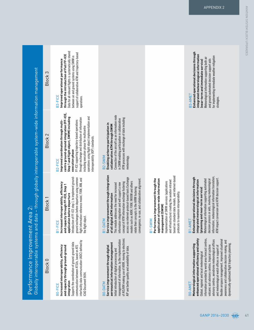
APPENDIX 2AVIATIO
N SYSTEM
BLO
CK
UP
GR
ADES
GANP 2016–2030 41
Perf
orm
ance
Impr
ovem
ent A
rea
2:G
loba
lly in
tero
pera
ble
syst
ems
and
data
– th
roug
h gl
obal
ly in
tero
pera
ble
syst
em-w
ide
info
rmat
ion
man
agem
ent
Blo
ck 0
Blo
ck 1
Blo
ck 2
Blo
ck 3
B0-
FIC
EIncreasedinterope
rability,efficien
cy
and
capa
city
thro
ugh
grou
nd-g
roun
d in
tegr
atio
n Su
ppor
ts th
e coo
rdin
ation
of g
roun
d-gr
ound
dat
a co
mm
unica
tion
betw
een
ATSU
s, ba
sed
on A
TS
inte
rfacil
ity d
ata
com
mun
icatio
n (A
IDC)
defi
ned
by
ICAO
Doc
umen
t 969
4.
B0-
DAT
MSe
rvic
e im
prov
emen
t thr
ough
dig
ital
aero
naut
ical
info
rmat
ion
man
agem
ent
Initi
al in
trodu
ction
of d
igita
l pro
cess
ing a
nd
man
agem
ent o
f inf
orm
ation
, by t
he im
plem
enta
tion
of
AIS
/AIM
mak
ing u
se o
f AIX
M, m
ovin
g to e
lectro
nic
AIP
and
bette
r qua
lity a
nd a
vaila
bilit
y of d
ata.
B0-
AMET
M
eteo
rolo
gica
l inf
orm
atio
n su
ppor
ting
enhancedoperatio
nalefficiencyandsafety
Glob
al, re
giona
l and
loca
l met
eoro
logica
l in
form
ation
pro
vided
by w
orld
are
a fo
reca
st ce
ntre
s, vo
lcani
c ash
adv
isory
cent
res,
tropi
cal c
yclon
e ad
visor
y cen
tres,
aero
drom
e met
eoro
logica
l offi
ces
and
met
eoro
logica
l wat
ch o
ffice
s in
supp
ort o
f fle
xible
airs
pace
man
agem
ent,
impr
oved
situ
ation
al
awar
enes
s and
colla
bora
tive d
ecisi
on-m
akin
g, an
d dy
nam
ically
-opt
imize
d fli
ght t
rajec
tory
plan
ning
.
B1-
FIC
EIncrea
sedinterope
rability,efficien
cy
and
capa
city
thro
ugh
FF-I
CE, S
tep
1 ap
plic
atio
n be
fore
dep
artu
reIn
trodu
ction
of F
F-IC
E st
ep 1
, to i
mpl
emen
t gro
und-
grou
nd ex
chan
ges b
efor
e dep
artu
re u
sing c
omm
on
fligh
t inf
orm
ation
refe
renc
e mod
el, F
IXM
, XM
L and
th
e fligh
t obj
ect.
B1-
DAT
MSe
rvic
e im
prov
emen
t thr
ough
inte
grat
ion
of a
ll di
gita
l ATM
info
rmat
ion
This
mod
ule a
ddre
sses
the n
eed
for i
ncre
ased
in
form
ation
inte
grat
ion a
nd w
ill su
ppor
t a n
ew
conc
ept o
f ATM
info
rmat
ion ex
chan
ge fo
ster
ing
acce
ss vi
a in
tern
et-p
roto
col-b
ased
tools
Exc
hang
e m
odels
such
as A
IXM
, FIX
M, I
WXX
M a
nd o
ther
s re
late
their
conc
epts
to th
e AIR
M fo
ster
ing
conv
erge
nce,
re-u
se, a
nd co
llabo
rativ
e alig
nmen
t.
B1-
SWIM
Perf
orm
ance
impr
ovem
ent t
hrou
gh th
e applicationofsystem-w
ideinform
ation
man
agem
ent (
SWIM
)Im
plem
enta
tion
of S
WIM
serv
ices (
appl
icatio
ns
and
infra
stru
ctur
e) cr
eatin
g the
avia
tion
intra
net
base
d on
stan
dard
dat
a m
odels
, and
inte
rnet
-bas
ed
prot
ocols
to m
axim
ize in
tero
pera
bilit
y.
B1-
AMET
Enha
nced
ope
ratio
nal d
ecis
ions
thro
ugh
inte
grat
ed m
eteo
rolo
gica
l inf
orm
atio
n (p
lann
ing
and
near
-ter
m s
ervi
ce)
Met
eoro
logica
l info
rmat
ion su
ppor
ting a
utom
ated
de
cision
pro
cess
or a
ids,
invo
lving
met
eoro
logica
l in
form
ation
, met
eoro
logica
l info
rmat
ion tr
ansla
tion,
AT
M im
pact
conv
ersio
n an
d AT
M d
ecisi
on su
ppor
t.
B2-
FIC
EIm
prov
ed c
oord
inat
ion
thro
ugh
mul
ti-ce
ntre
gro
und-
grou
nd in
tegr
atio
n (F
F-IC
E,
Step1and
flightobject,SW
IM)including
ex
ecut
ion
phas
eFF
-ICE
supp
ortin
g tra
jecto
ry-b
ased
ope
ratio
ns
thro
ugh
exch
ange
and
dist
ribut
ion o
f inf
orm
ation
in
cludi
ng e
xecu
tion
phas
e for
mul
ticen
tre
oper
ation
s usin
g fligh
t obj
ect i
mpl
emen
tatio
n an
d in
tero
pera
bilit
y (IO
P) s
tand
ards
.
B2-
SWIM
Enab
ling
airb
orne
par
ticip
atio
n in
co
llab
orat
ive
ATM
thro
ugh
SWIM
Conn
ectio
n of
the a
ircra
ft as
an
info
rmat
ion n
ode
in SW
IM en
ablin
g par
ticip
ation
in co
llabo
rativ
e AT
M p
roce
sses
with
exch
ange
of d
ata
inclu
ding
m
eteo
rolog
y.
B3-
FIC
EIm
prov
ed o
pera
tiona
l per
form
ance
th
roug
h th
e in
trod
uctio
n of
Ful
l FF-
ICE
Data
for a
ll rele
vant
fligh
ts is
syst
emat
ically
shar
ed
betw
een
air a
nd gr
ound
syst
ems u
sing S
WIM
in
supp
ort o
f coll
abor
ative
ATM
and
traj
ecto
ry-b
ased
op
erat
ions.
B3-
AMET
Enha
nced
ope
ratio
nal d
ecis
ions
thro
ugh
inte
grat
ed m
eteo
rolo
gica
l inf
orm
atio
n (n
ear-
term
and
imm
edia
te s
ervi
ce)
Met
eoro
logica
l info
rmat
ion su
ppor
ting b
oth
air
and
grou
nd a
utom
ated
dec
ision
supp
ort a
ids
for i
mpl
emen
ting i
mm
edia
te w
eath
er m
itiga
tion
stra
tegie
s.

GANP 2016–203042
APPENDIX 2
Perf
orm
ance
Impr
ovem
ent A
rea
3:O
ptim
um c
apac
ity a
nd fl
exib
le fl
ight
s –
thro
ugh
glob
al c
olla
bora
tive
ATM
Blo
ck 0
Blo
ck 1
Blo
ck 2
Blo
ck 3
B0-
FRTO
Impr
oved
ope
ratio
ns th
roug
h en
hanc
ed
en-r
oute
traj
ecto
ries
To a
llow
the u
se o
f airs
pace
whi
ch w
ould
oth
erwi
se
be se
greg
ated
(i.e.
spec
ial u
se a
irspa
ce) a
long w
ith
flexib
le ro
utin
g adju
sted
for s
pecifi
c tra
ffic p
atte
rns.
This
will a
llow
grea
ter r
outin
g pos
sibilit
ies, r
educ
ing
pote
ntia
l con
gest
ion on
trun
k rou
tes a
nd b
usy
cros
sing p
oints
, res
ultin
g in
redu
ced
fligh
t len
gth
and
fuel
burn
.
B0-
NO
PSIm
provedflow
perform
anceth
roug
hplan
ning
basedonane
twork-wideview
Colla
bora
tive A
TFM
mea
sure
to re
gula
te p
eak fl
ows
invo
lving
dep
artu
re sl
ots,
man
aged
rate
of e
ntry
into
a
given
piec
e of a
irspa
ce fo
r tra
ffic a
long a
certa
in
axis,
requ
este
d tim
e at a
way
-poin
t or a
n FI
R/se
ctor
bo
unda
ry a
long t
he fl
ight,
use o
f mile
s-in
-trail
to
smoo
th fl
ows a
long a
certa
in tra
ffic a
xis a
nd re
-ro
utin
g of t
raffi
c to a
void
satu
rate
d ar
eas.
B0-
ASU
RIn
itial
cap
abili
ty fo
r gro
und
surv
eill
ance
Gr
ound
surv
eillan
ce su
ppor
ted
by A
DS-B
OUT
and
/or
wid
e are
a m
ultil
ater
ation
syst
ems w
ill im
prov
e sa
fety,
espe
cially
sear
ch a
nd re
scue
and
capa
city
thro
ugh
sepa
ratio
n re
duct
ions.
This
capa
bilit
y will
be ex
pres
sed
in va
rious
ATM
serv
ices,
e.g.
traffi
c in
form
ation
, sea
rch
and
resc
ue a
nd se
para
tion
prov
ision
.
B1-
FRTO
Impr
oved
ope
ratio
ns
thro
ugh
optim
ized
ATS
rout
ing
Intro
duct
ion o
f fre
e rou
ting i
n de
fined
airs
pace
, wh
ere t
he fl
ight p
lan
is no
t defi
ned
as se
gmen
ts o
f a
publ
ished
rout
e net
work
or tr
ack s
yste
m to
facil
itate
ad
here
nce t
o the
use
r-pre
ferre
d pr
ofile.
B1-
NO
PSEn
hancedflow
perform
anceth
roug
hne
tworkop
erationa
lplann
ing
ATFM
tech
niqu
es th
at in
tegr
ate t
he m
anag
emen
t of
airsp
ace,
traffi
c flow
s inc
ludi
ng in
itial
user
driv
en
prior
itiza
tion
proc
esse
s for
colla
bora
tively
defi
ning
AT
FM so
lutio
ns b
ased
on co
mm
ercia
l/ope
ratio
nal
prior
ities
.
B2-
NO
PSIn
crea
sed
user
invo
lvem
ent i
n th
e dyna
micutilizationofth
ene
twork
Intro
duct
ion o
f CDM
app
licat
ions s
uppo
rted
by
SWIM
that
per
mit
airs
pace
use
rs to
man
age
com
petit
ion a
nd p
riorit
izatio
n of
com
plex
AT
FM so
lutio
ns w
hen
the n
etwo
rk or
its n
odes
(a
irpor
ts, s
ecto
rs) n
o lon
ger p
rovid
e cap
acity
co
mm
ensu
rate
with
use
r dem
ands
.
B3-
NO
PSTrafficcom
plexity
man
agem
ent
Intro
duct
ion o
f com
plex
ity m
anag
emen
t to a
ddre
ss
even
ts a
nd p
heno
men
a th
at a
ffect
traf
fic fl
ows
due t
o phy
sical
limita
tions
, eco
nom
ic re
ason
s or
parti
cula
r eve
nts a
nd co
nditi
ons b
y exp
loitin
g the
m
ore a
ccur
ate a
nd ri
ch in
form
ation
envir
onm
ent
of a
SW
IM-b
ased
ATM
.

APPENDIX 2AVIATIO
N SYSTEM
BLO
CK
UP
GR
ADES
GANP 2016–2030 43
Blo
ck 0
Blo
ck 1
Blo
ck 2
Blo
ck 3
B0-
ASEP
Airtrafficsituationa
lawaren
ess(ATS
A)
Two A
TSA
(Air
Traf
fic S
ituat
ional
Awar
enes
s)
appl
icatio
ns w
hich
will
enha
nce s
afet
y and
ef
ficien
cy b
y pro
vidin
g pilo
ts w
ith th
e mea
ns to
en
hanc
e tra
ffic s
ituat
ional
awar
enes
s and
ach
ieve
quick
er vi
sual
acqu
isitio
n of
targ
ets:
•
AIRB
(bas
ic air
born
e situ
ation
al aw
aren
ess
durin
g fligh
t ope
ratio
ns);
• VS
A (v
isual
sepa
ratio
n on
app
roac
h).
B0-
OPF
LIm
prov
ed a
cces
s to
opt
imum
fligh
tlevelsthroug
hclim
b/de
scen
tpr
oced
ures
usi
ng A
DS-
BTh
is m
odul
e ena
bles
an
aircr
aft t
o rea
ch a
mor
e sa
tisfa
ctor
y fligh
t lev
el fo
r fligh
t effi
cienc
y or t
o avo
id
turb
ulen
ce fo
r saf
ety.
The m
ain b
enefi
t of i
n-tra
il pr
oced
ure (
ITP)
is fu
el/em
ission
s sav
ings
and
the
uplif
t of g
reat
er p
ayloa
ds.
B0-
ACAS
AC
AS
impr
ovem
ents
To p
rovid
e sho
rt-te
rm im
prov
emen
ts to
exist
ing
airbo
rne c
ollisi
on a
void
ance
syst
ems (
ACAS
) to
redu
ce n
uisa
nce a
lerts
whi
le m
ainta
inin
g ex
istin
g lev
els o
f saf
ety.
This
will r
educ
e tra
jecto
ry
pertu
rbat
ion a
nd in
crea
se sa
fety
in ca
ses w
here
ther
e is
a br
eakd
own
of se
para
tion.
B0-
SNET
Incr
ease
d ef
fect
iven
ess
of
gro
und-
base
d sa
fety
net
sTo
enab
le m
onito
ring o
f fligh
ts w
hile
airb
orne
to
prov
ide t
imely
aler
ts to
air
traffi
c con
trolle
rs o
f po
tent
ial ri
sks t
o fligh
t saf
ety (
such
as s
hort-
term
co
nflict
aler
ts, a
rea
prox
imity
war
ning
s and
m
inim
um sa
fe a
ltitu
de w
arni
ngs)
.
B1-A
SEP
Increasedcapa
cityand
efficien
cy
thro
ugh
inte
rval
man
agem
ent
Inte
rval
man
agem
ent i
mpr
oves
the m
anag
emen
t of
traf
fic fl
ows a
nd a
ircra
ft sp
acin
g. Pr
ecise
m
anag
emen
t of i
nter
vals
betw
een
airc
raft
with
co
mm
on or
mer
ging t
rajec
torie
s max
imize
s airs
pace
th
roug
hput
whi
le re
ducin
g ATC
wor
kload
alon
g with
m
ore e
fficie
nt a
ircra
ft fu
el bu
rn.
B1-
SNET
Grou
nd-b
ased
saf
ety
nets
on
appr
oach
To en
hanc
e saf
ety b
y red
ucin
g the
risk
of c
ontro
lled
fligh
t int
o ter
rain
accid
ents
on fi
nal a
ppro
ach
thro
ugh
the u
se o
f app
roac
h pa
th m
onito
r (AP
M).
B2-
ASEP
Airb
orne
sep
arat
ion
(ASE
P)Cr
eatio
n of
oper
ation
al be
nefit
s thr
ough
tem
pora
ry
deleg
ation
of r
espo
nsib
ility t
o the
fligh
t dec
k fo
r sep
arat
ion p
rovis
ion w
ith su
itabl
y equ
ippe
d de
signa
ted
airc
raft,
thus
redu
cing t
he n
eed
for
confl
ict re
solu
tion
clear
ance
s whi
le re
ducin
g ATC
wo
rkloa
d an
d en
ablin
g mor
e effi
cient
fligh
t pro
files
.
B2-
ACAS
New
collis
ionavoidancesystem
Im
plem
enta
tion
of A
irbor
ne C
ollisi
on A
void
ance
Sy
stem
(ACA
S) a
dapt
ed to
traj
ecto
ry-b
ased
op
erat
ions w
ith im
prov
ed su
rveil
lance
func
tion
supp
orte
d by
ADS
-B a
imed
at r
educ
ing n
uisa
nce
aler
ts a
nd d
evia
tions
. The
new
syst
em w
ill en
able
mor
e effi
cient
oper
ation
s and
pro
cedu
res w
hile
com
plyin
g with
safe
ty re
gula
tions
.

GANP 2016–203044
APPENDIX 2
Perf
orm
ance
Impr
ovem
ent A
rea
4:Ef
ficie
nt fl
ight
pat
h –
thro
ugh
traj
ecto
ry-b
ased
ope
ratio
ns
Blo
ck 0
Blo
ck 1
Blo
ck 2
Blo
ck 3
B0-
CD
OIm
provedflexibilityand
efficien
cyin
descen
tprofiles(C
DO)
Depl
oym
ent o
f per
form
ance
-bas
ed a
irspa
ce a
nd
arriv
al pr
oced
ures
that
allo
w an
airc
raft
to fl
y its
op
timum
airc
raft
profi
le ta
king a
ccou
nt o
f airs
pace
an
d tra
ffic c
ompl
exity
with
cont
inuo
us d
esce
nt
oper
ation
s (CD
Os).
B0-
TBO
Improvedsafetyan
defficiencythroug
hth
e in
itial
app
licat
ion
of d
ata
link
and
SATV
OICE
en-
rout
eIm
plem
enta
tion
of a
n in
itial
set o
f dat
a lin
k ap
plica
tions
supp
ortin
g sur
veilla
nce a
nd
com
mun
icatio
ns in
air
traffi
c ser
vices
.
B0-
CCO
Improvedflexibilityand
efficien
cyin
depa
rtureprofi
les-con
tinuo
usclim
bop
erat
ions
(CCO
)De
ploy
men
t of d
epar
ture
pro
cedu
res t
hat a
llow
an
aircr
aft t
o fly i
ts op
timum
airc
raft
profi
le ta
king
acco
unt o
f airs
pace
and
traf
fic co
mpl
exity
with
co
ntin
uous
clim
b op
erat
ions (
CCOs
).
B1-
CD
OIm
provedflexibilityand
efficien
cyin
descen
tprofiles(C
DOs)using
VNAV
To en
hanc
e ver
tical
fligh
t pat
h pr
ecisi
on d
urin
g de
scen
t, ar
rival,
and
enab
les a
ircra
ft to
fly a
n ar
rival
pr
oced
ure n
ot re
liant
on gr
ound
-bas
ed e
quip
men
t for
ve
rtica
l gui
danc
e.
B1-
TBO
Improvedtrafficsynchronizatio
nan
din
itial
traj
ecto
ry-b
ased
ope
ratio
nTo
impr
ove t
he sy
nchr
oniza
tion
of tr
affic
flow
s at
en-r
oute
mer
ging p
oints
and
to op
timize
the a
ppro
ach
sequ
ence
thro
ugh
the u
se o
f 4DT
RAD
capa
bilit
y and
air
port
appl
icatio
ns, e
.g. D
-TAX
I, via
the a
ir gr
ound
ex
chan
ge o
f airc
raft
deriv
ed d
ata
rela
ted
to a
sing
le re
quire
d tim
e of a
rriva
l (RT
A).
B1-
RPA
SIn
itial
inte
grat
ion
of re
mot
ely
pilo
ted
airc
raft
(RPA
) int
o no
n-se
greg
ated
ai
rspa
ceIm
plem
enta
tion
of b
asic
proc
edur
es fo
r ope
ratin
g RPA
in
non-
segr
egat
ed a
irspa
ce.
B2-
CD
OIm
provedflexibilityand
efficien
cyin
descen
tprofiles(C
DOs)using
VNAV
,re
quir
ed s
peed
and
tim
e at
arr
ival
Use o
f arri
val p
roce
dure
s tha
t allo
w th
e airc
raft
to
appl
y litt
le or
no t
hrot
tle in
are
as w
here
traf
fic le
vels
woul
d ot
herw
ise p
rohi
bit t
his o
pera
tion)
, sup
porte
d by
tra
jecto
ry-b
ased
oper
ation
s and
self-
sepa
ratio
n.
B2-
RPA
SRe
mot
ely
pilo
ted
airc
raft
(RPA
) integrationintraffic
Impl
emen
ts re
fined
oper
ation
al pr
oced
ures
that
co
ver l
ost c
omm
and
and
cont
rol (
C2) l
ink (
inclu
ding
a un
ique
squa
wk co
de fo
r los
t C2
link)
, as w
ell a
s en
hanc
ed d
etec
t and
avo
id te
chno
logy.
B3-
TBO
Full
4D tr
ajec
tory
-bas
ed o
pera
tions
Traj
ecto
ry-b
ased
oper
ation
s dep
loys a
n ac
cura
te
four
-dim
ensio
nal t
rajec
tory
that
is sh
ared
am
ong
all o
f the
avia
tion
syst
em u
sers
at t
he co
res o
f the
sy
stem
. Thi
s pro
vides
cons
isten
t and
up-
to-d
ate
info
rmat
ion sy
stem
-wid
e whi
ch is
inte
grat
ed in
to
decis
ion su
ppor
t too
ls fa
cilita
ting g
lobal
ATM
de
cision
-mak
ing.
B3-
RPA
SRe
mot
ely
pilo
ted
airc
raft
(RPA
) tr
ansp
aren
t man
agem
ent
Cont
inui
ng to
impr
ove t
he ce
rtific
ation
pro
cess
for
rem
otely
pilo
ted
airc
raft
(RPA
) to o
pera
te on
the
aero
drom
e sur
face
and
in n
on-s
egre
gate
d air
spac
e ju
st lik
e any
oth
er a
ircra
ft.

APPENDIX 2AVIATIO
N SYSTEM
BLO
CK
UP
GR
ADES
GANP 2016–2030 45
SURF
RATS
SWIM
AMET
FRTO
NOPS
ASUR
ASEP
OPFL
SNET
CDO
TBO
CCO
RPAS
ACAS
RSEQ
ACDM
FICE
DATM
Airport accessibility
FULLAMAN/DMAN/SMAN AIRPORT OPERATIONS
Runway sequencing
Airport collaborativedecision-making
Surface operations
Wake turbulenceseparation
Remote ATS
Advanced MET information
Digital ATMinformation INTEROPERABLE
SYSTEMS & DATAFULL FF-ICE
FF-ICE
System-wide information management
Free-route operations
Airborne separation
Alternative surveillance
Optimum flight levels
COMPLEXITYMANAGEMENT
GLOBALLYCOLLABORATIVE ATM
Network operations
Safety nets
Airborne collision avoidance systems
Trajectory-based operations
Continuous descent operations
EFFICIENTFLIGHT PATHS
FULLTRAJECTORY-BASED
OPERATIONSContinuous climboperations
Remotely piloted aircraft systems
MODULECAPABILITY
REALIZEDOPERATIONAL
CONCEPT
TARGETPERFORMANCE
BENEFIT
APTA
WAKE
Figure 6: The ASBU Modules converge over time on their target operational concepts and performance improvements

46 GANP 2016–2030
APPENDIX 2
B0-APTA Optimization of approach procedures including vertical guidance
The use of performance-based navigation (PBN) and ground-based augmentation system (GBAS) landing system (GLS) procedures will enhance the reliability and predictability of approaches to runways, thus increasing safety, accessibility and efficiency. This is possible through the application of basic global navigation satellite system (GNSS), Baro-vertical navigation (VNAV), satellite-based augmentation system (SBAS) and GLS. The flexibility inherent in PBN approach design can be exploited to increase runway capacity.
Applicability
This Module is applicable to all instrument and precision instrument runway ends, and non-instrument runway ends.
Benefits
Access and Equity Increased aerodrome accessibility.
CapacityIn contrast with instrument landing systems (ILS), the GNSS-based approaches (PBN and GLS) do not require the definition and management of sensitive and critical areas resulting in potentially increased runway capacity.
Efficiency
Cost savings related to the benefits of lower approach minima: fewer diversions, overflights, cancellations and delays. Cost savings related to higher airport capacity in certain circumstances (e.g. closely spaced parallels) by taking advantage of the flexibility to offset approaches and define displaced thresholds.
Environment Environmental benefits through reduced fuel burn.
Safety Stabilized approach paths.
Cost
Aircraft operators and air navigation service providers (ANSPs) can quantify the benefits of lower minima by using historical aerodrome weather observations and modelling airport accessibility with existing and new minima. Each aircraft operator can then assess benefits against the cost of any required avionics upgrade. Until there are GBAS (CAT II/III) Standards, GLS cannot be considered as a candidate to globally replace ILS. Local business cases for GLS need to consider the risk of potential interference events and the cost of options available to allow continued operations, e.g. retaining ILS or MLS.
Performance Improvement Area 1: Airport operations
Block 0Block 0 is composed of Modules containing technologies and capabilities which have already been developed and can be implemented today. Based on the milestone framework established under the overall Block Upgrade strategy, ICAO Member States are encouraged to implement those Block 0 Modules applicable to their specific operational needs.
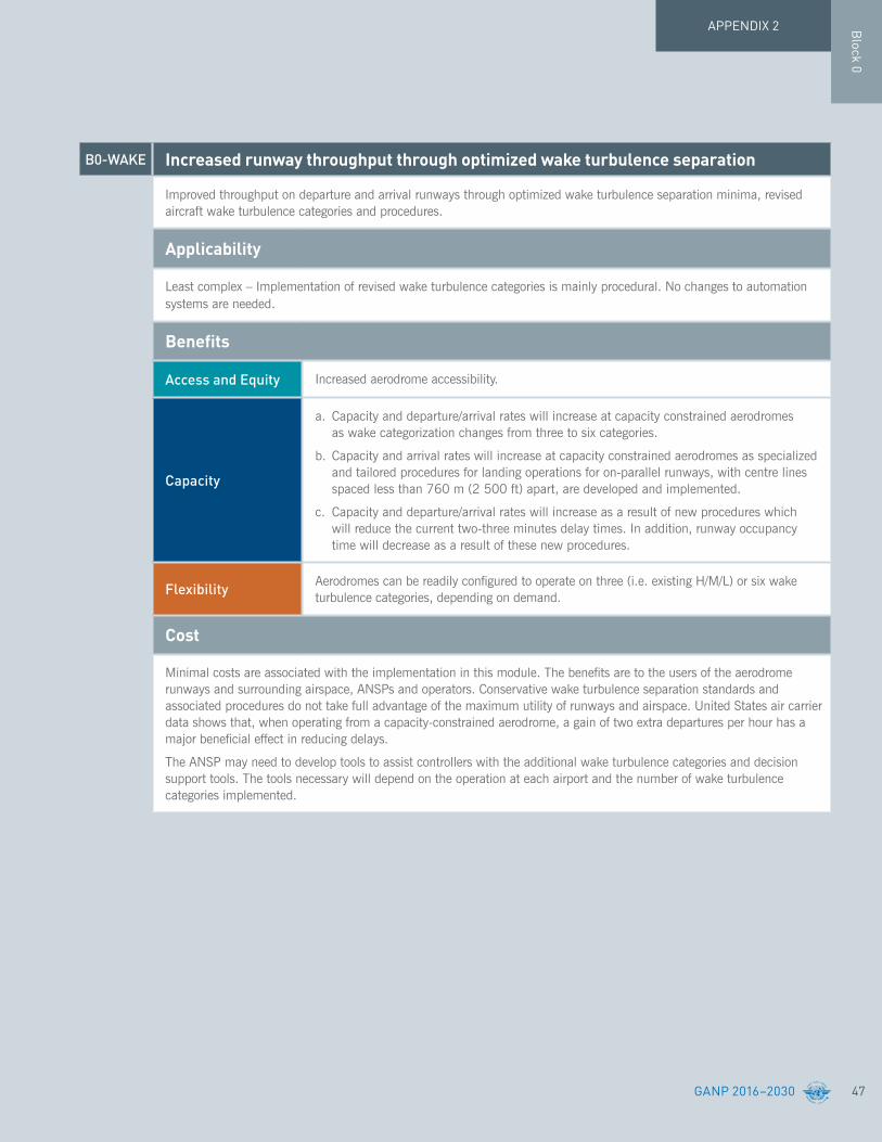
47
Block 0
GANP 2016–2030
APPENDIX 2
B0-WAKE Increasedrunwaythroughputthroughoptimizedwaketurbulenceseparation
Improved throughput on departure and arrival runways through optimized wake turbulence separation minima, revised aircraft wake turbulence categories and procedures.
Applicability
Least complex – Implementation of revised wake turbulence categories is mainly procedural. No changes to automation systems are needed.
Benefits
Access and Equity Increased aerodrome accessibility.
Capacity
a. Capacity and departure/arrival rates will increase at capacity constrained aerodromes as wake categorization changes from three to six categories.
b. Capacity and arrival rates will increase at capacity constrained aerodromes as specialized and tailored procedures for landing operations for on-parallel runways, with centre lines spaced less than 760 m (2 500 ft) apart, are developed and implemented.
c. Capacity and departure/arrival rates will increase as a result of new procedures which will reduce the current two-three minutes delay times. In addition, runway occupancy time will decrease as a result of these new procedures.
Flexibility Aerodromes can be readily configured to operate on three (i.e. existing H/M/L) or six wake turbulence categories, depending on demand.
Cost
Minimal costs are associated with the implementation in this module. The benefits are to the users of the aerodrome runways and surrounding airspace, ANSPs and operators. Conservative wake turbulence separation standards and associated procedures do not take full advantage of the maximum utility of runways and airspace. United States air carrier data shows that, when operating from a capacity-constrained aerodrome, a gain of two extra departures per hour has a major beneficial effect in reducing delays.
The ANSP may need to develop tools to assist controllers with the additional wake turbulence categories and decision support tools. The tools necessary will depend on the operation at each airport and the number of wake turbulence categories implemented.

48 GANP 2016–2030
APPENDIX 2
B0-RSEQ Improvetrafficflowthroughsequencing(AMAN/DMAN)
To manage arrivals and departures (including time-based metering) to and from a multi-runway aerodrome or locations with multiple dependent runways at closely proximate aerodromes, to efficiently utilize the inherent runway capacity.
Applicability
Runways and terminal manoeuvring area in major hubs and metropolitan areas will be most in need of these improvements.
The improvement is least complex – runway sequencing procedures are widely used in aerodromes globally. However some locations might have to confront environmental and operational challenges that will increase the complexity of development and implementation of technology and procedures to realize this module.
Benefits
Capacity Time-based metering will optimize usage of terminal airspace and runway capacity. Optimized utilization of terminal and runway resources.
Efficiency
Efficiency is positively impacted as reflected by increased runway throughput and arrival rates. This is achieved through:
a. Harmonized arriving traffic flow from en-route to terminal and aerodrome. Harmonization is achieved via the sequencing of arrival flights based on available terminal and runway resources; and
b. Streamlined departure traffic flow and smooth transition into en-route airspace. Decreased lead time for departure request and time between call for release and departure time. Automated dissemination of departure information and clearances.
Environment Reduced holding and low level vectoring has a positive environmental effect in terms of noise and fuel usage.
Flexibility By enabling dynamic scheduling.
Predictability Decreased uncertainties in aerodrome/terminal demand prediction.
Cost
A detailed positive business case has been built for the time-based flow management programme in the United States. The business case has proven the benefit/cost ratio to be positive. Implementation of time-based metering can reduce airborne delay. This capability was estimated to provide over 320,000 minutes in delay reduction and $28.37 million in benefits to airspace users and passengers over the evaluation period.
Results from field trials of a departure scheduling tool (DFM) in the United States have been positive. Compliance rate, a metric used to gauge the conformance to assigned departure time, has increased at field trial sites from 68 to 75 per cent. Likewise, the EUROCONTROL DMAN has demonstrated positive results. Departure scheduling will streamline the flow of aircraft feeding the adjacent center airspace based on that center’s constraints. This capability will facilitate more accurate estimated time of arrivals (ETAs). This allows for the continuation of metering during heavy traffic, enhanced airspace use efficiency and fuel efficiencies. This capability is also crucial for extended metering.
Block 0

49GANP 2016–2030
APPENDIX 2
B0-SURF Safetyandefficiencyofsurfaceoperations(A-SMGCSlevels1-2)andenhancedvisionsystems(EVS)
First levels of advanced-surface movement guidance and control systems (A-SMGCS) provides surveillance and alerting of movements of both aircraft and vehicles at the aerodrome, thus improving runway/aerodrome safety. Automatic dependent surveillance-broadcast (ADS-B) information is used when available (ADS-B APT). Enhanced vision systems (EVS) is used for low visibility operations.
Applicability
A-SMGCS is applicable to any aerodrome and all classes of aircraft/vehicles. Implementation is to be based on requirements stemming from individual aerodrome operational and cost-benefit assessments.
ADS-B APT is an element of A-SMGCS, designed to be applied at aerodromes (ICAO codes 3D and above) with medium traffic complexity, having up to two active runways at a time.
Benefits
Access and Equity
A-SMGCS improves access to portions of the manoeuvring area obscured from view of the control tower for vehicles and aircraft. Sustains an improved aerodrome capacity during periods of reduced visibility. Ensures equity in ATC handling of surface traffic regardless of the traffic’s position on the aerodrome.
ADS-B APT: as an element of an A-SMGCS, provides traffic situational awareness to the controller in the form of surveillance information. The availability of the data is dependent on the aircraft and vehicle level of equipage.
Capacity
A-SMGCS: sustained levels of aerodrome capacity for visual conditions reduced to minima lower than would otherwise be the case.
ADS-B APT: as an element of an A-SMGCS, potentially improves capacity resilience for medium complexity aerodromes in low visibility conditions.
Efficiency
A-SMGCS: reduced taxi times through diminished requirements for intermediate holdings based on reliance on visual surveillance only.
ADS-B APT: as an element of an A-SMGCS, potentially reduces taxi times by providing improved traffic situational awareness to controllers.
EVS: potentially reduces taxi times through improved situational awareness of aircraft position that will allow for more confidence by the flight crew in the conduct of the taxi operation during periods of reduced visibility.
Environment Reduced aircraft emissions stemming from improved efficiencies.
Safety
A-SMGCS: reduced runway incursions. Improved response to unsafe situations. Improved situational awareness leading to reduced ATC workload.
ADS-B APT: as an element of an A-SMGCS, potentially reduces the occurrence of runway collisions by assisting in the detection of the incursions.
EVS: Fewer navigation errors.
Cost
A-SMGCS: a positive CBA can be made from improved levels of safety and improved efficiencies in surface operations leading to significant savings in aircraft fuel usage. Furthermore, aerodrome operator vehicles will benefit from improved access to all areas of the aerodrome, improving the efficiency of aerodrome operations, maintenance and servicing.
ADS-B APT: as an element of an A-SMGCS, less costly surveillance solution for medium complexity aerodromes.
Block 0

50
Block 0
GANP 2016–2030
APPENDIX 2
B0-ACDM Improved airport operations through Airport-CDM
To implement collaborative applications that will allow the sharing of surface operations data among the different stakeholders on the airport. This will improve surface traffic management reducing delays on movement and manoeuvring areas and enhance safety, efficiency and situational awareness.
Applicability
Local for already established airport surface infrastructure.
Benefits
Capacity Enhanced use of existing infrastructure of gate and stands (unlock latent capacity). Reduced workload, better organization of the activities to manage flights.
Efficiency
Increased efficiency of the ATM system for all stakeholders. In particular for aircraft operators: improved situational awareness (aircraft status both home and away); enhanced fleet predictability and punctuality; improved operational efficiency (fleet management); reduced delay.
Environment Reduced taxi time; reduced fuel and carbon emission; and lower aircraft engine run time.
Cost
The business case has proven to be positive due to the benefits that flights and the other airport operational stakeholders can obtain. However, this may be influenced depending upon the individual situation (environment, traffic levels investment cost, etc.).
A detailed business case has been produced in support of the EU regulation which was solidly positive.

51
Block 0
GANP 2016–2030
APPENDIX 2
B0-FICE Increasedinteroperability,efficiencyandcapacitythroughground-groundintegration
To improve coordination between air traffic service units (ATSUs) by using ATS interfacility data communication (AIDC) defined by ICAO’s Manual of Air Traffic Services Data Link Applications (Doc 9694). An additional benefit is the improved efficiency of the transfer of communication in a data link environment.
Applicability
Applicable to at least two area control centres (ACCs) dealing with en-route and/or terminal control area (TMA) airspace. A greater number of consecutive participating ACCs will increase the benefits.
Benefits
Capacity Reduced controller workload and increased data integrity supporting reduced separations translating directly to cross sector or boundary capacity flow increases.
Efficiency The reduced separation can also be used to more frequently offer aircraft flight levels closer to the flight optimum; in certain cases, this also translates into reduced en-route holding.
InteroperabilitySeamlessness: the use of standardized interfaces reduces the cost of development, allows air traffic controllers to apply the same procedures at the boundaries of all participating centres and border crossing becomes more transparent to flights.
Safety Better knowledge of more accurate flight plan information for receiving ATS units and reduced risk of coordination errors.
Cost
Increase of throughput at ATS unit boundary and reduced ATC workload will outweigh the cost of ground system software changes. The business case remains dependent on the environment.
Performance Improvement Area 2: Globally interoperable systems and data

52
Block 0
GANP 2016–2030
APPENDIX 2
B0-DATM Service improvement through digital aeronautical information management
The initial introduction of digital processing and management of information from origination to publication through, aeronautical information service (AIS)/aeronautical information management (AIM) implementation, use of aeronautical exchange model (AIXM), migration to electronic aeronautical information publication (AIP) and better quality and availability of data.
Applicability
Applicable at State level with increased benefits as more States participate. States should be able to apply the most optimal exchange formats for the exchange of data as at the global level a standardized format is far more important to ensure global interoperability.
Benefits
Interoperability Essential contribution to interoperability.
SafetyReduction in the number of possible inconsistencies. Module allows for better data quality, safe guarding and validation of the data throughout the process, and harmonization/synchronization with adjacent States, as necessary.
Cost
Reduced costs in terms of data inputs and checks, paper and post, especially when considering the overall data chain, from originators, through AIS to the end users. The business case for the aeronautical information conceptual model (AIXM) has been conducted in Europe and in the United States and has shown to be positive. The initial investment necessary for the provision of digital AIS data may be reduced through regional cooperation and remains low compared with the cost of other ATM systems. The transition from paper products to digital data is a critical pre-requisite for the implementation of any current or future ATM or Air Navigation concept that relies on the accuracy, integrity and timeliness of data.

53GANP 2016–2030
APPENDIX 2 Block 0
B0-AMET Meteorologicalinformationsupportingenhancedoperationalefficiencyandsafety
Global, regional and local meteorological information:a. forecasts provided by world area forecast centres (WAFCs), volcanic ash advisory centres (VAACs) and tropical
cyclone advisory centres (TCAC);
b. aerodrome warnings to give concise information of meteorological conditions that could adversely affect all aircraft at an aerodrome, including wind shear; and
c. SIGMETs to provide information on occurrence or expected occurrence of specific en-route weather phenomena which may affect the safety of aircraft operations and other operational meteorological (OPMET) information, including METAR/SPECI and TAF, to provide routine and special observations and forecasts of meteorological conditions occurring or expected to occur at the aerodrome.
This information supports flexible airspace management, improved situational awareness and collaborative decision-making, and dynamically-optimized flight trajectory planning. This module includes elements which should be viewed as a subset of all available meteorological information that can be used to support enhanced operational efficiency and safety
Applicability
Applicable to traffic flow planning, and to all aircraft operations in all domains and flight phases, regardless of level of aircraft equipage.
Benefits
Capacity Optimized use of airspace capacity. Metric: ACC and aerodrome throughput.
Efficiency
Harmonized arriving air traffic (en-route to terminal area to aerodrome) and harmonized departing air traffic (aerodrome to terminal area to en-route) will translate to reduced arrival and departure holding times and thus reduced fuel burn. Metric: Fuel consumption and flight time punctuality.
Environment Reduced fuel burn through optimized departure and arrival profiling/scheduling. Metric: Fuel burn and emissions.
Flexibility Supports pre-tactical and tactical arrival and departure sequencing and thus dynamic air traffic scheduling. Metric: ACC and aerodrome throughput.
Interoperability Gate-to-gate seamless operations through common access to, and use of, the available WAFS, IAVW and tropical cyclone watch forecast information. Metric: ACC throughput.
ParticipationCommon understanding of operational constraints, capabilities and needs, based on expected (forecast) meteorological conditions. Metric: Collaborative decision-making at the aerodrome and during all phases of flight.
Predictability Decreased variance between the predicted and actual air traffic schedule. Metric: Block time variability, flight-time error/buffer built into schedules.
Safety Increased situational awareness and improved consistent and collaborative decision-making. Metric: Incident occurrences.
Cost
Reduction in costs through reduced arrival and departure delays (viz. reduced fuel burn). Metric: Fuel consumption and associated costs.

54
Block 0
GANP 2016–2030
APPENDIX 2
B0-FRTO Improved operations through enhanced en-route trajectories
To allow the use of airspace which would otherwise be segregated (i.e. special use airspace) along with flexible routing adjusted for specific traffic patterns. This will allow greater routing possibilities, reducing potential congestion on trunk routes and busy crossing points, resulting in reduced flight lengths and fuel burn.
Applicability
Applicable to en-route and terminal airspace. Benefits can start locally. The larger the size of the concerned airspace, the greater the benefits, in particular for flex track aspects. Benefits accrue to individual flights and flows. Application will naturally span over a long period as traffic develops. Its features can be introduced starting with the simplest ones.
Benefits
Access and Equity Better access to airspace by a reduction of the permanently segregated volumes.
Capacity
The availability of a greater set of routing possibilities allows reducing potential congestion on trunk routes and at busy crossing points. The flexible use of airspace gives greater possibilities to separate flights horizontally. PBN helps to reduce route spacing and aircraft separations. This in turn allows reducing controller workload by flight.
Efficiency
The different elements concur to trajectories closer to the individual optimum by reducing constraints imposed by permanent design. In particular the module will reduce flight length and related fuel burn and emissions. The potential savings are a significant proportion of the ATM related inefficiencies. The module will reduce the number of flight diversions and cancellations. It will also better allow avoidance of noise sensitive areas.
Environment Fuel burn and emissions will be reduced; however, the area where emissions and contrails will be formed may be larger.
Flexibility The various tactical functions allow rapid reaction to changing conditions.
Predictability Improved planning allows stakeholders to anticipate on expected situations and be better prepared.
Cost
FUA: In the United Arab Emirates (UAE) over half of the airspace is military. Opening up this airspace could potentially enable yearly savings in the order of 4.9 million litres of fuel and 581 flight hours. In the United States a study for NASA by Datta and Barington showed maximum savings of dynamic use of FUA of $7.8M (1995 dollars).
Flexible routing: Early modelling of flexible routing suggests that airlines operating a 10-hour intercontinental flight can cut flight time by six minutes, reduce fuel burn by as much as 2 per cent and save 3,000 kilograms of CO2 emissions. In the United States RTCA NextGen Task Force Report, it was found that benefits would be about 20 per cent reduction in operational errors; 5 to 8 per cent productivity increase (near term; growing to 8 to 14 per cent later); capacity increases (but not quantified). Annual operator benefit in 2018 of $39,000 per equipped aircraft (2008 dollars) growing to $68,000 per aircraft in 2025 based on the FAA Initial investment Decision. For the high throughput, high capacity benefit case (in 2008 dollars): total operator benefit is $5.7 billion across programme lifecycle (2014-2032, based on the FAA initial investment decision).
PerformanceImprovementArea3:Optimumcapacityandflexibleflights

55
Block 0
GANP 2016–2030
APPENDIX 2
B0-NOPS Improvedflowperformancethroughplanningbasedonanetwork-wideview
Air traffic flow management (ATFM) is used to manage the flow of traffic in a way that minimizes delays and maximizes the use of the entire airspace. Collaborative ATFM can regulate traffic flows involving departure slots, smooth flows and manage rates of entry into airspace along traffic axes, manage arrival time at waypoints or flight information region (FIR)/sector boundaries and reroute traffic to avoid saturated areas. ATFM may also be used to address system disruptions including crisis caused by human or natural phenomena.
Applicability
Region or subregion.
Benefits
Access and Equity Improved access by avoiding disruption of air traffic in periods of demand higher than capacity. ATFM processes take care of equitable distribution of delays.
CapacityBetter utilization of available capacity, network-wide; in particular the fact of not being faced by surprise to saturation tends to let ATC declare/use increased capacity levels; ability to anticipate difficult situations and mitigate them in advance.
Efficiency
Reduced fuel burn due to better anticipation of flow issues; a positive effect to reduce the impact of inefficiencies in the ATM system or to dimension it at a size that would not always justify its costs (balance between cost of delays and cost of unused capacity). Reduced block times and times with engines on.
EnvironmentReduced fuel burn when delays are absorbed on the ground, with shut engines; rerouting however generally increase flight distance, but this is generally compensated by other airline operational benefits.
Participation Common understanding of operational constraints, capabilities and needs.
Predictability Increased predictability of schedules as the ATFM algorithms tend to limit the number of large delays.
Safety Reduced occurrences of undesired sector overloads.
Cost
The business case has proven to be positive due to the benefits that flights can obtain in terms of delay reduction.

56
Block 0
GANP 2016–2030
APPENDIX 2
B0-ASUR Initial capability for ground surveillance
To provide initial capability for lower cost ground surveillance supported by new technologies such as ADS-B OUT and wide area multilateration (MLAT) systems. This capability will be expressed in various ATM services, e.g. traffic information, search and rescue and separation provision.
Applicability
This capability is characterized by being dependent/cooperative (ADS-B OUT) and independent/cooperative (MLAT). The overall performance of ADS-B is affected by avionics performance and compliant equipage rate.
Benefits
Capacity
Typical separation minima are 3 NM or 5 NM enabling a significant increase in traffic density compared to procedural minima. Improved coverage, capacity, velocity vector performance and accuracy can improve ATC performance in both radar and non-radar environments. Terminal area surveillance performance improvements are achieved through high accuracy, better velocity vector and improved coverage.
EfficiencyAvailability of optimum flight levels and priority to the equipped aircraft and operators. Reduction of flight delays and more efficient handling of air traffic at FIR boundaries. Reduces workload of air traffic controllers.
Safety Reduction of the number of major incidents. Support to search and rescue.
Cost
Either comparison between procedural minima and 5 NM separation minima would allow an increase of traffic density in a given airspace; or comparison between installing/renewing SSR Mode S stations using Mode S transponders and installing ADS-B OUT (and/or MLAT systems).
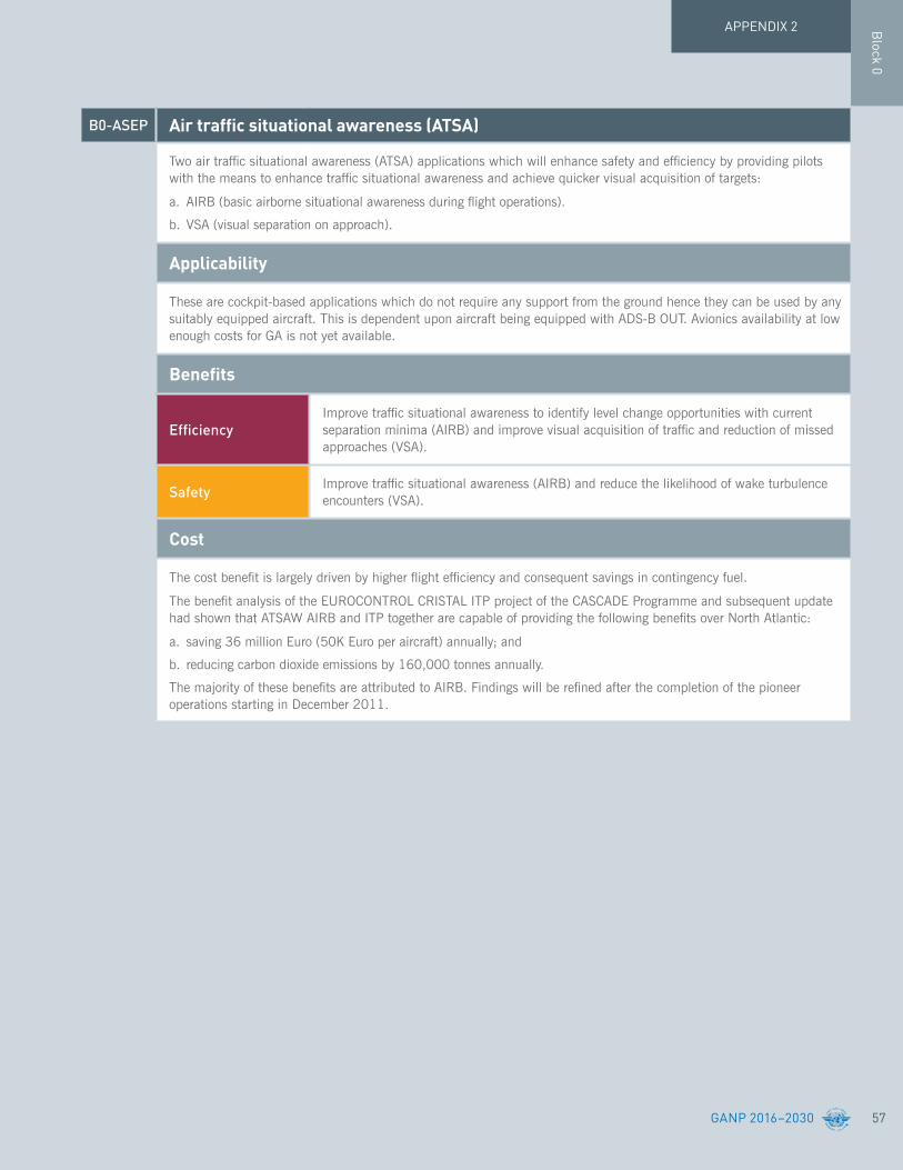
57
Block 0
GANP 2016–2030
APPENDIX 2
B0-ASEP Airtrafficsituationalawareness(ATSA)
Two air traffic situational awareness (ATSA) applications which will enhance safety and efficiency by providing pilots with the means to enhance traffic situational awareness and achieve quicker visual acquisition of targets:
a. AIRB (basic airborne situational awareness during flight operations).
b. VSA (visual separation on approach).
Applicability
These are cockpit-based applications which do not require any support from the ground hence they can be used by any suitably equipped aircraft. This is dependent upon aircraft being equipped with ADS-B OUT. Avionics availability at low enough costs for GA is not yet available.
Benefits
EfficiencyImprove traffic situational awareness to identify level change opportunities with current separation minima (AIRB) and improve visual acquisition of traffic and reduction of missed approaches (VSA).
Safety Improve traffic situational awareness (AIRB) and reduce the likelihood of wake turbulence encounters (VSA).
Cost
The cost benefit is largely driven by higher flight efficiency and consequent savings in contingency fuel.
The benefit analysis of the EUROCONTROL CRISTAL ITP project of the CASCADE Programme and subsequent update had shown that ATSAW AIRB and ITP together are capable of providing the following benefits over North Atlantic:
a. saving 36 million Euro (50K Euro per aircraft) annually; and
b. reducing carbon dioxide emissions by 160,000 tonnes annually.
The majority of these benefits are attributed to AIRB. Findings will be refined after the completion of the pioneer operations starting in December 2011.

58
Block 0
GANP 2016–2030
APPENDIX 2
B0-OPFL Improvedaccesstooptimumflightlevelsthroughclimb/descentproceduresusingADS-B
To enable aircraft to reach a more satisfactory flight level for flight efficiency or to avoid turbulence for safety. The main benefit of in-trail procedure (ITP) is fuel/emissions savings and the uplift of greater payloads.
Applicability
This can be applied to routes in procedural airspaces.
Benefits
Capacity Improvement in capacity on a given air route.
Efficiency Increased efficiency on oceanic and potentially continental en-route.
Environment Reduced emissions.
Safety A reduction of possible injuries for cabin crew and passengers by providing a tool to manage contingency scenarios.
B0-ACAS Airborne collision avoidance systems (ACAS) improvements
To provide short-term improvements to existing airborne collision avoidance systems (ACAS) to reduce nuisance alerts while maintaining existing levels of safety. This will reduce trajectory deviations and increase safety in cases where there is a breakdown of separation.
Applicability
Safety and operational benefits increase with the proportion of equipped aircraft.
Benefits
Efficiency ACAS improvement will reduce unnecessary resolution advisory (RA) and then reduce trajectory deviations.
Safety ACAS increases safety in the case of breakdown of separation.
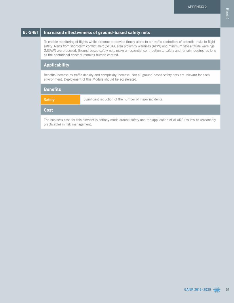
59
Block 0
GANP 2016–2030
APPENDIX 2
B0-SNET Increased effectiveness of ground-based safety nets
To enable monitoring of flights while airborne to provide timely alerts to air traffic controllers of potential risks to flight safety. Alerts from short-term conflict alert (STCA), area proximity warnings (APW) and minimum safe altitude warnings (MSAW) are proposed. Ground-based safety nets make an essential contribution to safety and remain required as long as the operational concept remains human centred.
Applicability
Benefits increase as traffic density and complexity increase. Not all ground-based safety nets are relevant for each environment. Deployment of this Module should be accelerated.
Benefits
Safety Significant reduction of the number of major incidents.
Cost
The business case for this element is entirely made around safety and the application of ALARP (as low as reasonably practicable) in risk management.

60
Block 0
GANP 2016–2030
APPENDIX 2
B0-CDO Improvedflexibilityandefficiencyindescentprofilesusingcontinuousdescentoperations(CDOs)
To use performance-based airspace and arrival procedures allowing an aircraft to fly its optimum profile using continuous descent operations (CDOs). This will optimize throughput, allow fuel efficient descent profiles and increase capacity in terminal areas. The application of PBN enhances CDO.
Applicability
Applicable to all aerodromes but for simplicity and implementation success, complexity can be divided into three tiers:
a. least complex – regional/States/locations with some foundational operational experience that could capitalize on near-term enhancements, which include integrating procedures and optimizing performance;
b. more complex – regional/State/locations that may or may not possess operational experience, but would benefit from introducing new or enhanced procedures. However, many of these locations may have environmental and operational challenges that will add to the complexities of procedure development and implementation.
c. most complex – regional/State/locations where introducing integrated and optimized operations will be the most challenging and complex. Traffic volume and airspace constraints are added complexities that must be confronted. Operational changes to these areas can have a profound effect on the entire State, region or location.
Benefits
Efficiency
Cost savings and environmental benefits through reduced fuel burn. Authorization of operations where noise limitations would otherwise result in operations being curtailed or restricted. Reduction in the number of required radio transmissions. Optimal management of the top-of-descent in the en-route airspace.
Environment As per efficiency
Predictability More consistent flight paths and stabilized approach paths. Reduced need for vectors.
SafetyMore consistent flight paths and stabilized approach paths. Reduction in the incidence of controlled flight into terrain (CFIT). Separation with the surrounding traffic (especially free-routing). Reduction in the number of conflicts.
Cost
It is important to consider that CDO benefits are heavily dependent on each specific ATM environment. Nevertheless, if implemented within the ICAO CDO manual framework, it is envisaged that the benefit/cost ratio (BCR) will be positive. After CDO implementation in Los Angeles TMA (KLAX) there was a 50 per cent reduction in radio transmissions and fuel savings averaging 125 pounds per flight (13.7 million pounds/year; 41 million pounds of CO2 emission).
The advantage of PBN to the ANSP is that PBN avoids the need to purchase and deploy navigation aids for each new route or instrument procedure.
PerformanceImprovementArea4:Efficientflightpaths

61
Block 0
GANP 2016–2030
APPENDIX 2
B0-TBO ImprovedsafetyandefficiencythroughtheinitialapplicationofdatalinkandSATVOICEen-route
To implement a set of data link applications supporting surveillance and communications in air traffic services, which will lead to flexible routing, reduced separation and improved safety.
Applicability
Applicable to the airspace where ATS surveillance is not available and/or VHF voice frequencies are scarce. Requires coordinated airborne and ground deployment to ensure that services are provided by the ground to a minimum proportion of flights suitably equipped.
Benefits
Capacity
Element 1: A better localization of traffic and reduced separations allow increasing the offered capacity.
Element 2: Reduced communication workload and better organization of controller tasks allowing increased sector capacity.
Efficiency
Element 1: Routes/tracks and flights can be separated by reduced minima, allowing flexible routings and vertical profiles closer to the user-preferred ones.
Element 2: Routes/tracks and flights can be separated by reduced minima, allowing flexible routings and vertical profiles closer to the user-preferred ones.
Flexibility
Element 1: ADS-C permits easier route change.
Element 2: CPDLC allows for prioritization of incoming messages. For continental CPDLC, there is a possibility of modifying task allocation in such a way that the Planning Controller may support the Tactical Controller in carrying out data link communication with the pilots.
Safety
Element 1: Increased controller’s situational awareness; ADS-C based safety nets like cleared level adherence monitoring, route adherence monitoring, danger area infringement warning; and better support to search and rescue.
Element 2: Increased situational awareness; reduced occurrences of misunderstandings; solution to stuck microphone situations.
Cost
Element 1: The business case has proven to be positive due to the benefits that flights can obtain in terms of better flight efficiency (better routes and vertical profiles; better and tactical resolution of conflicts).
To be noted, the need to synchronize ground and airborne deployments to ensure that services are provided by the ground when aircraft are equipped, and that a minimum proportion of flights in the airspace under consideration are suitably equipped. The need to properly design and manage the deployment of data link to avoid unnecessary channel congestions as well the air/ground systems and transmission optimization is also to be noted.
Element 2: For continental CPDLC, the European business case has proved to be positive due to:
a. the benefits that flights obtain in terms of better flight efficiency (better routes and vertical profiles; better and tactical resolution of conflicts); and
b. reduced controller workload and increased capacity.
A detailed business case has been produced in support of the EU regulation which was solidly positive. To be noted, there is a need to synchronize ground and airborne deployments to ensure that services are provided by the ground when aircraft are equipped, and that a minimum proportion of flights in the airspace under consideration are suitably equipped.

62
Block 0
GANP 2016–2030
APPENDIX 2
B0-CCO Improvedflexibilityandefficiencydepartureprofiles–continuousclimboperations(CCO)
To implement continuous climb operations in conjunction with performance-based navigation (PBN) to provide opportunities to optimize throughput, improve flexibility, enable fuel-efficient climb profiles, and increase capacity at congested terminal areas. The application of PBN enhances CDO.
Applicability
Applicable to all aerodromes but for simplicity and implementation success, complexity can be divided into three tiers:
a. least complex – regional/States/locations with some foundational operational experience that could capitalize on near-term enhancements, which include integrating procedures and optimizing performance.
b. more complex – regional/State/locations that may or may not possess operational experience, but would benefit from introducing new or enhanced procedures. However, many of these locations may have environmental and operational challenges that will add to the complexities of procedure development and implementation; and
c. most complex – regional/State/locations where introducing integrated and optimized operations will be the most challenging and complex. Traffic volume and airspace constraints are added complexities that must be confronted. Operational changes to these areas can have a profound effect on the entire State, region or location.
Benefits
Efficiency Cost savings through reduced fuel burn and efficient aircraft operating profiles. Reduction in the number of required radio transmissions.
Environment Authorization of operations where noise limitations would otherwise result in operations being curtailed or restricted. Environmental benefits through reduced emissions.
Safety More consistent flight paths. Reduction in the number of required radio transmissions. Lower pilot and air traffic control workload.
Cost
It is important to consider that CCO benefits are heavily dependent on the specific ATM environment. Nevertheless, if implemented within the ICAO CCO manual framework, it is envisaged that the benefit/cost ratio (BCR) will be positive.

Block 1
APPENDIX 2
GANP 2016–2030 63
The Block 1 Modules will introduce new concepts and capabilities supporting the future ATM System, namely: Flight and Flow Information for a Collaborative Environment (FF-ICE); trajectory-based operations (TBO); System-Wide Information Management (SWIM) and the integration of remotely piloted aircraft (RPA) into non-segregated airspace.
These concepts are at various stages of development. Some have been subject to flight trials in a controlled environment while others, such as FF-ICE, exist as a series of steps leading to the implementation of well understood concepts. As such, confidence is high that they will be successfully implemented but the near-term standardization is expected to be challenging, as outlined below.
Human Performance factors will have a strong impact on the final implementation of concepts such as FF-ICE and TBO. Closer integration of airborne and ground-based systems will call for a thorough end-to-end consideration of Human Performance impacts.
Similarly, technological enablers will also affect the final implementation of these concepts. Typical technological enablers include air-ground data link and the exchange models for SWIM. Every technology has limits on its performance and this could, in turn, impact the achievable operational benefits—either directly or through their effect on Human Performance.
The standardization effort will therefore need to follow three parallel courses:
a. the development and refinement of the final concept;
b. consideration of end-to-end Human Performance impacts and their effect on the ultimate concept and the necessary technological enablers;
c. further consideration of the technological enablers to ensure that their performance can support operations based on the new concepts and, if not, what procedural or other changes will be needed;
d. harmonization of the relevant Standards on a global level.
For example, RPA will require a ‘detect and avoid’ capability as well as a Command and Control link which is more robust than the pilot-ATC link available today. In each case, they are meant to replicate the cockpit experience for the remote pilot. There will clearly be some limits to what technology can provide in this regard, hence consideration will need to be given to limits on operations, special procedures, etc.
Block 1 therefore represents the primary ICAO technical work programme on air navigation and efficiency for the next triennium. It will require collaboration with industry and regulators, in order to provide a coherent globally harmonised set of operational improvements in the proposed time frame.
Block 1

64 GANP 2016–2030
APPENDIX 2
B1-APTA Optimized airport accessibility
To progress further with the universal implementation of performance-based navigation (PBN) and ground-based augmentation system (GBAS) landing system (GLS) approaches. PBN and GLS (CAT II/III) procedures to enhance the reliability and predictability of approaches to runways increasing safety, accessibility and efficiency.
Applicability
This Module is applicable to all runway ends.
Benefits
EfficiencyCost savings related to the benefits of lower approach minima: fewer diversions, overflights, cancellations and delays. Cost savings related to higher airport capacity by taking advantage of the flexibility to offset approaches and define displaced thresholds.
Environment Environmental benefits through reduced fuel burn.
Safety Stabilized approach paths.
Cost
Aircraft operators and ANSPs can quantify the benefits of lower minima by modelling airport accessibility with existing and new minima. Operators can then assess benefits against avionics and other costs. The GLS CAT II/III business case needs to consider the cost of retaining ILS or MLS to allow continued operations during an interference event. The potential for increased runway capacity benefits with GLS is complicated at airports where a significant proportion of aircraft are not equipped with GLS avionics.
Block 1The Modules comprising Block 1, which are intended to be available beginning in 2019, satisfy one of the following criteria:
a. the operational improvement represents a well understood concept that has yet to be trialed;b. the operational improvement has been trialed successfully in a simulated environment;c. the operational improvement has been trialed successfully in a controlled operational
environment; andd. the operational improvement is approved and ready for roll-out.
Performance Improvement Area 1: Airport operations

Block 1
APPENDIX 2
GANP 2016–2030 65
B1-WAKE Increasedrunwaythroughputthroughdynamicwaketurbulenceseparation
Improved throughput on departure and arrival runways through the dynamic management of wake turbulence separation minima based on the real-time identification of wake turbulence hazards.
Applicability
Least complex – implementation of re-categorized wake turbulence is mainly procedural. No changes to automation systems are needed.
Benefits
CapacityElement 1: Better wind information around the aerodrome to enact reduced wake mitigation measures in a timely manner. Aerodrome capacity and arrival rates will increase as the result of reduced wake mitigation measures.
Environment Element 3: Better cross-wind knowledge through precise measurement will optimize the use of more environmental-friendly departure procedures and departure runways.
Flexibility Element 2: Dynamic scheduling. ANSPs have the choice of optimizing the arrival/departure schedule via pairing number of unstable approaches.
Cost
Element 1’s change to the ICAO wake turbulence separation minima will yield an average nominal four per cent additional capacity increase for airport runways. This increase translates to one more landing per hour for a single runway that normally could handle thirty landings per hour. One extra slot per hour creates revenue for the air carrier that fills them and for the airport that handles the extra aircraft operations and passengers.
The impact of the Element 2 Upgrade is the reduced time that an airport, due to weather conditions, must operate its parallel runways, with centre lines spaced less than 760 m (2,500 feet) apart, as a single runway. Element 2 Upgrade allows more airports to better utilize such parallel runways when conducting instrument flight rules operations – resulting in a nominal 8 to 10 more airport arrivals per hour when crosswinds are favourable for WTMA reduced wake separations. For the Element 2 Upgrade, the addition of a crosswind prediction and monitoring capability to the ANSP automation is required. For the Element 2 and 3 Upgrades, additional downlink and real-time processing of aircraft observed wind information will be required.
The impact of the Element 3 Upgrade is the reduced time that an airport must space departures on its parallel runways, with centre lines spaced less than 760 m (2,500 feet) apart, by two to three minutes, depending on runway configuration. Element 3 Upgrade will provide more time periods for an airport ANSP to safely use WTMD reduced wake separations on their parallel runways. The airport departure capacity increases 4 to 8 more departure operations per hour when WTMD reduced separations can be used. Downlink and real-time processing of aircraft observed wind information will be required. There are no aircraft equipage costs besides costs incurred for other module upgrades.
66
Block 1
GANP 2016–2030
APPENDIX 2
B1-RSEQ Improved airport operations through departure, surface and arrival management
Extension of arrival metering and integration of surface management with departure sequencing will improve runway management and increase airport performance and flight efficiency.
Applicability
Runways and terminal manoeuvring areas in major hubs and metropolitan areas will be most in need of these improvements. Complexity in implementation of this module depends on several factors. Some locations might have to confront environmental and operational challenges that will increase the complexity of development and implementation of technology and procedures to realize this Module. Performance-based navigation (PBN) routes need to be in place.
Benefits
Capacity Time-based metering will optimize usage of terminal airspace and runway capacity.
Efficiency
Surface management decreases runway occupancy time, introduces more robust departure rates and enables dynamic runway rebalancing and re-configuration. Departure/surface integration enables dynamic runway rebalancing to better accommodate arrival and departure patterns. Reduction in airborne delay/holding. Traffic flow synchronization between en-route and terminal domain. RNAV/RNP procedures will optimize aerodrome/terminal resource utilization.
Environment Reduction in fuel burn and environment impact (emission and noise).
Flexibility Enables dynamic scheduling.
Predictability
Decrease uncertainties in aerodrome/terminal demand prediction. Increased compliance with assigned departure time and more predictable and orderly flow into metering points. Greater compliance to controlled time of arrival (CTA) and more accurate assigned arrival time and greater compliance.
Safety Greater precision in surface movement tracking.
Cost
Cost-benefits may be reasonably projected for multiple stakeholders due to increased capacity, predictability and efficiency of airline and airport operations.

Block 1
APPENDIX 2
GANP 2016–2030 67
B1-SURF Enhancedsafetyandefficiencyofsurfaceoperations–SURF
To provide enhancements for surface situational awareness, including both cockpit and ground elements, in the interest of runway and taxiway safety, and surface movement efficiency. Cockpit improvements including the use of surface moving maps with traffic information (SURF) for flight crew traffic situational awareness on the taxiways and on the runway.
Applicability
SURF has been designed to be applicable to larger aerodromes (ICAO codes 3 and 4) and all classes of aircraft. Cockpit capabilities work independently of ground infrastructure, however additional ground surveillance capability will improve the availability of service. Applicability to aerodrome types other than ICAO code 3 and 4 has to be validated.
Benefits
Efficiency Element 1: Reduced taxi times.
Safety Element 1: Reduced risk of collisions.
Cost
The business case for this element can mainly be made around safety. Currently, taxiing on the aerodrome surface may be considered as the phase of flight which has the most risk for aircraft safety, where there is lack of surveillance on the ground acting in redundancy with cockpit capabilities. Efficiency gains are expected to be marginal and modest in nature.
Improving flight crew situational awareness of aircraft position (especially during periods of reduced visibility) will reduce errors in the conduct of taxi and runway operations, which leads to both safety and efficiency gains.
68
Block 1
GANP 2016–2030
APPENDIX 2
B1-ACDM Optimized airport operations through A-CDM total airport management
To enhance the planning and management of airport operations and allows their full integration in air traffic management using performance targets compliant with those of the surrounding airspace. This entails implementing collaborative airport operations planning (AOP) and where needed, an airport operations centre (APOC).
Applicability
AOP: for use at all the airports (sophistication will depend on the complexity of the operations and their impact on the network).
APOC: will be implemented at major/complex airports (sophistication will depend on the complexity of the operations and their impact on the network).
Not applicable to aircraft.
Benefits
Efficiency
Through collaborative procedures, comprehensive planning and proactive action to foreseeable problems a major reduction in on-ground and in-air holding is expected thereby reducing fuel consumption. The planning and proactive actions will also support efficient use of resources; however, some minor increase in resources may be expected to support the solution(s).
EnvironmentThrough collaborative procedures, comprehensive planning and proactive action to foreseeable problems a major reduction in on-ground and in-air holding is expected thereby reducing noise and air pollution in the vicinity of the airport.
PredictabilityThrough the operational management of performance, reliability and accuracy of the schedule and demand forecast will increase (in association with initiatives being developed in other modules).
Cost
Through collaborative procedures, comprehensive planning and proactive action to foreseeable problems, a major reduction in on-ground and in-air holding is expected thereby reducing fuel consumption. The planning and proactive actions will also support efficient use of resources; however, some minor increase in resources may be expected to support the solution(s).

Block 1
APPENDIX 2
GANP 2016–2030 69
B1-RATS Remotely operated aerodrome control
To provide a safe and cost-effective air traffic services (ATS) from a remote facility to one or more aerodromes where dedicated, local ATS are no longer sustainable or cost-effective, but there is a local economic and social benefit from aviation. This can also be applied to contingency situations and depends on enhanced situational awareness of the aerodrome under remote control.
Applicability
The main target for the single and multiple remote tower services are small rural airports, which today are struggling with low business margins. Both ATC and AFIS aerodromes are expected to benefit.
The main targets for the contingency tower solution are medium to large airports – those that are large enough to require a contingency solution, but who require an alternative to A-SMGCS based “heads down” solutions or where maintaining a visual view is required.
Although some cost benefits are possible with remote provision of ATS to a single aerodrome, maximum benefit is expected with the remote provision of ATS to multiple aerodromes.
Benefits
Capacity Capacity may be increased through the use of digital enhancements in low visibility.
EfficiencyEfficiency benefits through the ability to exploit the use of technology in the provision of the services. Digital enhancements can be used to maintain throughput in low visibility conditions.
Flexibility Flexibility may be increased through a greater possibility to extend opening hours when through remote operations.
Safety
The provision of air traffic services (facilities and staff) from a remote location should provide the same, or greater if possible, levels of safety as if the services were provided locally. The use of the digital visual technologies used in the RVT may provide some safety enhancements in low visibility.
Cost
There are no current operational remote towers apart from service at one regional airport since April 2015, therefore the cost/benefit analyses (CBAs) are based on some assumptions developed by subject matter experts. Costs incurred are associated with procurement and installation of equipment and additional capital costs in terms of new hardware and adaptation of buildings. New operating costs include facilities leases, repairs and maintenance and communication links. There are then short-term transition costs such as staff re-training, re-deployment and relocation costs.
Against this, savings are derived from remote tower implementation. A significant portion of these result from savings in employment costs due to reduction in shift size. Previous CBAs indicated a reduction in staff costs of 10 to 35 per cent depending on the scenario. Other savings arise from reduced capital costs, particularly savings from not having to replace and maintain tower facilities and equipment and from a reduction in tower operating costs.
The CBA concluded that remote towers produce positive financial benefits for ANSPs. Further CBAs will be conducted during 2012 and 2013 using a range of implementation scenarios (single, multiple, contingency).

70
Block 1
GANP 2016–2030
APPENDIX 2
B1-FICE Increasedinteroperability,efficiencyandcapacitythroughFF-ICE, Step-1 application before departure
To introduce FF-ICE, Step 1 providing ground-ground exchanges before departure using a common flight information reference model (FIXM) and extensible markup language (XML) standard formats. FIXM, pre-requisite to trajectory-based operations, will allow richer content exchange with the goal to better support user needs.
Applicability
Applicable between ATS units, airspace users and airport operators to facilitate exchange of flight information where the need arises for content richer than what the current flight plan format can provide.
Benefits
Capacity Reduced air traffic controller workload and increased data integrity supporting reduced separations, translating directly to cross sector or boundary capacity flow increases.
EfficiencyBetter knowledge of aircraft capabilities allows trajectories closer to airspace user preferred trajectories and better planning.
Flexibility The use of FF-ICE, Step 1 allows a quicker adaptation of route changes.
Interoperability The use of a new mechanism for FPL filing and information sharing will facilitate flight data sharing among the actors.
Participation
FF-ICE, Step 1 for ground-ground application will facilitate collaborative decision-making (CDM), the implementation or the systems interconnection for information sharing, trajectory or slot negotiation before departure providing better use of capacity and better flight efficiency.
Safety More accurate flight information.
Cost
The new services have to be balanced by the cost of software changes in the ATM service provider, airline operations centre (AOC) and airport ground systems.
Performance Improvement Area 2: Globally interoperable systems and data

Block 1
APPENDIX 2
GANP 2016–2030 71
B1-DATM Service improvement through integration of all digital ATM information
This module addresses the need for increased information integration and will support a new concept of ATM information exchange fostering access via internet-protocol-based tools .This includes the cross-exchange of common elements with the initial introduction of the ATM Information Reference Model (AIRM), which integrates and consolidates ATM information in a transversal way. Exchange models such as AIXM, FIXM (for flight and flow information; and aircraft performance-related data), IWXXM (for meteorological information) and others relate their concepts to the AIRM fostering convergence, re-use, and collaborative alignment.
Applicability
Applicable at the State level, with increased benefits as more States participate.
Benefits
Access and Equity Greater and timelier access to up-to-date information by a wider set of users.
Efficiency Reduced processing time for new information; increased ability of the system to create new applications through the availability of standardized data.
Interoperability Essential for global interoperability.
Safety Reduced probability of data errors or inconsistencies; reduced possibility to introduce additional errors through manual inputs.
Cost
Business case to be established in the course of the projects defining the models and their possible implementation.
72
Block 1
GANP 2016–2030
APPENDIX 2
B1-SWIM Performanceimprovementthroughtheapplicationofsystem-wideinformation management (SWIM)
Implementation of system-wide information management (SWIM) services (applications and infrastructure) creating the aviation intranet based on standard data models and internet-based protocols to maximize interoperability.
Applicability
Applicable at State level, with increased benefits as more States participate.
Benefits
Efficiency Using better information allows operators and service providers to plan and execute better trajectories.
Environment Further reduction of paper usage, more cost-efficient flights as the most up-to-date information is available to all stakeholders in the ATM system.
Safety Access protocols and data quality will be designed to reduce current limitations in these areas.
Cost
Further reduction of costs; all information can be managed consistently across the network, limiting bespoke developments, flexible to adapt to state-of-the-art industrial products and making use of scale economies for the exchanged volumes.
The business case is to be considered in the full light of other Modules of this Block and the next one. Pure SWIM aspects unlock ATM information management issues; operational benefits are more indirect.

Block 1
APPENDIX 2
GANP 2016–2030 73
B1-AMET Enhanced operational decisions through integrated meteorological information (planning and near-term service)
To enable the reliable identification of solutions when forecast or observed meteorological conditions impact aerodromes, airspace or operations in general. Full ATM-Meteorology integration is needed to ensure that meteorological information is included in the logic of a decision process and the impact of the meteorological conditions on the operations are automatically derived, understood and taken into account. The supported decision time-horizons range from minutes, to several hours or days ahead of the ATM operation. This includes optimum flight profile planning and execution, and support to tactical in-flight avoidance of hazardous meteorological conditions (improved in-flight situational awareness) to typical near-term and planning (>20 minutes) type of decision making. This module promotes the establishment of standards for global exchange of the MET information closely aligned with other data domains and adhering to a single reference (ICAO-AIRM). It also promotes the further enhancement of meteorological information on various quality-of-service aspects including the accuracy and consistency of the data when used in inter-linked operational decision making processes.
Appreciating that the number of flights operating on cross-polar and trans-polar routes continues to steadily grow and recognizing that space weather affecting the earth’s surface or atmosphere (such as solar radiation storms) pose a hazard to communications and navigation systems and may also pose a radiation risk to flight crew members and passengers, this module acknowledges the need for space weather information services in support of safe and efficient international air navigation.
This module builds, in particular, upon Module B0-AMET, which detailed a sub-set of all available meteorological information that can be used to support enhanced operational efficiency and safety.
Applicability
Applicable to traffic flow planning, and to all aircraft operations in all domains and flight phases, regardless of level of aircraft equipage.
Benefits
Capacity Enables more precise estimates of expected capacity of a given airspace.
EfficiencyReduces the number of deviations from user-preferred flight profiles. Decrease in the variability and numbers of ATM responses to a given meteorological situation, along with reduced contingency fuel carriage for the same meteorological situation.
Environment Less fuel burn, and reduction of emissions due to fewer ground hold/delay actions and environmentally optimized routing.
Flexibility Users have greater flexibility in selecting trajectories that best meet their needs, taking into account the observed and forecast meteorological conditions.
Predictability
More consistent evaluations of meteorological constraints, which in turn will allow users to plan trajectories that are more likely to be acceptable from the standpoint of the ANSP. Fewer reroutes and less variability in associated traffic management initiatives (TMIs) can be expected.
SafetyIncreased situational awareness by pilots, AOCs and ANSPs, including enhanced safety through the avoidance of hazardous meteorological conditions. Reduced contingency fuel carriage for the same meteorological condition.
Cost
Current experience with utilization of ATM decision support tools, with basic meteorological input parameters to improve ATM decision making by stakeholders has proven to be positive in terms of producing consistent responses from both the ANSP and user community.

74
Block 1
GANP 2016–2030
APPENDIX 2
B1-FRTO Improved operations through optimized ATS routing
To provide, through performance-based navigation (PBN), closer and consistent route spacing, curved approaches, parallel offsets and the reduction of holding area size. This will allow the sectorization of airspace to be adjusted more dynamically. This will reduce potential congestion on trunk routes and busy crossing points and reduce controller workload. The main goal is to allow flight plans to be filed with a significant part of the intended route specified by the user-preferred profile. Maximum freedom will be granted within the limits posed by the other traffic flows. The overall benefits are reduced fuel burn and emissions.
Applicability
Region or subregion: the geographical extent of the airspace of application should be large enough; significant benefits arise when the dynamic routes can apply across flight information region (FIR) boundaries rather than imposing traffic to cross boundaries at fixed predefined points.
Benefits
Capacity
The availability of a greater set of routing possibilities allows for reduction of potential congestion on trunk routes and at busy crossing points. This in turn allows for reduction of controller workload by flight.
Free routings has the potential to naturally spread traffic in the airspace and the potential interactions between flights, but also reduces the “systematization” of flows and therefore may have a negative capacity effect in dense airspace if it is not accompanied by suitable assistance.
Reduced route spacing means reduced consumption of airspace by the route network and a greater possibility to match it with flows.
Efficiency
Trajectories closer to the individual optimum by reducing constraints imposed by permanent design and/or by the variety of aircraft behaviours. In particular the module will reduce flight length and related fuel burn and emissions. The potential savings are a significant proportion of the ATM-related inefficiencies.
Where capacity is not an issue, fewer sectors may be required as the spreading of traffic or better routings should reduce the risk of conflicts.
Easier design of high-level temporary segregated airspace (TSAs).
Environment Fuel burn and emissions will be reduced; however, the area where emissions and contrails will be formed may be larger.
Flexibility Choice of routing by the airspace user would be maximized. Airspace designers would also benefit from greater flexibility to design routes that fit the natural traffic flows.
Cost
The business case of free routing has proved to be positive due to the benefits that flights can obtain in terms of better flight efficiency (better routes and vertical profiles; better and tactical resolution of conflicts).
PerformanceImprovementArea3:Optimumcapacityandflexibleflights

Block 1
APPENDIX 2
GANP 2016–2030 75
B1-NOPS Enhancedflowperformancethroughnetworkoperationalplanning
To introduce enhanced processes to manage flows or groups of flights in order to improve overall flow. The resulting increased collaboration among stakeholders in real-time, regarding user preferences and system capabilities will result in better use of airspace with positive effects on the overall cost of ATM.
Applicability
Region or subregion for most applications; specific airports in case of initial user driven prioritization process (UDPP). This module is more particularly needed in areas with the highest traffic density. However, the techniques it contains would also be of benefit to areas with lesser traffic, subject to the business case.
Benefits
CapacityBetter use of airspace and ATM network, with positive effects on the overall cost efficiency of ATM. Optimization of DCB measures by using assessment of workload/complexity as a complement to capacity.
Efficiency Reduction of flight penalties supported by airspace users.
Environment Some minor improvement is expected compared to the module’s baseline.
Predictability Airspace users have greater visibility and say on the likelihood to respect their schedule and can make better choices based on their priorities.
Safety The module is expected to further reduce the number of situations where capacity or acceptable workload would be exceeded.
Cost
The business case will be a result of the validation work being undertaken.

76
Block 1
GANP 2016–2030
APPENDIX 2
B1-ASEP Increasedcapacityandefficiencythroughintervalmanagement
Interval management improves the organization of traffic flows and aircraft spacing. Precise management of intervals between aircraft with common or merging trajectories, maximize airspace throughput while reducing ATC workload along with more efficient aircraft fuel burn reducing environmental impact.
Applicability
En-route and terminal areas.
Benefits
Capacity Consistent, low variance spacing between paired aircraft (e.g. at the entry to an arrival procedure and on final approach).
EfficiencyEarly speed advisories provided by the IM system reduce controller interaction and remove the requirement for later path-lengthening. In medium density environments IM is expected to allow optimized descent profiles as well as maintain required capacity .
Environment All efficiency benefits have an impact of reduced emissions and noise (reduced noise contours), resulting in beneficial impact on the environment.
Safety Reduced ATC instructions and workload per aircraft without unacceptable increase in flight crew workload.

Block 1
APPENDIX 2
GANP 2016–2030 77
B1-SNET Ground-based safety nets on approach
To enhance safety by reducing the risk of controlled flight into terrain accidents on final approach and the risk of unstable approach through the use of approach path monitor (APM). APM warns the controller of increased risk of controlled flight into terrain during final approaches or of an approach path above nominal that could lead to unstable approaches. The major benefit is a significant reduction of the number of major incidents.
Applicability
This Module will increase safety benefits during final approach particularly where terrain or obstacles represent safety hazards. Benefits increase as traffic density and complexity increase.
Benefits
Safety Significant reduction of the number of major incidents.
Cost
The business case for this element is entirely made around safety and the application of ALARP (as low as reasonably practicable) in risk management.

78
Block 1
GANP 2016–2030
APPENDIX 2
B1-CDO Improvedflexibilityandefficiencyindescentprofiles(CDOs)usingVNAV
To enhance vertical flight path precision during descent, arrival, and to enable aircraft to fly an arrival procedure not reliant on ground-based equipment for vertical guidance. The main benefit is higher utilization of airports, improved fuel efficiency, increased safety through improved flight predictability and reduced radio transmission, and better utilization of airspace.
Applicability
Descent, arrival, flight in terminal area.
Benefits
Capacity
VNAV allows for added accuracy in a continuous descent operation (CDO). This capability allows for the potential to expand the applications of standard terminal arrival and departure procedures for improved capacity and throughput, and improve the implementation of precision approaches.
Efficiency
Enabling an aircraft to maintain a vertical path during descent allows for development of vertical corridors for arriving and departing traffic thus increasing the efficiency of the airspace. Additionally, VNAV promotes the efficient use of airspace through the ability for aircraft to fly a more precisely constrained descent profile allowing the potential for further reduced separation and increased capacity.
Environment VNAV allows for reduced aircraft level-offs, resulting in lower emissions.
Predictability VNAV allows for enhanced predictability of flight paths which leads to better planning of flights and flows.
Safety Precise altitude tracking along a vertical descent path leads to improvements in overall system safety.
Cost
VNAV allows for reduced aircraft level-offs, resulting in fuel and time savings.
PerformanceImprovementArea4:Efficientflightpaths

Block 1
APPENDIX 2
GANP 2016–2030 79
B1-TBO Improvedtrafficsynchronizationandinitialtrajectory-basedoperation
To improve the synchronization of traffic flows at en-route merging points and to optimize the approach sequence through the use of 4DTRAD capability and airport applications, e.g. D-TAXI.
Applicability
Requires good synchronization of airborne and ground deployment to ensure that services are provided by the ground to a minimum proportion of flights suitably equipped.
Benefits
Capacity
Positively affected because of the reduction of workload associated to the establishment of the sequence close to the convergence point and related tactical interventions. Positively affected because of the reduction of workload associated to the delivery of departure and taxi clearances.
Efficiency
Increased by using the aircraft RTA capability for traffic synchronization planning through en-route and into terminal airspace. ‘Closed loop’ operations on RNAV procedures ensure common air and ground system awareness of traffic evolution and facilitate its optimization. Flight efficiency is increased through proactive planning of top of descent, descent profile and en-route delay actions, and enhanced terminal airspace route efficiency.
Environment More economic and environmentally friendly trajectories, in particular absorption of some delays.
Predictability
Increased predictability of the ATM system for all stakeholders through greater strategic management of traffic flow between and within FIRs en-route and terminal airspace using the aircraft RTA capability or speed control to manage a ground CTA. Predictable and repeatable sequencing and metering. “Closed loop” operations on RNAV procedures ensuring common air and ground system awareness of traffic evolution.
Safety Safety at/around airports by a reduction of the misinterpretations and errors in the interpretation of the complex departure and taxi clearances.
Cost
Establishment of the business case is underway. The benefits of the proposed airport services have been demonstrated in the EUROCONTROL CASCADE Programme.

80
Block 1
GANP 2016–2030
APPENDIX 2
B1-RPAS Initial integration of remotely piloted aircraft (RPA) into non-segregated airspace
Implementation of basic procedures for operating remotely piloted aircraft (RPA) in non-segregated airspace.
Applicability
Applies to all RPA operating in non-segregated airspace and at aerodromes. Requires good synchronization of airborne and ground deployment to generate significant benefits, in particular to those able to meet minimum certification and equipment requirements.
Benefits
Access and Equity Limited access to airspace by a new category of users.
Safety Increased situational awareness; controlled use of aircraft.
Cost
The business case is directly related to the economic value of the aviation applications supported by RPA.

Block 2
APPENDIX 2
GANP 2016–2030 81
B2-RSEQ Linked arrival management and departure management (AMAN/DMAN)
Integrated AMAN/DMAN to enable dynamic scheduling and runway configuration to better accommodate arrival/departure patterns and integrate arrival and departure management. The module also summarizes the benefits of such integration and the elements that facilitate it.
Applicability
Runways and terminal manoeuvring area in major hubs and metropolitan areas will be most in need of these improvements. The implementation of this module is least complex. Some locations might have to confront environmental and operational challenges that will increase the complexity of development and implementation technology and procedures to realize this Block. Infrastructure for RNAV/RNP routes need to be in place.
B2-WAKE Advancedwaketurbulenceseparation(time-based)
The application of time-based aircraft-to-aircraft wake separation minima and changes to the procedures the ANSP uses to apply wake separation minima.
Applicability
Most complex – establishment of time-based separation criteria between pairs of aircraft extends the existing variable distance re-categorization of existing wake turbulence into a conditions-specific time-based interval. This will optimize the inter-operation wait time to the minimum required for wake disassociation and runway occupancy. Runway throughput is increased as a result.
Block 2The Modules comprising Block 2 are intended to be available in 2025 and must satisfy one of the following criteria:
a. represent a natural progression from the preceding Module in Block 1; anda. support the requirements of the operating environment in 2025.
Performance Improvement Area 1: Airport operations

Block 2
APPENDIX 2
82 GANP 2016–2030
B2-SWIM Enabling airborne participation in collaborative ATM through SWIM
This allows the aircraft to be fully connected as an information node in SWIM, enabling full participation in collaborative ATM processes with exchange of data including meteorology. This will start with non-safety critical exchanges supported by commercial data links.
Applicability
Long-term evolution potentially applicable to all environments.
B2-FICE Improved coordination through multi-centre ground-ground integration (FFICE,Step1andflightobject,SWIM)includingexecutionphase
FF-ICE supporting trajectory-based operations through exchange and distribution of information including execution phase for multi-centre operations using flight object implementation and interoperability (IOP) standards. Extension of use of FF-ICE after departure, supporting trajectory-based operations. New system interoperability SARPs to support the sharing of ATM services involving more than two air traffic service units (ATSUs).
Applicability
Applicable to all ground stakeholders (ATS, airports, airspace users) in homogeneous areas, potentially global.
B2-SURF Optimizedsurfaceroutingandsafetybenefits(A-SMGCSlevels3-4andSVS) andenhancedsafetyandefficiencyofsurfaceoperations(SURF-IA)
To improve efficiency and reduce the environmental impact of surface operations, even during periods of low visibility. Queuing for departure runways is reduced to the minimum necessary to optimize runway use and taxi times are also reduced. Operations will be improved so that low visibility conditions have only a minor effect on surface movement. This module also provides runway safety alerting logic (SURF-IA).
Applicability
Most applicable to large aerodromes with high demand, as the Upgrades address issues surrounding queuing and management and complex aerodrome operations. For SURF-IA, applicable to ICAO codes 3 and 4 aerodromes and all classes of aircraft; cockpit capabilities work independently of ground infrastructure.
Performance Improvement Area 2: Globally interoperable systems and data

Block 2
APPENDIX 2
GANP 2016–2030 83
B2-ACAS Newcollisionavoidancesystem
Implementation of the airborne collision avoidance system (ACAS) adapted to trajectory-based operations with improved surveillance function supported by ADS-B and adaptive collision avoidance logic aiming at reducing nuisance alerts and minimizing deviations.
The implementation of a new airborne collision warning system will enable more efficient operations and airspace procedures while complying with safety regulations. The reduction of “nuisance alerts” will lead to a reduction in pilot and controller workload as personnel will spend less time to responding to “nuisance alerts”. This will result in a reduction in the probability of a near mid-air collision.
Applicability
Safety and operational benefits increase with the proportion of equipped aircraft. The safety case needs to be carefully done.
B2-ASEP Airborne separation (ASEP)
Creation of operational benefits through temporary delegation of responsibility to the flight deck for separation provision with suitably equipped designated aircraft, thus reducing the need for conflict resolution clearances while reducing ATC workload and enabling more efficient flight profiles. The flight crew ensures separation from suitably equipped designated aircraft as communicated in new clearances, which relieve the controller of the responsibility for separation between these aircraft. However, the controller retains responsibility for separation from aircraft that are not part of these clearances.
Applicability
The safety case needs to be carefully done and the impact on capacity is still to be assessed in case of delegation of separation for a particular situation implying new regulation on airborne equipment and equipage roles and responsibilities (new procedure and training). First applications of ASEP are envisaged in Oceanic airspace and in approach for closely-spaced parallel runways.
B2-NOPS Increaseduserinvolvementinthedynamicutilizationofthenetwork
CDM applications supported by SWIM that permit airspace users to manage competition and prioritization of complex ATFM solutions when the network or its nodes (airports, sectors) no longer provide capacity commensurate with user demands. This further develops the CDM applications by which ATM will be able to offer/delegate to the users the optimization of solutions to flow problems. Benefits include an improvement in the use of available capacity and optimized airline operations in degraded situations.
Applicability
Region or subregion.
PerformanceImprovementArea3:Optimumcapacityandflexibleflights

Block 2
APPENDIX 2
84 GANP 2016–2030
B2-RPAS Remotelypilotedaircraft(RPA)integrationintraffic
Continuing to improve the remotely piloted aircraft (RPA) access to non-segregated airspace; continuing to improve the remotely piloted aircraft system (RPAS) approval/certification process; continuing to define and refine the RPAS operational procedures; continuing to refine communication performance requirements; standardizing the lost command and control (C2) link procedures and agreeing on a unique squawk code for lost C2 link; and working on detect and avoid technologies, to include automatic dependent surveillance – broadcast (ADS-B) and algorithm development to integrate RPA into the airspace.
Applicability
Applies to all RPA operating in non-segregated airspace and at aerodromes. Requires good synchronization of airborne and ground deployment to generate significant benefits, in particular to those able to meet minimum certification and equipment requirements.
B2-CDO Improvedflexibilityandefficiencyindescentprofiles(CDOs)usingVNAV, required speed and time at arrival
A key emphasis is on the use of arrival procedures that allow the aircraft to apply little or no throttle in areas where traffic levels would otherwise prohibit this operation. This Block will consider airspace complexity, air traffic workload, and procedure design to enable optimized arrivals in dense airspace.
Applicability
Global, high density airspace (based on the United States FAA procedures).
PerformanceImprovementArea4:Efficientflightpaths

Block 3
APPENDIX 2
GANP 2016–2030 85
B3-FICE Improved operational performance through the introduction of Full FF-ICE
Data for all relevant flights is systematically shared between the air and ground systems using SWIM in support of collaborative ATM and trajectory-based operations.
Applicability
Air and ground.
B3-RSEQ Integration AMAN/DMAN/SMAN
Fully synchronized network management between departure airport and arrival airports for all aircraft in the air traffic system at any given point in time.
Applicability
Runways and terminal manoeuvring area in major hubs and metropolitan areas will be most in need of these improvements. Complexity in implementation of this Block depends on several factors. Some locations might have to confront environmental and operational challenges that will increase the complexity of development and implementation of technology and procedures to realize this Block. Infrastructure for RNAV/RNP routes need to be in place.
Block 3The Modules comprising Block 3, intended to be available for implementation in 2031, must satisfy at least one of the following criteria:
a. represent a natural progression from the preceding Module in Block 2;b. support the requirements of the operating environment in 2031; andc. represent an end-state as envisaged in the Global ATM Operational Concept.
Performance Improvement Area 1: Airport operations
Performance Improvement Area 2: Globally interoperable systems and data

APPENDIX 2Block 3
86 GANP 2016–2030
B3-NOPS Trafficcomplexitymanagement
Introduction of complexity management to address events and phenomena that affect traffic flows due to physical limitations, economic reasons or particular events and conditions by exploiting the more accurate and rich information environment of SWIM-based ATM. Benefits will include optimized usage and efficiency of system capacity.
Applicability
Regional or subregional. Benefits are only significant over a certain geographical size and assume that it is possible to know and control/optimize relevant parameters. Benefits mainly useful in the higher density airspace.
B3-AMET Enhanced operational decisions through integrated meteorological information (near-term and immediate service)
The aim of this Module is to enhance global ATM decision making in the face of hazardous meteorological conditions in the context of decisions that should have an immediate effect. This Module builds upon the initial information integration concept and capabilities developed under B1-AMET. Key points are a) tactical avoidance of hazardous meteorological conditions in especially the 0-20 minute time frame; b) greater use of aircraft-based capabilities to detect meteorological parameters (e.g. turbulence, winds, and humidity); and c) display of meteorological information to enhance situational awareness. This module also promotes further the establishment of Standards for the global exchange of the information.
Applicability
Applicable to air traffic flow planning, en-route operations, terminal operations (arrival/departure) and surface. Aircraft equipage is assumed in the areas of ADS-B IN/CDTI, aircraft based meteorological observations, and meteorological information display capabilities, such as EFBs.
PerformanceImprovementArea3:Optimumcapacityandflexibleflights

Block 3
APPENDIX 2
GANP 2016–2030 87
B3-RPAS Remotely piloted aircraft (RPA) transparent management
Continuing to improve the certification process for remotely piloted aircraft (RPA) in all classes of airspace, working on developing a reliable command and control (C2) link, developing and certifying airborne detect and avoid (ABDAA) algorithms for collision avoidance, and integration of RPA into aerodrome procedures.
Applicability
Applies to all RPA operating in non-segregated airspace and at aerodromes. Requires good synchronization of airborne and ground deployment to generate significant benefits, in particular to those able to meet minimum certification and equipment requirements.
B3-TBO Full 4D trajectory-based operations
The development of advanced concepts and technologies, supporting four dimensional trajectories (latitude, longitude, altitude, time) and velocity to enhance global ATM decision making. A key emphasis is on integrating all flight information to obtain the most accurate trajectory model for ground automation.
Applicability
Applicable to air traffic flow planning, en-route operations, terminal operations (approach/departure), and arrival operations. Benefits accrue to both flows and individual aircraft. Aircraft equipage is assumed in the areas of: ADS-B IN/CDTI; data communication and advanced navigation capabilities. Requires good synchronization of airborne and ground deployment to generate significant benefits, in particular to those equipped. Benefit increases with size of equipped aircraft population in the area where the service are provided.
PerformanceImprovementArea4:Efficientflightpaths

GANP 2016–203088
The 2016–2030 GANP contains or is supported by policy and technical information that can be used at every level of the aviation community. This includes technical provisions describing the ASBU Modules and the Technology Roadmaps, training and personnel considerations, cooperative organizational aspects, cost-benefit analyses and financing concerns, environmental priorities and initiatives, and integrated planning support.
Since the last edition of the GANP, the document containing the detailed description of all Modules has been updated by ICAO panels, featuring an active and wide ranging participation of States and industry experts. ICAO has also developed a comprehensive plan for the development of SARPs and guidance material to support the ASBUs implementation and to be presented to the 39th Session of the ICAO Assembly. This work, requested by previous
Assembly Resolutions and the Twelfth Air Navigation Conference, lead to ICAO documentation for the ASBUs work programme and to a Standardization Roadmap. The panel structure has also been revised in order to better fit the working challenges identified in the GANP and the GASP.
Guidance material on financial aspects was also developed by the Multi-disciplinary Working Group on the Economic Challenges Linked to the Implementation of the Aviation System Block Upgrades (MDWG-ASBU). This edition of the GANP contains only a summary of their first work but the full report is available online.
These dynamic and ‘living’ GANP support components will be available online from the GANP webpage3 as links to the ICAO public website throughout the applicability period.
3 See http://www.icao.int/airnavigation/Pages/GANP-Resources.aspx
Online Support Documentation
2016 2018
PIA1
B0-APTA X X
B0-WAKE X X
B0-RSEQ
B0-SURF X X
B0-ACDM X X
PIA2
B0-FICE X
B0-DATM X X
B0-AMET X
PIA3
B0-FRTO X X
B0-NOPS X
B0-ASUR
B0-ASEP
B0-OPFL
B0-ACAS X
B0-SNET
PIA4
B0-CDO X
B0-TBO X X
B0-CCO X
Table 2: ICAO documentation for Block 0 Modules
APPENDIX 3

APPENDIX 3O
NLIN
E SUP
PO
RT D
OC
UM
ENTATIO
N
GANP 2016–2030 89
released every two years starting in 2014, following the new 2-year amendment cycle for SARPs. Each list will comprise the new versions of the Annexes, PANS and manuals necessary to get the full benefit of the operational improvement.
Table 2 maps all the Block 0 Modules to the relevant amendment cycles planned today. Table 3 does the same for all Block 1 Modules. In these two tables, an X indicates publications and the gray color the readiness of the Module in terms of ICAO documentation.
Under the authority of both the ICAO Council and Assembly, the GANP’s wide availability, accuracy, and review/update processes now provide ICAO Member States and industry stakeholders with the confidence that the Global Plan can and will be used effectively to direct relevant developments and implementations as required to achieve global ATM interoperability.
ICAO documentation for the ASBUsAn ASBU Module contains the intended operational improvements and the necessary Procedures-Technology-Regulatory Approval Plan, both for air and ground.
ICAO has developed its work programme for the coming years to deliver the documentation for the ASBU Modules. For each Module, a list of updated documents will be
2016 2018 2020 2022
PIA1
B1-APTA X X
B1-WAKE X X
B1-RSEQ X
B1-SURF X X
B1-ACDM X
B1-RATS X
PIA2
B1-FICE X X
B1-DATM X X
B1-SWIM X X
B1-AMET X X
PIA3
B1-FRTO X X X
B1-NOPS X
B1-ASEP X
B1-SNET X
PIA4
B1-CDO X
B1-TBO X X
B1-RPAS X X
Table 3: ICAO documentation for Block 1 Modules

GANP 2016–203090
APPENDIX 3
Standardization RoadmapThe standardization roadmap reflects ICAO’s planning on the development of new and updating of existing Standards and Recommended Practices (SARPs) for the Annexes, procedures for air navigation services (PANS) and, where needed, related guidance material. These products all together are often indicated as the ICAO provisions.
The standardization roadmap is a subset of the ICAO work programme for air navigation and safety. It is a living document planned to be updated once a year. It provides a direction for the work planning for the coming years, at a detailed level for the first two years and then on a more high level for future years. Linked to the updates of the GANP, major review will take place every three years.
Where needed and possible, ICAO will formulate performance-based standards. A performance-based standard is a standard defining the required performance to achieve, while referring to material providing information and methods on how this performance can be achieved. Parts of the standards can contain prescriptive elements as well. These performance-based standards will make reference to technical specifications developed by standard-making organizations of industry, in case not specified by ICAO itself. To that end, ICAO will set up regular contacts with these organizations.
The standardization roadmap, as requested by the ICAO Assembly in previous years, will detail the standards containing such references. A first version of it will be derived from the Air Navigation Commission online work programme database, yearly updated. The link is available from the GANP webpage.
LinkagewithThirdEditionGANPAlthough they introduce a new planning framework with increased definition and broad timelines, the GANP’s Block Upgrades are consistent with the third edition of the GANP’s planning process encompassing near-term, mid-term and long-term global plan initiatives (GPIs). This consistency has been retained to ensure the smooth transition from the former planning methodology to the Block Upgrade approach.
One of the clear distinctions between the third edition GANP and fifth edition GANP is that the consensus-driven ASBU methodology now provides more precise timelines and performance metrics.
This permits the alignment of planning on concrete, shared operational improvements that are referenced to the GPIs in the third edition of the GANP in order to preserve planning continuity.
In addition to the comprehensive online technical content supporting the ASBU Modules and Technology Roadmaps, ICAO has also posted essential background guidance materials that will assist States and stakeholders with matters of policy, planning, implementation and reporting.
A large amount of this content has been derived from the appendices in the third edition of the GANP, as illustrated in Figure 7.

APPENDIX 3O
NLIN
E SUP
PO
RT D
OC
UM
ENTATIO
N
GANP 2016–2030 91
Policy
Planning
CONTENT TYPE
HYPERLINKED ONLINE SUPPORTING DOCUMENTATION
REFERENCE FROMGANP THIRD EDITION
Integrated ATM Planning Appendixes A, I
Ownership & Governance Models Appendix G
Implementation Skilled Personnel & Training Appendix B
Reporting Air Navigation Report Form
Legal Considerations Appendix C
Financing & Investment Appendixes E,F,G
Environmental Benefits Appendix H
Module Technical Provisions GPIs
Environmental Benefits Appendix H
ICAO SARPs/PANS Outlook
PIRG Organizational Structures
GANP
Figure 7: Continuity tie-ins with the material in the Appendices of the third edition of the GANP
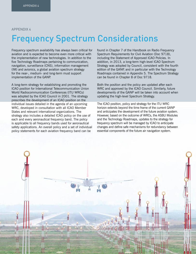
APPENDIX 4
Frequency spectrum availability has always been critical for aviation and is expected to become even more critical with the implementation of new technologies. In addition to the five Technology Roadmaps pertaining to communication, navigation, surveillance (CNS), information management (IM) and avionics, a global aviation spectrum strategy for the near-, medium- and long-term must support implementation of the GANP.
A long-term strategy for establishing and promoting the ICAO position for International Telecommunication Union World Radiocommunication Conferences (ITU WRCs) was adopted by the ICAO Council in 2001. The strategy prescribes the development of an ICAO position on the individual issues detailed in the agenda of an upcoming WRC, developed in consultation with all ICAO Member States and relevant international organizations. The strategy also includes a detailed ICAO policy on the use of each and every aeronautical frequency band. The policy is applicable to all frequency bands used for aeronautical safety applications. An overall policy and a set of individual policy statements for each aviation frequency band can be
found in Chapter 7 of the Handbook on Radio Frequency Spectrum Requirements for Civil Aviation (Doc 9718), including the Statement of Approved ICAO Policies. In addition, in 2013, a long-term high-level ICAO Spectrum Strategy was adopted by Council, consistent with the fourth edition of the GANP, and in particular with the Technology Roadmaps contained in Appendix 5. The Spectrum Strategy can be found in Chapter 8 of Doc 9718.
Both the position and the policy are updated after each WRC and approved by the ICAO Council. Similarly, future developments of the GANP will be taken into account when updating the high-level Spectrum Strategy.
The ICAO position, policy and strategy for the ITU WRC horizon extends beyond the time frame of the current GANP and anticipates the development of the future aviation system. However, based on the outcome of WRCs, the ASBU Modules and the Technology Roadmaps, updates to the strategy for frequency spectrum will be managed by ICAO to anticipate changes and define safe mechanisms for redundancy between essential components of the future air navigation system.
Frequency Spectrum ConsiderationsAPPENDIX 4

APPENDIX 4FR
EQU
ENC
Y SPECTR
UM
CO
NSID
ERATIO
NS
Future aviation spectrum access
Due to the constraints specific to frequency allocations suitable to support safety-of-life critical services, little growth is foreseen in the overall size of aeronautical allocations in the longer term. However, it is vital that conditions remain stable in the existing frequency bands, to support continued and interference-free access for current aeronautical safety systems as long as required.
Similarly, it is vital to manage the limited aviation spectrum resource in a manner which effectively supports the introduction of new technologies when available, in line with the ASBU Modules and the Technology Roadmaps.
In the light of ever increasing pressure on the frequency spectrum resource as a whole, including aeronautical frequency spectrum allocations, it is imperative that civil aviation authorities and other stakeholders not only coordinate the aviation position with their State’s radio regulatory authorities, but also actively participate in the WRC and other radio regulatory processes.
Frequency spectrum will remain a scarce and essential resource for air navigation as many Block Upgrades will require increased air-ground data sharing and enhanced navigation and surveillance capabilities. In this context, it should be recalled that the ITU considers the transmission of data for navigation or surveillance purposes to be in the communications domain.

GANP 2016–203094
The roadmaps illustrated in this Appendix have been designed to depict:
a. New and legacy technologies needed to support the Block Modules: 1. Modules that require the technology are shown in black. 2. Modules that are supported by the technology are shown in grey.
b. The date by which a technology is needed to support a Block and its Modules.
c. The availability of a technology (if it precedes the Block).
Technology Roadmaps
AIR-GROUNDDATA LINK
COMMUNICATIONS
ENABLERS(LINK MEDIA)
SERVICES
Broadband Satellite Systems ATN IPS
Commercial Broadband Links
LDACS
CPDLC over Baseline 1 (Link 2000+) Full 4D Applications
Advanced CPDLC & ADS-C over Baseline 2
ATN OSI then ATN IPS
ATN OSI then ATN IPS
ATN OSI
CPDLC & ADS-C over FANS/1A ACARS
ATN IPS
ATN IPS
ATN IPS
Airport Surface Data link Services
VDL Mode 2 (ACARS & ATN OSI)
Current Satellite Systems (ACARS) Broadband Satellite Systems (ACARS)
AeroMACS
BLOCK 0
B0-OPFL, B0-TBO
B1-RSEQ, B1-AMETB1-TBO, B1-ASEP
B2-RSEQ, B2-FICE, B2-SWIMB2-SURF, B2-ASEP, B2-CDO
B3-FICE, B3-AMETB2-SURF, B2-FICE, B2-SWIM
B3-FICE, B3-AMET B3-TBO
B1-RSEQ, B1-FICE, B1-AMET
B0-OPFL, B0-TBO, B0-FRTO
B0-OPFL, B0-TBO, B0-FRTO
B2-SURF, B2-FICE, B2-SWIM B3-FICE, B3-AMET
B1-RSEQ, B1-AMETB1-TBO, B1-ASEP, B1-FRTO
B1-AMET, B1-TBO, B1-ASEP
B2-SWIM
BLOCK 1 BLOCK 2 BLOCK 32018
2024
2030
B2-RSEQ, B2-FICE, B2-SWIMB2-SURF, B2-ASEP, B2-CDO
B3-FICE, B3-AMETB3-TBO, B3-NOPS
B1-RSEQ, B1-FICEB1-AMET, B1-TBO
B2-RSEQ, B2-FICE, B2-SWIMB2-ASEP, B2-CDO
HF (ACARS)
VDL Mode AOA (ACARS)
TECHNOLOGY AREA
MODULES
TECHNOLOGY SUPPORTING MODULES
DATE OF TECHNOLOGY AVAILABILITY (Earliest possible implementation)
DATE WHEN TECHNOLOGY NEEDED FOR BLOCK
Figure 8: Explanation of Technology Roadmap format
DOMAIN COMPONENTS ROADMAP
Communication
Air-ground data link communications 1
Ground-ground communications2
Air-ground voice communications
NavigationDedicated technology 3
Performance-based navigation 4
Surveillance
Ground-based surveillance5
Surface surveillance
Air-air surveillance 6
Information management
SWIM
7Flight & Flow
AIS/AIM
Meteorology
Time
Avionics
Communications8
Surveillance
Navigation 9
Airborne safety nets10
On-board systems
For ease of reference, CNS, IM and avionics roadmaps have been divided on the following basis:
APPENDIX 5

APPENDIX 5TEC
HN
OLO
GY R
OAD
MAP
S
GANP 2016–2030 95
CommunicationAir-ground data link services fall into two basic categories:
1. Safety-related ATS services where performance requirements, procedures, services and supporting technology are strictly standardized and regulated,
2. Information-related services where performance requirements, procedures and supporting technology are less critical.
In general, the enablers (link media technologies) will be developed and deployed based on the need to support safety-related ATS services. It should however be noted that in a radio regulatory context, AOC and certain other information services are considered as being safety related and should operate in spectrum allocations associated with safety and regularity of flight and so their needs may also have to be considered at the technology development stages.
To prepare for Block 3, research and development is needed in the Blocks 1 and 2 time frames; there are three areas of investigation where standards are being developed:
ENABLERS:
• Aviation will rely on existing communications systems, i.e. VHF ACARS and VDL Mode 2/ATN in continental areas.
• VHF ACARS will begin transitioning towards VDL Mode 2 AOA (i.e. providing higher bandwidth) since VHF channels have become a very scarce resource in several regions of the world.
• SATCOM ACARS will continue to be used in oceanic and remote regions.
• Airports – a ground-based high capacity airport surface data link system is currently under development. The Aeronautical Mobile Airport Communications System (AeroMACS) is based on IEEE 802.16/WiMAX standard).
• SATCOM – a new satellite based data link system targeted at oceanic and remote regions. This link may also be used in continental regions as a complement to terrestrial systems. This could be a dedicated ATS SATCOM (e.g. European ESA Iris initiative) system or a multi-mode commercial system (e.g. Inmarsat Swift Broadband, Iridium).
• Terrestrial (terminal and en-route) – a ground-based data link system for continental airspace is currently under investigation. This has been termed the aeronautical L-band digital aeronautical communications system (L-DACS).
In addition, studies are needed to a) review the role of voice communications in the long-term concept (primarily data centric); and to b) consider the need to develop a new appropriate digital voice communication system for continental airspace.
SERVICES:
• Data link service implementation is used in oceanic, en-route airspace and at major airports (FANS1/A and/or ICAO ATN based – ATN B1). Today’s data link service implementations are based on different standards, technology and operational procedures, although there are many similarities. There is a need to converge quickly to a common approach based upon ICAO approved standards. The common global guidance material continues to be developed, namely the Global Operational Data Link Document – GOLD (Doc 10037).
• Services such as aeronautical operational control (AOC) are carried by aircraft for communication with airline company host computers. The air-ground communications media (such as VDL Mode 2) are shared with the ATS services due to cost and avionics limitations. The use of these media for AOC is also consistent with the radio regulatory requirements of the aviation safety bands used.
Roadmap 1 - in the Block 0 time frame

GANP 2016–203096
APPENDIX 5
ENABLERS:
• ATS services will continue to exploit existing technology to maximize return on investment, hence VDL Mode 2/ATN will continue to be used for converged data link services in continental areas. New service providers may enter the market (mainly for service in oceanic and remote regions), provided they meet the ATS service requirements.
• AOC may begin to migrate towards new technologies at airports and in the en-route environment (e.g. AeroMACS at airports) as they become commercially attractive. This may also apply to some information-based ATS.
• VHF ACARS will continue to transition to VDL Mode 2.
• HF ACARS will be phased out as a better suitable datalink becomes capable of providing service over polar regions.
• The Aeronautical Telecommunications Network can be adapted to operate over new broadband Aeronautical Satellite Systems.
SERVICES:
• An important goal is to harmonize the regional data link implementations through a common technical and operational standard, applicable to all flight regions in the world. RTCA and EUROCAE have developed common safety, performance and interoperability standards for this next generation of ATS data link services (ATN B2) for both continental and oceanic and remote regions. These standards, supported by validation results, have been made available in an initial release in 2014 with the full standard in 2016, to be followed by a comprehensive validation phase and will be available for implementation in some regions from 2020. These standards will form the basis of data link services for the long term and will support the move towards trajectory-based operations.
• As avionics evolve, new high volume information services such as weather advisories, map updates, etc. will become possible. These services could take advantage of new communication technology that could be deployed at some airports and in some en-route airspace, this may be seen as the beginning of air-ground SWIM. These new data link services could be either AOC or ATS. Some of these services may however not need the same levels of performance as strictly safety-related ATS services and could therefore possibly make use of commercially available mobile data services, thus reducing the load on the infrastructure or spectrum allocation supporting the safety-related ATS services.
ENABLERS
• Data link will become the primary means for routine communication. In such a data-centric system, voice will be used for urgent messages; increased data link performance, availability and reliability, will be available supporting greater levels of safety and capacity.
• For oceanic and remote regions, it is expected that the migration from HF to SATCOM will be completed by the Block 3 time frame.
SERVICES:
• the ATM Target Concept is a “net-centric” operation based on full 4D trajectory management with data link (based on ATN Baseline 2) used as the prime means of communication, replacing voice due to its ability to handle complex data exchanges. In such a data-centric system, voice will be used only in exceptional/emergency situations.
Full air-ground SWIM services will be used to support advanced decision-making and mitigation. SWIM will allow aircraft to participate in collaborative ATM processes and provide access to rich voluminous dynamic data including meteorology. Commercial information-based services to companies and passengers may also be implemented using the same technology.
Roadmap 1 - in the Block 3 time frame
Roadmap 1 - in the Blocks 1 and 2 time frame

APPENDIX 5TEC
HN
OLO
GY R
OAD
MAP
S
GANP 2016–2030 97
AIR
-GR
OU
ND
DAT
A LI
NK
COM
MU
NIC
ATIO
NS
ENAB
LER
S(L
INK
MED
IA)
SER
VICE
S
Bro
adba
nd S
atel
lite
Syst
ems
ATN
IPS
Com
mer
cial
Bro
adba
nd L
inks
LDAC
S
CPD
LC o
ver
Bas
elin
e 1
(Lin
k 20
00+)
Full
4D
Appl
icat
ions
Adva
nced
CPD
LC &
AD
S-C
ove
r B
asel
ine
2
ATN
OSI
the
n AT
N IP
S
ATN
OSI
the
n AT
N IP
S
ATN
OSI
CPD
LC &
AD
S-C
ove
r FA
NS/
1AAC
ARS
ATN
IPS
ATN
IPS
ATN
IPS
Airp
ort S
urfa
ce D
ata
link
Serv
ices
VDL
Mod
e 2
(ACA
RS
& A
TN O
SI)
Cur
rent
Sat
ellit
e Sy
stem
s (A
CAR
S)B
road
band
Sat
ellit
e Sy
stem
s (A
CAR
S)
Aero
MAC
S
BLOC
K 0
B0-
OPF
L, B
0-TB
O
B1-
RSE
Q, B
1-AM
ETB
1-TB
O, B
1-AS
EPB
2-R
SEQ,
B2-
FICE
, B2-
SWIM
B2-
SUR
F, B
2-AS
EP, B
2-CD
O
B3-
FIC
E, B
3-AM
ETB
2-SU
RF,
B2-
FICE
, B2-
SWIM
B3-
FIC
E, B
3-AM
ET
B3-
TBO
B1-
RSE
Q, B
1-FI
CE, B
1-AM
ET
B0-
OPF
L, B
0-TB
O, B
0-FR
TO
B0-
OPF
L, B
0-TB
O, B
0-FR
TO
B2-
SUR
F, B
2-FI
CE,
B2-
SWIM
B3-
FIC
E, B
3-AM
ET
B1-
RSE
Q, B
1-AM
ETB
1-TB
O, B
1-AS
EP, B
1-FR
TO
B1-
AMET
, B1-
TBO,
B1-
ASEP
B2-
SWIM
BLOC
K 1
BLOC
K 2
BLOC
K 3
2018
2024
2030
B2-
RSE
Q, B
2-FI
CE, B
2-SW
IMB
2-SU
RF,
B2-
ASEP
, B2-
CDO
B3-
FIC
E, B
3-AM
ETB
3-TB
O, B
3-N
OPS
B1-
RSE
Q, B
1-FI
CEB
1-AM
ET, B
1-TB
OB
2-R
SEQ,
B2-
FICE
, B2-
SWIM
B2-
ASEP
, B2-
CDO
HF
(ACA
RS)
VDL
Mod
e AO
A (A
CAR
S)
Roadmap 1:DOMAIN: COMMUNICATION
COMPONENT(S): AIR-GROUND DATA LINK COMMUNICATION - ENABLERS (LINK MEDIA TECHNOLOGY) - SERVICES

GANP 2016–203098
APPENDIX 5
ENABLERS:
• IP networks will continue to be deployed. Existing IPV4 systems will be gradually replaced by IPV6.
• Until now, inter-centre voice ATM communications were mainly based on analogue (ATS-R2) and digital (ATS-QSIG) protocols. A move has begun to replace ground-ground voice communications with voice over IP (VoIP).
• Air-ground voice communications will remain on 25 kHz VHF channels in continental regions (note: 8.33 kHz VHF voice channels will continue to be deployed in Europe). Migration from HF to SATCOM in oceanic and remote regions is expected to start during this time.
SERVICES:
• Two major ground-ground communications services will be in operation: – ATS messaging operating over AFTN and/or AMHS in some areas. – ATS interfacility data communications (AIDC) for flight coordination and transfer.
ENABLERS:
• Traditional ground-ground voice communications will continue to migrate to Voice-over Internet Protocol (VoIP).
• Digital NOTAM and MET (using the AIXM and IWXXM data exchange formats) will be widely implemented over IP networks.
• FIXM will be introduced as the global standard for exchanging flight data prior to (Block 1) and during the flight (Block 2).
• To prepare for the long term, research and development is needed in the medium term for new satellite and terrestrial based systems. Voice communications will remain on 25 kHz VHF channels in continental regions (note: 8.33 kHz VHF voice channels will continue to be deployed in Europe). Migration from HF to SATCOM in oceanic and remote regions is expected to be progressing during this time.
It is quite likely that future digital systems will be used to carry voice. Where satellite communications are used, it will most likely be via the same systems used to support air-ground data link. In the terrestrial environment, it is not clear whether L-DACS will be used to carry this traffic or a separate voice system will be used. This will need to be the subject of R&D efforts in the Blocks 1 and 2 time frames.
• ATS messaging is used worldwide for the communication of flight plans, MET, NOTAMS, etc. over AFTN technology. Migration towards AMHS (directory, store and forward services) over IP (or using ATN in some regions) will progress in all regions.
• AIDC is used to provide inter-centre coordination and transfer of aircraft between adjacent air traffic control units. Migration from legacy data network (e.g. X25) to IP data network is progressing in various regions.
• The beginnings of SWIM will start to appear. Operational services will be offered by some SWIM pioneer implementations over IP, surveillance data distribution and MET data will also be distributed over IP. Migration to digital NOTAM has started in the United States and in Europe.
SERVICES:
• ATS messaging will migrate to AMHS supported by directory facilities that will include common security management by the end of Block 1. AIDC services will fully migrate towards using IP networks.
• Initial 4D air-ground services will require ground-ground inter-centre trajectory and clearance coordination via AIDC extensions or new flight data exchanges compatible with the SWIM framework.
• SWIM SOA services will mature and expand publish/subscribe and request/reply services in parallel to the more traditional messaging services based on AMHS but both will use the IP network.
• Information security, integrity, confidentiality and availability will be managed in order to mitigate the risks of intentional disruption and/or changes to safety critical ATM information.
Roadmap 2 - in the Block 0 time frame
Roadmap 2 - in the Blocks 1 and 2 time frame
Roadmap 2 - in the Block 3 time frame

APPENDIX 5TEC
HN
OLO
GY R
OAD
MAP
S
GANP 2016–2030 99
Futu
re S
atel
lite
Syst
em
Futu
re D
igita
l Voi
ce S
yste
m?
VHF
(25
KH
z)
Voic
e ov
er IP
IPV6
IPV4
VHF
(8.3
3 K
Hz)
HF
Curr
ent S
atel
lite
Syst
ems
CON
GES
TIO
N R
ELIE
F
IPV6
(for
G/G
coo
rd. a
nd li
nks
to A
/G tr
ansc
eive
rs)
GR
OU
ND
-GR
OU
ND
COM
MU
NIC
ATIO
NS
AIR
-GR
OU
ND
VO
ICE
COM
MU
NIC
ATIO
NS
BLOC
K 0
B2-
FIC
EB
3-TB
O, B
3-FI
CE,
B
3-AM
ETB
1-FI
CE,
B1-
DAT
MB
1-SW
IM, B
1-AM
ET
BLOC
K 1
BLOC
K 2
BLOC
K 3
ENAB
LER
S(L
INK
MED
IA)
ENAB
LER
S(L
INK
MED
IA)
SER
VICE
S
2018
2024
2030
Info
rmat
ion
Man
agem
ent
(See
spe
cific
Roa
dmap
fo
r B
lock
s 2
and
3)
AMH
S
AID
C
B0-
FIC
EB
1-FI
CE
B0-
FIC
E, B
0-D
ATM
Roadmap 2:DOMAIN: COMMUNICATION
COMPONENT(S): GROUND-GROUND COMMUNICATION - ENABLERS - SERVICES
AIR-GROUND VOICE COMMUNICATION - ENABLERS (LINK MEDIA TECHNOLOGY)

GANP 2016–2030100
APPENDIX 5
NavigationNavigation concepts such as RNAV, RNP and PBN provide a range of options for the use of navigation technology. As these are very much dependent on local requirements, this section will provide a narrative description of the considerations for the use of navigation technology.
GNSS infrastructure
GNSS is the core technology that has led to the development of PBN. It is also the basis for future improvements in navigation services. The core historical constellations GPS and GLONASS have been in operation for well over a decade, and SARPs in support of aviation operations are in place. Other core constellations, e.g. the European Galileo and China’s BeiDou, are being developed. Multi-constellation, multi-frequency GNSS has clear technical advantages that will support the provision of operational benefits. To realize these benefits, ICAO, States, ANSPs, standards bodies, manufacturers and aircraft operators need to coordinate activities to address and resolve related issues.
Satellite-based Augmentation System (SBAS) based on GNSS is available in North America (WAAS), Europe (EGNOS), Japan (MSAS) and will soon be available in India (GAGAN) and the Russian Federation (SDCM). Several thousand Localizer Performance with Vertical Guidance (LPV) and Localizer Performance (LP) approach procedures are implemented. SBAS typically supports APV operations, but can also support precision approach (Category I) operations. However, it is challenging for SBAS to support precision approach operations in equatorial regions using single-frequency GPS because of ionospheric effects.
GBAS CAT I based on GPS and GLONASS is available in the Russian Federation and, based on GPS, on some airports in several States. SARPs for GBAS CAT II/III are under operational validation. Related research and development activities are ongoing in different States. It is also challenging for GBAS to support a high availability of precision approach, in particular in equatorial regions.
Conventional radio navigation aids (VOR, DME, NDB, ILS) are in widespread use globally, and most aircraft are equipped with the relevant avionics. The vulnerability of GNSS signals to interference has led to the conclusion that there is a need to retain some conventional radio navigation aids or an alternative navigation service solution as a back-up to GNSS.
Mitigating the operational impact of a GNSS outage will rely primarily on the use of other constellation signals or employing pilot and/or ATC procedural methods, while taking advantage of on-board inertial systems and specific conventional radio navigation aids. In the case of a general GNSS outage in an area, reversion to conventional radio navigation aids and procedures could result in capacity or flight efficiency reduction. In such cases where there is a loss of signals from a specific constellation, the reversion to another constellation could allow maintaining the same PBN level.
The implementation of PBN will make area navigation operations the norm. DME is the most appropriate conventional radio navigation aid to support area navigation operations (i.e. assuming DME multilateration on-board capability), since it is currently used in multi-sensor avionics for this purpose. DME installations and their coverage will need to be optimized. Similarly, ILS remaining widely used, will provide, where available, an alternate approach and landing capability in case of GNSS outage.
Roadmap 3 depicts the expected evolution of navigation infrastructure and avionics.

APPENDIX 5TEC
HN
OLO
GY R
OAD
MAP
S
GANP 2016–2030 101
Until a solution to this adequate resilience problem is available, it is essential that a terrestrial navigation infrastructure, suitably dimensioned to be capable of maintaining safety and continuity of aircraft operations, be provided.
The FANS report from April 1985 stated: “The number and development of navigational aids should be reviewed with the aim of providing a more rational and more cost-effective homogeneous navigation environment.”
The current status of aircraft equipage for PBN operations supported by GNSS and terrestrial navigation aids, together with the availability of the ICAO PBN Manual and the associated design criteria provide the necessary baseline to commence the evolution to the homogeneous navigation environment envisaged within the FANS Report.
Current navigation infrastructure
The current navigation infrastructure comprising VOR, DME and NDB navigation beacons was initially deployed to support conventional navigation along routes aligned between VOR and NDB facilities. As traffic levels increased, new routes were implemented which in many cases necessitated additional navigation facilities to be installed.
As a result, navigation aid deployment has been driven by economic factors and has led to a non-uniform distribution of navigation aids with some regions, notably North America and Europe, having a high density of navigation aids with many other regions having a low density, and some areas having no terrestrial navigation infrastructure at all.
The introduction of RNAV in the last decades has led to setting up new regional route networks that no longer relied on these conventional radio navigation aids infrastructure thus allowing wider flexibility to tailor the route network to the traffic demand. This essential move has clearly stopped the direct link between the ground-based navaids and the route network in the busiest air traffic regions.
With the continuous evolution of aircraft navigation capability through performance-based navigation, and the widespread use of GNSS positioning, regions of high traffic density no longer need as high a density of navigation aids.
Future terrestrial infrastructure requirements
The GANP has the objective of a future harmonized global navigation capability based on area navigation (RNAV) and performance-based navigation (PBN) supported by the global navigation satellite system (GNSS).
The optimistic planning that was considered at the time of the Eleventh Air Navigation Conference for all aircraft to be equipped with GNSS capability and for other GNSS constellations to be available, together with dual frequency and multi-constellation avionics capability being carried by aircraft have not been realized.
The current single frequency GNSS capability provides the most accurate source of positioning that is available on a global basis. With suitable augmentation as standardized within Annexes, single frequency GNSS has the capability to support all phases of flight. The current GNSS has an extremely high availability, although it does not have adequate resilience to a number of vulnerabilities, most notably radio frequency interference and solar events causing ionospheric disturbances.

GANP 2016–2030102
APPENDIX 5
Infrastructure rationalization planning
It had initially been expected that the rationalization of the legacy navigation infrastructure would have been a consequence of a top-down process where the implementation of PBN and GNSS within volumes of airspace would result in navigation aids being made totally redundant so they could be simply be switched off.
All stakeholders generally agree that PBN is “the right thing to do” and although PBN offers the capability to introduce new routes without additional navigation aids, it remains difficult to justify the case for full scale implementation of PBN within a volume of airspace, unless there are capacity or safety issues to be addressed.
Many States have utilized PBN to implement additional routes as they are required to secure gains in capacity and operational efficiencies. This has resulted in volumes of airspace which contain a combination of new PBN routes and existing conventional routes.
It is now clear that for numerous reasons, which include being unable to establish a positive business case for a large-scale airspace redesign, a top-down PBN implementation followed by infrastructure rationalization will take many years to complete, if ever.
As an alternative strategy, a bottom-up approach should be considered as at the end of each navigation aid’s economic life, an opportunity exists to consider if a limited PBN implementation to alleviate the need for the replacement of the facility is more cost-effective than replacement of the navigation aid.
The replacement cost opportunity only presents itself if the navigation aid is fully depreciated and replacement is considered: it therefore arises on a 20-25-year cycle. In order to realize any cost-saving, rationalization opportunities need to be identified and the necessary route changes planned and implemented to enable the facilities to be decommissioned at the end of their lifetime.
This bottom-up approach to rationalization also provides a catalyst to start the airspace transition to a PBN environment, facilitating future changes to optimize routes to deliver gains in efficiency such as shorter routings and lower CO2 emissions.
In planning for the rationalization of navigation infrastructure, it is essential that all stakeholders’ needs and operational uses of the infrastructure be considered. This may include military instrument flight procedures, aircraft operational contingency procedures, such as engine failure on take-off, and used for VOR-based separations in procedural airspace or general aviation.
Additional guidance on navigation infrastructure rationalization planning is provided in Annex 10, Volume I, Attachment H, entitled “Strategy for rationalization of conventional radio navigation aids and evolution toward supporting performance based navigation”.

APPENDIX 5TEC
HN
OLO
GY R
OAD
MAP
S
GANP 2016–2030 103
ILS/
MLS
GB
AS C
at I
CAT
I / II
/I II
S
BAS
LPV
200
GB
AS C
at II
/ III
Reta
in to
sup
port
pre
cisi
on a
ppro
ach
and
miti
gate
GN
SS o
utag
e
CAT
I/II/
III L
andi
ng
PBN
Ope
ratio
ns
ILS/
MLS
Opt
imiz
e ex
istin
g ne
twor
k to
sup
port
PB
N o
pera
tions
DM
E
Sing
le fr
eque
ncy
(GPS
/GLO
NAS
S)M
ulti-
Freq
uenc
y/M
ulti-
Cons
tella
tion
(GPS
/GLO
NAS
S/B
eido
u/G
alile
o)Co
re G
NSS
Con
stel
latio
ns
SBAS
GB
AS C
at I
GB
AS C
at II
/III
Mul
ti-Fr
eq G
BAS
/SB
ASG
NSS
Aug
men
tatio
ns
APN
T
Rat
iona
lize
base
d on
nee
d an
d eq
uipa
geVO
R/N
DB
NAV
IGAT
ION
BLOC
K 0
BLOC
K 1
BLOC
K 2
BLOC
K 3
ENAB
LER
S(C
ON
VEN
TIO
NAL
)
ENAB
LER
S(S
ATEL
LITE
-BAS
ED)
ENAB
LER
S
CAPA
BIL
ITIE
S(P
BN
- s
ee r
oadm
ap)
CAPA
BIL
ITIE
S(P
REC
ISIO
N A
PPR
OACH
)
2018
2024
2030
B2-
CDO
B0-A
PTA,
B0-
CDO,
B0-
FRTO
B1-
TBO
B3-
TBO,
B3-
NOP
S
B0-
APTA
B1-
APTA
B1-
FRTO
Roadmap 3:DOMAIN: NAVIGATION
COMPONENT(S): ENABLERS - CONVENTIONAL - SATELLITE-BASED
CAPABILITIES - PBN - PRECISION APPROACH

GANP 2016–2030104
APPENDIX 5
Performance-based navigation
Roadmap 4 depicts the migration paths for the implementation of PBN levels and precision approaches for the following operations: en-route oceanic and remote continental, en-route continental, TMA arrival/departure, and approach. There is no attempt to show detailed timelines because regions and States will have different requirements; some may need to move quickly to the most demanding PBN specification while others will be able to satisfy airspace users’ requirements with a basic specification. The figures do not imply that States/regions have to implement each step along the path to the most demanding specification. The Performance-based Navigation (PBN) Manual (Doc 9613) provides the background and detailed technical information required for operational implementation planning.
The PBN Manual identifies a large set of navigation applications. Among these applications, one subset is the RNP applications. It is important to realize that the implementation of RNP applications within an airspace contributes de facto to a re-distribution of the surveillance and conformance monitoring functions. The RNP concept introduces an integrity check of the navigated position at the aircraft level and allows the automatic detection of non-conformance to the agreed trajectory while this function is today the full responsibility of the controller. Therefore RNP implementation should provide additional benefits to the air traffic service unit that is traditionally in charge of the conformance monitoring.

APPENDIX 5TEC
HN
OLO
GY R
OAD
MAP
S
GANP 2016–2030 105
RN
AV 1
0 (R
NP
10)
RN
P 4
R
NP
2
RN
AV 5
RN
AV 2
RN
AV 1
RN
AV 1 R
NP
1
RN
P 2
Adv
ance
d R
NP
RN
P 0.
3FR
T
PB
N
NAV
IGAT
ION
BLOC
K 0
BLOC
K 1
BLOC
K 2
BLOC
K 3
En-r
oute
Oce
anic
and
Rem
ote
Cont
inen
tal
En-r
oute
Cont
inen
tal
(Hel
icop
ter
only
)
Adva
nced
RN
P
RF
LEG
SR
NP
AR D
P
RN
P 0.
3(H
elic
opte
r on
ly)
RN
P AP
CH (L
PV, L
NAV
/VN
AV, L
NAV
)
RN
P AR
APC
H(w
here
ben
efic
ial)
Term
inal
Air
spac
e:Ar
riva
l & D
epar
ture
Appr
oach
2018
2024
2030
B1-
TBO
B0-
FRTO
, B0-
CDO
B1-
RSE
QB
2-CD
O
B0-
APTA
B1-
APTA
B1-
FRTO
Roadmap 4:DOMAIN: PERFORMANCE-BASED NAVIGATION (PBN)
COMPONENT(S): EN-ROUTE, OCEANIC AND REMOTE CONTINENTAL EN-ROUTE CONTINENTAL TERMINAL AIRSPACE: ARRIVAL AND DEPARTURE APPROACH

GANP 2016–2030106
APPENDIX 5
SurveillanceThe important trends of the next 20 years will be that:
a. Different techniques will be mixed in order to obtain the best cost-effectiveness depending on local constraints.
b. Cooperative surveillance will use technologies currently available using 1 030/1 090 MHz RF bands (SSR, Mode-S, WAM and ADS-B).
c. While refinements to capabilities may be identified, it is expected that the surveillance infrastructure currently foreseen could meet all the demands placed upon it.
d. The airborne part of the surveillance system will become more important and should be “future proof” and globally interoperable in order to support the various surveillance techniques which will be used.
e. There will be growing use of downlinked aircraft parameters bringing the following advantages:
1. Clear presentation of call-sign and level.
2. Improved situational awareness.
3. Use of some downlinked aircraft parameters (DAPs) and 25 ft altitude reporting to improve surveillance tracking algorithms, including safety nets.
4. Display of vertical stack lists.
5. Reduction in radio transmission (controller and pilot).
6. Improved management of aircraft in stacks.
7. Reductions in level busts.
f. Functionality will migrate from the ground to the air.


GANP 2016–2030108
APPENDIX 5
• The twin demands of increased traffic levels and reduced separation will require an improved form of ADS-B.
• There will be significant deployment of cooperative surveillance systems: ADS-B (ground- and space-based), MLAT, WAM.
• Ground processing systems will become increasingly sophisticated as they will need to fuse data from various sources and make increasing use of the data available from aircraft.
• Deployment of cooperative surveillance systems will expand.
• Cooperative surveillance techniques will enhance surface operations.
• Additional safety net functions based on available aircraft data will be developed.
• It is expected that multi-static primary surveillance radar (MPSR) will be available for ATS use and its deployment will provide significant cost savings.
Roadmap 5 - in the Block 0 time frame
• Surveillance data from various sources along with aircraft data will be used to provide basic safety net functions. Surveillance data will also be available for non-separation purposes.
Roadmap 5 - in the Block 1 time frame
• Remote operation of aerodromes and control towers will require remote visual surveillance techniques, e.g. cameras, to provide visual situational awareness. This visual situational awareness will be supplemented with graphical overlays such as tracking information, weather data, visual range values and ground light status, etc.
Roadmap 5 - in the Block 2 time frame
• Cooperative surveillance techniques will be dominant as primary surveillance radar (PSR) use will be limited to demanding or specialized applications.
Roadmap 5 - in the Block 3 time frame
• Primary surveillance radar will be used less and less as it is replaced by cooperative surveillance techniques.
• Space-based ADS-B is likely to be fully available.

APPENDIX 5TEC
HN
OLO
GY R
OAD
MAP
S
GANP 2016–2030 109
SUR
VEIL
LAN
CE
ENAB
LER
S
ENAB
LER
S
CAPA
BIL
ITIE
S
CAPA
BIL
ITIE
S
GR
OU
ND
-BAS
ED
SUR
FACE
SMR
PSR
Mul
ti-st
atic
PSR
Cam
eras
MLA
T
WAM
ADS-
B O
ut v
ia S
atel
lite
ADS-
C2018
2024
2030
B1-R
SEQ,
B1-
RATS
BLO
CK 0
BLO
CK 1
BLO
CK 2
BLO
CK 3
SSR
/Mod
e-S
B0-
ASU
R, B
0-SN
ETB
1-SN
ET
B1-
TBO
B0-
TBO
B0-
ASU
R
B0-
ASU
R, B
0-SN
ET
B0-
SUR
FB1
-SU
RF,
B
2-SU
RF
B1-
SNET
B1-S
URF
, B1-
RSEQ
, B1-
RATS
B0-S
URF
B2-S
URF
B1-W
AKE,
B1-
SURF
,
ADS-
B In
/Out
(ICA
O V
er. 2
)
Gro
und-
base
d Su
rvei
llanc
e
Surv
eilla
nce
Dat
a Fu
sion
Futu
re A
DS-
B In
/Out
Sys
tem
A-SM
GCS
Lev
els
1 an
d 2
A-SM
GCS
Lev
els
3 an
d 4
Futu
re A
DS-
B In
/Out
Sys
tem
ADS-
B In
/Out
(ICA
O V
er. 2
)
B1-
RSE
Q, B
1-R
ATS
B1-R
ATS
Roadmap 5:DOMAIN: SURVEILLANCE
COMPONENT(S): GROUND-BASED SURVEILLANCE - ENABLERS - CAPABILITIES
SURFACE SURVEILLANCE - ENABLERS - CAPABILITIES

GANP 2016–2030110
APPENDIX 5
• ADS-B technology will begin to be used for basic airborne (delegated) separation.
• Basic airborne situational awareness applications will become available using ADS-B In/Out (ICAO Version 2)
• Advanced situational awareness applications will become available, again using ADS-B In/Out.
Roadmap 6 - in the Block 0 time frame
Roadmap 6 - in the Block 1 time frame
Roadmap 6 - in the Block 2 time frame
• The ADS-B technology which supported Block 2 will be used for limited self-separation in remote and oceanic airspace.
Roadmap 6 - in the Block 3 time frame
• The twin demands of increased traffic levels and reduced separation will require an improved form of ADS-B.
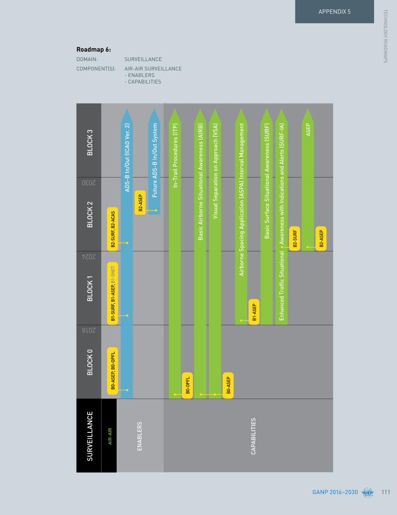
APPENDIX 5TEC
HN
OLO
GY R
OAD
MAP
S
GANP 2016–2030 111
ASEP
SUR
VEIL
LAN
CEBL
OCK
0
2018
2024
2030
B0-O
PFL
B1-A
SEP
B2-A
SEP
B0-A
SEP
B2-S
URF
BLOC
K 1
BLOC
K 2
BLOC
K 3
AIR
-AIR
ENAB
LER
S
CAPA
BIL
ITIE
S
B0-A
SEP,
B0-
OPFL
B1-S
URF,
B1-
ASEP
, B1-
SNET
B2-S
URF,
B2-
ACAS
ADS-
B In
/Out
(ICA
O Ve
r. 2)
In-T
rail
Proc
edur
es (I
TP)
Bas
ic A
irbo
rne
Situ
atio
nal A
war
enes
s (A
IRB
)
Visu
al S
epar
atio
n on
App
roac
h (V
SA)
Bas
ic S
urfa
ce S
ituat
iona
l Aw
aren
ess
(SU
RF)
Enha
nced
Tra
ffic
Situ
atio
nal
Aw
aren
ess
with
Indi
catio
ns a
nd A
lert
s (S
URF
-IA)
Airb
orne
Spa
cing
App
licat
ion
(ASP
A) In
terv
al M
anag
emen
t
Futu
re A
DS-
B In
/Out
Sys
tem
B2-A
SEP
Roadmap 6:DOMAIN: SURVEILLANCE
COMPONENT(S): AIR-AIR SURVEILLANCE - ENABLERS - CAPABILITIES

GANP 2016–2030112
APPENDIX 5
Information ManagementA goal of the Global ATM Operational Concept is a net-centric operation where the ATM network is considered as a series of nodes – including the aircraft – providing or using information.
Aircraft operators with flight/airline operational control centre facilities will share information while the individual user will be able to do the same via applications running on any suitable personal device. The support provided by the ATM network will, in all cases, be tailored to the needs of the user concerned.
The sharing of information of the required quality and timeliness in a secure environment is an essential enabler for the ATM Target Concept. The scope extends to all information that is of potential interest to ATM including trajectories, surveillance data, aeronautical information, meteorological data, etc.
System-wide information management (SWIM) is an essential enabler for ATM applications. It provides an appropriate infrastructure and ensures the availability of the information needed by the applications run by the members of the ATM community. The related geo-referenced/time-stamped, seamless and open interoperable data exchange relies on the use of common methodology and the use of a suitable technology and compliant system interfaces.
The availability of SWIM will make possible the deployment of advance end-user applications as it will provide extensive information-sharing and the capability to find the right information wherever the provider is. Cyber-security becomes an increasing issue through time and of ever growing importance in the migration to information management.
Need for a common time reference
In moving towards the Global ATM Operational Concept, and in particular 4D trajectory management and intensive exchanges of information through SWIM, some of the current provisions for time management might not be sufficient and could become a barrier to future progress.
The time reference for aviation is defined to be the Coordinated Universal Time (UTC). Requirements surrounding accuracy of time information depend on the type of ATM application in which it is used. For each ATM application, all contributing systems and all contributing users must be synchronized to a time reference that satisfies this accuracy requirement.
UTC is the common time reference, but the present requirements for the accuracy with which aviation clocks are synchronized to UTC may be insufficient to cover future needs. This relates to the integrity and timeliness of information or the use of dependent surveillance for closer separations, as well as more generally 4D trajectory operations. System requirements for synchronization using an external reference must also be considered.
Rather than defining a new reference standard, the performance requirement for accuracy has to be defined with respect to UTC for each system in the ATM architecture that relies on a coordinated time requirement. Different elements require different accuracy and precision requirements for specific applications. The increased exchange of data on SWIM creates the necessity of efficient “time stamping” for automated systems that are in communication with each other. The time information should be defined at the source and incorporated in the distributed data, with the proper level of accuracy maintained as part of the data integrity.
GNSS is an appropriate and cost-efficient system to distribute accurate timing to an increasing number of ATM systems and applications. The use of multiple GNSS constellations will provide a diversified source of time reference. An alternative time source to GNSS is developed over time to reduce the potential for interruption (alternative positioning, navigation, and timing, APNT).

APPENDIX 5TEC
HN
OLO
GY R
OAD
MAP
S
GANP 2016–2030 113
• SWIM will start to appear in Europe and the United States. The SWIM concept will be developed and refined.
• Operational services will be supported by service oriented architecture (SOA) pioneer implementations.
Roadmap 7 - in the Block 0 time frame
• SWIM in the Block 1 time frame: – An initial SWIM capability supporting ground-ground communications will be deployed. – Strong cyber-security is introduced to support information management.
• SWIM in the Block 2 time frame: – The aircraft will become a node on the SWIM network with full integration with the aircraft systems. – Information security, integrity, confidentiality and availability will be managed in order to mitigate the risks of intentional disruption and/or changes to safety critical ATM information.
• Digital NOTAM and MET information distribution (using the AIXM and IWXXM information exchange formats) will be widely implemented over the SWIM network.
• Flight objects will be introduced, improving interfacility
• Meteorological data will also be distributed over IP.
• Migration to digital NOTAM has commenced and will be distributed over IP.
coordination and providing multi-facility coordination for the first time. Flight objects will be shared on the SWIM network over an IP backbone and updated through SWIM synchronization services.
• The more traditional point-to-point ATS interfacility data communication (AIDC) message exchange will still coexist for some time with SWIM.
• Flight information exchange model (FIXM) will propose a global standard for exchanging flight information, replacing the flight plan used today.
• Common elements across the exchange Modules will be managed by a cross-cutting control board.
• More generally it is expected that SWIM will support the implementation of new concepts such as virtual ATS facilities, which control airspace remotely.
Roadmap 7 - in the Blocks 1 and 2 time frame

GANP 2016–2030114
APPENDIX 5
• Full SWIM deployment is expected allowing all participants, including the aircraft, to be able to access a wide range of information and operational services including full 4D-trajectory sharing.
• Full implementation of flight objects will be achieved as the FF-ICE concept is realized.
• An alternative time source to GNSS for timing will be available (APNT).
Roadmap 7 - in the Block 3 time frame and beyond

APPENDIX 5TEC
HN
OLO
GY R
OAD
MAP
S
GANP 2016–2030 115
SWIM
FLIG
HT
& F
LOW
SWIM
CAPA
BIL
ITIE
S
ENAB
LER
S
AIS/
AIM
MET
EOR
OLO
GY
CAPA
BIL
ITIE
S
CAPA
BIL
ITIE
S
ENAB
LER
S
ENAB
LER
S
ENAB
LER
S
INFO
RM
ATIO
NM
ANAG
EMEN
T
TIM
E
SWIM
(Gro
und-
Grou
nd):
Flig
ht In
tent
s be
fore
dep
artu
re, A
TM in
form
atio
n ex
chan
ges
SWIM
(Gro
und-
Grou
nd):
Inte
r-Ce
ntre
coo
rdin
atio
n
SWIM
(Air
-Gro
und)
: Air
craf
t int
egra
tion
BLOC
K 0
2018
2024
2030
BLOC
K 1
BLOC
K 2
BLOC
K 3
SWIM
CO
NC
EPT
SWIM
G-G
SWIM
A-G
IWXX
M
FIXM
befo
re D
epar
ture
Flig
ht a
nd F
low
Coo
rdin
atio
n
Dig
ital N
OTAM
4D T
raje
ctor
ies,
Fu
ll FF
-ICE
eAIP
, AIX
M
GNSS
B1-
DAT
M, B
1-FI
CE
B1-
FICE
, B1-
DAT
M, B
1-SW
IM
B0-
DAT
M
B2-
FICE
B2-
FICE
B2-
SWIM
B3-
FICE
, B3-
TBO
B1-
DAT
M
Dig
ital M
ET D
ata
exch
ange
& M
ET in
form
atio
n se
rvic
es,
Trad
ition
al a
lpha
num
eric
al
code
s re
plac
ed b
y di
gita
l dat
a;
enha
nced
qua
lity
B1-
DAT
M, B
1-AM
ET
ATM
Info
rmat
ion
Refe
renc
e an
d Se
rvic
e M
odel
, Com
mon
Gov
erna
nce,
ISO,
OGC
, etc
.
(initi
al F
F-IC
E)
(initi
al F
F-IC
E)
In F
light
upd
ates
Exch
ange
of F
light
Inte
nts
Dig
ital D
ata
exch
ange
& s
ervi
ces,
sho
rter
upd
ate
cycl
es
Elec
tron
ic C
hart
s, D
igita
l Bri
efin
g, In
Flig
ht u
pdat
es
AIS-
AIM
Enh
ance
d qu
ality
Pape
r --
> D
igita
l dat
a av
aila
bilit
y
B3-
AMET
APN
T
Roadmap 7:DOMAIN: INFORMATION MANAGEMENT
COMPONENT(S): SWIM FLIGHT AND FLOW - CAPABILITIES - ENABLERS
AIS/AIM - CAPABILITIES - ENABLERS
MET - CAPABILITIES - ENABLERS
TIME - ENABLERS

GANP 2016–2030116
APPENDIX 5
AvionicsA key theme with the avionics evolution is the significant increase in capability that is possible through the integration of various on-board systems/functions.
Communication, navigation and surveillance systems are becoming more interconnected and interrelated. For example, GNSS provides positioning to navigation, surveillance and a number of other avionics functions,
creating both common mode concerns as well as opportunities for synergies. In addition to harmonizing the evolution of CNS capability deployment, there is an increasing need to ensure that new digital CNS systems do not introduce undue complexity while ensuring that advanced CNS capabilities can be supported with the required level of robustness, in a failure-tolerant and cost-effective manner.
• Aircraft access to SWIM will be provided using the various means described in the roadmap for air-ground data link communications.
• FANS-2/B will be introduced which supports data link initiation capability (DLIC), ATC communications management (ACM) service, ATC microphone check (AMC) service and ATC clearances and information (ACL) service over ATN, thus providing better communication performance than FANS-1/A. In this first step with data link implementation over ATN, ACL is commonly used by ATC for the notification of voice frequencies changes to the aircraft. The more integrated solutions provide a connection between the FANS and the radio communication equipment. This integration enables the automatic transmission and tuning of these voice frequencies.
Roadmap 8 - in the Block 0 time frame
• The existing FANS-1/A system will continue to be used as there is a large base of equipped aircraft and it also supports both communication and navigation integration.
• Aircraft will have a traffic computer hosting the “traffic collision avoidance system”, and possibly the new air traffic situational awareness functions and airborne separation assistance systems. This capability is expected to undergo successive improvements in order to meet the requirement of later Blocks.
Roadmap 8 - in the Block 1 time frame
Roadmap 8 - in the Block 2 time frame
• FANS-3/C with CNS integration (via ATN B2) will be available providing communication and surveillance integration through a connection between the FANS and NAV (FMS) equipment. This avionics integration typically supports the easy loading in the FMS of complex ATC clearances transmitted by data link.
• Surveillance integration (via ATN B2) will provide an integrated surveillance through a connection between the FANS equipment and the traffic computer. This avionics integration typically supports the easy loading (within the traffic computer) of ASAS manoeuvres transmitted by data link.

APPENDIX 5TEC
HN
OLO
GY R
OAD
MAP
S
GANP 2016–2030 117
FAN
S 1/
A w
ith C
omm
, Nav
inte
grat
ion
(via
ACA
RS)
Traf
fic C
ompu
ter
ADS-
B In
/Out
(ICA
O Ve
r. 2)
Surv
eilla
nce
Int
egra
tion
(v
ia A
TN B
2)
Futu
re A
DS-B
In/O
ut S
yste
m
FAN
S 2/
B w
ith C
omm
,
N
av in
tegr
atio
n (v
ia A
TN B
1)
AVIO
NIC
SBL
OCK
0
2018
2024
2030
B0-
OPFL
, B0-
TBO,
B0-
FRTO
FAN
S 3/
C w
ith
CN
S in
tegr
atio
n
(vi
a AT
N B
2)
B1-S
URF,
B1-
ASEP
, B1-
SNET
B1-
ASEP
B2-
ASEP
B2-
SUR
F, B
2-AS
EP
B0-
ASEP
, B0-
OPFL
B2-S
URF,
B2-
ACAS
Airc
raft
acce
ss to
SW
IM
B1-
RSE
Q
BLOC
K 1
BLOC
K 2
BLOC
K 3
COM
MU
NIC
ATIO
NS
SUR
VEIL
LAN
CE
ENAB
LER
S
ENAB
LER
S
B1-
RSE
Q, B
1-TB
O, B
1-AS
EPB2
-SUR
F, B
2-AS
EP, B
2-CD
O
B2-
SWIM
B3-
FICE
, B3-
AMET
B3-
TBO
Roadmap 8:DOMAIN: AVIONICS
COMPONENT(S): COMMUNICATIONS & SURVEILLANCE

GANP 2016–2030118
APPENDIX 5
• Flight management system capability will be enhanced to support the full 4D capability.
• FMS supporting PBN represents a flight management system supporting PBN, i.e. providing multi-sensor (GNSS, DME, etc.) navigation and area navigation, and qualified for RNAV-x and RNP-x operations.
Roadmap 9 - in the Block 0 time frame
• INS will continue to be used in conjunction with other navigation sources. Navigation will be underpinned by the capability to merge and manage navigation data from various sources.
Roadmap 9 - in the Blocks 1 and 2 time frame
Roadmap 9 - in the Block 3 time frame and beyond
• Airport navigation integration (via ATN B2) provides integration between the FMS and the airport navigation system function to among other things support the easy loading within the traffic computer of ATC taxi clearances transmitted by data link.
• Flight management system capability will be enhanced to support initial 4D capability.
• GNSS-based services today rely on a single constellation, the global positioning system (GPS), providing service on a single frequency. Other constellations, i.e., the GLObal NAvigation Satellite System (GLONASS), Galileo and BeiDou will be deployed. All constellations will eventually operate in multiple frequency bands. GNSS performance is sensitive to the number of satellites in view. Multi-constellation GNSS will substantially increase that number, improving the availability and continuity of service. Furthermore, availability of additional
interoperable satellite ranging sources will support the evolution of aircraft-based augmentation systems (ABAS, system that augments and/or integrates the information obtained from the other GNSS elements with information available on board the aircraft) that could provide vertically guided approaches with minimal, or potentially no need for external augmentation signals. The availability of a second frequency will allow avionics to calculate ionospheric delay in real-time, effectively eliminating a major error source. The availability of multiple independent constellations will provide redundancy to mitigate the risk of service loss due to a major system failure within a core constellation, and will address the concerns of some States about reliance on a single GNSS constellation outside their operational control.
• The airborne MMR and FMS will have to gradually become compatible and interoperable with multi-constellation systems.

APPENDIX 5TEC
HN
OLO
GY R
OAD
MAP
S
GANP 2016–2030 119
INS
Mul
ti-Se
nsor
Nav
igat
ion
Man
agem
ent
AVIO
NIC
SBL
OCK
0
2018
2024
2030
B1-A
PTA,
B1-
FRTO
, B1-
CDO
FMS
supp
ortin
g PB
N
B0-
FRTO
, B0-
CDO
B2-
CDO
B1-A
PTA,
B1-
FRTO
, B1-
CDO
FMS
Full
4D
Airp
ort N
avig
atio
n In
tegr
atio
n (v
ia A
TN B
2)
Mul
ti-Co
nste
llatio
n/Fr
eq &
Mul
ti-Se
nsor
B1-
APTA
B3-
NOP
S, B
3-TB
O
B1-
FRTO
B0-
FRTO
BLOC
K 1
BLOC
K 2
BLOC
K 3
NAV
IGAT
ION
ENAB
LER
S
FMS
initi
al 4
D
B1-
TBO
B3-
NOP
S, B
3-TB
O
B1-
TBO
Roadmap 9:DOMAIN: AVIONICS
COMPONENT(S): NAVIGATION
GANP 2016–2030120
APPENDIX 5
• ACAS II (TCAS Version 7.1) will be the main airborne safety net. This will continue through the Block 1 time frame.
• The ground proximity warning system (GPWS, a.k.a. TAWS) will also continue.
• Information display devices will become increasingly common in the cockpit. Care must be taken to ensure that the use of the displays and/or electronic flight bags is well-defined, that they have been certified for the functions supported, and approved for use.
Roadmap 10 - in the Block 0 time frame
• Airport moving maps and cockpit display of traffic information will be supported with technologies such as ADS-B.
• Enhanced vision systems (EVS) for aerodrome use will be available in the cockpit.
Roadmap 10 - in the Block 2 time frame
• Synthetic vision systems (SVS) for aerodrome use will be available in the cockpit.

APPENDIX 5TEC
HN
OLO
GY R
OAD
MAP
S
GANP 2016–2030 121
GPW
S (T
AWS)
ACAS
II (T
CAS
Vers
ion
7.1)
CDTI
Airp
ort M
ovin
g M
ap
2018
2024
2030
Futu
re A
CAS
Wea
ther
Rad
ar
EVS
SVS
AIR
BO
RN
ESA
FETY
NET
S
EN
ABLE
RS
CAPA
BIL
ITIE
S
DIS
PLA
YS
BLO
CK 0
AVIO
NIC
SB
LOCK
1B
LOCK
2B
LOCK
3
ON
-BOA
RD
SYST
EMS
B0-
ACAS
B1-S
UR
F, B
1-TB
O
B2-
SUR
F
B2-
ACAS
B0-
SUR
F
B0-
ASEP
, B0-
OPF
LB
1-SU
RF,
B1-
ASEP
B2-
SWIM
B2-
SUR
F, B
2-AS
EP, B
2-C
DO
B3-
AMET
Elec
tron
ic F
light
Bag
s
Roadmap 10:DOMAIN: AVIONICS
COMPONENT(S): AIRBORNE SAFETY NETS ON-BOARD SYSTEMS

GANP 2016–2030122
APPENDIX 5
AutomationThe Twelfth Air Navigation Conference requested ICAO to develop a roadmap for ground air traffic automation systems. This work could not be achieved during the past triennium but will be included in the 2019 edition. The purpose of this roadmap will be to:
1. Ensure interoperability between States;
2. Function and operate these systems resulting in consistent and predictable air traffic management across States and regions.

APPENDIX 5TEC
HN
OLO
GY R
OAD
MAP
S

GANP 2016–2030124
The illustration on the following page depicts the various dependencies which exist between Modules. These may cross Performance Improvement Areas and Blocks.
Dependencies between Modules exist either because:
i. There is an essential dependency.
ii. The benefits of each Module are mutually reinforcing, i.e. implementation of one Module enhances the benefit achievable with the other Modules(s).
For further information the reader is referred to the detailed online descriptions of each Module.
This diagram assumes that all current SARPs are uniformly implemented.
Module Dependencies
Links from a Module in Block‘n’to a Module in Block ‘n+1’
Dependencies across Threads/Performance Areas
Links to other Threads/Performance Areaswhere a Module is dependent on an earlierModule or Modules
Legend
APPENDIX 6

APPENDIX 6M
OD
ULE D
EPEN
DEN
CIES
GANP 2016–2030 125
B0-
TBO
B3-
TBO
B0-
APTA
B1-
APTA
B0-
WAK
EB
2-W
AKE
B0-
FIC
E
B1-
SWIM
B1-
NO
PSB
3-N
OPS
B0-
ASU
R
B0-
OPF
L
B0-
ASEP
B2-
ASEP
B2-
CD
OB
0-C
DO
B0-
CC
O
B3-
RPA
S
B2-
SWIM
B2-
FIC
EB
3-FI
CE
AIRP
ORT
OPER
ATIO
NS
GLOB
ALLY
INTE
ROPE
RABL
ESY
STEM
SAN
D DA
TA
OPTI
MUM
CAPA
CITY
AND
FLEX
IBLE
FLIG
HTS
EFFI
CIEN
TFL
IGHT
PAT
HS
B1-
RAT
S
B0-
ACD
MB
1-AC
DM
B0-
SUR
FB
1-SU
RF
B2-
SUR
F
B2-
ACAS
B0-
ACAS
B0-
RSE
QB
2-R
SEQ
B3-
RSE
Q
B1-
SNET
B0-
SNET
B1-
CD
O
B1-
RPA
SB
2-R
PAS
B3-
AMET
B0-
AMET
B1-
AMET
B0-
NO
PSB
2-N
OPS
B1-
ASEP
B1-
DAT
M
B1-
TBO
B1-
FRTO
B0-
DAT
M
B0-
FRTO
B1-
RSE
Q
B1-
WAK
E
B1-
FIC
E

GANP 2016–2030126
As proposed by the Twelfth Air Navigation Conference to develop a Global ATM logical architecture to further work out the dependencies between the ASBU, to support the GANP and the planning work by regions and States, ICAO has started working on an initial architecture design.
Unlike the typical phases of flight representation which shows a geographic representation of a flight’s physical state, this architectural representation shows the ATM functional states that each flight may be involved in simultaneously, both singly and as a part of a fleet.
Figure 9 is designed to be simple in order to illustrate:
• the implications of specific functions for the different concept components;
• the performance requirements related to them;
• the elements impacted by ASBU Modules and/or Technology Roadmaps of the GANP.
It shows that technical infrastructure links to the Global Concept elements and the delivery of ATM. This infrastructure supports current operations and the fundamental change in ATM expressed in the Global Concept - trajectory based operations supported through trajectory management. These core technologies are implemented in both ground and air assets.
It can provide increased clarity on the functional requirements embedded in the ASBU Modules and should be detailed on a Module basis in order to clearly delineate the various functional components impacted by each one. It should also be detailed by actors of the ATM system in order to identify respective responsibility as well as potential consequences on their respective modernization plan. This should be achieved during the next triennium.
Further development of the ATM logical architecture will be instrumental in:
• Scoping the work on the Modules;
• Understanding and maintaining interdependencies and interoperability issues;
• Providing situational awareness; and
• Communicating.
ATM Logical ArchitectureAPPENDIX 7

APPENDIX 7ATM
LOG
ICAL AR
CH
ITECTUR
E
GANP 2016–2030 127
• compute, coordinate/distribute trajectories
• monitor trajectories• awareness, planning,
optimisation, follow-up
TRAJECTORY MNGT
INFR
ASTRU
CTUR
E CAPABILITIES
NAV (GND+SAT)
NAV (GND+SAT) mngt
A/G voice
A/G voice mngt
A/G D/L
A/G D/L mngt
G/G Voice
G/G Voice mngt
SUR
SUR mngt
G/G Data
G/G Data mngt
AERONAUTICAL MET SERVICES
WEATHER SERVICES
SUR DATA PROCESSING
WORKSTATIONS
GND SAFETY NETS
FOCATC
ONBOARD SAFETY NETS
DATA-LINK COMMS
NAV
AIR-AIR APPLICATIONS
AUO
Legend:
AO AOM APOC
AUO
CM DCB
FOC
TS
Conflict MngtDemand Capacity BalancingFlight Operations Centre
TRN TerrainTraffic Synchronization
Aerodrome OperationsAirspace Organization MngtAirport Operations Centre
ATM SDM ATM Service Delivery MngtAirspace User Operations
SUR (TFC, TRN, WX)
VOICE COMMS
DEFENCE ACTIVITIES
SAR
DATA
AOM
DCB CM
ATMSDM
TRAJECTORY MNGT
AO
AOU
TS
APOC
Figure 9: ATM logical architecture

GANP 2016–2030128
This appendix was developed to provide the States and the different stakeholders with financial guidance for the implementation of the ASBUs. The information contained herein was provided by the ICAO Multi-disciplinary Working Group on the Economic Challenges Linked to the Implementation of the Aviation System Block Upgrades (MDWG-ASBU, hereafter called MDWG) which developed guidance material on how to set up implementation, considering economic impact assessment, business cases, cost benefit analysis, financial instruments, incentives and the relation with ICAO policy documents, to assist States, stakeholders and regions to implement the ASBU. The full report is available from the GANP webpage.
General DescriptionThe ASBU Modules contribute to improved performance of an air navigation system. The starting point for most States, stakeholders and regions is to assess the actual performance of the system in order to underline the challenges to be met, either now or in the future, in key performance areas such as capacity, efficiency, safety or environment. This will also allow a measure of the real benefits of the Modules after their deployment. A performance based approach is advocated by ICAO (Chapter 3 refer).
Traditional measures, e.g. sector splitting when workload for ATC is too high or optimizing the route network in cooperation with neighbouring States, are always available. If the benefits for one performance area negatively impact on other performance areas (e.g. more capacity but less cost-efficiency) or traditional types of action only accommodate a short period, modernization will be the next step. The ASBU Modules provide the user with potential solutions. As always, application of the ASBUs may need to be adapted depending on the specific situation. Scenarios need to be developed, taking into account specific elements of Modules, Modules or packages of ASBU Modules, related to the needs and local constraints. A collaborative multidisciplinary approach to engage stakeholders from the outset and obtain their buy-in and determine relative priorities of performance objectives is key to the success of the investment.
Harmonization and interoperability should always be taken into account early in the project. Implementation benefits and costs may be influenced by the scale of improvement and the operational and organizational environment, hence solutions adopted by neighbouring States or regions should, as far as relevant, be taken into account. Economies of scale when working together with multiple stakeholders and States (route structure improvement at regional scale for instance) have a direct impact on the costs for procurement, training, maintenance, operation but also on the benefits of the investment. The trade-off with the managerial aspects of a several-player scenario should be comprehensively balanced.
Finally, all parties involved should check in advance if additional technical specifications, regulations or regulatory approvals would be required from or beyond the ICAO provisions and include their development in the project.
Evaluation techniques
Different types of evaluation techniques can be used for planning and decision-making: economic impact assessment, business case or cost-benefit analysis.
Financial and Coordination Aspects of Implementation
APPENDIX 8

APPENDIX 8FIN
ANC
IAL AND
CO
OR
DIN
ATION
ASPECTS O
F IMP
LEMEN
TATION
GANP 2016–2030 129
Financial instruments
When addressing the financial aspects, financial instruments should be taken into consideration.
The MDWG report provides guidance on the type of instruments and the way they can be applied. It gives an overview of different financial instruments, varying from all kinds of charges (air navigation service, airport, passenger facility, direct end-user ticket), airport improvement fees, non-repayable grants, subsidies from governments or lending institutions (like grants and upfront funding), pre-funding as well as the private investments from airlines, service providers and airports that may be taken into consideration. It is important to establish commitment amongst the parties involved in regard to the financing and timing of investments
A positive CBA is not necessarily equally beneficial for all parties involved, or in the same time horizon. It is therefore also important, in regard to the financing, to establish a commitment amongst the parties involved but for whom the implementation has no or no immediate positive financial outcome. The sensitivity of the investments have to be introduced in the CBA and some incentives can be used.
Incentives
Central to this deployment challenge is the lack of sufficient coordination and synchronization of investments across all stakeholder groups. If airborne and ground investments are not synchronized, this can lead to the realization of reduced, deferred, or unevenly apportioned performance benefits for the deploying stakeholder, and for the network as a whole.
On a strategic level, an economic impact assessment (EIA) could be a good starting point. An EIA identifies the cumulative economic effect of a major investment project and is used mainly for publicly funded projects. An EIA will help determine whether a project should be carried out with respect to national or regional economic development, even if it does not generate positive net benefits in any traditional sense.
A business case identifies and appraises the impacts of air navigation services on specific stakeholder groups and users. It describes the business rationale for undertaking a programme (or group of projects). Importantly, it also facilitates coordination with all parties involved in the investment decision and supports negotiations with financial institutions. A business case sets out the context, identifies the issue(s) to be addressed and provides a detailed description of the proposal selected as well as the rationale for its selection from among other options. The development of a business case is a complex process and includes a number of assumptions and assessments that go beyond the scope of the organization’s budget and business plan. Typical assessments in a business case are a financial analysis, strategic drivers, organizational performance factors, cost-benefit analysis, a risk assessment and stakeholder impact. The do nothing scenario and its costs are usually assessed at this stage.
A cost-benefit analysis (CBA) will make the business case more concrete. It identifies the investment option that best conforms to the economic goal of maximizing net societal benefits. It also examines all costs and benefits related to the production and consumption of an output, whether the costs and benefits are borne by the producer, the consumer or a third party. A CBA takes into account benefits and costs of a project, both public and private. Private costs and benefits of the airspace users, air navigation service providers and airports, as parties involved, are important as these actors have to organize their own investments. A CBA might become positive with the public funding.
When all this is done, it is, however, recommended to run the scenarios a few times to get a better understanding of all the contributing factors, geographical scope and time horizon.

GANP 2016–2030130
APPENDIX 8
Incentives will reward the ones that made an investment in new concepts and technologies, through either financial or operational benefits or combinations thereof. Financial incentives aim to support stakeholders to invest in operational improvements – e.g. in case of a negative CBA or low return on investment (ROI) or to elicit certain behaviour from an airspace user. Operational incentives aim to reward stakeholders who invest in operational improvements by granting the operational benefits, allowing or giving priority to more capable flights to operate in a manner that makes the best use of the stakeholder’s investment (equipage and training).
The last mover advantage problem is where it is financially advantageous for stakeholders to delay investment in technology until the last possible moment. It constitutes a serious obstacle in achieving a timely implementation. This potentially disrupts the implementation for improvements that require a large number of stakeholders to invest and negatively impacts the business-case for some of the other parties involved. It is also disruptive to the overall interoperability, safety and efficiency goals of the plan. Operational and financial incentives will help to avoid the last mover investment.
It is important to factor in the provision of operational benefits to airspace users and service providers as early as possible in the implementation process. This provides a number of benefits including a positive effect on the business case, the ability for pilots and controllers to learn and optimize procedures, and motivating airspace users to invest in capabilities without having to resort to mandates.
Governance and cooperation
Further to the deployment challenge described above, governance arrangements should ensure a “smooth” deployment phase amongst all actors involved and sufficient pressure on stakeholders to respect deadlines and constraints in agreed deployment and performance plans should be maintained. In addition to this, at the regional/network level, there is a risk of inadequate deployment planning, partly due to the fact that one party has more or better information than the others or lack of consideration of the different business models/cases/plans of stakeholders who bear the investment costs. In cases where several States and stakeholders are involved, agreements between parties or regulations are often needed to achieve synchronization.
Cooperation between different stakeholders and/or more than one State should include working arrangements, including commitment and agreements on financial aspects and incentives to be applied over the period of deployment. Best practices of cooperation models for implementation are also helpful to include in the preparation, as a good organization is essential to reach the expected benefits.

APPENDIX 8FIN
ANC
IAL AND
CO
OR
DIN
ATION
ASPECTS O
F IMP
LEMEN
TATION
GANP 2016–2030 131
C. Scenario building to meet needs and goals
7. Build a scenario composed of selected set in view of defined needs and goals.
8. The selection of improvements should consider solutions adopted by neighbouring States/regions so as to maximize synergies (ref. 5).
9. Include those Modules indicated by ICAO as part of a the minimum path to global interoperability and safety. Note: these Modules are the improvements necessary for global standardization and harmonization.
D. Economic impact assessment, business case andcost-benefitanalysis(CBA)
10. Undertake an economic impact assessment and, if needed, a business case. General principles are provided by the MDWG (ref. 6). In addition, consider as background information the best practices of others. Economic impact assessments and business cases should take into account the type and scale of improvements foreseen, the geographical scope and time horizon. It will also be necessary to consider which parties (one or more States, stakeholders, etc.) would be involved in the implementation of the set of selected improvements. Return as needed to the scenario of selected improvements (steps 7 to 9 above) to ensure an effective economic impact assessment and business case.
11. Perform a CBA for the scenario, using the guidance provided by the MDWG (ref. 6). The CBA should take into account the number of improvements, geographical scope, parties involved in implementation and time horizon.
E.Scenariofinancing
12. Address financing aspects, looking at possible options, based on the report of the MDWG (ref. 6).
MethodologyThe following generic steps are identified to guide and support a State, a group of States or a region, or stakeholders with the implementation of the relevant elements of the ASBUs to improve the performance of their ATM system. When available, reference is made to ICAO guidance material, available from the GANP webpage. This methodology is illustrated in Figure 10.
Some measures may have safety benefits or present unintended consequences. States and Organisations should use their SSP and SMS to conduct safety risk assessments to determine the potential impact to safety as part of the determination of the priorities and trade-offs and to support the management of the change to their aviation system.
A.DefinitionofneedsandgoalsforimprovedATMina given airspace (may include airports) to address immediateproblemsortocopewithfuturedemand
1. Determine the additional performance needs (e.g. accommodate x per cent more traffic). This can be based on national traffic forecasts, statistical forecasts at the State level, or other sources of information (ref. 1).
2. Assess current performance (ref. 2).
3. Analyse the gap between the desired improvement and existing situations to determine the type and scale of improvements. The type and size of the gap is important in the selection of options for solutions.
4. Consult other States and stakeholders in the region and collaborate with States, airspace users, service providers, and organizations in other regions to learn how they have set up their application of new concepts and/or technologies. Support from ICAO is available to help find proper contacts (ref. 3).
B. ATM improvements through the application of ASBU Modules
5. Taking into account defined needs, examine ASBU descriptions (ref. 4). These provide information on expected benefits from the application of an element of an ASBU Module, a complete Module or a group of Modules.
6. In collaboration with relevant stakeholders, select the set that will best meet defined needs.

GANP 2016–2030132
APPENDIX 8
F. Use incentives to avoid last mover advantage problem
13. Depending on the outcome of the CBA and available financial instruments, incentives may be required, again based on the report of the MDWG (ref. 6). These can be operational (e.g. Most Capable Best Served principle) or financial in nature. Often both types of incentives are needed to overcome the last mover advantage problem. The introduction of incentives will impact the CBA and may require a new economic impact assessment and business case, along with an updated CBA. The application of incentives is foreseen in the ICAO documentation on policy and charges (ref. 7), which describes the principles to be applied. Information is also available in the MDWG report (ref. 6).
14. A scenario modification may also be required at that point, if changes are too limited to receive sufficient benefits or too complex to handle the foreseen improvements, or not providing benefits to all participants.
G.Scenariodeploymentandworkingarrangements
15. Once a satisfactory scenario is achieved, possibly after several iterations, it can be deployed. The best practices of others can be taken into account when establishing working arrangements for deployment (ref. 5).
16. If the scenario is based on cooperation with more than one State and/or different stakeholders, working arrangements should be developed with all partners, including commitment and agreements on financial aspects and incentives to be applied over the period of deployment. Deployment activities require good preparation and their importance should not be underestimated. Here again, best practices in other regions can be considered.
Reference material:
1. This can be a national or regional source, or information from airlines, service providers or airports.
2. In general it is advised that, as a minimum, data for those elements of the ATM system which needs to be improved be collected to create a baseline ICAO is advocating performance monitoring at the national and regional levels. Information from other parts of the world can be used. This will enable a benchmark against other States and regions.
3. This can be at PIRG level, sub regional organizations, stakeholder organizations and of course ICAO.
4. Comparison with information from others may give you an indication if your existing system can produce more or differently, but also if new concepts and technologies can provide better solutions.
5. Consultation of modernization programmes applied elsewhere (e.g. SESAR, NextGen, CARATS, SIRIUS) may help you in setting up your scenarios.
6. The report of the MDWG provides guidance on: business cases, cost-benefit analysis, financial instruments and the application of incentives.
7. ICAO’s Policies on Charges for Airports and Air Navigation Services (Doc 9082) and Manual on Air Navigation Services Economics (Doc 9161).

APPENDIX 8FIN
ANC
IAL AND
CO
OR
DIN
ATION
ASPECTS O
F IMP
LEMEN
TATION
GANP 2016–2030 133
Existing performanceof the system
Desired performanceof the system
Potential improvements:ASBU modules, parts of it,
or combinations
Analysis;benchmarks
what, where,when, with whom
Commitment
Gap analysis
Improvementswith traditional means
Scenarios forimprovements
Economic assessment, businesscases, cost-benefit analysis
Financial instruments
Incentives
DEPLOYMENTFigure 10: Methodology

GANP 2016–2030134
AATFCM – Air traffic flow and capacity managementABDAA – Airborne detect and avoid algorithmsACAS – Airborne collision avoidance systemACC – Area control centreA-CDM – Airport collaborative decision-makingACL – ATC clearances and informationACM – ATC communications managementADEXP – ATS data exchange presentationADS-B – Automatic dependent surveillance—broadcastADS-C – Automatic dependent surveillance—contract AFIS – Aerodrome flight information serviceAFTN – Aeronautical fixed telecommunication networkAHMS – Air traffic message handling system AICM – Aeronautical information conceptual modelAIDC – ATS interfacility data communicationsAIP – Aeronautical information publicationAIRB – Enhanced traffic situational awareness during flight operationsAIRM – ATM information reference model AIS – Aeronautical information servicesAIXM – Aeronautical information exchange modelAMA – Airport movement areaAMAN/DMAN – Arrival/departure managementAMC – ATC microphone checkAMS(R)S – Aeronautical mobile satellite (route) serviceANM – ATFM notification messageANS – Air navigation servicesANSP – Air navigation services providerAO – Aerodrome operations/Aircraft operatorsAOC – Aeronautical operational controlAOM – Airspace organization and managementAPANPIRG – Asia/Pacific air navigation planning and implementation regional groupAPOC – Airport Operations CentreARNS – Aeronautical radio navigation serviceARNSS – Aeronautical radio navigation satellite serviceARTCCs – Air route traffic control centersAS – Aircraft surveillanceASAS – Airborne separation assistance system
ASDE-X – Airport surface detection equipmentASEP – Airborne separationASEP-ITF – Airborne separation in-trail followASEP-ITM – Airborne separation in-trail mergeASEP-ITP – Airborne separation in-trail procedureASM – Airspace managementA-SMGCS – Advanced surface movement guidance and control systemASPA – Airborne spacingASPIRE – Asia and South Pacific initiative to reduce emissionsATC – Air traffic controlATCO – Air traffic controllerATCSCC – Air traffic control system command centerATFCM – Air traffic flow and capacity managementATFM – Air traffic flow managementATMC – Air traffic management control ATMRPP – Air traffic management requirements and performance panelATN – Aeronautical Telecommunication NetworkATSA – Air traffic situational awarenessATSMHS – Air traffic services message handling services ATSU – ATS unitAU – Airspace user AUO – Airspace user operations
BBaro-VNAV – Barometric vertical navigationBCR – Benefit/cost ratioB-RNAV – Basic area navigation
CCSPO – Closely spaced parallel operationsCPDLC – Controller-pilot data link communicationsCDO – Continuous descent operationsCBA – Cost-benefit analysisCSPR – Closely spaced parallel runways
Acronym GlossaryAPPENDIX 9

APPENDIX 9AC
RO
NYM
GLO
SSARY
GANP 2016–2030 135
FFABEC – Functional Airspace Block Europe CentralFAF/FAP – Final approach fix/final approach pointFANS – Future air navigation systemsFDP – Flight data processingFDPS – Flight data processing systemFF-ICE – Flight and flow information for a collaborative environmentFIR – Flight information regionFIXM – Flight information exchange modelFMC – Flight management computerFMS – Flight management systemFMTP – Flight message transfer protocolFO – Flight objectFOC – Flight Operations CentreFPL – Filed flight planFPS – Flight planning systemsFRA – Free route airspaceFUA – Flexible use of airspaceFUM – Flight update message
GGANIS – Global Air Navigation Industry SymposiumGANP – Global air navigation planGAT – General air traffic GBAS – Ground-based augmentation systemGBSAA – Ground based sense and avoidGEO satellite – Geostationary satelliteGLS – GBAS landing systemGNSS – Global navigation satellite system GPI – Global plan initiativeGPS – Global positioning systemGRSS – Global runway safety symposiumGUFI – Globally unique flight identifier
CM – Conflict managementCDG – Paris - Charles de Gaulle airportCDM – Collaborative decision-makingCFMU – Central flow management unitCDQM – Collaborative departure queue managementCWP – Controller working positionCAD – Computer aided designCTA – Control time of arrivalCARATS – Collaborative actions for renovation of air traffic systemsCFIT – Controlled flight into terrainCDTI – Cockpit display of traffic informationCCO – Continuous climb operationsCAR/SAM – Caribbean and South American regionCOSESNA – Central American Corporation for Air Navigation Services.
DDAA – Detect and avoidDCB – Demand/capacity balancingDCL – Departure clearanceDFM Departure flow managementDFS – Deutsche Flugsicherung GmbHDLIC – Data link initiation capabilityDMAN – Departure managementDMEAN – Dynamic management of European airspace networkD-OTIS – Data link operational terminal information serviceDPI – Departure planning informationD-TAXI – Data link taxi clearance delivery
EEAD – European AIS databasee-AIP – Electronic AIPEGNOS – European GNSS navigation overlay serviceETMS – Enhanced air traffic management systemEVS – Enhanced vision system

GANP 2016–2030136
APPENDIX 9
MMASPS – Minimum aviation system performance standardsMILO – Mixed integer linear optimizationMIT – Miles-in-trailMLS – Microwave landing systemMTOW – Maximum take-off weight
NNADP – Noise abatement departure procedureNAS – National airspace systemNAT – North AtlanticNDB – Non-directional radio beaconNextGen – Next generation air transportation systemNGAP – Next Generation of Aviation ProfessionalsNOP – Network operations procedures (plan)NOTAM – Notice to airmen
OOLDI – On-line data interchangeOPD – Optimized profile descent OSED – Operational service and environment definition OTW – Out the window
PPACOTS – Pacific organized track systemPANS-OPS – Procedures for air navigation services - aircraft operationsPBN – Performance-based navigationPENS – Pan-European Network ServicePETAL – Preliminary EUROCONTROL test of air/ground data linkPIA – Performance improvement areaP-RNAV – Precision area navigation
HHAT – Height above thresholdHMI – Human-machine interfaceHUD – Head-up display
IIDAC – Integrated departure-arrival capabilityIDC – Interfacility data communicationsIDRP – Integrated departure route plannerIFR – Instrument flight rulesIFSET – ICAO Fuel Savings Estimation ToolILS – Instrument landing systemIOP – Implementation and InteroperabilityIP – Internetworking protocolIRR – Internal rate of returnISRM – Information service reference modelITP – In-trail-procedureIWXXM – ICAO weather exchange model
KKPA – Key performance area
LLARA – Local and subregional airspace management support systemLIDAR – Light detection and ranging (aerial laser scans)LNAV – Lateral navigationLoA – Letter of AgreementLoC – Letter of CoordinationLPV – Localizer performance with vertical guidanceLVP – Low visibility procedures

APPENDIX 9AC
RO
NYM
GLO
SSARY
GANP 2016–2030 137
TFM – Traffic flow managementTIS-B – Traffic information service-broadcast TMA – Trajectory management advisorTMIs – Traffic management initiativesTMU – Traffic management unitTOD – Top of DescentTRACON – Terminal radar approach controlTS – Traffic synchronizationTSA – Temporary segregated areaTSO – Technical standard orderTWR – Aerodrome control tower
UUA – Unmanned aircraftUAS – Unmanned aircraft systemUAV – Unmanned aerial vehicleUDPP – User driven prioritization process
VVFR – Visual flight rulesVLOS – Visual line-of-sightVNAV – Vertical navigationVOR – Very high frequency (VHF) omnidirectional radio rangeVSA – Enhanced visual separation on approach
WWAAS – Wide area augmentation systemWAF – Weather avoidance fieldWGS-84 – World geodetic system - 1984 WIDAO – Wake independent departure and arrival operationsWTMA – Wake turbulence mitigation for arrivalsWTMD – Wake turbulence mitigation for departuresWX – Weather
RRA – Resolution advisory RAIM – Receiver autonomous integrity monitoringRAPT – Route availability planning toolRNAV – Area navigation RNP – Required navigation performanceRPAS – Remotely piloted aircraft systemRTC – Remote tower centre
SSARPs – Standards and Recommended PracticesSASP – Separation and airspace safety panelSATCOM – Satellite communicationSBAS – Satellite-based augmentation systemSDM – Service delivery managementSESAR – Single European sky ATM researchSEVEN – System-wide enhancements for versatile electronic negotiationSIDS – Standard instrument departuresSMAN – Surface managementSMS – Safety management systemsSPRs – Special programme resourcesSRMD – Safety risk management documentSSEP – Self-separationSSR – Secondary surveillance radarSTA – Scheduled time of arrivalSTARS – Standard terminal arrivalsSURF – Enhanced traffic situational awareness on the airport surfaceSVS – Synthetic vision systemSWIM – System-wide information management
TTBFM – Time-based flow managementTBO – Trajectory-based operationsTCAS – Traffic alert and collision avoidance system


www.icao.int
Published in separate English, Arabic, Chinese, French, Russian and Spanish editions by theINTERNATIONAL CIVIL AVIATION ORGANIZATION
For ordering information and for a complete listing of sales agents and booksellers, please go to the ICAO website at www.icao.int
Doc 9750-AN/963, 2016–2030 Global Air Navigation PlanOrder Number: 9750-AN/963ISBN 978-92-9258-000-1
© ICAO 2016
All rights reserved. No part of this publication may be reproduced, stored in a retrieval system or transmitted in any form or by any means, without prior permission in writing from the International Civil Aviation Organization.
International Civil Aviation Organization (ICAO)999 Robert-Bourassa BoulevardMontréal, QC, CanadaH3C 5H7
Tel.: +1 (514) 954-8219Fax: +1 (514) 954-6077Email: [email protected]