2017 deer hunting forecast - new york state ... more information, or to sign-up for email updates...
TRANSCRIPT

For more information, or to sign-up for email updates from NYSDEC, visit our website: www.dec.ny.gov
2017 DEER HUNTING FORECAST Region 4
The 2016 deer season saw improved buck harvest in most of the WMUs in the Region which was a welcome change from the lackluster 2015 season. Only WMU 4K saw a decline, and the antler restricted units 4O, 4P and 4W remained stable. After two moderate to mild winters in a row, hunters should expect continued improvement in all units in the Region.
Of the 18 WMUs in Region 4, twelve will see an increase in Deer Management Permit (DMP) allocations, five will remain stable, and only WMU 4P will see a slight decrease.
Unit Summaries for the 2016 Season
The annual buck harvest is used as a gauge of population size and its relationship to the desired population level. The Buck Take Objective (BTO) for a WMU is the desired number of antlered bucks expected to be harvested per square mile when the WMU’s deer population is at the desired level as determined by the Citizen Task Force. The BTO is not the estimated take for the coming season but rather is the objective of our management efforts. In antler restriction units, the former BTO is no longer valid because a large segment of the buck population are ineligible for harvest. Buck harvests in these units are expected to remain below former BTOs when deer populations are at the desired level.
WMU 4A
Area = 430 mile2 2016 Buck Take = 3.0 bucks harvested per mile2
BTO =1.9 bucks harvested per mile2 2016 Total Deer Take = 4.6 deer harvested per mile2
WMU 4A is located in northern Schoharie, eastern Montgomery and western Schenectady Counties. There is a fair amount of agriculture in the area with two sizable state forests in the center (Charleston and Rural Grove State Forests) providing public deer hunting. The buck harvest in this unit has been over the objective for a few years and took another large leap in 2016. The goal now is to reduce the herd by increasing DMPs.

New York State Department of Environmental Conservation 2
WMU 4B
Area = 162 mile2 2016 Buck Take = 2.0 bucks harvested per mile2
BTO =1.8 bucks harvested per mile2 2016 Total Deer Take = 3.7 deer harvested per mile2
WMU 4B is located in Albany County, south and west of the City of Albany. Deer populations are difficult to manage in this area due to the unit's suburban character and very limited access for hunting. The buck harvest has been above objective for most of the past 10 years, so DMP numbers will be increased from last year.
WMU 4C
Area = 166 mile2 2016 Buck Take = 4.4 bucks harvested per mile2
BTO = 4.5 bucks harvested per mile2 2016 Total Deer Take = 8.1 deer harvested per mile2
WMU 4C is located in northern Rensselaer County. This area is predominantly farm land with some forested area. The unit includes very little public land for hunting. The buck take remained below objective for a number of years but increased dramatically in 2016. DMPs will be increased to stabilize the population.
New York State Department of Environmental Conservation 3
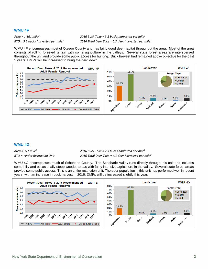
WMU 4F
Area = 1,161 mile2 2016 Buck Take = 3.5 bucks harvested per mile2
BTO = 3.2 bucks harvested per mile2 2016 Total Deer Take = 6.7 deer harvested per mile2
WMU 4F encompasses most of Otsego County and has fairly good deer habitat throughout the area. Most of the area consists of rolling forested terrain with some agriculture in the valleys. Several state forest areas are interspersed throughout the unit and provide some public access for hunting. Buck harvest had remained above objective for the past 5 years. DMPs will be increased to bring the herd down.
WMU 4G
Area = 371 mile2 2016 Buck Take = 2.3 bucks harvested per mile2
BTO = Antler Restriction Unit 2016 Total Deer Take = 4.1 deer harvested per mile2
WMU 4G encompasses much of Schoharie County. The Schoharie Valley runs directly through this unit and includes some hilly and occasionally steep wooded areas with fairly intensive agriculture in the valley. Several state forest areas provide some public access. This is an antler restriction unit. The deer population in this unit has performed well in recent years, with an increase in buck harvest in 2016. DMPs will be increased slightly this year.

New York State Department of Environmental Conservation 4
WMU 4H
Area = 290 mile2 2016 Buck Take = 3.4 bucks harvested per mile2
BTO = 3.4 bucks harvested per mile2 2016 Total Deer Take = 5.2 deer harvested per mile2
WMU 4H lies primarily in Albany County and includes a large portion of the Helderberg Mountains. Public access is available on several pieces of state land in the central-western portion of the unit. The buck take reached objective level in 2014, declined in 2015 and rebounded back to objective in 2016. Permit numbers will remain the same as last year to stabilize the population.
WMU 4J
Area = 149 mile2 2016 Buck Take = 1.5 bucks harvested per mile2
BTO = none 2016 Total Deer Take = 3.3 deer harvested per mile2
WMU 4J is a bowhunting-only unit in Albany County, including the City of Albany and several of the adjacent suburban towns. Gaining access to hunt in WMU 4J is difficult and limits the number of hunters. The only public land within WMU 4J open to hunting is the Albany Pine Bush Preserve. While the Preserve encompasses 3,000 acres, hunting can be challenging due to its urban/suburban character, dense vegetation, and other public uses of the property. The result is a relatively large deer population with a very low deer harvest.
After a couple years of decline, the buck harvest rebounded in 2016. Resident and non-resident applicants will have a high chance of getting first and second permits. Due to concerns of DMP misuse (DMPs used in the wrong WMU), DMPs for 4J will not be offered in the "First-Come/First-Serve" drawing that is offered in November for some other units. All hunters must apply before October 1st to receive a DMP in this area. However, hunters who are successful in filling a DMP in WMU 4J may request a Bonus Permit which are issued at the DEC regional office in Schenectady. Hunters can continue to shoot antlerless deer and can receive as many Bonus Permits as they are willing to fill.

New York State Department of Environmental Conservation 5
WMU 4K
Area = 256 mile2 2016 Buck Take = 2.4 bucks harvested per mile2
BTO = 3.0 bucks harvested per mile2 2016 Total Deer Take = 4.3 deer harvested per mile2
WMU 4K lies in western and southern Rensselaer County. It is bordered on the west by the Hudson River and extends east to the Massachusetts border. This unit is fairly flat and consists of a mosaic of residential, agricultural and forest land with limited hunting access. Agricultural complaints are high. Buck harvest approached the objective level in 2015 but declined slightly in 2016. As the population has increased, we have also increased DMP allocations slowly in 4K and will continue to again this year.
WMU 4L
Area = 221 mile2 2016 Buck Take = 2.0 bucks harvested per mile2
BTO = 2.0 bucks harvested per mile2 2016 Total Deer Take = 2.5 deer harvested per mile2
WMU 4L is located in central and eastern Rensselaer County in the Rensselaer Hills, includes a portion of the Taconic Mountains and extends to the Massachusetts and Vermont border. There is substantial public access in this unit including the Capital District Wildlife Management Area, Pittstown State Forest, Tibbitts State Forest, Taconic Ridge State Forest, Berlin State Forest and properties under conservation easement along the Taconic ridge. After over a decade without issuing DMPs, the population appears to have been near objective for the past two seasons. A low number of DMPs will be made available this year to allow increased opportunity for resident hunters.
New York State Department of Environmental Conservation 6
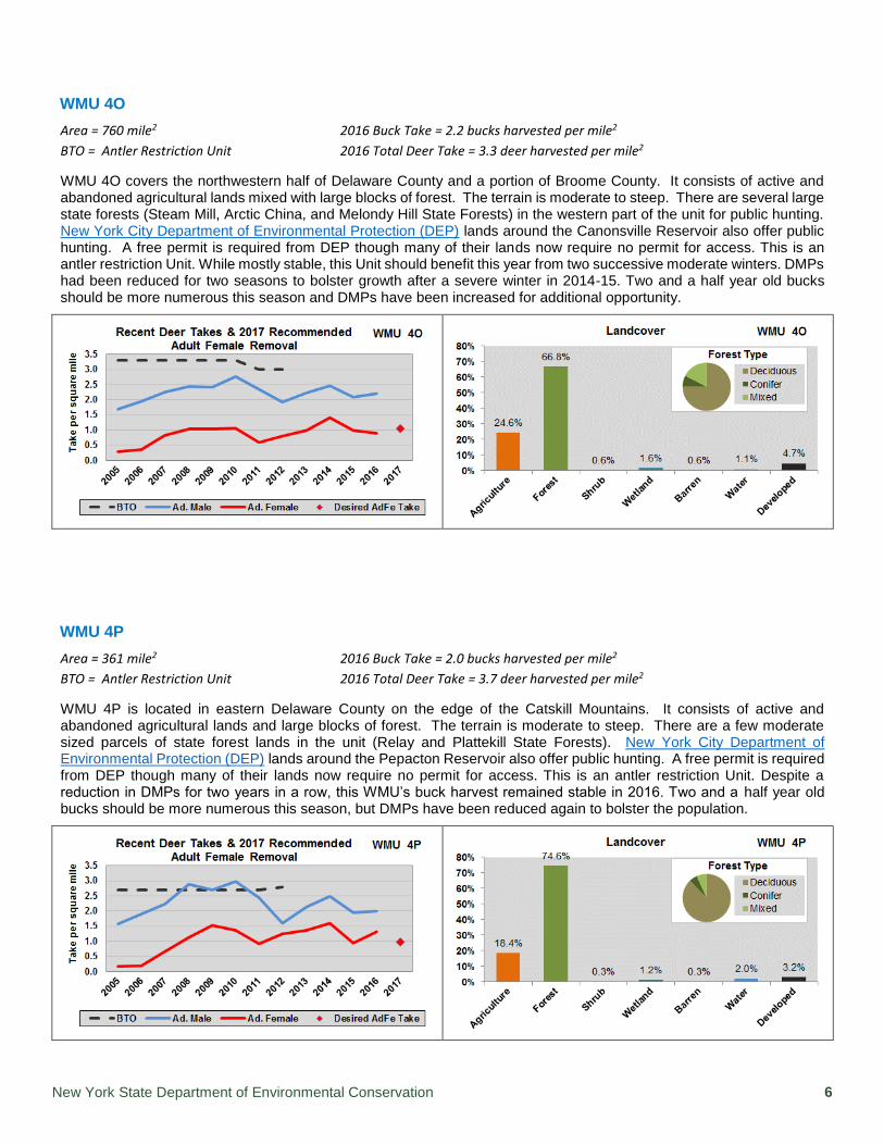
WMU 4O
Area = 760 mile2 2016 Buck Take = 2.2 bucks harvested per mile2
BTO = Antler Restriction Unit 2016 Total Deer Take = 3.3 deer harvested per mile2
WMU 4O covers the northwestern half of Delaware County and a portion of Broome County. It consists of active and abandoned agricultural lands mixed with large blocks of forest. The terrain is moderate to steep. There are several large state forests (Steam Mill, Arctic China, and Melondy Hill State Forests) in the western part of the unit for public hunting. New York City Department of Environmental Protection (DEP) lands around the Canonsville Reservoir also offer public hunting. A free permit is required from DEP though many of their lands now require no permit for access. This is an antler restriction Unit. While mostly stable, this Unit should benefit this year from two successive moderate winters. DMPs had been reduced for two seasons to bolster growth after a severe winter in 2014-15. Two and a half year old bucks should be more numerous this season and DMPs have been increased for additional opportunity.
WMU 4P
Area = 361 mile2 2016 Buck Take = 2.0 bucks harvested per mile2
BTO = Antler Restriction Unit 2016 Total Deer Take = 3.7 deer harvested per mile2
WMU 4P is located in eastern Delaware County on the edge of the Catskill Mountains. It consists of active and abandoned agricultural lands and large blocks of forest. The terrain is moderate to steep. There are a few moderate sized parcels of state forest lands in the unit (Relay and Plattekill State Forests). New York City Department of Environmental Protection (DEP) lands around the Pepacton Reservoir also offer public hunting. A free permit is required from DEP though many of their lands now require no permit for access. This is an antler restriction Unit. Despite a reduction in DMPs for two years in a row, this WMU’s buck harvest remained stable in 2016. Two and a half year old bucks should be more numerous this season, but DMPs have been reduced again to bolster the population.

New York State Department of Environmental Conservation 7
WMU 4R
Area = 290 mile2 2016 Buck Take = 1.9 bucks harvested per mile2
BTO = Antler Restriction Unit 2016 Total Deer Take = 2.9 deer harvested per mile2
WMU 4R is located in portions of Greene and Delaware counties in the northern Catskills. It contains a combination of forested mountains and agriculture. The terrain is moderate to steep. There are some state forest preserve lands in the southern portion of the unit for public hunting. This is an antler restriction Unit. The 2016 buck harvest increased from the previous year and should increase again this season. DMP allocations will remain the same as last year.
WMU 4S
Area = 220 mile2 2016 Buck Take = 2.6 bucks harvested per mile2
BTO = Antler Restriction Unit 2016 Total Deer Take = 3.9 deer harvested per mile2
WMU 4S is located in northeastern Greene County with a small portion in Albany County. The Hudson River is the eastern boundary for much of the unit. The eastern section is fairly flat but rises westward into moderately steeper terrain. There is little public access in this unit. This is an antler restriction unit. Buck harvest had remained stable for the previous 4 seasons, but rose dramatically in 2016 after several years of low DMP allocations. Buck harvest should continue to improve. Increased DMPs this year will allow more opportunity for resident hunters.

New York State Department of Environmental Conservation 8
WMU 4T
Area = 132 mile2 2016 Buck Take = 2.9 bucks harvested per mile2
BTO = 2.9 bucks harvested per mile2 2016 Total Deer Take = 6.7 deer harvested per mile2
WMU 4T is located in northwestern Columbia County with the Hudson River as the western boundary. Much of the area is agricultural and deer damage is a significant problem. Public access for hunting is very limited in this unit. Agricultural complaints are moderate to high. This unit reached objective in 2016. Buck harvest is expected to increase. DMPs have been increased this year.
WMU 4U
Area = 127 mile2 2016 Buck Take = 3.0 bucks harvested per mile2
BTO = 4.1 bucks harvested per mile2 2016 Total Deer Take = 3.8 deer harvested per mile2
WMU 4U is located in northeastern Columbia County and borders Massachusetts. Public access is limited to Beebe Hill State Forest in the southern portion of the unit. The buck harvest in this unit has increased for the past 2 years, reaching its highest level in over ten years. It is expected to increase again this year. DMPs have been increased to allow more opportunity for resident hunters.

New York State Department of Environmental Conservation 9
WMU 4W
Area = 443 mile2 2016 Buck Take = 1.8 bucks harvested per mile2
BTO = Antler Restriction unit 2016 Total Deer Take = 2.5 deer harvested per mile2
WMU 4W is located in southern Delaware County. It consists mostly of steep forested lands in the Catskill Mountains. There are a few large parcels of state forest land and Bear Spring Mountain Wildlife Management Area which add up to thousands of acres of public access for hunting. New York City Department of Environmental Protection (DEP) lands around the Pepacton and Canonsville Reservoirs also offer public hunting. A free permit is required from DEP though many of their lands now require no permit for access. This is an antler restriction Unit. DMPs were reduced for the previous two seasons because of poor harvest. Two and half year old bucks should be more abundant this year after two moderate winters in a row. DMPs remain unchanged in an effort to increase the population.
WMU 4Y
Area = 177 mile2 2016 Buck Take = 2.9 bucks harvested per mile2
BTO = 3.9 bucks harvested per mile2 2016 Total Deer Take = 5.8 deer harvested per mile2
WMU 4Y is located in southwestern Columbia County with the Hudson River as the western boundary of the unit. This unit contains a large amount of agricultural land, including a number of orchards, making it highly productive for deer but also a source of numerous damage complaints. Public hunting access is very limited in this unit. Buck take increased in 2016 for the first time in 6 seasons and should continue this trend this year. Permit numbers will remain unchanged for the second year in a row.

New York State Department of Environmental Conservation 10
WMU 4Z
Area = 251 mile2 2016 Buck Take = 2.6 bucks harvested per mile2
BTO = 4.7 bucks harvested per mile2 2016 Total Deer Take = 4.2 deer harvested per mile2
WMU 4Z is located in southeastern Columbia County bordering Massachusetts. Similar in character to WMU 4Y, there is a high proportion of agricultural land in the unit and a number of agricultural damage complaints occur here. Buck harvest may be artificially low due to a lack of public land and a large number of non-resident, posted properties. Buck take increased for the first time in 4 seasons in 2016 and is expected to increase again this year. Permit numbers have been increased to improve opportunity for resident hunters.
Larry Bifaro Region 4 Big Game Biologist