20170112 tosalifesciencesmasterplan- final draft
TRANSCRIPT
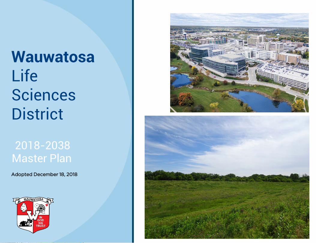
Wauwatosa Life Sciences District
2018-2038 Master Plan Adopted December 18, 2018

Earlier versions of this plan were prepared by the team of GRAEF, Nelson/ Nygaard, and Sasaki. Subsequently, the plan was amended by City of Wauwatosa staff.

TABLE OF CONTENTS
1. Life Sciences 2
2. History of the Vision 4
133. Community Context
4. Continuing the Vision 19
5. Reframing a Life Sciences District 30
36
39
46
6.
51
58
54Westside Neighborhood
Mayfair Corridor
Implementation
63
Framework Plan
Tosa/MRMC Circulator
Parks & Environmental Areas
Watertown Plank Neighborhood
68
MRMC Campus
1

1 Life Sciences
2

INTRODUCTION
• Improve circulation and traffic;
• Increase mutual trust andbenefits;
• Protect environmental areas;
• Design integrated streets andbuildings;
• Provide housing andmixed-uses; and
• Create and enhace sharedpublic places.
Exponential growth over the last 20 years in the Wauwatosa Life Sciences District has yielded untold opportunities for healthcare innovation, but has simultaneously produced significant challenges, most notably disjointed development and traffic congestion. The rationale for this Plan recognizes that economic, physical, and social growth will not stop. Since the 1963 freeway construction, auto traffic and building construction have steadily increased to a point where the planning area and surrounding thoroughfares now require a substantive intervention to guide growth towards a mutually beneficial end for Wauwatosa and the region.
This growth in the Wauwatosa Life Sciences District mirrors that of larger, national trends: the boom in academic medical centers, agglomerative forces creating major retail nodes, accompanying demands for housing and recreation, and a need to provide access for those living near and far.
The Wauwatosa Life Sciences District is currently home to major critical assets for the entire metropolitan area – high-quality medical care, a substantial quantity of employment opportunities, high-end retail, an innovation campus, desirable and diverse housing, and a one-of-a-kind natural environment that historically served, and serves today, as a place of respite for thousands.
In 2015, the City of Wauwatosa, in conjunction with Milwaukee County, commissioned a plan to unite multiple visions, concepts, and opportunities for the future of the area known as the County Grounds. It soon became evident that coordinated planning for this area requires looking beyond the historical boundaries of the County Grounds to tie this asset to other major assets in the community.
This plan will explore the history of the area and the community context to set a base for a framework plan consisting of five subareas of the larger Life Sciences District, leading to suggestions for implementation. The expected time frame for realizing these plan implementation is approximately 20 years.
As such, this Master Plan offers ideas and guidance for the areas surrounding the County Grounds and Interstate 41/US 45 from North Avenue to Wisconsin Avenue, and from Mayfair Road to the Village area.
To develop a plan that recognized the aforementioned pressures and assets, the following goals were established:
PLANNING AREA
Source: Graef 3

2History of the Vision
4

THE COUNTY GROUNDS The Milwaukee County Grounds embodies a proud history of providing high-quality health care to the Milwaukee metropolitan region and, now, the nation. Infused with a diverse and vibrant culture and identity, the County Grounds has become a unique community in Wisconsin with the embodied spirit of those who came before, those working there now, and those to come in the next decades.
An uncommon good sprang from the minds of a committed group of 19th-century citizens, sharing a belief in the power of a sanctuary for healing; they viewed the County Grounds as an integral and integrated part of their communities. Over the past 160 years, that sense of community transformed a small farm to a Garden City sanctuary, and now to one of Wisconsin’s emerging major metropolitan centers.
Currently, the County Grounds contains several disparate sectors. The Milwaukee Regional Medical Center (MRMC) represents the primary legacy of the social functions of healthcare and community service.
The north section, between Watertown Plank Road on the south and the Underwood Creek and Railroad to the north, does not feel like a single integrated district, but nevertheless contains some of the area’s most important environmental history. Initially, Watertown Plank Road was not a divisive feature; it was, in fact, the major unifier with points of access that linked activities to the north with those to the south.
With the advent of the freeway in 1963, the County Grounds was split east and west, and remains so to this day. This split created challenges, including the major impact of vehicular traffic and the subsequent further division of the Life Sciences District. At the same time, the added access has dramatically increased its potential social and economic value. The Milwaukee Regional Medical Center emerged as an essential component of the southeastern Wisconsin region, poised to become an even greater statewide and national community asset.
Understanding this heritage illuminates the future. The Life Sciences District’s history can provide some answers as to how the community can diminish the area’s weaknesses and capitalize on its strengths in a way that is beneficial for all. This chapter looks at the County Grounds’ history, development, and progress and offers clues as to how past practice should be reflected in the future.
Source: Milwaukee County Land Information Office and GRAEF
1937 Aerial Photo
5

Gregg Farm Purchased
The Milwaukee County Board of Supervisors assumed responsibility for the County’s poor, sick, and those with mental health challenges in 1849. To fulfill its mission, County Supervisor Hendrick Gregg’s 160-acre farm was purchased for $6,000 (about $170,000 today) to establish a Poor Farm. The house and three adjacent farms sat between present-day 84th and 92nd Streets, just south of Watertown Plank Road.
Asylum Built
It became clear shortly after the creation of the Poor Farm that those receiving treatment for mental health problems required their own facility in which to receive treatment and should be separated from the other residents. In 1878, Milwaukee County purchased an adjoining 70-acre farm and allocated $160,000 of public funds (about $3.9 million today) to build the Milwaukee County Insane Asylum. Two years later, the Asylum expanded its care and treated 200 patients. With the expansion of the North and South Division buildings, the Asylum’s capacity increased to 4,200 patients in later years.
Source: Milwaukee County Historical Society
Source: Milwaukee County Historical Society
6
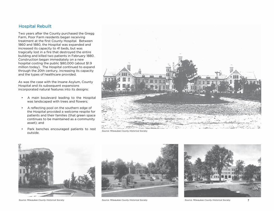
Hospital Rebuilt
Two years after the County purchased the Gregg Farm, Poor Farm residents began receiving treatment at the first County Hospital. Between 1860 and 1880, the Hospital was expanded and increased its capacity to 41 beds, but was tragically lost in a fire that destroyed the entire building and killed two patients in February 1880. Construction began immediately on a new hospital costing the public $80,000 (about $1.9 million today). The Hospital continued to expand through the 20th century, increasing its capacity and the types of healthcare provided.
As was the case with the Insane Asylum, County Hospital and its subsequent expansions incorporated natural features into its designs:
• A main boulevard leading to the Hospitalwas landscaped with trees and flowers;
• A reflecting pool on the southern edge ofthe Hospital provided a welcome respite forpatients and their families (that green spacecontinues to be maintained as a communityasset); and
• Park benches encouraged patients to restoutside.
Source: Milwaukee County Historical Society
Source: Milwaukee County Historical Society Source: Milwaukee County Historical Society Source: Milwaukee County Historical Society 7

Nursing Instruction Starts
Milwaukee County Hospital Superintendent Dr. M.E. Connell and his wife, Dr. Anna GregoryConnell, established a class for the instruction ofnursing in 1887, which was formally establishedas a School of Nursing by the County Board in1888.
Dependent Children Home
Upon immediate purchase of the Gregg Farm by the County in 1852, farm supervisors separated the children from the other Poor Farm residents to provide dedicated care and education. At the time, the adult residents were perceived as an often-corruptive influence. Consequently, a schoolhouse was built to create an environment that would allow the boys and girls to grow in a more effectively-controlled and managed environment. Ultimately, the Home for Dependent Children was formally established in 1898 to provide a permanent, structured life for the children.
Nurses care for patients on a ward in County Hospital in this 1908 photograph. As the Hospital continued to expand and its reputation improved, the sick actively sought treatment at the Hospital, as opposed to foregoing care because of a lack of money to pay an in-home doctor. Source: Milwaukee Public Library
A home away from no home: many of the Home’s children were suddenly without a family or regularly transient between the streets, their family, or the Home. Whether their parents were ill, deceased, incarcerated, or generally unable to care for them, the newly-arrived children were thrust into a sizable pseudo-family with brothers, sisters, masters, and matrons. As best they could, the masters and matrons tried to recreate a normal life full of daily activities, crafts, athletics, picnics, swimming, and holiday celebrations. Source: Milwaukee County Historical Society
The School of Nursing saw sustained growth and improvement between the year of its establishment and the beginning of the 20th century. Under the direction of strong matrons, the program thrived. A matron and her class are pictured above, c. 1890s. Source: Milwaukee County Historical Society
Directed by highly dedicated and talented staff, County Hospital survived its struggles with poor hygiene and lower quality care in the latter half of the 19th century to emerge as a sought-after healthcare institution by 1900. Pictured above (c. 1908), the Hospital’s team of physicians grew and the surgical department became ever more active. Source: Milwaukee County Historical Society
8

School Created
As social reform movements fomented change at the County healthcare institutions, a broader sentiment was coalescing around public education and its importance. The trend began on the Grounds in 1852 when the first schoolhouse was built for indigent children. In 1912, the School of Agriculture and Domestic Economy was established to teach young men and women technical skills in the trades and home making. Students attended classes in botany, animal husbandry, carpentry, blacksmithing, sewing, and cooking. The school included five buildings designed by Alexander C. Eschweiler. A few of these red brick buildings remain standing to this day remodeled and now called Echelon.
Source: Wauwatosa Historical Society
Source: Milwaukee County Historical Society
Source: Milwaukee County Historical Society
Source: Milwaukee County Historical Society
Muridale Sanitorium
Contagious diseases in the healthcare setting posed a daunting challenge to the doctors and nurses at County Hospital in the last quarter of the 19th century. What society faced, though, was far more widespread and lethal. Tuberculosis (TB) was a killer in the home environment; and, as cities continued to grow and people began living closer and closer together, the bacteria quickly spread among adults and children alike. In an effort to control the illness, the Muirdale Sanatorium – a TB treatment facility – was opened in 1915 on the County Grounds. It was believed that cool, dry air was an effective treatment, and patients had ready access to fresh air through open windows, sun rooms, and outdoor gardens (see images to the right). In 1921, the Blue Mound Preventorium was purchased as a children-only facility for TB treatment.
9

Collective Administration
As the County Grounds evolved from a Poor Farm to a focus for regional healthcare, the various facilities required additional institutional/quasi-governmental support to operate. Most notably, a fire and ambulance corps were established to provide emergency services. In addition, the Grounds generated its own power. Here we see another feature that has led to much broader, and far more impactful, issues regarding the provision and management of infrastructure for this unique and valuable community. In these cases, public support for infrastructure (energy, emergency services, and transit) became an integral component of an effective community.
New Hospital Built
By 1930, the Milwaukee County Grounds had witnessed almost full build-out of its contemporary institutions. The medical facilities were primarily clustered along the eastern edge of the Grounds running along Watertown Plank Road – with the Muirdale Sanitorium being the only exception on the western end. Milwaukee County General Hospital expanded in 1930 with a new facility and larger capacity (image to the right).
Development in Wauwatosa continued to remain on the eastern edge of the Grounds. As the county was in the throes of the Great Depression, large-scale building would not begin again until after World War II. See the 1937 aerial map on page 5 for an overall understanding of the site development at that time.
At the mid-point between Milwaukee and Waukesha, the Grounds sat along a heavily trafficked transportation corridor. A streetcar is running along Watertown Plank Road with a stop at the entrance to the Insane Asylum in the photograph above (c. 1910s). Source: Milwaukee County Historical Society
As the County Grounds grew, it became clear that a fire department was needed. Because of its sprawling grouping of facilities with a variety of uses, the presence of firefighters provided a sense of security to staff and patients. Source: Milwaukee County Historical Society
Source: Milwaukee County Historical Society 10

The Freeway
I-41/US45 first appears in Milwaukee Countyaerial photography in 1963, bifurcating theGrounds. Following World War II and theFederal-Aid Highway Act of 1956, housingconstruction across the United States boomed.In just 30 years since County Hospital’sexpansion, residential growth encircled theCounty Grounds. Wauwatosa quickly became aninner ring suburb of Milwaukee with bothrectilinear and curvilinear street patterns.
Regional Medical Center
Milwaukee County General Hospital continued to develop following its construction in 1930 with additions built in 1956 (pictured top right), but Froedtert Memorial Lutheran Hospital took its place when it opened on September 29, 1980. The green space incorporated into the original Hospital design remains on the southern edge of the Medical Center campus where County Hospital once stood.
By 1995, the Milwaukee County Grounds had largely assumed its present-day land use pattern. While changes have occurred over the last 20 years, many of the Grounds’ staple buildings and features remain including the Milwaukee County Children’s Court Center, Behavioral Health Complex, and the first iterations of Froedtert and Children’s Hospitals.
Six healthcare institutions are currently located at the Medical Center: Froedtert Hospital, Children’s Hospital, the Medical College of Wisconsin, the BloodCenter of Wisconsin, Curative Care, and the Milwaukee County Behavioral Health Complex. The high-quality medicine provided by these institutions has created a well-respected epicenter of regional and national healthcare.
Milwaukee County Research Park
Created in 1987, the Milwaukee County Research Park Corporation grew out of a multi-phased master plan for the physical development of the 192-acre research and technology business parkwith co-located laboratory space,commercialization resources, and professionalservices. Notable elements of the master planincluded:
• Preservation of existing parks and maturenatural areas;
• Creation of gateway entrances accentuatedwith iconic signage and natural features;
• Promotion of neighborhood and tenant useof common recreational areas, includingactivity trails; and
• Establishment of a long range planincorporating future mass transit service,including a vehicular and pedestrian bridgecrossing I-41/US45 from Innovation Drive.
Source: Medical College of Wisconsin Digital Collections
Source: Milwaukee County Research Park
Mayfair Corridor
With the development of Mayfair Mall in 1959, the road name was changed from Lovers Lane to Mayfair Road. Under State of Wisconsin jurisdiction, it is also known as State Trunk Highway 100. Through the 1960s, the area near Mayfair Mall became a popular location for the development of small office and commercial buildings and is now one of the area's major commercial corridors, including occupancy rates at Mayfair Mall being one of the highest in the country. This resulted in automobile-centered, suburban style developments with increased surface parking lots and the rerouting of major cross-town traffic.
Source: Hunzinger Construction11

UWM Innovation Campus
The UWM Innovation Campus co-locates students, engineers, and researchers near Wisconsin’s largest academic health cluster, the Milwaukee Regional Medical Center. The Campus contains a series of laboratory and collaborative spaces that bring industry, academic, and medical practice together, with a focus on biomedical engineering/devices and advanced materials/manufacturing. UWM purchased the 88.5 acres of land in 2011 to begin developing a mixed-use campus with private residences, wildlife habitat, and academic and industrial offices and laboratories. The Campus currently is home to the UW-Milwaukee Innovation Accelerator, ABB, Inc., a Marriott Residence Inn, Echelon Apartments, and The Monarch Trail.
Looking Back
Like most communities, the identity of places does not change quickly, but incrementally. Aerial photographs tell the story of how open farm land, still dominant in 1937, gradually moved through the various phases described in this chapter. Building by building, the character of the place shifted into a larger campus. The most profound change came with the introduction of the freeway, as seen in the 1963 aerial to the right. Today, the freeway plays an even larger role, along with the expansion of Watertown Plank Road and Mayfair Road, establishing sharp boundaries between the places within the Planning Area, segregating uses, and imposing a clear suburbanized model on land development.
Source: Milwaukee County Land Information Office
Source: GRAEF
Relation to the Plan
New, innovative ideas are derived from our experiences and knowledge. Our history and traditions – especially those directly associated with the planning area – provide the best source of relevant experiences and knowledge. Many of the ideas and practices that were put in place over the 160 years of the County Grounds can and should be used as the basis for innovation.
Source: MCRP12

3Community Context
13

Since the incorporation of the City of Wauwatosa in the 1800s, the planning area and adjacent areas have seen two distinct, but powerful, trends: the creation of high quality, traditional urban neighborhoods and the suburbanized pattern engendered by the busiest freeway interchange in the state. Wauwatosa’s traditional neighborhoods nestle themselves along seams between thriving economic corridors and the environmental features that community residents cherish. This chapter defines and contextualizes Wauwatosa’s neighborhoods, business districts, and parks and green spaces to understand how they interact and depend on one another. As Wauwatosa’s suburban development pattern has relied upon freeways and major arterials, this chapter highlights current circulation conditions, and introduces the planed integration of cycling, walking, and transit as a way to retain neighborhood character while supporting growth.
As an older first ring suburb, Wauwatosa’s patterns of development show distinct features of both urban and suburban communities: numerous traditional walkable neighborhoods that contrast with high-value auto-dominated arterials. Just as these strong neighborhoods pull the community together, the activity of the arterials sometimes pushes neighborhoods apart. The history of the city filters through these dichotomies and creates a rich layer of strong visual features, landmarks, and streets.
In recent decades, some of Wauwatosa’s historical community patterns have been reinvigorated – notably, the Village center and the socio-economic activity along North Avenue. In addition, other social activity centers have expanded within the suburbanized patterns embodied in Mayfair Mall and The Mayfair Collection/The District on Burleigh.
Traditional Neighborhoods
For Wauwatosa, a clear pattern emerges of residential neighborhoods built along urban streets organized into modified grid patterns and occasional curvilinear streets modeled after the picturesque forms from the early twentieth century garden cities. The grain and texture of these neighborhoods creates a highly social, walkable community system.
These neighborhoods, however, have been separated by a variety of boundaries and barriers created by multiple corridors and distinct districts. As a result, Wauwatosa seems comprised of many distinct neighborhoods, each of which offers a slightly different character based on the time of development, lot size, architectural style, local amenities (shopping districts, parks, and schools), and similar variables. The residential neighborhoods surrounding the planning area easily stand out on City maps that depict the patterns of streets, and houses.
14
Corridors
Some of the obvious corridors that act as dividers include the railroad tracks, Menomonee River and Underwood Creek, the freeway, and major commercial arterials. Such barriers can have negative impacts by separating people socially and/or economically. In this Plan, the key corridors acting as dividers include the railroad tracks, Mayfair Road, and Watertown Plank Road. The divisive nature of these barriers can be overcome through effective planning.
Conversely, corridors that act as unifiers or links, such as bridges, parks, and activated streets, provide connections to different types of neighborhoods or districts. Several corridors, and select portions of other corridors, create very positive social and economic impacts.
For example, North Avenue has had a clear positive impact because it unified neighborhoods to the north and south. The same holds true for portions of Harwood Avenue and State Street. Underwood Creek and the Menomonee River physically separate some neighborhoods, but, due to their environmental appeal and the variety of trails, walkways, and bridges, they also have had a positive impact socially and economically.
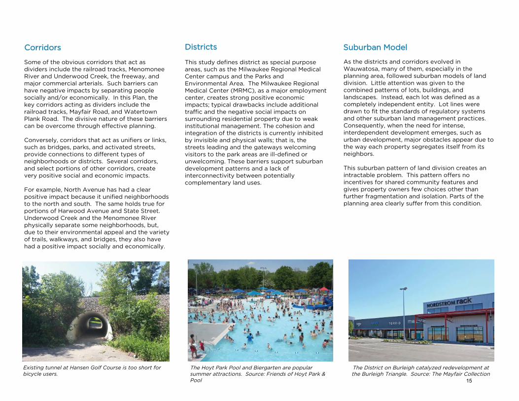
Existing tunnel at Hansen Golf Course is too short for bicycle users.
Districts
This study defines district as special purpose areas, such as the Milwaukee Regional Medical Center campus and the Parks and Environmental Area. The Milwaukee Regional Medical Center (MRMC), as a major employment center, creates strong positive economic impacts; typical drawbacks include additional traffic and the negative social impacts on surrounding residential property due to weak institutional management. The cohesion and integration of the districts is currently inhibited by invisible and physical walls; that is, the streets leading and the gateways welcoming visitors to the park areas are ill-defined or unwelcoming. These barriers support suburban development patterns and a lack of interconnectivity between potentially complementary land uses.
Suburban Model
As the districts and corridors evolved in Wauwatosa, many of them, especially in the planning area, followed suburban models of land division. Little attention was given to the combined patterns of lots, buildings, and landscapes. Instead, each lot was defined as a completely independent entity. Lot lines were drawn to fit the standards of regulatory systems and other suburban land management practices. Consequently, when the need for intense, interdependent development emerges, such as urban development, major obstacles appear due to the way each property segregates itself from its neighbors.
This suburban pattern of land division creates an intractable problem. This pattern offers no incentives for shared community features and gives property owners few choices other than further fragmentation and isolation. Parts of the planning area clearly suffer from this condition.
The Hoyt Park Pool and Biergarten are popular summer attractions. Source: Friends of Hoyt Park & Pool
The District on Burleigh catalyzed redevelopment at the Burleigh Triangle. Source: The Mayfair Collection
15

Interstates
First and foremost, regional traffic feeds the busiest interchange in Wisconsin: the Zoo Interchange. Nationally, the amount of household vehicle miles traveled has diminished, but the total volume of automobile traffic in the planning area has not decreased (source: Smart Growth America Policy Guide (2016)).
I-41/US45 and the major arterials will, for theforeseeable future, contain more drivers, most ofwhom head to destinations in and around thekey interchanges in Wauwatosa. Travelers toand through the area have commented duringthe planning process of bemoaning the trafficvolumes at each interchange. Such increasesreflect an overall pattern. As the flow of driversincreases at each interchange In and nearby theplanning area, the problems on local arterials andstreets constantly change as drivers encounternew challenges.
The Wisconsin Zoo Interchange Project is a large-scale infrastructure upgrade targeted at alleviating traffic congestion. The 92nd Street bridge is rebuilt in the photo above. Source: WisDOT
Beginning in 2012, the Wisconsin Zoo Interchange Project embarked upon one of the largest infrastructure upgrades in State history. The primary objectives were to alleviate highway congestion moving through the Interchangereduce traffic burden on local major roadways, and provide for cost-effective lane expansions in the future. Regional and State transportation engineers and project stakeholders have argued that once the project is completed, it will relieve congestion on WIS 100, Bluemound Road, Watertown Plank Road, and Glenview Avenue/84th Street. As the project has progressed, however, congestion has subsequently increased through the Interchange and on local major roadways.
Arterials
Residents, customers, and users of local streets have expressed that the traffic flows seem erratic and destabilized. Construction along arterials - including Watertown Plank Road and Mayfair Road – in the planning area from 2010 to today have anecdotally produced frustrated travelers.
Change requires adaptation to new patterns, typically viewed as a nuisance to be avoided. Complaints have surfaced among travelers to and through the area regarding traffic flow – too many drivers, not enough lanes, unexpected delays, unpredictable problems, poor signalization and signage, not enough parking, too much parking, and so on.
These issues occur throughout the planning area and future changes must, at the very least, lessen the negative traffic impact of new development for residents, businesses, institutions, patients, customers, visitors and all users.
CIRCULATIONCirculation of people makes places work and knits them together. To achieve this type of success, the pattern of urban form and development must be pedestrian friendly and engender a positive social, humanistic experience. Such experience rests on the way people move through, see, and use all of the places in their community.
As traffic congestion worsens and commuter frustration grows, many advocate for wider roads and intersections as ways to reduce travel times for drivers. No matter the size of local roadways or the efficiency of traffic signalization, communities eventually reach their carrying capacity for auto traffic. Even as many employees prefer driving their cars to work, others enjoy walking, biking, and riding the bus. As roadways can accommodate many modes of transit, this Plan emphasizes multi-modal transit to alleviate traffic congestion, improve commute times, and appeal to employees and visitors who appreciate alternate ways to travel to and through the planning area.
16

Watertown Plank Road is a major traffic arterial through the planning area for cars, buses, bicyclists, and pedestrians. Students from the Medical College of Wisconsin wait to cross Watertown Plank in the photo above. Source: GRAEF
The Hank Aaron State Trail and Oak Leaf Trail provide access to green space in the planning area, but larger gaps in pedestrian and bicycle infrastructure persist. Most importantly, safe access throughout the planning area is not well-distributed, nor robust.
Creating Positive Impacts
The circulation fostered by pedestrian, bicycle and transit systems offers the primary method for lessening the negative traffic impacts of new development. If people can walk, bicycle, or bus to work and to businesses, roads operate with fewer cars and destinations need fewer parking spaces.
The positive impacts have a multiplier effect. Each car that is kept off the road:
• Saves the owner money (less gasoline and mileage, longer life for the car, options not to own a car);
• Saves the community money (street maintenance has a distinct cost per passenger mile that can, over time, reduce public costs);
• Saves the destination-user substantial capital (one less surface parking space can save$10,000 and one less space in a parking structure can save $20,000 to$30,000);
• Reduces the number of parking spaces, saving the owners the costs of operation and maintenance and, at the same time, allowing for additional property value to be created; and
• Most importantly, allows for reinvestment of money not spent on automobiles (as a person, business, or community). For example, reducing the destination need for 100 structured parking spaces can save $2 million in capital costs plus operational costs that can then be used for other community goals.
Yet, effective transit expectedly does not occur overnight. Well-planned transit must gain ridership through a communal understanding of the multiple systems, markets, and operational patterns. While the Milwaukee County Transit System provides bus service to the entire planning area, this Plan includes concepts for using transit to minimize the negative circulation impacts imposed by additional development and take advantage of opportunities for increased social and economic value.
Complete Streets
Most urban areas, including Wauwatosa through its "Tosa Streets" ordinance, today value complete streets and pedestrian-friendly areas. Yet, these types of improvements can be meaningless if no social or economic activity exists to drive the street activation. Non-motorized circulation investments, to be effective, must be coupled with the densely-packed social and economic activities that animate public places.
Neighborhood Streets
When residual frustration spills onto local streets, it begins to impact residential neighborhoods. People who live very close to commercial and business areas experience a variety of stresses, including: non-residents parking near their homes, additional traffic driving by their property, and strangers traversing their neighborhood.
Some residents see these circulation patterns as a nuisance, but the same patterns help create a vibrant social community with walkable shops and activities. Consequently, balancing the social value of increased circulation against the social anxieties created by circulation becomes important work.
Public Transit
The use of public transit, such as buses, provides one of the best ways to reduce the costs of automobile driving and increase resources for community investment.
17
PUBLIC PLACESParks
Wauwatosa contains beautiful parks and river parkways. Many of these places, including several in the planning area, were established as part of the overall Milwaukee County Park System. The Milwaukee County Grounds Park blends preservation of environmental amenities with places that encourage spontaneous social activity by individuals and groups as well as organized events.
Most of the County parks provide high levels of access (for pedestrians, drivers, and bicyclists), as well as high visibility from local roads. This pattern of access and visibility underlies the higher value of many of the residential streets. The same approach can be embedded within the planning area as a way of giving future urban development a higher social, economic, and environmental value.
Activated Streets
In recent decades, two of the most remarkable changes in the character of Wauwatosa’s public places have been the emergence of a vibrant, historic village center and the rebirth of North Avenue as a fully activated street. Not all pedestrian-friendly streets have become as active as these two places. Many urban commercial districts in the region still have “dead zones” where improved sidewalks, streetscape, and bicycle facilities have not engendered the social changes they were intended to induce.
Environmental Area
The large environmental area with disjointed remnant parcels north of Watertown Plank Road comprises the most critical area in this Plan.
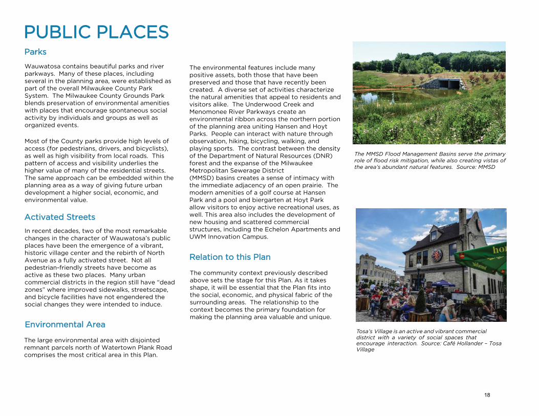
The environmental features include many positive assets, both those that have been preserved and those that have recently been created. A diverse set of activities characterize the natural amenities that appeal to residents and visitors alike. The Underwood Creek and Menomonee River Parkways create an environmental ribbon across the northern portion of the planning area uniting Hansen and Hoyt Parks. People can interact with nature through observation, hiking, bicycling, walking, and playing sports. The contrast between the density of the Department of Natural Resources (DNR) forest and the expanse of the Milwaukee Metropolitan Sewerage District (MMSD) basins creates a sense of intimacy with the immediate adjacency of an open prairie. The modern amenities of a golf course at Hansen Park and a pool and biergarten at Hoyt Park allow visitors to enjoy active recreational uses, as well. This area also includes the development of new housing and scattered commercial structures, including the Echelon Apartments and UWM Innovation Campus.
Relation to this Plan
The community context previously described above sets the stage for this Plan. As it takes shape, it will be essential that the Plan fits into the social, economic, and physical fabric of the surrounding areas. The relationship to the context becomes the primary foundation for making the planning area valuable and unique.
The MMSD Flood Management Basins serve the primary role of flood risk mitigation, while also creating vistas of the area’s abundant natural features. Source: MMSD
Tosa’s Village is an active and vibrant commercial district with a variety of social spaces that encourage interaction. Source: Café Hollander – Tosa Village
18
4Continuingthe Vision
19

To manage growth, enhance quality of life, and capitalize on investment opportunities, previous plans and studies were reviewed to learn about ongoing efforts and initiatives valued by the community. These include:
• The 2030 Wauwatosa Comprehensive Plan;
• The Village of Wauwatosa - A StrategicDevelopment Plan;
• The Burleigh Triangle and Mayfair RoadCorridor Vision; and
• The Wauwatosa Bicycle and PedestrianFacilities Plan.
• Active Tosa: Park, Trail, Open-Space andRecreational Facilities Master Plan
THE VISION
This review identified potential, coordinated implementation strategies, enhancements to Wauwatosa’s walkability and bikeability, and the strengthening of Wauwatosa’s “It's a Way of Life” character.
Development of this plan to achieve a shared vision also included community engagement and outreach, consisting of open houses, online comment forums, and stakeholder interviews. These methods reached a wide-ranging audience, providing a greater understanding of needs and desires of the planning area stakeholders and the broader community.
20

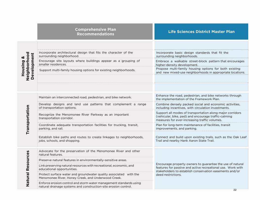
The City of Wauwatosa’s 2008 comprehensive plan proposes policies and recommendations to guide future planning efforts for the Wauwatosa community.
The key focus areas of this comprehensive plan include enhancing the quality of life for Wauwatosa residents, recognizing investment
Comprehensive Plan Recommendations
Life Sciences District Master Plan
Lan
d U
se
Prohibit incompatible land uses near residential neighborhoods. Use buffers through landscaping or designation of open spaces.
Encourage landscape and park features as transitions between subareas and neighborhoods. Disallow changes to current land uses and boundaries that do not conform to the future master plan options.
Encourage development densities and mixed land use served by mass transit.Encourage high-density development and compact building locations with access to transit.
Explore transitions and shared uses among institutions and neighborhoods. Encourage landscape and park features as transitions between subareas and neighborhoods.
Coordinate lot-by-lot redevelopment with necessary property changes to advance development.
Advance redevelopment of key parcels.
Provide and enhance accessibility to public park lands and gathering places. Preserve the Parks and Environmental Areas while providing increased access to park lands to spur social activity.
Eco
no
mic
De
ve
lop
me
nt Promote redevelopment and infill of sites to achieve desired land use pattern.
Encourage development along new and existing street edges that create activated streets.
Advance role as a center for research and innovation. Balance coordinated development with the needs of the medical community and research.
Support improvements that foster economic activity. Encourage development and ordinances that promote economic activity and high-density development in appropriate locations. Support mixed–use development of non-residential and residential parcels.
Incorporate architectural standards for commercial properties, industrial buildings, and site design.
Establish basic design standards for commercial and industrial buildings.
Promote transportation system enhancements and infrastructure development.
Support continued transit system enhancements and facilities, including Bus Rapid Transit (BRT) and continued research on a Tosa/MRMC Circulator.
Enhance Mayfair Road’s position as the region’s premier commercial service corridor.
Maintain and strengthen high visibility and access to Mayfair Corridor through multi-modal connections.
and reinvestment opportunities, and capitalizing on existing and future land use decisions.
The comprehensive plan emphasizes the City’s desire to develop itself as a center for research and innovation in hopes of ensuring its economic future as the region’s premier location for new development opportunities. The comprehensive
plan recommendations are identified in the Land Use, Economic Development, Housing and Neighborhood Development, Transportation and Natural Resources chapters.
The following table illustrates how the Life Sciences District Master Plan Implementation recommendations correspond with, or modify, the Comprehensive Plan recommendations.
2008-2030 COMPREHENSIVE PLAN
21
Comprehensive Plan Recommendations
Life Sciences District Master Plan
Ho
usi
ng
&
Ne
igh
bo
rho
od
D
eve
lop
me
nt
Support multi-family housing options for existing neighborhoods.
Embrace a walkable street-block pattern that encourages higher-density development.Propose multi-family housing options for both existing and new mixed-use neighborhoods in appropriate locations.
Incorporate architectural design that fits the character of the surrounding neighborhood.
Incorporate basic design standards that fit the surrounding neighborhoods.
Encourage site layouts where buildings appear as a grouping of smaller residences.
Tra
nsp
ort
ati
on
Maintain an interconnected road, pedestrian, and bike network.Enhance the road, pedestrian, and bike networks through the implementation of the Framework Plan.
Develop designs and land use patterns that complement a range of transportation options.
Combine densely packed social and economic activities, including incentives, with circulation investments.
Recognize the Menomonee River Parkway as an important transportation corridor.
Support all modes of transportation along major corridors (vehicular, bike, ped) and encourage traffic-calming measures for ever-increasing traffic volumes.
Coordinate adequate transportation facilities for trucking, transit, parking, and rail.
Plan for long-term maintenance of facilities, transit improvements, and parking.
Establish bike paths and routes to create linkages to neighborhoods, jobs, schools, and shopping.
Connect and build upon existing trails, such as the Oak Leaf Trail and nearby Hank Aaron State Trail.
Natu
ral
Re
sou
rce
s Advocate for the preservation of the Menomonee River and other natural features.
Encourage property owners to guarantee the use of natural features for passive and active recreational use. Work with stakeholders to establish conservation easements and/or deed restrictions.
Preserve natural features in environmentally-sensitive areas.
Link preserving natural resources with recreational, economic, and educational opportunities.
Protect surface water and groundwater quality associated with the Menomonee River, Honey Creek, and Underwood Creek.
Enforce erosion control and storm water management standards using natural drainage systems and construction-site erosion control.
22

The Strategic Development Plan offers a coordinated approach that supports recommendations from Wauwatosa’s residents, visitors, and businesses. The plan proposes implementation strategies to preserve historic infrastructure and enhance the commercial and entertainment offerings of the Village through both short term projects and overarching long term goals.
The following table illustrates how the Life Sciences District Master Implementation Plan correspond with the recommendations of this plan.
THE VILLAGE OF WAUWATOSA - A STRATEGIC DEVELOPMENT PLAN
Hart Park was revitalized and restored through a multi-phased process that included the addition of a playground and splash pad. Source: GRAEF
In 2014, Wangard Partners began construction on The Reef – a 180-unit residential development – along West State Street. Source: Wangard Partners
A 2016 streetscaping project continued the Historic Village’s growth as a major regional destination.
Strategic Development Plan Recommendations
Life Sciences District Master Plan
Improve traffic circulation and parking options.Create and promote transit connections via multi-modal transportation options (circulator system, bike sharing, bike/ped network).
Increase residential housing options. Increase new housing and residential options at the edges of Tosa Village.
Improve safety for pedestrians and bicyclists.
Support all modes of transportation along major corridors (vehicular, bike, ped) and encourage traffic calming measures for ever-increasing traffic volumes. Increase the off-street trail network.
Create more prominent linkages to the Village from other parts of the city for enhanced accessibility.
Create links and connections through trails throughout the city. Continue research on a Tosa/MRMC Circulator.
23

This plan updates the Burleigh Street Redevelopment Area Plan of 2005. The updated plan reinforces the previous efforts to make Burleigh Street a prominent entryway into Wauwatosa’s Mayfair Commercial District.
Building on existing plans, this plan recommends suggestions to rehabilitate existing buildings, redevelop vacant sites, and increase business development. The following table illustrates how the Life Sciences District Master Plan implementation recommendations correspond with the recommendations from this plan.
BURLEIGH TRIANGLE & MAYFAIR ROAD CORRIDOR NORTH REDEVELOPMENT VISION & PLAN
specific
generalThe site plan envisions a mixed-use retail, commercial, and residential hub. Source: City of Wauwatosa
Burleigh Triangle & Mayfair Road Corridor North
RecommendationsLife Sciences District Master Plan
Re-use underutilized and vacant commercial and industrial sites.
Create and promote transit connections via multi-modal transportation options (circulator system, bike sharing, bike/ped network). Ease of access between major activity hubs throughout the city will support the recommendations set forth in the Burleigh Triangle & Mayfair Road Plan.
Increase tax base through mixed uses, improved walkability, and high value development projects.
Develop improved traffic circulation and parking configurations.
Accommodate all users in public streets through enhanced accessibility and safety measures.
Retain residents and attract visitors in and around the medical community through diverse offerings and activities.
Phase I of “The District” on Burleigh included the Mayfair Collection with retail fronting I-41/US45. Source: Milwaukee Business Journal
“The District” on Burleigh is a multi-phased, mixed-use development at the Burleigh Triangle. Source: HSA Commercial Real Estate
24

This plan details strategies that will help the City of Wauwatosa become a more walkable and bikeable environment.
The plan proposes adding bicycling and walking opportunities to the City’s existing transportation corridors. Adopted in 2014, this Plan emphasizes the importance of bicycling and walking to the vibrancy of the community.
The following table illustrates how the Life Sciences District Master Plan Implementation recommendations correspond with the recommendations from this plan.
WAUWATOSA BICYCLE AND PEDESTRIAN FACILITIES PLAN
Bicycle and Pedestrian Facilities Plan
RecommendationsLife Sciences District Master Plan
Continue to expand the network of on-street bicycle facilities and pedestrian walkways.
Enhance and expand the network of trails and to support walking and biking.
Increase off-street bikeways and pedestrian connectivity throughout the city.
Increase the off-street trail network that connects existing trails, such as the Oak Leaf Trail and Hank Aaron State Trail.
Provide infrastructure support and improve accessibility in hazardous areas.
Coordinate major roadway improvements with new bicycle and pedestrian facilities.
Evaluate future development and redevelopment with the inclusion of bicycle and pedestrian ac-commodations.
Encourage multiple trail systems with the inclusion of walking and bicycling.
A bike box along North Avenue improves bicyclist safety and enhances Wauwatosa’s multi-modal transit initiatives. Source: Ayres Associates
Source: City of Wauwatosa
Streetscape enhancements added improved lighting and pedestrian protections in the Village. Source: GAI Consultants
25

In addition, it should be noted that several other ongoing, independent planning efforts overlap the goals and physical planning areas being considered here:
• The City of Wauwatosa’s Active Tosa Parkand Recreation plan;
• Streetscaping in the Wauwatosa Village;
• Milwaukee County’s plans for Bus RapidTransit;
• Milwaukee County’s plans for the MilwaukeeCounty Parks System Master Plan;
• Plans from the DNR for facilities ontheir holdings in the area;
BLUEMOUNDRD.
GREENFIELD
HIGHLAND
GLE
NVIE
W
OSA
tBLVD.
AVE.
AVE.
Analysis and
AVE.
WISCONSIN
T
STST
WN PLANK
NATIONAL AVE
STATE ST
MICHIGAN y ST
59
24
59
100
59
181
38
894
94
Wells /
6th
Wiscon
sin / 1
3th
Well
s / 11
th
Wells /
Plankin
ton
Wiscon
sin / 8
th
Wiscon
sin / 1
2th
794
Dow
ntown T
ransit
Cen
ter
Wiscon
sin / P
lankin
tonWisc
ons
Wiscoin
/ Broa
dway
Wiscon
sin / 5
th
nsin
/ Jac
kson
SWANBLVD
LegendProposed StationsEast-West BRT LPA
Based on Technical
Public/Stakeholder Input
Wells-Wisconsin Downtown Alignment if conditions arise where the LPA is not feasible during NEPA/PE phase of the project
92
95
nth
d / C
onne
ll
Wiscon
sin / 2
7h
Wiscon
sin
Swan Park
-n-Ride
Bluemou
nd / nd
/ 76th Well
s / Plan
kinton
BluemoB
ulu
nd
e m
/ Glou
envie
w
ells /
6th
awley
/ BWlisc
uemon
sioun
dnWisc
/ 51s
t
Wiscon
sin / 3
5th
BluemoH
und /
66th
Downto
wn Tran
sit C
enter
94s
Wiscon
Wiscon
in /
Wiscos
in / 1
2t13th
W/ells
/ 1 16
thW
1th
hnsin
/ 8thW
iscon
sin / 5
thin
/ Jac
dwa
Wiscon
sin / P
lankin
tonWisc
onsin
/ Broa
Wiscon
s
kson
onsin
/ 45th
• Plans from the Wisconsin Department ofTransportation (WisDOT) for future improvements;
• Plans from each of the members of theMRMC and the MRMC master plan; and
• Other plans underway by institutions,property owners, and organizations thatoverlap the goals and physical areas beingconsidered in this Plan.
Collective, simultaneous planning does not necessarily imply a lack of cohesion. However, it does imply that coordination of these efforts and mutual respect for each of the groups undertaking these plans should be the hallmark for implementation moving forward.
Milwaukee County conducted a feasibility study for bus rapid transit (BRT) along the 9-mile, east-west corridor between downtown Milwaukee and the Milwaukee Regional Medical Center. The preferred route should complement recommendations in this Plan and those in the MRMC master plan. Source: Milwaukee County and partners, as of August 2016.
COORDINATED PLANNING
The 2016 City of Wauwatosa Comprehensive Housing Study and Needs Analysis;
•
26
A coordinated public engagement strategy was developed in concert with the City of Wauwatosa and Milwaukee County to ensure that residents, business owners, and other stakeholders possessed ample opportunities to learn about the Plan and provide input. As Wauwatosa has undertaken extensive planning efforts throughout the city in the past decade, the focus was heavily on engaging the public in order to carry forward the city’s momentum with maintaining a community voice.
The strategy was developed with a series of goals guiding the discussions and events. Generally, the intent was to acknowledge Wauwatosa’s existing strengths and weaknesses, while recognizing the future development potential of the planning area. The goals included:
• Discuss Wauwatosa’s history to demonstratea respect for the city’s character and identity;
• Identify opportunities and challenges in theplanning area as discussion topics tounderstand public reaction to existingconditions; and
• Brainstorm solutions to challenges andpotentially propose innovative ideas for newdevelopment.
During plan development, numerous ways which stakeholders could provide their feedback to inform efforts and refine ideas was offered.
PUBLIC ENGAGEMENTIn April 2016, interviews were conducted with ten stakeholders from public, private and non-profit organizations with interests in natural resources, education, real estate development, and healthcare. Five interview sessions were conducted with Wauwatosa alderpersons to discuss governance topics related to the planning area and their constituents’ ideas and concerns about the planning effort.
On May 17, 2016, over 100 people gathered at Wauwatosa City Hall to participate in the first public open house and provide feedback and express their desires for the future of the planning area.
An online forum through Peak Democracy was launched following this open house. This forum hosted a survey and discussion area that allowed the City to efficiently collect feedback from those that could not attend the open house and allow attendees to continue commenting.
In January 2017, a complete draft of the Plan was presented at a Committee of the Whole meeting. Shortly thereafter, a second public open house was held in February at City Hall. Over 300 attendees had the opportunity to discuss Plan components, review presentation display boards, and provide written feedback. Additional comments was also encouraged through the online forum.
27

Feedback
Through the overall engagement efforts, stakeholders primarily commented on three specific topics:
• Environmental Features & Wildlife Habitat -The woodlands, prairies, and wildlife habitatsare appreciated by employees and residentsalike. Many hope to see improved facilitiesthat allow people to enjoy theseenvironments;
• Economic & Real Estate Development - Morediverse uses with select retail and residentialmay be desirable. People would appreciatethe ability to do more in the planning area,including errands and leisure activities; and
• Transportation - Participants lamented theplanning area as an auto-dominated space.Many hope to see improved pedestrian andbicycle facilities that allow people to safelycirculate through the planning area withoutthe need to drive.
The core themes that emerged from the feedback include:
•
•
•
•
Let development happen where it already is; no more development;Save “Sanctuary Woods,” the habitat, and preserve green space;No County Grounds development / Save County Grounds; andNo roads.
A third public open house was held at the Muellner Building in April 2017 with approprimately 250 attendees. Revised Plan concepts were presented and attendees were welcomed to speak during a public comment period. The online forum was again provided to obtain additional feedback.
Additional stakeholder interviews were also held between the second and third open houses to review plan revisions.
Additional meetings to garner Plan input and direction specifically from Common Council members consisted of a second Committee of the Whole meeting on May 9, 2017 and a June 26, 2018 Community Affairs Committee meeting. The majority of the comments from these meetings were regarding the environmental area north of Watertown Plank Road.
28

"This area has the potential to be a major economic engine for the Milwaukee community and can help provide jobs and address poverty." -Open House Attendee
29

5Reframing a Life Sciences District
30
The 21st-century evolution of Wauwatosa’s urban center relies upon a transition from a thoroughfare at the Zoo Interchange to a place with identity, authenticity, and heritage. This chapter introduces a triple bottom line approach that balances economic, social, and environmental considerations to encourage sustainable and resilient development. These ideas respect Wauwatosa’s traditions and history to fulfill the expectations of the community.
To maintain Wauwatosa’s quality of life, the City will continue to pursue budgetary goals that maintain and expand municipal services. These services include many of the amenities that Wauwatosans cherish: good schools, beautiful parks, responsive firefighters, police officers, and public works staff, a well-stocked public library, and a safe environment. To accomplish these goals, the City’s tax base needs to grow. As this Plan has previously acknowledged, Wauwatosa will continue to experience growth and construction regardless of planning efforts. At present, the City is positioned to guide that growth in a mutually beneficial manner – for the many stakeholders involved.
UNDERSTANDING THE POTENTIAL
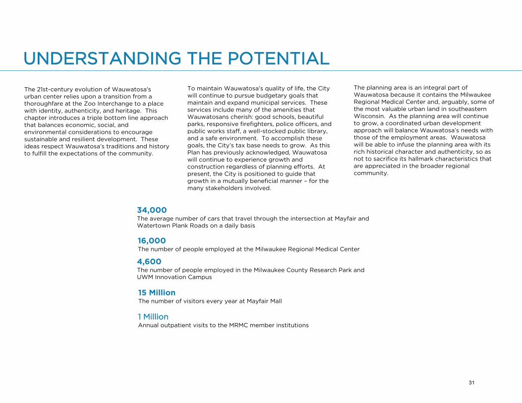
The planning area is an integral part of Wauwatosa because it contains the Milwaukee Regional Medical Center and, arguably, some of the most valuable urban land in southeastern Wisconsin. As the planning area will continue to grow, a coordinated urban development approach will balance Wauwatosa’s needs with those of the employment areas. Wauwatosa will be able to infuse the planning area with its rich historical character and authenticity, so as not to sacrifice its hallmark characteristics that are appreciated in the broader regional community.
34,000The average number of cars that travel through the intersection at Mayfair and Watertown Plank Roads on a daily basis
16,000The number of people employed at the Milwaukee Regional Medical Center
4,600The number of people employed in the Milwaukee County Research Park and UWM Innovation Campus
15 Million The number of visitors every year at Mayfair Mall
1 MillionAnnual outpatient visits to the MRMC member institutions
31

If asked to name the planning area, many people would identify it as just north of the Zoo Interchange. While this has become the busiest freeway interchange in Wisconsin, the name does not reveal the true value and power of this place in the metropolitan area. In the long run, the area can and should be known as the Life Sciences District – a new central business district at the heart of the region.
This Plan proposes to create the Life Sciences District – not as an arbitrarily imposed vision, but rather as a logical next step inferred from the social, economic, and environmental history of the County Grounds.
Third Generation
The Life Sciences District will emerge as the “third generation” of the County Grounds – following the first generation that ended with the freeway in 1963, and the second generation of expansion that has continued to the present day.
The Life Sciences District embodies the logical growth and integration of the health care institutions, the population base, the surrounding region, and social trends. These factors suggest that the next decades will create major changes. “Will change happen?” no longer remains a relevant question. Instead we must ask, “How can we initiate positive change and how can such changes endure?”
This Plan provides a roadmap for developing the Life Sciences District by maximizing development or redevelopment potential while respecting the environmental areas that are valued. No one set of values dominates – rather, values and options balance each other for a collective, multi-group, positive impact.
Triple Bottom Line - Sustainability
As new development occurs, it should be sustainable, enduring, and resilient. These concepts go beyond environmental issues. For example, a commonly used and robust approach views sustainability in terms of a best management practice (BMP) known as the triple bottom line (TBL). Any sustainable development must work in terms of three “e’s”:
• Economics (revenue)
• Equity (i.e., social and political fairness)
• Environment (natural and built)
In this case, a TBL becomes immediately obvious given the size of the critical environmental features, the potential economic value, and the major social and political issues that need to be addressed. This Plan addresses each of these factors.
Sustainable Change
It is not enough simply for a community to be aware of concepts and models for sustainable action. The community must make the actions happen, recognize the impacts, and determine accountability. Currently, the most widely accepted model for such accountability appears to be the The Triple Bottom Line Tool from the U.S. Department of Commerce and the Small Business Administration. This detailed, practical accounting system should be embodied in the Life Sciences District as TBL actions are undertaken.
Watertown Plank Road will be a major activity generator in the “third generation” of the planning area. Source: MRMC
CREATING A LIFE SCIENCES DISTRICT
Worth Per Acre
In many planning studies, the issue of economic value – among the three TBL components – must be addressed first because none of the other TBL components can be implemented without resources. In this case, economic resources fall into two distinct categories: jobs and property values.
32

Net increases in employment support the local economic base. In this case, the primary source of jobs comes from the current and future growth of the Milwaukee Regional Medical Center economic engine. Additional jobs come from the Milwaukee County Research Park and the UWM Innovation Campus. Collectively, if we assume current employment at around 18,000 jobs spread over 300 acres, the net job density is approximately 60 jobs per acre. If we look at job density for the entire planning area, the gross job density approximates 25 jobs per acre (source: MCRP and MRMC). Both of these figures represent very strong economic patterns that must be sustained.
More importantly, job density only creates active areas when combined with residential density. When jobs and residential populations combine to create a 24/7 day/night density, the result is almost always a dynamic urban pattern.
The residential density of these areas also requires an economic analysis measured in terms of community revenues over costs. The economic impact of residential density typically examines changes in the assessed values and property taxes per acre.
This planning area includes considerable acreage that does not provide any property tax revenues due to the large number of non-profit and publicly held property. As such, the level of property value per acre on land subject to property taxes emerges as the most important metric.
TRIPLE BOTTOM LINE AS APPLIED TO THE
LIFE SCIENCES DISTRICT
ECONOMICS
SOCIAL EQUITY ENVIRONMENT
• High-density, mixed-use places
• Taxable vs. non-taxable land
• Transit-oriented development
• Job creation
• High-value, specialized medicalresearch
• Globally competitive healthcare delivery
• Environmental protection
• Trails and loops
• Preservation of green space
• Preservation of wildlife habitat
• Removal of invasive species
• Promotion of multi-modaltransit connections for a diverseworkforce
• Retaining traditional neighbor-hood character
• Development of educationcenters
• Engagement with willing prop-erty owners
• Provision of primary and spe-cialty healthcare
33

• Effective street networks have becomehard to achieve;
• Building placements cannot bealigned given erratic geometries;
• Excessive curvilinear streets makedistrict coherence almost impossible;
• The size of lots forces lower density;
• Large lots promote inefficient parking and traffic arrangements; and
• Low densities make transit inefficient.
For these and related reasons, regulatory changes for land divisions will be essential to the creation of the Life Sciences District. Such changes must protect the property rights of existing owners and also advocate for the public interest. No owners should be coerced to change their property ownership or land boundaries. This Plan proposes discontinuing the extension of negative, unsustainable patterns of land control to implement new, more effective patterns of development.
Dilemma of Change
Wauwatosa will not be the first nor last city to experience pressures for substantial change. Growth in the Planning Area continually impacts the community in terms of employment, character, socio-economic activity, and physical features., and will remain for many years. This inevitable circumstance must be used as an opportunity for improvement.
Some communities view such changes as adversarial or unwelcome, working to minimize growth. Such growth avoidance rarely works and often makes circumstances worse. For example, neighborhoods fend off changes that increase traffic, the unplanned redistribution of traffic exacerbates other problems. Minimizing traffic problems requires cooperation and coordination, not conflict. There will always be alternatives but they must be measured in terms of overall impacts for the entire community.
Extending through parts of the Planning Area, the habitat of Monarch butterflies is preserved while simultaneously allowing for people to appreciate nature. Source: GRAEF
Remedial Land Control
Suburbanized patterns of land division, in addition to relatively lower values per acre, create intractable problems with regard to land divisions:
Supporting Mixed Uses
Highly-desirable neighborhoods include vibrant socio-economic diversity, energetic street scenes, and a sense of vitality, and can be achieved through a development approach that encourages mixed uses, specifically with the integration of housing, maximizing density where feasible. While some perceive constant activation of neighborhood space to be undesirable, daytime and nighttime activation generate increased business activity, social interaction, and a sense of safety for both employees and residents. Commercial real estate development craves the business activity, while residents appreciate interacting with their neighbors and the sense of security provided by eyes on the street.
The live-work-play mentality of real estate development requires that spaces remain active throughout the day. Activity generation is made easy in the planning area during day-time operating hours when the business day is in session; however there is little activity in the evening, except for the hospitals. Thus, residential development is a critical component to operationalize the live-work-play mentality.
Balancing Act
One way to avoid change is to do nothing. This might mean that nothing in the environment is sacrificed and nothing else gets built. The history of the County Grounds, however, suggests this is highly unrealistic. The Plan proposes the enhancement and protection of environmental resources while maximizing development and/or redevelopment when opportunites arise in other sectors of the Planning Area. In cases of conflict, the goals of one or the other may be curtailed in order to achieve a minimum level of satisfactory outcomes for each.
34

The proposed Life Sciences District contains more than one type of character with an interconnected network of places that overlap, interact and mix people, lifestyles, uses, and values.
The Plan envisions an incremental process whereby the places connect within a defined Life Sciences District for the 21st century.This Plan creates a series of neighborhoods, a district, designated green space and a corridor – all based on their history, context, and current visions.
The five proposed key places in the Life Sciences District are:
• Parks and Environmental Areas;
• The Watertown Plank Neighborhood;
• The Westside Neighborhood;
• The MRMC Campus District; and
• The Mayfair Corridor.
Source: City of Wauwatosa
35
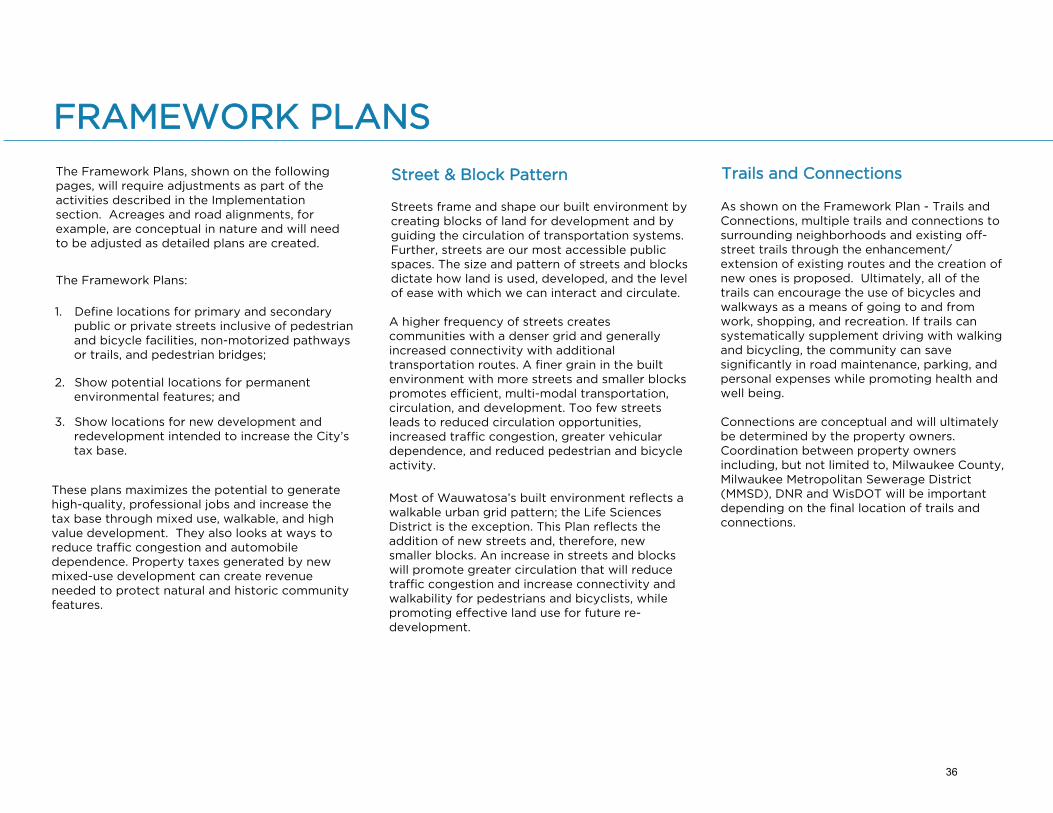
FRAMEWORK PLANS
Most of Wauwatosa’s built environment reflects a walkable urban grid pattern; the Life Sciences District is the exception. This Plan reflects the addition of new streets and, therefore, new smaller blocks. An increase in streets and blocks will promote greater circulation that will reduce traffic congestion and increase connectivity and walkability for pedestrians and bicyclists, while promoting effective land use for future re-development.
The Framework Plans, shown on the following pages, will require adjustments as part of the activities described in the Implementation section. Acreages and road alignments, for example, are conceptual in nature and will need to be adjusted as detailed plans are created.
The Framework Plans:
1. Define locations for primary and secondarypublic or private streets inclusive of pedestrianand bicycle facilities, non-motorized pathwaysor trails, and pedestrian bridges;
2. Show potential locations for permanentenvironmental features; and
3. Show locations for new development andredevelopment intended to increase the City’stax base.
These plans maximizes the potential to generate high-quality, professional jobs and increase the tax base through mixed use, walkable, and high value development. They also looks at ways to reduce traffic congestion and automobile dependence. Property taxes generated by new mixed-use development can create revenue needed to protect natural and historic community features.
Street & Block Pattern
Streets frame and shape our built environment by creating blocks of land for development and by guiding the circulation of transportation systems. Further, streets are our most accessible public spaces. The size and pattern of streets and blocks dictate how land is used, developed, and the level of ease with which we can interact and circulate.
A higher frequency of streets creates communities with a denser grid and generally increased connectivity with additional transportation routes. A finer grain in the built environment with more streets and smaller blocks promotes efficient, multi-modal transportation, circulation, and development. Too few streets leads to reduced circulation opportunities, increased traffic congestion, greater vehicular dependence, and reduced pedestrian and bicycle activity.
As shown on the Framework Plan - Trails and Connections, multiple trails and connections to surrounding neighborhoods and existing off-street trails through the enhancement/extension of existing routes and the creation of new ones is proposed. Ultimately, all of the trails can encourage the use of bicycles and walkways as a means of going to and from work, shopping, and recreation. If trails can systematically supplement driving with walking and bicycling, the community can save significantly in road maintenance, parking, and personal expenses while promoting health and well being.
Connections are conceptual and will ultimately be determined by the property owners. Coordination between property owners including, but not limited to, Milwaukee County, Milwaukee Metropolitan Sewerage District (MMSD), DNR and WisDOT will be important depending on the final location of trails and connections.
Trails and Connections
36
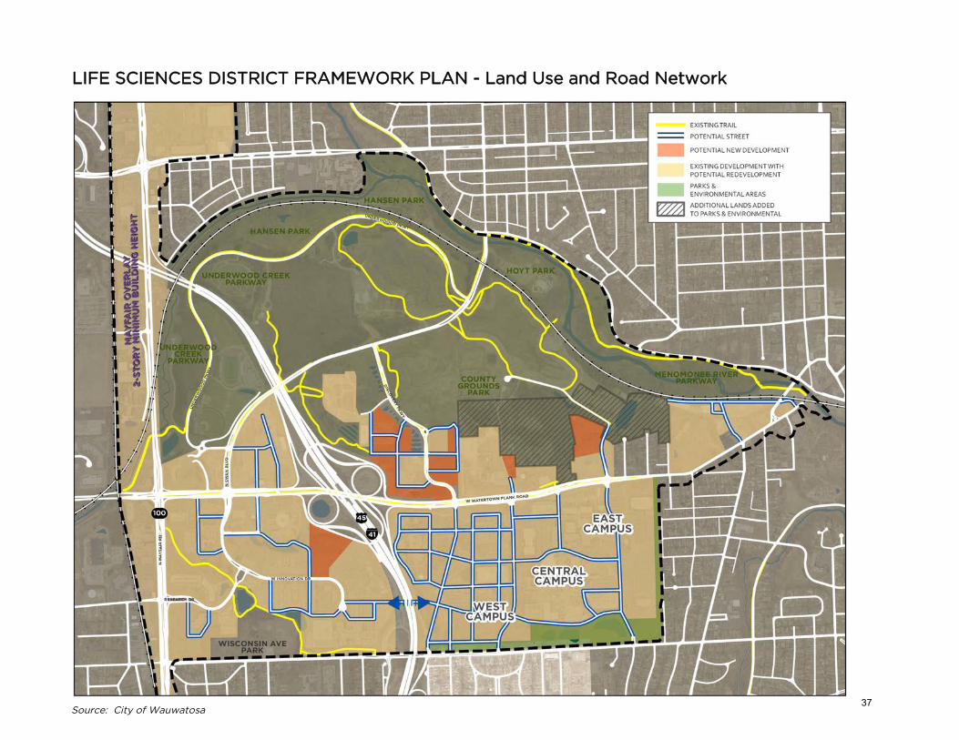
LIFE SCIENCES DISTRICT FRAMEWORK PLAN - Land Use and Road Network
Source: City of Wauwatosa37

Improved Connections (grey circle):
1. Swan Boulevard Underpass – Widenunderpass to provide safer bike/pedaccommodations.
2. Hansen Park Golf Course Tunnel – Widenand increase clearance height of theexisting tunnel and work with the Countyto allow both golfers and non-golfers toutilize the tunnel.
Potential Connections (blue circle):
3. Hoyt Parking Lot – An at-grade, informalcrossing already occurs at this location.Tunnel or bridge should be pursued tocreate a safe, legal crossing point thatconnects Hoyt Park to the larger Parksand Environmental Areas.
4. Hoyt Park – An alternative to the crossingat Hoyt Parking Lot, this potential crossingcould be a tunnel running between theMMSD Detention Basins and theMenomonee River.
5. MMSD Basin – Similar to the crossing atHoyt Park, this potential tunnel crossingcould run between the stormwater pondand the Menomonee River.
LIFE SCIENCES DISTRICT FRAMEWORK PLAN - Trails and Connections
Source: City of Wauwatosa38

Today many cities provide local circulators to complement regional transit systems, and to provide a transportation option that connects people to desired destinations. These circulators can foster the redevelopment of public places with high activity into walkable, mixed-use, high-density environments. The development and implementation of these systems comes about through partnerships with city departments, transit agencies, and non-traditional partners, such as non-profits or educational institutions. Two factors that determine the need for a circulator are:
1. High traffic area with large residential andemployee populations; and
2. Presence of multiple activity hubs or centersthat attract a large number of pedestrians.
Circulators are often seen as a popular way to get around in high-density areas, such as college campuses, downtowns, tourist attractions, airports, and commercial and retail hubs. Generally, they operate regular, all day or peak period service on a short, reliable route. With limited stops and short headways, circulators provide a faster way for people to get from one place to another within a set geographic area than what is possible with traditional transit.
Benefits
• Provides a transit option open to residents,staff, visitors, and the general public;
• Supports economic vitality andredevelopment;
• Creates important connections;
• Improves sustainability and energyefficiency, while providing direct andfrequent trips; and
• Can offer intuitive transfers to the regionaltransit system.
Vehicle Types
The recommended circulator mode for the planning area is a rubber-tire vehicle. Much like streetcars and buses, rubber-tire vehicles can vary greatly in style, size, and appearance. Many cities use engaging branding or a marketing campaign – with a complementary graphic design of the area being served – to attract riders.
Shorter buses allow for easier maneuverability and efficiency in crowded urban environments. Larger buses, such as those used by MCTS, are often considered the industry standard of bus fleets and are more affordable in terms of cost options and efficiency for local circulation.
In most cases, the vehicles used as circulators have large clear windows that allow people on the street to see the presence of passengers using the service, and that allow the riders to see attractions and destinations along the loop/route. Vehicles that have low floors, or the ability to lower, help to make boarding and alighting passengers easy, safe, and accessible to ADA passengers.
The DC Circulator services six routes throughout the United States’ Capital with five million trips per year. Source: DC Circulator
The University of Wisconsin-Milwaukee provides a campus
The University of Wisconsin-Milwaukee provides a shuttle service. The buses pictured are Cutaway Buses. Source: UW-Milwaukee
A variety of rubber-tire vehicles are available. Source: Mercedes Benz
CIRCULATOR
39

TOSA/MRMC NETWORK
Objectives
• Connect key trip generators throughoutWauwatosa;
• Encourage local access between residentialneighborhoods, the MRMC, restaurants, retail,and transit connections;
• Support the MRMC’s efforts to reduce drive-alone commutes, vehicle demand on localroadways, and parking; and
• Expand to serve the existing commutertransportation demand.
Suggested Phasing
• Phase 1 – Starter System (3 routes)» Wauwatosa Village» Mayfair Mall» Research Park
• Phase 2 – Future System (3 revised routes)» East Tosa» The District on Burleigh» Research Park via new Connell AvenueBridge
The following pages present the recommended routes and operating characteristics. Ongoing research and planning is warranted to confirm route details, select the preferred vehicle type, and maintain system efficiency.
Source: Nelson\NygaardSource: GRAEF
Watertown Plank Road, Mayfair Road, the UWM Innovation Campus, the parks, and the MRMC are some of the many social and economic hubs in Wauwatosa. These areas generate a significant amount of pedestrian, bicycle, public transit, and automobile traffic on a daily basis. Based on the number of cars and people going to and from Wauwatosa’s districts, the need for another transportation mode during peak hours is evident.
Improved signalization and traffic management between the campus and neighborhood will encourage pedestrian activity, bicycle use, and create healthier, compact, sustainable environments. Potential mixed-use or residential development north of Watertown Plank creates walk-to-work options for employees, thereby reducing traffic demands and work-related parking.
The proposed bridge over I-41/US45 alleviates traffic congestion on Wisconsin Avenue and offers a new circulation pattern that benefits the campus, Research Park, and surrounding areas. It also allows future organizational connectivity.
The plan allows parking facilities to be shared more effectively between different uses and to increase the levels of occupancy, and allows for better integration of transit to serve high-density areas, reducing the potential for traffic increases. Transit options would include shuttles, the Circulator, MCTS, and BRT.
ECONOMIC & SOCIAL HUBS
40
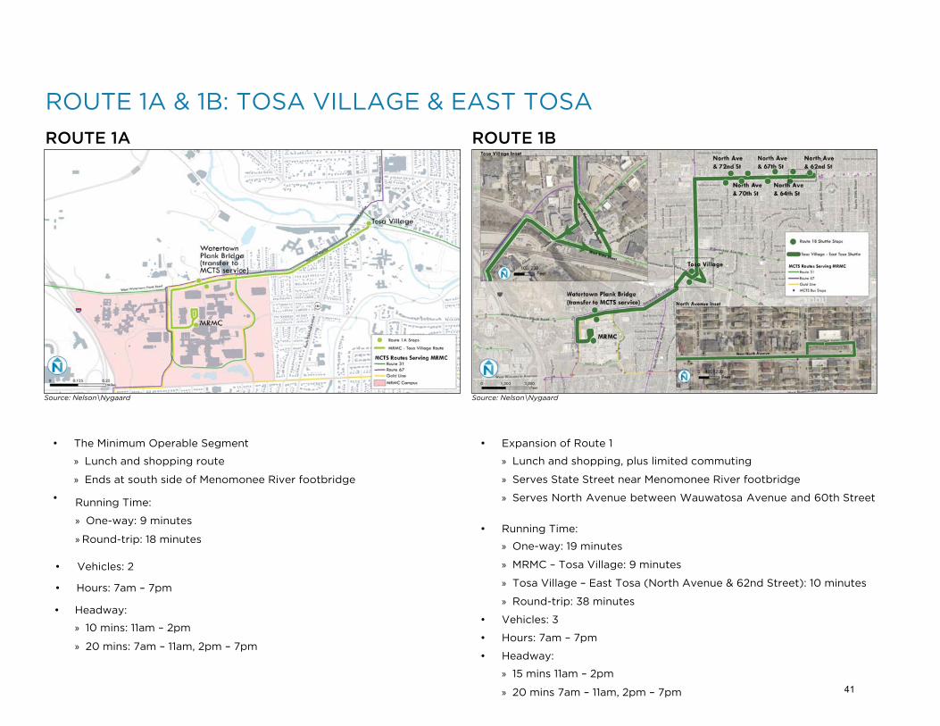
• The Minimum Operable Segment
» Lunch and shopping route
» Ends at south side of Menomonee River footbridge
• Running Time:
» One-way: 9 minutes
» Round-trip: 18 minutes
• Vehicles: 2
• Hours: 7am – 7pm
• Headway:
» 10 mins: 11am – 2pm
» 20 mins: 7am – 11am, 2pm – 7pm
ROUTE 1A & 1B: TOSA VILLAGE & EAST TOSA
ROUTE 1A ROUTE 1B
• Expansion of Route 1
» Lunch and shopping, plus limited commuting
» Serves State Street near Menomonee River footbridge
» Serves North Avenue between Wauwatosa Avenue and 60th Street
• Running Time:
» One-way: 19 minutes
» MRMC – Tosa Village: 9 minutes
» Tosa Village – East Tosa (North Avenue & 62nd Street): 10 minutes
» Round-trip: 38 minutes
• Vehicles: 3
• Hours: 7am – 7pm
• Headway:
» 15 mins 11am – 2pm
» 20 mins 7am – 11am, 2pm – 7pm
Source: Nelson\Nygaard Source: Nelson\Nygaard
41

ROUTE 2A & 2B: MAYFAIR MALL & THE DISTRICT
ROUTE 2A ROUTE 2B
• Lunch and shopping route to Mayfair Mall
» Need Mall’s support to use prime location for a shuttle stop
• Running Time:
» One-way: 10 minutes
» Round-trip: 21 minutes
• Vehicles: 2
• Hours: 11am – 2pm
• Headway: 15 mins
• Future expansion of Route 2
» Lunch and shopping route to Mayfair Mall and The District on
Burleigh/Mayfair Collection
» Need Malls’ support to use prime location for shuttle stop
• Running Time:
» One-way: 18 minutes
» MRMC – Mayfair Mall: 10 minutes
» Mayfair Mall – Mayfair Collection/The District: 8 minutes
» Round-trip: 36 minutes
• Vehicles: 3
• Hours: 11am – 2pm
• Headway: 15 mins
Source: Nelson\Nygaard Source: Nelson\Nygaard
42

ROUTE 3BROUTE 3A
ROUTE 3A & 3B: RESEARCH PARK & UWM INNOVATION CAMPUS
• Connect related businesses and other transit routes
• Running Time:
» One-way: 13 minutes
» MRMC – UWM Innovation Campus: 6 minutes
» UWM Innovation Campus – Research Park: 7 minutes
» Round-trip: 26 minutes
• Vehicles: 2
• Hours: 8am – 6pm
• Headway: 15 mins
• Future, faster service via future Connell Avenue bridge or DoyneAvenue bridge
• Running Time:
» One-way: 11 minutes
» MRMC – Research Park: 4 minutes
» Research Park – UWM Innovation Campus: 7 minutes
» Round-trip: 22 minutes
• Vehicles: 2
• Hours: 8am – 6pm
• Headway: 15 mins
Source: Nelson\Nygaard Source: Nelson\Nygaard
43

OPERATING COSTS BY ROUTE
RouteNumber
Route VehiclesDaily Vehicle Hours
Daily Operating Cost Estimate*
Annual Operating Cost Estimate*
1A MRMC - Tosa 2 15 $750 $187,500
1B MRMC - Tosa – East Tosa 3 27 $1,350 $337,500
2A MRMC - Mayfair 2 6 $300 $75,000
2B MRMC - Mayfair - Mayfair Collection 3 9 $450 $112,500
3AMRMC - Innovation Campus - County Research Park
2 20 $1,000 $250,000
3BMRMC - Innovation Campus - County Research Park
2 20 $1,000 $250,000
*Assuming $50 per vehicle hourSource: Nelson\Nygaard
OPERATING COSTS BY SCENARIO
Operating Scenarios
Scenario Name VehiclesDaily Vehicle Hours
Daily Operating Cost Estimate*
Annual Operating Cost Estimate*
1A only Minimum Operable Segment 2 15 $750 $187,500
1B East Tosa Expansion 3 27 $1,350 $337,500
1A, 2A Tosa Village & Mayfair 4 21 $1,050 $262,500
1B, 2A East Tosa & Mayfair 5 33 $1,650 $412,500
1B, 2A, 3A East Tosa, Mayfair, & Research Park 7 53 $2,650 $662,500
1B, 2B, 3AEast Tosa, Mayfair Collection/The District, & Research Park
8 56 $2,800 $700,000
1B, 2B, 3BEast Tosa, Mayfair Collection/The District, & Connell Avenue Bridge
8 56 $2,800 $700,000
*Assuming $50 per vehicle hourSource: Nelson\Nygaard
The following tables provide estimates for operating costs, capital costs, and ridership for the proposed circulator. These were developed using professionally-recognized forecasting methods; the estimates are contextually appropriate to the planning area. Various routes and scenarios are described to illustrate the potential for expansion.
The system would see increased capacity and efficiency if it were to be enlarged.
ESTIMATED COSTS & PROJECTIONS
44

CAPITAL COSTS BY SCENARIO
Operating Scenarios
Scenario NameTotal Vehicles
Total Daily Vehicle Hours
Capital Cost Estimate – High*
1A Minimum Operable Segment 2 15
Capital Cost Estimate – Low*
$200,000
1B East Tosa Expansion 3 27 $150,000 $300,000
1A, 2A Tosa Village & Mayfair 4 21 $200,000 $400,000
1B, 2A East Tosa & Mayfair 5 33 $250,000 $500,000
1B, 2A, 3A East Tosa, Mayfair, & Research Park 7 53 $350,000 $700,000
1B, 2B, 3AEast Tosa, Mayfair Collection/The District, & Research Park
8 56 $400,000 $800,000
1B, 2B, 3BEast Tosa, Mayfair Collection/The District, & Connell Avenue Bridge
8 56 $400,000 $800,000
*Assumes cutaway modelSource: Nelson\Nygaard
RIDERSHIP PROJECTIONS
Operating Scenarios
Scenario NameTotal Daily Vehicle Service Hours
Daily Ridership Forecast - Low
Daily Ridership Forecast - High
1A Minimum Operable Segment 15 180 390
1B East Tosa Expansion 27 324 702
1A, 2A Tosa Village & Mayfair 21 252 546
1B, 2A East Tosa & Mayfair 33 396 858
1B, 2A, 3A East Tosa, Mayfair, & Research Park 53 636 1,378
1B, 2B, 3AEast Tosa, Mayfair Collection/The District, & Research Park
56 672 1,456
1B, 2B, 3BEast Tosa, Mayfair Collection/The District, & Connell Avenue Bridge
56 672 1,456
Source: Nelson\Nygaard
Based on U.S. Census data (Employment: LEHD data; Population: Census 2010 block-level data)
Caution: Employer-based circulators have struggled to attract ridership; sparse data available on their performance
Average densities within 1/4-mile of shuttle route: 20 jobs per acre; 9 residents per acre
Based on TCRP 55 forecasts; we expect 12-26 passengers per vehicle hour
$100,000
45

Source: City of Wauwatosa
PARKS AND ENVIRONMENTAL AREAS
Historically, the greatest value of the Parks and Environmental Areas have been its rich physical features. The park areas within the overall proposed district include a broad range of owners, natural and artificial features, habitats, and built facilities. Each of these elements comes with a different purpose or mission. All features relate to environmental factors, but no overarching theme or identity emerges. A larger identity can help these disparate pieces merge physically and experientially into a much larger, culturally significant place.
Environmentally significant lands in the Parks and Environmental Areas were evaluated by the Southeastern Wisconsin Regional Planning Commission (SEWRPC) in spring and summer of 2017 and summarized in an October 26, 2017 SEWRPC staff memorandum. The natural resource features evaluated and inventoried included wetlands, critical species habitats, mature forest, natural areas, and primary environmental corridor. The map on the next page identifies the location of these features.
The SEWRPC memo concluded that no development or buildings should be constructed within the primary environmental corridor. If necessary, access roads, utilities, and compatible recreation facilities can be built if the impact to the primary environmental corridor is minimized. Development in critical species habitat and mature forest areas could be subject to State and Federal restrictions.
46

NATURAL RESOURCE FEATURES
Project Area refers to the SEWRPC surveyed area and is not the same as Planning Area.
47

Maintain Existing Parks
Different organizations own, manage, and protect different portions of the combined area of the Parks and Environmental Areas. Most of these patterns of ownership, regulation, and management are expected to continue. Each environmental area serves different user groups who have a stake in the long-term continuation of their interests. As of 2018, these owners included:
• Hoyt Park (Milwaukee County);
• Hansen Golf Course (Milwaukee County);
• County Grounds Park (MilwaukeeCounty);
• Underwood Parkway (Milwaukee County);
• Menomonee River Parkway(Milwaukee County);
• The Monarch Butterfly Habitat (UWM);
• Ronald McDonald House;
• Department of Natural Resources;
• Private landscapes; and
• MMSD Flood Management Basins.
This Plan assumes that all of these places continue their present ownership, overall missions, associated operational policies and procedures, and routine operations. Future opportunities for collaboration, coordination, and integration of activities (both informal and formal) may emerge as a mutually cooperative and voluntary effort.
Social Value
Parks must always protect and enhance the natural environment that visitors wish to experience. Parks, however, should not minimize public use, nor serve only specialized interests. Parks should maximize the frequency and diversity of experiences for a wide cross section of the urban population.
This Plan does not imply changes to such practices and conditions, but it does suggest that informal collaboration among all parties with ownership and oversight can create more integrated and coordinated environmental features and experiences.
EXISTING PARKS AND PUBLIC PLACES
Source: City of Wauwatosa 48

The Common Good
All stakeholders share the benefits of a life sciences district. The Parks and Environmental Areas should serve different population groups, including those who use the parks now, as well as others who will see them as a desirable destination. User groups should include:
•
•
•
Patients, staff, and visitors at the Milwaukee Regional Medical Center seeking a place of reflection, health improvement, or social activity;
Students from kindergarten through graduate school that study environmental issues, habitats, history, and related topics;
Neighbors from around the area looking for a place to spend a day in the park; and
• Persons participating in spontaneousunprogrammed activities, annual events (likeruns or social gatherings), individual hikes,picnics, organized sports, walking the dog, orjust spending a few minutes looking at otherpeople and the scenery.
Front Yard & Entrance
This area does not share the power of a lakefront view, but it can create its own internal amenity as a regional destination. To do this, public attitudes about the park area need to change.
During the preparation of this Plan, one contributor referred to the area as a “backyard” with an assortment of uses intended for more exclusive (and exclusionary) uses. This Plan envisions the area becoming a “front yard” - open to a broader population, and serving as a destination amenity. By creating a unified identity for the entire range of experiences, the Life Sciences District can claim pride as one of the strongest environmental amenities in the region.
Watertown Plank Road has become the primary street that brings almost everyone in the region to the park area. Yet development along Watertown Plank Road hides most of the park from view. Park features lie behind the buildings, not in front. This Plan seeks to preserve and create a more prominent entry visible from Watertown Plank Road, such as between the Wisconsin Athletic Club and the Ronald McDonald House. The exiting pedestrian bridge over Watertown Plank Road also provides a perfect pedestrian connection to the park's front door.
A good front yard also needs a good front gate. In this case, the front gate needs to occur along Watertown Plank Road. The other parks and environmental area edges remain either hard to penetrate (the river and railroad) or offer less visibility to outside population groups (Discovery Parkway and Swan Boulevard).
High value neighborhoods require a major amenity – in this case the large Parks and Environmental Areas – that include multiple use activities and many high quality views. Environmental features become major amenities to be enjoyed by new and existing residents, patients, employees, visitors, and other groups.
Measures can be taken to increase the likelihood of establishing permanence; such as zoning changes, deed restrictions, restrictive covenants, easements, and other regulatory mechanisms; which are outlined in Implementation. The plan provides enhanced protections for the parks and environmental areas, including additional land north of Watertown Plank Road that is currently zoned for medical related development.
Generally speaking, the social and economic value of parks requires high visibility, high access, and long-term permanence. In the case of the Parks and Environmental Areas, many different organizations and individuals, each with different missions, own and manage parts of the land. No entity oversees the combined environmental resource. Moreover, complex and, in some cases, ambiguous regulatory systems overlay these multiple sub-areas. This Plan assumes that the diversity of this area will remain, but at the same time, begin to create a cohesive area with a more integrated permanent boundary.
The Need for Permanence
Parks preserve our natural environment, though many of our most famous and well-used parks were not preserved but completely redesigned environments planned to attract all people in the surrounding community by appealing to diverse interests and offering an escape and a place of relaxation.
Maximizing views into the park can be done with an activated perimeter trail system that promotes walking, jogging, relaxing, or just looking. Parks, however, must also accommodate some motorized vehicles in order to facilitate a broad number of users, including individuals and groups and persons with disabilities.
49

All features in the parks deserve special care. Some places, however, can be viewed as regional, or at least community-wide, destination points that create the unique amenities and branding for the Life Sciences District.
Habitat
Protecting an existing migratory roost site for Monarch butterflies was a major opportunity in past years. Currently, the areas set aside to protect the Monarch’s annual migratory flyway and stopover are being restored and enhanced as the Monarch populations recover. Because these areas are interconnected both locally and internationally, future developments need to consider the critical support factors within this area.
In addition to the monarch butterflies, the Parks and Environmental Areas includes habitat areas for other species that need to be further studied, planned, and implemented. The environmental assets in the park areas represent a unique resource to simultaneously increase preservation, social activity, and higher levels of daily use.
Historic Ruins
Park users comment about the ruins of buildings and structures that have been left in the park areas. Remnants of the past can become important and appealing features of the park. While historical plaques can narrate the story, the physical ruins of old structures give the site unique, irreplaceable characteristics. These ruins can help the community understand the importance of the County Grounds and the entire system of social health and welfare issues that underlie the community.
The Woods
Parts of the environmental area still contain older growth trees. The magic of walking though old growth and forested areas can educate the population regarding the value and need for environmental conservation. The opportunity to walk through such an environment, as an individual or with a small group, gives people a truly rural experience – not just an abstract sense of nature implied by building setbacks and front lawns.
The Parkway System
Milwaukee County’s park system includes a structured set of river parkways intended to connect the County’s overall park system. The Parks and Environmental Areas can and should emphasize these connections and experiences. Additionally, restoration efforts are ongoing along the Parkways’ creeks and rivers to naturalize the water courses providing for healthier natural features.
Cemeteries
The paupers’ graves, and the stories behind them, provide another powerful reminder of community history. This part of our past needs commemoration. The graves tell us something about life in the community more than a century ago. The process of memorialization can become another effective way to make the Parks and Environmental Areas a unique and well-visited destination place for the region.
Friends of the Monarch Trail have begun reseeding areas with milkweed to rebuild habitat. Source: Friends of the Monarch Trail
Remnants of the Milwaukee County Insane Asylum Source: Eddee Daniel via WUWM
Restoration along the Menomonee River at Hart Park removed barriers to fish passage. Source:
JSOnline.com
50

Source: City of Wauwatosa
WATERTOWN PLANK NEIGHBORHOOD
The Watertown Plank Neighborhood acts as the planning area’s social street. This major traffic artery can become the central business corridor, uniting the social and economic activity on both sides of the street. It can connect all of the key places in the planning area from the Westside Neighborhood to the Village, as well as providing access to the scenic environmental area to the north.
51
Development adjacent to the Parks and Environmental Areas to the north must be done in a sustainable and environmentally-friendly manner as not to negatively impact the natural resources that will generate irreplaceable value to the Life Sciences District and community

Watertown Plank Road
This Plan proposes to reframe the image of Watertown Plank Road as a safe but active street that encourages slower driving and relieves some of the stress and frustration typical of suburban arterials. To create this new character, buildings should be constructed closer to the sidewalks with urban streetscape features that give pedestrians a sense of security. As buildings and streetscape elements occupy the driver’s field of vision, the perception of an urban street, requiring slower driving speeds, begins to occur naturally. This Plan proposes maximizing development opportunites in this area that includes street level uses for pedestrians, such as additional food and beverage establishments and small retail activities.
The proposed uses preserve Watertown Plank as a transportation thoroughfare while presenting opportunities for pedestrians to experience and activate the sidewalk edges. Today, people view Watertown Plank Road as a high volume automobile arterial that reminds drivers of suburbanized strip malls, rather than an appealing urban boulevard.
Single-use districts rarely thrive in the marketplace over the long term. While their concentration and focus may build a technical capacity that yields professional expertise and innovation, the environment lacks the socio-economic diversity needed to be sustainable and resilient. Successful professional and social ecosystems rely on mixed-use places to convene residents and employees of different backgrounds in order to harness and leverage creativity and intelligence.
Watertown Plank Road looking west at 92nd Street. Source: GRAEF
In addition, with higher density, mixed-use developments, people are encouraged to adopt the “park once” approach or even prefer to walk, bike, or ride the bus, ultimately reducing auto dependency. These places can provide the ideal environment for people to grow and prosper.
County Land
Milwaukee County owns a large parcel that has become an official County Park. The County also owns other parcels not designated as a park, which includes some older facilities, critical habitat as defined by SEWRPC, and historic ruins. Some of the area is referred to as “Sanctuary Woods”. Any future improvements to the non-park County land should be designed for more effective environmental habitats and active uses.
There is a key location along Watertown Plank that allows for the design of an effective, high-visibility entrance to the proposed Parks and Environmental Areas. While numerous secondary entries have been indicated (from the north, east, and west), more people see a Watertown Plank entry area than all the other entries combined. As described earlier, the proposed entry area, or front door, consisting of a simple picturesque landscape with strong borders and signage could be located between the water tower and the Ronald McDonald house.
52

The Tosa Farmers Market activates a parking lot in the Village. Source: Tosa Farmers Market
Harwood Avenue
Over time, several residential, multi-story buildings can replace the exiting industrial buildings located along the tracks. This location will provide residents with proximity to the tranquility of the Menomonee River, the vibrancy of the Village area. and the opportunity to explore the Parks and Environmental Areas, walk their dog, or ride their bicycle. Although the frequent use of the adjacent railroad may be seen as a nuisance, the noise and vibration can be lessened significantly with contemporary construction technologies.
The Harwood Place campus also offers opportunity for commercial or residential buildings redevelopment. This Plan proposes leveraging the existing commercial activity on the roadway based on the customer base in the immediate vicinity. This location suits both neighborhood retail as well as professional uses. If and when such changes occur, circulation improvements will be needed to maintain slow traffic and still provide reasonable access to businesses and homes.
UWM Innovation Campus
Earlier plans for the UWM Innovation Campus have been completed and approved by multiple agencies and organizations. Those agreements, however, represent a continuation of lower-density development based entirely on auto-dependent uses. Both the west and east sides of Discovery Parkway contain large surface lots. This Plan envisions a much denser alternative with the same overall perimeter footprint and the allowance of land preservation elsewhere. To achieve this vision, covenants and development agreements will require revisions and further parcel subdivisions will be necessary. It is assumed that such changes will take several years to initiate and will depend largely on the decisions of existing land owners and redevelopment approaches.
This Plan proposes options for mixed-use development with residential, office buildings, and modest retail and retaining the same amount of existing office space. Taller buildings can be sited along the freeway and Watertown Plank Neighborhood and more desirable locations along Discovery Parkway with views of the Parks and Environmental Areas can contain residences. Parking structures (some below grade) should replace large surface parking lots.
The gateway to the UWM Innovation Campus is currently marked by a terraced retaining wall with UWM signage. Source: ACEC Wisconsin
The existing Thermal Power Plant occupies a smaller amount of land, but the height and larger building masses make this a visually prominent feature. This Plan proposes that the Power Plant perimeter should be addressed with more attractive, native landscapes and, where possible, link to the system of park trails.
MRMC Thermal Plant
County Food Services
The food services building is currently located on a larger parcel owned by Milwaukee County and does not include a public right-of-way. This Plan envisions creation of a redevelopment parcel that follows the boundaries of the existing parking lot/paved areas north and east of the existing building. Trails and connections should also be incorporated into redevelopment of this site.
53

Source: City of Wauwatosa
WESTSIDE NEIGHBORHOOD
By capitalizing on the successes and efforts of existing companies, this chapter explores the Westside Neighborhood’s potential to attract activity from Watertown Plank Road, Mayfair, and I-41/US45. As demand increases, strategic infilldevelopment could increase density, creatingdiverse and mixed-use places to urbanize theexisting suburban development pattern. As theNeighborhood sits as an anchor at a strategicjuncture in a high traffic area, it could develop askyline along I-41/US45, a retail center to servepotential residential development, andconnections to the MRMC campus – whilesimultaneously protecting Wisconsin Avenue as aresidential collector street to preserve theexisting neighborhood to the south.
The Milwaukee County Research Park (MCRP), and the land just to the north, can form the hub of strong mixed-use neighborhoods. If the density increases, then housing can be combined with offices and public places. Collectively, these places can become a contemporary version of a central business district (CBD).
54

The Milwaukee County Research Park Master Plan envisioned a town center. Source: MCRP
Much of the Westside Neighborhood includes properties that follow suburban business park patterns with large lawns, low density, high ratios of surface parking and lot lines that preclude urban reconfiguration. Despite the extensive streetscaping efforts, this area creates a large dead zone with no effective street activation.
These uses and patterns will remain as long as present property owners and occupants wish to continue their current pattern of activity. When owners and users wish to redevelop, such changes should conform to this Plan.
Land Divisions
As noted previously, existing patterns of lot lines preclude almost any type of non-suburbanized configuration. If this Plan hopes to achieve higher densities, higher property values, and a socially activated condition, then changes in land divisions seem inevitable. The property line changes suggested in this Plan cannot be implemented without the full coordination with individual owners and businesses.
Like other changes over time, transformation from suburban to urban patterns does not happen all at once. Incremental change, however, still results in a profound shift in character. The transformation impacts social and economic activities, the environment, circulation, and the overall look and feel of a community.
GE Healthcare is a major employer at the Milwaukee County Research Park. Source: Irgens
Currently, many public uses occupy the land on each side of Swan Boulevard. In the next decade, the value of this land for private sector development can, and should, be increased. This area can contain both residential and office uses that will become desirable given the high level of nearby amenities, access, and visibility. Public uses may relocate in the long run. Ideas for redevelopment should be promoted as opportunities unfold.
Swan Boulevard
The long-term success of this Plan will require establishing a neighborhood retail center in the Westside Neighborhood– a place with convenient shopping for residents, employees, and visitors. Typical neighborhood retail zones succeed only when located along easily accessed traffic routes in both suburban and urban areas. Areas bordering Watertown Plank can be configured to allow for vehicular access, parking, and combinations with other uses, such that Watertown Plank has the look and feel of an active successful business street.
Retail Areas
The northeast sector with the Children’s Courthouse facilities is relatively underutilized and has additional redevelopment potential. Although the Courthouse will likely remain, portions of the existing Court property could be repurposed in a compatible manner with the development under construction at the intersection of Innovation Drive and Watertown Plank Road. The land can support a mix of housing, retail, and offices supported with some surface parking and substantial structured parking. Some changes to lot lines and property divisions may also be possible with the cooperation of existing owners and occupants.
Children's Court
55
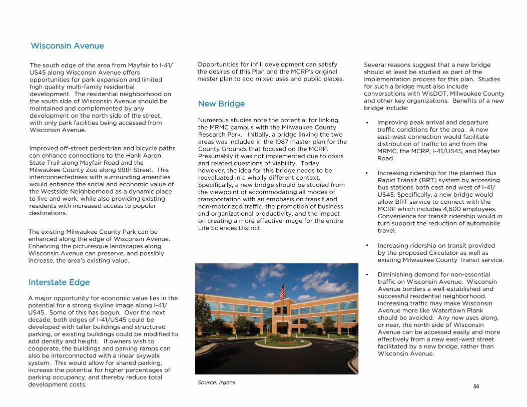
The south edge of the area from Mayfair to I-41/US45 along Wisconsin Avenue offers opportunities for park expansion and limited high quality multi-family residential development. The residential neighborhood on the south side of Wisconsin Avenue should be maintained and complemented by any development on the north side of the street, with only park facilities being accessed from Wisconsin Avenue.
Improved off-street pedestrian and bicycle paths can enhance connections to the Hank Aaron State Trail along Mayfair Road and the Milwaukee County Zoo along 99th Street. This interconnectedness with surrounding amenities would enhance the social and economic value of the Westside Neighborhood as a dynamic place to live and work, while also providing existing residents with increased access to popular destinations.
The existing Milwaukee County Park can be enhanced along the edge of Wisconsin Avenue. Enhancing the picturesque landscapes along Wisconsin Avenue can preserve, and possibly increase, the area’s existing value.
Wisconsin Avenue
A major opportunity for economic value lies in the potential for a strong skyline image along I-41/US45. Some of this has begun. Over the next decade, both edges of I-41/US45 could be developed with taller buildings and structured parking, or existing buildings could be modified to add density and height. If owners wish to cooperate, the buildings and parking ramps can also be interconnected with a linear skywalk system. This would allow for shared parking, increase the potential for higher percentages of parking occupancy, and thereby reduce total development costs.
Interstate Edge
Opportunities for infill development can satisfy the desires of this Plan and the MCRP’s original master plan to add mixed uses and public places.
Source: Irgens
Numerous studies note the potential for linking the MRMC campus with the Milwaukee County Research Park. Initially, a bridge linking the two areas was included in the 1987 master plan for the County Grounds that focused on the MCRP. Presumably it was not implemented due to costs and related questions of viability. Today, however, the idea for this bridge needs to be reevaluated in a wholly different context. Specifically, a new bridge should be studied from the viewpoint of accommodating all modes of transportation with an emphasis on transit and non-motorized traffic, the promotion of business and organizational productivity, and the impact on creating a more effective image for the entire Life Sciences District.
New Bridge
Several reasons suggest that a new bridge should at least be studied as part of the implementation process for this plan. Studies for such a bridge must also include conversations with WisDOT, Milwaukee County and other key organizations. Benefits of a new bridge include:
Improving peak arrival and departure traffic conditions for the area. A new east-west connection would facilitate distribution of traffic to and from the MRMC, the MCRP, I-41/US45, and Mayfair Road.
Increasing ridership for the planned Bus Rapid Transit (BRT) system by accessing bus stations both east and west of I-41/US45. Specifically, a new bridge would allow BRT service to connect with the MCRP which includes 4,600 employees. Convenience for transit ridership would in turn support the reduction of automobile travel.
Increasing ridership on transit provided by the proposed Circulator as well as existing Milwaukee County Transit service.
Diminishing demand for non-essential traffic on Wisconsin Avenue. Wisconsin Avenue borders a well-established and successful residential neighborhood. Increasing traffic may make Wisconsin Avenue more like Watertown Plank should be avoided. Any new uses along, or near, the north side of Wisconsin Avenue can be accessed easily and more effectively from a new east-west street facilitated by a new bridge, rather than Wisconsin Avenue.
•
•
•
•
56

•
•
•
•
• Increasing potential for bicyclecommuting and other bicycle activity.While there are east-west bike lanes alongWatertown Plank Road, most bicyclistsreport that these lanes are not bike-friendly and are not utilized. A new bridgewould help resolve this dilemma.
•
•
Increasing opportunities for sharedparking and increasing the parkingstructure occupancy rates. The amount ofunoccupied, unshared structured parkinghas increased. A bridge connection couldencourage shared parking and higheroccupancy rates, thereby reducing theoverall demand for parking structures.
Increasing productive shared/collaborative activity between the MRMC and the MCRP would also occur. Many of the employees and organizations on both sides of I-41/US45 would benefit from increased collaboration, but interactions between such organizations are hindered by the difficulties of transportation. While the buildings are geographically close, from the standpoint of transportation they are far apart. One cannot, for example, easily walk from GE Medical to Froedtert Hospital.
Finally, there is a substantial benefit to a new contemporary structure which would help brand the area and increase its prominence. This outcome is not a sufficient reason, by itself, for a new bridge, but it is still a significant benefit. If a new bridge was designed with low-cost, but high-visibility imagery, it would help create a stronger iconic identity and economic value for the Life Sciences District.
A new bridge might be considered an excessive expense and potentially redundant given the use of Watertown Plank Road and Wisconsin Avenue. There is no doubt that a new bridge would represent a significant infrastructure cost. These costs must be analyzed fairly along with the economic and social benefits associated with construction.
As part of the costs and benefits analysis of a new bridge, the costs and benefits of alternatives must also be evaluated. Several options need to be studied simultaneously including:
Doing nothing and letting existing conditions continue. While this may not be most advantageous option, the so-called “do-nothing” alternative is always relevant as a bench-mark. Will traffic really be much worse? Will productivity be truly hampered? Perhaps not. The evaluation of the “do-nothing” option will provide a critical baseline.
Changing the use and management of traffic on Wisconsin Avenue. Presumably, changing the design of Wisconsin Avenue today would be infeasible. However, there may be ways to improve the management of traffic on Wisconsin Avenue as well as an access point to Wisconsin Avenue from the MCRP similar to the conceptual diagram to the right.
Alternatives to a multi-modal bridge might also be useful options. For example a bridge which provides only bicycle and pedestrian connections may be appropriate.
Expanded transit options are also worth exploring. Increasing shuttle service or expanded circulator service between the MRMC and the MCRP area may have some beneficial impacts.
•
• Combinations of ideas and options alsoneed to be considered. Invariably asstudies evaluate new options, moreideas, including combinations ofalternatives begin to arise and deserveadditional study.
ALTERNATE ACCESS
Source: City of Wauwatosa57
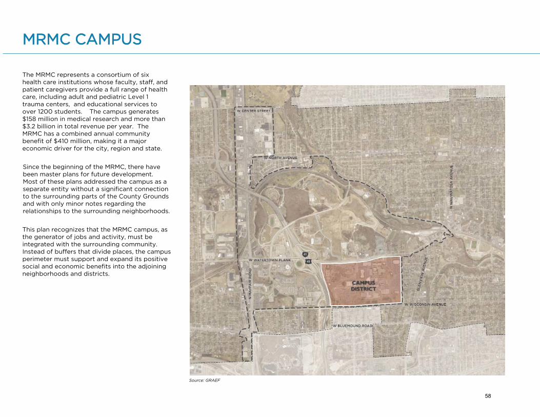
MRMC CAMPUS
Source: GRAEF
Since the beginning of the MRMC, there have been master plans for future development. Most of these plans addressed the campus as a separate entity without a significant connection to the surrounding parts of the County Grounds and with only minor notes regarding the relationships to the surrounding neighborhoods.
This plan recognizes that the MRMC campus, as the generator of jobs and activity, must be integrated with the surrounding community. Instead of buffers that divide places, the campus perimeter must support and expand its positive social and economic benefits into the adjoining neighborhoods and districts.
The MRMC represents a consortium of six health care institutions whose faculty, staff, and patient caregivers provide a full range of health care, including adult and pediatric Level 1 trauma centers, and educational services to over 1200 students. The campus generates $158 million in medical research and more than $3.2 billion in total revenue per year. The MRMC has a combined annual community benefit of $410 million, making it a major economic driver for the city, region and state.
58

MRMC’s growth creates jobs and economic vitality but also brings parking and traffic challenges that affect internal and external stakeholders and the surrounding community. Campus roads are at, or near capacity, during peak travel times. Infrastructure for parking, roads, and alternative transportation has not kept up with growth.
In addition to the framework for the possible streets and gathering places, MRMC intends to reduce the number of single-driver vehicles on campus through multimodal transportation options, incentives for employees who do not drive, special spaces for ridesharing, campus-wide solutions for parking, and growing off-campus health services.
Milwaukee County Transit System continues to serve as an alternative transportation option for employees, patients and visitors.
Source: www.ever-greenenergy.com
As illustrated on the Framework Plan on page 37, a simple street system is proposed that retains the existing pattern of development and allows for future growth as needed. New internal streets will likely develop in a general grid pattern to allow for a more robust, distributive circulation system. The streets may not be located in the specific locations as reflected in diagrams in the plan. Over time, the campus will become more pedestrian and bicycle friendly, thereby reducing the potential increases in traffic.
In addition, the plan provides for the possibility that there will be major gathering places such as an expanded quadrangle, a central plaza and new "green” areas located on the campus. The campus plan includes the possibility for a plaza and hotel/conference center, retail, residential and general office space development in locations as complementary to other uses.
The area labeled east campus on the Framework Plan is parking areas for MRMC entities. A proposed realignment of 87th Street is under construction to improving traffic flow and pedestrian safety. The new road includes substantial streetscape, bicycle lanes, and improved pedestrian circulation components.
The area labeled central campus on the Framework Plan includes almost all of the existing buildings for the MRMC member institutions. This is the functional heart of the campus and continues to serve as the focus for new growth. The central campus also contains beautiful landscaped areas and ponds which are expected to remain.
The west campus currently contains buildings associated with the County’s Behavioral Health Division, parking facilities and undeveloped areas. It is anticipated that a system of landscaping may be added in this area and along the south edge of the campus. A larger community plaza could be located in this area and the large undeveloped parcels in this area represent future growth opportunities.
59

1. East: property lines, streets and alleys in aquiet, valuable residential neighborhood;
2. West: I-41/US45 dividing the campus from acomplementary business park;
3. South: Wisconsin Avenue bordering anothersuccessful residential neighborhood andWisconsin Lutheran College; and
4. North: Watertown Plank Road with majortraffic and circulation problems.
Each edge should be improved to help the occupants and users on both sides of the border. None of these edges can be improved unilaterally by MRMC or the City. All require collaboration to achieve effective solutions.
East Edge
The east edge of the campus is adjacent to a residential neighborhood comprised mainly of single family homes. Green areas and gathering spaces proposed throughout the campus will invite neighbors, patients, and families to spend time and enjoy the beauty of natural features. Plans include a reconstructed 87th Street with substantial streetscape and bike lanes. The goal of the redesign is to improve traffic circulation, bicycle and pedestrian safety on the east side of campus.
A tree-lined sidewalk along Wisconsin Avenue would allow residents to walk while also providing a calm buffer between the MRMC and the neighborhood. A more active street edge might work along Watertown Plank Road.
A reconstructed 87th Street will look to include substantial streetscape elements along with accommodations for multiple modes of circulation.
Integration
The borders separating the city and campus require mutually supportive strategies to minimize negative impacts and improve beneficial outcomes. The four edges are:
60

West Edge
The western edge along I-41/US45 provides a unique opportunity for bold, dramatic, iconic buildings visible from the freeway comparable to other nationally prominent academic medical centers. A new image for the campus, and the surrounding community, can impress others in the region and help maintain the economic stability and value of the area. Iconic buildings regardless of height support the economic and social prominence of the district.
The current natural area along Wisconsin Avenue provides an appealing green space. Although it receives little social use, the picturesque landscape appears friendly and welcoming to visitors and campus users. Currently, the plan indicates the desire to extend a green border along the south edge of the campus.
As Wisconsin Avenue reaches the freeway, green features could be extended in the form of linear gardens. Such concepts maintain the scale and character of Wisconsin Avenue as a collector street providing a valuable shared community place. Continuation of green features is also contemplated in the plan west of the freeway.
The linear park at Atlantic Station (Atlanta, GA) activates a safe space for pedestrians to easily travel throughout the neighborhood. Source: Bilson & Associates
The Lawn on D in Boston features LED-illuminated swings.
Texas Medical Center’s skyline is captivating at night. Its iconic forms and features promote the Medical Center.
Highly designed green spaces can serve both as places of respite and relaxation and areas in which patients and visitors can socialize and engage.
South Edge
Development along Wisconsin Avenue should be especially sensitive to both the residential area to the south and the needs of Wisconsin Lutheran College.
Traffic management issues currently exist, especially at peak times. Alternative transportation and traffic interventions outlined elsewhere in the City’s plan can help to improve circulation.
61

North Edge
Watertown Plank Road can become safer, socially and economically active, and visually appealing to both drivers and pedestrians. This divider street should be transformed into a unifier street. Today, the street is a high-traffic thoroughfare fragmenting the overall Life Sciences District.
Transforming Watertown Plank Road requires multiple detailed changes over time, including:
• Locating new buildings much closer to the edge of the right-of-way to slow drivers;
• Traffic signalization systems that slow traffic, improve campus traffic management, and add more pedestrian and bicycle crossing time;
• Creating wider, safer sidewalks with terraces that accommodate trees, safety fencing, and garden planters that these provide a stronger feeling of safety for pedestrians and discourage faster driving;
• Including uses which support both the cam-pus activities to the south and residential and activities to the north; and
• Small-scale uses in abutting buildings mir-rored on both sides of the street and activities that emphasize the connection between the campus and uses to the north.
The south side might include very small urban social places at street level abutting new institutional buildings. Examples might include a small entry plaza for MCW at 87th Street or perhaps at the southward extension of Discovery Drive as it enters the campus.
The Broadway Plaza in Times Square, specifically the pedestrian boulevard, allows traffic to move freely while protecting pedestrians and bicyclists. Source: Montgomery Planning
Street environments that are activated during the day and at night will add value for staff working during shifts, patients eager to explore, and visitors looking for something to do (above & below).
In addition, activity centers can be developed at major intersections that provide diverse, high visibility amenities for students, staff, families, patients, neighborhood residents, employees from the whole district, and others using the street.
62
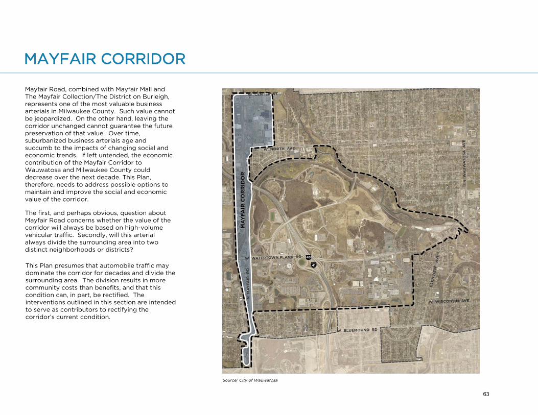
MAYFAIR CORRIDOR
Source: City of Wauwatosa
Mayfair Road, combined with Mayfair Mall and The Mayfair Collection/The District on Burleigh, represents one of the most valuable business arterials in Milwaukee County. Such value cannot be jeopardized. On the other hand, leaving the corridor unchanged cannot guarantee the future preservation of that value. Over time, suburbanized business arterials age and succumb to the impacts of changing social and economic trends. If left untended, the economic contribution of the Mayfair Corridor to Wauwatosa and Milwaukee County could decrease over the next decade. This Plan, therefore, needs to address possible options to maintain and improve the social and economic value of the corridor.
The first, and perhaps obvious, question about Mayfair Road concerns whether the value of the corridor will always be based on high-volume vehicular traffic. Secondly, will this arterial always divide the surrounding area into two distinct neighborhoods or districts?
This Plan presumes that automobile traffic may dominate the corridor for decades and divide the surrounding area. The division results in more community costs than benefits, and that this condition can, in part, be rectified. The interventions outlined in this section are intended to serve as contributors to rectifying the corridor’s current condition.
63

Linkages
Currently, a small percentage of people walk to stores and businesses on Mayfair Road. Some might bicycle, but safe and attractive bicycle and pedestrian facilities are primitive.
This Plan suggests beginning with incremental transportation linkages that connect locations on Mayfair Corridor to the environmental areas within the proposed Life Sciences District. In addition, the proposed transit circulator might connect areas along Mayfair Road to residential neighborhoods and business districts. Once ridership increases, so too will the demand for improved bicycle and pedestrian features that allow people to walk along appealing sidewalks to and from transit stops.
Life Sciences District Interdependence
As the major employment hub, the MRMC campus, the UWM Innovation Campus, and the Milwaukee County Research Park will likely have a strong long-term and functional linkage to Mayfair Road. Businesses and institutions in one area will naturally spur corresponding activity in the other area. This pattern already seems evident given the quantity of health-related institutions located on Mayfair Road.
As aspects of the health care and medical industries embrace decentralization, these health-related institutions along Mayfair Road may expand due to ease of access and high visibility. As such, three types of stronger physical linkages between the Mayfair Corridor and the rest of the planning area should be considered:
Complete Streets & Edges
The City is enforcing the concepts of Tosa Complete Streets in the Mayfair Corridor. Efforts must now shift from making improvments solely for the private vehicle to improvements for pedestrians, cyclists, and transit riders. Concurrently, the City should encourage physical change on private property to create a locked edge of buildings along Mayfair Road. The WisDOT recently completed the reconstruction of Hwy 100 to result in six lanes of vehicular traffic. A locked edge of buildings would deter further widening in future years. New or modified development in the Mayfair Corridor must apply the City’s two-story building height minimum listed in the Mayfair Corridor Overlay Zone of the City’s code. The diagram on the next page shows how the City can also enforce a Build-to-Zone (BTZ) that includes minimal building setbacks promoting an active, human-scale environment.
Pedestrian Activity
Space for pedestrian activity can and should be created incrementally along the edges of the corridor. Currently, limited pedestrian activity takes place far from the street edge, often behind surface parking lots. In addition, pedestrian movement occurs primarily on separate, disconnected lots. Occasionally, surface lots share parking through cross easements and other forms of linkages. The City can facilitate the creation of meaningful pedestrian spaces that generate value and visitor traffic by requiring improvements to pedestrian and bicycle facilities as part of new development or redevelopment along Mayfair Road.
Active Streets
The City should help owners focus active places along the front (street) edge of developments. Many buildings, as they get replaced or redeveloped, can change their configuration to locate buildings with pedestrian-scaled facades at the front of the parcel with minimal street setbacks and the parking in the rear. Such changes in configuration could be incentivized with additional funds for streetscape enhancements. Street level uses in the front should include restaurants, cafés and/or small plaza spaces. Entrances for such retail stores can be placed at the corners to maintain visibility from both the front and side. Initially, such changes may seem isolated; after a few early adopters, however, this approach will become more commonplace.
Places to Cross
As the edges of Mayfair Road begin to host places for pedestrian activity, the need and value for pedestrian crossings will become more obvious and desirable. Skywalks and bridges should be the primary focus for creating places to cross, particularly if included as part of a continuous upper-level pedestrian system designed for further connecting the corridor.
To locate places to cross, prior plans offer a guide. The City’s 2014 Bike/Ped Plan recommended a grade-separated crossing across Mayfair Road at Center Street. The City can focus first on the Center Street crossing, and subsequently plan for other grade-separated crossings based on where key intersections, public plazas, and major developments are located.
64
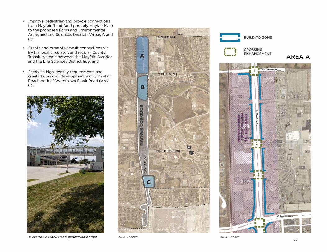
AREA A
Watertown Plank Road pedestrian bridge
• Improve pedestrian and bicycle connectionsfrom Mayfair Road (and possibly Mayfair Mall)to the proposed Parks and EnvironmentalAreas and Life Sciences District (Areas A andB);
• Create and promote transit connections viaBRT, a local circulator, and regular CountyTransit systems between the Mayfair Corridorand the Life Sciences District hub; and
• Establish high-density requirements andcreate two-sided development along MayfairRoad south of Watertown Plank Road (AreaC).
Source: GRAEF Source: GRAEF65

AREA B AREA C
Existing conditions on both sides of Mayfair Road contain large parking fields and a lack of pedestrian-friendly design elements. Future development should encourage minimal street setbacks along Mayfair Road. Additionally, the north edge of Wisconsin Avenue should provide a linear, tree-lined path connecting to existing parks and green space. The northeast corner of the intersection of Mayfair Road and Wisconsin Avenue could also include wayfinding signage that identifies the trail network within the planning area.
The City should facilitate new connections that could be developed primarily through the creation of above-grade crossings. Additionally, the City should work with WisDOT to provide improved access for pedestrians and cyclists along Mayfair Road, including beneath the freeway.
66
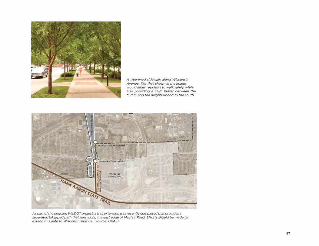
A tree-lined sidewalk along Wisconsin Avenue, like that shown in the image, would allow residents to walk safely while also providing a calm buffer between the MRMC and the neighborhood to the south.
As part of the ongoing WisDOT project, a trail extension was recently completed that provides a separated bike/ped path that runs along the east edge of Mayfair Road. Efforts should be made to extend this path to Wisconsin Avenue. Source: GRAEF
67

7Implementation
68

ACTIONS FOR IMPLEMENTATION
To grow a sustainable and resilient ecosystem for technological innovation, cutting-edge medicine, healthy living, and abundant access to green space, the Wauwatosa Life Sciences District is transforming into a mixed-use metropolitan center for the region. The build-out process will achieve this Plan’s goals by developing a cohesive district founded on cooperation, quality urban design principles, mixed uses, shared public places, and traffic demand management.
Implementation requires ongoing work by City staff, elected and appointed officials, various property owners, and other organizations in the community. Cooperation and collaboration between stakeholders will greatly increase the likelihood that tasks will be accomplished. While the City may initiate these tasks, substantive work may be conducted by other organizations. This chapter provides actions to realize concepts recommended in this Plan.
The City of Wauwatosa will adopt this Plan as part of the City of Wauwatosa Comprehensive Plan 2008-2030. The overarching goal is the creation of the Life Sciences District, which includes a mixture of institutional, residential, commercial, and environmental uses. The City should promote and initiate a collaborative implementation process in partnership with various property owners or entities and actively participate in a collaborative communication process to maintain effective communications with surrounding neighbors, landowners, and other key stakeholders. The first priority should be achieving the preservation in perpetuity of the parkland and natural areas to ensure those open spaces will be the foundation of the branding and unique amenity of the Wauwatosa Life Sciences District.
Implementation of this Plan is projected to occur over a 20-year period, and thus will not follow the precise patterns of physical diagrams. Rather, implementation will occur incrementally and this Plan presents a guide to help community leaders make strategic moves toward an end result. This Plan assumes that all of these places continue their present ownership, overall missions, associated operational policies and procedures, and routine operations.
69

This Plan intends to preserve and conserve the natural environment as identified in the Parks and Environmental Areas in the Framework Plan. This can be accomplished through the following actions that may be undertaken by the City, respective property owners, and/or Planning Area stakeholders:
1. Working to ensure that the natural features and environmental areas are preserved and protected in perpetuity through the use of land useregulations, conservation easements, deed restrictions, protective covenants, and/or development agreements.
2. Promoting the prominence and cultural/historical significance of the Parks and Environmental Areas and balancing environmental sustainability with
economic and social sustainability for both present and future users.
3. Supporting and/or promoting the creation of an overall management district or trust that includes existing owners and agencies to oversee opportunities
for more efficient management and more effective utilization of the environmental areas.
4. Estimating the costs and benefits of an historic preservation plan that would include preservation of the cultural aspects of the Parks and Environmental
Areas, and pursue funding opportunities.
5. Estimating the costs and benefits of a habitat restoration and reforestationplan that would address and improve sustainability and serve multipleenvironmental needs related to wildlife, plant life, social activities, andrelated environmental uses. This analysis should include the potential forshared land management operations with other organizations that couldreduce annual costs and increase efficiencies.
6. Identifying funding opportunities to preserve, conserve and enhancethe Parks and Environmental Areas, including creation of a moreprominent and visible park entry from Watertown Plank Road.
7. As identified by the SEWRPC memorandum dated October 26, 2017,ensuring that no building or development sites are located within theprimary environmental corridor and that development in critical specieshabitat and mature forest areas could be subject to State and Federalrestrictions.
ENVIRONMENT
70
TRANSPORTATIONThis Plan intends to foster multi-modal transportation options and improve circulation to lessen congestion and increase connectivity throughout the planning area as described in the Plan and/or illustrated on the Framework Plan. This can be accomplished through the following actions that may be undertaken by the City, respective property owners, and/or Planning Area stakeholders:
1. Continuing to work with property owners and stakeholders along with continued participation in the Regional Transportation Leadership Council (RTLC) tocoordinate the intended outcomes and impacts of new transit initiatives. Possible activities for this work include:
a. Planning for Phase 1 of Milwaukee County’s Bus Rapid Transit (BRT) initiative.b. Continuing planning for routing, management, and funding of a Tosa/MRMC Circulator System to enhance connectivity of nearby residential
areas, the UWM Innovation Campus, the MRMC campus, Mayfair Mall, and other commercial centers.c. Identifying locations for transfers between systems and upgrades to existing transit stops that offer end-of-trip facilities.
2. Coordinating phasing and linkages between large capital investments and mutually supporting investments and projects in the planning area, that mayinclude:
a. In conjunction with WisDOT, Milwaukee County, MRMC and MCRP, studying the potential construction of an east-west bridge over I-41/US45 to and from the MRMC campus and the MCRP.
b. In conjunction with property owners and other private entities, planning new and improved non-motorized bicycle/pedestrian facilities, includingconnections and crossings.
c. Constructing traffic calming improvements along major corridors and enhancing the road, pedestrian, and bike networks through theimplementation of the Framework Plan.
d. Planning for the construction of new City streets per the Framework Plan as development opportunities arise.
3. As part of the ongoing coordination and planning with local employers, the City should study concepts for a joint Intelligent Transportation Systems (ITS)plan including:
a. Installing signalization systems that support ITS.b. Developing a shared commuting intranet site for employees at the MRMC campus, the MCRP, and the UWM Innovation Campus to provide
commuter information, ride matching, performance tracking (transit ridership, parking utilization, bicycle use, etc.), trip planning, parkingmanagement, and revenue collection.
c. Monitoring changes and impacts to inform future actions, including the expansion of the commuting intranet site to include employees ofsurrounding commercial and retail outlets.
4. Considering the development of an area-wide parking district, in conjunction with other major users and parallel efforts— including major employers andresidential developments, that should include:
a. Evaluating multiple parking scenarios for mixed uses, including peak time usage, traffic generation, and the associated costs and benefits.b. Defining options for payment, cost sharing, and maximizing occupancy of parking facilities and deriving revenue from parking fees in locations
that support private sector development.c. Coordinating with parallel and overlapping projects, such as the Transportation Demand Management Plan at the MRMC.d. Estimating parking expansion costs and revenues, and ways in which parking programs and regulations can support the
implementation of Milwaukee County’s BRT initiative and connections to proposed Tosa/MRMC CirculatorSystem routes.
e. Supporting combined transportation demand management for the entire district that will optimize parking occupancy, increase non-motorizedcirculation, and act as an incentive for new property development.
71

LAND USE & DEVELOPMENTAdoption of the Wauwatosa Life Sciences District 2018-2038 Master Plan modifies the City of Wauwatosa Comprehensive Plan 2008-2030 Future Land
Use map according to the following maps:
Source: City of Wauwatosa
EXISTING FUTURE LAND USE MAP, 2008-2030 Comprehensive Plan
72

PROPOSED FUTURE LAND USE MAP, 2018-2038 Wauwatosa Life Sciences District Master Plan
Source: City of Wauwatosa
73

In addition, to realize the vision illustrated in the Framework Plan and reflect plan recommendations, the following land use related actions, to be primarily undertaken by the City, should occur:
1. Requesting and considering a land division and a zoning map amendment from Special Purpose District - Medical Center to Special Purpose
District -Conservancy for the non-park land owned by Milwaukee County to preserve and protect in perpetuity the Parks and Environmental
Areas as illustrated on the Framework Plan and Proposed Future Land Use Map.
2. Encouraging respective property owners within the Parks and Environmental areas to further protect and preserve the area through deed
restrictions, easements, and other more permanent actions.
3. Initiating zoning map and text amendments to establish the Mayfair Road Overlay District and applicable regulations for properties along Mayfair
Road.
4. Modifying zoning regulations, zoning districts, and other applicable regulations to encourage development that promotes economic activity andhigh-density development in appropriate locations and along new and existing street edges that may include:
a. Density and development minimums.b. Parking maximums and accommodations for shared parking and multi-modal options.c. Sustainability guidelines to promote best management practices for environmental, social, and economic sustainability.d. Infrastructure for circulation and utilities such as a complete street design approach for streets.e.f.
Maximum setbacks along street edges for any new buildings.Disincentivizing and/or prohibiting changes to current development that do not conform to the Framework Plan but that also respect theexisting property boundaries and ensure that plans do not require cooperation from owners who prefer not to be part of this Plan.
g. Providing economic incentives to participate in and support changes that fit the Framework Plan.
5. Continuing to stress the importance of linkages and integration of uses along the MRMC Campus perimeter including:a. Options for landscape and compatible neighborhood uses along the East Edge.b Traffic calming devices, improved crossings for pedestrians and cyclists, and streetscape along both sides of Watertown Plank Road.
c. Landscape and park-like features along Wisconsin Avenue that maintain the residential character of the neighborhood.d. Taller and more visible buildings along the freeway that create a strong contemporary skyline promoting the prominence of the Life
Sciences District.
6. Working jointly with property owners and lawmakers to find creative fundingsources as a method for making physical change in the planning area, asneeded.
7. Encouraging and working with property owners in the planning area to createdaytime and nighttime activation and coordinate skywalk development,specifically along Watertown Plank Road, to connect social places (i.e.,housing, employment centers, parks, plazas, and trails).
Working with property owners to modify applicable development restrictions to maximize development and redevelopment opportunities when and where appropriate.
8.
74
Working with propective developers to design new buildings with environmental sensitivity (including Dark Sky protocols, building materials, native landscaping, and stormwater management).
9.

10. Using the principles outlined in the 2004 Plan for the Milwaukee County Grounds Northeast Quadrant as a guide, ensure that futuredevelopment in the Northeast Quadrant is designed so as to preserve green spaces and protect natural areas; promote human-scaled,walk-able environment; and provide connections to the surrounding neighborhoods.
75
FRAMEWORK PLAN - Land Use and Road Network