2019 easement dedication packet - aurora, colorado · • lender signed subordination or affidavit...
TRANSCRIPT

Rev. 1/06/20
2020 EASEMENT DEDICATION PACKET
(INCLUDES PARCELS OF LAND, EASEMENTS, AND RIGHTS-OF-WAY FOR PUBLIC USE)
Information Packet
There are various situations in which easements, rights-of-way, and parcels of land may be dedicated to the City for public use. If a new subdivision plat is not being required, Real Property Services requires these dedications to be made to the City by separate conveyance document.
There is no processing fee or application form for dedications. You will, however, have to hire a surveyor (registered in Colorado) to prepare a legal description and illustration using our Property Description Specifications (included in this packet).
Real Property will also need information from the owner on the legal name of the entity making the dedication and their mortgage status, so that conveyance documents can be filled out correctly. We have provided an Ownership Information Sheet in this packet for the owner to fill in the required information. This information must be correct and current. If we cannot verify the ownership information provided, you may have to obtain a title commitment or title policy. Additionally, if the property is encumbered with a mortgage or deed of trust then a subordination agreement for easement dedications and/or a partial release of lien for fee dedications shall be provided.
If these dedications are on land that does not belong to this owner/developer (i.e. abutting parcel of land), it is the owner’s responsibility to acquire the easement or parcel for the City, pay any compensation, etc. The City will not participate in any negotiations or agreements.
This packet deals with dedications only. It contains the step-by-step process on how to do an easement or parcel of land dedication to the City of Aurora, the specifications for the description and illustration, examples of how those documents should be prepared, and everything else you’ll need to do your submittal. If you have questions after you’ve reviewed this packet, get in touch with Andy Niquette ([email protected]) in Real Property at 303-739-7300.
For additional information on easement releases, Revocable Licenses, subdivision plat checklists, and other items that Real Property works with click this link, Real Property webpage.
• REQUIRED ITEMS for Dedication submittals:
• Ownership Information Sheet completely and accurately filled out
• Lender signed subordination or affidavit of no lien form.
• Legal description prepared to Property Description Specifications
• Illustration prepared to Property Description Specifications
• Current Certificate of Taxes Due (if parcel of land or right-of-way)
• A Metes and Bounds closure sheet(s) for legal descriptions
• With Five (5) or more descriptions submitted – an overall AutoCAD drawing and a
computer files with all easements and/or parcels of land represented
• All required items should be submitted at the same time.
Rev. 1/06/20
STEPS FOR PROCESSING DEDICATIONS:
1. Review this packet then contact Andy Niquette ([email protected]) in Real Property Services at 303-739-7300 to discuss your particular situation and any questions you may have.
2. Hire a surveyor to prepare the legal description and illustration using the attached Property Description Specifications.
3. Obtain subordination agreement and/or partial release of lien from mortgage or deed of trust holder, if applicable.
4. Email or bring the legal description(s), illustration(s), *closure sheet(s), a PDF (overall view) or AutoCAD computer files with 5 or more submittals and Ownership Information Sheet to Real Property Services at 15151 E. Alameda Parkway, Suite 3218, Aurora, CO 80012-1555. We do not accept incomplete submittals. (Electronic submittals are acceptable) If parcels of land or rights-of-way are being dedicated in Fee Simple, we will also need a Certificate of Taxes Due. This may be obtained from the County Treasurer.
5. The information submitted will be reviewed and the surveyor will be contacted by email on any changes that must be made. This step continues until all documents are acceptable to Real Property.
6. Once the documents are acceptable, a conveyance document will be prepared that will legally dedicate the easement and/or parcel to the City and the description and illustration will be attached.
7. The conveyance document, description and illustration are routed to various City staff for review and approval. If changes are asked for from the review staff, Real Property will get back in touch with the contact person.
8. Once the conveyance documents have routed and been approved by the City, Real Property will return them to the contact person to obtain the property owner’s signature. The document must be signed by the property owner, notarized, and returned to Real Property.
9. When completed, Real Property will send the conveyance documents to the county to be recorded.
From the time Real Property receives the original submittal, it usually takes 4-6 weeks to complete the process. The majority of that time period depends on how quickly the changes can be done, items corrected and returned to Real Property, the length of time it takes to obtain the owner’s signature, etc. Building permits cannot be signed until the documents are ready to record, nor will Real Property record any related site plans or subdivision plats.
* Closure sheets and AutoCAD computer files requirement is new. Due to the large number
of plats and separate documents for developing areas in the City of Aurora

Rev. 1/06/20
PROPERTY DESCRIPTION SPECIFICATIONS (See Example of Legal Description)
Descriptions submitted to the Real Property Services Division will not be accepted unless prepared by a professional land surveyor registered in the State of Colorado, and shall conform to the following required criteria:
1. Submit an original typewritten legal description on letter size plain white paper (8.5” x 11”).
Electronic submittals of PDF’s are acceptable. No paper with company logos will be accepted. 2. Each description must have an introduction which states the existing use of the property described, the location of the property, (Section, Township, Range, P.M.), and the subdivision name and filing number, if applicable. ***Samples are provided in this packet.***
3. The body of the description must contain sufficient information to avoid any ambiguities or the necessity for assumptions.
4. The description must close mathematically with a ratio of closure of at least 1’:10,000’. Distances should be represented in “U.S. survey feet.”
5. The point of beginning must be tied to an established land corner or to a point identifiable on a
recorded subdivision plat.
6. Metes and bounds descriptions are preferred whenever possible. Centerline descriptions will be accepted only when:
A. The point of beginning and the point of terminus are described in the text and are tied to independent control points.
B. The land described is uniform in width (from the described centerline) throughout its entire
length.
C. The sidelines of the land described are at all points parallel with the described centerline.
D. Land (or easement) descriptions that deviate from any of the foregoing conditions must be written in a metes and bounds format.
7. The area shall be expressed in square feet and acres.
8. Each description shall be signed and sealed in accordance with C.R.S. 12-25- 217(2) which presently states:
“All documents, plats, and reports resulting from the practice of land surveying shall be identified with and bear the seal or exact copy thereof, signature, and date of signature of the land surveyor in responsible charge."
9. Each description shall have a heading similar to “Exhibit A”. With the subsequent descriptions to be consecutively lettered Exhibits. (Example: Exhibit A, Exhibit B, Exhibit C, etc.)

Rev. 1/06/20
ILLUSTRATION SPECIFICATIONS (See Illustration for Exhibit A as an example)
An illustration shall accompany each property description conforming to the following format:
1. A computer generated and plotted representation done according to the example. A paper drawing in ink is also acceptable.
2. Lettering to be “AutoCAD,” Leroy or professional grade lettering.
3. Size is to be 8.5” x 11”. Please note the County margin spaces
4. The following disclaimer statement must appear on each exhibit:
"THIS ILLUSTRATION DOES NOT REPRESENT A MONUMENTED
SURVEY. IT IS INTENDED ONLY TO DEPICT THE ATTACHED
DESCRIPTION."
5. The heading at the top of the sheet should read “Illustration for Exhibit ___ ” (insert letter).
6. A City of Aurora title block should be at the bottom of each
Illustration. Below is a sample.
For the AutoCAD – COA Title Block Drawing, “Double Click” on the PDF
attachment folder for a Blank Illustration layout or find the link on the Real
Property webpage.
7. Bearings, distances, and curve data should be shown on the illustration and should match the legal description.
8. Show a bar and ratio scale and north arrow.
9. Label all street names and alleys.
10. Name and address of owner.
11. Label the lot and block numbers and the subdivision plat names and filing numbers.
12. Each illustration shall be signed and sealed in accordance with C.R.S. 12-25-217(2) which presently states:
"All documents, plats, and reports resulting from the practice of land surveying shall be identified with and bear the seal or exact copy thereof, signature, and date of signature of the land surveyor in responsible charge."

Rev. 1/06/20
INTRODUCTORY PARAGRAPH SAMPLES (See Exhibit A)
The following are examples of typical introduction paragraphs for the legal descriptions. A. UTILITY EASEMENTS (which include all easements for water, sanitary and storm sewer
lines, fire hydrants, and water meters) - A utility easement, 16.00 feet wide, situated in the NW 1/4 of Section 12, T4S, R67W of the 6th P.M., Arapahoe County, Colorado, being a part of Lot 1, Block 1, XYZ Subdivision Filing No. 1, more particularly described as follows:
B. FIRE LANE EASEMENTS - A fire lane easement, 26.00 feet wide, situated in the NW 1/4 of Section 12, T4S, R67W of the 6th P.M., Arapahoe County, Colorado, being a part of Lot 1, Block 1, XYZ Subdivision Filing No. 1, more particularly described as follows:
C. FIRE LANE AND UTILITY EASEMENTS - A fire lane and utility easement, 26.00 feet wide, situated in the NW 1/4 of Section 12, T4S, R67W of the 6th P.M., Arapahoe County, Colorado, being a part of Lot 1, Block 1, XYZ Subdivision Filing No. 1, more particularly described as follows:
D. SIDEWALK EASEMENTS (which includes all Handicapped Ramps and sidewalks) - A
sidewalk easement, 5.00 feet wide, situated in the NW 1/4 of Section 12, T4S, R67W of the 6th P.M., Arapahoe County, Colorado, being a part of Lot 1, Block 1, XYZ Subdivision Filing No. 1, more particularly described as follows:
E. RIGHT-OF-WAY AND OTHER PUBLIC USE PARCELS (streets, lot corner radii, and other
parcels for public use) - A parcel of land 55.00 feet wide, situated in the NW 1/4 of Section 12, T4S, R67W of the 6th P.M., Arapahoe County, Colorado, being a part of Lot 1, Block 1, XYZ Subdivision Filing No. 1, more particularly described as follows:
F. CENTERLINE DESCRIPTIONS - A utility easement 16.00 feet wide, situated in the NW 1/4 of Section 26, T4S, R66W of the 6th P.M., Arapahoe County, Colorado, being a part of Lot 1, Block 1, XYZ Subdivision Filing No. 1, being 8.00 feet on each side of the following described centerline:

Rev. 1/06/20

Rev. 1/06/20

Rev. 1/06/20
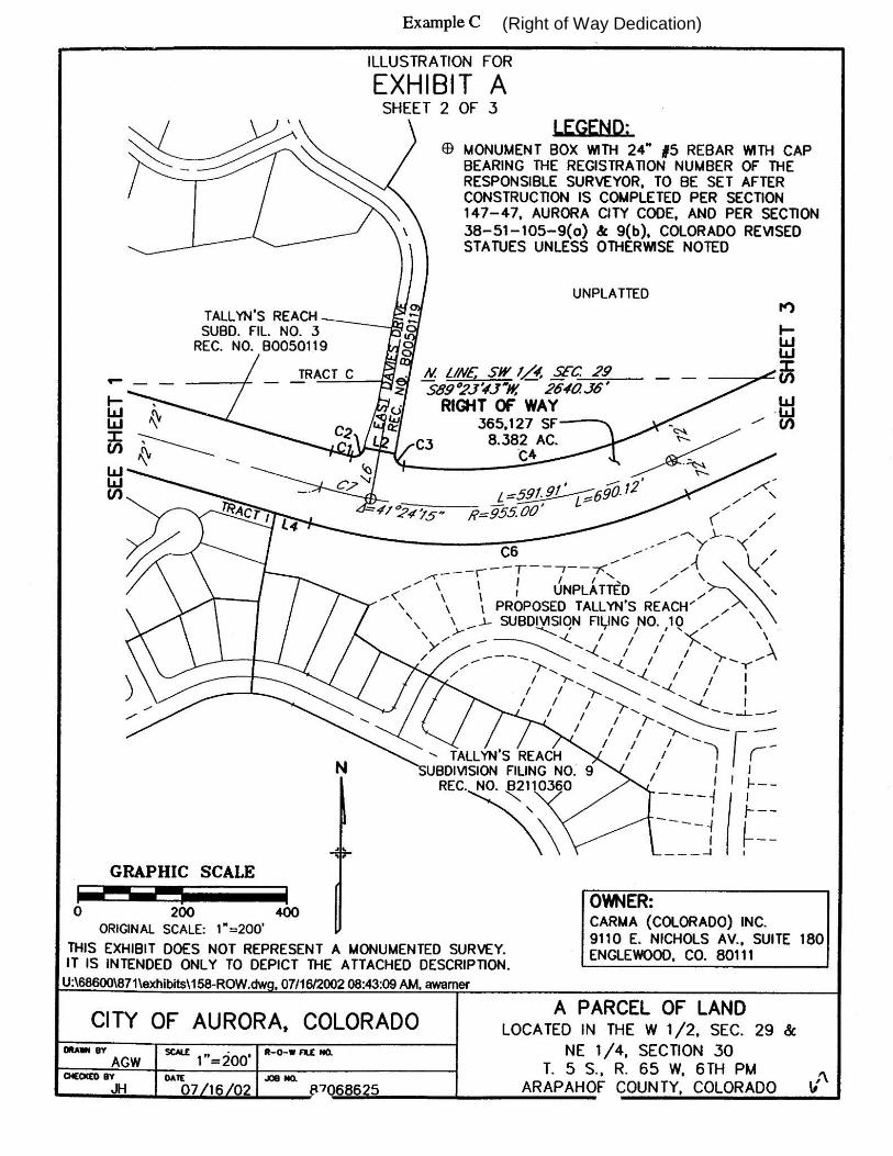
REQUIRED MONUMENTATION FOR RIGHTS-OF-WAY DEDICATED BY
SEPARATE DOCUMENT
(See Example C)
Monuments shall be physically placed in the field at:
- Street intersections
- Cul-de-sac radius points
- Points of curve, tangency where necessary to preserve a line of sight
between proposed street centerline monuments (excluding minor tracts)
need to show the appropriate centerline bearings, distances, and curve
data
- Other points as may be determined by the City Engineer or designee
An Illustration shall be prepared using the above Illustration Specifications. In
addition to those specifications, add the following:
- Legend identifying symbol for monument box
- Symbol identifying locations of monument box
- Note added to legend symbol used for monument boxes:
38-51-105-9(a & b) Colorado Revised Statutes
(9) (a) The top of the monument for any corner required by this section which is within the traffic area of a publicly named dedicated or deeded street, road, or highway shall be placed one-half foot below the roadway surface.
(b) If the roadway surface is pavement two inches thick or greater, the monument shall include a monument box the top of which shall be set flush with the surface of the pavement
These monument boxes are considered a public improvement and must be
identified in the civil engineering drawings (contact the Engineering Dept. for
additional information).
The process for determining the location of the monument boxes will be consistent with the line of sight method. Current practice requires this type of monumentation of the centerline of street rights-of-way that are within the boundaries of a new subdivision plat.
Rev. 1/06/20
(Right of Way Dedication)

Rev. 1/06/20
Legal Description and Illustration Check List (FOR SURVEYOR’S USE)
1. General Format:
a. 8” x 11” size plain white paper: New page margin changes
b. Original document
c. Exhibit (insert letter) at top of the page margin
d. No company logo or title blocks on document
2. Introduction or Preamble:
a. Intended use (i.e. type of easement, parcel of land, etc.)
b. Section, Township, Range designations
c. Lot, Block numbers and subdivision plat name and filing No. (if applicable)
d. Related reception or books and pages noted
3. Body:
a. Metes and Bounds Descriptions
1. Tied out (i.e. subdivision plat or section corner)
2. Fits other related documents (i.e. plats or recorded separate document dedications)
3. Coordinate configuration with the affected departments
4. Use passing calls to clarify points
(Example: Thence N 45°15’ 36” E a distance of 154.89 feet to a point on the southerly line of that utility
easement recorded in Adams County, Colorado in Book 2642 at Page 269.)
5. Point of Commencement identified
6. Point of Beginning identified
7. Closure check to (1’: 10,000’ratio)
8. Distances represented in U.S. survey feet
9. Area stated (square footage and acreage)
b. Centerline Descriptions
1. Point of Commencement identified
2. Point of Beginning identified and tied to independent control point
3. Point of Terminus identified and tied to independent control point
4. Fits other related documents
5. Area stated (square footage and acreage)
c. Would you like to add a Basis of Bearing Statement?
d. Seal of Surveyor
1. Signature and Date through the seal
Illustration for the Exhibit
1. 8” x 11” size plain paper: see County page margin requirements
2. Title: “Illustration for Exhibit (Insert the exhibit letter)”
3. Disclaimer Statement: “This illustration does not represent…”
4. City of Aurora Title Block
5. All bearings and distances with areas agrees with description
6. Scale ratio correct (with Bar Scale added)
7. North arrow
8. Names of lots, blocks and subdivision plats affected
9. Street names correct
10. Name (s) & Address (es) of the owner(s) of the property
“Double Click” on the attachment folder for the AutoCAD Drawing for the Blank Illustration – COA Title Block

Rev. 1/06/20
Is there a mortgage or Deed of Trust?
❑ Yes, a Subordination statement will be submitted.
❑ No, an Affidavit of no mortgage will be submitted.

Rev. 1/06/20
CONSENT AND SUBORDINATION OF MORTGAGE
Whereas, INSERT BORROWER'S INFO, as the Grantor, by its Deed of Trust dated INSERT MONTH DAY
YEAR, and recorded on INSERT MONTH DAY YEAR, in the clerk and recorder's office in and for the County of
INSERT COUNTY and State of Colorado at Reception/Book/Page Number INSERT RECORDING INFORMATION
(“Deed of Trust”), conveyed to the INSERT LENDER'S NAME (the “Lender”), as TRUSTEE/BENEFICIARY, the
property in said Deed of Trust, to secure to the Lender the payment of a certain note described in the Deed of Trust;
and
NOW, THEREFORE, for good and valuable consideration paid to all parties to this agreement by the other
parties hereto, the receipt and sufficiency of which are hereby acknowledged; the Lender does hereby agree
and declare that the Deed of Trust, and all extensions and renewals thereof, shall be, and hereby is made
subordinate, subject and inferior to the following easement(s):
1. ______________ Easement recorded at Reception Number _____________ in the Clerk and Recorders
office of ____________ County, State of Colorado.
IN WITNESS WHEREOF, the Lender has executed these presents as of ______________ ___, 20____.
LENDER NAME
By: _________________________________
Name: ________________________________
Title:
STATE OF ________________ )
)
COUNTY OF ______________ )
On this ____ day of ______________________, 20____, before me, a Notary Public, in and for said state,
personally appeared ___________________, its __________________, known to me to be the person who executed
the Consent and Subordination of Mortgage on behalf of ____________________, a ____________________, and
acknowledged to me that he/she executed the same for the purposes herein stated.
IN WITNESS WHEREOF, I have hereunto set my hand and affixed my official seal in the County and State
aforesaid, the day and year first above written.
My term expires: Notary Public

Rev. 1/06/20
AFFIDAVIT OF NO MORTGAGE OR DEED OF TRUST
Each for Himself and or Herself, declare: That to my/our personal knowledge there are NO
encumbrances in the form of a Mortgage or Deed of Trust against the property identified below.
That this declaration is made for the protection of all parties to this transaction, and particularly for the
benefit of the City of Aurora, Colorado, which is about to accept Choose an item. in reliance thereon.
That I/We will testify, declare, depose, or certify before any competent tribunal, officer, or person, in
any case now pending or which may hereafter be instituted, to the truth of particular facts hereinabove
set forth.
PROPERTY
ADDRESS:
LEGAL
DESCRIPTION:
OWNER(S):
Owner 1 Name Owner 2 Name
State of )
) §
County of )
The foregoing instrument was acknowledged before me this _______day of __________________, 20__, by
__________________ as ______________________ of ________________________________.
Witness my hand and official seal.
My commission expires: _________________
SEAL
_____________________________
Notary Public