2020 year end program report - uploads-ssl.webflow.com
TRANSCRIPT
1
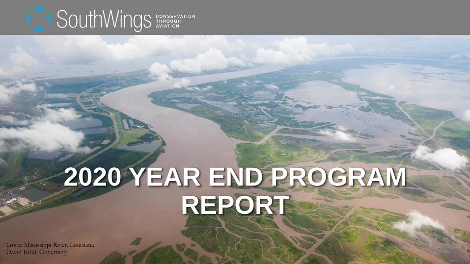
2020 YEAR END PROGRAM REPORT
Lower Mississippi River, LouisianaDavid Kidd, Governing

After completing one of our most successful years ever in 2019, at the beginning of 2020 SouthWings waspoised for another banner year. Unfortunately, the pandemic required us to adapt our operating model toarranging pilot-only flights on behalf of partner organizations. This model aided our partners’ legal work,surveillance of environmental issues, and media exposure. Our program staff focused on maintaining andreinforcing the flight partnerships we’ve built and the relationships with the committed volunteer pilots who makeour work possible. When the conditions are right, we’re ready to pick up right where we left off.
This report describes what SouthWings accomplished during 2020 and the ways we adapted to thesechallenging times. While our flight numbers were reduced, our long-standing work across the region continued tobear fruit. As pilot-only flying is most effective for monitoring purposes, this year 72% of flights supportedpartners’ work to protect communities and ecosystems through regulatory enforcement; this included 5 post-storm flights to monitor environmental damage and pollution in the aftermath of Hurricanes Laura, Sally, Delta,and Zeta. Across our region, we have been able to meet nearly all of the need that our established partners havefor pilot-only flights, enabling us to continue supporting our partners’ important work while we all wait for thisstorm to pass. As of September 2020, 43 volunteer pilots across the region were standing by to take pilot-onlymissions. As I begin my first few weeks serving as Executive Director, I’m heartened that the commitment of ourvolunteer pilots and supporters remains as strong as I’ve ever seen it in my 13 years with SouthWings.
2SouthWings
A message from our Executive Director
Real life experiences simply cannot be replaced, as so many of us have learned as we’ve attempted to live viavideoconference due to the pandemic. It’s just not the same. Fortunately, we have a sound financial position anda Board of Directors, staff, and volunteers who are deeply committed to our mission. I’m confident thatSouthWings will emerge intact on the other side of this pandemic and grateful to all who make our work possible.
Meredith DowlingExecutive Director
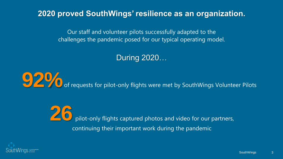
2020 proved SouthWings’ resilience as an organization.
Our staff and volunteer pilots successfully adapted to the
challenges the pandemic posed for our typical operating model.
During 2020…
3SouthWings
26 pilot-only flights captured photos and video for our partners,
continuing their important work during the pandemic
92% of requests for pilot-only flights were met by SouthWings Volunteer Pilots

A2A 28 (52%)
Chesapeake6 (11%)
Gulf 20 (37%)
42018 Year End Flight Operations Report
2020 Completed Flights by Program and State
LA
14
MS
1
AL
4
GA
6
KY
0
TN
0
NC
17
SC
3
FL
1
VA
2
DE
1
PA
4
WV
0
54
Completed
Flights
MD
1

Flights are designed to uncover environmental challenges and inspire lasting solutions. In 2020 SouthWings collaborated with our partners on a wide range of environmental issues, most often focusing on:
52%Watershed Protection
39%Holding Polluters Accountable
24%Oil Industry Pollution
10%Ecosystem Restoration
24%Monitoring CAFOs (Concentrated Animal Feeding Operations)
19%Cleaning Up Coal Ash
13%Restoring the Mississippi River
24%Solving the Climate Crisis
20%Wetland Protection
5

Federal permit suspended for controversial 'Cancer Alley' plastics plant
Atlantic Coast Pipeline Canceled as Delays and Costs Mount
Board denies controversial plan to put luxury ‘ecotourism’ resort on SC barrier
island
Leak in barge barrier leads to fuel sheen on East River
County launches project to bring clean water to Juliette residents
Trump rule eases effort to strip-mine near Okefenokee Swamp
June spill at New Orleans East oil terminal still being cleaned up
Hurricane Laura Causes Wetland Pollution
2020 Media Pieces Informed by SouthWings Flights
38
APPALACHIA TO ATLANTIC
© Jake Faber, SouthWings

North CarolinaSouthWings arranged 28 flights in North Carolina this year, eight withpassengers and nine as pilot-only, passenger-less flights. Eleven flightswere cancelled, mostly due to COVID-19. The total number of passengerscarried in North Carolina this year was 14. When the pandemic made it nolonger an option to carry passengers, SouthWings adapted and turned ourfocus to pilot-only flying to capture the aerial footage that helps ourpartners bring awareness to the issues they are working on. 2020 has alsobrought with it the necessity to attend virtual public hearings and townhalls, as it remains unsafe to participate in person. We are also taking thistime to firm up our foundation, strengthen and expand our network ofpartners, and ensure that everyone has access to the tool of flight.
In North Carolina, SouthWings flights continue to support our WaterkeeperAlliance partners in monitoring pollution threats from Concentrated AnimalFeeding Operations (CAFOs) around the state. The Cape Fear,Waccamaw, Yadkin, Haw, Catawba, and Broad Riverkeepers all flewthis year, continuing the established routine over the past year to providecontinuity in documenting violations to state regulators.
The A2A region spans five states, encompassing some of the most varied landscapes in the Southeast. From the scenic Blue Ridge Mountains to the historic Sea Islands of the Lowcountry, this region includes some of the most biologically diverse ecosystems as well as some of the fastest-growing cities in the country. Our volunteers in the A2A region support our partners in monitoring ongoing pollution concerns from coal ash and agricultural waste, advocating for the protection of wildlife habitat and cultural heritage sites, and educating decision-makers and the public about key issues facing communities across the region.
8SouthWings
Cara Schildtknecht (Waccamaw Riverkeeper) identifies a spraying violation on her flight with Volunteer Pilot Art Falk.
“We had a great flight! I was checking on some sites where I had begun sampling in Brunswick and Columbus counties.We observed a facility - not originally on our flight plan - with some spraying violations. They were spraying on fields thatwere already waterlogged and there was evidence of pooling on the spray fields. We reported the issue to DEQ.”
– Cara Schildtknecht, Waccamaw RiverKeeper
9SouthWings
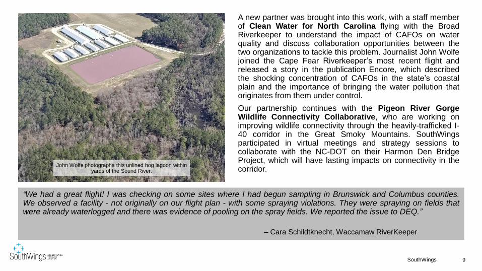
A new partner was brought into this work, with a staff memberof Clean Water for North Carolina flying with the BroadRiverkeeper to understand the impact of CAFOs on waterquality and discuss collaboration opportunities between thetwo organizations to tackle this problem. Journalist John Wolfejoined the Cape Fear Riverkeeper’s most recent flight andreleased a story in the publication Encore, which describedthe shocking concentration of CAFOs in the state’s coastalplain and the importance of bringing the water pollution thatoriginates from them under control.
Our partnership continues with the Pigeon River GorgeWildlife Connectivity Collaborative, who are working onimproving wildlife connectivity through the heavily-trafficked I-40 corridor in the Great Smoky Mountains. SouthWingsparticipated in virtual meetings and strategy sessions tocollaborate with the NC-DOT on their Harmon Den BridgeProject, which will have lasting impacts on connectivity in thecorridor.
John Wolfe photographs this unlined hog lagoon within yards of the Sound River.
10SouthWings
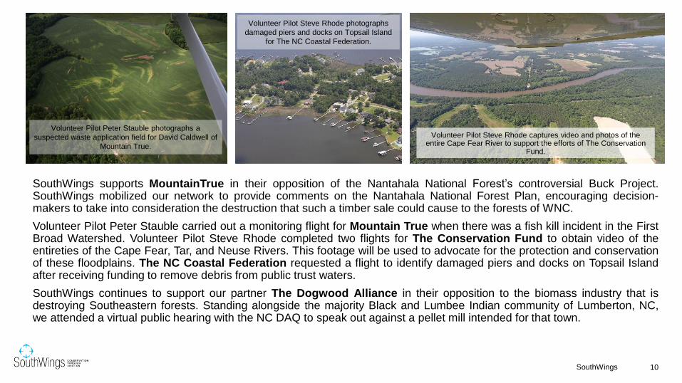
SouthWings supports MountainTrue in their opposition of the Nantahala National Forest’s controversial Buck Project.SouthWings mobilized our network to provide comments on the Nantahala National Forest Plan, encouraging decision-makers to take into consideration the destruction that such a timber sale could cause to the forests of WNC.
Volunteer Pilot Peter Stauble carried out a monitoring flight for Mountain True when there was a fish kill incident in the FirstBroad Watershed. Volunteer Pilot Steve Rhode completed two flights for The Conservation Fund to obtain video of theentireties of the Cape Fear, Tar, and Neuse Rivers. This footage will be used to advocate for the protection and conservationof these floodplains. The NC Coastal Federation requested a flight to identify damaged piers and docks on Topsail Islandafter receiving funding to remove debris from public trust waters.
SouthWings continues to support our partner The Dogwood Alliance in their opposition to the biomass industry that isdestroying Southeastern forests. Standing alongside the majority Black and Lumbee Indian community of Lumberton, NC,we attended a virtual public hearing with the NC DAQ to speak out against a pellet mill intended for that town.
Volunteer Pilot Art Falk returns from a flight with Kemp Burdette of Cape Fear River Watch and Gen. Stephen
Cheney of the American Security Project.
Volunteer Pilot Peter Stauble photographs a
suspected waste application field for David Caldwell of
Mountain True.
Volunteer Pilot Steve Rhode captures video and photos of the entire Cape Fear River to support the efforts of The Conservation
Fund.
Volunteer Pilot Steve Rhode photographs
damaged piers and docks on Topsail Island
for The NC Coastal Federation.

After Tropical Storm Isaias, Cape Fear RiverWatch took a flight, adhering to strict COVID-19precautions, to monitor hog CAFO lagoonsoverflowing due to major rains from the storm.
In Vance County, residents and environmentalgroups are coming together in opposition to a LandClearing and Inert Debris Landfill (LCID) that isproposed to be constructed on steep forested landwithin a half mile of 60 homes and dangerouslyclose to Long Creek, a tributary of the Tar River.Sound Rivers requested SouthWings’ help withcapturing photos of the proposed site to be used astestimony in front of the Vance County Board ofAdjustment about the potential environmentalimpacts of the LCID. Volunteer Pilot Steve Rhodewas able to take flight and capture incredibly usefulphotos and video to help Sound Rivers’ case. TheBoard will rule on the proposal in early 2021.
“The photos were super helpful for me to get a sense of what the entire property looked like, as well as sending to others involved who were not familiar with the area. We were able to get an attorney for some of the adjacent neighbors, as well as experts to testify, and pulled together a pretty good case in opposition.”
-Jill Howell, Pamlico-Tar Riverkeeper (Sound Rivers)
11SouthWings
Steve Rhode captures the site of a proposed landfill in Kittrell, Vance County NC.
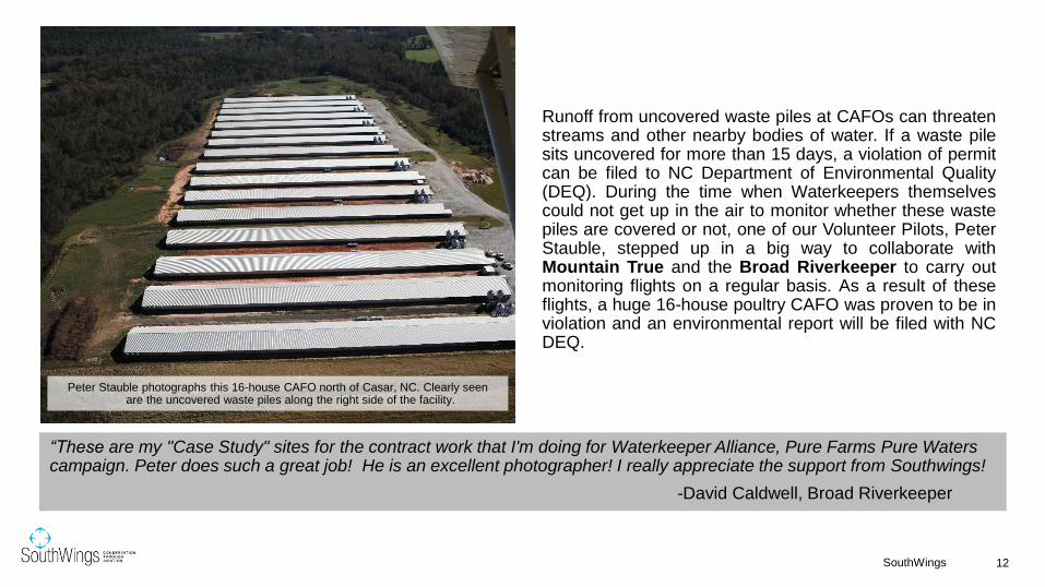
Runoff from uncovered waste piles at CAFOs can threatenstreams and other nearby bodies of water. If a waste pilesits uncovered for more than 15 days, a violation of permitcan be filed to NC Department of Environmental Quality(DEQ). During the time when Waterkeepers themselvescould not get up in the air to monitor whether these wastepiles are covered or not, one of our Volunteer Pilots, PeterStauble, stepped up in a big way to collaborate withMountain True and the Broad Riverkeeper to carry outmonitoring flights on a regular basis. As a result of theseflights, a huge 16-house poultry CAFO was proven to be inviolation and an environmental report will be filed with NCDEQ.
“These are my "Case Study" sites for the contract work that I'm doing for Waterkeeper Alliance, Pure Farms Pure Waters campaign. Peter does such a great job! He is an excellent photographer! I really appreciate the support from Southwings!
-David Caldwell, Broad Riverkeeper
12SouthWings
Peter Stauble photographs this 16-house CAFO north of Casar, NC. Clearly seen are the uncovered waste piles along the right side of the facility.

Elsewhere in the state, Cape Fear River Watch flew multipletimes to monitor CAFOs’ compliance with permits. During thisseries of flights, several violations were reported to DEQ,including one CAFO that was spreading sludge on its fields.During one flight in particular, a CAFO was observed sprayinghog waste directly into a ditch that led to a tributary of GreatCoharie Creek. This was reported to the Division of WaterResources, who received the referral and were on-site that day toassess the situation.
"Flying is the only way to see what goes on at the majority of CAFOs in the Cape Fear Watershed. Seeing the extent and concentration of these facilities from the air you can really understand how they have such an enormous negative impact on water quality in the basin. We made several referrals to DEQ using photos from the flight. Bill Kahn is amazing. He is such a professional pilot and so fun to fly with. “
-Kemp Burdette, Cape Fear Riverkeeper
13SouthWings
Cape Fear River Watch documents waste being sprayed into a ditch that led to a tributary of Great Coharie Creek on a CAFO
monitoring flight.

South CarolinaSouthWings’ work in South Carolina has continuedin 2020, with three flights in this state. One flightcarried one passenger before the pandemic hit andtwo flights were pilot-only. One flight was arrangedbut cancelled. Save Our Saluda took their secondflight with SouthWings monitoring coal ash cleanup,deforestation, cover crop usage, and waterpollution concerns around the Upstate.
Queen Quet, the Chieftess of the Gullah/GeecheeNation completed a documentary highlighting theGullah/Geechee Fishing Association, usingseveral photos and information obtained during herSouthWings flight last year.
14SouthWings
Melanie Ruhlman (Save Our Saluda) and Volunteer Pilot Woody Beck prepare for their flight to monitor the Saluda
River Watershed on February 23 (pre-pandemic).
“Seeing the entire watershed from the air is very different from looking at a map and really helps to drive home theimportance of protecting what we have left. We are in one of the most rapidly developing areas of the country. Greatexperience, great program, great pilots. THANK YOU!!”
– Melanie Ruhlman, Save Our Saluda
15SouthWings
A still from Queet Quet’s 2020 documentary, “Gwine Fishin”, taken on SouthWings flight with Volunteer Pilot Art Falk.
Credit: Queen Quet.Volunteer Pilot Jon Engle photographs Crab Bank for Audubon
South Carolina’s habitat restoration work on the islet.
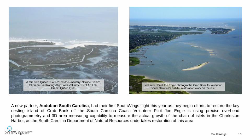
A new partner, Audubon South Carolina, had their first SouthWings flight this year as they begin efforts to restore the key
nesting island of Crab Bank off the South Carolina Coast. Volunteer Pilot Jon Engle is using precise overhead
photogrammetry and 3D area measuring capability to measure the actual growth of the chain of islets in the Charleston
Harbor, as the South Carolina Department of Natural Resources undertakes restoration of this area.

In Greenwood, an Enviva pellet mill isapplying for an expansion permit whichwould increase their production capacity to660,000 tons per year, also increasing theacres of Southern forests destroyed per yearand the amount of carbon emissions.Volunteer Pilot Peter Stauble took photos ofthe plant that showed an unusually highnumber of 26 full logging trucks waiting to beunloaded. The photos were passed along tothe Dogwood Alliance who is fightingagainst this expansion permit.
“We are building an international database of photos on bioenergy, and these are perfect to include! We keep hearing from EU bioenergy apologists that they keep seeing the "same four photos" of clear cut logging from Dogwood, so new photos would be really helpful.”
- Mary Booth, Partnership for Policy Integrity
16SouthWings
VP Peter Stauble captures activity at the Enviva Pellet Mill.
GeorgiaNine flights were arranged in Georgia this year. Three of these flights carried a total of four passengers and two flights were pilot-only. Four flights were cancelled, mostly due to COVID-19.
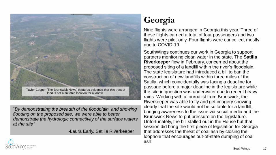
SouthWings continues our work in Georgia to support partners monitoring clean water in the state. The Satilla Riverkeeper flew in February, concerned about the proposed siting of a landfill within the river’s floodplain. The state legislature had introduced a bill to ban the construction of new landfills within three miles of the Satilla, which coincidentally was facing a deadline for passage before a major deadline in the legislature while the site in question was underwater due to recent heavy rains. Working with a journalist from Brunswick, the Riverkeeper was able to fly and get imagery showing clearly that the site would not be suitable for a landfill, bringing awareness to the issue via social media and the Brunswick News to put pressure on the legislature. Unfortunately, the bill stalled out in the House but that session did bring the first piece of legislation for Georgia that addresses the threat of coal ash by closing the loophole that encourages out-of-state dumping of coal ash.
17SouthWings
Taylor Cooper (The Brunswick News) captures evidence that this tract of land is not a suitable location for a landfill.
“By demonstrating the breadth of the floodplain, and showing flooding on the proposed site, we were able to better demonstrate the hydrologic connectivity of the surface waters at the site”
-Laura Early, Satilla Riverkeeper
18SouthWings
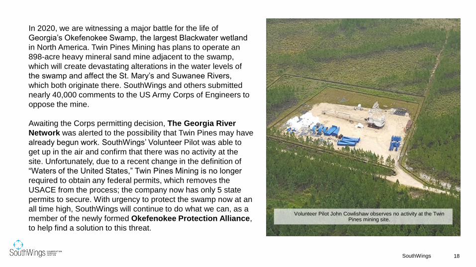
In 2020, we are witnessing a major battle for the life of
Georgia’s Okefenokee Swamp, the largest Blackwater wetland
in North America. Twin Pines Mining has plans to operate an
898-acre heavy mineral sand mine adjacent to the swamp,
which will create devastating alterations in the water levels of
the swamp and affect the St. Mary’s and Suwanee Rivers,
which both originate there. SouthWings and others submitted
nearly 40,000 comments to the US Army Corps of Engineers to
oppose the mine.
Awaiting the Corps permitting decision, The Georgia River
Network was alerted to the possibility that Twin Pines may have
already begun work. SouthWings’ Volunteer Pilot was able to
get up in the air and confirm that there was no activity at the
site. Unfortunately, due to a recent change in the definition of
“Waters of the United States,” Twin Pines Mining is no longer
required to obtain any federal permits, which removes the
USACE from the process; the company now has only 5 state
permits to secure. With urgency to protect the swamp now at an
all time high, SouthWings will continue to do what we can, as a
member of the newly formed Okefenokee Protection Alliance,
to help find a solution to this threat.
Volunteer Pilot John Cowlishaw observes no activity at the Twin Pines mining site.
19SouthWings
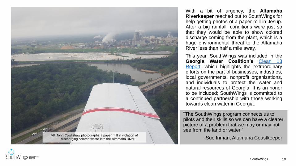
With a bit of urgency, the AltamahaRiverkeeper reached out to SouthWings forhelp getting photos of a paper mill in Jesup.After a big rainfall, conditions were just sothat they would be able to show coloreddischarge coming from the plant, which is ahuge environmental threat to the AltamahaRiver less than half a mile away.
This year, SouthWings was included in theGeorgia Water Coalition’s Clean 13Report, which highlights the extraordinaryefforts on the part of businesses, industries,local governments, nonprofit organizations,and individuals to protect the water andnatural resources of Georgia. It is an honorto be included; SouthWings is committed toa continued partnership with those workingtowards clean water in Georgia.
VP John Cowlishaw photographs a paper mill in violation of discharging colored waste into the Altamaha River.
“The SouthWings program connects us to pilots and their skills so we can have a clearer picture of a problem that we may or may not see from the land or water.”
-Sue Inman, Altamaha Coastkeeper

20SouthWings
Altamaha Coastkeeper Sue Inman and VP John Cowlishaw masked up and ready to fly.
The Altamaha River was again imperiled in November when a shrimp boatcrashed into Wolf Island Bar, a National Wildlife Refuge at the mouth of the river.The Altamaha Coastkeeper flew to survey the impacts of the oil spill andidentify areas that need to be protected by the Georgia Department of NaturalResources. Luckily no significant oil sheen was spotted. This flight also includeda fly over of the capsized Golden Ray cargo ship, which finally began cuttingoperations after more than a year of sitting in St. Simon’s Sound. Small oilsheens have been reported. Some oil has reached the beach, along with foam,fiberglass, and a few car bumpers.
A shrimp boat run aground on Wolf Island Bar National Wildlife Refuge.
The Golden Ray cargo ship with the VB 10,000 crane surrounding it and the Environmental Protection barrier circling the wreck site. Seven cuts will be made and each piece lifted onto a barge and
taken to a facility for further recycling and reclamation.

Tennessee & West Virginia
While SouthWings volunteers have not flown any flights inTennessee or West Virginia this year, we continue to support ourpartners’ conservation efforts in these states. One flight wasarranged in West Virginia, but ended up getting cancelled due toCOVID-19. After flying with SouthWings last year, the UnitedMethodist New Service published their story this year on how theMountain Valley Pipeline has devastated lands in West Virginia.
The Atlantic Coast Pipeline, a similar 600-mile natural gas pipeline,saw its end this year when, faced with mounting legal battles andfees, Dominion and Duke Energy decided not to move forward withthe project. This pipeline, which would have started in West Virginia,has been a subject of several SouthWings volunteer flights over thepast few years. We will continue to support our partners seekingrestoration of these areas.
“In our mission to show the impact of hydraulic fracturing, the aerial views afforded by our flight were invaluable for putting things in context and very moving for me. Seeing the beautiful mountains of West Virginia criss-crossed by pipeline rights of way and drilling pads was very moving for me and I hope to be able to convey this to our readers.”
-Mike DuBose, United Methodist News Service
21SouthWings
Volunteer Pilot Scott Simonton flies reporters from the United Methodist News Service to observe the effects of the
Mountain Valley Pipeline on the landscape of West Virginia. Credit: Mike DuBose

CHESAPEAKE BAY
Madison County, VirginiaWill Parson, Chesapeake Bay Program

VirginiaSeven flights were arranged in Virginia this year. Two flightscarried a total of four passengers, and one flight was pilot-only.Four flights were cancelled due to COVID-19.
Dogwood Alliance’s January wood pellet investigation innortheastern North Carolina and southeastern Virginia allowed ourpartners to use aerial surveillance to document fresh clear cutswithin the sourcing radius of two wood pellet manufacturingfacilities, which provide biomass fuel to overseas power plants. Byidentifying these clear cuts from the air, our partners were able toconduct on-the-ground follow-up to confirm that some of thesesites do indeed have connections to the manufacturing plants.Based on this information, the Southern Environmental LawCenter flew in February to provide an aerial tour to journalists fromthe UK who hope to share the story of biomass’ impacts onsoutheastern landscapes with the communities that use thesewood pellets overseas.
The Chesapeake Bay Conservation Flight Program encompasses the watershed within Virginia, Maryland, Delaware, theDistrict of Columbia, and southern Pennsylvania. The area is vast and covers nearly 64,000 square miles – from mountainstream headwaters, through ecologically rich forests and productive agricultural lands, to the mouth of the largest estuaryin the nation. Flight work reveals challenges related to water quality, climate change, and coastal resilience, energyextraction and infrastructure, and land conservation.
23SouthWings
Rita Frost observes deforestation on a flight with Volunteer Pilot Paul Werbin. Credit: Rita Frost
“The flight is integral to our logging investigations.We couldn't do it without SouthWings!”
– Rita Frost, Dogwood Alliance

Maryland and DelawareSouthWings arranged five flights in Maryland and Delaware this year, one of which carried one passenger and four of which were pilot-only.
The Alliance for the Chesapeake Bay flew in Maryland to gather high-quality images for advocacy and communications, particularly of cover crops and other agricultural best management practices that help to prevent water pollution. By advocating for these systems and showing them in action, they hope that they can improve implementation of these strategies to improve water quality in the Bay. Due to the production slowdown brought on by the pandemic, the Assateague Coastal Trust was alerted to the fact that many chicken growers have had to euthanize their flocks and possibly were burying the remains or spreading them on their fields. Volunteer Pilot Jeremy Jacobsohn was able to get up in the air to assess the situation and get those photographs into the right hands.
24SouthWings
Volunteer Pilot Jeremy Jacobsohn monitors CAFOs in MD and DE.
Cover Crops in Maryland. Photo courtesy Chesapeake Bay Program.
“You captured a number of good photos that we can also use with our current state legislative effort to stop CAFOs being built in areas that flood or will be inundated from SLR.”
- Kathy Phillips, Assateague Coastal Trust

PennsylvaniaSouthWings arranged four flights in Pennsylvania this year. Threeof them were pilot-only flights and one flight carried threepassengers. SouthWings was contacted by the USA TodayNetwork, who is working on a major enterprise project focusedon the health of the Susquehanna River and the ChesapeakeBay, for a flight covering the entire river from Havre De Grace,MD to Cooperstown, NY. In February, a test flight was conductedto gain a preliminary understanding of the areas where they willfly and discuss strategies to capture the best footage for thedocumentary. The actual flight was slated to be conducted weekslater, however COVID-19 forced those plans to change. InSeptember, USA Today revisited the prospect of carrying out theirSusquehanna flight as a passenger-less flight and it was decidedthat this project could still be completed by attaching a GoPro toour Volunteer Pilot’s plane while he flew the length of the river. Itwas a success and USA Today received great footage that theywill use for their story. We expect to see it published in early2021. SouthWings looks forward to continuing our partnershipwith the Lower Susquehanna Riverkeeper in helping to protectthe health of this important river.
"Pilot Bill Kahn was outstanding. Great guy, very informative, very open to experimenting and learning how to help us accomplish our goals.”
– Scott Fisher, USA Today
25SouthWings
Test flight surveying The Susquehanna River in February. Credit: The York
Daily Record
GULF OF MEXICO
© Virginia Richard
Louisiana2020 started off much like past years with typical educational flightsof the Mississippi River delta. Environmental Defense Fund stafffrom around the country came to Louisiana as part of a resilienceinformation exchange trip to provide an open forum for key states toshare and highlight challenges, solutions, and lessons learnedaround coastal issues. It also highlighted Louisiana’s coastalresilience and community planning efforts since Hurricane Katrina.We were proud to host three of these leaders and a local guide on aflight.
SouthWings also provided an educational flight for the Coalition toRestore Coastal Louisiana’s board member and Project Directorfor the Louisiana Children’s Museum. The museum not onlystrives to instill a lifelong passion for learning, but also the values ofstewardship and resilience in Louisiana’s future decision-makers.
The Gulf region is as rich in beauty as it is in biodiversity. Encompassing prairies, marshes, swamps, hardwood forests, and more, this region is an undervalued national treasure. Staggering environmental challenges have brought the Gulf region to a crossroad. With threats from poorly built and maintained industrial infrastructure, sea level rise, climate change, lax pollution enforcement, and an oil and gas-dependent economy trials abound. However, as obstacles mount, so do efforts for a just transition to a more sustainable and healthier economy. SouthWings is proud to partner with a diverse array of leaders and organizations to lead the charge for a safer, cleaner, and healthier Gulf region.
“It was a really unique experience and really crystalized in my mind, the issues of land loss and barrier island collapse.”
–Jonathan Bridgeman, CPRA
27SouthWings
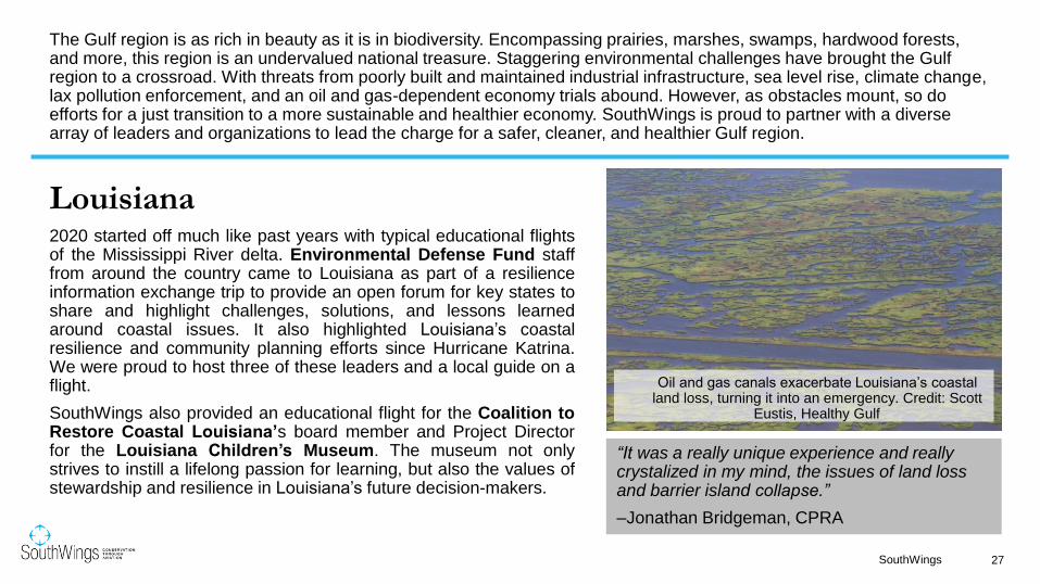
Oil and gas canals exacerbate Louisiana’s coastal land loss, turning it into an emergency. Credit: Scott
Eustis, Healthy Gulf

“This was an incredibly helpful opportunity to see large scale sediment diversions and the improvement to wetland systems that is possible through this work. This type of knowledge-building simply is not possible on the ground or on the water.” –Paxton Ramsdell, EDF
28SouthWings
Oil pollution after Hurricane Barry, during an historic flood year, near WeaksIsland. Credit: Jonathan Henderson, Vanishing Earth
Scott Eustis and Naomi Yoder of Healthy Gulf
pause with volunteer pilot Ken Knevel after a
successful pollution-monitoring flight.
[Note: Photo taken before pandemic.]

Out of an abundance of caution for the health andsafety of our pilots and partners, after a pause inflights for a few months, SouthWings resumed ouroperations using a passenger-less flight model. Ourpilots fly alone and collect video and/or photographicinformation for our partners, who continue their worksafely from the ground.
In the first half of 2020, our passenger-less flightsincluded collecting information about land buildingand loss along the Mississippi River for LUMCON(Louisiana Universities Marine Consortium)scientist, Dr. Alex Kolker, as well as surveillance anddocumentation of activities in Cancer Alley, especiallyat the proposed Formosa Plastics site, for HealthyGulf’s legal team. As we learned more about testingand transmission of the novel coronavirus, weinstituted a limited, controlled return to passenger-carrying flights.
“Thanks again to you, and to everyone at SouthWings for all of your efforts!... These [photos] are great!!!”
-Dr. Alex Kolker, scientist with LUMCON
29SouthWings
Scientists study how human intervention can both promote land building and land loss along the Mississippi River. Credit: Ken Knevel

30SouthWings
Slicks of unknown substances were frequently sighted in the aftermath of Hurricane Laura. Credit: Naomi Yoder
“I've never flown in a helicopter before; it was absolutely the best for photography and getting close-ups. The experience was so incredibly valuable for me. I've been studying the area of Southwest Louisiana for some time, and this was my first chance to see it first hand, and I got to see inside walls of petrochemical plants that I never would have gotten to be able to see from the ground.”
–Naomi Yoder, Healthy Gulf
This summer the Gulf Coast faced a record-breaking, historichurricane season as tangible evidence of the climate crisis we canno long ignore. In the middle of a raging pandemic, people losthomes and livelihoods while, ironically, industrial facilities drivingclimate change were damaged and released further pollution. Heat,humidity, mosquito swarms massive enough to kill cows, lack ofrunning water, and little to no housing for social distancing orprotection from the elements quickly and rightfully shifted the focusof many people, including several SouthWings volunteer pilots, toimmediate humanitarian efforts. Weather around the rapid-succession of storms and TFRs further complicated the flight-planning process.
Throughout hurricane season, our pilots enabled Healthy Gulf toreport and collect evidence of pollution events, resulting in NationalResponse Center reports and media coverage. In one case,Healthy Gulf's Naomi Yoder was able to ride along with LeonardGuidry to Southwest Louisiana on one of several humanitarianflights he conducted. While Leonard's focus was on delivering foodand ice, he graciously allowed Naomi to fly along to survey andcollect evidence of industrial pollution.

31SouthWings
Right: A haze covers the horizon as the Venture Global Liquid Natural Gas facility overlooks homes.
Below: Oil and gas infrastructure, especially when aging and/or abandoned, pose increased pollution risks from natural disasters.
Credit: Naomi Yoder, Healthy Gulf

32SouthWings
As the country continued to battle the pandemic, citizens of Cancer Alleywaged war on an additional front: fighting the construction of the FormosaPlastics 14 plant complex, which would double the amount of toxic air pollutionin St. James Parish. A portion of the proposed site of the complex is home tothe graves of enslaved people. Desecration of the bodies of enslaved people,even after death, and the landscape of the modern "plantation" where many oftheir descendants work low-wage jobs for billion-dollar corporations, whilebeing poisoned, form an evocative juxtaposition that has become a rallyingpoint for low-income and minority communities around the country.
Citizens are fighting not only to honor their past, but to save their future, andSouthWings is proud to have assisted a coalition partner, Healthy Gulf, in theirlegal battle. SouthWings volunteer pilots Ken Knevel, Poco Sloss, and TimWalsh flew recon flights over the area to gather photographic evidence forHealthy Gulf's lawyers. On November 4th, the Army Corps of Engineerssuspended a critical permit for building, pending further review. Two weeks lateron November 18th, Judge Trudy White further stalled construction by forcing areview on air permits issued.
Construction continues, but in a limited capacity, while our commitment tosupport the community remains steadfast.
Views of the historically Black Burton Lane community in Cancer Alley.
Credit: Scott Eustis, Healthy Gulf

Alabama
Our flights in Alabama in the first half of this year revolved around holding pollutersaccountable with Mobile Baykeeper and Little River Waterkeeper (LRW). At the endof February, the Mobile River was at its sixth highest level in recorded history. We veryquickly put together a flight for Mobile Baykeeper to survey potentially impacted coalash impoundments along the river. Alabama houses a massive amount of toxic coalash along its waterways, and flooding is known to exacerbate the heavy metal pollutionthat it already causes in local soil and water.
Similarly, logging and sedimentation also pose risks to the health of Alabama’swatersheds. In early March, we flew Little River Waterkeeper’s Executive Director toinvestigate sedimentation pollution from logging and development along the river’scorridors. The flight also supported LRW’s work to nominate the Little River as aNational Wild and Scenic River, which would afford it greater protections.
“It was an incredible experience. Very awe-inspiring. I work from the landscape a lot in my work but this was a whole new perspective and way of understanding our human impact on the environment. The proximity to the land in the small plane was also an amazing experience. We were just low enough to still pick out individual trees. I was struck by the beauty of our planet.” – Hannah Chalew, artist
33SouthWings
The confluence of the Tallapoosa and Coosa Rivers. Credit: Frank Chitwood

In August, we began a new partnership with Gasp, an organization fighting environmental racism in the North Birmingham area. Volunteer pilot Tom Kahlert took photos of the 35th Street Superfund Site area for Gasp to use in citizen watchdog functions. These photos gave Gasp a bird's eye view of the site and helped inform their pollution detection and reporting strategies.
One month later we flew Nancy Pierce, photographer for regional powerhouse Southern Environmental Law Center (SELC), over four coal ash plants in a "marathon" flight. She collected powerful images for SELC to use in their media and advocacy campaigns.
34SouthWings
The 35th Street Superfund Site in North Birmingham is right next to homes. The site continues to be a source of toxic pollution that poisons neighbors who can’t afford to move.
Credit: Tom Kahlert
Coal ash impoundments impacting Alabama’s drinking water supplies. Ernest C. Gaston Electric Generating Plant is a coal and natural gas-fired electrical generation facility near Wilsonville, Shelby County, Alabama on Lay Lake of the Coosa River.
Photo and Caption Credit: Nancy Pierce

35SouthWings
Left: Coal ash impoundments impacting Alabama’s drinking water supplies. James M. Barry Electric Generating Plant, also known as Barry Steam Plant or Plant Barry is a coal- and natural gas-fired electrical generation facility in Bucks, Mobile County, Alabama, United States. It lies on the west bank of the Mobile River. Caption and Photo Credit: Nancy Pierce
Right: Volunteer Pilot Bryan Tauchen and Nancy Pierce on their “marathon” coal ash flight. Credit Nancy Pierce
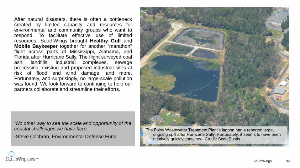
After natural disasters, there is often a bottleneckcreated by limited capacity and resources forenvironmental and community groups who want torespond. To facilitate effective use of limitedresources, SouthWings brought Healthy Gulf andMobile Baykeeper together for another "marathon"flight across parts of Mississippi, Alabama, andFlorida after Hurricane Sally. The flight surveyed coalash, landfills, industrial complexes, sewageprocessing, existing and proposed industrial sites atrisk of flood and wind damage, and more.Fortunately, and surprisingly, no large-scale pollutionwas found. We look forward to continuing to help ourpartners collaborate and streamline their efforts.
“No other way to see the scale and opportunity of the coastal challenges we have here.”
-Steve Cochran, Environmental Defense Fund
36SouthWings
The Foley Wastewater Treatment Plant’s lagoon had a reported large, ongoing spill after Hurricane Sally. Fortunately, it seems to have been relatively quickly contained. Credit: Scott Eustis

Mississippi
In addition to the post-storm flight for HealthyGulf and Mobile Baykeeper, SouthWingsvolunteer pilots also performed a surveillanceflight over the Bayou Casotte IndustrialParkway in Pascagoula. We teamed up withCherokee Concerned Citizens, an ultra-localcommunity organization primarily made up ofresidents in the Cherokee subdivision, locatedwithin 1 mile from six Title V air permittingindustrial facilities and one Superfund site.The group plans to use flight imagery anddata in support of their efforts to protect thecommunity from further pollution. To helpfacilitate their work, SouthWings staffconnected the Cherokee Concerned Citizenswith other flight partners with experience usingaerial imagery for regulatory reporting andpermit enforcement.
“Seeing the landscape from above was invaluable and gives the viewer of my photos a totally different perspective.”
-Drew Angerer, Getty Images
37SouthWings
Chevron’s pollution turned the water green along Mississippi’s coast.
Credit: Scott Eustis
38SouthWings
A coal plant in Pensacola. Credit: Scott Eustis
“There really isn’t a better way to understand our coastal issues than from above.
Thanks for your hard work on getting this together for us!”
-Emily Falgoust, National Audubon Society
Florida
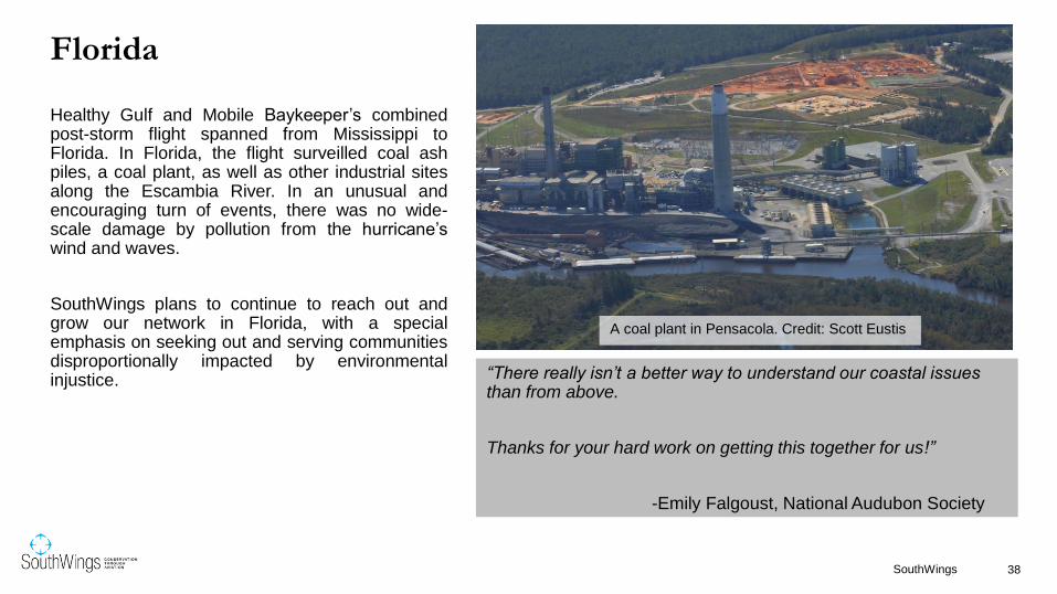
Healthy Gulf and Mobile Baykeeper’s combinedpost-storm flight spanned from Mississippi toFlorida. In Florida, the flight surveilled coal ashpiles, a coal plant, as well as other industrial sitesalong the Escambia River. In an unusual andencouraging turn of events, there was no wide-scale damage by pollution from the hurricane’swind and waves.
SouthWings plans to continue to reach out andgrow our network in Florida, with a specialemphasis on seeking out and serving communitiesdisproportionally impacted by environmentalinjustice.