2.1 natural environment - california coastal...
TRANSCRIPT
2
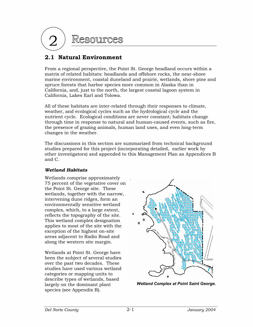
2.1 Natural Environment From a regional perspective, the Point St. George headland occurs within a matrix of related habitats: headlands and offshore rocks, the near-shore marine environment, coastal duneland and prairie, wetlands, shore pine and spruce forests that harbor species more common in Alaska than in California, and, just to the north, the largest coastal lagoon system in California, Lakes Earl and Tolowa. All of these habitats are inter-related through their responses to climate, weather, and ecological cycles such as the hydrological cycle and the nutrient cycle. Ecological conditions are never constant; habitats change through time in response to natural and human-caused events, such as fire, the presence of grazing animals, human land uses, and even long-term changes in the weather. The discussions in this section are summarized from technical background studies prepared for this project (incorporating detailed, earlier work by other investigators) and appended to this Management Plan as Appendices B and C. Wetland Habitats Wetlands comprise approximately 75 percent of the vegetative cover on the Point St. George site. These wetlands, together with the narrow, intervening dune ridges, form an environmentally sensitive wetland complex, which, to a large extent, reflects the topography of the site. This wetland complex designation applies to most of the site with the exception of the highest on-site areas adjacent to Radio Road and along the western site margin.
Wetland Complex at Point Saint George.
Wetlands at Point St. George have been the subject of several studies over the past two decades. These studies have used various wetland categories or mapping units to describe types of wetlands, based largely on the dominant plant species (see Appendix B).
Del Norte County January 2004 2-1
Resources
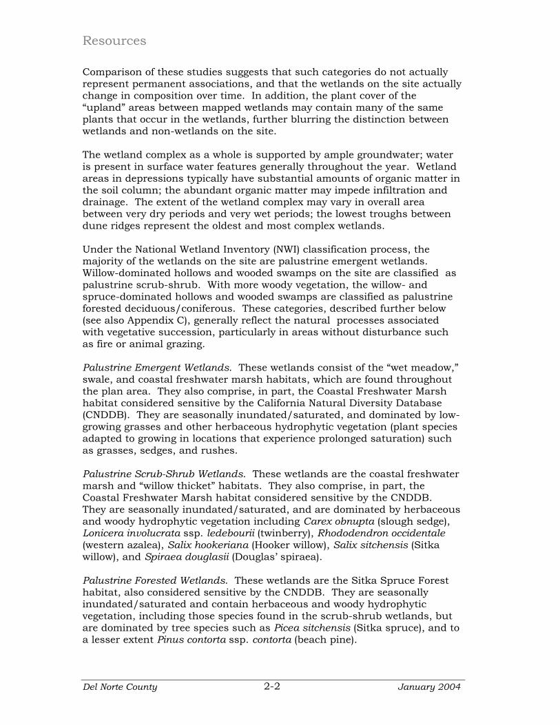
Comparison of these studies suggests that such categories do not actually represent permanent associations, and that the wetlands on the site actually change in composition over time. In addition, the plant cover of the “upland” areas between mapped wetlands may contain many of the same plants that occur in the wetlands, further blurring the distinction between wetlands and non-wetlands on the site. The wetland complex as a whole is supported by ample groundwater; water is present in surface water features generally throughout the year. Wetland areas in depressions typically have substantial amounts of organic matter in the soil column; the abundant organic matter may impede infiltration and drainage. The extent of the wetland complex may vary in overall area between very dry periods and very wet periods; the lowest troughs between dune ridges represent the oldest and most complex wetlands. Under the National Wetland Inventory (NWI) classification process, the majority of the wetlands on the site are palustrine emergent wetlands. Willow-dominated hollows and wooded swamps on the site are classified as palustrine scrub-shrub. With more woody vegetation, the willow- and spruce-dominated hollows and wooded swamps are classified as palustrine forested deciduous/coniferous. These categories, described further below (see also Appendix C), generally reflect the natural processes associated with vegetative succession, particularly in areas without disturbance such as fire or animal grazing.
Palustrine Emergent Wetlands. These wetlands consist of the “wet meadow,” swale, and coastal freshwater marsh habitats, which are found throughout the plan area. They also comprise, in part, the Coastal Freshwater Marsh habitat considered sensitive by the California Natural Diversity Database (CNDDB). They are seasonally inundated/saturated, and dominated by low-growing grasses and other herbaceous hydrophytic vegetation (plant species adapted to growing in locations that experience prolonged saturation) such as grasses, sedges, and rushes. Palustrine Scrub-Shrub Wetlands. These wetlands are the coastal freshwater marsh and “willow thicket” habitats. They also comprise, in part, the Coastal Freshwater Marsh habitat considered sensitive by the CNDDB. They are seasonally inundated/saturated, and are dominated by herbaceous and woody hydrophytic vegetation including Carex obnupta (slough sedge), Lonicera involucrata ssp. ledebourii (twinberry), Rhododendron occidentale (western azalea), Salix hookeriana (Hooker willow), Salix sitchensis (Sitka willow), and Spiraea douglasii (Douglas’ spiraea). Palustrine Forested Wetlands. These wetlands are the Sitka Spruce Forest habitat, also considered sensitive by the CNDDB. They are seasonally inundated/saturated and contain herbaceous and woody hydrophytic vegetation, including those species found in the scrub-shrub wetlands, but are dominated by tree species such as Picea sitchensis (Sitka spruce), and to a lesser extent Pinus contorta ssp. contorta (beach pine).
Del Norte County January 2004 2-2

Point St. George Management Plan
Pond Wetlands. This habitat type has standing water throughout the year and hosts a diversity of herbaceous aquatic species, such as Nuphar luteum ssp. polysepalum (pond lily), Sparganium eurycarpum (bur reed), and Potamogeton sp. (pond weed), in addition to other associated hydrophytes around their margins. Non-Wetland Habitats The wetlands described above occur in an environmental setting that includes non-wetland habitats (although as noted, the distinction is sometimes blurred). For the purposes of this plan, “non-wetland” habitat types are described below and illustrated in the figure on the next page (for additional information, see Appendix B). Dune Mat: This habitat has a semi-stable, sandy substrate and variable vegetative cover that typically hosts relatively high native species diversity. Dune Mat is considered “sensitive” by the California Department of Fish and Game and is listed in the CNDDB. Coastal Prairie: Coastal Prairie habitat is an upland habitat composed predominantly of a variety of exotic and native grasses and other herbaceous species. It is found adjacent to, and transitioning from, wetland habitats and coastal bluff scrub communities. Where this habitat has been sufficiently disturbed, the vegetation is more appropriately classified as ruderal. Coastal Bluff Escarpment: This habitat is restricted to the bluff edge and is typically steep, rocky, and sparsely vegetated. This habitat has experienced substantial disturbance in the past and has been colonized in many places by annual exotic grasses, Rubus discolor (Himalayan blackberry), and Raphanus spp. (radish). Coastal Bluff Scrub: This habitat type is located along the top of coastal terraces and extends from the steep escarpment to where it typically transitions into the coastal prairie or (rarely) the palustrine emergent or palustrine scrub-shrub wetlands. The vegetative cover in these areas varies from low to high and is typically composed of a relatively high diversity of low-growing native species. The substrate is sandy. Ruderal/Disturbed Habitat: These habitats are dominated by species common to the original habitat that has been disturbed, in addition to other early-successional pioneer species that are known to colonize disturbed areas, including invasive, exotic species.
Del Norte County January 2004 2-3
Resources
Interpretation of Habitat Types at Point Saint George.
Del Norte County January 2004 2-4

Point St. George Management Plan
Special Status Species “Special status species” is a general term for animal or pspecies that are considsufficiently rare to require special consideration or legal protection (see Appendix C for further information). Speciastatus species related to Point St. George are discussed in detail in Appendix C and summarized briefly below.
Generalized Map of Special Status Plant Species at Point Saint George.
lant ered
l
lants. Fifteen special status
n
e
s are
e
Pplant species, plus one plant (western dog violet) that servesas a host species for a federally listed insect species (Oregon silverspot butterfly), are knowto occur within the planning area at Point St. George (Tablbelow). An additional 22 special status plant specieconsidered to have limited potential to occur within thplanning area.
Special Status Plant Species Known to Occur at Point St. George
Taxonomic Name Common Name Lilium occidentale western lily Empetrum nigrum
(E. nigrum ssp. hermaphroditum) black crowberry
Oenothera wolfii Wolf’s evening primrose Phacelia argentea sand dune phacelia Trientalis arctica arctic starflower Angelica lucida sea-watch
Carex buxbaumii Buxbaum’s sedge Lathyrus palustris marsh pea Romanzoffia tracyi Tracy’s romanzoffia
Sanguisorba officinalis great burnet Sidalcea malviflora ssp. patula Siskiyou checkerbloom
Viola adunca western dog violet Viola langsdorfii Langsdorf’s violet Viola palustris marsh violet
Hesperevax sparsiflora var. brevifolia short-leaved evax Sidalcea oregana ssp. eximia coast checkerbloom
Del Norte County January 2004 2-5
Resources
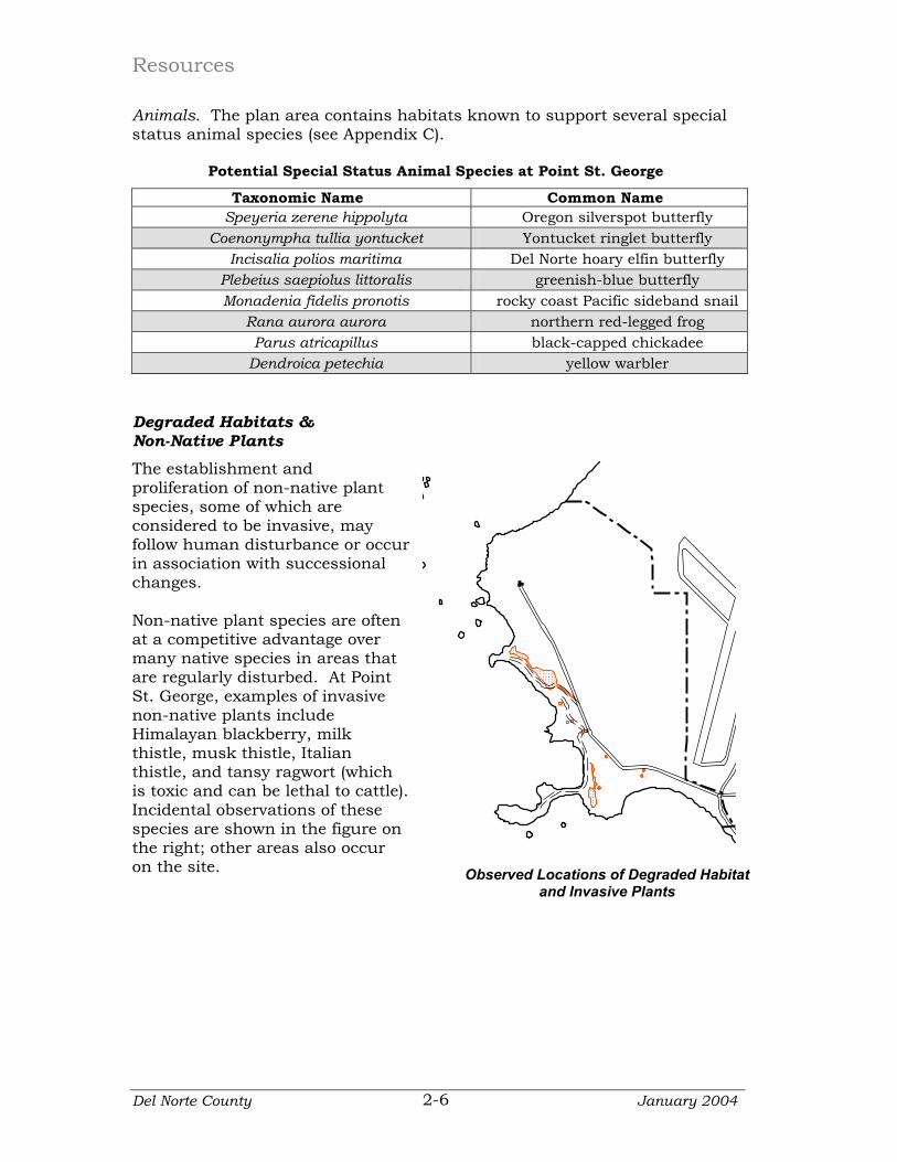
Animals. The plan area contains habitats known to support several special status animal species (see Appendix C).
Potential Special Status Animal Species at Point St. George
Taxonomic Name Common Name Speyeria zerene hippolyta Oregon silverspot butterfly
Coenonympha tullia yontucket Yontucket ringlet butterfly Incisalia polios maritima Del Norte hoary elfin butterfly
Plebeius saepiolus littoralis greenish-blue butterfly Monadenia fidelis pronotis rocky coast Pacific sideband snail
Rana aurora aurora northern red-legged frog Parus atricapillus black-capped chickadee
Dendroica petechia yellow warbler
Degraded Habitats & Non-Native Plants The establishment and proliferation of non-native plant species, some of which are considered to be invasive, may follow human disturbance or oin association with succeschanges.
ccur sional
attle).
on
Non-native plant species are often at a competitive advantage over many native species in areas that are regularly disturbed. At Point St. George, examples of invasive non-native plants include Himalayan blackberry, milk thistle, musk thistle, Italian thistle, and tansy ragwort (which is toxic and can be lethal to cIncidental observations of these species are shown in the figure the right; other areas also occur on the site. Observed Locations of Degraded Habitat
and Invasive Plants
Del Norte County January 2004 2-6

Point St. George Management Plan
2.2 Cultural Resources Much of this section is summarized from a technical evaluation study prepared for this project (incorporating earlier work by other investigators); this report is available to qualified reviewers through Del Norte County Department of Community Development. Archaeological Resources The archaeological resources at Point St. George are highly significant. Two major archaeological sites exist on the property; both are listed on the National Register of Historic Places, which also qualifies them for listing on the California Register of Historic Resources. One of these is a keystone site for the interpretation of northwest California prehistory. In addition to their value for prehistory, these sites produce important biological information on the ancient zoogeography of certain marine mammal species and have the potential to help with issues of habitat restoration; for example, an understanding of the local plants used for food by prehistoric peoples can be used to help reconstruct the structure and composition of native habitats. Relatively high densities of Native American peoples occupied the northcoast region at the time of European contact. What is now the Point St. George area was occupied in prehistoric times by the Tolowa, whose ethnographic region encompassed the entire Smith River watershed. The Tolowa spoke a dialect of the Athapascan language that was related to Athapascan speakers to the north. The Tolowa made use of seasonally available resources in a cyclical pattern, as the resources became available along the coast or inland along rivers and in oak woodlands. The coastal zone was a focus of many activities, and major Tolowa settlements, or villages, were situated on or near the coast (including in both the Lake Earl and Point St. George areas). Many of these villages were supported by the use of oceangoing canoes, composite harpoons, large communal fish weirs, and redwood smoke houses, which maximized the procurement and storage of marine mammals, fish, and waterfowl. Individual ownership of these capital-intensive technologies was linked to differential wealth and power within the population, resulting in a stratified community organization that characterized much of northwest California.
Drawing of Tolowa Redwood Plank House.
Del Norte County January 2004 2-7
Resources
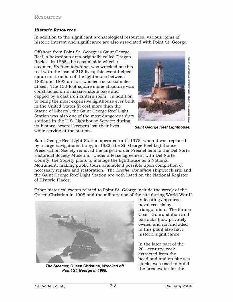
Historic Resources In addition to the significant archaeological resources, various items of historic interest and significance are also associated with Point St. George. Offshore from Point St. George is Saint George Reef, a hazardous area originally called Dragon Rocks. In 1865, the coastal side-wheeler steamer, Brother Jonathan, was wrecked on this reef with the loss of 215 lives; this event helped spur construction of the lighthouse between 1882 and 1892 on surf-washed rocks six miles at sea. The 150-foot square stone structure was constructed on a massive stone base and capped by a cast iron lantern room. In addition to being the most expensive lighthouse ever bin the United States (it cost more than the Statue of Liberty), the Saint George Reef Light Station was also one of the most dangerous duty stations in the U.S. Lighthouse Service; during its history, several keepers lost their lives while serving at the station.
uilt
Pho
to c
ourte
sy S
t. G
eorg
e R
eef L
ight
hous
e P
rese
rvat
ion
Soci
ety
Saint George Reef Lighthouse.
Saint George Reef Light Station operated until 1975, when it was replaced by a large navigational buoy; in 1983, the St. George Reef Lighthouse Preservation Society removed the largest-order Fresnel lens to the Del Norte Historical Society Museum. Under a lease agreement with Del Norte County, the Society plans to manage the lighthouse as a National Monument, making public tours available if possible upon completion of necessary repairs and restoration. The Brother Jonathan shipwreck site and the Saint George Reef Light Station are both listed on the National Register of Historic Places. Other historical events related to Point St. George include the wreck of the Queen Christina in 1908 and the military use of the site during World War II
in locating Japanese naval vessels by triangulation. The former Coast Guard station and barracks (now privately owned and not included in this plan) also have historic significance. In the later part of the 20th century, rock extracted from the headland and on-site sea stacks was used to build the breakwater for the
The Steamer, Queen Christina, Wrecked off Point St. George in 1908.
Del Norte County January 2004 2-8
Point St. George Management Plan
Crescent City harbor; access roads from the quarrying operation and the former crusher site are still evident. Historical uses also include some limited exploration of the low-quality coal underlying the property. The fences and corral on the property are evidence of ranching activity in recent times.
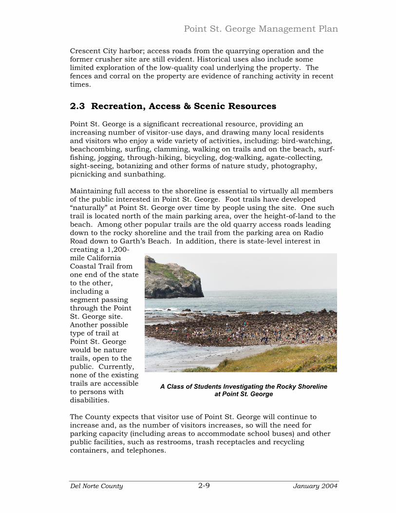
2.3 Recreation, Access & Scenic Resources Point St. George is a significant recreational resource, providing an increasing number of visitor-use days, and drawing many local residents and visitors who enjoy a wide variety of activities, including: bird-watching, beachcombing, surfing, clamming, walking on trails and on the beach, surf-fishing, jogging, through-hiking, bicycling, dog-walking, agate-collecting, sight-seeing, botanizing and other forms of nature study, photography, picnicking and sunbathing. Maintaining full access to the shoreline is essential to virtually all members of the public interested in Point St. George. Foot trails have developed “naturally” at Point St. George over time by people using the site. One such trail is located north of the main parking area, over the height-of-land to the beach. Among other popular trails are the old quarry access roads leading down to the rocky shoreline and the trail from the parking area on Radio Road down to Garth’s Beach. In addition, there is state-level interest in creating a 1,200-mile California Coastal Trail from one end of the sto the other, including a segment passing through the Point St. George site. Another possible type of trail at Point St. George would be nature trails, open to the public. Currently, none of the existing trails are ato persons witdisabilities.
tate
ccessible h
he County expects that visitor use of Point St. George will continue to
ther
A Class of Students Investigating the Rocky Shoreline at Point St. George
Tincrease and, as the number of visitors increases, so will the need for parking capacity (including areas to accommodate school buses) and opublic facilities, such as restrooms, trash receptacles and recycling containers, and telephones.
Del Norte County January 2004 2-9
