2.1 scoping and screening of alternatives - fastracks home
TRANSCRIPT

East Corridor Final Environmental Impact Statement Alternatives Considered
September 2009 2-1
2.0 ALTERNATIVES CONSIDERED The alternatives considered for the East Corridor are the result of agency involvement and extensive public outreach, described in Chapter 6, Public Comment and Agency Coordination, combined with detailed environmental and technical analysis. This chapter summarizes:
• The process used to define the goals, objectives, and evaluation criteria • Development and screening of alternatives including transit alignments, station
locations, and transit technologies • Alternatives that were considered during the analysis but eliminated • The No-Action Alternative • The Transportation System Management (TSM) Alternative • The Preferred Alternative and design options • The commuter rail maintenance facility (CRMF) • The estimated costs including capital, operation, and maintenance
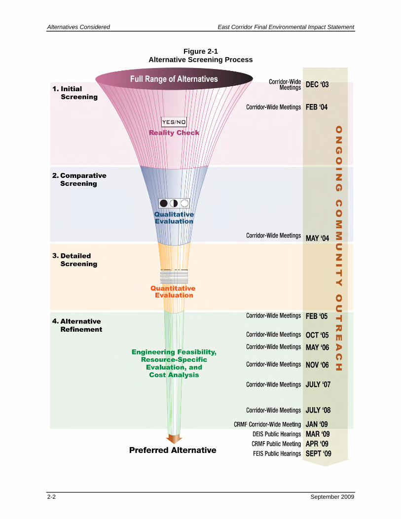
2.1 SCOPING AND SCREENING OF ALTERNATIVES Numerous alternatives were proposed as transportation improvements. The project team developed these alternatives based on input from the community and affected agencies, previous studies, and new concepts. To help establish the transportation and environmental issues in the project area, project scoping was completed with stakeholders, the community, cooperating agencies, and others. Based on scoping and as defined in Chapter 1, Purpose and Need, the project purpose and need were developed and served as the basis for project-specific goals and objectives. These goals and objectives were then used to develop specific evaluation criteria that allowed for the comparison of alternatives and the determination of the Preferred Alternative for the East Corridor. The Preferred Alternative best addresses the transportation needs in the area while minimizing potential impacts on the community and environment. Table 2-1 lists the goals and objectives and the criteria used in the various screening levels. 2.1.1 Screening Process A four-level screening process, shown in Figure 2-1, was used to reduce the range of alternatives considered to the selection of the Preferred Alternative. Alternatives were evaluated with increasing levels of detailed analysis at each screening level: initial screening, comparative screening, detailed screening, and alternative refinement. Cost comparisons were occasionally used in the screening process at various levels. While the assumptions and costs may have changed, the results are still valid.
Alternatives Considered East Corridor Final Environmental Impact Statement
2-2 September 2009
Figure 2-1 Alternative Screening Process

East Corridor Final Environmental Impact Statement Alternatives Considered
September 2009 2-3
Table 2-1Goals, Objectives, and Evaluation Criteria
Goals Objectives Evaluation Criteria
1. Initial Screening 2. Comparative Screening 3. Detailed Screening 4. Alternative Refinement
Access (A) Provide for reasonable access to transportation facilities
• Balance the need for access with adverse affects on system performance – A1 • Bring together multiple transportation modes to maximize convenience,
flexibility, and connectivity – A2 • Provide access to transportation facilities for a variety of users – A3
• Does the alternative provide adequate transportation access to and through the corridor? (A3)
• Provides access to local residences, businesses, and activity centers within the corridor (A3)
• Balances local access with system performance (A1)
• Transit travel time between key activity centers (A1,M1)
• Population and employment within 0.5 mile of a transit station (A3)
• Population and employment within 0.25 mile of local bus service (A3)
• Engineering feasibility • Environmental resource-
specific evaluation • Cost analysis
Capacity (CA) Provide for realistic capacity expansion and minimize future congestion
• Address additional capacity requirements by providing multi-modal choices – CA1
• Provide sufficient transportation system capacity to ensure the efficient movement of people – CA2
• Satisfies future system capacity needs (CA1,2)
• Number of linked transit trips (CA1)
Community (CO) Support community plans and avoid, minimize, and mitigate impacts to neighborhoods
• Maximize consistency with existing local, regional, and state plans – CO1 • Minimize adverse impacts to residential, business, and institutional properties –
CO2 • Minimize adverse economic impacts to local businesses – CO3 • Allow for economic development opportunities – CO4 • Address transportation-related community impacts associated with air quality,
water quality, hazardous materials, and noise – CO5 • Allow for transit-oriented development (TOD) opportunities – CO6
• Does the alternative provide the ability to implement the general intent of local plans and policies? (CO1)
• Meets the intent of existing local, regional, and state plans (CO1,4)
• Minimizes potential residential displacement/disruption (CO2)
• Minimizes potential business displacement/disruption (CO2)
• Minimizes potential institutional property displacement/disruption (CO2)
• Provides consistency of adjacent land use with TOD principles (CO6)
• Meets the intent of existing local, regional, and state plans (CO1)
• Number of residential properties potentially physically affected (CO2)
• Number of institutional properties potentially physically affected (CO2)
• Number of business properties potentially physically affected (CO2,3)
• Community sentiment on the relationship between the alternative and neighborhood character (CO5)
Note: Objectives are represented by alphabetical and numerical descriptors (e.g., A1) to simplify tracking throughout the screening process. The description in the parenthesis after each screening criteria (e.g., A1) shows which objective the criteria represents.

Alternatives Considered East Corridor Final Environmental Impact Statement
2-4 September 2009
Table 2-1Goals, Objectives, and Evaluation Criteria
Goals Objectives Evaluation Criteria
1. Initial Screening 2. Comparative Screening 3. Detailed Screening 4. Alternative Refinement
Environment (E)
Avoid, minimize, and mitigate adverse impacts to the natural, social, and cultural environment
• Minimize adverse impacts to historic resources – E1 • Ensure consistency with regional air quality model to help achieve federal and
state air quality standards – E2 • Minimize disproportionately high and adverse impacts on minority and low-
income populations – E3 • Minimize adverse impacts to waters of the U.S., including wetlands – E4 • Minimize adverse impacts to recreational and open-space resources – E5 • Minimize public exposure to highway and transit noise and transit vibration
impacts – E6 • Minimize adverse impacts associated with hazardous materials – E7 • Incorporate design standards that minimize visual impacts and enhance
aesthetics – E8
• Does the alternative avoid clearly unacceptable environmental impacts? (All)
• Minimizes potential impacts to historic resources (E1)
• Minimizes potential impacts to natural resources (E2,4,5,7)
• Minimizes potential impacts to natural resources (E3,6,8)
• Number of historic resources potentially affected (E1)
• Tons of mobile source emissions (E2)
• Amount of minority and low-income population potentially affected (E3)
• Acres of waters of the U.S., including wetlands potentially affected (E4)
• Acres of recreational and open space potentially affected (E5)
• Number of residential, business, and sensitive properties exposed to noise and/or vibration levels that exceed federal standards (E6)
• Number and nature of known hazardous material sites potentially affected (E7)
• Potential visual affects of alternatives (E8)
Implementation (IM)
Provide a cost-effective transportation solution that can be implemented
• Provide a cost-effective, long-term transportation solution – IM1 • Provide flexibility for future expansion and modification – IM2 • Provide technologies that are practical and implementable – IM3 • Maximize the opportunity that federal, state, local, and/or private funding will be
available to fund improvements – IM4
• Is the alternative a proven technology in a comparable application? (IM3)
• Minimizes project cost (All) • Facilitates ease of
construction (IM1,3) • Facilitates ease of operation
and maintenance (IM1,4) • Accommodates the potential
for future transportation improvements consistent with local, regional, and state transportation plans (IM2)
• Total estimated capital cost (IM1)
• Estimated annual operation and maintenance cost (IM1)
• Estimated cost per passenger mile (IM1,3)
• Estimated cost per rider (includes annualized operations, maintenance, and capital costs) (IM1,3)
Mobility (M)
Enhance mobility by providing transportation choices
• Facilitate connections between residential and business activity centers – M1 • Facilitate ease of transfer between modes – M2 • Provide convenient, multi-modal transportation options – M3 • Enhance system reliability across travel modes – M4 • Balance the transportation needs of local, regional, and national users – M5
• Does the alternative avoid precluding existing or planned transportation system improvements? (All)
• Reduces travel delay and congestion (M4,M5)
• Improves system reliability (M4,M5)
• Allows the ability to accommodate adverse weather conditions (M4)
• Number of modes available at strategic locations (M2,3,5,A2)
• Average wait time for transfers between modes (M2,4,5,A2)
Note: Objectives are represented by alphabetical and numerical descriptors (e.g., A1) to simplify tracking throughout the screening process. The description in the parenthesis after each screening criteria (e.g., A1) shows which objective the criteria represents.

East Corridor Final Environmental Impact Statement Alternatives Considered
September 2009 2-5
Table 2-1Goals, Objectives, and Evaluation Criteria
Goals Objectives Evaluation Criteria
1. Initial Screening 2. Comparative Screening 3. Detailed Screening 4. Alternative Refinement
Safety (SA)
Address safety needs and upgrade facilities to current standards
• Optimize safety and minimize accidents across all modes – SA1 • Conform with engineering design and safety standards and with standard
practices for construction, maintenance, and operations – SA2 • Minimize cross modal conflicts and conflict points – SA3 • Provide access for emergency response and evacuation situations – SA4
• Does the alternative address existing safety issues? (All)
• Conforms with engineering design and safety standards (SA2)
• Addresses emergency response needs (SA4)
• Number of instances where minimum design standards were used (SA2)
• Number of conflict points between modes (transit, highway, pedestrian, bicycle) (SA3)
Security (SE)
Provide a secure transportation system
• Maintain maximum security measures regarding access to DIA – SE1 • Develop and maintain a transportation system that supports national homeland
security objectives – SE2
• Does the alternative support homeland security objectives? (SE2)
• Provides the ability to meet Transportation Security Administration standards for transit access to DIA (SE2)
• Number and type of critical design features that are potential security risks (SE1)
• Ability to meet Transportation Security Administration standards for transit access to DIA (SE2)
Note: Objectives are represented by alphabetical and numerical descriptors (e.g., A1) to simplify tracking throughout the screening process. The description in the parenthesis after each screening criteria (e.g., A1) shows which objective the criteria represents.

Alternatives Considered East Corridor Final Environmental Impact Statement
2-6 September 2009
This page intentionally left blank.

East Corridor Final Environmental Impact Statement Alternatives Considered
September 2009 2-7
Initial Screening (Level One) Alternatives were evaluated within categories for initial screening and comparative screening levels. The first level of evaluation, initial screening, was a reality check that eliminated transit alignment, technology, and station location alternatives that did not have a realistic chance of being designed and built because they would either result in significant environmental impacts, were not located in the project area, or were not a technology that was in revenue service. A series of yes-or-no questions were used to evaluate alternatives during this step. Alternatives not eliminated in initial screening were refined and evaluated in comparative screening. Comparative Screening (Level Two) Comparative screening continued to look at transit alignments and technologies relative to each other within categories to determine if some were clearly better than others. A qualitative (good 1/better 3/best 5) approach was used to identify the alternatives in each category that were more effective at meeting the purpose and need. Detailed Screening (Level Three) Alignments, station locations, and technologies remaining after comparative screening were combined to create several corridor-wide transit alternatives for analysis in detailed screening. A quantitative (measure-based) analysis was used to identify the strengths and weaknesses of the alternatives. Alternative Refinement (Level Four) Alternatives that remained after detailed screening were developed in more detail and further analyzed as part of alternative refinement. The evaluation was more in depth than the detailed screening analysis and was used to determine the alternatives most responsive to the project purpose and need. This fourth level of screening considered engineering feasibility; potential impacts on social, environmental, and economic resources; and an analysis of capital, operation, and maintenance costs. 2.1.2 Alternatives Considered More than 100 transportation elements were evaluated during the screening process. As discussed previously, the first two screening levels (initial screening and comparative screening) considered alternative elements within categories including alignments, station locations, and technologies to determine which best met the corridor needs and should be advanced for further analysis. Following comparative screening, the remaining alignments, station locations, and technologies were combined to form corridor alternatives that were further evaluated and refined in subsequent screening levels. Transportation demand management (TDM)/TSM strategies were not evaluated as stand-alone alternatives because they do not individually address the project purpose and need. TDM/TSM strategies represent operating policies applicable to any build alternative to better address project goals and objectives. 2.1.2.1 Transit Alignments Figure 2-2 shows potential corridors considered for a rapid transit alignment between downtown Denver and DIA. Alignments were also suggested to extend the Central Corridor from 30th Avenue and Downing Street to connect to the East Corridor. Alignments are described by three subareas:
• Downtown Alignments – Alignments to downtown Denver (specifically DUS), generally south of I-70 and west of Franklin Street.
Alternatives Considered East Corridor Final Environmental Impact Statement
2-8 September 2009
• East-West Alignments – Alignments east of downtown and generally west of Airport Boulevard.
• Airport Connection Alignments – Alignments running north-south through the eastern portion of the project area that connect east-west alignments to DIA.
The corridor crosses each of these three alignment subareas; therefore, an alignment from each subarea is necessary to develop a complete alternative that connects downtown Denver to DIA. A separate category for other alignments was created to address improvements that are not specific to a subarea and alignments outside of the project area. This subsection describes the alignment subareas and the other alignment categories in more detail. Downtown alignments. Connect downtown Denver to east-west alignments:
• Brighton Boulevard – Extend from DUS north along the Union Pacific railroad (UPRR) corridor and then along Brighton Boulevard.
• Broadway – Extend from existing light rail at 18th Avenue/California Street north along Broadway to the UPRR corridor or along Brighton Boulevard to I-70.
• Washington Street – Extend from Broadway or Brighton Boulevard north along Washington Street.
• California Street – Place a track along California Street parallel to Welton Street from downtown Denver to 30th/Downing (Central Corridor alignment).
• Welton Street/Downing Street – Place a second track along Welton Street and then extend along Downing Street to 40th Avenue (Central Corridor alignment).
East-west alignments. Run east-west through the project area and connect downtown alignments to airport connection alignments:
• Along I-70 (in the right of way [ROW]) – Connect with one of the downtown alignments and run along I-70.
• Existing UPRR tracks/Smith Road – Run from DUS or other downtown alignment to the UPRR corridor/Smith Road and run east along UPRR corridor/Smith Road.
• 35th Avenue – Connect one of the downtown alignments and run east along 35th Avenue.
• Martin Luther King Boulevard – Connect with one of the downtown alignments and run east along Martin Luther King Boulevard.
• Colfax Avenue – Connect from existing downtown light rail south to Colfax Avenue and then east along Colfax Avenue.
• Bruce Randolph Avenue/35th Avenue – Connect with one of the downtown alignments and run east along Bruce Randolph Avenue to Dahlia Street, south on Dahlia Street to Martin Luther King Boulevard, and then east on Martin Luther King Boulevard.
• 38th Avenue – Connect with one of the downtown alignments and run east along 38th Avenue.
• Montview Boulevard – Connect with either the 38th Avenue, 35th Avenue, Martin Luther King Boulevard, or Bruce Randolph Avenue alignments and run south on Colorado Boulevard and then east along Montview Boulevard.
• Havana Street – Connect with one of the east-west alignments between Martin Luther King Boulevard and I-70 and then run north along Havana Street and east along 56th Avenue.

East Corridor Final Environmental Impact Statement Alternatives Considered
September 2009 2-9
Figure 2-2 Alignments

Alternatives Considered East Corridor Final Environmental Impact Statement
2-10 September 2009
This page intentionally left blank.

East Corridor Final Environmental Impact Statement Alternatives Considered
September 2009 2-11
• 56th Avenue/north of 56th Avenue – Connect with one of the downtown alignments north to 56th Avenue and run east along 56th Avenue.
• 64th Avenue median – Connect with one of the downtown alignments and run north to 64th Avenue and then east in the median of 64th Avenue.
• BNSF Market Lead – Divert from an alignment along the existing UPRR corridor/Smith Road to 40th Street, east along the BNSF Market Lead corridor to Colorado Boulevard, then back to the UPRR corridor/Smith Road.
• Sand Creek – Divert from one of the east-west alignments between Martin Luther King Boulevard and the UPRR corridor/Smith Road through the Stapleton Redevelopment area along Sand Creek and then continue along the UPRR corridor/Smith Road.
Airport connection Alignments. Run north-south through the eastern portion of the project area to connect east-west alignments to DIA:
• Tower Road – Connect with one of the east-west alignments and run north along Tower Road, then east along Peña Boulevard and/or 78th Avenue to DIA.
• Peña Boulevard – Connect with one of the east-west alignments and run north along Peña Boulevard, then east along Peña Boulevard and/or 78th Avenue to DIA.
• Run farther east of DIA – Connect DIA to the town of Strasburg located approximately 40 miles east of downtown Denver.
• Picadilly Road – Connect with one of the east-west alignments and run north along Picadilly Road, then east along Peña Boulevard and/or 78th Avenue to DIA.
• E-470 – Connect with one of the east-west alignments and run north along E-470, then east along Peña Boulevard and/or 78th Avenue to DIA.
• Telluride Street – Connect with one of the east-west alignments and run north along the future Telluride Street, then east along Peña Boulevard and/or 78th Avenue to DIA.
Other alignments. Are either not located in the subareas mentioned previously or are other types of transit connections or improvements:
• Keep the opportunity open for connection to North Front Range area – Connect to an alternative to the North Front Range.
• 30th Avenue and Downing Street to 40th Avenue/40th Street – Extend the existing alignment north along Downing Street to 40th Avenue/40th Street (Central Corridor alignment).
• Downtown Brighton to National Western Complex – Provide a connection from proposed alignments at 40th Avenue/40th Street along Brighton Boulevard to the National Western Complex.
• Connection between Northwest Rail Corridor (formerly called US 36) and East Corridor before DUS – Provide a direct connection from the Northwest Rail Corridor alternative to an East Corridor alternative bypassing DUS.
• From Montbello to downtown Denver to DIA – Provide a connection from Montbello to downtown and DIA.
• Connection between I-225 and East Corridor transit alternatives – Provide a connection from an I-225 alternative to a potential East Corridor alternative.
• Depressed alignment – Construct an alignment below existing ground. • Elevated alignment – Construct an alignment above existing ground.

Alternatives Considered East Corridor Final Environmental Impact Statement
2-12 September 2009
2.1.2.2 Station locations Stations allow passenger boarding and alighting and may include parking. They may also serve as bus transfer facilities. Station locations were developed during the scoping process based on input from the community, affected agencies, previous studies, and other alternatives developed by the project team. Stations were suggested at the following locations and areas.
• DUS • Five Points Area • Blake Street • 33rd Avenue/
Downing Street • 31st Street • Cole Area • 40th Avenue/40th
Street • National Western
Complex • Globeville Area • Brighton Boulevard • Swansea/
Globeville Area • 47th Avenue/
Brighton Boulevard • Swansea Area • York Street • Steele Street
• Clayton Area • Northeast Denver • 40th Avenue/
Colorado Boulevard
• Colorado Boulevard
• Dahlia Street • Northeast Park Hill • Holly Street • Quebec Street • Former Stapleton • Within Stapleton
Redevelopment • Havana Street • Smith Road/
Peoria Street • Fitzsimons • Gateway • Peña Boulevard/
Tower Road
• 40th Avenue/ Peña Boulevard
• Airport Boulevard/ Smith Road
• 68th Avenue/ Tower Road
• 56th Avenue/ Tower Road
• 48th Avenue/ Tower Road
• 45th Avenue/ Tower Road
• Smith Road/ Tower Road
• DIA • 1 to 2 miles apart
with park-n-Rides • Ballpark Area (29th
and 33rd) • Monaco Parkway

East Corridor Final Environmental Impact Statement Alternatives Considered
September 2009 2-13
2.1.2.3 Transit Technologies Technology refers to the specific mode (e.g., rail or bus) and type of propulsion (e.g., diesel, natural gas, or electric) that would be used. It also refers to operating characteristics for both guideway and guidance types. Technologies were identified during the scoping process based on input from the community, affected agencies, previous studies, and other alternatives developed by the project team. The following technologies were evaluated as potential rapid transit alternatives.
Bus rapid transit (BRT) – This rubber tire technology combines the operating concepts of rail transit and buses. It can operate in exclusive ROW, high-occupancy vehicle lanes, or along city streets. BRT uses technologies (such as intelligent transportation systems) to increase operating efficiency.
Bus Rapid Transit
Commuter rail – This technology typically operates on tracks shared with freight trains or on parallel tracks in or along the railroad ROW and serves longer distance trips. It may use locomotives with passenger cars or self-propelled passenger cars, known as diesel multiple units (DMU) or electric multiple units (EMU).
Commuter Rail
Heavy rail – This technology is commonly referred to as metro or subway. It operates in exclusive ROW using electricity from a third rail alongside the track.
Heavy Rail

Alternatives Considered East Corridor Final Environmental Impact Statement
2-14 September 2009
High-speed rail – This technology typically provides intercity service, operating in exclusive ROW that can be located at grade, elevated, or below ground, but without at-grade crossings with roadways or other rail lines. Range of speed is from 100 miles per hour (mph) to 200 mph.
High Speed Rail
Light rail transit (LRT) – This technology can operate in exclusive ROW, either private or along city streets. LRT is usually powered by electricity from overhead wires.
Light Rail Transit
Magnetic levitation – This is an emerging technology that can provide very high-speed service in metropolitan areas as well as long-distance intercity service. Magnetic levitation trains float on a magnetic field and are propelled by magnets located on the guideway.
Magnetic Levitation
Monorail – This technology is elevated on a concrete or steel guideway. Monorail vehicles are supported and guided by rubber tires that run along the guideway. It is powered by electricity from a rail along the guideway. Trains can be fully automated or driver-operated and typically operate at lower speeds.
Monorail

East Corridor Final Environmental Impact Statement Alternatives Considered
September 2009 2-15
Personal rapid transit – This technology is designed to provide direct, non-stop service between specific origins and destinations. Personal rapid transit is an automated system of small vehicles that travel on elevated guideways and operates on demand without intermediate stops. It typically operates at lower speeds.
Personal Rapid Transit
Sky tram – This technology uses vehicles suspended from a cable. The cable is driven by a motor and moves the vehicle from station to station.
Sky Tram
Streetcar/trolley – Streetcars and trolleys operate on rails in city streets with traffic. Streetcars provide limited-stop service on medium to long routes, whereas trolleys typically provide circulation or connector service. This technology is usually powered by electricity from overhead wires. Many trolleys in operation are historic and serve as tourist attractions.
Bus – This technology can provide either local/circulator service within neighborhoods and connect to a rail fixed guideway alignment at a transit station or can provide express or limited-stop service along a street or exclusive guideway.
Bus
Trolley
Streetcar

Alternatives Considered East Corridor Final Environmental Impact Statement
2-16 September 2009
Double-deck bus – This technology provides higher passenger capacity than a standard 40-foot bus, but would not require as much curb space as an articulated bus (usually 55 feet or more in length with two connected passenger compartments that bend at the connecting point when the bus turns a corner). Double-deck buses are used extensively in the United Kingdom and other locations.
Double-deck Bus
Call-n-Ride service – This technology provides curb-to-curb service that uses smaller buses and taxis and covers a specified geographic area. Passengers call the transit agency to request a small bus or taxi pick them up and deliver them to their destination within the service territory.
2.1.2.4 Transportation Demand Management/Transportation System
Management Strategies TDM/TSM strategies are programs designed to reduce travel demand and improve the use of the current transportation system. TDM strategies would address traffic congestion by reducing travel demand rather than increasing transportation capacity. TSM strategies would help improve traffic flow on the existing transportation system. These strategies were identified during the scoping process based on input from the community, affected agencies, previous studies, and other alternatives developed by the project team. These strategies could be added to any alternative to enhance operations.
• Improved pedestrian facilities – Improve pedestrian facilities and allow users to walk to destinations rather than drive.
• Improved bicycle facilities – Improve bicycle facilities and allow users to bike to destinations that are typically farther away than users are willing to walk.
• Enhanced bus service – Create new bus services, modify existing bus routes, and/or increase bus frequencies.
• Ride sharing – Encourage using ride-sharing programs that allow travelers with common destinations to travel together and share costs associated with traveling. Ride-sharing programs reduce the total number of vehicle trips by reducing the number of single occupant vehicular trips. DRCOG already has RideArrangers, which provides this service in the metropolitan area.
• Vary business work schedules (Flex time) – Encourage using flex time, a varied work schedule where employees may go to work later or earlier in the day to reduce traffic during peak commuter travel periods.
• Intelligent transportation systems – Incorporate intelligent transportation systems technology applications to move traffic more efficiently.
2.1.3 Initial Screening and Comparative Screening Table 2-2 through Table 2-4 describe the alignment, station location, and technology alternatives eliminated during initial screening and comparative screening, including the rationale for eliminating each alternative. Figure 2-3 through Figure 2-5 summarize the results of the first two levels of the screening process. The last column of each of these figures highlights

East Corridor Final Environmental Impact Statement Alternatives Considered
September 2009 2-17
that each alternative remaining after comparative screening was combined with other alternatives to form the eight corridor-wide alternatives (numbers in green) outlined in detail in Subsection 2.1.4, Detailed Screening. TDM/TSM results are shown in Figure 2-6.
Table 2-2 Transit Alignment Alternatives Eliminated in Initial and Comparative Screening
Alternative Reason Eliminated
Downtown Transit Alignments
Washington Street
Eliminated during comparative screening because it would have more impacts on residential and historical properties due to the limited amount of ROW available as compared to other more reasonable alternatives on wider streets such as Brighton Boulevard and Broadway.
East-West Transit Alignments
35th Avenue
Eliminated during comparative screening because it would have more residential and business property impacts, and does not support community plans or other more reasonable on-street east-west transit alignments such as Bruce Randolph Avenue/35th Avenue.
38th Avenue
Eliminated during comparative screening because it would run through a primarily industrial area that would not provide access to local residences, businesses, or activity centers in the corridor or other more reasonable, on-street, east-west transit alignments such as Martin Luther King Boulevard and Bruce Randolph Avenue.
Montview Boulevard Eliminated during initial screening because it is not in the project area.
Colfax Avenue Eliminated during initial screening because it is not in the project area.
Havana Street
Eliminated during comparative screening because it would run through a primarily industrial area that would not provide access to local residences, businesses, or activity centers in the corridor or other more reasonable, on-street, east-west transit alignments such as Martin Luther King Boulevard and Bruce Randolph Avenue.
56th Avenue/North of 56th Avenue
Eliminated during comparative screening because it would run through a primarily industrial area that does not provide access to local residences, businesses, or activity centers in the corridor or other more reasonable, on-street, east-west transit alignments. The alignment also does not fit within local plans to expand 56th Avenue.
64th Avenue median Eliminated during initial screening because of environmental impacts on the Rocky Mountain Arsenal National Wildlife Refuge.
Airport Transit Alignments Run farther east of DIA Eliminated during initial screening because it is not in the project area.
E-470 Eliminated during initial screening because it is not in the project area.
Other Transit Alignments Keep the opportunity open for connection to North Front Range area
Eliminated during initial screening because it is not in the project area. This alternative is being considered in the North I-25 EIS.

Alternatives Considered East Corridor Final Environmental Impact Statement
2-18 September 2009
Table 2-3 Station Location Alternatives Eliminated in Initial and Comparative Screening
Alternative Reason Eliminated
Fitzsimons Eliminated during initial screening because it is not in the project area. This alternative will be considered as part of the I-225 environmental evaluation.
Table 2-4 Transit Technology Alternatives Eliminated in Initial and Comparative Screening
Alternative Reason Eliminated
Heavy rail Eliminated during comparative screening because it has substantially higher construction and maintenance costs than other more reasonable transit technology alternatives.
High speed rail (bullet train)
Eliminated during initial screening because it is not a proven technology for this type of transit service. This technology is meant for longer-distance trips.
Magnetic levitation Eliminated during initial screening because it is not a proven technology for shorter-distance transit service with multiple stops. This technology would not provide reasonable local access and is meant for longer trips.
Monorail
Eliminated during comparative screening because it would not balance access with acceptable transit operations and would have substantially higher construction and operational costs than other more reasonable transit technology alternatives.
Personal rapid transit Eliminated during initial screening because it is not a proven technology for providing service between a downtown and an airport more than 20 miles apart.
Sky tram
Eliminated during initial screening because it is not a proven technology for providing service between a downtown and an airport more than 20 miles apart. This technology is not a realistic application for this corridor and is meant for shorter trips.

East Corridor Final Environmental Impact Statement Alternatives Considered
September 2009 2-19
Figure 2-3 Transit Alignment Alternatives Initial and Comparative Screening Results

Alternatives Considered East Corridor Final Environmental Impact Statement
2-20 September 2009
Figure 2-4 Station Location Alternatives Initial and Comparative Screening Results

East Corridor Final Environmental Impact Statement Alternatives Considered
September 2009 2-21
Figure 2-5 Transit Technology Alternatives Initial and Comparative Screening Results
Figure 2-6 TDM/TSM Alternatives Initial and Comparative Screening Results

Alternatives Considered East Corridor Final Environmental Impact Statement
2-22 September 2009
2.1.4 Detailed Screening Using the alternative elements remaining after the initial and comparative screening, eight alternatives were developed for additional screening. These alternatives follow various alignments between DUS and DIA and assume both on-street and separate ROW operations. All alternatives except Alternative 1 include the extension of the Central Corridor from 30th Avenue and Downing Street to the East Corridor alignment (later in the study the RTD 2007 Annual Program recommended the Central Corridor Extension in a separate environmental evaluation document apart from the East Corridor EIS). For Alternative 1 there was no logical connection point between the Central Corridor and I-70. Three technologies were evaluated: BRT, LRT, and commuter rail. Corridor-wide transit alternatives evaluated in detailed screening included:
• Alternative 1: I-70 BRT • Alternative 2: UPRR Commuter Rail • Alternative 3: UPRR LRT • Alternative 4: UPRR BRT • Alternative 5: Bruce Randolph Avenue LRT • Alternative 6: Bruce Randolph Avenue BRT • Alternative 7: Martin Luther King Boulevard LRT • Alternative 8: Martin Luther King Boulevard BRT
These eight alternatives included four alignment connection options (A, B, C, and D) to access DIA. Alignment variations (m, sq, su, and sp) include smaller deviations within the overall alignments between York Street and Peoria Street. Option A – Peña Boulevard This option runs along the eastern and southern edges of the Peña Transportation Corridor, crossing E-470 just south of the E-470/Peña Boulevard interchange. The alignment then runs north along Picadilly Road to 78th Avenue and continues east along 78th Avenue turning north to connect to the first level of the DIA terminal. This option was analyzed with seven of the eight transit alternatives (detailed screening alternatives 2 through 8). Option B – Telluride Street This option runs along the future Telluride Street alignment to the southern edge of the Peña Transportation Corridor, crossing E-470 just south of the E-470/Peña Boulevard interchange. The alignment then runs north along future Picadilly Road to 78th Avenue and continues east along 78th Avenue turning north to connect to the first level of the DIA terminal. This option was analyzed with seven of the eight transit alternatives (detailed screening alternatives 2 through 8). Option C – Tower Road This option runs along Tower Road north of I-70 to the southern edges of the Peña Transportation Corridor, crossing E-470 just south of the E-470/Peña Boulevard Interchange. The alignment then runs north along future Picadilly Road to 78th Avenue and continues east along 78th Avenue turning north to connect to the first level of the DIA terminal. This option was analyzed with detailed screening alternatives 3 through 8. Option D – Picadilly Road This option runs along future Picadilly Road north of I-70 and then crosses E-470 to 78th Avenue. The alignment then continues east along 78th Avenue and turns north to connect to the

East Corridor Final Environmental Impact Statement Alternatives Considered
September 2009 2-23
first level of the DIA terminal. This option was analyzed with detailed screening alternatives 3 through 8. Variation m – BNSF Market Lead This variation diverges south from the UPRR corridor just west of York Street and connects back to the UPRR corridor at Colorado Boulevard. This variation was analyzed with detailed screening alternatives 3 and 4. Variation sq – Stapleton Access along Quebec Street This variation leaves the UPRR corridor and follows Quebec Street south and then continues east along Martin Luther King Boulevard, 33rd Avenue, and Sand Creek Parkway to Peoria Street. The alignment then continues north along Peoria Street to connect back to the UPRR corridor. This variation was analyzed with detailed screening alternatives 3 and 4. Variation su – Stapleton Access along Ulster Street This variation leaves the UPRR corridor and follows Ulster Street south and then continues east along 33rd Avenue and Sand Creek Parkway to Peoria Street. The alignment then continues north along Peoria Street to connect back to the UPRR corridor. This variation was analyzed with detailed screening alternatives 3 and 4. Variation sp – UPRR Access along Peoria Street This variation stays on Martin Luther King Boulevard east along Sand Creek Parkway to Peoria Street. The alignment then continues north along Peoria Street to connect back to the UPRR corridor. This variation was analyzed with detailed screening alternatives 5 through 8. Transit alternatives evaluated in detailed screening are shown in Figure 2-7 through Figure 2-14.

Alternatives Considered East Corridor Final Environmental Impact Statement
2-24 September 2009
Alternative 1 – I-70 BRT As shown in Figure 2-7, this alternative would include running BRT in special purpose lanes in the median of I-70 to Peña Boulevard. To access DUS, the BRT would run either along Brighton Boulevard or I-25 to I-70. At Peña Boulevard, the BRT would use Peña Boulevard general purpose lanes to DIA.
Figure 2-7 Alternative 1 – I-70 BRT

East Corridor Final Environmental Impact Statement Alternatives Considered
September 2009 2-25
Alternative 2 – UPRR Commuter Rail As shown in Figure 2-8, this alternative would include running commuter rail along the UPRR corridor starting at DUS and would continue east to Airport Boulevard where two options could connect the alignment to DIA: Peña Boulevard or Telluride Street.
Figure 2-8 Alternative 2 – UPRR Commuter Rail

Alternatives Considered East Corridor Final Environmental Impact Statement
2-26 September 2009
Alternative 3 – UPRR LRT As shown in Figure 2-9, this alternative would include running LRT along the UPRR corridor starting at DUS and would continue east to Airport Boulevard where four options could connect the alignment to DIA: Peña Boulevard, Telluride Street, Tower Road, and Picadilly Road.
Figure 2-9 Alternative 3 – UPRR LRT

East Corridor Final Environmental Impact Statement Alternatives Considered
September 2009 2-27
Alternative 4 – UPRR BRT As shown in Figure 2-10, this alternative would include running BRT on Wewatta Street to 23rd Street. At 23rd Street, the alignment would turn south using 23rd Street to Market Street/Blake Street. The alignment would use Market Street/Blake Street to Broadway and then would use Broadway to the UPRR corridor. The alignment would then run along the UPRR corridor to Airport Boulevard where four options could connect the alignment to DIA: Peña Boulevard, Telluride Street, Tower Road, and Picadilly Road.
Figure 2-10 Alternative 4 – UPRR BRT

Alternatives Considered East Corridor Final Environmental Impact Statement
2-28 September 2009
Alternative 5 – Bruce Randolph Avenue LRT As shown in Figure 2-11, this alternative would include running LRT along the UPRR corridor, crossing along 34th Street, and continuing east along Bruce Randolph Avenue to Dahlia Street. At Dahlia Street, the alignment would turn south and connect to Martin Luther King Boulevard. The alignment would then continue along Martin Luther King Boulevard and would run north along Ulster Street to the UPRR corridor. Four options could connect the alignment to DIA: Peña Boulevard, Telluride Street, Tower Road, and Picadilly Road.
Figure 2-11
Alternative 5 – Bruce Randolph Avenue LRT

East Corridor Final Environmental Impact Statement Alternatives Considered
September 2009 2-29
Alternative 6 – Bruce Randolph Avenue BRT As shown in Figure 2-12, this alternative would include running BRT on Wewatta Street to 23rd Street. At 23rd Street, the alignment would turn south using 23rd Street to Champa Street and Stout Street, depending on the direction of travel. The alignment would use Champa Street or Stout Street to connect to Bruce Randolph Avenue near Downing Street. The alignment would then continue east along Bruce Randolph Avenue to Dahlia Street. At Dahlia Street, the alignment would turn south and connect to Martin Luther King Boulevard. The alignment would then continue along Martin Luther King Boulevard and would run north along Ulster Street to the UPRR corridor. Four options could connect the alignment to DIA: Peña Boulevard, Telluride Street, Tower Road, and Picadilly Road.
Figure 2-12
Alternative 6 – Bruce Randolph Avenue BRT

Alternatives Considered East Corridor Final Environmental Impact Statement
2-30 September 2009
Alternative 7 – Martin Luther King Boulevard LRT As shown in Figure 2-13, this alternative would include running LRT along the UPRR corridor, crossing along 33rd Street, and continuing east along Martin Luther King Boulevard to Ulster Street. The alignment would then turn north along Ulster Street to the UPRR corridor. Four options could connect the alignment to DIA: Peña Boulevard, Telluride Street, Tower Road, and Picadilly Road.
Figure 2-13 Alternative 7 – Martin Luther King Boulevard LRT

East Corridor Final Environmental Impact Statement Alternatives Considered
September 2009 2-31
Alternative 8 – Martin Luther King Boulevard BRT As shown in Figure 2-14, this alternative would include running BRT on Wewatta Street to 23rd Street. At 23rd Street, the alignment would turn south using 23rd Street to Champa Street and Stout Street depending on the direction of travel. The alignment would use Champa Street or Stout Street to connect to Martin Luther King Boulevard at Downing Street. The alignment would then continue east along Martin Luther King Boulevard to Ulster Street. The alignment would then turn north along Ulster Street to the UPRR corridor. Four options could connect the alignment to DIA: Peña Boulevard, Telluride Street, Tower Road, and Picadilly Road.
Figure 2-14 Alternative 8 – Martin Luther King Boulevard BRT

Alternatives Considered East Corridor Final Environmental Impact Statement
2-32 September 2009
Table 2-5 highlights the transit alternatives, DIA connection options, alignment variations eliminated during detailed screening, and the rationale for elimination.
Table 2-5 Detailed Screening Results
Alternative Reason Eliminated
Transit Alternatives
Alternative 1 – I-70 BRT
Eliminated because it has the lowest ridership of all alternatives (24,100 riders per day, which is 35 percent lower than other alternatives), the lowest population and employment within 0.5 mile of stations (39,800 and 84,600, respectively), a larger number of buildings potentially affected than the UPRR corridor (78 on I-70 versus 43 to 45 on the UPRR corridor), one of the highest total estimated capital costs ($1.29 billion represents cost of special purpose lanes on I-70), and the highest estimated annual cost per rider (i.e., lowest cost/benefit ratio) ($16.95).
Alternative 2 – UPRR Commuter
Rail Evaluated in more detail in alternative refinement.
Alternative 3 – UPRR LRT
Evaluated in more detail in alternative refinement.
Alternative 4 – UPRR BRT
Eliminated because it does not maximize connections to other transportation modes, has the potential for major traffic impacts on downtown streets, requires several at-grade crossings with traffic signals and slower speeds, and has lower ridership than other alternatives on the UPRR corridor.
Alternative 5 – Bruce Randolph
Avenue LRT
Eliminated because it has a slower travel time between DIA and downtown Denver (56 minutes minimum), lower ridership than the UPRR corridor with higher potential community impacts, the highest number of buildings potentially affected (170 to 181), and significant community opposition.
Alternative 6 – Bruce Randolph
Avenue BRT
Eliminated because it has a slower travel time between DIA and downtown Denver (65 minutes minimum), lower ridership than the UPRR corridor with higher potential community impacts, the highest number of buildings potentially affected (170 to 181), and significant community opposition.
Alternative 7 – Martin Luther King
Boulevard LRT
Eliminated because it has a slower travel time between DIA and downtown Denver (56 minutes minimum), lower ridership than the UPRR corridor with higher potential community impacts, a higher number of buildings potentially affected (167 to 178), and significant community opposition.
Alternative 8 – Martin Luther King
Boulevard BRT
Eliminated because it has a slower travel time between DIA and downtown Denver (61 minutes minimum), lower ridership than the UPRR corridor with higher potential community impacts, a higher number of buildings potentially affected (167 to 178), and significant community opposition.
DIA Connection Options
Option A – Peña Boulevard Evaluated in more detail in alternative refinement.

East Corridor Final Environmental Impact Statement Alternatives Considered
September 2009 2-33
Table 2-5 Detailed Screening Results
Alternative Reason Eliminated
Option B – Telluride Street
Eliminated because it has similar costs to the Peña Boulevard options but has additional impacts to potential development and access. Commuter rail is not consistent with the existing and planned development along Telluride Street because it creates a barrier for future development and limits the ability to construct the planned street network in the area. Considered with alternative 3 until the alternative (which included light rail technology) was eliminated.
Option C – Tower Road
Eliminated because of plans to widen Tower Road from 68th Avenue to 71st Avenue, which would affect the ability to incorporate transit into the Tower Road corridor without major impacts to existing development.
Option D – Picadilly Road
Eliminated because it has the slowest travel time compared to other DIA connection options (21 to 23 minutes between 40th/Airport and DIA), the lowest ridership compared to other DIA connection options (daily boardings and alightings between 2,200 to 2,400 for three stations), and a lack of stakeholder support for this alignment (CCD and Aurora staff prefer other alignments that better meet future plans in the area).
Alignment Variations
Variation m – BNSF Market Lead
Eliminated because it has lower daily ridership than the UPRR corridor alternative (37,300 versus 37,800), an additional two to three minutes in travel time, an additional $100 million in cost, six instances where minimum design standards would be required, and 15 hazardous material sites that could potentially be affected.
Variation sq – Stapleton Access
along Quebec Street
Variation su –Stapleton Access along Ulster Street
Both were eliminated because they have longer travel times than the UPRR corridor alternative (barrier separated travel times are 11 to 13 minutes longer and non-barrier separated travel times are 15 to 17.5 minutes longer), 10 instances where minimum design standards would be required, lower ridership than the UPRR corridor, and an additional $170 to $220 million in capital cost.
Variation sp – UPRR Access along
Peoria Street
Eliminated because all Bruce Randolph Avenue and Martin Luther King Boulevard mainline alternatives were eliminated.
2.1.5 Alternative Refinement Following detailed screening, the remaining alternatives went through alternative refinement that included additional engineering; social, economic, and environmental resource evaluation; and cost analysis. These two alternatives are shown in Figure 2-15:
• Alternative 2 – UPRR Commuter Rail • Alternative 3 – UPRR LRT
The alternative refinement resulted in the determination of the alignment, vehicle technology, maintenance facility, and stations for the Preferred Alternative. Alternative 3 – UPRR LRT was eliminated as part of the alternative refinement evaluation.

Alternatives Considered East Corridor Final Environmental Impact Statement
2-34 September 2009
Figure 2-15 Alternatives Evaluated in Alternative Refinement
2.1.5.1 Elimination of Alternative 3 – UPRR LRT The DUS Master Plan and DUS Master Plan Supplement (CCD, CDOT, DRCOG, FTA, & RTD, 2004; 2008) identified commuter rail technology for the East Corridor. Since LRT had not been considered previously at DUS for the East Corridor, additional studies were required to evaluate how LRT on the East Corridor would affect DUS operations. Additional issues evaluated during alternative refinement included the use of non-Federal Railroad Administration (FRA) compliant equipment within UPRR ROW and the cost differential between LRT and commuter rail for the East Corridor. The I-70 East Corridor Access to Denver Union Station, A Technical Evaluation Study for the I-70 East Environmental Impact Statement (2005) examined capacity and operational issues with introducing LRT from the East Corridor into DUS. The throat of DUS is defined as the existing trackwork currently used for passenger rail between 18th Street and Park Avenue. The current throat has three tracks. The proposed throat for the DUS Master Plan anticipates five tracks through this area, all dedicated to commuter rail. While LRT tracks could be accommodated in the throat area approaching DUS, they would require a 25-foot separation from the commuter rail tracks, as opposed to the 15-foot separation between commuter rail tracks. This would result in a decrease in the number of commuter rail tracks in the throat from

East Corridor Final Environmental Impact Statement Alternatives Considered
September 2009 2-35
five to three, thereby reducing operational reliability for other commuter rail trains accessing the station. The reduction of the throat passenger rail tracks available for commuter rail from five to three increases the number of trains using these tracks by 31 percent. The increased use of these tracks would consequently require more maintenance, while also making the scheduling of this maintenance less flexible. The study also examined the introduction of LRT into DUS in regard to platform layouts. The potential East Corridor LRT alignments allow for only one viable platform layout, which would require major infrastructure changes and reconstruction at DUS. The platform layout widths and access required to safely accommodate the passenger volumes of the at-grade LRT alternative do not meet the physical site constraints. There is not sufficient room to place the needed additional LRT platforms at grade without reducing the commuter rail tracks in the platforms from four to three, or eliminating the bus high-occupancy vehicle lane. This is considered to be a fatal flaw for LRT due to the operating requirements needed for commuter rail. Concurrently, the project team examined issues regarding the allowance of non-FRA compliant equipment (light rail vehicles) to operate within the UPRR ROW. In 2005, RTD presented design concepts to UPRR including barrier walls, vertical alignment separations, and signal systems to address their concerns. UPRR determined that these concepts did not address their concerns, and on November 11, 2005, they issued a letter to RTD stating that they would not allow non-compliant vehicles in their ROW. As engineering advanced for the alternatives, more detailed cost estimates were created. These estimates identified a cost differential of approximately $250 million between LRT and commuter rail. The cost per user is approximately 35 percent higher for LRT than for commuter rail. With the elimination of Alternative 3 – UPRR LRT, the LRT-related station locations were also eliminated. The closer spacing proposed for LRT stations is not practical for commuter rail technology; however, station locations identified for both LRT and commuter rail technologies were not eliminated. 2.1.5.2 Selection of Commuter Rail Vehicle Technology Following the elimination of Alternative 3 – UPRR LRT and the selection of Alternative 2 – UPRR Commuter Rail, a separate study was conducted to evaluate different types of FRA-compliant commuter rail vehicle technologies. These technologies included:
• Diesel locomotive hauled coaches – passenger coach cars that are pushed or pulled by a diesel locomotive.
• Dual-mode locomotive hauled coaches – passenger coach cars that are pushed or pulled by a locomotive that can be powered by both diesel and electricity.
• DMU – individually powered cars that use diesel engines and can run as single-unit or in multiple-unit trains.
• EMU – individually powered cars that use an overhead electric system and can run as single-unit or in multiple-unit trains.
The Lifecycle Cost and Payback Analysis of Candidate Technologies for Commuter Rail Corridors in the Denver Regional Transportation District (Front Range Systems Consultants, 2006) study concluded that both DMU and EMU would be more cost-effective than locomotive hauled coach technologies for the East Corridor. An additional analysis was completed for the DMU and EMU technologies. As a result of this analysis, it was determined that EMU is the

Alternatives Considered East Corridor Final Environmental Impact Statement
2-36 September 2009
most effective technology for the East Corridor because it best addresses the purpose and need and goals and objectives of the project. Key discriminators included:
• Community/environmental impacts – EMU is a non-diesel technology that minimizes potential air quality impacts, which were expressed as a major community concern during scoping.
• Capacity – EMU is the faster commuter rail technology. • Implementation – EMU can be implemented more cost-effectively than DMU. Because
of the corridor’s high passenger demand and frequency of service, the lifecycle and operating costs for the East Corridor are lower for EMU than for DMU. Since EMU has the ability to climb steeper grades, it also has shorter bridge approaches and walls than DMU.
The Commuter Rail Vehicle Technology Analysis (RTD, 2007b) examined EMU, DMU, and DMU double-deck technologies. It included a lifecycle cost analysis of all alternatives under consideration that examined both the differential capital costs and operating and maintenance costs for the entire RTD FasTracks system. The analysis included a review of four possible technology alternatives regarding various combinations for the East Corridor, Gold Line, North Metro Corridor, and Northwest Rail Corridor.
• Technology Alternative 1 – all corridors EMU • Technology Alternative 2 – all corridors DMU • Technology Alternative 3 – all corridors DMU double-deck • Technology Alternative 4 – mixed fleet of two EMU and two DMU corridors
The study recommended Technology Alternative 4, identifying EMU as the vehicle technology for the East Corridor and Gold Line, and DMU as the vehicle technology for North Metro and Northwest Rail corridors. Technology Alternative 4 was identified as the most cost-effective alternative for all corridors, while also meeting the strong community and agency support established during the Gold Line and East Corridor alternative evaluation process. Since the completion of the Commuter Rail Vehicle Technology Analysis, a sensitivity analysis was conducted for the North Metro corridor, which concluded that EMU is also the most cost-effective vehicle technology for that corridor. The Updated EMU and DMU Technology Analysis (Goldman Sachs & JP Morgan, 2007) analyzed differential costs of EMU and DMU. The results of the analysis concluded that total annual operations, maintenance, and debt service costs for EMU are lower than the corresponding DMU cost for the East Corridor. Since then, diesel fuel prices have increased significantly, which reinforces these findings. Based on the analysis and EIS process, the RTD Board supported the staff recommendation of EMU as the preferred commuter rail vehicle technology for the East Corridor. 2.1.5.3 Commuter Rail Maintenance Facility Alternatives Considered The CRMF site selection process began in 2004 with the identification of 24 candidate sites, as shown in Figure 2-16, to identify a location for a facility that would support the operations and maintenance of the commuter rail components of the FasTracks transit system. The site selection process has been influenced by railroad negotiations, peer reviews, and later by opportunities resulting from property acquisition required for the Gold Line and Northwest Rail projects’ alignment. This has resulted in adjustments to the process and decision during the process.

East Corridor Final Environmental Impact Statement Alternatives Considered
September 2009 2-37
Figure 2-16 CRMF Candidate Sites

Alternatives Considered East Corridor Final Environmental Impact Statement
2-38 September 2009
The following subsection presents the criteria used for the CRMF evaluation and the results from each level of screening. The first level evaluation looked for fatal flaws and was focused on the transportation function of the site. The second level evaluation looked at the site’s relationship and compatibility with its surroundings. The third level evaluation examined impacts to environmental resources. 2.1.5.3.1 Commuter Rail Maintenance Facility Screening Criteria As shown in Table 2-6, criteria were developed for each level of the screening process.
Table 2-6 Screening Process Criteria
Screening Level Screening Criteria
Level 1
1. Is the site located within 5 miles of DUS or end-of-line terminal station? 2. Does the site meet size and configuration requirements? 3. Is the site able to accommodate a double-ended yard and shop rather than a stub-
ended facility? 4. Is rail access into the site at grade? 5. Is site access from tracks on an RTD transit corridor? 6. Does the site avoid conflicts with freight trains? 7. Does the site avoid impacts to major public roadways? 8. Does the site avoid substantial environmental impacts? 9. Does the site accommodate part of a split central maintenance facility if a site for
the entire facility cannot be identified? For example, train storage and running maintenance could be accommodated on one site with heavy maintenance accommodated at another site.
Level 2
1. Can the functions and uses of the existing property owner be relocated? 2. Can rail and vehicle access be provided? 3. Does the site avoid significant environmental issues? 4. Does the site require minimal property acquisitions? 5. Are there minimal railroad crossings into the site? 6. Are there minimal impacts on vehicle traffic?
Level 3
Environmental Resource Impacts or Benefits • Land Use • Economic Conditions • ROW and Relocations • Social Impacts and Community
Facilities • Environmental Justice • Cultural Resources • Parks and Open Space • Safety and Security • Visual Resources • Air Quality • Noise and Vibration
• Biological Resources • Mineral Resources • Farmland • Hazardous Materials • Transportation • Utilities • Energy • Water Resources • Wetlands • Construction • Property Acquisition Cost

East Corridor Final Environmental Impact Statement Alternatives Considered
September 2009 2-39
2.1.5.3.2 Commuter Rail Maintenance Facility Screening Results through 2007 As the process advanced through the three levels of screening, the number of alternatives decreased while being subjected to an increasing level of detailed analysis. The results of this process are shown in Table 2-7. A check mark in the table indicates that the site passed that level of screening and was carried through to the next level. Recommendation from 2007 Screening: The UPRR 36th Street Yard/Properties West site (later renamed the 40th/40th site) was selected due to good access and reduced environmental impacts.
Table 2-7 Summary of Screening Results in 2007
Site No. Site Location
Screening Level Reason for Retention/Elimination
Level 1 Level 2 Level 3
C1 BNSF Rennick Yard/Properties East a a Dropped at Level 3 – Higher acquisition costs.
C2 BNSF Trail-on-Flat-Car (TOFC) Facility a a
Dropped at Level 3 – Size/configuration; conflicts with freight; impacts to public roadways. Brought back at second level due to public support. Eliminated in third level due to higher acquisition costs.
C3 BNSF 31st Street Yard a a Dropped at Level 3 – Higher acquisition costs.
C4 RTD District Shops/ Platte Facility a a
Dropped at Level 3 – Potential conflict: planning documents indicate future mixed use development; three households affected.
C5 UPRR 36th Street Yard/Properties West1 a a a Selected as Preferred Alternative.
C6 UPRR North Yard a Dropped at Level 2 – Existing property owner cannot be relocated.
C7 UPRR Moffat Station Dropped at Level 1 – Not on RTD transit corridor; conflicts with freight; impacts to public roadways; substantial environmental impacts.
C8 National Western Stock Show Stockyards
Dropped at Level 1 – Conflicts with freight; substantial environmental impacts.
C9 Suncor Refinery Dropped at Level 1 – Conflicts with freight; impacts to public roadways; substantial environmental impacts.
C10 UPRR Boulder Industrial Subdivision
Dropped at Level 1 – Not on RTD transit corridor; conflicts with freight; impacts to public roadways; substantial environmental impacts.
C11 UPRR Burnham Yard Dropped at Level 1 – Not on RTD transit
corridor; conflicts with freight.

Alternatives Considered East Corridor Final Environmental Impact Statement
2-40 September 2009
Table 2-7 Summary of Screening Results in 2007
Site No. Site Location
Screening Level Reason for Retention/Elimination
Level 1 Level 2 Level 3
C12 UPRR 36th Street Yard/Properties East a Dropped at Level 2 – Conflicts with freight.
C13 Smith Road (south side) Dahlia Street to Quebec Street
Dropped at Level 1 – Impacts to public roadways.
C14 Smith Road (north side) Dahlia Street to Quebec Street
Dropped at Level 1 – Conflicts with freight; impacts to public roadways.
C15 UPRR Rock Island Alignment
Dropped at Level 1 – Not on RTD transit
corridor; substantial environmental impacts.
C16 Smith Road (south side) Quebec Street to Central Park a
Dropped at Level 2 – Significant environmental issues; major property acquisitions; vehicle traffic impacts.
C17 Smith Road (north side) Quebec Street to Central Park
Dropped at Level 1 – Not within 5 miles to end of transit corridor; conflicts with freight; substantial environmental impacts.
C18 Smith Road (south side) Peoria Street/ I-225
Dropped at Level 1 – Not within 5 miles to end of transit corridor; size/configuration requirements.
C19 Smith Road (north side) Chambers Road to Airport Road
Dropped at Level 1 – Not within 5 miles to end of transit corridor; size/configuration requirements; conflicts with freight.
C20 Smith Road (north side) Airport Road to Tower Road
Dropped at Level 1 – Not within 5 miles to end of transit corridor; conflicts with freight.
C21 Smith Road (south side) Airport Road to Tower Road
Dropped at Level 1 – Not within 5 miles to end of transit corridor.
C22 BNSF 23rd Street Yard
Dropped at Level 1 – Size/configuration requirements; not on RTD transit corridor; conflicts with freight.
C23 North Metro East a Dropped at Level 2 – Significant environmental issues; major property acquisitions; impacts to public roadways; vehicle traffic impacts.
C24 Denver Water Treatment Plant
Dropped at Level 1 – Not on RTD transit corridor; conflicts with freight; impacts with public roadways; substantial environmental impacts.
1This site was renamed 40th/40th after it was reconfigured and expanded after this level of screening. a indicates site location was carried through to next screening level.

East Corridor Final Environmental Impact Statement Alternatives Considered
September 2009 2-41
2.1.5.3.3 Commuter Rail Maintenance Facility Screening Results after Railroad Negotiations
Table 2-8 provides a summary of screening results for the reevaluation that took place during the CRMF project planning process after November 2007, when railroad negotiations for property acquisition of the 40th/40th site (previously called the UPRR 36th Street yard/Properties West site but renamed to 40th/40th) did not proceed. Several issues factored into the discontinuation of negotiations for the 40th/40th site: high acquisition costs; schedule risks with the uncertainty that approval of an alternate location for the UPRR maintenance yard facility would be achieved; and secondary impacts at the relocation site. Previously eliminated alternatives that passed second level screening were reintroduced for this evaluation. A check mark in the table indicates that the site passed that level of screening and was carried through to the next level. Recommendation from Screening after Railroad Negotiations: The RTD District Shops/Platte Division Site was selected due to RTD ownership of the majority of the property.
Table 2-8 Results of Reevaluation of Remaining Sites after Railroad Negotiations
Site No. Site Location Reevaluation
Screening Findings after Reevaluation
C1 BNSF Rennick Yard/Properties East
Dropped – Higher acquisition costs due to operational link to TOFC facility that would require purchase and relocation of both TOFC and Rennick facilities.
C2 BNSF TOFC Facility
Dropped – Higher acquisition costs due to operational link to Rennick Yard that would require purchase and relocation of both TOFC and Rennick facilities.
C3 BNSF 31st Street Yard
Dropped – Higher acquisition costs associated with operational link to the BNSF 23rd Street Yard that would require purchase and relocation of both 23rd Street and 31st Street Yards.
C4 RTD District Shops/ Platte Division Site a
Selected – Majority of site owned by RTD and acquisition costs fall within RTD budget; potential to resolve land-use conflicts with extensive coordination efforts.
a indicates site location was carried through to next screening level. 2.1.5.3.4 Commuter Rail Maintenance Facility Screening Results
after the Peer Review Table 2-9 summarizes the findings after a reevaluation that occurred due to a peer review suggestion that a smaller CRMF was feasible. This evaluation reintroduced sites previously eliminated for size/configuration issues. A check mark in the table indicates that the site passed that level of screening and was carried through to the next level. Recommendation from Screening after Peer Review: The Modified BNSF TOFC – Fox North Site (hereafter referred to as the Fox North site) was selected as the most cost effective and with the fewest environmental impacts.

Alternatives Considered East Corridor Final Environmental Impact Statement
2-42 September 2009
Table 2-9 Results of Reevaluation of Remaining Sites Retained after Peer Review
Site No. Site Location Reevaluation
Screening Findings after Reevaluation
C2 Modified BNSF TOFC – Fox North a
Selected – Most impacts to property owners (3 out of the 4 properties required) already occur under the North West Rail and Gold Line projects; substantial cost savings to tax payers to keep bus maintenance facility in current location ($100 million); public preference for CRMF in vicinity of this site.
C4 Platte Site
Dropped – Relocation of bus maintenance facility too costly and slow progress in bus maintenance facility site selection threatened CRMF construction schedule; peer review identified feasibility of smaller-sized CRMF, making other sites more attractive; CRMF would be less consistent with existing and planned land uses.
C18 Smith Road (south side) Peoria Street/I-225
Dropped – Beyond 5-mile radius to DUS, resulting in operational inefficiencies.
C19
Smith Road (north side) Chambers Road to Airport Road
Dropped – Beyond 5-mile radius to DUS, resulting in operational inefficiencies.
C22 BNSF 23rd Street Yard Dropped – Not in RTD transit corridor; freight
conflicts.
C23 North Metro East Dropped – Significant environmental issues; major property acquisitions.
a indicates site location was carried through to next screening level. The Fox North CRMF site was fully evaluated in a supplemental environmental assessment (SEA) (RTD, 2009a) that is herein incorporated by reference. 2.1.5.3.5 Commuter Rail Maintenance Facility Refinements after
the SEA Public Hearing A public hearing was held on April 23, 2009 to present the results of the CRMF SEA. The potential acquisition of the Owens Corning (OC) facility was the issue that received the majority of the comments opposing the site. Other possible impacts such as the location of the site relative to the surrounding neighborhoods, the effects of the shared alignment, and the impacts of the CRMF itself on the environment, were not major public concerns. Many comments from OC employees were received and responded to and are referenced in Chapter 8, Response to Agency and Public Comments. Almost unanimously, the OC employees and management believed that RTD had underestimated the cost of relocating the OC facility, the facility would close, and employees would lose their jobs, including indirect employment related to OC operations. In response to concerns about potential job loss, RTD redesigned the CRMF to minimize the impact on the OC facilities (see Figure 2-17). The redesign involved some modifications to the original design and operational criteria and included the following measures.

East Corridor Final Environmental Impact Statement Alternatives Considered
September 2009 2-43
Figure 2-17 Revised CRMF Site Layout

Alternatives Considered East Corridor Final Environmental Impact Statement
2-44 September 2009
Design Change 1 – Reduce the minimum vehicle storage requirements at the CRMF to 78 vehicles (the full 2015 fleet) from 96 (the full 2030 fleet), with the assumption that the additional 18 vehicles would be stored at the end of line of the Gold Line, North Metro, and Northwest Rail corridors (this would involve storing 6 vehicles at each end of line for Gold Line, Northwest Rail and North Metro commuter rail corridors). No end-of-line storage would be assumed for the East Corridor due to security concerns at DIA. It should be noted that end-of-line storage for morning startup would most likely be needed regardless of the CRMF storage capacity due to the need to avoid morning dead-head (with no passengers) runs. This option would save site space, but would slightly reduce the amount of storage in the yard. Design Change 2 – Reduce the amount of impervious surface by not paving the rail yard (the area between the storage tracks); the amount of impervious surface is replaced with pervious ballast. This change would reduce the amount of stormwater runoff and the amount of onsite detention. Reducing the amount of paving is also a way to save on construction costs, but is expected to increase future maintenance costs for replacement of ballast. Design Change 3 – Underground stormwater detention would be provided to reduce the surface area of the site. Underground stormwater detention is more expensive than surface detention and presents ongoing maintenance (and cost) concerns. Eliminating the surface detention saves approximately 1.5 acres of the OC site. Design Change 4 – Adjust the mainline track to accommodate southern movements from the CRMF to DUS. This also allows the entire storage track configuration to be moved to the south, further removing track work from the OC facility. In total, these changes avoid the acquisition of approximately 9 acres of the OC site, allowing the administration and plant operating facilities to remain intact. OC could potentially lose some outside storage area and some parking that would need to be relocated as a part of this project. 2.1.5.4 Alignment Refinement near DIA Once commuter rail was selected for the Preferred Alternative, alignment refinements were considered along the Peña Boulevard corridor and near DIA. These refinements are discussed in the following subsections. DIA/Peña Boulevard Corridor Alignment Refinements Four alignments were evaluated along Peña Boulevard to optimize its location. Initially, the Peña Boulevard (Option 1) and High Point (Option 2) alignments were evaluated. These alignments are shown in Figure 2-18. The main differences between the two alignments are that the Peña Boulevard alignment would result in a faster travel time and lower cost, while the High Point alignment could provide a better opportunity for potential TOD. The cost difference between the two alignments is approximately $59 million, which includes the additional infrastructure, private ROW, and an extra train set required for the High Point alignment (these cost estimates were based on various assumptions that may have changed; however, the relative comparison would still be pertinent). To address the cost difference and desire to provide for TOD opportunities, alignments along 68th Avenue and 72nd Avenue were examined. The 68th Avenue (Option 3) alignment was developed as a modification to the High Point alignment, shortening the alignment and eliminating some of the curves. Analysis of this alignment showed that it would still require an extra train set, private ROW, and additional

East Corridor Final Environmental Impact Statement
September 2009 2-45
infrastructure, resulting in a cost difference of approximately $38 million more than the Peña Boulevard alignment. The 68th Avenue alignment would also cause impacts to existing development on Tower Road, planned developments at the Denver International Business Center, and the High Point development by creating a barrier in the middle of the developments and limiting roadway crossings of the commuter rail alignment. Another alignment was considered along 72nd Avenue (Option 4) to avoid the potential land-use impacts caused by the 68th Avenue alignment. This alignment stays fully within the Peña Transportation Corridor and would result in the same ROW costs as the Peña Boulevard alignment. The revised geometry of the 72nd Avenue alignment would result in a similar travel time and same number of trains as the Peña Boulevard alignment. The resulting cost was estimated to be a minimum of $3.3 million at the time, which included the additional infrastructure associated with the station platforms. The 64th/Peña and 72nd/Himalaya stations are not part of the FasTracks Plan (RTD, 2004). RTD would not construct these stations unless they were funded by others. The 72nd Avenue (Option 4) alignment was recommended for the northeast portion of the project area near DIA because it has the potential for TOD opportunities, maintains an acceptable travel time between DUS and DIA, and is supported by the local land owners and municipalities.