22 january 2015 marlene h. dortch, secretary federal ... with wide-area network and femtocell based...
TRANSCRIPT

22 January 2015 Marlene H. Dortch, Secretary Federal Communications Commission 445 12th Street SW Washington, DC 20554 Re: Wireless E9-1-1 Location Accuracy Requirements, PS Docket No. 07-114
Dear Ms. Dortch:
T-Mobile USA, Inc. (“T-Mobile”) is submitting the attached white paper, E911 Indoor Location Technology Assessment, which it commissioned from Roberson and Associates, LLC (“Roberson”), as part of the record in the above-referenced proceeding. In the white paper, Roberson specifically evaluates standards-based beaconing and local area network/personal network-based location methods, concluding that such technologies are well-understood, are being widely deployed for commercial location applications and can provide a reliable, robust, accurate, and usable dispatchable location to public safety agencies for indoor wireless E911 calls. Please contact the undersigned with any questions. Respectfully submitted, John T. Nakahata Kristine Laudadio Devine Counsel to T-Mobile USA, Inc. Attachment

FINAL
Roberson and Associates, LLC Technology and Management Consultants
E911 Indoor Location Technology Assessment
Roberson and Associates, LLC
Contributors:
Nat Natarajan, Ph.D. Ken Zdunek, Ph.D. January 21, 2015

2 1/21/2015
Roberson and Associates, LLC Technology and Management Consultants
Contents List of Figures ................................................................................................................................. 3
Executive Summary ........................................................................................................................ 4
1.0 Introduction ............................................................................................................................... 6
1.1 Classification of Location Technologies ............................................................................................................. 6
1.2 Necessity to Investigate Alternative Indoor Location Approaches ........................................................ 9
2. Bluetooth® Beacons .................................................................................................................. 11
2.1 Bluetooth® Technology Description .................................................................................................................. 12
2.2 Existing and Planned Demonstrations / Deployments ............................................................................. 13
2.3 Vendor Assessment and Ecosystem .................................................................................................................. 16
2.4 Application to Public Safety .................................................................................................................................. 16
3.0 Wi-Fi® .................................................................................................................................... 17
3.1 W-Fi® Technology Description ........................................................................................................................... 18
3.2 Existing and Planned Demonstrations and Deployments ........................................................................ 20
3.3 Vendor Assessment and Ecosystem .................................................................................................................. 24
3.4 Proposed Architecture for Public Safety ........................................................................................................ 25
3.4.1 In-Location Alliance Architecture ............................................................................................................... 25
3.4.2 Architectural Framework for Location Using Beacon-based Technologies ............................. 27
4.0 Femtocells ............................................................................................................................... 28
4.1 Technology description .......................................................................................................................................... 29
4.2 Existing and Planned Demonstrations and Deployments ........................................................................ 31
4.3 Vendor Assessment and Ecosystem .................................................................................................................. 31
5.0 Hybrid Approaches ................................................................................................................. 32
6.0 Technology Comparison ......................................................................................................... 32
7.0 Conclusions and Recommendations ....................................................................................... 35
7.1 Conclusions ………………………………………………………………………………………………………………35
7.2 Recommendations .................................................................................................................................................... 35
Appendix: Company Profile ......................................................................................................... 37

3 1/21/2015
Roberson and Associates, LLC Technology and Management Consultants
List of Figures Figure 1: A Classification of Location Determination Methods ............................................................................ 8 Figure 2: Typical Contents of Bluetooth® Beacon Signal ...................................................................................... 13 Figure 3: A Beacon Signal with Dispatchable Address ........................................................................................... 17 Figure 5: Probing the Wi-Fi® Networks in a Sector of the Macro Network ................................................... 23 Figure 6: A Unified Framework for Handling Beacon-Based E911 Calls ........................................................ 26 Figure 7: Dispatchable Address Database ................................................................................................................... 28 Figure 8: Typical Architecture for Femtocell Deployment ................................................................................... 30 Figure 9: Indoor Location Technology Comparison................................................................................................ 34

4 1/21/2015
Roberson and Associates, LLC Technology and Management Consultants
E911 Indoor Location Technology Assessment
Executive Summary To date, a number of the indoor location methods that have been proposed to provide increased indoor location accuracy for mobile E911 callers have been primarily wide area-network or device-centric. Wide-area network-centric approaches rely on either unique, terrestrial-based overlay networks, or standards-based approaches. Device-centric approaches rely on special-purpose position determining software or hardware, such as dedicated network elements or a barometer residing in the user’s handheld device. Because first responders generally do not dispatch to latitude and longitude coordinates, an additional step of “reverse geocoding” is necessary to translate the coordinates for dispatch purposes. For the purposes of this report and consistent with statements by public safety agencies, we assume that to minimize response time, a dispatchable location should consist of a civic street address and any additional information such as the floor number, apartment number, or suite number necessary to locate the 911 caller. Data submitted to the FCC indicates that current reverse geocoding methods are not robust, may fail to return a usable location to first responders in life-critical situations even with accurate coordinate information.
The research and analyses in this report reveal that alternative, standards-based beaconing, and local area network/personal network -based location methods can provide a reliable, robust, accurate, and usable dispatchable location to public safety agencies for indoor mobile 911 callers. These methods, based on Wi-Fi® or Bluetooth®, have been proven in commercial applications and should be readily extended to serve both near- and long-term public safety requirements. In these alternative approaches, when a mobile user initiates a 911 call, the user device receives identification information from nearby wireless access points or beacons, and relays that information to a database location server that translates the identification information to a dispatchable location. The dispatchable location is in turn delivered to the public safety answering point or PSAP. The beacon methods are based on the precise address and indoor location (street / floor / suite / apartment number / elevator / foyer etc.) of the Wi-Fi® access points and/or Bluetooth® beacons and enable indoor location accuracy that is often times within a few meters of the 911 caller, and does not rely on reverse geocoding a geospatial coordinate.
Compared to the unique, special purpose device-centric approaches, or unique overlay network-based approaches, methods based on leveraging the indoor beacon-based technologies in enterprises, public buildings, and residences possess the following advantages:
Have the potential to meet public safety needs with a significantly faster roll-out, and at a significantly lower cost.
Are well-proven in operation with a large vendor community, and enjoy widespread and growing commercial deployment and use across the United States and globally.

5 1/21/2015
Roberson and Associates, LLC Technology and Management Consultants
Have exhibited high-accuracy and high-reliability location determination in actual operation.
Result in a dispatchable location that is directly associated with the building/floor of the wireless caller, without the inherent error associated with a reverse geocoding process.
Will perform well even in deep indoor locations where a sufficient quantity of wide-area radio sources necessary for trilateration of the caller’s location may not be available.
Are well aligned with commercial-based location methods and will benefit from continued refinement and technological evolution over time.
Key to the realization of the full potential of the indoor beacon technologies is the development of a common overall architectural framework with standardized messaging that accommodates these alternative location technologies and marries them with a national database for arriving at a dispatchable location. These indoor beacon technologies and associated methods can be readily integrated with wide-area network and femtocell based LTE methods to provide dispatchable indoor location capability. Adoption of an architecture approach that seamlessly integrates beacon-based indoor technologies along with wide-area technologies is a prudent, future-proof approach to realizing short- and long-term dispatchable address solutions for first-responders.
It is recommended that these small-cell indoor technologies based approaches be included in future indoor location evaluation tests, and that performance metrics appropriate to measure the effectiveness of these approaches be incorporated into indoor location test procedures.

6 1/21/2015
Roberson and Associates, LLC Technology and Management Consultants
1.0 Introduction
The wireless communications landscape has changed significantly since the FCC first adopted its wireless Enhanced 911 (E911) location accuracy rules in 1996. In the early days, the networks were based primarily on macro-cellular architecture and circuit-switched technology. Over the past two decades, there have been steady improvements in the capabilities of the networks, mobile devices and network architectures. Current and future networks, in the US and across the globe, are mostly based on Long Term Evolution (LTE) and LTE-Advanced, comprised entirely of Internet Protocol (IP) packet transmissions (including Voice-over-LTE) and capable of working effectively in a heterogeneous cellular network (including some or all of the following – Macrocells / Picocells / Metrocells / Femtocells / Wi-Fi® Access Points / Bluetooth® Beacons / Distributed Antenna Systems).
1.1 Classification of Location Technologies
While an accurate estimate of the number of calls made from indoor locations is not readily possible, the FCC cites estimates that about 70% of the 500,000 E911 calls placed daily nationwide originate from cell phones.1 It is important for Public Safety Answering Points (PSAPs) to have accurate location information when a wireless E911 call is received from a user, whether that user is calling from indoors or outdoors. Current location technologies deliver (x-, y-) coordinates which are subject to a reverse geocoding process for dispatch purposes, and while the accuracy of these technologies continues to improve, there is some inherent level of location uncertainty. It is preferable to eliminate uncertainty to the extent possible and, for indoor location, it is most desirable to have an accurate “dispatchable location” so that public safety personnel can be dispatched effectively to the 911 caller location. In recognition of the changing wireless landscape, the FCC has issued a Third FNPRM2 that describes a proposed set of indoor location accuracy requirements intended to meet public safety needs. The FCC has proposed goals for location accuracy along x-, y- and z-axes of the 911 caller.3
1 Federal Communications Commission, GUIDE: WIRELESS 911 SERVICES (last updated Dec. 05, 2014) http://www.fcc.gov/guides/wireless-911-services. 2 Wireless E911 Location Accuracy Requirements, Third Notice of Proposed Rulemaking, FCC 14-13, 29 FCC Rcd. 2374, (2014) (“3rd FNPRM”). 3 As per the 3rd FNPRM proposed requirements, an E911 caller must be located on the horizontal plane (x- and y-axis) within 50 meters accuracy 67% of the time in 2 years and 80% of the time in 5 years. Furthermore, on the vertical plane, the location estimate must be + 3 meters (to provide a floor level accuracy) for 67% of all calls within 3 years and 80% within 5 years. However, the document does not address important issues of using (x-, y-, z-) coordinates for implementing a total long-term public safety solution, such as the creation of accurate mapping systems to convert z-axis data into floor-level dispatchable

7 1/21/2015
Roberson and Associates, LLC Technology and Management Consultants
At a high-level, one can classify location technologies as:
Network-based: Location technologies that use hardware/software in the operator network and/or another fixed infrastructure, with no additional requirement of special location-determining hardware/software in the mobile device.
Mobile device-based: Location technologies that use special location-determining hardware/software in the mobile device, and may use additional location-determining hardware/software in the operator network and/or another fixed infrastructure.
Within these classifications, there exists a variety of solutions that have been proposed and deployed to locate E911 callers.4 5 6 7 8 The performance of a particular technology can be characterized by the accuracy with which caller location can be determined, the availability or yield of the particular location method, the confidence in the estimated location (uncertainty estimate), and the time to fix or estimate the location. Some examples of methods that have been deployed, developed or proposed to date are listed below.
Satellite-based positioning methods - Assisted Global Navigation Satellite Systems (A-GNSS)9. The network assists a mobile in fast acquisition of satellite signals needed in position determination. Examples of A-GNSS systems include:
o GPS o GLONASS o GALILEO
Mobile radio cellular positioning methods based on:
o Observed Time Difference of Arrival (OTDOA) / Advanced Forward Link Trilateration (AFLT )
information, readiness of the PSAPs to use z-axis information, and accuracy issues associated with reverse geocoding a point in space to a dispatchable location for first responders. 4 Y. Gu, A. Lo, I. Niemegeers, A survey of indoor positioning systems for wireless personal networks, IEEE COMM’S. SURV’S. & TUTORIALS, First Quarter, Vol. 11, No. 1, pp. 13-32, (2009). 5 Pahlavan, K., X. Li, and J.-P. Makela, Indoor geolocation science and technology, IEEE COMM. MAG., Vol. 40, pp. 112-118 (2002). 6 Gianmarco Baldini, Stan Karanasios, David Allen and Frabrizio Vergari, Survey of Wireless Communication Technologies for Public Safety, IEEE COMM.’S SURVEYS AND TUTORIALS, Second Quarter, Vol. 16, No. 2, (2014). 7 Zahid Farid, Rosdiadee Nordin, and Mahamod Ismail, Recent Advances in Wireless Indoor Localization Techniques and System, J. OF COMPUTER NETWORKS AND COMM.’S, Vol. 2013, Art. ID 185138. 8 Suma S. Cherian and Ashok N. Rudrapatna, LTE Location Technologies and Delivery Solutions, BELL LABS TECHNICAL J., Vol. 18, No. 2, pp. 175–194 (2013). 9 G. Lachapelle, GNSS Indoor Location Technologies, J. GLOBAL POSITION SYS’S., Vol. 3, Nos. 1-2, pp. 2-11, (2004).
8 1/21/2015
Roberson and Associates, LLC Technology and Management Consultants
o Uplink Time Difference of Arrival (U-TDOA) o Angle of Arrival (AOA) o Cell ID (Location of the Serving Cell) o Enhanced Cell ID / RTT (Cell location enhanced by network timing advance or round-
trip-timing measurements) o Terrestrial Beacon Systems (proposed work in 3GPP for LTE networks) o Radio Frequency (RF) Fingerprinting (RF pattern matching)
Hybrid Methods: Hybrid-GNSS, for example GNSS + OTDOA. Other methods may also seek to
combine satellite-based methods with one or more indoor technologies such as Wi-Fi® and/or Bluetooth®. The LTE standards enable greater use of hybrid solutions by permitting carriers to launch multiple location estimation techniques simultaneously. It is likely that carriers in the future will increasingly be utilizing hybrid methods that combine data from multiple sources.
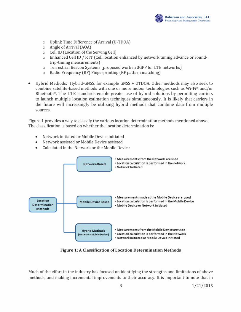
Figure 1 provides a way to classify the various location determination methods mentioned above. The classification is based on whether the location determination is:
Network initiated or Mobile Device initiated Network assisted or Mobile Device assisted Calculated in the Network or the Mobile Device
Figure 1: A Classification of Location Determination Methods
Much of the effort in the industry has focused on identifying the strengths and limitations of above methods, and making incremental improvements to their accuracy. It is important to note that in

9 1/21/2015
Roberson and Associates, LLC Technology and Management Consultants
challenging indoor radio environments, some technologies that perform well outdoors in macro cellular networks (large and medium cell sizes with range of several hundred meters or more) may encounter performance challenges. This is an issue that needs further work.
1.2 Necessity to Investigate Alternative Indoor Location Approaches In its Third FNPRM10, the FCC has acknowledged that the proposed indoor requirements for horizontal location within 50 meters and z-axis information within 3 meters could still result in building misidentification and are insufficiently granular to provide room or apartment-level information. The importance of serving public safety through the delivery of dispatchable location (such as a civic address) for wireless E911 calls is well recognized and even with incremental improvements in accuracy of existing methods, there still remain important challenges on that front.
In this paper we report on our survey and analysis of a number of indoor wireless access technologies and architectures that have recently gained widespread acceptance in the United States and abroad for commercial applications, though not for E911. Our particular interest is an investigation of how these technologies have been used for determining the indoor location of their users. Specific technologies were investigated, including but not limited to those based on “beaconing” principles:
Bluetooth Low Energy (BLE) Wireless Local Area Networks (LANs) (Wi-Fi®) Femtocells Hybrid approaches (combinations of the above)
Indoor wireless access technologies such as Bluetooth®, Wi-Fi® and Femtocells, have found increasing acceptance and deployment in a wide variety of commercial, enterprise, government and residential applications such as:
Indoor navigation and guidance at public venues for improving customer experience at airports, railway stations, shopping centers, and sports stadiums.
10 3rd FNPRM, ¶ 117 (“In developing a framework for E911 location accuracy, we seek comment on how any potential near-term requirements would operate in a NG911 environment, as well as how these requirements could facilitate the Commission’s long-term location accuracy objectives. The accuracy requirements discussed above only provide for an estimate of a wireless 911 caller’s location. The proposed requirements for horizontal location within 50 meters and z-axis information within 3 meters could still result in building misidentification, and are insufficiently granular to provide room or apartment-level location. We agree with commenters who assert that public safety would be best served through the delivery of a dispatchable location.”).

10 1/21/2015
Roberson and Associates, LLC Technology and Management Consultants
Resources and asset tracking in enterprises, e.g., factories, offices, and stores. Targeted micro-location-based marketing, e.g., customized advertisements, coupons, and
vouchers. Collection of data analytics enabling enterprises to study and track customer movements
and habits to improve business decisions and marketing models. Wireless internet access in residential and enterprise environments in rural, suburban and
urban environments (including high rise buildings and multi-tenant dwellings).
It is essential to consider how best to leverage these alternative technologies to achieve a dispatchable location solution that could meet long-term public safety requirements. In this context, we propose a high-level architectural framework that could be utilized by wireless operators to provide such a dispatchable location to public safety first responders. We strongly believe that a ubiquitous adoption of the above technologies in indoor environments presents a viable, future-proof, evolutionary path to meet the dispatchable location requirements of public safety.
In our assessment:
The technologies considered here have growing adoption rates and will become even more widely deployed in the coming months and years.
As a matter of due diligence, all stakeholders interested in the long-term public safety goal of providing a dispatchable location solution for wireless E911 calls must consider the current state and potential of these alternate technologies.
Leveraging these new technologies to develop a pragmatic approach to fulfilling long term public safety needs requires the cooperative participation of all interested stakeholders.
Finally, in order to conduct a pragmatic and objective assessment of proposed indoor location technologies, the following questions guided our research:
How does the technology address the indoor location challenges? How well developed is the technology—is the technology capable of meeting desired indoor
accuracy requirements? What are the scope and limitations of the technology? Are there current demonstrations and/or deployments of the technology in the commercial
marketplace? What are some examples of ongoing deployments and their current status and experiences? How well developed is the ecosystem of vendors that can deliver and support the technology
today? In the near/medium/long term future? Is the technology amenable to evolve to satisfy public safety requirements? What incremental
steps or development are needed to achieve an E911 wireless dispatchable location solution for public safety?
11 1/21/2015
Roberson and Associates, LLC Technology and Management Consultants
What resources are in the market that carriers can leverage to demonstrate they can move forward in a reasonable timeframe?
What actions can be taken by various stakeholders—including the public safety community, the FCC and others—to progress toward realization of long-term E911 indoor location goals?
2. Bluetooth® Beacons Bluetooth® wireless technology enables devices within a prescribed range to interact and communicate with one another. The technology was first created in 1994 to enable the exchange of data over short distances using radio transmissions in the unlicensed industrial, scientific and medical (ISM) band at 2.4 – 2.4835 GHz using spread spectrum, frequency hopping, full-duplex signals. The core specifications have undergone several updates over the past several years.11 Bluetooth Low Energy (BLE) 4.0 is the Bluetooth® wireless personal area network technology used for transmitting data over short distances, in applications such as mobile phones, computers, medical equipment, and home entertainment devices. It has been enhanced for low energy operation and low cost implementation. The BLE system uses 40 RF channels (each 2 MHz wide) with transmit power in the range 0.01 – 10 mWatts. It has been designed for low energy consumption and cost compared to its predecessor, classic Bluetooth® which is used for more complex applications requiring consistent communication and high throughput. BLE can be configured for operation with a single coin battery than can last up to 3 years of operation and a range of about 10 meters. Such operating parameters are well suited for indoor location determination purposes with simple and highly accurate methods (e.g., cell-of-origin described in Section 3.1). The range of the Bluetooth® radio may be optimized according to application. The majority of Bluetooth® devices on the market today include the basic 30 foot, or 10 meter, range of the Classic Bluetooth® radio, but there is no limit imposed by the Bluetooth® specification. Aside from using cell-of-origin as the primary method to provide the actual dispatchable location of the beacon, using well-known triangulation methods, it is realistic to achieve location accuracy within a few meters or less in a Bluetooth® deployment. In this paper, Bluetooth® beacons are transmitters that use BLE 4.0 to broadcast signals that can be heard by compatible smart devices. These transmitters can be powered by batteries or a fixed power source such as a USB adapter. When a smart device with Bluetooth® capability is in a beacon’s proximity, the beacon will automatically recognize it and will be able to interact with that device. Beacons offer the versatility of being able to be placed virtually anywhere - indoors or outdoors.
11 Bluetooth Special Interest Group, SPECIFICATION ADOPTED DOCUMENTS, https://www.bluetooth.org/en-us/specification/adopted-specifications (Bluetooth Special Interest Group has pointers to Bluetooth Core Specifications 4.0, 4.1 and 4.2 [relevant to Bluetooth Low Energy] as well previous versions [2.0, 2.1, 3.0]).

12 1/21/2015
Roberson and Associates, LLC Technology and Management Consultants
BLE was introduced in version 4.0 of the Bluetooth® Core Specifications12 in July 2010 and has been marketed as Bluetooth Smart and Bluetooth Smart Ready devices. In December 2013, version 4.1 of the Bluetooth Core Specification was released to provide improved data transfer, better connections and co-existence support for LTE. Bluetooth® and LTE radios can communicate and coordinate automatically in order to ensure transmissions are coordinated and therefore reduce the possibility of near-band interference. As of December 2014, Bluetooth Core Specification 4.2 is the latest update delivering further enhancements for Bluetooth Smart. Bluetooth 4.2 makes Bluetooth Smart even smarter, faster and the ideal wireless technology for the Internet of Things (IoT).
2.1 Bluetooth® Technology Description
Beacons transmit a low energy radio signal at periodic intervals from a device. The main function of the beacon is to notify smartphones in its close proximity of its existence at a physical location. The logic behind a beacon deployment is resident on supporting beacon-aware applications on smartphones. Users need not be connected to the internet in order to receive beacon notifications. A beacon is identified uniquely using three customizable fields that can be used to identify its location (Figure 2). These are:
a) Universal Unique Identifier (UUID): This component is used to distinguish the beacons from one another. It is guaranteed to be unique across all space and all time and can be independently created in a distributed fashion. No central registry of assigned UUIDs is required. A UUID is a 128-bit value.
b) Major: An optional component of the UUID that specifies a group of related beacons (minimum: 0, maximum: 65,535).
c) Minor: Another optional component of the UUID that is specific to a beacon in a related group of beacons (minimum: 0, maximum: 65,535).
12 Id.

13 1/21/2015
Roberson and Associates, LLC Technology and Management Consultants
Figure 2: Typical Contents of Bluetooth® Beacon Signal
An important factor in using beacons is the power source driving the beacons. Some beacons are plugged into the wall socket, others may use USB and still other beacons are powered by batteries of all shapes and sizes. In the latter case, battery life depends on the transmit power and frequency of beacon transmissions. By configuring the right balance between performance (beacon advertising interval) and energy efficiency (broadcast signal power), it is possible to achieve a battery life lasting up to several years. Additional use of smart algorithms from vendors optimizing energy consumption of beacons may extend the battery life even further. Applications could run in the background and still receive beacon signals. BLE 4.0 minimizes battery impact prolonging battery life.
2.2 Existing and Planned Demonstrations/Deployments
Bluetooth® beacons are generally very small and can be installed in discrete locations. These beacons transmit in the 2.4 GHz ISM band and can be placed in elevated positions (or in ceilings) to minimize signal blockage. They typically come with an adhesive-back surface and can be easily stuck to any flat surface like a glass window, a wooden door, a painted wall, or even an exit sign. Many businesses and developers in diverse industries are realizing the potential of this technology and are already taking advantage of it to deliver relevant and contextual interactions to their customers. The versatility of the technology makes the uses of the beacons countless, and limited only by the imagination of the business.13
13 ABI Research Technology Market Intelligence, iBeacon/BLE Beacon Shipments to Break 60 Million by 2019, Press (July 8, 2014) https://www.abiresearch.com/press/ibeaconble-beacon-shipments-to-break-60-million-by.
UUID 20e7g87b-ge15-6bb4-c27f-f04388274bg7
Major ID < optional> (e.g. Store#50)
Minor ID < optional> (e.g. Cosmetics – Aisle 22)
Optional field(s)

14 1/21/2015
Roberson and Associates, LLC Technology and Management Consultants
Bluetooth® beacons are quickly becoming ubiquitous14 with applications such as:
Proximity15 Advertising – retailers offering personalized offers and discounts to customers. Indoor Positioning – enable indoor navigation in locations where GPS is unavailable. Places of Interest – users receive contextual information with great precision and relevance. Smart Signage – provide relevant content from signs and digital displays. Home Automation – create home of the future and/or automate various elements in a home
(thermostats, garage door opener, electric lights, appliances, security systems and more).
One of the most publicized recent users of Bluetooth technology is Apple’s iBeacon. iBeacon is an Apple Application Programming Interface that uses third party BLE 4.0 devices as beacons. It allows businesses to add location features and send location-specific information to iOS 7 and 8 devices within its range. Beacons run on BLE 4.0 and can only send signals or information to devices that have Bluetooth® turned on. Users who don’t want to interact with beacon-enabled applications can simply disable Bluetooth® for particular applications or turn it off completely.
In addition to the introduction of iBeacon by Apple as part of their iOS 7 release, countless Bluetooth® proximity beacon manufacturers have entered the market. BLE beacons are not only becoming lower cost, but enterprises world-wide have been rolling out the technology on a great scale.16 As application developers increasingly build beacon support into their applications, smartphone users are increasingly benefiting in a variety of environments—retail shops, airports, restaurants, hotels, stadiums, museums and more. They are used for indoor navigation, as well as improving customer experiences and engagement. New location-based applications are continually being developed with support from software vendors and beacon hardware manufacturers. E911 positioning could be a natural beneficiary of the existing and planned rollout of Bluetooth® beacons.
In one example of how Bluetooth® beacons can be used to assist with indoor navigation and provide relevant information to consumers, American Airlines has a BLE beacon pilot at Dallas/Fort Worth International Airport (DFW) that allows travelers access to a range of way-finding and
14 Matt McFarland, How iBeacons could change the world forever, WASHINGTON POST, (Jan. 7, 2014), available at http://www.washingtonpost.com/blogs/innovations/wp/2014/01/07/how ibeacons-could-change-the-world-forever/. 15 Aspina, Aspina Supports Any iBeacon Compatible Beacon Out of the Box, Beacons http://apsima.com/beacons/bluetooth-proximity-beacons. 16 Claire Swedberg, Simon to Implement Bluetook Beacons at 240 Malls, Outlets, RFID Journal, (Sept. 02, 2014) http://www.rfidjournal.com/articles/view?12144, https://gigaom.com/2014/03/25/mobiquity-switches-on-its-bluetooth-beacon-network-covering-100-u-s-malls/.

15 1/21/2015
Roberson and Associates, LLC Technology and Management Consultants
location based services from their mobile device.17 18 The airline is using a new Common-use Beacon Registry (Registry) developed by technology provider SITA.19 20 The Registry allows airlines to make shared use of BLE beacons installed in airports. The Registry has given the airline industry a single point of contact for common-use beacons deployed at any airport around the world. By using the Registry, airports can control and share the metadata—the exact location including information on gates and terminals with airlines, and allow passengers to receive accurate and relevant flight information. Other application developers are enabled to create travel-related applications that make use of the airport’s beacon infrastructure via an Application Programming Interface. The same or similarly developed infrastructure may be able to be leveraged for E911 positioning in the future.
In addition to the example above, in order to improve customer experiences, the retail industry has seen a large and ever growing list of adopters of BLE 4.0 technology in the past few years. An example of this can be seen with Macy’s department stores testing Bluetooth® beacon technology in 2013 in major cities21 and building out its deployment of Shopkick22 23 BLE beacons (approximately 4,000), to include multiple departments in all its stores. The deployment will enable a shopper who opts in to receive discount coupons and rewards within a store, based on his or her location. There are additional case studies illustrating the adoption of Bluetooth® beacon technology in public venues for location purposes.24
17 SITA, Beacons Show the Way, News and Events, AIR TRANSPORT IT REVIEW, Issue 2, (2014) available at http://www.sita.aero/content/Beacons-show-way. 18 Sarah Clark, American Airlines pilots BLE beacons in Dallas, NFO World+, (June 19, 2014, 11:45 AM), http://www.nfcworld.com/2014/06/19/329793/american-airlines-pilots-ble-beacons-dallas/. 19 SITA, SITA Shows the way for iBeacon Technology at Airports, NEWS AND EVENTS, (June 18, 2014) http://www.sita.aero/content/SITA-shows-way-iBeacon-technology-airports. 20 SITA, Common Use Beacon Registry, BEACON REGISTRY API, http://www.developer.aero/beaconregistry/. 21 Claire Swedberg, Macy's Tests Shopkick's ShopBeacon at New York, San Francisco Stores, RFID JOURNAL, (Dec. 09, 2013) http://www.rfidjournal.com/articles/view?11250/. 22 SHOPKICK, http://www.shopkick.com/. 23 Claire Swedberg, Macy's Expands RFID & Beacon Deployments, RFID JOURNAL, (Sept. 16, 2014) http://www.rfidjournal.com/articles/view?12183. 24 Fosbury, The Event Blueprint for iBeacons White Paper, Resources, (2014), http://www.fosbury.co/ (Fosbury iBeacon Case Studies White paper contains examples of Bluetooth® beacon deployments at Major League Baseball parks, drug stores (Duane Read / Walgreens), airline carriers such as Virgin Atlantic, grocery stores, sports teams etc.).

16 1/21/2015
Roberson and Associates, LLC Technology and Management Consultants
2.3 Vendor Assessment and Ecosystem
Significantly, BLE beacon technology is supported by both Apple (with iOS and OS X) and Google (with Android). This means broad availability with 100s of millions of devices already beacon-enabled. There is little risk of launching services that only target a single OS. In short, all BLE 4.0 enabled devices can receive beacon signals. These include the iPhone 4S, iPhone 5, iPhone 6, iPhone 6 Plus, iPad 3, Samsung Galaxy S series, and more.25 Microsoft has recently added support for BLE in Windows 8, Windows Phone 8 and Nokia's Lumia WP8. A sample list26 of Bluetooth® beacon vendors is noted below. Details of their offerings may be found on their websites.
2.4 Application to Public Safety
At present the use of BLE beacons is gaining momentum in a variety of user environments as described in Section 2.2. These deployments can be leveraged to serve the interests of public safety. When a smartphone user makes a 911 call, its Bluetooth® functionality can be automatically turned on, if not already active. It can receive the UUID and signal strength of the nearest Bluetooth® beacons, and report them to the location determination process described in Section 3.4.
A useful aspect of Bluetooth® beacons is the availability of optional field(s) that could be provisioned with dispatchable location information as an integral part of the beacon information. Assuming the validation of provisioning can be done by an authorized entity, the beacon
25 Bluetooth, Bluetooth Smart Ready Products, Using Bluetooth® Products, http://www.bluetooth.com/Pages/Bluetooth-Smart-Devices-List.aspx (Bluetooth® provides a full list of devices that are compatible with beacons.). 26 A sample list of Bluetooth® beacon vendors:
ESTIMOTE, http://estimote.com. KNONTAKT.IO, http://kontakt.io. RADIUS NETWORKS, http://www.radiusnetworks.com. BLUECATS, http://www.bluecats.com/. PASSKIT, https://passkit.com/gemtot-ibeacon-specifications/. TWOCANOES, http://twocanoes.com/bleu. EASIBEACON, http://www.easibeacon.com/. REDBEARLAB, http://redbearlab.com/ibeacon. GIMBAL, http://www.gimbal.com/. BLUESENSE NETWORKS, http://www.bluesensenetworks.com/ . GELO, http://www.getgelo.com/. GLIMWORM BEACONS, http://www.glimwormbeacons.com/. SENSORBERG, http://www.sensorberg.com/. SIGNAL3, http://www.sonicnotify.com/.

17 1/21/2015
Roberson and Associates, LLC Technology and Management Consultants
information can then be used for dispatching first responders. An example of a beacon including dispatchable location is shown in Figure 3 to illustrate the concept. Alternatively, location information for the UUID could be included in a master database that a carrier would access to locate a caller.
Figure 3: A Beacon Signal with Dispatchable Address
3.0 Wi-Fi®
IEEE 802.11 based wireless LANs (WLANs), also referred to in this paper as Wi-Fi®,27 were first standardized in 1997 and since then they have been updated with added functionality numerous times. Initially they were conceived and introduced as a way to enhance productivity in vertical market environments. However, since about year 2000, there has been increasing adoption of mobile computers and handheld devices requiring wireless connectivity. This drove the dramatic adoption of Wi-Fi® and the wide deployment of 802.11 based wireless LANs across the globe.28 About 72% of the mobile phones in use today are smartphones29 with Wi-Fi® interfaces, and in the future this will increase further. Wi-Fi® has become pervasive throughout the US and is becoming virtually ubiquitous with deployments in offices, homes, manufacturing and distribution centers, metropolitan areas, and all manner of public as well as private venues.
In the US, there are over 120 million Wi-Fi® access points deployed in 2014,30 with the number growing by millions each year. It is natural to take advantage of the location determination
27 WI-FI ALLIANCE, http://www.wi-fi.org/ (The Wi-Fi® Alliance is the industry consortium responsible for the higher protocol layers and interoperability of the IEEE 802.11-based LANs). 28 Wi-Fi® Alliance, Total Wi-Fi® device shipments to surpass ten billion this month, News & Events (Jan. 5, 2015), http://www.wi-fi.org/news-events/newsroom/total-wi-fi-device-shipments-to-surpass-ten-billion-this-month. 29 Greg Sterling, Smartphone Penetration Likely To Be 75 Percent By Year End, MARKETING LAND SECTIONS (Aug. 07, 2014), http://marketingland.com/nearing-75-percent-smartphone-penetration-year-end-94903. 30 Letter from H. Russell Frisby, Jr., Counsel for TeleCommunications Systems, Inc., to Marlene H. Dortch, Secretary, FCC, PS Docket No. 07-114, Attachment at 28 (Jan. 16, 2015).
UUID 20e7g87b-ge15-6bb4-c27f-f04388274bg7
Major ID < optional>
Minor ID < optional>
Optional field(s) ABC Co.(17th Floor, Suite 120, 500 Main St, Peoria, IL)

18 1/21/2015
Roberson and Associates, LLC Technology and Management Consultants
capabilities inherent in Wi-Fi® access points and use them for a variety of location-based services (LBS), including emergency call handling for 911 callers. The inherent capability of the ever increasing installed base of Wi-Fi® technology could redefine indoor location determination for E911 and deliver dramatically improved first response outcomes. In this section we describe the basics of location determination with Wi-Fi® and recent industry demonstrations of practical solutions using Wi-Fi® positioning for 911 calls.
3.1 W-Fi® Technology Description
The Institute of Electrical and Eletronics Engineers (IEEE) 802.11 WLAN standard31 deals with the data link and physical layers of the wireless protocol stack. Today’s commercial WLAN products are mostly based on IEEE 802.11a, 802.11b, 802.11g, 802.11n and more recently 802.11ac protocols, each distinguished by the frequency band and modulation schemes used at the physical layer. The data link layer functions are covered by the Media Access Control (MAC) protocol of the 802.11 standard. The MAC protocol governs access to the wireless transmission medium enabling the exchange of data between wireless devices in the WLAN network.
A MAC address is a globally unique identifier assigned to a wireless network interface for communication on a physical network. The MAC address is used as a network address on an IEEE 802.11 network and in the MAC protocol layer for access to the wireless medium. MAC addresses are typically assigned by the manufacturer of a network interface controller (NIC) and are stored in the hardware or firmware of the card. They are also referred to as the hardware or physical address. A network node, such as an access point, may have one or more NICs with a unique MAC address for each NIC. MAC addresses are formed according to rules of address numbering spaces and managed by the IEEE. The most common addressing scheme is called MAC-48 in which each MAC address is denoted in six groups of two hexadecimal digits, separated by hyphens (-). An example MAC address is: 02-13-45-69-78-AB. The 48-bit address space contains potentially over 281 trillion possible MAC addresses and is sufficiently large to uniquely identify all current and anticipated wireless interfaces. In short, a MAC address is a unique way to identify a wireless interface or network element in a WLAN network and provides an unambiguous mechanism to identify devices such as smartphones, access points and other Wi-Fi® enabled devices.
In most common Wi-Fi® network deployments, a mobile device communicates to an access point with which it is associated. The access points are connected by a wired local area backbone network which provides connectivity to the Internet. Communication from (or to) the mobile device always occurs via the access point with which it is associated. Thus, the access point serves
31 IEEE STANDARDS ASSOCIATION, IEEE 802 Standard for Information technology—Part 11: Wireless LAN Medium Access Control (MAC) and Physical Layer (PHY) Specifications, IEEE Get Program, http://standards.ieee.org/about/get/802/802.11.html.

19 1/21/2015
Roberson and Associates, LLC Technology and Management Consultants
as an anchor and is considered the “cell-of-origin” for the mobile devices. Wi-Fi® access points are configured to satisfy a competing set of objectives for coverage, capacity and reliability of service. Considering the wide range of deployment scenarios, cell radii with typical values of about 20 meters are quite common.
Early work on WLAN based indoor positioning was based on signal strength measurements.32 Subsequently, a number of Wi-Fi® positioning technologies have evolved over the past few years.33 34 The following are a few of the positioning techniques that have been used successfully by various Wi-Fi® vendors for indoor location determination. Of course, for Wi-Fi® to be successfully used for location purposes, a mobile device must have its Wi-Fi® interface enabled.
Cell-of-Origin – This technique resolves the position of a mobile device by identifying the Wi-Fi® access points closest to it. Because of the limited RF range of the Wi-Fi® access points, cell-of-origin can provide accurate location determination. A mobile device scans for Wi-Fi® access points in its radio proximity. For each Wi-Fi® access point that is detected, it gathers the unique Media Access Identifier (MAC ID) and measures the Received Signal Strength Indicator (RSSI) for signals from it. The information collected by the mobile device is reported to the network and then used to identify of the closest Wi-Fi® access point. The network can refer to a database that simply contains the unique identifying MAC ID for each listed Wi-Fi® access point and its associated physical location usable for dispatching first responders, e.g., 73.163.27.219 (MAC ID) = 123 Main Street, Suite 400. In the case of Bluetooth®, one can regard the BLE beacon that is sending the strongest periodic beacon signals to the client device as the cell-of-origin. In this case, a database containing the dispatchable location of the BLE beacon identified by its UUID and associated location can be used for dispatch purposes. A single database could be used for both Wi-Fi® and Bluetooth®-based beacons.
Time of Arrival methods are distance-based, multilateration techniques that rely on the precise measurement of the arrival time of a signal transmitted from a mobile device to several receiving access points. The distance between the mobile device and each access point can be determined from the elapsed propagation time of the signal traveling between them. The technique requires very precise knowledge of the transmission start time(s) and must ensure that all receiving access points, as well as the mobile device, are accurately synchronized with a precise time source.
32 Z. Xiang et al., A Wireless LAN-Based Indoor Positioning Technology, IBM J. RESEARCH AND DEV., Vol. 48 (Sept. – Nov. 2004). 33 Cisco Systems, Wi-Fi® Location-Based Services Design Guide 4.1, (May 2008) www.cisco.com/c/en/us/td/docs/solutions/Enterprise/Mobility/WiFiLBS-DG.html. 34 Aruba Networks, Location-Based Services for Cell Phones Using Wi-Fi® White Paper (2010) http://www.arubanetworks.com/pdf/technology/whitepapers/wp_AirWave-LocationService.pdf.

20 1/21/2015
Roberson and Associates, LLC Technology and Management Consultants
Time Difference of Arrival methods are distance based techniques that use relative time
measurements at each receiving access point in place of absolute time measurements. Because of this, this method does not require the use of a synchronized time source at the point of transmission (e.g., the mobile device) in order to resolve timestamps and determine location. A transmission with an unknown starting time is received at various receiving access points, with only the latter requiring time synchronization. At least three time-synchronized receiving access points are required.
Received Signal Strength Indicator (RSSI) methods are used in distance based techniques. The RSSI is measured by either the mobile device or the receiving access point. With knowledge of the transmitter output power, cable losses, and antenna gains, as well as the appropriate path loss model, one can solve for the distance between the two stations. Using measurements from three access points, it is possible to calculate the location of the mobile device.
Angle of Arrival or Direction of Arrival techniques locate the mobile station by determining the angle of incidence at which signals arrive at the receiving access points. In a three-dimensional plane, at least three receiving access points are required for location estimation. Improved accuracy can be achieved with four or more receiving access points. This method has been used successfully in macro-cellular networks and works well in line of sight but is less effective in dense urban or cluttered office Wi-Fi® environment with significant multipath interference.
RF Fingerprinting refers to a technique that is based on the sampling and recording of radio signal behavior patterns in a specific environment. This solution may be implemented totally via software with significantly less complexity and cost compared to distance-based or Angle of Arrival methods. This method assumes that each potential device location ideally possesses a distinctly unique RF “signature”.
3.2 Existing and Planned Demonstrations and Deployments
Many Wi-Fi® location determination methods have been designed employing existing radios and RF spectrum, and utilizing primitives for device location that have been standardized for 802.11 control. In fact, a growing number of enterprises have implemented Wi-Fi® based location solutions using a variety of the location techniques described in section 3.1. Enterprise WLANs have been deployed to quickly locate and deploy valuable assets and key personnel. Network administrators, security personnel, users, asset owners and others have great interest in location-based services to allow them to better address key issues such as reducing loss due to unauthorized removal of assets from company premises, improving WLAN planning and tuning capabilities, coordinating Wi-Fi® device location with security policy enforcement, monitoring the health and status of key

21 1/21/2015
Roberson and Associates, LLC Technology and Management Consultants
assets in their environment and receiving prompt notification of changes, and receiving prompt notification when unauthorized addition or removal of assets occurs.
In one specific enterprise network-based implementation35, location determination uses “probes”. It is based on measurement of RSSI at the Wi-Fi® access points (See Figure 4) with the following main steps:
1. Access points detect mobile devices and measure RSSI from all frames sent over the Wi-Fi® network.
2. The RSSI information is relayed in the Wi-Fi® network to a centralized location server for location calculation.
3. The centralized location server will calculate the device location using multilateration algorithms, such as those described in Section 3.1.
In Figure 4, there are 4 access points, AP1, AP2, AP3 and AP4. The measured RSSI values from mobile device MD at APi is Si (i=1, 2, 3, 4). These are relayed to the centralized Location Server (LS). The LS is programmed with the geographic location of each access point. Using a knowledge of the RSSI values, the LS computes the distance of MD from each access point. These are shown in Figure 4 as distance D1 from AP1, D2 from AP2, D3 from AP3 and D4 from AP4. Using knowledge of the geographic locations of access points and their distances to the MD, the LS will use triangulation methods to precisely locate the location of the Mobile Device. Note that the LS can also use hybrid combination of algorithms described in Section 3.1. This technology can be easily applied to emergency calling. For example, when a mobile phone user on an enterprise Wi-Fi® network initiates a 911 call, the accurate location of the caller can be determined in real-time using one of the methods in Section 3.1. Telecommunications Systems (TCS) and Cisco Systems, Incorporated (Cisco) have teamed to provide such a solution. When a cellular 911 call is made, it is routed based on the cell sector where the call originates to the PSAP assigned for responding to calls from the sector.
35 Marc Linsner, Solutions Architect, Cisco Systems, Inc., Next Generation Indoor Location for Public Safety, IIT REAL-TIME SYSTEMS CONFERENCE (Oct. 01, 2014), available at http://www.rtc-conference.com/wp-content/uploads/gravity_forms/2-2f7a537445fa703985ab4d2372ac42ca/2014/10/Linsner-NG911-RegulatoryPolicy-Presentation.pdf.

22 1/21/2015
Roberson and Associates, LLC Technology and Management Consultants
Within each sector, there are potentially multiple enterprise and/or residential Wi-Fi® networks (Figure 5). On reception of the 911 call, the Wi-Fi® networks within the sector (originating the call) are individually probed to see if they can see the device originating the call. Only one of the Wi-Fi® networks will respond positively and that network is probed further to determine more accurate location information, e.g., the access points that detect the mobile device calling 911. The Wi-Fi® network location and tracking methods in the enterprise network (described previously) are used to provide highly accurate location information to the PSAP, thus enabling dispatch of public safety personnel. Additional functions required to support Wi-Fi® E911 positioning are an integral part of the Wi-Fi® network. These include:
Ability to track the phone location to the access point (“cell of origin”). Maintain a location database of all access points in the Wi-Fi® network. Reception of real-time events when a phone moves from one access point to another.

23 1/21/2015
Roberson and Associates, LLC Technology and Management Consultants
Figure 5: Probing the Wi-Fi® Networks in a Sector of the Macro Network
While the above description is based on network-centric implementations of Wi-Fi® location determination, alternate Wi-Fi® location methods have been developed and widely deployed in consumer/public environments. For example, the RSSI strengths from different access points can be measured at the mobile device and reported to a location server (that is aware of the location of the access points). The location server can use the measurements to determine the location of the mobile device. Another example that uses crowdsourcing36 37 principles has allowed companies like Google, Apple and others to develop their own mobile-centric implementations of Wi-Fi® location determination.
For instance, an Apple iPhone, with its Wi-Fi® interface turned on, periodically scans for Wi-Fi® access points in its vicinity and sends geo-tagged locations of the nearby Wi-Fi® access points in an anonymous and encrypted form to Apple. Apple maintains a crowd-sourced database of Wi-Fi® access point data that is generated by tens of millions of iPhones that are continually scanning their radio proximity. Since the entire crowd-sourced database is too large to store on an iPhone, a
36 URBAN DICTIONARY, “Crowdsourced” http://www.urbandictionary.com/define.php?term=Crowdsourced – (Organizations collect data or relevant information from the masses of people using certain services or devices in order to compile useful information (anonymously) for the future development of other technologies.). Apple crowdsources (crowdsourced) Wi-Fi® hotspot and cell tower Location information from iPhone users to compile a database with locations of fixed Wi-Fi® access points and cell towers in order to enhance location based services on mobile devices. 37 Ludovic Privat, Mozilla to Crowdsource Wi-Fi® & Cell-ID Locations for Geo-Positioning Service, GPS NEWS BUSINESS (Oct. 29, 2013) http://www.gpsbusinessnews.com/Mozilla-to-Crowdsource-WiFi-Cell-ID-Locations-for-Geo-Positioning-Service_a4479.html.

24 1/21/2015
Roberson and Associates, LLC Technology and Management Consultants
subset (cache) of the crowd-sourced Wi-Fi® hotspot database is downloaded from Apple into the iPhone to assist the iPhone in rapidly and accurately calculating its location when requested. It is worth noting that these calculations are performed live on the iPhone using the crowd-sourced database of Wi-Fi® hotspot data and demonstrate a successful mobile device-centric approach. The other major class of smartphone devices in wide use today is based on the Google Android platform: a similar crowdsourcing approach has been successfully implemented for Android and is in wide use today.
In summary, application of Wi-Fi® based position determination has been well demonstrated and is in wide use commercially. These techniques can be utilized to serve the needs of E911 emergency positioning as well.
3.3 Vendor Assessment and Ecosystem
There are a multitude of vendors that are active in offering Wi-Fi® products and services in both the residential and enterprise markets. Several vendors, such as Cisco, Aruba and Ruckus Wireless, offer enterprise based Wi-Fi® location services.38 39 40 In regards to Wi-Fi® based 911 location solutions, in many cases a Wi-Fi® services vendor will work in partnership with a Gateway provider, such as Intrado, TCS or RedSky to provide PSAPs with the information necessary for dispatching public safety personnel. The Gateway functions to provide the interworking of the Wi-Fi® network and the cellular network.
We provide examples of some vendors that specialize in Wi-Fi® based E911 solutions and provide references to their product briefs, customer deployments, and experience. The vendor TCS offers a variety of public safety solutions based on different radio access and location technologies and is recognized as a pioneer in wireless E911. TCS has partnered with Cisco Systems to develop a Wi-Fi® based E911 solution.41 TCS and Cisco have demonstrated how Wi-Fi® can enable first responders to locate mobile phone users in emergencies.42 At the NENA 2014 Conference and Expo,
38 CISCO SYSTEMS, INC., Wi-fi Location-Based Services 4.1 Design Guide, http://www.cisco.com/c/en/us/td/docs/solutions/Enterprise/Mobility/WiFiLBS-DG.html 39 ARUBA NETWORKS, Aruba Mobility-Defined NetworksTM empower a new generation of users who rely on their mobile devices for every aspect of work and personal communication, Products, http://www.arubanetworks.com/products/. 40 RUCKUS WIRELESS, Enterprises http://www.ruckuswireless.com/enterprises (last visited Jan. 21, 2015). 41 TeleCommunication Systems, Cisco Solution, 9-1-1 AND INDOOR LOCATION ACCURACY, http://www.telecomsys.com/products/public-safety/indoor-location-accuracy/cisco.aspx (Notes that there is a partnership between Cisco Systems (provider of Wi-Fi® network with mobility tracking and management) and TCS (provider of next generation text to 9-1-1 solution).). 42 IWCE's Urgent Communications, TCS and Cisco Systems: Roger Marshall and Marc Linsner outline joint proposal to leverage Wi-Fi® for indoor-wireless 911 location, (June 17, 2014)

25 1/21/2015
Roberson and Associates, LLC Technology and Management Consultants
the companies gave a technology presentation that demonstrated the functionality of their solution. The demonstration43 showed the use of Wi-Fi® technology to complement standard 911 solutions for the purpose of providing indoor location information in emergency situations. Using Cisco’s Mobility Services Engine (MSE) for Wi-Fi® together with TCS’s GEM9-1-1 information mapping solution, they demonstrated that the MSE can provide an indoor caller’s location information to the 911 call taker. This information is valuable especially considering other location techniques may face challenges in some indoor environments. The basic principles of the TCS-Cisco implementation were described above in section 3.2. Another vendor in the ecosystem of Wi-Fi® E911 solution providers is RedSky Technologies.44 The company is a provider of E911 software solutions to enterprise customers. The company claims support for hundreds of customers (including 50+ Fortune 500 companies) with its software to automate their customers’ E911 processes. Its main software products include E911 Manager and Wi-Fi® E911 software modules45, and the products are compatible with many different call servers, including those from Avaya, Nortel, Cisco and others. RedSky’s solution is also compatible with Wi-Fi® vendors like Cisco, Aruba and others.
3.4 Proposed Architecture for Public Safety
3.4.1 In-Location Alliance Architecture
Recently, a multi-entity consortium called the In Location Alliance has published a white paper with recommended specifications for indoor E911 positioning systems and their interoperability.46 The
http://m.urgentcomm.com/cisco/tcs-and-cisco-systems-roger-marshall-and-marc-linsner-outline-joint-proposal-leverage-wi-fi-in?NL=UC-03&Issue=UC-03_20140617_UC-03_892&[email protected]&YM_MID=1471359&sfvc4enews=42&cl=article_5. 43 TeleCommunication Systems, Inc., TeleCommunication Systems and Cisco Demonstrate How Wi-Fi® can Enable First Responders to Locate Mobile Phone Users in Emergencies, YAHOO FINANCE, (June 16, 2014) http://finance.yahoo.com/news/telecommunication-systems-cisco-demonstrate-wi-120000045.html. 44 REDSKY TECHNOLOGIES, INC., www.redskyE911.com. 45 REDSKY, Wi-Fi® E911, Product Data Sheet for Cisco Systems, Inc., http://www.redskye911.com/sites/default/files/resources/WiFie911-2013-June-Cisco-web.pdf; REDSKY, Wi-Fi® E911, Product Data Sheet for Aruba Wi-Fi® Networks, http://www.redskye911.com/sites/default/files/resources/WiFie911-2013-June-Aruba-web.pdf. 46 ILA System Architecture Working Group, ILA Architecture White Paper, Release 1.0, (Aug. 19, 2014) http://ieeeila.wpengine.com/wp-content/uploads/2014/08/ILA-Architecture-White-Paper-Release-1.0-Final.pdf (The Indoor Location Alliance is an ecosystem of industry players working together to stimulate innovation, enhance service delivery and accelerate market adoption of Bluetooth® and Wi-Fi® based indoor position.).

26 1/21/2015
Roberson and Associates, LLC Technology and Management Consultants
main functions that have been proposed are shown (blue) in Figure 6. A simplified overview is provided below.
Figure 6: A Unified Framework for Handling Beacon-Based E911 Calls An Access/Location Network is any network that can be used for indoor location. This may consist of a multitude of technologies that can be used for indoor location, including Wi-Fi®, Bluetooth® and potentially other technologies such as A-GNSS. An Access/Location Network Database contains essential information such as the geographic coordinates of various network entities. A Location Server supports position calculation capabilities and providing data that can be used by mobile devices to either a) improve their measurements used in locating the mobile device or b) enable the mobile device to compute its position based on measurements. A Location Based Service (LBS) Application Server is an application server that provides location related content and services to a requesting entity. An LBS Application Server requires the ability to request and receive (either from a Location Server or the Mobile Device directly) the position of a MD whose position is the subject of the location related content or location service. A Map Database is a database that may include two and three-dimensional features (e.g., floor plans, walls, paths, etc.) of buildings and their properties and are geo-referenced to a well-known coordinate system. A Map Database may be connected to more than one Access/Location Network Database and LBS Application Server.
Access / LocationNetwork
Mobile Device
LocationServer
E911 AppServer
DispatchableAddress Map
Database
Access / LocationNetworkDatabase
MapDatabase
Location Based Service App
Server

27 1/21/2015
Roberson and Associates, LLC Technology and Management Consultants
A Dispatchable Address Map Database is used for the purpose of handling an E911 call from indoor locations deploying beacon based technologies such as Wi-Fi® and Bluetooth®. In such instances, the Map Database is obviated by the use of the Dispatchable Address Map Database (shaded green in Figure 6) that provides accurate and explicit information, such as floor, suite or apartment number in a building, for dispatch purposes.
3.4.2 Architectural Framework for Location Using Beacon-based Technologies This section contains a further description of an architectural framework within which beacon technologies such as Bluetooth® and Wi-Fi® can be accommodated for public safety use in dispatching first responders. While the focus of the work of In-Location Alliance is centered on use in commercial LBS environments, we propose conceptual extensions to show a feasible approach to meet public safety requirements for a dispatchable location for indoor 911 calls. The proposed architecture framework is amenable for future extensions when new indoor beacon based technologies are introduced. Associated with each Wi-Fi® access point is its unique MAC-ID. When a Wi-Fi® access point is configured in a fixed, stationary network, it is possible to associate a dispatchable location with access point’s physical placement. Associated with each Bluetooth® beacon is its UUID that is periodically broadcast by the beacon. When a BLE beacon is installed in a fixed location, it is also possible to associate a dispatchable location that corresponds to the beacon’s physical placement. The Wi-Fi® access point and Bluetooth® beacon identities are stored in tables as shown in Figure 7 to illustrate the concept. Each network element will have a unique identifier and its corresponding dispatchable location. When a 911 call is made by a smartphone user, the available Wi-Fi®/Bluetooth® radios are turned on automatically (if they are not on already) and the mobile device starts listening to beacons. After a short time interval, the MAC-ID(s) and UUID(s) of the nearby Wi-Fi® access points and BLE beacons along with RSSI measurements are made available to the service provider. The service provider needs to communicate with the Dispatchable Location Database and secure the dispatchable location information corresponding to the most appropriate Wi-Fi® or BLE beacon identifiers, depending on which Wi-Fi® access point/BLE Beacon technology is judged as providing better signal strength and quality. Consistency checks can be conducted when more than one beacon identifier is detected, by comparing the dispatchable address location with the known location of the macro cellular network serving cell, or by comparing other available location estimates. Then the service provider evaluates the best estimate based on all location estimates (including perhaps A-GNSS or other options that may be available to the mobile device) and forwards the result to the PSAP for carrying out the dispatch operations.

28 1/21/2015
Roberson and Associates, LLC Technology and Management Consultants
Figure 7: Dispatchable Address Database
4.0 Femtocells Wireless cells can be categorized as femtocells, picocells, microcells and macrocells, based on increasing cell radii and increasing transmit power levels. A Femtocell Access Point (FAP) is an operator-controlled, low power radio access node deployed in residential and enterprise environments utilizing a specific carrier(s) licensed radio spectrum. As an example, a residential FAP47 48 consists of a self-contained antenna and base station and provides coverage with a typical cell range of up to 14 meters in all directions from the base station and is capable of handling up to 4 simultaneous users. Femtocells were initially intended for home use, but they are also being used in businesses, and in both rural and metropolitan areas. They use existing Internet connections for backhaul, self-optimization, and ease of installation. They rely on standards-based, zero-touch provisioning to simplify and accelerate deployment and for plug and play end-user convenience. Service providers can put the FAPs into service on the network and configure the necessary parameters automatically without any action from end-users. They optimize use of radio spectrum
47 Cisco Systems, Inc., AT&T Microcell: A Cisco Small Cell Solution, http://www.cisco.com/c/en/us/solutions/service-provider/mobile-internet/att_microcell.html. 48 Cisco Systems, Inc., Cisco Universal Small Cell 7330, DATA SHEET (2013) http://www.cisco.com/c/en/us/products/collateral/wireless/universal-small-cell-7330/datasheet-c78-728549.pdf.
WiFi Access Point Dispatchable Address
xx-xx-xx-xx-xx-xx Address 1
yy-yy-yy-yy-yy-yy Address 2
………………….. ………………….
zz-zz-zz-zz-zz-zz Address k
Bluetooth Beacon Dispatchable Address
UUID 1 Address 1
UUID 2 Address 2
………………….. ………………….
UUID n Address n

29 1/21/2015
Roberson and Associates, LLC Technology and Management Consultants
by handling access control for authorized handsets directly at the FAP and rejecting unauthorized handsets (i.e., not registered with a FAP). A GPS module is used to provide femtocell location verification for licensed spectrum usage, and can also be used to validate the registered dispatchable location of the FAP. Note that FAPs are typically located such that they can get GPS synchronization directly (e.g., FAP is located close to a window) or indirectly (i.e., FAP is connected to an antenna located close to a window that receives GPS signals), even if the actual mobile users of the femtocell move indoors and are not able to receive GPS. E911 services are supported for femtocell users and can provide a dispatchable location. A way to achieve this is by ensuring each femtocell is registered properly. The registration information must include where the FAP is physically located and this information must be kept up to date in order to ensure the proper location is available to dispatch first responders in the event of an emergency call made using the FAP. Additionally, since this may register as Phase I with some PSAPs, there must be some indication to 911 call takers, e.g., class of service, that the address provided with the call is highly accurate and a dispatchable location, as opposed to a Cell ID location. E911 services are supported for femtocell users. A way to achieve this is by requiring femtocell users to register with the femtocell service provider. The registration information must include where the FAP is physically located and keeping the information up to date in order to ensure the proper location is available to dispatch first responders in the event of an emergency call made using the FAP.
4.1 Technology description
A typical architecture for a femtocell deployment is shown in Figure 8. It has the following functional components:
Femtocell Access Point Femtocell Gateway Auto Provisioning System Femto Management System
Among the many functions of the Femtocell Gateway, a key function is support for E911 service call flows, including the look up of FAP location. When a subscriber makes an emergency call from a mobile device (MD), the FAP recognizes the emergency status of the call in the connection request. The FAP also obtains the International Mobile Subscriber Identity (IMSI)49 of the MD. The
49 The International Mobile Subscriber Identity or IMSI is used to identify the user of a cellular network and is a unique identification associated with all cellular networks.

30 1/21/2015
Roberson and Associates, LLC Technology and Management Consultants
emergency call status plus the MD’s IMSI allows the FAP to treat the emergency call according to operator’s preferred policy for emergency call handling.
Under normal conditions (i.e., no emergency), assuming Closed Subscriber Group (CSG)50 access mode, the FAP will accept only the authorized MDs to make calls. Under emergency conditions the FAP could be mandated to accept calls from any authorized or unauthorized MD that may wish to make an emergency call. If the FAP is configured to operate in Open Subscriber Group (OSG)51 or Semi-open Access Group mode, then no users are regarded as unauthorized at the FAP.
When the FAP is configured to allow emergency calls from unauthorized MDs, i.e., CSG, it performs an emergency MD registration procedure and allows the emergency call setup to proceed. The FAP maintains a configurable timer that starts after the emergency call by the MD is released. The MD remains “emergency registered” until the timer expires and the MD is de-registered. However, when the timer is active, the MD can make further emergency calls and/or receive call back from the PSAP.
Figure 8: Typical Architecture for Femtocell Deployment
50 A closed subscriber group (CSG) is a limited set of users with connectivity access to a femtocell. When a femtocell is configured in CSG mode, only those users included in the femtocell's access control list (or the “white list”) are allowed to use the femtocell resources. 51 A femtocell can be configured as an Open Subscriber Group (OSG) and operate in an Open Access mode with any user allowed access to the femtocell resources.

31 1/21/2015
Roberson and Associates, LLC Technology and Management Consultants
4.2 Existing and Planned Demonstrations and Deployments
Beginning in 2007, there have been a number of commercial trials aimed at proving the technical and business viability of femtocells. Since that time, all national wireless carriers in the US have deployed femtocells for their customers. Some examples of existing deployments are: Sprint52, AT&T53, Verizon Wireless54, T-Mobile and others. AT&T rolled out an early commercial residential femtocell deployment in the US in 2010 and this deployment is currently among the largest of its kind in the US. Furthermore, Informa projects a rapid growth in world-wide femtocell deployments growing 24 times from 2.5 million in 2012 to 59 million in 2016.55
While the early femtocell deployments focused on 2G (CDMA) and 3G (UMTS) technologies, there is now a current industry focus to roll out 4G LTE femtocells. The importance of femtocells is greater for the 4G technologies since the 4G LTE macrocell coverage in indoor environments is initially not as ubiquitous as 2G or 3G. In such an environment, the need for 4G femtocell deployments (either in residential or enterprise settings) is much greater. In this context it is worthwhile to leverage the existing and planned femtocells for indoor E911 location determination.
4.3 Vendor Assessment and Ecosystem
The vendors providing femtocell technology include many well-known telecommunications equipment manufacturers, for example, Airvana, Samsung, NSN, Ericsson, ALU and Cisco. They address the needs of different 4G technologies that are of interest to various service providers.
There are many existing femtocell deployments for 2G/3G/4G LTE networks. Carriers should provide the location and the associated dispatchable address information of the FAP to the 911 call taker. Since femtocells are operator controlled and managed, the location information of the registered user is already in the operator database. The database can be used for 911 calls to extract and forward the appropriate location information to the PSAP. Because of their growing
52 SPRINT, Airave: Tell Me More, http://www.sprintenterprise.com/airave/tellMeMore.html. 53 AT&T, AT&T MicroCell, http://www.att.com/standalone/3gmicrocell/?fbid=DwbPqyGchT3. 54 VERIZON, Samsung Network Extender (SCS-2U01), Accessories Home, http://www.verizonwireless.com/accessories/samsung-network-extender-scs-2u01/.
55 Denise Duffy, Public Relations Manager, Informa Telecoms & Media, Small Cells to Make Up Almost 90 Percent of all Base Stations by 2016, SMALL CELL FORUM (Feb. 28, 2012) http://www.smallcellforum.org/press-releases/small-cells-make-almost-90-base-stations-2016/.

32 1/21/2015
Roberson and Associates, LLC Technology and Management Consultants
numbers, femtocells are a natural component of any indoor E911 location solution that provides dispatchable location.
5.0 Hybrid Approaches
There are many technologies for determining indoor location, but not all of them are applicable to all scenarios. In reality, a hybrid, or combination of multiple location technology approaches will represent the optimal solution enabling ubiquitous and accurate indoor positioning, ideally resulting in a dispatchable address. We expect the following scenario to exist: A mobile user’s smartphone will have the capability to use A-GPS, Wi-Fi®, Bluetooth® LE as well as other access technologies such as femtocells. The user will be able to take advantage of the incremental advancements in the outdoor location technology and standards as well. When the smartphone user is in the vicinity of the beacon-based technologies discussed in this paper, and an emergency 911 call is initiated, the Bluetooth® and Wi-Fi® interfaces can be leveraged so that a highly accurate dispatchable location can be made available to public safety. Bluetooth® as well as Wi-Fi® must be turned on (if they are not already on) and location determination activated. A hybrid approach would rely on all available technologies generating location estimates, ideally including a dispatchable location. The 911 caller’s wireless service provider will then evaluate the available indoor locations based on the technologies available to the user device, and choose the best estimate to forward to the PSAP for dispatch purposes.
6.0 Technology Comparison
When comparing technologies, the key goal of providing public safety with a “dispatchable address” must be considered. As of the beacon based technologies analyzed in this paper, dispatchable location must include not only a civic street address, but also the floor information and office suite, apartment, hotel room or classroom where applicable. The technology focus of location determination has been to arrive at greater level of accuracy of (x-, y-,) coordinates and assume some complementary accurate reverse geocoding procedure for dispatch purposes. However, a reliable and consistent reverse geocoding procedure does not exist yet and the several challenges involved are well documented.56 In contrast to this approach, we have sought to look at available and growing deployments of alternative indoor technologies (such as Bluetooth®, Wi-Fi® and Femtocells) that are inherently positioned to lead the way for dispatchable location solutions.
56 Comments of Intrado Inc., PS Docket No. 07-114 (filed May 12, 2014).

33 1/21/2015
Roberson and Associates, LLC Technology and Management Consultants
In this key measure, all the beacon-based technologies considered in this paper rank highly. (Bluetooth® ranks best, followed by Wi-Fi® and femtocells with similar performance.) The ranking is based primarily due to the inherent capability to locate indoor users to a high degree of accuracy based on radius of the beacon RF coverage.
The solutions considered here are flexible to accommodate technological advancements and are reliant on open and global standards. Investments in these technologies are future proof and amenable to graceful upgrade and evolution, and are being motivated by market demand. The solutions are not exclusive to address E911 location needs—exclusivity would tend to lead to technical stagnation and higher costs. Instead, open and global standards and commercial application ensures that these solutions will be available from multiple sources, thus creating a virtuous cycle that simultaneously encourages innovation while lowering cost, which will further increase adoption of these technologies.
The table (Figure 9) compares the performance and other aspects of the beacon-based technologies analyzed in this paper.
The technologies have reasonable time to market to reach the goal of dispatchable location. In fact, Wi-Fi®, Bluetooth®, and femtocells are already widely deployed.57 Leveraging these to improve E911 location may be regarded as an added advantage for increasing their market appeal.
57 Claire Swedberg, Simon to Implement Bluetook Beacons at 240 Malls, Outlets, RFID Journal, (Sept. 02, 2014) http://www.rfidjournal.com/articles/view?12144, https://gigaom.com/2014/03/25/mobiquity-switches-on-its-bluetooth-beacon-network-covering-100-u-s-malls/.

34 1/21/2015
Roberson and Associates, LLC Technology and Management Consultants
Figure 9: Indoor Location Technology Comparison
Technology Characteristic -------------------------
Bluetooth®, Bluetooth® LE Wi-Fi® Femtocell
Basics – principles of operation Section 2.1 Section 3.1 Section 4.1
911 Achievable Location Accuracy Within few feet Within 10 meters Within 15 meters
Technology Availability / Maturity Apple iOS 7.0; Android; Microsoft Windows8.0
Yes Yes
Cost per device (beacon/AP/FAP) ~$5 – 30 per beacon ~ $50 – 100 per Access Point
~$150 per femtocell
Major Vendors Estimote, Kontakt.io, Passkit (GemTot) see footnote in Section
2.4 for a list of beacon vendors
Cisco Aruba Ruckus
Cisco ALU NSN Ericsson Airvana
Existing Customers (deploying LBS for non E911 purposes)
Airline industry; Retail stores; Museums; Hotels; Sports stadiums; others.
Enterprises; stadiums; hotels; shopping malls; others.
Dispatchable location available to service providers.
E911 Application Readiness Technology well developed and widely deployed for indoor location
Widely deployed and existing 911 demonstrations (e.g., TCS+Cisco @ NENA conference June ’14)
Widespread existing deployments
Extensibility to satisfy public-safety long-term needs (“dispatchable address”)
Yes Yes Yes
Potential Players for Engaging with Carriers
Retail stores and enterprises where beacons have been deployed for commercial purposes
Cisco RedSky Aruba
Networks Ruckus Comcast Others
Cisco ALU NSN Ericsson Samsung Airvana

35 1/21/2015
Roberson and Associates, LLC Technology and Management Consultants
7.0 Conclusions and Recommendations
7.1 Conclusions The conclusions of the research and analysis in this report are summarized as follows:
Beacon-based location solutions that consistently achieve high degrees of accuracy are seeing wide and growing successful deployment in commercial applications.
Large vendor ecosystems for beacon-based technologies, including Apple and Android device platforms, have developed.
Beacon-based indoor location technologies, specifically those based on Bluetooth®, Wi-Fi®, and femtocells, hold considerable promise as a solution to provide a reliable dispatchable location for indoor wireless 911 calls. Technological advancements in both the beacon-based technologies and mobile devices have progressed to enable the use of these technologies for E911.
A database that provides a translation between a unique beacon identifier and a dispatchable location is a key element of a wireless E911 solution based on beacon technologies.
A dispatchable location database facilitates the rapid and successful dispatch of first responders to an indoor 911 caller. The database approach is technology neutral, and can be augmented to include future beacon based technologies in addition to the Bluetooth® beacon and Wi-Fi® access points considered in this paper.
Standardized messaging approaches for communicating a) beacon information from the beacon to the cellphone; b) cellphone and beacon information to the database; and c) the dispatchable location from the database to the appropriate PSAP, need to be created to enable beacon-based E911 solutions.
7.2 Recommendations In order to accelerate the application of beacon-based technology solutions for indoor E911 location, the following recommendations are made:
Public safety, manufacturer, operator, and other relevant expert stakeholders should begin working on the development of an approach for the database necessary to provide translation between unique beacon identifiers and a dispatchable location. The database should accommodate a variety of beacon types, including Bluetooth® beacons and Wi-Fi® access points.

36 1/21/2015
Roberson and Associates, LLC Technology and Management Consultants
Along with the development of the database approach, stakeholders should develop standardized messaging protocols and procedures for communicating the necessary information between beacons, cellphones, the emergency address database, and PSAPs.
A full-scale demonstration of using beaconing technologies to provide a wireless E911 dispatchable location should be conducted as soon as possible.
Carriers and public safety stakeholders should work with commercial location-based solution vendors to assess the number and location of as many existing Wi-Fi® access points and Bluetooth® beacons as possible.
Owners and managers of existing commercially controlled Wi-Fi® access points and Bluetooth® beacons should be widely encouraged to contribute the identifiers and locations of their devices to an emergency dispatchable location database.
Carriers should continue to investigate technologies that would provide improvements to indoor location accuracy and the ability to provide a dispatchable location.
All stakeholders should continue to promote further deployment of beacon-based technologies via outreach to other relevant communities such as hoteliers and local zoning and ordinance officials. As Bluetooth® beacons and Wi-Fi access points are installed in in the future, they should be encouraged to register the devices in the dispatchable location database.

37 1/21/2015
Roberson and Associates, LLC Technology and Management Consultants
Appendix: Company Profile Profile: Roberson and Associates, LLC Roberson and Associates, LLC, is a technology and management consulting company with government and commercial customers that provides services in the areas of RF spectrum management, RF measurements and analysis, and technology management. The organization was founded in 2008 and is composed of a select group of individuals with corporate and academic backgrounds from Motorola, Bell Labs, IBM, IITRI (now Alion), independent consulting firms, and the Illinois Institute of Technology. Together the organization has over 400 years of the high technology management and technical leadership experience with a strong telecommunications focus. Profiles: Roberson and Associates, LLC, Staff Kenneth J. Zdunek, Ph.D. –V.P. and Chief Technology Officer Dr. Zdunek is Vice President and the Chief Technology Officer of Roberson and Associates. He has over 35 years of experience in wireless communications and public safety systems. He is a Fellow of the IEEE, recognized for his leadership in integrating voice and data in wireless networks. Concurrently he is a research faculty member in Electrical Engineering at the Illinois Institute of Technology, in Chicago, Illinois, where he conducts research in the area of dynamic spectrum access and efficient spectrum utilization, and teaches a graduate course in wireless communication system design. Prior to joining Roberson and Associates, he was VP of Networks Research at Motorola. Dr. Zdunek was awarded Motorola’s patent of the year award in 2002 for a voice-data integration approach that is licensed and extensively used in GSM GPRS. He holds 17 other patents, included patents used in public safety systems and second and third generation cellular networks. He directed the invention and validation of Nextel’s iDENTM voice-data air interface and IP based roaming approach, and was the principal architect of Motorola’s SmartNetTM public safety trunking protocol suite. In the 1990’s, he directed a Spectrum Utilization and Public Safety Spectrum Needs Projection submitted to the FCC in support of the 700 MHz spectrum allocation for Public Safety. He was awarded the BSEE and MSEE degrees from Northwestern University, and the Ph.D. EE degree from the Illinois Institute of Technology. He is a registered Professional Engineer in the State of Illinois. He is past president, and a member of the board of directors of the Chicago Public Schools Student Science Fair, Inc.
Nat Natarajan, Ph.D., Principal Engineer Dr. Natarajan earned his B.Tech. from the Indian Institute of Technology (Chennai), ME with Distinction from the Indian Institute of Science (Bangalore) and Ph.D. from the Ohio State University, Columbus, OH. Nat joined Roberson and Associates in 2014 with over 25 years of industry experience in wireless communication and networking systems. Previously he has worked as a Mobility Network Consulting engineer and architect at Cisco Systems (2010-2013), Fellow of the Technical Staff at Motorola (1993-2009) and Research Staff Member at IBM Thomas J. Watson Research Center in Yorktown Heights, NY (1983-1993). At IBM he made fundamental contributions to WLAN architecture concepts and specs of the baseline 802.11 standard that have been

38 1/21/2015
Roberson and Associates, LLC Technology and Management Consultants
acknowledged by the IEEE. At Motorola he developed the routing algorithms for Iridium, a LEO satellite communication system. He subsequently pioneered and advocated all-IP Packet switching for mobile wireless networks starting with Motorola 4G research (1997). He led the early customer demonstrations of such systems, including VoIP, SIP, Mobile IP and seamless inter-technology handoffs (Wi-Fi® and cellular RAN) through a sequence of trials (2000-2002). Nat has 38 issued US patents including several implemented in commercial wireless systems. He contributed to development teams in prototyping early implementations of WiMAX and LTE prior to commercial release. His most recent experiences at Cisco (2010-13) include commercial customer deployment of UMTS Femto and Macro LTE systems. Nat has 35+ refereed technical publications, 3 Cisco Achievement Awards, Motorola Science Advisory Board Associate recognition, Global Standards Awards for Outstanding Performance and 5 IBM Achievement Plateau awards. Nat is an IEEE Senior Member and a member of its communication society.