22.0 bike-pedestrian crossing -...
TRANSCRIPT

Long Bridge Project Draft EIS 22-1
Chapter 22: Bike-Pedestrian Crossing September 2019
22.0 Bike-Pedestrian Crossing 1
The purpose of this chapter is to describe the evaluation of the potential bike-pedestrian crossing 2 opportunities near the Long Bridge Project (the Project). This chapter reviews the process for developing 3 the bike-pedestrian crossing as potential mitigation for impacts to properties protected under Section 4 4(f) of the United States Department of Transportation Act of 1966,1 and its potential impacts to the 5 human and natural environment. 6
22.1. Overview 7
While a bike-pedestrian crossing is not part of the Purpose and Need for the Long Bridge Project, the 8 Federal Railroad Administration (FRA) and District Department of Transportation (DDOT) began 9 considering the potential opportunity to accommodate connections to the pedestrian and bicycle 10 network that follow the trajectory of the Long Bridge Corridor during the pre-NEPA Phase I and II 11 Studies. During the NEPA process, the public submitted comments during the Scoping Period requesting 12 inclusion of a bike-pedestrian crossing. Exploration of a potential crossing continued throughout the 13 NEPA process for the Project. 14
FRA and DDOT assessed the feasibility of the bike-pedestrian crossing and considered whether a path 15 could be designed consistent with railroad operator plans and railroad safety practices. The National 16 Park Service (NPS), which administers the George Washington Memorial Parkway (GWMP) and East 17 Potomac Park, agreed that the bike-pedestrian crossing could potentially serve as mitigation for impacts 18 to the parks. The crossing could provide an important connection between the parks and the regional 19 trail system and therefore has a regional recreational benefit. 20
Bicycle and pedestrian connectivity is an element of regional multimodal transportation network plans. 21 A bike-pedestrian connection in the vicinity of Long Bridge is included in the NPS Paved Trails Study 22 (2016)2 and moveDC (2014),3 the multimodal long-range transportation plan for the District of Columbia 23 (the District). The Long Bridge Study (Phase I Study), completed in 2015, evaluated the railroad network 24 system as well as the overall multimodal connectivity and capacity needs in the area, including potential 25 bicycle and pedestrian opportunities.4 Modeling for the Phase I Study identified an increase in 26 pedestrian and bicycle use of the trail network with the addition of bike-pedestrian connections, with 27 most of the use originating for the District. As discussed in Section 22.1.2, Public and Agency 28 Comments, members of the public and several agencies have expressed support for the crossing. 29
The only existing bike-pedestrian path across the Potomac River in the vicinity of Long Bridge is attached 30 to an interstate highway on the 14th Street Bridge. The next closest crossing is over a mile north via that 31 Arlington Memorial Bridge. According to bi-directional counter data available on the public website of 32
1 49 USC 303 2 NPS, National Capital Region. Paved Trails Study. 2016. Accessed from https://parkplanning.nps.gov/document.cfm?documentID=74623. Accessed October 20, 2018. 3 DDOT. moveDC: the District of Columbia’s Multimodal Long-Range Transportation Plan. 2014. Accessed from http://www.wemovedc.org/. Accessed October 20, 2018. 4 DDOT. Long Bridge Study. 2015. Accessed from https://ddot.dc.gov/publication/final-long-bridge-study. Accessed October 20, 2018.

Long Bridge Project Draft EIS 22-2
Chapter 22: Bike-Pedestrian Crossing September 2019
BikeArlington, an Arlington County program, the 14th Street Bridge path at the Mount Vernon Trail 33 (MVT) carried 59,391 bicyclists and 8,802 pedestrians in July 2018.5 On average in July 2018, the path 34 carried 1,583 bicyclists and 357 pedestrians per day on Saturdays and Sundays. A total of 2,203 bicyclists 35 and 454 pedestrians used the path on July 4, 2018.6 A second connection would alleviate some of the 36 pedestrian and cyclist traffic on the 14th Street Bridge, would be a pathway dedicated solely to cyclists 37 and pedestrians, and would provide an enhanced connection between Long Bridge Park, the MVT, 38 GWMP, and East and West Potomac Parks. 39
22.1.1. Previous Plans and Studies 40
As noted above, the opportunity for a bike-pedestrian crossing near the existing Long Bridge has been 41 included in plans and studies such as moveDC, the NPS Paved Trails Study, and Long Bridge Study (Phase 42 I Study). 43
22.1.1.1. moveDC 44
The District’s moveDC multimodal long-range transportation plan, completed in 2014, includes specific 45 recommendations for investments in the transportation system within the District. The 46 recommendations in the plan “recognize how to use the infrastructure the city already has wisely and 47 efficiently; target investment to benefit people’s mobility and quality of life; and use the transportation 48 system to improve the environment.”7 A bike-pedestrian connection from Maine Avenue to the Virginia 49 line in conjunction with the Long Bridge Project is included in the Bicycle Element of the plan. The bike-50 pedestrian crossing would help advance the plan’s goal of citywide accessibility and mobility by 51 connecting with regional bicycle facilities and ensuring the trail network is compatible with regional 52 initiatives.8 53
22.1.1.2. Paved Trails Study – National Capital Region, NPS 54
The NPS Paved Trails Study, completed in 2016, provides a vision for the regional trail network, including 55 both NPS and local government-owned trails. The study includes 121 capital and programmatic 56 recommendations within the 95-mile trail network, and a framework for prioritizing regional funding of 57 trail-related projects. The framework includes corridors of regional significance, high-volume corridors, 58 and linkages among those corridors. Combining regionally significant and high-volume corridors led to 59 the development of the National Capital Trail (NCT) concept. The concept designates four distinct loops 60 that each offer between 18 and 45 miles of diverse trail experiences, linking NPS parks and area 61 destinations.9 The study proposes a new dedicated bike-pedestrian crossing along the trajectory of the 62 new railroad bridge (called the CSX Bridge Trail Connector in the study) to provide an additional 63 connection across the Potomac River between segments of the NCT.10 The bike-pedestrian crossing 64 would connect to the MVT, Long Bridge Park, and Boundary Channel Drive on the west side of the 65
5 BikeArlington. Undated. Counter Dashboard. Accessed from http://counters.bikearlington.com/. Accessed October 21, 2018. 6 BikeArlington. Undated. Counter Dashboard. Accessed from http://counters.bikearlington.com/. Accessed October 21, 2018. 7 moveDC, p. 57. 8 moveDC, p. B-38. 9 Paved Trails Study, p. ES-4. 10 Paved Trails Study, p. 6-17.
Long Bridge Project Draft EIS 22-3
Chapter 22: Bike-Pedestrian Crossing September 2019
Potomac River and to Ohio Drive SW and Rock Creek Multi-Use Trail on the east side of the Potomac 66 River. 67
22.1.1.3. Long Bridge Study (Phase I Study) 68
The Phase I Study considered the need for intermodal connectivity and system linkages. The study noted 69 the extensive bike-pedestrian network on both sides of the Potomac River, and the existing usage of the 70 14th Street Bridge path by hundreds of pedestrians and 1,500 to 2,000 bicyclists per day.11 Of the eight 71 alternatives evaluated in the Phase I Study, four included a bike-pedestrian connection to the bike-72 pedestrian network. 73
22.1.2. Public and Agency Comments 74
Members of the public and representatives from Participating and Cooperating agencies have offered 75 comments on bike-pedestrian crossing as summarized below. 76
22.1.2.1. Public Comments 77
During the Scoping period for the Project EIS, members of the public expressed strong support for a 78 bicycle and pedestrian crossing near Long Bridge. The Project received 80 comment submissions from 79 the public and public organizations during the Scoping comment period in fall 2016. Twenty of the 80 80 public comments supported providing bicycle and pedestrian access, including comments that cited the 81 importance of a safety barrier separating bicyclists and pedestrians from the railroad crossing. The 82 Friends of Long Bridge Park, Crystal City Civic Association, and Southern Environmental Law Center 83 noted their support for alternatives connecting existing pedestrian and bicycle trail networks. 84
FRA and DDOT held a public meeting on December 14, 2017, to present the results of the concept 85 screening process for the EIS, including the Action Alternatives for evaluation in the EIS. At the meeting, 86 FRA and DDOT showed three potential bike-pedestrian crossing options that would land near the MVT in 87 Virginia and in East Potomac Park in the District. Two of the options presented would be separate 88 structures from the railroad bridge(s), while one of the options would be attached to the upstream side 89 of a new railroad bridge. Following the public meeting, members of the public and stakeholders 90 submitted 1,604 comments in support of a bike-pedestrian crossing as part of the Project. One 91 commenter expressed opposition to the bike-pedestrian crossing. Of the 1,604 email comments in favor 92 of a bike-pedestrian crossing, 98 percent of commenters supported extending the crossing over the 93 GWMP to destinations in Arlington and Crystal City, and over the Washington Channel to destinations in 94 the District. 95
On November 29, 2018, FRA and DDOT held a public meeting to present the Preferred Alternative for 96 the Project. FRA and DDOT also presented two bike-pedestrian crossing options as potential Section 4(f) 97 mitigation and noted key differentiating design, security, and cost elements. During and following the 98 public meeting, 45 members of the public commented on the bike-pedestrian crossing. Some members 99 of the public asked for more detailed information on the design and maintenance of the crossing, while 100 others asked for confirmation that the bike-pedestrian crossing would move forward even if the 101 preferred crossing option is an independent bridge that is separate from the railroad bridge. 102
11 Long Bridge Study, p. 11.

Long Bridge Project Draft EIS 22-4
Chapter 22: Bike-Pedestrian Crossing September 2019
FRA and DDOT noted in the meeting that if the bike-pedestrian crossing is included as mitigation in the 103 Record of Decision (ROD), the Virginia Department of Rail and Public Transportation, the project sponsor 104 for final design and construction, would be responsible for implementing the bike-pedestrian 105 connection. Fourteen of the 45 comments suggested extending the bike-pedestrian crossing farther into 106 the District, to areas such as L’Enfant Plaza and the Wharf. DDOT stated that the most feasible 107 connection at the northern end of the corridor is at Ohio Drive SW in East Potomac Park, as there is not 108 adequate space to extend the connection along the railroad corridor. Further bicycle and pedestrian 109 connections into the District would be considered as part of separate projects. The bike-pedestrian 110 crossing was extended on the southern end to connect with Long Bridge Park in response to public 111 comments from the December 2017 public meeting. Two organizations, Virginians for High Speed Rail 112 and the Southern Environmental Law Center also submitted comments via letters to the Project and 113 voiced support for the bike-pedestrian crossing. 114
22.1.2.2. Agency Comments 115
Cooperating and Participating Agencies also addressed the potential bike-pedestrian crossing options 116 during the Scoping Period and in several Interagency and Public meetings throughout the NEPA process. 117 Table 22-1 summarizes the agencies’ comments and positions on a proposed bike-pedestrian crossing. 118 Consulting Parties also discussed the crossing at the four Consulting Parties meetings. 119
Table 22-1 | Agency Comments and Positions on the Bike-Pedestrian Crossing Received During NEPA 120 Process 121
Agency Comment
Arlington County • Supports construction of a bike-pedestrian crossing as part of the Project
• Supports a direct bike-pedestrian connection to Long Bridge Park United States Commission of Fine Arts (CFA)
• Supports connecting the bike-pedestrian crossing to the regional bicycle and pedestrian network
• Supports a direct bike-pedestrian connection to Long Bridge Park District of Columbia State Historic Preservation Office
• Supports the Preferred Option
National Capital Planning Commission (NCPC)
• Any bike-pedestrian connection should maximize utility and enhance experience for all users
NPS • Supports the potential bike-pedestrian crossing option as mitigation for impacts to parkland;
• Has concerns regarding impacts to the MVT; needs to see evaluation of potential impacts, including congestion on the trail, visual changes, and loss of vegetation and trees
Virginia Department of Historic Resources
• Supports the Preferred Option
Virginia Department of Rail and Public Transportation
• Notes primary focus of the Project is increasing rail capacity
• Has significant concerns regarding safety and constructability of any single bridge structure sharing rail, bicycle, and pedestrian accommodation
Virginia Railway Express (VRE)
• Has concern regarding the safety and security implications of any single bridge structure sharing rail, bicycle, and pedestrian accommodation

Long Bridge Project Draft EIS 22-5
Chapter 22: Bike-Pedestrian Crossing September 2019
22.1.3. Development of Bike-Pedestrian Crossing Options 122
The bike-pedestrian crossing study limits extend from the north end of Long Bridge Park in Arlington, 123 Virginia, to Ohio Drive SW in the District. The crossing would connect to the planned trail network within 124 Long Bridge Park, which will connect to the on-street bicycle network following Long Bridge Drive to 125 Crystal City. The bike-pedestrian crossing analysis includes a conceptual evaluation of connections to the 126 MVT and Ohio Drive SW. FRA and DDOT considered railroad crossing concepts that included a bike-127 pedestrian path advanced through the first level of screening (Level 1 Concept Screening). 128
FRA and DDOT did not screen bike-pedestrian crossing opportunities as part of the Level 2 Concept 129 Screening. Instead, the analysis determined that opportunities for a bike-pedestrian crossing could be 130 included with all the railroad tracks or alignment concepts being considered for the Project. FRA and 131 DDOT developed four potential bike-pedestrian crossing options for further evaluation (see Section 132 22.1.3.2, Level 2 Concept Screening and Development of Bike-Pedestrian Options, for details). The 133 analysis included upstream and downstream bike-pedestrian crossing options to determine if a crossing 134 could be designed to be consistent with railroad operator plans and railroad safety practices. 135
FRA has since selected a Preferred Alternative for the railroad bridge. The Preferred Alternative for the 136 railroad bridge would expand the north-south railroad corridor from two to four tracks throughout the 137 Long Bridge Corridor. The Preferred Alternative would involve adding two tracks west of the existing 138 corridor and a new two-track bridge over the GWMP; a new two-track crossing over the MVT, Potomac 139 River, and Ohio Drive SW; a new two-track bridge over the Washington Metropolitan Area Transit 140 Authority (WMATA) Metrorail Portal; two new, separate, two-track bridges over I-395; and new four-141 track bridges over Ohio Drive SW, the Washington Channel, and Maine Avenue SW. (See Chapter 3, 142 Alternatives). 143
22.1.3.1. Level 1 Concept Screening for DEIS Alternatives 144
In spring 2017, the Level 1 Concept Screening evaluated 18 preliminary concepts to address the 145 deficiencies of the Long Bridge Corridor, which varied based on number of railroad tracks, the type of 146 crossing, and the inclusion of additional transportation modes, including a bike-pedestrian path. The 147 concepts at this stage focused on the elements (such as number of railroad tracks) to be included in the 148 Project and did not consider specific track alignments. FRA and DDOT assumed that these elements 149 could have various configurations and that all elements could be provided within existing right-of-way 150 constraints. The screening evaluated 18 preliminary concepts for their ability to meet the Project 151 Purpose and Need, including consistency with adopted regional, state, or local transportation plans. The 152 screening retained the bike-pedestrian path because it is included in moveDC. 153

Long Bridge Project Draft EIS 22-6
Chapter 22: Bike-Pedestrian Crossing September 2019
22.1.3.2. Level 2 Concept Screening and Development of Bike-Pedestrian 154
Options 155
During the Level 2 Concept Screening, FRA and DDOT developed potential bike-pedestrian crossing 156 options for further evaluation. The alignments met the following metrics: 157
• Provides a minimum of 25 feet horizontal separation between structures over the river;12 158
• Connects to existing bike-pedestrian facilities, paths, or on-street infrastructure, including 159 bike-friendly streets; and 160
• Does not require more than a 5-percent slope for ramps from the crossing to existing 161 connections (required by Americans with Disabilities Act of 1990 [ADA] regulations). 162
FRA and DDOT eliminated from consideration any initial options that would place the bike-pedestrian 163 crossing between two independent railroad bridges. These options would require the railroad bridges 164 and track alignments on each approach to the river to be located farther apart from each other, 165 significantly expanding the area of right-of-way impact on the Virginia and District sides of the river. This 166 right-of-way impact would be to parkland, which is a Section 4(f) resource. Locating the bike-pedestrian 167 crossing between two railroad bridges would also make connections to existing trail facilities and Long 168 Bridge Park more difficult. 169
The screening retained four bike-pedestrian crossing options for further analysis alongside the two 170 Project Action Alternatives that were advanced, Action Alternative A and Action Alternative B.13 The four 171 bike-pedestrian crossing options illustrated in Figure 22-1 are: 172
• Option 1, which would provide a crossing attached to the upstream side of the new upstream 173 railroad bridge, with two variations: 174
o Option 1A (Figure 22-2) would use a shared superstructure and substructure with the 175 railroad bridge. 176
o Option 1B (Figure 22-3) would use a shared substructure, but separate superstructures. 177
• Option 2 (Figure 22-4), which would provide a crossing on an independent bridge on the 178 upstream side of the new upstream railroad bridge. 179
• Option 3, which would provide a crossing on an independent bridge downstream of the existing 180 railroad bridge. To optimize connections to bicycle and pedestrian facilities, the crossing would 181 connect in the District to Ohio Drive SW near the NPS National Capital Region Headquarters, 182 rather than landing next to Long Bridge. 183
12 The 25-foot horizontal separation is required to enable construction of substructures outside the zone of influence for the adjacent bridge while establishing minimum clearances for future maintenance and inspection needs. 13 Action Alternative A would construct a new two-track railroad bridge upstream of the existing Long Bridge; the existing two-track Long Bridge would be retained to create a four-track crossing. Action Alternative B would construct a new two-track railroad bridge upstream of the existing Long Bridge; subsequently, the existing bridge would be replaced with a new two-track bridge, creating a four-track crossing (see Chapter 3, Alternatives).

Long Bridge Project Draft EIS 22-7
Chapter 22: Bike-Pedestrian Crossing September 2019
Figure 22-1 | Level 2 Bike-Pedestrian Crossing Alignment Options 184
185
Options shown at the public and agency meetings in December 2017 did not show the bike-pedestrian 186 connection across the GWMP to Long Bridge Park. However, following feedback received from the 187 public and agencies (CFA, NCPC, and Arlington County) that emphasized the importance of a connection 188 to Crystal City in Arlington, the potential to cross the GWMP was evaluated as part of all options. The 189 crossing to Long Bridge Park would provide the option for bicyclists traveling between the Crystal City, 190 Pentagon City, and Potomac Yard areas and the District to avoid the MVT, easing congestion on that 191 heavily used trail. Public comments suggested a bike-pedestrian connection across the Washington 192 Channel to Maine Avenue SW or L’Enfant Plaza. However, as determined by FRA and DDOT, the 193 connection at these locations would be infeasible since there is not adequate space to extend these 194 improvements. 195
Following the Level 2 Concept Screening, FRA and DDOT eliminated Option 3 from consideration 196 because it would introduce a new visual element into the viewsheds from GWMP, East Potomac Park, 197 and the Potomac River, resulting in additional impacts, and because it could not provide a direct 198 connection to Long Bridge Park and from there to Crystal City. NPS did not support Option 3 as 199 Section 4(f) mitigation because of its visual impacts. 200

Long Bridge Project Draft EIS 22-8
Chapter 22: Bike-Pedestrian Crossing September 2019
Figure 22-2 | Section of New Upstream Railroad Bridge and Bike-Pedestrian Crossing Option 1A 201
202
Figure 22-3 | Section of New Upstream Railroad Bridge and Bike-Pedestrian Crossing Option 1B 203
204

Long Bridge Project Draft EIS 22-9
Chapter 22: Bike-Pedestrian Crossing September 2019
Figure 22-4 | Section of New Upstream Railroad Bridge and Bike-Pedestrian Crossing Option 2 205
206
22.1.3.3. Safety and Security Analyses 207
FRA and DDOT conducted a Threat, Vulnerability, and Risk Assessment (TVRA, or security assessment) 208 and Hazard Analysis (HA, or safety assessment) on the three bike-pedestrian crossing options remaining 209 after the Level 2 Concept Screening (Options 1A, 1B, and 2). DDOT and FRA used the results of the TVRA 210 and HA to determine if each option should be further evaluated. Safety, security, and risk analysis 211 professionals conducted the TVRA and HA. The TVRA identified the credible threats that a person or 212 group of people with malicious intent might consider harming travelers and damaging the railroad 213 system infrastructure by using the bicycle-pedestrian crossing as a path of attack (for example, climbing 214 onto the railroad bridge or throwing something onto the railroad bridge), and the potential safety issues 215 with the options. The HA evaluated safety hazards and hazardous conditions, probability of occurrence, 216 and the resultant consequence of that occurrence. 217
TVRA Conclusions 218
Option 1A would share its superstructure and substructure with the new upstream railroad bridge 219 (Figure 22-2). The TVRA concluded that this option would have the highest risk of the options available, 220 because it would provide the easiest access to the railroad bridge from the bike-pedestrian crossing. 221
Option 1B (Figure 22-3) would share its substructure with the new upstream railroad bridge, but would 222 have a separate superstructure, enabling additional separation distance from the active railroad. The 223 TVRA concluded that this option would have the second highest risk of the options available. While 224 separating the superstructures would reduce risk compared to a completely attached structure, it would 225

Long Bridge Project Draft EIS 22-10
Chapter 22: Bike-Pedestrian Crossing September 2019
still be possible to access the railroad bridge from the bike-pedestrian crossing because of the shared 226 substructure and proximity. 227
Both Option 1A and Option 1B would require substantial security measures, which would include some 228 combination of protective screening, cameras, thermal imaging, radar equipment, and regular law-229 enforcement patrols to make it more difficult for pedestrians to access the railroad bridge. 230
Option 2 (Figure 22-4) would locate the bike-pedestrian crossing on a separate structure approximately 231 25 feet upstream of the new railroad bridge. This option would have the lowest risk for the Long Bridge 232 bike-pedestrian crossing from a safety and security perspective. The separate structure eliminates the 233 possibility of an adversary directly accessing the railroad bridge from the bike-pedestrian crossing as 234 well as potential hazards that could occur if the crossing is attached to the bridge. 235
Hazard Analysis Conclusions 236
The HA concluded that the number of potential hazards that could occur and their severity are greater 237 when the bicycle-pedestrian crossing is attached to the railroad bridge (either superstructure or shared 238 substructure). Such hazards could include injury due to proximity to passing trains, damage to the 239 railroad system and equipment, access during an emergency, and exposure to hazardous leaks and spills 240 from the railroad. 241
22.1.4. Bike-Pedestrian Crossing Option Screening 242
This section describes the options removed from further consideration and identification of the 243 Preferred Option. 244
22.1.4.1. Options Removed from Further Consideration 245
Following completion of the TVRA analysis, FRA and DDOT eliminated Options 1A and 1B from further 246 consideration for the following reasons: 247
• Option 1A, as shown in Figure 22-2, requires extending the railroad bridge piers further 248 upstream by approximately 22 feet to support the bike-pedestrian crossing. Larger piers would 249 result in more environmental impacts as well as a greater cost compared to single-column 250 bridge piers supporting an independent bike-pedestrian bridge. The need to carry trains as well 251 as bicycles and pedestrians means the bridge piers would be sized to support the heavier 252 railroad load. 253
Option 1A would also have the highest safety and security risk, requiring substantial security 254 measures, and would have the highest cost for those measures. The deck of Option 1A, because 255 it shares its superstructure with the new upstream railroad bridge, would be at a much higher 256 elevation than the deck of Options 1B and 2 across the river. This would require longer ramps to 257 connect to the MVT and East Potomac Park, resulting in additional impacts to the GWMP, MVT, 258 and NPS Parking Lot C. In addition, the proximity to the railroad bridge would result in a less 259 desirable experience for bicyclists and pedestrians than a fully separate bridge or a crossing 260 using a separate superstructure. This proximity would also make maintenance and inspection 261 more difficult and costly compared to the other options. 262

Long Bridge Project Draft EIS 22-11
Chapter 22: Bike-Pedestrian Crossing September 2019
• Option 1B, as shown in Figure 22-3, would also require extending the railroad piers to support 263 the bike-pedestrian crossing and would have the same costs and resource impacts as Option 1A. 264 Option 1B would share its substructure with the new upstream railroad bridge but would use a 265 separate superstructure. The deck of Option 1B would be lower than the deck of Option 1A, 266 reducing impacts to the GWMP, MVT, and NPS Parking Lot C. Separating the superstructures 267 would mitigate some of the concerns discussed above related to pedestrian and bicyclist 268 experience and maintenance and inspection. However, the shared substructure would still make 269 Option 1B less desirable than Option 2 for these considerations. Finally, Option 1B would have 270 high safety and security risk, requiring substantial security measures, and would have high costs 271 for those measures. 272
22.1.4.2. Identification of the Preferred Option 273
Conceptual engineering analysis on the Preferred Bike-Pedestrian Crossing Option (Preferred Option) 274 further defined the crossing, ramps, and path geometry. The screening advanced Option 2 for further 275 consideration for the following reasons: 276
• As shown in Figure 22-4, the Preferred Option would be on a separate structure approximately 277 25 feet upstream of the new upstream railroad bridge. Six-foot diameter single column piers 278 would support the structure. These smaller piers would have fewer potential impacts to 279 resources within the Project Area compared to the larger piers required for Options 1A or 1B. 280
• The results of the TVRA indicated that the Preferred Option would have the lowest security risk, 281 as the separate structure and distance between bridges would prohibit pedestrians from 282 accessing the railroad bridge. Therefore, fewer security measures would be required. 283
• The Preferred Option is favored by the railroad operators and NPS (the land owner on either 284 side of the bridge and of the river bottom) as the separate structure would reduce the need for 285 risk mitigation measures, simplify inspection and maintenance, and allow for smaller piers and 286 landing ramps on NPS property. 287
• The construction cost of the Preferred Option would be approximately 20 percent less than 288 Option 1B. 289
22.1.4.3. Description of the Preferred Option 290
The Preferred Option would provide a bike-pedestrian connection between Long Bridge Park in 291 Arlington, Virginia, and East Potomac Park in the District, crossing the Potomac River on an independent 292 bridge on the upstream side of the new upstream railroad bridge (Figure 22-5). The southern end of the 293 Preferred Option would connect to a path at the northern end of the Long Bridge Aquatic and Fitness 294 Center and Park Expansion in Long Bridge Park, which is currently under construction and scheduled for 295 completion in 2021 The bike-pedestrian path would cross over the GWMP, MVT, and the Potomac River 296 on a 2,300-foot-long bridge consisting of prefabricated truss spans. The northern end of the Preferred 297 Option would connect to Ohio Drive SW in East Potomac Park. The area between Ohio Drive SW and the 298 Southwest neighborhood following the trajectory of the Long Bridge Corridor is constrained and directly 299 extending the connection would be infeasible. Bicycle and pedestrian connections from Ohio Drive SW 300 into the District would be considered as part of separate projects. 301

Long Bridge Project Draft EIS 22-12
Chapter 22: Bike-Pedestrian Crossing September 2019
The bridge superstructure, including the railing, would be either steel or aluminum and would have an 302 approximate overall height of 7 feet and width of 14 feet. The materials and dimensions of the bridge 303 would be confirmed in a final design phase following completion of the EIS. The bridge railing would 304 have vertical pickets and an overall height of approximately 4.5 feet. Specific designs for the bridge and 305 railing have not yet been determined but would be ADA compliant and in accordance with the 306 requirements of the authority having jurisdiction over final design and construction. 307
Figure 22-5 | Preferred Bike-Pedestrian Crossing Option – Independent Bridge Structure 308
309
After crossing over the GWMP, the bike-pedestrian crossing would connect to the MVT via a ramp near 310 the shoreline of the Potomac River. A level landing area would extend from the bike-pedestrian bridge 311 and connect to the ramp. The ramp would slope downward at a 5-percent grade to another level landing 312 area before changing directions 180 degrees and continuing down to the MVT. The overall length of the 313 ramp to the MVT would be approximately 225 feet with approximately five 6-foot diameter piers 314 supporting the structure. 315
The bike-pedestrian bridge would continue over the Potomac River, 25 feet upstream from the new 316 railroad bridge. The bike-pedestrian bridge would have approximately 22 single-column, 6-foot diameter 317 concrete piers with concrete caps, which would be aligned with the railroad bridge piers. The navigation 318 clearance of the bike-pedestrian bridge would match the vertical clearance of the new railroad bridge 319 providing additional clearance beyond the 18 feet provided by existing Long Bridge. After crossing the 320 Potomac River, the bridge would continue across Ohio Drive SW in the District and terminate in NPS 321 Parking Lot C in East Potomac Park. The ramp down from the northern terminus of the bike-pedestrian 322 bridge to the parking lot and Ohio Drive SW would be similar in design to the ramp down to the MVT 323 with approximately five 6-foot diameter piers supporting the structure. 324
Long Bridge Project Draft EIS 22-13
Chapter 22: Bike-Pedestrian Crossing September 2019
As proposed in the Draft Section 4(f) Evaluation, construction of the Preferred Option would be required 325 4(f) mitigation committed to in the ROD. The Preferred Option could be constructed along with the 326 railroad bridge construction contract or separately following completion of the Project. If constructed 327 along with the Project construction contract, it is anticipated that construction would begin following 328 completion of the project as the same space is needed to deliver equipment and materials for the 329 railroad bridge pier construction. Therefore, the construction of the bike-pedestrian bridge piers would 330 take place after completion of the railroad bridge piers. Construction would take approximately two 331 additional years. Pedestrian-bike bridge construction would use access points and temporary finger 332 piers along the shoreline for delivery of equipment and materials via barge, and construction of the 333 drilled shaft foundations, piers, and superstructure bridge components. See Chapter 3, Alternatives for 334 information on the construction of the railroad bridge. More details on construction would become 335 available as final design of the Preferred Option is advanced. 336
22.2. Environmental Consequences of the Preferred Option 337
Based on the conceptual engineering, DDOT and FRA assessed the potential permanent and temporary 338 impacts of the Preferred Option on the environmental resources within the Study Area. The analysis for 339 each resource considered the same regulatory context, as summarized in Chapters 4 through 21 and 340 described in detail in Appendix D1, Methodology Report. Because the Preferred Option is within the 341 Local and Regional Study Areas for the Action Alternatives, the analysis of impacts relied on the data 342 collected to document the Affected Environment for the Project. In general, the analysis of the 343 environmental impacts followed the same or similar methodologies as used to evaluate the impacts of 344 the Action Alternatives. Where the methodologies differ, the sections below explain the approach taken 345 to evaluate the impacts of the bike-pedestrian bridge. 346
22.2.1. Natural Ecological Systems and Endangered Species 347
This section assesses the potential short-term and long-term impacts of the Preferred Option on natural 348 ecological systems and endangered species. This section also discusses proposed avoidance, 349 minimization, and mitigation measures to reduce adverse impacts of the Preferred Option. See Chapter 350 5, Natural Ecological Systems and Endangered Species for a description of the regulatory context and 351 Local and Regional Study Areas. 352
The analysis of impacts to natural ecological systems and endangered species as a result of the bike-353 pedestrian crossing applied the same methodologies used to evaluate impacts of the Action Alternatives 354 (see Chapter 5.2.2 Natural Ecological Systems and Endangered Species, Methodology). 355
22.2.1.1. Permanent or Long-Term Effects 356
Terrestrial Vegetation 357
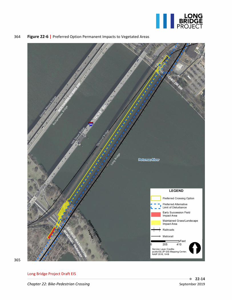
The Preferred Option would have minor permanent direct adverse impacts to terrestrial vegetation on 358 the Virginia side of the Potomac River where the bridge would connect to the MVT and Long Bridge Park 359 via ramps, as shown in Figure 22-6. The Preferred Option would permanently impact 7,225 square feet 360 (0.2 acres) of early succession scrub-shrub habitat just south of the GWMP roadway for the ramp 361 connecting to Long Bridge Park. The Preferred Option would not directly impact the natural forest 362 between the existing tracks and Roaches Run. 363
Long Bridge Project Draft EIS 22-14
Chapter 22: Bike-Pedestrian Crossing September 2019
Figure 22-6 | Preferred Option Permanent Impacts to Vegetated Areas 364
365

Long Bridge Project Draft EIS 22-15
Chapter 22: Bike-Pedestrian Crossing September 2019
There would be impacts to an additional 20,055 square feet (0.5 acres) of maintained landscape areas 366 on both sides of the Potomac River. Indirect impacts to terrestrial vegetation under the Preferred 367 Option would be negligible. The Preferred Option when combined with either of the Action Alternatives 368 would permanently impact 12,921 square feet (0.3 acres) of early succession scrub-shrub habitat and 369 either 176,891 square feet (4.1 acres) of forest when combined with Action Alternative A or 197,649 370 square feet (4.5 acres) of forest when combined with Action Alternative B (see Chapter 5.4.1.1, Natural 371 Ecological Systems and Endangered Species, Terrestrial Vegetation). 372
Wetland Vegetation 373
There would be no permanent direct or indirect adverse impacts to wetland vegetation from the 374 Preferred Option. This is because the Preferred Option is located upstream of the new railroad bridge 375 and is therefore not located adjacent to the wetlands associated with Roaches Run. 376
Submerged Aquatic Vegetation 377
The Preferred Option would cross over a single bed of submerged aquatic vegetation (SAV) found along 378 the northern shoreline of the Potomac River. Permanent direct impacts would amount to 28 square feet 379 for a single, concrete circular bridge support having a diameter of 6 feet located in the center of the SAV 380 bed. In addition, shading of the SAV bed by the 17-foot wide trail bridge deck could impact SAV growth 381 after construction. 382
When combined with the Action Alternatives, the total direct impacts to SAV would be 1,778 square 383 feet. See Chapter 5.4.1.3, Natural Ecological Systems and Endangered Species, Submerged Aquatic 384 Vegetation. 385
Wildlife 386
The Preferred Option would have a negligible permanent direct adverse impact due to the disturbance 387 of small areas of upland habitat, including removing several trees and the small scrub-shrub habitat 388 adjacent to the western side of the proposed new railroad right-of-way in Long Bridge Park. Permanent 389 impacts would include the removal of deciduous shade trees within the GWMP available for use by 390 various songbirds and gray squirrels (Sciurus carolinensis) as well as scrub-shrub habitat within the 391 undeveloped northeast corner of Long Bridge Park. The new bike-pedestrian bridge would increase 392 available habitat for wildlife that use bridge structures, resulting in a negligible beneficial indirect 393 impact. 394
Aquatic Biota 395
The Preferred Option would have negligible permanent direct adverse impacts to aquatic biota 396 associated with disturbance to benthic habitat. The Preferred Option would involve construction of a 397 separate bridge structure spanning the Potomac River upstream of the railroad bridge. It would include 398 22 bridge piers placed on concrete footers, disturbing benthic habitat by 622 square feet (<0.1 acres). 399 Soft-bottom benthic habitat would be lost, impacting benthic invertebrates that use such substrate. This 400 area is relatively small in comparison to available habitat in adjacent areas in the Potomac River. 401 Permanent effects to the benthic invertebrate community would be negligible and localized. Because 402

Long Bridge Project Draft EIS 22-16
Chapter 22: Bike-Pedestrian Crossing September 2019
the Preferred Option includes installing additional pier structures in the Potomac River, the additional 403 structures would provide cover and foraging opportunities for many fish species. 404
When combined with the Action Alternatives, total impacts to benthic habitat would be 8,014 square 405 feet in the Potomac River. There would be no additional disturbance to benthic habitat in the 406 Washington Channel. See Chapter 5.4.1.5, Natural Ecological Systems and Endangered Species, Aquatic 407 Biota. 408
Rare, Threatened, and Endangered Species (RTE) 409
The Preferred Option would cause negligible permanent direct adverse impacts to shortnose or Atlantic 410 sturgeon. The Preferred Option would involve construction of an independent bridge structure 411 comprised of 22 bridge piers, 6 feet in diameter, reducing available sturgeon foraging habitat by an 412 additional 622 square feet (<0.1 acres) as noted above. The potential permanent impact to sturgeon and 413 Atlantic sturgeon Critical Habitat would be relatively small compared to the available habitat that would 414 remain following the construction. 415
22.2.1.2. Temporary Effects 416
Terrestrial Vegetation 417
No temporary direct or indirect adverse impacts to terrestrial vegetation would be attributable to the 418 Preferred Option if the Preferred Option is constructed along with the Project. If the Preferred Option is 419 constructed along with the new railroad bridge construction contract, no additional area would be 420 required for access and staging (see Chapter 5.4.1.1, Natural Ecological Systems and Endangered 421 Species, Terrestrial Vegetation). However, if the Preferred Option is constructed separately following 422 completion of the Project, it could cause additional impacts because of the potential for different 423 staging and access areas. 424
Wetland Vegetation 425
There would be no temporary direct or indirect adverse impacts to wetland vegetation due to the 426 Preferred Option. 427
Submerged Aquatic Vegetation 428
Temporary adverse impacts to SAV from the Preferred Option could occur due to contractor boat 429 propellers gouging the shallow river bottom and suspended sediments moving downstream from the 430 construction zone during installation of the bridge. 431
Wildlife 432
No additional temporary direct or indirect adverse impacts to wildlife would be attributable to the 433 Preferred Option if constructed along with the Project. If the Preferred Option is constructed along with 434 the new railroad bridge construction contract, no additional area would be required for access and 435 staging (see Chapter 5.4.1.3, Natural Ecological Systems and Endangered Species, Wildlife). However, if 436 the Preferred Option is constructed separately following completion of the Project, it could cause 437 additional impacts because of the potential for different staging and access areas. This may result in 438

Long Bridge Project Draft EIS 22-17
Chapter 22: Bike-Pedestrian Crossing September 2019
temporary displacements of wildlife during construction, but once completed, these areas would be 439 restored. 440
Aquatic Biota 441
Minor temporary indirect adverse impacts to aquatic fauna from the construction of the Preferred 442 Option would result from similar measures used to build the new railroad bridge, as described for the 443 railroad piers (see Chapter 5.4.1.4, Natural Ecological Systems and Endangered Species, Aquatic Biota). 444 The bike-pedestrian bridge supports would be 6-foot piles driven in the wet. The Preferred Option 445 would result in the construction of piers, which would require the installation of piles using drilled 446 shafts. Avoidance and minimization techniques described in Section 22.2.1.3, Avoidance, Minimization, 447 and Mitigation, such as the use of turbidity curtains to contain suspended sediments, would offset any 448 potential impacts from construction of the Preferred Option. 449
RTE Species 450
Minor temporary direct adverse impacts to RTE species from the construction of the Preferred Option 451 would result from similar measures used to build the new railroad bridge, as described for the railroad 452 piers (see Chapter 5.4.2, Natural Ecological Systems and Endangered Species, RTE Species). 453 Construction of the piers for the Preferred Option would require the installation of piles that could 454 result in increased turbidity and sound and pressure waves. Avoidance and minimization techniques 455 described in Section 22.2.1.3, Avoidance, Minimization, and Mitigation, would offset any potential 456 impacts from construction of the bike-pedestrian bridge. 457
22.2.1.3. Avoidance, Minimization, and Mitigation 458
Terrestrial Vegetation 459
Steps to mitigate the loss of vegetation would include planting native woody shrubs and trees on NPS 460 property within the GWMP and Long Bridge Park in coordination with Arlington County. Tree species 461 may include various oaks (Quercus sp.), American sycamore (Platanus oxidentalis), and tulip poplar 462 (Liriodendron tulipfera). Impacts to trees and vegetated areas would be minimized through tree 463 protection measures and preventing or limiting equipment access to adjacent forested areas through 464 protective fencing. Both forest areas and individual trees within construction staging and access areas 465 would be protected prior to construction, under the supervision of a licensed arborist or other qualified 466 professional. The arborist would perform any necessary pruning to maximize tree survival both during 467 and following bridge construction. Adjusting temporary access and staging areas to avoid trees and 468 vegetation would be determined during refinement of the disturbance limits to ensure that vehicles and 469 materials are only stored on vegetated surfaces when necessary. When vegetated surfaces are the only 470 option for staging near the Project, fencing, mulch, and planking would be installed to reduce injury to 471 and compaction of vegetation. 472
Wetland Vegetation 473
There would be no effects to wetland vegetation due to the Preferred Option. Therefore, no avoidance, 474 minimization, or mitigation is necessary. 475

Long Bridge Project Draft EIS 22-18
Chapter 22: Bike-Pedestrian Crossing September 2019
Submerged Aquatic Vegetation 476
Steps to mitigate adverse impacts would include the use of a silt curtain around the immediate 477 construction zone of the single bridge pier to be installed in the SAV bed in order to keep suspended 478 sediments from spreading over any downstream SAV, as well as restricting contractor boat access only 479 within the immediate area of the pier support to be placed within the SAV area. 480
Wildlife 481
Efforts to minimize impacts would be implemented throughout the future phases of design and 482 construction of the Project. Specifically, efforts would be made during final design to avoid trees that 483 could be used by wildlife. Best management practices (BMPs) and currently acceptable design and 484 construction procedures would be used to reduce or eliminate anticipated undesirable effects resulting 485 from construction. Construction activities would be planned to minimize unnecessary disturbance of 486 wildlife habitat. For example, where appropriate and practicable, construction activities affecting avian 487 wildlife would be performed during months when migratory birds are not nesting. Erosion control and 488 stormwater management would be implemented during construction to reduce disturbance to wildlife 489 habitat from erosive forces, such as stormwater runoff. 490
Aquatic Biota 491
Avoidance and minimization of construction impacts to aquatic biota would include construction 492 methods to reduce noise, vibration, sedimentation, or turbidity, and time-of-year restrictions to protect 493 areas of seasonal importance for migratory species. Depending upon the specific construction methods 494 for the proposed Project, various techniques would be investigated to avoid or minimize impacts to 495 aquatic biota as described below. 496
No dredging is proposed under the current construction plan. The avoidance of dredging would 497 minimize overall impacts to existing river bed habitats and would minimize sedimentation and 498 resuspension of sediment into the water column. 499
To reduce turbidity or clouding of water from potential sediment releases during construction of the 500 new bridge piers, work would be conducted behind turbidity curtains. Installation of piles using drilled 501 shafts can create minor sediment releases and produce noise. The expected sediment release and noise 502 produced from this activity is low, but turbidity curtains would be used to further reduce turbidity and 503 attenuate noise within the Potomac River. Sufficient space is present within the Potomac River to allow 504 fish to escape the area prior to the start of drilling. 505
Time-of-year restrictions on in-stream construction work would be required by regulatory agencies to 506 avoid impacting migratory fish species during specific periods when they are most likely to be present in 507 the Project Area. The Potomac River supports regular spring spawning runs of four anadromous herring 508 and shad species: blueback herring (Alosa aestivalisI), hickory shad (Alosa mediocris), alewife (Alosa 509 pseudoharengus), and American shad (Alosa sapidissima). Although variable among species and across 510 years, spawning events generally occur between late March and early June for all four species.14 Striped 511 bass (Morone saxatilis), another anadromous species that uses the Potomac River, typically spawns from 512
14 Lippson, A.J. and R. L. Moran. 1974. Manual for identification of early developmental stages of fishes of the Potomac River estuary. Prepared for Maryland Department of Natural Resources, Power Plant Siting Program.

Long Bridge Project Draft EIS 22-19
Chapter 22: Bike-Pedestrian Crossing September 2019
mid-April to June. During this time, and several weeks prior, adults of these species are most likely to be 513 found in the Project Area. Sufficient space is present within the Potomac River to allow migratory fish to 514 circumvent disturbance areas, assuming construction activities are staggered, and work is not occurring 515 across the entire river at one time. 516
RTE Species 517
Avoidance and minimization of construction impacts include construction methods to reduce noise, 518 vibration, sedimentation, or turbidity, and time-of-year restrictions to protect areas of seasonal 519 importance. Depending upon specific construction methods for the Project, various techniques would 520 be investigated during later phases of design to avoid or minimize impacts to sturgeon or Atlantic 521 sturgeon critical habitat. To reduce turbidity from potential sediment releases and noise during 522 construction and pier installation through drilled shafts, drilling would occur behind turbidity curtains. 523
Time-of-year restrictions on in-stream construction work would also be required to avoid impacting 524 sturgeon during specific periods when they are most likely to be present. Based upon recent capture 525 information, the most likely time for adult shortnose sturgeon presence within the Project Area would 526 be during the spring spawning run (mid-March to mid-May). The likelihood of sturgeon being within the 527 Project Area is so low that use of other avoidance and minimization measures may preclude the need 528 for time-of-year restrictions. Additional informal consultation with the National Marine Fisheries Service 529 (NMFS) further in the design process would be necessary to confirm whether the Preferred Option is not 530 likely to adversely affect sturgeon. Additional coordination with NMFS would also be necessary in later 531 phases of design to confirm potential construction restrictions. 532
22.2.2. Water Resources and Water Quality 533
This section assesses the potential short-term and long-term impacts of the Preferred Option on water 534 resources and water quality. This section also discusses proposed avoidance, minimization, and 535 mitigation measures to reduce adverse impacts of the Preferred Option. See Chapter 6, Water 536 Resources and Water Quality for a description of the regulatory context, analysis methodology, and 537 Local and Regional Study Areas. 538
The analysis of impacts to water resources and water quality as a result of the bike-pedestrian crossing 539 applied the same methodologies used to evaluate impacts of the Action Alternatives (see Chapter 6.2.2, 540 Water Resources and Water Quality, Methodology). 541
22.2.2.1. Permanent or Long-Term Effects 542
Water Quality 543
The Preferred Option would have a negligible permanent direct adverse impact on groundwater 544 recharge, peak runoff rates, or total runoff volume reaching the Potomac River due to an increase in 545 impervious surface. The Preferred Option would also cause minor permanent direct adverse impacts on 546 water quality due to an increase in impervious surface allowing for buildup and wash-off of pollutants. 547 The construction of a ramp connecting to the MVT, a crossing deck over the Potomac River, and a 548 landing in the existing NPS Parking Lot C in East Potomac Park would result in this increase in impervious 549 surface. 550
Long Bridge Project Draft EIS 22-20
Chapter 22: Bike-Pedestrian Crossing September 2019
Groundwater 551
The Preferred Option would have negligible permanent direct adverse impacts on groundwater quantity 552 through reduction in groundwater recharge. The Local Study Area generally consists of only shallow 553 discharges to groundwater in the unconfined surficial aquifer that flows toward the Potomac River. The 554 Preferred Option would result in an increase in impervious area of less than 0.1 acres within the Roaches 555 Run watershed. The Preferred Option would increase impervious area within the Potomac River 556 watershed because of the new closed bridge deck. Almost the entire increase is in area of existing open 557 water. 558
There would be no permanent direct adverse impacts to groundwater quality because of the Preferred 559 Option. The Preferred Option would not introduce pollutants into the groundwater. 560
Surface Water 561
There would be negligible permanent direct adverse impacts on surface water quality because of the 562 Preferred Option. The Preferred Option would not change drainage to sub-watersheds. The crossing 563 would result in an increase in impervious area of less than 0.1 acres tributary to Roaches Run. 564
The Preferred Option would have negligible permanent direct adverse impacts on surface water quality 565 within the Potomac River given the anticipated pollutant load from the area relative to the volume of 566 the receiving surface water body. Currently, rain falls directly into the river in this location. Under the 567 Preferred Option, stormwater would wash from the deck into the river. Because the Preferred Option 568 would not be used by vehicles, pollutant load would be negligible and primarily from aerial deposition. 569
Stormwater 570
The Preferred Option would not have permanent direct or indirect adverse impacts to stormwater 571 infrastructure. The Preferred Option would have negligible permanent indirect adverse impacts on 572 surface water quality within the Potomac River given the anticipated pollutant load from the area 573 relative to the volume of the receiving surface water body. 574
Stormwater within the Local Study Area would continue to be conveyed either directly to the Potomac 575 River or via overland flow to Roaches Run. As the Preferred Option would result in an increase in 576 impervious area of less than 0.1 acres tributary to Roaches Run, slight increases to the stormwater 577 retention volume and negligible permanent adverse impacts on stormwater quality would be 578 anticipated. 579
The Preferred Option would also result in an approximately 1.3-acre increase in impervious area within 580 the Potomac River watershed. Since this increase in impervious area is almost entirely over existing 581 open water, the crossing would have a negligible permanent indirect adverse impact on recharge, peak 582 runoff rates, or total runoff volume in the Potomac River watershed. When combined with the Action 583 Alternatives, the total increase in impervious area within the Potomac River watershed would be 3.2 584 acres (see Chapter 6.4.1, Water Quality and Water Resources, Water Quality). 585

Long Bridge Project Draft EIS 22-21
Chapter 22: Bike-Pedestrian Crossing September 2019
Wetlands and Other Waters of the United States 586
The Preferred Option would have minor permanent direct adverse impacts to other waters of the 587 United States. Permanent impacts to tidal waters of the United States within the District would increase 588 by a total of 693 square feet (<0.02 acres) due to the pilings, as shown in Figure 22-7. There would be 589 minor permanent indirect adverse impacts to other waters of the United States under the Preferred 590 Option because of the removal of approximately 1,650 cubic yards of soil and sediment from installing 591 the crossing piers through drilled shafts. Removal of soil and sediment for the crossing piers would have 592 minor permanent direct adverse impacts to the overall function of the Potomac River. 593
When combined with the Action Alternatives, total impacts to waters of the United States would be 594 23,730 square feet (0.5 acres). See Chapter 6.4.2, Water Quality and Water Resources, Wetlands and 595 Waters of the United States. 596
Flood Hazards and Floodplain Management 597
The Preferred Option would cause a negligible permanent direct adverse impact resulting in an increase 598 in floodplain base elevation. The Preferred Option would require new bridge piers to be placed in the 599 Potomac River and adjacent floodplain. The increase in floodplain base elevation would not be at a level 600 to trigger the Federal Emergency Management Agency (FEMA) 1-foot threshold. Prior to final design and 601 permitting of the crossing, a determination of the effects would be modeled in accordance with FEMA 602 protocols to more accurately estimate the new floodplain elevation. 603
Additionally, adverse effects to the floodplain would be minimized through retaining walls. The vertical 604 retaining walls would reduce the footprint and preserve existing floodplain features to the greatest 605 extent practicable. Impacts to the floodplain and river bed are anticipated to be negligible and not affect 606 the function or integrity of the resource. 607
Chesapeake Bay Preservation Areas 608
The Preferred Option would cause minor permanent direct adverse impacts to the 100-foot RPA buffer 609 along the shoreline of the Potomac River of approximately 6,570 square feet (0.15 acres), as shown in 610 Figure 22-8. The Preferred Option would add a structure over the RPA buffer, as well as a ramp within 611 the RPA. Permanent impacts to the RPA would include those areas converted to infrastructure and 612 impervious surface that could increase pollutant loads to the Potomac River. 613
When combined with Action Alternative A, the Preferred Option would impact approximately 14,000 614 square feet (0.3 acres) of the RPA buffer. When combined with Action Alternative B, the Preferred 615 Option would impact approximately 18,000 square feet (0.4 acres) of the RPA buffer (see Chapter 6.4.4, 616 Water Resources and Water Quality, Chesapeake Bay Preservation Areas). 617
618

Long Bridge Project Draft EIS 22-22
Chapter 22: Bike-Pedestrian Crossing September 2019
Figure 22-7 | Preferred Option Impacts to Wetlands and Waterways 619
620

Long Bridge Project Draft EIS 22-23
Chapter 22: Bike-Pedestrian Crossing September 2019
Figure 22-8 | Preferred Option Impacts to Vegetation within the RPA 621
622

Long Bridge Project Draft EIS 22-24
Chapter 22: Bike-Pedestrian Crossing September 2019
Coastal Zone Consistency 623
FRA and DDOT expect the bike-pedestrian crossing to be consistent with the enforceable policies of 624 Virginia’s CZMP, as described in the draft Consistency Determination, pending review by VDEQ. FRA’s 625 draft Consistency Determination was submitted to VDEQ on August 9, 2019 and addressed both the 626 Project and the bike-pedestrian crossing. The Federal Consistency Determination commits the Project to 627 a variety of actions related to consistency with Virginia’s CZMP, including obtaining permits and 628 approvals related to stormwater management, RPAs, coastal lands, water resources, and other 629 environmental resources. 630
22.2.2.2. Temporary Effects 631
Water Quality 632
Soil erosion and sedimentation caused by construction activities may result in negligible temporary 633 direct adverse impacts on water quality within the Local Study Area. These activities can include 634 construction of the bridge, staging and laydown areas, and access locations. In addition, construction 635 activities could result in increased likelihood of spills of fuels, lubricants, or other pollutants. 636
The Preferred Option would be designed and constructed in accordance with the United States 637 Environmental Protection Agency (EPA) 2017 National Pollutant Discharge Elimination System (NPDES) 638 Construction General Permit, the Virginia Erosion and Sediment Control Regulations, the District 639 Department of Energy and Environment (DOEE) Stormwater Management Guidebook, the Anacostia 640 Waterfront Development Zone, and the Arlington County Stormwater Manual. 641
Despite protective measures, the Preferred Option could result in negligible temporary direct adverse 642 effects to water quality, including sedimentation, turbidity, and pollutants entering surface waters. As a 643 separate facility, the Preferred Option would be constructed either along with the Project or 644 constructed separately following the completion of the Project. If constructed along with the Project, 645 the Preferred Option would make use of the same construction access and staging areas. However, if 646 constructed separately as a different construction contract, access and staging would be required from 647 Long Bridge Park, the GWMP, and East Potomac Park. 648
Groundwater 649
The Preferred Option would not impact groundwater quality or quantity because the bike-pedestrian 650 bridge piles would be driven in the wet and would not require dewatering. 651
Surface Water 652
The Preferred Option would not impact surface water quality. The Preferred Option construction would 653 be performed using drilled shafts, removing approximately 1,650 cubic yards of soil and sediment during 654 pier installation. Construction staging, laydown areas, and access locations could also result in erosion 655 and sedimentation, resulting in negligible temporary direct adverse impacts to surface water quality in 656 the Potomac River and Roaches Run. However, adverse impacts to surface water quality would be 657 avoided through implementation of temporary treatment measures such as turbidity curtains and 658 erosion and sedimentation control. 659

Long Bridge Project Draft EIS 22-25
Chapter 22: Bike-Pedestrian Crossing September 2019
Stormwater 660
The Preferred Option would result in no temporary direct or indirect adverse impacts to stormwater. 661 Construction of the Preferred Option would comply with construction-phase stormwater management 662 requirements. Construction activities would include erosion and sediment controls and management of 663 construction wastes to prevent stormwater impacts in compliance with EPA’s 2017 NPDES Construction 664 General Permit,15 DOEE’s Erosion and Sediment Control Manual,16 and the Virginia Erosion and Sediment 665 Control Handbook.17 666
Wetlands and Other Waters of the United States 667
There would be no temporary direct or indirect adverse impacts to wetlands under the Preferred 668 Option. Negligible temporary direct adverse short-term impacts to tidal waters of the U.S. are expected 669 for installing circular drilled shafts for the piers, as opposed to cofferdams, which are associated with 670 dredging. 671
Flood Hazards and Floodplain Management 672
The Preferred Option would have negligible temporary direct adverse impacts to the floodplain area due 673 to staging of equipment along the shoreline within the floodplain. 674
Chesapeake Bay Preservation Areas 675
The construction of the Preferred Option along with the Preferred Alternative would result in no 676 additional access or staging areas and no additional adverse impacts to RPAs. However, if the Preferred 677 Option is constructed separately following the completion of the Project, it would have additional 678 temporary adverse impacts if construction staging or access areas are placed within the RPAs (Figure 22-679 8). 680
22.2.2.3. Avoidance, Minimization, and Mitigation 681
Avoidance, minimization, and mitigation approaches for the Preferred Option would be similar to those 682 for the Project (see Chapter 6.6, Water Resources and Water Quality, Avoidance, Minimization, and 683 Mitigation). 684
Water Quality 685
The following mitigation measures are recommended to minimize or mitigate for adverse impacts to 686 groundwater, surface water, and stormwater. 687
15 EPA. 2017. National Pollutant Discharge Elimination System (NPDES) General Permit for Construction Activities. Accessed from https://www.epa.gov/sites/production/files/2017-06/documents/2017_cgp_final_permit_508.pdf. Accessed June 15, 2018. 16 DOEE. 2017. Erosion and Sediment Control Manual. Accessed from https://doee.dc.gov/esc. Accessed August 24, 2018. 17 VDEQ. Undated. Virginia Erosion and Sediment Control Handbook. Accessed from http://www.deq.virginia.gov/Programs/Water/StormwaterManagement/Publications/ESCHandbook.aspx. Accessed January 12, 2018.

Long Bridge Project Draft EIS 22-26
Chapter 22: Bike-Pedestrian Crossing September 2019
Construction-Phase Mitigation 688
Erosion and sedimentation controls associated with the Preferred Option would be in accordance with 689 EPA’s 2017 NPDES Construction General Permit, DOEE’s Stormwater Management Guidebook, the DDOT 690 Green Infrastructure Standards, the DC Water Green Infrastructure Utility Protection Guidelines, the 691 DC Water Project Design Manual Volume 3 Infrastructure Design, and the Arlington County Stormwater 692 Manual. 693
Post-Construction Stormwater BMPs 694
If necessary, permanent adverse impacts to water quality in the Roaches Run and Potomac River 695 watersheds, would be mitigated through stormwater BMPs. Design of stormwater BMPs would be 696 completed during final design. If designed in accordance with the DOEE Stormwater Management 697 Guidebook18 or the Arlington County Stormwater Manual,19 these BMPs would decrease runoff volume 698 and peak flow rate and would provide the prescribed treatment volume to mitigate adverse impacts to 699 surface water and stormwater. These BMPs would also provide the prescribed recharge volume to 700 mitigate adverse impacts to groundwater. 701
Due to the limited space within the right-of-way in the Project Area, installation of open-air infiltration-702 type stormwater BMPs, such as bioretention areas and infiltration basins, is likely infeasible. Treatment 703 BMPs such as oil/grit separators could be implemented to treat runoff prior to discharge; however, 704 these BMPs would not mitigate increases in runoff volume or peak flow rate, which would be negligible. 705
Wetlands and Other Waters of the United States 706
Potential impacts to waters of the U.S. would be minimized by aligning the new piers with existing piers, 707 which minimizes the potential to alter the existing current of the river. Erosion control and stormwater 708 management would be implemented during construction to reduce disturbance to waters of the U.S. 709 from erosive forces, such as stormwater runoff. Because the Preferred Option includes 6-foot-diameter 710 drilled shafts, these piers would not require the use of cofferdams, which can create minor sediment 711 releases. Although the drilling of new piers would cause some sediment release, the expected amount 712 from this activity is low. Turbidity curtains would be used around each drilled shaft to further reduce 713 turbidity within the Potomac River. 714
Flood Hazards and Floodplain Management 715
Although impacts to the floodplain would be unavoidable, efforts would be taken to minimize floodplain 716 impacts during the design and construction phases. Minimization efforts would include a pier support 717 design having an elliptical shape that would allow smoother flood flow conveyance underneath the 718 bridge with minimal turbulence and hydraulic force against the pier walls. Additionally, adverse effects 719 to the floodplain would be minimized through retaining walls. The vertical retaining walls would reduce 720 the footprint and preserve existing floodplain features to the greatest extent practicable. 721
18 DOEE. 2017. 19 Arlington County. Stormwater Manual: A Guide to Stormwater Requirements for Land Disturbing Activities in Arlington County. 2018. Accessed from https://building.arlingtonva.us/wp-content/uploads/sites/38/2016/09/DES-Stormwater-Management-Ordinance-Guidance-Manual.pdf. Accessed September 19, 2018.

Long Bridge Project Draft EIS 22-27
Chapter 22: Bike-Pedestrian Crossing September 2019
Chesapeake Bay Preservation Areas 722
The nature of the project as bridge construction over an RPA, the Potomac River, and its buffer means 723 complete avoidance of the RPA is not feasible. In areas of bare ground, proper erosion and sediment 724 control techniques would help reduce runoff that could negatively affect RPAs. Efforts made to avoid 725 forest and vegetation impacts as part of the terrestrial vegetation avoidance and minimization would 726 also provide avoidance and minimization in the RPA buffer. 727
22.2.3. Geologic Resources 728
This section assesses the potential short-term and long-term impacts of the Preferred Option on 729 geologic resources. This section also discusses proposed avoidance, minimization, and mitigation 730 measures to reduce adverse impacts of the Preferred Option. See Chapter 7, Geologic Resources for a 731 description of the regulatory context and Local and Regional Study Areas. 732
The analysis of impacts to geologic resources as a result of the bike-pedestrian crossing used a 733 qualitative assessment based on geologic mapping from the Project’s documentation of the affected 734 environment (Chapter 7.3, Geologic Resources, Affected Environment). The qualitative assessment 735 involved identification of geologic, soils, and geomorphic features within the bike-pedestrian crossing’s 736 footprint and determining potential impacts of installing the structure. 737
22.2.3.1. Permanent or Long-Term Effects 738
Geologic Resources 739
The Preferred Option would cause minor permanent direct adverse effects to geologic resources. Minor 740 permanent direct adverse effects would be localized and would not affect the integrity of the resource. 741 The Preferred Option would have free-standing support structures occupying approximately 622 square 742 feet of shallow river bed of the Potomac River. Minor alterations to other geomorphic features would 743 include grading and filling in the floodplain to link the Preferred Option with existing infrastructure on 744 the north and south sides of the Potomac River. These modifications would not affect the function or 745 integrity of geologic resources. See Section 22.2.2, Water Resources and Water Quality, for further 746 discussion on the effects to floodplain functions. The new Preferred Option connection would be 747 constructed in accordance with current seismic structural criteria. 748
Soils 749
The Preferred Option would have minor permanent direct adverse effects to soil resources since the 750 footprint of the bike-pedestrian connection is relatively small and localized and would not affect the 751 function or integrity of soils. The free-standing supports within the river would be constructed using 752 drilled shafts that would remove approximately 1,650 cubic yards of soil. These soils would be removed 753 and disposed of offsite in accordance with applicable laws and regulations. See Section 22.2.4, Solid 754 Waste Disposal and Hazardous Materials, for offsite disposal of potential soil materials. 755
Soils would be disturbed at the north and south ends of the bike-pedestrian connection for the 756 construction of access ramps down to existing infrastructure. The primary concern for these areas would 757 be related to the potential for soil loss from erosion following construction. Removing existing 758 vegetative cover like trees and grasses can destabilize soils, making them susceptible to erosion during 759
Long Bridge Project Draft EIS 22-28
Chapter 22: Bike-Pedestrian Crossing September 2019
rainfall events. The erodibility of existing soils is variable due to previous disturbance and potentially 760 imported materials. However, further investigations during the design phase would identify appropriate 761 permanent soil stabilization measures for specific locations that could include items such as silt fences, 762 rock check dams, soil stabilization blankets, and temporary and permanent seeding. A Stormwater 763 Pollution Prevention Plan (SWPPP) would be developed to provide guidance and strict adherence to 764 erosion and sediment control measures developed for the Project. 765
22.2.3.2. Temporary Effects 766
Geologic Resources 767
The Preferred Option would have minor temporary direct adverse effects to geologic resources, but 768 would be considered relatively small and localized, and would not affect the function or integrity of the 769 resource. During construction phases of the Preferred Option, construction access, storage, and staging 770 would temporarily disturb geomorphic features like the floodplain, but once construction is completed 771 the areas would be returned to pre-construction conditions. Temporary impacts to riverine features 772 such as disturbance of the shallow river bed adjacent to the channel would occur through the 773 installation of free-standing support structures that would occupy approximately 622 square feet of 774 shallow river bed of the Potomac River. After removal of construction structures, the river bed would be 775 exposed to existing tidal currents and frequent flood events that constantly move river sediments, 776 potentially returning these temporary impact areas to more natural conditions in a relatively quick 777 timeframe. 778
Soils 779
The Preferred Option would have minor temporary direct adverse effects to soil resources since the 780 footprint of the bike-pedestrian connection is relatively small and localized and would not affect the 781 function or integrity of soil resources. Disturbed areas would be returned to preconstruction conditions 782 and would not affect the function or integrity of the resource. Temporary effects to soil resources 783 would result from construction access, staging and stockpiling, and demolition/construction work of the 784 permanent improvements. The free-standing supports within the river would be constructed using 785 drilled shafts that would result in the removal of approximately 1,650 cubic yards of soil. These soils 786 would be removed and disposed of offsite in accordance with applicable laws and regulations. See 787 Section 22.2.4, Solid Waste Disposal and Hazardous Materials, for further discussion on the offsite 788 disposal of potential soil materials. 789
Temporary soil disturbance would occur at the north and south ends of the bike-pedestrian connection 790 for the construction of access ramps down to existing infrastructure. The primary concern for these 791 areas would be related to the potential for soil loss from erosion during and following construction. 792 Removal of existing vegetative cover like trees and grasses can destabilize soils, making them 793 susceptible to erosion during rainfall events. The erodibility of existing soils is variable due to previous 794 disturbance and potentially imported materials. However, further investigations during the design phase 795 would identify appropriate temporary and permanent soil stabilization measures for specific locations 796 that could include items such as silt fences, rock check dams, soil stabilization blankets, and temporary 797 and permanent seeding. A SWPPP would be developed to provide guidance and strict adherence to 798 erosion and sediment control measures developed for the project. 799

Long Bridge Project Draft EIS 22-29
Chapter 22: Bike-Pedestrian Crossing September 2019
22.2.3.3. Avoidance, Minimization, and Mitigation 800
Avoidance, minimization, and mitigation approaches for the Preferred Option would be similar to those 801 for the Project (see Chapter 7.6, Geologic Resources, Avoidance, Minimization, and Mitigation). 802
Geologic Resources 803
The Preferred Option may result in minor adverse effects to geomorphic features like the floodplain and 804 river bed due to construction of the bike-pedestrian connection. These geomorphic features cannot be 805 avoided while achieving the goals and objectives of the Preferred Option. Adverse effects to the 806 floodplain would be minimized through retaining walls. The vertical retaining walls would reduce the 807 footprint and preserve existing floodplain features to the greatest extent practicable. As the impacts to 808 the floodplain and river bed are anticipated to be minor, localized, and not affecting the function or 809 integrity of the resource, no mitigation is proposed. 810
Soils 811
The Preferred Option would have minor adverse effects on soil resources within the Local Study Area 812 due to the bike-pedestrian ramp features at the north and south ends. Erosion of soil resources would 813 be mitigated through soil stabilization blankets, turbidity curtains, silt fences, rock check dams, and 814 other BMPs designed to minimize and control soil loss during and following construction. Retaining walls 815 would also minimize the Project footprint and disturbance to soil resources. Final construction 816 documents would include an approved erosion and sediment control plan and SWPPP from the Virginia 817 Department of Environmental Quality (VDEQ) and DOEE, further minimizing permanent erosion hazards. 818
22.2.4. Solid Waste and Hazardous Materials 819
This section assesses the potential short-term and long-term impacts of the Preferred Option on solid 820 waste and hazardous materials. This section also discusses proposed avoidance, minimization, and 821 mitigation measures to reduce adverse impacts of the Preferred Option. See Chapter 8, Solid Waste and 822 Hazardous Materials for a description of the regulatory context and Local and Regional Study Areas. 823
The analysis of impacts from solid waste and hazardous materials as a result of the bike-pedestrian 824 crossing used a qualitative assessment based on information collected from assessing impacts of the 825 Action Alternatives (see Chapter 8, Solid Waste Disposal and Hazardous Materials). The bike-pedestrian 826 crossing would not be an intensive waste generator and use of the bridge would only result in trash 827 generated by bicyclists and pedestrians. 828
22.2.4.1. Permanent or Long-Term Impacts 829
Solid Waste 830
The Preferred Option would have negligible permanent direct adverse impacts on the environment due 831 to an increase in solid waste generation and disposal. Long-term direct impacts such as trash generation 832 by users of the crossing would be negligible and would be handled by maintenance of the Preferred 833 Option; negligible permanent indirect adverse impacts would occur related to the ultimate off-site 834 disposal location for soil generated during construction of the Preferred Option. No new on-site sources 835 of solid waste are expected to be introduced for the Preferred Option. 836

Long Bridge Project Draft EIS 22-30
Chapter 22: Bike-Pedestrian Crossing September 2019
Hazardous Materials 837
The Preferred Option would have no permanent direct or indirect adverse impacts on the environment 838 and human health relative to hazardous materials. There would be no long-term generation of 839 hazardous materials because of the Preferred Option. 840
22.2.4.2. Temporary Effects 841
During construction, the Preferred Option is expected to generate hazardous materials and solid waste. 842 The types of solid waste and hazardous materials generated during construction would likely be related 843 to environmental media (such as soil) and construction materials (such as machinery and supplies). 844
Solid Waste 845
The Preferred Option would have minor temporary direct adverse impacts because of solid waste 846 generation and disposal. No demolition is anticipated for construction of the crossing. Excess soil 847 (approximately 1,650 cubic yards) would be excavated from the river bed because of drilled shafts and 848 pier installations and transported off-site. Direct impacts would be minor and associated with the 849 excavation and removal of solid waste, and indirect impacts would be minor and primarily consist of the 850 off-site transportation of these materials. 851
Hazardous Materials 852
The Preferred Option would have minor temporary indirect adverse impacts because of hazardous 853 materials. Urban runoff from the region is likely to have impacted sediments at the bottom of the 854 Potomac River with contaminants such as heavy metals and petroleum hydrocarbons such as 855 polyaromatic hydrocarbons, and polychlorinated biphenyls. The construction of the Preferred Option 856 would result in 1,650 cubic yards of sediments generated by excavation within the drilled shafts for the 857 crossing piers. Sediments found to be contaminated could have a potentially minor temporary adverse 858 effect during the transportation, disposal, and management of contaminated media. 859
Construction-related equipment contains mechanical fluids that have the potential to result in spills or 860 leaks when not maintained in good working order. Contractors may also use supplies containing 861 hazardous materials. Although the spill or release of oil or hazardous materials in the process of 862 construction is an unlikely event, spill prevention plans would be required to prevent and control any 863 such spills. Therefore, construction-related equipment is not anticipated to result in an adverse 864 temporary effect. 865
The temporary concrete plant installed for construction of the Project would remain in place for 866 construction of the Preferred Option. The process of creating concrete involves the use of aggregate, 867 sand, and water, which would need to be transported to and stored within the Local Study Area. The 868 raw materials associated with concrete generation may originate from a variety of sources and have the 869 potential to contain oil and/or hazardous materials (OHM). Therefore, materials containing OHM would 870 need to be stored properly either on impermeable surfaces covered as needed to prevent erosion, or 871 within containers to prevent the materials from impacting the surrounding environment. The generation 872 of concrete also involves the use of chemical additives, lubricants, and fuel, the use of which has the 873 potential to impact environmental media within the Local Study Area. These materials would be stored 874 in vessels such as tanks and drums with secondary containment in order to prevent an accidental spill. 875
Long Bridge Project Draft EIS 22-31
Chapter 22: Bike-Pedestrian Crossing September 2019
The contractor operating the plant would also need to implement a Spill Prevention Plan to respond to a 876 release of fuel or chemicals, if an incident were to occur. Finally, the process of creating concrete may 877 generate dust, which would need to be monitored and suppressed to prevent off-site migration of 878 particulate matter. Based on the processes noted above, the operation of the concrete plant would 879 likely have a minor temporary adverse impact on the Local Study Area and indirect impacts based on the 880 potential for dust generation, spills of OHM (that would be cleaned up if they occur), and transportation 881 impacts (truck emissions and fuel usage). 882
22.2.4.3. Avoidance, Minimization, and Mitigation 883
Avoidance, minimization, and mitigation approaches for the Preferred Option would be similar to those 884 for the Project (see Chapter 8.6, Solid Waste Disposal and Hazardous Materials, Avoidance, 885 Minimization, and Mitigation). 886
Solid Waste 887
The construction of the Preferred Option would result in the generation of soil and minor construction 888 debris during the construction phases of the Project. A Soil Management Plan (SMP) would be 889 developed based on results of subsurface investigations dictating appropriate soil handling procedures 890 and identifying appropriate receiving facilities. Construction debris would be handled appropriately in 891 accordance with applicable regulations, and contractors would maintain good housekeeping practices to 892 prevent construction debris from impacting the environment. All applicable licenses, permits, and 893 approvals would be obtained prior to initiating the work. The work would be conducted in accordance 894 with Federal, state, and local regulatory guidelines and procedures. Proper personal protective 895 equipment (PPE) would be used based on the contaminants of concern and known or suspected 896 hazards. 897
Hazardous Materials 898
The construction of the Preferred Option would likely result in the generation of hazardous materials 899
(such as contaminated soil or sediment from drilled shafts) during the construction phases of the 900
Project. Prior to initiating construction, all applicable licenses, permits, and approvals would be 901
obtained. The work would be conducted in accordance with Federal, state, and local regulatory 902
guidelines and procedures. An SMP would be developed based on the results of subsurface 903
investigations. These investigations would be conducted to pre-characterize soils designated for 904
excavation during construction phases. The SMP typically outlines standards and procedures for 905
identifying and disposing of contaminated materials that may be encountered during construction. Soil 906
tracking protocols would be detailed from the point of excavation to designated testing areas and to the 907
ultimate disposal sites. Records pertaining to hazardous material generation, transport, and disposal 908
would be maintained for a prescribed period of time and in a manner consistent with Federal, state, and 909
local regulations. 910
Fugitive dust would be controlled through wetting, sweeping, and other suppression techniques. 911 Furthermore, a Health and Safety Plan would be developed that would provide the minimum health and 912 safety specifications contractors must meet during construction, including requirements for 913 environmental monitoring, PPE, site control and security, and training. PPE would be selected based on 914 the contaminants of concern and known or suspected hazards. 915

Long Bridge Project Draft EIS 22-32
Chapter 22: Bike-Pedestrian Crossing September 2019
Spills and leaks associated with vehicles and heavy machinery can be appropriately mitigated by 916 implementing spill response programs that specify procedures for emergency response in the event a 917 spill or leak occurs. Depending on the nature of the spill or discharge to the environment, it may also be 918 necessary to contact regulatory agencies such as the National Response Center, the EPA Region 3 Office, 919 the United States Coast Guard Marine Safety Office, Virginia Department of Emergency Services, and the 920 DOEE. The agency to be contacted would depend on the nature and amount of the spilled material and 921 the location of the spill. 922
22.2.5. Transportation and Navigation 923
This section assesses the potential short-term and long-term impacts of the Preferred Option on 924 transportation and navigation. The transportation system includes all transportation modes, including 925 passenger and freight railroad (Amtrak, VRE, CSX Transportation, and Norfolk Southern), the transit 926 system (Metrorail and local bus operations), the pedestrian and bicycle network, and the surrounding 927 roadway network. This section also evaluated navigation and the marine transportation system. 928 Navigable waterways are waters subject to the ebb and flow of tides and are presently used, have been 929 used in the past, or may be used for transportation. This section also discusses proposed avoidance, 930 minimization, and mitigation measures to reduce adverse impacts of the Preferred Option. See Chapter 931 9, Transportation and Navigation for a description of the regulatory context and Local and Regional 932 Study Areas. 933
The analysis of impacts to transportation and navigation as a result of the bike-pedestrian crossing used 934 a qualitative assessment. Bicycle and pedestrian routes that would include the bike-pedestrian crossing 935 were analyzed to determine any adverse or beneficial impacts to users and the overall bicycle network 936 in this area, as well as any resulting mode shifts. Impacts to navigation due to the bike-pedestrian 937 crossing were assessed similarly to the assessment used for the Action Alternatives (see Chapter 9.2.2.2, 938 Transportation and Navigation, Methodology). 939
22.2.5.1. Permanent or Long-Term Effects 940
Railroad Infrastructure and Operations 941
The Preferred Option would not have permanent or long-term impacts on the railroad infrastructure 942 and operations. The Preferred Option would be constructed on a separate structure upstream from the 943 new railroad bridge. 944
Transit 945
The Preferred Option would have no permanent direct or indirect adverse impacts to transit. The 946 Preferred Option would construct a bike-pedestrian crossing downstream of the WMATA Metrorail 947 bridge. It would not require permanent modification of transit operations or infrastructure and 948 therefore is not expected to have permanent or long-term effects on transit. 949
Pedestrian and Bicycle Network 950
The Preferred Option would have major permanent direct beneficial impacts to the pedestrian and 951 bicycle network. By providing additional pedestrian and bicycle access to and between Crystal City, the 952 MVT, and East Potomac Park, the Preferred Option would increase the connectivity of, and have a 953

Long Bridge Project Draft EIS 22-33
Chapter 22: Bike-Pedestrian Crossing September 2019
beneficial impact on, the existing pedestrian and bicycle network. The new bike-pedestrian connection 954 between the District and Arlington would be a pathway dedicated solely to cyclists and pedestrians and 955 would provide an enhanced connection between (via Long Bridge Park), the MVT, and destinations in 956 the District. It is expected that some bicycle and pedestrian traffic would be diverted from the existing 957 14th Street Bridge particularly for people traveling to and from Long Bridge Park, Crystal City, Pentagon 958 City, and surrounding neighborhoods. The Preferred Option would serve as a more direct connection 959 from these areas. Also, since the Preferred Option would be separated from automobile traffic, travel on 960 the Preferred Option would likely be preferable for pedestrians and bicyclists. 961
NPS has expressed concern that the bike-pedestrian bridge would increase congestion on the MVT. The 962 new connection would make it easier for users from Pentagon City, Crystal City, Potomac Yard, and 963 surrounding areas to cross the GWMP and the Potomac River in this location, and some users would 964 likely use the ramp to access the MVT. However, other pedestrians and bicyclists who currently use the 965 MVT to access the 14th Street Bridge when traveling between these areas and the District would now 966 use the direct connection provided by the new bridge and never access the MVT at all. Therefore, the 967 new connection would decrease volumes and current congestion on the MVT. Finally, the ramp landing 968 at the MVT would be designed to minimize conflict between users already on the trail and those coming 969 from the bike-pedestrian bridge. 970
Roadway Network 971
The Preferred Option would have negligible permanent direct beneficial impacts to the roadway 972 network through potential mode shifts from automobiles to bicycles. The Preferred Option would 973 construct a bike-pedestrian crossing over the Potomac River. This new connection would provide access 974 between Crystal City, the MVT, and East Potomac Park, and increased connectivity between Arlington 975 and the District. Increased connectivity through the Preferred Option may encourage some drivers to 976 change modes from automobiles to bicycles. However, given the current volume of automobile traffic 977 on roadways within the Local Study Area (in 2015, the 14th Street Bridge Complex carried over 230,000 978 vehicles per day),20 any shift from driving to bicycling would have a negligible impact on roadway 979 congestion. The Preferred Option would not require permanent modification of streets, roads, or 980 highways, and therefore would not impact roadway infrastructure. 981
Parking 982
The Preferred Option would have a minor permanent direct adverse impact to parking. The Preferred 983 Option would include a new bike-pedestrian ramp in the NPS Parking Lot C in East Potomac Park. 984 Approximately fifty parking spaces would be eliminated due to the construction of the Project. The exact 985 number of parking spots to be removed would be determined as design of the bike-pedestrian crossing 986 and ramp is advanced, as the surface parking areas would be reconfigured to minimize permanent loss 987 of parking spaces. The addition of the bike-pedestrian ramp would result in less space for 988 reconfiguration of the parking spaces. The removal of parking and additional constraint of the remaining 989 surface parking would amount to a minor direct adverse impact as the current spaces are generally 990 under-utilized except during peak times such as during the National Cherry Blossom Festival each spring. 991
20 DDOT. Traffic Volume M Section 3.3.2.2 (p. 29): made revisions for consistency with DEIS ap 2015. July 2017. Accessed from https://ddot.dc.gov/publication/traffic-volume-maps-2015. Accessed January 17, 2019.

Long Bridge Project Draft EIS 22-34
Chapter 22: Bike-Pedestrian Crossing September 2019
Navigation 992
There would be minor permanent direct adverse impacts to navigation due to the Preferred Option. 993 Installation of the Preferred Option may pose hazards such as marine vessel strikes to the bike-994 pedestrian crossing piers. However, the Preferred Option would be consistent with the clearances 995 provided by the rail bridge constructed with the Project which would exceed the 18 feet provided by 996 existing Long Bridge. The piers of the new bike-pedestrian bridge would align with the railroad bridge 997 piers, maintaining the navigation channel and existing horizontal clearances. 998
Aviation 999
There would be no permanent or long-term effects on aviation because of the Preferred Option. The top 1000 of structure of the Preferred Option would be within the limit set by the Federal Aviation 1001 Administration. 1002
22.2.5.2. Temporary Effects 1003
The Preferred Option would have minor temporary direct adverse effects to transportation and 1004 navigation. As a separate facility, the Preferred Option may be constructed along with the construction 1005 of the Project or as a separate construction project at a later time. If constructed along with the Project, 1006 the Preferred Option would make use of the same construction access and staging areas, rerouting of 1007 the MVT, diverting sidewalks, and extend the duration of construction. However, if constructed 1008 separately, construction access and staging would be required in similar areas as the Preferred 1009 Alternative along the GWMP and Ohio Drive SW. Separate construction of the Selected Crossing over 1010 the GWMP would require traffic control measures, temporary lane closures, and temporary lane shifts 1011 on the GWMP for delivery of materials and equipment, and for construction activities for the 1012 abutments, piers, and superstructure while maintaining a safe work zone. Construction material for the 1013 Preferred Option could be barged in on the river and staging areas would have to be established. To 1014 encourage traffic to make use of other routes, additional access points would be identified. 1015
22.2.5.3. Avoidance, Minimization, and Mitigation 1016
Avoidance, minimization, and mitigation approaches for the Preferred Option would be similar to those 1017 for the Project (see Chapter 9.6, Transportation and Navigation, Avoidance, Minimization, and 1018 Mitigation). As there are no anticipated permanent adverse effects to transportation or navigation 1019 except for loss of parking, mitigation measures are proposed to mainly address temporary impacts and 1020 are the same as the mitigation measures of the Project’s Preferred Alternative. 1021
The construction of the Preferred Option would require typical maintenance of traffic measures such as 1022 lane and shoulder closures, lane shifts, potential detours and a host of temporary traffic mitigation 1023 strategies to minimize the impacts to the traveling public. The implementation of these measures and 1024 strategies would be necessary in order construct the project safely while allowing for reasonable 1025 production of construction operations. The contractor would be required to develop, in coordination 1026 with DDOT, a project-wide Traffic Management Plan (TMP) that includes temporary traffic control plans, 1027 the analysis of traffic operations, and a public outreach campaign. During development of the TMP, 1028 additional coordination with the Project stakeholders and public at large would inform the specific 1029 measures laid out in the plan. 1030

Long Bridge Project Draft EIS 22-35
Chapter 22: Bike-Pedestrian Crossing September 2019
For impacts to parking during construction, temporary parking or parking shuttles would be considered 1031 as potential mitigation for the loss of parking spaces at NPS Parking Lot C, especially during periods of 1032 heavy usage, such as during the National Cherry Blossom Festival. Permanent loss of parking would not 1033 be mitigated since parking is generally underused. 1034
For impacts to the MVT, the mitigation would be the same as the Preferred Alternative. Wayfinding 1035 signage would be installed, as appropriate, to redirect pedestrian and bicycle traffic during temporary 1036 closures due to construction. In addition, temporary crossings of trails for materials delivery would be 1037 scheduled during evening hours to the extent practicable, to minimize impacts to trail users. 1038
The construction of the Preferred Option would require the installation of navigation lights, the quantity 1039 to be determined through agency coordination, the development of an inspection and maintenance 1040 program for the crossing and navigation lights, and to inform recreational boaters of the new bike-1041 pedestrian crossing and proper clearances for watercraft. 1042
22.2.6. Air Quality and Greenhouse Gas Emissions 1043
This section assesses the potential short-term and long-term impacts of the Preferred Option on air 1044 quality and greenhouse gas emissions. This section also discusses proposed avoidance, minimization, 1045 and mitigation measures to reduce adverse impacts of the Preferred Option. See Chapter 10, Air Quality 1046 and Greenhouse Gas Emissions for a description of the regulatory context and Local and Regional Study 1047 Areas. 1048
The analysis of impacts to air quality and greenhouse gas emissions due to the bike-pedestrian crossing 1049 applied a similar methodology to that used for evaluating impacts of the Action Alternatives (See 1050 Chapter 10.2.2, Air Quality and Greenhouse Gases, Methodology). The bike-pedestrian crossing is 1051 within the footprint of the Action Alternatives’ Study Areas for air quality and greenhouse gas emissions. 1052 Due to its use for non-motorized transportation and its smaller size and scope, it was assumed that the 1053 bike-pedestrian crossing emissions from permanent and temporary activities would be below those of 1054 the Action Alternatives and would not exceed de minimis thresholds for criteria pollutants and would 1055 therefore not require a General Conformity determination. 1056
22.2.6.1. Permanent or Long-Term Effects 1057
The Preferred Option would not have permanent direct adverse air quality impacts and would have 1058 minor permanent indirect benefits to air quality. The current pedestrian-bike crossing on the 14th Street 1059 Bridge carries approximately 2,000 trips per weekday during the warmer months. The proposed crossing 1060 and connection to Crystal City via Long Bridge Park would likely encourage additional pedestrian and 1061 bicycle trips, thereby slightly reducing vehicle trips and the corresponding vehicular pollutant emissions 1062 including carbon monoxide (CO), volatile organic carbon (VOC), nitrogen oxide (NOx), particulate matter 1063 (PM), and CO2. 1064
22.2.6.2. Temporary Effects 1065
The Preferred Option would have minor temporary adverse effects to air quality and GHG. The 1066 emissions associated with construction activities for the Preferred Option are assumed not to exceed de 1067 minimis thresholds for criteria pollutants. This is based on the conclusion that construction of the 1068 Preferred Alternative (with its much larger construction scope) would be below de minimis thresholds. 1069

Long Bridge Project Draft EIS 22-36
Chapter 22: Bike-Pedestrian Crossing September 2019
The Preferred Option would be constructed either along with the Project or constructed separately 1070 following the completion of the Project. Similar to construction of the Preferred Alternative, pollutant 1071 emissions during construction would occur because of emissions from on-site diesel equipment, 1072 increased truck traffic to and from the construction site on local roadways, and fugitive dust. 1073
22.2.6.3. Avoidance, Minimization, and Mitigation 1074
Avoidance, minimization, and mitigation approaches for the Preferred Option would be similar to those 1075 for the Project (see Chapter 10.6, Air Quality and Greenhouse Gases, Avoidance, Minimization, and 1076 Mitigation). 1077
No permanent air quality mitigation is proposed, as the bike-pedestrian bridge would have no 1078 permanent adverse impacts to air quality. Although no major temporary adverse impacts are 1079 anticipated during construction of the Preferred Option, measures would be taken to reduce pollutant 1080 emissions during construction in accordance with all applicable laws and regulations. 1081
The District’s and Virginia’s anti-idling laws would be enforced during all construction phases for the 1082 Preferred Option. Construction in the District would comply with the District’s 20 DCMR 900 limiting 1083 non-road engine idling to 3 minutes. Construction components in Virginia would comply with 1084 9 VAC 5-40-5670 limiting motor vehicle idling to 3 minutes unless providing auxiliary power for purposes 1085 other than heating or air conditioning. Idling restriction signs would be placed on the premises to 1086 remind drivers and construction personnel of the idling regulations. 1087
Construction contractors would be required to use ultra-low-sulfur diesel fuel for all off-road 1088 construction vehicles as an additional measure to reduce air emissions from construction activities. Any 1089 non-road diesel equipment rated 50 horsepower or greater would meet EPA’s Tier 4 emission limits or 1090 be retrofitted with appropriate emission reduction equipment. Emission reduction equipment could 1091 include EPA-verified or California Air Resources Board verified diesel oxidation catalysts or diesel 1092 particulate filters. 1093
Protective measures around the construction and demolition work would be required to protect 1094 pedestrians and prevent dust and debris from leaving the site or entering the surrounding community in 1095 accordance with 20 DCMR 605. Appropriate methods of dust control would be determined by the 1096 surfaces affected (such as roadways or disturbed areas) and would include, as necessary, the application 1097 of water, the use of stone in construction roads, and vegetative cover. Dust generated from earthwork 1098 and other construction activities, such as stockpiled soils, would be controlled by spraying with water to 1099 mitigate wind erosion on open soil areas. Other dust suppression methods, such as wheel washing, may 1100 be implemented to minimize the off-site transport of dust. Regular sweeping of the pavement of 1101 adjacent roadway surfaces may be required during the construction period to minimize the potential for 1102 vehicular traffic to create airborne dust and particulate matter. Another way to reduce air quality 1103 impacts would be to recycle construction waste. 1104
22.2.7. Energy 1105
This section assesses the potential short-term and long-term impacts of the Preferred Option on energy 1106 resources. Energy resources refer to energy end-use, or consumption. Energy use is divided into 1107 operational and construction energy consumption. Energy sources considered include electricity and 1108

Long Bridge Project Draft EIS 22-37
Chapter 22: Bike-Pedestrian Crossing September 2019
other fuels as applicable, such as natural gas, gasoline, diesel fuel, and propane. This section also 1109 discusses proposed avoidance, minimization, and mitigation measures to reduce adverse impacts of the 1110 Preferred Option. See Chapter 11, Energy for a description of the regulatory context and Local and 1111 Regional Study Areas. 1112
The analysis calculated energy use for the bike-pedestrian crossing for lighting, maintenance, and 1113 construction. These calculations used reasonable assumptions as precise data was not available for 1114 quantifying energy consumption for these features. 1115
22.2.7.1. Permanent or Long-Term Effects 1116
The Preferred Option would have minor permanent direct adverse impacts to energy due to use of 1117 lighting and other equipment, as well as a minor permanent direct beneficial impact to energy due to 1118 shifting trips from motorized to non-motorized modes. The Preferred Option would be on a separate 1119 structure upstream from the new railroad bridge. Energy consumed by lighting and other equipment on 1120 the new crossing would be minor and estimated to be 52.31 million British Thermal Units (BTU) 1121 annually, a negligible amount when compared to the overall annual energy use of the Washington 1122 Metropolitan Region of 174 trillion BTU. 1123
Vehicles and equipment would consume energy used for ongoing maintenance of the Preferred Option. 1124 Energy consumption is assumed at a negligible 14.95 million BTU annually. In addition, the Preferred 1125 Option would provide a new route for non-motorized travel, reducing energy use by shifting some users 1126 from motorized transportation to bicycling or walking. 1127
22.2.7.2. Temporary Effects 1128
There would be minor temporary direct adverse impacts to energy as a result of the Preferred Option. 1129 Temporary effects for the Preferred Option include the energy consumed by vehicles and equipment 1130 during construction. The Preferred Option would require trucks and other equipment that consume fuel 1131 throughout the course of their operation, most likely in the form of diesel fuel. At this level of design, 1132 the precise number of vehicle trips, distance traveled, or hours of operation have not yet been 1133 determined for the Preferred Option alone, and therefore, fuel usage cannot be precisely quantified. 1134 However, construction of the bike-pedestrian crossing was estimated at 0.001 trillion BTU. 1135
22.2.7.3. Avoidance, Minimization, and Mitigation 1136
Avoidance, minimization, and mitigation approaches for the Preferred Option would be similar to those 1137 for the Project (see Chapter 11.6, Energy, Avoidance, Minimization, and Mitigation). 1138
The most energy efficient technologies would be used wherever feasible in the operations the Preferred 1139 Option. These technologies and anticipated continued improvements in energy efficiency would reduce 1140 energy use, normalized per piece of equipment. These reductions would be associated with on-bridge 1141 equipment (for example, lighting), maintenance equipment, construction equipment and trains, due to 1142 adoption of technologies such as LED lights and higher efficiency engines. 1143
Temporary impacts during construction would primarily result from fuel consumed in vehicles and 1144 equipment. Construction staging and access areas would be strategically planned to minimize the 1145 distance traveled by construction vehicles or trucks hauling materials to or from the site. In addition, 1146

Long Bridge Project Draft EIS 22-38
Chapter 22: Bike-Pedestrian Crossing September 2019
construction plans would emphasize minimizing, to the greatest extent possible, vehicle idling times. 1147 While some vehicles and equipment may require ongoing engine use, other applicable vehicles should 1148 adhere to this policy. The policy would encourage contractors to use fuel efficient or alternative fuel 1149 vehicles to the greatest extent feasible. Solar-powered generators would be considered as an alternative 1150 to diesel generators wherever feasible. 1151
22.2.8. Land Use and Property 1152
This section assesses the potential short-term and long-term impacts of the Preferred Option on land 1153 use and property. Land use is characterized by the arrangements, activities, and inputs people 1154 undertake in a certain land cover type to produce, change, or maintain it.0F
21 Examples of typical land uses 1155 include residential and commercial development, transportation, resource management, and 1156 agricultural lands. This section also discusses proposed avoidance, minimization, and mitigation 1157 measures to reduce adverse impacts of the Preferred Option. See Chapter 12, Land Use and Property 1158 for a description of the regulatory context and Local and Regional Study Areas. 1159
The analysis of impacts to land use and property due to the bike-pedestrian crossing applied the same 1160 data, mapping, and methods used for assessing the impacts of the Action Alternatives (see Chapter 1161 12.2.2, Land Use and Property, Methodology). The analysis determined impacts to land use and 1162 property by overlaying the bike-pedestrian crossing’s footprint on mapping of land use and property 1163 ownership. 1164
22.2.8.1. Permanent or Long-Term Effects 1165
Land Use 1166
Construction of the Preferred Option would result in a minor permanent direct adverse impact to 1167 parkland due to loss of Long Bridge Park and GWMP land where the crossing connects to the parks. 1168 However, the Preferred Option would be consistent with existing park and recreational land uses. At 1169 Long Bridge Park, the Preferred Option would connect with a loop trail planned as part of new park 1170 facilities currently under construction. The alignment of the crossing would impact a portion of Arlington 1171 County property that is currently undeveloped and forested; this land is envisioned to serve as an edge 1172 and buffering adjacent to park facilities. As such, the bike-pedestrian crossing would complement, but 1173 not adversely impact, park facilities by providing a connection across the GWMP that would link Long 1174 Bridge Park to parkland on both sides of the Potomac River. 1175
The Preferred Option would be on a separate structure adjacent to the new railroad bridge across the 1176 river. In East Potomac Park, the ramp would land near Ohio Drive SW in NPS Parking Lot C. Overall, 1177 moderate permanent direct adverse impacts would result from the loss of portions of the surface 1178 parking area. In the long term, moderate beneficial impacts would result from the construction of the 1179 ramp, due to the improved pedestrian access the new connection would provide to and between areas 1180 of Federal parkland, enhancing the intended use of these areas and the overall visitor experience. 1181
21 Natural Resources Management and Environment Department. Undated. Land Cover Classification System. Accessed from http://www.fao.org/docrep/003/X0596E/x0596e01e.htm. Accessed May 3, 2018.

Long Bridge Project Draft EIS 22-39
Chapter 22: Bike-Pedestrian Crossing September 2019
Property 1182
The Preferred Option would have minor permanent direct adverse impacts on one Federally owned 1183 parcel in Virginia, and one Federally owned parcel in the District. This would yield a total property 1184 impact area of 1.07 acres, as shown in Table 22-2. None of the property impacts would result in 1185 displacement of residences or businesses. 1186
Table 22-2 | Preferred Option Property Impacts 1187
Property State Acres Acres with Action
Alternative A
Acres with Action
Alternative B
Long Bridge Park1 VA 0.14 or 0.27 0.18 or 0.41 0.18 or 0.41
GWMP1 VA 0.49–0.62 0.89 or 1.12 0.89 or 1.12
East Potomac Park DC 0.31 2.71 2.81
Total 1.07 4.01 4.11
Source: Virginia and District Property Data, VHB, GIS analysis.
1Range provided due to difference in and overlap of data sources from NPS and Arlington County
Consistency with Local and Federal Plans 1188
The Preferred Option would have minor permanent direct beneficial impacts to local and Federal Plans. 1189 The Preferred Option is largely consistent with Federal and local plans, including local plans that do not 1190 directly address the construction of a new bike-pedestrian connection over the Potomac River. By 1191 providing additional pedestrian and bicycle access to and among Crystal City, the MVT, and East 1192 Potomac Park, the Preferred Option would also further the goal of improving access to the Potomac 1193 River and Federal parkland espoused by numerous local and Federal plans. The Preferred Option is 1194 consistent with plans that specifically call out a new bike-pedestrian connection across the river in the 1195 Long Bridge Corridor, specifically the NPS Paved Trails Study,22 moveDC,23 and the plans for Long Bridge 1196 Park.24 1197
22.2.8.2. Temporary Effects 1198
The Preferred Option would have negligible temporary direct adverse impacts to land use. As a separate 1199 facility, the Preferred Option would be constructed either along with the Project or constructed 1200 separately following the completion of the Project. If constructed along with the railroad bridges, the 1201 crossing would make use of the same construction access and staging areas and rerouting of the MVT 1202 (see Chapter 12.5, Land Use and Property, Temporary Effects). However, if constructed following 1203 completion of the Project, access and staging would be required from Long Bridge Park, the GWMP, and 1204 East Potomac Park. These would result in negligible impacts requiring pedestrian sidewalks, bicycle 1205 trails, and the MVT to be temporarily diverted. 1206
22 NPS. Paved Trails Study. August 2016. 23 moveDC. October 2014. 24 Concepts and Plans for Long Bridge Park. Undated.

Long Bridge Project Draft EIS 22-40
Chapter 22: Bike-Pedestrian Crossing September 2019
22.2.8.3. Avoidance, Minimization, and Mitigation 1207
Avoidance, minimization, and mitigation approaches for the Preferred Option would be similar to those 1208 for the Project (see Chapter 12.6, Land Use and Property, Avoidance, Minimization, and Mitigation). 1209
Land Use 1210
The Preferred Option, including the crossing and ramps would be designed and implemented to 1211 minimize the footprint and land use impacts to the extent practicable. During construction, visitor use of 1212 parkland and trails near the Preferred Option would be maintained to the extent practicable. Following 1213 construction of the Preferred Option, land or property adversely impacted by construction activities 1214 (including trees, other vegetation, and landscaping) would be restored to the extent practicable. 1215
Property 1216
Ownership of the Preferred Option is still to be determined. If the structure is owned by an entity other 1217 than NPS, a land exchange may be required for any NPS-administered property acquisition. 1218
22.2.9. Noise and Vibration 1219
This section assesses the potential short-term and long-term impacts of the Preferred Option on noise 1220 and vibration. This section also discusses proposed avoidance, minimization, and mitigation measures to 1221 reduce adverse impacts of the Preferred Option. See Chapter 13, Noise and Vibration for a description 1222 of the regulatory context and Local and Regional Study Areas. 1223
The analysis of noise and vibration impacts as a result of the bike-pedestrian crossing used a qualitative 1224 assessment of noise and vibration generation based on operations and construction. 1225
22.2.9.1. Permanent or Long-Term Effects 1226
There would be no noise or vibration impacts from the Preferred Option. The Preferred Option would be 1227 a bike and pedestrian facility that would not generate operational noise or vibration. Noise impacts from 1228 the operation of the Action Alternatives would range from 67 to 71 dBA in the areas affected by the 1229 bike-pedestrian crossing. These impacts would not change due to operation of the bike-pedestrian 1230 crossing. In addition, operation of the bike-pedestrian crossing would not exceed FTA criteria for 1231 vibration. 1232
22.2.9.2. Temporary Effects 1233
The Preferred Option would have minor temporary direct adverse impacts from noise as it would exceed 1234 the Arlington nighttime noise limit at one receptor (Mount Vernon Trail) due to construction activities 1235 related to pile driving construction of the new bridge over the GWMP. The Preferred Option would 1236 involve construction of a bike-pedestrian path from Long Bridge Park to a bridge over the GWMP, a 1237 bridge over the Potomac River, and ramps and landings at the MVT and NPS Parking Lot C in East 1238 Potomac Park. The piers within the Potomac River would be constructed using circular concrete drilled 1239 shafts. The construction activities for the Preferred Option would generate much less noise than 1240 construction of the railroad bridge as installation of the drilled shaft piers would not require pile driving 1241 equipment. 1242

Long Bridge Project Draft EIS 22-41
Chapter 22: Bike-Pedestrian Crossing September 2019
22.2.9.3. Avoidance, Minimization, and Mitigation 1243
As no permanent or temporary noise or vibration impacts are anticipated from the Preferred Option, no 1244 avoidance, minimization, or mitigation is required. Avoidance, minimization, and mitigation approaches 1245 for temporary noise impacts of the Preferred Option would be similar to those for the Project (see 1246 Chapter 13.6, Noise and Vibration, Minimization, and Mitigation). 1247
22.2.10. Aesthetics and Visual Resources 1248
This section assesses the potential short-term and long-term impacts of the Preferred Option on 1249 aesthetics and visual resources. This section also discusses proposed avoidance, minimization, and 1250 mitigation measures to reduce adverse impacts of the Preferred Option. See Chapter 14, Aesthetics and 1251 Visual Resources for a description of the regulatory context and Local and Regional Study Areas. 1252
The analysis of impacts to aesthetic and visual resources due to the bike-pedestrian crossing applied a 1253 similar methodology to that used for the analysis of impacts due to the Action Alternatives (See Chapter 1254 14.2.2, Aesthetics and Visual Resources, Methodology). The assessment of the aesthetic and visual 1255 impacts of the bike-pedestrian crossing was based on field observations, consideration of photographs, 1256 and the findings of other photo simulations prepared for the Action Alternatives. 1257
22.2.10.1. Permanent or Long-Term Effects 1258
This section considers the permanent direct and indirect impacts of the Preferred Option on aesthetics 1259 and visual resources organized by geographical sub-areas with a common visual character. 1260
George Washington Memorial Parkway 1261
The Preferred Option would cause moderate permanent direct adverse impacts to visual quality along 1262 the GWMP. Construction of the railroad bridge(s) would remove 5 trees within the Preferred Option’s 1263 Limits of Disturbance (LOD). Locating the bike-pedestrian bridge within the construction LOD of the new 1264 railroad bridge would impact the number of trees that the Project would be able to replant to mitigate 1265 the visual impacts of both the bike-pedestrian bridge and the railroad bridge. The reduction of 1266 additional property upon which to replant trees would therefore diminish the GWMP’s visual integrity 1267 through loss of trees visible from the roadway and contribute to the tunnel-like effect that results from 1268 the sequence of bridges along this segment of the GWMP. 1269
Visitors and commuters traveling southbound along the GWMP by motor vehicle would serve as the 1270 primary viewers of the Preferred Option. The overall sensitivity of these viewers to changes in visual 1271 character would be moderate overall, as the high number of daily viewers and the proximity of views, as 1272 well as the routine nature of trips along the GWMP, would be counterbalanced by the short duration of 1273 these views and viewers’ secondary focus on them. 1274
While noticeable, the Preferred Option over the GWMP would be moderately compatible with this 1275 segment of the roadway, where multiple bridges already exist in close proximity to each other and an 1276 additional bridge would exist as part of the Preferred Alternative. However, ramp structures like the 1277 proposed connection to the MVT are currently not present along the trail and would provide an 1278 additional contrast with the natural harmony of the area between the GWMP and the Potomac River. 1279

Long Bridge Project Draft EIS 22-42
Chapter 22: Bike-Pedestrian Crossing September 2019
In addition to introducing a sixth bridge structure as a new visual element with a contrasting form and 1280 design to other bridges along the GWMP, the Preferred Option would limit the ability to replant 1281 vegetation removed for construction of the new railroad bridge, including some mature trees associated 1282 with the 1932 Planting Plan, along both sides of the roadway. This vegetation buffers and frames views 1283 while contributing to the essential visual experience and natural harmony of the GWMP. Cumulatively 1284 with the five other bridges along this segment of the GWMP, the addition of the Preferred Option would 1285 adversely impact continuous views along the GWMP by expanding and further accentuating the tunnel-1286 like environment created by transportation infrastructure along this segment of the Parkway. 1287
The proposed ramp structure for the Preferred Option would be set back from the GWMP yet visible to 1288 passing motorists on the roadway and I-395 ramp. It would reduce the natural harmony of its context by 1289 removing trees, including some mature trees, in the open area between the Metrorail Bridge and Long 1290 Bridge. Combined with the loss of trees resulting from the Preferred Alternative, a previously natural 1291 area would be increasingly defined by transportation infrastructure, altering the planned visual 1292 character of the GWMP. 1293
Additional adverse impacts would result from extending the GWMP crossing into Long Bridge Park, 1294 which would require removing an area of trees and scrub vegetation along southbound side of the 1295 GWMP. The loss of trees and the tallest vegetation immediately adjacent to the GWMP would open 1296 views into Long Bridge Park in a location where the vegetation currently screens the railroad and 1297 contributes to the GWMP’s natural character and sense of enclosure. The Preferred Option would 1298 connect to a loop trail planned as part of the Long Bridge Park improvements but would not impact the 1299 visual character of the remainder of the park. 1300
Mount Vernon Trail 1301
The Preferred Option would have a moderate permanent direct adverse impact on visual quality along 1302 the MVT, particularly from the ramp structure on the areas of parkland and vegetation adjacent to the 1303 crossing. Adding a ramp would change the nature and visual setting by replacing portions of an open 1304 area of parkland with transportation infrastructure clearly visible from both directions along the trail. 1305 Similar to the GWMP, locating the bike-pedestrian bridge and ramp within the construction LOD of the 1306 new railroad bridge would impact the number of trees that the Project would be able to replant to 1307 mitigate the visual impacts of both the bike-pedestrian bridge and the railroad bridge. 1308
Along the segment of the MVT near the Preferred Option, viewers would consist primarily of trail users 1309 traveling on bicycle and on foot. Overall viewer sensitivity would range from moderate to high, 1310 depending on the individual viewer, reflecting the scenic aspects of the view, the proximity of the view, 1311 and the routine nature of travel along the trail. Construction of a bike-pedestrian ramp near the 1312 Preferred Alternative bridges would be moderately incompatible with the visual environment. While 1313 there are existing bridges near the Preferred Option, ramp structures are currently not present along 1314 the trail and would pose an additional contrast with the natural harmony of this segment of the trail. 1315
Potomac River 1316
Overall, the Preferred Option would have minor permanent direct adverse impacts to visual quality on 1317 the Potomac River because of its contribution to the tunnel-like effect created by the concentration of 1318

Long Bridge Project Draft EIS 22-43
Chapter 22: Bike-Pedestrian Crossing September 2019
five other bridges along this segment of the river. Impacts would be limited, however, by the structure’s 1319 location at a midway point of the five other bridges along this segment of the Potomac River 1320
Viewers of the Preferred Option would be primarily Metrorail Yellow Line passengers and operators. The 1321 crossing would also be visible to travelers by boat and visitors to the MVT and East Potomac Park. 1322 Viewer sensitivity would be highest facing the Metrorail bridge, where a high number of travelers would 1323 have close-up views of the Preferred Option, often on a routine basis. 1324
The Preferred Option crossing would run parallel to the upstream side of the Preferred Alternative 1325 bridge across the Potomac River. The Preferred Option’s height relative to the adjacent railroad bridge 1326 would limit its visibility from downstream locations, but the structure would be clearly visible from 1327 Yellow Line Metrorail trains. In combination with other bridges spanning this portion of the Potomac 1328 River, the Preferred Option would accentuate the tunnel-like nature of the nearby bridges. As the 1329 structure would have additional piers supporting it, it would further reduce the transparency beneath 1330 the Preferred Alternative bridges to a minor extent. 1331
East Potomac Park 1332
Overall, the Preferred Option would have negligible permanent direct adverse impacts to the visual 1333 quality of East Potomac Park. While there would be noticeable changes in visual character, adverse 1334 impacts would be diminished in part by the existing dominance of transportation infrastructure in the 1335 surrounding visual environment and by the location of the ramp structure on the site of the existing 1336 surface parking area. 1337
Viewers of the Preferred Option from East Potomac Park would consist primarily of East Potomac Park 1338 users and some commuters traveling on foot, in motor vehicles, and on bicycles as well as commuters 1339 traveling by Metrorail. Viewer exposure would be moderate overall, depending on the speed at which 1340 viewers are traveling through the area, due to the proximity of the bridges, the amount of time available 1341 to notice the view on bicycle or on foot, and the high number of potential viewers. Overall viewer 1342 sensitivity would be moderate, depending on the individual viewer. 1343
The construction of the Preferred Option would be moderately compatible with the existing visual 1344 environment due to the two existing bridges along an approximately 230-foot stretch of Ohio Drive SW 1345 and a third added as part of the Preferred Alternative. However, compatibility would be limited by the 1346 contrast between the new built element and the park’s natural harmony, as well as by the proximity of 1347 the new bridge to the viewer. Potential impacts would be reduced since the visual setting is already 1348 predominantly of transportation infrastructure, paved areas, with trees and landscaping lacking in this 1349 portion of the park. 1350
The ramp structure of the Preferred Option would have the greatest visual impact as it would be clearly 1351 visible and would constitute a noticeably new visual element within East Potomac Park. Its impact would 1352 be minimized, however, by its location in a previously paved area (the existing NPS Parking Lot C surface 1353 parking area) and outside the linear vista along Ohio Drive SW. The Preferred Option would add another 1354 overhead visual element, further accentuating the visual dominance of bridges in this portion of the 1355 park. Similar to the GWMP, locating the bike-pedestrian bridge and ramp within the construction LOD of 1356 the new railroad bridge would impact the number of trees that the Project would be able to replant to 1357 mitigate the visual impacts of both the bike-pedestrian bridge and the railroad bridge. 1358

Long Bridge Project Draft EIS 22-44
Chapter 22: Bike-Pedestrian Crossing September 2019
Nighttime Conditions 1359
The Preferred Option’s impacts on nighttime conditions would be determined by the final design of the 1360 bike-pedestrian bridge, including the extent, location, and type of lighting. Pedestrian- and bicycle-scale 1361 lighting would result in potential light spillage and make the bridge visible from a distance. Lighting 1362 would be minimal and understated overall and limited to that which is necessary for bicycle and 1363 pedestrian safety. Any light spillage would not be incompatible with the Potomac River’s visual 1364 environment, given the amount of light that currently emanates from the 14th Street Bridge Complex, 1365 but would be more visible and noticeable in East Potomac Park and the along the MVT, where existing 1366 lighting is minimal or nonexistent. Any light spillage along the GWMP would be absorbed by existing 1367 roadway lighting along the GWMP and the I-395 ramp. 1368
22.2.10.2. Temporary Effects 1369
The Preferred Option would have moderate temporary direct adverse impact to visual quality as a result 1370 of construction. Construction of the Preferred Option would occur either along with the Project or 1371 separately following the completion of the Project. If constructed along with the Preferred Alternative, 1372 temporary impacts due to construction of the Preferred Option would be the same as those described 1373 for the Preferred Alternative. Construction activities would cause generally moderate temporary 1374 adverse impacts to visual quality due to construction and staging areas, construction equipment access, 1375 construction activities, removal of vegetation, reduction of screening vegetation, and rerouting of the 1376 MVT. See Chapter 14, Visual and Aesthetic Resources for more details on temporary effects of the 1377 Preferred Alternative to aesthetics and visual resources. 1378
22.2.10.3. Avoidance, Minimization, and Mitigation 1379
Mitigation approaches for the Preferred Option would be similar to those for the Project (see Chapter 1380 14.6, Aesthetic and Visual Resources, Avoidance, Minimization, and Mitigation). 1381
Potential measures that would be employed to mitigate permanent adverse impacts of the Preferred 1382 Option on aesthetics and visual resources are the same as those for the Project’s Preferred Alternative 1383 and include the following: 1384
• Any vegetation within areas of temporary impact, including landscape plantings, ground cover, 1385 and trees, would be restored following construction. Monitoring to ensure vegetation survival 1386 may also be required. 1387
• Final landscaping, including planting, plant selection, and berms, would be implemented in a 1388 manner that mitigates visual impacts on the GWMP, MVT, and East Potomac Park, and includes 1389 NPS as a participant in the design process. 1390
• Bridge structure design and materials may be refined in later design phases to mitigate impacts 1391 on visual resources and ensure aesthetic compatibility with built, natural, and cultural resources 1392 in the surrounding visual environment. 1393
Potential measures that would be employed to mitigate temporary adverse impacts of the Preferred 1394 Option on aesthetics and visual resources include the following: 1395

Long Bridge Project Draft EIS 22-45
Chapter 22: Bike-Pedestrian Crossing September 2019
• Construction fencing and barriers would be as aesthetically pleasing as feasible and would block 1396 potentially unattractive views into construction areas. 1397
• Visitor use of parkland and trails near the Preferred Option would be maintained to the 1398 maximum extent feasible during construction. 1399
• Signage for construction, traffic control, and MVT relocation would be clear, legible, attractive, 1400 and designed in consultation with NPS. 1401
22.2.11. Cultural Resources 1402
This section assesses the potential short-term and long-term impacts of the Preferred Option on cultural 1403 resources. This section also discusses proposed avoidance, minimization, and mitigation measures to 1404 reduce adverse impacts of the Preferred Option. See Chapter 15, Cultural Resources for a description of 1405 the regulatory context and Local and Regional Study Areas. 1406
The analysis of impacts to cultural resources due to the bike-pedestrian crossing applied a similar 1407 methodology to that used to assess impacts of the Action Alternatives (See Chapter 15.2.2, Cultural 1408 Resources, Methodology). The analysis took into consideration physical impacts to cultural resources 1409 including removal of contributing vegetation as well as visual impacts based on the analysis described in 1410 Section 22.2.10, Aesthetics and Visual Resources. 1411
In addition to the impacts to historic districts discussed below, FRA and DDOT conducted a Phase IA 1412 Archaeological Assessment for the Project (see Appendix E4, Phase IA Archaeological Assessment 1413 Technical Report), including the LOD for the Preferred Option. The analysis identified three terrestrial 1414 areas of high potential for archaeological resources within the LOD one submerged area of moderate 1415 potential. FRA has not evaluated these sites for NRHP eligibility or their value for preservation in place.25 1416 Additional investigations will be identified in consultation with the appropriate SHPO and will be 1417 conducted during Final Design. 1418
22.2.11.1. Permanent or Long-Term Effects 1419
This section describes impacts to cultural resources resulting from the Preferred Option, organized by 1420 Historic District. This section only addresses cultural resources with identified impacts. For a complete 1421 description of the permanent or long-term effects, see Appendix E3, Section 106 Assessment of Effects 1422 Report. FRA and DDOT produced the Assessment of Effects Report in compliance with the Section 106 1423 process. FRA and DDOT considered adverse impacts with an intensity of moderate or above to be 1424 adverse effects for the Section 106 evaluation. 1425
George Washington Memorial Parkway Historic District 1426
The Preferred Option would have a moderate permanent direct adverse impact on the GWMP. The 1427 Preferred Option’s LOD includes approximately 29,000 square feet of the GWMP. In addition to the 1428 infringement on undeveloped parkland, construction of the Preferred Option and access ramps would 1429 remove contributing vegetation. Vegetation removal would include mature trees that date to the 1932 1430
25 When FRA, in consultation with the District of Columbia State Historic Preservation Office (DC SHPO) and Virginia Department of Historic Resources (VDHR), determines that the archeological resource is important chiefly because of what can be learned by data recovery and has minimal value to preservation in place.

Long Bridge Project Draft EIS 22-46
Chapter 22: Bike-Pedestrian Crossing September 2019
planting plan of the GWMP, which were intended to visually screen the railroad bridge from the 1431 motorway, resulting in a moderate permanent direct adverse impact. 1432
The existing, non-contributing bridges along this portion of the GWMP have already compromised the 1433 GWMP’s integrity of feeling, association, and setting. Although the addition of the Preferred Option 1434 would be visible, it would not diminish the integrity of the historic district and resulting indirect 1435 permanent adverse impacts would be negligible. 1436
Mount Vernon Memorial Highway Historic District 1437
The Preferred Option would have a moderate permanent direct adverse impact on the Mount Vernon 1438 Memorial Highway (MVMH). Effects to the MVMH would be similar and additive to those described 1439 above affecting the GWMP. The Preferred Option’s LOD includes approximately 25,000 square feet of 1440 the historic district. 1441
East and West Potomac Parks Historic District 1442
The Preferred Option would have a moderate permanent direct adverse impact on the East and West 1443 Potomac Parks. The Preferred Option’s LOD includes approximately 14,000 square feet of the historic 1444 district. In addition to the infringement on undeveloped parkland, construction of a bike-pedestrian 1445 crossing and access ramp would affect the ability to replant Japanese cherry blossom plantings removed 1446 for construction of the new railroad bridge, resulting in a moderate permanent direct adverse impact. 1447
National Mall Historic District 1448
The Preferred Option would have no permanent direct or indirect adverse impacts on the National Mall 1449 Historic District. The Preferred Option’s LOD include approximately 14,000 square feet within the 1450 National Mall Historic District. As there are no identified contributing features within the Preferred 1451 Option’s alignment, there would be no adverse impacts on the historic district. 1452
22.2.11.2. Temporary Effects 1453
As a separate facility, the Preferred Option could be constructed on a different schedule from the 1454 Preferred Alternative. If constructed along with the Project, the crossing would make use of the same 1455 construction access and staging areas and would not have additional temporary effects (see Chapter 1456 15.5, Cultural Resources, Temporary Effects). However, if constructed separately, access and staging 1457 areas would be required within the GWMP, MVMH, East and West Potomac Parks, and areas of East 1458 Potomac Park that would result in moderate temporary adverse direct impacts to the National Mall 1459 Historic District. 1460
Potential impacts on archaeological resources would be minimized or avoided by locating construction 1461 access and staging activities away from areas of high archaeological potential or within sites that are 1462 paved or have been previously disturbed. 1463
22.2.11.3. Avoidance, Minimization, and Mitigation 1464
Avoidance, minimization, and mitigation approaches for the Preferred Option would be similar to those 1465 for the Project (see Chapter 15.6, Cultural Resources, Avoidance, Minimization, and Mitigation). 1466

Long Bridge Project Draft EIS 22-47
Chapter 22: Bike-Pedestrian Crossing September 2019
The permanent and temporary impacts resulting from the bike-pedestrian crossing requires mitigation 1467 measures, including the replacement of mature, contributing vegetation within the GWMP, MVMH, and 1468 East and West Potomac Parks Historic Districts. The Section 106 consultation process is ongoing. FRA 1469 and DDOT will continue to consult with DC State Historic Preservation Office, Virginia Department of 1470 Historic Resources, and the Consulting Parties to identify ways to avoid, minimize, and mitigate adverse 1471 impacts. The Section 106 agreement document, a Programmatic Agreement (PA), describes these 1472 measures and stipulates that consultation will continue through the final design and construction 1473 processes. The Draft PA is available for review in Appendix E5, Section 106 Draft Programmatic 1474 Agreement. 1475
22.2.12. Recreation and Parks 1476
This section assesses the potential short-term and long-term impacts of the Preferred Option on parks 1477 and recreation resources. Park and recreation resources were defined as areas providing leisure, 1478 entertainment, and recreational pursuits. Such resources include public spaces, facilities, parks, open 1479 space areas, trails, and built structures for recreation. This section also discusses proposed avoidance, 1480 minimization, and mitigation measures to reduce adverse impacts of the Preferred Option. See Chapter 1481 16, Recreation and Parks for a description of the regulatory context and Local and Regional Study Areas. 1482
The analysis of impacts to parks and recreation resources due to the bike-pedestrian crossing applied 1483 the same methodology used for assessing impacts of the Action Alternatives (see Chapter 16.2.2, 1484 Recreation and Parks, Methodology). 1485
22.2.12.1. Permanent or Long-Term Impacts 1486
Impacts to Park Property 1487
The Preferred Option would have minor direct adverse impacts to park property. Table 22-2 lists the 1488 parks that construction of the Preferred Option would directly affect, and the total acres of parkland 1489 impacted (Figure 22-9). It also shows the total acres of parkland impacted when the Preferred Option is 1490 combined with the Action Alternatives. 1491
The Preferred Option would impact between approximately 0.14 and 0.27 acres of Long Bridge Park.26 1492 This land is currently undeveloped, forested, and serves as an edge and buffer adjacent to existing and 1493 planned facilities at Long Bridge Park. The Preferred Option would impact between approximately 0.49 1494 and 0.62 acres of GWMP land as it crosses over the GWMP roadway to access the MVT. 1495
1496
26 Parcel data from NPS and Arlington County conflict on the boundaries of the GWMP and Long Bridge Park. Therefore, direct impacts are represented as a range.

Long Bridge Project Draft EIS 22-48
Chapter 22: Bike-Pedestrian Crossing September 2019
Figure 22-9 | Permanent Direct Impacts of the Preferred Option to Parks and Recreation Areas 1497
1498

Long Bridge Project Draft EIS 22-49
Chapter 22: Bike-Pedestrian Crossing September 2019
The Preferred Option would terminate on East Potomac Park land, where it would impact 0.31 acres. 1499 The bike-pedestrian bridge would end in a ramp near the sidewalk for Ohio Drive SW and NPS Parking 1500 Lot C. Approximately 50 of 67 parking spaces would be eliminated due to the construction of the 1501 Project. The exact number of parking spots to be removed would be determined as design of the bike-1502 pedestrian crossing and ramp is advanced, as the parking lots would be reconfigured to minimize 1503 permanent loss of parking spaces. The addition of the bike-pedestrian ramp would result in less space 1504 for reconfiguration of the parking spaces. 1505
Impacts to Visitor Experience 1506
The Preferred Option would have moderate permanent direct beneficial impacts on recreation users by 1507 connecting public park spaces for visitors and providing an alternative bike and pedestrian connection. 1508 The Preferred Option would consist of a ramp west of the existing railroad corridor, beginning in Long 1509 Bridge Park, the crossing spanning the Potomac River, and a ramp ending in East Potomac Park. The 1510 Preferred Option would have a moderate permanent direct beneficial impact to Long Bridge Park users. 1511 The new crossing would terminate in Long Bridge Park on a ramp that would connect with a loop trail 1512 planned as part of new park facilities currently under construction. Users of Long Bridge Park would be 1513 able to access the East and West Potomac Parks facilities using the crossing, which would provide a 1514 connection between parklands on both sides of the Potomac River. 1515
The Preferred Option would have a major permanent direct beneficial impact on GWMP users by 1516 providing a connection between parklands on both sides of the Potomac River. Users of the MVT would 1517 be able to access East and West Potomac Park facilities using the crossing. Improved bike access to a 1518 Potomac River crossing would also be a beneficial impact on MVT users, including bike commuters, who 1519 currently use the I-395 bridge to cross the river. By providing a direct connection between the District 1520 and Long Bridge Park, the Preferred Option would eliminate the need for bicyclists traveling between 1521 the District and Crystal City to use the MVT, thereby reducing congestion on the trail. 1522
The Preferred Option would have negligible permanent direct adverse impacts for recreational users of 1523 the Potomac River. Because of its location between the new railroad bridge and the Metrorail bridge, it 1524 would not impact views from the river. However, it would add additional shade for users passing under 1525 the complex of bridges. 1526
The Preferred Option would have minor permanent direct adverse impacts on East Potomac Park users 1527 by removing parking spaces. This surface parking area is heavily used by visitors at certain times of the 1528 year, such as in the spring for the blooming of the Japanese cherry blossom plantings. The Preferred 1529 Option would also provide moderate permanent direct beneficial impacts for users of East and West 1530 Potomac Parks by providing bicycle and pedestrian access across the river to the MVT and Long Bridge 1531 Park. 1532
22.2.12.2. Temporary Impacts 1533
If the Preferred Option is constructed along with the Project, the crossing would make use of the same 1534 construction access and staging areas and would not have additional temporary direct or indirect 1535 impacts (see Chapter 16.5, Recreation and Parks, Temporary Impacts). However, if constructed 1536 following completion of the Project, access and staging would be required at Long Bridge Park, the 1537 GWMP, and East Potomac Park. Constructing the Preferred Option would have temporary direct adverse 1538

Long Bridge Project Draft EIS 22-50
Chapter 22: Bike-Pedestrian Crossing September 2019
impacts to parklands and the GWMP roadway. Impacts to the GWMP roadway would include traffic 1539 control measures, temporary lane closures, temporary lane shifts, and limited use of the roadway for 1540 construction vehicles. Impacts to the parklands would include loss of vegetation and trees due to 1541 construction staging. 1542
22.2.12.3. Avoidance, Minimization, and Mitigation 1543
Avoidance, minimization, and mitigation approaches for the Preferred Option would be similar to those 1544 for the Project (see Chapter 16.6, Recreation and Parks, Avoidance, Minimization, and Mitigation). 1545 During construction visitor use of parkland and trails near the Preferred Option would be maintained to 1546 the extent practicable. Following construction of the Preferred Option, parkland and recreation areas 1547 adversely impacted by construction activities (including trees, other vegetation, and landscaping) would 1548 be restored to the extent practicable. Permanent loss of parking would not be mitigated since parking is 1549 generally underused. 1550
22.2.13. Social and Economic Resources 1551
This section assesses the potential short-term and long-term impacts of the Preferred Option on social 1552 and economic resources. Social and economic resources are related to demographics, jobs, current 1553 economic conditions, taxes, revenue, community facilities, local government services, and commercial 1554 activity. This section also discusses proposed avoidance, minimization, and mitigation measures to 1555 reduce adverse impacts of the Preferred Option. See Chapter 17, Social and Economic Resources for a 1556 description of the regulatory context and Local and Regional Study Areas. 1557
The analysis of impacts to social and economic resources due to the bike-pedestrian crossing applied 1558 similar methodologies as those used for the impact analysis of the Action Alternatives (See Chapter 1559 17.2.2, Social and Economic Resources, Methodology). However, the analysis of the temporary 1560 economic impacts of the bike-pedestrian crossing used a qualitative analysis. 1561
22.2.13.1. Permanent or Long-Term Effects 1562
The Preferred Option would have a minor permanent direct beneficial impact on community cohesion 1563 by increasing connectivity of the existing pedestrian and bicycle network and providing a new 1564 connection between Arlington and the District. Community facilities would be affected in that the 1565 Preferred Option would result in both adverse and beneficial impacts to East Potomac Park and Long 1566 Bridge Park (see Section 22.2.12, Recreation and Parks, for impacts to parks and recreation areas). 1567
The Preferred Option would have minor permanent direct adverse impacts to NPS Parking Lot C in East 1568 Potomac Park by removing parking spaces, which would reduce metered parking revenue to NPS. 1569 However, no additional parking spaces would be removed beyond the 50 spaces proposed in the 1570 Preferred Alternative. No other impacts to economic conditions are anticipated under the Preferred 1571 Option. 1572
22.2.13.2. Temporary Effects 1573
Construction of the Preferred Option would result in minor temporary effects to social conditions typical 1574 of construction projects such as minor traffic impacts on the GWMP due to construction access vehicles. 1575 As a separate facility, the Preferred Option could be constructed along with the Project or as a separate 1576

Long Bridge Project Draft EIS 22-51
Chapter 22: Bike-Pedestrian Crossing September 2019
construction contract at another time. If constructed along with the Project, the Preferred Option would 1577 make use of the same construction access and staging areas and would not have no additional 1578 temporary direct or indirect impacts. However, if constructed separately, access and staging would be 1579 required at Long Bridge Park, the GWMP, and East Potomac Park. In that case, the Preferred Option 1580 would result in minor temporary direct impacts such as traffic. 1581
The Preferred Option would result in a minor temporary direct beneficial impact to construction 1582 employment for the duration of the construction period commensurate with the construction costs. No 1583 other temporary impacts to economic conditions are expected. 1584
22.2.13.3. Avoidance, Minimization, and Mitigation 1585
Avoidance, minimization, and mitigation approaches for the Preferred Option would be similar to those 1586 for the Project (see Chapter 17.6, Social and Economic Resources, Avoidance, Minimization, and 1587 Mitigation). 1588
22.2.14. Safety and Security 1589
This section assesses the potential short-term and long-term impacts of the Preferred Option on safety 1590 and security. Safety is defined as being protected from or unlikely to cause danger, risk, or injury, while 1591 security is the state of being free from danger or threat. This section also discusses proposed avoidance, 1592 minimization, and mitigation measures to reduce adverse impacts of the Preferred Option. See Chapter 1593 18, Safety and Security for a description of the regulatory context and Local and Regional Study Areas. 1594
The analysis of impacts to safety and security due to the bike-pedestrian crossing applied the same 1595 methodologies as those used for the impact analysis of the Action Alternatives (See Chapter 18.2.2, 1596 Safety and Security, Methodology). 1597
22.2.14.1. Permanent or Long-Term Effects 1598
Railroad Safety 1599
The Preferred Option would have negligible permanent direct adverse impacts to railroad safety. The 1600 Preferred Option would be on a separate superstructure than the railroad bridge. Because of the 1601 distance between structures (25 feet), railroad safety impacts would have a negligible effect. The 1602 potential for trespassing, incursions, or refuse being thrown onto the tracks from the Preferred Option is 1603 unlikely. 1604
Public Safety 1605
The Preferred Option would have minor permanent direct adverse impacts on public safety. The 1606 Preferred Option would be served by public and private emergency response services, depending on the 1607 jurisdiction (the District or Arlington). The distance of the bridge over the Potomac River of 2,300 feet 1608 could result in increased time for emergency response to an incident on the bridge. In addition, the 1609 potential isolation of users during times when the bridge is not well used could provide the opportunity 1610 for criminal activity. 1611
Long Bridge Project Draft EIS 22-52
Chapter 22: Bike-Pedestrian Crossing September 2019
Constructing the Preferred Option would result in long-term safety benefits to the public by separating 1612 the bike-pedestrian crossing over the Potomac River from the roadway crossings on the 14th Street 1613 Bridge. 1614
Security 1615
The Preferred Option would have no permanent impacts to security. The Preferred Option would limit 1616 incursions onto the railroad right-of-way due to the distance between the structures. The Preferred 1617 Option would also be covered by police with jurisdiction of the area. Therefore, there are no anticipated 1618 security issues. 1619
22.2.14.2. Temporary Effects 1620
Railroad Safety 1621
The Preferred Option would have no temporary impacts to railroad safety. 1622
Public Safety 1623
The Preferred Option would have negligible temporary direct adverse impacts to public safety. 1624 Construction staging and laydown areas for the Preferred Option would be secured to prevent public 1625 entry and injury using construction BMPs. Impacts to public safety would be negligible. There would be 1626 potential traffic control and lane closures on the GWMP and Ohio Drive under the Preferred Option 1627 during the evening hours, which may impact accessibility of emergency services. 1628
Security 1629
The Preferred Option would have negligible temporary direct adverse impacts to security. The Preferred 1630 Option would temporarily add security risk due to the addition of several construction staging areas and 1631 access points, and the proximity of these areas to public right-of-way. However, all construction staging 1632 areas and access points would be secured and security impacts would be negligible. 1633
22.2.14.3. Avoidance, Minimization, and Mitigation 1634
Avoidance, minimization, and mitigation approaches for the Preferred Option would be similar to those 1635 for the Project (see Chapter 18.6, Safety and Security, Minimization, and Mitigation). 1636
Railroad Safety 1637
The Preferred Option would be on a separate structure from the railroad bridge. Therefore, no 1638 mitigation, minimization, or avoidance is required. However, fencing on the crossing could further 1639 provide safety and minimize objects being thrown from the crossing. 1640
Public Safety 1641
To ensure adequate access for emergency responders and deter crime, mitigation measures would 1642 include providing access for emergency responders, coordinating the design with emergency 1643 responders, and use of BMPs in design of the crossing, such as emergency call boxes, fencing, lighting, or 1644

Long Bridge Project Draft EIS 22-53
Chapter 22: Bike-Pedestrian Crossing September 2019
closed-circuit television (CCTV) cameras. Additional police and emergency response resources to ensure 1645 the safety of the public would also be identified. 1646
Construction staging areas can be targets for theft or vandalism, with materials and construction 1647 equipment stored there for extended periods of time. Throughout the construction period, the proper 1648 measures would be in place to prohibit trespassing, such as barriers, fences, or barricades. Entrances 1649 and exits to construction sites would be locked. Areas would be well lit and equipped with automatic 1650 protective lighting systems. 1651
Security 1652
The crossing area would be secured through passive security means (such as lighting), and potentially 1653 active security measures (such as CCTV cameras). Security would also be managed by jurisdictional 1654 police authorities that incorporate the Preferred Option. Additional police and emergency response 1655 resources to ensure the security of the public would also be identified. 1656
All construction sites would be secured through fencing or other passive security measures (such as 1657 lighting), as well as active security measures (such as cameras or intrusion detection), security 1658 personnel, monitoring of various activities, and adherence to strict protocols for entrance of 1659 construction workers to construction sites. The inspection of materials would also be employed at the 1660 construction sites. 1661
22.2.15. Public Health, Elderly, and Persons with Disabilities 1662
This section assesses the potential short-term and long-term impacts of the Preferred Option on public 1663 health, the elderly, and persons with disabilities. This section also discusses proposed avoidance, 1664 minimization, and mitigation measures to reduce adverse impacts of the Preferred Option. See Chapter 1665 19, Public Health, Elderly, and Persons with Disabilities for a description of the regulatory context and 1666 Local and Regional Study Areas. 1667
The analysis of impacts to public health, elderly, and persons with disabilities due to the bike-pedestrian 1668 crossing applied the same methodologies as those used in the impact analysis of the Action Alternatives 1669 (See Chapter 19.2.2, Public Health, Elderly, and Persons with Disabilities, Methodology). Assessments 1670 of impacts to public health, elderly, and people with disabilities for the purposes of this analysis include 1671 the resources and crucial issues or concerns relating to human health and welfare. 1672
22.2.15.1. Permanent or Long-Term Effects 1673
Public Health 1674
The Preferred Option would provide a minor permanent direct beneficial effect to public health. 1675 Constructing the Preferred Option adjacent to the new railroad bridge would not result in adverse 1676 impacts to public health related to water quality, air quality, noise and vibration, or safety and security. 1677 There are no healthcare facilities identified in the Local Study Area. Therefore, no permanent adverse 1678 direct or indirect impacts to healthcare facilities are expected. 1679
The long-term public safety benefits of constructing the Preferred Option would result in beneficial 1680 permanent health and safety improvements to the public. A major benefit would be providing a crossing 1681

Long Bridge Project Draft EIS 22-54
Chapter 22: Bike-Pedestrian Crossing September 2019
over the Potomac River separate from roadways over the Potomac River such as the 14th Street Bridge. 1682 The Preferred Option would not pose risks of motor-vehicle accidents, would connect multiple regional 1683 trails, and would provide a public health benefit by encouraging active recreation (bicycling, running, 1684 and walking). 1685
Elderly Persons 1686
The Preferred Option would provide minor permanent beneficial direct impacts to elderly persons by 1687 encouraging active recreation. The Preferred Option would connect multiple regional trails and would 1688 provide a public health benefit that includes the elderly by encouraging active recreation (bicycling, 1689 running, and walking) between Arlington and the District. 1690
Persons with Disabilities 1691
There would be no permanent direct or indirect adverse impacts to persons with disabilities due to the 1692 Preferred Option. The Preferred Option would be fully ADA compliant and would provide access to the 1693 crossing for persons with disabilities. This would provide long-term beneficial impacts to persons with 1694 disabilities by increasing the number of bike and pedestrian facilities that are ADA compliant and 1695 provide access to the network of trails on either side of the Potomac River. 1696
22.2.15.2. Temporary Effects 1697
Public Health 1698
The Preferred Option would have minor temporary direct adverse impacts on public health. Overall 1699 public health impacts from construction activities would be the result of minor water quality, solid waste 1700 disposal and hazardous materials, air quality, noise and vibration, or safety and security effects. As 1701 described in their respective sections, unmitigated temporary impacts on public health related to 1702 construction are expected to be negligible. 1703
Elderly Persons 1704
The Preferred Option would have negligible temporary indirect adverse impacts on elderly persons 1705 because of construction. There are no nursing homes or assisted living facilities within 0.5 miles of the 1706 Preferred Option. The negligible impacts would result from diversion of pedestrian sidewalks and bicycle 1707 trails that may be used by elderly persons; however, these impacts are not specific to elderly persons. 1708
Persons with Disabilities 1709
The Preferred Option would have negligible temporary direct adverse impacts on persons with 1710 disabilities. The Preferred Option may result in negative impacts to persons with disabilities from 1711 changes in pedestrian walkways and sidewalks, if temporary replacement facilities are not fully 1712 accessible. If applicable, curb cuts or curb ramps would be used to enable ADA accessibility when 1713 construction activities inhibit sidewalk usage. All temporary walkways would be required to be ADA 1714 compliant when possible. 1715

Long Bridge Project Draft EIS 22-55
Chapter 22: Bike-Pedestrian Crossing September 2019
22.2.15.3. Avoidance, Minimization, and Mitigation 1716
Avoidance, minimization, and mitigation approaches for the Preferred Option would be similar to those 1717 for the Project (see Chapter 19.6, Public Health, Elderly, and Persons with Disabilities, Avoidance, 1718 Minimization, and Mitigation). 1719
Public Health 1720
For the Preferred Option, resource-specific mitigation measures are the same as those discussed in their 1721 applicable sections (Section 22.2.2, Water Resources and Water Quality; Section 22.2.4, Solid Waste 1722 Disposal and Hazardous Materials; Section 22.2.6, Air Quality and Greenhouse Gas Emissions; Section 1723 22.2.9, Noise and Vibration; and Section 22.2.14, Safety and Security). Unmitigated temporary impacts 1724 would be negligible; therefore, no mitigation measures are proposed. 1725
Elderly Persons 1726
Both permanent and temporary effects to elderly persons because of the Preferred Option would be 1727 negligible. The proper signage and mitigation measures to ensure pedestrian and bicyclist safety would 1728 be used during the temporary relocation of walking trails. No additional temporary mitigation measures 1729 are proposed. 1730
Persons with Disabilities 1731
Temporary negative impacts to persons with disabilities because of the Preferred Option would be 1732 negligible. Temporary walkways would be required to be ADA compliant when possible. No additional 1733 temporary mitigation measures are proposed. 1734
22.2.16. Environmental Justice 1735
This section assesses the potential short-term and long-term impacts of the Preferred Option on 1736 environmental justice (EJ). This section also discusses proposed avoidance, minimization, and mitigation 1737 measures to reduce adverse impacts of the Preferred Option. See Chapter 20, Environmental Justice for 1738 a description of the regulatory context and Local and Regional Study Areas. 1739
The analysis of impacts to environmental justice populations due to the bike-pedestrian crossing applied 1740 the same methodology used in the impact analysis for the Action Alternatives (See Chapter 20.2.2, 1741 Environmental Justice, Methodology). 1742
22.2.16.1. Permanent or Long-Term Effects 1743
The Preferred Option would not result in disproportionately high adverse permanent impacts to EJ 1744 populations. EJ populations would not be denied benefits from the new connection. None of the 1745 environmental impacts from establishing the new connection would be disproportionately borne by 1746 minority or low-income persons, or disproportionately affect facilities or service of importance to such 1747 persons. Completion of the new connection would not displace any persons. 1748
None of the adverse effects of the Preferred Option would overlap with EJ populations. However, as 1749 noted in Chapter 20.3, Environmental Justice, Affected Environment, local District residents including 1750 EJ populations who live nearby use East Potomac Park for activities such as cycling along Ohio Drive, 1751
Long Bridge Project Draft EIS 22-56
Chapter 22: Bike-Pedestrian Crossing September 2019
walking on trails, and picnicking along the waterfront. However, the adverse impacts to the park due to 1752 the loss of approximately 50 parking spaces would not cause disproportionately high adverse effects on 1753 EJ populations. This is because the affected parking lot is currently lightly used and there is plentiful 1754 parking elsewhere in the park, closer to the activities described above. 1755
The Preferred Option would provide a net benefit for EJ populations. The new connection would 1756 generally result in beneficial effects on transportation, and recreation and parks by creating a new 1757 crossing over the Potomac River for bicyclists and pedestrians, and indirect beneficial effects on social 1758 cohesion. This crossing would enhance access between communities on either side of the river; access 1759 between East Potomac Park, the GWMP, and Long Bridge Park; and access to the regional trail network. 1760 Minority or low-income persons would enjoy these benefits as much as the general population. 1761
22.2.16.2. Temporary Effects 1762
Constructing the Preferred Option would not cause any disproportionately high temporary adverse 1763 effects on EJ populations. None of the environmental impacts caused by construction would be 1764 disproportionately borne by minority or low-income persons, or disproportionately affect facilities or 1765 service of importance to such persons. Construction would not displace any persons. 1766
All temporary adverse effects would occur immediately adjacent to the railroad corridor. These areas 1767 immediately adjacent to the railroad corridor do not meet the thresholds used to identify areas of EJ 1768 concern. As noted above, local residents including EJ populations who live nearby make use of East 1769 Potomac Park and therefore may be affected by temporary impacts to the park, including use of surface 1770 parking for construction staging. However, the bulk of activities in East Potomac Park take place south of 1771 Buckeye Drive SW in areas that would not be adversely affected by construction. All users regardless of 1772 race, ethnicity, or socioeconomic status would experience the temporary impacts north of Buckeye 1773 Drive SW. Therefore, the Preferred Option would not cause disproportionately high adverse effects on 1774 EJ populations, and no further analysis was conducted. 1775
22.2.16.3. Avoidance, Minimization, and Mitigation 1776
Avoidance, minimization, and mitigation approaches for the Preferred Option would be similar to those 1777 for the Project (see Chapter 20.6, Environmental Justice, Avoidance, Minimization, and Mitigation). 1778 The Preferred Option would not cause disproportionately high adverse effects on EJ populations. 1779 Therefore, no avoidance, minimization, nor mitigation measures are warranted beyond those already 1780 described for other resources where direct and indirect effects on those resources are described 1781 (including Section 22.2.5, Transportation and Navigation; Section 22.2.6, Air Quality and Greenhouse 1782 Gas Emissions; and Section 22.2.8, Land Use and Property). 1783