2200201bc geological survey assessment report 35121
TRANSCRIPT


2020202011114444 GEOLOGICAL REPORTGEOLOGICAL REPORTGEOLOGICAL REPORTGEOLOGICAL REPORT

Baymag Inc. – 2014 Geological Report - i-
GEOLOGICALGEOLOGICALGEOLOGICALGEOLOGICAL EXPLORATION EXPLORATION EXPLORATION EXPLORATION
Consisted of mineral exploration on Baymag Mineral Claims.
GOLDEN MINING DIVISIONGOLDEN MINING DIVISIONGOLDEN MINING DIVISIONGOLDEN MINING DIVISION
NTS 82 J/13 @ 562700 N, 593000 ENTS 82 J/13 @ 562700 N, 593000 ENTS 82 J/13 @ 562700 N, 593000 ENTS 82 J/13 @ 562700 N, 593000 E
LATITUDE 50 47’ N LONGITUDE 115 41’ WLATITUDE 50 47’ N LONGITUDE 115 41’ WLATITUDE 50 47’ N LONGITUDE 115 41’ WLATITUDE 50 47’ N LONGITUDE 115 41’ W
CLAIMSCLAIMSCLAIMSCLAIMS OWNED BY: Baymag Inc.OWNED BY: Baymag Inc.OWNED BY: Baymag Inc.OWNED BY: Baymag Inc.
AUTHORS: Ian KnuckeyAUTHORS: Ian KnuckeyAUTHORS: Ian KnuckeyAUTHORS: Ian Knuckey, , , , Fabio SternFabio SternFabio SternFabio Stern, Brody Myers, Brody Myers, Brody Myers, Brody Myers
DATE SUBMITTED: DATE SUBMITTED: DATE SUBMITTED: DATE SUBMITTED: December December December December 9999, 20, 20, 20, 2011114444

Baymag Inc. – 2014 Geological Report - ii-
TABLE OF CONTENTSTABLE OF CONTENTSTABLE OF CONTENTSTABLE OF CONTENTS
1 INTRODUCTION ................................................................................ 1
1.1 LOCATION AND ACCESS ........................................................................................................................ 1
1.2 PREVIOUS WORK ............................................................................................................................... 1
2 GEOLOGICAL SETTINGS ................................................................. 4
2.1 GEOLOGY OF THE OREBODY .................................................................................................................... 4
3 DETAILED TECHNICAL DATA AND INTERPRETATION .................. 5
3.1 OBJECTIVE ...................................................................................................................................... 5
3.2 METHODOLOGY ................................................................................................................................. 5
3.3 RESULTS ......................................................................................................................................... 6
3.4 SUMMARY AND CONCLUSIONS ............................................................................................................... 9
4 FIGURES ......................................................................................... 11
5 ITEMIZED COST STATEMENT ....................................................... 21
6 REFERENCES ................................................................................ 22
7 AUTHORS’ QUALIFICATIONS ........................................................ 23
8 APPENDIX A – SAMPLES ASSAY SHEET ..................................... 24
Baymag Inc. – 2014 Geological Report - iii-
Table of FiguresTable of FiguresTable of FiguresTable of Figures Figure 1 – Baymag Location .................................................................................................................................. 12
Figure 2 – Regional Geology Map ......................................................................................................................... 13
Figure 3 – Claim Map ............................................................................................................................................ 14
Figure 4 – Exploration Summary Map................................................................................................................... 15
Figure 5 – Marvel Pass Area .................................................................................................................................. 16
Figure 6 – Alcanterra Creek Area .......................................................................................................................... 17
Figure 7 – Struna Creek Area ................................................................................................................................ 18
Figure 8 – Assiniboine / Aurora Creek Area ......................................................................................................... 19
Figure 9 – Miller Pass Area ................................................................................................................................... 20
Figure 10 – Itemized Cost Statement ..................................................................................................................... 21

Baymag Inc. – 2014 Geological Report -1-
1111 INTRODUCTIONINTRODUCTIONINTRODUCTIONINTRODUCTION
This report summarizes activities and results from the geological exploration program carried out by Baymag Inc.
between May and September 2014.
During five months two geologists conducted field work in the area with the main objective of evaluating
potential viable sources of magnesite ore. The main executed activities were: field reconnaissance, geological
mapping, rock description and sampling. All samples were described, labeled and sent for chemical analysis.
Throughout this time, several new outcrops were identified and 110 samples were collected and analyzed.
Baymag Inc. personnel were responsible for the program’s design, coordination, field supervision, sampling and
handling.
Geochemical composition of the samples was determined through application of Induced Coupled Plasma (ICP)
analysis, at the Baymag chemical lab in Exshaw, Alberta.
1.11.11.11.1 Location and AccessLocation and AccessLocation and AccessLocation and Access
The Mt. Brussilof Magnesite Mine is located within Mining Lease M31, immediately north of the confluence of
the Mitchell River and Assiniboine Creek approximately 35 km north-east of Radium Hot Springs in the East
Kootenay District of British Columbia (See Fig.01). The property is crossed by latitude 50°47’N and longitude
115° 41’W.
Access to the site is by Provincial Highway 93 from Radium Hot Springs northeast to Settlers Road in Kootenay
National Park. The road, which starts about 20 km east of Radium, leads for 12 km south/southeast along the
Valley of the Kootenay River. At the 12 km mark Palliser Forest Service Road (FSR) branches off from Settlers
and continues over a bridge on the Kootenay River then connects to Cross River FSR at the 14 km junction. From
the junction Cross River FSR follows a northeast direction along the south side of the Cross River valley to
another junction at 32 km. Baymag’s mineral tenures begin here and access can be gained by either heading
northward on the Mitchell River FSR or eastward continuing along the Cross River FSR.
The Baymag minesite is accessed by heading up the Mitchell River FSR (Fig. 01). In total the roads cover a
distance of 38 km from the highway to the Mine Site and are maintained year round by Baymag Inc.
1.21.21.21.2 Previous WorkPrevious WorkPrevious WorkPrevious Work
Exploration activities performed on the area have a long and rewarding history. They resulted in a discovery of a
world class magnesite deposit, which currently is mined and processed by Baymag Inc.
Commercial scale mining started in the second quarter of 1982 and has increased dramatically since then. The
Mine is an open pit development and operates year round. Currently it produces in the order of 180,000 mt/year
of high quality magnesite ore.

Baymag Inc. – 2014 Geological Report -2-
The ore is subsequently transported to Baymag’s production facilities in Exshaw, Alberta where it is calcined
into various grades of magnesium oxide (MgO). The calcined product is used in a wide variety of industrial,
agricultural and environmental applications. Baymag produces several grades of MgO suitable for all of these
purposes.
The history of the mine started in 1966 when G.B. Leech of the Geological Survey of Canada first discovered
magnesite occurrence. Rock samples collected during the time upon chemical assaying showed high contents of
MgO. The content was consistently reaching or exceeding 97% MgO level. Because of the Leech report, New
Jersey Zinc Exploration Canada Ltd. staked the area and conducted a mapping and diamond drill program.
Imperial Oil Enterprises also investigated the area but no additional work was performed. Baykal Minerals Ltd.
conducted a mapping program in 1969, which resulted in acquisition of additional claims to bring the total to
278. Following the completion of fieldwork in 1969 to 1970, which included diamond-drilling programs, Acres
Western Limited of Vancouver completed a production feasibility report for Baykal Minerals Ltd.
During 1971 Brussilof Resources Limited and Baykal Minerals Ltd. amalgamated to form Baymag Mines Co.
Limited.
The property was optioned to Canadian Exploration Limited (CANEX) in 1972. CANEX conducted a field
orientation program that included 2819.4 meters of diamond drilling to bring the total length then drilled on the
property to 5,255 meters. Geological mapping of specific areas was also completed.
In 1975, a 250 mt. bulk sample was shipped to Refratechnik, a major German producer of refractory products,
which showed interest in securing a raw material source. Crushed material was then forwarded to the research
and manufacturing companies KHD, Lurgi and Polysius for industrial scale bulk testing for calcining and dead-
burning Mt. Brussilof type ore.
In 1979 Baymag Mines Co. Limited - a subsidiary of Refratechnik GmbH of West Germany - contracted Techman
and Kilborn Engineering (B.C.) Ltd to re-evaluate the feasibility of bringing the magnesite deposit into
production. The evaluation involved surveys, 130 meters of percussion drilling, 75 meters of shallow diamond
drilling and bulk sample extraction. A 100 ton sample of magnesite was extracted from a site on Rok 17 (now
mine lease M31) and shipped to a crusher to be reduced to a minus 10 millimetres mesh. The crushed sample
was then shipped to Nichols Engineering and Research in New Jersey for industrial scale dead burning trials.
In 1981, Baymag entered into a contractual agreement with John Wolfe Construction Co. Ltd to operate the
mine and to be responsible for ore supply to the production plant at Exshaw, Alberta, a facility leased from
Canada Cement Lafarge.
During 1984, eight exploration holes totalling a length of 731.5 meters of diamond drilling was completed on the
Rok 17 claim. The core was descriptively logged, sampled and assayed.
A major exploration program was conducted in 1987, the purpose of which was to investigate the extension of
the known magnesite deposit up-slope from the current pit development and further delineate and evaluate the
quality and quantity of the ore in the immediate vicinity of the active mining operations. Thirty-four diamond
drill holes totalling 2707 meters were drilled, logged, sampled and assayed.

Baymag Inc. – 2014 Geological Report -3-
A smaller exploration program was conducted in 1989 in two areas of the claim block. In the area proximal to
the current mine development, the goal was to further delineate and evaluate the quality and quantity of ore
immediately north of the known reserves. Fifteen shallow diamond drill holes totalling 273 meters were drilled,
logged, sampled and assayed. The other area of interest was near the confluence of the Cross and Mitchell
Rivers on the southern Vano claims (now Bay 19 & 21 claims). Ten shallow diamond drill holes totalling 110
meters were drilled, logged, sampled and assayed.
The following year Baymag acquired new ground up the Alcantara, Assiniboine and Aurora Creeks bringing the
total number of claims to 461 units.
A small, percussion drilling program was conducted in 1990 with the goal of delineating zones of contamination
near the little explored upper pit area. A total of 370 meters was drilled, sampled and assayed. It became
evident that these localized contamination zones greatly influence the direction of pit development. Future drill
and assay programs will be targeted toward these structures.
Eight shallow percussion holes were drilled in the summer of 1991 to further delineate the zones of
contamination in the north section of the upper pit. A total of 166 m were drilled, logged and assayed.
A diamond-drilling program consisting of 16 holes was drilled in the summer of 1992. A total of 950 m was
drilled, concentrated in an area immediately north of the upper pit. The program hoped to delineate new
reserves and determine future pit development.
A small exploration program was conducted in 1993 on the Bay-21 claim. Three diamond drill holes totalling 182
meters were drilled, logged, sampled and assayed.
At the end of the 1993 exploration program, a total of 27 percussion holes and 145 diamond drill holes had been
drilled on the property.
The last drilling program was executed in 2011, in the Struna Creek area (approximately 3.5 km south from the
Baymag Magnesite Mine), where 5 diamond drill holes were drilled. As a result of the drilling a total of 776.1
meters of core was recovered. Subsequently 470 samples were taken from the core for purpose of mineral and
chemical evaluation.
In the summer of 2012, an exploration program was conducted with the objective of evaluating potential viable
sources of magnesite ore. Significant portions of the claims were mapped with a total of 105 analyses
performed on rock samples collected. Three areas located within Baymag claims (Struna Creek, Aurora Creek,
Miller Pass) showed geochemical evidence for existence of magnesite mineralization.
Most recently, in the summer of 2013 an exploration program was conducted with the objective of further
evaluating areas previously identified as well as continuing the systematic mapping of the entire claim block.
Six areas located within Baymag claims (Struna Creek, North Struna, Assiniboine Creek, Aurora Creek, Miller
Pass and Cross River) showed geochemical evidence for existence of magnesite mineralization. These areas
(excluding Cross River) were further investigated in the 2014 exploration campaign, with greater focus on three
new areas: West Alcantara Creek, East Alcantara Creek and Marvel Pass.

Baymag Inc. – 2014 Geological Report -4-
2222 GEOLOGICAL SETTINGSGEOLOGICAL SETTINGSGEOLOGICAL SETTINGSGEOLOGICAL SETTINGS
According to Simandl and Hancock (1990) the Mount Brussilof deposit is situated east of a Cambrian
bathymetric feature commonly referred to as the Cathedral escarpment. The carbonate rocks east of this
feature, which host the magnesite mineralization, were deposited in a shallower marine environment than their
stratigraphic equivalents to the west.
The magnesite deposit occurs in the Cathedral Formation (Fig. 02), a Middle Cambrian buff and grey limestone
and dolomitic body with about 340 meters thick.
The carbonate rocks from Cathedral Formation are underlain by the thin bedded, brown and green shales of
Naiset Formation and overlain by the argillaceous dolomites and limestones of the undivided Eldon and Pika
Formations. The thin Stephen Formation, composed of fossiliferous tan to grey shale might occur at some
locations between Cathedral and Eldon Formations.
It is suggested that the magnesite postdates early diagenesis of the Cathedral Formation and probably of the
Stephen, Eldon and Pika formations as well. Widespread dolomitization, subsequent fracturing, and brecciation
contributed significantly to an increase in porosity. Some of the fracturing may be due to reactivation of a pre-
Cathedral escarpment fault or to a difference in competence of deep and shallow water sediments during the
post-Middle Cambrian tectonic activity. However, most of the breccias were probably produced by a partial
dissolution and collapse of the carbonate host rock, caused by incursion of meteoric water or hydrothermal
solutions in the manner described by Sangster (1988). Fluids responsible for crystallization of coarse sparry
carbonates reacted with dolomitized, permeable and fractured reef facies along the Cathedral escarpment and
moved up-dip along the permeable zones. The fluid cooled and evolved chemically along its path due to
interaction with dolomitic host rock. Predictions based on this model suggest that the highest grade magnesite
deposits should be located along the edge of the Cathedral escarpment, within the reef facies. Lower grade
magnesite deposits and sparry dolomites would be located at a greater distance up-dip from the Cathedral
escarpment along the same permeable zones, or adjacent to escarpment but in the zones of lesser permeability.
2.12.12.12.1 Geology of the OrebodyGeology of the OrebodyGeology of the OrebodyGeology of the Orebody
The genesis of the deposit is thought to be mineralogical replacement or molecular substitution. As such, the
process occurred when a fine-grained dolomite CaMg(CO3)2 was substituted by a coarse-crystalline magnesite
MgCO3. The replacement, when taking place in geological past, likely included several phases of progressive
influx of magnesium (Mg) rich fluids into existed dolomite sediment.
On the molecular basis, the incursion resulted in a near complete removal of Ca+2 from chemical structure of the
sediment and a fill up of available vacancies with Mg+2. The above chemical process was accompanied by a
textural transformation, where original fine-grained layout of dolomite molecules was transposed into coarse-
crystalline texture of newly formed magnesite.
When viewed on a large scale the deposit is a relatively homogenous, high-grade orebody. Its appearance is
well defined by a white to light-grey colour and remarkably evident crystalline texture of the magnesite rock.
Baymag Inc. – 2014 Geological Report -5-
Closer examination, predominantly by chemical analysis, have identified that broad irregular zones of
contaminants occur through such forms as veining, in-filling of fractures and within the magnesite matrix itself.
The value of these contaminants and the form in which they occur play a key role in determining whether the
material is considered as ore or waste.
The components of vein material are generally fine-grained pyrite and/or aphanitic white dolomite. Veins occur
as irregularly oriented structures with individual veins swelling to thickness of 10 cm and pinching out to
nothing. Some veins, especially pyrite, tend to form in swarms covering areas tens of meters wide.
In-filling of fractures occurs in thickness up to 5 cm and generally occurs as a light brown silty clay material,
aphanitic white dolomite or as pyrite. Minor occurrences of palygorskite can sometimes be seen coating fracture
walls. The fractures are generally narrow elongated curvy-planar structures with local deviations of strike and
dip. An invisible chemical halo often brackets the more visible fracture. These halos pinch and swell in a similar
manner as veining but on a larger scale.
The interstitial or in-matrix contaminants are comprised of thin coatings of calcite or dolomite between
magnesite crystals or as a simple Ca ion exchange within the crystal lattice itself. This form of contamination is
the broadest form, covering areas as wide as 100 meters. With sufficient drilling, these areas can now be
generally classified in the complimentary and marginal ore types, as contaminant values are usually less than
occur in the other forms of contamination.
The competitive market and specific end uses of magnesite, place a great importance on the chemical
specification of the product. Somewhat unique to industrial minerals and magnesite in particular, as opposed to
metal mining, is the requirement of continually meeting a set grade specification without receiving any bonus
for surpassing it. Material under spec on the other hand, has a very sharp value cut-off and is essentially
valueless mere tenths of a percent below spec.
3333 DETAILED TECHNICAL DATA AND INTERPRETATIONDETAILED TECHNICAL DATA AND INTERPRETATIONDETAILED TECHNICAL DATA AND INTERPRETATIONDETAILED TECHNICAL DATA AND INTERPRETATION
3.13.13.13.1 ObjectiveObjectiveObjectiveObjective
The primary objective of the 2014 Exploration Program was to continue the previous year’s program conducting
a geological and geochemical evaluation on Baymag’s Mineral Claims (Fig. 03) of potentially viable sources of
magnesite ore.
3.23.23.23.2 MethodologyMethodologyMethodologyMethodology
The regions of interest were reached primarily by Forest Service Roads (FSR). After driving to the area of
investigation, the trek continued on foot. The daily treks, outcrops and samples were tracked by a handheld
GPS.
Rock that was determined to be outcrop was described and recorded in a field book as well as marked on a
handheld GPS. To describe the outcrops, hand samples were obtained and characteristics such as crystal/grain
Baymag Inc. – 2014 Geological Report -6-
size (where crystals <2mm =fine, 2-6mm = medium, and >6mm = coarse), texture, color, mineral inclusions,
level of reactivity with 10% hydrochloric acid (HCl) and hardness were observed and recorded within a field
book. After these characteristics were observed, the lithology was determined.
After description and identification, rock samples were selected, cut in half, and sent for chemical analysis.
Remaining sample halves were safely stored at the mine for future reference if needed.
The chemical assaying was performed by Baymag’s laboratory at the processing Plant in Exshaw, Alberta. It
resulted in quantitative determination of MgO, CaO, Fe2O3, Al2O3, and SiO2 as major components of the
researched material. All chemical analyses are Lost of Ignition (LOI) basis. Appendix A provides a complete set
of chemical data obtained from the program.
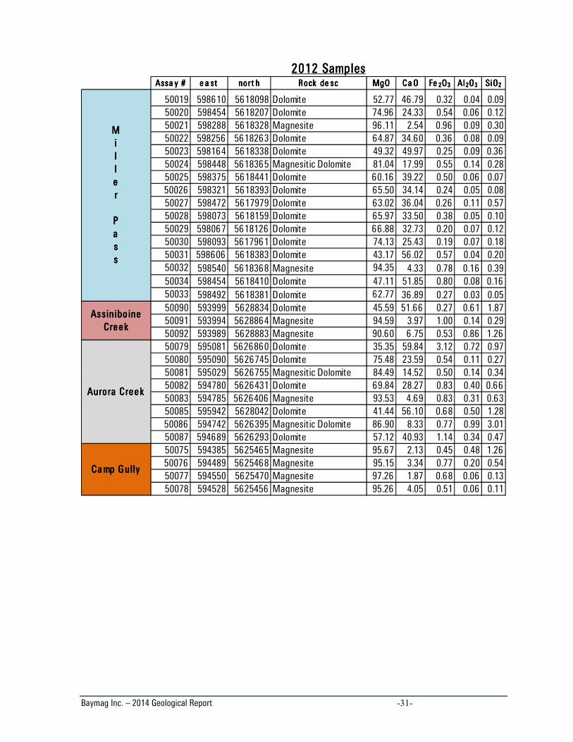
3.33.33.33.3 ResultsResultsResultsResults
The fieldwork conducted in the study area described and identified several outcrops of dolomite, magnesite and
limestone. A total of 110 samples were analyzed in this campaign, helping to identify new magnesite outcrops.
The chemical analysis results are shown in Appendix A.
The 2014 exploration campaign focused on three potential areas: Marvel Pass, West Alcantara Creek and East
Alcantara Creek (Fig. 04). In addition, five areas studied in both 2012 and 2013 were further investigated, these
included: Struna Creek, North Struna, Assiniboine Creek, Aurora Creek and Miller Pass. Among these areas,
new outcrops of magnesite were described and sampled. All the areas studied in the 2014 campaign are
described in detail below.
3.3.1 Marvel Pass
The Marvel Pass area (Fig. 05) is dominated by fine grained, crystalline, massive, grey/white dolomite.
Disseminated pyrite is commonly an accessory mineral and is usually ≤1mm. Magnesite outcrops were not
identified in this area, nor were replacement textures associated with the transition from dolomite to magnesite
(pinolite). Interbedded with these dolomites is fine grained, grey, massive limestone. These layers are typically
several meters thick and are laterally continuous. Occasionally the limestone shows bedding, in such cases the
orientation was measured and recorded. During explorations up the surrounding mountain, outcrops were not
detected until an approximate elevation of 1775m. Below this elevation, the valley floor is covered by vegetation
and transitions to talus as you near the cliff above. The valley is easily accessible due to the Marvel Pass hiking
trail in the area. Above 1775m looms a steep cliff, which begins approximately at the contact between the
underlying Naiset Fm. and overlying Cathedral Fm... Access above the cliff was possible only in one area; from
there exploration could continue east/west with a wide, accessible range to the south. Samples were collected
from dolomite outcrops within the Cathedral Fm. The maximum elevation reached was 2121 meters, where the
contact between the underlying Cathedral Fm. meets the overlying Stephen Fm. shale.

Baymag Inc. – 2014 Geological Report -7-
A total of 15 samples were collected in this area. Among all the samples analyzed, the rocks show MgO ranging
from 53 to 66.1%, Fe2O3 and SiO2 are low (< 2.1% and < 0.7% respectively), and CaO ranges from 33.3 to 46.3%.
3.3.2 West Alcantara Creek
Extensive field work was conducted on the west side of Alcantara Creek (Fig. 06). The outcrops observed were
located between 1450m and 2151m elevation. Magnesite was observed exclusively in boulders north of
Brussilof Creek, sometimes occurring in large boulder gardens on the mountain. In this case, the provenance of
the boulders is likely the Cathedral Fm. which is thought to be mostly buried under talus from the overlying
Eldon Fm. On this side of the creek the Stephen Fm. was not observed. The contact between the Cathedral and
Eldon Fm. lies at the base of a large, steep and laterally extensive cliff in this area. Due to having no access
above the base of the cliff, it is also possible that the origin of the magnesite boulders is somewhere in the cliffs
(Eldon Fm.). This is less likely due to the fact that the boulders are well sorted (on a lithological basis, not size)
which would be improbable if they fell from the cliffs. The rocks have similar characteristics to each other such
as: grain size, texture, colour, reactivity with 10% HCl and lithology. These boulder gardens contained few rocks
that had similar characteristics to the overlying cliff, suggesting that the rocks did not come from the Eldon Fm.,
and are instead a remnant of the once exposed Cathedral Fm. Evidence of partial replacement of dolomite to
magnesite was occasionally observed in outcrops along the base of this cliff which was displayed in rocks with
pinolite texture. The dominant lithology making up the base of the cliff is fine grained dolomite with lesser fine
grained, massive limestone. Disseminated pyrite is commonly seen as an accessory mineral in dolomite samples
and is usually ≤1mm. The cliff dips toward the south, beginning at an approximate elevation of 2000m (from
there it does not begin again until approximately 2150m) in the north and ending around 1900m in the south.
Between Brussilof Creek and about 1.2km up Alcantara Creek FSR, 16 treks were completed. The rocks in this
area that were studied lie within the Eldon Fm., however the Stephen Fm. was never observed to confirm this.
All of the rocks in this area were described as dolomite (except for two outcrops of fine grained, massive and
bedded, grey limestone), having the following characteristics: dominantly massive texture including lesser
amounts of banded, bedded, zebra, laminated, veined and granola texture. Generally grey or white (or both), had
grain size ranging from fine-medium, rarely up to coarse, and most of the rocks contained disseminated pyrite.
A total of 42 samples were collected in the West Alcantara Creek area this summer. Bulk rock analysis shows
MgO concentrations ranging from 55.96-78.26% for seven samples taken from the base of the cliff (between
Brussilof Creek going north until the cliff ends at 2000m and starts again near 2151m). CaO is between 20.6 and
38.8%, Fe2O3 is ≤ 2.0% and SiO2 is <1.8%. An additional 18 samples were taken in this same range beneath the
cliff from boulders and less commonly, outcrops. MgO concentration ranged from 46.17-96.56%. CaO fell
between 2.36-52.7% and Fe2O3 and SiO2 are low, <0.93%, ≤0.53% respectively. In the area between Brussilof
Creek and approximately 1.2km up Alcantara Creek FSR, 17 samples were collected that were of dolomitic
composition. MgO concentration ranged from 44.36-65.46%, CaO 33.0-54.5%, Fe2O3 ≤1.0% and SiO2 <0.5%.

Baymag Inc. – 2014 Geological Report -8-
3.3.3 East Alcantara Creek
The east side of Alcantara Creek (Fig. 06) was studied to a lesser extent than the west side. On this side of the
valley, the Stephen Fm. can be observed in several locations in the mountains making it simple to identify the
location of the Cathedral Fm. Again, there are few exposures of the Cathedral Fm. due to it being covered by
talus and vegetation. Outcrops north of Brussilof Creek were marked between the elevations 1700m and 2200m.
South of this on the Cross River FSR, still on the east side of Alcantara Creek, outcrops were marked between
1550m and 1675m. Boulder gardens similar to the west side of Alcantara Creek were identified near the valley
floor in four different locations and are possibly remnant exposures of the Cathedral Fm. Five samples were
taken from the southernmost one which contained fine grained, massive dolomites and pinolitic textured
dolomites. North of this, along the east bank of Alcantara Creek are two more boulder gardens that are
coincident with avalanche slides coming from the west side of the valley. Two samples were obtained from the
southernmost one (which was larger, and had the approximate dimensions 75m long by 30m wide) and were
medium to coarse grained, white and had granola texture. One sample was taken from the northern most
boulder field which had rocks with similar characteristics to the boulders from the south. Approximately 1km
north of the end of the road on the east side of Alcantara Creek is another boulder garden where one sample
was obtained that was described having the following characteristics: grey/white, medium grained, no pyrite,
granola texture, and moderate-high reactivity. Exposures of the Cathedral Fm. were mainly found along creek
drainages on the surrounding mountains to the east of Alcantara Creek, in which case they displayed the
following characteristics: mainly fine grain size, rarely medium, grey or white colour (or a combination of the
two), massive, bedded, laminated, mottled, zebra and one instance of pinolite texture, commonly contained
disseminated pyrite as an accessory mineral, and reactivity with HCl was high indicating high CaCO3
concentration. Interbedded with this is fine grained, grey and black, bedded limestone. Where possible,
contacts and the orientation of the limestone beds was measured and recorded in order to accurately adjust the
geologic map. Limestone was observed commonly between 1690m and 1800m elevation, where it often occurs
in mappable scale layers bounded by fine grained dolomite.
In this area a total of 17 samples were collected. Four samples obtained from the boulder gardens yielded MgO
concentrations between 84.07% and 93.36%. In all of these samples, CaO was between 5.77-14.50%, Fe2O3
ranged from 0.62 to 1.22%, and SiO2 was <0.25%. The remaining 13 samples showed low MgO concentrations
ranging from 50.63% to 70.35%, with one sample reaching 83.20%. The remaining impurities were as follows:
16.0%≥ CaO ≤48.4%, 0.17%≥ Fe2O3 ≤0.77%, SiO2 <0.6%.

Baymag Inc. – 2014 Geological Report -9-
3.3.4 Struna Creek, North Struna
Early in the field season Struna Creek and North Struna were investigated briefly to study the extent of
previously identified magnesite outcrops (Fig. 07). Samples were obtained from 15 different outcrops where
assay information was lacking south of Struna Creek. These samples were obtained between 1290m and 1600m
elevation. The MgO concentration was determined to fall between 85.51-97.75% for all samples. In the North
Struna area, 17 samples were obtained between 1442m and 1935m elevation. MgO concentration in these rocks
was high, ranging between 86.63-97.95%. The remaining impurities for both areas were as follows: 1.04%≥
CaO ≤17.40%, 0.33%≥ Fe2O3 ≤3.22% and 0.15%≥ SiO2 ≤3.59%.
3.3.5 Assiniboine Creek, Aurora Creek
One sample was obtained in the Assiniboine Creek area and two in the Aurora Creek area where only one day
was spent in each (Fig. 08). The trek in the Assiniboine Creek area marked outcrops between1800m and1895m
elevation. The sample obtained was described as: white/pink, medium-coarse grained, contained disseminated
and veined pyrite up to 2% abundance, had granola texture and had low reactivity with HCl. Assay results
determined MgO to be 88.54%, with 8.28% CaO, 2.19% Fe2O3 and O.59% SiO2. Outcrops in the Aurora Creek
area were marked between 1827m and 1967m. Both samples contained pyrite, were medium coarse grained,
grey and white in colour and had massive and granola texture, reactivity was high indicating dolomite
composition. Assay results determined MgO concentration to be 64.67% and 52.36%, CaO was 33.70% and
46.60%, Fe2O3 and SiO2 were both ≤0.66% for both samples.
3.3.6 Miller Pass
Two treks were completed in the Miller Pass area to collect data where exploration in 2012 and 2013 had not
reached (Fig. 09). Few outcrops were seen due to a thick till blanket covering the Cathedral Fm. One sample was
collected having the following characteristics: fine grain size, white colour, banded-massive texture, contained
pyrite, and had high reactivity with HCl indicating high CaCO3 composition. MgO concentration was determined
to be 44.28% with 55.0% CaO and Fe2O3 and SiO2 ≤0.61%.
3.43.43.43.4 Summary and Summary and Summary and Summary and ConclusionsConclusionsConclusionsConclusions
The Baymag Inc. 2014 exploration was focused around the north and east side of Mount Brussilof in which
recent exploration had not been completed. Obtaining more information about the rocks in that area was
priority. During the 2014 summer, several outcrops of various lithologies were analyzed. Rocks such as: shale,
limestone, dolomite, magnesitic dolomite and magnesite were described. Samples of dolomite, magnesitic
dolomite and magnesite were obtained to determine the concentration of MgO, CaO, Fe2O3, and SiO2 in each
sample.
Baymag Inc. – 2014 Geological Report -10-
Three potential areas located within claims (Marvel Pass, West Alcantara Creek and East Alcantara Creek) were
investigated this summer. Among them, several small areas within West and East Alcantara Creek contained
magnesite outcrops. In addition to this, several areas that were explored in the last two summers: Struna Creek,
North Struna, Assiniboine Creek, Aurora Creek and Miller Pass were further investigated with the objective of
determining and expanding the known extent of previously identified magnesite outcrops and discovering new
magnesite outcrops.
Further investigation is still needed to confirm the potential of the areas. Future exploration programs should
focus on determining the extent and grade of the magnesite outcrops discovered in the 2012, 2013 and 2014
exploration campaigns as well as exploring areas that have not been studied in these years. The goal is to
delineate the horizontal extension of the lithologically crystalline magnesite formation, which hosts the Brussilof
Magnesite Orebody.

Baymag Inc. – 2014 Geological Report -11-
4444 FiguresFiguresFiguresFigures

Baymag Inc. – 2014 Geological Report -21-
5555 ITEMIZED COST STATEMENTITEMIZED COST STATEMENTITEMIZED COST STATEMENTITEMIZED COST STATEMENT
The total costs incurred during the 2014 exploration program:
Figure Figure Figure Figure 10101010 –––– Itemized Itemized Itemized Itemized Cost StateCost StateCost StateCost Statementmentmentment
ITEM NUMBER UNIT UNIT COST QUANTITY TOTAL COST
Personnel Geo Senior Geo 1 day 189.03$ 84 15,878.72$
Geo Junior Geo 1 day 180.12$ 89 16,030.56$
Supervision hr 41.00$ 129.0 5,289.00$
Report Preparation
hr 41.00$ 40 1,640.00$
GeochemBaymag Lab (Exshaw)
sample analysis
MgO, CaO, Fe2O3,
Al2O3, SiO2 sample
analysis
$ 60.00 106 $ 6,360.00
Drilling Diamond Drilling BQTW meters 55.77$ 0.0 -$
Core Boxes box 0
Other
Operations2222....2.....
22.Drill access trail
Drill Pad Construction
320 Backhoe hr 135.00$ 0 -$
backhoe pulling backhoe (hr) 135.00$ 0 -$ D7 pushing D7 Cat (hr) 125.00$ 0 -$
Trail Construction 320 backhoe backhoe (hr) 135.00$ 0 -$
Settling Pond Construction
backhoe (hr) 135.00$ 0 -$
Lowbed mob / demob D7 Cat hr 194.62$ 0 -$
Lowbed mob / demob 320 Hoe hr 175.00$ 0 -$
Transportation Pickup (4X4) day 25.40$ 89 2,260.23$
rate km 0.38$ 2608 982.40$
Accommodation camp 2 day 19.16$ 84 3,218.19$
Equipment Rentals rock saw sample prep days 10.56$ 11 110.85$
blades sample prep blades 125.00$ 0 -$
chainsaw drill day 20.00$ 0 -$
GPS day 5.28$ 89 469.81$
Sat phone month 133.93$ 5.00 669.64$
Misc suppliesbear spray, hammer,
batteries, notebook,
propaneitem 193.92$ 1 193.92$
Grand Total 53,103.33$
Drill Mobilization / demobilization

Baymag Inc. – 2014 Geological Report -22-
6666 REFERENCESREFERENCESREFERENCESREFERENCES
Sangster, D.F., 1998, Breccia-hosted Lead-Zinc deposits in carbonate rocks, Paleocarst, N.P. James and P.W.
Choquette, Editors, Springer-Verlag New York Inc., p. 102-116.
Simandl, G. J. and Hancock, K. D., 1990, Geology Of The Mount Brussilof Magnesite Deposit, Southeastern
British Columbia (82J/12, 13). Geological Fieldwork 1990 – British Columbia Geological Survey Branch,
Paper 1991-1, p. 269-278.

Baymag Inc. – 2014 Geological Report -23-
7777 AUTHORS’AUTHORS’AUTHORS’AUTHORS’ QUALIFICATIONSQUALIFICATIONSQUALIFICATIONSQUALIFICATIONS
Program supervision, geological interpretation, conclusions: Ian Knuckey, MBA, B.Sc. Geology, Mine Manager Report compilation, geological interpretation, conclusions: Fabio Stern, M.Sc. Geology, Mine Geologist
Report compilation, geological interpretation, conclusions: Brody Myers, B.Sc. Geology, Field Geologist
Baymag Inc. – 2014 Geological Report -24-
8888 APPENDIX A APPENDIX A APPENDIX A APPENDIX A –––– Samples Assay SheetSamples Assay SheetSamples Assay SheetSamples Assay Sheet
Sample #Sample #Sample #Sample # Assa y #Assa y #Assa y #Assa y # e a ste a ste a ste a st nort hnort hnort hnort h Rock de scRock de scRock de scRock de sc MgOMgOMgOMgO Ca OCa OCa OCa O FeFeFeFe 2222OOOO3333 AlAlAlAl 2222OOOO3333 SiOSiOSiOSiO2222
S109 50710 594419 5623536 Magnesite 94.16 4.30 0.89 0.21 0.44
S110 50711 594515 5623146 Magnesite 90.92 5.45 2.64 0.31 0.68
S111 50712 594445 5622745 Magnesitic Dolomite 85.51 13.59 0.65 0.05 0.20
S112 50713 594506 5622710 Magnesite 90.57 7.86 0.56 0.35 0.66
S113 50714 594547 5622671 Magnesitic Dolomite 88.79 9.33 1.29 0.25 0.34
S114 50715 594636 5622789 Magnesitic Dolomite 86.81 10.80 0.89 0.45 1.05
S115 50716 594610 5622810 Magnesitic Dolomite 89.79 8.85 0.69 0.17 0.49
S116 50717 594545 5622877 Magnesitic Dolomite 80.89 17.44 1.09 0.17 0.42
S117 50718 594609 5622996 Magnesite 96.78 2.44 0.48 0.01 0.30
S118 50719 594597 5623027 Magnesite 96.70 1.64 0.89 0.25 0.53
S119 50720 594614 5623100 Magnesite 96.48 1.65 0.69 0.30 0.89
S120 50721 594527 5622564 Magnesite 91.24 5.06 3.23 0.16 0.31
S121 50722 594561 5623364 Magnesite 97.24 1.39 1.00 0.11 0.26
S140 50723 594297 5621971 Magnesite 97.75 1.04 0.71 0.13 0.37
S122 50724 594344 5622184 Magnesite 91.18 7.51 1.04 0.12 0.15
S123 50725 594196 5624147 Magnesitic Dolomite 86.64 11.91 1.07 0.09 0.30
S124 50751 594264 5624206 Magnesite 94.90 3.42 0.66 0.35 0.67
S125 50752 594385 5624255 Magnesite 96.53 2.03 0.68 0.22 0.54
S126 50753 594400 5624351 Magnesite 96.26 2.25 0.57 0.26 0.67
S127 50754 594506 5624755 Magnesite 96.92 1.69 0.62 0.14 0.62
S128 50755 594606 5624789 Magnesitic Dolomite 93.34 3.87 1.18 0.44 1.18
S129 50756 594636 5624744 Magnesite 94.86 4.17 0.54 0.13 0.30
S130 50757 594378 5625047 Magnesitic Dolomite 92.78 2.69 0.63 0.31 3.59
S131 50758 594449 5625067 Magnesite 91.64 7.26 0.66 0.06 0.38
S132 50759 594095 5624998 Magnesite 97.95 1.50 0.33 0.04 0.18
S133 50760 594091 5625035 Magnesite 97.34 1.45 0.49 0.24 0.47
S135 50761 594062 5624994 Magnesite 96.05 2.56 0.64 0.33 0.42
S134 50762 594055 5625032 Magnesite 96.38 1.72 0.34 0.66 0.90
S136 50763 594241 5625048 Magnesite 96.16 2.08 0.37 0.59 0.80
S137 50764 594553 5625104 Magnesitic Dolomite 88.36 10.93 0.42 0.08 0.21
S138 50765 594612 5625186 Magnesite 93.58 4.00 0.56 0.12 1.75
S139 50766 594576 5625077 Magnesite 93.17 5.40 0.66 0.18 0.60
Miller PassMiller PassMiller PassMiller Pass S190 50822 599268 5618242 Dolomite 44.28 55.01 0.61 0.05 0.05
Assiniboine Ass iniboine Ass iniboine Ass iniboine
CreekCreekCreekCreek S140 50767 593823 5629321 Magnesitic Dolomite 88.54 8.28 2.19 0.40 0.59
S141 50768 595605 5627249 Dolomite 64.67 33.76 0.61 0.37 0.59
S142 50769 595666 5627169 Dolomite 52.36 46.67 0.66 0.10 0.21Aurora CreekAurora CreekAurora CreekAurora Creek
2014 Samples2014 Samples2014 Samples2014 Samples
NNNN
oooo
rrrr
tttt
hhhh
SSSS
tttt
rrrr
uuuu
nnnn
aaaa
SSSS
tttt
rrrr
uuuu
nnnn
aaaa
CCCC
rrrr
eeee
eeee
kkkk
Baymag Inc. – 2014 Geological Report -25-
Sample #Sample #Sample #Sample # Assa y #Assa y #Assa y #Assa y # e a ste a ste a ste a st nort hnort hnort hnort h Rock de scRock de scRock de scRock de sc MgOMgOMgOMgO Ca OCa OCa OCa O FeFeFeFe 2222OOOO3333 AlAlAlAl 2222OOOO3333 SiOSiOSiOSiO2222
S143 50771 598870 5629423 Dolomite 56.34 41.85 1.66 0.05 0.10
S144 50772 598868 5629306 Dolomite 66.10 33.33 0.43 0.05 0.09
S145 50773 599539 5629790 Dolomite 59.96 38.36 1.56 0.05 0.08
S146 50774 599431 5629740 Dolomite 60.27 37.67 1.00 0.37 0.69
S147 50775 596993 5629159 Dolomite 60.52 38.49 0.80 0.06 0.13
S148 50776 597269 5629166 Dolomite 60.46 38.80 0.22 0.20 0.32
S149 50777 596625 5629125 Dolomite 61.36 38.24 0.30 0.04 0.06
S150 50778 596626 5628869 Dolomite 57.28 41.90 0.65 0.08 0.09
S151 50779 597173 5629329 Dolomite 59.19 39.53 1.17 0.05 0.06
S152 50780 596327 5628864 Dolomite 59.76 38.41 1.77 0.02 0.04
S153 50781 597416 5629421 Dolomite 60.32 38.61 1.02 0.02 0.03
S154 50782 597267 5629331 Dolomite 61.54 37.79 0.59 0.02 0.06
S155 50783 597807 5629486 Dolomite 61.68 36.09 2.12 0.04 0.07
S156 50784 599066 5629369 Dolomite 53.28 46.35 0.27 0.03 0.07
S157 50785 596735 5628937 Dolomite 61.06 38.38 0.40 0.06 0.10
S158 50786 600259 5620390 Dolomite 62.28 37.21 0.46 0.02 0.03
S159 50787 600672 5620407 Dolomite 65.46 34.15 0.35 0.01 0.03
S160 50788 600624 5620793 Dolomite 63.07 36.52 0.34 0.02 0.05
S161 50789 600507 5621201 Dolomite 63.00 36.18 0.26 0.09 0.47
S162 50790 600324 5621344 Dolomite 62.98 36.43 0.47 0.04 0.08
S163 50792 600105 5621496 Dolomite 55.37 42.30 0.24 0.20 1.89
S164 50791 601263 5621432 Dolomite 57.15 42.38 0.36 0.04 0.08
S165 50793 601313 5621391 Dolomite 66.49 33.09 0.35 0.03 0.04
S166 50794 600194 5621959 Dolomite 44.37 54.69 0.34 0.09 0.52
S167 50795 600829 5622135 Dolomite 44.42 54.36 1.05 0.07 0.10
S168 50796 600954 5622224 Dolomite 44.92 54.50 0.45 0.05 0.07
S169 50797 601264 5622755 Dolomite 51.60 47.51 0.68 0.10 0.11
S170 50798 601362 5622996 Dolomite 61.73 37.96 0.23 0.02 0.06
S171 50799 601119 5623184 Dolomite 60.92 38.27 0.60 0.11 0.11
S172 50800 601174 5621190 Dolomite 61.34 38.27 0.27 0.04 0.08
S173 50801 601084 5623631 Dolomite 45.40 53.95 0.48 0.07 0.11
S174 50802 601219 5623562 Dolomite 49.37 50.15 0.31 0.08 0.09
S175 50803 601410 5624624 Dolomite 61.38 38.16 0.30 0.06 0.10
- 50815 601520 5624836 Magnesitic Dolomite 80.28 18.19 1.04 0.26 0.23
- 50816 601529 5624893 Dolomite 46.91 52.44 0.52 0.07 0.07
- 50817 601513 5625071 Dolomite 69.26 30.12 0.51 0.06 0.04
- 50818 601493 5625538 Dolomite 52.35 46.25 1.00 0.20 0.20
- 50819 601496 5625541 Dolomite 58.45 40.04 1.08 0.19 0.24
- 50820 601494 5625542 Dolomite 53.24 45.02 1.36 0.18 0.20
- 50821 601492 5625549 Dolomite 46.17 52.79 0.84 0.10 0.10
S176 50804 601983 5624649 Dolomite 60.44 39.31 0.18 0.03 0.05
- 50823 601554 5625483 Dolomite 64.32 34.87 0.75 0.03 0.03
- 50824 601422 5625595 Dolomite 68.83 29.81 0.50 0.32 0.54
S177 50805 601909 5624788 Dolomite 69.89 29.57 0.34 0.07 0.12
2014 Samples2014 Samples2014 Samples2014 Samples
AAAA
llll
cccc
aaaa
nnnn
tttt
aaaa
rrrr
aaaa
CCCC
rrrr
eeee
eeee
kkkk
MMMM
aaaa
rrrr
vvvv
eeee
llll
PPPP
aaaa
ssss
ssss
Baymag Inc. – 2014 Geological Report -26-
Sample #Sample #Sample #Sample # Assa y #Assa y #Assa y #Assa y # e a ste a ste a ste a st nort hnort hnort hnort h Rock de scRock de scRock de scRock de sc MgOMgOMgOMgO Ca OCa OCa OCa O FeFeFeFe 2222OOOO3333 AlAlAlAl 2222OOOO3333 SiOSiOSiOSiO2222
S178 50806 602304 5624892 Dolomite 61.48 37.97 0.47 0.03 0.05
S179 50807 602518 5625185 Dolomite 69.44 29.90 0.43 0.05 0.18
S180 50808 601297 5625648 Magnesite 94.35 4.76 0.64 0.10 0.15
S181 50809 601272 5625720 Magnesitic Dolomite 88.16 10.83 0.76 0.11 0.14
S182 50810 601542 5624891 Magnesite 94.21 4.61 0.73 0.20 0.25
S183 50811 601199 5625840 Magnesitic Dolomite 76.81 21.20 1.34 0.27 0.37
S184 50812 601145 5626084 Magnesite 90.39 8.81 0.68 0.05 0.07
S186 50813 601110 5626219 Magnesite 78.36 20.59 0.90 0.08 0.07
S188 50814 601662 5625827 Magnesite 93.36 5.78 0.77 0.04 0.05
S187 50825 601664 5625823 Magnesitic Dolomite 86.63 12.65 0.62 0.05 0.05
S189 50826 601148 5626397 Magnesite 91.31 5.30 0.75 0.11 2.53
S190 50827 601966 5621417 Dolomite 65.09 33.91 0.33 0.05 0.61
S191 50828 602107 5621575 Dolomite 61.72 37.76 0.44 0.03 0.06
S192 50829 600851 5626657 Dolomite 60.74 38.08 0.70 0.10 0.37
S193 50830 600640 5626626 Dolomite 64.09 34.98 0.77 0.07 0.09
S194 50831 600557 5626988 Dolomite 55.96 38.89 2.01 1.34 1.81
S195 50832 600548 5626936 Magnesite 96.56 2.36 0.59 0.12 0.37
S196 50833 600451 5626940 Magnesitic Dolomite 87.91 11.04 0.93 0.05 0.07
S197 50834 600373 5626811 Dolomite 71.62 27.16 0.85 0.15 0.22
S198 50835 600362 5626803 Dolomite 78.05 20.85 0.91 0.08 0.11
S199 50836 600297 5626722 Dolomite 78.26 20.63 0.91 0.09 0.11
S200 50837 601891 5624708 Dolomite 66.71 32.38 0.62 0.12 0.17
S201 50838 601942 5624794 Dolomite 70.35 28.51 0.93 0.12 0.09
S202 50839 601927 5624901 Dolomite 68.77 30.25 0.69 0.15 0.14
S203 50840 601513 5626171 Magnesitic Dolomite 85.58 13.02 1.22 0.09 0.09
S204 50841 602182 5626688 Dolomite 42.45 55.05 0.98 0.49 1.03
S205 50842 600943 5627478 Magnesitic Dolomite 84.07 14.52 0.92 0.24 0.25
S206 50843 600587 5627783 Dolomite 50.63 48.42 0.77 0.08 0.09
S207 50844 601216 5627511 Magnesitic Dolomite 83.20 16.02 0.71 0.05 0.02
S208 50845 600816 5628072 Dolomite 59.04 39.97 0.69 0.15 0.15
2014 Samples2014 Samples2014 Samples2014 Samples
AAAA
llll
cccc
aaaa
nnnn
tttt
aaaa
rrrr
aaaa
CCCC
rrrr
eeee
eeee
kkkk

Baymag Inc. – 2014 Geological Report -27-
Sample #Sa mple #Sa mple #Sa mple # Assa y #Assa y #Assa y #Assa y # e a ste a ste a ste a st nor t hnort hnort hnort h Rock de scRock de scRock de scRock de sc MgOMgOMgOMgO Ca OCa OCa OCa O FeFeFeFe 2222OOOO 3333 AlAlAlAl 2222OOOO3333 SiOSiOSiOSiO 2222
S17 50667 593999 5624238 Magnesitic Dolomite 84.95 14.22 0.26 0.02 0.55
S18 50668 594047 5624241 Dolomite 78.63 20.24 0.35 0.21 0.56
S19 50669 594096 5624166 Dolomite 59.28 39.54 0.14 0.36 0.68
S20 50670 594385 5624457 Dolomite 77.85 21.37 0.53 0.06 0.19
S21 50671 594447 5624431 Magnesitic Dolomite 82.75 16.69 0.39 0.05 0.12
S22 50672 594468 5624395 Magnesite 97.74 1.72 0.46 0.03 0.06
S23 50673 594472 5624161 Magnesite 95.90 2.28 1.18 0.16 0.48
S24 50674 594504 5624197 Magnesite 97.75 1.61 0.36 0.08 0.20
S25 50675 594469 5624284 Magnesite 96.46 2.27 0.47 0.20 0.60
S26 50726 594464 5624009 Magnesitic Dolomite 87.07 8.01 0.56 0.55 3.80
S27 50727 594523 5624220 Magnesite 96.82 1.99 0.67 0.16 0.36
S28 50728 594472 5624430 Magnesite 90.66 8.33 0.31 0.23 0.48
S29 50729 594271 5625194 Magnesite 97.52 1.51 0.31 0.17 0.49
S30 50730 594317 5625131 Dolomite 77.02 22.12 0.44 0.18 0.25
S31 50731 594252 5625003 Magnesite 93.50 5.47 0.31 0.28 0.44
S32 50732 594215 5625058 Magnesite 93.83 5.45 0.40 0.09 0.24
S33 50733 594265 5625121 Magnesitic Dolomite 82.90 16.49 0.49 0.04 0.08
S34 50734 594022 5624731 Magnesite 90.76 8.29 0.28 0.30 0.37
S35 50735 594101 5624780 Magnesite 90.14 9.35 0.33 0.04 0.14
S36 50736 594290 5624927 Magnesite 95.30 2.97 0.44 0.34 0.95
S37 50737 594332 5624969 Magnesitic Dolomite 86.92 11.74 0.43 0.18 0.73
S38 50738 594297 5624745 Magnesite 95.72 2.31 0.61 0.30 1.05
S39 50739 594402 5624735 Magnesite 91.04 8.23 0.45 0.08 0.20
S59 50609 594418 5628677 Magnesite 91.72 6.45 1.07 0.23 0.53
S60 50610 594124 5629067 Magnesite 94.56 3.84 0.64 0.22 0.75
S61 50611 594036 5629165 Magnesite 94.65 3.12 0.68 0.35 1.20
S68 50619 593862 5629234 Magnesitic Dolomite 86.76 12.29 0.51 0.15 0.29
S69 50620 593821 5629095 Magnesite 91.21 7.15 0.77 0.26 0.61
S82 50683 593822 5629402 Magnesite 90.50 7.66 0.79 0.32 0.73
S83 50684 593814 5629428 Magnesite 94.74 3.81 0.75 0.22 0.47
S84 50685 593711 5629469 Magnesite 95.27 4.05 0.60 0.03 0.05
2013 Samples2013 Samples2013 Samples2013 Samples
Assinibo ine Assinibo ine Assinibo ine Assinibo ine
CreekCreekCreekCreek
NNNN
oooo
rrrr
tttt
hhhh
SSSS
tttt
rrrr
uuuu
nnnn
aaaa

Baymag Inc. – 2014 Geological Report -28-
Sample #Sa mple #Sa mple #Sa mple # Assa y #Assa y #Assa y #Assa y # e a ste a ste a ste a st nor t hnort hnort hnort h Rock de scRock de scRock de scRock de sc MgOMgOMgOMgO Ca OCa OCa OCa O FeFeFeFe 2222OOOO 3333 AlAlAlAl 2222OOOO3333 SiOSiOSiOSiO 2222
S43 50743 594342 5625560 Magnesite 95.31 3.45 0.62 0.23 0.39
S44 50744 594389 5625631 Magnesite 96.21 2.98 0.63 0.06 0.11
S45 50745 594444 5625589 Magnesite 97.29 1.89 0.64 0.06 0.12
S46 50746 594495 5625642 Magnesite 96.02 2.60 0.38 0.32 0.68
S47 50747 594421 5625702 Magnesite 97.29 1.77 0.52 0.14 0.29
S48 50748 594404 5625713 Magnesite 96.35 2.61 0.47 0.23 0.34
S49 50749 594428 5625793 Magnesite 96.83 2.67 0.36 0.07 0.08
S50 50750 594593 5625603 Magnesitic Dolomite 85.66 12.74 0.36 0.40 0.84
S51 50601 594656 5625657 Magnesite 90.52 8.92 0.43 0.04 0.10
S52 50602 594395 5625759 Magnesite 91.60 5.77 0.61 0.80 1.23
S53 50603 594488 5625892 Magnesitic Dolomite 86.99 11.71 0.65 0.25 0.40
S54 50604 594917 5626783 Magnesite 90.81 7.59 0.88 0.19 0.53
S55 50605 594875 5626741 Magnesitic Dolomite 87.52 9.54 1.04 0.70 1.20
S56 50606 594982 5626690 Magnesitic Dolomite 87.35 11.57 0.51 0.13 0.44
S57 50607 595025 5626621 Magnesite 96.90 1.28 0.58 0.13 1.11
S58 50608 594564 5626075 Dolomite 45.33 52.14 1.41 0.44 0.68
S71 50625 594391 5625616 Magnesite 94.83 2.01 1.95 0.24 0.96
S97 50698 595895 5628255 Dolomite 61.88 37.08 0.78 0.08 0.17
S98 50699 596037 5628369 Dolomite 43.24 54.89 1.67 0.07 0.12
S40 50740 600075 5619482 Dolomite 45.64 53.48 0.65 0.09 0.14
S41 50741 600056 5619787 Dolomite 44.56 55.01 0.35 0.04 0.03
S42 50742 600142 5619901 Dolomite 45.52 54.07 0.36 0.02 0.02
Alcant ara Alcant ara Alcant ara Alcant ara
CreekCreekCreekCreek
AAAA
uuuu
rrrr
oooo
rrrr
aaaa
CCCC
rrrr
eeee
eeee
kkkk
2013 Samples2013 Samples2013 Samples2013 Samples
Baymag Inc. – 2014 Geological Report -29-
Sample #Sa mple #Sa mple #Sa mple # Assa y #Assa y #Assa y #Assa y # e a ste a ste a ste a st nor t hnort hnort hnort h Rock de scRock de scRock de scRock de sc MgOMgOMgOMgO Ca OCa OCa OCa O FeFeFeFe 2222OOOO 3333 AlAlAlAl 2222OOOO3333 SiOSiOSiOSiO 2222
S01 50651 597507 5619149 Dolomite 50.32 48.89 0.69 0.05 0.05
S03 50653 597563 5619207 Dolomite 62.26 37.46 0.16 0.04 0.08
S04 50654 597603 5619188 Dolomite 62.48 36.91 0.45 0.08 0.08
S05 50655 597609 5619161 Dolomite 61.81 37.10 1.00 0.03 0.06
S06 50656 597592 5619545 Dolomite 60.64 38.19 0.60 0.18 0.38
S07 50657 597703 5619503 Dolomite 59.35 39.47 0.59 0.24 0.36
S08 50658 597936 5619367 Dolomite 61.36 37.95 0.26 0.18 0.25
S09 50659 597968 5619340 Dolomite 75.50 23.33 0.84 0.13 0.21
S10 50660 598032 5619249 Dolomite 68.06 31.37 0.41 0.07 0.09
S11 50661 598026 5619299 Dolomite 65.24 34.10 0.55 0.03 0.07
S12 50662 598015 5619379 Dolomite 76.69 22.43 0.67 0.07 0.14
S13 50663 598044 5619437 Dolomite 61.42 38.02 0.45 0.05 0.06
S14 50664 598164 5619064 Dolomite 70.92 27.92 0.20 0.06 0.90
S15 50665 598160 5619077 Magnesite 91.19 7.42 0.41 0.13 0.84
S16 50666 598459 5619119 Dolomite 57.51 41.61 0.79 0.04 0.05
S62 50613 595946 5619746 Dolomite 59.82 39.58 0.29 0.10 0.21
S63 50614 596014 5619724 Dolomite 56.73 42.56 0.37 0.12 0.23
S64 50615 597601 5618733 Dolomite 79.25 19.80 0.84 0.04 0.07
S93 50694 597760 5618095 Dolomite 43.28 55.80 0.71 0.09 0.12
S95 50696 598001 5617402 Dolomite 40.86 55.46 0.90 0.97 1.80
S99 50700 596626 5619457 Dolomite 74.29 24.42 0.49 0.32 0.48
S100 50701 596561 5619525 Dolomite 47.02 52.16 0.72 0.03 0.06
S101 50702 596821 5620358 Magnesite 90.46 8.61 0.63 0.08 0.21
S102 50703 597078 5620315 Dolomite 44.51 54.80 0.58 0.03 0.08
S103 50704 597087 5620084 Dolomite 44.42 53.74 0.82 0.32 0.69
S104 50705 597201 5620033 Dolomite 31.68 65.75 2.09 0.18 0.29
S105 50706 595702 5619967 Dolomite 33.33 65.21 1.11 0.13 0.22
S106 50707 595583 5620075 Dolomite 32.54 65.45 1.92 0.03 0.07
S107 50708 597397 5619887 Dolomite 31.54 64.77 3.30 0.13 0.27
S108 50709 597499 5619816 Dolomite 36.58 62.56 0.70 0.06 0.10
CCCC
rrrr
oooo
ssss
ssss
RRRR
iiii
vvvv
eeee
rrrr
2013 Samples2013 Samples2013 Samples2013 Samples

Baymag Inc. – 2014 Geological Report -30-
Assa y #Assa y #Assa y #Assa y # e a ste a ste a ste a st nort hnort hnort hnort h Rock de scRock de scRock de scRock de sc MgOMgOMgOMgO Ca OCa OCa OCa O FeFeFeFe 2222OOOO 3333 AlAlAlAl 2222OOOO 3333 SiOSiOSiOSiO2222
45227 594363 5621889 Dolomite 45.05 53.72 0.46 0.25 0.52
45228 594209 5622002 Dolomite 72.71 26.65 0.45 0.07 0.12
45229 594570 5623433 Magnesite 91.55 7.33 0.84 0.09 0.18
45230 594597 5623436 Magnesitic Dolomite 88.64 9.90 0.66 0.25 0.56
45232 594534 5622870 Magnesitic Dolomite 82.60 15.50 0.87 0.30 0.74
45233 594553 5623043 Magnesite 95.63 1.51 1.73 0.28 0.86
45234 594543 5623129 Magnesite 94.55 3.00 1.11 0.34 0.99
45235 594668 5623249 Magnesite 95.41 1.79 0.50 0.57 1.74
45236 594500 5623437 Magnesite 95.08 1.92 0.83 0.55 1.62
45237 594556 5623117 Magnesite 93.59 1.98 1.90 0.62 1.91
45238 594480 5622843 Dolomite 75.23 23.01 1.31 0.19 0.26
45240 594092 5623556 Dolomite 59.19 40.07 0.46 0.12 0.16
45241 594389 5623639 Magnesite 95.35 3.67 0.60 0.11 0.26
45242 594417 5623632 Magnesitic Dolomite 86.89 10.07 1.79 0.37 0.88
45243 594454 5623630 Magnesite 97.48 1.68 0.74 0.04 0.06
45244 594500 5623650 Dolomite 65.86 33.62 0.39 0.06 0.07
45245 594346 5623540 Magnesite 90.77 5.99 2.07 0.42 0.75
45246 594412 5623559 Dolomite 79.19 18.28 2.23 0.11 0.19
45247 594514 5623659 Magnesite 97.04 1.99 0.72 0.09 0.16
45248 594515 5623633 Magnesitic Dolomite 85.42 13.48 0.95 0.06 0.09
45249 594560 5623602 Magnesite 94.19 4.12 1.24 0.14 0.30
45250 594649 5623532 Magnesite 95.96 2.92 0.76 0.10 0.26
50001 594587 5623498 Magnesite 96.87 1.63 0.89 0.19 0.42
50002 594560 5623531 Magnesite 96.02 1.86 1.98 0.05 0.10
50003 594542 5623407 Magnesite 96.92 2.14 0.74 0.07 0.13
50004 594429 5623682 Magnesite 90.26 7.53 0.98 0.35 0.89
50005 594499 5623536 Magnesitic Dolomite 87.44 11.32 0.78 0.15 0.31
50006 594541 5623515 Magnesite 97.26 1.76 0.68 0.10 0.20
50093 594137 5625221 Dolomite 46.02 52.82 0.36 0.35 0.44
50094 594159 5625221 Magnesite 91.03 8.26 0.36 0.12 0.23
50095 594233 5625120 Dolomite 72.43 25.94 0.70 0.28 0.65
50096 594212 5624833 Dolomite 58.26 39.72 0.67 0.36 0.99
50501 594409 5624297 Dolomite 78.34 20.90 0.45 0.10 0.21
50502 594495 5624327 Magnesite 96.95 1.85 0.49 0.20 0.51
2012 Samples2012 Samples2012 Samples2012 Samples
SSSS
tttt
rrrr
uuuu
nnnn
aaaa
CCCC
rrrr
eeee
eeee
kkkk
North S t runa North S t runa North S t runa North S t runa
Baymag Inc. – 2014 Geological Report -31-
Assa y #Assa y #Assa y #Assa y # e a ste a ste a ste a st nort hnort hnort hnort h Rock de scRock de scRock de scRock de sc MgOMgOMgOMgO Ca OCa OCa OCa O FeFeFeFe 2222OOOO 3333 AlAlAlAl 2222OOOO 3333 SiOSiOSiOSiO2222
50019 598610 5618098 Dolomite 52.77 46.79 0.32 0.04 0.09
50020 598454 5618207 Dolomite 74.96 24.33 0.54 0.06 0.12
50021 598288 5618328 Magnesite 96.11 2.54 0.96 0.09 0.30
50022 598256 5618263 Dolomite 64.87 34.60 0.36 0.08 0.09
50023 598164 5618338 Dolomite 49.32 49.97 0.25 0.09 0.36
50024 598448 5618365 Magnesitic Dolomite 81.04 17.99 0.55 0.14 0.28
50025 598375 5618441 Dolomite 60.16 39.22 0.50 0.06 0.07
50026 598321 5618393 Dolomite 65.50 34.14 0.24 0.05 0.08
50027 598472 5617979 Dolomite 63.02 36.04 0.26 0.11 0.57
50028 598073 5618159 Dolomite 65.97 33.50 0.38 0.05 0.10
50029 598067 5618126 Dolomite 66.88 32.73 0.20 0.07 0.12
50030 598093 5617961 Dolomite 74.13 25.43 0.19 0.07 0.18
50031 598606 5618383 Dolomite 43.17 56.02 0.57 0.04 0.20
50032 598540 5618368 Magnesite 94.35 4.33 0.78 0.16 0.39
50034 598454 5618410 Dolomite 47.11 51.85 0.80 0.08 0.16
50033 598492 5618381 Dolomite 62.77 36.89 0.27 0.03 0.05
50090 593999 5628834 Dolomite 45.59 51.66 0.27 0.61 1.87
50091 593994 5628864 Magnesite 94.59 3.97 1.00 0.14 0.29
50092 593989 5628883 Magnesite 90.60 6.75 0.53 0.86 1.26
50079 595081 5626860 Dolomite 35.35 59.84 3.12 0.72 0.97
50080 595090 5626745 Dolomite 75.48 23.59 0.54 0.11 0.27
50081 595029 5626755 Magnesitic Dolomite 84.49 14.52 0.50 0.14 0.34
50082 594780 5626431 Dolomite 69.84 28.27 0.83 0.40 0.66
50083 594785 5626406 Magnesite 93.53 4.69 0.83 0.31 0.63
50085 595942 5628042 Dolomite 41.44 56.10 0.68 0.50 1.28
50086 594742 5626395 Magnesitic Dolomite 86.90 8.33 0.77 0.99 3.01
50087 594689 5626293 Dolomite 57.12 40.93 1.14 0.34 0.47
50075 594385 5625465 Magnesite 95.67 2.13 0.45 0.48 1.26
50076 594489 5625468 Magnesite 95.15 3.34 0.77 0.20 0.54
50077 594550 5625470 Magnesite 97.26 1.87 0.68 0.06 0.13
50078 594528 5625456 Magnesite 95.26 4.05 0.51 0.06 0.11
2012 Samples2012 Samples2012 Samples2012 Samples
MMMM
iiii
llll
llll
eeee
rrrr
PPPP
aaaa
ssss
ssss
Assinibo ine Assinibo ine Assinibo ine Assinibo ine
CreekCreekCreekCreek
Aurora CreekAurora CreekAurora CreekAurora Creek
Camp GullyCamp GullyCamp GullyCamp Gully

Baymag Inc. – 2014 Geological Report - 32 -
Assa y #Assa y #Assa y #Assa y # e a ste a ste a ste a st nort hnort hnort hnort h Rock de scRock de scRock de scRock de sc MgOMgOMgOMgO Ca OCa OCa OCa O FeFeFeFe 2222OOOO 3333 AlAlAlAl 2222OOOO 3333 SiOSiOSiOSiO2222
50007 595470 5621597 Dolomite 57.90 41.34 0.46 0.09 0.21
50009 595544 5621504 Dolomite 53.34 46.16 0.36 0.06 0.08
50010 595559 5621541 Dolomite 51.13 48.06 0.66 0.05 0.10
50011 595546 5621634 Dolomite 57.09 42.38 0.42 0.02 0.10
50012 595520 5621695 Dolomite 50.90 46.26 0.49 0.05 2.30
50013 595510 5621749 Dolomite 46.25 51.34 0.73 0.58 1.10
50014 595469 5621624 Dolomite 47.78 51.17 0.52 0.15 0.38
50015 596305 5620924 Dolomite 52.49 46.51 0.85 0.05 0.10
50016 596345 5621102 Dolomite 48.45 49.93 1.40 0.08 0.14
50017 596392 5621156 Dolomite 70.43 28.37 0.71 0.04 0.45
50035 599562 5619022 Dolomite 52.51 46.80 0.30 0.14 0.25
50036 598196 5618819 Dolomite 50.54 48.33 0.42 0.20 0.52
50037 598177 5618858 Dolomite 45.62 53.74 0.25 0.11 0.27
50038 598195 5618912 Magnesitic Dolomite 81.78 16.34 0.55 0.28 1.05
50039 598208 5618925 Magnesitic Dolomite 89.52 8.46 0.44 0.43 1.14
50040 598219 5618970 Magnesitic Dolomite 81.58 17.32 0.66 0.15 0.30
50041 598221 5618997 Magnesite 95.23 3.97 0.63 0.06 0.12
50042 598317 5618908 Magnesite 90.45 8.74 0.54 0.10 0.17
50043 598311 5618891 Magnesite 96.75 2.76 0.43 0.02 0.03
50044 598239 5618818 Magnesitic Dolomite 89.44 9.31 0.52 0.25 0.48
50045 598302 5618840 Dolomite 49.50 49.42 0.39 0.24 0.46
50046 598321 5618856 Magnesite 94.16 4.76 0.52 0.15 0.42
50047 598306 5618876 Magnesitic Dolomite 82.98 16.29 0.36 0.13 0.23
50048 598330 5618868 Magnesitic Dolomite 89.02 10.35 0.47 0.04 0.12
50049 598570 5619048 Dolomite 59.60 39.63 0.59 0.09 0.10
50050 598813 5618824 Magnesitic Dolomite 83.14 15.90 0.51 0.20 0.24
50052 598978 5618831 Magnesite 91.46 7.29 0.46 0.27 0.51
50053 598990 5618839 Magnesite 92.62 6.53 0.43 0.18 0.24
50054 598952 5618806 Magnesitic Dolomite 86.73 12.38 0.52 0.17 0.21
50055 598995 5618804 Magnesitic Dolomite 85.49 14.00 0.39 0.04 0.07
50056 599137 5619070 Dolomite 72.28 26.74 0.45 0.19 0.33
50057 599019 5619021 Dolomite 43.50 55.51 0.80 0.10 0.08
50058 599162 5618957 Dolomite 41.11 57.08 0.96 0.27 0.58
50059 598961 5618775 Dolomite 67.45 31.74 0.31 0.24 0.26
50060 598937 5618771 Magnesite 92.24 7.03 0.54 0.07 0.13
50061 598924 5618778 Magnesitic Dolomite 89.54 8.99 0.69 0.33 0.45
50062 598883 5618780 Magnesite 95.41 3.18 0.59 0.34 0.49
50063 598915 5618809 Magnesite 92.03 6.82 0.74 0.17 0.25
50064 599538 5618967 Dolomite 47.34 51.93 0.41 0.12 0.20
2013 Samples2013 Samples2013 Samples2013 Samples
CCCC
rrrr
oooo
ssss
ssss
RRRR
iiii
vvvv
eeee
rrrr

580000 590000 600000
56
00
00
05
61
00
00
56
20
00
05
63
00
00
Fig. 01: Baymag Location
·
Baymag Claims
Mine site
Highway
Roads
0 52.5Km
Datum NAD83
UTM Zone 11N
1:175,000
Cro
ssR
iver
_̂
_̂
£¤93
Koote
nay
Rive
r
To Banff
To Radium

596517
596511
596510
596519
596515
596507
596514
596529
596230
596527
596530
596231
596229
596523
596513
596518
596509
596506
596512
596516
597889
597887
213677213798
597888
213678
213681
596228
596526
596528
596521
213796
213682
213794
597928
597929
213679
595000 600000
56
20
00
056
25
00
056
30
00
0
Fig. 02: Baymag - Mt. Brussilof Mine
·
0 20001000m
Datum NAD83UTM Zone 11N
1:50,000
Cro
ssRiver
_̂
_̂
Legend
Mine site
Magnesite Outcrops
Baymag Claims
Roads
Arctomys Fm.
Eldon Fm.
Stephen Fm.
Cathedral Fm.
Naiset Fm.
Gog Group
Geology

Bru
ss ilof Creek
596517
596511
596510
596519
596515
596507
596514
596529
596230
596527
596530
596231
596229
596523
596513
596518
213874
596509
596506
596512
596516
597889
597887
213677213798
597888
213678
213681
596228
596526
596528
596521
213796
213682
213794
597928
597929
213679
16 00
140
0
1800
200
0
1200
22
00
2400
2600
2
800
240
0
20
00
2600
1400
1 80 0
200
0
2000
2600
26
00
22
00
1600
1800
22 0022
00
2 20 0
24
00
1800
26 0 0
2000
2400
220 0
2200
16 001800
260
0
2200
2400
1600
1800
2000
140
0
26 00
2800
3 000
32 00
300022
00
2600
260
0
2200
2
0 00
2800
26
00
2
20
0
22002000
26002400
240
0
1800
22
00
1800
2600
2400
200 0
280026
00
24002
60
0
2600
2600
2800
1600
26
00
2800
2400
24
0
0
2800
2800
595000 600000
56
20
00
056
25
00
056
30
00
0
Fig. 03: Baymag - Mineral Claims
·
0 20001000m
Datum NAD83UTM Zone 11N
1:50,000
Cro
ssRiver
_̂
_̂ Mine site
Roads
Water bodies
Mine Lease
Baymag Claims
StrunaCre
ek
Auro
raC
reek
Mitc
hell
Riv
er
Cro
ssRiv
er
Alc
anta
raC
reek
Ass
iniboin
e
Creek

Fig. 04: Baymag - Exploration Summary
_̂
Legend
#* 2014 Samples
#* 2013 Samples
#* 2012 Samples
2014 Geo Stations
2013 Geo Stations
2012 Geo Stations
Mine site
Baymag Claims
Tracks
Roads
Struna Creek
Miller Pass
#*#*
#*#*
#*
#*#*#*
#*
#*
#*
#*#*#*#*#*#*#*
#*#*#*#*#*#*
#*
#*#*#*
#*#*#*#*#*#*#*#*
#*
#*#*
#*#*
#*#*
#* #*#*#*
#*
#*#*
#*
#*#*#*#*
#*
#*#*#*#*#*#*#*#*#*#*#*#*#*
#*
#* #*#*#*#*
#*#*#*
#*#*#*#*#*
#*
#*#*#*#*
#*#*#*
#*#*
#*
#*#*
#*#*#*
#*#*#*
#*
#*#*
#*#*#*#*#*
#*#*#*#*#*#*#*#*
#*#*#*
#*#*#*
#*#*#*
#*#*#*
#*
#*
#*
#*#*#*#*#*
#*#*
#*#*
#*#*
#*
#*#*
#*#*#*#*#*#*#*
#*#*
#*#*
#*#*#*#*
#*
#*
#*#*
#*#*
#*
#*#*
#*
#*#*#*
#*
#*
#*#*
#*#*
#* #*
#*#*#*
#*
#*#*
#*
#*
#*#*#*#*#*
#*#*#*#*
#*
#*
#*
#*
#*#*#*#*
#*#*#*
#*#*#*#*#*#*#*
#*#*#*
#*
#*#*
#*#*
#*#*
#* #*#*
#*
#*
#*
#*#*
#*#*
#*
#* #*
#*
#*
#*
#*#*#*
#*
#*#*
#*
#*
#*
#*
#*#*
#* #*#*
#*
#*
#*#*
#*
#*
#*#*
#*#*
#*
#*
#*
#*#*
#*
#*#*#*#*
#*
#*#*
#*#*
#*#*#*#*#*#*
#*#*#*
#*
#*
#*
#*
#*
#*
596517
596511
596510
596519
596515
596507
596514
596529
596230
596527
596530
596231
596229
596523
596513
596518
596509
596506
596512
596516
597889
597887
213677213798
597888213678
213681
596228
596526
596528
596521
213796
213682
213794
597928
597929
213679
16 00
140
0
1800
200
0
1200
22
00
2400
2600
2
800
240
0
20
00
2600
1400
1
800
200
0
2000
2600
26
00
22
00
16001800
22 0022
00
2 20 0
24
00
1800
26 0 0
2
000
2400
220 0
2200
16 001800
260
0
220
0
2400
1600
1800
200 0
1400
26 00
2800
3 000
32 00
2600
2600
30002
200
200 0
2
20
028
00
2600
260
0
2400
2800
2400
2
0 00
22
00
1800
260
0
2200
20002200
26
00
2600
160
0
24002
60
0
2600
2800
1800
24
0
0
26
00
2800
240
0
2400
2800
2800
592000 596000 600000 604000
56
20
00
056
25
00
056
30
00
0
Au
rora
Cre
ek
Mitc
hell
Riv
er
Cro
ss
Rive
r
Cross River
Br u
ss
ilof
Cre
ek
Marvel Pass
Alc
an
tara
Cre
ek
Alc
an
tara
Cre
ek
No
rth S
trun
aS
trun
a C
reek
Mill
er Pass
Auro
ra C
reek
Ass
inib
oine C
reek
_̂
Alc
an
tara
Cre
ek
·S
trun
aCreek
0 21Km
Datum NAD83UTM Zone 11N
1:50,000
Assin
iboin
e Creek
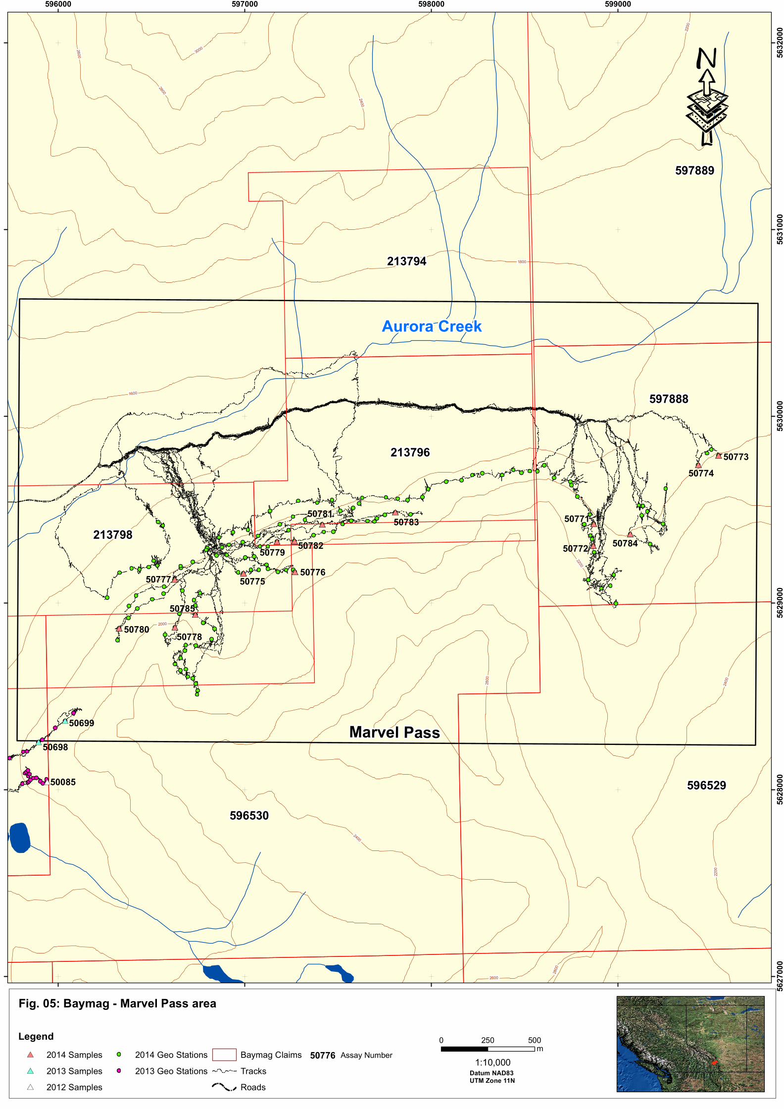
Fig. 05: Baymag - Marvel Pass area
Legend
#* 2014 Samples
#* 2013 Samples
#* 2012 Samples
2014 Geo Stations
2013 Geo Stations
Baymag Claims
Tracks
Roads
Struna Creek
Miller Pass
#*
#*
#*
#*
#*
#*
#*
#* #*
#*
#*
#*
#*
#*
#*
#*
#*
#*
#*
#*
#*
#*
#* #*
#*
#*
#*
#*
#*
#*
#*
#*
#*
#*
#*
#*
#*
#* #*
#*
#*
#*
#*
#*
#*
#*
#*
#*50785
50784
50783
50782
50781
50780
50779
50778
5077750776
50775
50774
50773
50772
50771
50699
50698
596529
596530
597889
213798
597888
213796
213794
50085
2000
2200
1800
2400
2600
1600
2800
3000
2200
2600
2400
22
00
2400
28
00
2800
596000 597000 598000 599000
56
27
00
056
28
00
056
29
00
056
30
00
056
31
00
056
32
00
0
50776 Assay Number
·
Marvel Pass
0 500250m
Datum NAD83UTM Zone 11N
1:10,000
Aurora Creek

Fig. 06: Baymag - Alcantara Creek area
0 500250m
Datum NAD83UTM Zone 11N
1:10,000
Legend
#* 2014 Samples
#* 2013 Samples
#* 2012 Samples
2014 Geo Stations
2013 Geo Stations
2012 Geo Stations
Baymag Claims
Tracks
Roads
Struna Creek
Miller Pass
#*#*
#*
#*
#*
#*#*
#*#*
#*#*
#*#*#*#*#*
#*
#* #*#*#*#*
#*
#*
#*
#*#*#*#*#*
#*
#*#*
#*#*#*
#*
#*
#*#*
#*
#*
#*
#*
#*#*
#*
#*
#*
#*
#*
#*
#*
#*
50666
508215082050819
50059
50054
#*
#*
#*
#*
#*
#*
#*
#*#*
#*
#*
#*
#*
#*
#*
#*
#*
#*
#*
#*
#*
#*
#*
#*
#*#*
#*
#*
#*
#*
#*
#*
#*
#*
#*
#*#*
#*
#*
#*
#*
#*
#*
#*#*#*#*
#*
#*
#*#*
#*
#*#*
#*#*
#*
#*
#*
#*
#*
#*
#*
#*
#*
#*
#*
#*
#*
#*
#*
#*
#*
#*#*
#*
#*
#*
#*
#*
#*
#*
#*
#*
#*
#*
#*
#*
#*
#*
#*#*
#*
#*
#*
#*
#*
#*
#*
#*
#*
#*#*
#*
#*
#*
#*
#*
#*
#*#*#*#*
#*
#*
#*#*
#*
#*#*
#*#*
#*
#*
#*
#*
#*
#*
#*
#*
#*
#*
#*
#*
#*
#*
#*
#*
#*
#*#*
#*
#*
#*
#*
#*
#*
#*
#*
#*
#*
#*
#*
#*
#*
#*
#*#*
#*
#*
#*
#*
#*
#*
#*
#*
#*
#*#*
#*
#*
#*
#*
#*
#*
#*#*#*#*
#*
#*
#*#*
#*
#*#*
#*#*
#*
#*
#*
#*
#*
#*
#*
#*
#*
#*
50845
50844
50843
50842
50841
50840
50839
5083850837
50836
5083550834
5083350832
50831
50830 50829
50824
5082350818
50817
50816
50815
50828
50827
50826
50825
50814
50813
50812
50811
50810
50809
50808
50807
50806
50805
5080450803
50802
50801
50800
50799
50798
50797
50796
50795
50794
5079350791
50792
50790
50789
50788
5078750786
50784
50783
50782
50781
0779
50776
50772
50771
50709
50708
5070550704
0703
50615
50742
50741
50740
50665
50664
5066350662
5066150660
5065950658
50657
50656
5065550654
50653
50652
50651
50034 50031
50064
50063
50062
5006
150060
50058
50057
50056
50055
5005
3
50052
50050
50049
500485004750046500455
0044
50043
5004
2
50041
5004050039
50038
50037
50036
50035
50025
596517
596511
596510
596519
596507
596529
596230
596527
596530
596231
596229
596523
596513
596518
596509
596506
597887
597888
596228
596526
596521
1600
1800
2000
2400
1400
2200
26
00
2800
2800
24
00
2600
2400
2600
1600
2600
2000
1800
20
00
2200
18
00
2600
2600
2400
2200
20
00
18
00
2600
2800
16
00
2800
2000
1800
2600
2800
2600
2600
28
00
2600
2200
2000
26
00
2400
2200
1800
2600
24
00
24
00
598000 599000 600000 601000 602000 603000 604000 605000
56
19
00
056
20
00
056
21
00
056
22
00
056
23
00
056
24
00
056
25
00
056
26
00
056
27
00
056
28
00
056
29
00
0
50788 Assay Number
·
West A
lcanta
ra C
reek
West A
lcanta
ra C
reek
Ea
st
Alc
an
tara
Cre
ek
East A
lcanta
ra C
reek
Alc
an
tara
Cre
ek
Cross River
Bru
ssilo
f Cre
ek
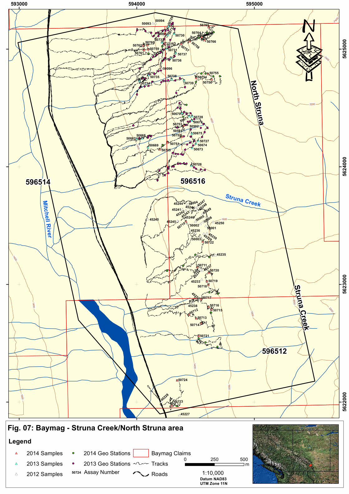
Fig. 07: Baymag - Struna Creek/North Struna area
Legend
#* 2014 Samples
#* 2013 Samples
#* 2012 Samples
2014 Geo Stations
2013 Geo Stations
Baymag Claims
Tracks
Roads
Struna Creek
Miller Pass
#*
#*
#*#*
#*
#*
#*
#*
#*
#*
#*
#*
#*#* #*#*
#*#*
#*#*
#*
#*
#*
#*
#*
#*
#*#*
#*#*
#*
#*
#*
#*
#* #*
#*
#*
#*
#*
#*
#*
#*
#*
#*
#*
#*
#*
#*
#*
#*
#*
#*
#*
#*
#* #*
#*
#*
#*
#*
#*
#*#*
#*
#*
#*
#*
#*
#*
#*
#*
#*
#*
#*
#*
#*
#*
#*
#*#*
#*
#*#*
#*
#*
#*
#*
#*50760
45247
45244
45229
45230
45232
50766
50765
50764
50763
50761
5076250759
5075850757
50756
50755
50754
50753
50752
50751
50725
50723
50724
50722
50721
50720
50719
50718
50717
50716
50715
50714
50713
50712
50711
50710
50739
50738
50737
50736
50735
50734
50733
50732
50731
50730
50729
50728
50727
50726
50675
50674
50673
5067250671
50670
50669
5066850667
50502
50501
50096
50095
5009450093
5000650005
50004
50003
5000250001
45250
4524945248
45246
45245
45244
4524345242
45241
45240
45238
45237
45236
45235
4523
4
45233
4522
8
45227
596514
596512
596516
1800
2000
14
00
16
00
2200
1400
1600
1400
1600
1800
20
00
2200
2400
2 600
1400
593000 594000 595000
56
22
00
056
23
00
056
24
00
056
25
00
0
Mitc
hell
Riv
er
No
rth S
trun
a
Stru
na C
reek
·
Struna Creek
50724 Assay Number
0 500250m
Datum NAD83
UTM Zone 11N
1:10,000

Fig. 08: Baymag - Assiniboine Creek/Aurora Creek area
_̂
Legend
#* 2014 Samples
#* 2013 Samples
#* 2012 Samples
2014 Geo Stations
2013 Geo Stations
2012 Geo Stations
Mine site
Baymag Claims
Tracks
Roads
Struna Creek
Miller Pass
#* #* #*#*
#*
#*#*
#*#*
#*
#*
#*
#*#*#*
#*
#*#*
#*
#*#*
#*
#*
#*
#*
#*
#*#*
#*
#*
#*
#*
#*
#*
#*
#*
#*
#*#*
#*
#*
#*
#*
#*
#*
#*
#*#*
#*
50748
50785
50684
50746
5062550744
#*
#*
#*
#*
#*#*
#*
#*
#*
#*
#*
#*#*
#*
#*
#*
#*
#*
#*#*
#*
50780 50778
50777
50769
50768
50767
50699
50698
50685
50683
50625
50620
50619
50611
50610
50609
50608
50607
50606
50605
50604
50603
50602
50601
50750
50749
50747
50743
5009250091
50090
50087
50086
50085
5008350082
5008150080
50079
1600
1800
1400
2000
2200
2400
26
00
2800
24
00
22
00
2600
593000 594000 595000 596000
56
26
00
056
27
00
056
28
00
056
29
00
056
30
00
0
50723 Assay Number
·
Auro
ra C
reek
0 500250m
Datum NAD83UTM Zone 11N
1:10,000
Auro
ra C
reek
Ass
inib
oine
Cre
ek
Assiniboine C
reek
_̂
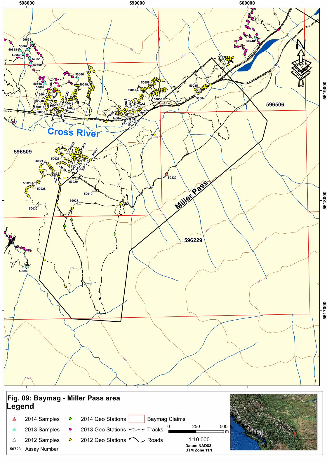
Fig. 09: Baymag - Miller Pass area
Struna Creek
#*
#*
#*
#*
#*#*
#*
#*
#*
#*#*
#*
#*#*#*#*
#*
#*
#*
#*#*
#*#*
#*#*
#*#*#*#*#*
#*
#* #*#*#*#*
#*
#*
#*
#*#*#*#*#*
#*
#*#*
#*
#*
#*
#*
#*#*
#*
#*
#*
#*
50659
5065850662
50024
50033
50032
50031
5005
0 50055
50064
50
06
0
50059
50
05
2
50
05
450
06
35003
9
50038
50037
50036 50045
50
04
2
5004350047
50046
50048
50021
#*#*#*50822
50664
50661
50660
50062
50058
50057
50056
50053
50049
50
04
450
04
1
50040
50035
5003
4
50029
50028
50027
50025
50023
50
02
2
50020
50696
50740
50666
50665
50663
50064
50030
50026
50019
596229
596509
596506
1600
1400
1800
2000
2200
1800
1600
1800
598000 599000 600000
56
17
00
056
18
00
056
19
00
0
50723 Assay Number
0 500250m
Datum NAD83UTM Zone 11N
1:10,000
Cross River
·
Legend
#* 2014 Samples
#* 2013 Samples
#* 2012 Samples
2014 Geo Stations
2013 Geo Stations
2012 Geo Stations
Baymag Claims
Tracks
Roads
Mill
er Pass