24th september 2015 - ffue
TRANSCRIPT

Development and crisis of European cities during
the 20th century
Pierre LACONTE President, Foundation for the Urban Environment - FFUE
Honorary Secretary General, International Association of Public Transport - UITP Past-President, International Society of City and Regional Planners – ISOCARP
Co-designer of the Louvain new university town
"Creative City – Past, Present and Future", ICC - International Cultural Centre Krakow 24th September 2015 Keynote speech

2
Summary I. Place-making in urban planning history: Four examples II. From the railway to the automobile age III. Finding a compromise between urban sprawl and urban place-making: Four examples

I. Place-making in urban planning history: Four examples

17
The plan embodied a long term vision through its strong framework combining a radial linear and grid pattern of development. The starting point was the present Piazza del Popolo. The urban expansion followed the Via del Corso, Via Ripetta and Via del Babuino. The filling-in of the framework was flexible, allowing for changes in style and function through the following centuries.
1. Rome : Sixtus V Plan (1586)
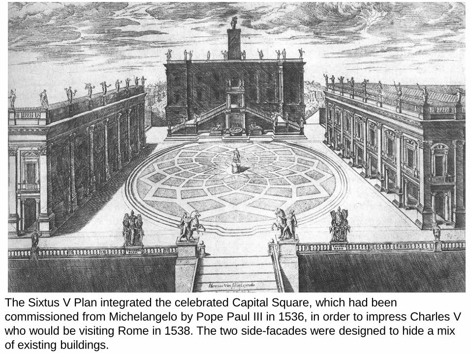
The Sixtus V Plan integrated the celebrated Capital Square, which had been commissioned from Michelangelo by Pope Paul III in 1536, in order to impress Charles V who would be visiting Rome in 1538. The two side-facades were designed to hide a mix of existing buildings.

The urban framework starts from the present Mehringenplatz (Hallessches Gate) and develops northwards along the Friedrichstrasse towards the Oranienburger Gate. Once divided by the Berlin wall, today it is once again the central part of the capital (“Mitte”). The east-west Axis is Unter den Linden. Its « anchors » are Pariserplatz in the west and the Schlossplatz in the east.
2. Friedrichstadt Berlin: an inversion of the Sixtus V Plan

19
The medieval town developed southwards from the port along a main waterway and parallel canals but was confronted in the early 17th century by the need to accommodate major population growth.
3. Amsterdam’s curvilinear extension: The Singel

The city adopted a place-making curvilinear development framework, surrounding the old town by a triple circle of canals and a grid of streets. This plan was implemented over some 400 years and has become a World Heritage site (http://www.ffue. org/?s=singel )
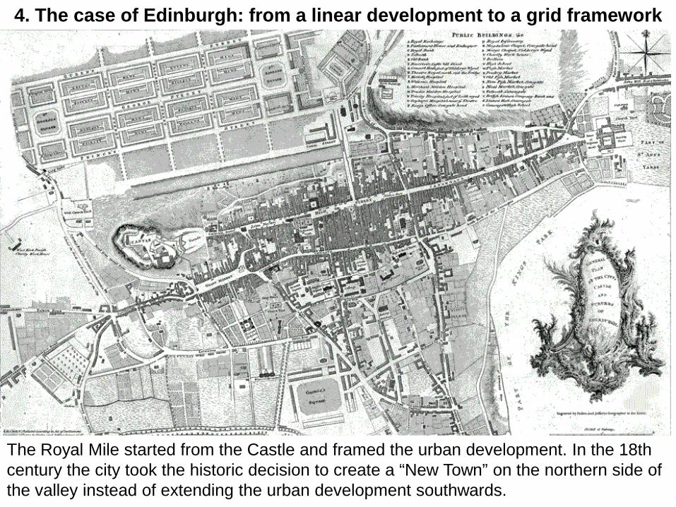
The Royal Mile started from the Castle and framed the urban development. In the 18th century the city took the historic decision to create a “New Town” on the northern side of the valley instead of extending the urban development southwards.
4. The case of Edinburgh: from a linear development to a grid framework

The new grid framework was gradually implemented by filling the space between the two “anchors” (St George’s and St Andrew’s squares).

II. From the railway to the automobile age

The railway age generated squares to magnify the monumental stations, accommodate pedestrian movement and make space for tram lines.

The development of tramways over half a century came to a halt in the US when the automobile was allowed to use the road network free of charge (except for a few turnpikes) while the tramways had to pay for their infrastructure and its maintenance and enjoyed no right-of-way.

Most of the public space became occupied by the parking of automobiles. The difference in space occupancy between man and motor was much larger than commonly perceived, as can be seen from the area x time space consumption diagram.
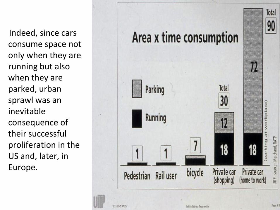
Indeed, since cars consume space not only when they are running but also when they are parked, urban sprawl was an inevitable consequence of their successful proliferation in the US and, later, in Europe.

The UK SACTRA Report (1995) showed that traffic generated by new roads increased congestion and reduced mobility instead of increasing it.

III. Finding a compromise between urban sprawl and urban
place-making: Four examples

1. ZÜRICH
Planning for smart mobility: the case of Zürich 1985-
19

The city of Zurich has a long term policy of giving priority to surface public transport (rail and tram, but no metro) and to spaces and places for pedestrians.

Bahnhofstrasse © Zürich Tourismus/Bruno Macor

In Zurich, trams and buses enjoy absolute priority on street. The sensor shown on the lower left ensures that they have a green light when approaching a traffic light at any time of the day. The city’s modal split is around 80% in favour of public transport (1985). Source: City of Zurich Police Department.

Motorised traffic was calmed by controlling traffic light cycles. The control system for traffic lights has a much shorter cycle which favours pedestrians, cyclists and public transport. Source: City of Zurich Police Department.

Unrestricted on-street parking is exclusively reserved for Zurich-registered residents, while car commuters entering the city from other municipalities are subject to limits on their parking time. Conversely, rail commuters have benefited from an increased service. The parking measure has brought a return of inhabitants to the city (who are able to park), and has been politically rewarding for the city fathers, while suburban rail travel (S-Bahn) has been constantly improved. Source: City of Zurich Police Department.


2. COPENHAGEN
26

The Copenhagen “streetscape” is characterized by narrow streets, small building plots and the mixed use of different modes of transport.


Canals and waterways are an essential feature of place-making.

31 PLAN COPENHAGEN

The Copenhagen opera is a good example of “water shaped” place-making.

Suburban place-making: the Copenhagen finger-plan extensions. Copenhagen’s high-density low-rise urban planning, its pedestrian streets introduced from 1962, its bicycle network (36% of commuters use bicycles, notwithstanding the Scandinavian climate), and its expanding driverless urban metro network have enhanced livability. The Copenhagen metro lines also reinforce the “finger-plan”, which concentrates development along radial public transport corridors. Source: City of Copenhagen.

A cross-border metropolis: In addition to the intra urban metro, the commuter rail line linking Copenhagen, Kastrup airport and Malmo has created an integrated urban agglomeration served by a common public transport network.

3. LOUVAIN-LA-NEUVE
Planning for low energy - growth: the case of the Louvain-la-Neuve new university town (Brussels) 1972-
35

SUBURBAN BRUSSELS: LOUVAIN-LA-NEUVE. The Louvain university bought ca 1000 ha of agricultural and forest land in a rural area close to the Brussels-Namur road: only the central part was set aside for urban development. The overall master plan and architectural coordination was entrusted to the Groupe Urbanisme- architecture (R. Lemaire, J-P. Blondel and P. Laconte).

Planning for land saving. The pedestrian option allowed to save land and advance transport infrastructure investment. The diagram shows the multiplier of land consumption generated by automobile transport and related parking.

Planning for uncertainty. A linear pedestrian central spine – in this case the University of Lancaster - allows a step by step mixed urban development, automobile access to buildings and parking being placed outside of the spine, with occasional underpasses.

This place-making was implemented in the main pedestrian street in the first phase, starting from the existing road east of the site, in 1972 (lower part of the picture), and later extended to the railway station opened in 1976 (upper part), the centre of the city, and the extension towards the western part of the site. Car access to buildings and parking is placed outside the spine, with some underpasses. Property development of the whole university-owned site (1000 ha) is by long term leases (75 to 99 years).


A string a public spaces for movement of leisure. The centre of the first phase was the Science Library, a huge concrete building seen as the cathedral of a university town with its plaza (parvis), above an automobile underpass. It is a social gathering place with university buildings, shops and restaurants (arch. A. Jacqmain).

Trees are planted on the space next to it, in contrast to the concrete and wood library plaza.

Parking. All parking spaces are planted with different tree species in order to attract different kinds of birds. They have become an ornithological reserve.

The new railway station (1976). It is entirely underground, with a view to being covered at a later stage.

The station square. The arcaded entrance of the station (arch. Y. Lepere) opens onto the pedestrian spine.

Underground space and slab. The diagram shows how the sub-surface area remains the property of the university while the infrastructure and buildings are leased (for up to 99 years) to public and private investors.

Courtyards are open passages wherever needed for access to university buildings.

The slab supports numerous small public spaces planted with trees and pavement cafés.

Cafés and restaurants occupy pedestrian spaces while vehicle access and parking is under ground.

“L’Esplanade”. In 2005 a large shopping mall was opened, next to the station, together with a new residential street, on the slab. It was an immediate success (8 million visitors per year) and is to be extended above the rail tracks.
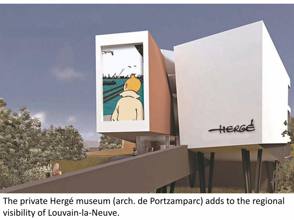
The private Hergé museum (arch. de Portzamparc) adds to the regional visibility of Louvain-la-Neuve.

All storm water is collected in a lake that serves as reservoir and amenity. The level varies according to the seasons, combining landscape and waterscape .

Pre-monitoring of inflowing water and oxygen levels allows the fishing water quality of the lake to be checked.

An aerial view of the city taken in 2003 shows the generally high-density low-rise development and the potential for further extensions close to the lake.

Mixing landscape and waterscape: The new “park/lake” of Billancourt-Trapèze (in suburban Paris) collects storm water from a high density mixed development. It is mostly green in the summer, blue in the winter.

4. BILBAO
Planning urban regeneration through smart public-public partnerships:
the case of Bilbao 1989-2012
56

57
A derelict area of around 40 hectares owned by several public bodies was developed along a unified linear grid, framed with two development anchors: a new museum (Guggenheim Bilbao) in the south and a concert and conference complex in the north. The actual urban development was entrusted to an autonomous publicly owned private company: RIA 2000. http://www.ffue.org/?p=1301
Redevelopment of a brownfield area into an urban place

A view of the industrial zone before clearance.

The valuable land situated between the two anchors, very close to the central business district, was developed by Rià 2000 with an obligation to invest the whole of the surplus in new public infrastructure along the canal.
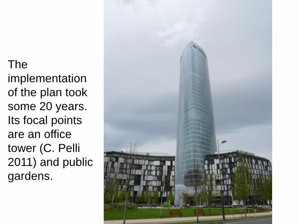
The implementation of the plan took some 20 years. Its focal points are an office tower (C. Pelli 2011) and public gardens.

A new tram line serves the canal bank in the urban centre, saving traffic and parking space and adding to the quality of urban life.

The proceeds generated by the Rià 2000 development contributed to the rehabilitation of Bilbao La Vieja further along the same canal. http://www.ffue.org/?p=1301

The Bilbao Metro is made partially of new stations, designed by Norman Foster, and partially by reusing old industrial railways. It enhanced connectivity throughout the city and its region and improved the balance between transport modes. 63

AN ARTIST’S PERSPECTIVE Three posters by Hundertwasser illustrate the planning vision of a sustainable city : high-density compactness, transport corridors served by public transport, and amenities making the city enjoyable.

