26. greater blue mountains - western sydney...
TRANSCRIPT
26. Greater Blue Mountains
The Greater Blue Mountains World Heritage Area (GBMWHA) and National Heritage Area covers 1.03 million hectares of sandstone plateaus, escarpments and gorges dominated by temperate eucalypt forest. The site constitutes one of the largest and most intact tracts of protected bushland in Australia and is noted for its representation of the evolutionary adaption and diversification of the eucalypts in post-Gondwana isolation on the Australian continent. The Greater Blue Mountains Area is a declared property, listed on the United Nations Educational, Scientific and Cultural Organization (UNESCO) World Heritage List for its outstanding universal value, including representative examples of the evolution of Eucalyptus species (Criterion ix) and diversity of habitats and plant communities (Criterion x). In addition to the features recognised by the World Heritage Committee as having World Heritage value, the GBMWHA has a number of other important values which complement and interact with the World Heritage values of the area including recreation, tourism, wilderness, scenic and aesthetic values.
Potential impacts arising from the proposed airport to the World Heritage and National Heritage values and other values of the Greater Blue Mountains Area were assessed against the Significant Impact Guidelines 1.1 – Matters of National Environmental Significance (DoE 2013). The GBMWHA is approximately eight kilometres from the proposed airport at its closest point. Site specific direct impacts associated with the construction of the airport are not expected to influence the values of the GBMWHA. A number of indirect operational impacts on the GBMWHA are expected in relation to noise, air emissions and visual impact from the overflight of aircraft.
Based on preliminary airspace design by Airservices Australia, almost all flights are expected to be at an altitude greater than 5,000 feet and most would be more than 10,000 feet above sea level when passing over the GBMWHA. No flights are expected to occur below 6,000 feet above ground level in the vicinity of identified sensitive areas. At these altitudes, aircraft are likely to be difficult to discern from ground level and are not considered to be visually obtrusive. Indicative flight tracks at altitudes of less than 5000 feet are limited to Warragamba and the eastern boundary of the Blue Mountains National Park, which would experience 50 to 100 flights per day.
Generally across the GBMWHA, minimal incursion of noise levels in excess of 55 dBA would occur. Echo Point at Katoomba would not experience impacts from increased noise levels, and the majority of other sensitive areas are predicted to only be impacted during the infrequent operation of the Boeing 747.
Emergency fuel dumping is very unlikely to have any impact on the GBMWHA due to the rarity of these events, the inability of many aircraft to perform fuel dumps, the rapid vaporisation and wide dispersion of jettisoned fuel and the strict guidelines on fuel dumping altitudes and locations.
Mitigation and management of potential noise impacts would be achieved through the implementation of flight planning and airspace design. The measures would include requirements regarding flight paths, altitude and operational parameters for different aircraft. The potential noise and amenity impacts from aircraft flying over wilderness areas of the GBMWHA, and Aboriginal sites promoted for public visitation, would be considered in the future development of formal flight paths for the proposed airport by Airservices Australia, subject to requirements for safe and efficient aircraft operations. Having regard to the indirect impacts of aircraft operations it is concluded that the proposed airport would not have a significant impact upon the GBMWHA and its recognised World Heritage values. The proposed action would not result in attributes of the World Heritage Area being lost, degraded or damaged, or notably altered, modified, obscured or diminished.
Western Sydney Airport – Environmental Impact Statement – Volume 2 525

26.1. Introduction This chapter considers the potential impacts of development of the proposed airport on the World Heritage and National Heritage values and other values of the Greater Blue Mountains Area. The chapter draws upon detailed environmental and social assessments undertaken for the proposed airport which are included in Volume 4 as well as the relevant assessment chapters in Volume 2.
The assessment is in accordance with the requirements of the Guidelines for the Content of a Draft Environmental Impact Statement – Western Sydney Airport (EIS guidelines) issued by the Commonwealth Department of the Environment for consideration of world heritage impacts associated with the proposal.
26.2. Methodology The assessment of impacts on the Greater Blue Mountains Area (GBMA) involved:
• identification of the property’s World Heritage and National Heritage values, including attributes recognised in the Statement of Outstanding Universal Value;
• identification of key examples or attributes of other values that complement the property’s World Heritage and National Heritage values;
• collation of relevant baseline information on environmental factors and existing impacts including baseline noise levels and flight paths associated with Sydney Airport;
• assessment of significance of impacts on World Heritage values and the integrity of the world heritage property and the National Heritage values based on the Significant Impact Guidelines 1.1 (DoE 2013a) and the property’s Statement of Outstanding Universal Value; and
• assessment of the National Heritage area having regard to all environmental matters.
26.3. Existing environment
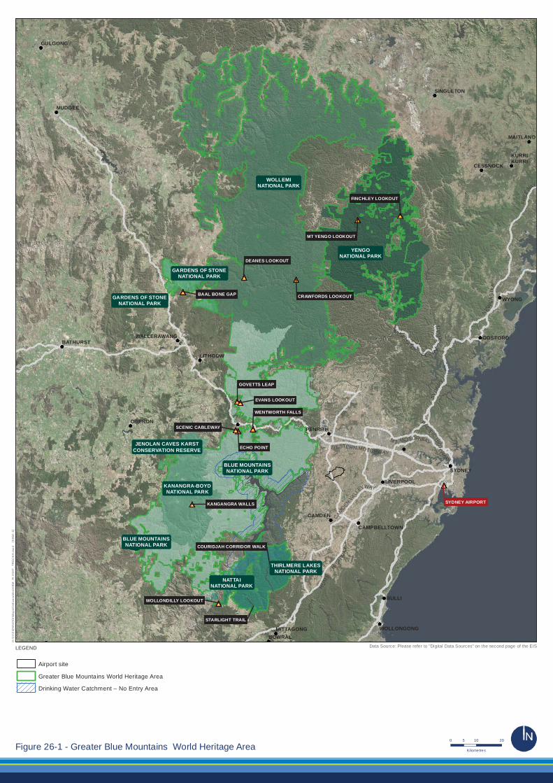
26.3.1. Overview At its closest point, the GBMA is approximately eight kilometres from the proposed airport. The GBMA covers 1.03 million hectares of sandstone plateaus, escarpments and gorges dominated by temperate eucalypt forest (UNESCO 2015). The site constitutes one of the largest and most intact tracts of protected bushland in Australia and is noted for its representation of the evolutionary adaption and diversification of the eucalypts in post-Gondwana isolation on the Australian continent (UNESCO 2015). The Greater Blue Mountains Area was inscribed on the World Heritage list in 2000. This listing formally recognises that the area has outstanding universal value under the World Heritage Convention. The GBMA comprises eight protected areas (see Figure 26–1)
• Blue Mountains National Park
• Wollemi National Park;
• Yengo National Park;
• Nattai National Park;
526 Western Sydney Airport – Environmental Impact Statement – Volume 2
• Kanangra-Boyd National Park;
• Gardens of Stone National Park;
• Thirlmere Lakes National Park; and
• Jenolan Caves Karst Conservation Reserve.
The GBMA provides significant representation of Australia’s biodiversity with 10 per cent of the country’s vascular flora as well as significant numbers of rare or threatened species (UNESCO 2015). In addition to its outstanding eucalypts, the area also contains ancient, relict species of global significance including the Wollemi pine (Wollemia nobilis), one of the world’s rarest species that was thought to have been extinct for millions of years (DoE 2015d). The few surviving trees are known only from three small populations located in remote, inaccessible gorges within the Greater Blue Mountains (DoE 2015d).
Western Sydney Airport – Environmental Impact Statement – Volume 2 527
SYDNEY
MAITLAND
LIVERPOOL
CAMDEN
CAMPBELLTOWN
BULLI
WOLLONGONGBOWRAL
MITTAGONG
WALLERAWANG
LITHGOW
SINGLETON
KURRIKURRI
CESSNOCK
BATHURST
OBERON
GULGONG
MUDGEE
GOSFORD
WYONG
PENRITH
PACIFICHIG
HW
AY
CAMDEN
VALL
EYWAY
M 2 MO TORWAY
W
I SEMANS
F ER RYR
OA
D
WESTERN MOTORWAY
SYDN
EY
NEWC
AS
TLE
FREE
WAY
HU
ME
HIGH
WA
Y
GARDENS OF STONENATIONAL PARK
KANANGRA-BOYDNATIONAL PARK
WOLLEMINATIONAL PARK
BLUE MOUNTAINSNATIONAL PARK
NATTAINATIONAL PARK
YENGONATIONAL PARK
BLUE MOUNTAINSNATIONAL PARK
STARLIGHT TRAIL
COURIDJAH CORRIDOR WALK
THIRLMERE LAKESNATIONAL PARK
JENOLAN CAVES KARSTCONSERVATION RESERVE
GARDENS OF STONENATIONAL PARK
ECHO POINT
WENTWORTH FALLS
GOVETTS LEAP
SCENIC CABLEWAY
KANGANGRA WALLS
BAAL BONE GAP
DEANES LOOKOUT
CRAWFORDS LOOKOUT
MT YENGO LOOKOUT
FINCHLEY LOOKOUT
EVANS LOOKOUT
WOLLONDILLY LOOKOUT
SYDNEY AIRPORT
Airport site
Greater Blue Mountains World Heritage Area
Drinking Water Catchment – No Entry Area
G:\2
1\24
265\
GIS
\Map
s\D
eliv
erab
les\
KB
M_F
LIG
HT
_TR
AC
KS
.mxd
[K
BM
: 4]
LEGEND
0 10 205
KilometresFigure 26-1 - Greater Blue Mountains World Heritage Area
Data Source: Please refer to "Digital Data Sources" on the second page of the EIS

26.3.2. Outstanding universal value
26.3.2.1. World Heritage values of the Greater Blue Mountains Area
The Greater Blue Mountains Area was inscribed on the World Heritage List because it satisfies two of the criteria for natural values of outstanding universal value. While the criteria for outstanding universal value have changed over time, the underlying concepts have remained constant (UNESCO 2015). The two criteria for which the property is listed are criterion ix and criterion x.
Criterion ix
Criterion ix is defined in the Operational Guidelines for the Implementation of the World Heritage Convention (UNESCO 2015) as follows:
to be outstanding examples representing significant on-going ecological and biological processes in the evolution and development of terrestrial, fresh water, coastal and marine ecosystems and communities of plants and animals.
The GBMWHA includes outstanding and representative examples of the evolution and adaptation of the genus Eucalyptus and eucalypt-dominated vegetation in a relatively small area of the Australian continent (UNESCO 2015). It is a centre of diversification for Australian scleromorphic flora, including significant aspects of eucalypt evolution and radiation (UNESCO 2015). Primitive species of outstanding significance to the evolution of the planet’s plant life such as the Wollemi pine and the Blue Mountains pine (Pherosphaera fitzgeraldii). These are examples of ancient, relict species with Gondwanan affinities that have survived past climatic changes and demonstrate the highly unusual juxtaposition of Gondwanan taxa with the diverse scleromorphic flora (UNESCO 2015).
Criterion x
Criterion x is defined in the Operational Guidelines for the Implementation of the World Heritage Convention (UNESCO 2015) as follows:
to contain the most important and significant natural habitats for in-situ conservation of biological diversity, including those containing threatened species of outstanding universal value from the point of view of science or conservation.
The GBMWHA includes an outstanding diversity of habitats and plant communities and a significant proportion of the Australian continent’s biodiversity, especially its scleromorphic flora, (UNESCO 2015). As described above, the GBMWHA includes primitive and relict species with Gondwanan affinities and supports many plants of conservation significance including 114 endemic species and 177 threatened species (UNESCO 2015). Habitat diversity has also resulted in an outstanding representation of Australian fauna with more than 400 vertebrate taxa recorded (of which 40 are threatened) including 52 native mammals, 265 bird species (one third of the Australian total), 63 reptile species and more than 30 frog species (UNESCO 2015).
Western Sydney Airport – Environmental Impact Statement – Volume 2 529
26.3.2.2. Integrity
In addition to meeting at least one of the criteria for outstanding universal value, a world heritage property listed for natural values also needs to meet conditions of integrity. Integrity is a measure of the ‘wholeness and intactness’ of the natural heritage and its attributes (UNESCO 2015). Examining the condition of integrity requires assessing the extent to which the property:
• includes all elements necessary to express its outstanding universal value;
• is of adequate size to ensure the complete representation of the features and processes that convey the property’s significance; and
• suffers from adverse effects of development and/or neglect (UNESCO 2015).
The Statement of Outstanding Universal Value for the GBMWHA states that the eight protected areas that comprise the listed property are of sufficient size to protect the biota and ecosystem processes, although the boundary has several anomalies that reduce the effectiveness of its one million hectare size. These anomalies are explained by historical patterns of clearing, private land ownership and topography such as escarpments that act as barriers to potential adverse impacts from adjoining land (UNESCO 2015).
A number of historical land uses have affected the past integrity of the area including Warragamba Dam, cattle grazing, logging, land clearing, coal mining, oil shale mining, military activities and fire regimes (IUCN 1999). However, active management has reduced these impacts and the landscape is in recovery (IUCN 1999).
Much of the property is largely protected by adjoining public lands of State forests and State conservation areas. Additional regulatory mechanisms, such as the statutory wilderness designation over 65 per cent of the property, the closed and protected catchment for the Warragamba Dam and additions to the conservation reserves that comprise the area all serve to further protect the integrity of the GBMWHA (UNESCO 2015).
The plant communities and habitats within the GBMWHA occur almost entirely as an extensive, mostly undisturbed matrix almost entirely free of structures, earthworks and other human intervention (UNESCO 2015). Because of its size and connectivity, the area will continue to provide opportunities for adaptation and shifts in range for flora and fauna species within it. The area’s integrity depends upon the complexity of its geological structure, geomorphology and water systems, which have created the conditions for the evolution of its outstanding biodiversity (UNESCO 2015).
Aboriginal people from six language groups continue to have a custodial relationship with the area through ongoing practices that reflect both traditional and contemporary presence (UNESCO 2015). Aboriginal sites including important rock art sites provide physical evidence of the longevity of the strong Aboriginal cultural connections with the land. The conservation of these associations contributes to integrity of the GBMWHA (UNESCO 2015).
530 Western Sydney Airport – Environmental Impact Statement – Volume 2
26.3.2.3. Protection and management
All properties inscribed on the World Heritage List must have adequate protection and management mechanisms in place, the nature of which can vary so long as they are effective. In most cases, both the Australian and state or territory governments are responsible for the management and protection of Australia’s World Heritage properties, with state and territory agencies taking responsibility for on-ground management where relevant.
The GBMWHA is protected and managed primarily under the following Commonwealth and New South Wales legislation:
• Environment Protection and Biodiversity Conservation Act 1999 (Cth);
• National Parks and Wildlife Act 1974 (NSW); and
• Wilderness Act 1987 (NSW).
Other relevant legislation includes the New South Wales Threatened Species Conservation Act 1995, the Environmental Planning and Assessment Act 1979, the Sydney Water Catchment Management Act 1998 and the Heritage Act 1977.
The New South Wales Office of Environment and Heritage manages the GBMWHA. The Greater Blue Mountains World Heritage Area Strategic Plan (DECC 2009c) provides a framework for the property’s integrated management, protection, interpretation and monitoring.
The key management objectives set out in the Strategic Plan provide the philosophical basis for the management of the area and guidance for operational strategies, in accordance with requirements of the World Heritage Convention and its Operational Guidelines (UNESCO 2015). These objectives are also consistent with the Australian World Heritage management principles, contained in regulations under the EPBC Act (UNESCO 2015).
The Strategic Plan (DECC 2009c) identifies the following threats to the integrity of the area:
• uncontrolled and inappropriate use of fire;
• inappropriate recreation and tourism activities, including development of tourism infrastructure;
• invasion by pest species including weeds and feral animals;
• loss of biodiversity and geodiversity;
• impacts of human enhanced climate change; and
• lack of understanding of heritage values.
26.3.3. National Heritage Area The Greater Blue Mountains National Heritage Area was included on the National Heritage Register in 2007. The National Heritage Area is the same as that listed for the World Heritage Area and the values identified for the listing are the same as those for the World Heritage Area. As such the following assessment against the heritage values is taken to address both the National and World Heritage values of the GBMA.
Western Sydney Airport – Environmental Impact Statement – Volume 2 531

26.3.4. Other values of the Greater Blue Mountains Area In addition to the features recognised by the World Heritage Committee as having World Heritage value, the Greater Blue Mountains Area has a number of other important values which complement and interact with the World Heritage values of the area (DECC 2009c). Protection of these values is considered to be integral in managing individual protected areas and the GBMA as a whole (DECC 2009c). Table 26–1 provides a summary of the values identified by the NPWS in the GBHA Strategic Plan which contribute to the overall values of the area. Table 26–1 – Other important values of the GBMA
Value Description Geodiversity and biodiversity
In addition to the outstanding biodiversity of the GBMA, the area also has a diversity of landscapes and geological features including the most extensive sandstone canyon system in eastern Australia. The site also contains karst landscapes with several cave systems including Jenolan Caves, the world’s oldest open cave system. Other features include prominent basalt-capped peaks, quaternary alluvial deposits and perched perennial freshwater lakes.
Water catchment The GBMA protects a large number of pristine and relatively undisturbed catchment areas, some of which make a substantial contribution to maintaining high water quality in a series of water storage reservoirs supplying Sydney and adjacent rural areas.
Indigenous heritage values
Although no comprehensive surveys have been taken, known Aboriginal sites within the area are widespread and diverse including landscape features of spiritual significance and rock art sites. Given the wilderness nature of the area and the limited survey to date, there is high potential for the discovery of further significant Aboriginal sites.
Historic heritage values
The GBMA includes numerous places of historic significance some of which date back to the early years of European settlement and exploration in Australia. Recorded sites demonstrating post-1788 human use are associated with rural settlement, pastoral use, timber getting, mining, transport routes, tourism and recreation. The sites include small graziers’ huts, logging roads, stock routes and the ruins of mines.
Recreation and tourism The GBMA has high recreational values due to the area’s intrinsic beauty, natural features and accessibility from major population centres. Recreational opportunities are wide ranging and include canyoning, bushwalking, rock climbing, nature observation, caving, picnicking, camping and photography. The regional economy surrounding the GBMWHA is increasingly supported by tourism with the area contributing directly and indirectly to the employment, income and output of the region.
Wilderness The high wilderness quality of much of the GBMA constitutes a vital and highly significant contribution to its World Heritage value and has ensured the integrity of its ecosystems and the retention and protection of its heritage value. The wild and rugged landscapes, diverse flora and fauna, and opportunities for solitude, self-reliant recreation and reflection are attributes that promote inspiration, serenity and rejuvenation of the human mind and spirit. Such experiences are valued by individuals and society.
Research and education
The GBMA is ideal for research and educational visits due to the variety of ecological communities, landscape and associated cultural sites. The high scientific value reflects what has been discovered and what remains to be discovered as large gaps in knowledge remain in regard to Aboriginal use and occupation of the area and the ecological needs of threatened species and communities.
Scenic and aesthetic Dramatic scenery within the GBMA includes striking vertical cliffs, waterfalls, ridges, escarpments, uninterrupted views of forested wilderness, extensive caves, narrow sandstone canyons and pagoda rock formations.
Source: NSW NPWS 2009
532 Western Sydney Airport – Environmental Impact Statement – Volume 2

26.3.5. Wilderness areas One of the key features of the GBMA are the wilderness areas located primarily in the northern section of the World Heritage and National Heritage area. The National Wilderness Inventory (AHC 2003) identifies 83.5 per cent of the GBMA as wilderness area.
The identified wilderness areas cover a significant proportion of the GBMA, with the specific exclusion of the area northern portions of both the Blue Mountains National Park and Kanangra-Boyd National Park associated with the Katoomba region.
26.3.6. Sensitive tourism and recreation areas Sensitive tourism and recreation areas were determined for this assessment based on the identification of key attractions and associated viewing locations within the GBMA (Table 26–2). The assessment considered the remoteness, accessibility and accommodation options as an indication of the type of tourism and recreational experiences available at each location.
Western Sydney Airport – Environmental Impact Statement – Volume 2 533
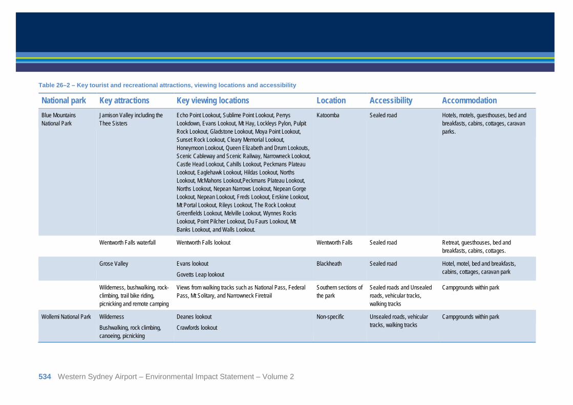
Table 26–2 – Key tourist and recreational attractions, viewing locations and accessibility
National park Key attractions Key viewing locations Location Accessibility Accommodation Blue Mountains National Park
Jamison Valley including the Thee Sisters
Echo Point Lookout, Sublime Point Lookout, Perrys Lookdown, Evans Lookout, Mt Hay, Lockleys Pylon, Pulpit Rock Lookout, Gladstone Lookout, Moya Point Lookout, Sunset Rock Lookout, Cleary Memorial Lookout, Honeymoon Lookout, Queen Elizabeth and Drum Lookouts, Scenic Cableway and Scenic Railway, Narrowneck Lookout, Castle Head Lookout, Cahills Lookout, Peckmans Plateau Lookout, Eaglehawk Lookout, Hildas Lookout, Norths Lookout, McMahons Lookout,Peckmans Plateau Lookout, Norths Lookout, Nepean Narrows Lookout, Nepean Gorge Lookout, Nepean Lookout, Freds Lookout, Erskine Lookout, Mt Portal Lookout, Rileys Lookout, The Rock Lookout Greenfields Lookout, Melville Lookout, Wynnes Rocks Lookout, Point Pilcher Lookout, Du Faurs Lookout, Mt Banks Lookout, and Walls Lookout.
Katoomba Sealed road Hotels, motels, guesthouses, bed and breakfasts, cabins, cottages, caravan parks.
Wentworth Falls waterfall Wentworth Falls lookout Wentworth Falls Sealed road Retreat, guesthouses, bed and breakfasts, cabins, cottages.
Grose Valley Evans lookout
Govetts Leap lookout
Blackheath Sealed road Hotel, motel, bed and breakfasts, cabins, cottages, caravan park
Wilderness, bushwalking, rock-climbing, trail bike riding, picnicking and remote camping
Views from walking tracks such as National Pass, Federal Pass, Mt Solitary, and Narrowneck Firetrail
Southern sections of the park
Sealed roads and Unsealed roads, vehicular tracks, walking tracks
Campgrounds within park
Wollemi National Park Wilderness
Bushwalking, rock climbing, canoeing, picnicking
Deanes lookout
Crawfords lookout
Non-specific Unsealed roads, vehicular tracks, walking tracks
Campgrounds within park
534 Western Sydney Airport – Environmental Impact Statement – Volume 2
National park Key attractions Key viewing locations Location Accessibility Accommodation Yengo National Park Wilderness
Bushwalking, horse riding, trail bike riding, picnicking
Finchley lookout
Mt Yengo lookout
50 km south-west of Cessnock
Unsealed roads, walking tracks
Campgrounds within park – tent, camper trailer, vehicle
Nattai National Park Wilderness
Bushwalking, remote camping
Wollondilly lookout
Starlights trail
Couridjah Corridor walk
30 km north of Mittagong
Vehicular tracks, walking tracks
No facilities within park. Remote backpack camping only at Emitts Flat.
Kanangra-Boyd National Park
Kanangra Walls
Mount Cloudmaker
Kanangra-Boyd lookout, Kowmung Lookout, Rigby Rock Lookout, Moorilla Lookout, Mt Dingo Lookout, and Kanangra Walls Lookouts
50 km south-east of Oberon
Unsealed road from park entrance
Boyd River Campground – tent, camper trailer, caravan, vehicle
Wilderness, bushwalking, rock-climbing, trail bike riding, picnicking and remote camping
Non-specific Southern sections of the park
Sealed roads and Unsealed roads, vehicular tracks, walking tracks
Campgrounds within park
Gardens of Stone National Park
Baal Bone Gap, four-wheel driving
Baal Bone Gap picnic area 35 km north of Lithgow
Unsealed road requiring 4WD vehicle
No facilities within park. Remote backpack camping only.
Thirlmere Lakes National Park
Birdwatching, picnicking, walking and swimming
Werri Berri picnic area Couridjah Sealed road No facilities within park.
Jenolan Caves Karst Conservation Reserve
Jenolan Caves Not applicable Jenolan Sealed road Cabins, cottages and hostels
Western Sydney Airport – Environmental Impact Statement – Volume 2 535
The upper Blue Mountains, with its extensive system of scenic lookouts and walking tracks, is one of the major nature-based tourism destinations in Australia (NPWS 2001). Echo Point at Katoomba is the main lookout over Jamison Valley, including the Three Sisters rock formation, and attracts around two million visitors each year (NPWS 2001; NSW Government 2015). Other key attractions include Wentworth Falls and Grose Valley viewed from Govetts Leap lookout and Evans lookout at Blackheath.
The Wollemi wilderness area is primarily accessed at Newnes Plateau Cliffs on the western boundary and via Putty Road on the eastern side of the park. Most campgrounds and park facilities are located within proximity to the park boundaries. While only Dunns Swamp-Ganguddy and Wheeny campgrounds are accessible to caravans, Coorongooba and Newnes campgrounds are open to tent, camper trailer and vehicle camping. Colo Meroo campground is only accessible by foot and is suitable for tent and remote/backpack camping. Deanes lookout (west) and Crawfords lookout (east), which are accessible by foot and provide views of the Wollemi wilderness area.
Yengo National Park and wilderness area is accessed via unsealed roads, vehicle tracks and walking tracks. Campgrounds are accessible to tent, camper trailer and vehicle camping. Bushwalking is popular in the park and other popular forms of recreation include horse riding, trail bike riding, mountain bike riding and bird watching. Mt Yengo lookout (west) and Finchley lookout (east) provide views over the Yengo wilderness area.
Nattai National Park offers opportunities for bushwalking and backpack camping in a relatively untouched wilderness environment. Wollondilly lookout near the south-east boundary provides views of eucalypt forests, sandstone cliffs and mountain ranges. Other areas of the park and wilderness areas are accessible via walking tracks.
The Kanangra Walls and wilderness area is the main focus of activity in Kanangra-Boyd National Park. Baal Bone Gap picnic area within the Gardens of Stone National Park is accessible to four wheel drive vehicles. The site includes examples of rock pagoda formations, sheer cliffs and scenic views over Baal Bone Gap. No significant viewpoints were identified within the Thirlmere Lakes National Park or Jenolan Caves Karst Conservation Reserve.
The following areas within the GBMA were identified as sensitive tourism and recreation areas in relation to potential impacts of the proposed airport development on noise, air quality and amenity (see Figure 26–1):
• Jamison Valley south of Echo Point lookout and the Scenic Cableway at Katoomba and Wentworth Falls lookout;
• Grose Valley east of Evans lookout and Govetts Leap lookout;
• the wilderness area between Deanes lookout and Crawfords lookout within Wollemi National Park;
• the wilderness area between Mt Yengo lookout and Finchley lookout within Yengo National Park;
• Nattai wilderness area;
• Kanangra Walls and wilderness area east of Kanangra-Boyd lookout; and
• Baal Bone Gap within Gardens of Stone National Park.
536 Western Sydney Airport – Environmental Impact Statement – Volume 2
26.4. Assessment of impacts during construction Construction of the proposed airport would involve a number of specific direct impacts to the airport site. Having regard to the distance and lack of direct connectivity between the site and the GBMWHA, none of these impacts are expected to influence the values of the GBMWHA.
26.5. Assessment of impacts during operations
26.5.1. Direct operational impacts There would be no direct impacts on the GBMA and its associated World Heritage values from the operation of the proposed airport.
26.5.2. Indirect operational impacts Operation of the proposed airport may have several potential indirect impacts on the GBMA, primarily from the overflight of aircraft. These potential impacts include:
• noise;
• air quality impacts from aircraft emissions; and
• amenity impacts.
26.5.2.1. Noise
Noise impacts from aircraft overflying the GBMA have been assessed having regard to the maximum noise levels generated. Specific noise criterion for wilderness areas are not available relevant to aircraft noise, consequently alternate values have been adopted. Whilst the NSW Industrial Noise Policy is not a regulatory provision for the project it does provide guidance in regard to noise values for wilderness areas. The policy identifies values of 50 dBA LAeq and 55 dBA LAeq as being acceptable and recommended maximum values respectively for rural areas incorporating wilderness areas (EPA 2000). Between 50 and 60 dBA is equivalent to normal conversational noise or background music/radio (Sydney Metro Airport 2010) or a bird call within a wilderness setting.
The assessment of noise impacts from the proposed airport over the GBMA has modelled LAmax levels for single event flights. These are considered to represent a conservative worst case basis for assessment. Noise modelling methodology is described in detail in Appendix E, in regard to the GBMA the model incorporates the topography of the areas and as such the height of aircraft as they overpass the GBMA. This captures the variance in noise across peaks and valleys within the GBMA. Noise levels from specific aircraft have been modelled as detailed in Appendix E. The highest predicted noise levels are associated with a departing Boeing 747 aircraft, while the more common noise levels are represented by a departing Airbus 320.
Western Sydney Airport – Environmental Impact Statement – Volume 2 537

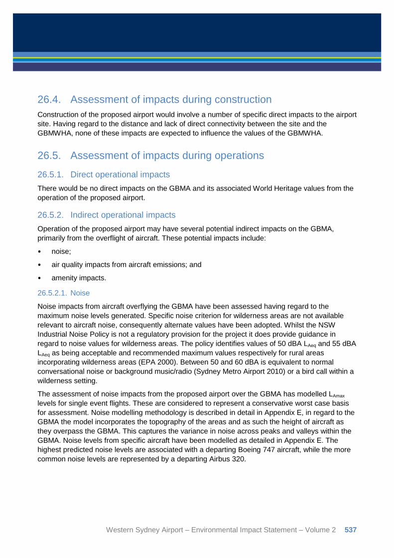
Figure 26–2 and Figure 26–3 show the indicative noise contours for a single event departure and arrival (for both 05 and 23 directions) for the Boeing 747 and Airbus 320 respectively on all indicative arrival and departure flight tracks. The Boeing 747 is the maximum noise event for all aircraft arriving and departing the proposed airport. However, it is important to note that a Boeing 747 flying to the south would only be expected to depart once every two days on average during Stage 1 operations. As shown in Figure 26–2, noise levels above 50 dBA LAmax and 55 dBA LAmax are experienced in some areas of the GBMA for the maximum noise level in a single event.
Figure 26–3 indicates that a noise exposure contour of 50 dBA LAmax associated with the Airbus 320 extends into the GBMA on the north-eastern fringes during arrivals and the southern area only during departures. Generally across the GBMWHA, minimal incursion of noise levels in excess of 55 dBA occurs. As shown in Table 26–3, two of the key areas identified for this assessment do not experience noise levels at or above 50 dBA LAmax, and the majority of areas would only be affected by noise above this level during the infrequent operation of the Boeing 747 (an aircraft type that is generally being phased out by airlines).
In addition to the assessment of noise impacts at levels below 55 dBA as described above, it is important to note that it is unlikely that any areas of the GBMA would experience noise levels above the general assessment level of 70 dBA LAmax on a regular basis during Stage 1 operations (refer to Chapter 10).
Increased noise levels are shown for the walking trails within the Nattai wilderness area. However, impacts along walking trails would be minimised by vegetation cover and lower elevations within valley areas and along creeks. Similarly, areas affected by increased noise levels within the Wollemi wilderness area are accessible only on foot and impacts would be reduced by the nature of the steep terrain and vegetation cover. Table 26–3 – Predicted peak noise levels affecting sensitive areas (LAmax)
Area Single event B747 Single event A320 50 dBA 55 dBA 50 dBA 55 dBA Jamison Valley south of Echo Point lookout and the Scenic Cableway at Katoomba and Wentworth Falls lookout
No impact No impact No impact No impact
Grose Valley east of Evans lookout and Govetts Leap lookout
Marginal impact at lookouts
No impact No impact No impact
Wilderness area between Deanes lookout and Crawfords lookout within Wollemi National Park
Impact along north eastern alignment
No impact No impact No impact
Nattai wilderness area Impact on eastern wilderness area
Impact on eastern wilderness area
No impact Impact on eastern wilderness area
Kanangra Walls and wilderness area east of Kanangra-Boyd lookout
No impact on eastern wilderness area
Marginal impact at lookout
No impact No impact
Baal Bone Gap within Gardens of Stone National Park
No impact No impact No impact No impact
538 Western Sydney Airport – Environmental Impact Statement – Volume 2
SYDNEY
MAITLAND
LIVERPOOL
CAMDEN
CAMPBELLTOWN
BULLI
WOLLONGONGBOWRAL
MITTAGONG
WALLERAWANG
LITHGOW
SINGLETON
KURRIKURRI
CESSNOCK
BATHURST
OBERON
GULGONG
MUDGEE
GOSFORD
WYONG
PENRITH
PACIFICHIG
HW
AY
CAMDEN
VALL
EYWAY
M 2 MO TORWAY
W
I SEMANS
F ER RYR
OA
D
WESTERN MOTORWAY
SYDN
EY
NEWC
AS
TLE
FREE
WAY
HU
ME
HIGH
WA
Y
STARLIGHT TRAIL
COURIDJAH CORRIDOR WALK
SYDNEY AIRPORT
ECHO POINT
WENTWORTH FALLS
GOVETTS LEAP
SCENIC CABLEWAY
KANGANGRA WALLS
BAAL BONE GAP
DEANES LOOKOUT
CRAWFORDS LOOKOUT
MT YENGO LOOKOUT
FINCHLEY LOOKOUT
EVANS LOOKOUT
WOLLONDILLY LOOKOUT
THIRLMERE LAKESNATIONAL PARK
JENOLAN CAVES KARSTCONSERVATION RESERVE
GARDENS OF STONENATIONAL PARK
GARDENS OF STONENATIONAL PARK
KANANGRA-BOYDNATIONAL PARK
WOLLEMINATIONAL PARK
BLUE MOUNTAINSNATIONAL PARK
NATTAINATIONAL PARK
YENGONATIONAL PARK
BLUE MOUNTAINSNATIONAL PARK
Airport site
Greater Blue Mountains World Heritage Area
Drinking Water Catchment – No Entry Area
50 dba LA max noise contour (arrivals)
55 dba LA max noise contour (arrivals)
50 dba LA max noise contour (departures)
55 dba LA max noise contour (departures)
G:\2
1\24
265\
GIS
\Map
s\D
eliv
erab
les\
KB
M_F
LIG
HT
_TR
AC
KS
.mxd
[K
BM
: 9]
LEGEND Data Source: Please refer to "Digital Data Sources" on the second page of the EIS
0 10 205
KilometresFigure 26-2 - Combined single event noise level for a B747

SYDNEY
MAITLAND
LIVERPOOL
CAMDEN
CAMPBELLTOWN
BULLI
WOLLONGONGBOWRAL
MITTAGONG
WALLERAWANG
LITHGOW
SINGLETON
KURRIKURRI
CESSNOCK
BATHURST
OBERON
GULGONG
MUDGEE
GOSFORD
WYONG
PENRITH
PACIFICHIG
HW
AY
CAMDEN
VALL
EYWAY
M 2 MO TORWAY
W
I SEMANS
F ER RYR
OA
D
WESTERN MOTORWAY
SYDN
EY
NEWC
AS
TLE
FREE
WAY
HU
ME
HIGH
WA
Y
STARLIGHT TRAIL
COURIDJAH CORRIDOR WALK
KANANGRA-BOYDNATIONAL PARK
WOLLEMINATIONAL PARK
BLUE MOUNTAINSNATIONAL PARK
NATTAINATIONAL PARK
YENGONATIONAL PARK
BLUE MOUNTAINSNATIONAL PARK
SYDNEY AIRPORT
ECHO POINT
WENTWORTH FALLS
GOVETTS LEAP
SCENIC CABLEWAY
KANGANGRA WALLS
BAAL BONE GAP
DEANES LOOKOUT
CRAWFORDS LOOKOUT
MT YENGO LOOKOUT
FINCHLEY LOOKOUT
EVANS LOOKOUT
WOLLONDILLY LOOKOUT
GARDENS OF STONENATIONAL PARK
THIRLMERE LAKESNATIONAL PARK
JENOLAN CAVES KARSTCONSERVATION RESERVE
GARDENS OF STONENATIONAL PARK
Airport site
Greater Blue Mountains World Heritage Area
Drinking Water Catchment – No Entry Area
50 dba LA max noise contour (arrivals)
55 dba LA max noise contour (arrivals)
50 dba LA max noise contour (departures)
55 dba LA max noise contour (departures)
G:\2
1\24
265\
GIS
\Map
s\D
eliv
erab
les\
KB
M_F
LIG
HT
_TR
AC
KS
.mxd
[K
BM
: 10]
LEGEND
0 10 205
KilometresFigure 26-3 - Combined single event noise level an A320
Data Source: Please refer to "Digital Data Sources" on the second page of the EIS

Noise has been shown to have a variety of impacts on fauna, including changing foraging behaviour, impacting breeding success and changing species occurrences. Low-flying aircraft can cause flight response in some species, causing them to abandon nests, and other species are known to avoid higher elevation areas where noise levels are higher, potentially resulting in fragmentation of habitat (Ellis, Ellis, & Mindell, 1991). Most of these impacts occur when noise levels are high (greater than 65 dB). Given the height at which flights to and from the proposed airport are likely to occur over the GBMA, these impacts are unlikely. While noise would increase marginally above background levels on an intermittent basis directly under the flight paths, fauna are likely to become habituated to any elevation in noise levels in the long term (Conomy et al 1998), particularly as aircraft would not be flying at low altitudes over the GBMA. Operation of aircraft at the proposed airport is highly unlikely to permanently alter foraging or breeding behaviour of any fauna species. Any impacts would be localised, with impacts occurring under the main flight paths. The majority of fauna within the vast GBMA would not be impacted by aircraft noise. As such, noise would not result in a loss of biodiversity and would not interfere with the ecological viability and capacity for ongoing evolution of species within the GBMA.
26.5.2.2. Air quality
Regional air quality impacts relevant to the GBMA have been assessed in regard to three principal elements:
• regional air quality (ozone);
• contribution to climate change; and
• emissions from fuel dumping.
Regional air pollutants (Ozone)
Regional air pollutants including ozone formed by the photochemical reaction of precursor emissions from the proposed airport can contribute to regional photochemical smog which may have an impact on the amenity of the GBMA. The National Environment Protection Measures (NEPM) ambient air quality standard for ozone is 0.10 parts per million for a one hour period (equivalent to 100 parts per billion) and 0.08 parts per million for a four hour period (equivalent to 80 parts per billion).
To assess the impact from the addition of airport emissions, 12 days were selected for detailed analysis to represent the meteorological conditions that have historically led to peak ozone formation with strong model calibration with existing monitoring data.
The assessment of air quality impacts associated with the proposed airport identified that the peak predicted one hour ozone concentrations were unchanged between the 2030 base case and the 2030 ‘with airport’ case. This is because the predicted ozone concentrations from the proposed airport occur in different locations to where ozone peaks occur. The predicted average of the 2nd to 4th highest increase in daily maximum one-hour ozone concentration was 1.1 parts per billion.
Western Sydney Airport – Environmental Impact Statement – Volume 2 541

The peak predicted four-hour ozone concentration was unchanged on ten days, increased on four days and decreased on two days due to 2030 airport emissions. The peak predicted four-hour ozone concentration increased by 0.1 parts per billion due to the proposed airport. The highest predicted change in daily maximum four-hour ozone concentration from the addition of airport emissions was 2.4 parts per billion, while the average of the 2nd to 4th highest modelled increase in daily maximum four-hour ozone was 0.9 parts per billion. The background levels for ozone in Western Sydney regularly exceed NEPM guidelines in the summer months. For example, ozone concentrations of 124 parts per billion were monitored at in November 2014 and 108 parts per billion in October 2013. The modelled contribution of emissions from the proposed airport would represent an increase of less than one per cent on these measured values which are not considered significant in the context of regional emission sources.
Contribution to climate change
Climate change is identified as a threat to the GBMA due to its potential to alter the frequency and intensity of fires and for increased temperatures to impact upon biodiversity and ecosystem function (UNESCO 2015). Greenhouse gas emissions (GHG) are identified as a contributing factor to climate change. The proposed airport is expected to contribute approximately 0.10 per cent of Australia’s projected 2030 transport-related GHG emission inventory. Given the small percentage of contribution, it is concluded the GHG emissions from the proposed airport would not be material in terms of the national inventory, or represent a significant contribution to climate change.
Emissions from fuel jettison
Emergency fuel jettison (commonly referred to as fuel dumping) is a procedure used by an aircraft in certain emergency situations. The objective of fuel dumping is to reduce an aircraft's weight to allow it to land safely. Instances of fuel dumping are extremely rare worldwide. In Australian airspace, there were 10 reported instances of civilian aircraft dumping fuel in 2014 from 698,856 domestic air traffic movements and 31,345 international movements (approximately 0.001 per cent of all movements).
The procedure for jettisoning fuel is specified in the En Route supplement of the Aeronautical Information Package published by Airservices Australia as outlined in Chapter 7 of Volume 2. When fuel jettisoning is required, the pilot in command requests authority from air traffic control before commencing a fuel jettison and must:
• take reasonable precautions to ensure the safety of persons or property in the air and on the ground;
• where possible, conduct a controlled jettison in clear air at an altitude of above 6,000 feet (approximately 1.8 kilometres) and in an area nominated by air traffic control; and
• notify air traffic control immediately after an emergency jettison.
The authority for fuel jettisoning is the Air Navigation (Fuel Spillage) Regulations 1999, which prescribe penalties for the unauthorised release of fuel from an aircraft other than in an emergency.
542 Western Sydney Airport – Environmental Impact Statement – Volume 2

The results of a previous study on fuel dumping indicate that when fuel is jettisoned above 1,500 metres in above freezing temperatures, 98 per cent will evaporate before reaching ground level (Clewell 1983). Due to the dispersion of fuel after release, the highest concentrations of fuel at ground level during calm, sunny and cool weather conditions (with wind speeds of three metres per second), were determined to occur seven kilometres downwind away from the location of the aerial dumping. The maximum concentrations were determined to be 0.021 parts per million with a maximum duration of airborne jet fuel at any site being 17 minutes. These results indicate that vaporisation and dispersion of fuel occurs very quickly when jettisoned and is unlikely to have a significant local impact on air quality.
These results indicate that fuel dumping is very unlikely to have a significant impact on the GBMWHA due to the rarity of such events, the inability of many aircraft to perform fuel dumps, the rapid vaporisation and wide dispersion of jettisoned fuel and the strict guidelines on fuel dumping altitudes and locations.
26.5.2.3. Amenity
Amenity impacts have been assessed by reviewing the density of flights and altitude of flights to provide a cumulative measure of the visibility of overflights.
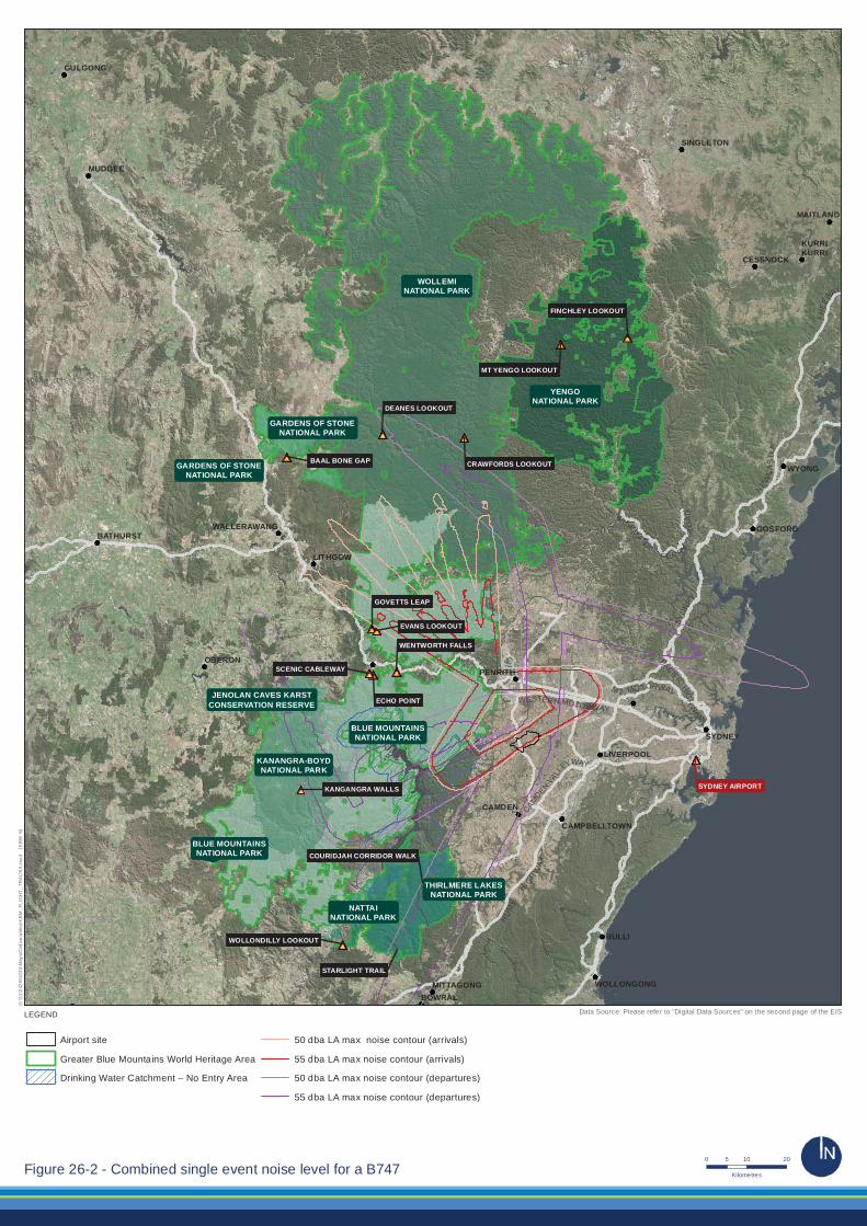
Almost all aircraft approaching or departing the proposed airport over the GBMA would be at an altitude in excess of 5,000 feet and most would be in excess of 10,000 feet above sea level. The anticipated altitude of arriving and departing flights is shown in Figure 26–4 and Figure 26–5.
The altitude of key sensitive areas and the average altitude of aircraft above ground level relevant to these sensitive areas are shown in Table 26–4. No flights would be expected to occur below 6,000 feet above ground level in the vicinity of sensitive areas.
The levels for each sensitive area relate to lookout locations at high elevations within the GBMA. Some areas frequented by tourists and recreational users are at significantly lower altitudes such as the Jamison Valley walking tracks (1570 feet), the Starlights trail within the Nattai wilderness area (305 feet at Nattai River) and Wollemi Creek within the Wolllemi wilderness area (450 feet).
Western Sydney Airport – Environmental Impact Statement – Volume 2 543

SYDNEY
MAITLAND
LIVERPOOL
CAMDEN
CAMPBELLTOWN
BULLI
WOLLONGONGBOWRAL
MITTAGONG
WALLERAWANG
LITHGOW
SINGLETON
KURRIKURRI
CESSNOCK
BATHURST
OBERON
GULGONG
MUDGEE
GOSFORD
WYONG
PENRITH
PACIFICHIG
HW
AY
CAMDEN
VALL
EYWAY
M 2 MO TORWAY
W
I SEMANS
F ER RYR
OA
D
WESTERN MOTORWAY
SYDN
EY
NEWC
AS
TLE
FREE
WAY
HU
ME
HIGH
WA
Y
ECHO POINT
WENTWORTH FALLS
GOVETTS LEAP
SCENIC CABLEWAY
KANGANGRA WALLS
BAAL BONE GAP
DEANES LOOKOUT
CRAWFORDS LOOKOUT
MT YENGO LOOKOUT
FINCHLEY LOOKOUT
EVANS LOOKOUT
WOLLONDILLY LOOKOUT
SYDNEY AIRPORT
STARLIGHT TRAIL
COURIDJAH CORRIDOR WALK
THIRLMERE LAKESNATIONAL PARK
JENOLAN CAVES KARSTCONSERVATION RESERVE
GARDENS OF STONENATIONAL PARK
GARDENS OF STONENATIONAL PARK
KANANGRA-BOYDNATIONAL PARK
WOLLEMINATIONAL PARK
BLUE MOUNTAINSNATIONAL PARK
NATTAINATIONAL PARK
YENGONATIONAL PARK
BLUE MOUNTAINSNATIONAL PARK
Airport site
Greater Blue Mountains World Heritage Area
Drinking Water Catchment – No Entry Area
Flight track altitude below 10,000 feet
0 ft
10,000 ft
5,000 ft
G:\2
1\24
265\
GIS
\Map
s\D
eliv
erab
les\
KB
M_F
LIG
HT
_TR
AC
KS
.mxd
[K
BM
: 5]
LEGEND
0 10 205
KilometresFigure 26-4 - Flight track altitude below 10,000 feet above sea level, prefer 05 single runway
Data Source: Please refer to "Digital Data Sources" on the second page of the EIS
SYDNEY
MAITLAND
LIVERPOOL
CAMDEN
CAMPBELLTOWN
BULLI
WOLLONGONGBOWRAL
MITTAGONG
WALLERAWANG
LITHGOW
SINGLETON
KURRIKURRI
CESSNOCK
BATHURST
OBERON
GULGONG
MUDGEE
GOSFORD
WYONG
PENRITH
PACIFICHIG
HW
AY
CAMDEN
VALL
EYWAY
M 2 MO TORWAY
W
I SEMANS
F ER RYR
OA
D
WESTERN MOTORWAY
SYDN
EY
NEWC
AS
TLE
FREE
WAY
HU
ME
HIGH
WA
Y
SYDNEY AIRPORT
ECHO POINT
WENTWORTH FALLS
GOVETTS LEAP
SCENIC CABLEWAY
KANGANGRA WALLS
BAAL BONE GAP
DEANES LOOKOUT
CRAWFORDS LOOKOUT
MT YENGO LOOKOUT
FINCHLEY LOOKOUT
EVANS LOOKOUT
WOLLONDILLY LOOKOUT
STARLIGHT TRAIL
COURIDJAH CORRIDOR WALKBLUE MOUNTAINSNATIONAL PARK
KANANGRA-BOYDNATIONAL PARK
WOLLEMINATIONAL PARK
BLUE MOUNTAINSNATIONAL PARK
NATTAINATIONAL PARK
YENGONATIONAL PARK
GARDENS OF STONENATIONAL PARK
THIRLMERE LAKESNATIONAL PARK
JENOLAN CAVES KARSTCONSERVATION RESERVE
GARDENS OF STONENATIONAL PARK
Airport site
Greater Blue Mountains World Heritage Area
Drinking Water Catchment – No Entry Area
Flight track altitude below 10,000 feet
0 ft
10,000 ft
5,000 ft
G:\2
1\24
265\
GIS
\Map
s\D
eliv
erab
les\
KB
M_F
LIG
HT
_TR
AC
KS
.mxd
[K
BM
: 6]
LEGEND
0 10 205
KilometresFigure 26-5 - Flight track altitude below 10,000 feet above sea level, prefer 23 single runway
Data Source: Please refer to "Digital Data Sources" on the second page of the EIS

Table 26–4 – Flight levels above sensitive areas
Area Site altitude (~ above sea level)
Flight altitude
Flight above ground level
Jamison Valley south of Echo Point lookout and the Scenic Cableway at Katoomba and Wentworth Falls lookout
3,350 feet > 10,000 feet > 6,650 feet
Grose Valley east of Evans lookout and Govetts Leap lookout 3,350 feet > 10,000 feet > 6,650 feet
Wilderness area between Deanes lookout and Crawfords lookout within Wollemi National Park
3,000 feet > 10,000 feet > 7,000 feet
Nattai wilderness area 2,150 feet > 10,000 feet > 7,850 feet
Kanangra Walls and wilderness area east of Kanangra-Boyd lookout
3,550 feet > 10,000 feet > 6,450 feet
Baal Bone Gap within Gardens of Stone National Park 3,050 feet > 10,000 feet > 6,950 feet
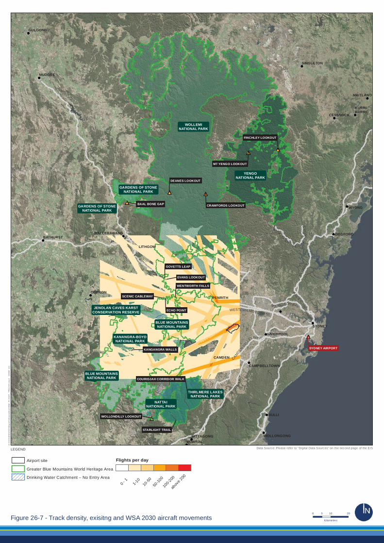
The density of flights equates to the total number of overflights at all altitudes from existing operations and also from operation of the proposed Western Sydney Airport. Flight densities are shown in Figure 26–6 for the 2015 base case (existing operations) and in Figure 26–7 reflecting full operations for Stage 1 of the proposed airport. Much of the GBMWHA is currently impacted by between one and 10 flights per day with specific areas under flight paths experiencing an average of 50 flights. The broad area of impact associated with one to 10 flights per day is generally related to high altitude commercial flights over the area and low altitude small aircraft. The areas of greater density are flight tracks to Sydney Airport.
Total flight numbers at the proposed airport in 2030 are expected to be approximately 200 movements per day. As shown in Figure 26–7, the area currently impacted by one to 10 flights per day remains unchanged with the increase in density being associated with the indicative flight tracks of the proposed airport. When reviewed in the context of the flight altitudes shown in Figure 26–4 and Figure 26–5, the majority of the dense flight tracks are at altitudes exceeding 10,000 feet.
As shown in Photograph 26–1, aircraft at 3,000 feet are not prominent visual features although they are visible from the ground. Aircraft viewed from a distance of between five and 10 kilometres from the airport would have an altitude above 5,000 feet and increasing to above 10,000 feet above sea level. When viewed from the key sensitive areas this equates to at least 6,000 feet above ground level. At 6,000 feet, aircraft are likely to be difficult to discern from ground level and are not considered to be visually obtrusive.
546 Western Sydney Airport – Environmental Impact Statement – Volume 2

SYDNEY
MAITLAND
LIVERPOOL
CAMDEN
CAMPBELLTOWN
BULLI
WOLLONGONGBOWRAL
MITTAGONG
WALLERAWANG
LITHGOW
SINGLETON
KURRIKURRI
CESSNOCK
BATHURST
OBERON
GULGONG
MUDGEE
GOSFORD
WYONG
PENRITH
PACIFICHIG
HW
AY
CAMDEN
VALL
EYWAY
M 2 MO TORWAY
W
I SEMANS
F ER RYR
OA
D
WESTERN MOTORWAY
SYDN
EY
NEWC
AS
TLE
FREE
WAY
HU
ME
HIGH
WA
Y
STARLIGHT TRAIL
COURIDJAH CORRIDOR WALK
ECHO POINT
WENTWORTH FALLS
GOVETTS LEAP
SCENIC CABLEWAY
KANGANGRA WALLS
BAAL BONE GAP
DEANES LOOKOUT
CRAWFORDS LOOKOUT
MT YENGO LOOKOUT
FINCHLEY LOOKOUT
EVANS LOOKOUT
WOLLONDILLY LOOKOUT
SYDNEY AIRPORT
THIRLMERE LAKESNATIONAL PARK
JENOLAN CAVES KARSTCONSERVATION RESERVE
GARDENS OF STONENATIONAL PARK
GARDENS OF STONENATIONAL PARK
KANANGRA-BOYDNATIONAL PARK
WOLLEMINATIONAL PARK
BLUE MOUNTAINSNATIONAL PARK
NATTAINATIONAL PARK
YENGONATIONAL PARK
BLUE MOUNTAINSNATIONAL PARK
Airport site
Greater Blue Mountains World Heritage Area
Drinking Water Catchment – No Entry Area
Flights per day
0 - 1
1-10
10-5
0
50-1
00
100-
200
abov
e 200
G:\2
1\24
265\
GIS
\Map
s\D
eliv
erab
les\
KB
M_F
LIG
HT
_TR
AC
KS
.mxd
[K
BM
: 11]
LEGEND
0 10 205
KilometresFigure 26-6 - Track density existing 2015 aircraft movements
Data Source: Please refer to "Digital Data Sources" on the second page of the EIS
SYDNEY
MAITLAND
LIVERPOOL
CAMDEN
CAMPBELLTOWN
BULLI
WOLLONGONGBOWRAL
MITTAGONG
WALLERAWANG
LITHGOW
SINGLETON
KURRIKURRI
CESSNOCK
BATHURST
OBERON
GULGONG
MUDGEE
GOSFORD
WYONG
PENRITH
PACIFICHIG
HW
AY
CAMDEN
VALL
EYWAY
M 2 MO TORWAY
W
I SEMANS
F ER RYR
OA
D
WESTERN MOTORWAY
SYDN
EY
NEWC
AS
TLE
FREE
WAY
HU
ME
HIGH
WA
Y
STARLIGHT TRAIL
COURIDJAH CORRIDOR WALK
SYDNEY AIRPORT
ECHO POINT
WENTWORTH FALLS
GOVETTS LEAP
SCENIC CABLEWAY
KANGANGRA WALLS
BAAL BONE GAP
DEANES LOOKOUT
CRAWFORDS LOOKOUT
MT YENGO LOOKOUT
FINCHLEY LOOKOUT
EVANS LOOKOUT
WOLLONDILLY LOOKOUT
KANANGRA-BOYDNATIONAL PARK
WOLLEMINATIONAL PARK
BLUE MOUNTAINSNATIONAL PARK
NATTAINATIONAL PARK
YENGONATIONAL PARK
BLUE MOUNTAINSNATIONAL PARK
GARDENS OF STONENATIONAL PARK
THIRLMERE LAKESNATIONAL PARK
JENOLAN CAVES KARSTCONSERVATION RESERVE
GARDENS OF STONENATIONAL PARK
Airport site
Greater Blue Mountains World Heritage Area
Drinking Water Catchment – No Entry Area
Flights per day
0 - 1
1-10
10-50
50-10
0
100-2
00
abov
e 200
G:\2
1\24
265\
GIS
\Map
s\D
eliv
erab
les\
KB
M_F
LIG
HT
_TR
AC
KS
.mxd
[K
BM
: 12]
LEGEND
0 10 205
KilometresFigure 26-7 - Track density, exisitng and WSA 2030 aircraft movements
Data Source: Please refer to "Digital Data Sources" on the second page of the EIS

Photograph 26–1 – Aircraft at approximately 3,000 feet at a ground distance of 2.75 kilometres
The proposed airport site may potentially be visible from Nepean lookout and Mount Portal Lookout both located at Glenbrook and between 13 and 14 kilometres from the airport site. A detailed assessment of visual impact of the airport site is included in Chapter 22. This assessment concluded that a moderate impact to visual amenity was likely at Nepean Lookout and a negligible impact at Mount Portal.
Amenity can also be influenced by light spill from the proposed development. Having regard to the provisions of Australian Standard AS 4280: Control of the obtrusive effects from outdoor lighting, the lighting for the proposed roads, car parks, apron lighting and other ancillary infrastructure is likely to be low impact, due to the large separation distances to sensitive receivers. Sky glow can occur from airfield lighting; reflective lighting and building lighting; within the context of the site within an existing major urban environment and the distance to sensitive receptors it is considered unlikely that sky glow would represent a significant impact.
26.5.3. Outstanding universal value Operation of the proposed airport would have no direct impact on the outstanding universal value of the GBMA. Indirect impacts on the property’s outstanding universal value are expected to be limited to potential noise and air quality. These potential impacts are described and their significance assessed in Table 26–5.
The assessment of significance is based on the requirements of the EPBC Act Significant Impact Guidelines 1.1, which state that an action is likely to have a significant impact on the World Heritage values of a declared World Heritage property if there is a real chance or possibility that it will cause:
• one or more of the World Heritage values to be lost,
• one or more of the World Heritage values to be degraded or damaged, or
• one or more of the World Heritage values to be notably altered, modified, obscured or diminished.
Western Sydney Airport – Environmental Impact Statement – Volume 2 549

Table 26–5 – Operational impacts on the outstanding universal value of the GBMWHA
Criterion/ element Attributes Operational impacts Assessment of significance Criterion (ix) ongoing evolutionary processes
• Outstanding and representative examples of:
evolution and adaptation of the genus Eucalyptus and eucalypt-dominated vegetation on the Australian continent; and
products of evolutionary processes associated with the global climatic changes of the late Tertiary and the Quaternary;
• Centre of diversification for the Australian scleromorphic flora, including significant aspects of eucalypt evolution and radiation;
• Primitive species of outstanding significance to the evolution of the earth’s plant life:
Wollemi pine (Wollemia nobilis); and
Blue Mountains pine (Pherosphaera fitzgeralii).
Impacts on these attributes would only occur if there were direct loss through ground disturbance or significant pollution resulting in loss of habitat or alteration to evolutionary processes. Noise and air emissions represent indirect impacts and given the distance from the airport site and the predicted emission levels are not considered to pose a threat to these listed values. The assessment of these impacts indicates that noise from overflights would not impact evolutionary processes. Air emissions from airport operations are not considered to represent a material contribution to global climate change which may impact these processes. Direct emissions from fuel jettisoning are rare and fuel evaporates before reaching the ground. As such, air emissions would not have an impact on evolutionary processes.
Outstanding and representative examples of evolutionary processes relate to pre-historical processes associated with climatic, geological, biological and ecological factors which have shaped the development of the GBMA. Similarly the significant aspects of scleromorphic flora and the existence of primitive species present in the GBMA are representative of evolutionary processes.
No direct or indirect operational activities would have an impact on these processes in the GBMA and, as such, no discernible impact on the attributes under this criterion would likely occur as a result of operation of the proposed airport.
The operation of the proposed airport would not result in direct impacts on the attributes demonstrated within the GBMA relevant to evolutionary processes.
The indirect impacts of the proposed airport would not result in a World Heritage value being lost, degraded or damaged, or notably altered, modified, obscured or diminished. Accordingly, the proposed action would not have a significant impact on the attributes of this World Heritage criterion.
550 Western Sydney Airport – Environmental Impact Statement – Volume 2

Criterion/ element Attributes Operational impacts Assessment of significance Criterion (x) biological diversity • Outstanding diversity of habitats and plant
communities;
• Significant proportion of the Australian continent’s biodiversity (scleromorphic flora);
• Primitive and relictual species with Gondwanan affinities;
• Plants of conservation significance including 114 endemic species and 177 threatened species; and
• Habitat that supports 52 mammal species, 63 reptile species, over 30 frog species and about one third of Australia’s bird species.
Impacts on these attributes would only occur if there were direct loss through on- ground impacts or significant pollution resulting in loss of habitat or alteration to biological diversity. Noise and air emissions represent indirect impacts and given the distance from the airport and predicted emission levels are not considered to pose a threat to these listed values. The assessment of these impacts indicates that noise from overflights would not impact biological diversity values. While peak noise levels associated with overflights may disturb species close to operations, flights to and from the proposed airport over the GBMA would generally be more than 5,000 feet above ground level, and would not exceed 55 dBA. These intermittent noise levels are unlikely to disturb fauna within the GBMA.
Air emissions from the operation of the proposed airport are not considered to represent a material contribution to climate change which may impact biodiversity. Direct emissions from fuel dumping would not impact biological diversity values.
An assessment of the potential for the proposed development to impact upon biodiversity is provided in Chapter 15. Based on that assessment, no direct or indirect operational activities would impact upon biological diversity of the GBMA and as such no discernible impact on the attributes under this criterion would likely occur as a result of operation of the proposed airport.
The operation of the proposed airport would not result in direct impacts on the examples of biological diversity present within the GBMA.
The indirect impacts of the proposed airport would not result in a World Heritage value being lost, degraded or damaged, or notably altered, modified, obscured or diminished. Accordingly the proposed action would not have a significant impact on the attributes of this World Heritage criterion.
Western Sydney Airport – Environmental Impact Statement – Volume 2 551

Criterion/ element Attributes Operational impacts Assessment of significance Integrity • Sufficient size to protect the biota and ecosystem
processes;
• Largely protected by adjoining public lands of state forests and state conservation areas;
• Statutory wilderness designation over 83.5% of the property;
• Closed and protected catchment for the Warragamba Dam;
• Plant communities and habitats occur almost entirely as an extensive, largely undisturbed matrix almost entirely free of structures, earthworks and other human intervention; and
• Custodial relationship of Aboriginal people from six language groups through ongoing practices that reflect both traditional and contemporary presence.
The operation of the proposed airport would not directly affect the physical size of the GBMA or the adjoining lands.
Statutory provisions which provide protection to wilderness areas and the Warragamba Dam would not be impacted as the project will not directly encroach upon wilderness areas and indirect impacts are not expected to alter the wilderness values for which these areas have been designated under the National Wilderness Inventory.
The operation of the proposed airport would have no direct or indirect impact on the plant communities and habitats within the property.
The operation of the airport would not directly or indirectly impact upon the maintenance of Aboriginal cultural practices within the GBMA.
The proposed airport would not result in the loss of any elements necessary for the property to express its outstanding universal value.
The proposed airport would not reduce the size or change the boundary of the GBMA and would not impact on any features and processes that convey the property’s outstanding universal value.
As described in Section 26.5.5, the proposed airport would not exacerbate existing threats to the integrity of the GBMA.
552 Western Sydney Airport – Environmental Impact Statement – Volume 2
26.5.4. Other values Table 26–6 provides an assessment of the potential operational impacts of the proposed airport on the additional values of the Greater Blue Mountains Area identified in the Strategic Plan (DECC 2009c). These values complement and interact with the property’s World Heritage values but are not part of the defined natural values for which the property is listed. The assessment of these values is relevant to the National Heritage listing of the GBMA.
Western Sydney Airport – Environmental Impact Statement – Volume 2 553
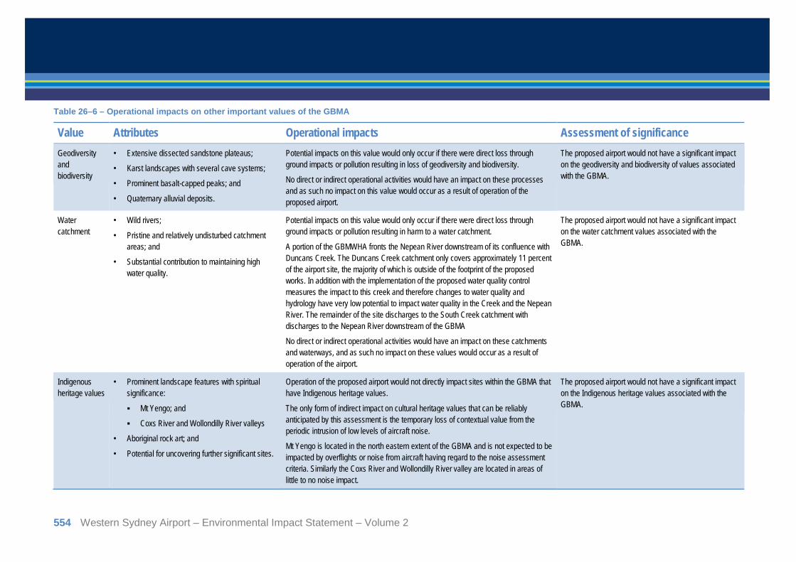
Table 26–6 – Operational impacts on other important values of the GBMA
Value Attributes Operational impacts Assessment of significance Geodiversity and biodiversity
Extensive dissected sandstone plateaus; •
Karst landscapes with several cave systems; •
Prominent basalt-capped peaks; and •
Quaternary alluvial deposits. •
Potential impacts on this value would only occur if there were direct loss through ground impacts or pollution resulting in loss of geodiversity and biodiversity.
No direct or indirect operational activities would have an impact on these processes and as such no impact on this value would occur as a result of operation of the proposed airport.
The proposed airport would not have a significant impact on the geodiversity and biodiversity of values associated with the GBMA.
Water catchment
Wild rivers; •
Pristine and relatively undisturbed catchment •areas; and
Substantial contribution to maintaining high •water quality.
Potential impacts on this value would only occur if there were direct loss through ground impacts or pollution resulting in harm to a water catchment.
A portion of the GBMWHA fronts the Nepean River downstream of its confluence with Duncans Creek. The Duncans Creek catchment only covers approximately 11 percent of the airport site, the majority of which is outside of the footprint of the proposed works. In addition with the implementation of the proposed water quality control measures the impact to this creek and therefore changes to water quality and hydrology have very low potential to impact water quality in the Creek and the Nepean River. The remainder of the site discharges to the South Creek catchment with discharges to the Nepean River downstream of the GBMA
No direct or indirect operational activities would have an impact on these catchments and waterways, and as such no impact on these values would occur as a result of operation of the airport.
The proposed airport would not have a significant impact on the water catchment values associated with the GBMA.
Indigenous heritage values
Prominent landscape features with spiritual •significance:
Mt Yengo; and
Coxs River and Wollondilly River valleys
Aboriginal rock art; and •
Potential for uncovering further significant sites. •
Operation of the proposed airport would not directly impact sites within the GBMA that have Indigenous heritage values.
The only form of indirect impact on cultural heritage values that can be reliably anticipated by this assessment is the temporary loss of contextual value from the periodic intrusion of low levels of aircraft noise.
Mt Yengo is located in the north eastern extent of the GBMA and is not expected to be impacted by overflights or noise from aircraft having regard to the noise assessment criteria. Similarly the Coxs River and Wollondilly River valley are located in areas of little to no noise impact.
The proposed airport would not have a significant impact on the Indigenous heritage values associated with the GBMA.
554 Western Sydney Airport – Environmental Impact Statement – Volume 2
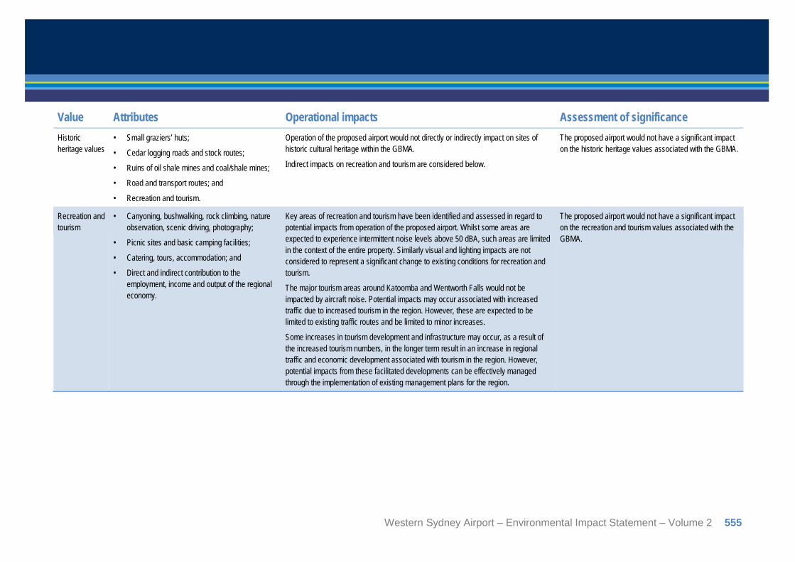
Value Attributes Operational impacts Assessment of significance Historic heritage values
Small graziers’ huts; •
Cedar logging roads and stock routes; •
Ruins of oil shale mines and coal/shale mines; •
Road and transport routes; and •
Recreation and tourism. •
Operation of the proposed airport would not directly or indirectly impact on sites of historic cultural heritage within the GBMA.
Indirect impacts on recreation and tourism are considered below.
The proposed airport would not have a significant impact on the historic heritage values associated with the GBMA.
Recreation and tourism
Canyoning, bushwalking, rock climbing, nature •observation, scenic driving, photography;
Picnic sites and basic camping facilities; •
Catering, tours, accommodation; and •
Direct and indirect contribution to the •employment, income and output of the regional economy.
Key areas of recreation and tourism have been identified and assessed in regard to potential impacts from operation of the proposed airport. Whilst some areas are expected to experience intermittent noise levels above 50 dBA, such areas are limited in the context of the entire property. Similarly visual and lighting impacts are not considered to represent a significant change to existing conditions for recreation and tourism.
The major tourism areas around Katoomba and Wentworth Falls would not be impacted by aircraft noise. Potential impacts may occur associated with increased traffic due to increased tourism in the region. However, these are expected to be limited to existing traffic routes and be limited to minor increases.
Some increases in tourism development and infrastructure may occur, as a result of the increased tourism numbers, in the longer term result in an increase in regional traffic and economic development associated with tourism in the region. However, potential impacts from these facilitated developments can be effectively managed through the implementation of existing management plans for the region.
The proposed airport would not have a significant impact on the recreation and tourism values associated with the GBMA.
Western Sydney Airport – Environmental Impact Statement – Volume 2 555

Value Attributes Operational impacts Assessment of significance Wilderness Extensive natural areas; •
Absence of significant human interference; •
Opportunity to maintain integrity, gradients and •mosaics of ecological processes;
Opportunities for solitude and self-reliant •recreation; and
Aesthetic, spiritual and intrinsic value. •
The wilderness areas of the GBMA are generally associated with the Nattai National Park and the Wollemi National Park. With lower noise levels potentially also affecting Blue Mountains and Kanangra Boyd National Parks (e.g. effects on Grose and Kanangra Boyd Wilderness Areas). Access to these areas is generally limited to hikers and low impact tourism. These limitations restrict the number of people within the area and as such limits the number of people potentially affected.
Some areas of Nattai National Park and Wollemi National Park would be affected by maximum noise levels associated with infrequent overflights of Boeing 747 aircraft, an aircraft type gradually being phased out by airlines. A small proportion of the wilderness areas may be impacted by visual and lighting changes; however these are considered to be insignificant for the vast majority of wilderness areas.
A potential increase in tourism numbers in the longer term may impact the wilderness experience of some areas.
The majority of aircraft using the proposed airport such as the Airbus 320 (refer Figure 25-5) would have minimal noise impacts on the GBMA. Some new generation aircraft such as the Boeing 787 which are already in use in Australia have less noise impact than the A320. It is expected that future generations of aircraft would utilise quieter engine technologies which would reduce noise impact further. In addition, the current generation of larger aircraft (i.e. Boeing 747) are predicted to use the proposed airport infrequently (once every two days on average). Aircraft passing over the GBMA on approach to or departure from the proposed airport would generally be at least 5,000 feet to 10,000 feet above ground level and are unlikely to be visually intrusive. Based on these factors it is not expected that a significant impact on wilderness values would occur as a result of the operation of the airport.
Research and education
High scientific value discovered and •undiscovered;
Scientific research into the identification, •conservation and rehabilitation of World Heritage values, best management practice and threat abatement; and
Education value for schools and universities. •
Operation of the proposed airport is not expected to have an impact on the biological diversity of the GBMA and, as such, the availability of the area for scientific investigation and research would not be limited.
The proposed airport would not have a significant impact on the research and education values associated with the GBMA.
556 Western Sydney Airport – Environmental Impact Statement – Volume 2

Value Attributes Operational impacts Assessment of significance Scenic and aesthetic
Vertical cliffs, waterfalls, ridges, escarpments; •
Outstanding vistas, uninterrupted views of •forested wilderness;
Extensive caves; and •
Sandstone canyons and pagoda rock •formations.
Aircraft overflying the key lookouts that take advantage of the unique scenic qualities of the GBMA would be more than 6,000 feet above the relevant ground level and at this altitude would have limited visual intrusion. Similarly visual and lighting impacts are not considered to represent a significant change to existing conditions for scenic and aesthetic amenity.
Based on the altitude of aircraft overflying scenic areas it is not expected that a significant impact would occur as a result of the operation of the proposed airport.
Western Sydney Airport – Environmental Impact Statement – Volume 2 557

26.5.5. Influence on existing threats Table 26–7 provides a description of the proposed airport’s influence on existing threats identified in the Strategic Plan for the GBMA (DECC 2009c). Table 26–7 – Operational impacts contribution to existing threats within the GBMWHA
Threat Project influence Uncontrolled and inappropriate use of fire
The only risk of fire associated with the operation of the proposed airport would be as a result of an aircraft crash. This would be a very rare and unlikely event and is not considered to be a contributory factor in the overall threat of uncontrolled and inappropriate use of fire.
Inappropriate recreation and tourism activities, including development of tourism infrastructure
The proposed airport would provide progressively increasing aviation capacity in the Sydney region, which could also parallel a growth in tourism and visitation for the GBMA. Such an increase in tourism may influence potential for inappropriate tourism development. However it is very unlikely that the proposed airport would directly contribute to inappropriate development or uncontrolled visitor access particularly within the context of strong management plans which are in place for the GBMA. Other factors such as Sydney’s expanding population are likely to drive the need for any new management responses to threats posed by increased visitations.
Invasion by pest species including weeds and feral animals
No direct impacts on biodiversity are expected as a result of the proposed airport. It is very unlikely that the proposal would contribute to threats associated with weed and pest species.
Loss of biodiversity and geodiversity
Loss of biodiversity and geodiversity would only occur as a direct loss through ground impacts, such as an aircraft crash, or significant pollution resulting in loss of habitat or alteration to evolutionary processes. Noise and air emissions from overflying planes are not expected to negatively impact biodiversity or geodiversity. As such the indirect impacts associated with the proposed airport are not considered to be a contributing factor to this threat.
Impacts of human enhanced climate change
The proposed airport is expected to have a marginal contribution to overall transport related GHG emissions. A predicted overall contribution of 0.10 per cent of GHG emissions is considered to be negligible. As such the proposed airport is not considered to be a contributing factor to this threat.
Lack of understanding of heritage values
This threat would be relevant if no assessment of potential impacts was undertaken. An assessment of heritage values has been undertaken and as such the proposed airport is not considered to be a contributing factor to this threat.
558 Western Sydney Airport – Environmental Impact Statement – Volume 2
26.6. Mitigation and management measures Noise modelling and impact assessment for this EIS have been based on indicative flight paths and a preliminary analysis of airspace arrangements undertaken by Airservices Australia. The principal objective of the preliminary assessment was to establish whether safe and efficient operations could be introduced at the proposed airport through the development of indicative proof-of-concept design does not take into account other influences on air traffic movement such as consideration of potential noise or other environmental impacts. This work does not present a comprehensive airspace and air route redesign, nor does it consider all essential components of any such design process.
Formal design of airspace arrangements and flight paths for the proposed airport would be undertaken closer to the commencement of operations. That design process would take account of all relevant factors, including potential environmental impacts on sensitive areas such as the GBMA, in determining operating procedures for the proposed airport.
The current assessment based on the above indicative arrangements shows that level of impacts on the Greater Blue Mountains, including the World Heritage and National Heritage values of the GBMA, from operation of the proposed Western Sydney Airport is likely to be low. The potential to further reduce the noise and visual impact from aircraft flying over wilderness and other areas of the GBMA would be key considerations in determining the final and formal airspace and operational arrangements prior to the commencement of operations at the proposed airport.
Detailed management plans are in place for the GBMA; including the Strategic Plan. This plan would be considered in the development of the detailed environmental; management plan for the project.
26.7. Conclusion At its closest point, the GBMA is approximately eight kilometres from the proposed airport. As such, no direct impacts are expected on World Heritage or National Heritage values from the construction or operation of the proposed Western Sydney Airport. Potential indirect impacts on World Heritage and National Heritage values from the operation of the airport were assessed having regard to the attributes identified in the Statement of Outstanding Universal Value for the GBMA and the complementary values of the area as defined in the GBMA Strategic Plan. The assessment considered noise, air emissions and amenity impacts from overflight of aircraft; lighting and traffic.
The assessment’s findings are that the proposed airport would not have a significant impact on the GBMA. In particular, the indirect impacts of airport operation would not result in an attribute of the property being lost, degraded or damaged, or notably altered, modified, obscured or diminished.
Western Sydney Airport – Environmental Impact Statement – Volume 2 559

This page intentionally left blank
560 Western Sydney Airport – Environmental Impact Statement – Volume 2