285 rosehill street re -zoning - the city of nanaimo€¦ · · 2017-10-18285 rosehill street re...
TRANSCRIPT
285 Rosehill Street Re-zoningVancouver Island Mental Health SocietyPresented to the Community Planning & Development Committee
October 17, 2017
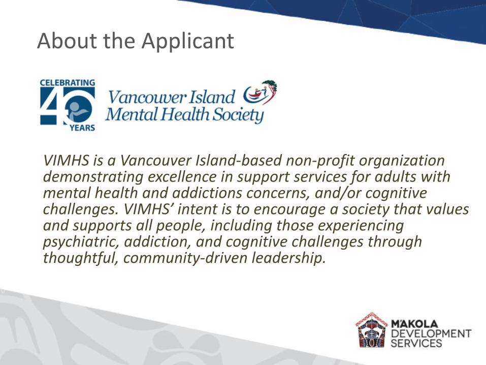
VIMHS is a Vancouver Island-based non-profit organization demonstrating excellence in support services for adults with mental health and addictions concerns, and/or cognitive challenges. VIMHS’ intent is to encourage a society that values and supports all people, including those experiencing psychiatric, addiction, and cognitive challenges through thoughtful, community-driven leadership.
About the Applicant
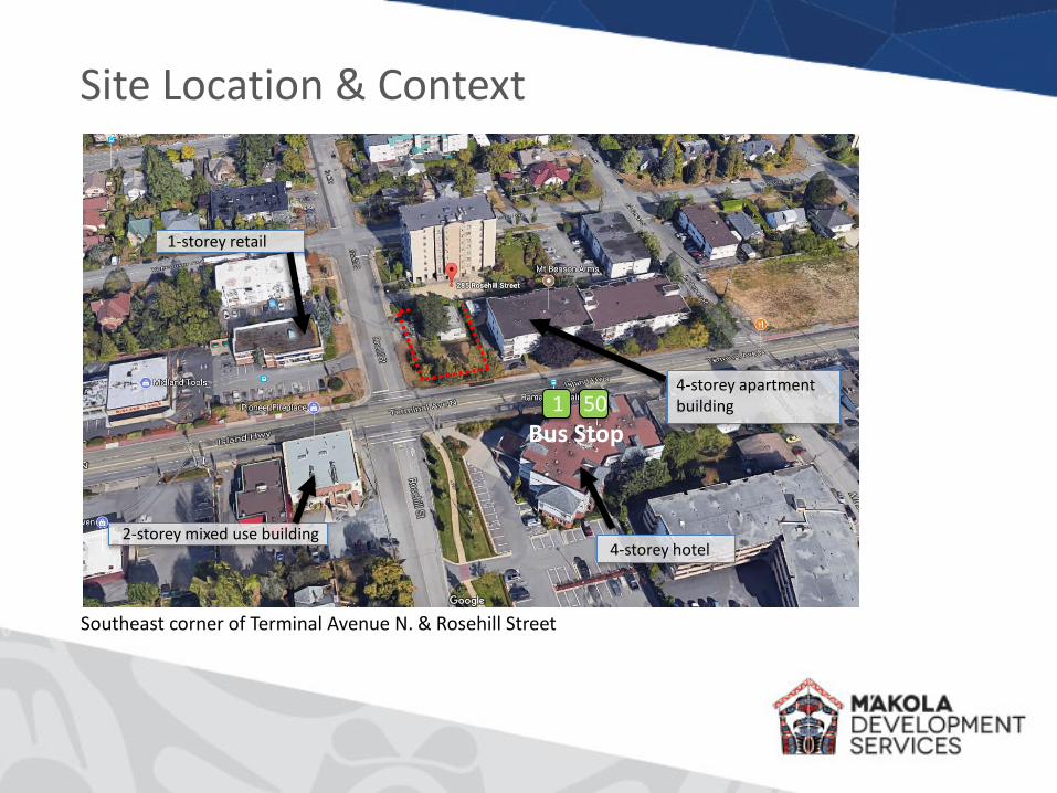
Site Location & Context
Southeast corner of Terminal Avenue N. & Rosehill Street
2-storey mixed use building
1-storey retail
4-storey hotel
4-storey apartment building1 50
Bus Stop

Site Location & Context
Terminal Avenue North Frontage
Rosehill Street Frontage Existing four plex
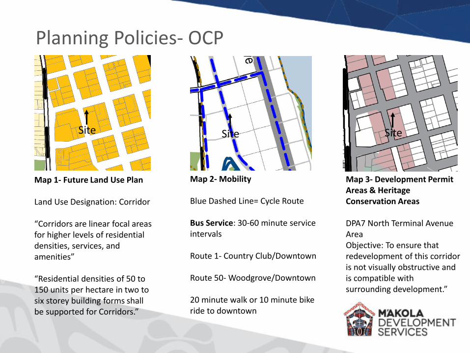
Planning Policies- OCP
Site SiteSite
Map 1- Future Land Use Plan
Land Use Designation: Corridor
“Corridors are linear focal areas for higher levels of residential densities, services, and amenities”
“Residential densities of 50 to 150 units per hectare in two to six storey building forms shall be supported for Corridors.”
Map 2- Mobility
Blue Dashed Line= Cycle Route
Bus Service: 30-60 minute service intervals
Route 1- Country Club/Downtown
Route 50- Woodgrove/Downtown
20 minute walk or 10 minute bike ride to downtown
Map 3- Development Permit Areas & Heritage Conservation Areas
DPA7 North Terminal Avenue AreaObjective: To ensure that redevelopment of this corridor is not visually obstructive and is compatible with surrounding development.”

Planning Policies- Newcastle + BrechinNeighbourhood Plan
Site
Map 1- Neighbourhood Land UseDesignation: Mixed Use Corridor
Part E- Neighbourhood Plan Policies• Development will include multiple unit residential in
developments up to 6-storeys (2.11- Land Use & Development- Mixed Use Corridor)
• Ensure affordable housing is available to all age groups and income levels in neighbourhoods (Section 3- Social Enrichment and Culture)
• The construction of affordable housing units within new and existing residential developments is encouraged (Section 3- Social Enrichment and Culture)
Part F- Urban Design Framework & Guidelines• Enhance local streets with sidewalks, street trees, curb
bulges, rainwater management, on-street parking• Multiple dwelling housing should complement scale
and character of the area (1.3- Street Character)• Maintain min. 1.0m front setback, provide strong,
overall building form, visual breaks, texture & rhythm and visual interest, use entrance design as corner activity markers (2.11 Building Design)
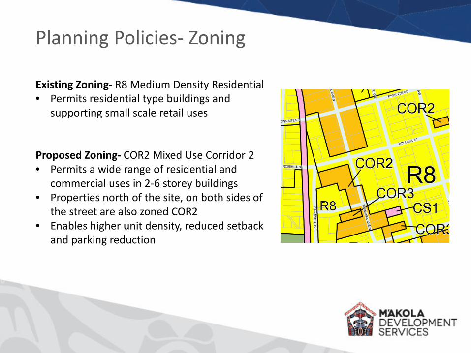
Planning Policies- Zoning
Existing Zoning- R8 Medium Density Residential• Permits residential type buildings and
supporting small scale retail uses
Proposed Zoning- COR2 Mixed Use Corridor 2• Permits a wide range of residential and
commercial uses in 2-6 storey buildings• Properties north of the site, on both sides of
the street are also zoned COR2• Enables higher unit density, reduced setback
and parking reduction
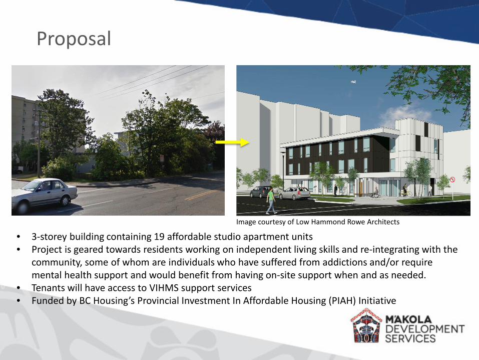
Proposal
• 3-storey building containing 19 affordable studio apartment units • Project is geared towards residents working on independent living skills and re-integrating with the
community, some of whom are individuals who have suffered from addictions and/or require mental health support and would benefit from having on-site support when and as needed.
• Tenants will have access to VIHMS support services• Funded by BC Housing’s Provincial Investment In Affordable Housing (PIAH) Initiative
Image courtesy of Low Hammond Rowe Architects
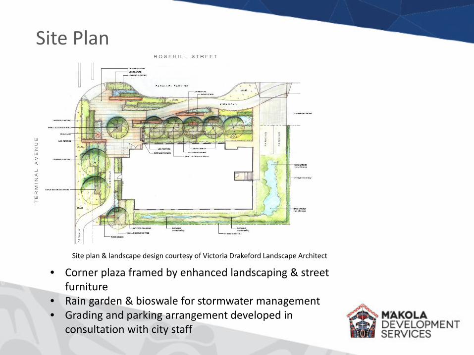
Site Plan
• Corner plaza framed by enhanced landscaping & street furniture
• Rain garden & bioswale for stormwater management• Grading and parking arrangement developed in
consultation with city staff
Site plan & landscape design courtesy of Victoria Drakeford Landscape Architect
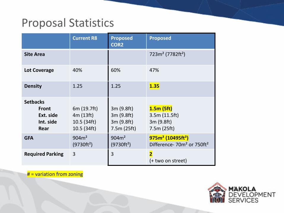
Proposal StatisticsCurrent R8 Proposed
COR2Proposed
Site Area 723m² (7782ft²)
Lot Coverage 40% 60% 47%
Density 1.25 1.25 1.35
SetbacksFrontExt. sideInt. sideRear
6m (19.7ft)4m (13ft)10.5 (34ft)10.5 (34ft)
3m (9.8ft)3m (9.8ft)3m (9.8ft)7.5m (25ft)
1.5m (5ft)3.5m (11.5ft)3m (9.8ft)7.5m (25ft)
GFA 904m² (9730ft²)
904m² (9730ft²)
975m² (10495ft²)Difference- 70m² or 750ft²
Required Parking 3 3 2(+ two on street)
# = variation from zoning
Project Merits- OCP & Neighbourhood Plan
• Proposed 3-storey building is an appropriate height and density for the OCP and Neighbourhood Plan land use designations, which support 2-5 storey buildings (OCP- 2.2.(1), Neighbourhood Plan- Section E)
• Ground floor office use and inviting corner entrance with plaza and landscaping enhance the streetscape (OCP- 2.2(5), Neighbourhood Plan-Section F (1.3, 2.11))
• Provision of secure ground floor bike parking supports cycling, and close proximity to bus route encourages sustainable travel (OCP section 6, Neighbourhood Plan- Section E (7))
• Building design will be energy efficient and reduce GHG emissions during construction and operation in accordance with Nanaimo Community Sustainability Action Plan and BC Housing’s STEP Code (OCP- 2.2(12))
• Supports a broad social mix and access to adequate housing at all income levels (OCP- 2.2(13))
• Project contributes to the diversity of residential uses/tenures, advances Nanaimo towards its “critical” goal of creating opportunities for new affordable housing (See Section 3.2- Affordable Housing).
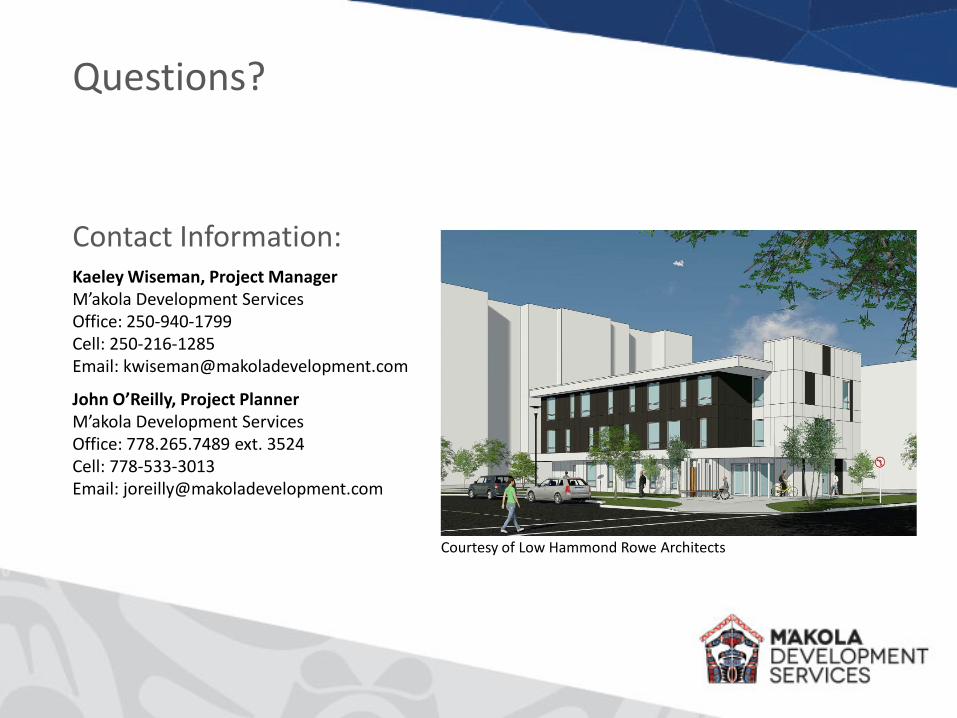
Kaeley Wiseman, Project ManagerM’akola Development ServicesOffice: 250-940-1799Cell: 250-216-1285Email: [email protected]
John O’Reilly, Project PlannerM’akola Development ServicesOffice: 778.265.7489 ext. 3524Cell: 778-533-3013Email: [email protected]
Contact Information:
Questions?
Courtesy of Low Hammond Rowe Architects